chapter 4 basic strategy
TRANSCRIPT
The Study on Disaster Risk Management for Narayangharh -Mugling Highway Main Report
NIPPON KOEI CO., LTD. February 2009 4-1
CHAPTER 4
BASIC STRATEGY
4.1 General
4.1.1 Policies on Formulation of Basic Strategy
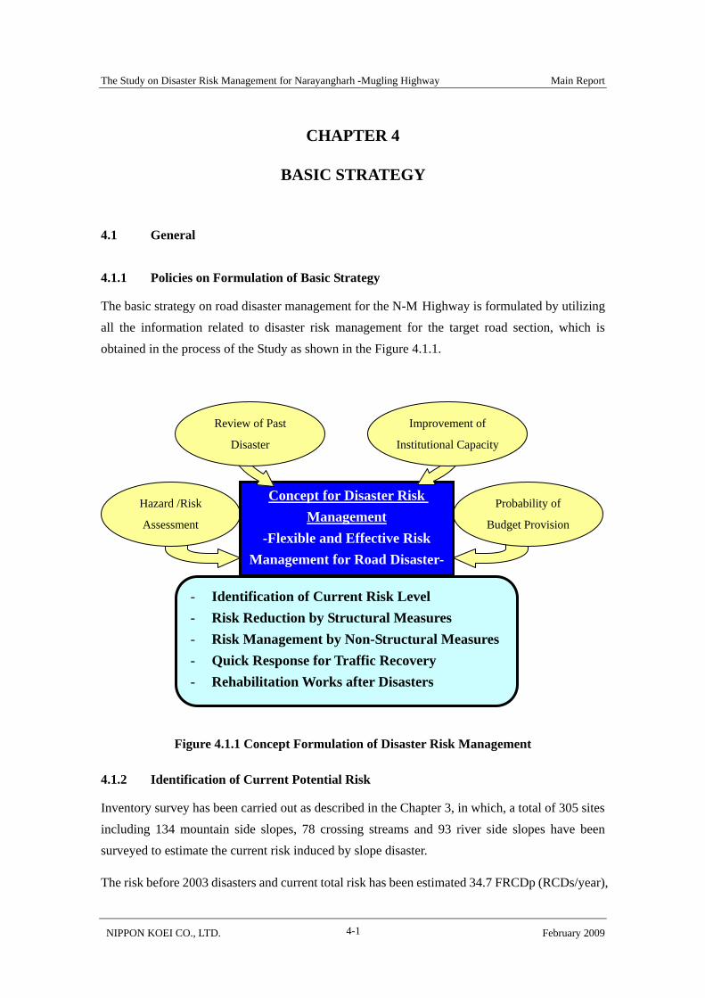
The basic strategy on road disaster management for the N-M Highway is formulated by utilizing all the information related to disaster risk management for the target road section, which is obtained in the process of the Study as shown in the Figure 4.1.1.
Figure 4.1.1 Concept Formulation of Disaster Risk Management
4.1.2 Identification of Current Potential Risk
Inventory survey has been carried out as described in the Chapter 3, in which, a total of 305 sites including 134 mountain side slopes, 78 crossing streams and 93 river side slopes have been surveyed to estimate the current risk induced by slope disaster.
The risk before 2003 disasters and current total risk has been estimated 34.7 FRCDp (RCDs/year),
Hazard /Risk
Assessment
Probability of
Budget Provision
Concept for Disaster Risk Management
-Flexible and Effective Risk Management for Road Disaster-
- Identification of Current Risk Level - Risk Reduction by Structural Measures - Risk Management by Non-Structural Measures - Quick Response for Traffic Recovery - Rehabilitation Works after Disasters
Review of Past
Disaster
Improvement of
Institutional Capacity
The Study on Disaster Risk Management for Narayangharh -Mugling Highway Main Report
NIPPON KOEI CO., LTD. February 2009 4-2
194 ALp (million Rs) and 22.0 FRCDp (nos/year), 106 ALp (million Rs) respectively as shown in the Table 4.1.1.
Table 4.1.1 Risk before 2003 and At Present Term FRCDp
(RCDs/year)Ratio
ALp
(mil. Rs/Year) Ratio
Before 2003 34.7 100% 194 100 % At Present (2007) 22.0 63% 106 55%
Drastic improvement of risk level of current situation compared to 2003 has been generated by the rehabilitation work named Road Maintenance and Development Project, Road Rehabilitation Component for N-M Highway which had been done from 2004 to 2006 by DOR and preventive work named Mugling- Narayangharh Water Induced Prevention Project (MNWIDPP) which is being implemented from 2004 by DWIDP.
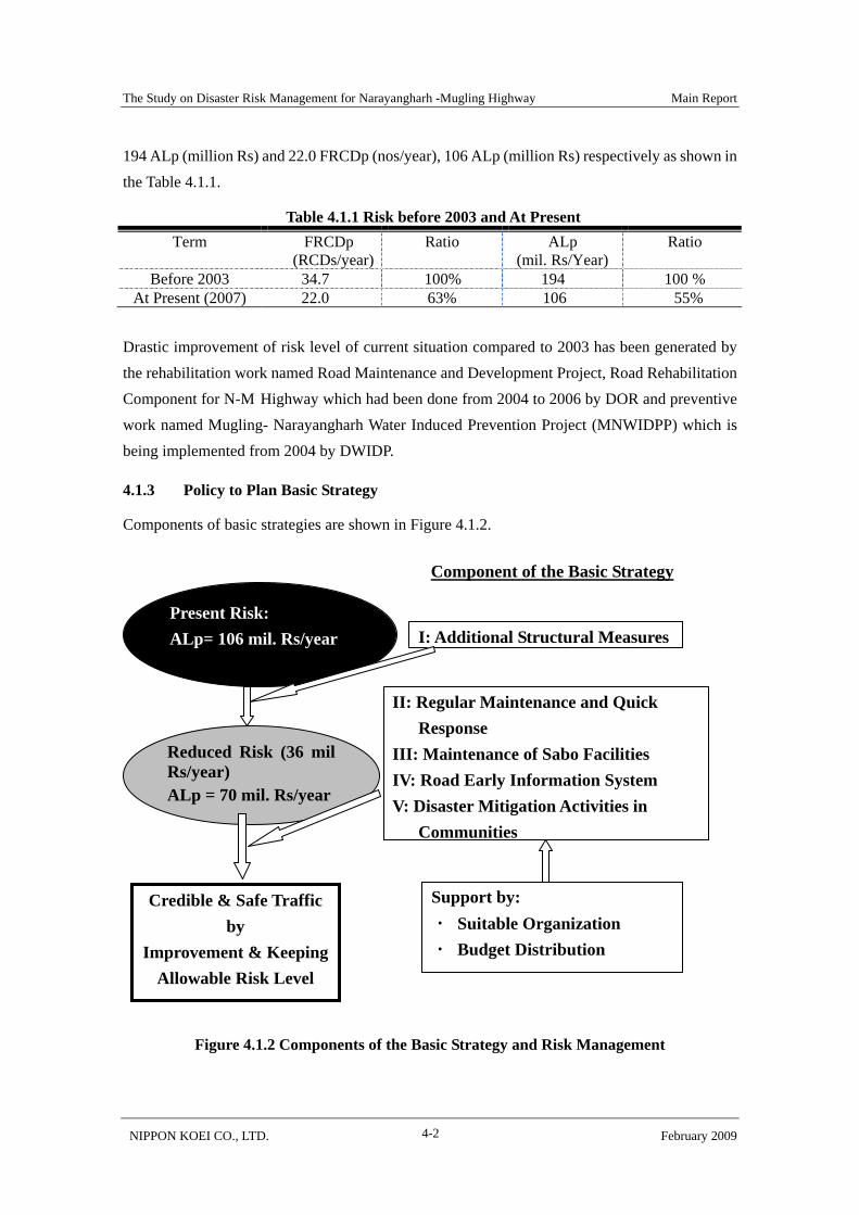
4.1.3 Policy to Plan Basic Strategy
Components of basic strategies are shown in Figure 4.1.2.
Figure 4.1.2 Components of the Basic Strategy and Risk Management
Present Risk: ALp= 106 mil. Rs/year
Reduced Risk (36 mil Rs/year) ALp = 70 mil. Rs/year
Component of the Basic Strategy
I: Additional Structural Measures
II: Regular Maintenance and Quick Response
III: Maintenance of Sabo Facilities IV: Road Early Information System V: Disaster Mitigation Activities in
Communities
Support by: ・ Suitable Organization ・ Budget Distribution
Credible & Safe Traffic by
Improvement & Keeping Allowable Risk Level

The Study on Disaster Risk Management for Narayangharh -Mugling Highway Main Report
NIPPON KOEI CO., LTD. February 2009 4-3
Results of risk estimation indicated that the implementation of structural measures after 2003 disaster achieved 45% decrease in ALp compared to the 2003 disasters. Under 2006 heavy rainfall which return period is around 10yrs, no serious traffic disturbance happened.
So, in consideration of the effectiveness of structural measures mentioned above, Basic Strategy is planned to strengthen and maintain current preventive facilities by implementing additional measures and soft measures. Each item in detail of the Basic Strategy is described as follows:
1) Additional Structural Measures
High-risk sites with ALp of more than 1.0 million Rs which is accounting for 47% of overall ALp of the total section is selected and structural measures are implemented to decrease ALp from 106 million Rs to 70 million Rs.
2) Regular Maintenance and Quick Response
Measures to prevent occurrence of sediment related disasters have been constructed after 2003 disasters by DOR and DWIDP that improved drastically traffic function of N-M Highway. But, to keep this condition, continuous maintenance works are indispensable.
3) Maintenance of Sabo Facilities
Sabo dames, which constructed from 2004 to 2007, contribute risk reduction. Disposal of accumulated sand is most important and efficient procedure and priority method.
4) Road Early Information System/ 5) Disaster Mitigation Activities in Communities ‘Road Early Information System’ and ‘Disaster Mitigation Activities in Communities’ are introduced components of basic strategy which evaluated by pilot projects. Even after implementing additional countermeasure, road disaster potential still remained. So, risk management utilizing soft measure such as road information system is proposed in the basic strategy.
The Study on Disaster Risk Management for Narayangharh -Mugling Highway Main Report
NIPPON KOEI CO., LTD. February 2009 4-4
4.2 Additional Structural Measures
4.2.1 Target Setting
As described in Chapter 3, the risk level of slopes and stream can be classified into three categories using rank of ALp as indicator (mil. Rs/year) with values 0-0.1, 0.1-1.0, 0, These were related with Alp values of more than 1 million Rs/year as shown in the Table 4.2.1.
Table 4.2.1 Classification of Risk Level by Alp as of 2007 Mountain side
Slopes Crossing Stream Riverside Slope Total Rank
of ALp
(mil. Rs) Nos. ALp
(mil. Rs)
Ratio (%)
Nos. ALp(mil.Rs)
Ratio(%)
Nos. ALp(mil.Rs)
Ratio(%)
Nos. ALp (mil. Rs)
Ratio(%)
0-0.1 61 0.4 1 54 0.4 1 87 0.0 2 202 0.9 10.1-1.0 67 41.6 60 18 11.1 33 6 2.1 98 91 54.8 521.0< 6 27.9 40 6 22.5 65 0 0 0 12 50.4 47
Total 134 69.9 100 78 34.0 100 93 2.1 100 305 106.1 100
Among three ranks of ALp, the rank of over 1.0 million Rs/year class twelve slopes occupies 47% of the total amount of ALp, which is 106 million Rs/year. If these slopes were protected by
sufficient countermeasures, the total ALp of N-M Highway would be reduced to 70 (=106-36) million Rs/year, which is 36% (=70/194) of ALp before 2003 disasters.
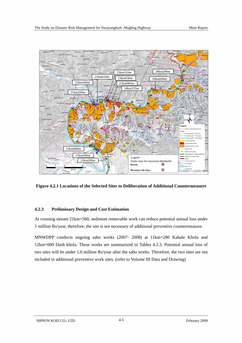
4.2.2 Selected Sites for Preventive Structural Measures
It is judged by the risk evaluation that serious slope disasters are not occur in other slopes. So, the target of risk reduction set for the twelve site of that ALp is higher than 1.0 million Rs/year. Selected sites include six mountainside slopes and six crossing streams. Preventive structural measures and economical evaluation were studied on these 12 sites.
Table 4.2.2 Selected Sites of Preventive Structural Measures Location of Mountainside Slopes Location of Crossing Streams 21km+610 SL-1: landslide-1 11km+200 Kahale Khola 23km+510 SL-2: landslide-2 11km+500 23km+960 SL-3: landslide-3 12km+600 Dash Khola 24km+235 SL-4: landslide-4 21km+200 30km+690 21km+560 34km+200 23km+930
The Study on Disaster Risk Management for Narayangharh -Mugling Highway Main Report
NIPPON KOEI CO., LTD. February 2009 4-5
Figure 4.2.1 Locations of the Selected Sites to Deliberation of Additional Countermeasure
4.2.3 Preliminary Design and Cost Estimation
At crossing stream 21km+560, sediment removable work can reduce potential annual loss under 1 million Rs/year, therefore, the site is not necessary of additional preventive countermeasure.
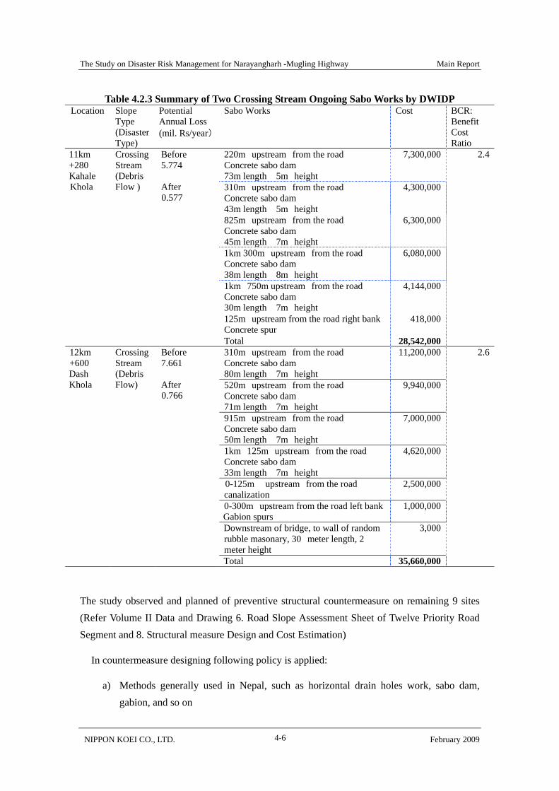
MNWDPP conducts ongoing sabo works (2007- 2008) at 11km+280 Kahale Khola and 12km+600 Dash khola. These works are summarized in Tables 4.2.3. Potential annual loss of two sites will be under 1.0 million Rs/year after the sabo works. Therefore, the two sites are not included in additional preventive work sites. (refer to Volume III Data and Drawing)
34km200m
30km690m
23km510m
23km930m23km960m
24km235m
21km610m
21km560m
21km200m
11km500m 11km200m
12km600m
Legend Study sites for structural measures
The Study on Disaster Risk Management for Narayangharh -Mugling Highway Main Report
NIPPON KOEI CO., LTD. February 2009 4-6
Table 4.2.3 Summary of Two Crossing Stream Ongoing Sabo Works by DWIDP Location Slope
Type (Disaster Type)
Potential Annual Loss (mil. Rs/year)
Sabo Works Cost BCR: Benefit Cost Ratio
220m upstream from the road Concrete sabo dam 73m length 5m height
7,300,000
310m upstream from the road Concrete sabo dam 43m length 5m height
4,300,000
825m upstream from the road Concrete sabo dam 45m length 7m height
6,300,000
1km 300m upstream from the road Concrete sabo dam 38m length 8m height
6,080,000
1km 750m upstream from the road Concrete sabo dam 30m length 7m height
4,144,000
125m upstream from the road right bank Concrete spur
418,000
11km +280 Kahale Khola
Crossing Stream (Debris Flow )
Before 5.774 After 0.577
Total 28,542,000
2.4
310m upstream from the road Concrete sabo dam 80m length 7m height
11,200,000
520m upstream from the road Concrete sabo dam 71m length 7m height
9,940,000
915m upstream from the road Concrete sabo dam 50m length 7m height
7,000,000
1km 125m upstream from the road Concrete sabo dam 33m length 7m height
4,620,000
0-125m upstream from the road canalization
2,500,000
0-300m upstream from the road left bankGabion spurs
1,000,000
Downstream of bridge, to wall of random rubble masonary, 30 meter length, 2 meter height
3,000
12km +600 Dash Khola
Crossing Stream (Debris Flow)
Before 7.661 After 0.766
Total 35,660,000
2.6
The study observed and planned of preventive structural countermeasure on remaining 9 sites (Refer Volume II Data and Drawing 6. Road Slope Assessment Sheet of Twelve Priority Road Segment and 8. Structural measure Design and Cost Estimation)
In countermeasure designing following policy is applied:
a) Methods generally used in Nepal, such as horizontal drain holes work, sabo dam, gabion, and so on
The Study on Disaster Risk Management for Narayangharh -Mugling Highway Main Report
NIPPON KOEI CO., LTD. February 2009 4-7
b) In the cases of a little or no effect for disaster prevention, typical methods in Japan were introduced as new ones, such as concrete crib work, rock fall prevention net and fence, and so on.
Total cost of preventive structural countermeasure is 204 million Rs.
Economic indicator shows that all of nine sites are economically feasible.
The result of planning of countermeasures/cost estimation is shown in the Table 4.2.4.

The Study on Disaster Risk Management for Narayangharh -Mugling Highway Main Report
NIPPON KOEI CO., LTD. February 2009 4-8
Table 4.2.4 Selected Sites for Implementing Preventive Structural Countermeasure Location Slope
(Disaster Type)
ALp mil. NPR/year
Recommended Measures Cost BCR: Benefit cost ratio
Concrete retaining wall
113.39 m3 527,859.0
Rock fall protection fence
22.0m 377,663.0
21km +200
Crossing stream (SF/DF)
Before 2.653 After 0.796 Demolishing of
existing wall 19.5m 13,934.0
×1.13(13%VAT) 1,038,985.0
23.6
Horizontal drain holes
486.0m 5,728,880.0 21km +610
Mountainside slope (SL)
Before 2.863 After 0.716
×1.13(13%VAT) 6,473,634.0
4.4
Shotcrete crib work 4196.6 m2 14,318,696.0 Rock bolt work 3671.50m 5,398,327.0 Seed-mud spraying work
3032.06 m2 6,506,910.0
23km +510
Mountainside slope (SL/SF)
Before 3.492 After 0.715
×1.13(13%VAT) 29,633,044.0
1.5
Gabion mat 825.69 m3 1,607,117.0 Removal of deposits
2,730m3 ― 23km +930
Crossing stream (DF)
Before 2.286 After 0.686 ×1.13(13%VAT) 1,816,042.0
11.7
Shotcrete crib work 20269.72 m2 68,930,851.0 Rock bolt work 17734.5m 26,000,153.0 Seed-mud spraying work
14644.87 m2 30,774,324.0
23km +960
Mountainside slope (SL)
Before 13.749 After 0.687
×1.13(13%VAT) 142,047,020.0
1.2
Horizontal drain holes
150.0m 1,770,488.0 24km +235
Mountainside slope (SL/DF)
Before 1.523 After 0.381
×1.13(13%VAT) 2,000,651.0
7.5
Shotcrete crib work
2433.94 m2 8,466,350.0
Seed-mud Spraying work
1690.24 m2 3,660,422.0
30km +690
Mountainside slope (SF)
Before 1.898 After 0.285
×1.13(13%VAT) 13,703,252.0
1.6
Rock fall protection net
4150.0m2 6,180,463.0 34km +200
Mountainside slope (RF)
Before 4.347 After 0.652
×1.13(13%VAT) 6,983,923.0
7.0
8 sites Before 32.811 After 4.377
203,696,551.0 2.0
The Study on Disaster Risk Management for Narayangharh -Mugling Highway Main Report
NIPPON KOEI CO., LTD. February 2009 4-9
4.2.4 Implementation Plan
F/S for N-M Highway has been done within the Maintenance and Development Project (MDP), Sector Wide Road Programme and Priority Plan Study, which is financed by the World Bank. However, an agreement to finance for the implementation of the Maintenance and Development Project has been not yet reached between the Government of Nepal and the World Bank.
Therefore, implementation plan for structural measures in this F/S are formulated, taking no account of the above-mentioned Maintenance and Development Project.
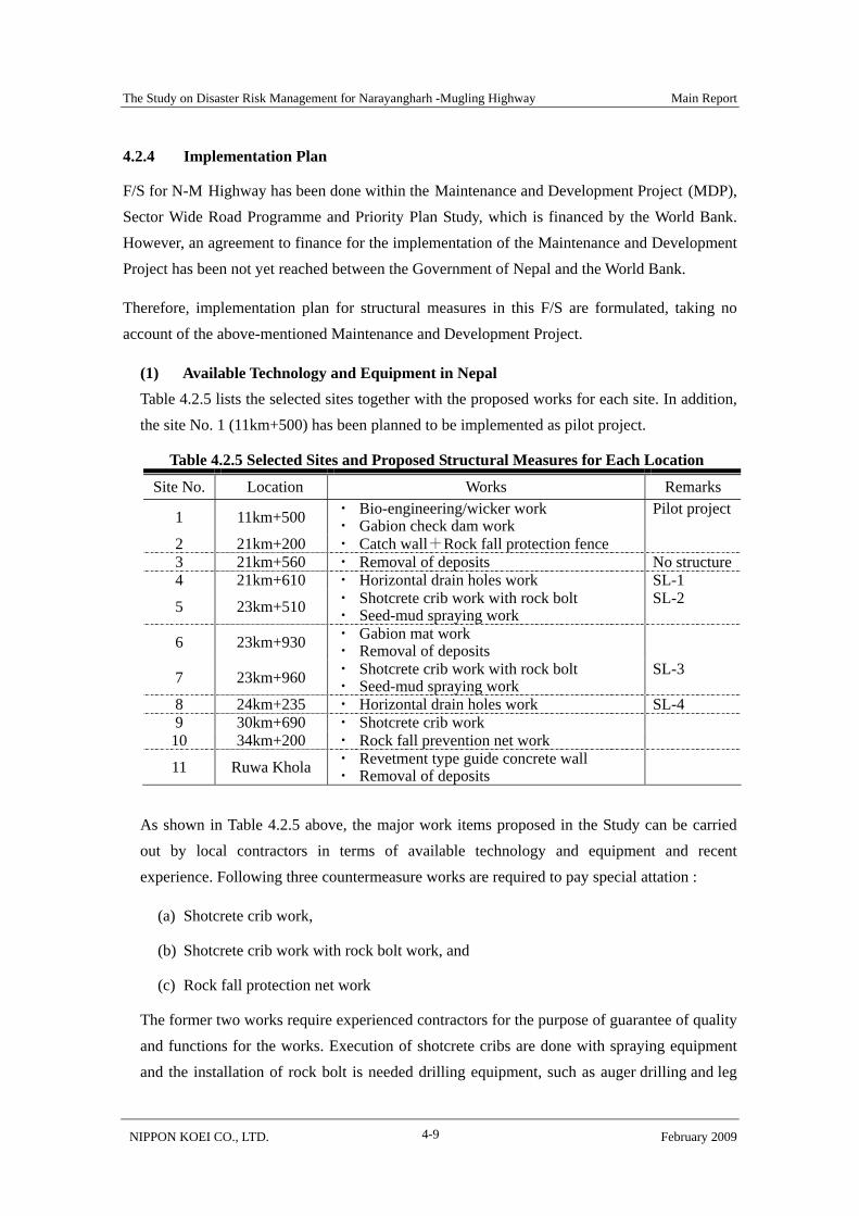
(1) Available Technology and Equipment in Nepal Table 4.2.5 lists the selected sites together with the proposed works for each site. In addition, the site No. 1 (11km+500) has been planned to be implemented as pilot project.
Table 4.2.5 Selected Sites and Proposed Structural Measures for Each Location
Site No. Location Works Remarks
1 11km+500 ・ Bio-engineering/wicker work ・ Gabion check dam work
Pilot project
2 21km+200 ・ Catch wall+Rock fall protection fence 3 21km+560 ・ Removal of deposits No structure4 21km+610 ・ Horizontal drain holes work SL-1
5 23km+510 ・ Shotcrete crib work with rock bolt ・ Seed-mud spraying work
SL-2
6 23km+930 ・ Gabion mat work ・ Removal of deposits
7 23km+960 ・ Shotcrete crib work with rock bolt ・ Seed-mud spraying work
SL-3
8 24km+235 ・ Horizontal drain holes work SL-4 9 30km+690 ・ Shotcrete crib work
10 34km+200 ・ Rock fall prevention net work
11 Ruwa Khola ・ Revetment type guide concrete wall ・ Removal of deposits
As shown in Table 4.2.5 above, the major work items proposed in the Study can be carried out by local contractors in terms of available technology and equipment and recent experience. Following three countermeasure works are required to pay special attation :
(a) Shotcrete crib work,
(b) Shotcrete crib work with rock bolt work, and
(c) Rock fall protection net work
The former two works require experienced contractors for the purpose of guarantee of quality and functions for the works. Execution of shotcrete cribs are done with spraying equipment and the installation of rock bolt is needed drilling equipment, such as auger drilling and leg

The Study on Disaster Risk Management for Narayangharh -Mugling Highway Main Report
NIPPON KOEI CO., LTD. February 2009 4-10
hammer drilling. Some local contractors have certain experience in the construction of shotcrete crib work under the supervision of international consultants.
Rock fall prevention net work is the preferred solution to mitigate the damage of rock fall, especially in mountainous countries like Nepal. Its application provides the opportunity to expand the base of the contractor’s experience in the country.
(2) Contract Packaging and Implementation Organization Certain works have been recommended to be subjected to international competitive bidding (ICB) mainly for technical reasons. Accordingly, the work is suggested to be divided into three contract packages, as shown in Table 4.2.6.
Table 4.2.6 Arrangement of Selected Sites for Implementation
Package Location Works Cost (mil.Rs)
Implementation organization
21km+200 ・ Catch wall + Protection fence 1.04 1 21km+610 ・ Horizontal drain holes 6.48
23km+930 ・ Gabion mat + Removal of deposit
1.82 DWIDP (LCP)
24km+235 ・ Horizontal drain holes work 2.00 Sub-total 11.34 23km+510 ・ Crib with rock bolt + Vegetation 29.63
2 23km+960 ・ Crib with rock bolt + Vegetation 142.05
30km+690 ・ Crib work + Vegetation 13.70 DOR (ICP/LCP)
34km+200 ・ Rock fall prevention net 6.98 Sub-total 192.36
3 Ruwa Khola ・ Guide concrete wall 18.37 Total 222.07
Package 1 and 3 will be constructed by local contractors. Package 2 will be implemented under both ICB and Local Competitive Bidding (LCB) because it includes some techniques that are not common to local contractors in Nepal.
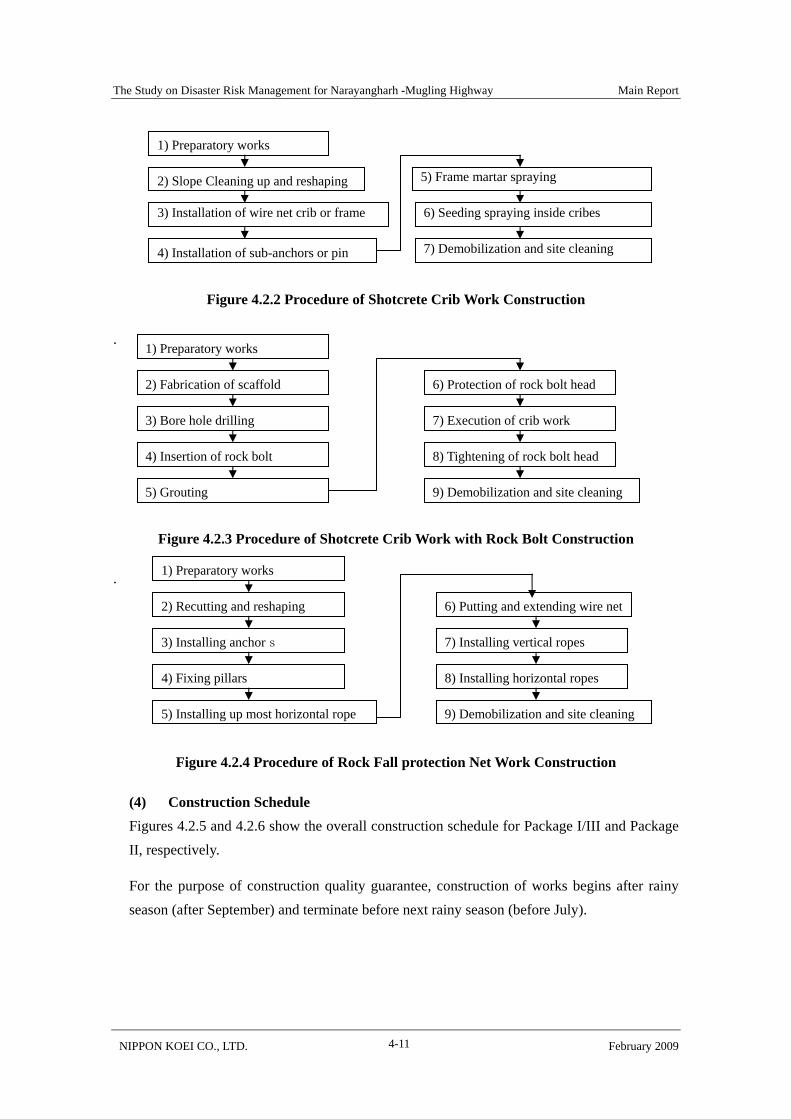
(3) Construction Procedures Most of the proposed works are common in Nepal. Local contractors have much experience in implementing them under the management of DWIDP or DOR. Therefore, construction procedures focus on crib work and rock fall protection net work, as shown in Figures 4.2.2 to 4.2.4.
The Study on Disaster Risk Management for Narayangharh -Mugling Highway Main Report
NIPPON KOEI CO., LTD. February 2009 4-11
Figure 4.2.2 Procedure of Shotcrete Crib Work Construction
.
Figure 4.2.3 Procedure of Shotcrete Crib Work with Rock Bolt Construction
.
Figure 4.2.4 Procedure of Rock Fall protection Net Work Construction
(4) Construction Schedule Figures 4.2.5 and 4.2.6 show the overall construction schedule for Package I/III and Package II, respectively.
For the purpose of construction quality guarantee, construction of works begins after rainy season (after September) and terminate before next rainy season (before July).
1) Preparatory works
2) Slope Cleaning up and reshaping
3) Installation of wire net crib or frame
4) Installation of sub-anchors or pin
5) Frame martar spraying
6) Seeding spraying inside cribes
7) Demobilization and site cleaning
1) Preparatory works
2) Fabrication of scaffold
3) Bore hole drilling
4) Insertion of rock bolt
5) Grouting
8) Tightening of rock bolt head
6) Protection of rock bolt head
9) Demobilization and site cleaning
7) Execution of crib work
1) Preparatory works
2) Recutting and reshaping
3) Installing anchors
4) Fixing pillars
5) Installing up most horizontal rope
8) Installing horizontal ropes
6) Putting and extending wire net
9) Demobilization and site cleaning
7) Installing vertical ropes
The Study on Disaster Risk Management for Narayangharh -Mugling Highway Main Report
NIPPON KOEI CO., LTD. February 2009 4-12
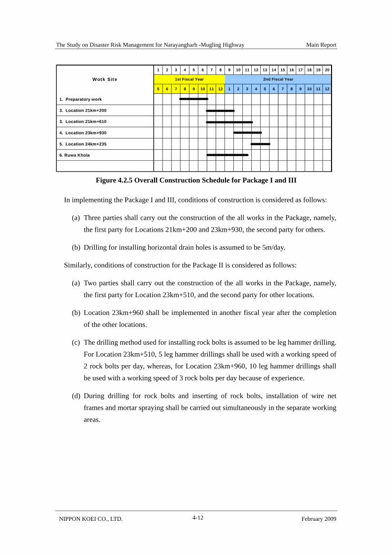
Figure 4.2.5 Overall Construction Schedule for Package I and III
In implementing the Package I and III, conditions of construction is considered as follows:
(a) Three parties shall carry out the construction of the all works in the Package, namely, the first party for Locations 21km+200 and 23km+930, the second party for others.
(b) Drilling for installing horizontal drain holes is assumed to be 5m/day.
Similarly, conditions of construction for the Package II is considered as follows:
(a) Two parties shall carry out the construction of the all works in the Package, namely, the first party for Location 23km+510, and the second party for other locations.
(b) Location 23km+960 shall be implemented in another fiscal year after the completion of the other locations.
(c) The drilling method used for installing rock bolts is assumed to be leg hammer drilling. For Location 23km+510, 5 leg hammer drillings shall be used with a working speed of 2 rock bolts per day, whereas, for Location 23km+960, 10 leg hammer drillings shall be used with a working speed of 3 rock bolts per day because of experience.
(d) During drilling for rock bolts and inserting of rock bolts, installation of wire net frames and mortar spraying shall be carried out simultaneously in the separate working areas.
1 2 3 4 5 6 7 8 9 10 11 12 13 14 15 16 17 18 19 20
5 6 7 8 9 10 11 12 1 2 3 4 5 6 7 8 9 10 11 12
1. Preparatory work
3. Location 21km+200
3. Location 21km+610
4. Location 23km+930
5. Location 24km+235
6. Ruwa Khola
2nd Fiscal YearWotk Site 1st Fiscal Year

The Study on Disaster R
isk Managem
ent for Narayangharh -M
ugling Highw
ay M
ain Report
NIPPO
N K
OEI C
O., LTD
.
February 2009 4-13
Figure 4.2.6 Overall Construction Schedule for Package II
1 2 3 4 5 6 7 8 9 10 11 12 13 14 15 16 17 18 19 20 21 22 23 24 25 26 27 28 29 30 31 32 33 34 35 36
1 2 3 4 5 6 7 8 9 10 11 12 1 2 3 4 5 6 7 8 9 10 11 12 1 2 3 4 5 6 7 8 9 10 11 12
1. Preparatory Work2. Location 23km+510 2.1 Cleaning up slope
2.2 Installation of Rock Bolt
2.3 Execution of crib
2.4 Tightening rock bolt head
3. Location 30km+690 3.1 Cleaning up slope
3.2 Installing wire net frame
3.3 Mortar sparying
4. Location 34km+200 4.1 Cutting work
4.2 Installing rock fall net
5. Location 23km+960 5.1 Preparatory work
5.2 Cleaning up slope
5.3 Installation of Rock Bolt
5.4 Execution of crib
5.5 Tightening rock bolt head
1st Fiscal Year 2nd Fiscal Year 3rd Fiscal YearWotk Item

The Study on Disaster Risk Management for Narayangharh -Mugling Highway Main Report
NIPPON KOEI CO., LTD. February 2009 4-14
4.3 Regular Maintenance and Quick Response
Measures to prevent occurrence of sediment related disasters have been constructed after 2003 disasters by DOR and DWIDP that improved drastically traffic function of N-M Highway. But, to keep this condition, continuous maintenance works are indispensable.
(1) Road maintenance including routine, recurrence, emergency
(2) Maintenance works for sabo dams in streams across the Highway
The system on road maintenance including routine maintenance, recurrence maintenance is already formulated by DOR and the road maintenance for the Highway is being executed steadily and successively. The outline of existing maintenance system is summarized referring the “Annual Road Maintenance Plan for 2008/2009 (Draft/Request)” prepared by Division Road Office Bharatpur, Chitwan and some recommendation on the system is described in this section.
On the other hand, maintenance system for sobo facilities is not established at present. Construction of check dams to prevent debris flows affecting traffic functions of the Highway started in 2004 and being implementing. These check dams are very effective at present that was proved by no road closure under heavy rainfall in 2006. But, the capacities of check dams are almost filled up by the 2006 debris deposits that will not be able to prevent the next debris flow induced by heavy rainfall in the near future. So, maintenance work for check dams is essential to keep the effectiveness to prevent road closure by debris flow.
Maintenance system for sabo facility is proposed in this section
4.3.1 Road Maintenance along with Annual Plan
Road maintenance works on sediment related disasters including routine maintenance and emergency maintenance for N-M Highway is executed by the Division Roads Office, Bharatpur along with “Annual Road Maintenance Plan” prepared in February 2008.
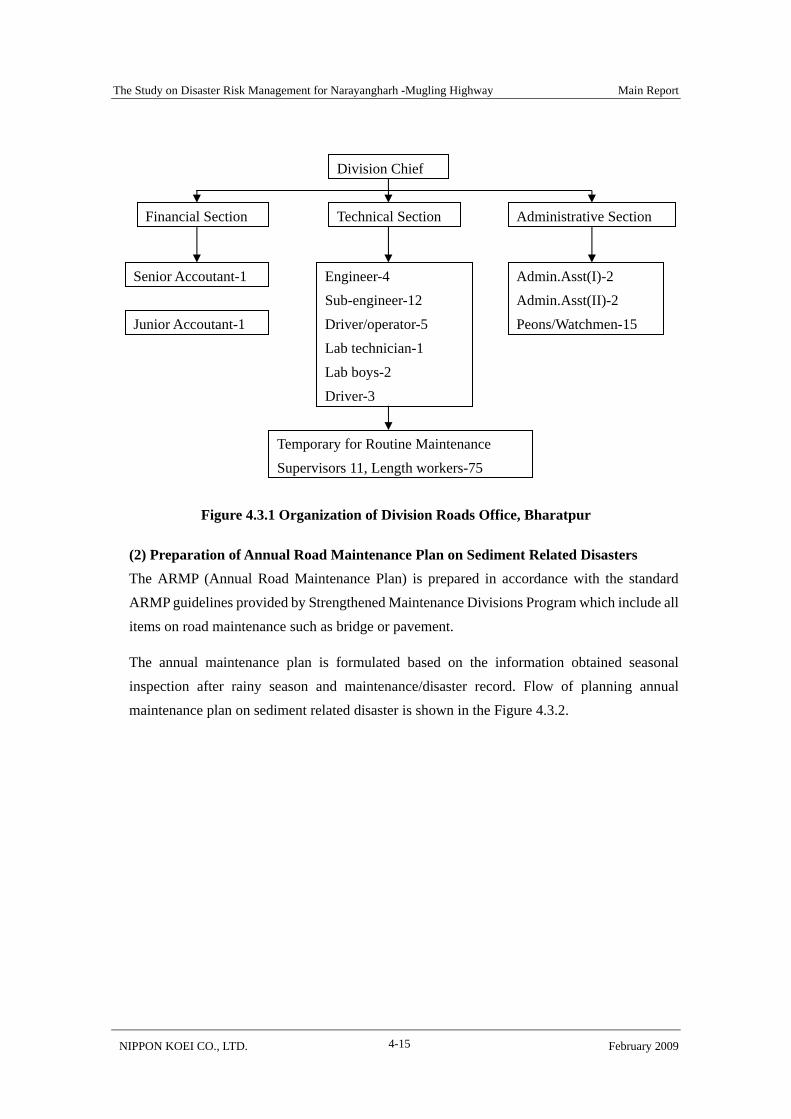
(1) Role of the Division Road Office, Bharatpur and its Organization Division Road Office, Bharatpur is responsible for maintaining strategic roads in Chitwan and Dhading districts. Roads being administrated by the Office are 264.27km of Strategic Network including 36.16km of N-M Highway. The Office is also involved in the construction of major bridges within these districts under the organization shown in the Figure 4.3.1.
The Study on Disaster Risk Management for Narayangharh -Mugling Highway Main Report
NIPPON KOEI CO., LTD. February 2009 4-15
Figure 4.3.1 Organization of Division Roads Office, Bharatpur
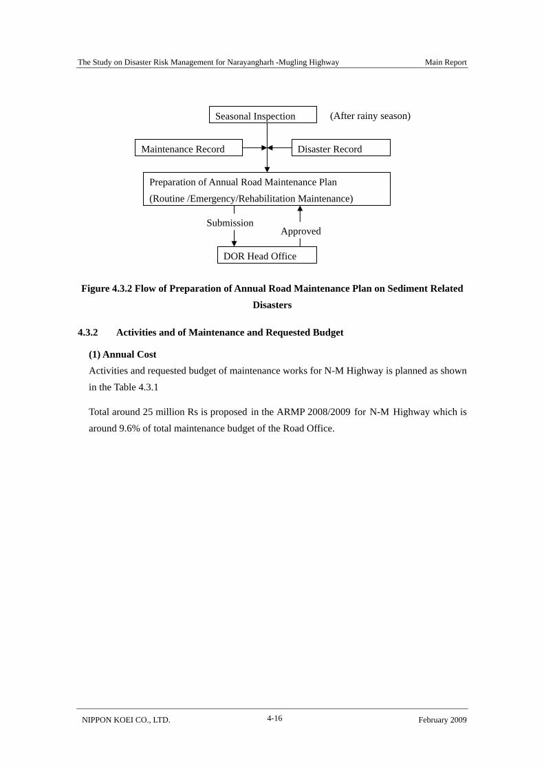
(2) Preparation of Annual Road Maintenance Plan on Sediment Related Disasters The ARMP (Annual Road Maintenance Plan) is prepared in accordance with the standard ARMP guidelines provided by Strengthened Maintenance Divisions Program which include all items on road maintenance such as bridge or pavement.
The annual maintenance plan is formulated based on the information obtained seasonal inspection after rainy season and maintenance/disaster record. Flow of planning annual maintenance plan on sediment related disaster is shown in the Figure 4.3.2.
Division Chief
Financial Section
Engineer-4 Sub-engineer-12 Driver/operator-5 Lab technician-1 Lab boys-2 Driver-3
Junior Accoutant-1
Admin.Asst(I)-2 Admin.Asst(II)-2 Peons/Watchmen-15
Technical Section Administrative Section
Senior Accoutant-1
Temporary for Routine Maintenance Supervisors 11, Length workers-75
The Study on Disaster Risk Management for Narayangharh -Mugling Highway Main Report
NIPPON KOEI CO., LTD. February 2009 4-16
Figure 4.3.2 Flow of Preparation of Annual Road Maintenance Plan on Sediment Related Disasters
4.3.2 Activities and of Maintenance and Requested Budget
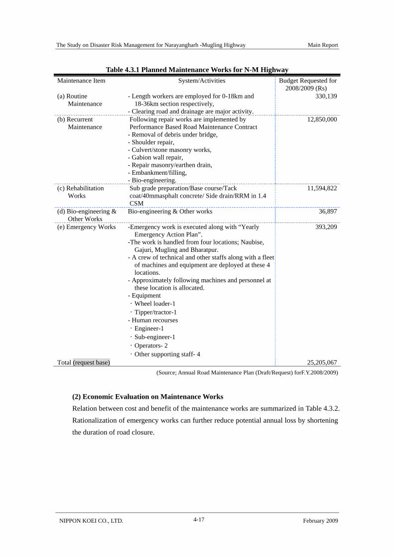
(1) Annual Cost Activities and requested budget of maintenance works for N-M Highway is planned as shown in the Table 4.3.1
Total around 25 million Rs is proposed in the ARMP 2008/2009 for N-M Highway which is around 9.6% of total maintenance budget of the Road Office.
Seasonal Inspection
Preparation of Annual Road Maintenance Plan (Routine /Emergency/Rehabilitation Maintenance)
DOR Head Office
Maintenance Record Disaster Record
Submission Approved
(After rainy season)
The Study on Disaster Risk Management for Narayangharh -Mugling Highway Main Report
NIPPON KOEI CO., LTD. February 2009 4-17
Table 4.3.1 Planned Maintenance Works for N-M Highway Maintenance Item System/Activities Budget Requested for
2008/2009 (Rs) (a) Routine
Maintenance - Length workers are employed for 0-18km and
18-36km section respectively, - Clearing road and drainage are major activity.
330,139
(b) Recurrent Maintenance
Following repair works are implemented by Performance Based Road Maintenance Contract
- Removal of debris under bridge, - Shoulder repair, - Culvert/stone masonry works, - Gabion wall repair, - Repair masonry/earthen drain, - Embankment/filling, - Bio-engineering.
12,850,000
(c) Rehabilitation Works
Sub grade preparation/Base course/Tack coat/40mmasphalt concrete/ Side drain/RRM in 1.4 CSM
11,594,822
(d) Bio-engineering & Other Works
Bio-engineering & Other works 36,897
(e) Emergency Works -Emergency work is executed along with “Yearly Emergency Action Plan”.
-The work is handled from four locations; Naubise, Gajuri, Mugling and Bharatpur.
- A crew of technical and other staffs along with a fleet of machines and equipment are deployed at these 4 locations.
- Approximately following machines and personnel at these location is allocated.
- Equipment ・Wheel loader-1 ・Tipper/tractor-1 - Human recourses ・Engineer-1 ・Sub-engineer-1 ・Operators- 2 ・Other supporting staff- 4
393,209
Total (request base) 25,205,067(Source; Annual Road Maintenance Plan (Draft/Request) forF.Y.2008/2009)
(2) Economic Evaluation on Maintenance Works Relation between cost and benefit of the maintenance works are summarized in Table 4.3.2. Rationalization of emergency works can further reduce potential annual loss by shortening the duration of road closure.

The Study on Disaster Risk Management for Narayangharh -Mugling Highway Main Report
NIPPON KOEI CO., LTD. February 2009 4-18
Table 4.3.2 Cost and Benefit of Maintenance and Emergency Works Cost
Requested for 2008/2009 (Rs)
Annual benefit 2009 (Rs)
Benefit Cost Ratio
Maintenance Upkeep benefit of road condition 1. Benefit by reduction of vehicle operation cost =10% of vehicle operation cost of a vehicle of the N-M highway x annual nos. of vehicles
115,178,835 Routine Maintenance
330,139 Recurrent Maintenance
12,850,000 Rehabilitation Works
11,594,822 Bio-engineering
36,897 2. Benefit by reduction of travel time =10% of travel time of a vehicle of the N-M highway x Unit value of traffic time of a vehicle x annual nos. of vehicles
30,091,641
5.2
Total 24,811,858
Total 145,270,477
Emergency Works 393,209 50% of potential annual loss of traffic
suspension (Rs 105,109,585) 52,554,793 134
4.3.3 Recommendation on Road Maintenance Works
(1) Sites necessary to take special attention in routine maintenance Locations and viewpoints taken with special attention for sites are shown in the Table 4.3.3.
Table 4.3.3 Sites Need Attention in Seasonal inspection Location Disaster Type Hazard Condition/Check Points 26km+700 landslide continuous cracks by landslide
movement on the road 27km+050 landslide continuous cracks by landslide
movement on the road Anchor installation locations Sta24+025, Sta24+600 etc
sinking of embankment
(2) Utilizing of Road Early Information System for Emergency Works Reopening works or soil removal in emergency works is being carried out by Mugling camp, Gajuri camp, and Naubise camp, where heavy machines for soil works are deployed. Heavy machines of the camps are not sufficient for serious slope disasters, hence, machines shall be used efficiently. Monitoring by automatic raingauge suggests probability of occurrence of road slope disasters. It is recommended to prepare urgent response team when value reaches 12-hour half- rainfall amount = 60mm (One year return period). Earlier preparation and flexible operation of machines in three camps hastens reopening of road works. It seems that recording and compilation of road maintenance is not systematic. Recording of
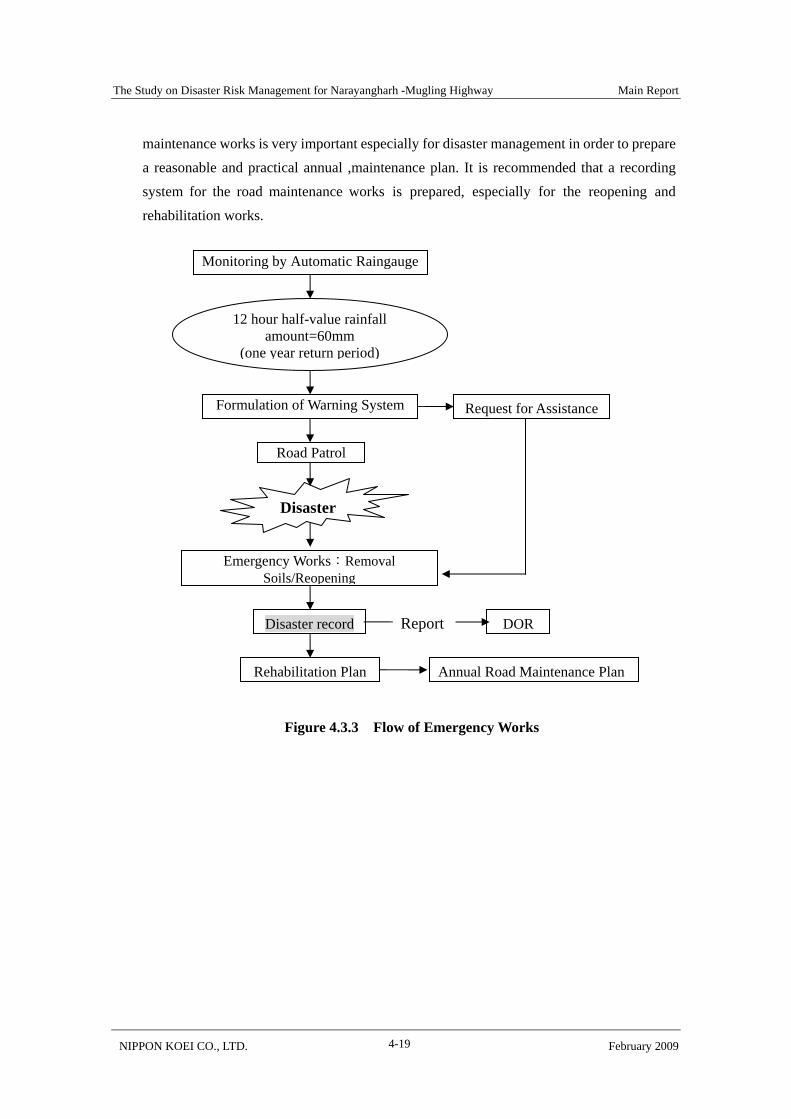
The Study on Disaster Risk Management for Narayangharh -Mugling Highway Main Report
NIPPON KOEI CO., LTD. February 2009 4-19
maintenance works is very important especially for disaster management in order to prepare a reasonable and practical annual ,maintenance plan. It is recommended that a recording system for the road maintenance works is prepared, especially for the reopening and rehabilitation works.
Monitoring by Automatic Raingauge
12 hour half-value rainfall amount=60mm
(one year return period)
Formulation of Warning System
Road Patrol
Disaster
Emergency Works:Removal Soils/Reopening
Disaster record DOR
Rehabilitation Plan Annual Road Maintenance Plan
Figure 4.3.3 Flow of Emergency Works
Report
Request for Assistance
The Study on Disaster Risk Management for Narayangharh -Mugling Highway Main Report
NIPPON KOEI CO., LTD. February 2009 4-20
4.4 Maintenance of Sabo Facilities
Mugling – Narayangharh Water Induced Disaster Prevention Project (MNWIDPP) implemented under DWIDP involves construction of sabo dams since 2004 in crossing streams that affect N-M Highway. Effectiveness of these facilities has been demonstrated during the 2006 heavy rainfall when no serious traffic disturbance happened. However, dams had been filled up with deposits due to this heavy rainfall, consequently deteriorating function of the sabo dams.
It should be noted that maintenance works of sabo facilities is very important to maintain the intended traffic flow along the highway.
4.4.1 Implementation organization
The implementing organization for maintenance works for sabo dam is DWIDP.
4.4.2 Major Maintenance Works of Sabo Dams
In order to maintain the functions of the existing sabo dams, the following two plans should be implemented:
• Removal of deposits • Repair of damaged sabo facilities
(1) Removal of Deposits Because of limited sedimentation capacity, the existing sabo dams have been malfunctioned with sedimentation behind the dam. In order to protect the traffic safety from debris flow, construction of new sabo dams or functional recovery of existing sabo dams are necessary. In generally, the functional recovery of an existing sabo dam by removing the overall or partial deposits behind the dams are much cheaper than construction of a new sabo dam, especially with respect to mountain roads. The functional recovery of an existing sabo dam by removing deposits is one of the most important and cost-effective methods for sabo dams.
A number of sabo dams were constructed by DWIDP after the 2003 disaster. These sabo dams considerably contributed to mitigation of disasters in the 2006 heavy rainfall. However, these sabo dams were mostly filled up with deposits and had not enough capacity to cope with the next large disaster such as the 2003 or 2006 disasters. Therefore, the functional recovery for the existing sabo dams by removing deposits should be done immediately and continuously.
(2) Repair of Sabo Facilities Based on field inspection, the existing sabo dams and other sabo facilities had some damage
The Study on Disaster Risk Management for Narayangharh -Mugling Highway Main Report
NIPPON KOEI CO., LTD. February 2009 4-21
and defects as follows:
• Damage of gabion mesh wire • No foundation work for dam body were executed • Settlement and inclination of dam body due to scouring of foundation • No protection on the crest part of gabion sabo dams from damaging by debris flow
deposits was made
• Flow sections near the road were not enough to discharge the expected debris flow • Others
Without repair of the above-mentioned damage and defects, the existing sabo facilities could not show the original function and capacity. This probably caused the occurrence of damage.
In this Study, the potential annual loss estimation and hazard evaluation was done on the condition that the existing sabo facilities had the originally designed functions and capacity. If repair of sabo facilities were not done, the present effectiveness of the existing sabo facilities would be very small or zero, and therefore new sabo facilities as alternative facilities should be implemented.
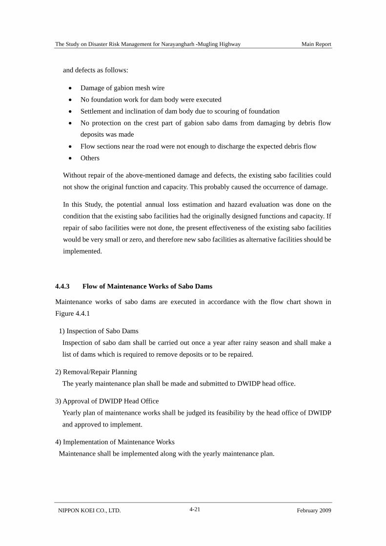
4.4.3 Flow of Maintenance Works of Sabo Dams
Maintenance works of sabo dams are executed in accordance with the flow chart shown in Figure 4.4.1
1) Inspection of Sabo Dams Inspection of sabo dam shall be carried out once a year after rainy season and shall make a
list of dams which is required to remove deposits or to be repaired.
2) Removal/Repair Planning The yearly maintenance plan shall be made and submitted to DWIDP head office.
3) Approval of DWIDP Head Office Yearly plan of maintenance works shall be judged its feasibility by the head office of DWIDP
and approved to implement.
4) Implementation of Maintenance Works Maintenance shall be implemented along with the yearly maintenance plan.
The Study on Disaster Risk Management for Narayangharh -Mugling Highway Main Report
NIPPON KOEI CO., LTD. February 2009 4-22
Figure 4.4.1 Flow of Maintenance Works for Sabo Dams
4.4.4 Outline of Removal of Deposits
(1) Selection of priority crossing streams Sabo dams subjected to removal of deposits were as follows:
• Sabo dams within about 100 m far from the road, in consideration of the easy access and these dam having mainly catch capacity of deposits
• Sabo dams in the upstream were excluded because they had the same function as embankment to protect the toe failure of slope
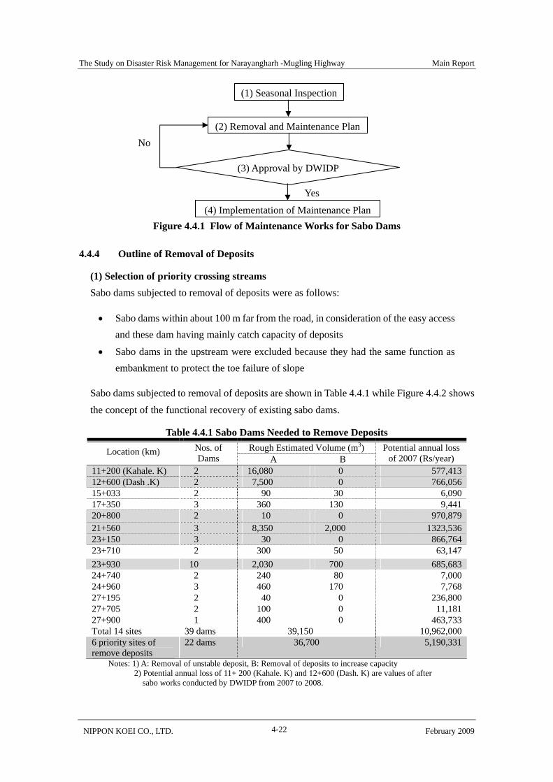
Sabo dams subjected to removal of deposits are shown in Table 4.4.1 while Figure 4.4.2 shows the concept of the functional recovery of existing sabo dams.
Table 4.4.1 Sabo Dams Needed to Remove Deposits Rough Estimated Volume (m3) Location (km) Nos. of
Dams A B Potential annual loss
of 2007 (Rs/year) 11+200 (Kahale. K) 2 16,080 0 577,41312+600 (Dash .K) 2 7,500 0 766,05615+033 2 90 30 6,09017+350 3 360 130 9,44120+800 2 10 0 970,87921+560 3 8,350 2,000 1323,53623+150 3 30 0 866,76423+710 2 300 50 63,14723+930 10 2,030 700 685,68324+740 2 240 80 7,00024+960 3 460 170 7,76827+195 2 40 0 236,80027+705 2 100 0 11,18127+900 1 400 0 463,733Total 14 sites 39 dams 39,150 10,962,0006 priority sites of remove deposits
22 dams 36,700 5,190,331
Notes: 1) A: Removal of unstable deposit, B: Removal of deposits to increase capacity 2) Potential annual loss of 11+ 200 (Kahale. K) and 12+600 (Dash. K) are values of after
sabo works conducted by DWIDP from 2007 to 2008.
(1) Seasonal Inspection
(2) Removal and Maintenance Plan
(3) Approval by DWIDP
(4) Implementation of Maintenance Plan
No
Yes

The Study on Disaster Risk Management for Narayangharh -Mugling Highway Main Report
NIPPON KOEI CO., LTD. February 2009 4-23
Six sites which potential annual loss of 2007 are over 0.5 mil. Rs/year progress the sedimentation of sand/debris. After 10-year risk (potential annual loss) will be two times of the present which is over 1.0 mil. Rs/year. Hence, the six sites are prioritized for the removal of deposit.
Figure 4.4.2 Location of Sabo Dams Needed to Remove Deposits
Figure 4.4.3 Conceptual Illustration of Functional Recovery for Sabo Dam
(2) Economic Evaluation Sand removal is planned for the six priority sites which cross streams once every ten years.
Original streambed lineSabo dam
A: Removal of unstable depositsB: Removal of deposits to increase capacity
A
B
(1)11km+280
(5)20km+800 (6)21km+560
(14)27km+900(7)23km+150
(8)23km+710
(10)24km+740
(2)12km+600
(3)15km+033
(9)23km+930
(4)17km+350
(11)24km+960
(13)27km+705(12)27km+195
(1)11km+280
(5)20km+800 (6)21km+560
(14)27km+900(7)23km+150
(8)23km+710
(10)24km+740
(2)12km+600
(3)15km+033
(9)23km+930
(4)17km+350
(11)24km+960
(13)27km+705(12)27km+195
(1) 11km+200

The Study on Disaster Risk Management for Narayangharh -Mugling Highway Main Report
NIPPON KOEI CO., LTD. February 2009 4-24
Amount of deposit is 36,700 m3 of the six crossing streams. Annual cost is determined as follows:
Deposit removal cost is 1.0 mil Rs/year (280 Rs/ m3)
Annual benefit is estimated as 1/4 of potential annual loss and 1.3 mil. Rs/year, because benefit of the after deposit removal is 1/2, but which is zero in ten years. Since annual benefit is bigger than the annual cost, the programme is determined economically feasible.
4.4.5 Repair of Sabo Facilities
Inventory survey on sabo facilities along N-M highway was carried out under MNWIDPP in the first half of 2008. A total of 251 facilities including concrete sabo dams, gabion check dams catch drainages, retaining walls, spurs, toewalls/chute/cascade, horizontal drainage and bioengineering works were surveyed. Result of surveyed is shown in Figure 4.4.4 (source: Contract No: MNWIDPP-C-01/064/65 Preparation of Asset Inventory of MNWIDPP).
Figure 4.4.4 Result of Inventory Survey on Facility of Disaster Preventive Works
It was found during the survey that six facilities were already damaged, 14 facilities lost their have totally become non-functional and thirty 39 are potentially loosing their preventive function. For these facilities, annual maintenance plan shall be implemented in order to retain their preventive purpose.
N=251
5: Very good,n=64, 25%
4: Good,n=128, 51%
3: Needmonitoring,n=39, 16%
1: Need urgentrepairing,n=6, 2%
2: Needrepairing,n=14, 6%
The Study on Disaster Risk Management for Narayangharh -Mugling Highway Main Report
NIPPON KOEI CO., LTD. February 2009 4-25
4.5 Road Early Information System
4.5.1 Purpose
The objectives of formulation of the Road Early Information System are:
• To prevent loss of human lives as well as vehicles subjected to road slope disasters,
• To reduce traffic congestion by disseminating early road information to drivers.
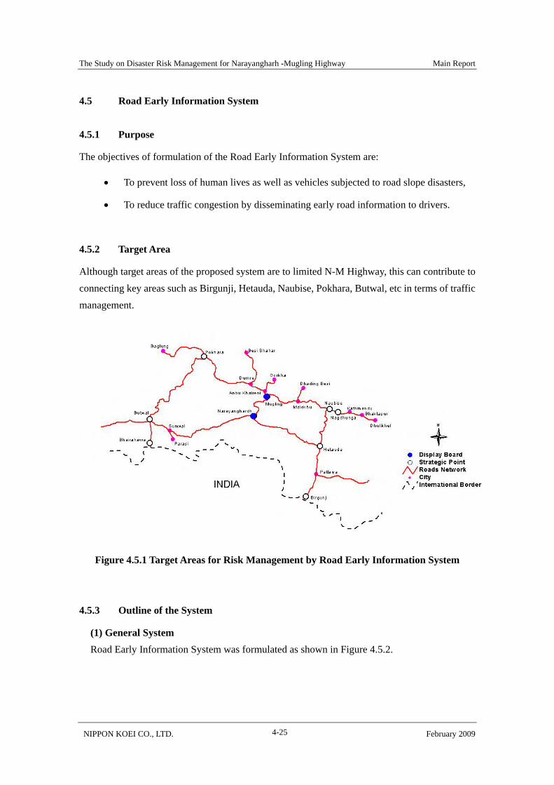
4.5.2 Target Area
Although target areas of the proposed system are to limited N-M Highway, this can contribute to connecting key areas such as Birgunji, Hetauda, Naubise, Pokhara, Butwal, etc in terms of traffic management.
Figure 4.5.1 Target Areas for Risk Management by Road Early Information System
4.5.3 Outline of the System
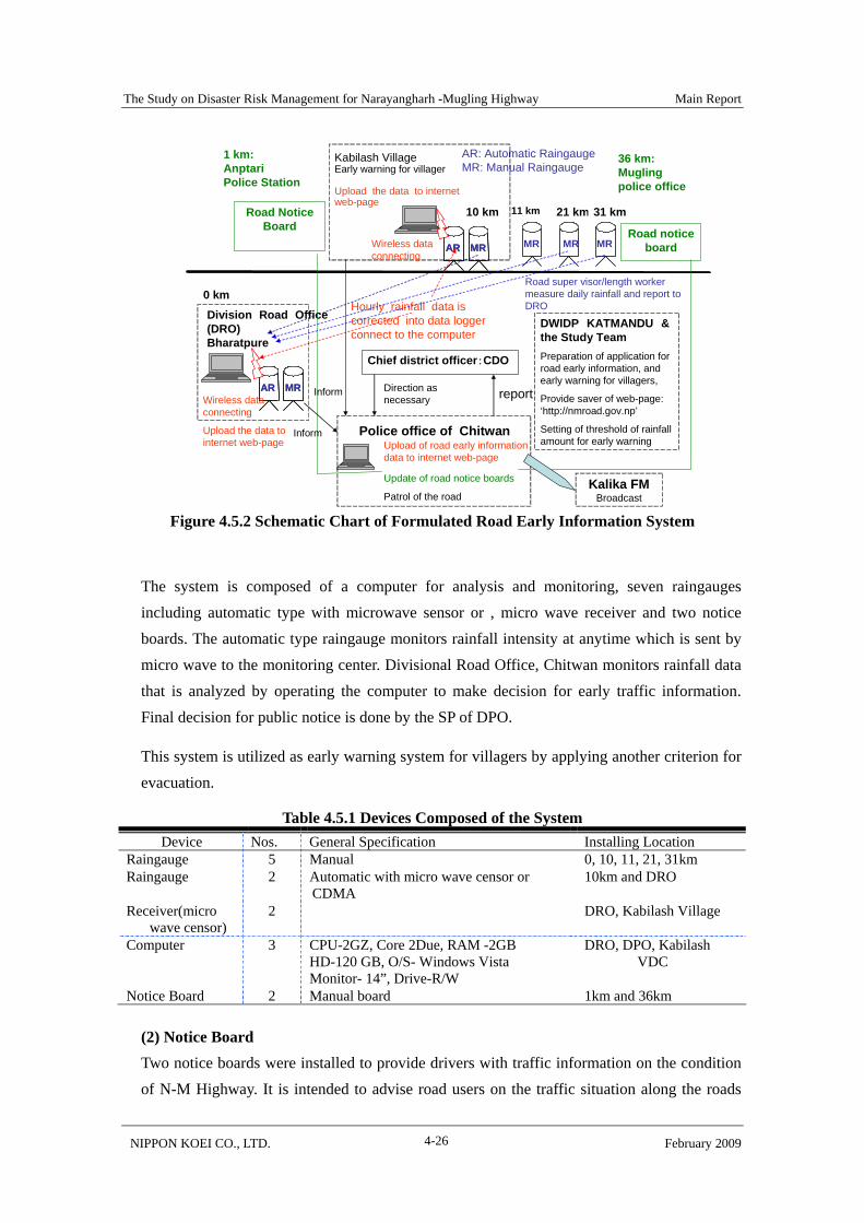
(1) General System Road Early Information System was formulated as shown in Figure 4.5.2.
The Study on Disaster Risk Management for Narayangharh -Mugling Highway Main Report
NIPPON KOEI CO., LTD. February 2009 4-26
Figure 4.5.2 Schematic Chart of Formulated Road Early Information System
The system is composed of a computer for analysis and monitoring, seven raingauges including automatic type with microwave sensor or , micro wave receiver and two notice boards. The automatic type raingauge monitors rainfall intensity at anytime which is sent by micro wave to the monitoring center. Divisional Road Office, Chitwan monitors rainfall data that is analyzed by operating the computer to make decision for early traffic information. Final decision for public notice is done by the SP of DPO.
This system is utilized as early warning system for villagers by applying another criterion for evacuation.
Table 4.5.1 Devices Composed of the System Device Nos. General Specification Installing Location
Raingauge 5 Manual 0, 10, 11, 21, 31km Raingauge 2 Automatic with micro wave censor or
CDMA 10km and DRO
Receiver(micro wave censor)
2 DRO, Kabilash Village
Computer 3 CPU-2GZ, Core 2Due, RAM -2GB HD-120 GB, O/S- Windows Vista Monitor- 14”, Drive-R/W
DRO, DPO, Kabilash VDC
Notice Board 2 Manual board 1km and 36km
(2) Notice Board Two notice boards were installed to provide drivers with traffic information on the condition of N-M Highway. It is intended to advise road users on the traffic situation along the roads
Division Road Office (DRO)Bharatpure
10 km 21 km 31 km
Chief district officer:CDO
AR: Automatic RaingaugeMR: Manual Raingauge
Road notice board
Road Notice Board
1 km: Anptari Police Station
36 km:Mugling police office
AR MRAR MR MR MR
Kabilash VillageEarly warning for villager
Upload the data to internet web-page
Hourly rainfall data is corrected into data logger connect to the computer
AR MRAR MR
DWIDP KATMANDU & the Study TeamPreparation of application for road early information, and early warning for villagers,
Provide saver of web-page: ‘http://nmroad.gov.np’
Setting of threshold of rainfall amount for early warning
Road super visor/length worker measure daily rainfall and report to DRO
Police office of Chitwan
reportDirection as necessary
Upload of road early information data to internet web-page
Update of road notice boards
Patrol of the road
11 km
MR
0 km
Wireless data connecting
Wireless data connecting
Upload the data to internet web-page
Inform
Inform
Kalika FMBroadcast
The Study on Disaster Risk Management for Narayangharh -Mugling Highway Main Report
NIPPON KOEI CO., LTD. February 2009 4-27
that they need to pass through as shown in the Table 4.5.2.
Table 4.5.2 Contents of Road Early Information Traffic obstacle
status Section of traffic obstacle
Predicted duration of the obstacle Phenomena
Road closure Traffic jam
- Slope disaster - Traffic accident - Strike - The other
Potential road closure/traffic jam
From xx Hour xx Day xx Month 2008 Until xx Hour xx Day xx Month 2008 or Not clear of duration
- Schedule of strike - The other
Early warning/caution by heavy rain
From CH xx To xx
From xx Hour xx Day xx Month 2008
- Notice by threshold of 12 hour half-value rainfall amount
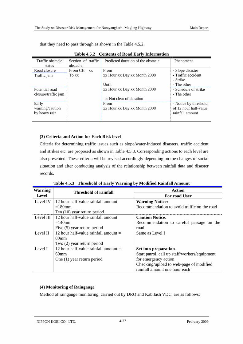
(3) Criteria and Action for Each Risk level Criteria for determining traffic issues such as slope/water-induced disasters, traffic accident and strikes etc. are proposed as shown in Table 4.5.3. Corresponding actions to each level are also presented. These criteria will be revised accordingly depending on the changes of social situation and after conducting analysis of the relationship between rainfall data and disaster records.
Table 4.5.3 Threshold of Early Warning by Modified Rainfall Amount Action Warning
Level Threshold of rainfall
For road User Level IV
12 hour half-value rainfall amount =180mm Ten (10) year return period
Warning Notice: Recommendation to avoid traffic on the road
Level III 12 hour half-value rainfall amount =140mm Five (5) year return period
Caution Notice: Recommendation to careful passage on the road
Level II
12 hour half-value rainfall amount = 80mm Two (2) year return period
Same as Level I
Level I
12 hour half-value rainfall amount = 60mm One (1) year return period
Set into preparation Start patrol, call up staff/workers/equipment for emergency action Checking/upload to web-page of modified rainfall amount one hour each
(4) Monitoring of Raingauge Method of raingauge monitoring, carried out by DRO and Kabilash VDC, are as follows:
The Study on Disaster Risk Management for Narayangharh -Mugling Highway Main Report
NIPPON KOEI CO., LTD. February 2009 4-28
(a) Automatic Raingauge Monitoring of the automatic raingauge is carried out in the following manner.
12 hour rainfall amount is less than 60mm: checked once a day 12 hour rainfall is over 60mm: check every time
(b) Manual Raingauge Monitoring of manual raingauges is performed once a day.
(5) Monitoring of Traffic Condition Traffic incidents, road blockade by strike, abnormal condition of the road and road slopes are reported by drivers and pedestrians to DPO and DRO.
4.5.4 Organization Formed to Operate the System
(1) Tasks of Chitwan District Disaster Management Partnership Committee “Chitwan District Disaster Management Partnership Committee” was formulated. The committee executes general management and make plan of operation of the system.
Chairman of the committee the CDO, Chitwan and members are composed of SP of Division Police office, the chief of Division Road Office Bharatpur, Chitwan, representative of MNWIDPP and /or No3. Division of DWIDP, representative of the press and, etc.
Role and activities of the committee are as follows;
Decide on methods of disseminating traffic information
Discuss and determine risk level and information criteria
Preparation of manuals and leaflets regarding the system
Public relation on Road Early Information System through the press and mass media
(2) Roles of Concerned Major Organization Chief of Divisional Office, Divisional Police Office, Divisional Road Office and Kabilash VDC are major players to operate the Road Early Information System. Their roles to operate the system are as follows:
1) CDO CDO is the chairperson who manages the committee totally and makes final decision of operation plan.

The Study on Disaster Risk Management for Narayangharh -Mugling Highway Main Report
NIPPON KOEI CO., LTD. February 2009 4-29
2) DPO Roles of DPO are as follows
Superintendent of Police (SP) of DPO recommends deciding the appropriate public notice for risk level III (Caution Notice) and risk level IV (Warning Notice).
After decision is made for risk levels III and IV, SP orders the traffic police to display advise on the notice board
Upload the early warning/traffic condition to the web page Inform traffic condition to Kalika FM Maintenance of computer Instruct drivers on matters of traffic control policy and conduct
3) DRO DRO monitors five (one automatic and four manual) raingauges and analyzes rainfall monitoring data by operating computer. Roles of DRO are follows.
Monitors and maintains designated devices namely, five raingauges and a computer Analyzes monitoring data to determine the time to post notice regarding risk levels
III and IV Reports to DPO regarding rainfall monitoring and analyzed results, and
recommends posting risk level III and IV notice. 4) Kabilash VDC Kabilash VDC monitors two raingauges and analyzes rainfall monitoring data by operating central computer. Roles of Kabilash VDC are follows.
Monitors and maintains designated devices namely, four raingauges and a computer Analyzes monitoring data to determine the time to post notice regarding risk levels
III and IV Reports to DPO regarding rainfall monitoring and analyzed results and recommends
posting risk levels III and IV notice 5) DWIDP, Mugling-Narayangharh Water Induced Disaster Prevention Project (MNWIDPP) and/or Division No.3 office
Formulate/revise Road Early Information System on road slope disaster Support Kabilash Village in monitoring rainfall
4.5.5 Cost and Economical Evaluation of the System
(1) Cost
Cost of the system in 20 years from 2008 is shown in Table 4.5.4. Annual cost is 150,000
The Study on Disaster Risk Management for Narayangharh -Mugling Highway Main Report
NIPPON KOEI CO., LTD. February 2009 4-30
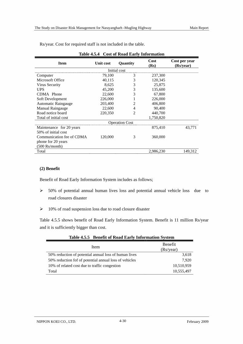
Rs/year. Cost for required staff is not included in the table.
Table 4.5.4 Cost of Road Early Information
Item Unit cost Quantity Cost (Rs)
Cost per year (Rs/year)
Initial cost Computer 79,100 3 237,300 Microsoft Office 40,115 3 120,345 Virus Security 8,625 3 25,875 UPS 45,200 3 135,600 CDMA Phone 22,600 3 67,800 Soft Development 226,000 1 226,000 Automatic Raingauge 203,400 2 406,800 Manual Raingauge 22,600 4 90,400 Road notice board 220,350 2 440,700 Total of initial cost 1,750,820
Operation Cost Maintenance for 20 years 50% of initial cost
875,410 43,771
Communication fee of CDMA phone for 20 years (500 Rs/month)
120,000 3 360,000
Total 2,986,230 149,312
(2) Benefit
Benefit of Road Early Information System includes as follows;
50% of potential annual human lives loss and potential annual vehicle loss due to road closures disaster
10% of road suspension loss due to road closure disaster
Table 4.5.5 shows benefit of Road Early Information System. Benefit is 11 million Rs/year and it is sufficiently bigger than cost.
Table 4.5.5 Benefit of Road Early Information System
Item Benefit (Rs/year)
50% reduction of potential annual loss of human lives 3,618 50% reduction fof of potential annual loss of vehicles 7,920 10% of related cost due to traffic congestion 10,510,959 Total 10,555,497
The Study on Disaster Risk Management for Narayangharh -Mugling Highway Main Report
NIPPON KOEI CO., LTD. February 2009 4-31
4.6 Disaster Mitigation Activities in Communities
4.6.1 Purpose
The objectives of disaster mitigation activities in communities are to:
Mitigate the hazard condition of the higher portion of the slopes which are affecting occurrence of debris flow and landslide,
Reduce casualties caused by slope/water induced disasters by initiating Early Warning/ Evacuation System.
Formulate system on self and mutual assistance for disaster mitigation
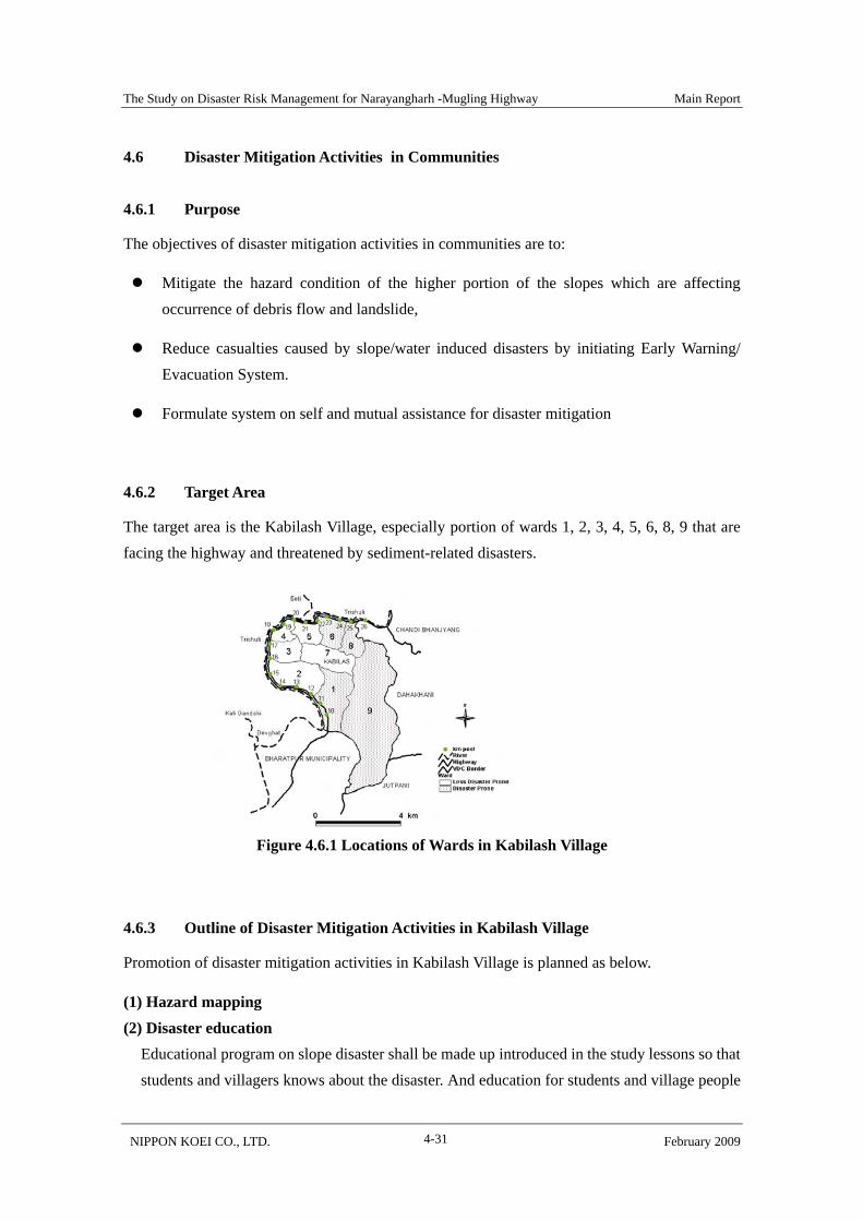
4.6.2 Target Area
The target area is the Kabilash Village, especially portion of wards 1, 2, 3, 4, 5, 6, 8, 9 that are facing the highway and threatened by sediment-related disasters.
Figure 4.6.1 Locations of Wards in Kabilash Village
4.6.3 Outline of Disaster Mitigation Activities in Kabilash Village
Promotion of disaster mitigation activities in Kabilash Village is planned as below.
(1) Hazard mapping (2) Disaster education
Educational program on slope disaster shall be made up introduced in the study lessons so that students and villagers knows about the disaster. And education for students and village people
The Study on Disaster Risk Management for Narayangharh -Mugling Highway Main Report
NIPPON KOEI CO., LTD. February 2009 4-32
shall be carried out once a year before rainy season.
(3) Early Warning/ Evacuation System Utilizing Road Early Information System, Early Warning/ Evacuation System for evacuation has been formulated as shown in the 4.6.2. Warning criteria is set considering the rainfall intensity analysis and hazard condition of the village.
(4) Simple structural measures A simple slope protection works for upper slopes of 11km+500 has been implemented as a model case of slope protection works executed by village people.
(5) Forestation planning and countermeasure planning Plan of planting trees for on slopes was made considering the forest condition of the village.
This plan is implemented in cooperation with through the “Project on Disaster Preparedness and Sustainable Livelihood Development Project, Chitwan District, Nepal” which is jointly implementing by NPO Shaplaneer/ NGO Rural Reconstruction Nepal (hereinafter described as RRN) joint project team starting from September 2007. This project is mainly composed of two major programs that is; a) income generation with finance/saving system and b) disaster mitigation.
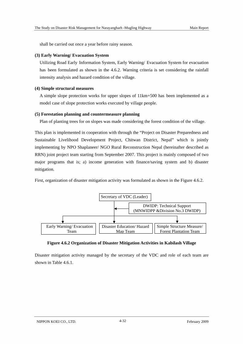
First, organization of disaster mitigation activity was formulated as shown in the Figure 4.6.2.
Figure 4.6.2 Organization of Disaster Mitigation Activities in Kabilash Village
Disaster mitigation activity managed by the secretary of the VDC and role of each team are shown in Table 4.6.1.
Secretary of VDC (Leader)
Early Warning/ Evacuation Team
Disaster Education/ Hazard Map Team
DWIDP: Technical Support (MNWIDPP &Division No.3 DWIDP)
Simple Structure Measure/ Forest Plantation Team
The Study on Disaster Risk Management for Narayangharh -Mugling Highway Main Report
NIPPON KOEI CO., LTD. February 2009 4-33
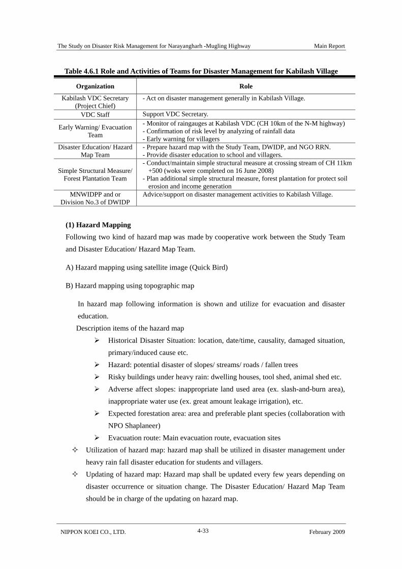
Table 4.6.1 Role and Activities of Teams for Disaster Management for Kabilash Village
Organization Role
Kabilash VDC Secretary (Project Chief)
- Act on disaster management generally in Kabilash Village.
VDC Staff Support VDC Secretary.
Early Warning/ Evacuation Team
- Monitor of raingauges at Kabilash VDC (CH 10km of the N-M highway) - Confirmation of risk level by analyzing of rainfall data - Early warning for villagers
Disaster Education/ Hazard Map Team
- Prepare hazard map with the Study Team, DWIDP, and NGO RRN. - Provide disaster education to school and villagers.
Simple Structural Measure/ Forest Plantation Team
- Conduct/maintain simple structural measure at crossing stream of CH 11km +500 (woks were completed on 16 June 2008)
- Plan additional simple structural measure, forest plantation for protect soil erosion and income generation
MNWIDPP and or Division No.3 of DWIDP
Advice/support on disaster management activities to Kabilash Village.
(1) Hazard Mapping Following two kind of hazard map was made by cooperative work between the Study Team and Disaster Education/ Hazard Map Team.
A) Hazard mapping using satellite image (Quick Bird)
B) Hazard mapping using topographic map
In hazard map following information is shown and utilize for evacuation and disaster education. Description items of the hazard map
Historical Disaster Situation: location, date/time, causality, damaged situation, primary/induced cause etc.
Hazard: potential disaster of slopes/ streams/ roads / fallen trees Risky buildings under heavy rain: dwelling houses, tool shed, animal shed etc. Adverse affect slopes: inappropriate land used area (ex. slash-and-burn area),
inappropriate water use (ex. great amount leakage irrigation), etc. Expected forestation area: area and preferable plant species (collaboration with
NPO Shaplaneer) Evacuation route: Main evacuation route, evacuation sites
Utilization of hazard map: hazard map shall be utilized in disaster management under heavy rain fall disaster education for students and villagers.
Updating of hazard map: Hazard map shall be updated every few years depending on disaster occurrence or situation change. The Disaster Education/ Hazard Map Team should be in charge of the updating on hazard map.

The Study on Disaster Risk Management for Narayangharh -Mugling Highway Main Report
NIPPON KOEI CO., LTD. February 2009 4-34
(2) Disaster Education Disaster education for villagers and students shall be carried out continuously once a year before rainy season. Program for education is as below.
A) Program for villagers:
Review of past disasters and awareness of dangerous area; utilizing hazard map
Early Warning/ Evacuation System of Kabilash Village
Site visits
B) Program for students (Class 5)
Basic knowledge on sediment-related disasters
Map reading
Rainfall related with water induced disasters
Early Warning/ Evacuation System of Kabilash Village
Leaders of Kabilash VDC shall be instructors for education for villagers supported by staffs of DWIDP. And, teachers of each school shall be instructors for students.
(3) Formulation/operation of Early Warning/ Evacuation System The project set one (1) automatically recording raingauge, and one (1) non-recoding raingauge, and formulate & operate Early Warning/ Evacuation System.
The Study on Disaster Risk Management for Narayangharh -Mugling Highway Main Report
NIPPON KOEI CO., LTD. February 2009 4-35
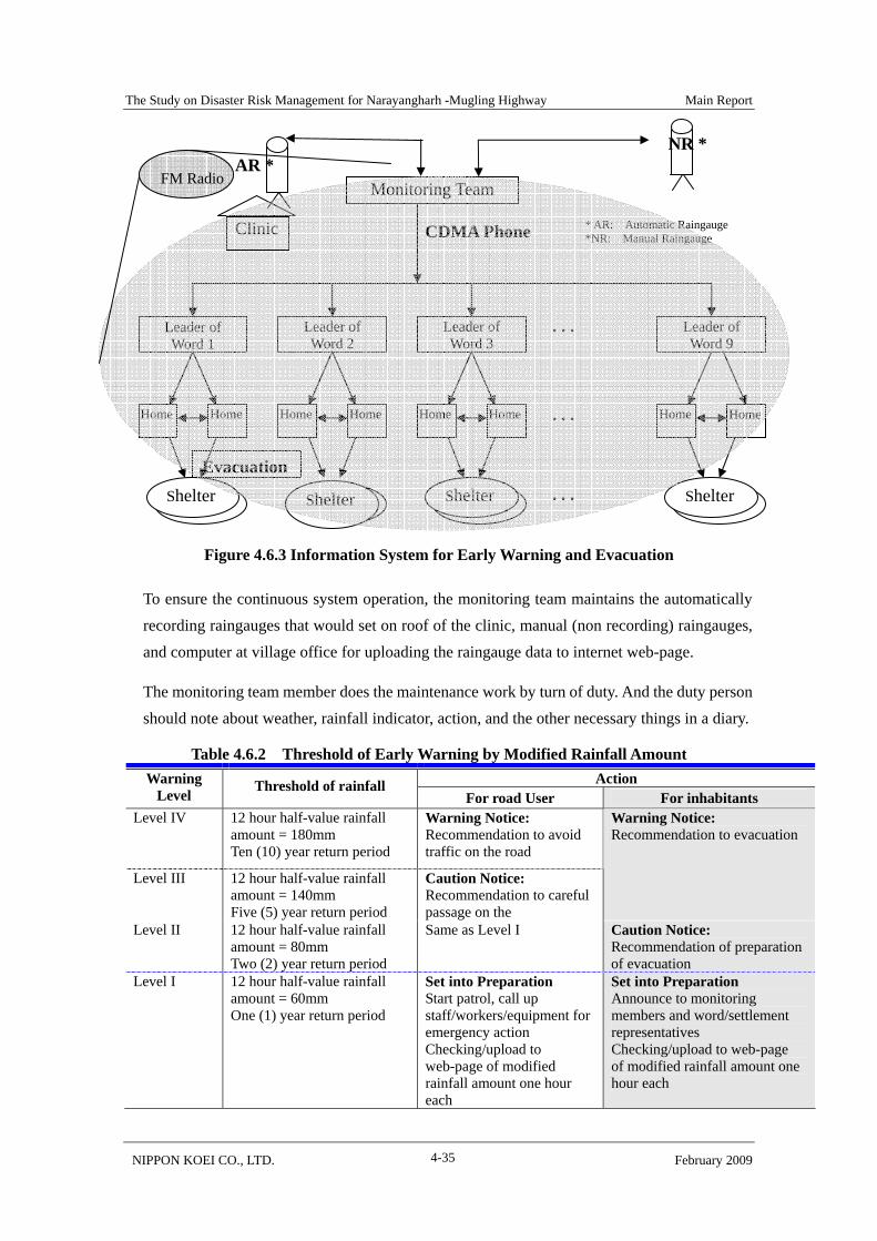
Figure 4.6.3 Information System for Early Warning and Evacuation
To ensure the continuous system operation, the monitoring team maintains the automatically recording raingauges that would set on roof of the clinic, manual (non recording) raingauges, and computer at village office for uploading the raingauge data to internet web-page.
The monitoring team member does the maintenance work by turn of duty. And the duty person should note about weather, rainfall indicator, action, and the other necessary things in a diary.
Table 4.6.2 Threshold of Early Warning by Modified Rainfall Amount Action Warning
Level Threshold of rainfall For road User For inhabitants
Level IV
12 hour half-value rainfall amount = 180mm Ten (10) year return period
Warning Notice: Recommendation to avoid traffic on the road
Level III 12 hour half-value rainfall amount = 140mm Five (5) year return period
Caution Notice: Recommendation to careful passage on the
Warning Notice: Recommendation to evacuation
Level II
12 hour half-value rainfall amount = 80mm Two (2) year return period
Same as Level I Caution Notice: Recommendation of preparation of evacuation
Level I
12 hour half-value rainfall amount = 60mm One (1) year return period
Set into Preparation Start patrol, call up staff/workers/equipment for emergency action Checking/upload to web-page of modified rainfall amount one hour each
Set into Preparation Announce to monitoring members and word/settlement representatives Checking/upload to web-page of modified rainfall amount one hour each
* AR: Automatic Raingauge *NR: Manual Raingauge
・・・ Leader of Word 1
Home
Leader of Word 2
Leader of Word 9
Leader of Word 3
Evacuation
避難
・・・ Home Home Home Home Home Home Home
・・・ Shelter 避難Shelter 避難
Shelter避難
Shelter
Monitoring Team
CDMA Phone
AR * NR *
Clinic
FM Radio
The Study on Disaster Risk Management for Narayangharh -Mugling Highway Main Report
NIPPON KOEI CO., LTD. February 2009 4-36
4.6.4 Cost of the System and Economic Evaluation
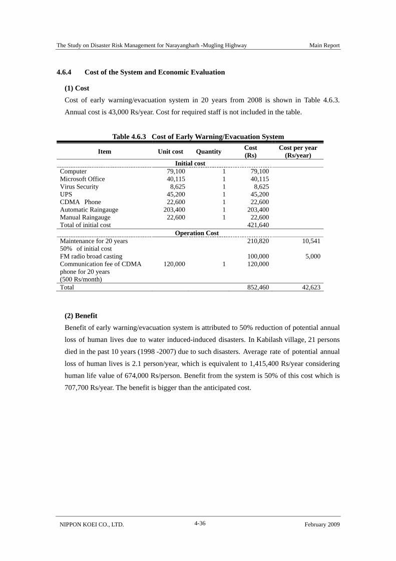
(1) Cost Cost of early warning/evacuation system in 20 years from 2008 is shown in Table 4.6.3. Annual cost is 43,000 Rs/year. Cost for required staff is not included in the table.
Table 4.6.3 Cost of Early Warning/Evacuation System
Item Unit cost Quantity Cost (Rs)
Cost per year (Rs/year)
Initial cost Computer 79,100 1 79,100 Microsoft Office 40,115 1 40,115 Virus Security 8,625 1 8,625 UPS 45,200 1 45,200 CDMA Phone 22,600 1 22,600 Automatic Raingauge 203,400 1 203,400 Manual Raingauge 22,600 1 22,600 Total of initial cost 421,640
Operation Cost Maintenance for 20 years 50% of initial cost
210,820 10,541
FM radio broad casting 100,000 5,000 Communication fee of CDMA phone for 20 years (500 Rs/month)
120,000 1 120,000
Total 852,460 42,623
(2) Benefit Benefit of early warning/evacuation system is attributed to 50% reduction of potential annual loss of human lives due to water induced-induced disasters. In Kabilash village, 21 persons died in the past 10 years (1998 -2007) due to such disasters. Average rate of potential annual loss of human lives is 2.1 person/year, which is equivalent to 1,415,400 Rs/year considering human life value of 674,000 Rs/person. Benefit from the system is 50% of this cost which is 707,700 Rs/year. The benefit is bigger than the anticipated cost.

The Study on Disaster Risk Management for Narayangharh -Mugling Highway Main Report
NIPPON KOEI CO., LTD. February 2009 4-37
4.7 Organization and Institutional Plan/Budget Planning
4.7.1 Organization in Charge
The program and organization for the basic strategies is shown in Figure 4.7.1.
Figure 4.7.1 Implementation Organization for Basic Strategies
Major roles of each concerned organization are as follows.
(1) Division Road Office, Bharatpur, DOR To implements structural measures for road slopes. Regular maintenance and quick response for traffic blockade induced by
sediment-related disasters. Monitoring of raingauges and reporting to DPO on risk level of sediment
related-disasters on the M-N Highway. Maintenance of monitoring devices.
(2) M-N Water-induced Disaster Prevention Project Office, DWIDP The office implements structural measures for crossing streams, maintenance of sabo facilities,
Program of Basic Strategies Organization in Charge
Additional Structural Measure
Maintenance of Sabo Facilities
Road Early Information System
Disaster Mitigation Activities in Communities
Division Road Office, DOR
M-N Water-induced Disaster Prevention Project Office,
DWIDP
Village Development Committee, Bharatpur Municipality/ District
Development Committee
District Police Office, Chitwan
Regular Maintenance and Quick Response
Kalika FM
The Study on Disaster Risk Management for Narayangharh -Mugling Highway Main Report
NIPPON KOEI CO., LTD. February 2009 4-38
technical support for disaster mitigation activities by communities. DWIDP analyze rainfall data and disaster occurrence, and update rainfall amount criteria for Early Warning/ Evacuation System.
(3) Village Development Committee, Bharatpure Municipality/ District Development Committee
Bharatpure municipality, villages along N-M road offer the account of road traffic obstacles to District Police Office, conduct Early Warning/ Evacuation System and simple slope protection work. District development committee supports the municipality and villages.
(4) Division Police Office Chitwan Division Police Office Chitwan is the central organization on the Road Early Information System.
To decide traffic control policy,
To updates road notice board and internet-web page of Road Early Information System,
To inform road condition to Kalika FM
(5) Kalika FM
Kalika FM broadcast road conditions informed by DPO and risk level of sediment-related disaster reported by Kabilash Village.
4.7.2 Necessary Expenditure
Necessary expenditure for the five basic strategies is 25,650,000 Rs. The structural measures for the expenditure cost 221,600,000 Rs. The expenditure is shown in Table 4.7.1 to 4.7.4
Table 4.7.1 Necessary Expenditure of Division Road Office, Bharatpure
Program Item Quantities Amount (Rs) Remark Additional Structural Measure
Construction Cost
Lump sum 221.600,000
Amount per year (Rs/year)
Regular Maintenance
Lump sum 25,650,000 Annual plan
Quick response Fuel/ staff cost
392,000 Annual plan
20,000 Maintenance for equipment, CDMA phone
The Study on Disaster Risk Management for Narayangharh -Mugling Highway Main Report
NIPPON KOEI CO., LTD. February 2009 4-39
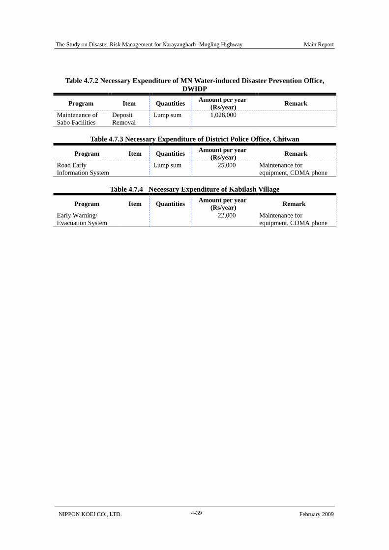
Table 4.7.2 Necessary Expenditure of MN Water-induced Disaster Prevention Office,
DWIDP
Program Item Quantities Amount per year (Rs/year) Remark
Maintenance of Sabo Facilities
Deposit Removal
Lump sum 1,028,000
Table 4.7.3 Necessary Expenditure of District Police Office, Chitwan
Program Item Quantities Amount per year (Rs/year) Remark
Road Early Information System
Lump sum 25,000 Maintenance for equipment, CDMA phone
Table 4.7.4 Necessary Expenditure of Kabilash Village
Program Item Quantities Amount per year (Rs/year) Remark
Early Warning/ Evacuation System
22,000 Maintenance for equipment, CDMA phone

The Study on Disaster Risk Management for Narayangharh -Mugling Highway Main Report
NIPPON KOEI CO., LTD. February 2009 4-40
4.8 Evaluation of Basic Strategies
4.8.1 Social & Environment
All items for the basic strategies (I: Additional structural measures, II: Regular maintenance and quick response, III: Maintenance of sabo facilities, IV: Road Early Information System, V: Disaster mitigation activities in communities) are not required in the initial environment examination (IEE) and environmental impact assessment (EIA) as per relevant environmental laws of the GON. Determining structural measures for the construction of sabo facilities is not the object of IEE and EIA. Natural preserved areas as well as significant archaeological and cultural areas require execution of EIA, however, the Study does not cover such areas.
Evaluated by JICA’s guidelines for environmental and social considerations, two social/environmental items are corresponded to Categories C: project is likely to have minimal or little adverse impacts on the environmental and society. There are no items which are categorized into more serious categories. Consideration points of the two items to implement basic strategies are shown in Table 4.8.1.
Table 4.8.1 Deliberation and Points of Social/Environmental Consideration
Item Content Point of Consider Traffic accident under construction work
- Safety measure is required for inhabitants drivers, and workers under constriction work
Accident/Disaster (risk)
Inducement of slope disaster by construction work
- Prevent newly slope disaster by excavation work
Road traffic obstacle by construction work
- Avoid road closure due to construction work Social, infrastructure Service Inaccurate early warning - Appropriate criteria setting for early warning
4.8.2 Integrated Evaluation
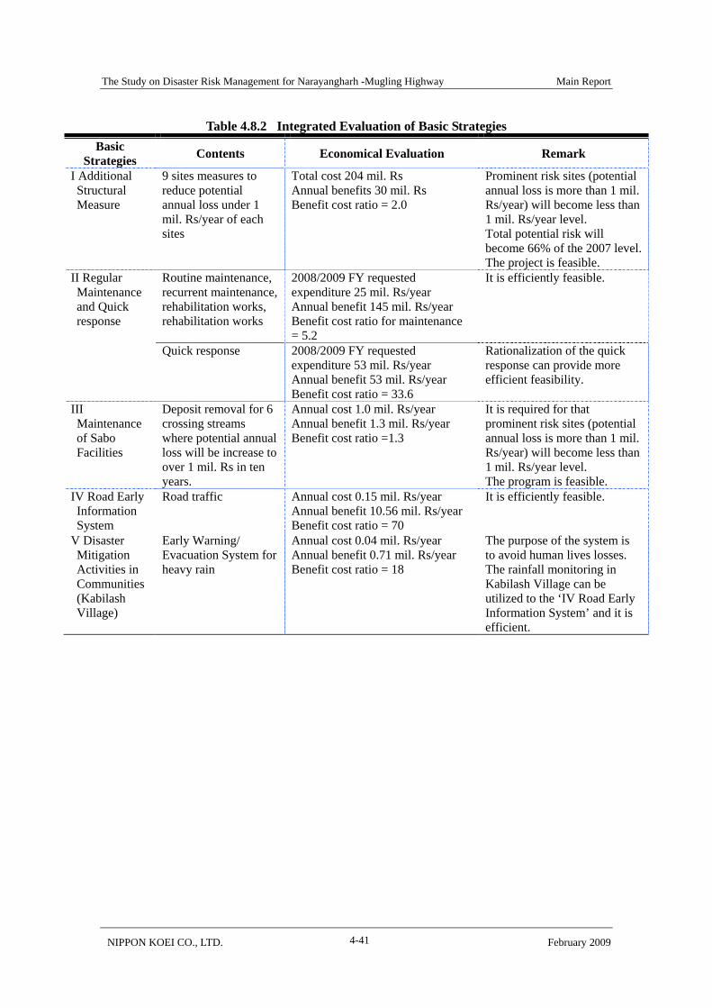
Integrated evaluation of each basic strategy is shown in Table 4.8.2. The explanation of cost and benefit are described in previous section 4.2 to 4.5.
Benefit cost ratios of each basic strategy are higher than 1.0, indicating that it is economically feasible. This is more evident for basic strategy II (Regular maintenance and quick response) and IV (road early information system). Considerable annual benefits are obtained from strategy II, with 145 mil. Rs from regular maintenance and 53 mil. Rs from quick response. Annual benefit gained from strategy I (Additional structural measures) is also significant with 30 mil. Rs.
The Study on Disaster Risk Management for Narayangharh -Mugling Highway Main Report
NIPPON KOEI CO., LTD. February 2009 4-41
Table 4.8.2 Integrated Evaluation of Basic Strategies Basic
Strategies Contents Economical Evaluation Remark
I Additional Structural Measure
9 sites measures to reduce potential annual loss under 1 mil. Rs/year of each sites
Total cost 204 mil. Rs Annual benefits 30 mil. Rs Benefit cost ratio = 2.0
Prominent risk sites (potential annual loss is more than 1 mil. Rs/year) will become less than 1 mil. Rs/year level. Total potential risk will become 66% of the 2007 level.The project is feasible.
Routine maintenance, recurrent maintenance, rehabilitation works, rehabilitation works
2008/2009 FY requested expenditure 25 mil. Rs/year Annual benefit 145 mil. Rs/year Benefit cost ratio for maintenance = 5.2
It is efficiently feasible. II Regular Maintenance and Quick response
Quick response 2008/2009 FY requested
expenditure 53 mil. Rs/year Annual benefit 53 mil. Rs/year Benefit cost ratio = 33.6
Rationalization of the quick response can provide more efficient feasibility.
III Maintenance of Sabo Facilities
Deposit removal for 6 crossing streams where potential annual loss will be increase to over 1 mil. Rs in ten years.
Annual cost 1.0 mil. Rs/year Annual benefit 1.3 mil. Rs/year Benefit cost ratio =1.3
It is required for that prominent risk sites (potential annual loss is more than 1 mil. Rs/year) will become less than 1 mil. Rs/year level. The program is feasible.
IV Road Early Information System
Road traffic Annual cost 0.15 mil. Rs/year Annual benefit 10.56 mil. Rs/year Benefit cost ratio = 70
It is efficiently feasible.
V Disaster Mitigation Activities in Communities (Kabilash Village)
Early Warning/ Evacuation System for heavy rain
Annual cost 0.04 mil. Rs/year Annual benefit 0.71 mil. Rs/year Benefit cost ratio = 18
The purpose of the system is to avoid human lives losses. The rainfall monitoring in Kabilash Village can be utilized to the ‘IV Road Early Information System’ and it is efficient.
The Study on Disaster Risk Management for Narayangharh-Mugling Highway Main Report
NIPPON KOEI CO., LTD. February 2009
5-1
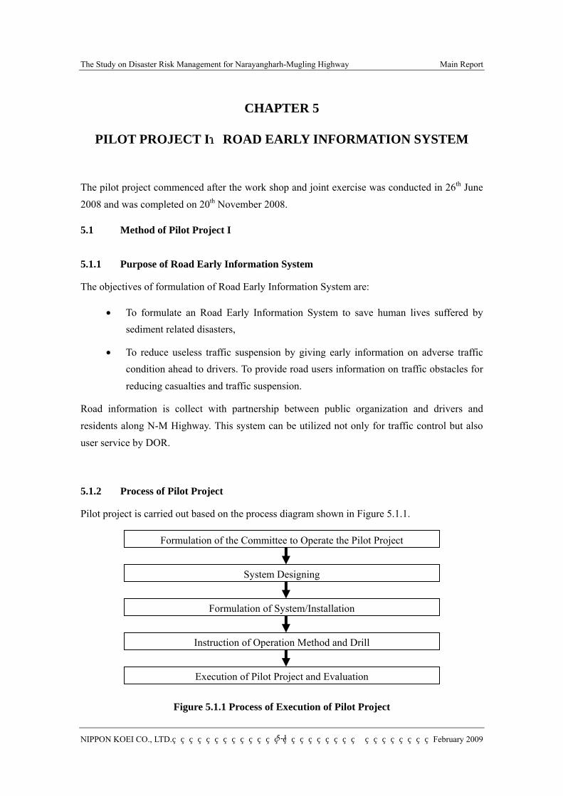
CHAPTER 5
PILOT PROJECT I:ROAD EARLY INFORMATION SYSTEM
The pilot project commenced after the work shop and joint exercise was conducted in 26th June 2008 and was completed on 20th November 2008.
5.1 Method of Pilot Project I
5.1.1 Purpose of Road Early Information System
The objectives of formulation of Road Early Information System are:
• To formulate an Road Early Information System to save human lives suffered by sediment related disasters,
• To reduce useless traffic suspension by giving early information on adverse traffic condition ahead to drivers. To provide road users information on traffic obstacles for reducing casualties and traffic suspension.
Road information is collect with partnership between public organization and drivers and residents along N-M Highway. This system can be utilized not only for traffic control but also user service by DOR.
5.1.2 Process of Pilot Project
Pilot project is carried out based on the process diagram shown in Figure 5.1.1.
Figure 5.1.1 Process of Execution of Pilot Project
Formulation of the Committee to Operate the Pilot Project
System Designing
Formulation of System/Installation
Instruction of Operation Method and Drill
Execution of Pilot Project and Evaluation

The Study on Disaster Risk Management for Narayangharh-Mugling Highway Main Report
NIPPON KOEI CO., LTD. February 2009
5-2
(1) Formulation of the Committee Planning and management committee has been formulated, because the system is operated with cooperative work among multiple organizations such as Division Road Office. The committee plans and reviews the activities of pilot project.
(2) System Designing Administrative structure, information network, computer system, and notice board have been designed.
(3) Formulation of System/Installation Computer system to collect and analyze information has been formulated and raingauges and notice boards have been installed.
(4) Instruction of Operation Method and Drill A) Instruction for Each Operation Unit
Instruction on operation of system and drill was carried out on 18th June at District Police Office, Chitwan and Division Road Office, Bharatpur
B) Work Shop and Joint Training Exercise Work shop and joint training among concerned organization was carried out on 26th June in N-M Highway and Kabilash Village
(5) Execution of Pilot Project and Evaluation After the work shop and joint exercise in 26th June, 2008 mentioned above the pilot project to operate Road Early Information System and Early Warning/ Evacuation System has been carried out by the counterpart and implementing organizations. The performance of the pilot project was evaluated by hearing of drivers and staffs in charge of operation.

The Study on Disaster Risk Management for Narayangharh-Mugling Highway Main Report
NIPPON KOEI CO., LTD. February 2009
5-3
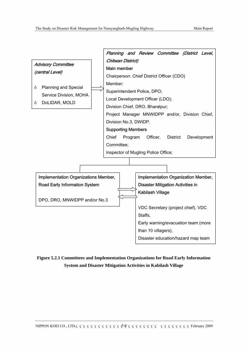
5.2 Organization of Pilot Project I
5.2.1 Forming of Committee
The committee for planning and managing the pilot project was formed.
(1) Name of the Committee As pilot project I (Road Early Information System) and pilot project II (disaster mitigation activities in Kabilash Village described in Chapter 6) is closely related, the committee formed was named “Committees for the N-M Highway Early Information System and Water Induced Disaster Management for Kabilash Village”.
(2) Committee Two committees were formed as shown in the Figure 5.2.1;
1) Planning and Review Committee (district level) and 2) Advisory Committee (central level). The objectives of these committees for Planning and Review Committee (district level) and Advisory Committee (central level) are to plan/conduct/evaluate pilot projects and to offer useful advice respectively.
Both of central/district level organizations are required to operate these systems successfully though the pilot projects are operated in limited area. Because;
These systems can also be applied to the area that has similar issues on water-induced disaster management.
Cooperation of public/private sector is indispensable for sustainable and efficient disaster risk management.
Both of administrative system and scientific technology are also indispensable to implement the activities successfully.
Under these two committees, two implementing organizations have been formulated. That is ; 1) Implementation organization for Road Early Information System and 2) Implementation Organization for Disaster mitigation activities in Kabilash Village.
The roles of members of the committee and implementing organizations are shown in the Table 5.2.1.
The Study on Disaster Risk Management for Narayangharh-Mugling Highway Main Report
NIPPON KOEI CO., LTD. February 2009
5-4
Figure 5.2.1 Committees and Implementation Organizations for Road Early Information System and Disaster Mitigation Activities in Kabilash Village
Advisory Committee (central Level) - Planning and Special
Service Division, MOHA - DoLIDAR, MOLD -
Planning and Review Committee (District Level, Chitwan District) Main member Chairperson: Chief District Officer (CDO) Member: Superintendent Police, DPO; Local Development Officer (LDO); Division Chief, DRO, Bharatpur; Project Manager MNWIDPP and/or, Division Chief, Division No.3, DWIDP. Supporting Members Chief Program Officer, District Development Committee; Inspector of Mugling Police Office;
Implementation Organizations Member,Road Early Information System DPO, DRO, MNWIDPP and/or No.3
Implementation Organization Member, Disaster Mitigation Activities in Kabilash Village VDC Secretary (project chief), VDC Staffs, Early warning/evacuation team (more than 10 villagers), Disaster education/hazard map team

The Study on Disaster Risk Management for Narayangharh-Mugling Highway Main Report
NIPPON KOEI CO., LTD. February 2009
5-5
Table 5.2.1 (1) Committee Members for the Pilot Projects Planning and Review Committee (District Level) Organization Role for the committee and the pilot projects
Chairperson Chief District officer (CDO), Chitwan
Call and facilitate ‘planning and review committee’ General management of pilot project.
Main Member
Superintendent Police (SP), District Police office(DPO), Chitwan
Supervise junior staffs of the district police office for collecting/disseminating information of N-M highway traffic obstacle, early warning for heavy rain
Local Development Officer (LDO)
Supervise village development committees along N-M Highway (Kabilash, Dahakhani, Chandi Bhanjyang, and Darechok), and Bharatpur Municipality to facilitate inhabitants who help conduct road traffic obstacle monitors/reporters to police office/stations. Support Kabilash VDC for their disaster management activities (Early Warning/ Evacuation System, hazard mapping & disaster education, simple slope protection work and forestation planning)
Division Chief, Divisional Road office (DRO)
Appoint/supervise team of raingauge monitoring, patrol and traffic obstacle report, emergency action for water-induced disaster on N-M Highway.
Project Manager, MNWIDPP. And/or Division Chief, Division No.3, DWIDP (DDWIDP)
Supervise staffs for the role of DWIDP for the pilot projects as follows; Support to Kabilash Village’s disaster management activities technically such as rainfall monitoring, computer operating for rainfall data computation and up-loading to internet web-page. Analyze rain and disaster occurrence relation and modify rainfall threshold for N-M Highway users and for Kabilash Village in the feature, in every five year.
Supporting Member
Chief Program Officer, District Development Committee (DDC)
Support LDO
Inspector of Mugling Police Office
Supervise junior staffs of the Mugling police office for the correcting/disseminating information of N-M highway traffic obstacle, early warning for heavy rain.
Engineer, DRO Support Division Chief, DRO Engineer, MNWIDPP. And or Engineer, Division No.3, DWIDP
Support project manager of MNWIDPP and/or Division Chief, Division No.3 of DWIDP
Secretary of Kabilash VDC Explain about Road Early Information System to inhabitants. Facilitate inhabitants as monitor/reporter to police office/station about road obstacle phenomena. Assign and supervise member of team of early warning&evacuation, disaster education & hazard mapping, and simple slope protection work & forestation.
Secretary of Dahakhani, Chandi Bhanjyang, Darechok VDC And Executive Chief of Bharatpur Municipality
Explain about Road Early Information System of the N-M Highway to inhabitants. Facilitate inhabitants as monitor/reporter to police office/station about road obstacle phenomena.
Planning and Special Service Division Ministry of Home Affairs
Advice for disaster management policy and methodology, especially Early Warning/ Evacuation System.
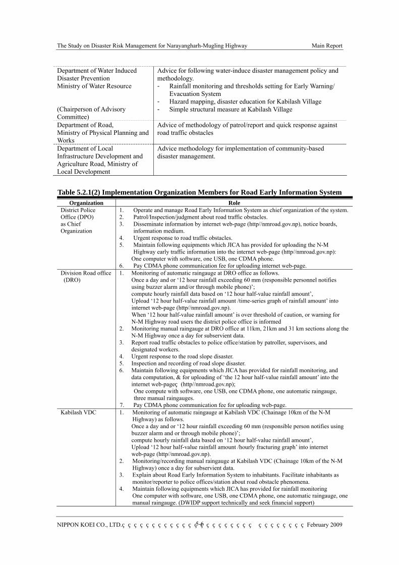
The Study on Disaster Risk Management for Narayangharh-Mugling Highway Main Report
NIPPON KOEI CO., LTD. February 2009
5-6
Department of Water Induced Disaster Prevention Ministry of Water Resource (Chairperson of Advisory Committee)
Advice for following water-induce disaster management policy and methodology. - Rainfall monitoring and thresholds setting for Early Warning/
Evacuation System - Hazard mapping, disaster education for Kabilash Village - Simple structural measure at Kabilash Village
Department of Road, Ministry of Physical Planning and Works
Advice of methodology of patrol/report and quick response against road traffic obstacles
Department of Local Infrastructure Development and Agriculture Road, Ministry of Local Development
Advice methodology for implementation of community-based disaster management.
Table 5.2.1(2) Implementation Organization Members for Road Early Information System
Organization Role District Police Office (DPO) as Chief Organization
1. Operate and manage Road Early Information System as chief organization of the system.2. Patrol/Inspection/judgment about road traffic obstacles. 3. Disseminate information by internet web-page (http//nmroad.gov.np), notice boards,
information medium. 4. Urgent response to road traffic obstacles. 5. Maintain following equipments which JICA has provided for uploading the N-M
Highway early traffic information into the internet web-page (http//nmroad.gov.np): One computer with software, one USB, one CDMA phone.
6. Pay CDMA phone communication fee for uploading internet web-page. Division Road office (DRO)
1. Monitoring of automatic raingauge at DRO office as follows. Once a day and or ‘12 hour rainfall exceeding 60 mm (responsible personnel notifies using buzzer alarm and/or through mobile phone)’; compute hourly rainfall data based on ‘12 hour half-value rainfall amount’, Upload ‘12 hour half-value rainfall amount /time-series graph of rainfall amount’ into internet web-page (http//nmroad.gov.np). When ‘12 hour half-value rainfall amount’ is over threshold of caution, or warning for N-M Highway road users the district police office is informed
2. Monitoring manual raingauge at DRO office at 11km, 21km and 31 km sections along the N-M Highway once a day for subservient data.
3. Report road traffic obstacles to police office/station by patroller, supervisors, and designated workers.
4. Urgent response to the road slope disaster. 5. Inspection and recording of road slope disaster. 6. Maintain following equipments which JICA has provided for rainfall monitoring, and
data computation, & for uploading of ‘the 12 hour half-value rainfall amount’ into the internet web-page (http//nmroad.gov.np); One compute with software, one USB, one CDMA phone, one automatic raingauge, three manual raingauges.
7. Pay CDMA phone communication fee for uploading web-page. Kabilash VDC 1. Monitoring of automatic raingauge at Kabilash VDC (Chainage 10km of the N-M
Highway) as follows. Once a day and or ‘12 hour rainfall exceeding 60 mm (responsible person notifies using buzzer alarm and or through mobile phone)’; compute hourly rainfall data based on ‘12 hour half-value rainfall amount’, Upload ‘12 hour half-value rainfall amount /hourly fracturing graph’ into internet web-page (http//nmroad.gov.np).
2. Monitoring/recording manual raingauge at Kabilash VDC (Chainage 10km of the N-M Highway) once a day for subservient data.
3. Explain about Road Early Information System to inhabitants. Facilitate inhabitants as monitor/reporter to police offices/station about road obstacle phenomena.
4. Maintain following equipments which JICA has provided for rainfall monitoring One computer with software, one USB, one CDMA phone, one automatic raingauge, one manual raingauge. (DWIDP support technically and seek financial support)
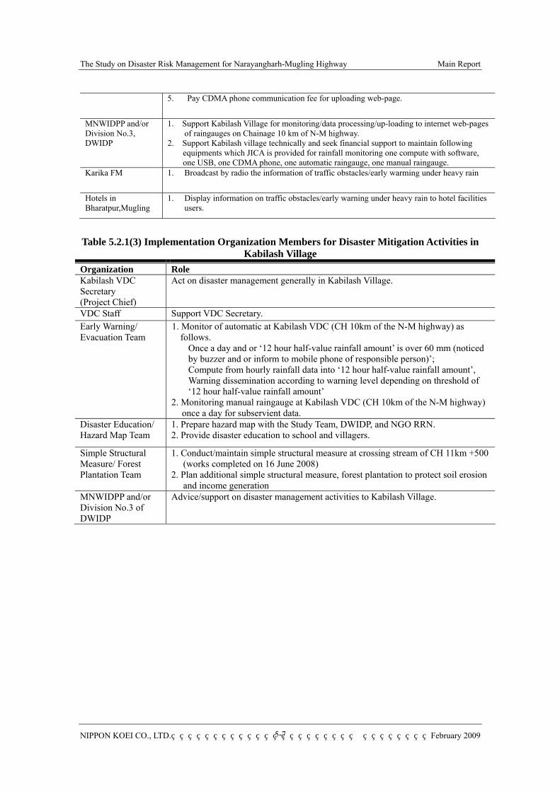
The Study on Disaster Risk Management for Narayangharh-Mugling Highway Main Report
NIPPON KOEI CO., LTD. February 2009
5-7
5. Pay CDMA phone communication fee for uploading web-page.
MNWIDPP and/or Division No.3, DWIDP
1. Support Kabilash Village for monitoring/data processing/up-loading to internet web-pages of raingauges on Chainage 10 km of N-M highway.
2. Support Kabilash village technically and seek financial support to maintain following equipments which JICA is provided for rainfall monitoring one compute with software, one USB, one CDMA phone, one automatic raingauge, one manual raingauge.
Karika FM 1. Broadcast by radio the information of traffic obstacles/early warming under heavy rain
Hotels in Bharatpur,Mugling
1. Display information on traffic obstacles/early warning under heavy rain to hotel facilities users.
Table 5.2.1(3) Implementation Organization Members for Disaster Mitigation Activities in
Kabilash Village Organization Role Kabilash VDC Secretary (Project Chief)
Act on disaster management generally in Kabilash Village.
VDC Staff Support VDC Secretary. Early Warning/ Evacuation Team
1. Monitor of automatic at Kabilash VDC (CH 10km of the N-M highway) as follows.
Once a day and or ‘12 hour half-value rainfall amount’ is over 60 mm (noticed by buzzer and or inform to mobile phone of responsible person)’; Compute from hourly rainfall data into ‘12 hour half-value rainfall amount’, Warning dissemination according to warning level depending on threshold of ‘12 hour half-value rainfall amount’
2. Monitoring manual raingauge at Kabilash VDC (CH 10km of the N-M highway) once a day for subservient data.
Disaster Education/ Hazard Map Team
1. Prepare hazard map with the Study Team, DWIDP, and NGO RRN. 2. Provide disaster education to school and villagers.
Simple Structural Measure/ Forest Plantation Team
1. Conduct/maintain simple structural measure at crossing stream of CH 11km +500 (works completed on 16 June 2008)
2. Plan additional simple structural measure, forest plantation to protect soil erosion and income generation
MNWIDPP and/or Division No.3 of DWIDP
Advice/support on disaster management activities to Kabilash Village.
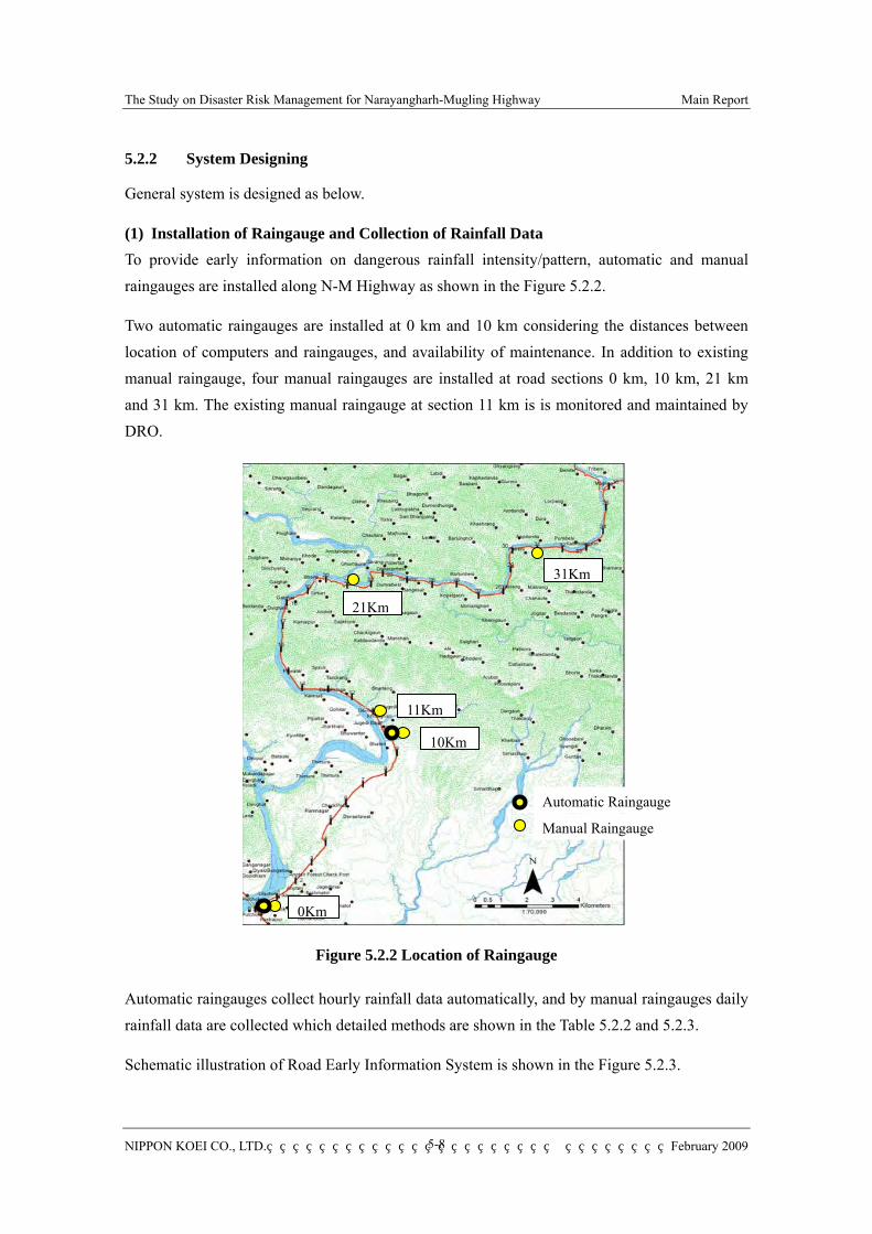
The Study on Disaster Risk Management for Narayangharh-Mugling Highway Main Report
NIPPON KOEI CO., LTD. February 2009
5-8
5.2.2 System Designing
General system is designed as below.
(1) Installation of Raingauge and Collection of Rainfall Data To provide early information on dangerous rainfall intensity/pattern, automatic and manual raingauges are installed along N-M Highway as shown in the Figure 5.2.2.
Two automatic raingauges are installed at 0 km and 10 km considering the distances between location of computers and raingauges, and availability of maintenance. In addition to existing manual raingauge, four manual raingauges are installed at road sections 0 km, 10 km, 21 km and 31 km. The existing manual raingauge at section 11 km is is monitored and maintained by DRO.
Figure 5.2.2 Location of Raingauge
Automatic raingauges collect hourly rainfall data automatically, and by manual raingauges daily rainfall data are collected which detailed methods are shown in the Table 5.2.2 and 5.2.3.
Schematic illustration of Road Early Information System is shown in the Figure 5.2.3.
0Km
10Km
11Km
21Km
31Km
Automatic Raingauge
Manual Raingauge
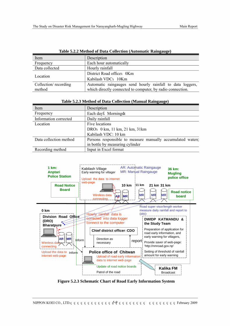
The Study on Disaster Risk Management for Narayangharh-Mugling Highway Main Report
NIPPON KOEI CO., LTD. February 2009
5-9
Table 5.2.2 Method of Data Collection (Automatic Raingauge) Item Description Frequency Each hour automatically Data collected Hourly rainfall
Location District Road office:0Km Kabilash VDC:10Km
Collection/ recording method
Automatic raingauges send hourly rainfall to data loggers, which directly connected to computer, by radio connection.
Table 5.2.3 Method of Data Collection (Manual Raingauge)
Item Description Frequency Each day(Morning) Information corrected Daily rainfall Location Five locations
DRO:0 km, 11 km, 21 km, 31km Kabilash VDC: 10 km
Data collection method Persons responsible to measure manually accumulated water in bottle by measuring cylinder
Recording method Input in Excel format
Figure 5.2.3 Schematic Chart of Road Early Information System
Division Road Office (DRO)Bharatpure
10 km 21 km 31 km
Chief district officer:CDO
AR: Automatic RaingaugeMR: Manual Raingauge
Road notice board
Road Notice Board
1 km: Anptari Police Station
36 km:Mugling police office
AR MRAR MR MR MR
Kabilash VillageEarly warning for villager
Upload the data to internet web-page
Hourly rainfall data is corrected into data logger connect to the computer
AR MRAR MR
DWIDP KATMANDU & the Study TeamPreparation of application for road early information, and early warning for villagers,
Provide saver of web-page: ‘http://nmroad.gov.np’
Setting of threshold of rainfall amount for early warning
Road super visor/length worker measure daily rainfall and report to DRO
Police office of Chitwan
reportDirection as necessary
Upload of road early information data to internet web-page
Update of road notice boards
Patrol of the road
11 km
MR
0 km
Wireless data connecting
Wireless data connecting
Upload the data to internet web-page
Inform
Inform
Kalika FMBroadcast
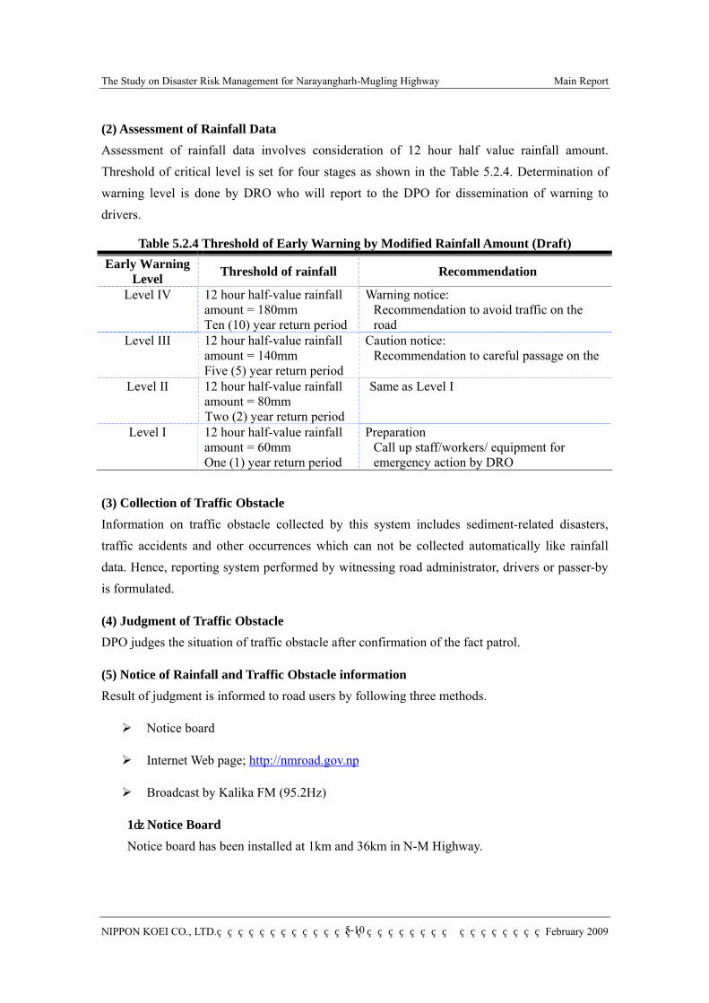
The Study on Disaster Risk Management for Narayangharh-Mugling Highway Main Report
NIPPON KOEI CO., LTD. February 2009
5-10
(2) Assessment of Rainfall Data Assessment of rainfall data involves consideration of 12 hour half value rainfall amount. Threshold of critical level is set for four stages as shown in the Table 5.2.4. Determination of warning level is done by DRO who will report to the DPO for dissemination of warning to drivers.
Table 5.2.4 Threshold of Early Warning by Modified Rainfall Amount (Draft) Early Warning
Level Threshold of rainfall Recommendation
Level IV 12 hour half-value rainfall amount = 180mm Ten (10) year return period
Warning notice: Recommendation to avoid traffic on the road
Level III 12 hour half-value rainfall amount = 140mm Five (5) year return period
Caution notice: Recommendation to careful passage on the
Level II 12 hour half-value rainfall amount = 80mm Two (2) year return period
Same as Level I
Level I 12 hour half-value rainfall amount = 60mm One (1) year return period
Preparation Call up staff/workers/ equipment for emergency action by DRO
(3) Collection of Traffic Obstacle Information on traffic obstacle collected by this system includes sediment-related disasters, traffic accidents and other occurrences which can not be collected automatically like rainfall data. Hence, reporting system performed by witnessing road administrator, drivers or passer-by is formulated.
(4) Judgment of Traffic Obstacle DPO judges the situation of traffic obstacle after confirmation of the fact patrol.
(5) Notice of Rainfall and Traffic Obstacle information Result of judgment is informed to road users by following three methods.
Notice board
Internet Web page; http://nmroad.gov.np
Broadcast by Kalika FM (95.2Hz)
1)Notice Board Notice board has been installed at 1km and 36km in N-M Highway.
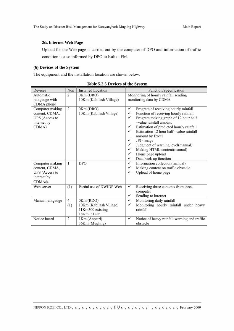
The Study on Disaster Risk Management for Narayangharh-Mugling Highway Main Report
NIPPON KOEI CO., LTD. February 2009
5-11
2)Internet Web Page Upload for the Web page is carried out by the computer of DPO and information of traffic condition is also informed by DPO to Kalika FM.
(6) Devices of the System The equipment and the installation location are shown below.
Table 5.2.5 Devices of the System Devices Nos Installed Location Function/Specification Automatic raingauge with CDMA phone
2 0Km (DRO) 10Km (Kabilash Village)
Monitoring of hourly rainfall sending monitoring data by CDMA
Computer making content, CDMA, UPS (Access to internet by CDMA)
2 0Km (DRO) 10Km (Kabilash Village)
Program of receiving hourly rainfall Function of receiving hourly rainfall Program making graph of 12 hour half
–value rainfall amount Estimation of predicted hourly rainfall Estimation 12 hour half –value rainfall
amount by Excel JPG image Judgment of warning level(manual) Making HTML content(manual) Home page upload Data back up function
Computer making content, CDMA, UPS (Access to internet by CDMA)
1 DPO Information collection(manual) Making content on traffic obstacle Upload of home page
Web server (1) Partial use of DWIDP Web Receiving three contents from three computer
Sending to internet Manual raingauge
4 (1)
0Km (RDO) 10Km (Kabilash Village) 11Km300 existing 18Km, 31Km
Monitoring daily rainfall Monitoring hourly rainfall under heavy
rainfall
Notice board 2 1Km (Anptari) 36Km (Mugling)
Notice of heavy rainfall warning and traffic obstacle

The Study on Disaster Risk Management for Narayangharh-Mugling Highway Main Report
NIPPON KOEI CO., LTD. February 2009
5-12
(7) Content of Early Road Information by Notice Board Items and contents of rainfall information and traffic obstacle information in the web page and notice board are shown in tables 5.2.6 and 5.2.7.
Table 5.2.6 Content of Warning Information Item Content of Web Content of Notice Board
Warning Level
・heavy rain warning/ Recommendation to avoid traffic on the road
・heavy rain warning/ Recommendation to avoid traffic on the road/ Recommendation to careful passage on the road
Same as content of web
Section From 10Km to 36Km point Same as content of web Date/time Year/month/day/time Same as content of web Situation ・Rainfall intensity of 10year return period
・Rainfall intensity of 5 year return period ―
Rainfall Graph
・12 hour half –value rainfall amount of 0km and 10km
・showing line rainfall graph of 7days
―
Table 5.2.7 Information on Traffic Obstacle
Item Content of Web Content of Notice Board Traffic Condition
・Full lane traffic blockade ・Half lane blockade ・Traffic congestion
Same as content of web
Section From defined distances Same as content of web Date/time Year/month/day/time Same as content of web Reopening reopening:Year/month/day/time Same as content of web Cause ・Flood
・Sediment-related disasters ・Traffic accident ・Unpredicted occurrences
Same as content of web
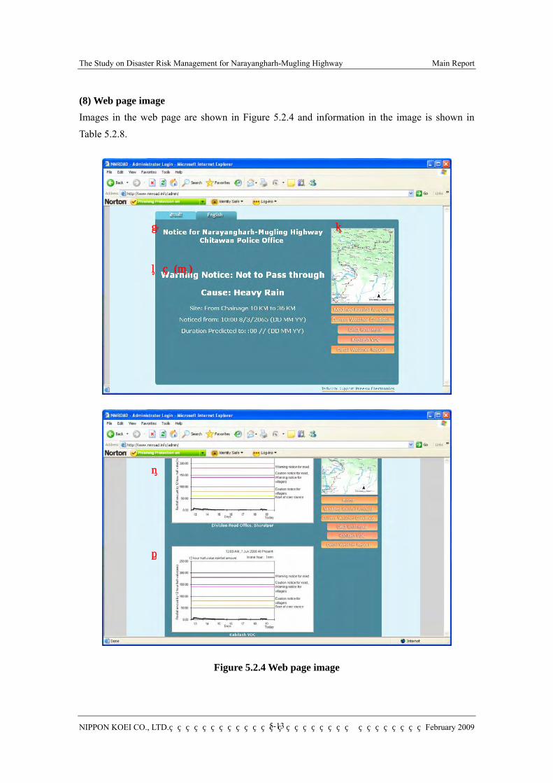
The Study on Disaster Risk Management for Narayangharh-Mugling Highway Main Report
NIPPON KOEI CO., LTD. February 2009
5-13
(8) Web page image Images in the web page are shown in Figure 5.2.4 and information in the image is shown in Table 5.2.8.
Figure 5.2.4 Web page image
① ②
③ (④)
⑤
⑥

The Study on Disaster Risk Management for Narayangharh-Mugling Highway Main Report
NIPPON KOEI CO., LTD. February 2009
5-14
Table 5.2.8 Information in the image
No Kind Content (1) Title Name of home page and name of DPO (no upload) (2) Location map Location of N-M Highway (no upload) (3) Rain Warning/caution notice (uploaded by DPO) (4) Traffic obstacle Information on road blockade and congestion (uploaded by DPO) (5) Line graph of 12 hour half
–value rainfall amount (0 km)
Line graph of 12 hour half –value rainfall amount processed by DRO(uploaded by DRO)
(6) Line graph of 12 hour half –value rainfall amount (10Km)
Line graph of 12 hour half –value rainfall amount processed by Kabilash VDC (uploaded by Kabilash VDC)
(9) Function of Computer of DRO and Kabilash 1) Program of receiving hourly rainfall Receiving and display of hourly rainfall from the automatic raingauge.
2) Program of making line graph of 12 hour half –value rainfall amount (a) Prediction of hourly rainfall Prediction of hourly rainfall based on latest hourly rainfall. Estimation formula is as below (refer to Chapter2)
Rprd=Robs (mm) Here
Rprd = hourly rainfall value from some point Robs = hourly rainfall value until some point
In put current hourly rainfall value by manual and this value is utilize to estimate next 12 hour half –value rainfall amount
(b) Estimation of 12 hour half –value rainfall amount 12 hour half –value rainfall amount is estimated by formula below.
RAHhv(t) = 0.5i/H x HR(i) Here, RAHhv(t) = 12 hour half –value rainfall amount at‘t’ I = ‘i' hour before t’ (time) H = H- hour half –value: term that hourly rainfall reduce to half
H = 12
HR(i) = hourly rainfall value from‘i+1’to‘i' 12 hour half –value rainfall amount = X168(0.5)168/12+X167(0.5)167/12・・・+X1(0.5)1/12+X0+X-1
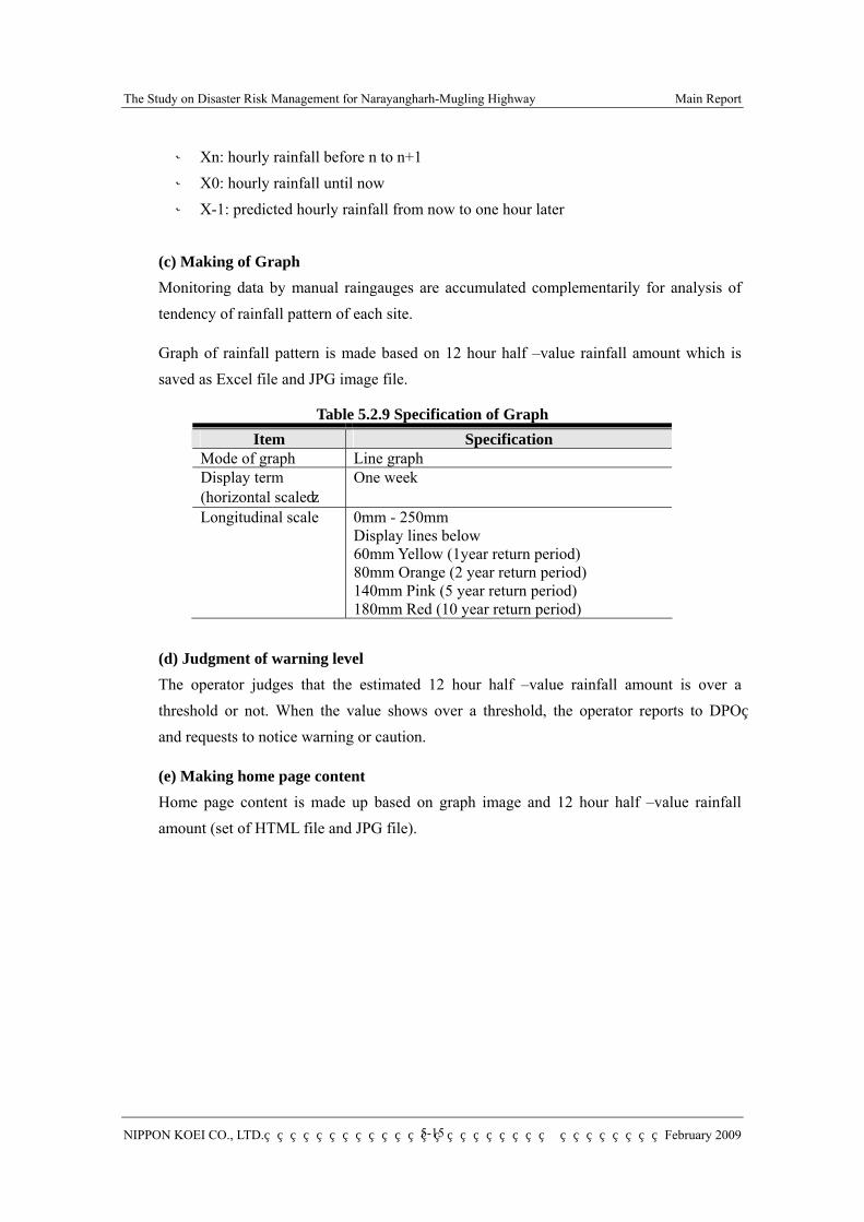
The Study on Disaster Risk Management for Narayangharh-Mugling Highway Main Report
NIPPON KOEI CO., LTD. February 2009
5-15
※ Xn: hourly rainfall before n to n+1 ※ X0: hourly rainfall until now ※ X-1: predicted hourly rainfall from now to one hour later
(c) Making of Graph Monitoring data by manual raingauges are accumulated complementarily for analysis of tendency of rainfall pattern of each site.
Graph of rainfall pattern is made based on 12 hour half –value rainfall amount which is saved as Excel file and JPG image file.
Table 5.2.9 Specification of Graph Item Specification
Mode of graph Line graph Display term (horizontal scale)
One week
Longitudinal scale 0mm - 250mm Display lines below 60mm Yellow (1year return period) 80mm Orange (2 year return period) 140mm Pink (5 year return period) 180mm Red (10 year return period)
(d) Judgment of warning level The operator judges that the estimated 12 hour half –value rainfall amount is over a threshold or not. When the value shows over a threshold, the operator reports to DPO and requests to notice warning or caution.
(e) Making home page content Home page content is made up based on graph image and 12 hour half –value rainfall amount (set of HTML file and JPG file).
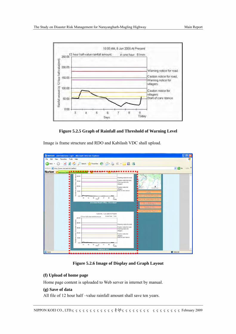
The Study on Disaster Risk Management for Narayangharh-Mugling Highway Main Report
NIPPON KOEI CO., LTD. February 2009
5-16
Figure 5.2.5 Graph of Rainfall and Threshold of Warning Level
Image is frame structure and RDO and Kabilash VDC shall upload.
Figure 5.2.6 Image of Display and Graph Layout
(f) Upload of home page Home page content is uploaded to Web server in internet by manual.
(g) Save of data All file of 12 hour half –value rainfall amount shall save ten years.
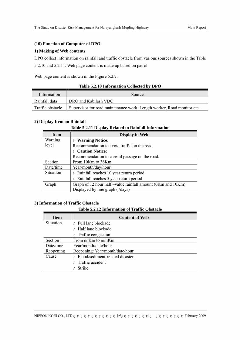
The Study on Disaster Risk Management for Narayangharh-Mugling Highway Main Report
NIPPON KOEI CO., LTD. February 2009
5-17
(10) Function of Computer of DPO 1) Making of Web contents DPO collect information on rainfall and traffic obstacle from various sources shown in the Table 5.2.10 and 5.2.11. Web page content is made up based on patrol
Web page content is shown in the Figure 5.2.7.
Table 5.2.10 Information Collected by DPO
2) Display Item on Rainfall Table 5.2.11 Display Related to Rainfall Information
Item Display in Web Warning level
・Warning Notice: Recommendation to avoid traffic on the road ・Caution Notice: Recommendation to careful passage on the road.
Section From 10Km to 36Km Date/time Year/month/day/hour Situation ・Rainfall reaches 10 year return period
・Rainfall reaches 5 year return period Graph Graph of 12 hour half –value rainfall amount (0Km and 10Km)
Displayed by line graph (7days) 3) Information of Traffic Obstacle
Table 5.2.12 Information of Traffic Obstacle
Item Content of Web Situation ・Full lane blockade
・Half lane blockade ・Traffic congestion
Section From nnKm to mmKm Date/time Year/month/date/hour Reopening Reopening: Year/month/date/hour Cause ・Flood/sediment-related disasters
・Traffic accident ・Strike
Information Source Rainfall data DRO and Kabilash VDC Traffic obstacle Supervisor for road maintenance work, Length worker, Road monitor etc.
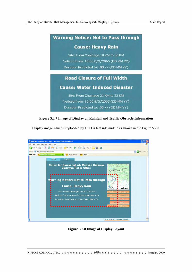
The Study on Disaster Risk Management for Narayangharh-Mugling Highway Main Report
NIPPON KOEI CO., LTD. February 2009
5-18
Figure 5.2.7 Image of Display on Rainfall and Traffic Obstacle Information
Display image which is uploaded by DPO is left side middle as shown in the Figure 5.2.8.
Figure 5.2.8 Image of Display Layout
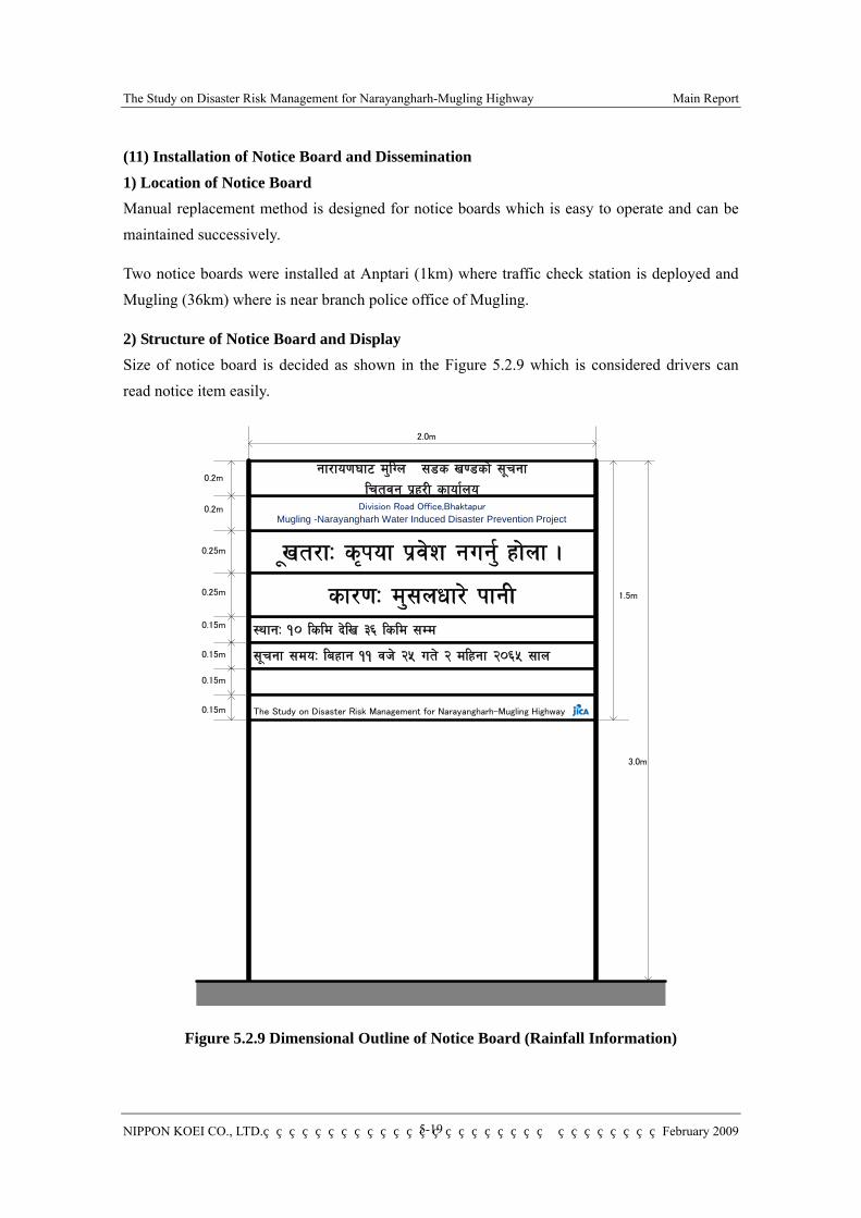
The Study on Disaster Risk Management for Narayangharh-Mugling Highway Main Report
NIPPON KOEI CO., LTD. February 2009
5-19
(11) Installation of Notice Board and Dissemination 1) Location of Notice Board Manual replacement method is designed for notice boards which is easy to operate and can be maintained successively.
Two notice boards were installed at Anptari (1km) where traffic check station is deployed and Mugling (36km) where is near branch police office of Mugling.
2) Structure of Notice Board and Display Size of notice board is decided as shown in the Figure 5.2.9 which is considered drivers can read notice item easily.
"vt/fM s[kof k|j]z gug'{ xf]nf .
:yfgM !) lsld b]lv #^ lsld ;Dd
;"rgf ;doM laxfg !! jh] @% ut] @ dlxgf @)^% ;fn
sf/0fM d';nwf/] kfgL
0.25m
0.25m
0.15m
0.15m
0.15m
0.15m
0.2m
2.0m
1.5m
Division Road Office,Bhaktapur
Mugling -Narayangharh Water Induced Disaster Prevention Project
gf/fo0f3f6 d'lUn ;8s v08sf] ;"rgflrtjg k|x/L sfof{no
0.2m
The Study on Disaster Risk Management for Narayangharh-Mugling Highway
3.0m
Figure 5.2.9 Dimensional Outline of Notice Board (Rainfall Information)

The Study on Disaster Risk Management for Narayangharh-Mugling Highway Main Report
NIPPON KOEI CO., LTD. February 2009
5-20
;Dk"0f{ af6f] aGb 5 .
:yfgM !! lsld b]lv !@ lsld ;Dd
;"rgf ;doM laxfg !! jh] @% ut] @ dlxgf @)^% ;fn
v'Ng] ;doM a]n'sf ^ jh] @% ut] @ dlxgf @)^% ;fn
sf/0fM hn pTkGg k|sf]k
0.25m
0.25m
0.15m
0.15m
0.15m
0.15m
0.2m
2.0m
1.5m
Division Road Office,Bhaktapur
Mugling -Narayangharh Water Induced Disaster Prevention Project
gf/fo0f3f6 d'lUn ;8s v08sf] ;"rgflrtjg k|x/L sfof{no
0.2m
The Study on Disaster Risk Management for Narayangharh-Mugling Highway
3.0m
Figure 5.2.10 Dimensional Outline of Notice Board (Traffic Information)
Information in the notice board is the same as internet Web page which is shown in the Figure 5.2.11 and Table 5.2.13.

The Study on Disaster Risk Management for Narayangharh-Mugling Highway Main Report
NIPPON KOEI CO., LTD. February 2009
5-21
;Dk"0f{ af6f] aGb 5 .
:yfgM !! lsld b]lv !@ lsld ;Dd
;"rgf ;doM laxfg !! jh] @% ut] @ dlxgf @)^% ;fn
v'Ng] ;doM a]n'sf ^ jh] @% ut] @ dlxgf @)^% ;fn
sf/0fM hn pTkGg k|sf]k
0.25m
0.25m
0.15m
0.15m
0.15m
0.15m
0.2m
2.0m
1.5m
Division Road Office,Bhaktapur
Mugling -Narayangharh Water Induced Disaster Prevention Project
gf/fo0f3f6 d'lUn ;8s v08sf] ;"rgflrtjg k|x/L sfof{no
0.2m
The Study on Disaster Risk Management for Narayangharh-Mugling Highway
Figure 5.2.11 Display of Notice Board
Table 5.2.13 Information in Notice Board No Item contents
Heavy Rain Information
・ Warning Notice : Not to Pass through ・ Caution Notice : Caution to Pass through
No1
Traffic Obstacle Information
・ Road Closure of Full Width ・ Road Closure of Partial Width ・ Traffic Jam
Heavy Rain Information
・ Cause:Heavy Rain
No2
Traffic Obstacle Information
・ Cause:Water-Induced Disaster ・ Cause:Traffic Accident ・ Cause:Strike
No3 Common ・ Site:From Bharatpure/Anptari/Mugling nnKm to mmKm (Heavy Rain Information is only “From Bharatpure 10Km to 36Km”)
No4 Common ・ Noticed from:hh AM/PM dd MMM yyyy Heavy Rain Information
・ Blank panel
No5
Traffic Obstacle Information
・ Duration Predicted to: hh AM/PM dd MMM yyyy
No1
No2
No3
No4
No5
Selection from three
nn,mm::0~36 hh:1~12 dd:1~30 MMM : Jan,Feb,Mar,Apr,
May,Jun,Jul,Aug,Sep,Oct,Nov,Dec
yyyy:2008~2999
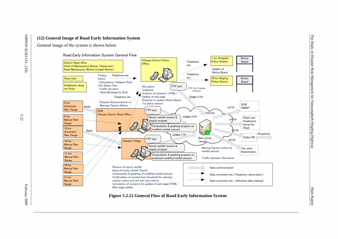
The Study on Disaster R
isk Managem
ent for Narayangharh-M
ugling Highw
ay M
ain Report
NIPPO
N K
OEI C
O., LTD
.
February 20095-22
(12) General Image of Road Early Information System General image of the system is shown below.
Figure 5.2.12 General Flow of Road Early Information System
DORChitwan District Road Office
Road User
District Road officeChief of Maintenance Worker (Supervisor)Road Maintenance Worker(Length Worker)
Inhabitants alongthe Road
Chitwan District PoliceOffice
FindingInform・Disturbance, Collapse, RockFall, Debris Flow・Traffic Accident・ Road Blockage by Strik
Site patrolJudgmentCreation of contents (HTML)Update of web pageDirection to update Notice Board(to police station)0 km
AutomaticRain Gauge
31 kmManual RainGauge
Telephone etc.
Kabilash Village
Radio
Receive of hourly rainfallInput of hourly rainfall (Excel)Computation & graphing of modified rainfall amountConfirmation of exceed from threshold for warning/caution notice and set into care stanceformulation of contents for update of web-page(HTML)Web-page update
CDMA/FTP
Web server(lental)
DORDWIDP
Waning/Caution notice byrainfall amount
Traffic obstacle information
Road userInhabitantsalong theRoad
Internet
The otherStakeholders
HTTP
Road Early Information System General Flow
HTTP
HTTP
10 kmAutomaticRain Gauge
11 kmManual RainGauge
18 kmManual RainGauge
10 kmManual RainGauge
0 kmManual RainGauge
CDMA/FTP
CDMA/FTP
Data communication
Data correction etc.(Telephone, observation )
Data correction etc. (reference data, backup)
Telephoneetc.
1 km AntaptariPolice Station
36 km MuglingPolice Station
Telephoneetc.
Update ofNotice Board
Telephone etc.
FTP tool
FTP tool
Computation & graphing program onpredicted modified rainfall amount
Hourly rainfall receive &display program
FTP tool
Computation & graphing program onmodified rainfall amount
Hourly rainfall receive &display program
Request Announcement ofWarning/Caution NoticeRadio
NoticeBoard
NoticeBoard
FTP: File TransferProtocol
HTTP
Kalika FM
Broadcast

The Study on Disaster Risk Management for Narayangharh-Mugling Highway Main Report
NIPPON KOEI CO., LTD. February 2009
5-23
5.2.3 Installation of Devices
Required devices and instrument were installed based on system designing.
(1) Notice Board
1km Anptari Traffic Check Point 36km Mugling near the Branch Police Office (2) Automatic raingauge and radio communication part
0km Division Road office
10km Kabilash VDC
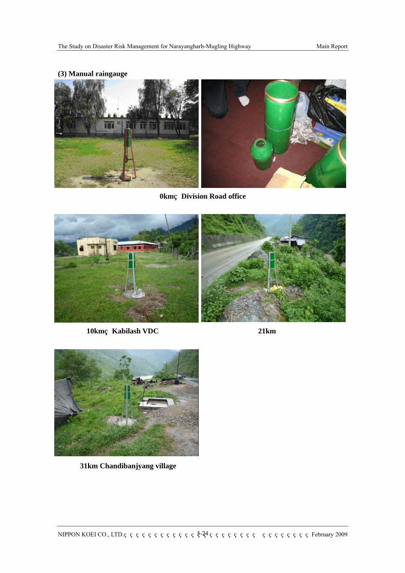
The Study on Disaster Risk Management for Narayangharh-Mugling Highway Main Report
NIPPON KOEI CO., LTD. February 2009
5-24
(3) Manual raingauge
0km Division Road office
10km Kabilash VDC 21km
31km Chandibanjyang village
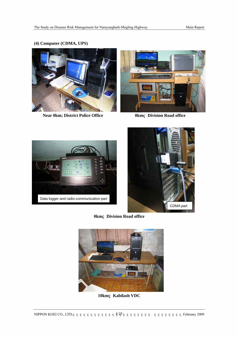
The Study on Disaster Risk Management for Narayangharh-Mugling Highway Main Report
NIPPON KOEI CO., LTD. February 2009
5-25
(4) Computer (CDMA, UPS)
Near 0km; District Police Office 0km Division Road office
0km Division Road office
10km Kabilash VDC
Data logger and radio-communication part
CDMA part
The Study on Disaster Risk Management for Narayangharh-Mugling Highway Main Report
NIPPON KOEI CO., LTD. February 2009
5-26
5.2.4 Instruction on System Operation
Instruction on system operation for each operation unit and joint drill has been carried out as follows.
(1) Instruction onSystem Operation for 1) DPO
Place : District Police Office Chitwan Date : 18th June 2008 Participant : Staff of DPO, Traffic police of Anptari, Police of Mugling Branch Office Instruction : Receiving and arrangement of rainfall and traffic obstacles, making Web
page content/uploading, update of notice board.
2) DRO Bharatpur, Chitwan Place : Division Road office Date : 18th June 2008 Participant : Engineers of DRO Instruction : Confirmation of rainfall information, prediction of hourly rainfall based on
12 hour half –value rainfall amount/program. Making graph, making Web page content and method of upload.
3) Kabilash VDC Place : Office of Kabilash VDC Date : 19th June 2008 Participant : Staffs of VDC, School teacher Instruction : Confirmation of rainfall information, prediction of hourly rainfall based on
12 hour half –value rainfall amount/program. Making graph, making Web page content and method of upload.
(2) Joint Training Drill Joint training drill on road early information system for N-M Highway and corresponding early warning/ evacuation system was carried out on 26th June 2008. (Refer to Data & Drawing)
Place : Royal Century Hotel, N-M highway and Kabilash Village Date : 26th June 2008 Participant : Planning and Review Committee member, staffs of DPO, staffs of DRO,
staffs of Kabilash VDC and villagers, C/P, the Study Team One day drill along considering a scenario of disaster occurrence in the project area was carried out.
1) Organization of Drill Organization of drill was formulated as shown Figure 5.2.13 and roles were given to each
The Study on Disaster Risk Management for Narayangharh-Mugling Highway Main Report
NIPPON KOEI CO., LTD. February 2009
5-27
operation unit as shown in Table 5.2.14 which is almost same of actual operation of the system.
Figure 5.2.13 General Organization of Drill Work
Table 5.2.14 The role for each organization on Drill on June 26th
Organization Role Implementation Group
Supporter
District Police office(DPO)
1. Collect urgent information for road traffic obstacles.
2. Patrol/Inspection/judgment about road traffic obstacles.
3. Update information for notice boards. 4. Disseminate information by internet
web-page. 5. Urgent response to road traffic obstacles.
- Information Receiver - Decision maker - Computer operator - Board updater - Patrol
The Study Team (Computer operator) RRN (Hearing for road user)
Divisional Road office (DRO)
1. Monitor automatic raingauge and manual raingauge at DRO office.
2. Report road traffic obstacles to police office/station.
3. Patrol/Inspection/judgment about road traffic obstacles for road user.
4. Urgent response to the road disaster.
- Computer operator - Decision maker - liaison - Patrol - Data collector
The Study Team (Computer operator)
Kabilash VDC 1. Monitoring of automatic raingauge and manual raingauge at Kabilash VDC.
2. Report road traffic obstacles to police office/station.
3. Patrol/Inspection/judgment about road traffic obstacles for inhabitants.
4. Urgent response to the road disaster.
- Disaster Education/Hazard Map Team
MNDWIDPP (Information provider) The Study Team (Computer operator) RRN (Hearing for inhabitants)
Supervisor / Length worker
1. Report road traffic obstacles to police office/station
- Finder
Inhabitants / Road user
1. Report road traffic obstacles to police office/station
- Finder
Media Association (Kalika FM)
1. Broadcast information of traffic obstacles/ early warming under heavy rain by radio.
- confirmer for Web site
Drill Conductor (CDO)
DPO DRO Kabilash VDC Kalika FM
Monitor (RRN, DWIDP) Supporter (Study Team)
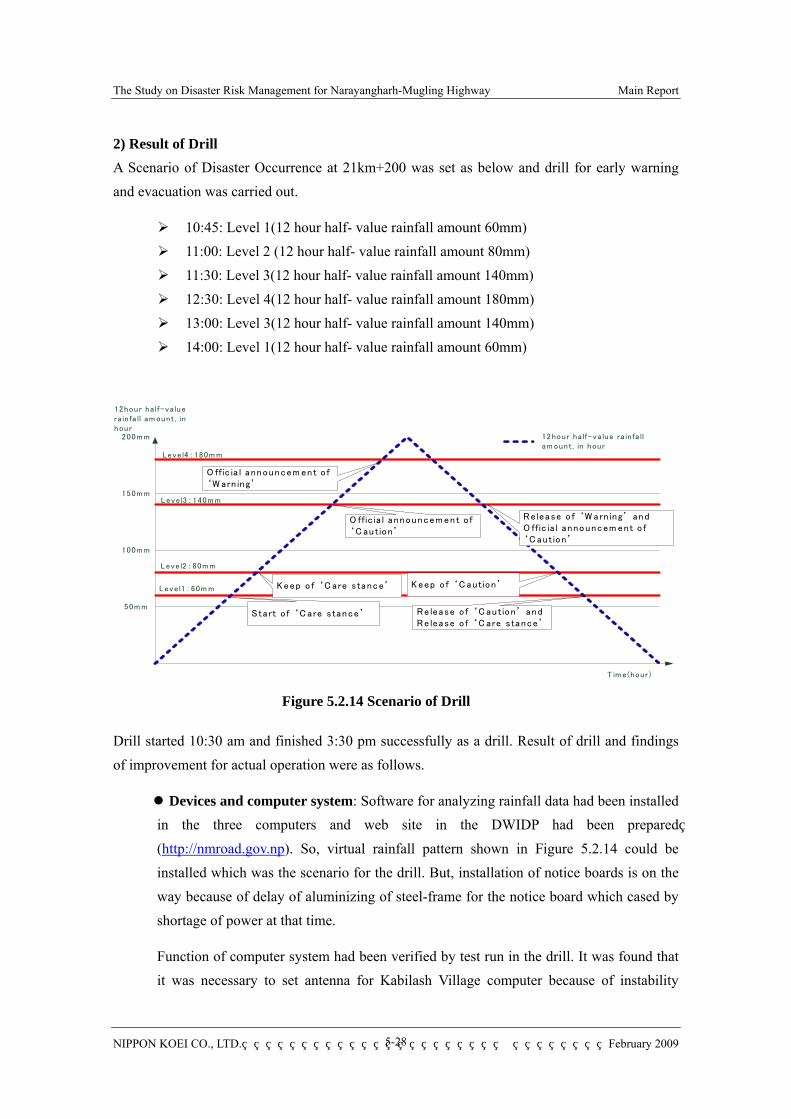
The Study on Disaster Risk Management for Narayangharh-Mugling Highway Main Report
NIPPON KOEI CO., LTD. February 2009
5-28
2) Result of Drill A Scenario of Disaster Occurrence at 21km+200 was set as below and drill for early warning and evacuation was carried out.
10:45: Level 1(12 hour half- value rainfall amount 60mm) 11:00: Level 2 (12 hour half- value rainfall amount 80mm) 11:30: Level 3(12 hour half- value rainfall amount 140mm) 12:30: Level 4(12 hour half- value rainfall amount 180mm) 13:00: Level 3(12 hour half- value rainfall amount 140mm) 14:00: Level 1(12 hour half- value rainfall amount 60mm)
Figure 5.2.14 Scenario of Drill
Drill started 10:30 am and finished 3:30 pm successfully as a drill. Result of drill and findings of improvement for actual operation were as follows.
Devices and computer system: Software for analyzing rainfall data had been installed in the three computers and web site in the DWIDP had been prepared (http://nmroad.gov.np). So, virtual rainfall pattern shown in Figure 5.2.14 could be installed which was the scenario for the drill. But, installation of notice boards is on the way because of delay of aluminizing of steel-frame for the notice board which cased by shortage of power at that time.
Function of computer system had been verified by test run in the drill. It was found that it was necessary to set antenna for Kabilash Village computer because of instability
Leve l1:60m m
Leve l2:80m m
Leve l3:140m m
Leve l4:180m m
50m m
100m m
150m m
200m m 12hour ha lf-va lue ra in fa ll am ount, in hour
S tart o f ‘C are stance’
Keep o f ‘C are stance’
O ffic ia l announcem ent o f ‘C aution’
O ffic ia l announcem ent o f ‘W arn ing’
Re lease o f ‘W arn ing’ andO ffic ia l announcem ent o f ‘C aution’
Re lease o f ‘C aution’ andRe lease o f ‘C are stance’
Keep o f ‘C aution’
12hour ha lf-va lue ra in fa ll am ount , in hour
T im e(hour)

The Study on Disaster Risk Management for Narayangharh-Mugling Highway Main Report
NIPPON KOEI CO., LTD. February 2009
5-29
electric waves to access to the web site in the area.
Operation skill of each unit: Staffs of DOR, DPO, and Kabilash Village operated computers properly.
Information network: It was confirmed that the information network between major operation units: DPO-DRO- Kabilash Village- Kalika FM. But, it was found that reporting from the disaster site was very difficult because telephone was not available from 21km+200 to 10km (Kabilash Village). So, I took around thirty minutes by car for reporting of disaster occurrence for each operation units.
Performance of villagers: Drill of Kabilash Village was focus mainly on operation of the Early Warning/ Evacuation System. Ward 1, 5, 6 was selected for the drill where is many critical places under heavy rain. Operation of computer and information network between village office and leaders of wards was carried out smoothly. But, getting weather information through Kalika FM was difficult because the broadcast on the weather information could not hear in 95.2 MHz. But, later it was found weather information could hear frequency 148.8. Process of Kabilash Village is summarized in Table 5.2.15.
Table 5.2.15 Process of Drill in Kabilash Village Time Staffs in Charge Performance/Remarks 11:00 VDC Secretary
/Staffs Input 89 mm rainfall(Level II), Announce of Recommendation for preparation for evacuation. Upload to The web site was not available due to instability of radio wave.
11:15 VDC Staffs Report to DPO and Kalika FM; At first, phone line of DPO was very busy to access. But soon later, special line able to access was found.
11:20 VDC Staffs Confirmation of broadcast on weather information by Kalika FM;At first, Kalika FM cannot hear in 95.2MHz
12:00 VDC Secretary /Staffs
Input 148 mm rainfall (Level III), Announce of order for evacuation to ward leaders.
12:10 Villager Report to DPO and Kalika FM on evacuation order 12:20 VDC Staffs Confirmation of broadcast on weather information by Kalika FM;12:30 Villagers Villagers began to move to evacuation area 13:00 VDC Secretary
/Staffs Input 176 mm rainfall (Level IV), Kept on evacuation place.
14:00 VDC Secretary /Staffs
Input 123 mm rainfall (Level IV); Release of evacuation order..
14:10 VDC Staffs Report to DPO and Kalika FM 14:20 Villagers Villagers left evacuation place to their home. 14:30 Drill was concluded
The Study on Disaster Risk Management for Narayangharh-Mugling Highway Main Report
NIPPON KOEI CO., LTD. February 2009
5-30
Review and Discussion on the Drill: After closing the drill at 2:30 pm, the drill performance was reviewed and evaluated by Mr. H.Bhurtel Engineer, Road Office Bharatpur, Ms. Saraswoti Adhikari; Coordinator, Kabilash VDC and by Mr. Prakash Malla, District Police Office, Chitwan.
Drill was conducted as scheduled and all participants did their role in charge and understood relationship between each operation unit through the drill. Following item was pointed out and proposed for actual operation of the system.
Broadcast from Kalika FM was very important to notice on critical condition widely. But, relationship between operation units and Kalika FM was not so smooth. Network with Kalika FM should be strengthened.
Electric wave around Kabilash Village is not stable. Installation of antenna is required to upload to the web site.
System was conducted suitably, but more training is necessary to operate the system steadily for the pilot projects
It is necessary to prepare incentive for sustainable system operation. (DPO/Kabilash Village)