chapter 3 transport department highways department … · chapter 3 transport department highways...
TRANSCRIPT

CHAPTER 3
Transport Department Highways Department
Civil Engineering and Development Department
Construction of pedestrian crossing facilities
Audit Commission Hong Kong 29 March 2010
This audit review was carried out under a set of guidelines tabled in the Provisional Legislative Council by the Chairman of the Public Accounts Committee on 11 February 1998. The guidelines were agreed between the Public Accounts Committee and the Director of Audit and accepted by the Government of the Hong Kong Special Administrative Region.
Report No. 54 of the Director of Audit contains 8 Chapters which areavailable on our website at http://www.aud.gov.hk. Audit Commission 26th floor, Immigration Tower 7 Gloucester Road Wan Chai Hong Kong Tel : (852) 2829 4210 Fax : (852) 2824 2087 E-mail : [email protected]
— i —
CONSTRUCTION OF PEDESTRIAN CROSSING FACILITIES
Contents
Paragraph
PART 1: INTRODUCTION
Pedestrian crossing facilities
Construction and maintenance of footbridges and subways
Pedestrians’ preference for crossing facilities
Director of Audit’s Report on provision of footbridges and subways
Audit review
Acknowledgement PART 2: IMPROVEMENT MEASURES ON UTILISATION OF FOOTBRIDGES AND SUBWAYS
2007 audit review
Review of footbridges and subways with low utilisation
Actions to deal with footbridges and subways with low utilisation
Audit observations and recommendations
Response from the Administration PART 3: A FOOTBRIDGE ALONGSIDE HUNG HOM BYPASS
Footbridge J between Tsim Sha Tsui East and Hung Hom
Changes in design of the elevated walkway
Audit observations and recommendations
Response from the Administration
1.1 1.2 – 1.8 1.9 – 1.11 1.12 – 1.14 1.15 1.16 1.17 2.1 2.2 2.3 – 2.5 2.6 – 2.7 2.8 – 2.14 2.15 3.1 3.2 – 3.4 3.5 – 3.6 3.7 – 3.19 3.20 – 3.23
— ii —
Paragraph
PART 4: A CLOSED SUBWAY IN SHAM SHUI PO
A closed subway across Tung Chau Street near Kiu Kiang Street
Proposed demolition of Subway W
Illegal occupation by street sleepers
Audit observations and recommendations
Response from the Administration PART 5: TWO FOOTBRIDGES IN TUNG CHUNG WEST
Footbridges K and L
Phased development of Tung Chung New Town
Requests for at-grade crossing near Footbridge L
Requests for at-grade crossing near Footbridge K
Audit observations and recommendations
Response from the Administration PART 6: FOOTBRIDGES BUILT UNDER CASTLE PEAK ROAD IMPROVEMENT PROJECT
Castle Peak Road improvement project
Road type and speed limit of the Castle Peak Road section
Audit observations and recommendations
Response from the Administration
4.1 4.2 – 4.3 4.4 4.5 4.6 – 4.20 4.21 – 4.24 5.1 5.2 – 5.5 5.6 – 5.7 5.8 – 5.11 5.12 – 5.15 5.16 – 5.29 5.30 – 5.32 6.1 6.2 – 6.3 6.4 – 6.6 6.7 – 6.41 6.42 – 6.43
Appendices: Page
A : Footbridges and subways with low utilisation identified by Audit
B : Details of the 11 footbridges along the Castle Peak Road section C : Acronyms and abbreviations
62 63 64

— 1 —
PART 1: INTRODUCTION 1.1 This PART describes the background to the audit and outlines the audit objectives and scope. Pedestrian crossing facilities
1.2 Road traffic in Hong Kong is very busy in terms of both vehicular and pedestrian flows. To avoid conflict in road use between vehicles and pedestrians and to reduce road accidents involving pedestrians, adequate and safe pedestrian crossing facilities should be carefully planned. Pedestrian crossing facilities should be provided at locations that would enhance potential usage and should be as convenient as possible to desired pedestrian paths. Crossing facilities located too far away from pedestrian routes could lead to pedestrians creating their own crossing points to the detriment of their own and other road users’ safety. At-grade crossing facilities
1.3 Most pedestrian crossing facilities are provided at grade (i.e. at the same level as the road), including:
(a) zebra crossings (where pedestrians have the priority to cross the road);
(b) signal-controlled crossings (commonly known as “Green Man” crossings);
(c) cautionary crossings at signal-controlled junctions (with signals for drivers only but not for pedestrians); and
(d) uncontrolled cautionary crossings (no signals for either pedestrians or drivers). 1.4 At-grade crossings are the most direct and convenient route for use by pedestrians. In areas with high vehicular flows, at-grade crossings are usually controlled by light signals to reduce the risk of traffic accidents involving pedestrians. The type of at-grade crossings to be used depends on the vehicular and pedestrian flows, accident records involving pedestrians, and the benefits to pedestrians against any additional delay to vehicular flow.

Introduction
— 2 —
Grade-separated crossing facilities
1.5 Footbridges and subways are grade-separated crossings (i.e. constructed at a level higher or lower than that of the road). The benefits of grade-separated crossings are twofold, namely maximising pedestrian safety when crossing the road and minimising disruption to vehicular traffic. However, the need to walk up and down when using a footbridge or subway is not always welcomed by pedestrians. Therefore, grade-separated crossings should be provided at locations where the traffic flow and road safety conditions warrant their provision. Most footbridges and subways are installed with ramps or lifts and some, with high levels of pedestrian flow, are installed with escalators. Factors for consideration in planning pedestrian crossing facilities
1.6 The Transport Department (TD) has laid down detailed guidelines in the Transport Planning and Design Manual (TPDM) for the planning of pedestrian crossing facilities. The TPDM stipulates that, because of the potential danger to pedestrians crossing at grade and the disruption to traffic by at-grade crossing movements on congested roads, wherever justified, consideration should be given to providing grade-separated crossings to segregate pedestrians from vehicular traffic. 1.7 According to the TPDM, the justifications for each case of providing a grade-separated crossing should be considered on its own merit, taking into account the following factors in the area concerned:
(a) anticipated pedestrian utilisation;
(b) type, characteristics and layout of the road concerned;
(c) volume and speed of the traffic;
(d) road safety and capacity considerations;
(e) desired pedestrian path;
(f) availability and location of alternative crossings;
(g) connectivity of the facility with nearby developments and walkway systems;
(h) capital and recurrent cost considerations; and
(i) public opinions.

Introduction
— 3 —
1.8 In March 2010, the TD elaborated that:
(a) in planning for the provision of grade-separated crossing facilities, the TD would consider all the justifying factors in accordance with the TPDM. While anticipated pedestrian utilisation was one of the factors, other factors should be considered in tandem, particularly road safety and capacity considerations;
(b) with the segregation of pedestrians from vehicles, grade-separated crossing facilities would greatly improve the safety of both pedestrians and motorists, thereby saving economic and social costs related to accidents;
(c) the increase in throughput of the vehicle traffic would enhance the effectiveness of the overall network, contributing more economic benefits; and
(d) the justification for provision of grade-separated crossing facilities merely by anticipated utilisation should not be over-emphasised in order to maintain a balanced and full picture for making prudent decisions in the planning for the facilities.
Construction and maintenance of footbridges and subways
1.9 The TD has the overall responsibility for the planning and provision of pedestrian crossing facilities, including footbridges and subways. For new development or redevelopment projects, the Planning Department and the Civil Engineering and Development Department (CEDD — Note 1) are sometimes involved in the planning of footbridges and subways. The Highways Department (HyD) and the CEDD implement capital works projects for constructing footbridges and/or subways (Note 2 ). After completion, the footbridges and subways are usually handed over to the HyD for maintenance.
Note 1: In July 2004, the CEDD was formed by merging the former Civil Engineering Department and the Territory Development Department. For simplicity, both the Civil Engineering Department and the Territory Development Department are referred to as the CEDD in this Report.
Note 2: Some footbridges and subways are constructed by other government departments
(e.g. the Housing Department), subvented organisations or private developers.
Introduction
— 4 —
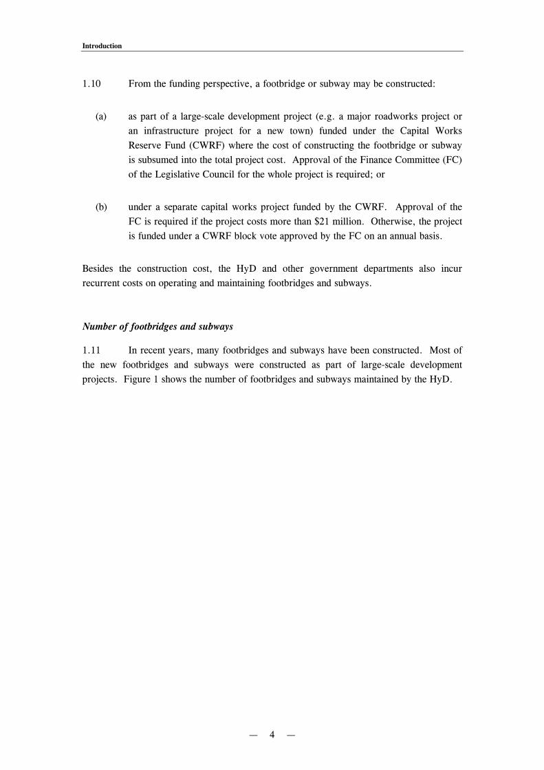
1.10 From the funding perspective, a footbridge or subway may be constructed:
(a) as part of a large-scale development project (e.g. a major roadworks project or an infrastructure project for a new town) funded under the Capital Works Reserve Fund (CWRF) where the cost of constructing the footbridge or subway is subsumed into the total project cost. Approval of the Finance Committee (FC) of the Legislative Council for the whole project is required; or
(b) under a separate capital works project funded by the CWRF. Approval of the FC is required if the project costs more than $21 million. Otherwise, the project is funded under a CWRF block vote approved by the FC on an annual basis.
Besides the construction cost, the HyD and other government departments also incur recurrent costs on operating and maintaining footbridges and subways. Number of footbridges and subways
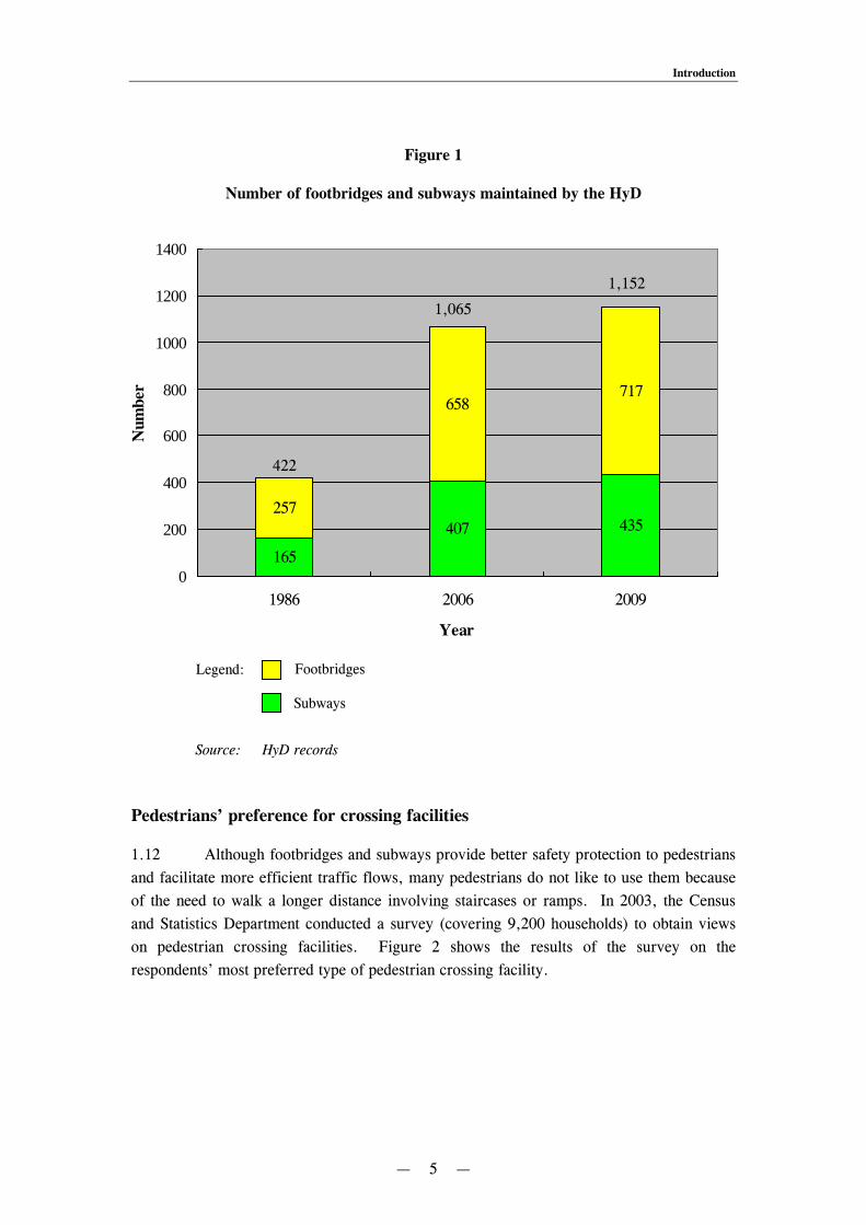
1.11 In recent years, many footbridges and subways have been constructed. Most of the new footbridges and subways were constructed as part of large-scale development projects. Figure 1 shows the number of footbridges and subways maintained by the HyD.
Introduction
— 5 —
Figure 1
Number of footbridges and subways maintained by the HyD
Source: HyD records
Pedestrians’ preference for crossing facilities
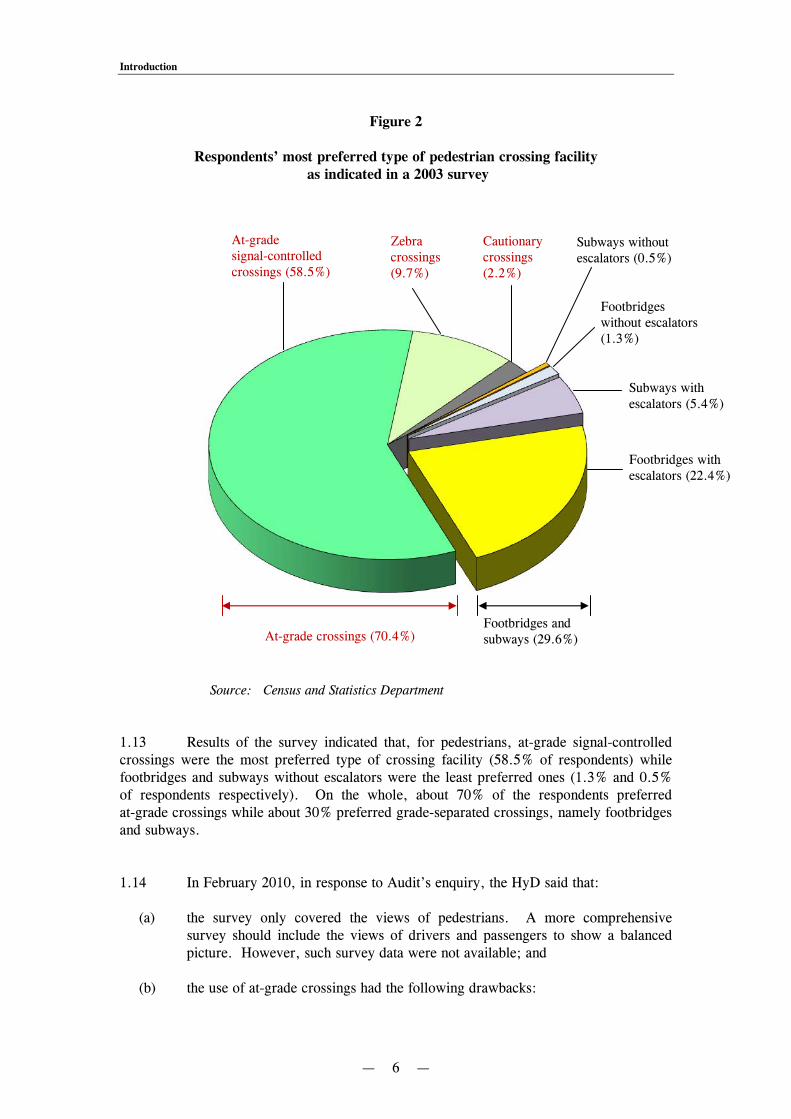
1.12 Although footbridges and subways provide better safety protection to pedestrians and facilitate more efficient traffic flows, many pedestrians do not like to use them because of the need to walk a longer distance involving staircases or ramps. In 2003, the Census and Statistics Department conducted a survey (covering 9,200 households) to obtain views on pedestrian crossing facilities. Figure 2 shows the results of the survey on the respondents’ most preferred type of pedestrian crossing facility.
Legend: Footbridges
Subways
165
407 435257
658717
0
200
400
600
800
1000
1200
1400
1986 2006 2009
Year
Num
ber
1,152
1,065
422
Introduction
— 6 —
Figure 2
Respondents’ most preferred type of pedestrian crossing facility as indicated in a 2003 survey
Source: Census and Statistics Department 1.13 Results of the survey indicated that, for pedestrians, at-grade signal-controlled crossings were the most preferred type of crossing facility (58.5% of respondents) while footbridges and subways without escalators were the least preferred ones (1.3% and 0.5% of respondents respectively). On the whole, about 70% of the respondents preferred at-grade crossings while about 30% preferred grade-separated crossings, namely footbridges and subways. 1.14 In February 2010, in response to Audit’s enquiry, the HyD said that:
(a) the survey only covered the views of pedestrians. A more comprehensive survey should include the views of drivers and passengers to show a balanced picture. However, such survey data were not available; and
(b) the use of at-grade crossings had the following drawbacks:
At-grade crossings (70.4%) Footbridges and subways (29.6%)
At-grade signal-controlled crossings (58.5%)
Zebra crossings (9.7%)
Cautionary crossings (2.2%)
Subways without escalators (0.5%)
Footbridges without escalators (1.3%)
Footbridges with escalators (22.4%)
Subways with escalators (5.4%)
Introduction
— 7 —
(i) vehicular speed limit had to be reduced to 50 kilometres per hour (km/hr);
(ii) more stop-and-go operations meant more delay to traffic and more air
pollution; and (iii) once an at-grade crossing was provided, there would be more jaywalking.
Director of Audit’s Report on provision of footbridges and subways
1.15 In Chapter 11 of the Director of Audit’s Report No. 49 of October 2007, the Audit Commission (Audit) reported observations on the provision of footbridges and subways. The audit review identified a number of footbridges and subways with low utilisation due to the presence of nearby at-grade crossings or connection to undeveloped sites. Audit made a number of recommendations for improvement. The Administration accepted the audit recommendations and subsequently implemented them. Audit review
1.16 In view of the much higher costs for construction and maintenance of footbridges and subways as compared to at-grade crossings, Audit has recently conducted a review to examine the planning process for the provision of footbridges and subways by selecting a number of footbridges and subways for detailed study. The review also examined the measures taken by the Administration to improve utilisation of footbridges and subways since the 2007 audit review. The review focused on the following areas:
(a) improvement measures on utilisation of footbridges and subways (PART 2); (b) a footbridge alongside Hung Hom Bypass (PART 3); (c) a closed subway in Sham Shui Po (PART 4); (d) two footbridges in Tung Chung West (PART 5); and (e) footbridges built under Castle Peak Road improvement project (PART 6).
Audit has found that there are areas where improvements can be made and has made a number of recommendations to address the issues. Acknowledgement
1.17 Audit would like to acknowledge with gratitude the full cooperation of the staff of the TD, the HyD, the CEDD, the Lands Department (LandsD) and the Home Affairs Department (HAD) during the course of the audit review.
— 8 —
PART 2: IMPROVEMENT MEASURES ON UTILISATION OF FOOTBRIDGES AND SUBWAYS 2.1 This PART examines the measures taken to improve the utilisation of footbridges and subways since the 2007 audit review. 2007 audit review
2.2 In the 2007 audit review (see para. 1.15), Audit identified 8 footbridges (Footbridges A to H) and 3 subways (Subways X to Z) with low utilisation. Audit recommended that the TD should conduct a review to identify footbridges and subways with low utilisation and ascertain the underlying reasons, and regularly monitor their utilisation. The TD agreed with the audit recommendations and said that, in view of the fairly large number of facilities, it would conduct the review in stages. It would initially focus on the facilities with very low utilisation, and extend the work depending on resources. Review of footbridges and subways with low utilisation
2.3 The TD commenced the first stage of the review in December 2007. In June 2008, the TD identified 22 footbridges and 17 subways with low utilisation (including the 8 footbridges and 3 subways identified in the 2007 audit review) for detailed examination. In reviewing the 22 footbridges and 17 subways, the TD:
(a) conducted site visits and field observations;
(b) conducted surveys of pedestrian and vehicular flows, including those at nearby at-grade crossing facilities; and
(c) collected information on construction cost and annual recurrent costs of the footbridges and subways, accident statistics, and future development in the vicinity of the facilities.
2.4 In March 2009, the TD completed the first stage of the review and compiled a draft report for consideration by the Transport and Housing Bureau (THB). In January 2010, the TD compiled a final report (hereinafter referred to as the 2010 Review Report) which was endorsed by the THB.

Improvement measures on utilisation of footbridges and subways
— 9 —
2.5 According to the 2010 Review Report, pedestrians generally preferred at-grade crossings because they were more direct and convenient, without the need to go up and down stairs/ramps of footbridges and subways. The report identified the following reasons for low utilisation of the 22 footbridges and 17 subways:
(a) the presence of at-grade crossings (with or without signal controls) nearby, though some of the at-grade crossings were provided afterwards at the requests of the local residents or organisations for the disabled;
(b) the lack of facilities, such as ramps, lifts and escalators, to serve the aged and the disabled;
(c) low road crossing demand on one or both ends of some facilities either due to low development density or delay in the completion of developments or population intake;
(d) location of some facilities not along the popular or shortest routes, involving detour along the staircases or ramps;
(e) pedestrian concerns over security or presence of street sleepers; and
(f) exceptional height of a particular footbridge (more than 10 metres above ground due to connection to upper floors of adjoining development) requiring considerable effort to use.
Actions to deal with footbridges and subways with low utilisation
2.6 The 2010 Review Report mentioned that improvement works had been/would be implemented at four footbridges and one subway to promote pedestrian usage, including the following:
(a) erecting directional signs to guide pedestrians to use the footbridge;
(b) relocating railings and traffic signs to widen a footpath leading to Footbridge G (see para. 2.2) in Kowloon Tong; and
(c) erecting railings to deter jaywalking.
2.7 In addition to the above improvement works, the following actions were proposed in the 2010 Review Report:
Improvement measures on utilisation of footbridges and subways
— 10 —
(a) a subway across Tsuen King Circuit should be closed because of extremely low patronage;
(b) 14 footbridges and 5 subways should be monitored as it was expected that there would be developments which might lead to increase in pedestrian flow in the near future;
(c) no further action was required for the remaining 19 footbridges and subways for which there were no known developments in their vicinity; and
(d) the HyD should inform the TD in advance of any proposed major maintenance works or upgrading works on the 22 footbridges and 17 subways in future, and review jointly on a case-by-case basis whether the proposed works should proceed (Note 3).
Audit observations and recommendations
Need to implement improvement works and follow-up actions
2.8 In March 2009, the TD completed the first stage of the review of footbridges and subways with low utilisation and compiled a draft report with proposed improvement works and follow-up actions (see paras. 2.6 and 2.7). In January 2010, the TD compiled the 2010 Review Report which was endorsed by the THB. Audit considers that there is a need to take early action to implement the improvement works and follow-up actions proposed in the 2010 Review Report. Need to draw up a programme for reviewing utilisation of footbridges and subways 2.9 As at December 2009, the HyD was maintaining 717 footbridges and 435 subways. In the 2010 Review Report, the TD identified 22 footbridges and 17 subways with low utilisation based on the working knowledge of TD staff responsible for managing the facilities. While the TD had said that it would conduct the review of footbridges and subways in stages (see para. 2.2), Audit noted that the TD had not compiled any action plans for conducting the review on a systematic basis.
Note 3: In February 2010, in response to Audit’s enquiry, the HyD said that it had adopted the practice of informing the TD in advance of any proposed major maintenance works or upgrading works on the 22 footbridges and 17 subways, and reviewing jointly with the TD on a case-by-case basis whether the proposed works should proceed.
Improvement measures on utilisation of footbridges and subways
— 11 —
2.10 With a view to identifying other footbridges and subways with low utilisation which may require detailed examination and follow-up actions, Audit carried out the following audit work:
(a) reviewing media reports;
(b) reviewing committee meeting minutes of District Councils;
(c) conducting research on maps and the Internet;
(d) examining records of the TD and the HyD; and
(e) conducting site visits to selected footbridges and subways with indications of low utilisation.
2.11 From the above audit work, Audit found 7 footbridges and 2 subways (not covered by the TD’s review) with low utilisation that might warrant detailed examination and monitoring (see Appendix A). Audit considers that there is a need for the TD to draw up a programme with a timetable to examine the utilisation of footbridges and subways on a systematic basis, and to identify improvement measures for those with low utilisation. Need to identify measures for better planning of pedestrian crossing facilities 2.12 The presence of nearby at-grade crossings is the major reason affecting the utilisation of footbridges and subways. Audit noted that there was an at-grade crossing (Note 4) in the vicinity of each of the 7 footbridges and 2 subways identified by Audit (see para. 2.11) as having low utilisation. Most pedestrians crossed the road by using the at-grade crossings. Photographs 1 to 4 show four such footbridges (see Items 1 to 4 in Appendix A).
Note 4: For Item 9 in Appendix A, the alternative at-grade crossing was located inside the adjacent Nam Cheong Station of the Mass Transit Railway West Rail Line.

Improvement measures on utilisation of footbridges and subways
— 12 —
Photograph 1
Footbridge at the junction of Hoi Fan Road and Hoi Fai Road in Tai Kok Tsui
Source: Photograph taken by Audit in November 2009
Photograph 2
Footbridge across Tai Wo Hau Road near Hing Fong Road in Kwai Chung
Source: Photograph taken by Audit in December 2009
Hoi Fan Road

Improvement measures on utilisation of footbridges and subways
— 13 —
Photograph 3
Footbridge across Chung Mei Road near Sheung Ko Tan Street in Tsing Yi
Source: Photograph taken by Audit in December 2009
Photograph 4
Footbridge across Wang Chiu Road near Kai Yip Estate in Kowloon Bay
Source: Photograph taken by Audit in November 2009

Improvement measures on utilisation of footbridges and subways
— 14 —
2.13 In the 2010 Review Report, the TD also identified the presence of nearby at-grade crossings as one of the major reasons leading to the low utilisation of footbridges and subways (see para. 2.5(a)). The TD found that, in some cases, at-grade crossings were provided after the construction of the footbridges and subways. However, the TD’s review did not examine the underlying reasons for constructing the footbridges and subways, or for not providing the at-grade crossings in the first place. Audit considers that there is a need to examine the underlying reasons for this problem with a view to identifying measures for better planning of pedestrian crossing facilities in future. Audit recommendations
2.14 Audit has recommended that the Commissioner for Transport should: (a) take early action to implement the improvement works and follow-up actions
proposed in the 2010 Review Report (see para. 2.8); (b) draw up a programme with a timetable to examine the utilisation of
footbridges and subways on a systematic basis, and to identify improvement measures for those with low utilisation (see para. 2.11); and
(c) in the review of footbridges and subways with low utilisation in future,
examine the underlying reasons for the existence of a footbridge/subway and an at-grade crossing in close proximity, with a view to identifying measures for better planning of pedestrian crossing facilities (see para. 2.13).
Response from the Administration
2.15 The Commissioner for Transport accepts the audit recommendations. He has said that:
(a) the TD will take early action to implement the proposed improvement works and follow-up actions. However, some proposed improvement works will require detailed discussion with the relevant departments, followed by consultation with the relevant District Council and local community before a final decision could be made;
(b) while the TD considers that review of under-utilised facilities is an ongoing and
continuing exercise, the TD will draw up a programme to examine the facilities having regard to the availability of resources; and
(c) examination of the underlying reasons for the existence of a footbridge/subway
and an at-grade crossing in close proximity, and identification of measures for the better planning of pedestrian crossing facilities, are an ongoing exercise which will continue to be conducted in future.

— 15 —
PART 3: A FOOTBRIDGE ALONGSIDE HUNG HOM BYPASS 3.1 This PART examines the planning and construction of an elevated walkway (hereinafter referred to as Footbridge J) alongside Hung Hom Bypass connecting Tsim Sha Tsui East and Hung Hom.
Footbridge J between Tsim Sha Tsui East and Hung Hom
3.2 Hung Hom Bypass is a dual carriageway connecting Hung Hom Road in Hung Hom with Salisbury Road in Tsim Sha Tsui East. The Bypass spans over the railway freight-yard extension, the seafront beyond the International Mail Centre and Salisbury Road before landing on Salisbury Road near Mody Lane. Footbridge J is situated alongside a section of Hung Hom Bypass connecting the promenade of Tsim Sha Tsui East with Hung Hom Bay reclamation area. Photograph 5 and Figure 3 show Footbridge J and its location respectively.
Photograph 5
Footbridge J
Source: Photograph taken by Audit in December 2009

A footbridge alongside Hung Hom Bypass
— 16 —
Figure 3
Location of Footbridge J
Source: Records of the HyD and LandsD 3.3 Footbridge J is a 600-metre long elevated pedestrian walkway with supporting columns — with some planted on the seabed. The footbridge, with ramps at both ends and a staircase at the Hung Hom side, does not have a cover. 3.4 Footbridge J was constructed under two capital works projects, namely:
(a) Hung Hom Bypass and Princess Margaret Road Link (Project A), implemented by the HyD; and
(b) engineering infrastructure on Hung Hom Bay reclamation (Project B), implemented by the CEDD.
N
Railway station
Footbridge J Deleted side span
Pedestrian walkway to railway station
Freight yard
Podium of freight-yard
extension
A footbridge alongside Hung Hom Bypass
— 17 —
The construction of Footbridge J was completed in 1999 at a cost of $30 million (70% charged to Project A and 30% to Project B). The maintenance cost incurred in 2009 was $154,000. Changes in design of the elevated walkway
3.5 Planning for Project A and Project B started in the early 1990s. In August 1992, the CEDD entrusted the design and construction of Project B to the HyD. In the original design, Footbridge J comprised a main span connecting Tsim Sha Tsui East and Hung Hom, and a side span connecting the main span to the podium of the railway freight-yard extension then under development (see Figure 3 in para. 3.2). There was a pedestrian link between the podium of the freight-yard extension and the then Kowloon-Canton Railway Hung Hom Station. Therefore, the side span of Footbridge J would provide a pedestrian link from Tsim Sha Tsui East and Hung Hom Bay reclamation area to Hung Hom Station. 3.6 In March 1994, at a meeting attended by the CEDD, the HyD and the TD, the design of Footbridge J was revised and the side span was deleted as it was considered that Footbridge J was not an essential pedestrian link to the podium of the freight-yard extension and the railway station. In September 1994, the details of Project A and Project B were gazetted, and Footbridge J was described as a pedestrian walkway alongside Hung Hom Bypass to connect the promenade at Tsim Sha Tsui East with Hung Hom Bay reclamation area. Audit observations and recommendations
Need to provide sufficient and accurate information in funding submissions
3.7 Project A. In July 1995, the HyD submitted a paper to the Public Works Subcommittee (PWSC) of the FC seeking funding for Project A. Audit noted that the PWSC paper did not specifically mention the construction of Footbridge J, despite the fact that 70% of the cost of Footbridge J was charged to the project vote of Project A (see para. 3.4). 3.8 In February 2010, in response to Audit’s enquiry, the HyD said that:
(a) in preparing PWSC papers, it always strived to give a succinct and concise account of what the funding application was about. Minor or incidental work items (such as footpaths, traffic signs and railings) might not always be highlighted;
(b) the approved project estimate of Project A was $1,375 million, and the main
theme of the project was the construction of Hung Hom Bypass. Part of the elevated walkway was an integral part of Hung Hom Bypass and the associated cost was only about $20 million which was included under the main works item mentioned in the PWSC paper; and
A footbridge alongside Hung Hom Bypass
— 18 —
(c) the drawing attached to the PWSC paper showed the extent of Footbridge J (Note 5).
3.9 Project B. In March 1996, the CEDD submitted a paper to the PWSC seeking funding for Project B. In the PWSC paper, it was mentioned that five footbridges would be constructed, three of which (including Footbridge J) would link up Hung Hom Bay reclamation area with the railway freight-yard extension. Audit noted that this general description was not entirely applicable to Footbridge J because its side span for connection to the railway freight-yard extension had already been deleted in the revised design (see para. 3.6 and Note 6). 3.10 In Audit’s view, the HyD and the CEDD had not provided sufficient detailed information about the justifications for constructing Footbridge J in the two funding submissions to the PWSC. After deleting the side span, Footbridge J was not designed to provide a pedestrian link from Tsim Sha Tsui East or Hung Hom Bay reclamation area to Hung Hom Station. The main function of Footbridge J was to connect the promenade in Tsim Sha Tsui East with Hung Hom Bay reclamation area. 3.11 In February 2010, in response to Audit’s enquiry, the TD said that:
(a) for major infrastructure projects, there were usually ancillary works, such as footpaths, footbridges and landscaping works. The functions of these facilities were often self-explanatory. The need for providing detailed justifications for a grade-separated facility in funding submissions to the PWSC/FC should be considered in the proper perspective; and
(b) Footbridge J in fact served as an elevated walkway and provided a nice walkway
environment to those who liked to stroll with leisure. It was practically used as a “semi-jogging trail” at present and formed part of the continuous seafront promenade between Tsim Sha Tsui East and Hung Hom Bay reclamation area.
3.12 Audit considers that, in planning capital works projects in future, there is a need to provide sufficient and accurate information in the PWSC paper for the provision of footbridges or subways under the projects, including the justifications, the
Note 5: Audit notes that the drawing only showed a general layout plan of the proposed Hung Hom Bypass and Princess Margaret Road Link with no description of individual components and associated structures.
Note 6: The drawing attached to the PWSC paper also indicated that Footbridge J was not
connected to the freight-yard extension.
A footbridge alongside Hung Hom Bypass
— 19 —
intended purposes and functions, the estimated cost and expected utilisation of these facilities, where applicable. Low utilisation of Footbridge J 3.13 In October and December 2009, Audit conducted site visits to Footbridge J and the nearby areas. Audit found that:
(a) the pedestrian flow at Footbridge J was low. The few pedestrians using this walkway were mostly joggers and strollers;
(b) the promenade at Hung Hom Bay reclamation area was partially developed; and (c) most of the pedestrians commuting between Tsim Sha Tsui and Hung Hom made
use of the footbridges near the Cross Harbour Tunnel Toll Plaza (see Figure 3 in para. 3.2).
3.14 In October 2009 and February 2010, in response to Audit’s enquiry, the TD said that:
(a) Footbridge J was the only direct pedestrian link between Hung Hom and Tsim Sha Tsui East and was a continuation of the Tsim Sha Tsui waterfront promenade. The alternative pedestrian link via the podium of Mass Transit Railway Hung Hom Station would be far away and tortuous. Footbridge J provided great convenience to those living in Hung Hom area and alleviated the traffic problems in Tsim Sha Tsui to some extent;
(b) a pedestrian count conducted on a Monday in October 2009 found that the
peak-hour pedestrian flows were:
(i) 68 pedestrians in the morning (7:30 a.m. to 8:30 a.m.); and
(ii) 98 pedestrians in the afternoon (5:45 p.m. to 6:45 p.m.);
(c) another pedestrian count conducted on a Sunday in December 2009 found that the peak-hour pedestrian flows were:
(i) 138 pedestrians (including 92 joggers) in the morning (7:15 a.m. to
8:15 a.m.); and
(ii) 157 pedestrians (including 14 joggers) in the afternoon (3:00 p.m. to 4:00 p.m.);

A footbridge alongside Hung Hom Bypass
— 20 —
(d) although the pedestrian usage of Footbridge J was not high during weekdays, it was a pleasant route for jogging and leisure walking along the promenade, especially during public holidays. Indeed, being a promenade on normal days, a level of service which allowed its users more room and open view as against a high utilisation, would better meet the expectation of the public. On the other hand, the utilisation was high during festive/celebration events. It also provided significant pedestrian diversion effect for major events such as firework shows when a big crowd gathered at the Tsim Sha Tsui seafront; and
(e) a promenade was being planned in the Hung Hom Bay reclamation area. When it was opened, the utilisation of the walkway would be substantially increased (Note 7).
3.15 In view of the low pedestrian usage of Footbridge J, Audit considers that there is a need to monitor its utilisation with a view to identifying ways to promote usage. Need to explore alternative uses of Footbridge J 3.16 On ground level, the Tsim Sha Tsui East promenade and Hung Hom Bay reclamation area are separated by two sites currently allocated for use as the International Mail Centre and the railway freight-yard. According to the Hung Hom District Study completed by the Planning Department in April 2008, in the long term, the International Mail Centre and the railway freight-yard would be relocated to make way for the development of a continuous waterfront promenade at ground level connecting Tsim Sha Tsui East and Hung Hom Bay reclamation area. If this materialises, the usefulness of Footbridge J as a pedestrian connection between Tsim Sha Tsui East and Hung Hom Bay reclamation area may further diminish. 3.17 Audit considers that the TD needs to, in consultation with other relevant government departments (e.g. the Leisure and Cultural Services Department), explore alternative uses of Footbridge J (e.g. as a jogging trail), taking into account the planned development of the nearby areas.
Note 7: Notwithstanding the TD’s assessment, Audit notes that the future utilisation of Footbridge J may diminish as a result of the development of a continuous waterfront promenade at ground level connecting Tsim Sha Tsui East and Hung Hom Bay reclamation area (see para. 3.16).

A footbridge alongside Hung Hom Bypass
— 21 —
Audit recommendations
3.18 Audit has recommended that, in planning infrastructure and roadworks projects in future, the Director of Highways and the Director of Civil Engineering and Development should, in consultation with the Commissioner for Transport, provide sufficient and accurate information to the PWSC/FC for the provision of footbridges or subways under the projects, including the justifications, the intended purposes and functions, the estimated cost and expected utilisation of these facilities, where applicable (see para. 3.12). 3.19 Audit has recommended that the Commissioner for Transport should:
(a) monitor the utilisation of Footbridge J with a view to identifying ways to promote its uses (see para. 3.15); and
(b) in consultation with other relevant government departments, explore alternative uses of Footbridge J, taking into account the planned development of the nearby areas (see para. 3.17).
Response from the Administration
3.20 The Director of Civil Engineering and Development agrees with the audit recommendation in paragraph 3.18. 3.21 The Secretary for Development agrees with the audit recommendation in paragraph 3.18. 3.22 The Commissioner for Transport agrees with the audit recommendations in paragraph 3.19. He has said that:
(a) the TD is agreeable to providing separate justifications and estimated cost for proposed footbridges or subways in the PWSC/FC papers on infrastructure and roadworks projects, where appropriate and subject to the views of other bureaux/departments. The TD will continue to provide input to the HyD and the CEDD in pursuing the audit recommendation mentioned in paragraph 3.18; and
(b) the TD will consider ways to promote the use of the walkway in consultation with other departments, in particular when there is a change in development in adjacent areas.
3.23 The Director of Highways has said that the HyD will work with the relevant parties to seek further improvement in preparing PWSC/FC papers.
— 22 —
PART 4: A CLOSED SUBWAY IN SHAM SHUI PO 4.1 This PART examines the planning and construction of a subway in Sham Shui Po which has not been open to public use since completion in 1988.
A closed subway across Tung Chau Street near Kiu Kiang Street
4.2 In Sham Shui Po, underneath the West Kowloon Corridor, there is a subway (Subway W — see Photograph 6) across Tung Chau Street near Kiu Kiang Street. It is closed with locked gates at both ends of the subway barrel. The subway is about 150 metres long and occupies an area of about 590 square metres. With a staircase and a ramp at each end, Subway W connects Kiu Kiang Street to an undeveloped site pending public housing development. Part of the site is let under a short term tenancy for use as a temporary carpark. Figure 4 shows Subway W’s location.
Photograph 6
Subway W — the northern end near Kiu Kiang Street
Source: Photograph taken by Audit in June 2009

A closed subway in Sham Shui Po
— 23 —
Figure 4
Location of Subway W
Source: Records of the HyD and LandsD 4.3 Subway W was completed in 1988 at a cost of $1.96 million as part of an HyD major roadworks project for constructing West Kowloon Corridor Stage III, Cheung Sha Wan Section. In the paper submitted in July 1984 to the PWSC seeking funding for this project, it was stated that a subway would be built under the project. However, the justifications for and the estimated cost of the subway were not provided.
Proposed demolition of Subway W
4.4 In May 1995, the TD intended to demolish Subway W under a proposed roadworks project “Tung Chau Street Extension and Dualling between Tonkin Street and Tai Kok Tsui Road”, which was scheduled to commence in April 1997. Eventually, the proposed roadworks project was not implemented as scheduled and the demolition of Subway W was not carried out.
N
Subway W
At-grade pedestrian crossings

A closed subway in Sham Shui Po
— 24 —
Illegal occupation by street sleepers
4.5 In late 1994, there were reports of illegal occupation by street sleepers at Subway W. In December 1994, the Sham Shui Po District Office of the HAD, together with the HyD, the Food and Environmental Hygiene Department, the LandsD, the Social Welfare Department and the Hong Kong Police Force, conducted a tidy-up exercise against illegal occupation at Subway W. After this exercise, there were still repeated reports of illegal occupation by street sleepers and illegal dumping at Subway W. Tidy-up and clearance exercises were conducted from time to time to tackle the problem. Audit observations and recommendations
Room for improvement in planning of grade-separated crossing facilities
4.6 According to records of the HyD and the TD, Subway W was not open to the public after its completion in 1988. Up to February 2010, it had been closed for over 20 years. Records of the TD and the HyD indicated that the closure of Subway W was related to changes in the development programme of the site connected to the southern end of the subway. However, Audit could not find records showing the justifications for constructing Subway W. The funding submission to the PWSC/FC in July 1984 only mentioned that a subway would be built under the roadworks project. 4.7 In February 2010, in response to Audit’s enquiry, the HyD said that because of the lapse of time, it could not locate the relevant documents providing justifications for constructing Subway W. 4.8 In February 2010, in response to Audit’s enquiry, the TD said that when the subway was completed in 1988, the use of the site to which it connected had yet to be decided. The entrance to the subway was proposed to be blocked off temporarily to avoid illegal intrusion into the undeveloped site and to discourage illegal occupation by street sleepers. 4.9 As the construction and maintenance of footbridges and subways involve considerable capital and recurrent costs, careful planning is necessary to ensure that the completed facilities are put to their intended uses. Audit considers that in roadworks projects involving footbridges and subways in future, there is a need to provide separate justifications and estimated costs for constructing these facilities in the funding submissions. There is also a need for a review of the closure of Subway W to draw lessons for better planning of grade-separated crossing facilities in future.

A closed subway in Sham Shui Po
— 25 —
Need to review the future use of Subway W
4.10 In 2006 and 2009, there were media reports questioning the justifications for constructing Subway W but not opening it for public use. There were also enquiries and requests from residents and District Council Members of Sham Shui Po for opening it for public use. In April 2009, the TD said that:
(a) the expected utilisation of the subway would not be high as residents mainly used the two at-grade signal-controlled crossings nearby (see Figure 4 in para. 4.2);
(b) if the subway was open, it would be prone to illegal occupation by street sleepers; and
(c) it had no plan to open Subway W for public use. 4.11 In August 2009, in response to an enquiry from the Housing Department, the TD said that it had no strong views on opening Subway W for public use provided that:
(a) the Housing Department could demonstrate that the utilisation of the subway would not be low; and
(b) the vacant site between the housing development and the southern end of the subway could be converted into a place suitable for use by pedestrians.
4.12 Audit considers that the TD should, in consultation with other relevant government departments (e.g. the HAD and the Housing Department), conduct a review of the future use of Subway W, including the prospect of opening it for public use. Room for improvement in subway maintenance
4.13 The HyD is responsible for the maintenance of the closed Subway W. The maintenance cost incurred in 2009 was about $50,000. In 1995, HyD maintenance staff noted that there was no need for providing lighting in the closed subway. In March 2000, in order to avoid payment of a minimum charge of $30 a month even if no electricity was consumed, the HyD terminated Subway W’s electricity account. 4.14 In June 2000, soon after termination of the electricity account, flooding occurred in Subway W after heavy rainstorms. The HyD issued works orders to the maintenance contractor for draining the flood water and related works. From June 2000 to March 2001, eight related works orders costing $17,400 were issued.

A closed subway in Sham Shui Po
— 26 —
4.15 The HyD found that the flooding was caused by the disconnection of electricity supply to the automatic water pumping system inside Subway W for draining rainwater. It also found that the pumping system was damaged due to flooding. In August 2000, the HyD re-applied for an electricity account and re-connected electricity supply to the pumping system. Remedial works for repairing the control system and replacing the pump, at a cost of $70,000, were completed in April 2001. 4.16 In February 2010, in response to Audit’s enquiry, the HyD said that:
(a) the closure of a subway was an isolated and rare event;
(b) in making the decision to terminate the electricity account of Subway W, the need to maintain emergency pumping was overlooked inadvertently; and
(c) for similar cases in future, the HyD would carefully review the minimum
maintenance requirements including flood prevention and electricity supply on a case-by-case basis.
4.17 Audit considers that there is room for improvement in the management of electricity supply and flood prevention of closed subways by the HyD. Audit recommendations
4.18 Audit has recommended that the Director of Highways should:
(a) in consultation with the Commissioner for Transport, provide separate justifications and estimated costs for constructing footbridges and subways in connection with roadworks projects in funding submissions to the PWSC/FC in future (see para. 4.9); and
(b) take measures to improve the management of electricity supply and flood
prevention of closed subways to ensure that existing facilities would not be affected when considering the termination of electricity supply (see para. 4.17).
4.19 Audit has recommended that the Director of Highways and the Commissioner for Transport should examine the justifications for constructing Subway W, and its closure after completion, with a view to drawing lessons for better planning of grade-separated crossing facilities in future (see para. 4.9).

A closed subway in Sham Shui Po
— 27 —
4.20 Audit has recommended that the Commissioner for Transport should, in consultation with other relevant government departments (e.g. the HAD and the Housing Department), review the future use of Subway W, including the prospect of opening it for public use (see para. 4.12).
Response from the Administration 4.21 The Commissioner for Transport agrees with the audit recommendations in paragraphs 4.19 and 4.20. He has said that:
(a) the TD will continue to provide input to the HyD in pursuing the audit recommendations in paragraph 4.18;
(b) the TD will, in consultation with the HyD, carry out a review of the closure of Subway W, including the justifications for constructing the subway and the reasons for its closure with a view to better planning grade-separated crossing facilities in future; and
(c) the TD will, in consultation with other relevant government departments, carry out a review of the future use of Subway W, including the prospect of opening it for public use.
4.22 The Director of Highways accepts the audit recommendations in paragraphs 4.18(b) and 4.19. He has said that:
(a) the PWSC/FC papers for the project were prepared some 25 years ago and there have been improvements in the preparation of PWSC/FC papers. The HyD will work with the relevant parties to review the need for further improvements in preparing PWSC/FC papers;
(b) separate justifications and estimated cost for constructing footbridges/subways can be laid out in PWSC/FC papers subject to whether such information has been given in the justifications for the whole project, and whether it is advisable to have separate justifications as agreed with relevant government departments; and
(c) the HyD will work jointly with the TD to further investigate the case relating to Subway W with a view to improving the planning of grade-separated crossing facilities in future.

A closed subway in Sham Shui Po
— 28 —
4.23 The Director of Home Affairs has said that:
(a) the southern end of Subway W is connected to the site of a public rental housing project under construction for completion by 2013;
(b) according to experience, subways with relatively low utilisation are indeed prone to illegal occupation by street sleepers. As the subway is linked to a construction site, its closure seems to be the best management option for the time being; and
(c) any review on the future opening of the subway should be considered in connection with the time-frame for the completion of the public rental housing project and the construction of other relevant pedestrian facilities. The Sham Shui Po District Council should also be consulted in due course.
4.24 The Director of Housing has said that:
(a) Subway W is located outside the boundary of the proposed public rental housing development;
(b) the Housing Department has assessed the pedestrian flow generated by the public rental housing development and considered that the existing pedestrian crossing facilities would be adequate to serve the future residents to reach the Sham Shui Po District even without Subway W. The residents may gain access to and from Tung Chau Street via the two at-grade crossings at Tonkin Street West and Yen Chow Street West. It is not envisaged that there will be an essential need for a subway solely due to the completion of the public rental housing development; and
(c) in the event that the Government decides to re-open Subway W, the Housing Department is prepared to make necessary arrangement to accommodate the pedestrian flow generated.
— 29 —
PART 5: TWO FOOTBRIDGES IN TUNG CHUNG WEST
5.1 This PART examines the planning and construction of two pedestrian/cycle
bridges in Tung Chung West (for simplicity, they are referred to as Footbridges K and L in
this Report).
Footbridges K and L
5.2 Both Footbridges K and L are located in the western part of the Tung Chung
New Town. Footbridge K is located at the junction of Yu Tung Road and Chung Yan Road,
providing a pedestrian link and cycle track for Yat Tung Estate, Ma Wan New Village and
the proposed North Lantau Hospital. Footbridge L is located to the west of Footbridge K
and provides a pedestrian link and a cycle track between Yat Tung Estate and some rural
villages (Tung Chung villages — Note 8) south of Yu Tung Road. Photographs 7 and 8
show Footbridges K and L respectively and Figure 5 shows their locations.
Note 8: These rural villages include Fui Yiu Ha, Sheung Ling Pei, Ha Ling Pei and Wong Ka Wai.

Two footbridges in Tung Chung West
— 30 —
Photograph 7
Footbridge K in Tung Chung West
Source: Photograph taken by Audit in December 2009
Photograph 8
Footbridge L in Tung Chung West
Source: Photograph taken by Audit in June 2009

Two footbridges in Tung Chung West
— 31 —
Figure 5
Locations of Footbridges K and L
Source: Records of the HyD and LandsD 5.3 As part of the capital works project for the infrastructure development of Phase IIB development at Tung Chung, the CEDD commenced construction of Footbridges K and L in 1996 and completed them in 2000. The western end of Yu Tung Road near Footbridge L leads to two secondary schools and a temporary carpark (see Figure 5 in para. 5.2). Yu Tung Road may be extended under the future development of Tung Chung New Town (see paras. 5.6 and 5.7). 5.4 Footbridges K and L are both installed with staircases and ramps. The ramps of the footbridges are wide and long as they carry divided lanes for pedestrians and cyclists. Their width of 7.8 metres is double that of a normal footbridge. The total construction cost of Footbridges K and L was $110 million (Note 9 ), comprising $59 million for Footbridge K and $51 million for Footbridge L. The maintenance costs incurred in 2009
Note 9: The cost of the capital works project for the infrastructure development of Phase IIB development in Tung Chung, including the construction of Footbridges K and L, was $524 million.
N
Footbridge L
Footbridge K
New at-grade pedestrian crossing
Temporary carpark
Two secondary schools

Two footbridges in Tung Chung West
— 32 —
for Footbridges K and L were $181,000 and $135,000 respectively. Footbridge K is 521 metres long and occupies an area of 3,900 square metres. Footbridge L is 388 metres long and occupies an area of 2,900 square metres. 5.5 Surveys conducted by the TD in October 2009 found that the utilisation of Footbridges K and L was not low as they provided the only pedestrian links at the locations. During the peak hour in the morning, 1,254 pedestrians/cyclists used Footbridge K (7:30 a.m. to 8:30 a.m.) and 379 pedestrians/cyclists used Footbridge L (8:00 a.m. to 9:00 a.m.). Phased development of Tung Chung New Town
5.6 In 1992, the CEDD completed the North Lantau Development Study for the planning and detailed feasibility studies of the development of Tung Chung New Town. The Study recommended that the new town should be developed in phases. It was projected that the population of Tung Chung would be 120,000 by 2006 and 200,000 by 2011, with an ultimate population of 260,000 after 2011. In 1996, during the planning stage of Phase IIB development at Tung Chung, it was envisaged that the Phase III development (further west of Tung Chung) would proceed for completion in 2006 and Yu Tung Road would be further extended. By 2002, Phases I, IIA and IIB of Tung Chung development had been completed. As at the end of 2009, the population of Tung Chung was about 80,000. 5.7 In the 2003 Policy Address, new initiatives affecting the developments at North Lantau were announced, including the plan for constructing the HongKong-Zhuhai-Macau Bridge. As a result, the planning parameters for the development of Tung Chung New Town were reviewed and the Phase III development did not proceed as originally envisaged. In late 2004, the Concept Plan for Lantau with updated planning parameters for Tung Chung development was issued for consultation. In May 2007, the revised Concept Plan for Lantau was released, with the target population of Tung Chung revised to 220,000. In February 2010, in response to Audit’s enquiry, the CEDD said that a re-planning study for further phases of development at Tung Chung would be conducted later. Requests for at-grade crossing near Footbridge L
5.8 Footbridge L provides a pedestrian link between Tung Chung villages and Yat Tung Estate, passing over Yu Tung Road and a nullah (see Figure 5 in para. 5.2). In 1999, when the construction of Footbridge L was in progress, residents of the Tung Chung villages expressed reservations about the planned crossing facilities. They considered that the footbridge would be too long and steep for the elderly and children, and requested the TD to provide additional at-grade crossings for them to cross Yu Tung Road and the nullah.

Two footbridges in Tung Chung West
— 33 —
5.9 In 2000, the TD informed the residents that:
(a) at-grade crossings would not be provided because Yu Tung Road would be a busy road; and
(b) Footbridge L, equipped with ramps, would be a convenient and safe pedestrian crossing for connecting the commercial blocks of the public housing estate (Yat Tung Estate) then under construction. There was thus no need to install other crossing facilities.
5.10 Despite TD’s explanation, the residents insisted that an additional at-grade crossing should be provided. The TD agreed to critically re-assess their requests after the completion of Yat Tung Estate. In September 2001, the residents considered that Footbridges K and L were at the two ends of Yu Tung Road and were not convenient to them. As the public housing estate had been completed, they requested the TD to re-assess the feasibility of providing an additional at-grade crossing near Footbridge L. 5.11 In November 2001, the TD informed the residents that, as Yu Tung Road would be a high-speed road, it was undesirable to provide an at-grade crossing from a road safety viewpoint. In response, in February 2002, the residents said that Footbridge L, with steep staircases and long ramps, was not convenient to them. They also said that Yu Tung Road was a dead-end road with light traffic, and the traffic flow would remain low until the road was extended in the future phases of Tung Chung New Town development. They urged the TD to re-consider the matter. In February and April 2002, the residents requested the TD to install escalators or lifts for Footbridge L. The TD considered that there were no sufficient justifications for the additional facilities and did not accept the residents’ requests. Requests for at-grade crossing near Footbridge K
5.12 Footbridge K has two spans, one across Yu Tung Road and the other across Chung Yan Road. According to the TD’s survey conducted in October 2009, pedestrians used Footbridge K mainly for crossing Chung Yan Road. However, residents of Yat Tung Estate considered that Footbridge K was not convenient to them for crossing Chung Yan Road. 5.13 In February, May and November 2008, Members of the Islands District Council (IDC) repeatedly requested the TD to provide an at-grade crossing at Chung Yan Road near Footbridge K. They said that:
Two footbridges in Tung Chung West
— 34 —
(a) the section of Chung Yan Road outside Yat Tung Estate did not have an at-grade crossing for residents to reach the bus stop on the other side of the road;
(b) residents had to use Footbridge K to cross Chung Yan Road but its high staircases and long ramps were not convenient and required much effort;
(c) some residents might risk jaywalking instead of using Footbridge K;
(d) in November 2007, a girl was knocked down by a car while crossing Chung Yan Road near Footbridge K; and
(e) an at-grade crossing would be more convenient and would improve road safety at that location.
5.14 In February and May 2008, the TD said that there were no justifications for providing an at-grade crossing at Chung Yan Road given the low pedestrian flow and the availability of the footbridge. In March and October 2008, the TD arranged two site visits at Footbridge K with Members of the IDC. In November 2008, the TD informed the IDC of a proposal to install an at-grade pedestrian crossing at Chung Yan Road near Footbridge K as an alternative pedestrian crossing, based on the review result of the latest traffic condition and public expectation. The TD said that the installation works would commence in March 2009 for completion in three months. Members of the IDC welcomed the TD’s proposal and urged the TD and the HyD to expedite action on the works. 5.15 In July 2009, Members of the IDC enquired about the progress of the works. The HyD replied that there was a delay due to the need for diversion of water mains and transplantation of trees. The HyD said that the installation of the at-grade crossing would be completed in early 2010. Audit observations and recommendations
Need for better planning of pedestrian crossing facilities
5.16 According to the TPDM, one of the nine factors for consideration in providing grade-separated crossing facilities is the volume and speed of the traffic (see para. 1.7(c)). Audit notes that Yu Tung Road and Chung Yan Road, where Footbridges K and L are situated, are roads currently with light traffic and a speed limit of 50 km/hr as shown in paragraphs 5.17 to 5.20.

Two footbridges in Tung Chung West
— 35 —
5.17 The volume of traffic. Both Yu Tung Road and Chung Yan Road are dual two-lane carriageways with a design flow capacity of 2,800 vehicles per hour in each direction. Audit could not find information about the forecast traffic flows of these two roads in the PWSC/FC papers of the infrastructure development project proposing the construction of Footbridges K and L. In April 2009, in the context of a consultancy study commissioned by the Architectural Services Department, a survey was conducted on the peak traffic flows on Yu Tung Road and Chung Yan Road (near the location of Footbridge K). Table 1 shows the results of the survey.
Table 1
Peak traffic flows on Yu Tung Road and Chung Yan Road (April 2009)
Location
Peak hourly flow (Note 1) (Number of vehicles — Note 2)
Yu Tung Road Eastbound Westbound
Eastern section (under Footbridge K) 718 691
Western section (under Footbridge L) 169 128
Chung Yan Road Northbound Southbound
Northern section (Note 3) 409 446
Southern section 254 305
Source: TD records Note 1: The peak hourly traffic flows were observed from 7:30 a.m. to 8:30 a.m. Note 2: The number of vehicles in the survey is expressed in passenger car unit which is a unit
for measuring traffic flow in equivalent number of private cars. Other vehicles are converted to the same unit by a factor, e.g. a light bus is assigned a factor of 1.5.
Note 3: This is the location where the new at-grade crossing is situated (see para. 5.14).
5.18 Results of the survey indicated that the traffic flows on Yu Tung Road and Chung Yan Road were not high in comparison with the design flow capacity of 2,800 vehicles per hour for a dual two-lane carriageway. The traffic flow was particularly low at the western section of Yu Tung Road under Footbridge L.
Two footbridges in Tung Chung West
— 36 —
5.19 In February 2010, in response to Audit’s enquiry, the CEDD said that the North Lantau Development Study (see para. 5.6) completed in 1992 provided forecast traffic volume up to 2011, though such information was not specifically provided in the PWSC/FC papers. 5.20 The speed of traffic. In November 2001, the TD informed residents of Tung Chung villages that Yu Tung Road would be a high-speed road (see para. 5.11). However, Audit notes that the speed limits of both Yu Tung Road and Chung Yan Road have been set at 50 km/hr since their opening for public use. 5.21 According to the residents of Yat Tung Estate and Tung Chung villages, the two footbridges were not convenient to them and they had requested the TD to provide at-grade crossings near the footbridges (see paras. 5.8 to 5.15). Audit considers that, in planning the pedestrian crossing facilities in future, there is a need to critically examine the traffic flows at the locations of the proposed footbridges and take account of the preference of the local residents as far as practicable. Need to provide justifications for grade-separated crossing facilities
5.22 In June 1996, the Administration sought funding approval from the PWSC/FC for the infrastructure development in Tung Chung West including the construction of Footbridges K and L. In the PWSC paper, it was proposed to carry out the construction works for the two footbridges together with the works for site formation, roads, drainage and sewerage. The reason provided was “to avoid future interfacing and environmental problems such as road closure, traffic congestion, construction noise, dust, etc.” However, no detailed information was given about the justifications for providing the two footbridges instead of at-grade crossings. 5.23 In February 2010, in response to Audit’s enquiry, the CEDD said that:
(a) the North Lantau Development Study completed in 1992 (see para. 5.6) recommended the need for a high degree of pedestrian/vehicle segregation for the transport facilities at Tung Chung to ensure pedestrian safety and to facilitate vehicular traffic movements. As such, a network of pedestrian ways and cycle tracks was planned with grade-separated crossing facilities, i.e. footbridges and subways, for crossing roads. Various factors were duly taken into account, including the volume and speed of traffic, type, characteristics and layout of the road, road safety and capacity considerations, and connectivity with nearby developments;
Two footbridges in Tung Chung West
— 37 —
(b) careful planning, based on the known parameters, was carried out in consultation with the TD and other relevant departments before implementing the Phase IIB development at Tung Chung. It was envisaged that Yu Tung Road would be a major road with high traffic flows, and would be extended to provide an alternative access to the airport. The subsequent changes in planning circumstances leading to certain deviations were not expected and were beyond the CEDD’s control; and
(c) public consultation had been properly conducted before seeking funding for the
Phase IIB development in 1996. No objections were received when:
(i) the then Islands District Board was consulted in February 1995; and
(ii) the project details were gazetted in December 1995. 5.24 Audit considers that when grade-separated crossing facilities are included under an infrastructure development project, it is necessary to provide sufficient detailed information in the funding application to justify the need for, and the timing of provision of, grade-separated crossing facilities. In the case of Footbridges K and L, the PWSC/FC papers did not give the basis for their provision in place of at-grade crossings. Need to continue to monitor the problem of jaywalking near Footbridge K 5.25 In October 2009, Audit conducted a site visit to Footbridges K and L. Audit found that:
(a) there were jaywalkers crossing Yu Tung Road and Chung Yan Road near
Footbridge K; (b) there was a path (apparently created by jaywalkers) across Chung Yan Road,
cutting through the central divider; (c) many pedestrians from Yat Tung Estate took the path across Chung Yan Road to
get to the bus stop instead of using Footbridge K (see Photograph 9); (d) the works of the at-grade crossing at Chung Yan Road had not commenced; and (e) there were no signs of jaywalking near Footbridge L. As that section of Yu
Tung Road near Footbridge L ran alongside a nullah (see Figure 5 in para. 5.2), there was no feasible path for jaywalking.
Two footbridges in Tung Chung West
— 38 —
Photograph 9
Jaywalkers crossing Chung Yan Road near Footbridge K
Source: Photograph taken by Audit in October 2009 5.26 In response to Audit’s enquiry, in November 2009, the TD said that:
(a) as the LandsD and the Leisure and Cultural Services Department had only approved a tree transplantation proposal (at the location of the proposed at-grade crossing) in September 2009, the tree transplantation work could only be completed in October 2009;
(b) the HyD could only start works for installing the at-grade crossing after
completing the tree transplantation in October 2009; and (c) the works were scheduled for completion in March 2010.
5.27 In the event, the HyD completed the works and opened up the at-grade crossing by the end of January 2010. Audit considers that there is a need to continue to monitor the problem of jaywalking at Chung Yan Road after the completion of the at-grade crossing.

Two footbridges in Tung Chung West
— 39 —
Audit recommendations 5.28 Audit has recommended that, in planning the provision of grade-separated crossing facilities as part of an infrastructure development project in future, the Director of Civil Engineering and Development should:
(a) provide sufficient detailed information in the funding application to justify the need for, and timing of provision of, the grade-separated crossing facilities (see para. 5.24); and
(b) in consultation with the Commissioner for Transport, critically examine the justifications for each case of providing a grade-separated crossing, taking into account all relevant factors mentioned in the TPDM, including:
(i) the projected volume and speed of traffic; and
(ii) local residents’ views and their preferred type of crossing facility (see para. 5.21).
5.29 Audit has recommended that the Commissioner for Transport should, in consultation with the Director of Highways, continue to monitor the problem of jaywalking near Footbridge K at Chung Yan Road after the completion of the at-grade crossing (see para. 5.27).
Response from the Administration 5.30 The Director of Civil Engineering and Development agrees with the audit recommendations in paragraph 5.28. He has said that, in planning the provision of grade-separated crossing facilities as part of an infrastructure project in future, the CEDD will continue to take into account all relevant factors mentioned in the TPDM including those specifically mentioned in paragraph 5.28(b). 5.31 The Secretary for Development agrees with the audit recommendations in paragraph 5.28. 5.32 The Commissioner for Transport accepts the audit recommendation in paragraph 5.29. He has said that:

Two footbridges in Tung Chung West
— 40 —
(a) the TD will continue to provide input to the CEDD in pursuing the audit recommendations in paragraph 5.28. There may be practical difficulty in collecting views from local residents in new development areas before the housing developments are in place and the residents have moved in;
(b) the TD has revised the TPDM in July 2008 to the effect that considerations should be made to improving the connectivity of grade-separated pedestrian facilities to adjoining developments/buildings at the planning and design stage, incorporating connection provisions, as appropriate. This will improve the convenience of pedestrians and help raise utilisation. The TD will further promulgate this requirement to the works departments; and
(c) following the completion of the at-grade crossing in January 2010, the TD will continue to address any road safety problem at Chung Yan Road as part of the TD’s day-to-day traffic management duties.

— 41 —
PART 6: FOOTBRIDGES BUILT UNDER CASTLE PEAK ROAD IMPROVEMENT PROJECT
6.1 This PART examines the planning and construction of 11 footbridges along a
section of the Castle Peak Road (CPR) in Tsuen Wan between Area 2 and Ka Loon Tsuen.
Castle Peak Road improvement project
6.2 In March 2001, the FC approved funding of $3,761 million for the improvement
works of a section of CPR in Tsuen Wan between Area 2 and Ka Loon Tsuen (hereinafter
referred to as the CPR section). The main purposes of the improvement project were to
increase the road capacity to cater for the expected increase of traffic flows, and to improve
the road safety conditions. The boundary of the CPR improvement project began from the
junction of CPR and Hoi On Road in the east, via Yau Kom Tau, Ting Kau, Sham Tseng,
and Tsing Lung Tau, and ended at Ka Loon Tsuen in the west, totalling 8.3 kilometres.
The scope of works included the construction of 11 covered footbridges (Footbridges M to
W, sequentially from east to west) along the road alignment. Figure 6 shows the locations
of the 11 footbridges.

Footbridges built under Castle Peak Road improvement project
— 42 —
Figure 6
Locations of the 11 footbridges along the CPR section
Source: Records of the HyD and LandsD Note: As required under the land grant conditions of a site in Sham Tseng, a developer had carried out
road improvement works for a section of CPR in Sham Tseng (the green section) before 2001. Therefore, improvement works for this section were not required under the CPR Project.
6.3 The 11 footbridges were completed at a total cost of $88.9 million and opened to public use between 2005 and 2006. The construction costs of individual footbridges ranged from $4.7 million to $15.3 million. In 2009, the total maintenance cost of these 11 footbridges was $0.6 million. Details of the construction and maintenance costs are shown in Appendix B.
Road type and speed limit of the Castle Peak Road section
6.4 The CPR section serves mainly the residential developments along the road alignment and those between Ka Loon Tsuen and Tuen Mun East. As the CPR section runs parallel to Tuen Mun Road, it also serves as an alternative route when congestions occur at Tuen Mun Road. At Sham Tseng, there is an interchange between Tuen Mun Road and the CPR section, providing an access to an expressway for local traffic along the CPR section.
Sham Tseng
Ting KauTsuen Wan
Area 2
Tsing Lung Tau
Ka Loon Tsuen
MN OP
Q
RS
T U
W
V
Yau Kom Tau
(Note)
N
Footbridges built under Castle Peak Road improvement project
— 43 —
6.5 Traffic flow at Sham Tseng is the highest among the CPR road sections as the density of residential development is high there. The pedestrian crossing facilities at Sham Tseng include four sets of signal-controlled at-grade crossings, and one footbridge constructed by a private developer under conditions of a land grant. All the 11 footbridges constructed under the CPR Project are located outside Sham Tseng. 6.6 After the improvement works, the CPR section was upgraded from a single two-lane carriageway to a dual two-lane carriageway. According to the TD’s road classification, after upgrading, the CPR section remains as a “Rural Road” which is defined as a road for the movement of traffic from the smaller centres of population or popular recreational areas to major road networks. Along the road section, there are five roundabouts and some road junctions and lay-bys. For road sections approaching roundabouts and at-grade crossings, and the road section in Sham Tseng, the speed limit is 50 km/hr. The speed limit of other road sections (making up a greater portion of the full length of the CPR section) is 70 km/hr. On the whole, the speed limit of the CPR section alternates between 50 km/hr and 70 km/hr according to the types of crossing facilities and transport facilities provided.
Audit observations and recommendations Need to document justifications for providing grade-separated crossing facilities in PWSC/FC papers 6.7 In the design document of the CPR Project, it was mentioned that, given the proposed dual carriageway improvement, grade-separated pedestrian crossing facilities were recommended on both town planning and traffic management/road safety grounds. Therefore, the HyD provided 11 footbridges under the CPR Project at various locations outside Sham Tseng (see para. 6.5). At-grade pedestrian crossing was constructed under the CPR Project only at one location, namely a signal-controlled junction at Yau Kom Tau about mid-way between Footbridges M and N, where the traffic signal controls both the vehicular and pedestrian flows. 6.8 According to the TPDM, when pedestrian crossing facilities are provided for crossing expressways and trunk roads, they have to be grade-separated crossing facilities, i.e. footbridges and subways. For other types of roads, including rural roads, pedestrian crossing facilities can be either at-grade or grade-separated. The TPDM also stipulates that, when consideration is given to providing a grade-separated crossing facility at a location, the justifications should be considered on its own merits, taking into account a number of factors relating to the location concerned (see para. 1.7).

Footbridges built under Castle Peak Road improvement project
— 44 —
6.9 Audit notes that the CPR section is classified as a rural road and pedestrian crossing facilities can be either at-grade or grade-separated. In the event, the HyD provided one at-grade crossing at Yau Kom Tau and 11 footbridges at other locations. Audit notes that the funding papers submitted to the PWSC/FC had mentioned that 11 footbridges would be constructed along the CPR section but did not fully document the justifications for providing footbridges (instead of at-grade crossings) on a case-by-case basis. 6.10 In February 2010, in response to Audit’s enquiry, the HyD and the TD said that:
HyD
(a) the rationale for providing each grade-separated facility had been critically examined and documented in the study reports of the project;
(b) in the report on traffic study for the CPR Project, it was mentioned that at-grade pedestrian crossings across dual two-lane carriageway generally had poor safety records, unless they were signalised. However, even signalised crossings could have less than desirable safety records if pedestrian volumes were not high and regular drivers on the route became accustomed to not having to stop at them. Accordingly, the design strategy for transverse pedestrian movements throughout the study had been towards providing grade-separated crossings. The design of the CPR Project had been accepted by the government departments concerned;
(c) justifications for providing individual footbridges were documented in the final review report of the project in accordance with the requirements of the TPDM. The relevant reports had been circulated to relevant government departments and the conclusions were supported;
TD
(d) road safety along the CPR section had improved upon completion of the improvement project as evidenced by the significant decrease in the number of traffic accidents involving pedestrians (from 10.4 cases a year to 1.3 cases a year);
(e) using grade-separated crossing facilities would bring about saving in travelling time by motorists and would obviate the cost of maintaining at-grade crossings. Such savings, if converted to monetary cost, would be substantial as compared with the maintenance cost of the footbridge; and
Footbridges built under Castle Peak Road improvement project
— 45 —
(f) the CPR section also served as an alternative route when congestions occurred at Tuen Mun Road. Therefore, the CPR section had been designed as a high capacity road, but that would not be possible if all the 11 footbridges were replaced by at-grade crossings.
6.11 Audit considers that, in future roadworks projects, there is a need to document the justifications in the relevant PWSC/FC papers for providing grade-separated crossing facilities, especially those provided for rural roads. Need to consider adopting at-grade crossings at locations with low traffic and pedestrian flows 6.12 In October and November 2009, Audit conducted site visits to the CPR section and observed the traffic and pedestrian flows at the locations of the 11 footbridges. According to the site visits, the traffic and pedestrian flows at the locations of the 11 footbridges were not high. On Audit’s request, in October and November 2009, the TD conducted a further survey of the peak-hour traffic and pedestrian flows. Table 2 shows the results of the TD’s survey.

Footbridges built under Castle Peak Road improvement project
— 46 —
Table 2
Vehicular and pedestrian flows at the 11 footbridges
At location of
Footbridge
Vehicular flow in two directions during the peak hour (Note 1)
Number of pedestrians during the peak hour (Note 3)
(Number of vehicles)
(A)
(As a percentage of design flow capacity)
(Note 2)
(B)= × 100%
M 1,163 21% 91
N 903 16% 33
O 779 14% 34
P 814 15% 49
Q 710 13% 25
R 1,165 21% 33
S 1,601 29% 58
T 1,378 25% 98
U 949 17% 70
V 949 17% 71
W 1,002 18% 6
Legend: Vehicular flow less than 20% of the design flow capacity of 5,600 vehicles per
hour in two directions
Pedestrian flow less than 60 pedestrians per hour Source: TD records Note 1: The TD’s survey was conducted from 7:00 a.m. to 9:30 a.m. and from 5:00 p.m. to
7:30 p.m. at each location in one day during the survey period. Vehicular and pedestrian flows were taken for each 15-minute interval. The highest flow for four consecutive 15-minute intervals was taken as the peak hourly flow.
Note 2: According to the TPDM, the design flow capacity of a dual two-lane carriageway is
2,800 vehicles per hour in one direction, or 5,600 vehicles per hour in two directions. Note 3: The pedestrian flow included the number of pedestrians using the footbridge and those
jaywalking near the footbridge.
(A) 5,600

Footbridges built under Castle Peak Road improvement project
— 47 —
6.13 TD’s survey indicated that the peak-hour vehicular flow along the CPR section was not high, ranging from 13% to 29% of the design flow capacity of 5,600 vehicles per hour in two directions. In particular, the vehicular flows at the locations of seven footbridges were lower than 20% of the design flow capacity at peak hours. As the survey covered the peak-hour traffic only, the vehicular flows at non-peak hours would be considerably lower. 6.14 Regarding pedestrian flows, the survey found that the peak-hour flows ranged from 6 to 98 pedestrians per hour. In particular, at the locations of seven footbridges, the pedestrian flows at peak hour were lower than 60 pedestrians per hour, or 1 pedestrian per minute. 6.15 Audit notes that the CPR section is a rural road and both the vehicular and pedestrian flows are currently not high. At those locations where both the traffic and pedestrian flows are low (at the locations of Footbridges N, O, P, Q and W), providing at-grade crossings might have been a viable alternative compared with the provision of grade-separated facilities. 6.16 In February and March 2010, in response to Audit’s enquiry, the TD and the HyD said that:
TD
(a) adopting at-grade crossings at locations with low vehicular and pedestrian flows might over-simplify the complicated considerations in designing a crossing facility. There were a number of factors that had to be considered when planning a grade-separated crossing facility. In particular, road safety, having regard to the traffic characteristics and road/site conditions, was the prime consideration;
HyD
(b) the CPR section would cater for future development. Hence, a snapshot of vehicular and pedestrian flows in 2009 might not give a complete picture. The grade-separated crossings were required at these locations and justifiable on traffic and road safety grounds; and
(c) it was not appropriate to adopt at-grade crossings in the CPR section even at locations with low vehicular and pedestrian flows. Providing at-grade crossings at the locations of Footbridges N, O, P, Q and W was not a viable option
Footbridges built under Castle Peak Road improvement project
— 48 —
because this would demote both the level of safety of pedestrians and the capacity of the CPR section. It should also be noted that:
(i) Footbridges N, O, Q and W were situated at locations with a high speed limit of 70 km/hr;
(ii) the low incidence of jaywalking at Footbridge N (see Table 3 in para. 6.18) suggested that the pedestrians also appreciated the utility of Footbridge N;
(iii) Footbridge P was located at a roundabout. It was not acceptable to provide an at-grade crossing instead; and
(iv) Footbridge W provided a safe crossing over the CPR section for the Ka Loon Tsuen residents. After the addition of an at-grade crossing about 250 metres east of Footbridge W (see para. 6.22(a)), Footbridge W was still useful in that it provided a more convenient access for the residents to the west of Ka Loon Tsuen and obviated the need for two closely spaced signal-controlled junctions.
6.17 In view of the high construction and maintenance costs of grade-separated crossing facilities, and the pedestrians’ general preference for using at-grade crossing facilities (see para. 1.13), Audit considers that, in future roadworks projects, consideration should be given to examining the feasibility of providing at-grade crossings as an alternative to grade-separated crossings at locations with low vehicular and pedestrian flows as far as practicable, where road safety is not compromised. Need to monitor road safety and jaywalking near footbridges 6.18 The survey conducted by TD in October and November 2009 (see para. 6.12) revealed jaywalking at the 11 footbridges. Table 3 shows the TD’s survey results.
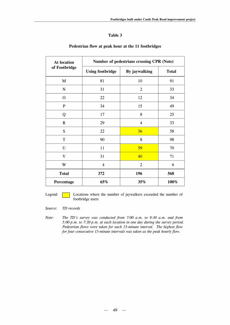
Footbridges built under Castle Peak Road improvement project
— 49 —
Table 3
Pedestrian flow at peak hour at the 11 footbridges
At location of Footbridge
Number of pedestrians crossing CPR (Note)
Using footbridge By jaywalking Total
M 81 10 91
N 31 2 33
O 22 12 34
P 34 15 49
Q 17 8 25
R 29 4 33
S 22 36 58
T 90 8 98
U 11 59 70
V 31 40 71
W 4 2 6
Total 372 196 568
Percentage 65% 35% 100%
Legend: Locations where the number of jaywalkers exceeded the number of
footbridge users Source: TD records Note: The TD’s survey was conducted from 7:00 a.m. to 9:30 a.m. and from
5:00 p.m. to 7:30 p.m. at each location in one day during the survey period. Pedestrian flows were taken for each 15-minute interval. The highest flow for four consecutive 15-minute intervals was taken as the peak hourly flow.

Footbridges built under Castle Peak Road improvement project
— 50 —
6.19 The TD’s survey found that, of the 568 pedestrians crossing the road at the 11 footbridge locations during peak hours, 196 (35%) crossed the road by jaywalking. At Footbridges S, U and V, the numbers of jaywalkers exceeded the numbers of footbridge users. Audit also noted that close to Footbridge S (near Sham Tseng Public Pier), a warning sign was posted (see Photograph 10).
Photograph 10
A warning sign posted at the roundabout near Footbridge S
Source: Photograph taken by Audit in November 2009 6.20 In February 2010, in response to Audit’s enquiry, the TD said that:
(a) the sign shown in Photograph 10 was put up by the Hong Kong Police Force temporarily to warn pedestrians of the potential danger of jaywalking and to advise them to use Footbridge S. The location was not a formal black spot according to the TD’s standard; and
(b) education was always an important measure to minimise jaywalking. As a continuous effort, the TD would liaise with relevant departments to work out measures in this respect.
Footbridge S

Footbridges built under Castle Peak Road improvement project
— 51 —
6.21 Audit considers that there is a need to monitor road safety at the 11 footbridge locations, and identify measures to deter jaywalking and encourage pedestrians to use the footbridges. 6.22 In recent years, residents along the CPR section had requested that the pedestrian crossing facilities should be improved, as follows:
(a) in November 2003, residents of a residential development near Ka Loon Tsuen complained to the HyD that Footbridge W (then under construction) was too far away and requested the provision of an at-grade crossing nearer to their residence. After years of discussions, in 2008, a new signal-controlled at-grade crossing was installed at a location about 250 metres east of Footbridge W;
(b) in October 2006, residents of a residential development (between Footbridges S
and T) lodged a complaint to the TD about the lack of pedestrian crossing facilities near their residence, and requested the provision of an at-grade crossing; and
(c) in September 2007, residents living in Tsing Lung Tau lodged a complaint to the
TD, commenting that:
(i) the footbridges built in the area for crossing CPR were not meeting residents’ need as they had to walk a long distance and spend extra efforts to walk up and down the staircases or ramps;
(ii) instead of using the footbridge, some residents would jaywalk across the
road, giving rise to road safety concern; and
(iii) there was a need to improve the pedestrian crossing facilities by providing at-grade crossings or installing lifts at the footbridges.
6.23 In February 2010, in response to Audit’s enquiry, the TD said that it was its responsibility to continuously monitor the road conditions to improve road safety. The TD also said that it quite often received requests for installing at-grade crossings and it would consider each request according to the individual situation. About the three cases mentioned in paragraph 6.22 above, the TD had responded and taken actions as follows:
(a) the at-grade crossing provided to the east of Footbridge W was located at a section where the speed limit was 50 km/hr and its existence would not have great impact on the traffic flow. The decision was a result of balancing the pedestrian demand and the impact on traffic flow;
Footbridges built under Castle Peak Road improvement project
— 52 —
(b) the proposed at-grade crossing between Footbridges S and T was not supported because of various factors, such as high speed limit (70 km/hr), gradient and alignment consideration. However, the TD had arranged to provide a green minibus stop near the southern ramp of Footbridge S to facilitate passengers to use the footbridge; and
(c) the request was not justified because an at-grade crossing at the location (with a speed limit of 70 km/hr) would induce safety problem. Moreover, provision of lifts to footbridges with ramps did not tally with current government policy.
6.24 Audit considers that there is a need to continue improving the pedestrian crossing facilities along the CPR section having regard to road safety, the residents’ needs and other considerations. Need to take into account pedestrian crossing facilities in the vicinity 6.25 According to the TPDM, one of the factors for consideration in providing grade-separated crossing facilities is the availability and location of alternative crossings (see para. 1.7(f)). Footbridge M is located at the eastern end of the works boundary of the CPR improvement project. It provides a pedestrian link across Hoi On Road to a seafront promenade. As shown in Figure 7, adjacent to Footbridge M, there are three other pedestrian crossing facilities, namely:
(a) a footbridge built in 1993 and maintained by a private developer for public use;
(b) a signal-controlled at-grade crossing installed in 1995; and
(c) a footbridge built by a private developer in 1991 for public use and taken over by the HyD in 2005 for maintenance.

Footbridges built under Castle Peak Road improvement project
— 53 —
Figure 7
Locations of Footbridge M and the three nearby pedestrian crossing facilities
Source: Records of the HyD and LandsD Note: About 800 metres west of Footbridge M, there is a signal-controlled junction with at-grade
crossings to serve the residents of Yau Kom Tau.
6.26 Including Footbridge M, there are currently four pedestrian crossing facilities along a 600-metre section of Hoi On Road linking residential developments to the promenade. This section of the promenade is thus served by a pedestrian crossing facility about every 200 metres. Apart from Footbridge M, the other three pedestrian crossing facilities were completed before the CPR improvement project. It appears that there were adequate pedestrian crossing facilities linking to the promenade before the CPR improvement project. 6.27 Audit considers that it might be a viable alternative to provide an at-grade crossing at the location of Footbridge M if a crossing was considered necessary. Moreover, there is a road junction near Footbridge M allowing right turn movement from the westbound lane without traffic signal control. A signal-controlled at-grade pedestrian crossing at this location may facilitate the regulation of right-turn traffic and enhance road safety. In this connection, Audit notes that a signal-controlled at-grade crossing is currently installed at a location between Footbridges M and N.
N (Note) Footbridge M
Footbridge
Footbridge
At-grade pedestrian crossing

Footbridges built under Castle Peak Road improvement project
— 54 —
6.28 In February 2010, in response to Audit’s enquiry, the TD and the HyD said that:
TD
(a) Footbridge M was constructed to serve residents of nearby residential developments to access the seafront promenade. Without this footbridge, some residents had to walk more than 400 metres to the nearest crossing facility;
(b) converting the junction into a signalised junction would incur delay to the vehicular flow and would not be conducive to road safety;
HyD
(c) after the widening of the CPR section, the pedestrian crossing environment would be different. The provision of Footbridge M was necessary to allow a safe and convenient pedestrian link for residents of a nearby residential development to cross the dual two-lane carriageway to the promenade;
(d) at-grade crossing was not appropriate at the location of Footbridge M as the speed limit was set at a high speed limit of 70 km/hr and it was intended to upgrade the capacity of the CPR section under the improvement project; and
(e) the pedestrian flow along footbridge M was the second highest among the 11 footbridges (see Table 3 in para. 6.18). The provision of Footbridge M was fully justified despite the fact that there were other pedestrian crossings in the vicinity.
6.29 Audit notes that the justifications for providing Footbridge M, as mentioned in paragraph 6.28, were not provided in the relevant PWSC paper. Audit considers that, in planning roadworks projects in future, there is a need to document in PWSC/FC papers the justifications for providing grade-separated pedestrian crossing facilities, taking into account other pedestrian crossing facilities in the vicinity and the feasibility of providing at-grade crossings as an alternative option.
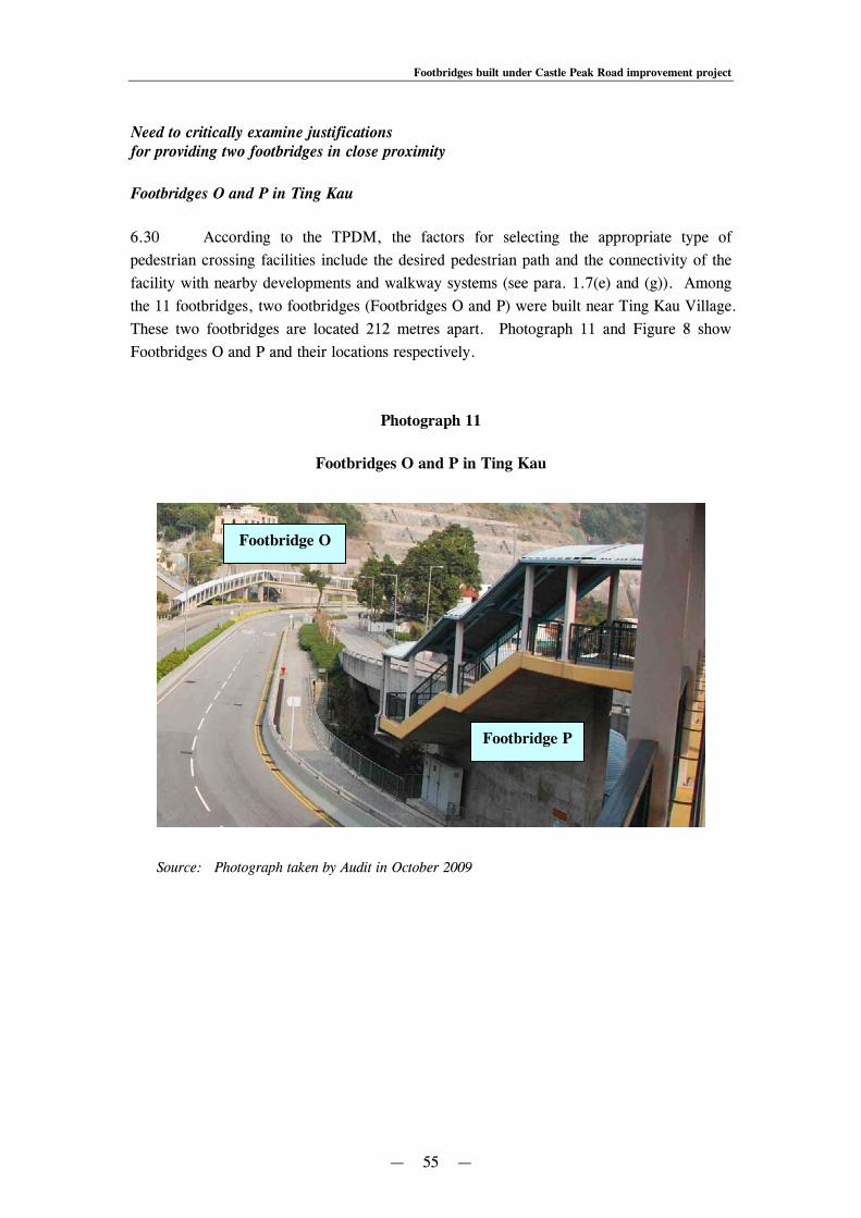
Footbridges built under Castle Peak Road improvement project
— 55 —
Need to critically examine justifications for providing two footbridges in close proximity Footbridges O and P in Ting Kau 6.30 According to the TPDM, the factors for selecting the appropriate type of pedestrian crossing facilities include the desired pedestrian path and the connectivity of the facility with nearby developments and walkway systems (see para. 1.7(e) and (g)). Among the 11 footbridges, two footbridges (Footbridges O and P) were built near Ting Kau Village. These two footbridges are located 212 metres apart. Photograph 11 and Figure 8 show Footbridges O and P and their locations respectively.
Photograph 11
Footbridges O and P in Ting Kau
Source: Photograph taken by Audit in October 2009
Footbridge P
Footbridge O

Footbridges built under Castle Peak Road improvement project
— 56 —
Figure 8
Locations of Footbridges O and P in Ting Kau
Source: Records of the HyD and LandsD 6.31 In July 1998, after completion of the design of the improvement works, the Administration gazetted details of the CPR improvement project for public information. According to the design in 1998, a pedestrian subway near the western access of Ting Kau Village would be constructed in the area. In August 1998, representatives of Ting Kau Village submitted objections to the proposed subway on the grounds that:
(a) the location of the proposed subway was not convenient to villagers of Ting Kau Village as they rarely used the western access to reach the CPR;
(b) the eastern access was the main pedestrian path used by villagers. Therefore, a
pedestrian crossing facility should be provided near the eastern access; and (c) there were concerns about security in a subway which was prone to occurrence
of crime, especially at night. Therefore, a footbridge instead of a subway would be a better option.
N
Footbridge P
Footpath along a flyover
Footbridge O
Ting Kau Village

Footbridges built under Castle Peak Road improvement project
— 57 —
6.32 In the light of the residents’ views, in January 1999, the HyD revised the design and provided an additional footbridge (Footbridge O) near the eastern access of Ting Kau Village at the location desired by the residents. The HyD also replaced the proposed subway by a footbridge, i.e. Footbridge P. In 2002, in response to residents’ concerns, the design of Footbridge P was further revised by replacing the proposed ramps with two lifts. As a result, the original design of providing one subway at Ting Kau Village was eventually changed to the provision of two footbridges in close proximity. 6.33 In October 2009, Audit conducted a site visit to the locations of Footbridges O and P. Audit noted that Footbridge P connected a nearby carpark to the western access of Ting Kau Village. Moreover, there was also a footpath along a flyover linking the carpark to the western access of Ting Kau Village, serving as an alternative pedestrian path in addition to Footbridge P. 6.34 In February and March 2010, in response to Audit’s enquiry, the TD and the HyD said that:
TD
(a) Footbridge P was required as a direct link between the carpark and western access of Ting Kau Village while using the footpath along the flyover would result in a longer detour. This footbridge also served the nearby developments;
HyD
(b) Footbridge O was requested by residents of Ting Kau Village to better suit their use and Footbridge P was necessary to serve the users of the carpark; and
(c) Footbridges O and P, despite their close proximity, were cases where the road layout had been revised to suit the public’s aspirations, achieving an improved environment to residents, carpark users and drivers alike.
6.35 Audit notes that the construction cost and annual maintenance cost of Footbridge P were $15.3 million and $0.23 million respectively, and that residents of Ting Kau Village had said that they would rarely use the western access (i.e. at the location of Footbridge P) for crossing CPR. Audit considers that in planning roadworks projects in future, there is a need to critically examine the desired pedestrian path of the potential users and the connectivity of the facility with nearby developments and walkway systems, taking into account the costs for constructing and maintaining the facilities.

Footbridges built under Castle Peak Road improvement project
— 58 —
Footbridges U and V in Tsing Lung Tau
6.36 Besides Footbridges O and P, along the CPR section, there is another pair of footbridges, namely Footbridges U and V located in Tsing Lung Tau, which are in close proximity (315 metres apart). Photograph 12 and Figure 9 show Footbridges U and V and their locations respectively.
Photograph 12
Footbridges U and V in Tsing Lung Tau
Source: Photograph taken by Audit in October 2009
Footbridge U
Footbridge V

Footbridges built under Castle Peak Road improvement project
— 59 —
Figure 9
Locations of Footbridges U and V
Source: Records of the HyD and LandsD
6.37 In October 2009, Audit conducted a site visit to the locations of Footbridges U and V. Audit observed that the traffic and pedestrian flows were not high. The TD’s survey found that the peak-hour vehicular flows at the locations were only 17% of the design flow capacity and the peak-hour pedestrian flows were around 70 pedestrians per hour (see Table 2 in para. 6.12). Audit also found that there was a road junction near Footbridge V allowing vehicles right-turning from the westbound lane. The right-turning vehicles were not controlled by traffic light signals and the vehicles would cut across two traffic lanes of the opposite direction. In Audit’s view, the provision of an at-grade crossing at the location of Footbridge V might be an alternative option as it would allow pedestrians to cross the road at grade and the light signal can also control the right-turning vehicles to enhance road safety. Moreover, because of a break in the central divider at the road junction near Footbridge V, the location was prone to jaywalking. According to results of the TD’s survey, there were more jaywalkers than footbridge users at the locations of Footbridges U and V (see Table 3 in para. 6.18).
N
Footbridge V Footbridge U

Footbridges built under Castle Peak Road improvement project
— 60 —
6.38 In February and March 2010, in response to Audit’s enquiry, the TD and the HyD said that:
TD
(a) a distance of 315 metres took the average pedestrian a five-minute walk. Whether such spacing between Footbridges U and V was close was subject to interpretation;
(b) the provision of Footbridge U is to supplement the roundabout at the junction
and to facilitate unimpeded pedestrian and vehicle movements, whilst the provision of Footbridge V is to cater for the crossing needs of the residents of the adjacent developments;
(c) provision of an at-grade crossing at the location of Footbridge V would disrupt
the smooth traffic at the westbound carriageway. From the traffic capacity point of view, the existing priority junction with a right-turn pocket was considered more efficient, as the demand for right-turn was not great and it would not incur delay to through traffic;
(d) an at-grade crossing at this location instead of a footbridge is not conducive to
road safety because of the introduction of vehicle and pedestrian conflict; and
HyD
(e) as the speed limit at the location of Footbridge V was set at 70 km/hr, the provision of a footbridge was considered more appropriate on traffic management and road safety grounds in accordance with traffic studies carried out for the CPR Project.
6.39 Audit notes that the justifications for providing two footbridges in close proximity were not provided for in the PWSC paper for the CPR Project. Audit considers that, in planning roadworks projects in future, there is a need to set out clearly the justifications in the PWSC paper for providing two grade-separated crossings in close proximity, and the reasons for not providing one or more at-grade crossings instead. Audit recommendations
6.40 Audit has recommended that, in planning roadworks projects in future, the Director of Highways should, in consultation with the Commissioner for Transport, set out clearly in the PWSC/FC papers the justifications for providing grade-separated crossing facilities (see para. 6.11), taking into account:

Footbridges built under Castle Peak Road improvement project
— 61 —
(a) vehicular and pedestrian flows (see para. 6.17);
(b) other pedestrian crossing facilities in the vicinity (see para. 6.29);
(c) the desired pedestrian path of the potential users and the connectivity of the facility with nearby developments and walkway systems (see para. 6.35); and
(d) whether two grade-separated crossings are provided in close proximity
(see para. 6.39). 6.41 Audit has recommended that the Commissioner for Transport should:
(a) monitor road safety at the locations of the 11 footbridges along the CPR section, and identify measures to deter jaywalking and encourage pedestrians to use the footbridges (see para. 6.21); and
(b) continue to improve the pedestrian crossing facilities along the CPR section
having regard to road safety, the residents’ needs and other considerations (see para. 6.24).
Response from the Administration
6.42 The Commissioner for Transport accepts the audit recommendations in paragraph 6.41. He has said that:
(a) the TD will continue to provide input to the HyD in pursuing the audit recommendation in paragraph 6.40; and
(b) the TD will continue to address any road safety problem along the CPR section
as part of the TD’s day-to-day traffic management duties. 6.43 The Director of Highways has said that:
(a) the HyD will work with the relevant parties to seek further improvements in preparing PWSC/FC papers; and
(b) the HyD will take into account the audit comment in paragraph 6.11 on the
documentation of justifications for grade-separated crossing facilities in PWSC/FC papers and take action flexibly in the preparation of PWSC/FC papers in future to suit the nature of the project.
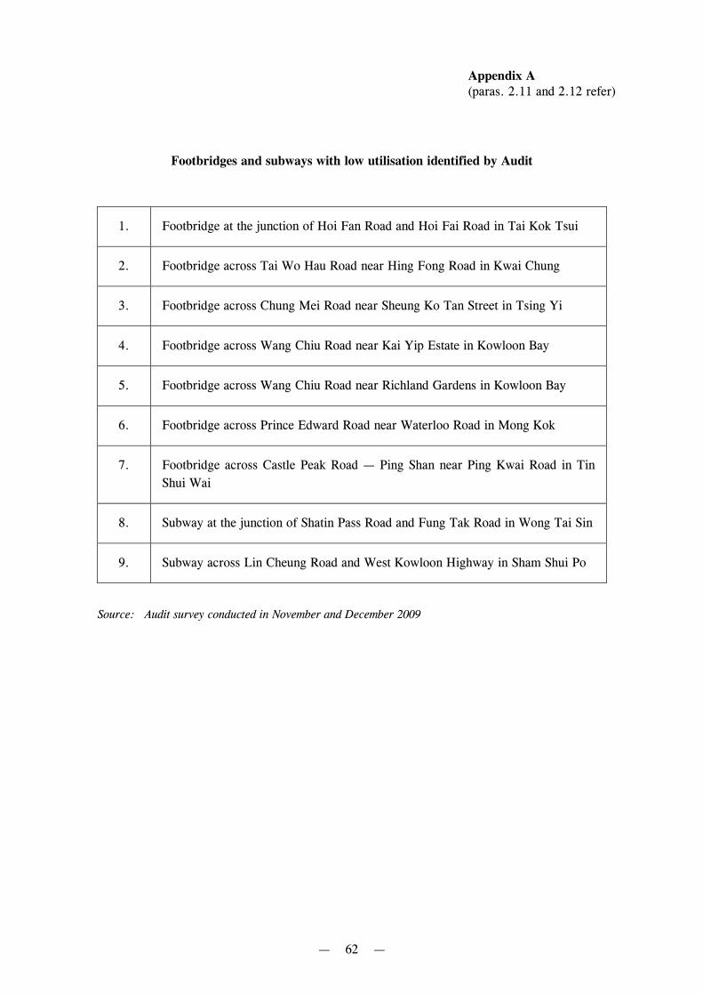
— 62 —
Appendix A (paras. 2.11 and 2.12 refer)
Footbridges and subways with low utilisation identified by Audit
1. Footbridge at the junction of Hoi Fan Road and Hoi Fai Road in Tai Kok Tsui
2. Footbridge across Tai Wo Hau Road near Hing Fong Road in Kwai Chung
3. Footbridge across Chung Mei Road near Sheung Ko Tan Street in Tsing Yi
4. Footbridge across Wang Chiu Road near Kai Yip Estate in Kowloon Bay
5. Footbridge across Wang Chiu Road near Richland Gardens in Kowloon Bay
6. Footbridge across Prince Edward Road near Waterloo Road in Mong Kok
7. Footbridge across Castle Peak Road — Ping Shan near Ping Kwai Road in Tin Shui Wai
8. Subway at the junction of Shatin Pass Road and Fung Tak Road in Wong Tai Sin
9. Subway across Lin Cheung Road and West Kowloon Highway in Sham Shui Po
Source: Audit survey conducted in November and December 2009
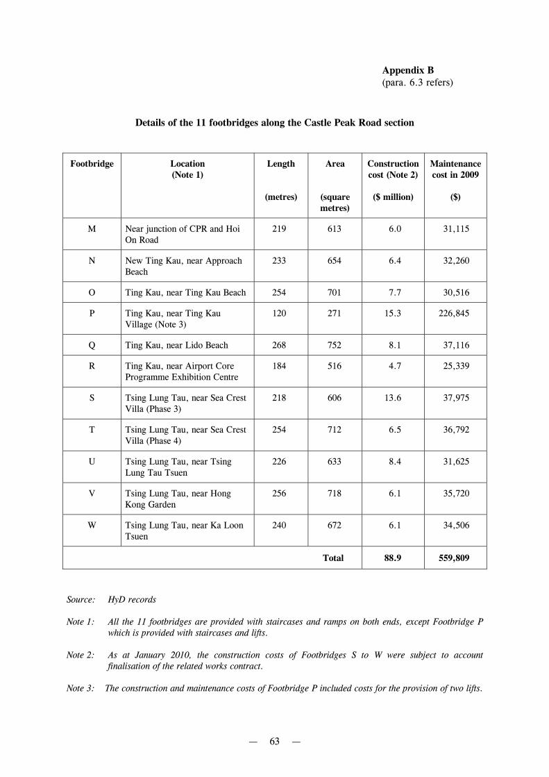
— 63 —
Appendix B (para. 6.3 refers)
Details of the 11 footbridges along the Castle Peak Road section
Footbridge Location (Note 1)
Length
(metres)
Area
(square metres)
Construction cost (Note 2)
($ million)
Maintenance cost in 2009
($)
M Near junction of CPR and Hoi On Road
219 613 6.0 31,115
N New Ting Kau, near Approach Beach
233 654 6.4 32,260
O Ting Kau, near Ting Kau Beach 254 701 7.7 30,516
P Ting Kau, near Ting Kau Village (Note 3)
120 271 15.3 226,845
Q Ting Kau, near Lido Beach 268 752 8.1 37,116
R Ting Kau, near Airport Core Programme Exhibition Centre
184 516 4.7 25,339
S Tsing Lung Tau, near Sea Crest Villa (Phase 3)
218 606 13.6 37,975
T Tsing Lung Tau, near Sea Crest Villa (Phase 4)
254 712 6.5 36,792
U Tsing Lung Tau, near Tsing Lung Tau Tsuen
226 633 8.4 31,625
V Tsing Lung Tau, near Hong Kong Garden
256 718 6.1 35,720
W Tsing Lung Tau, near Ka Loon Tsuen
240 672 6.1 34,506
Total 88.9 559,809
Source: HyD records Note 1: All the 11 footbridges are provided with staircases and ramps on both ends, except Footbridge P
which is provided with staircases and lifts. Note 2: As at January 2010, the construction costs of Footbridges S to W were subject to account
finalisation of the related works contract. Note 3: The construction and maintenance costs of Footbridge P included costs for the provision of two lifts.
— 64 —
Appendix C
Acronyms and abbreviations
Audit Audit Commission
CEDD Civil Engineering and Development Department
CPR Castle Peak Road
CWRF Capital Works Reserve Fund
FC Finance Committee
HAD Home Affairs Department
HyD Highways Department
IDC Islands District Council
km/hr Kilometres per hour
LandsD Lands Department
PWSC Public Works Subcommittee
TD Transport Department
THB Transport and Housing Bureau
TPDM Transport Planning and Design Manual