chapter 2—area description and resources
TRANSCRIPT
Chapter 2—Area Description and Resources
© K
eith
Pen
ner
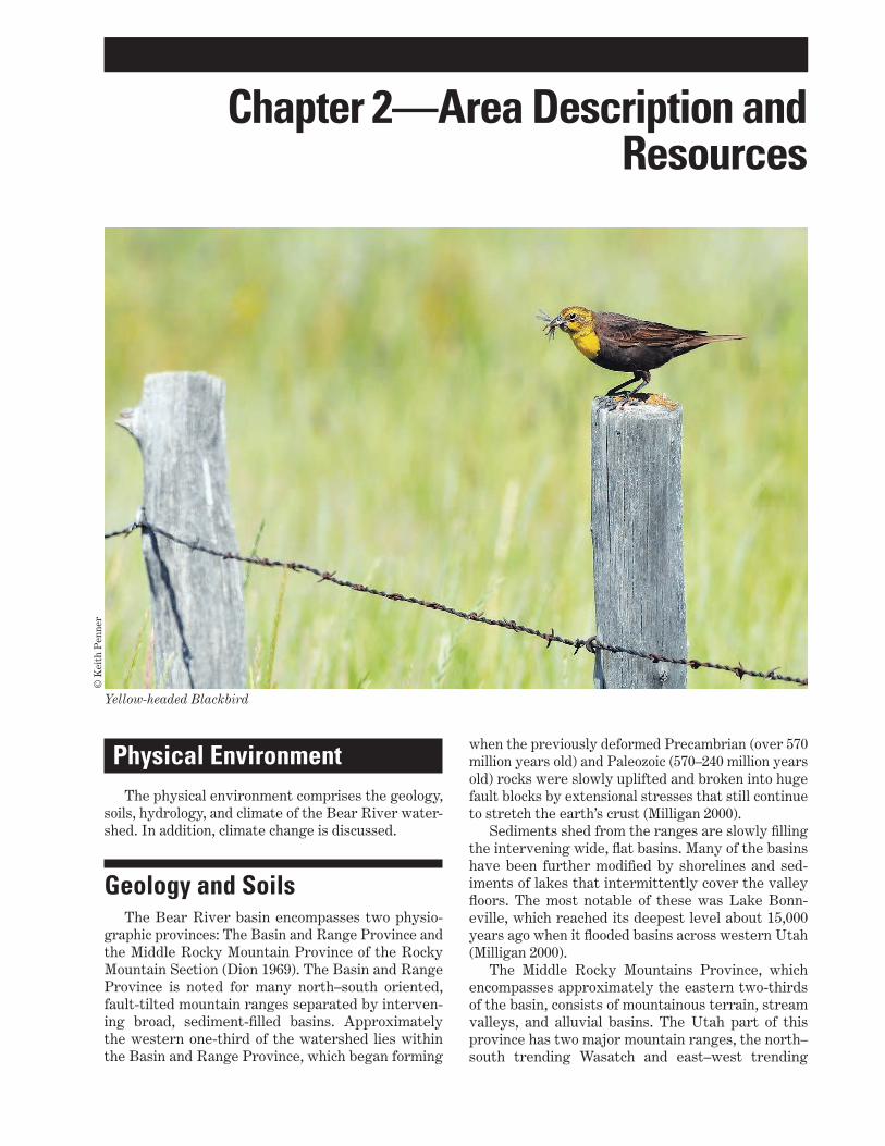
Yellow-headed Blackbird
Physical EnvironmentThe physical environment comprises the geology,
soils, hydrology, and climate of the Bear River water-shed. In addition, climate change is discussed.
Geology and SoilsThe Bear River basin encompasses two physio-
graphic provinces: The Basin and Range Province and the Middle Rocky Mountain Province of the Rocky Mountain Section (Dion 1969). The Basin and Range Province is noted for many north–south oriented, fault-tilted mountain ranges separated by interven-ing broad, sediment-filled basins. Approximately the western one-third of the watershed lies within the Basin and Range Province, which began forming
when the previously deformed Precambrian (over 570 million years old) and Paleozoic (570–240 million years old) rocks were slowly uplifted and broken into huge fault blocks by extensional stresses that still continue to stretch the earth’s crust (Milligan 2000).
Sediments shed from the ranges are slowly filling the intervening wide, flat basins. Many of the basins have been further modified by shorelines and sed-iments of lakes that intermittently cover the valley floors. The most notable of these was Lake Bonn-eville, which reached its deepest level about 15,000 years ago when it flooded basins across western Utah (Milligan 2000).
The Middle Rocky Mountains Province, which encompasses approximately the eastern two-thirds of the basin, consists of mountainous terrain, stream valleys, and alluvial basins. The Utah part of this province has two major mountain ranges, the north–south trending Wasatch and east–west trending

10 Land Protection Plan—Bear River Watershed Conservation Area; Idaho, Utah, Wyoming
Uinta Mountains. Both ranges have cores of old Pre-cambrian rocks, some more than 2.6 billion years old (Milligan 2000). This Precambrian bedrock became exposed during the Pleistocene by glacial activity that created smooth bowls that collect and funnel water down the Bear River (Denton 2007).
The Bear River Range, located in the central part of the Bear River watershed, is aligned north to south and divides the eastern Mesozoic and west-ern Cenozoic zones. From the Uinta Mountains in the eastern part of the watershed, the Bear River flows northward along the edge of a Mesozoic region, char-acterized by rock structures that have little ability to absorb water. The western part of the watershed is comprised primarily of Paleozoic rock in the moun-tains and Cenozoic rock in the valleys. The valleys here contain alluvial and glacial deposits that are absorptive and lend well to agricultural use (Haws and Hughes 1973). The Bear River range is an impor-tant catch basin for precipitation.
The watershed contains multiple mountain ranges including the Wasatch Front to the west, the Bear River Divide (Crawford) and Tunp Ranges to the east, and the Sublette Range to the north (see fig-ure 3). The convergence of mountain ranges at Rocky Point about 1 mile northeast of Cokeville creates a pinch-point for one of the regionally important migra-tion corridors in the watershed. The position and alignment of the various ranges across the watershed play a central role in precipitation, climatic, hydrolog-ical, and biological patterns.
HydrologyThe Bear River is the largest tributary to the
Great Salt Lake, the remnant of ancient Lake Bonn-eville. Lake Bonneville was a closed inland sea basin the size of Lake Michigan that once dominated the landscape in Idaho, Nevada, and Utah. Approxi-mately 16,000 years ago, Lake Bonneville began spilling over into the Snake River drainage at Red Rock Pass, reducing the lake level by 375 feet. Over the following 8,000 years, Lake Bonneville contin-ued to shrink because of changing climatic conditions, eventually occupying only the present day Great Salt Lake (Utah Geological Survey).
The Bear River watershed is unusual in that it is entirely enclosed by mountains, forming one arm of the Great Salt Lake basin, which has no natural drainage outlets. Three States share drainage in the 7,500 square-mile watershed: 2,700 square miles in Idaho, 3,300 square miles in Utah, and 1,500 square miles in Wyoming. Progressions of small, high-moun-tain streams form the headwaters of the Bear River in Utah’s Uinta–Wasatch–Cache National Forest. The Uinta Mountains, a subrange of the Rocky Mountains,
vary in elevation from 7,500 to 13,500 feet and are unusual in that they run in an east to west orien-tation. From the headwaters, the Bear River flows north and west in an arc from Utah, Wyoming, Idaho, and back into Utah. Near the city of Evanston, Wyo-ming, the topography flattens and land use becomes a mix of urban and agricultural uses. Here the river begins a dramatic transformation from fast-flow-ing, cold, and clear water in the narrow valleys to a slow-moving, cool-water, meandering course on the valley floor. Humans have altered the natural stream dynamics throughout the remaining course of the Bear River to its termination at the Great Salt Lake. Although agriculture accounts for only 7 percent of the land use in the upper watershed, it accounts for more than 80 percent of the water usage. Surface and ground water sources are used to irrigate more than 96,512 acres of hay, pasture, and cropland (Bear River Watershed Information System 2009).
Instream structures like the Chapman Canal Diversion and Woodruff Narrows Reservoir dis-rupt natural channel-forming flows and sediment transport, leading to streambed and bank instability downstream. After passing through Woodruff Nar-rows Reservoir, the valley broadens and the river travels along the Wyoming–Utah border and lends itself to irrigation and production agriculture for 30 miles before reentering Wyoming near Sage Junc-tion. Nutrient loading (especially phosphorus, which is found at naturally high levels in surrounding soil formations), sediment from accelerated bank erosion, and dewatering are leading causes of stream degra-dation. Sediment and nutrient levels remain as the main water quality concerns throughout the entire Bear River watershed, and those impacts contribute to water management challenges in the refuges (Utah Division of Water Resources 2002).
As the river flows north from Evanston, the ridge and swale topography of the floodplain is character-ized by a complex association of irrigated meadows, wetlands, and grass uplands that support one of the highest densities of migrating and nesting waterfowl in Wyoming. Centered along a 20-mile stretch of the Bear River and its associated wetlands and uplands, Cokeville Meadows National Wildlife Refuge was established in 1992 to protect this important habitat.
After leaving Cokeville, the Bear River crosses into Idaho near the community of Border, where the flow is greatly increased by inflow from the Smith’s Fork River, which originates in the Bridger–Teton National Forest and has a relatively intact water-shed and native fish assemblages (Wyoming Game and Fish Department 2010).
As the Bear River passes into Idaho, Pacifi-Corp diverts water at Stewart Dam through Bear Lake National Wildlife Refuge and into Bear Lake proper (which straddles Idaho and Utah). Bear Lake
11Chapter 2—Area Description and Resources
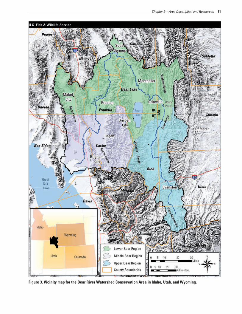
Figure 3. Vicinity map for the Bear River Watershed Conservation Area in Idaho, Utah, and Wyoming.
12 Land Protection Plan—Bear River Watershed Conservation Area; Idaho, Utah, Wyoming
National Wildlife Refuge, near Montpelier, Idaho, was established in 1968 to protect and manage habitat for waterfowl and other migratory birds. Once released from Bear Lake proper, water travels from the Out-let Canal and the refuge’s Mud Lake unit back to the Bear River’s original channel about 7 miles from where the water is first diverted. Except for some water seepage from Stewart Dam, all Bear River water is diverted through the refuge; however, small creeks and irrigation return water enter into the orig-inal river channel so that the river is not completely dewatered between Stewart Dam and its reunion with the Outlet Canal.
From Bear Lake, the river travels 100 miles to the north, where it is impounded in the Alexander Res-ervoir for irrigation, recreation, and hydroelectric power generation. Below the Alexander Dam, about one-tenth of the river’s annual flow is sent through one of the oldest diversion canals in the watershed, the Last Chance Canal. The canal was constructed by settlers to provide irrigation for agriculture in the early 1900s. From there, the river continues south toward Grace, Idaho. Just above the Black Can-yon, almost all the river water is again diverted, at the Grace Dam, through an aqueduct to the Grace Power Plant for power production. The water then is returned to its original river channel just below Black Canyon at Cove Dam. As a part of its 2008 relicensing agreement for the Grace and Cove dams, PacifiCorp provides scheduled whitewater flow releases back into Black Canyon during spring and early summer months to help mimic natural flow patterns.
Below Black Canyon, the river continues south through the Gem, Gentile, and Cache Valleys, where the predominant land uses are irrigated agriculture, grazing, and dairy production. About 100,000 people live in the Cache Valley, making it the most populated area in the Bear River watershed. Just below the Idaho–Utah State line, the Bear River receives water from the Cub River, which in turn obtains part of its water from the Mount Naomi Wilderness. Below the Cub River, the amount of water in the Bear River doubles because of input from the Logan, Blacksmith Fork, and Little Bear River flows.
Eventually the Bear River passes into the Bear River delta and the Bear River Migratory Bird Refuge and then terminates its horseshoe-shaped 500-mile route in Utah’s Great Salt Lake. Today, the Bear River contributes more than one-half of the total surface flow entering the Great Salt Lake each year. This large volume of freshwater from the river helps to maintain proper temperatures, salinity, and water levels in the lake. The saline waters and freshwater marshes of the Great Salt Lake constitute one of the most important breeding and migratory staging sites for colonial waterbirds, waterfowl, and shorebirds in the Great Basin.
ClimateThe climate of most of the Bear River Water-
shed Conservation Area is characterized as having warm to hot summers and cold winters and is clas-sified as humid continental, mild summer under the Koppen climate classification system. The remainder of the watershed near the Great Salt Lake is classi-fied as semiarid desert–steppe or humid continental, hot summer for the Great Basin and Wasatch Front, respectively.
Annual precipitation is influenced greatly by the topography and elevations found within the water-shed, which range from 4,200 to 13,000 feet. Annual precipitation ranges from 10 inches in the lower val-leys to 65 inches at the headwaters of the Bear River in the Uinta Mountains (Utah Division of Water Resources 2005b). Two major storm patterns influ-ence precipitation in the basin: (1) frontal systems from the Pacific Northwest during winter and spring; and (2) thunderstorms from the south and southwest in late summer and early fall.
Temperatures are also variable throughout the watershed because of differences in elevation. Mean annual temperatures range from 37 °F in the Uinta Mountains at about 8,400 feet elevation to 53 °F at Tremonton at 4,300 feet. Maximum July temperatures average 91 °F at Tremonton compared to 74 °F in the Uinta Mountains.
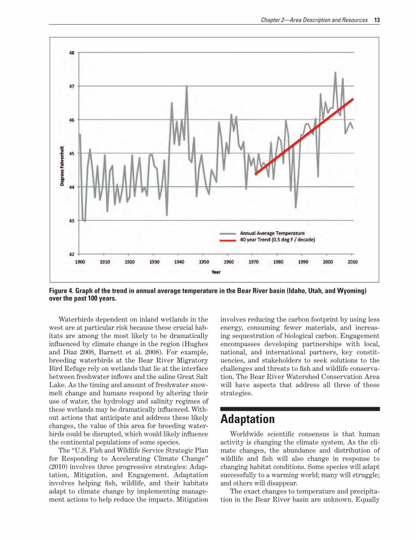
Climate ChangeThe Bear River basin has warmed an average 2
°F since 1971 (Utah Climate Center). The trend of 0.5 °F per decade during the last 40 years is 1.5 times greater than the trend for the global average over the same period. Simulation models predict that, by 2040 to 2060, the Bear River basin’s climate could be 5–6 °F warmer with a 5–13 percent decrease in annual runoff, 10–15 percent lower peak accumula-tion of snowpack, earlier spring melt by 2–4 weeks, and an increasing fraction of winter precipitation coming as rain (Degiorgio et al. 2010) (see figure 4). Climate change models in the arid western regions of North America also suggest an increased frequency of extended drought in the future (Hughes and Diaz 2008, Barnett et al. 2008, Degiorgio et al. 2010). These changes have important implications for waterbird populations, and ecosystem stability within the Bear River basin wetlands.
Maclean et al. (2008) found that waterbird abun-dance and phenology are sensitive to the effects of climate change.
13Chapter 2—Area Description and Resources
Figure 4. Graph of the trend in annual average temperature in the Bear River basin (Idaho, Utah, and Wyoming) over the past 100 years.
Waterbirds dependent on inland wetlands in the west are at particular risk because these crucial hab-itats are among the most likely to be dramatically influenced by climate change in the region (Hughes and Diaz 2008, Barnett et al. 2008). For example, breeding waterbirds at the Bear River Migratory Bird Refuge rely on wetlands that lie at the interface between freshwater inflows and the saline Great Salt Lake. As the timing and amount of freshwater snow-melt change and humans respond by altering their use of water, the hydrology and salinity regimes of these wetlands may be dramatically influenced. With-out actions that anticipate and address these likely changes, the value of this area for breeding water-birds could be disrupted, which would likely influence the continental populations of some species.
The “U.S. Fish and Wildlife Service Strategic Plan for Responding to Accelerating Climate Change” (2010) involves three progressive strategies: Adap-tation, Mitigation, and Engagement. Adaptation involves helping fish, wildlife, and their habitats adapt to climate change by implementing manage-ment actions to help reduce the impacts. Mitigation
involves reducing the carbon footprint by using less energy, consuming fewer materials, and increas-ing sequestration of biological carbon. Engagement encompasses developing partnerships with local, national, and international partners, key constit-uencies, and stakeholders to seek solutions to the challenges and threats to fish and wildlife conserva-tion. The Bear River Watershed Conservation Area will have aspects that address all three of these strategies.
AdaptationWorldwide scientific consensus is that human
activity is changing the climate system. As the cli-mate changes, the abundance and distribution of wildlife and fish will also change in response to changing habitat conditions. Some species will adapt successfully to a warming world; many will struggle; and others will disappear.
The exact changes to temperature and precipita-tion in the Bear River basin are unknown. Equally
14 Land Protection Plan—Bear River Watershed Conservation Area; Idaho, Utah, Wyoming
unknown are the responses of wildlife and habitat to these changes, for example, which species will become the most vulnerable. Keeping adequate densities of wetlands, robust riparian corridors, and open spaces will become increasingly important to allow fish and wildlife to adapt to the changing environment.
MitigationForests, grasslands, wetlands, and soils have a
large influence on atmospheric levels of carbon dioxide. Carbon sequestration forms one of the key elements of mitigation. The World Resources Institute esti-mates that grasslands store approximately 34 percent, forests store approximately 39 percent, and agro-eco-systems approximately 17 percent of the global stock of carbon in terrestrial ecosystems. It is as important to protect existing carbon stores from further degrada-tion as it is to sequester atmospheric carbon.
Historically, the destruction of wetlands through land use changes has had the largest effects on carbon fluxes and the resulting radiative forcing of North American wetlands. [Radiative forcing is the measure of the amount that the Earth’s energy budget is out of balance.] The primary effects have been a reduction in the ability of the wetlands to sequester carbon (a small to moderate increase in radiative forcing), oxi-dation of their soil carbon reserves upon drainage (a small increase in radiative forcing), and reduction in methane emissions (a small to large decrease in radi-ative forcing). It is uncertain how global changes will affect the carbon pools and fluxes of North American wetlands (Bridgham et al. 2006).
EngagementEngagement involves cooperation, communica-
tion, and partnerships to address the conservation challenges presented by climate change (USFWS 2009). The conservation area will serve as a model for engagement by working with landowners, nongov-ernmental organizations, State agencies, and Federal agencies.
A key recommendation from a recent climate change workshop held by The Nature Conservancy was to coordinate management of shared resources. Given the regional pattern of recent temperature changes, with some areas experiencing warming more rapidly than others, natural resource managers will benefit by coordinating their activities with oth-ers who are managing common resources. Regional and coordinated management of shared habitat may be the only way to make sure that some habitat can be kept in a resilient state while other habitat transi-tions to another state (Roble 2011).
Taking action on these recommendations will be crucial for achieving conservation and management goals in the face of a changing climate. Reduced snow-pack in the mountains combined with earlier seasonal melting caused by rising temperatures may increase the intensity and length of late summer droughts and reduce the availability of water, especially in the western United States. Finding enough water is becoming an increasingly difficult challenge for west-ern fish and wildlife species. Spring is arriving earlier, and plants and animals are being found farther and farther north of their historical ranges in the U.S. Wildlife biologists are concerned that this will mean some migratory species may not arrive in their breed-ing habitats when, or where, their particular food sources are available.
Education is a key part of engagement. The Bear River Migratory Bird Refuge watershed education program will work with local school districts to apply scientific understanding, at a student level, through field trips to sites within the Bear River watershed. Students groups will monitor local climate change through tracking phenological events and engage in strategies to reduce carbon footprints. It is predicted that student engagement in climate change education will result in advancing its understanding among the citizenry within the watershed.
Biological EnvironmentThe Bear River watershed’s habitat ranges from
river and the adjacent riparian areas to wetland, grassland, shrubland, and forest. This section also describes the wildlife and species of concern that use these habitats.
Habitat Below the peaks of the Uinta Mountains lies
a landscape carved by glaciers containing lakes, streams, forests, and meadows. Dropping in ele-vation from more than 13,000 feet to 4,211 feet and crossing through many life zones (alpine to valley floor), the Bear River area contains a large diversity of plant communities. The diver-sity of habitats in the Bear River watershed support a variety of fish, mammal, reptile, and amphibian species as well as a large number of res-ident and migratory bird species. See figure 5 for a map of habitat types, table 1 for acreages of vegetation types, and appendix D for a list of plant and animal species representative of the Bear River watershed.

15Chapter 2—Area Description and Resources
Figure 5. Habitat map for the Bear River Watershed Conservation Area in Idaho, Utah, and Wyoming. Source: NorthWest GAP (Idaho Cooperative Fish and Wildlife Research Unit 2011); South West reGAP (U.S. Geological Survey 2005).

16 Land Protection Plan—Bear River Watershed Conservation Area; Idaho, Utah, Wyoming
Table 1. Acreages of vegetation types found in the Bear River project area in Idaho, Utah, and Wyoming.
Vegetation types Acres
Agriculture: cultivated cropland 594,358
Agriculture: pasture and hay 133,482
Developed 83,343
Forest and woodland 1,250,529
Grassland 128,848
Introduced riparian area and wetland vegetation
8,821
Introduced upland vegetation—annual grassland
44,840
Introduced upland vegetation—perennial grassland and forbs
19,171
Marsh 69,430
Mining 197
Open water 119,497
Riparian area 261,407
Sagebrush steppe and shrubland 1,945,752
Shrubland and steppe 18,565
Sparse and barren 44,912
Wet meadow or prairie 12,803
Wetland 27,577
Wetland–playa 59,350
Total 4,822,882
Source: http://gap.uidaho.edu/index.php/gap-home/Northwest -GAP/landcover; http://fws-nmcfwru.nmsu.edu/swregap /habitatreview/ModelQuery.asp; Northwest GAP (Idaho Coop-erative Fish and Wildlife Research Unit 2011); Southwest ReGAP (U.S. Geological Survey 2005)
Connectivity and CorridorsHabitat loss and fragmentation are the chief fac-
tors in the decline of many populations of wildlife throughout the world (Harris 1984, Ehrlich 1986, Lovejoy et al. 1986). In the western United States, human development of open spaces has fragmented the connections between wildlife habitats (Gude et
al. 2007). Corridors that link habitats or other land-scape linkages help mitigate the effects of habitat fragmentation by linking core areas so that indi-viduals can move between them (Mech and Hallett 2001). They also allow evolutionary and ecological processes (for example, fire, succession, predation) to continue. By ensuring that plants and animals have connected populations, corridors can help prevent or mitigate against harmful population-level effects resulting from isolation including inbreeding, low genetic diversity, and extirpation (Noss 1983, Harris 1984, Dobson et al. 1999) and may actually increase population sizes, viability, and movement of habi-tat-restricted species (Noss and Cooperrider 1994, Haddad 1999, Haddad and Baum 1999). Landscape linkages should also help to provide for longer term gene flow between populations in core habitats and linkage areas and may provide a pathway for plants populations to shift under regional climate change trends (Bates and Jones 2007).
Almost all species rely on more than one habitat type to complete their life cycles, and the availability of various intact habitats close together is essential to many wildlife species found in the watershed. For example, Saalfeld et al. (2010) found that, while the long-billed curlew’s need for wetlands near its grass-land nesting habitat is poorly understood, it is clearly important since more curlews were detected near wetlands. Brood-rearing long-billed curlews typi-cally forage in upland areas (Pampush and Anthony 1993); however, curlew chicks move toward wet-lands as they grow (Foster-Willfong 2003). Shorter travel times between nest sites and wetland foraging sites reduce chick mortality (Saalfeld et al. 2010). In addition to grassland habitat, conservation of emer-gent wetlands—an element that generally has been overlooked—needs to be incorporated into habitat management plans for curlews (Saalfeld et al. 2010).
White-faced ibis also have specific habitat needs that are now being met in the Bear River watershed. In Wyoming, Dark-Smiley and Keinath (2003) found that ibis require large wetlands or lakes with dense emergent vegetation, such as bulrushes for breed-ing and foraging grounds near breeding areas. One consistent feature that all the breeding records in Wyoming have in common is proximity to irrigated crops. It seems likely that a combination of factors, such as proximity of foraging grounds and specialized habitat at open-water systems, plays a role in where white-faced ibis choose to breed.
The Bear River watershed provides linkages and migration corridors for seasonal movements of wild-life between various habitats within the watershed as well as between other protected lands and eco-systems in the region (see figure 6). Crucial wildlife corridors maintain system resiliency in the face of climate change, especially for wide-ranging wildlife
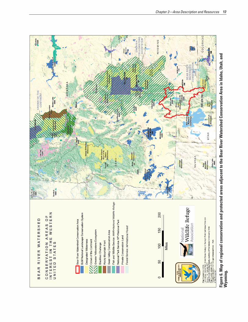
17Chapter 2—Area Description and Resources
ater
shed
Con
serv
atio
n A
rea
in Id
aho,
Uta
h, a
nd
Figu
re 6
. Map
of r
egio
nal c
onse
rvat
ion
and
prot
ecte
d ar
eas
adja
cent
to th
e B
ear R
iver
WW
yom
ing.
18 Land Protection Plan—Bear River Watershed Conservation Area; Idaho, Utah, Wyoming
species such as Canada lynx, wolverine, mule deer, and pronghorn. Migration corridors provide connectivity between habitats in the northern and southern Rock-ies and between Idaho and the Greater Yellowstone Ecosystem for mule deer, elk, and mid- to large-sized carnivores. In particular, Canada lynx linkages are mentioned for Cache, Rich, and Uinta Counties (Idaho Department of Fish and Game 2007). Core habitat areas for lynx are found in the Uinta Mountains (USDA For-est Service 2003) as well. Large numbers of mule deer, pronghorn, elk, and moose migrate through narrow corridors in the Rocky Point area north of Cokeville Meadows National Wildlife Refuge in Wyoming.
© C
raig
Den
ton
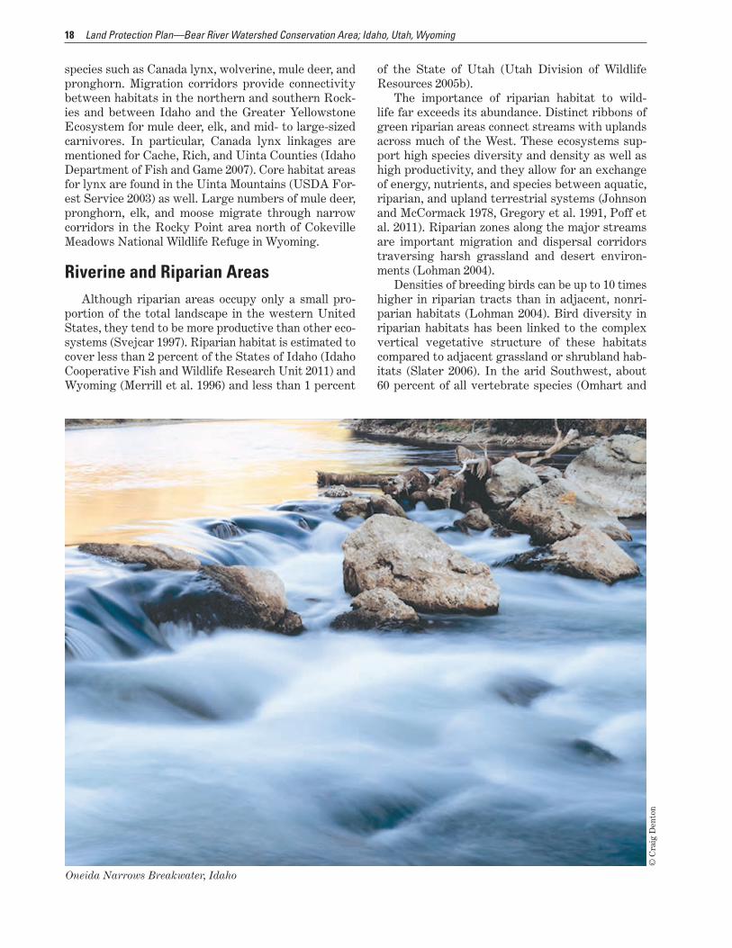
Oneida Narrows Breakwater, Idaho
Riverine and Riparian AreasAlthough riparian areas occupy only a small pro-
portion of the total landscape in the western United States, they tend to be more productive than other eco-systems (Svejcar 1997). Riparian habitat is estimated to cover less than 2 percent of the States of Idaho (Idaho Cooperative Fish and Wildlife Research Unit 2011) and Wyoming (Merrill et al. 1996) and less than 1 percent
of the State of Utah (Utah Division of Wildlife Resources 2005b).
The importance of riparian habitat to wild-life far exceeds its abundance. Distinct ribbons of green riparian areas connect streams with uplands across much of the West. These ecosystems sup-port high species diversity and density as well as high productivity, and they allow for an exchange of energy, nutrients, and species between aquatic, riparian, and upland terrestrial systems (Johnson and McCormack 1978, Gregory et al. 1991, Poff et al. 2011). Riparian zones along the major streams are important migration and dispersal corridors traversing harsh grassland and desert environ-ments (Lohman 2004).
Densities of breeding birds can be up to 10 times higher in riparian tracts than in adjacent, nonri-parian habitats (Lohman 2004). Bird diversity in riparian habitats has been linked to the complex vertical vegetative structure of these habitats compared to adjacent grassland or shrubland hab-itats (Slater 2006). In the arid Southwest, about 60 percent of all vertebrate species (Omhart and

19Chapter 2—Area Description and Resources
US
FW
S
Riparian areas are important habitat for yellow warblers.
Anderson 1982) and 70 percent of all threatened and endangered species are riparian area obligates (John-son 1989, Poff et al. 2011). The quality of riparian habitat greatly influences the quality of aquatic hab-itat. Riparian vegetation influences light penetration and air and water temperatures, and is the transition point for food chain interactions between aquatic and terrestrial zones. Large woody debris and litter asso-ciated with riparian vegetation are often necessary for productive fish habitats, and influence the phys-ical, chemical, and biotic characteristics of riparian and stream ecosystems (Naiman et al. 1992). In some riparian ecosystems, herbaceous plants provide the functions supplied by woody plants in other locations (Baker et al. 2004, Poff et al. 2011).
Riparian areas also play an essential role in main-taining year-round aquatic habitat for fish and other species that occupy the stream channel. In most years, overbank flooding during snowmelt saturates ripar-ian area soils and elevates water tables in adjacent areas. Subsurface water sustains riparian vegetation during drought periods and releases water slowly into the stream (Ewing 1978). Although often small, these waterflows help keep appropriate stream tem-peratures, improve water quality, and sustain isolated pools essential for fish survival (Winters et al. 1998 as cited in “Wyoming State Wildlife Action Plan” 2010). Native fish populations have fluctuated, through time, in response to changes in the extent and function of riparian willow communities (Chaney et al. 1991, Binns 1981). Riffle-dwelling species such as longnose dace and riffle-spawning salmonids require relatively smaller fine sediment levels associated with healthy riparian vegetation. Riparian habitat is also required by many amphibian and reptile species.
Trout Unlimited (2010) found that the greatest limiting factor for Bonneville cutthroat trout appears to be land stewardship, because most populations are located on unprotected public and private lands. Strategies such as securing long-term protection, restoring and reconnecting degraded and fragmented habitats, and controlling nonnative species on a watershed scale are necessary to build resiliency while protecting genetic purity.
Wildlife abundance, water availability, vegetation diversity, soil productivity, and favorable topography found in riparian zones attracted both Native Amer-icans and early Europeans settlers to these areas. As a result, a high percentage of riparian areas are today privately owned. Most communities in the Bear River watershed are located near riparian zones used for agriculture, recreation, travel, water development, and housing (Wyoming Game and Fish Department 2010).
Riparian areas in the West are being influenced by a variety of stressors including land use change, grazing, dams, invasive species, timber harvest-ing, climate change, recreation, water quality, water
diversion, ground-water depletion, fire, and mining. Although no comprehensive national inventory of riparian area conditions exists, Ohmart (1994) sug-gests that a minimum of 95 percent of all western riparian habitats have been altered in some way dur-ing the past century.
Another major influence on riparian areas in the Bear River watershed is irrigation. The timing, extent, and method of irrigation can have a strong influence on riparian vegetation. Conversion from flood irrigation to center pivot irrigation has been known to change riparian area characteristics. While technological changes like side-role systems and gated pipe deliver water more efficiently to crops and potentially conserve water for other uses like main-taining streamflows, the influence on riparian area characteristics is complex (Wyoming Game and Fish Department 2010).
Lowland Riparian Areas. Lowland riparian areas in the West are typically narrow bands of trees—pre-dominantly cottonwoods—and shrubs surrounded by uplands of shorter vegetation (Knopf et al. 1988, Montgomery 1996). Principal woody species found in lowland riparian habitats in the watershed include Fremont cottonwood, netleaf hackberry, squaw-bush, boxelder, lanceleaf cottonwood, willow, and redosier dogwood. Nonnative invasive species include Rus-sian olive and tamarisk. (Utah Division of Wildlife Resources, 2005, Wyoming Game and Fish Depart-ment, 2005).
Mountain Riparian Areas. Mountain riparian habitats differ from those found in lowlands because of the generally steeper stream gradients, cooler temperatures, and smaller amounts of soil deposition (Knight 1994). Mountain riparian vegetation is often characterized by sedges and short willow shrubland (Winward 2000). As elevation decreases, alder and tall willows become common, with Engelmann spruce,
20 Land Protection Plan—Bear River Watershed Conservation Area; Idaho, Utah, Wyoming
species. The Bear River watershed provides impor-tant complexes of wet meadow, flooded pastures, and hayfields used by many species of migrating water-fowl, shorebirds, and waterbirds including American avocet, sandhill crane, white-faced ibis, American bittern, marbled godwit, long-billed dowitcher, and northern pintail. The quality and availability of spring migration habitat have direct implications for the sur-vival and breeding productivity of migratory birds. This shallowly flooded habitat is extremely important to spring-migrating waterfowl, especially northern pintails, whose population remains below continental management goals. Important flood-irrigated grazed and hayed wet meadow habitats sustain migrat-ing waterfowl and waterbirds in the Intermountain West. These areas also provide crucial brood habitat for waterfowl and other waterbirds by supplying both escape cover from predators and productive foraging sites for rapidly growing ducklings and chicks.
As with riparian areas, the irrigation of agricul-tural lands can have both a positive and a negative influence on the ecological condition of wetlands. Agricultural irrigation has affected the hydrology of many wetlands in the Bear River watershed. Cope-land et al. (2010) found that more than 50 percent of Wyoming wetland areas in four different complexes were influenced by agricultural irrigation and pre-dicted that changes in irrigation practices driven by the need for water conservation would be likely to adversely affect the hydrology of many lower eleva-tion wetlands. As agricultural producers convert to alternative forms of irrigation because of drought concerns, many wetlands throughout the water-shed may disappear. Some studies have documented negative effects from irrigation, mainly involving
US
FW
S
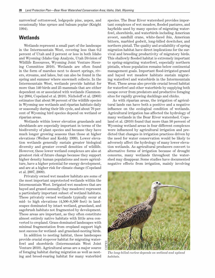
The long-billed curlew depends on wetland and upland habitats.
narrowleaf cottonwood, lodgepole pine, aspen, and occasionally blue spruce and balsam poplar (Knight 1994).
WetlandsWetlands represent a small part of the landscape
in the Intermountain West, covering less than 0.2 percent of Utah and 2 percent or less in both Idaho and Wyoming (Idaho Gap Analysis, Utah Division of Wildlife Resources, Wyoming Joint Venture Steer-ing Committee 2010). Wetlands are often found in the form of marshes next to desert springs, riv-ers, streams, and lakes, but can also be found in the spring and summer where snowmelt collects. In the Intermountain West, wetlands provide habitat for more than 140 birds and 25 mammals that are either dependent on or associated with wetlands (Gammon-ley 2004, Copeland et al. 2010). Nicholoff et al. (2003) estimates that about 90 percent of the wildlife species in Wyoming use wetlands and riparian habitats daily or seasonally during their life cycle, and about 70 per-cent of Wyoming bird species depend on wetland or riparian areas.
Wetlands within lower elevation grasslands and shrublands are especially important in terms of the biodiversity of plant species and because they have much longer growing seasons than those at higher elevations (Weiher and Keddy 1999). Lower eleva-tion wetlands generally sustain greater biological diversity and greater overall densities of wildlife. However, these lower wetland complexes are also at greatest risk of future change because they support higher density human populations and more agricul-ture, have a higher potential for energy development, and are at a higher risk for climate change (Copeland et al. 2007, 2009).
Privately owned wet meadow habitats are some of the most important unprotected wetlands within the Intermountain West. Irrigated wet meadows that are hayed and grazed annually (hay meadows) represent a particularly important subset of wetland habitats. These privately owned wetlands typically occur at mid- to high elevations (4,500–8,500 feet) in land-scapes dominated by intact wetland, grassland, and sagebrush habitats not fragmented by development. These areas are important, as they often constitute almost entirely native habitats with little area con-verted to cropland. Grass-dominated landscapes with minimal fragmentation from cropland support high nest success for wetland- and grassland-nesting birds.
In addition to nesting habitat, these landscapes provide crucial stopover habitat for migrating water-fowl and shorebirds (Intermountain West Joint Venture 2010). Agricultural areas are a major source of foraging habitat during migration as well as nest-ing and brood-rearing habitat for many waterbird
21Chapter 2—Area Description and Resources
the conversion of existing wetlands to cropland and impairment from contaminant and nutrient runoff (Dickerson et al. 1996; Lemly et al. 1993, 2000; Kie-secker 2002).
Livestock grazing can also have a major influence on the functional integrity of wetlands and riparian systems throughout the Intermountain West (U.S. General Accounting Office 1988; Chaney et al. 1990, 1993; Belsky et al. 1999; Copeland et al. 2010). If effec-tive land conservation measures are not employed, certain farming practices may adversely affect wet-lands. Sediment runoff from tilled fields and heavily grazed pastures decreases the lifespan of ponds and wetlands and impairs water quality.
Upland, Grassland, and ShrublandFrom 1950 to 1990, grasslands west of the Mis-
sissippi River declined by 27.2 million acres, with approximately 36 percent converted to uses other than cropland (Conner et al. 2001). Now, the greatest threats to grasslands and sagebrush ecosystems come from oil and gas development, increasing urban and agricultural development, and invasive species. Cli-mate change is also expected to cause major changes in grassland and sagebrush distribution across the landscape (Bachelet et al. 2001). Range expansions of woody species are predicted to continue, particularly the expansion of pinyon–juniper into sagebrush–steppe and grasslands (Rowland et al. 2006), resulting in a decrease in sagebrush and an increase in wood-lands across the West. Wildfires are increasing and are likely to intensify in a warmer future with drier soils, longer growing seasons, and more severe droughts (Field et al. 2007); wildfires may also cause large changes in grassland and sagebrush ecosystems.
Changes in grassland cover can be subtle, but cover is generally predicted to decrease (Bachelet et al. 2001). Modeling suggests that climate change will likely increase net primary production in grasslands and decrease soil carbon, but high annual variability in plant production makes these projections uncer-tain (Parton et al. 2005). Nutrient cycling and plant production are expected to occur more rapidly in response to climate change than changes in commu-nity composition (Parton et al. 1994).
Sagebrush is typically the most common plant in shrub–steppe habitats in the watershed. There are many species of sagebrush in the Bear River water-shed including basin, Wyoming, and mountain big sagebrush, and black or low sagebrush, which dif-fer in height and habitat affinity. Other common shrubs include rabbitbrush, greasewood, fourwing saltbush, shadscale, serviceberry, and bitterbrush. Perennial grasses may also be common and include Indian ricegrass, sand dropseed, bluebunch wheat-grass, Sandberg bluegrass, alkali sacaton, wild rye,
and inland saltgrass. Common forbs include Hood’s phlox, arrowleaf balsamroot, yarrow, Richardson’s geranium, and milkvetch (Idaho Department of Fish and Game 2005, Utah Division of Wildlife Resources 2005b).
In the foothills and on mountain slopes, mountain big sagebrush occurs as a dominant shrub, typically with bluebunch wheatgrass or Idaho fescue. Moun-tain big sagebrush also occurs in a more diverse shrub community known as mountain shrub, in which it codominates with bitterbrush, serviceberry, mountain snowberry, chokecherry, mountain mahogany, big-tooth maple, and a variety of forbs. In Utah, Gambel oak is a dominant species in the mountain shrub com-munity. Idaho fescue and basin wildrye are common bunchgrasses (Idaho Department of Fish and Game 2005, Utah Division of Wildlife Resources 2005b). In Idaho, this habitat is restricted to the southern part of the State but is widespread in Wyoming. This diverse community of shrubs is highly palatable and is the preferred browse for many big game species (Wyoming Game and Fish Department 2010).
Sagebrush ecosystems are among the most imper-iled in North America because of a variety of human disturbances. Sagebrush habitat has been altered and fragmented by changing fire regimes, an influx of invasive species, and development (agriculture, energy, natural resource, urban, and associated infra-structure). This has resulted in a decline in both the numbers and the distribution of many of the more than 350 species that depend on sagebrush habitat for all or part of their life cycles (Wisdom et al. 2005). In particular, such habitat shifts have major implica-tions for sagebrush-dependent vertebrates, such as certain bird species (Knick et al. 2003). In all, shrub–steppe habitats are home to 20 species in Utah, 15 species in Wyoming, and at least 25 species Idaho that need added conservation actions (Idaho Department of Fish and Game 2005, Utah Division of Wildlife Resources 2005b, Wyoming Game and Fish Depart-ment 2005).
Sagebrush-dependent wildlife species have adapted to heterogeneous sagebrush communities comprised of multiple age classes of plants across the landscape. In sites where the forb and grass diver-sity necessary for a healthy sagebrush community is reduced, the amount of essential food and cover avail-able for wildlife is decreased (Wyoming Game and Fish Department 2011). Greater sage-grouse in par-ticular have been affected, with breeding populations declining 45 to 80 percent from estimated numbers in the 1950s (Connelly and Braun 1997, Connelly et al. 2004, Braun 2006).
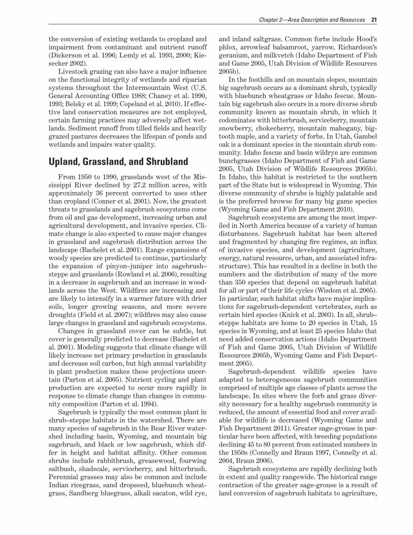
Sagebrush ecosystems are rapidly declining both in extent and quality rangewide. The historical range contraction of the greater sage-grouse is a result of land conversion of sagebrush habitats to agriculture,
22 Land Protection Plan—Bear River Watershed Conservation Area; Idaho, Utah, Wyoming
US
FW
S
White-faced ibis feeding in an irrigated agricultural field.
climatic trends, and human population growth. Future range loss, however, may be due more to recent changes in land use and habitat condition including energy development and invasive species, such as cheatgrass and West Nile virus (Aldridge et al. 2008). Keeping large areas of intact sagebrush is considered essential to the long-term persistence of the sage-grouse (Aldridge et al. 2008). Based on this finding, it has been recommended that conservation efforts should begin by maintaining large expanses of sagebrush habitat and enhancing the quality and con-nectivity of those areas.
Recent research shows that viable prairie grouse and sage-grouse populations are heavily dependent on suitable nesting and brood-rearing habitat (Con-nelly et al. 2000, Hagen et al. 2009). These habitats are usually associated with leks that are located in the approximate centers of nesting and brood-rear-ing habitats (Connelly et al. 2000, but see Connelly et al. 1988; Becker et al. 2009). Quality nesting and brood-rearing habitats surrounding leks are crucial to sustaining viable prairie grouse and sage-grouse populations (Giesen and Connelly 1993, Hagen et al. 2004, Connelly et al. 2000). The average distances from nests to active leks of nonmigratory sage-grouse range from 0.7 mile to 4 miles (Connelly et al. 2000), and are possibly much more for migratory popula-tions (Connelly et al. 1988). Kaczor et al. (2011) found that sage-grouse selected brood-rearing habitats that provided increased visual obstruction and bluegrass cover. More herbaceous vegetation at these sites may provide increased invertebrate abundance. Inverte-brates are a necessary part of the diet of sage-grouse chicks to support their growth, development, and sur-vival (Johnson and Boyce 1990).
Sage-grouse avoid energy developments in oth-erwise suitable habitats in winter. Previous research has shown that breeding sage-grouse in oil and gas fields avoid developments, experience higher rates of mortality, or both (Holloran 2005, Kaiser 2006, Aldridge and Boyce 2007).
Studies on the impacts of energy development in sagebrush–steppe ecosystems show that the effects extend beyond the sage-grouse. Sawyer et al. (2006) found that mule deer avoided otherwise suitable hab-itats within 1.7–2.3 miles (2.7–3.7 kilometers) of gas wells, and densities of Brewer’s sparrow and sage sparrow declined by 36–57 percent within 328 feet (100 meters) of dirt roads in gas fields (Ingelfinger and Anderson 2004).
Sagebrush habitats conserved for sage-grouse may also benefit other sagebrush-dependent spe-cies, although the effectiveness of sage-grouse as an umbrella species will depend on the specific manage-ment objectives for the conservation of other target species (Rowland et al. 2006).
ForestAt higher elevations in the watershed, forests typ-
ically consist of spruce, lodgepole pine, and subalpine fir, with areas of high-elevation tundra on north-fac-ing slopes. Moving down slope and the corresponding precipitation gradient, subalpine forests give way to dry forests of Douglas-fir, white fir, lodgepole pine, limber pine, and aspen groves, with bigtooth maple and boxelder in ravines.
Although the forested areas are largely on public lands, habitat loss through conversion to residential development is of local importance in some areas of
23Chapter 2—Area Description and Resources
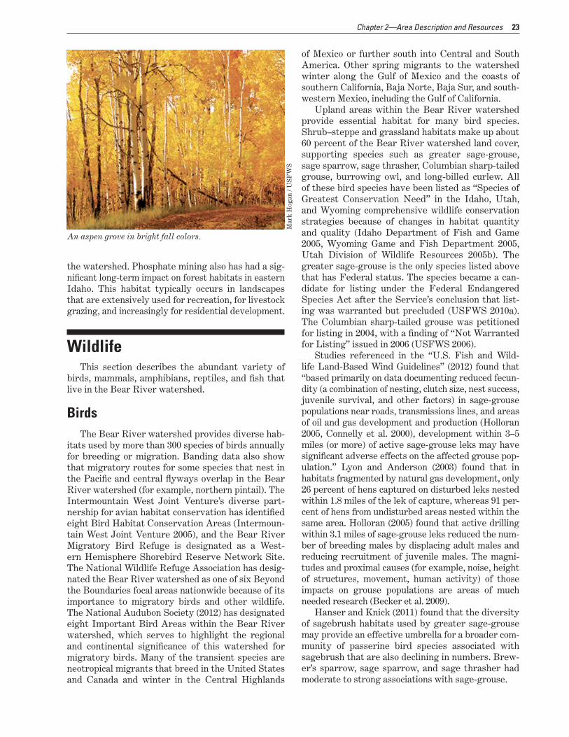
the watershed. Phosphate mining also has had a sig-nificant long-term impact on forest habitats in eastern Idaho. This habitat typically occurs in landscapes that are extensively used for recreation, for livestock grazing, and increasingly for residential development.
Mar
k H
ogan
/ U
SF
WS
An aspen grove in bright fall colors.
WildlifeThis section describes the abundant variety of
birds, mammals, amphibians, reptiles, and fish that live in the Bear River watershed.
BirdsThe Bear River watershed provides diverse hab-
itats used by more than 300 species of birds annually for breeding or migration. Banding data also show that migratory routes for some species that nest in the Pacific and central flyways overlap in the Bear River watershed (for example, northern pintail). The Intermountain West Joint Venture’s diverse part-nership for avian habitat conservation has identified eight Bird Habitat Conservation Areas (Intermoun-tain West Joint Venture 2005), and the Bear River Migratory Bird Refuge is designated as a West-ern Hemisphere Shorebird Reserve Network Site. The National Wildlife Refuge Association has desig-nated the Bear River watershed as one of six Beyond the Boundaries focal areas nationwide because of its importance to migratory birds and other wildlife. The National Audubon Society (2012) has designated eight Important Bird Areas within the Bear River watershed, which serves to highlight the regional and continental significance of this watershed for migratory birds. Many of the transient species are neotropical migrants that breed in the United States and Canada and winter in the Central Highlands
of Mexico or further south into Central and South America. Other spring migrants to the watershed winter along the Gulf of Mexico and the coasts of southern California, Baja Norte, Baja Sur, and south-western Mexico, including the Gulf of California.
Upland areas within the Bear River watershed provide essential habitat for many bird species. Shrub–steppe and grassland habitats make up about 60 percent of the Bear River watershed land cover, supporting species such as greater sage-grouse, sage sparrow, sage thrasher, Columbian sharp-tailed grouse, burrowing owl, and long-billed curlew. All of these bird species have been listed as “Species of Greatest Conservation Need” in the Idaho, Utah, and Wyoming comprehensive wildlife conservation strategies because of changes in habitat quantity and quality (Idaho Department of Fish and Game 2005, Wyoming Game and Fish Department 2005, Utah Division of Wildlife Resources 2005b). The greater sage-grouse is the only species listed above that has Federal status. The species became a can-didate for listing under the Federal Endangered Species Act after the Service’s conclusion that list-ing was warranted but precluded (USFWS 2010a). The Columbian sharp-tailed grouse was petitioned for listing in 2004, with a finding of “Not Warranted for Listing” issued in 2006 (USFWS 2006).
Studies referenced in the “U.S. Fish and Wild-life Land-Based Wind Guidelines” (2012) found that “based primarily on data documenting reduced fecun-dity (a combination of nesting, clutch size, nest success, juvenile survival, and other factors) in sage-grouse populations near roads, transmissions lines, and areas of oil and gas development and production (Holloran 2005, Connelly et al. 2000), development within 3–5 miles (or more) of active sage-grouse leks may have significant adverse effects on the affected grouse pop-ulation.” Lyon and Anderson (2003) found that in habitats fragmented by natural gas development, only 26 percent of hens captured on disturbed leks nested within 1.8 miles of the lek of capture, whereas 91 per-cent of hens from undisturbed areas nested within the same area. Holloran (2005) found that active drilling within 3.1 miles of sage-grouse leks reduced the num-ber of breeding males by displacing adult males and reducing recruitment of juvenile males. The magni-tudes and proximal causes (for example, noise, height of structures, movement, human activity) of those impacts on grouse populations are areas of much needed research (Becker et al. 2009).
Hanser and Knick (2011) found that the diversity of sagebrush habitats used by greater sage-grouse may provide an effective umbrella for a broader com-munity of passerine bird species associated with sagebrush that are also declining in numbers. Brew-er’s sparrow, sage sparrow, and sage thrasher had moderate to strong associations with sage-grouse.

24 Land Protection Plan—Bear River Watershed Conservation Area; Idaho, Utah, Wyoming
The three national wildlife refuges—Bear Lake (with the Oxford Slough Waterfowl Production Area), Bear River, and Cokeville— in the watershed pro-vide habitat for waterfowl, wading birds, shorebirds, and landbirds that migrate through these refuges on their way to and from Canadian and Alaskan interior and coastal wetlands. More than 270 different species have been identified using the habitats associated with the three refuges including the following birds:
■■ white-faced ibis (46 percent of the North Ameri-can population)
■■ marbled godwit (more than 24 percent of the North American population)
■■ black-necked stilt (more than 18 percent of the North American population)
■■ American avocet (more than 16 percent of the North American population)
■■ tundra swan (32 percent of the western population)
Fish populations on the refuges provide food for birds like the American white pelican, egrets, herons, and the bald eagle. The Bear River Refuge is likely the most important foraging location for the Great Salt Lake breeding colony of American white pelican (Frank Howe, Utah Division of Wildlife Resources, personal communication 2000).
Other noteworthy species using wetland habi-tats found throughout the watershed include sandhill crane, redhead, Wilson’s phalarope, trumpeter swan, black-crowned night-heron, cinnamon teal, blue-winged teal, northern pintail, American white pelican, rough-legged hawk, burrowing owl, and short-eared owl.
US
FW
S
Cinnamon teal and many other waterfowl species migrate through the watershed.
US
FW
S
A bull moose rests in wetland vegetation at Bear Lake National Wildlife Refuge, Idaho.
MammalsThe Bear River watershed provides habitat for
nearly 100 species of mammals. Forty-six of these species are listed as “Species of Greatest Conser-vation Need” under the Idaho, Utah, and Wyoming comprehensive wildlife conservation strategies (Idaho Department of Fish and Game 2005, Utah Division of Wildlife Resources 2005b, Wyoming Game and Fish Department 2005).
Many wide-ranging mammals depend on the large blocks of intact habitat found in the watershed, the wintering areas, and the key migration linkages including elk, mule deer, moose, pronghorn, grizzly bear, Canada lynx, gray wolf, and wolverine. Upland shrub and grassland habitats support many species, such as white-tailed prairie dog, pygmy rabbit, Idaho pocket gopher, sagebrush vole, Wyoming ground squirrel, and Preble’s shrew.
Wetlands in the watershed provide habitat for such species as water shrew, water vole, and northern river otter. In addition, the concentration of insects found in and around wetland complexes attracts many bat species of concern including pallid bat, Townsend’s big-eared bat, long-eared bat, and long-legged bat.
AmphibiansThe diversity of amphibian species in the Great
Basin and southern Rocky Mountains is low compared to other areas of the country, such as the Pacific North-west. However, wetland and riparian habitats in the watershed do support 11 species of frogs and toads and one salamander. Most of these species are listed as “Species of Greatest Conservation Need” under the Idaho, Utah, and Wyoming comprehensive wildlife conservation strategies (Idaho Department of Fish and
25Chapter 2—Area Description and Resources
Game 2005, Utah Division of Wildlife Resources 2005b, Wyoming Game and Fish Department 2005).
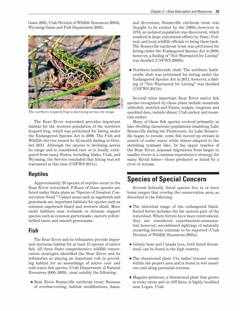
The Bear River watershed provides important habitat for the western population of the northern leopard frog, which was petitioned for listing under the Endangered Species Act in 2006. The Fish and Wildlife Service issued its 12-month finding in Octo-ber 2011. Although the species is declining across its range and is considered rare or is locally extir-pated from many States, including Idaho, Utah, and Wyoming, the Service concluded that listing was not warranted at this time (USFWS 2011c).
US
FW
S
The northern leopard frog is declining across its range.
ReptilesApproximately 20 species of reptiles occur in the
Bear River watershed. Fifteen of these species are listed under State plans as “Species of Greatest Con-servation Need.” Upland areas such as sagebrush and grasslands are important habitats for species such as common sagebrush lizard and western skink. More moist habitats near wetlands or streams support species such as common gartersnake, eastern yellow-bellied racer, and smooth greensnake.
FishThe Bear River and its tributaries provide impor-
tant instream habitat for at least 15 species of native fish. All three State comprehensive wildlife conser-vation strategies identified the Bear River and its tributaries as playing an important role in provid-ing habitat for an assemblage of native cool- and cold-water fish species (Utah Department of Natural Resources 2000, 2009), most notably the following:
■■ Bear River Bonneville cutthroat trout: Because of overharvesting, habitat modifications, dams,
and diversions, Bonneville cutthroat trout was thought to be extinct by the 1960s; however, in 1974, an isolated population was discovered, which resulted in large restoration efforts by State, Fed-eral, and local wildlife officials to bring them back. The Bonneville cutthroat trout was petitioned for listing under the Endangered Species Act in 2008; however, a finding of “Not Warranted for Listing” was decided (USFWS 2008b).
■■ Northern leatherside chub: The northern leath-erside chub was petitioned for listing under the Endangered Species Act in 2011; however, a find-ing of “Not Warranted for Listing” was decided (USFWS 2011b).
Several other important Bear River native fish species recognized by these plans include mountain whitefish, mottled and Paiute sculpin, longnose and speckled dace, redside shiner, Utah sucker, and moun-tain sucker.
Many of these fish species evolved primarily as lake-dwelling (lacustrine) populations inhabiting Lake Bonneville during the Pleistocene. As Lake Bonnev-ille began to recede, some fish moved up stream in search of cooler water while others adapted to the shrinking remnant lake. In the upper reaches of the Bear River, seasonal migrations from larger to smaller rivers is a common reproductive strategy for many fluvial fishes—those produced or found by a river or stream.
Species of Special ConcernSeveral federally listed species live in or have
home ranges that overlap the conservation area, as described in the following:
■■ The historical range of the endangered black-footed ferret includes the far eastern part of the watershed. Where ferrets have been reintroduced, they are considered experimental–nonessen-tial; however, unconfirmed sightings of naturally occurring ferrets continue to be reported (Utah Division of Wildlife Resources 2005a).
■■ Grizzly bear and Canada lynx, both listed threat-ened, can be found in the high country.
■■ The threatened plant Ute ladies’-tresses occurs within the project area and is found in wet mead-ows and along perennial streams.
■■ Maguire primrose, a threatened plant that grows in rocky areas and on cliff faces, is highly localized near Logan, Utah.

26 Land Protection Plan—Bear River Watershed Conservation Area; Idaho, Utah, Wyoming
■■ Candidate species such as the yellow-billed cuckoo occupy mature cottonwood–willow riparian habi-tats.
■■ Greater sage-grouse, a candidate for listing, is dependent on sagebrush and grassland habitats found throughout the watershed.
■■ The wolverine, a candidate species, occurs in higher elevation forested areas of the watershed.
■■ Whitebark pine, a coniferous tree occurring in subalpine to alpine sites above 8,000 feet, is a can-didate species.
Ste
ve C
aicc
o / U
SF
WS
Maguire primrose is a threatened plant.
Cultural ResourcesHumans have inhabited the Bear River area for
more than 12,000 years. Their uses of the land are as diverse as the regional topography and environments and reflect both changes through time and localized adaptations. The following brief summary of the pre-history and history of the Bear River area provides an overview of some of the major themes that have influenced the human interaction with the land.
Prehistory
Paleo-Indian PeriodCurrent archaeological evidence shows that the
earliest humans, called the paleo-Indians, migrated to the region near the close of the last ice age approx-imately 12,000 years ago. These people had a highly mobile lifestyle that depended on big game hunting including for mammoths and the huge, now-extinct bison. The hallmarks of most paleo-Indian sites are the beautiful but deadly spear points that are gen-erally recovered from animal kill and butchering sites and small temporary camps, or from isolated occurrences.
Recorded paleo-Indian sites are rare in the Bear River drainage, probably indicating the need for more surveys and research rather than reflecting actual prehistoric use patterns. Several early sites have been recorded in the general region, and many of these are found in the numerous caves that charac-terize parts of the Great Basin. Sites are also found near wetlands and along the shorelines of ancient lakes, indicating the use of the abundance of floral and faunal resources that would have been available in these locations. The warming and drying climatic trend that began at the start of the Paleo-Indian Period continued and, by approximately 8,000 years ago, contributed to a change in settlement patterns and local adaptations.
Archaic PeriodThere was a gradual but definite shift in the pat-
tern of human use of the region beginning about 8,000 years ago and continuing until approximately 2,500 years ago. The changes were the result of a combina-tion of regional climatic fluctuations and an increasing population, coupled with technological innovation and regional influences. Although the Archaic Period is bet-ter represented in the archaeological record than the preceding Paleo-Indian Period, the interpretation of the remains is difficult. A greater diversity of tools and the use of a larger variety of plants and animals are found on many sites. The semipermanent occupation of small villages, the use of smaller spear points, and the creation of basketry, cloth, and cordage are hall-marks of this period. As with the earlier inhabitants, the Archaic peoples made extensive use of the many caves and the wetland environments in the region.

27Chapter 2—Area Description and Resources
US
FW
S
Springtime wetlands at Cokeville Meadows National Wildlife Refuge, Wyoming.
Late Prehistoric and Protohistoric Period
Beginning approximately 2,500 years ago, several innovations greatly influenced life in the Bear River region. Although these changes were adopted at dif-ferent rates and degrees throughout the area, the advent of pottery, the bow and arrow, and agriculture, coupled with a larger and more sedentary population, defines the period until approximately 800 years ago.
Approximately 1,500 years ago, people archae-ologists refer to as the Fremont began to settle the Bear River drainage. Although five distinct Fremont variants have been identified in the archaeologi-cal record of the Great Basin, the use of pit houses, agriculture, granaries, and distinctive artistic motifs are common throughout the region. Fremont sub-sistence included cultivated corn, beans, and squash but also relied heavily on hunting and the intensive exploitation of native plants. Archaeologists suspect that a major staple of the Fremont diet along the Bear River would have been cattail and other seeds ground into meal. Animal species exploited included bison, pronghorn, and mule deer as well as shellfish, fish, and waterfowl. Evidence of the Fremont in the archaeological record disappears about 700 years ago.
About 600 years ago, the people living in the Bear River watershed began to blend culture traits
with Shoshonean people living to the east of the Uinta Mountains and abandoned some Fremont cul-tural traits. These people continued to live in part on wild foods available in the marsh, but probably lived in smaller groups and exploited a broader range of resources. It is not known if the Fremont people were replaced or the two groups integrated. When the first trappers arrived in the early 1800s, people of the Sho-shone and Bannock Tribes were living in the area.
HistoryThe Historic Period for the Bear River drainage
begins with the recurring contact of the Native Peo-ples with people of European descent and ends in the mid-twentieth century. This interaction generally fol-lowed many years of occasional contact—usually for the exchange of trade goods—and occurred at differ-ent times throughout the area. As with the prehistory of the area, the history of the Bear River watershed reflects both broad themes and individual stories. The narrative below briefly summarizes some of the major historic influences in the region.
The earliest documented European in the area was fur trapper Robert Stuart in 1812. The region quickly gained fame for its abundant resources and became the site of both the 1827 and 1828 trappers’
28 Land Protection Plan—Bear River Watershed Conservation Area; Idaho, Utah, Wyoming
rendezvous on the southern end of Bear Lake near the current town of Laketown, Utah. These annual gatherings were held from 1825 to 1840 to allow the trappers to sell their furs and restock their supplies.
Border disputes between the United States and Spain in various parts of North America, includ-ing the Bear River drainage, were addressed in the Adams–Onis Treaty of 1819. As a part of this treaty, the land north of the 42nd Parallel—the State bound-ary between Idaho and Utah—became United States territory and the lands below the parallel that of New Spain (Mexico after 1821).
Several major trails, sometimes referred to as the Emigrant Trails, crossed the Bear River drainage. The Oregon Trail in this area often followed the route of earlier fur trapper foot and horse trails but did not become a wagon trail until 1836. Coming from the east, the main trail takes a sharp north turn at Fort Bridger in southwest Wyoming before heading north-west along the northern banks of the Little Muddy Creek. It crosses over the Bear River Divide and joins the Bear River just south of the Cokeville Mead-ows National Wildlife Refuge. From there, it never strays far from the Bear River and is most often along the east or north sides of the river. Just west of Soda Springs, where the river cuts to the south, the trail diverges from the river and heads north-west toward Fort Hall. The California Trail follows
a similar path through the watershed, but splits from the Oregon Trail at Fort Hall.
The grade of the Union Pacific Railroad, built as a part of the Transcontinental Railroad, crosses the watershed just north of the Bear River Migra-tory Bird Refuge. The Union Pacific began in Omaha, Nebraska, and headed west until joining the Central Pacific Railroad at Golden Spike, approximately 10 miles to the north of the Bear River Migratory Bird Refuge in 1869. The completion of this railroad and its links to rail systems in the eastern United States had a profound effect on the settlement of the West.
The first European resident of the area is reported to have been Thomas “Peg Leg” Smith, who ran a trading post from 1842–57 near Dingle, Idaho, on the northeastern shores of Bear Lake. The influx of settlers accelerated greatly during the early 1850s following the initial waves of Mormon immigrants arriving from the east. The towns of Brigham City and Willard in the southwest corner of the watershed were both founded in 1851 by Mormon pioneers. In 1860, Mormons settled the town of Franklin, Idaho, located along the Cub River just north of the Utah–Idaho boundary, which became the first town settled in what is now Idaho. In 1867, the Fort Hall Reser-vation near Pocatello, Idaho, was established for the Shoshone and Bannock Tribes.
US
FW
S
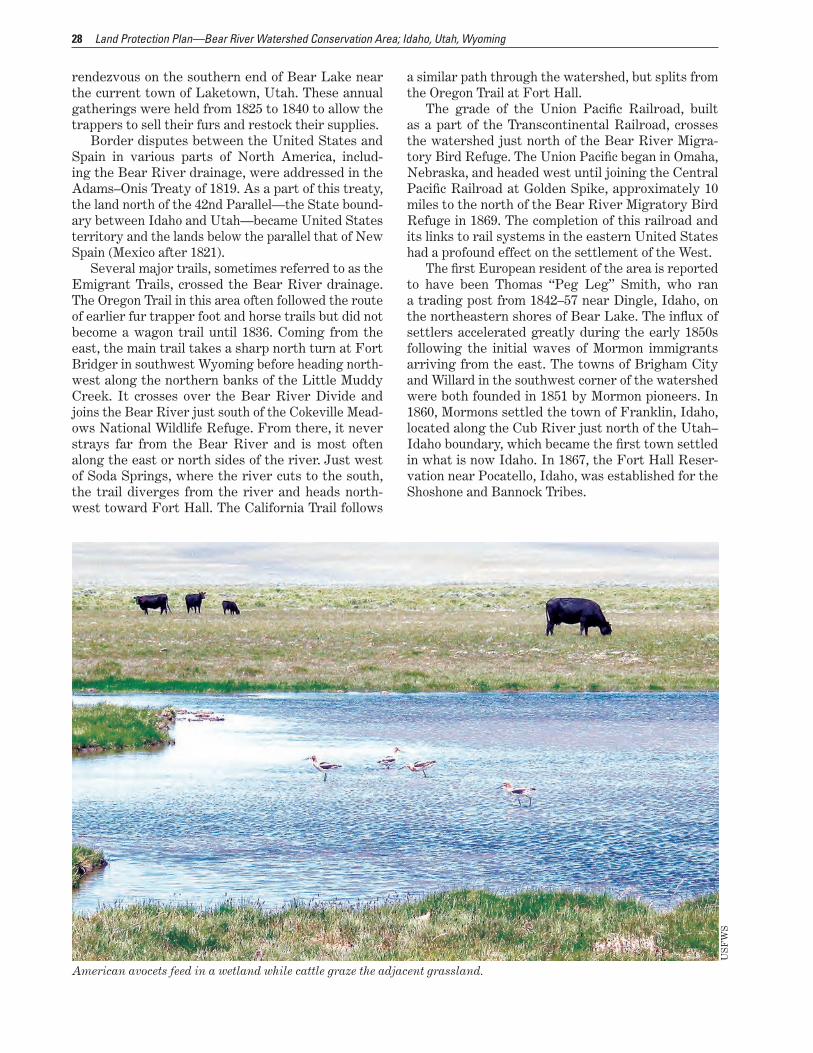
American avocets feed in a wetland while cattle graze the adjacent grassland.
29Chapter 2—Area Description and Resources
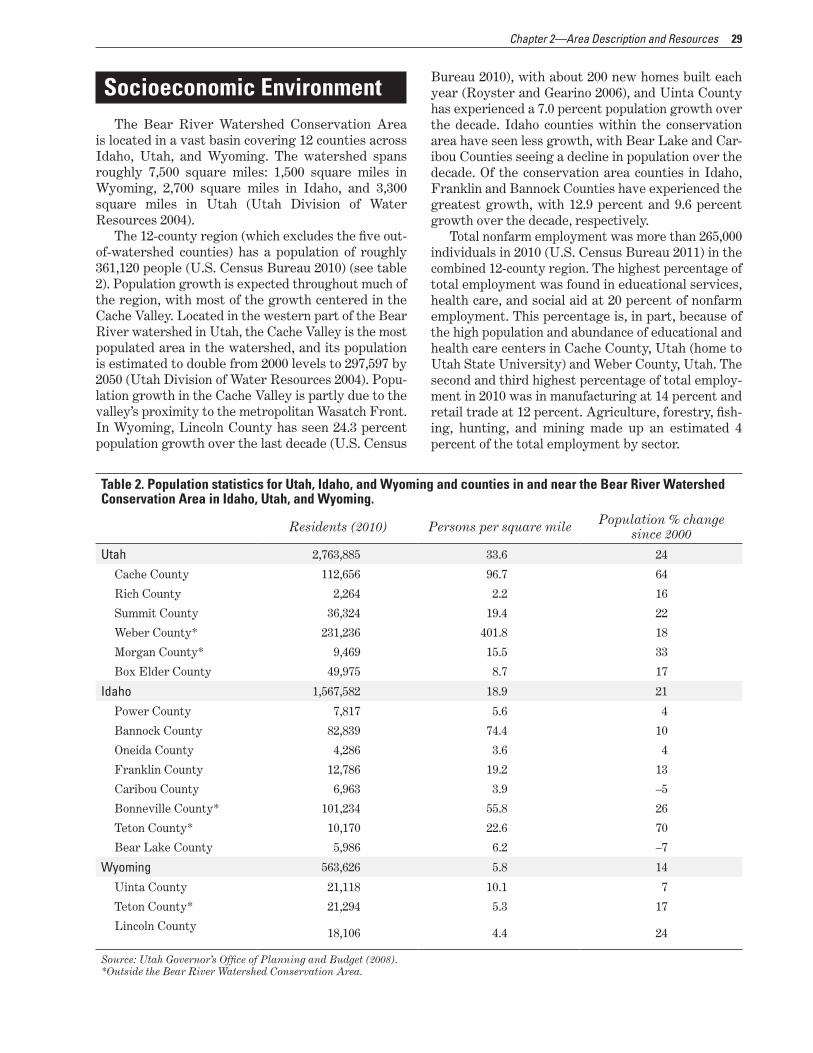
Socioeconomic EnvironmentThe Bear River Watershed Conservation Area
is located in a vast basin covering 12 counties across Idaho, Utah, and Wyoming. The watershed spans roughly 7,500 square miles: 1,500 square miles in Wyoming, 2,700 square miles in Idaho, and 3,300 square miles in Utah (Utah Division of Water Resources 2004).
The 12-county region (which excludes the five out-of-watershed counties) has a population of roughly 361,120 people (U.S. Census Bureau 2010) (see table 2). Population growth is expected throughout much of the region, with most of the growth centered in the Cache Valley. Located in the western part of the Bear River watershed in Utah, the Cache Valley is the most populated area in the watershed, and its population is estimated to double from 2000 levels to 297,597 by 2050 (Utah Division of Water Resources 2004). Popu-lation growth in the Cache Valley is partly due to the valley’s proximity to the metropolitan Wasatch Front. In Wyoming, Lincoln County has seen 24.3 percent population growth over the last decade (U.S. Census
Bureau 2010), with about 200 new homes built each year (Royster and Gearino 2006), and Uinta County has experienced a 7.0 percent population growth over the decade. Idaho counties within the conservation area have seen less growth, with Bear Lake and Car-ibou Counties seeing a decline in population over the decade. Of the conservation area counties in Idaho, Franklin and Bannock Counties have experienced the greatest growth, with 12.9 percent and 9.6 percent growth over the decade, respectively.
Total nonfarm employment was more than 265,000 individuals in 2010 (U.S. Census Bureau 2011) in the combined 12-county region. The highest percentage of total employment was found in educational services, health care, and social aid at 20 percent of nonfarm employment. This percentage is, in part, because of the high population and abundance of educational and health care centers in Cache County, Utah (home to Utah State University) and Weber County, Utah. The second and third highest percentage of total employ-ment in 2010 was in manufacturing at 14 percent and retail trade at 12 percent. Agriculture, forestry, fish-ing, hunting, and mining made up an estimated 4 percent of the total employment by sector.
Table 2. Population statistics for Utah, Idaho, and Wyoming and counties in and near the Bear River Watershed Conservation Area in Idaho, Utah, and Wyoming.
Residents (2010) Persons per square mile Population % change since 2000
Utah 2,763,885 33.6 24
Cache County 112,656 96.7 64
Rich County 2,264 2.2 16
Summit County 36,324 19.4 22
Weber County* 231,236 401.8 18
Morgan County* 9,469 15.5 33
Box Elder County 49,975 8.7 17
Idaho 1,567,582 18.9 21
Power County 7,817 5.6 4
Bannock County 82,839 74.4 10
Oneida County 4,286 3.6 4
Franklin County 12,786 19.2 13
Caribou County 6,963 3.9 –5
Bonneville County* 101,234 55.8 26
Teton County* 10,170 22.6 70
Bear Lake County 5,986 6.2 –7
Wyoming 563,626 5.8 14
Uinta County 21,118 10.1 7
Teton County* 21,294 5.3 17
Lincoln County 18,106 4.4 24
Source: Utah Governor’s Office of Planning and Budget (2008). *Outside the Bear River Watershed Conservation Area.
30 Land Protection Plan—Bear River Watershed Conservation Area; Idaho, Utah, Wyoming
Mining represents a relatively small percentage of total employment for many of the counties in the region, but has increased slightly since 1998 (U.S. Census Bureau 2011, Headwaters Economics 2011). Mining accounted for less than 1 percent of total employment in 2009 for all but three counties in the 12-county region.
LandownershipThe Upper Bear River area is located in parts of
Summit County, Utah, and Lincoln and Uinta County, Wyoming. The headwaters of the Bear River, near the border of Summit and Uinta Counties, is forested; the remaining land cover in the high-elevation Upper Bear River area is primarily grassland and shrubland, with about three-quarters of the land used for graz-ing (Utah Water Research Laboratory 2011). As of 2006, about 63 percent of the land in the Upper Bear River counties was federally owned, primarily by the Bureau of Land Management and the USDA Forest Service; about 24 percent of the land was privately owned, 4 percent was State owned, and 7 percent was tribally owned (Headwaters Economics 2011). The Upper Bear River area is lightly populated. The largest municipalities in the region are Evanston and Cokeville, Wyoming, and Randolph and Woodruff, Utah (Utah Water Research Laboratory 2011).
The Middle Bear River area is located in parts of Bear Lake, Caribou, Franklin, Bannock, Oneida, and Power Counties in Idaho. Grassland and shrubland account for about 77 percent of the land cover in the Middle Bear River counties, and croplands account for about 11 percent of the land cover (Headwaters Economics 2011). As of 2006, urban development accounts for only about 0.2 percent of the land cover in these counties; the largest municipalities in the region are Grace, Preston, Montpelier, Soda Springs, and Malad City, Idaho, and Garden City, Utah (Head-waters Economics 2011; Utah Division of Water Resources 2004). As of 2006, landownership in the Middle Bear River counties was 48 percent private, 38 percent Federal, 5 percent State, and 6 percent tribal (Headwaters Economics 2011).
The Lower Bear River area is in parts of Box Elder, Cache, Rich, Weber, and Morgan Counties in Utah. The rich soil and abundant water in this part of the Bear River watershed support a mix of urban and agricultural uses. About 9 percent of the land cover in the Lower Bear River counties is water. Mixed crop-lands account for 21 percent of the land cover in the Lower Bear River counties, with croplands concen-trated in Cache and Box Elder Counties (Headwaters Economics 2011). As of 2006, about 1.6 percent of the land in these counties is urban development, with much of the development concentrated in the
Cache Valley (Headwaters Economics 2011). Major municipalities in the Lower Bear River area include Brigham City, Logan, North Logan, Smithfield, Trem-onton, and Richmond. As of 2006, landownership in the Lower Bear River counties was 52-percent pri-vate, 31-percent Federal, and 6-percent State (Headwaters Economics 2011).
While the population of the Bear River Watershed Conservation Area has declined in two counties in Idaho, some parts of the conservation area as well as areas next to it have experienced significant growth trends over the past decade (see table 2).
Property TaxProperty taxes are assessed based on the value of
property. For most types of properties, county asses-sors use fair market value to determine property tax liabilities. In many States, however, the assessed value of agricultural land is determined based on the productive value of the land rather than on the fair market value of the property. The fair market value of land is the estimate of a property’s sale price. This value includes both the productive value of the land and any speculative value associated with the possi-bility of developing the land.
Conservation easements reduce the fair mar-ket value of a property by removing the speculative value associated with possible development; how-ever, conservation easements generally do not affect the productive value of agricultural land. The Bear River Watershed Conservation Area encompasses three States: Idaho, Utah, and Wyoming. In all three States, property taxes for agricultural land are assessed based on the productive value of the land. Most properties that enter into conservation ease-ment agreements with the Service are classified as agricultural land; therefore, there will be little or no impact on the current property tax base for the 12-county area.
Public Use and Wildlife-Dependent Recreational Activities
According to the “2006 National Survey of Fish-ing, Hunting, and Wildlife-Associated Recreation,” approximately 2.9 million residents took part in wild-life-associated recreational activities in Idaho, Utah, and Wyoming in 2006 (USFWS 2008a). It was esti-mated that residents and visitors spent $3.3 billion on wildlife-associated recreational activities in 2006 in the three States combined. Among participants,

31Chapter 2—Area Description and Resources
wildlife watching was the most frequently reported activity followed by fishing and hunting. In Wyoming, 84 percent of individuals surveyed watched wildlife, 27 percent fished, and 13 percent hunted; in Utah, 77 percent watched wildlife, 33 percent fished, and 15 percent hunted; and in Idaho, 75 percent watched wildlife, 35 percent fished, and 19 percent hunted (USFWS 2008a). Following the national trend, wild-life viewing has become increasingly popular, while hunting and fishing have decreased or remained sta-ble in popularity. From 1996 to 2006, it was found that the number of Idaho residents who fished declined by 21 percent while those who hunted declined by 33 percent. Wyoming residents who fished declined by 19 percent, while hunting and wildlife viewing num-bers remained relatively constant. During the same timeframe, Utah residents who watched wildlife increased by 30 percent, while hunting and fishing numbers remained relatively constant.
© K
eith
Pen
ner
Killdeer at Cokeville Meadows National Wildlife Refuge, Wyoming.
