chapter 24: draft section 4(f) evaluation section 4(f... · draft eis and draft section 4(f)...
TRANSCRIPT
Draft EIS and Draft Section 4(f) Evaluation 24-1 June 2017
Chapter 24: Draft Section 4(f) Evaluation
24.1 INTRODUCTION This Draft Section 4(f) Evaluation evaluates and documents the Hudson Tunnel Project (the Project) in terms of its compliance with the requirements of Section 4(f) as codified at 23 USC 138 and 49 USC 303.1 Section 4(f) governs the use of land from publicly owned parks, recreation areas, and wildlife and waterfowl refuges and publicly or privately owned significant historic sites that may be affected by projects approved or funded by the U.S. Department of Transportation (USDOT). The requirements of Section 4(f) apply to the operating administrations of USDOT, including the Federal Railroad Administration (FRA), the Federal Transit Administration (FTA), and the Federal Highway Administration (FHWA).
This chapter contains the following sections:
24.1 Introduction 24.2 Regulatory Context
24.2.1 Section 4(f) Use 24.2.2 Avoidance Alternatives 24.2.3 Least Overall Harm Alternative
24.3 Need, Purpose, Goals, and Objectives 24.4 Alternatives
24.4.1 No Action Alternative 24.4.2 Preferred Alternative
24.5 Identification and Use of Section 4(f) Properties 24.5.1 Wildlife or Waterfowl Refuges 24.5.2 Parklands and Recreational Resources 24.5.3 Historic Resources
24.6 Hudson River Bulkhead 24.6.1 Description of the Section 4(f) Property 24.6.2 Use of the Section 4(f) Property 24.6.3 Alternatives to Avoid the Use of the Section 4(f) Property 24.6.4 Least Overall Harm Alternative 24.6.5 Measures to Minimize Harm
24.7 Coordination 24.7.1 Coordination with Officials with Jurisdiction over the Section 4(f) Resource 24.7.2 Public Involvement
1 In 1983, Section 4(f) of the U.S. Department of Transportation Act was codified as 49 USC § 303(c), but
this law is still commonly referred to as Section 4(f).

June 2017 24-2 Draft EIS and Draft Section 4(f) Evaluation
24.2 REGULATORY CONTEXT During development of this Environmental Impact Statement (EIS), FRA and NJ TRANSIT developed methodologies for evaluating the potential effects of the Hudson Tunnel Project in coordination with the Project’s Cooperating and Participating Agencies (i.e., agencies with a permitting or review role for the Project). The methodologies used for Section 4(f) analysis are summarized in this chapter.
Section 4(f) prohibits USDOT operating administrations, including FRA, from approving any program or project that requires the “use” of any publicly owned parkland, recreation area, or wildlife and waterfowl refuge; or any land from a publicly or privately owned historic site of national, state, or local significance (collectively, “Section 4(f) properties”), unless (a) the agency determines that the use of the property will have a de minimis impact; or (b) there is no feasible and prudent avoidance alternative to the use of the land, and the action includes all possible planning to minimize harm to the Section 4(f) property. A historic site is a property that is listed on, or eligible for listing on, the National Register of Historic Places (NRHP).
FRA does not have its own Section 4(f) regulations. However, FRA’s Procedures for Considering Environmental Impacts2 address Section 4(f) requirements and, in making its own Section 4(f) determinations, FRA uses the joint FTA and FHWA Section 4(f) regulations (23 CFR Part 774) and FHWA’s Section 4(f) Policy Paper3 as guidance.
24.2.1 SECTION 4(f) USE Pursuant to 23 CFR § 774.17, a project uses a Section 4(f) property when:
• Land from the Section 4(f) property is permanently incorporated into a transportation facility; • There is a temporary occupancy of land that is adverse in terms of the statute’s preservation
purpose, as determined by the criteria in 23 CFR § 774.13(d) (e.g., when all or part of the Section 4(f) property is required for project construction-related activities); or
• There is a “constructive” use of a Section 4(f) property, as determined by the criteria in 23 CFR § 774.15(a).4
Whenever a Section 4(f) property would be used for a transportation project, the responsible USDOT operating administration must demonstrate that there is no feasible and prudent alternative to the use of the Section 4(f) property, and that the project includes all possible planning to minimize harm to the Section 4(f) property. In addition, the responsible USDOT operating administration must coordinate with the U.S. Department of the Interior (DOI), and if appropriate, with the U.S. Department of Housing and Urban Development (HUD) and the U.S. Department of Agriculture (USDA), and the appropriate official(s) with jurisdiction over the
2 64 Federal Register 28545, May 26, 1999. 3 Section 4(f) Policy Paper, FHWA Office of Planning, Environment and Realty, July 20, 2012. 4 “A constructive use occurs when the transportation project does not incorporate land from a Section 4(f)
property, but the project's proximity impacts are so severe that the protected activities, features, or attributes that qualify the property for protection under Section 4(f) are substantially impaired.”

Chapter 24: Draft Section 4(f) Evaluation
Draft EIS and Draft Section 4(f) Evaluation 24-3 June 2017
Section 4(f) property, prior to approving the use of a Section 4(f)resource (23 CFR § 774.5(a)).5 This coordination must be documented in a project’s Section 4(f) evaluation.
24.2.1.1 DE MINIMIS IMPACTS
The joint FTA and FHWA Section 4(f) regulations (23 CFR Part 774) establish procedures for determining if the use of a Section 4(f) property has a de minimis impact on a property. The regulations define de minimis impacts related to historic sites as those where the responsible USDOT modal administration made a determination of either “no effect” or “no adverse effect” pursuant to Section 106, and the SHPO concurred with that determination. De minimis impacts on publicly owned parks, recreation areas, and wildlife and waterfowl refuges are defined as those that do not “adversely affect the activities, features, and attributes” of the Section 4(f) property (23 CFR § 774.17). As noted above, while the regulations do not apply to FRA projects, they do provide guidance that FRA uses in evaluating de minimis impacts and making its own Section 4(f) determinations. Once FRA, through appropriate consultation and public involvement, and having received concurrence from the official(s) with jurisdiction, determines that a transportation use of a Section 4(f) property results in a de minimis impact, and documents that determination consistent with the requirements of FRA’s Procedures for Considering Environmental Impacts, analysis of avoidance alternatives is not required and the Section 4(f) evaluation process is complete.
24.2.1.2 EXCEPTIONS FROM SECTION 4(f) The joint FTA and FHWA Section 4(f) regulations (23 CFR § 774.13) identify various exceptions to the requirement for Section 4(f) approval, including, among others: (1) restoration, rehabilitation, or maintenance of transportation facilities that are on or eligible for the NRHP when adverse effects will not occur; (2) archaeological sites that are on or eligible for the NRHP when the resource is important chiefly because of what can be learned by data recovery and has minimal value for preservation in place; and (3) temporary occupancies of land that are so minimal as to not constitute a use within the meaning of Section 4(f).
24.2.1.3 EXEMPTIONS FROM SECTION 4(f) The Section 4(f) legislation at 23 USC § 138(f) and 49 USC § 303(h)) exempts from Section 4(f) review the use of railroad and rail transit lines, or elements thereof, that are in use or that were historically used for the transportation of goods and passengers. The exemption applies regardless of whether the railroad or rail transit line, or element thereof, is listed on or eligible for listing on the NRHP. The exemption has two exceptions:
• The exemption does not apply to rail stations or transit stations; and • The exemption does not apply to bridges or tunnels located on a rail line that has been
abandoned under the process described in 49 USC § 10903, or a transit line that is not in use.
5 As defined in 23 CFR § 774.17, for public parks, recreation areas, and wildlife and waterfowl refuges,
the official(s) with jurisdiction are the official(s) from the agency or agencies that own and/or administer the property in question, and who are empowered to represent the agency or agencies on matters related to the property. For historic sites, the official with jurisdiction is the relevant State Historic Preservation Officer (SHPO), as well as the Advisory Council on Historic Preservation (ACHP) if ACHP has chosen to participate in consultation in accordance with Section 106 of the National Historic Preservation Act (NHPA) (Section 106). There may be more than one official with jurisdiction for the same Section 4(f) property.
June 2017 24-4 Draft EIS and Draft Section 4(f) Evaluation
24.2.2 AVOIDANCE ALTERNATIVES When a project would use a Section 4(f) property, the transportation agency must demonstrate that there is no feasible and prudent alternative to avoid the use of the property.
24.2.3 LEAST OVERALL HARM ALTERNATIVE If there is no feasible and prudent avoidance alternative to the use of a Section 4(f) resource, and multiple alternatives would use Section 4(f) resources, FRA may approve only the alternative that causes the least overall harm in light of Section 4(f)’s preservation purpose.
24.3 NEED, PURPOSE, GOALS, AND OBJECTIVES The existing North River Tunnel beneath the Hudson River is a critical Northeast Corridor (NEC) asset and is the only intercity passenger rail crossing into New York City from New Jersey and areas west and south.6 This tunnel, constructed between 1904 and 1908 and opened for service in 1910, is more than 100 years old and was designed and built to early 20th-century standards. Service reliability through the tunnel, already suboptimal because of the tunnel’s age and antiquated standards, has been further compromised because of the damage to tunnel components caused by Superstorm Sandy.
The purpose of the Hudson Tunnel Project is to preserve the current functionality of the National Railroad Passenger Corporation’s (Amtrak) NEC service and NJ TRANSIT’s commuter rail service between New Jersey and Penn Station New York (PSNY) by repairing the deteriorating North River Tunnel; and to strengthen the NEC’s resiliency to support reliable service by providing redundant capability under the Hudson River for Amtrak and NJ TRANSIT NEC trains between New Jersey and the existing PSNY. These improvements must be achieved while maintaining uninterrupted commuter and intercity rail service and by optimizing the use of existing infrastructure.
FRA and NJ TRANSIT established five goals and related objectives to address the Project purpose and need. The objectives further define the goals and provide specific and measurable means by which to evaluate Project alternatives:
Goal 1: Improve service reliability and upgrade existing tunnel infrastructure in a cost-effective manner. • Objective 1.1: Reduce infrastructure-related delays due to poor condition of the
North River Tunnel following Superstorm Sandy. • Objective 1.2: Rehabilitate the North River Tunnel to modern system standards.
Goal 2: Maintain uninterrupted existing NEC service, capacity, and functionality by ensuring North River Tunnel rehabilitation occurs as soon as possible. • Objective 2.1: Optimize use of existing infrastructure. • Objective 2.2: Use conclusions from prior planning studies as appropriate and to
the maximum extent possible. • Objective 2.3: Avoid regional and national economic impacts associated with loss
of rail service.
6 The Port Authority of New York & New Jersey’s (PANYNJ)’s Port Authority Trans Hudson (PATH) rail
service also crosses the Hudson River, serving local New Jersey and New York commuters rather than intercity or regional commuters.
Chapter 24: Draft Section 4(f) Evaluation
Draft EIS and Draft Section 4(f) Evaluation 24-5 June 2017
Goal 3: Strengthen the NEC’s resiliency to provide reliable service across the Hudson River crossing, facilitating long-term infrastructure maintenance and enhancing operational flexibility. • Objective 3.1: Construct additional tracks to allow for continued NEC rail
operations during maintenance periods and unanticipated human-caused and natural events.
Goal 4: Do not preclude future trans-Hudson rail capacity expansion projects. • Objective 4.1: Allow for connections to future capacity expansion projects,
including connections to the Frank R. Lautenberg Station (Secaucus Junction Station) through to the Portal Bridge over the Hackensack River, and connections to station expansion projects in the area of PSNY.
Goal 5: Minimize impacts on the natural and built environment. • Objective 5.1: Avoid/minimize adverse impacts on communities and
neighborhoods. • Objective 5.2: Strive for consistency with local plans and policies. • Objective 5.3: Preserve the natural and built environment to the extent practicable.
24.4 ALTERNATIVES The Project’s Draft Environmental Impact Statement (DEIS) considers two alternatives in detail: the No Action Alternative and the Preferred Alternative. These are described in detail in Chapter 2 of the DEIS, “Project Alternatives and Description of the Preferred Alternative” and summarized below.
24.4.1 NO ACTION ALTERNATIVE The National Environmental Policy Act (NEPA) requires examination of a No Action Alternative, which is an alternative against which the potential benefits and impacts of Build Alternatives can be compared. In the No Action Alternative, no new passenger rail tunnel across the Hudson River would be constructed and rehabilitation of the North River Tunnel would not occur. The existing North River Tunnel would remain in service, with continued maintenance as necessary to address ongoing deterioration to the extent possible. However, without full rehabilitation of the North River Tunnel, ongoing deterioration combined with the tunnel’s age and intensity of use would likely lead to increasing instability of rail operations in the tunnel, and may lead to its eventual closure.
24.4.2 PREFERRED ALTERNATIVE The Preferred Alternative for the Project would consist of a new two-track tunnel, parallel to the North River Tunnel, extending from the NEC in Secaucus, New Jersey, beneath the Palisades (North Bergen and Union City) and the Hoboken waterfront area, and beneath the Hudson River to connect to the existing approach tracks at PSNY. New ventilation shafts and associated fan plants would be located above the tunnel in New Jersey and New York for regular and emergency ventilation and emergency access. The western terminus of the new tunnel and related tracks and infrastructure would be east of County Road in Secaucus, New Jersey and the eastern terminus would be at approximately Ninth Avenue in Manhattan, New York. No changes east of Ninth Avenue, and no changes to PSNY platforms or platform tracks, are proposed as part of the Preferred Alternative.
June 2017 24-6 Draft EIS and Draft Section 4(f) Evaluation
Major components of the Preferred Alternative’s new tunnel would include:
• Two new surface tracks parallel to the south side of the NEC beginning at a realigned Allied Interlocking in Secaucus, New Jersey just east of NJ TRANSIT’s Secaucus Junction Station. These tracks would be accessible for maintenance and emergency services via new access roads.7
• A new tunnel with two tracks in two separate “tubes” (i.e., single-track tunnels) beneath the Palisades and the Hoboken waterfront area east of the Palisades, continuing beneath the Hudson River to Manhattan. In New Jersey, the tunnel would begin at a portal in the western slope of the Palisades, just east of Tonnelle Avenue (US Routes 1 and 9). The two new tracks would continue through the Manhattan bulkhead, beneath Hudson River Park and Twelfth Avenue (New York State Route 9A) to meet the underground Hudson Yards Right-of-Way Preservation Project that Amtrak is constructing beneath the Hudson Yards overbuild project at the Western and Eastern Rail Yards in Manhattan.
• Two new tracks and associated rail systems to be added by the Project to the Hudson Yards Right-of-Way Preservation Project.
• Extension of the tunnel past the Hudson Yards Right-of-Way Preservation Project beneath Tenth Avenue to a tunnel portal east of Tenth Avenue, within the complex of tracks located beneath the existing building that spans the tracks on the east side of Tenth Avenue (450 West 33rd Street, referred to as the Lerner Building). The new tunnel portal would be adjacent to the tunnel portals for Amtrak’s Empire Line and for the North River Tunnel.
• Track connections east of Tenth Avenue to the existing approach tracks into PSNY. • A ventilation shaft and associated fan plant in Hoboken, New Jersey. • A ventilation shaft and fan plant near Twelfth Avenue between West 29th and 30th Streets
(Block 675) in Manhattan. • A fan plant beneath the Lerner Building, which is located at Tenth Avenue between 31st and
33rd Streets and spans across the rail right-of-way.
The Preferred Alternative would also include a rehabilitated North River Tunnel, so that the NEC would have four tracks (two in the new tunnel and two in the North River Tunnel) between New Jersey and New York under the Hudson River, which would provide operational flexibility and redundancy for Amtrak and NJ TRANSIT rail operations. Once construction of both tubes of the new tunnel is complete and Amtrak and NJ TRANSIT service shifts to the new tunnel, rehabilitation of the North River Tunnel would begin. The rehabilitation would include bench wall and duct bank removal and reconstruction; replacing ballast track system to ballast-less track system; installing new signal, communication, and power cables and associated components; and localized crack, leakage, and spall repairs on the existing tunnel concrete lining.
24.5 IDENTIFICATION AND USE OF SECTION 4(f) PROPERTIES
This evaluation identifies Section 4(f) properties that could be affected by the Project, based on analyses conducted for this DEIS and described in Chapter 8, “Open Space and Recreational Resources,” and Chapter 9, “Historic and Archaeological Resources.”
7 An interlocking is a system of switches and signals that allows trains to make connections from one
track to another.
Chapter 24: Draft Section 4(f) Evaluation
Draft EIS and Draft Section 4(f) Evaluation 24-7 June 2017
24.5.1 WILDLIFE OR WATERFOWL REFUGES No wildlife or waterfowl refuges are located in proximity to the Preferred Alternative, and no wildlife or waterfowl refuges would be affected by the Preferred Alternative. Therefore, the Preferred Alternative would not result in the use of any such resources.
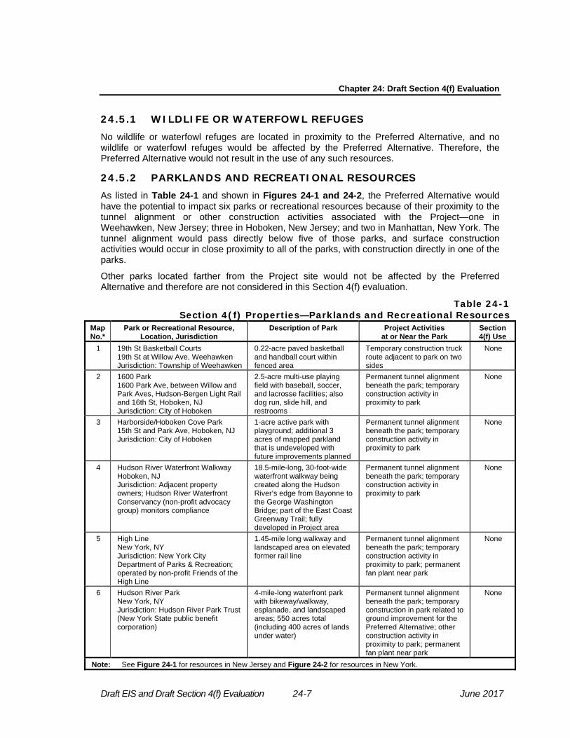
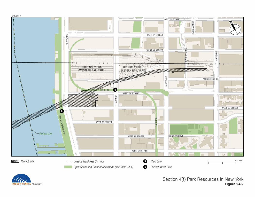
24.5.2 PARKLANDS AND RECREATIONAL RESOURCES As listed in Table 24-1 and shown in Figures 24-1 and 24-2, the Preferred Alternative would have the potential to impact six parks or recreational resources because of their proximity to the tunnel alignment or other construction activities associated with the Project—one in Weehawken, New Jersey; three in Hoboken, New Jersey; and two in Manhattan, New York. The tunnel alignment would pass directly below five of those parks, and surface construction activities would occur in close proximity to all of the parks, with construction directly in one of the parks.
Other parks located farther from the Project site would not be affected by the Preferred Alternative and therefore are not considered in this Section 4(f) evaluation.
Table 24-1 Section 4(f) Properties—Parklands and Recreational Resources
Map No.*
Park or Recreational Resource, Location, Jurisdiction
Description of Park Project Activities at or Near the Park
Section 4(f) Use
1 19th St Basketball Courts 19th St at Willow Ave, Weehawken Jurisdiction: Township of Weehawken
0.22-acre paved basketball and handball court within fenced area
Temporary construction truck route adjacent to park on two sides
None
2 1600 Park 1600 Park Ave, between Willow and Park Aves, Hudson-Bergen Light Rail and 16th St, Hoboken, NJ Jurisdiction: City of Hoboken
2.5-acre multi-use playing field with baseball, soccer, and lacrosse facilities; also dog run, slide hill, and restrooms
Permanent tunnel alignment beneath the park; temporary construction activity in proximity to park
None
3 Harborside/Hoboken Cove Park 15th St and Park Ave, Hoboken, NJ Jurisdiction: City of Hoboken
1-acre active park with playground; additional 3 acres of mapped parkland that is undeveloped with future improvements planned
Permanent tunnel alignment beneath the park; temporary construction activity in proximity to park
None
4 Hudson River Waterfront Walkway Hoboken, NJ Jurisdiction: Adjacent property owners; Hudson River Waterfront Conservancy (non-profit advocacy group) monitors compliance
18.5-mile-long, 30-foot-wide waterfront walkway being created along the Hudson River’s edge from Bayonne to the George Washington Bridge; part of the East Coast Greenway Trail; fully developed in Project area
Permanent tunnel alignment beneath the park; temporary construction activity in proximity to park
None
5 High Line New York, NY Jurisdiction: New York City Department of Parks & Recreation; operated by non-profit Friends of the High Line
1.45-mile long walkway and landscaped area on elevated former rail line
Permanent tunnel alignment beneath the park; temporary construction activity in proximity to park; permanent fan plant near park
None
6 Hudson River Park New York, NY Jurisdiction: Hudson River Park Trust (New York State public benefit corporation)
4-mile-long waterfront park with bikeway/walkway, esplanade, and landscaped areas; 550 acres total (including 400 acres of lands under water)
Permanent tunnel alignment beneath the park; temporary construction in park related to ground improvement for the Preferred Alternative; other construction activity in proximity to park; permanent fan plant near park
None
Note: See Figure 24-1 for resources in New Jersey and Figure 24-2 for resources in New York.

NE
W Y
OR
K
6/19/2017
PROJECTSection 4(f) Park Resources in New Jersey
Figure 24-1
!3 Harborside/Hoboken Cove Park
!4 Hudson River Waterfront Walkway
Weehawken
Weeh a w ken
R ese r vo i r
North BergenTonnelle Ave
Hudson-Bergen
Light Rail
£¤9
Willow
Ave
Northeast Corridor
HU
DS
ON
RI
VE
R
!1
!2 !3 !4
Secaucus Rd
Hudson St
10th St
5th St
16th St
Paterson
Plank
Rd K
enne
dyB
lvd
New
Yor
k Av
e
19th St
14th St
21st St
Gra
nd A
ve
Sum
mit
Ave
Park Ave
JFK
Bou
leva
rdE
Mountain Rd
Berg
enlin
e Av
e Gre
gory
Ave
Ker
riga
nAv
e
Har
bor B
lvd
Manhatt an
AveHoboken
Union City
UV495
UV3
£¤1
0 1,000 FEETProject Site
Municipal Boundaries !1 19th Street Basketball Courts
!2 1600 Park
Open Space and Outdoor Recreation (see Table 24-1)
6/6/2017
Section 4(f) Park Resources in New YorkFigure 24-2PROJECT
DY
ER
AV
EN
UE
HUDSON YARDS
(WESTERN RAIL YARD)HUDSON YARDS
(EASTERN RAIL YARD)
HIG
H L
INE
WEST 34 STREET
WEST 35 STREET
WEST 31 STREET
WEST 26 STREET
10
AV
EN
UE
WEST 33 STREET
WEST 30 STREET
WEST 29 STREET
WEST 27 DRIVE
11
AV
EN
UE
12
AV
EN
UE
WEST 28 STREET
WEST 27 STREET
HU
DS
ON
RIV
ER
PA
RK
DY
ER
AV
EN
UE
9 A
VE
NU
E
HIGH LINE
Pierhead Line
!6
!5
0 500 FEET!5
!6Project Site Existing Northeast Corridor High Line
Hudson River ParkOpen Space and Outdoor Recreation (see Table 24-1)

June 2017 24-8 Draft EIS and Draft Section 4(f) Evaluation
24.5.2.1 19TH STREET BASKETBALL COURTS The 19th Street Basketball Courts consist of a paved, fenced court area. The park is located at a busy intersection and fronts on local streets on three sides, including Willow Avenue, 19th Street, and Park Avenue/JFK Boulevard East. The Preferred Alternative would have temporary construction activities near this park, as follows. The Preferred Alternative would not result in any permanent use of the 19th Street Basketball Courts, since it would not physically alter or occupy the property.
24.5.2.1.1 Temporary Construction Activity in Proximity to 19th Street Basketball Courts: No Constructive Use
24.5.2.1.1.1 Description of Construction Activity The proposed truck route for construction trucks traveling to and from the Hoboken construction staging site would pass the basketball courts on both 19th Street and Park Avenue/JFK Boulevard East. Trucks traveling to and from the construction site would pass directly alongside the basketball/handball court, which would result in traffic-related noise levels exceeding FTA impact thresholds over the course of the approximately four years of construction at the Hoboken staging area (see Chapter 12, “Noise and Vibration,” Section 12.6.2.1.3).8
24.5.2.1.1.2 No Constructive Use The nearby construction activities and associated noise increase at the 19th Street Basketball Courts would not constitute a constructive use under Section 4(f). As defined in the joint FTA and FHWA Section 4(f) regulations, a constructive use under Section 4(f) occurs when the transportation project does not incorporate land from a Section 4(f) property, but the project's proximity impacts are so severe that the protected activities, features, or attributes that qualify the property for protection under Section 4(f) are substantially impaired. The 19th Street Basketball Courts have active recreational uses that are not noise-sensitive and therefore the increase in noise would not substantially impair the protected activity (the use of the park for active recreation) during the four-year-long period when the increased noise from construction traffic would occur. Therefore, FRA anticipates that the Preferred Alternative would not result in a constructive use of the 19th Street Basketball Courts under Section 4(f).
24.5.2.2 1600 PARK 1600 Park is a 2.5-acre park recently developed by the City of Hoboken on a full block between the Willow and Park Avenue viaducts just south of the Hudson-Bergen Light Rail (HBLR) right-of-way. The park has two components: a slide hill (a constructed hill with a staircase and slide built into it) at its northern end and a playing field for team sports to the south. The Preferred Alternative would have temporary construction activities near this park and the permanent tunnel alignment of the Preferred Alternative would be directly beneath the park.
24.5.2.2.1 Temporary Construction Activity in Proximity to 1600 Park: No Constructive Use
24.5.2.2.1.1 Description of Construction Activity Construction activities for the Preferred Alternative would occur in close proximity to and beneath 1600 Park. The construction activities near the park would include the following:
8 As described in Chapter 12, “Noise and Vibration,” of the DEIS, the noise analysis for this DEIS was
conducted following procedures described in the FTA guidance manual, Transit Noise and Vibration Impact Assessment, FTA-VA-90-1003-06, May 2006. The impact thresholds used for the analysis are the thresholds set forth in the FTA manual.
Chapter 24: Draft Section 4(f) Evaluation
Draft EIS and Draft Section 4(f) Evaluation 24-9 June 2017
• Construction truck route: A construction truck route would be located within 150 feet of 1600 Park at its northern end, where the active play slide hill is located. Trucking activity would be discernible from the slide hill, but would not result in noise impacts at the park. Based on the noise analysis presented in Chapter 12 of the DEIS, “Noise and Vibration,” Section 12.6.2.1.3.1, the truck route would not be close enough to the park to result in noise levels that would exceed the FTA noise impact thresholds at the park.
• Construction noise associated with pile drilling: At Willow Avenue (adjacent to the park’s slide hill), the Preferred Alternative would involve short-term construction activity associated with underpinning (supporting) the foundation of the Willow Avenue viaduct. The underpinning would include installation of piles, which will be drilled into place rather than driven, to reduce noise levels. Pile drilling at Willow Avenue adjacent to the park would produce noise levels at the park that exceed FTA noise impact thresholds. This would occur for approximately four months, Monday through Friday, 7 AM–10 PM. Due to the active recreational uses in the park, which are generally not noise-sensitive, and the relatively short duration of this exceedance, the noise impact would not constitute an adverse construction noise impact at this park (see Chapter 12, “Noise and Vibration,” Section 12.6.2.1.3).
• Vibration during tunnel boring: The new Hudson River Tunnel’s alignment would be constructed directly beneath this park, approximately 75 feet below the surface. The new tunnel would be constructed by two tunnel boring machines (TBMs) drilling the two separate tubes of the tunnel. The TBMs would work entirely underground and any vibration from tunnel construction would be barely perceptible (see Chapter 12, “Noise and Vibration,” Section 12.6.2.2.4). The subsurface construction work for tunnel boring beneath the park would not be visible from the park, would not occupy any park space, and would not be staged from the park.
These temporary construction activities for the Preferred Alternative would occur in close proximity to 1600 Park but would not result in physical alterations to or occupation of the park.
24.5.2.2.1.2 No Constructive Use The nearby construction activities and associated noise increase at 1600 Park would not constitute a constructive use under Section 4(f). As defined in the joint FTA and FHWA Section 4(f) regulations, a constructive use under Section 4(f) occurs when the transportation project does not incorporate land from a Section 4(f) property, but the project's proximity impacts are so severe that the protected activities, features, or attributes that qualify the property for protection under Section 4(f) are substantially impaired. 1600 Park has active recreational uses that are not noise-sensitive and therefore the increase in noise would not substantially impair the protected activity (the use of the park for active recreation) during the four months when pile drilling occurs. In addition, the construction activity would normally occur only on weekdays, which is typically not the peak period for park use, and the Project Sponsor will coordinate with the City of Hoboken, which is the official with jurisdiction for this park, to coordinate construction activities to avoid disruption to special events in the park. Therefore, FRA anticipates that the Preferred Alternative would not result in a constructive use of 1600 Park under Section 4(f).
24.5.2.2.2 Permanent Tunnel Alignment Beneath 1600 Park: No Use The Preferred Alternative’s permanent tunnel alignment would be located beneath 1600 Park. This permanent feature beneath the park would not constitute a Section 4(f) use of the park. When construction is occurring, the TBMs operating 75 feet below the park would not have result in noticeable vibrations and therefore also would not result in any damage to the park. Once the tunnel is complete and operational, the presence of the tunnel would not be noticeable in the park or affect the protected activities in the park. Operation of trains in the completed tunnel would not result in vibration impacts (see Chapter 12, “Noise and Vibration,” Section

June 2017 24-10 Draft EIS and Draft Section 4(f) Evaluation
12.7.2.2). Therefore, FRA anticipates that the permanent presence of a tunnel beneath 1600 Park would not harm the protected purpose of the park and would not result in a use according to Section 4(f).
24.5.2.3 HARBORSIDE/HOBOKEN COVE PARK
Harborside/Hoboken Cove Park is a waterfront park that is still under development. This park, east of Park Avenue in Hoboken directly across from 1600 Park, is publicly owned and designated as parkland, and a 1-acre area fronting on 15th Street is complete. The completed portion of the park includes an active park space and a playground. North of the completed park, approximately 3 acres of Harborside/Hoboken Cove Park is designated parkland that is currently undeveloped. This area is in the planning phase and will be completed in the future as part of the New Jersey Department of Environmental Protection’s (NJDEP) Rebuild By Design project. The Rebuild By Design project proposes to improve this section of Harborside/Hoboken Cove Park with a signature park with playgrounds, lawns, game courts, and a viewing deck.9 The Preferred Alternative would have temporary construction activities near this part of Harborside/Hoboken Cove Park and the permanent tunnel alignment would be directly beneath this part of the park. Although this portion of the park is not currently a recreational resource and the future timing of its development is unknown, this Section 4(f) evaluation conservatively assumes that this area will be completed as a recreational resource before construction of the Preferred Alternative occurs.
In addition, Harborside/Hoboken Cove Park abuts a waterfront walkway that is part of the Hudson River Waterfront Walkway, discussed below in Section 24.5.2.4.
24.5.2.3.1 Temporary Construction Activity in Proximity to Harborside/Hoboken Cove Park: No Constructive Use
24.5.2.3.1.1 Description of Construction Activity Construction activities for the Preferred Alternative would occur in close proximity to and beneath the undeveloped section of Harborside/Hoboken Cove Park. Construction activities would not affect the currently developed portion of Harborside/Hoboken Cove Park. The construction activities near the park would include the following:
• Construction truck route: A construction truck route would be located approximately 150 feet from the undeveloped section of Harborside/Hoboken Cove Park at its closest point (a currently undeveloped stretch of waterfront along Park Avenue that will be developed in the future; the timing for this construction is not known). Trucking activity would be discernible from this area of the park, but would not result in noise impacts at the park. Based on the noise analysis presented in Chapter 12 of the DEIS, “Noise and Vibration,” Section 12.6.2.1.3.1, the truck route would not be close enough to the park to result in noise levels that would exceed the FTA noise impact thresholds at the park.
• Construction noise associated with pile drilling: Pile drilling at the Willow Avenue underpinning work area (one block or approximately 250 feet away from the undeveloped portion of the park at its nearest point) would produce noise levels at the park that exceed FTA noise impact thresholds. This would occur for approximately four months, Monday through Friday, 7 AM–10 PM. Based on early conceptual planning, this future park will include predominantly active uses—playgrounds, lawns, game courts, and a viewing deck. Due to the relatively short duration of the noise exceedance at this park and its predominantly active uses, which are generally not noise-sensitive, the noise impact would
9 NJDEP, Rebuild By Design Hudson River Final Environmental Impact Statement, June 2017, Chapter
4.8, p. 4-187, available at http://www.nj.gov/dep/floodresilience/rbd-hudsonriver-feis.htm.

Chapter 24: Draft Section 4(f) Evaluation
Draft EIS and Draft Section 4(f) Evaluation 24-11 June 2017
not constitute an adverse construction noise impact at this park (see Chapter 12, “Noise and Vibration,” Section 12.6.2.1.3).
• Vibration during tunnel boring: The new Hudson River Tunnel’s alignment would be constructed directly beneath this park, approximately 75 feet below the surface. The new tunnel would be constructed by two tunnel boring machines (TBMs) drilling the two separate tubes of the tunnel. The TBMs would work entirely underground and any vibration from tunnel construction would be barely perceptible (see Chapter 12, “Noise and Vibration,” Section 12.6.2.2.4). The subsurface construction work for tunnel boring beneath the park would not be visible from the park, would not occupy any park space, and would not be staged from the park.
These temporary construction activities for the Preferred Alternative would occur in close proximity to Harborside/Hoboken Cove Park but would not result in physical alterations to or occupation of the park.
24.5.2.3.1.1 No Constructive Use The nearby construction activities and associated noise increase at Harborside/Hoboken Cove Park would not constitute a constructive use under Section 4(f). As defined in the joint FTA and FHWA Section 4(f) regulations, a constructive use under Section 4(f) occurs when the transportation project does not incorporate land from a Section 4(f) property, but the project's proximity impacts are so severe that the protected activities, features, or attributes that qualify the property for protection under Section 4(f) are substantially impaired. The affected area of Harborside/Hoboken Cove Park is currently undeveloped. Based on conceptual planning for the Rebuild By Design project, this section of the park will be improved with predominantly active uses in the future. If the park is completed when construction for the Preferred Alternative occurs, the increase in noise resulting from the Preferred Alternative would not impair the protected activity during the four months when pile drilling occurs, since active uses are generally not noise-sensitive. In addition, the construction activity would normally only occur on weekdays, which is typically not the peak period for park use. Therefore, FRA anticipates that the Preferred Alternative would not result in a constructive use of Harborside/Hoboken Cove Park under Section 4(f).
24.5.2.3.2 Permanent Tunnel Alignment Beneath Harborside/Hoboken Cove Park: No Use
The Preferred Alternative’s permanent tunnel alignment would be located beneath the currently undeveloped portion of Harborside/Hoboken Cove Park. When construction is occurring, the TBMs operating 75 feet below the park would not have result in noticeable vibrations and therefore also would not result in any damage to the park. Once the tunnel is complete and operational, the presence of the tunnel would not be noticeable in the park or affect the protected activities in the park. Operation of trains in the completed tunnel would not result in vibration impacts (see Chapter 12, “Noise and Vibration,” Section 12.7.2.2). Therefore, FRA anticipates that the permanent presence of a tunnel beneath Harborside/Hoboken Cove Park would not harm the protected purpose of the park and would not result in a use according to Section 4(f).
24.5.2.4 HUDSON RIVER WATERFRONT WALKWAY The Hudson River Waterfront Walkway is an 18.5-mile-long waterfront walkway under development along the New Jersey waterfront between Bayonne and Fort Lee. Most of the walkway in Weehawken and Hoboken is completed; in the Project area, this linear open space has been completed. The Hudson River Waterfront Walkway passes alongside Harborside/Hoboken Cove Park in the Project area. The Preferred Alternative would have
June 2017 24-12 Draft EIS and Draft Section 4(f) Evaluation
temporary construction activities near the Hudson River Waterfront Walkway and the permanent tunnel alignment would be directly beneath the park.
24.5.2.4.1 Temporary Construction Activity in Proximity to the Hudson River Waterfront Walkway: No Constructive Use
24.5.2.4.1.1 Description of Construction Activity Construction activities for the Preferred Alternative would occur in close proximity to and beneath a small segment of the Hudson River Waterfront Walkway. The construction activities near the park would include the following:
• Construction truck route: A construction truck route would be located approximately 250 feet from the Hudson River Waterfront Walkway at its closest point. Trucking activity would be discernible from this area of the park, but would not result in noise impacts at the park. Based on the noise analysis presented in Chapter 12 of the DEIS, “Noise and Vibration,” Section 12.6.2.1.3.1, the truck route would not be close enough to the park to result in noise levels that would exceed the FTA noise impact thresholds at the park.
• Construction noise associated with pile drilling: Pile drilling at the Willow Avenue underpinning work area (one block or approximately 320 feet away from the undeveloped portion of the park at its nearest point) would produce noise levels in a small section of the park (a few hundred linear feet) that exceed FTA noise impact thresholds. This would occur for approximately four months, Monday through Friday, 7 AM–10 PM. Due to the relatively short duration of the noise exceedance at this park and the small section (a few hundred feet) of the 18.5-mile-long walkway affected, the noise impact would not constitute an adverse construction noise impact at this park (see Chapter 12, “Noise and Vibration,” Section 12.6.2.1.3).
• Vibration during tunnel boring: The new Hudson River Tunnel’s alignment would be constructed directly beneath this park, approximately 75 feet below the surface. The new tunnel would be constructed by two tunnel boring machines (TBMs) drilling the two separate tubes of the tunnel. The TBMs would work entirely underground and any vibration from tunnel construction would be barely perceptible (see Chapter 12, “Noise and Vibration,” Section 12.6.2.2.4). The subsurface construction work for tunnel boring beneath the park would not be visible from the park, would not occupy any park space, and would not be staged from the park.
These temporary construction activities for the Preferred Alternative would occur in close proximity to the Hudson River Waterfront Walkway but would not result in physical alterations to or occupation of the park.
24.5.2.4.1.2 No Constructive Use The nearby construction activities and associated noise increase at the Hudson River Waterfront Walkway would not constitute a constructive use under Section 4(f). As defined in the joint FTA and FHWA Section 4(f) regulations, a constructive use under Section 4(f) occurs when the transportation project does not incorporate land from a Section 4(f) property, but the project's proximity impacts are so severe that the protected activities, features, or attributes that qualify the property for protection under Section 4(f) are substantially impaired. Noise resulting from the Preferred Alternative would not impair the protected activity during the four months when pile drilling occurs, since only a few hundred feet of the 18.5-mile-long walkway would be affected. In addition, the construction activity would normally only occur on weekdays, which is typically not the peak period for park use. Therefore, FRA anticipates that the Preferred Alternative would not result in a constructive use of the Hudson River Waterfront Walkway under Section 4(f).

Chapter 24: Draft Section 4(f) Evaluation
Draft EIS and Draft Section 4(f) Evaluation 24-13 June 2017
24.5.2.4.2 Permanent Tunnel Alignment Beneath the Hudson River Waterfront Walkway: No Use
The Preferred Alternative’s permanent tunnel alignment would be located beneath the Hudson River Waterfront Walkway. When construction is occurring, the TBMs operating 75 feet below the park would not have result in noticeable vibrations and therefore also would not result in any damage to the park. Once the tunnel is complete and operational, the presence of the tunnel would not be noticeable in the park or affect the protected activities in the park. Operation of trains in the completed tunnel would not result in vibration impacts (see Chapter 12, “Noise and Vibration,” Section 12.7.2.2). Therefore, FRA anticipates that the permanent presence of a tunnel beneath the Hudson River Waterfront Walkway would not harm the protected purpose of the park and would not result in a use according to Section 4(f).
24.5.2.5 THE HIGH LINE The High Line is a 1.45-mile-long linear park being developed on the viaduct structure of a former rail freight line that runs between and through existing buildings and around the Metropolitan Transportation Authority (MTA) Long Island Rail Road’s (LIRR) John D. Caemmerer West Side Yard. The High Line is also a historic site eligible for the NRHP (the Section 4(f) evaluation related to its historic status is provided below in Section 24.5.3). The High Line consists predominantly of a paved walking area lined with landscaped areas of native plantings evocative of the plants that grew on the abandoned freight right-of-way before it was converted into a park. The entire route is on a steel railroad viaduct approximately 25 to 30 feet above street level that cuts between and through buildings. Access is via staircases and elevators located every few blocks. The High Line is a linear park with a range of different zones that offer a varied experience for visitors, including segments located in narrow corridors between buildings, segments running through buildings, and segments in wide open areas. The High Line is owned by the City of New York and maintained, operated, and programmed by a non-profit conservancy, Friends of the High Line, in cooperation with the New York City Department of Parks & Recreation.
As shown in Figure 24-2, in the northern segment (near the Project site), the High Line runs along Twelfth Avenue and then along the north side of West 30th Street. . This segment of the High Line is predominantly paved, with limited plantings and some seating areas; an adjacent area of former rail tracks and volunteer vegetation between the tracks is intentionally preserved beside the walkway. Since it is currently located higher than the undeveloped Project site on its south and the open rail yard on its north, the High Line today offers wide vistas of Hudson River Park and the Hudson River beyond.
The Preferred Alternative would have temporary construction activities in proximity to the High Line. In addition, the permanent tunnel alignment for the Preferred Alternative would be directly beneath the High Line. In addition, a permanent Project above-grade structure would be in proximity to the park.
24.5.2.5.1 Temporary Construction Activity in Proximity to the High Line: No Constructive Use
24.5.2.5.1.1 Description of Construction Activity Construction activities for the Preferred Alternative would occur in close proximity to the High Line. Construction activities near the park would include the following:
• Construction staging site on Twelfth Avenue staging site for approximately seven years. • Truck route along Twelfth Avenue near the High Line for approximately seven years.

June 2017 24-14 Draft EIS and Draft Section 4(f) Evaluation
• Cut-and-cover excavation in West 30th Street near Twelfth Avenue for approximately three years.
• Pile driving at the Twelfth Avenue shaft for approximately five months and in West 30th Street for seven months.
• Installation of tracks and systems within the completed tunnel box that is being constructed by the Hudson Yards Right of Way Preservation Project.10
These construction activities would be noticeable at the High Line and could be temporarily disruptive to people on the High Line. In the future, in the same period while the Preferred Alternative is under construction, extensive construction will also be occurring in the surrounding area. With the Preferred Alternative, a noise wall would surround the Twelfth Avenue staging site, which would also serve to block views into the site. Taller equipment would be visible above the wall, as would the fan plant structure as it is erected. People on the High Line would have views over the wall into the site. Overall, construction activities may result in an adverse visual impact but this effect would be temporary.
As discussed in Chapter 12, “Noise and Vibration,” Section 12.6.3.1.1, the portion of the High Line that runs along West 30th Street would have noise levels that exceed the FTA noise impact criteria for the duration of the pile driving at the Twelfth Avenue shaft site (up to approximately five months) and the pile driving during cut-and-cover work on West 30th Street (seven months). During this 12-month period, construction noise would potentially disrupt the any passive recreation that occurs on the High Line along its West 30th Street segment (approximately 800 feet long), such as at the seating areas. When pile driving is not occurring, construction noise at this location would be audible and noticeable, but it would not exceed the FTA construction noise impact thresholds.
During the construction in West 30th Street (up to approximately three years), the western half of West 30th Street may be closed to traffic. This would not affect the access points to the High Line at Tenth and Eleventh Avenues.
In addition, the Preferred Alternative would involve installation of tracks and systems within the below-grade concrete tunnel box that is being constructed by a different project, the Hudson Yards Right-of-Way Preservation Project. Construction activity within this tunnel structure beneath the High Line would not result in noise or vibration at the High Line and this subsurface construction work would not be visible from the park, would not occupy above-grade park space, and would not be staged from the park.
These temporary construction activities for the Preferred Alternative would occur in close proximity to the High Line but would not result in physical alterations to or occupation of the park.
24.5.2.5.1.1 No Constructive Use The nearby construction activities and associated visual changes and noise increase at the High Line would not constitute a constructive use under Section 4(f). As defined in the joint FTA and FHWA Section 4(f) regulations, a constructive use under Section 4(f) occurs when the transportation project does not incorporate land from a Section 4(f) property, but the project's proximity impacts are so severe that the protected activities, features, or attributes that qualify
10 The Hudson Yards Right-of-Way Preservation Project is a concrete tunnel box along the south side of
the West Side Yard that is being constructed to preserve a future location for rail operations, since a large-scale redevelopment, known as Hudson Yards, is planned on a platform above the West Side Yard. The Hudson Yards Right-of-Way Preservation Project is a separate project from the Hudson Tunnel Project and underwent its own environmental review and Section 4(f) evaluation. The Preferred Alternative would make use of this completed tunnel box for its alignment.
Chapter 24: Draft Section 4(f) Evaluation
Draft EIS and Draft Section 4(f) Evaluation 24-15 June 2017
the property for protection under Section 4(f) are substantially impaired. The High Line is a 1.45- mile-long linear park with a range of different zones that offer a varied experience for visitors. While construction activity for the Preferred Alternative would result in noise increase that exceed FTA’s noise impact thresholds for up to a year, this would affect only about 800 linear feet of the High Line, leaving the rest of this long park available for recreation without increased noise. In addition, construction would normally not occur on weekends, which is the time when the High Line has the greatest demand. Overall, therefore, construction activities for the Preferred Alternative would not impair the protected activity on the High Line (the use of the High Line for recreation). Therefore, FRA anticipates that the Preferred Alternative would not result in a constructive use of the High Line under Section 4(f).
24.5.2.5.2 Permanent Tunnel Alignment Beneath the High Line: No Use The Preferred Alternative’s permanent tunnel alignment would be located beneath the High Line. The tunnel alignment for the Preferred Alternative would make use of the Hudson Yards Right-of-Way Preservation Project being constructed by Amtrak along the southern edge of the West Side Yard, which passes directly beneath the High Line.
When construction is occurring for installation of tracks and systems within the completed tunnel box, this would not result in any damage to the park. Once the tunnel is complete and operational, the presence of the tunnel would not be noticeable in the park or affect the protected activities in the park. Operation of trains in the completed tunnel would not result in vibration impacts (see Chapter 12, “Noise and Vibration,” Section 12.7.3.2). Therefore, FRA anticipates that the permanent presence of a tunnel beneath the High Line would not harm the protected purpose of the park and would not result in a use according to Section 4(f).
24.5.2.5.3 Permanent Project Structure in Proximity to High Line: No Constructive Use
The Preferred Alternative would include a permanent new above-grade fan plant on the block between West 29th and West 30th Streets and Eleventh and Twelfth Avenues (Manhattan Block 675), on a site that is currently paved and undeveloped. This new structure would not result in adverse impacts on the High Line and therefore would not result in constructive use, as follows:
• The new structure, with a height that may potentially be up to approximately 150 feet (equivalent to a 15-story building), would change the appearance of the site. However, the area around the Twelfth Avenue fan plant is currently undergoing substantial redevelopment and by 2030, when the Preferred Alternative would be complete, the block where the fan plant site is located (Block 675) will be developed with two tall towers at Eleventh Avenue. On the large blocks to the north between Tenth and Twelfth Avenues, many high-rise buildings and mid- to low-rise buildings will be present. A high-rise commercial building may also be developed on the same lot as the fan plant. Overall, this area of the Far West Side will be transformed into a densely developed neighborhood of large and bulky buildings. The Twelfth Avenue fan plant would be similar in bulk and height to many of the mid-rise buildings that will be present in the surrounding area and much shorter than the high-rise buildings that will be located on the same block and on the blocks to the north.
• With the Preferred Alternative, the fan plant would cast new shadows on the High Line from the Twelfth Avenue fan plant site, but the extent of incremental shadows would be small, all affected areas would continue to receive four hours of sunlight or longer over the course of the day so that plantings would not be adversely affected; and large adjacent areas of the High Line would be in sun at the times when incremental shadow would occur, for users seeking sunlight.
• The new fan plant would not result in air quality or noise impacts on the High Line.
June 2017 24-16 Draft EIS and Draft Section 4(f) Evaluation
The new Twelfth Avenue fan plant would not adversely affect the High Line so as to substantially impair its use, and therefore FRA anticipates that no constructive use would occur under Section 4(f).
24.5.2.6 HUDSON RIVER PARK
Hudson River Park is an approximately 4-mile long, 550-acre linear waterfront park under development along New York City’s Hudson River waterfront. Hudson River Park is the result of long-term efforts by New York City and New York State to transform the underutilized industrial Hudson River waterfront into a network of open space on upland areas and piers. The park also includes approximately 400 acres of lands under water. The park was established by the Hudson River Park Act of 1998, which identified the boundaries of Hudson River Park, established the Hudson River waters within the park as an estuarine sanctuary, and created the Hudson River Park Trust (HRPT) as a public benefit corporation with the mandate to design, construct, and maintain the park. HRPT is undertaking construction of Hudson River Park incrementally, as funding becomes available, such that the park is now approximately 76 percent complete.
Hudson River Park extends from just north of Chambers Street in Lower Manhattan to West 59th Street, where it connects to Riverside Park South. The park occupies the area from the pierhead line to the western boundary of Manhattan’s waterfront arterial, Route 9A (also known as Twelfth Avenue near the Project site).11 The park includes a waterfront esplanade that runs the length of the park, adjacent to a bikeway that is under the jurisdiction of the New York State Department of Transportation (NYSDOT) as part of the adjacent Route 9A roadway but is maintained by HRPT. Near West 26th Street, the park includes two piers, Pier 66A and Pier 66. Pier 66 has an esplanade extending the length of the pier and a boathouse dedicated to non-motorized recreational boating. The boathouse is operated by New York River Sports, a consortium of several for-profit and non-profit boating organizations that offers kayak trips and lessons, kayak polo games, and outrigger and sailing programs from the boathouse.12
The area of the park north of West 29th Street is not yet completed; plans are dependent on the availability of future funding. Today, this section of the park consists of the bikeway running alongside Route 9A, an interim walkway beside the bikeway, and a privately operated commercial heliport, the West 30th Street Heliport, that occupies the area west of the walkway to the water’s edge within the boundaries of the park. The heliport is located within the boundaries of Hudson River Park along the Project alignment on land that is publicly owned and designated for parkland use. Although within the park boundaries, it is a private commercial operation that is not open to the public for recreation. The heliport has 10 helipads and provides commercial, general aviation, and air taxi services. No tourist flights operate from the West 30th Street Heliport. An amendment to the Hudson River Park Act calls for the relocation of the heliport to a floating structure between West 29th and West 32nd Streets, but the timing of such a relocation is unknown.13 Although the West 30th Street Heliport is not currently open to the public or used 11 The Hudson River Park Act establishes the eastern boundary of the park as the western boundary of
West Street/Eleventh Avenue/Twelfth Avenue, and when Route 9A is complete, as certified by the commission of NYSDOT, the eastern boundary of the park will be the western boundary of Route 9A. Hudson River Park is being developed in conjunction with the reconstruction of Route 9A into a landscaped urban boulevard, also a long-term project that began construction in 1994. At this time, the commissioner of NYSDOT has not yet certified the long-term reconstruction of Route 9A as complete and therefore the exact location of the boundary between the park and the roadway has not yet been established.
12 www.hudsonriverpark.org. 13 2013 Amendment to Hudson River Park Act (Chapter 517 of the Laws of 2013), Section 3(m)(v).
Chapter 24: Draft Section 4(f) Evaluation
Draft EIS and Draft Section 4(f) Evaluation 24-17 June 2017
as a park, pending further consultation with HRPT regarding the area occupied by the West 30th Street Heliport, this analysis conservatively treats this space as a Section 4(f) resource.
The Preferred Alternative would have temporary construction activities within Hudson River Park. In addition, other temporary construction activities would occur in proximity to the park. Once construction is complete, the permanent tunnel alignment for the Preferred Alternative would be directly beneath Hudson River Park. In addition, a permanent Project above-grade structure would be in proximity to the park.
24.5.2.6.1 Construction Directly Affecting Hudson River Park: No Use 24.5.2.6.1.1 Description of Construction Activity
Construction activities for the Preferred Alternative would directly affect Hudson River Park. As described in Chapter 3, “Construction Methods and Activities,” of the DEIS, Section 3.3.6, the tunnel alignment from the New York Hudson River Bulkhead to the Twelfth Avenue shaft would be subject to ground freezing with some cement grouting at the bulkhead and other locations. This construction method would allow below-grade tunneling here, which would avoid the potential for construction disruption that would otherwise be associated with cut-and-cover excavation of the tunnel segment from the water’s edge to the Twelfth Avenue shaft site.
Ground freezing involves installation of a network of underground pipes and the circulation of a cold liquid (calcium chloride brine) through the pipe network until the ground around the pipes freezes solid. The freeze and grout pipes would be installed in a grid pattern from the surface. Pipes can be installed vertically and diagonally to minimize disturbance at the surface from pipe installation. Freeze pipes would be installed within the boundaries of Hudson River Park primarily in an approximately 10,000-square-foot area of the West 30th Street Heliport and also in a narrow area of the Hudson River Park walkway. The walkway area affected would be about 10 feet wide, about half the width of the walkway, and about 150 feet long, for a total of about 1,500 square feet. A small area near the walkway could also be affected. The walkway would remain open during this time, with a minimum width of approximately 8 feet through the construction zone.
The adjacent Route 9A bikeway would not be affected by installation of the freeze pipes, except for a potential short-term closure (up to several days) if trenching is needed to connect pipes across the bikeway; any trench would be immediately decked over and the bikeway reopened. The freeze pipes installed to treat this area would be installed from locations to the east or west of the bikeway at an angle to pass beneath the bikeway.
During the five-month period when the equipment is being installed, the 1,500-square-foot walkway area would be closed to the public, but the walkway itself would remain open. Following installation, the freezing and tunneling would occur over an approximately nine-month period, during which the park (and other affected areas) could remain in normal use. The freeze pipes would be below ground and covered with steel plates so the covered area could be returned to park use, although there could be intermittent closures to access the pipes. Intermittent closures of the adjacent bikeway may also be required for installation of horizontal piping, but this would be staged so the bikeway could always remain open. Once the tunneling is complete, the same walkway area would be closed for a final four-month period to remove the equipment and restore the areas. Therefore, the total amount of time that the 1,500-square-foot walkway area would be closed would be nine months. The other half of the walkway would remain open.
All of the areas disturbed by the freeze pipe installation would be restored after the freezing operation is completed and the tunnel segment has been excavated throughout this area.
In addition to the ground freezing, below-ground obstructions present in the bikeway would be removed prior to tunneling. Specifically, piles that formerly supported the viaduct that carried the
June 2017 24-18 Draft EIS and Draft Section 4(f) Evaluation
West Side Highway may remain buried in this area, primarily beneath the southbound lanes of Twelfth Avenue and beneath the Route 9A bikeway. The piles would be removed by a pile extractor working from the surface of Twelfth Avenue. An MPT plan would be followed to minimize disruption traffic. Alternatively, the piles could be cut and removed manually from within the tunnel as it is excavated.
During the full 18 months of the ground freezing operation, equipment would be located within the 10,000-square-foot area of the West 30th Street Heliport to support the freezing operation and the heliport functions would not operate in this area during this time. This area is not open to the public for recreational use and would not be so during this construction activity either. This construction equipment would be visible to people in nearby areas of Hudson River Park. Construction barricades would be installed to block views of the construction zone for park users.
24.5.2.6.1.2 Temporary Construction Activities: Not a Section 4(f) Use According to the Section 4(f) regulations, temporary occupancies of land are not considered Section 4(f) uses when they are so minimal as to not constitute a use within the meaning of Section 4(f) when certain conditions are satisfied. FRA believes that the ground freezing operation in Hudson River Park would qualify as such an exception from Section 4(f) and therefore would not constitute a use under Section 4(f). The ground freezing operation meets the criteria for the temporary occupancy exception as defined in the joint FTA and FHWA Section 4(f) regulations (23 CFR § 774.13(d)) as follows:
• Duration must be temporary, i.e., less than the time needed for construction of the project, and there should be no change in ownership of the land: The closure of the park’s walkway would occur for approximately nine months, which is substantially shorter than the 11-year construction of the Preferred Alternative overall, and the 7-year construction of the new Hudson River Tunnel. Similarly, the closure of the southern portion of the West 30th Street Heliport (approximately 10,000 square feet) would occur for approximately 18 months, substantially shorter than the full construction period for the full Project or the new Hudson River Tunnel. During that time, activities would be carried out through an easement or permit from the HRPT, but there would be no change in ownership of the land.
• Scope of work must be minor, i.e., both the nature and the magnitude of the changes to the Section 4(f) property are minimal: Construction activities would affect approximately half of the Hudson River Park walkway for a length of 150 feet for a total of up to nine months, but the walkway would remain open and publicly accessible. During the rest of the ground freezing operation, the full walkway would remain open with plates covering the piping below. In addition, if trenching across the bikeway is required, it would be staged so that the bikeway could remain open. The construction activities would also affect a portion of the West 30th Street Heliport. As noted above, the West 30th Street Heliport is not publicly available for recreation.
• There would be no anticipated permanent adverse physical impacts, nor would there be interference with the protected activities, features, or attributes of the property, on either a temporary or permanent basis: The proposed activities would occur only during short period of construction, during which time the walkway and adjacent bikeway would remain open to the public. Once construction is complete, the Preferred Alternative would not result in any permanent changes to Hudson River Park’s recreational features.
• The land being used must be fully restored, i.e., the property must be returned to a condition which is at least as good as that which existed prior to the project: The affected park area would be fully restored following completion of construction.
Chapter 24: Draft Section 4(f) Evaluation
Draft EIS and Draft Section 4(f) Evaluation 24-19 June 2017
• There must be documented agreement of the official(s) with jurisdiction over the Section 4(f) property regarding the above conditions: NJ TRANSIT and FRA are coordinating with the official with jurisdiction (HRPT) regarding the potential impact to the park during construction. To date, this has included several meetings to discuss the proposed construction work in Hudson River Park and measures to reduce the impact of this construction on the park. In addition, discussions have also considered measures to reduce the impact of Project construction on the Hudson River Bulkhead, which is in the park. FRA will seek HRPT’s agreement on the Section 4(f) conclusions for Hudson River Park during the public review period for this Draft Section 4(f) Evaluation.
Therefore, FRA anticipates that the Preferred Alternative’s ground improvement activities in Hudson River Park would not result in use of a 4(f) resource.
24.5.2.6.2 Temporary Construction in Proximity to Hudson River Park: No Constructive Use
24.5.2.6.2.1 Description of Construction Activity In addition to the ground freezing that would occur within Hudson River Park described in the previous section, other construction activities for the Preferred Alternative would occur in close proximity to Hudson River Park. Construction activities near the park would include the following:
• Construction staging site on Twelfth Avenue staging site for approximately seven years. • Truck route along Twelfth Avenue for approximately seven years. • Cut-and-cover excavation in West 30th Street near Twelfth Avenue for approximately two
years. • Pile driving at the Twelfth Avenue shaft for approximately five months and in West 30th
Street for seven months. • Construction work in the Hudson River approximately 100 feet from the pierhead line for up
to 15 months.
These construction activities would be noticeable in Hudson River Park. With the Preferred Alternative, a noise wall would surround the Twelfth Avenue staging site, which would also serve to block views into the site. Taller equipment would be visible above the wall, as would the fan plant structure as it is erected. Overall, construction activities may result in an adverse visual impact but this effect would be temporary.
As discussed in Chapter 12, “Noise and Vibration,” of the DEIS, Section 12.6.3.1.1, construction at the Manhattan waterfront and Twelfth Avenue shaft site would produce noise levels at Hudson River Park that would be noticeable and audible, but would be below FTA noise impact criteria. Construction noise at this location would not affect Hudson River Park visitors’ ability to utilize or enjoy the park.
Construction of the Preferred Alternative would include in-water construction activities for approximately 15 months. The construction zone would be outside of the pierhead line, which is the boundary of Hudson River Park. As discussed in Chapter 3, “Construction Methods and Activities,” of the DEIS, Section 3.3.5, the work area within the river would first be enclosed by a cofferdam—a temporary, watertight structure that would isolate the water affected by construction from the surrounding river water. Barges supporting construction equipment would be permanently moored around the cofferdam until the construction in the river is complete.
The in-water construction work would occur in three sections to limit the area of the river affected at any one time. In total, the affected area would be 550 feet long and 120 feet wide, with a buffer zone of 100 feet around the area where barges would be stationed. At its closest point,
June 2017 24-20 Draft EIS and Draft Section 4(f) Evaluation
the barge buffer zone would be 100 feet from the pierhead line, which is the Hudson River Park boundary.
Modifications to the river bottom would require a permit from the USACE and must meet conditions imposed by the USACE to protect the navigation channel and maritime safety. The Preferred Alternative would include measures during construction to warn maritime traffic, including recreational boaters, of the construction zone and to ensure the continued safety of boaters. Measures would include notifications to mariners via the USCG, installation of lighting on barges and the cofferdam, and automatic identification system (AIS) transponders affixed to barges and cofferdams to enable electronic locating of the cofferdam and tracking of the barges. These measures will be developed in coordination with the USCG as the design advances. Therefore, there would be minimal, temporary effects on recreational activities on the Hudson River that would not adversely affect the river’s usefulness as a recreational resource during construction.
24.5.2.6.2.1 No Constructive Use The nearby construction activities and associated visual changes and noise increase at Hudson River Park would not constitute a constructive use under Section 4(f). As defined in the joint FTA and FHWA Section 4(f) regulations, a constructive use under Section 4(f) occurs when the transportation project does not incorporate land from a Section 4(f) property, but the project's proximity impacts are so severe that the protected activities, features, or attributes that qualify the property for protection under Section 4(f) are substantially impaired.
Construction activities for the Preferred Alternative that occur near Hudson River Park would also result in some disruption to park users because of the proximity of the construction activity to the waterfront walkway, bike path, and other nearby park resources. However, as discussed above, the visual changes, noise increases, and in-water activities would not adversely affect Hudson River Park and would not impact its use as a recreational resource. Moreover, extensive construction has been occurring across Route 9A from the park in many locations, and the park is located on a busy and noisy traffic arterial; therefore, additional construction activities associated with the Preferred Alternative would not change the character or usefulness of the park’s recreational resources. Therefore, FRA anticipates that construction activities for the Preferred Alternative would not result in proximity impacts that adversely affect the recreational features of Hudson River Park and therefore this would not constitute a constructive use under Section 4(f).
24.5.2.6.3 Permanent Tunnel Alignment Beneath Hudson River Park: No Use
The Preferred Alternative’s permanent tunnel alignment would be located beneath Hudson River Park. Construction activities for the tunnel would not result in damage to the park. Once the tunnel is complete and operational, the presence of the tunnel would not be noticeable in the park or affect the protected properties of the park. This permanent feature beneath the park would not constitute a Section 4(f) use of the park because the presence of the tunnel would not be noticeable in the park or affect the protected activities in the park. Operation trains in the completed tunnel would not result in vibration impacts (see Chapter 12, “Noise and Vibration,” Section 12.7.3.2). Therefore, FRA anticipates that the permanent presence of a tunnel beneath Hudson River Park would not harm the protected purpose of the park and would not constitute a Section 4(f) use.
Chapter 24: Draft Section 4(f) Evaluation
Draft EIS and Draft Section 4(f) Evaluation 24-21 June 2017
24.5.2.6.4 Permanent Project Structure in Proximity to Hudson River Park: No Constructive Use
The Preferred Alternative would include a permanent new above-grade fan plant on Manhattan Block 675, on a site that is currently paved and undeveloped. This new structure would not result in adverse impacts on Hudson River Park and therefore would not result in constructive use, as follows:
• The new structure, with a height that may potentially be up to approximately 150 feet (equivalent to a 15-story building), would change the appearance of the site. However, the area around the Twelfth Avenue fan plant is currently undergoing substantial redevelopment and by 2030, when the Preferred Alternative would be complete, the block where the fan plant site is located (Block 675) will be developed with two tall towers at Eleventh Avenue. On the large blocks to the north between Tenth and Twelfth Avenues, many high-rise buildings and mid- to low-rise buildings will be present. A high-rise commercial building may also be developed on the same lot as the fan plant. Overall, this area of the Far West Side will be transformed into a densely developed neighborhood of large and bulky buildings. The Twelfth Avenue fan plant would be similar in bulk and height to many of the mid-rise buildings that will be present in the surrounding area and much shorter than the high-rise buildings that will be located on the same block and on the blocks to the north.
• With the Preferred Alternative, the fan plant would cast new shadows on Hudson River Park from the Twelfth Avenue fan plant site during early morning in the spring, winter, and fall, but the extent of incremental shadows would be small and this area of the park would continue to receive ample sunlight throughout the day.
• The new fan plant would not result in air quality or noise impacts on Hudson River Park. The new Twelfth Avenue fan plant would not adversely affect the High Line so as to substantially impair its use, and therefore FRA anticipates that no constructive use would occur under Section 4(f).
24.5.3 HISTORIC RESOURCES
24.5.3.1 ARCHAEOLOGICAL RESOURCES
Section 4(f) applies to archeological sites that are on or eligible for listing on the National Register of Historic Places (NRHP), including those discovered during construction, except when the resource is important chiefly because of what can be learned by data recovery and has minimal value for preservation in place. This applies both to situations where data recovery is undertaken and where the FRA decides, with agreement from the officials with jurisdiction, not to carry out data recovery at the site.
24.5.3.1.1 Potential Archaeological Resources that Qualify as an Exception from Section 4(f)
The following areas of archaeological sensitivity have been identified within the alignment of the Preferred Alternative:
• Potential prehistoric archaeological resources: the Meadowlands portion of the alignment in New Jersey, where new surface tracks would be constructed, has been identified as having moderate potential for prehistoric archaeological resources to be present.
• Historic-period archaeological resources, including the former alignment of the Hackensack Plank Road and the former alignment of a historic seawall: these have a moderate to high potential to be located within the alignment of the Preferred Alternative at the eastern side of the Hoboken staging area.
June 2017 24-22 Draft EIS and Draft Section 4(f) Evaluation
• Historic piers, wharves, and fill-retaining devices have a moderate potential to be located within the alignment in Manhattan from the shoreline to the northern side of West 30th Street.
• The Twelfth Avenue staging area and shaft site also has a moderate potential for industrial, manufacturing, and domestic sites.
All of these archaeological features have importance for what could be learned through data recovery and do not warrant preservation in place. The joint FTA and FHWA Section 4(f) regulations specify that Section 4(f) is not applicable for archaeological resources if it is determined that such resources are important because of what can be learned through data recovery rather than through preservation in place (23 CFR § 774.13(b)). Therefore, the FRA anticipates that the Preferred Alternative would not result in a Section 4(f) use of these previously identified archaeological resources.
If additional NRHP-Eligible archaeological resources are found to exist before or during construction of the Preferred Alternative, any activities that would damage or destroy the newly discovered NRHP-Eligible archaeological resources would constitute a Section 4(f) use. Therefore, should it be determined that these resources would warrant preservation in place, the Project Sponsor would prepare a separate Section 4(f) evaluation.
The Project’s Draft Programmatic Agreement (PA) developed in accordance with Section 106 includes stipulations to address potential impacts to areas that have been identified as archaeologically sensitive. The Draft PA is included with the DEIS in Appendix 9.
Prior to any Project-related subsurface disturbance at any of the locations that have been determined to be sensitive for historic archaeological resources, the Project Sponsor, in consultation with the Lead Federal Agency, the New Jersey Historic Preservation Officer (NJHPO), the New York State Historic Preservation Officer (NYSHPO), Federally recognized Indian tribes, and signatories and concurring parties to the PA, will develop an Archaeological Testing Plan and/or an Archaeological Monitoring Plan, as appropriate. The Archaeological Testing Plan and/or Archaeological Monitoring Plan will include provisions for the evaluation of encountered archaeological resources per NRHP eligibility standards, and development of mitigation or data recovery for any archaeological properties found to be NRHP-Eligible.
24.5.3.1.2 Hudson River Bulkhead: Section 4(f) Use Along the New York shoreline, the Preferred Alternative would result in an adverse effect to the Hudson River Bulkhead. The Hudson River Bulkhead is NRHP-Eligible under Criterion A for its association with commerce and industry, under Criterion C for engineering, and Criterion D for its potential to yield data of archaeological significance, and is therefore both an archaeological and historic resource.14 With respect to this Section 4(f) analysis, the Hudson River Bulkhead is treated as a historic resource (Criteria A and C) rather than an archaeological resource. Its use is described in Section 24.5.3.2 and Section 24.6 below.
24.5.3.2 HISTORIC ARCHITECTURAL RESOURCES The analysis of effects to historic resources conducted in accordance with Section 106 and summarized in Chapter 9, “Historic and Archaeological Resources,” of the DEIS identifies the potential effects of the Preferred Alternative on sites listed on or eligible for listing on the NRHP. As required by Section 106, FRA and NJ TRANSIT established an Area of Potential Effect (APE) for the Preferred Alternative, which is defined as “the geographic area or areas within which an undertaking may directly or indirectly cause alterations in the character or use of historic
14 The NRHP criteria for evaluation for evaluation are defined in 36 CFR Part 60.
Chapter 24: Draft Section 4(f) Evaluation
Draft EIS and Draft Section 4(f) Evaluation 24-23 June 2017
properties, if such properties exist” (36 CFR § 800.16[d]). FRA and NJ TRANSIT then identified a total of 16 properties that are listed on or eligible for the NRHP in the APE and assessed the effects of the Preferred Alternative on those resources. These resources are shown in Figures 24-3 and 24-4 and Table 24-2 lists these resources and the potential effects of the Preferred Alternative. As shown in Table 24-2, the Preferred Alternative would result in no effect or no adverse effect on 12 of the 16 historic properties identified as being located in the Preferred Alternative’s APE.
The Preferred Alternative would involve tunneling beneath one of the resources identified in Table 24-2. It would also involve construction activities and permanent structures near some of the resources in the table. Finally, the Preferred Alternative would result in physical alterations to some of the resources, including three resources that are part of the NEC and one that is not.
24.5.3.2.1 Permanent Tunnel Alignment Beneath Resource: No Use The tunnel alignment for the Preferred Alternative would pass directly beneath the High Line (which is also a park and is evaluated as such in Section 24.5.2.5). As described in FHWA’s Section 4(f) Policy Paper, tunneling beneath a Section 4(f) property does not constitute a use of a historic property unless it “substantially impairs the historic values of a historic site.” As shown in Table 24-2, the Preferred Alternative would result in no adverse effect on the High Line. Therefore, the presence of the tunnel beneath the High Line would not result in a Section 4(f) use of the High Line.
24.5.3.2.2 Temporary Construction Activity and/or Permanent Project Structures in Proximity to Resource: No Constructive Use
Most of the historic resources in the APE for the Preferred Alternative would be located near temporary construction activities related to the Project; many would also be located near permanent above-grade structures associated with the Preferred Alternative. As shown in Table 24-2, the evaluation conducted pursuant to Section 106 concluded that no adverse effect or no effect would occur to those resources. The joint FTA and FHWA Section 4(f) regulations (23 CFR § 774.15(f)(1)) state that no constructive use occurs on a historic resource when review in accordance with Section 106 for proximity impacts results in an agreement of “no adverse effect.”
Therefore, the Preferred Alternative would not: (1) permanently incorporate land from these resources into a transportation facility; (2) temporarily occupy land that is part of the resources; or (3) constructively use the resources. Therefore, no Section 4(f) use would occur for historic resources listed in Table 24-2 for which no effect or no adverse effect would occur.

In-WaterGround Improvement
PROJECT
New Fan Plant
Tunnel Portal
Construction Staging Area
Cut and Cover ExcavationExisting North River Tunnel
Underpinning
Section 4(f) Historic Resources in New JerseyFigure 24-3
6/5/2017
£¤9
!4!5
!3!2
!1!6
!8!7
Cen
tral A
ve
Secaucus Rd
New C
ounty
Rd
10th St
Baldw inAve
16th St
Seaview Dr
Paterson Plank Rd
Ken
nedy
Blv
d
Hudson S
t
19th St
5th St
County Ro ute 681
County Rd
Nel
son
Ave
14th St
New
Yor
k Av
e
Palis
ade
Ave
21st St
John
F
Kenn
edy
Blv
d
Cou
nty
Ave
Gra
nd A
ve
JFK
Bou
leva
rdE
Sum
mit
Ave
Park Ave
Berg
enlin
e Av
e
Gregory Ave
Kerr
igan
Ave
Har
bor B
lvd
Manhat tan
Av e
UV495
UV3
£¤1
§̈¦95
0 1,000 FEET
New Surface Tracks
Ventilation Shaft & Construction Staging Area
Area of Potential Effect for Direct Effects
Access Road for New Surface Tracks Construction Access Road to
Ventilation Shaft Site
New Deeply Bored Tunnel
Existing Northeast Corridor
Area of Potential Effect
for Indirect Effects
1. North (Hudson) River Tunnels
2. Pennsylvania Railroad New York to Philadelphia Historic District
3. New Jersey Midland Railway/New York Susquehanna and
Western Railroad Historic District
4. Erie Railroad Main Line Historic District
5. Jersey City Waterworks Historic District
6. Substation No. 3, Pennsylvania Railroad
7. Charles X. Harris House and Studio
8. Residence at 320-324 Mountain Road
Historic Architectural Resources
Historic Architectural Resource1
Ground Improvement

ExistingNorth RiverTunnel
PROJECTSection 4(f) Historic Resources in New York
Figure 24-4
6/5/2017
UnderpinningShallowly Constructed New Tunnel Construction Staging AreaArea of Potential Effect for Indirect Effects
!
!
!
!
!!
!
NE
W Y
OR
K
NE
W J
ER
SE
Y
3
5
1
DY
ER A
VE
!8
W 34 ST
W 31 ST
W 26 ST
10 A
VE
11 A
VE
W 33 ST
DYE
R AV
E
W 30 ST
W 25 ST
W 29 ST
W 27 DR
9 AV
E
W 28 ST
W 27 ST
12AV
EH
UD
SO
N R
IVER
PA
RK
1
2
3
4
56
7
0 1,000 FEET
1. New York Improvements and Tunnel Extension of the
Pennsylvania Railroad [North (Hudson) River Tunnels]
2. Hudson River Bulkhead
3. High Line
4. Master Printers Building
5. Charles P. Rodgers & Co. Building
6. W & J Sloane Warehouse and Garage
7. Starrett-Lehigh Building
8. West Chelsea Historic District
Historic Architectural Resources
New Fan Plant Ventilation Shaft & Construction Staging Area In-Water Ground Improvement
Area of Potential Effect for Direct Effects
Existing North River TunnelGround Improvement Cut and Cover Excavation
Deeply Bored New Tunnel
Hudson Yards Right-of-Way Preservation
Historic Architectural Resource1 Existing Northeast Corridor
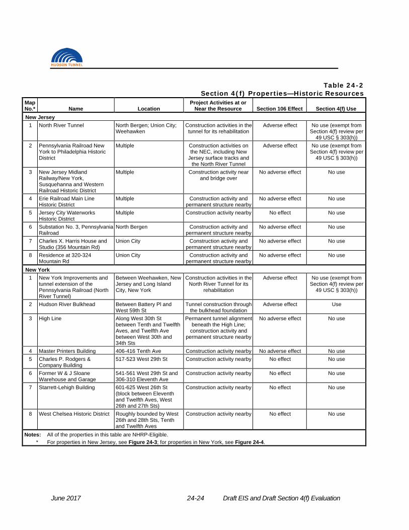
June 2017 24-24 Draft EIS and Draft Section 4(f) Evaluation
Table 24-2 Section 4(f) Properties—Historic Resources
Map No.* Name Location
Project Activities at or Near the Resource Section 106 Effect Section 4(f) Use
New Jersey 1 North River Tunnel North Bergen; Union City;
Weehawken Construction activities in the tunnel for its rehabilitation
Adverse effect No use (exempt from Section 4(f) review per
49 USC § 303(h)) 2 Pennsylvania Railroad New
York to Philadelphia Historic District
Multiple Construction activities on the NEC, including New
Jersey surface tracks and the North River Tunnel
Adverse effect No use (exempt from Section 4(f) review per
49 USC § 303(h))
3 New Jersey Midland Railway/New York, Susquehanna and Western Railroad Historic District
Multiple Construction activity near and bridge over
No adverse effect No use
4 Erie Railroad Main Line Historic District
Multiple Construction activity and permanent structure nearby
No adverse effect No use
5 Jersey City Waterworks Historic District
Multiple Construction activity nearby No effect No use
6 Substation No. 3, Pennsylvania Railroad
North Bergen Construction activity and permanent structure nearby
No adverse effect No use
7 Charles X. Harris House and Studio (356 Mountain Rd)
Union City Construction activity and permanent structure nearby
No adverse effect No use
8 Residence at 320-324 Mountain Rd
Union City Construction activity and permanent structure nearby
No adverse effect No use
New York 1 New York Improvements and
tunnel extension of the Pennsylvania Railroad (North River Tunnel)
Between Weehawken, New Jersey and Long Island City, New York
Construction activities in the North River Tunnel for its
rehabilitation
Adverse effect No use (exempt from Section 4(f) review per
49 USC § 303(h))
2 Hudson River Bulkhead Between Battery Pl and West 59th St
Tunnel construction through the bulkhead foundation
Adverse effect Use
3 High Line Along West 30th St between Tenth and Twelfth Aves, and Twelfth Ave between West 30th and 34th Sts
Permanent tunnel alignment beneath the High Line;
construction activity and permanent structure nearby
No adverse effect No use
4 Master Printers Building 406-416 Tenth Ave Construction activity nearby No adverse effect No use 5 Charles P. Rodgers &
Company Building 517-523 West 29th St Construction activity nearby No effect No use
6 Former W & J Sloane Warehouse and Garage
541-561 West 29th St and 306-310 Eleventh Ave
Construction activity nearby No effect No use
7 Starrett-Lehigh Building 601-625 West 26th St (block between Eleventh and Twelfth Aves, West 26th and 27th Sts)
Construction activity nearby No effect No use
8 West Chelsea Historic District Roughly bounded by West 26th and 28th Sts, Tenth and Twelfth Aves
Construction activity nearby No effect No use
Notes: All of the properties in this table are NHRP-Eligible. * For properties in New Jersey, see Figure 24-3; for properties in New York, see Figure 24-4.

Chapter 24: Draft Section 4(f) Evaluation
Draft EIS and Draft Section 4(f) Evaluation 24-25 June 2017
24.5.3.2.3 Railroad-Related Resources Physically Altered by Project that Qualify for Exemption from Section 4(f)
The Preferred Alternative would result in physical alterations to four historic properties, resulting in an adverse effect on those resources. As shown in Table 24-2, those resources are the North River Tunnel; the Pennsylvania Railroad New York to Philadelphia Historic District; the New York Improvements and Tunnel Extension of the Pennsylvania Railroad (North River Tunnel); and the Hudson River Bulkhead in New York.
Three of the resources that the Preferred Alternative would adversely affect are part of the NEC: the North River Tunnel; the Pennsylvania Railroad New York to Philadelphia Historic District; and the New York Improvements and Tunnel Extension of the Pennsylvania Railroad. As described earlier, the Section 4(f) legislation at 23 USC § 138(f) and 49 USC § 303(h) exempts from Section 4(f) review improvements to, or the maintenance, rehabilitation, or operation of railroad and rail transit lines, or elements thereof, that are in use or that were historically used for the transportation of goods and passengers, regardless of whether the railroad or rail transit line is eligible for listing on the NRHP. Three of the historic properties physically altered by the Project are railroad sites that are part of the NEC and are actively used for railroad purposes and meet the criteria for the Section 4(f) exemption, as discussed below.
24.5.3.2.3.1 North River Tunnel The NEC’s existing tunnel beneath the Hudson River, the North River Tunnel, extends from the Bergen Portal in the Township of North Bergen, Hudson County, New Jersey to the Tenth Avenue Portal in New York City, New York County, New York. The tunnel was determined to be eligible for listing in the NRHP under Criteria A and C by NJHPO on November 12, 1998. The tunnel is significant for its contribution to advances in tunneling technology and railroad electrification, which together allowed for the first major direct rail connection between New York and New Jersey. The tunnel is also a contributing resource within the Pennsylvania Railroad New York to Philadelphia Historic District and is significant for its role in the continued expansion of the railroad.
Subsequently, on March 21, 2011, NYSHPO made a determination that the subterranean and subaqueous railroad tracks and tunnels (North River Tunnel) of the New York improvement and tunnel extension of the Pennsylvania Railroad, extending from Weehawken, New Jersey, beneath the Hudson River, beneath Manhattan, and under the East River to Long Island City, Queens meet NRHP Criterion A for transportation history and Criterion C for engineering design.
NYSHPO’s Statement of Significance noted that this project, built between 1903 and 1910, was “the largest and most advanced metropolitan railroad project undertaken in the United States at that point in history.” The North River Tunnel was one element of this larger project. The two subaqueous tubes under the Hudson River were constructed using large shields measuring 18 feet in diameter driven from each side of the Hudson River and joined together mid-river. Each tube is cast iron and is lined with monolithic masonry panels. An important component of the design was the bore segments placed every 15 feet to accommodate a screw pile driven into bedrock to stabilize the tubes. This was done to solve the previous problems in building railroad tunnels under the Hudson River due to the unstable silt river floor. The piles kept the silt surrounding the tubes from shifting and potentially fracturing the cast iron tube while a train was moving through it.
Each tube contains only a single set of tracks to prevent train derailments and collisions. The tubes were designed with side benches on both sides of each tube, one foot higher than the average Pullman car in order to prevent derailments. The benches are constructed on hollow terra-cotta tiles to accommodate electrical cables, including high-tension and low-tension power
June 2017 24-26 Draft EIS and Draft Section 4(f) Evaluation
lines and telegraph, telephone, and signal wires. Walkways on these concrete benches allow for maintenance and repair.
The Bergen Portal in North Bergen serves as the western terminus of the North River Tunnel. The portal is a coursed stone structure with two arched tunnel openings and with an upper level containing sealed arched openings.
The Preferred Alternative would rehabilitate the North River Tunnel, including both the north and south tubes. The bench walls would be demolished and reconstructed, portal to portal, including the embedded duct banks. The new bench wall arrangement would have one high bench wall, level with the train floor, on the inner tunnel side providing emergency egress via cross passages, and one low bench wall at a height slightly above the top of rail for ease of maintenance and inspection. In addition, the existing ballasted track system (rail and ballast) would be removed and replaced with a direct fixation track system, which is the current state of practice for rail tunnels. As the Preferred Alternative would remove interior components of the North River Tunnel that include original physical features such as the bench walls, which were technologically innovative and are character-defining features of the NRHP-Eligible resource, and the ballast track system, the Preferred Alternative would result in an adverse effect on this historic architectural resource. However, because the adverse effect would be a result of rehabilitation of a railroad that has historically been used and is in use to transport passengers, and the railroad line has not been abandoned, in accordance with 49 USC § 303(h), FRA anticipates that the rehabilitation of the North River Tunnel with the Preferred Alternative does not constitute a use of a historic site under Section 4(f).
24.5.3.2.3.2 Pennsylvania Railroad New York to Philadelphia Historic District The Pennsylvania Railroad New York to Philadelphia Historic District is a linear historic district extending from New York to Philadelphia. NJHPO determined the Pennsylvania Railroad New York to Philadelphia Historic District to be NRHP-Eligible under Criterion A in the areas of Transportation, Engineering, and Commerce, and under Criterion C for its “distinctive and characteristic array of surviving cuts, embankments, grade separations, overgrade and undergrade bridges and culverts, stations, interlocking towers, and overhead catenary system.” The period of significance for the district is 1863-1966.
The Preferred Alternative would directly affect the Pennsylvania Railroad New York to Philadelphia Historic District through alterations to the existing surface tracks and embankment and the addition of new surface tracks on the existing NEC between County Road and Tonnelle Avenue in the Town of Secaucus and Township of North Bergen, New Jersey. However, the addition of new surface tracks would be confined to a relatively small portion of this linear historic district. Furthermore, the alterations would be industrial in nature, consistent with the historic railroad character of the historic district, and would support the continued use of this active historic railroad. The Preferred Alternative would also have a direct effect on the Pennsylvania Railroad New York to Philadelphia Historic District because of the proposed rehabilitation of the North River Tunnel, a contributing resource to the larger historic district. The removal of the bench walls, original physical features of the tunnel that were technologically innovative and are character-defining features of a key contributing resource within the Pennsylvania Railroad New York to Philadelphia Historic District, would result in an adverse effect on the district, as discussed above.
The Pennsylvania Railroad New York to Philadelphia Historic District is a railroad that has historically been used and is in use to transport passengers. The Preferred Alternative would improve the railroad through the addition of redundant capacity including a new tunnel and new surface tracks and connections, and would rehabilitate the railroad by repairing the damaged North River Tunnel, requiring the removal of damaged bench walls and other original physical features of the North River Tunnel, as discussed above. Therefore, in accordance with 49

Chapter 24: Draft Section 4(f) Evaluation
Draft EIS and Draft Section 4(f) Evaluation 24-27 June 2017
USC § 303(h), FRA anticipates that the activity associated with the Preferred Alternative does not constitute a use of a historic site under Section 4(f).
24.5.3.2.3.3 New York Improvements and Tunnel Extension of the Pennsylvania Railroad (North River Tunnel)
The New York Improvements and Tunnel Extension of the Pennsylvania Railroad (North River Tunnel) fully overlaps with the Pennsylvania Railroad New York to Philadelphia Historic District (described above in Section 24.5.3.2.3.2) but was determined eligible for the NRHP by NYSHPO rather than NJHPO. It includes the North River Tunnel, which extends from the Bergen Portal in the Township of North Bergen, Hudson County, New Jersey to the Tenth Avenue Portal in New York City, New York County, New York. The New York portal of the North River Tunnel is located just east of Tenth Avenue beneath the building at 450 West 33rd Street (between Dyer and Tenth Avenues and West 31st and West 33rd Streets). As noted above, NJHPO and NYSHPO previously determined that the tunnel is eligible for listing in the NRHP.
As discussed above, the Preferred Alternative’s rehabilitation of the North River Tunnel would remove character-defining features of the North River Tunnel, which would result in an adverse effect on this historic architectural resource. However, as discussed above, because the adverse effect would be a result of rehabilitation of a railroad that has historically been used and is in use to transport passengers, and the railroad line has not been abandoned, in accordance with 49 USC § 303(h), FRA anticipates that the tunnel rehabilitation does not constitute a use of a historic site under Section 4(f).
24.5.3.2.3.4 Section 4(f) Exemption Section 4(f) law exempts from Section 4(f) review the use of railroad and rail transit lines, or elements thereof, that are in use or that were historically used for the transportation of goods and passengers. The exemption has two exceptions:
• The exemption does not apply to rail stations or transit stations; and • The exemption does not apply to bridges or tunnels located on a rail line that has been
abandoned under the process described in 49 USC § 10903 or a transit line that is not in use.
The three railroad-related historic resources that would be adversely affected by the Preferred Alternative are all resources that are in use (and were historically used) for the transportation of goods and passengers; none of them are rail stations and none have been abandoned or are no longer in use. Therefore, this exemption applies to these resources and no Section 4(f) review is required for the Preferred Alternative’s effect on these resources.
24.5.3.2.4 Non-Railroad-Related Resources Physically Altered by Project In addition, the Preferred Alternative would result in an adverse effect on one non-railroad historic property, the Hudson River Bulkhead. The permanent incorporation of a portion of the Hudson River Bulkhead into the Preferred Alternative is considered a use under Section 4(f). Therefore, a Section 4(f) evaluation has been prepared for the Hudson River Bulkhead in Section 24.6 below.
June 2017 24-28 Draft EIS and Draft Section 4(f) Evaluation
24.6 HUDSON RIVER BULKHEAD
24.6.1 DESCRIPTION OF THE SECTION 4(f) PROPERTY The Hudson River Bulkhead extends from the Battery to West 59th Street within the boundaries of Hudson River Park and has been determined eligible for the NRHP. Significant under Criterion A in the areas of commerce or industry, Criterion C in the area of engineering, and Criterion D for the potential of the bulkhead to yield information about historic engineering methods, the bulkhead and its associated structural systems were constructed between 1871 and 1936 by the New York City Department of Docks. The majority of the construction consisted of masonry walls on a variety of foundation systems, with quarry-faced ashlar granite block forming the visible face along most of the armored frontage. Built between 1876 and 1898, the bulkhead between approximately West 23rd and West 34th Streets consists of a granite wall on narrow concrete block with inclined bracing piles and timber binding frames around the piles.
Design of the bulkhead was the responsibility of George B. McClellan, a general during the Civil War who became the first Engineer-in-Chief of the Department of Docks. McClellan's plans contemplated the creation of a 250-foot-wide marginal street, from which 60- to 100-foot-wide piers with cargo sheds would project 400 to 500 feet around 150- to 200-foot-wide slips. Initiated to respond to the deteriorated, congested, and silt-filled condition of the waterfront, the carefully built granite walls created a consistent monumental surface to the waterfront that reinforced an image of New York City's commercial prominence. As property was acquired and as commerce warranted, New York City built the bulkheads, built or rebuilt pier substructures, and leased redeveloped areas to private companies that were usually responsible for piershed and headhouse construction.
The officials with jurisdiction over the Hudson River Bulkhead are HRPT, the NYSHPO, and the ACHP since it is participating in the Section 106 review for the Project.
24.6.2 USE OF THE SECTION 4(f) PROPERTY The Preferred Alternative would construct a new Hudson River Tunnel with two single-track tubes, like the existing North River Tunnel. The two tubes of the new tunnel would be relatively shallow beneath the Hudson River’s riverbed near the Manhattan shoreline, in order to align with the existing approach tracks leading into PSNY. Therefore, the tubes must pass directly through the substructure portion of Manhattan’s Hudson River Bulkhead.
Grout would be installed from the landside of the bulkhead in both vertical and inclined orientations to fill voids in the bulkhead riprap prior to ground freezing. The grouting pressures would be as low as possible. It would be high enough to travel horizontally through the riprap voids, but low enough not to exceed the resistance of the overlying ground weight of 30 feet of overlying silt and clay; this would limit the possibility of grout being released into the river. Instrumentation would be installed that continuously monitors changes of pressures in ground during grouting. Safe limits of changes of pressures in the ground would be pre-established for specific locations as part of the monitoring plan.
After the grouting, ground improvement would be implemented, using a ground freezing technique. With ground freezing, a network of vertical or inclined pipes would be installed into the ground from the surface. The pipes would be connected by supply lines to a refrigerator plant on a nearby construction staging site. After the pipes are in place, a refrigerated brine would be circulated through the closed system of pipes, and this brine would gradually freeze the ground around the pipes until it is solid. Once the ground is frozen at the bulkhead, the TBM that constructed the tunnel beneath the river bottom would continue eastward, tunneling through
Chapter 24: Draft Section 4(f) Evaluation
Draft EIS and Draft Section 4(f) Evaluation 24-29 June 2017
frozen ground at the bulkhead. The TBM would be designed to be capable of cutting through timber piles and riprap under frozen ground conditions.
The Preferred Alternative would remove original components of the Hudson River Bulkhead and therefore would result in an adverse effect on this resource. To avoid damaging the structural integrity of the bulkhead structure while construction through the bulkhead is occurring, a monitoring plan would be in place to protect the remaining bulkhead structure. The monitoring plan would be developed in consultation with the NYSHPO and the HRPT, the New York State entity responsible for the Hudson River Park, including the Manhattan Hudson River Bulkhead.
The Preferred Alternative would remove original components of the Hudson River Bulkhead, and therefore, would result in use of this Section 4(f) property.
24.6.3 ALTERNATIVES TO AVOID THE USE OF THE SECTION 4(f) PROPERTY
As set forth in Section 4(f) legislation, FRA may not approve the use of a Section 4(f) property—in this case, the Hudson River Bulkhead—if there is a “feasible and prudent” avoidance alternative. Therefore, if any feasible and prudent avoidance alternatives are available, one must be selected. As defined in the regulations (23 CFR § 774.17), an alternative that would not require the use of any Section 4(f) property is an avoidance alternative. Feasible and prudent avoidance alternatives are those that avoid using any Section 4(f) property and do not cause other severe problems that substantially outweigh the importance of protecting the Section 4(f) property.
As defined in 23 CFR § 774.17, an alternative is not feasible if it cannot be built as a matter of sound engineering judgment. As defined in 23 CFR § 774.17, an alternative is not prudent if: 1. It compromises the project to a degree that it is unreasonable to proceed with the project in
light of its stated purpose and need; 2. It results in unacceptable safety or operational problems; 3. After reasonable mitigation, it still causes:
a. Severe social, economic, or environmental impacts; b. Severe disruption to established communities; c. Severe disproportionate impacts to minority or low income populations; or d. Severe impacts to environmental resources protected under other Federal statutes;
4. It results in additional construction, maintenance, or operational costs of an extraordinary magnitude;
5. It causes other unique problems or unusual factors; or 6. It involves multiple factors of the above, that while individually minor, cumulatively cause
unique problems or impacts of extraordinary magnitude.
As an initial step in the Project’s evaluation in accordance with NEPA, a multi-step alternatives development and evaluation process was conducted to identify Build alternatives that meet the purpose and need for the Project. A total of 15 alternatives were developed and evaluated during the alternatives phase of the NEPA process. This process is described in Section 2.3 of Chapter 2, “Project Alternatives and Description of the Preferred Alternative” in the DEIS, with additional detail provided in the Project’s Alternatives Development Report completed in April 2017. As the result of this process, two alternatives were identified for analysis in the DEIS: (1) the No Action Alternative and (2) a single Build Alternative, which is the Preferred Alternative.
June 2017 24-30 Draft EIS and Draft Section 4(f) Evaluation
The alternatives were evaluated against a two-tiered set of criteria:
• First, each alternative was assessed for its ability to meet purpose and need, including Project goals and objectives as well as established design criteria (engineering and operational factors).
• Alternatives that were found to meet purpose and need were then assessed in terms of feasibility (i.e., whether the alternative can feasibly be constructed and operated given engineering, constructability, and rail operations considerations) and reasonableness (i.e., an alternative may not be reasonable if it would have a likelihood for substantial impacts, a protracted construction time, an unacceptably high cost or great environmental impact relative to other alternatives, or operational characteristics that are unacceptable).
As a result of the screening evaluation, FRA and NJ TRANSIT concluded that the only Build Alternative concept that meets both of the established criteria is a new two-track rail tunnel near the existing North River Tunnel, with rehabilitation of the existing tunnel. Other alternatives were dismissed because they did not meet the Project purpose and need or because they were found to be infeasible or unreasonable. Alternatives that did not meet the Project purpose and need had constraints related to either (1) connecting from the NEC into the existing tracks at PSNY; or (2) maintaining uninterrupted NEC service and functionality.
For purposes of Section 4(f) evaluation, any alternative that does not meet the Project purpose and need is not prudent (any one of the six items listed above can make an alternative not prudent; not meeting purpose and need is one such item, as noted in item 1). Similarly, any alternative that was determined not reasonable in the NEPA screening can be considered not prudent for purposes of Section 4(f) evaluation, in accordance with the six items provided in the regulations as defining an alternative that is not prudent (see discussion above). Table 24-3 lists the 15 alternatives that were developed and evaluated in the preliminary screening and conclusions for this Section 4(f) evaluation related to their feasibility and prudence.
As shown in the table, most of the alternatives considered would not avoid the use of the Hudson River bulkhead. The alternatives that would avoid the use of the bulkhead—the No Action Alternative, a deeper tunnel such as was proposed in the Access to the Region’s Core (ARC) Project’s Supplemental DEIS and Final Environmental Impact Statement (FEIS), or a rail bridge over the Hudson River—would not meet the Project purpose and need and therefore are not prudent. These are discussed below. In addition, for purposes of this Section 4(f) evaluation, another alternative to avoid the use of the Hudson River Bulkhead, a “northern alignment alternative,” would not be prudent and may not be feasible, as is also discussed below.
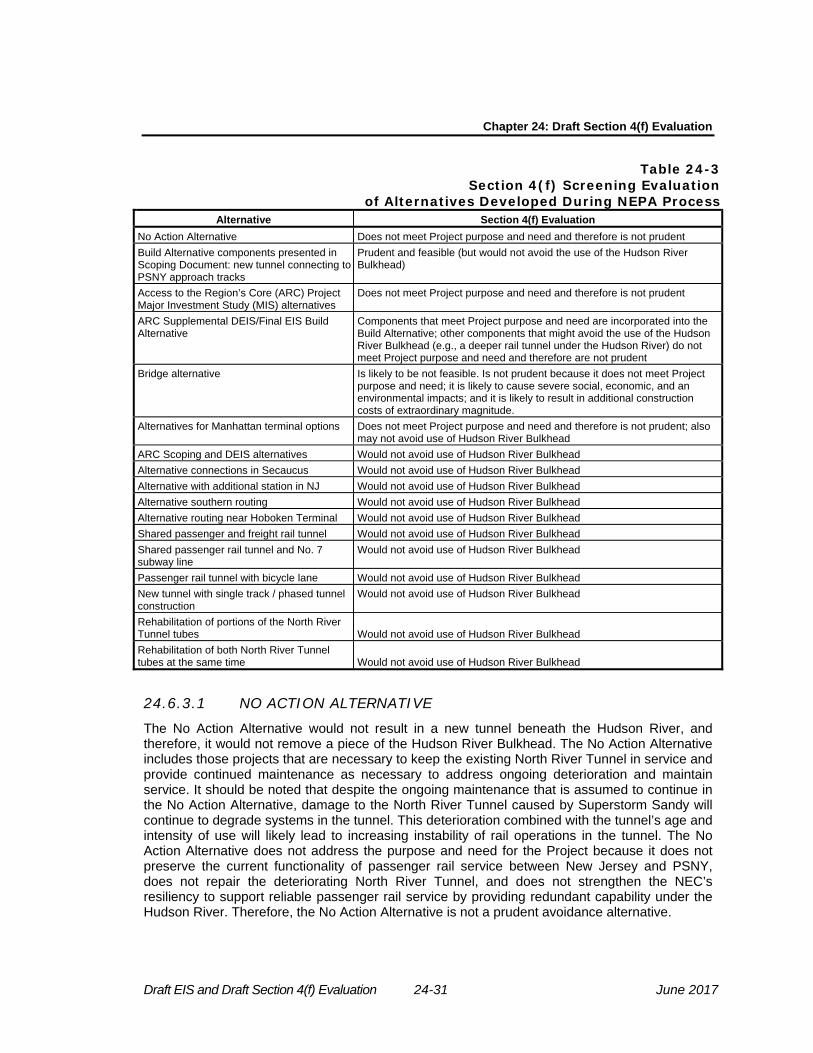
Chapter 24: Draft Section 4(f) Evaluation
Draft EIS and Draft Section 4(f) Evaluation 24-31 June 2017
Table 24-3 Section 4(f) Screening Evaluation
of Alternatives Developed During NEPA Process Alternative Section 4(f) Evaluation
No Action Alternative Does not meet Project purpose and need and therefore is not prudent Build Alternative components presented in Scoping Document: new tunnel connecting to PSNY approach tracks
Prudent and feasible (but would not avoid the use of the Hudson River Bulkhead)
Access to the Region’s Core (ARC) Project Major Investment Study (MIS) alternatives
Does not meet Project purpose and need and therefore is not prudent
ARC Supplemental DEIS/Final EIS Build Alternative
Components that meet Project purpose and need are incorporated into the Build Alternative; other components that might avoid the use of the Hudson River Bulkhead (e.g., a deeper rail tunnel under the Hudson River) do not meet Project purpose and need and therefore are not prudent
Bridge alternative Is likely to be not feasible. Is not prudent because it does not meet Project purpose and need; it is likely to cause severe social, economic, and an environmental impacts; and it is likely to result in additional construction costs of extraordinary magnitude.
Alternatives for Manhattan terminal options Does not meet Project purpose and need and therefore is not prudent; also may not avoid use of Hudson River Bulkhead
ARC Scoping and DEIS alternatives Would not avoid use of Hudson River Bulkhead Alternative connections in Secaucus Would not avoid use of Hudson River Bulkhead Alternative with additional station in NJ Would not avoid use of Hudson River Bulkhead Alternative southern routing Would not avoid use of Hudson River Bulkhead Alternative routing near Hoboken Terminal Would not avoid use of Hudson River Bulkhead Shared passenger and freight rail tunnel Would not avoid use of Hudson River Bulkhead Shared passenger rail tunnel and No. 7 subway line
Would not avoid use of Hudson River Bulkhead
Passenger rail tunnel with bicycle lane Would not avoid use of Hudson River Bulkhead New tunnel with single track / phased tunnel construction
Would not avoid use of Hudson River Bulkhead
Rehabilitation of portions of the North River Tunnel tubes Would not avoid use of Hudson River Bulkhead Rehabilitation of both North River Tunnel tubes at the same time Would not avoid use of Hudson River Bulkhead
24.6.3.1 NO ACTION ALTERNATIVE The No Action Alternative would not result in a new tunnel beneath the Hudson River, and therefore, it would not remove a piece of the Hudson River Bulkhead. The No Action Alternative includes those projects that are necessary to keep the existing North River Tunnel in service and provide continued maintenance as necessary to address ongoing deterioration and maintain service. It should be noted that despite the ongoing maintenance that is assumed to continue in the No Action Alternative, damage to the North River Tunnel caused by Superstorm Sandy will continue to degrade systems in the tunnel. This deterioration combined with the tunnel’s age and intensity of use will likely lead to increasing instability of rail operations in the tunnel. The No Action Alternative does not address the purpose and need for the Project because it does not preserve the current functionality of passenger rail service between New Jersey and PSNY, does not repair the deteriorating North River Tunnel, and does not strengthen the NEC’s resiliency to support reliable passenger rail service by providing redundant capability under the Hudson River. Therefore, the No Action Alternative is not a prudent avoidance alternative.

June 2017 24-32 Draft EIS and Draft Section 4(f) Evaluation
24.6.3.2 DEEP TUNNEL ALTERNATIVE A deeper trans-Hudson passenger rail tunnel, such as the one that was included in the ARC Project’s Supplemental DEIS and FEIS, could enter Manhattan at an elevation below the Hudson River Bulkhead, and therefore, avoid the use of this Section 4(f) property. However, a deep tunnel could not connect to the existing tracks at PSNY, because the slope required to connect between a deep alignment lower than the Bulkhead and the PSNY approach tracks would be at a grade too steep for train operations.
Given the train lengths (and resulting weight) of NJ TRANSIT’s commuter trains serving PSNY, grades should not exceed 2.1 percent for the tunnel design. This is the steepest grade for NJ TRANSIT’s trainsets in terms of operational reliability. With a grade of no more than 2.1 percent and the need to connect to existing tracks leading into PSNY, the new tunnel must be relatively shallow beneath the Hudson River and its navigation channel to allow a connection to the existing tracks that lead into PSNY.
To avoid the Hudson River Bulkhead, a deep tunnel would have to be approximately 50 feet deeper than the current alignment. To connect to the PSNY approach tracks at Tenth Avenue, the tracks would have to ascend at a grade of approximately 4.3 percent, far greater than the maximum 2.1 percent required for the tunnel design, which would cause unacceptable operational problems for Amtrak and NJ TRANSIT.
For these reasons, a deep tunnel alternative would either be infeasible, because such an alternative cannot be constructed as a matter of sound engineering judgement, while avoiding the Bulkhead and still connecting to PSNY, or it would be imprudent, because without a connection to PSNY it would not meet the Project purpose and need. Therefore, this is not a feasible and prudent avoidance alternative to the use of the Hudson River Bulkhead.
24.6.3.3 BRIDGE ALTERNATIVE
An alternative that brings passenger trains to New York on a bridge over the Hudson River rather than using a tunnel beneath the river would avoid the use of the Hudson River Bulkhead. However, this alternative appears to be infeasible and is not prudent because: (1) it would not meet the purpose and need of the Project; and (2) it would likely result in severe social, economic, and environmental impacts.
In terms of feasibility, this alternative could not be built as a matter of sound engineering judgment. The bridge would have to be high enough above the Hudson River so as not to adversely affect navigation. This would mean that on the Manhattan side, tracks would have to slope steeply to reach the grade of existing PSNY, which would result in a grade that is much greater than can be used by Amtrak’s and NJ TRANSIT’s passenger trains, leading to an unacceptable operational problem. In addition, land is not readily available on either side of the river for new support towers for a new rail bridge.
In terms of prudence, a bridge alternative would not meet the Project purpose and need unless it can connect to PSNY. The stated purpose and need is to preserve the current functionality of Amtrak’s NEC service and NJ TRANSIT’s commuter rail service between New Jersey and PSNY by repairing the deteriorating North River Tunnel, while maintaining uninterrupted commuter and intercity rail service on the NEC, and to strengthen the NEC’s resiliency to support reliable service by providing redundant capability under the Hudson River for Amtrak and NJ TRANSIT NEC trains between New Jersey and the existing PSNY. In addition, a bridge alternative would require extensive disruption leading to substantial environmental impacts on both sides of the river, assuming the requisite property could be acquired for new support towers. For this alternative to connect from the NEC’s surface tracks in New Jersey, it would have to either include a tunnel through the Palisades that leads to the bridge, or a long approach ascending

Chapter 24: Draft Section 4(f) Evaluation
Draft EIS and Draft Section 4(f) Evaluation 24-33 June 2017
over the Palisades from the Meadowlands. Construction of support tracks connecting to the NEC in New Jersey and into PSNY in New York and construction of support towers would require further property acquisition along the selected alignment. This alternative would have substantial community and environmental impacts to residential properties on the Palisades in New Jersey and residential and commercial properties in New York City from the massive structures that would need to be placed in close proximity to existing buildings and from the train operations on those structures occurring near these adjacent buildings.
For these reasons, a bridge alternative is not a feasible or prudent avoidance alternative to the use of the Hudson River Bulkhead.
24.6.3.4 NORTHERN ALIGNMENT ALTERNATIVE The Hudson River Bulkhead extends along New York’s Hudson River shoreline from the tip of Manhattan (the Battery) to 59th Street. An alternative that enters Manhattan north of 59th Street would avoid the need to use a portion of the Hudson River Bulkhead. However, such an alternative is not feasible or prudent.
This alternative is not feasible. A rail alignment that enters Manhattan north of 59th Street would be approximately 1 mile north of PSNY. PSNY is about ½ mile from the waterfront, so the alignment would have to turn sharply to the south, and then turn sharply east again to connect into PSNY. The tight turns required would not be feasible for train operations, as trains likely would not be able to operate with such tight turns. In addition, it may be very difficult or even impossible to find a suitable below-grade right-of-way beneath densely developed Manhattan that is not already occupied by a substantial number of subsurface structures. These could potentially include subway alignments, building foundations, and the approaches for the Lincoln Tunnel.
In addition, this alternative is not prudent. If the tight turns were feasible for train operations, they would certainly reduce train speeds substantially, significantly reducing the capacity of the NEC to process trains. This would not meet the Project purpose and need, which includes maintaining uninterrupted commuter and intercity rail service on the NEC, and strengthening the NEC’s resiliency to support reliable service by providing redundant capability under the Hudson River for Amtrak and NJ TRANSIT NEC trains. For these reasons, a northern alignment alternative would not meet the Project purpose and need.
For these reasons, a northern alignment alternative is not a feasible and prudent avoidance alternative to the use of the Hudson River Bulkhead.
24.6.4 LEAST OVERALL HARM ALTERNATIVE If there is no feasible and prudent avoidance alternative, FRA may approve only the alternative that causes the least overall harm in light of the statute’s preservation purpose. As stated in 23 CFR § 774.3, the “least overall harm” is determined by balancing the following list of factors: • The ability to mitigate adverse impacts to each Section 4(f) property (including any
measures that result in benefits to the property); • The relative severity of the remaining harm, after mitigation, to the protected activities,
attributes, or features that qualify each Section 4(f) property for protection; • The relative significance of each Section 4(f) property; • The views of the official(s) with jurisdiction over each Section 4(f) property; • The degree to which each alternative meets the purpose and need for the project; • After reasonable mitigation, the magnitude of any adverse impacts to resources not
protected by Section 4(f); and
June 2017 24-34 Draft EIS and Draft Section 4(f) Evaluation
• Substantial differences in costs among the alternatives.
If the analysis described in the preceding section concludes that there is no feasible and prudent avoidance alternative, then FRA may approve, from among the remaining alternatives that use Section 4(f) property, only the alternative that causes the least overall harm in light of the statute's preservation purpose. However, this analysis is required only when multiple alternatives that use Section 4(f) property remain under consideration.
24.6.5 MEASURES TO MINIMIZE HARM When there is no feasible and prudent alternative to the use of a Section 4(f) resource, the Project must include all possible planning to minimize harm to the Section 4(f) property.
FRA and NJ TRANSIT have developed measures to avoid, minimize, and/or mitigate adverse effects on the Hudson River Bulkhead in consultation with NJHPO, NYSHPO, and others in accordance with Section 106. These measures are set forth in a Draft Programmatic Agreement (PA) that is provided in Appendix 9 to the DEIS. Measures to avoid, minimize, and/or mitigate adverse effects on the Hudson River Bulkhead will be agreed upon in consultation with FRA, NYSHPO, and signatories, consulting parties, and concurring parties to the PA as part of the Section 106 process. All parties will have an opportunity to review the Draft PA that is included in the DEIS during the public comment period for the DEIS, and the final PA that is executed will reflect the review of all parties.
Measures included in the Draft PA to minimize harm to the Hudson River Bulkhead, which qualifies for Section 4(f) protection as a historic site and would be used by the Project, are as follows:
• The Project Sponsor, in coordination with the Lead Federal Agency, will compile the information gathered and drawings made in preparation for, and during the construction at, the Hudson River Bulkhead structure into a report documenting the characteristics of the affected bulkhead location. This information will augment information about the bulkhead as previously documented in the 1989 Building-Structure Inventory Form on file with NYSHPO. The Project Sponsor, in coordination with the Lead Federal Agency, will provide NYSHPO and HRPT, the New York State entity responsible for the Hudson River Park including the Manhattan Hudson River Bulkhead, a draft copy of the recordation document for review and comment and a final copy of the recordation.
• To avoid damaging the structural integrity of the Hudson River Bulkhead structure while construction through the bulkhead is occurring, the Project Sponsor will develop and implement a monitoring plan to protect the remaining bulkhead structure. The Project Sponsor, in coordination with the Lead Federal Agency, will develop a the monitoring plan in consultation with NYSHPO and HRPT prior to Project construction in the location of the Hudson River Bulkhead and ensure that the provisions of the monitoring plan approved by NYSHPO and HRPT are implemented by the Project contractors. The monitoring plan will describe the procedures and instrumentation to be used to monitor the structure for movement/tilt and settlement.
24.7 COORDINATION
24.7.1 COORDINATION WITH OFFICIALS WITH JURISDICTION OVER THE SECTION 4(f) RESOURCE
As set forth in the Section 4(f) regulations (23 CFR § 774.5), Section 4(f) evaluations must be provided for coordination and comment to the officials with jurisdiction over the Section 4(f) resources that will be used by a proposed project, and to the DOI. For this Project, the officials
Chapter 24: Draft Section 4(f) Evaluation
Draft EIS and Draft Section 4(f) Evaluation 24-35 June 2017
with jurisdiction are the HRPT for Hudson River Park, which includes the Hudson River Bulkhead, and HRPT, NYSHPO, and ACHP for the NRHP-Eligible Hudson River Bulkhead. In addition, the officials with jurisdiction over any archaeological resources that have been determined to have minimal value for preservation in place are NJHPO and NYSHPO. HRPT, NYSHPO, ACHP, and NJHPO are all NEPA Cooperating Agencies for this Project and have participated in development of the Draft Section 4(f) Evaluation during development of the DEIS.
In addition, this Project is being reviewed in accordance with Section 106 concurrently with its review under NEPA and Section 4(f). Section 106 requires Federal agencies to take into account the effects of their undertakings on historic properties that are listed in or meet the eligibility criteria for listing in the NRHP and afford the SHPO(s) and the ACHP, as appropriate, a reasonable opportunity to comment. Section 106 also requires that agency officials work with the SHPOs to identify parties to participate in the Section 106 process (consulting parties). Consulting parties may include local governments, Federally recognized Indian tribes, and individuals and organizations with a demonstrated interest in the project due to the nature of their legal or economic relationship to the project or affected historic properties, or their concern with the project’s effects on historic properties. For this Project, Section 106 consultation has involved coordination with the NYSHPO, HRPT, the New York City Landmarks Preservation Commission, and other signatories, consulting parties, and concurring parties in the Section 106 process regarding the Preferred Alternative’s potential effects to the Hudson River Bulkhead and proposed measures to minimize, avoid, and mitigate adverse effects.
FRA and NJ TRANSIT have conducted extensive coordination with HRPT during preparation of the DEIS and the Draft Section 4(f) Evaluation related to impacts on Hudson River Park and on the Hudson River Bulkhead, which is located in the park. To date, this has included several meetings to discuss the proposed construction work in Hudson River Park and measures to reduce the impact of this construction on the park. In addition, discussions have also considered measures to reduce the impact of Project construction on the Hudson River Bulkhead.
The Draft Section 4(f) Evaluation will be made available to DOI, NJHPO, NYSHPO, HRPT, and ACHP for comment during the public review period.
24.7.2 PUBLIC INVOLVEMENT Section 4(f) requires that public notice and an opportunity for public review and comment must be provided on the Draft Section 4(f) Evaluation. This requirement can be satisfied in conjunction with other public involvement procedures, such as the comment period provided on a DEIS prepared in accordance with NEPA. For this Project, FRA is providing an opportunity for public review and comment on this Draft Section 4(f) Evaluation for the Project in conjunction with the public review period for the DEIS. The Draft Section 4(f) Evaluation is being made available to the public together with the DEIS. Any agency or public comments received during this review period will be addressed in the Final Section 4(f) Evaluation, to be provided with the FEIS for the Hudson Tunnel Project. FRA will issue a Section 4(f) Determination prior to or in conjunction with the Record of Decision for the Project. In addition, FTA will issue its own Section 4(f) Determination in conjunction with its Record of Decision for the Project.