chapter - 2 profile of kanyakumari districtshodhganga.inflibnet.ac.in/bitstream/10603/4170/7/07...38...
TRANSCRIPT
37
CHAPTER - 2
PROFILE OF KANYAKUMARI
DISTRICT
38
AREA PROFILE
2. 1 PROFILE OF KANYAKUMARI DISTRICT
Kanyakumari is the southern – most district of the peninsular
India,the seventh largest country in the world. In Kanyakumari, the Indian
ocean, the Arabian sea and the Bay of Bengal embrace one another.
Kanyakumari district comprises of four taluks of the erstwhile
Travancore – Cochin state. The present Kanyakumari district was formed
on the first of November 1956, as a result of the reorganization of states
on linguistic basis.
This district is the smallest in the state of Tamil Nadu (with the
exception of the district of Madras) lying at the southern most tip of the
country. As in the case of the rest of the districts in the state of Tamil
Nadu, the economy of this district is also agriculture - based. However, it
is endowed with a lovely coastline and rich mineral resources like ilmenite
and retile.
Kanyaumri district is named after the goddess, “Kanyakumari”.
The district headquarters is at Nagercoil, endowed with all kinds of natural
resources from land, sea, forest, and mountains. This district is by nature
and heritage, predominantly agrarian with 68 percent of the land utilized
for agricultural purposes. This district is blessed with its vast stretches of
green paddy fields, rich forests, coconut groves and coast line. This
district has a coastline of about 68 km.
39
2.2 HISTORY
Kanyakumari has a hoary past in ancient history dating back to
the Sangam age and was a cradle of civilization. The Tamil culture which
had its origin in the Zumaurian continent, of which Kanyakumari was a
part. The district has a large number of historic monuments and temples.
A series of kingdoms under famous kings are known to have existed in
Kanyakumari, the most important being the Chera, Chola and Pandia upto
the early fifties of this century. This region was part of Travancore
samasthanam, the present day Kerala, where the Tamil speaking
population treated as second class citizens struggled to merge with Tamil
Nadu. As per the recommendations of the state re – organizing
commission, the regions of Agasteeswaram, Thovalai, Kalkulam and
Vilavancode were grouped to form the “Kanyakumari district”. On
November 1, 1956, Kanyakumari district of TamilNadu state came into
existence with Nagercoil as its Head quarters, which crowned the struggle
for separation from Kerala and merger with Tamilnadu
2.3 LOCATION AND ORIGIN
Kanyakumari is situated between 770 - 05` and 77
0 – 36` of
eastern longitude and 80- 03 and 8
0-36 of the northern latitude, occupying
a total area of 1672 sq. km. It is bordered with Tirunelveli district in the
north and north east, Kerala in the northwest and by the Indian Ocean and
the Bay of Bengal in the south and western sides respectively1.
1 District statistics Hand Book of Kanyakumari District 1991-92.P.1
40
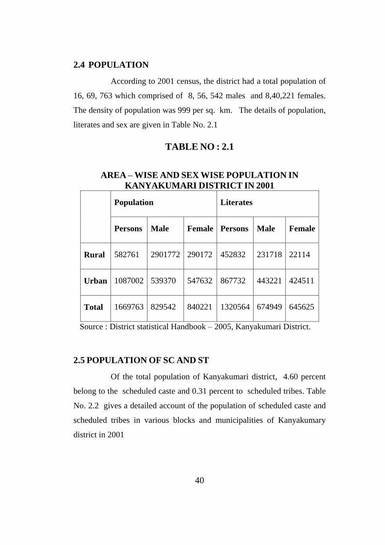
2.4 POPULATION
According to 2001 census, the district had a total population of
16, 69, 763 which comprised of 8, 56, 542 males and 8,40,221 females.
The density of population was 999 per sq. km. The details of population,
literates and sex are given in Table No. 2.1
TABLE NO : 2.1
AREA – WISE AND SEX WISE POPULATION IN
KANYAKUMARI DISTRICT IN 2001
Population Literates
Persons Male Female Persons Male Female
Rural 582761 2901772 290172 452832 231718 22114
Urban 1087002 539370 547632 867732 443221 424511
Total 1669763 829542 840221 1320564 674949 645625
Source : District statistical Handbook – 2005, Kanyakumari District.
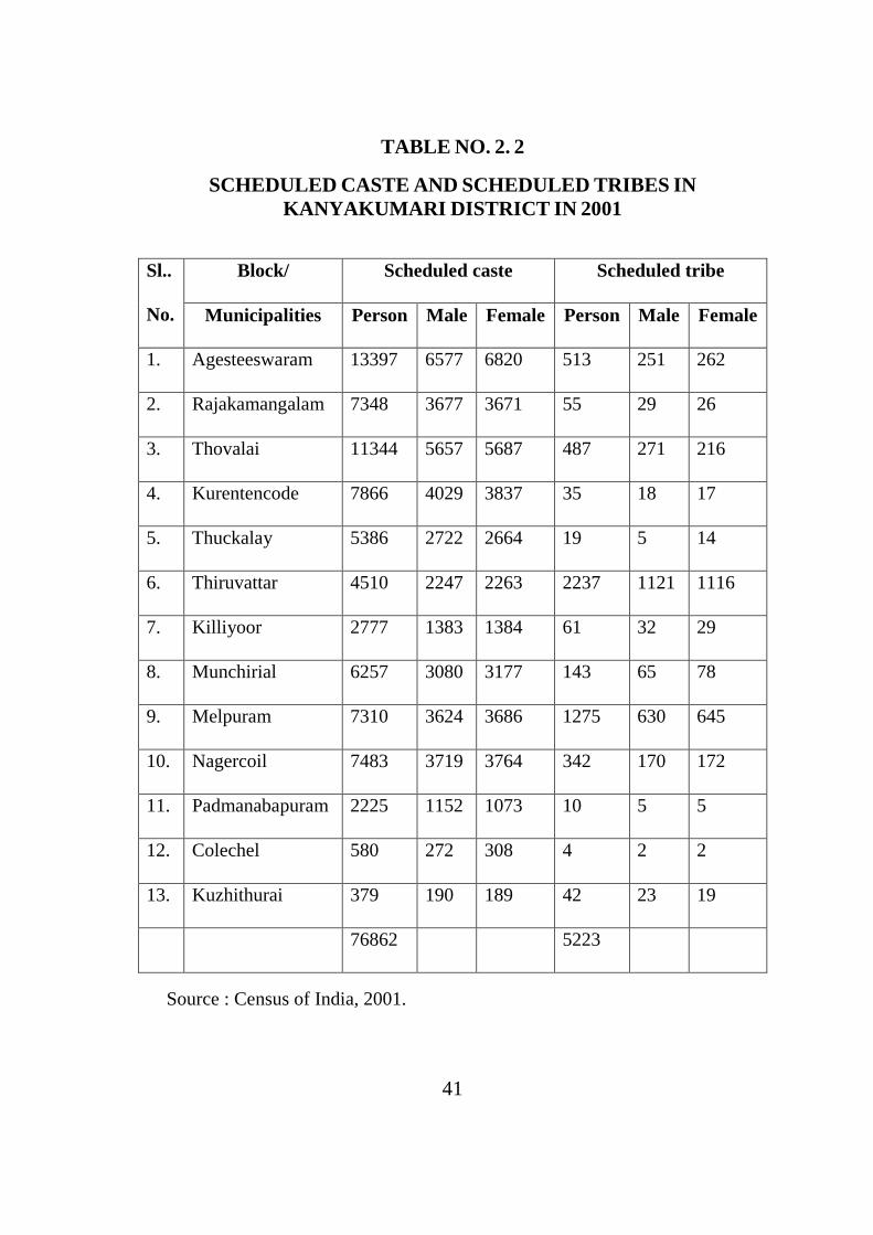
2.5 POPULATION OF SC AND ST
Of the total population of Kanyakumari district, 4.60 percent
belong to the scheduled caste and 0.31 percent to scheduled tribes. Table
No. 2.2 gives a detailed account of the population of scheduled caste and
scheduled tribes in various blocks and municipalities of Kanyakumary
district in 2001
41
TABLE NO. 2. 2
SCHEDULED CASTE AND SCHEDULED TRIBES IN
KANYAKUMARI DISTRICT IN 2001
Sl..
No.
Block/ Scheduled caste Scheduled tribe
Municipalities Person Male Female Person Male Female
1. Agesteeswaram 13397 6577 6820 513 251 262
2. Rajakamangalam 7348 3677 3671 55 29 26
3. Thovalai 11344 5657 5687 487 271 216
4. Kurentencode 7866 4029 3837 35 18 17
5. Thuckalay 5386 2722 2664 19 5 14
6. Thiruvattar 4510 2247 2263 2237 1121 1116
7. Killiyoor 2777 1383 1384 61 32 29
8. Munchirial 6257 3080 3177 143 65 78
9. Melpuram 7310 3624 3686 1275 630 645
10. Nagercoil 7483 3719 3764 342 170 172
11. Padmanabapuram 2225 1152 1073 10 5 5
12. Colechel 580 272 308 4 2 2
13. Kuzhithurai 379 190 189 42 23 19
76862 5223
Source : Census of India, 2001.

42
Kanyakumary has people belonging to different castes, such as,
Brahmins, Vellalas, Nadars and a sizeable number of SC/ST people. From
the table it is clear that Agstheeswaram block has the maximum number of
SC people the total number being 13397. It is followed by Thovalai block
with 11344. As far as ST people are concerned Thriruvattar block has the
maximum of 2, 237 persons. In total there were 76,862 SC persons and
5,223 ST persons as per the 2001 census.
2.6 RELIGION
Tamil Nadu has people belonging to Hinduism, Islam and
Christian religion with a sprinkling of saints. As elsewhere in the state,
the district consists of Hindus, Muslims, Christians and others. However,
Christain population is the largest in number in the district. Among
Hindus, there is a separate religious sect known as “Ayya vazhi” based on
the precepts propounded by “Ayya vaikundar”3.
2.7 LANGUAGE
Kanyakumari is a bilingual state. Tamil and Malayalam are the
two languages spoken in this district, though Tamil is the official
language.4
2.8 ADMINISTRATION SET UP
This district has been divided into two revenue divisions
consisting of two taluks each, ie, Padmanabhapuram revenue division
consisting of Vilavancode and Kalkulam taluks and Nagercoil revenue
division consisting of Agasteeswaram and Thovalai taluks. There are four
3 District statistical Hard Book in Kanyakumari - 2002
4 Districl Staistics Hand Book, Kanyakumari. 2003

43
municipalities Nagercoil, Padmanaphapuram, Colachel and Kuzhithurai.
For the purpose of better administration the district has been divided into 9
community development blocks, 155 panchayats (56 town panchayats
and 99 village panchayats ) and1207 hamlets in 2001.5
2.9 EDUCATION
Kanyakumari district ranks first in literacy level in Tamil Nadu
and boasts of 100 percent literacy. The total number of educational
institutions was 933 in 2005. The various statistics regarding educational
institutions in Kanyakumary district are listed in Table No: 2.3.
TABLE NO: 2.3
EDUCATIONAL INSTITUTIONS OF KANYAKUMARY
DISTRICT IN 2005
Sl. No. Institutions Number of
Institution
1. Arts and Science Colleges 16
2. B.Ed colleges 7
3. Medicine – Allopathy 1
Indian Medicine 1
Homeopathy 2
4. Engineering 7
5. College for special education 8
6. Pre – primary school 83
7. Primary schools 413
8. Middle schools 147
9. High schools 120
10. Higher secondary school 122
11. Teacher Training Institute 6
Total 933
Source : District Statistical Handbook, Nagercoil.
5 District Statistical Handbook of Kanyakumari P.O
44
Recently there has been a mushrooming of many engineering
colleges and colleges of education. From table 4.4 it can be easily inferred
that women are almost at par with men as regards the number of persons
who had registered. The total number of unemployed male persons was
121616 while the number of women who had registered was 117419. The
largest number of them were those who had completed matriculation level
of education and the number was 174733. Once again, it is evident from
the table that the number of men and women belonging to this category
were almost equal. The total number of youth who had registered with
Higher Secondary education was 31883. Here women exceeded men. I.T.I
holders came last with just 462 registered candidates. It has the largest
number of professional and educational institutions
2.10 LITERACY
Next to Ernakulam in Kerala , Kanyakumari achieved the
enviable status of 100 percent literacy. In Kanyakumari district the
literacy rate is very high. In this district the total number of literate
persons is 13, 20, 564 out of which 6, 74, 939 are males and 6, 45,625 are
females in the year 2001. Similarly the literacy rate has gone up from
82. 06 in 1991 by 88.16 in 2001.
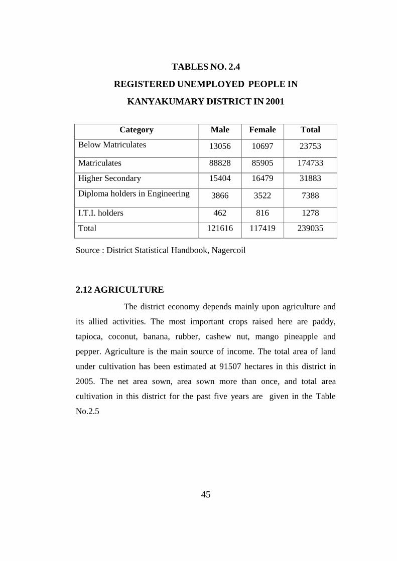
2.11 UNEMPLOYMENT
The district has been producing many educated persons. The
educated youth duly register themselves in the Employment Exchange.
The number of unemployed youths, who have registered their names in
the Employment Exchange, exceeded two lakhs in 2001. The details of
registered unemployed persons in Kanyakumari district are given in the
following table.no.2.4
45
TABLES NO. 2.4
REGISTERED UNEMPLOYED PEOPLE IN
KANYAKUMARY DISTRICT IN 2001
Category Male Female Total
Below Matriculates 13056 10697 23753
Matriculates 88828 85905 174733
Higher Secondary 15404 16479 31883
Diploma holders in Engineering 3866 3522 7388
I.T.I. holders 462 816 1278
Total 121616 117419 239035
Source : District Statistical Handbook, Nagercoil
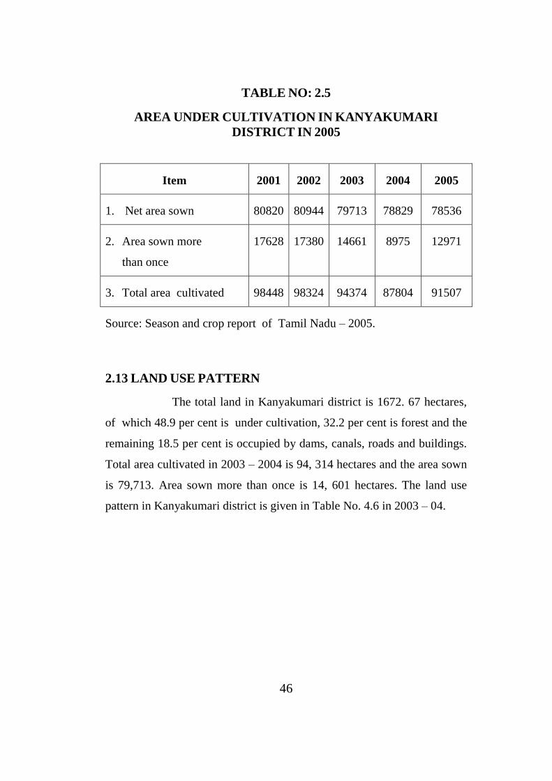
2.12 AGRICULTURE
The district economy depends mainly upon agriculture and
its allied activities. The most important crops raised here are paddy,
tapioca, coconut, banana, rubber, cashew nut, mango pineapple and
pepper. Agriculture is the main source of income. The total area of land
under cultivation has been estimated at 91507 hectares in this district in
2005. The net area sown, area sown more than once, and total area
cultivation in this district for the past five years are given in the Table
No.2.5
46
TABLE NO: 2.5
AREA UNDER CULTIVATION IN KANYAKUMARI
DISTRICT IN 2005
Item 2001 2002 2003 2004 2005
1. Net area sown 80820 80944 79713 78829 78536
2. Area sown more
than once
17628 17380 14661 8975 12971
3. Total area cultivated 98448 98324 94374 87804 91507
Source: Season and crop report of Tamil Nadu – 2005.
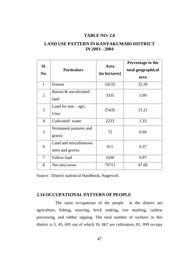
2.13 LAND USE PATTERN
The total land in Kanyakumari district is 1672. 67 hectares,
of which 48.9 per cent is under cultivation, 32.2 per cent is forest and the
remaining 18.5 per cent is occupied by dams, canals, roads and buildings.
Total area cultivated in 2003 – 2004 is 94, 314 hectares and the area sown
is 79,713. Area sown more than once is 14, 601 hectares. The land use
pattern in Kanyakumari district is given in Table No. 4.6 in 2003 – 04.
47
TABLE NO: 2.6
LAND USE PATTERN IN KANYAKUMARI DISTRICT
IN 2003 – 2004
Sl.
No. Particulars
Area
(in hectares)
Percentage to the
total geographical
area
1 Forests 54155 32.39
2 Barren & uncultivated
land 3335 1.99
3 Land for non – agri.
Uses 25435 15.21
4 Cultivated waste 2233 1.33
5 Permanent pastures and
grassy 72 0.04
6 Land and miscellaneous
trees and groves 611 0.37
7 Fallow land 1630 9.97
8 Net area sown 79713 47.68
Source : District statistical Handbook, Nagercoil.
2.14 OCCUPATIONAL PATTERN OF PEOPLE
The main occupations of the people in the district are
agriculture, fishing, weaving, brick making, coir marking, cashew
processing, and rubber tapping. The total number of workers in this
district is 5, 45, 605 out of which 16, 067 are cultivators, 81, 099 occupy
48
32.39 percent of the total geographical area in this district. It is followed
by 15.21 percent of area of non – agricultural land used as permanent
pastures and grass lands by the agricultural labourers. 38, 514 people
work in household industries and 3,13,487 are other workers of whom
95,538 are marginal workers6.
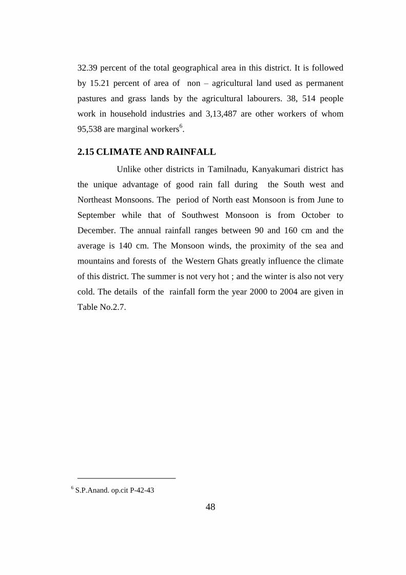
2.15 CLIMATE AND RAINFALL
Unlike other districts in Tamilnadu, Kanyakumari district has
the unique advantage of good rain fall during the South west and
Northeast Monsoons. The period of North east Monsoon is from June to
September while that of Southwest Monsoon is from October to
December. The annual rainfall ranges between 90 and 160 cm and the
average is 140 cm. The Monsoon winds, the proximity of the sea and
mountains and forests of the Western Ghats greatly influence the climate
of this district. The summer is not very hot ; and the winter is also not very
cold. The details of the rainfall form the year 2000 to 2004 are given in
Table No.2.7.
6 S.P.Anand. op.cit P-42-43
49
TABLE NO : 2.7
RAIN FALL IN KANYAKUMARI DISTRICT DURING
2000 – 2004
North east monsoon
June to September
Southwest monsoon
October to December
Year Normal Actual Normal Actual
2000 526.0 864. 6 559. 1 360.8
2001 526.0 650.9 559.1 484.8
2002 526.0 239.8 559.1 768.38
2003 526.0 769.1 559.1 239.8
2004 526.0 526.0 559.1 559.1
Source : District statistical Handbook, Nagercoil.
The district has had the good fortune of having more than normal
monsoon rains . except during 2002 from north east monsoon .
2.16 SOIL CONDITION
In Kanyakumari district there are three main soil groups. They
are laterite type, which occurs in the Blocks of Thiruvattar, Munchirai,
Kurnthencode, Rajakkamangalam, Killioor, Thuckalay and Melpuram.
The mixed type of red loam and coastal alluvial soil is found in
Agasteeswaram and Thovalai blocks.7
7 Socio-economic Review of Kanyakumari.

50
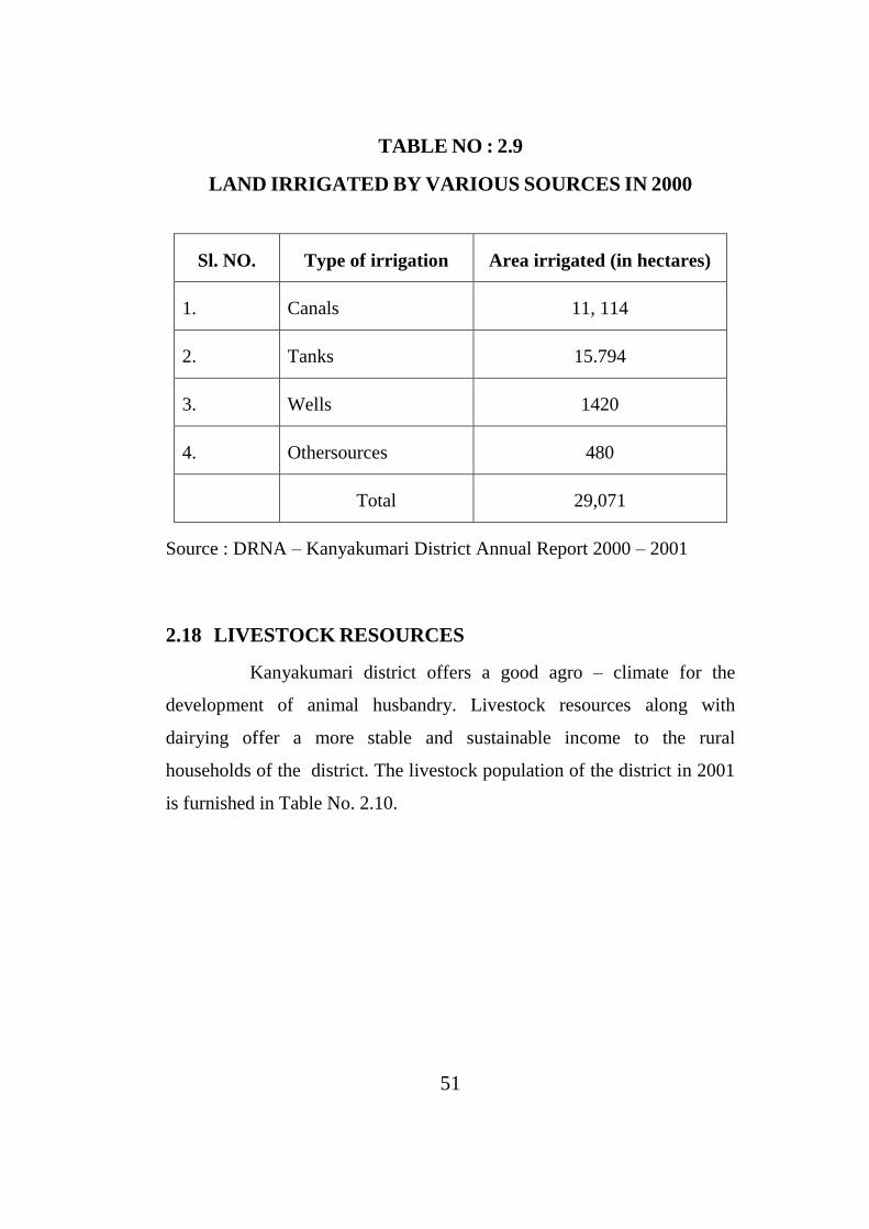
2.17 SOURCES OF IRRIGATION
As Kanyakumari is an agrarian district, and as paddy is the
main crop, cultivation depends mainly on irrigation. In Kanyakumari
District rivers, dams and channels are the important sources of irrigation.
The important rivers, dams and cannels are given in the table below.
TABLE NO. 2.8
SOURCES OF IRRIGATION IN KANYAKUMARI DISTRICT
2002 – 03
Rivers Dams Channels
Thamiraparasni Pandhiyan dam Pandhiyan karai
Pazhayar Puthendam Thovalai channel
Pooniavaikal Pechipparai dam Regulatory kalavi
Paraliyar Perunchani dam Anandarnal channel
Chittar dam – I Nanchinad Puthanar - Channel
Chittar dam – II Padmanabhapuram Puthanar channel
Source : Indian Oversears Bank, Annual credit plan 2002 – 03.
Among the various sources of irrigation on which the
cultivation of crops depends, tanks come first which, irrigate the largest
area of 15794 hectares ,followed by canals which irrigate 11114 hectares.
Compared to these two major sources of irrigation, wells also irrigate an
area of 1420 hectares.
Land irrigated by various sources are illustrated in Table No. 2.9
51
TABLE NO : 2.9
LAND IRRIGATED BY VARIOUS SOURCES IN 2000
Sl. NO. Type of irrigation Area irrigated (in hectares)
1. Canals 11, 114
2. Tanks 15.794
3. Wells 1420
4. Othersources 480
Total 29,071
Source : DRNA – Kanyakumari District Annual Report 2000 – 2001
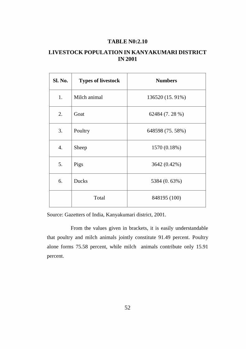
2.18 LIVESTOCK RESOURCES
Kanyakumari district offers a good agro – climate for the
development of animal husbandry. Livestock resources along with
dairying offer a more stable and sustainable income to the rural
households of the district. The livestock population of the district in 2001
is furnished in Table No. 2.10.
52
TABLE N0:2.10
LIVESTOCK POPULATION IN KANYAKUMARI DISTRICT
IN 2001
Sl. No. Types of livestock Numbers
1. Milch animal 136520 (15. 91%)
2. Goat 62484 (7. 28 %)
3. Poultry 648598 (75. 58%)
4. Sheep 1570 (0.18%)
5. Pigs 3642 (0.42%)
6. Ducks 5384 (0. 63%)
Total 848195 (100)
Source: Gazetters of India, Kanyakumari district, 2001.
From the values given in brackets, it is easily understandable
that poultry and milch animals jointly constitute 91.49 percent. Poultry
alone forms 75.58 percent, while milch animals contribute only 15.91
percent.

53
2.19 FISHERIES
Kanyakumari district is famous for fish production. It has
both inland and marine fishing centers. It has a long coastal line of 68
kms. Fish has a prominent place in the diet of the people of Kanyakumari
district. There are five coastal blocks and 42 coastal landing centers. In the
district, the fish production has decreased from 49951 tons in 2001 – 02 to
16, 308 tons in 2004 – 05. The total inland fish production has also
decreased from 2,870 tons in 2001 – 02 to 2, 159 tons in 2004 – 058
2.20 INDUSTRIES
Though the districts is educationally forward industrially it is
backward. It has only 649 registered working factories. There were 645
large scale industries, 991 small scale industries and 121 cottage
industries, which promote the development and welfare of the rural as
well as the urban people of the district in 2004. Thus compared to other
districts in Tamilnadu, Kanyakumari has very few industries.9
2.21 WIND MILLS AND ENERGY
Kanyakumari is famous for its windmill and wind energy.
Windmills are localized in and around Aralvoimozhi in Thovalai taluk.It
can boast of the largest wind mill farm in Asia. It produced 226.950 M.V
of electricity in 2003 – 2004. The total hydropower generalized in this
district is 154. 230M.V. in 2003 – 2004. There is no thermal plant in this
district.10
8 Socio-economic Review of Kanyakumari (2001-2002)
9 Kanyakumary District Annual plan for 1987 , P-31s
10 Annual Credit Plan 92-93

54
2.22 MINERAL RESOURCES
As far as mineral resources are concerned the district is in a
satisfactory position. Limestone deposites are there in Thovalai and
Agesteeswaram blocks, while granite is available in Tiruvattar, Thuckalay,
Kurunthocode and Agasteewaram blocks.
Manavalakurichi, a coastal area, is naturally blessed with rare
earth minerals like brown, ilmenite, monazite, rutile, garnet, silumerite
and zircon. M/s Indian Rare Erath Ltd. Manavalakurichi, a Central
Government Enterprise, is engaged in the separation of these minerals.
Some minerals are exported to Japan and other countries from Colachel
coast. This has secured Kanyakumari district a place in the map of the
world. There is also a demand for setting up a Titanium factory.
The annual production and the end use of the major minerals of
the district are given in Table No. 2.11 in 2001.

55
TABLE NO. 2.11
PRODUCTION, VALUE AND END USE OF MAJOR
MINERALS DURING 2001
Source: District statistical Handbook 2001
2. 23 FOREST RESOURCES
Forest occupied an area of 54155 hectares in 2003–2004 which
forms 32. 4 percent of the total geographical area of Kanyakumari district.
The major portion of the forest area lies in Thovalai, Thiruvattar and
Melpuram blocks. The elevation of the Forest Range from the sea level is
estimated at 1850 m. Forest in Kanyakumari district has about 606 species
of gigantic timber trees and 350 other plants many of which have high
economic value. In the forest area the plantation crops such as coffee, tea,
rubber, pepper and cardamom are grown in plenty.11
11Kanyakumari District Annual Action plan for 1987, P-31.
Sl.
No.
Name of the
mineral
Production
(in tons)
Value
Rs. In ‘000 End use
1 Ilmenite (Block
sand) 90700 2380875 White paint
2.
Monazite
(Radioactive
material)
3100 9000 Atomic Energy
3. Zircon 9650 1737000 Atomic Energy
4. Rutile (Titan oxide) 4000 126000 Welding
electrodes
5. Garnet (Silicon
carbon) 6540 16350
Abrasives and
grinding wheels
56
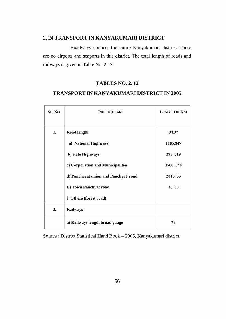
2. 24 TRANSPORT IN KANYAKUMARI DISTRICT
Roadways connect the entire Kanyakumari district. There
are no airports and seaports in this district. The total length of roads and
railways is given in Table No. 2.12.
TABLES NO. 2. 12
TRANSPORT IN KANYAKUMARI DISTRICT IN 2005
Source : District Statistical Hand Book – 2005, Kanyakumari district.
SL. NO.
PARTICULARS LENGTH IN KM
1. Road length
a) National Highways
b) state Highways
c) Corporation and Municipalities
d) Pancheyat union and Panchyat road
E) Town Panchyat road
f) Others (forest road)
84.37
1185.947
295. 619
1766. 346
2015. 66
36. 88
2. Railways
a) Railways length broad gauge 78
57
2.25 BEE – KEEPING INDUSTRY
The development of Bee – keeping industry is primarily taken
up through 27 State KVI Boards and 192 Registered Institutions and Co –
operative Societies directly financed by KVIC. KVIC has launched a
national programme for three years on Bee – keeping.12
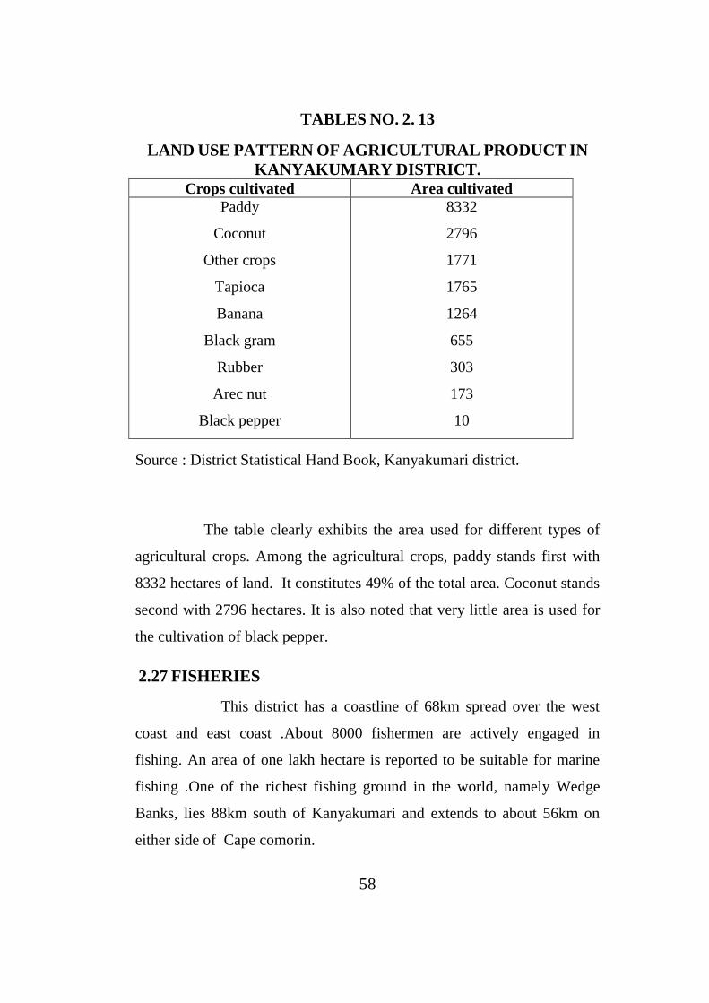
2.26 AGRICULTURAL BACKGROUND OF THE DISTRICT:
The district depends entirely on agriculture for its income.
Various agricultural commodities are cultivated in the district. In the
Western Ghats, plantation crops like tea, coffee, rubber, spices and
tobacco are raised. Where as in the plains paddy, banana, coconut and
vegetables are grown .
Agriculture is the main source of income . There are about
three thousand small scale industries in Kanayakumari district. There are
about ninety different types of industries .Commercial banks play a vital
role in catering to the financial needs of farmers and industries .Co-
operative Housing Societies have also started functioning in different
localities for providing loan to different crops, which are stated in the
following table.
12 Census of India 1981, P-13
58
TABLES NO. 2. 13
LAND USE PATTERN OF AGRICULTURAL PRODUCT IN
KANYAKUMARY DISTRICT.
Crops cultivated Area cultivated
Paddy
Coconut
Other crops
Tapioca
Banana
Black gram
Rubber
Arec nut
Black pepper
8332
2796
1771
1765
1264
655
303
173
10
Source : District Statistical Hand Book, Kanyakumari district.
The table clearly exhibits the area used for different types of
agricultural crops. Among the agricultural crops, paddy stands first with
8332 hectares of land. It constitutes 49% of the total area. Coconut stands
second with 2796 hectares. It is also noted that very little area is used for
the cultivation of black pepper.
2.27 FISHERIES
This district has a coastline of 68km spread over the west
coast and east coast .About 8000 fishermen are actively engaged in
fishing. An area of one lakh hectare is reported to be suitable for marine
fishing .One of the richest fishing ground in the world, namely Wedge
Banks, lies 88km south of Kanyakumari and extends to about 56km on
either side of Cape comorin.

59
2.28 BANKS, INSURANCE COMPANIES , POSTOFFICES, AND
OTHER INSTITUTIONS:
Kanyakumari district is endowed with a very good network of
Post Offices, Commercial Banks and other insurance companies.
Commercial Banks play an important role in providing finance both to the
agricultural and industrial sector. Indian Overseas Bank and its branches
operate in most areas. State Bank of Travancore occupies the second
position with 24 branches.
2.29 TRANSPORT AND COMMUNICATION
The district has a metalled road length of 2621.70kms, and 167
post offices to take care of the present transport and communication needs.
All the villages are connected by road and transport system. The head
quarters of the district, Nagercoil is well connected with other major cites
of the State both by Express Bus routes and Rail.
2.30 CONCLUSION
It is clear that Kanyakumari district is equipped with rich
infrastructure like Educational Institutions, Industries, Fishing, and Tourist
centers. It shows highly developed agricultural situations. The
improvement in the agricultural sector shows that there is ample scope for
the industrial development in this district with the help of the Bee Keeping
industry.