chapter 2 methods 2.1 introduction - 1&1...
TRANSCRIPT

CHAPTER 2 METHODS
2.1 INTRODUCTION
Islands, where comparatively high numbers of Choughs are concentrated in discrete areas, providegood opportunities and facilities for ecological study (e.g. Bullock 1980, Bullock & del-Nevo 1983,Roberts 1985, Warnes 1982, Still 1989, and McKay in prep.) but the ecology of mainland Choughshas been little studied (cf. Owen 1985). Objective research on the species has occurred principallyin North Wales and on Islay. Of the above studies, Ian Bullock pioneered work into Choughbehavioral ecology on Anglesey and the Isle of Man, followed notably by Warnes on Islay, andRoberts on Bardsey. The Islay effort is continuing (e.g. Monaghan et al. (1989), Still (1989), andMcKay (in prep.). Within Europe generally there is growing interest (see Bignal & Curtis 1989). Thisbody of work has greatly increased knowledge whilst at the same time revealing paradoxes andgaps.
Published work on the Chough in West Wales relies largely on the censuses of Donovan (1973)and Roderick (1978). The Nature Conservancy Council (NCC) in Dyfed-Powys, Wales was concernedabout the status of the species (see, e.g. Gamble 1984, Gamble & Haycock 1988), therefore theWelsh and Cornish/English interests were integrated into the research objective explained inSection 1.2.
The methods employed in this study are essentially twofold and of a comparative nature:
(1) broad comparison of Welsh areas within current Chough range, and Cornwall currently outwithChough range, comparison of resources used by Choughs within the Welsh areas, again related toCornwall; and
(2) comparison of past land-use regimes with present day regimes within and between Wales andCornwall. This duality of habitat assessment required the selection of 2 levels of study areas: (i)large scale uniform selection of 1km squares including both used and unused habitats, inland andcoastal (2.2); and (ii) smaller observational study areas within these (2.3).
Regarding bird observation, unlike the island communities referred to above, i.e. South Stack(Anglesey), Bardsey, Islay and the Calf of Man, the Choughs in Dyfed are scattered thinly along anextensive mainland coastline. Practical and technical problems beset the study of low densitypopulations, especially when distributed through 5 separate study areas over more than 100kmof coastline (2.5.2). The Cornwall element was located ca. 120km across the Bristol Channel (aroad journey of >480km). The Cornish effort was spread over 4 sub-areas (all historically importantfor Choughs) separated along >230km of coast (2.3). A study circuit of all study sites involved around trip of ca. 1500km every 6-8 weeks.
2.2 BACKGROUND HABITAT ASSESSMENT
Habitats in Wales and Cornwall were sampled in order to assess broad features of land type. Bunce& Shaw (1973) have stressed the importance of objectivity and standardisation in ecologicalsampling and surveying techniques. To maximize the benefits of this study, it was designed to becompatible with a similar study on Islay (Bignal et al. 1988, Curtis et al. 1989), but comparison isbeyond the scope of the present study. The full methodology is given in Section 4.2.1. Six areas (3each in Wales and Cornwall; see Appendix II and Figure 2.1), subdivided on the Ordnance Survey(OS) km square grid matrix (Figures 2.2 - 2.5), were used for the initial assessment. These wereselected to provide fundamental habitat data within principal Chough and ex-Chough regions. A
7

Figure 2.1
Habitat assessment regions inWales and Cornwall
Key (Wales)N-C New Quay (Ceredigion)
to CardiganC-S Cardigan to Strumble HeadSD-A St Davids to Angle
Key (Cornwall)T-PH Tintagel to Park Head
(North Cornwall)WP West PenwithLZ The Lizard


SAMPLE AREA
SD-A


Figu
re 2
.5
Loca
�on
of 1
km sq
uare
s sam
pled
in re
gion
s WP
and
LZ. C
lose
d sq
uare
s giv
e 12
% re
solu
�on;
shad
ed sq
uare
s, in
crem
enta
lly c
hose
n,on
seaw
ard
side
of d
raw
n lin
e in
crea
se c
oast
al re
solu
�on
to 2
5%. S
clae
5m
m:1
km

total of 184 1km2 (94 in Wales and 90 in Cornwall) were selected as shown in Table 2.1.
Within the separate study blocks, the sample 1km2 were surveyed 'field-by-field' on 1:10,000 scalemaps, and annotated (see Figure 4.1), as recommended within the Institute of Terrestrial Ecologyproject, Changes in the Rural Environment, for natural, semi-natural and agricultural features.Vegetation cover types plus all species with a frequency of >19% within a minimum mappable unitof 1/25ha and a minimum mappable length of 20m (1/50km) were recorded. Descriptiveinformation such as agricultural usage and vegetation heights were also recorded because of theireffect on the presence and availability of food resources. The environmental data weretransformed into raster as described in Section 4.2.1.
Table 2.1 Kilometre squares surveyed in habitat assessment. The 12% background sample wasincreased incrementally on coastal squares to give ca. 25% resolution_____________________________________________________________________
Kilometre Squares__________________________________________
Grid AdditionalStudy Block Sample ca. 12% Coastal ca. 25% Total____________________________________________________________________New Quay-Cardigan 18 6 24Cemaes-Strumble 23 6 29St Davids-Angle 31 10 41_____________________________________________________________________Total Wales 72 22 94__________________________________________________________________________________________________________________________________________Tintagel-Park Head 20 9 29West Penwith 27 9 36The Lizard 18 7 25____________________________________________________________________Total Cornwall 65 25 90_______ ___________________________________________________________________________________________________________________________________GRAND TOTAL 137 47 184_____________________________________________________________________
Each 1km2 was effectively mapped 3 times (see Figure 4.1), yielding 7,500 packets of descriptiveinformation. Additional physiographical details were recorded, e.g. topography was assessed forcliff height and natural nest sites but since this can be safely assumed not to have changedsignificantly over time it is excluded from the present analysis. Similarly, woodland and scrub weremeasured but these are negative features since, as with long vegetation they prevent access toinvertebrate food resources. The scrubbing over of headlands and clifftops consequent upon areduction in grazing was suggested as a contributory factor in the decline 20 years ago (Darke1971; see Chapter 4). Whittaker (1947) was the first to record a link between grazing and Choughs,but it was not to be demonstrated for a further 30 years (Bullock 1980, Bullock & del-Nevo 1983).
8

2.3 THE OBSERVATIONAL STUDY AREAS
2.3.1 INTRODUCTION AND SELECTION CRITERIA
Selection of the study areas within the regionalised blocks was based principally on Choughdistribution taken from, in Wales, NCC unpublished data, information from local naturalists, andnotes made during the mapping survey described above; and, in Cornwall, knowledge of ex-distribution acquired from the literature (3.1 et seq.). Supplementary information may be gleanedfrom old place names, such as 'Chough's Ogo' (=Chough's cave) on the Lizard, Cornwall (see Figure2.13). Boundaries of study areas were determined by bird exploitation (see Chapter 6 and AppendixVIII) established during pursuit periods (2.5.2) and surrounding visible area.
The selection criteria were:
Wales. Topography in key Chough regions to have comparable physiography to Cornwall. Thestudy sites were chosen to provide a representative selection of the habitats exploited by Choughsin West Wales excluding the Old Red Sandstone region near St. Anne's Head in the far south. Thisarea was not selected because (i) it has no physical equivalent elsewhere in the region or inCornwall, and (ii) it is already the subject of a Chough-related inquiry (Gamble & Haycock 1988).For similar reasons and access problems, the island reserves of Skomer and Ramsey also receivedless attention. All these areas, however, were visited on one or more occasions, and their wardensprovided valuable data. The two islands were, however, visited for study periods of several days(see Appendices V and VI). All Welsh study areas, with the exception of the northerly section(Mwnt-Cemaes; see Section 2.3.2), were linked and traversed by the Pembrokeshire Coast Path,which is administered by the Pembrokeshire Coast National Park (PCNP), and is largely of SSSI (Siteof Special Scientific Interest) status.
Cornwall. Ex-Chough areas with (i) a history of recent occurrence (e.g. North Cornwall); (ii) adiscrete area with on-going sympathetic management and scientifically important (e.g. the Lizard);and (iii) strategic importance (e.g. West Penwith/Lands End), i.e. an area of great historicimportance, compact with an extended coastline and forming a continuum between (i) and (ii). SeeTable 7.3 for detailed rationale.
2.3.2 THE WELSH STUDY AREAS
STUDY AREA W1: MWNT-CEMAES (Figure 2.6a-c, and see Appendix VIII).The northernmost area (4o38-46'W, 51o06-08'N), effectively bisected into two sub-areas by theTeifi estuary and the town of Cardigan. The Cemaes section (ca. 145ha) was located to the westin Pembrokeshire and the Mwnt section (ca. 85ha) to the north-east of the Teifi in Ceredigion.Long gently declining vegetated slopes and cliffs of Ordovician rocks (0-100m), bounded tolandward by a variable maritime mosaic of occasionally grazed semi-natural heath or scrubgrassland, giving way to low-intensity pastoral-based agriculture of essentially upland character.In 1988 (and possibly 1989), one pair of Choughs nested unsuccessfully at Mwnt. At Cemaes, oneof two pairs nested successfully in 1988 (the unsuccessful pair being possibly too disturbed by anearby Peregrine eyrie); in 1989, both pairs were successful, the neighbours at the Peregrine sitemoving farther away around a headland.
Much of the ownership is controlled by conservation interests (National Trust (NT) and DyfedWildlife Trust) with guidance from the NCC. Both sub-areas were subjected to visitor pressure.Reliable figures for Mwnt, deriving from a NT carpark, show that over 5 years (1985-1989), themean usage was 10,910 cars per annum (s.d. 1,178), peaking during school holidays, when good
9

Figu
re 2
.6a
Stud
y ar
ea W
1. D
o�ed
line
s sho
w e
aste
rn M
wnt
sec�
on (s
ee F
igur
e 2.
8b) a
nd w
este
rn C
emae
s sec
�on
(see
Fig
ure
2.8c
)se
para
ted
by T
eifi
estu
ary
and
the
tow
n of
Car
diga
n.


beach, public amenities and proximity to Cardigan make it popular with local people (E. Gwynnpers. comm.). No such facilities and no beach at Cemaes result in reduced usage: the path beingmainly used by serious walkers: usually <25 per day in the summer (pers. obs.); the path is littleused in the winter. At Mwnt, the beach and open spaces are popular with dog-walkers throughoutthe year, especially in the evenings, when walkers are rare everywhere.
STUDY AREA W2: STRUMBLE (Figure 2.7, and see Appendix VIII).Strumble Head lies to the west of Cemaes (5o02-06'W, 52o00-03'N). It has been formed by doleriteintrusions of igneous rock into Ordovician sediments. [Igneous headlands and eroded sedimentarycoves form a typical geological pattern of the region (George 1970)]. Both Strumble and Cemaesare NW trending headlands with, therefore, predominantly SW and NE aspects. Cliffs climb toabout 80m, and are bounded to landward by species-rich maritime heath and mixed agriculture.A popular Youth Hostel at Pwllderi attracts considerable usage to the area which diffuses aroundthe headland, although this declines considerably in the winter when the Youth Hostel is closed.The study area (ca. 275ha) was believed locally to support many (+6 pairs) of Choughs (R. Spicerpers. comm.) but only one pair bred (successfully) in 1988-89. Strumble Head is a nationallyimportant 'sea-watching' site, and most observer-effort concentrates on this activity; but sincemy work showed that the resident pair of Choughs foraged over most of the area, it is possible thatover-estimation has occurred (see Section 1.3.2), further emphasising the need for a colour-ringingprogramme in West Wales (Chapter 7).
STUDY AREA W3: NEWGALE-SOLVA (Figure 2.8, and see Appendix VIII). Situated at the north of St. Bride's Bay, east of St. David's Head (5o08-13'W, 51o-51'N), the area isin a higher grade agricultural neighbourhood than the more upland areas W1 and W2. Thecoastline has a southerly aspect, characterised by two reef-like promontories: Dinas Fawr andDinas Fach, both of which supported successful nest sites. The larger promontory, Dinas Fawr, wasgrazed in summer, and because of its aspect, receiving exposure from both the south and west,supported the most feeding sites (Appendix VIII). Dinas Fach lacked southerly exposure and wasungrazed. The cliffpath is very steep in places, climbing to ca. 100m. Despite the promontories, itforms a more linear stretch of coast than the remaining three sites; the study area (ca. 125ha) iselongated by the intensive agricultural hinterland. The landscape has been shaped and thepromontories formed by intrusions of basic rock into the Ordovician System; sheer cliffs alternatewith 45o vegetated cliffslopes, often scrub-covered.
STUDY AREA W4: MARLOES (Figure 2.9, and see Appendix VIII).The Marloes peninsula forms the south-western tip of Wales, opposite Skomer Island (5o11-15'W,51o42-44'N). It comprises mainly a plateau about 40m high on a W-E axis near Dale and St. Anne'sHead, and includes Gateholm Island - once a Chough nestsite (D. Saunders pers. comm.): totalstudy area ca. 257ha. The interior agriculture is largely intensive sheep and arable, but at thesouthern end there is a disused World War II airfield, currently used for grazing. The westernmosttip, known as the 'Deerpark' is a NT owned property managed for its natural history interest. Thereare plans to reintroduce grazing to Gateholm Island (S.B.Evans pers comm.). The geology is Silurianwith contemporaneous igneous intrusions. Cliffs and steep cliffslopes dominate. The shadednorthern sector shown in Figure 2.9 (ca. 70ha) was never seen to be used by Choughs during theentire study period.
10

Figure 2.7
Study area W2. Strumble Head - Penbwchdy.Do�ed line delimits study range.

Figu
re 2
.8
Stud
y ar
ea W
3. S
olva
(Sol
fach
) - N
ewga
le.
Do�
ed li
ne d
elim
its st
udy
rang
e.

Figure 2.9
Study area W4. Marloes peninsula. Do�ed line delimits study range. Shaded area indicated northern sec�on, unused by Choughs
during project �me.

2.3.3 THE CORNISH STUDY AREAS
STUDY AREA C1: PENTIRE-CANT (Figure 2.10). Pentire Head (4o56'W, 50o34'N) was formed by volcanic extrusions of pillow lava >60m thick, andintrusions of greenstone into Middle Devonian slates (Edmonds et al. 1975). It has a NWorientation, akin to Study Areas W1 and W2, and is located on the Camel estuary north of Padstow.An unsubstantiated report records an unsuccessful breeding attempt at Pentireglaze ("a traditionalsite of great but unknown antiquity" (Penhallurick 1978) in 1947, and they certainly bred therebetween 1930 and 1944 (ibid). Ray in 1662 reported 'great flocks' nearby (Ray 1678). Pentire is aNational Trust property. The interior is mainly mixed arable and sheep farming. The cliffs are ca.<60m high and rock outcrops and grass or scrub cover the moderately steep coastal slopes. It andnearby beaches are popular with visitors in the summer and with locals during weekends at alltimes.
The Cant section is a small site on the north side of the Camel estuary to the east of Pentire(4o54'W, 50o31'N), included to enable further invertebrate studies. Cant Hill is privately-owned,75m high, with unimproved summit pasture and improved inland slopes, both grazed by sheep.Ulex scrub clothed the steeper slopes overlooking the estuary.
STUDY AREA C2: WEST PENWITH (Figure 2.11). Most of the West Penwith coast was important historically for Choughs (see Figure 3.2). Theparticular site at Treveal, on the NW facing coast (5o33'W, 50o12'N), was selected because of recentoccupancy by Choughs, disappearing ca. 1870s (Penhallurick 1978), and for logistical reasons, NTownership and residency of warden, and an agriculture and physiography superficially, at least,resembling Study Areas W1 and W2, including rough grazing by cattle.
STUDY AREA C3: THE LIZARD(Figure 2.12). The west side of Lizard Point (the most southerly part of Britain) is historically important forChoughs. The Predannack cliffs (5o15'W, 50o0'N), south of Mullion, is an area where Choughs werein 'tolerable abundance' (1856; see Figure 3.2) but possibly gone by 1870 due in part to theactivities of egg collectors (Penhallurick 1978). Predannack is owned and managed by conservationinterests: NT and NCC. The geology of the Lizard is amongst the oldest, most complex andinteresting in Britain (Edmonds et al. 1975). The Predannack cliffs are basically hornblende-schistsof ca. 50m and levelling into a plateau of largely unimproved or semi-improved grass with heathand scrub elements. The more intensively managed fields were down to either improved cattle-grazed grass or arable. Grazing within the study area was by equines and sheep.
11
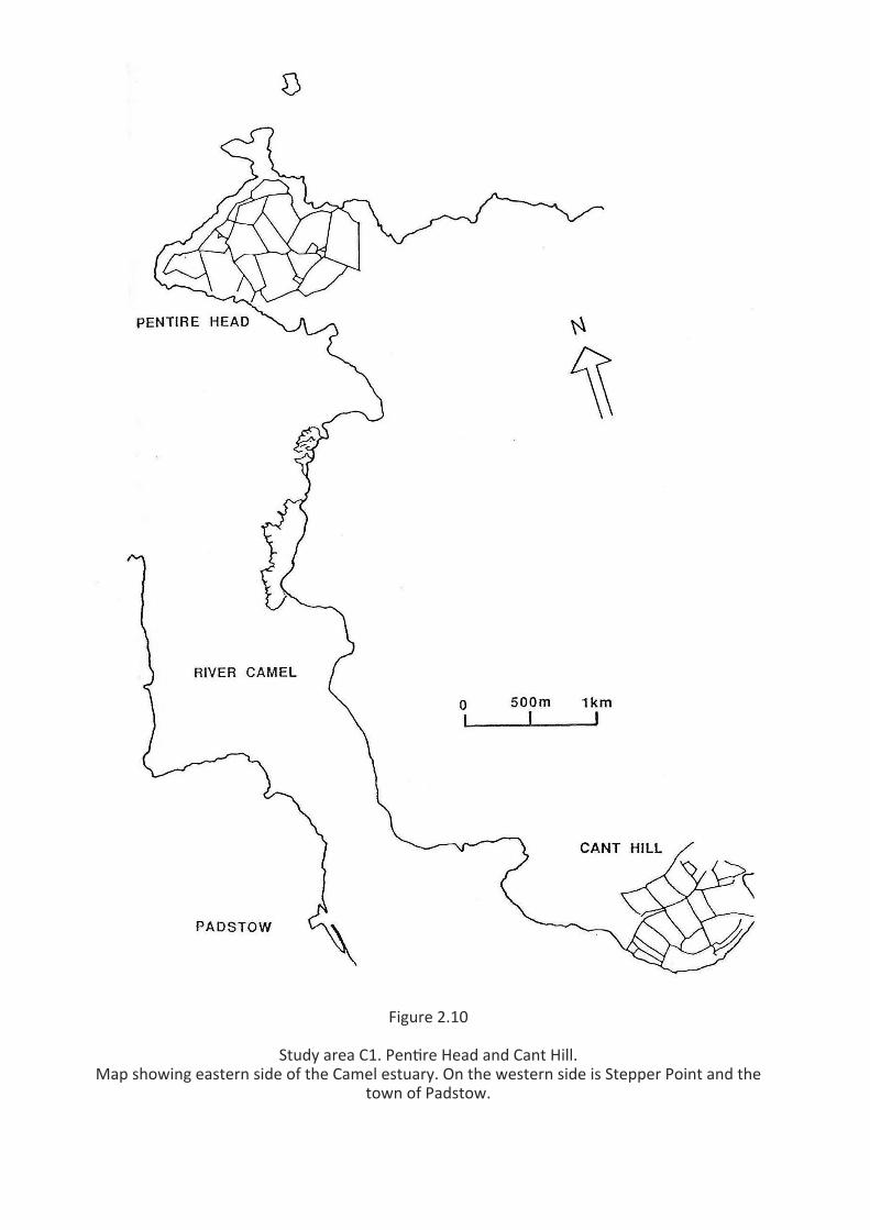
Figure 2.10
Study area C1. Pen�re Head and Cant Hill.Map showing eastern side of the Camel estuary. On the western side is Stepper Point and the
town of Padstow.

Figu
re 2
.11
Stud
y ar
ea C
2. T
reve
al c
liffs,
Wes
t Pen
with
. Map
show
ing
nort
hern
sec�
on o
f the
Wes
t Pen
with
coa
st n
ear s
ampl
ing
area
plus
ass
ocia
ted
field
syst
em

Figure 2.12
Study area C3. Predannack cliffs. Map showing western sec�on of the Lizard coast nearsampling area plus associated field system


2.4 HISTORICAL HABITAT ASSESSMENT
The Chough's decline and disappearance from southern England is investigated mainly by referenceto the historical literature (Chapter 3) and an assessment of changing land-use practices as revealedby tithe surveys (4.5 & 4.6). Owen (1985) examined the historical literature for evidence of thedecline in England, paying particular attention to Cornwall and Wales. I have added a little newevidence and reinterpreted some of his data.
The Tithe Apportionments of the 1840s provide, with caution, a reliable insight into contemporaryland-use (Kain & Holt 1981) for both Cornwall and Wales. The coastal 1km2 mapped in the originalhabitat assessment (see Section 2.2, Figures 2.2 - 2.5) were reanalysed from tithe data to providea measure of the quality and rate of habitat change. The maps were rasterized similarly so as toenable direct comparison although the available information was of a far less precise nature: broadvariables such as 'pasture', 'arable', 'furze' etc. forming the parameters (see Figures 2.13 & 4.3).In addition to the map data, there were also aggregated acreages available for each parish, andthese were compared to recent MAFF (Ministry of Agriculture, Fisheries & Food) census returns.
2.5 BIRD OBSERVATIONS
2.5.1 THE DETECTABILITY OF CHOUGHS
Physical location of the subject within the time available was problematical. Bullock (1980) andRoberts (1985), working respectively on South Stack and Bardsey island reserves to the north(Figure 1.2), were able to employ transect routes and 'pursuit days' "when groups of Choughswere watched all day." Roberts mentioned the advantages of "so many observer-hours on such asmall and discrete area." In contrast, I occasionally spent entire days without locating a singleChough, and initially the concept of pursuit was replaced by one of dedicated search time (DST)(2.5.2).
The bird-watching literature claims that the Chough's distinctive cry (1.3.1) often draws attentionto it. It would clearly be useful to know if this encouraged a bias: with negative records beinginterpreted as actual absence of birds rather than mere non-visibility, and whether poor visibility,due to weather conditions, decreased search success. Consequently, all presence cues - visible(VC) and audible (AC) - were recorded for one year from June 1988 in order to check their relativefrequencies. To prevent a 'learning' or 'knowledge curve' affecting the results, only 'surprise' cueswere counted, and those resulting from nest-watching or from where birds were expected wereomitted.
The data presented in Figure 2.14 support the field guides. In all conditions, 63% of surpriseencounters (n=228) were AC initiated. In poor visibility/bad weather, when the proportion mightbe expected to increase, the reverse applied and ACs decreased to <50% (n=21). This can possiblybe explained by Choughs sheltering and remaining quiet in adverse weather (Borlase 1758; and seeSection 6.3.1). During 3 days of observation on Ramsey Island in July 1989 (Appendix V) in excellentconditions, and in a situation comparable to the island reserves of Bullock and Roberts, 20 of 22(91%) 'surprise' encounters, were of AC origin, possibly reflecting the higher density and/or betterweather.
To establish whether the converse applied, i.e. did very windy or 'noisy' conditions reduce thenumber of ACs, cues in a wind velocity estimated as >6 on the Beaufort Scale (n=23) were subjectedto a chi-square test; 14 (61%) were of VC origin (X2= 1.608; d.f. 1; N.S.). Although a small sample,the value is equivalent to that for ACs in 'good' weather, suggesting that there is, at most, only a
12

Figu
re 2
.14
Prop
or�o
n of
Cho
ugh
obse
rva�
ons i
ni�a
ted
from
aud
ible
cue
s (AC
) and
visi
ble
cues
(VC)
by
stud
y ar
ea a
nd d
iffer
ent w
eath
er c
ondi
�ons
.

low element of bias relative to weather conditions and, from the Ramsey data, densities of birds.Interestingly, at wind force 6, the AC:VC ratio was almost exactly equal.
It is possible that AC induced 'sightings' would have been subsequently detected by observer effort,but it cannot be known how many sightings were missed altogether; the data include onlysubsequently confirmed sightings. In conclusion, detection was probably independent of weatherand topographical conditions, but search time was affected.
2.5.2 GENERAL OBSERVATIONS
Due to the low density of birds, scattered sites and initial poor success, the pursuit concept wasreplaced, as stated, by DST, in which an attempt was made to strengthen the evaluation of timebudgets by assessing non-usage of ground patch types. By relating non-usage to usage andexamining the results in relation to the availability of those patch types, negative data mightincrease in its significance and be less wasteful of effort. However, if these results were to bemeaningful, it was necessary to know how Choughs spent their time when not under observation,and whether they were unobserved due to observer inefficiency, topography, habits or climaticfactors, e.g. sheltering in hot/cold/wet/ windy weather (see Sections 2.5.1 and 6.3.1).
Rigorous interpretation of negative records was confounded by these variables, but, with a fewnotable exceptions, it was found that due to increasing knowledge of the birds' habits, negativerecords per se became virtually non-existent, and it was possible ultimately to drop DST and revertto Ian Bullock's (1980) pursuit concept. However, since time spent in the field on different inquirieswas always logged, negative periods were available, if needed, by the simple equation:N-ve = N - N+ve.
As stated, study sites were visited every 6-8 weeks. The whereabouts of Choughs was ascertainedby routine searching of the ranges around known nest sites, which were regarded as focal centres.Family roosting occurs at or near nest sites in June and July (Williamson 1959; Cowdy 1962, 1973;Roberts 1985), and it is possible that low-density populations retain this behaviour for longer (pers.obs., cf. Still 1989). Methodical searching radiating away from foci was carried out until successfulor it was assumed that the birds had been missed; the procedure was repeated until it wasassumed that the birds were not present, whereupon wider areas were searched. At the outset,some entire days were negative. Subsequent information helped to explain these events whichoccurred only during the winter, due to shorter days, poor weather and reduced or temporarilynon-linkage with the nest/roost place.
When found, pursuit commenced. Birds were observed by a 9x35 binocular or a x20-60 zoom-lenstelescope. Every effort was made not to disturb the birds (and see p.165). Occasionally, it wasunavoidable, as for example when the observer happened to be in a location desired by theChoughs. However, the subjects were generally found to be sufficiently 'trusting' to allow approachto ca. 60m (see also Section 6.3.3). Generally the birds were less approachable during the winterand autumn, presumably because they were not constrained by reproductive duties.
2.5.3 ACTIVITY PATTERNS
Activities and habitat selection were recorded, either in a notebook or on to a portable tape-recorder. The location and nature of all foraging events were noted by habitat variables (Table2.2; see Chapter 4). Major categories tended to be one (or more) of the following: (i) 'broad'categories, such as 'maritime cliff' which, unqualified, denoted an absence of more preciseinformation (occurring most often when birds foraged out of direct view); (ii) homogeneous
13
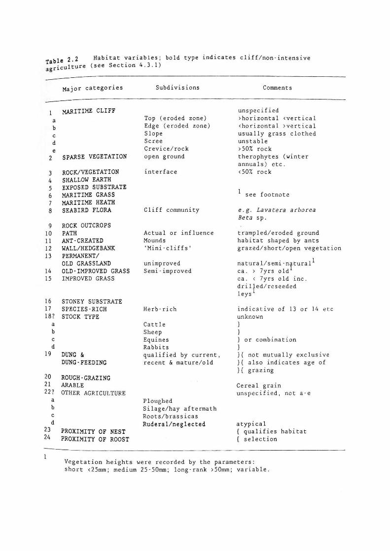
habitats, e.g. 'improved pasture', 'dung' etc.; and/or (iii) prime feeding habitats, such as 'exposedsubstrate', 'therophyte zone' etc. Subdivisions refined the major categories so as to enable aprecise description of resource use. In practice, categories and subdivisions were often combined.Supplementary data were collected, notably on prevailing weather conditions. Additional datawere supplied by local naturalists who recorded observations on feeding incidents to the samecriteria. This helped to extend the field period within the area covered.
Habitat usage and selection was enhanced by behavioral observations obtained by instantaneoussampling of focal animals as recommended by Altmann (1973). On every hour and half-hour, plusa first opportunity in case of sudden departure, detailed behavioral observations were taken bytelescope over periods of one minute duration. To overcome the bias inherent in ad lib sampling,when two or more birds were in view, the nearest was selected or, if equidistant, the left-most.These ‘focal minute’ data were dictated onto audio tape and later transcribed to the nearestsecond by digital stopwatch. Behavioral data were gained from different habitats on vigilance(frequency and number of scans; see Appendix IX); feeding, including an estimation of successrates and prey; movements on the ground; flights; and other behaviours including resting,maintenance, interactions etc (Chapter 6).
'Feeding' included both foraging - actual feeding, with head down or horizontal and eyes scanningthe ground (Feare et al.1974), and hunting- inclusive of all other activities integral to foraging, e.g.vigilance movements and locomotion between foraging patches. The other principal behaviourswere associated with breeding (courtship, nest-building, incubation, care of young), inter-specificinteractions, maintenance activities, resting, roosting and sheltering etc.
Usually pursuit was undertaken for at least two half-day periods at each study area per visit. Usuallythey would include morning and afternoon periods on separate days: the former beginning atdawn, and the latter ending when the birds went to roost. Profitable morning periods wereoccasionally continued into the afternoon if circumstances permitted, in order to compensate fornegative searching.
Prevalent weather conditions and their changes were recorded throughout observation periods.Cloud cover was measured in increments of eighths: 0/8 (=no cloud) to 8/8 (=overcast).Temperature was measured in 5oC bands: 0 = <0oC, 1 = 0-5oC, 2 = 6-10oC ... 6 = >25oC. Wind wasmeasured on the Beaufort Scale: 0 = Calm ... 9 = Strong gale; and wind direction was also recordedusing conventional compass points. Precipitation was registered on the following scale: 0 = dry, 1= mist/light rain, 2 = steady rain, 3 = Heavy rain, and 4 = hail/snow.
During pursuit, feeding sites were marked for later sampling, and faeces were collected wheneverpossible. Evidence of digestion in Choughs can be seen after about two hours (Bullock 1980, andsee Appendix X). To help matching of remains to feeding sites, only fresh faecal samples weretaken. Occasionally, older samples were collected to check the prey assemblage. After birdobservation was complete, a further day (or part thereof) was set aside for invertebrate sampling.Therefore, a minimum of 3 days was usually spent at each study area per visit. Unfortunately, noaccessible roost site was found, and no pellets were examined from Welsh birds (but see AppendixIV).
2.5.4 INVERTEBRATE SAMPLING
Pursuit data, in particular feeding observations, were supported by invertebrate sampling. Feedingsites were visited immediately on departure of the birds and sampled directly or marked for latersampling. There were often clear signs of Chough activity: probe holes, faeces or disturbed ground
14

Figure 2.15
Transect of 5 x 1m soil cores (8 x 6cm) takenfor invertebrate samples.


and vegetation. The primary objective was to identify the selected prey. Sometimes this wasobvious: e.g. anthills, dung fauna, diptera colonies, tipulid larvae, earthworms and cereal grain, andsome of these foods could clearly be seen to be taken during bird observation. At other times,prey was not obvious, such as when Choughs were feeding opportunistically. Feeding areas weresampled as near the feeding point as possible and compared to control sampling on adjacentground which appeared similar yet unused, either within the same complex or adjacent to it (seeSection 5.2.1).
Soil cores measuring 8x6cm were extracted unless prevented by geology, in which case anequivalent volume of substrate was taken by knife or trowel. Except when a prey focus wasobvious, a minimum of 3 samples was taken from feeding sites, where feeding was scattered withina patch, a transect of 5 core samples at 1m intervals was taken (Figure 2.15); 5x1m transects werealso used when sampling in unused habitats. In agricultural fields or where an edge effect mighthave confounded the results, the transect was begun at a point 25m from a field corner and 25mat right angles into the habitat being sampled (Figure 2.16). To eliminate observer bias, the precisestarting point was randomly selected and the transect line directed towards the nearest coastpoint (after Hughes 1962).
2.5.5 FAECAL SAMPLING
Whilst the examination of cast pellets from both raptors and corvids has been quite widelypractised (cf. Dugmore 1986, Howes 1975, and Yalden & Warburton 1979), even to the extent ofidentifying fossil remains (Girling 1977), much less research has been carried out with faecalmaterial (cf. Ralph et al. 1985). Moreby (1987) has applied the technique to examine the diets ofgamebirds, and Green & Tyler (1989) have studied faecal evidence from captive Stone curlews. Tosome extent, progress has been limited by the problems inherent in the identification offragmentary material, although, for many years, paleontologists concerned with insect remainsfrom Quaternary deposits have been dealing with such material with considerable success (forreview, see Buckland & Coope 1990). Kenward (1976) pointed out the contribution which birdfaeces made to archaeological insect assemblages by a study of modern building gutterassemblages in York.
In this study, faecal evidence provided direct and irrefutable evidence of Chough diet, andconsiderable effort was expended in both collecting samples and identifying the survivingcomponents (5.2.2).
15
MEYER, R.M. 1991 The Feeding Ecology of the Red-billed Chough Pyrrhocorax pyrrhocorax L.in West Wales, and the Feasibility of Re-establishment in Cornwall.
www.operationchough.org