chapter 2 environmental setting, impacts · pdf filethe community impact assessment is...
TRANSCRIPT

Initial Study Proposed Mitigated Negative 2.1-1 November 2006 Declaration-Environmental Assessment North Connector Project
CHAPTER 2 ENVIRONMENTAL SETTING, IMPACTS AND MITIGATION 2.1 HUMAN ENVIRONMENT The information presented below is summarized from the Community Impact Assessment prepared for this project (2004). This section addresses direct and indirect land use and farmland impacts, consistency with plans and policies, growth inducement, and construction-related land use impacts. The Community Impact Assessment is available for public review at Caltrans District 4, 111 Grand Avenue, Oakland, CA 94610, and the Solano Transportation Authority, One Harbor Center, Suite 130, Suisun City, CA 94585 during normal business hours. Affected Environment Land Use Characteristics The purpose of this section is to describe the existing range of land uses in the project area, and the amount of developable land uses that would be made more accessible by the project. The proposed North Connector project is located in an unincorporated portion of Solano County and the City of Fairfield, north of I-80 in the Suisun Valley and Green Valley areas. The project area borders Solano Community College, Cordelia, and Old Town Cordelia, which is in unincorporated Solano County. These are areas of rapidly developing residential and commercial uses that are located near the junction of two major freeways I-80 and I-680 and one highway, State Route 12 (SR12).
West End Major land uses in this area include grazing land, agricultural land, and new residential developments found along and to the east and west of Green Valley Road. An office park is located along Business Center Drive and I-80. Commercial and industrial land uses are found south of I-80 near Red Top Road.
Central Section Major land uses in this area include residential uses north of Mangels Boulevard and industrial and commercial uses south of Mangels Boulevard. North of the I-80/I-680 interchange, development has rapidly increased in recent years. A 150,000-square-foot retail center was constructed in 2001. West America Corporate Headquarters and 2 million square feet for future corporate office development was approved in the last few years. This employment center will have research and development, offices, and light manufacturing. The Fairfield Corporate Commons Project, approved in August 2005, includes the development of office, residential and hotel properties on 79.2 acres in the Central Section. On the east side of Suisun Road uses include a truck stop, Fairfield Corporate Commons Business Park, and Solano Community College. To the west of the community college are Oakwood Meadows and Oakwood Estates, both single-family subdivisions. North of the corporate office development are several parcels that are being developed for 1,550 single-family and 685 multiple-family residences.

Initial Study Proposed Mitigated Negative 2.1-2 November 2006 Declaration-Environmental Assessment North Connector Project
East End The Suisun Valley area along I-80 is a valuable agricultural resource and is presently used for orchard and row crop production as well as providing a natural separator between the City of Fairfield and Cordelia growth centers. The Solano County General Plan retains this area in intensive agricultural use. The predominant land use north of I-80 in this area is agriculture located on Prime Farmland. Consistency with State, Regional and Local Plans Land use and transportation planning in the study area is governed by the City of Fairfield and the Solano County General Plans. The City and County General Plans also include policies related to agriculture. Regional transportation planning for the area is conducted by the Solano Transportation Authority (STA), the regional transportation planning agency for the County. The relevant objectives, policies, programs, and goals within the General Plans are described below.
Land Use Policies – City of Fairfield The objectives, policies, and programs that apply to the project are as follows:
• Objective LU 2 – Achieve a pattern of development that reinforces the City’s desired image.
• Policy LU 2.1 – Encourage the preservation of agricultural land surrounding the City and permanently preserve agriculture in the Suisun Valley.
• Program LU 2.1A – In order to protect agriculture and the visual character of Suisun Valley, the City, in cooperation with the County, shall establish an open space buffer along its perimeter. This buffer will serve to separate agriculture from development. Agriculture and recreational uses will be allowed within the buffer. This buffer shall incorporate existing landforms and features, such as the ridges east of Mankas Corner Road and Clayton Road, and groves of trees so as to take advantage of these features to visually screen development from the Valley. If existing features prove inadequate, the development shall use trees, berms, and other methods to minimize visibility from the Valley.
• Objective LU 15 – Preserve identified prominent topographical features, including ridgelines, steep slopes and hillsides; and natural features such as tree stands and riparian areas.
• Objective LU 16 – Development of identified hillside areas should be sensitive, to preserve natural features.
Land Use Policies – Solano County The County of Solano’s General Plan includes the following goals which pertain to the project. They contain the overall planning basis for future land use decisions:
• Provide for orderly growth which assures a harmonious relationship of land uses both rural and urban and maintains the distinctive character of each community in Solano County.
• Maintain and enhance the environmental quality of Solano County as it relates to the use of land, water, and air by managing and preserving the diverse natural resources of the County for the use and enrichment of the lives of present and future generations.
• Provide and maintain a safe, economical, and efficient circulation and transportation system to ensure adequate multi-modal movement of people and goods within, to, and from, the County while incurring the least social, economic, and environmental harm to existing or planned activities and land uses.

Initial Study Proposed Mitigated Negative 2.1-3 November 2006 Declaration-Environmental Assessment North Connector Project
The following goal and objectives included in the County’s General Plan Development Strategy apply to the project:
• Goal – Provide for orderly growth which assures a harmonious relationship of land uses, both rural and urban, and maintains the distinctive character of each community in Solano County.
• Objectives – 1) Preserve and protect the existing development pattern of distinct and identifiable cities and communities; 2) Encourage land use development patterns and circulation and transportation systems which minimize energy consumption; and 3) Encourage a development pattern which first seeks to maintain existing communities, second, to develop vacant lands within existing communities presently served by public services, and third, to develop lands immediately adjacent to existing communities where services can easily be provided.
Transportation Policies – City of Fairfield The City of Fairfield’s General Plan Circulation Element includes the following goal, objectives and policies pertaining to the project:
• Goal – Create and maintain an efficient, safe, and coordinated multi-modal circulation system, serving the needs of a variety of users.
• Objective CI 1 – Establish a circulation system that is consistent with the land use patterns of the City (see Objective LU 4 and Policy LU 4.2).
• Policy CI 1.1 – Develop a network of roads that is compatible with the general land use patterns of the City.
• Objective CI 2 – Achieve a coordinated regional and local transportation system that minimizes traffic congestion and efficiently serves users.
• Policy CI 2.3 –Work with Caltrans to identify needed improvements to its highway/interstate facilities in the City and implement necessary programs on the state highway system and its interchanges/intersections with local roadways.
• Policy CI 2.4 –Work with Caltrans and adjacent jurisdictions to improve the operational performance of I-80, I-680 and SR12 as regional facilities.
• Policy CI 2.7 –Discourage vehicles from using I-80 to travel between Cordelia and Fairfield. Proposed roadways paralleling I-80 to the south should be developed to ease congestion. Any roadway development shall be consistent with Land Use Element Policy LU 2.1, which protects Suisun Valley agricultural lands.
Transportation Policies – Solano County Chapter IX of Solano County’s General Plan Circulation Element includes the following goal, objectives, and policies pertaining to the project:
• Goal – Develop a comprehensive transportation and circulation system which is efficient, safe, environmentally sound, aesthetically pleasing, and compatible with the goals and plans of state, regional, and other local agencies.
• Objective 1 – Provide and maintain a safe, economical and efficient system of roads, streets, and highways to ensure adequate multi-modal movement of people and goods within, to and from the County, while incurring the least social, economic, and environmental harm to existing or planned activities and land uses.
• Objective 3 – Establish a system of trails, bikeways, and walkways as an alternate mode of travel which would provide convenient and safe movement of non-motorized traffic.
Initial Study Proposed Mitigated Negative 2.1-4 November 2006 Declaration-Environmental Assessment North Connector Project
• General Policy 2 – Develop a transportation system that encourages concentration of major employment and activity centers in proximity to residential areas to facilitate shorter travel distances and non-auto modes of travel.
• General Policy 3 – Develop the transportation system to promote the planned pattern of land uses; limit transportation improvements to those necessary to serve existing and planned future land uses.
• Policy 1 – Plan and design a street and road system to serve areas where growth is desired and anticipated as shown on the general plan while minimizing growth inducing impacts to agricultural and open space areas.
• Policy 2 – Transportation right-of-way adequate to meet the projected traffic volumes shall be designated and reserved as far in advance as possible in anticipation of new development.
Consistency with Plans and Policies The purpose of this section is to evaluate the relationship between the proposed project and existing land use policies guiding future development in the project area. Land Use Policies – City of Fairfield The project is consistent with the City’s land use policies in that it would link existing residential areas to the main section of Fairfield. The project would assist in achieving “a pattern of development that reinforces the City’s desired image” as stated in Objective LU 2 through reducing the fragmented nature of current development. The alignment in the East End section of the project would result in the removal of prime agricultural land from production. This land is designated as Intensive Agriculture by the Solano County General Plan. Impacts to agriculture are described in the Farmland section of this report. The project does not increase access to parcels and would not affect the separation of agriculture from development which is described in the City’s Program LU 2.1A. The project would not affect the greenbelt buffer around the City that is proposed in the City’s General Plan.
In 2002, the City of Fairfield amended its General Plan to incorporate a new “Livable City Concept.” As stated in the Land Use Element of the General Plan, “The Livable City Concept envisions the city developing in a manner that promotes more compact and efficient land use patterns and places less emphasis on development that necessitates automobile use.” The Land Use Element incorporates concepts which are listed in Section 4.1.3. While the North Connector project is a roadway project, the purpose of the project is to decrease traffic congestion on the local freeway system and provide a link from the Green Valley and Suisun Valley Road areas to the central section of Fairfield. The project would assist with the already existing problem of freeway traffic congestion. The project is consistent with the overall concept of the “Livable City” and the following tenet from the Land Use Element about the concept:
• The existing separation of the western, central, and eastern areas of the city will
become more connected, with emphasis on a common city identity and citywide diversity in development. However, areas such as Cordelia that will remain remote from central Fairfield and downtown will have high-quality governmental services, recreation, shopping and employment.

Initial Study Proposed Mitigated Negative 2.1-5 November 2006 Declaration-Environmental Assessment North Connector Project
Land Use Policies – Solano County The proposed project is consistent with the County’s plans for future development and land uses within the project area; however, the project would not be consistent with goals regarding the preservation of agriculture. However, Solano County submitted a letter dated October 31st, 2005 which states that Alignment Option ET3 in the East End best supports the goals of the Agriculture Element of the County’s General Plan. (See Appendix G) This impact is considered to be adverse and is discussed under Farmland Impacts. The project is consistent with the County’s Land Use policy which seeks to “provide and maintain a safe, economical and efficient circulation and transportation system to ensure adequate multi-modal movement of people and goods within, to and from, the County while incurring the least social, economic and environmental harm to existing or planned activities and land uses.” The project would decrease the travel time on I-80 by allowing local trips to take place on the new road, instead of the freeway. This is consistent with the County’s Objective 2 which seeks to “Encourage land use development patterns and circulation and transportation systems which minimize energy consumption.” This area is also subject to the Orderly Growth Initiative and any proposal to change Agricultural land use designation to another land use would be required to be put to a countywide vote of people under the provisions of the initiative.
Transportation Policies – City of Fairfield The project is consistent with the City of Fairfield’s General Plan Circulation Element. The project seeks to improve traffic congestion on I-80 and complies with Objective CI 2 which seeks to “achieve a coordinated regional and local transportation system that minimizes traffic congestion and efficiently serves users.” In addition, the project is consistent with Policy CI 2.3 which states that the City should “work with Caltrans to identify needed improvements to its highway/interstate facilities in the City and implement necessary programs on the state highway system and its interchanges/intersections with local roadways.” This policy is similar to Policy CI 2.4 which states that the City should “work with Caltrans and adjacent jurisdictions to improve the operational performance of I-80, I-680 and SR12 as regional facilities.” The project would assist the City with working toward the implementation of Policy CI 2.7 which states that it should “discourage vehicles from using I-80 to travel between Cordelia and Fairfield. Proposed roadways paralleling I-80 to the south should be developed to ease congestion. Any roadway development shall be consistent with Land Use Element Policy LU 2.1, which protects the Suisun Valley agricultural lands.” However, the project would require the removal of prime agricultural land from production. This is considered to be an adverse effect. Impacts to agriculture are described under Farmlands Impacts in this section. Transportation Policies – Solano County The project is consistent with Chapter IX of Solano County’s General Plan Circulation Element. The project would assist the County in achieving its goal of developing “a comprehensive transportation and circulation system which is efficient, safe, environmentally sound, aesthetically pleasing, and compatible with the goals and plans of state, regional, and other local agencies.” Construction of the project would allow the residential areas in the Green Valley and Suisun Valley areas to travel to the main area of Fairfield without using I-80. The project would be constructed to serve only existing and planned land uses consistent with General Policy 3 which states that the County should “develop the transportation system to promote the planned pattern of land uses; limit transportation improvements to those necessary to serve existing and planned future land uses.”

Initial Study Proposed Mitigated Negative 2.1-6 November 2006 Declaration-Environmental Assessment North Connector Project
Parks and Recreational Facilities A portion of the Fairfield Linear Park is located within the East End section of the project. The park is a 94-acre rails-to-trails public use, City-owned resource located entirely in the City of Fairfield. The length of the park east-to-west is approximately five miles, with an eastern terminus at the intersection of North Texas Street and East Tabor Avenue in downtown Fairfield and a western terminus at Solano Community College. The park extends without interruption between these two points but crosses over several city streets. The majority of the park parallels the northern side (westbound lanes) of I-80. Future plans include an extension of the park’s eastern boundary to the Fairfield city limits, which will extend the park’s length to approximately eight miles. The park is a multi-use facility that provides opportunities for both active and passive outdoor recreation. Some of the more common activities that occur at the park include jogging, biking, and walking, which mostly take place on a concrete/asphalt path that spans the entire distance between the park’s two end points. The path is eight to ten feet wide, on average, and is located entirely within the park right-of-way, which varies between 40-100 feet in width, depending on location. Although bicycling, running, and walking are all permitted on the path, there is no signage or striping to establish speed limits or separate uses. A section of the Bay Area Ridge Trail (Ridge Trail) is located in the Rockville Hills Regional Park. At the closest point, this park is located approximately two miles to the north of the Central Section of the project. There are future plans for extending the Ridge Trail at the West End of the project; however potential trail alignments are still being evaluated, partially on the basis of what alignment is selected for the North Connector project. Depending on where potential Ridge Trail extensions take place, the trail would either transect or be in relatively close proximity (within ¼ mile) to the North Connector roadway. FARMLANDS / TIMBERLANDS Regulatory Setting The National Environmental Policy Act (NEPA) and the Farmland Protection Policy Act (FPPA, USC 4201-4209; and its regulations, 7 CFR Ch. VI Part 658) require federal agencies, such as FHWA, to coordinate with the Natural Resources Conservation Service (NRCS) if their activities may irreversibly convert farmland (directly or indirectly) to nonagricultural use. For purposes of the FPPA, farmland includes prime farmland, unique farmland, and land of statewide or local importance. The land does not currently have to be used for cropland. It can be forestland, pastureland, cropland, or other land, but not water or urban developed land.
The California Environmental Quality Act requires the review of projects that would convert Williamson Act contract land to non-agricultural uses. The main purposes of the Williamson Act are to preserve agricultural land and to encourage open space preservation and efficient urban growth. The Williamson Act provides incentives to landowners through reduced property taxes to deter the early conversion of agricultural and open space lands to other uses.

Initial Study Proposed Mitigated Negative 2.1-7 November 2006 Declaration-Environmental Assessment North Connector Project
Affected Environment – Farmland Agricultural Characteristics This section provides a general discussion of the agricultural resources and character of agriculture in the project study area, including a description of farmland preservation policies. The study area for farmland differs from that of other issue areas – it encompasses the entire area of each parcel containing farmland that the project would traverse. The California Department of Conservation Farmland Mapping and Monitoring Program defines farmland according to four types: 1) Prime Farmland is the land with the best physical and chemical features able to sustain long-term production of crops. 2) Farmland of Statewide Importance is land which is similar to Prime Farmland but has minor faults, such as slopes or not as much ability to store soil moisture as Prime Farmland. 3) Unique Farmland has less quality soils which are used for the production of the state’s leading crops. This land may be irrigated or include non-irrigated orchards or vineyards. 4) Grazing Land has existing vegetation that is suitable for livestock.1 According to the 1997 Census of Agriculture, there are 795 farms located in Solano County occupying 362,102 acres. Within Solano County, as of 1998, there were 150,356 acres of Prime Farmland, 11,088 acres of Farmland of Statewide Importance, 13,969 acres of Unique Farmland, and 199,270 acres of Grazing Land.2
In the East End section of the project, along the I-80 corridor between Suisun Creek and Abernathy Road, the land north of the freeway is categorized by the City of Fairfield as intensive agriculture production land and by the California Department of Conservation Farmland Mapping and Monitoring Program as Prime Farmland. General Industrial, Highway Commercial, Watershed, and Park and Recreation designated land borders the agricultural land. The California Land Conservation Act of 1965, known as the Williamson Act, provides incentives to continue agricultural production by offering property tax reductions. Contracts under the Williamson Act specify that the landowners not convert the land to nonagricultural uses for least a ten-year period. At the end of each year within the ten-year contract period, the contract is automatically renewed for an additional year, unless the landowner of the local government terminates this automatic renewal through the recordation of a notice of non-renewal. There are 258,999 acres of land held under Williamson Act contracts in Solano County3, while there are 170,000 acres of agricultural land in unincorporated Solano County. There are 180,000 acres of Grazing Land within unincorporated County land and 199,270 acres of Grazing Land in the County as a whole.4 There are approximately 133 acres of land in Williamson Act contracts in the project’s study area, and 772 acres of Prime Farmland in the study area.5 1 Final Agricultural Conservation Easement Plan, Prepared by Stott Planning Associates for Solano Land Trust, August 2002. 2 Final Agricultural Conservation Easement Plan, Prepared by Stott Planning Associates for Solano Land Trust, August 2002. 3 Harry Englebright, Department of Environmental Management, Solano County. E-mail correspondence, January 2004. 4 Final Agricultural Conservation Easement Plan, Prepared by Stott Planning Associates for Solano Land Trust, August 2002. 5 These first acreages were arrived upon by adding up the amount of acres for each parcel held in a Williamson Act contract that would be encroached upon by the project. The second acreage was arrived upon by calculating the amount of acres for each parcel which contains Prime Farmland that would be encroached upon by the project.
Initial Study Proposed Mitigated Negative 2.1-8 November 2006 Declaration-Environmental Assessment North Connector Project
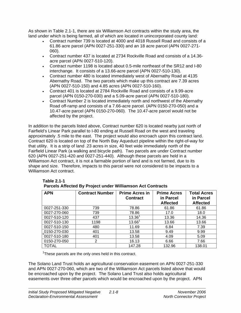
As shown in Table 2.1-1, there are six Williamson Act contracts within the study area, the land under which is being farmed, all of which are located in unincorporated county land:
• Contract number 739 is located at 4000 and 4018 Russell Road and consists of a 61.86 acre parcel (APN 0027-251-330) and an 18 acre parcel (APN 0027-271-060).
• Contract number 437 is located at 2734 Rockville Road and consists of a 14.36-acre parcel (APN 0027-510-120).
• Contract number 1198 is located about 0.5-mile northeast of the SR12 and I-80 interchange. It consists of a 13.66-acre parcel (APN 0027-510-130).
• Contract number 480 is located immediately west of Abernathy Road at 4135 Abernathy Road. The two parcels which make up this contract are 7.39 acres (APN 0027-510-150) and 4.85 acres (APN 0027-510-160).
• Contract 401 is located at 2784 Rockville Road and consists of a 9.99-acre parcel (APN 0150-270-030) and a 5.09-acre parcel (APN 0027-510-180).
• Contract Number 2 is located immediately north and northwest of the Abernathy Road off-ramp and consists of a 7.66-acre parcel. (APN 0150-270-050) and a 10.47-acre parcel (APN 0150-270-060). The 10.47-acre parcel would not be affected by the project.
In addition to the parcels listed above, Contract number 620 is located nearby just north of Fairfield’s Linear Park parallel to I-80 ending at Russell Road on the west and traveling approximately .5 mile to the east. The project would also encroach upon this contract land. Contract 620 is located on top of the North Bay Aqueduct pipeline within the right-of-way for that utility. It is a strip of land .23 acres in size, 40 feet wide immediately north of the Fairfield Linear Park (a walking and bicycle path). Two parcels are under Contract number 620 (APN 0027-251-420 and 0027-251-440). Although these parcels are held in a Williamson Act contract, it is not a farmable portion of land and is not farmed, due to its shape and size. Therefore, impacts to this parcel were not considered to be impacts to a Williamson Act contract. Table 2.1-1 Parcels Affected By Project under Williamson Act Contracts
1
1These parcels are the only ones held in this contract. The Solano Land Trust holds an agricultural conservation easement on APN 0027-251-330 and APN 0027-270-060, which are two of the Williamson Act parcels listed above that would be encroached upon by the project. The Solano Land Trust also holds agricultural easements over three other parcels which would be encroached upon by the project. APN
APN Contract Number Prime Acres in Contract
Prime Acres in Parcel Affected
Total Acres in Parcel Affected
0027-251-330 739 78.86 61.86 61.86 0027-270-060 739 78.86 17.0 18.0 0027-510-120 437 13.361 13.36 14.36 0027-510-130 1198 13.661 13.66 13.66 0027-510-150 480 11.69 6.84 7.39 0150-270-030 401 13.58 9.49 9.99 0027-510-180 401 13.58 4.09 5.09 0150-270-050 2 16.13 6.66 7.66 TOTAL 147.28 132.96 138.01

Initial Study Proposed Mitigated Negative 2.1-9 November 2006 Declaration-Environmental Assessment North Connector Project
0027-251-400 is currently used as part of the Fairfield Linear Park (bicycle and walking path); APN 0027-251-420 and 0027-251-440 are parcels of land which lie over the North Bay Aqueduct. Agricultural Preservation Policies – City of Fairfield The City’s General Plan Agriculture Element states “One of the underlying goals of the General Plan is to maintain and enhance the City’s desired image through a well balanced pattern of development. The agricultural lands in the Suisun Valley and the grazing lands to the north and south of Fairfield play a prominent role in defining the visual character of the City.” The City has adopted a large amount of policies and programs intended to protect the agricultural lands around Fairfield from development pressures.
The City’s General Plan Agriculture Element contains goals, objectives, policies, and programs which relate to the project as follows:
• Goals – Preserve agricultural and grazing lands within the General Plan area which define the visual setting of Fairfield; and, recognize the economic importance of agriculture in Solano County by directing the City’s growth away from important farmlands and prime agricultural soils.
• Objective AG1 – Support preservation of existing agricultural lands. • Policy AG1.4 – Permanently preserve productive agricultural lands within the
Suisun Valley by continuing to direct new urban development away from the Suisun Valley.
• Program 1.4A – Where land is identified as Prime farmland, Farmland of statewide importance, or Unique Farmland on the most recent Important Farmland maps prepared by the California Department of Conservation is proposed for conversion to urban uses, the City shall arrange for preservation of an equal amount of the same class of farmland within the area. Such arrangement may be through fee purchase, purchase of conservation easements, payment of an in-lieu fee, or other mechanism.
• Objective AG2 – Encourage the preservation and expansion of the local agricultural economy.
• Policy AG 2.1 – Cooperatively work with farmers, property owners, universities, colleges, and agricultural organizations and agencies to enhance the viability of agricultural uses and activities.
• Policy AG 2.3 – Development shall not encroach upon or consume productive cropland in areas such as the Suisun Valley.
Agricultural Preservation Policies – Solano County Agricultural and Open Space Land Use is found as Chapter III of Solano County’s General Plan Land Use Element. This chapter includes the following goal, objectives, and policies pertaining to the project:
• Goal – Maintain and enhance environmental quality of Solano County as it
relates to the use of land, water, and air by managing and preserving the diverse natural resources of the County for the use and enrichment of the lives of present and future generations.
• Objective – Preserve the County’s high quality soils and protect and maintain essential agricultural lands including areas which possess unique characteristics for the raising of specialty crops.

Initial Study Proposed Mitigated Negative 2.1-10 November 2006 Declaration-Environmental Assessment North Connector Project
• Policy 1 – Preserve and maintain essential agricultural lands including intensive agricultural areas comprised of high quality soils and irrigated lands and extensive agricultural areas with unique or significant dry land farming or grazing activities.
• In essential agricultural areas, the County shall encourage the formation and retention of agricultural parcels of sufficient size to be maintained as a farmable unit.
A farmable unit is distinguished as the size of parcel a farmer would lease or purchase for agricultural purposes. In Solano County, this is defined as 160 acres for non-irrigated land, and 80 acres for irrigated land. A 40-acre parcel size is admissible where “highly productive” irrigated parcels exist. Where parcel sizes are smaller than the defined farmable unit, these parcels should not be broken up further. In non-essential agricultural areas, 20-acre parcel sizes may be applied. In Solano County, approximately 173,000 acres have been designated for intensive agricultural use (high productive yield). Approximately 135,000 acres have been designated for extensive agricultural (lower yield, used for grazing). Federal Agricultural Preservation Policies The Farmland Protection Policy Act requires that federal agencies use specified criteria to identify and take into consideration the adverse effects of their projects on farmland. The Act also requires that agencies consider alternatives to their projects, as appropriate, that could reduce adverse effects and to ensure that their projects are consistent with policies to protect farmland. A Farmland Conversion Impact Rating for Corridor Type Projects form was completed for the project and can be found in the Appendix I of this document.
Impacts Methodology Data used to characterize the study area were obtained primarily from the City and County General Plans, the Draft EIR for the Comprehensive Amendment to the City of Fairfield General Plan (Jones & Stokes 2001), the Final Agricultural Conservation Easement Plan prepared for the Solano Land Trust (Stott Planning Associates 2002), site visits, and review of aerial photographs. The purpose of this section is to describe possible impacts of the proposed project on existing and planned/permitted land uses and on developable land. Table 2.1-2 provides a summary of the project’s encroachments and building displacements by alternative.

Initial Study Proposed Mitigated Negative 2.1-11 November 2006 Declaration-Environmental Assessment North Connector Project
Table 2.1-2 Totals of Parcel Encroachment and Displacement6
Alignment Option
Number of Parcels or
Portions of Land Affected
Number of Full Property
Acquisitions
Total Acres7
Number of Demolitions
West End 2:1 Slope 5 0 11.3 0 4:1 Slope 5 0 17.7 0 Central Section 1 0 ? 0
East End 17 1 26.3 4 buildings (1 business)
Jameson Canyon8 4 0 1.9 0 Red Top Road9 1 0 0.47 0 Total 57.67 Construction Period Impacts All sections of the Project involve construction of a new road with grading, paving and ancillary facilities such as traffic signals, lighting, signs, landscaping and fencing. The West End described in Section 1.1 would require grading for the proposed connection to SR 12. Red Top Road intersection would have to be improved as part of the Project. Construction staging would be required at the Red Top Road Intersection. During project construction, work would be staged to maintain existing traffic flow and local access. For each stage, the contractor would be required to provide a minimum number of through lanes and possibly one turning lane to satisfactorily accommodate vehicular traffic during construction. The contractor would also be required to maintain local vehicular access to driveways and properties, even when an existing street is closed for construction. The contractor may be allowed to close major streets and intersections at night and during some weekends. With the requirements of the construction contractors described above, no special design considerations are needed. No significant impacts to existing or planned development are expected and the construction of the project would not physically divide an established community. West End The West End would require grading for the proposed connection to SR12. The Red Top Road intersection would have to be improved as part of the project, and construction staging would be required to maintain existing traffic flow and local access. For each stage, the contractor would be required to provide a minimum number of through lanes and possibly
6 Only structures of monetary value and included in County of Solano assessment roles, were considered displaced. 7 Does not include ROW acquisition for temporary or permanent bike path, or detention basins in the West End. 8 Properties affected by improvements to accommodate the new North Connector/ Red Top Road/ SR 12 West signalized intersection. 9 Properties affected by improvements to accommodate the new North Connector/ Red Top Road/ SR 12 West signalized intersection.

Initial Study Proposed Mitigated Negative 2.1-12 November 2006 Declaration-Environmental Assessment North Connector Project
one turning lane to satisfactorily accommodate vehicular traffic during construction. The contractor would also be required to maintain local vehicular access to driveways and properties, even when an existing street is closed for construction. The contractor may be allowed to close major streets and intersections at night and during some weekends. With the requirements of the construction contractors described above, no special design considerations are needed. No adverse impacts to existing or planned development are expected. Central Section The western part of the Central Section requires minor grading and demolition of a small section of Mangels Blvd, but the contractor would be required to maintain local access at intersections and driveways. The construction impacts on the existing or planned land uses are not considered significant. East End During construction of all design options, alternate access for the bike path in the Linear Park would be provided adjacent to Suisun Creek and the Abernathy Road interchange. The path would be rerouted for approximately six months at each location. See Appendix B, Section 4(f) Evaluation, for a more detailed discussion of the effects to the Linear Park. Most of the East End is on level agricultural land with the road just above the existing ground. There would be limited grading and minor access requirements for the intersecting farm roads. The North Connector merges with Abernathy Road on the east end, which would require a construction staging area and traffic control during construction. The impacts to planned or existing land uses during construction are not expected to be adverse.
Land Use Impacts West End In the West End, the project would be constructed with limited access to adjacent agricultural areas. Provisions for access under the new roadway would be provided to allow the movement of livestock and equipment in the grazing land area. Access to another grazing land property would be severed by the new road and would be replaced with a new driveway. Central Section The proposed Project would improve access to the area located between Suisun Valley Road and Dan Wilson Creek. This area is zoned Highway and Regional Commercial, and was most recently developed with a vacant truck stop and gas station service center (demolished in January 2004). Impacts Related to Farm and Grazing Lands West End The project would result in impacts to Grazing Land in the West End section. The project would encroach upon 15.14 acres of Grazing Land if contour grading were used and 8.95 acres if grading to a 2:1 slope were used. This amount of undeveloped Grazing Land would be converted to roadway. There are approximately 180,000 acres of Grazing Land in unincorporated Solano County. The project would convert about .008 percent of Grazing Land to roadway under the contour grading alternative and about .005 percent under the 2:1
Initial Study Proposed Mitigated Negative 2.1-13 November 2006 Declaration-Environmental Assessment North Connector Project
slope grading alternative. This small amount would not be considered a substantial change in the overall amount of Grazing Land in the County. Central Section There is neither Farm nor Grazing Land in the Central Section. East End The Solano Land Trust holds an agricultural conservation easement on APN 0027-251-330 and APN 0027-270-060, which are two of the Williamson Act parcels listed above that would be encroached upon by the project. The Solano Land Trust also holds agricultural easements over three other parcels which would be encroached upon by the project. APN 0027-251-400 is currently used as part of the Fairfield Linear Park (bicycle and walking path); APN 0027-251-420 and 0027-251-440 are parcels of land which lie over the North Bay Aqueduct. Impacts to these parcels are considered to be adverse. The segmentation of the agricultural parcels would not be consistent with the following County policy, which seeks to maintain parcels of sufficient size for productive and economical farming:
In essential agricultural areas, the County shall encourage the formation and retention of agricultural parcels of sufficient size to be maintained as a farmable unit. Farmable units are defined as the size of parcels a farmer would consider leasing or purchasing for different agricultural purposes as follows: 160-acre minimum parcel size for non-irrigated lands; 80-acre minimum parcel size for irrigated lands; 40-acre minimum parcel size where “highly productive” irrigated parcels are demonstrated to exist.
As a plan to retain essential agricultural areas, Solano County has established the “farmable unit.” A farmable unit is distinguished as the size of parcel a farmer would lease or purchase for agricultural purposes. In Solano County, this is defined as 160 acres for non-irrigated land, and 80 acres for irrigated land. A 40-acre parcel size is admissible where “highly productive” irrigated parcels exist. Where parcel sizes are smaller than the defined farmable unit, these parcels should not be broken up further. In non-essential agricultural areas, 20-acre parcel sizes may be applied. Five of the Williamson Act parcels that would be encroached upon by the project are already fewer acres than the smallest acreage which is considered a farmable unit by the county’s policy. The project would make the parcels and contract acreage even smaller. This could affect the land owner’s ability to farm those lands. The other parcel (APN 0027-251-330) would continue to be considered farmable due to its size. Impacts to Williamson Act Contracts and Agricultural Conversion See Figure 2.1-1 for the location of each Williamson Act Parcel. Table 2.1-3 below list the amount of acres which would remain in each of the Williamson Act contracts and in each of the parcels after encroachment by the project. Table 2.1-4 provides a summary of the total acreage of farmland affected by the project.

Initial Study Proposed Mitigated Negative 2.1-14 November 2006 Declaration-Environmental Assessment North Connector Project
Table 2.1-3 East End Alignment Impacts to Williamson Act Contracts
APN Contract Number
Prime Acres in Contract
Prime Acres
in Parcel
Total Acres
in Parcel
Acres Affected by the Project
Remaining Acres in Parcel
Remaining Prime
Acres in Contract
0027-251-330 7391 78.86 61.86 61.86 6.21 55.65 70.58 0027-271-060 7391 78.86 17.0 18.0 2.07 15.93 70.58 0027-510-120 437 13.362 13.36 14.36 1.51 11.85 11.85 0027-510-130 1198 13.662 13.66 13.66 1.71 12.85 11.95 0027-510-150 480 11.692 6.84 7.39 0.30 11.95 11.39 0150-270-030 4013 13.58 9.49 9.99 0.37 7.09 12.1 0027-510-180 4013 13.58 4.09 5.09 1.32 9.62 12.1 0150-270-050 2 16.13 6.66 7.66 0.16 3.77 15.97 TOTAL 13.65 1 The total take for Contract 739 is 8.28 acres. 2 These parcels are the only one held in this contract. 3The total take for Contract 401 is1.48 acres.
Table 2.1-4 Total Acres of Farmland Affected by the Project
Total Acres in a Williamson
Act Contract Removed
Total Acres of
Prime/Non-Contract Removed
Total Acres of
Prime Farmland Removed
Percentage Farmland Removed
from Study Area
Percentage Farmland Removed
From County
13.65 12.5 26.15 3.31 0.015 The East End Alignment would remove 26.15 acres, which would be .015 percent of the acres of farmland in unincorporated land and 3.31 percent of the Prime Farmland acres in the study area Solano County has indicated that the preferred alignment ET3 reduces impacts to Agricultural land. Caltrans Environmental Handbook Volume 4, Community Impact Assessment, Section 4-5.2 states that the Williamson Act “prohibits a public agency from acquiring Prime Farmland covered under the Act for the location of a public improvement if there is other land within or outside the preserve on which it is reasonably feasible to locate the public improvement.” The Handbook further states, “Solely on the question of valuation, Government Code section 51295 states that when a project would condemn or acquire only a portion of a parcel of land subject to a Williamson Act contract, the contract is deemed null and void only as to that portion of the contracted farmland taken. The remaining land continues to be subject to the contract unless it is adversely affected by the condemnation. In such cases, the contract for the remaining portion may be canceled.”

Initial Study Proposed Mitigated Negative 2.1-15 November 2006 Declaration-Environmental Assessment North Connector Project
Avoidance, Minimization and Mitigation Measures Impact LU 1: The proposed project would bisect the Mangels Property, currently being used for limited cattle ranching and agriculture. Access to the Ditmer Property would also be severed by the new road and would be replaced with a new driveway off of the roadway. Mitigation Measure LU 1: The project shall provide an under crossing to allow movement of livestock and tractors on the Mangels Property. Impact LU 2: The project would conflict with applicable local and regional agricultural polices. Policy LU 2.1 states that the City shall “Encourage the preservation agricultural land surrounding the City in the Suisun Valley.” The East End is zoned Exclusive Agriculture by the Solano County General Plan. The construction of a new roadway would result in direct take of land ranging from 24.79 to 27.0 acres of prime agricultural land. Mitigation Measure LU 2: The STA shall be required to replace Prime Farmland at a 1:1 ratio with agricultural land of equal quality and shall be required to protect the land for agricultural use through agricultural conservation easements. All easement acquisitions shall conform to the policies of the Final Agricultural Conservation Easement Plan (Prepared for Solano Land Trust, August 2002). Impact LU 3: The alignment in the East End would result in impacts to Prime Farmland. The City of Fairfield’s General Plan Agriculture Element and Solano County’s General Plan Land Use Element include goals, objectives, policies, and programs which relate to the preservation of farmland. The removal of prime agricultural land from production, as would take place under the Ease End alignment, would not be consistent with policies regarding the preservation of agriculture in the City of Fairfield and Solano County General Plans. Mitigation Measure LU 3: Parcels designated Prime or Unique Farmlands as designated by the Natural Resources Conservation Service that are affected by the project (right of way acquisition required) shall be evaluated to determine if the remainder parcel is of adequate size for continued agricultural use. This determination shall be based on discussions with the property owner and on the County’s farmable unit criteria. If the remainder parcel is not considered farmable by the property owner, and does not meet the County’s farmable unit criteria, the STA/County shall consider purchasing the remainder parcel for assembly with adjacent farmlands.
Impact LU 4: The project would result in the conversion of prime farmland and conflict with parcels zoned Exclusive Agriculture and parcels under Williamson Act Contract. The direct take of agricultural land is 26.15 acres. There would also be an indirect take of agricultural land – where the utility of agricultural land is diminished due to segmentation of a parcel. Mitigation Measure LU 4: Parcels under current Williamson Act Contracts (or Prime or Unique Farmlands as designated by the Natural Resources Conservation Service) that are affected by the project (right of way acquisition required) shall be evaluated to determine if the remainder parcel is of adequate size for continued agricultural use. This determination should be based on discussions with the property owner and on the County’s farmable unit criteria. If the remainder parcel is not considered farmable by the property owner, and does not meet the County’s farmable unit criteria, the STA/County shall consider purchasing the remainder parcel for assembly with adjacent farmlands.

Initial Study Proposed Mitigated Negative 2.1-16 November 2006 Declaration-Environmental Assessment North Connector Project
Impact LU 5: The project would temporarily impact the Fairfield Linear Park bicycle path at Abernathy Road and Suisun Creek. This would conflict with the Solano County General Plan, Objective 3: “Establish a system of trails, bikeways, and walkways as an alternate mode of travel which would provide convenient and safe movement of non-motorized traffic.”

Parc
el #
002
7-25
1-33
0 W
illia
mso
n A
ctC
on
trac
t #7
30
Parc
el #
002
7-51
0-12
0 W
illia
mso
n A
ctC
on
trac
t #4
30
Parc
el #
002
7-51
0-13
0 W
illia
mso
n A
ctC
on
trac
t #1
193
Parc
el #
015
0-27
0-03
0 W
illia
mso
n A
ctC
on
trac
t #4
01
Parc
el #
027
-510
-15
0 W
illia
mso
n A
ctC
on
trac
t #4
30
Parc
el #
027
-510
-18
0 W
illia
mso
n A
ctC
on
trac
t #4
01
Figu
re 2
.1-1
Will
iam
son
Act
Par
cels

Initial Study Proposed Mitigated Negative 2.1-18 November 2006 Declaration-Environmental Assessment North Connector Project
Page Left Intentionally Blank