chapter 2 alternatives considered -...
TRANSCRIPT

CHAPTER 2ALTERNATIVES CONSIDERED

Alternatives Considered
page 2-1
CHAPTER 2 - ALTERNATIVES CONSIDEREDThree alternatives are under were consideration considered in this the Draft EnvironmentalImpact Statement/Environmental Impact Report (Draft EIS/EIR) for the San Fernando ValleyEast-West Transit Corridor released in May 2001. These alternatives were arrived at afterconsideration in an extensive screening and selection process, described in Section 2-1, whichculminated in the recommendations of a Major Investment Study (MIS) released by the MTA inFebruary 2000. Based on the recommendations in the MIS, the Board approved further study ofa Bus Rapid Transit (BRT) exclusive guideway busway between the North Hollywood MetroRed Line station and Warner Center Transit Hub, 14 miles to the west. In addition, two baselinealternatives, the No Build and Transportation System Management (TSM) alternatives are underwere consideration considered in this the Draft EIS/EIR. Following the recommendations madein the MIS, on February 24, 2000 the MTA Board of Directors approved the development of aDraft EIS/EIR for these alternatives:
In July 2001, the MTA Board selected the Full BRT Alternative including the alignment alongthe Chandler Boulevard median as the Locally Preferred Alternative for the Final EIS/EIR. Inaddition, the Board directed staff to study the Lankershim/Oxnard On-Street Alignment variationfor potential weekend service should the Board choose to not operate on Chandler Boulevard onweekends. Section 2-2.3 describes the Full BRT Alternative (Locally Preferred Alternative) indetail. This section includes refinements to the Full BRT Alternative developed during thepreliminary engineering of the BRT Alternative, in response to comments received on the DraftEIS/EIR and community meetings held regarding design of the project after the Draft EIS/EIRwas prepared. Section 2-2.4 describes the Lankershim/Oxnard On-Street Alignment, whichwould function as the weekend service option. Below is a summary of the alternativesconsidered in the Draft EIS/EIR and in this Final EIS/EIR:
1. No Build - The “No Build” alternative reflects conditions in the San Fernando Valley ifno new transit improvements are made in the next twenty years. The No Build wouldinclude existing commitments, such as the Metro Rapid Bus demonstration project alongVentura Boulevard and High-Occupancy Vehicle (HOV) lanes along some freeways inthe Valley. This alternative is used in comparison with “build” alternatives in order tobetter understand their impacts.
2. Transportation System Management (TSM) - The TSM alternative is a federallymandated “basic improvements” alternative. In other words, the TSM is composed oflow-cost, non-capital intensive enhancements to transit service in the Valley. The SanFernando Valley TSM alternative is largely composed of increasing the frequency oftransit service along major arterials.
3. Bus Rapid Transit (BRT) - The “build” alternative under consideration is a bus rapidtransit system along an exclusive busway between the North Hollywood Metro Red Linestation and the Warner Center Transit Hub along the former Southern Pacific BurbankBranch right-of-way (SP ROW; also now known as the MTA ROW). This BRTalternative would also include the Valley-wide bus service improvements of the TSMalternative, plus additional transit service improvements along some north-south arterials
Alternatives Considered
page 2-2
that intersect the busway. The Full BRT Alternative, including the Chandler Boulevardmedian alignment, is the Locally Preferred Alternative selected by the MTA Board.
Lankershim/Oxnard On-Street Alignment – Also under consideration is a variation on thebaseline BRT alternative that would also operate between the North Hollywood MetroRed Line station and the Warner Center Transit Hub. However, this variation wouldinclude a segment in which buses would run on-street in mixed traffic. This on-streetsegment would run from the North Hollywood Metro Red Line station, north onLankershim Boulevard to Oxnard Street, and then west on Oxnard to Woodman Avenue.At Woodman, buses would enter the railroad right-of-way and continue to Warner Centeron exclusive busway. The MTA Board directed that the Lankershim/Oxnard On-StreetAlignment variation be considered as a weekend service option in lieu of operating onChandler Boulevard on the weekend.
Minimum Operable Segment (MOS) - A segment of the full project between WoodmanAvenue and Balboa Boulevard is being was studied as an initial phase. This shorterbusway segment would still provide enhanced cross-Valley bus service. In addition tothe busway, buses would run on-street along Oxnard Street to the east of the MOS and onVictory Boulevard to the west of the MOS to complete their runs from North Hollywoodto Warner Center.
Section 2-2 provides detailed descriptions and graphics of these alternatives.
2-1 SCREENING AND SELECTION PROCESS
2-1.1 Successive Evaluation and Re-Evaluation of CandidateAlternatives
2-1.1.1 Background
In November 1980, Los Angeles County voters approved Proposition A, authorizing the LosAngeles County Transportation Commission (LACTC, now the MTA) to assess a county-widehalf-cent sales tax to improve and expand the county’s existing public transit system, and toconstruct and operate a rail rapid transit network. In June 1990, voters approved Proposition C,which added another half-cent to the local sales tax to fund further expansion of transit systemsand allow expedited construction of area transportation projects. The passage of these twopropositions led the LACTC to formulate the 30-Year Integrated Transportation Plan, adopted inApril 1992, which called for construction of over 400 miles of rail transit in Los Angeles Countyand beyond, at a cost of approximately $187 billion. The map accompanying Proposition A onthe ballot included a rail transit line running east-west through the San Fernando Valley (seeFigure 2-1). The 30-Year Plan included this same corridor as a candidate for rail service.
However, in March 1995 the MTA adopted a scaled-down version known as the Long RangePlan, with a 20-year time frame extending to the year 2015. The Long Range Plan was drafted inresponse to Intermodal Surface Transportation Efficiency Act (ISTEA) requirements for fiscally-

SYLMAR
CANOGAPARK VAN NUYS GLENDALE
PASADENA
EL MONTECIVICCENTERSANTA
MONICA
LAX
DOWNEY
NORWALK
CARSON
TORRANCE
PALOSVERDES SAN
PEDROLONG BEACH
Alternatives Considered
page 2-3
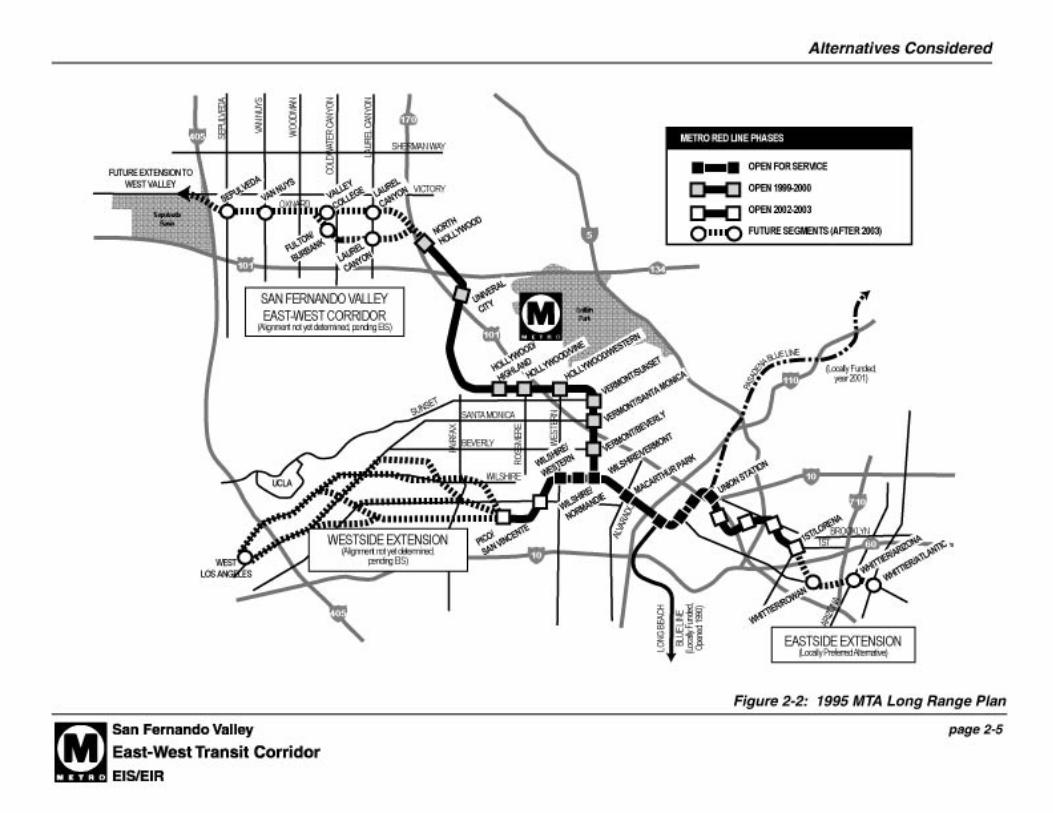
Figure 2-1: Proposition A Rail Transit System
Source: MTA, 1999.
Alternatives Considered
page 2-4
constrained transportation planning and addressed an anticipated decline in sales tax revenuesdue to the severity of the recession affecting the Los Angeles region. The Long Range Planlimited investment in the county’s transit network to $72 billion, eliminating several previouslyproposed rail lines and designating five proposed rail projects as candidate corridors “shouldfunding become available.” Nonetheless, the east-west corridor through the San Fernando Valleyfrom North Hollywood to I-405 remained a funded corridor (see Figure 2-2).
In July 1997, work on the San Fernando Valley Transit Corridor Study was suspended pendingthe adoption of an MTA Recovery Plan. In January 1998, the Metro Red Line Eastside and Mid-City subway projects were suspended, pending the adoption of a Recovery Plan and theevaluation of more cost-effective solutions for each corridor. As a result, there are $649 millionin federal funding commitments to the heavy rail system that are under review, pending action bythe MTA to develop alternatives to the previous heavy rail subway extensions.
In November 1998, the Regional Transit Alternatives Analysis (RTAA Study) was completedwhich identified several lower-cost options for the Eastside, Mid-City/Westside, and SanFernando Valley corridors. Previously prepared Major Investment Studies have beenreevaluated and updated to reflect this new information. New alternatives must also beenvironmentally cleared in conformance with state and federal regulations to become eligible forfuture funding grants. Amended Locally Preferred Alternative (LPA) decisions will be weresought from the Board for the Eastside and Mid-City/Westside corridors. A first time LPAdecision will be was sought from the Board for the San Fernando Valley East-West TransitCorridor. The Full BRT Alternative was selected as the Locally Preferred Alternative in July2001. The Board also directed that consideration be given to the Lankershim/Oxnard On-StreetAlignment variation as a potential weekend service alternative to Chandler Boulevard.
2-1.1.2 Previous Study Process
A series of studies have has been conducted over the past 12 years to identify promising transitalternatives and rail technologies for the San Fernando Valley East-West Transit Corridor (seeFigure 2-3). The major periods of study (dates in bold) and the studies resulting from thoseefforts (italics) are summarized below:1
• 1983/1984 - Preliminary Route Assessment, 1983 - Initiated by the Los Angeles CountyTransportation Commission (LACTC, now the MTA), this study provided a preliminaryassessment of various above-ground rail transit alternatives for an east-west corridor throughthe San Fernando Valley. The alignments initially considered were: SP Coast Mainline,Sherman Way, Los Angeles River, SP ROW, Ventura Freeway, and Ventura Boulevard.
Conclusion: The results of this initial analysis process led LACTC to remove the ShermanWay and Ventura Boulevard alternatives from further consideration and carry the remainingalternatives forward. Based on the preliminary assessment of the remaining candidate routes,LACTC selected a light rail line generally following the SP ROW as a representative routefor system planning purposes.
1 For all studies conducted prior to this EIS/EIR, the Southern Pacific ROW is referred to as the SP ROW. For allreferences pertaining to this EIS/EIR, the SP ROW, which was purchased by MTA, is referred to as the MTA ROW.


Alternatives Considered
page 2-7
• 1985/1986 - Route Refinement Study, 1985-86 - This study focused on options within the SPROW.
Conclusion: In response to local opposition to the SP ROW, LACTC broadened the range ofalternatives under consideration to include again three other routes: the SP Coast Mainline,the Los Angeles River, and the Ventura Freeway; and to add Victory Boulevard.
• 1987 - Initial Alternatives Evaluation Report, 1987 - This study, a precursor to the EIRauthorized by the LACTC in 1987, discussed the engineering considerations, environmentalimpacts, and land use impacts that would be associated with implementation of light railtransit service along the five alignments identified in the Route Refinement Study.
Conclusion: Following completion of the report, the LACTC retained the SP ROW andVentura Freeway alignments for consideration in an environmental impact report, andeliminated the SP Coast Mainline, Victory Boulevard, and Los Angeles River alignmentsfrom further consideration.
• 1990 - 1992 - San Fernando Valley East-West Rail Transit Project Environmental ImpactReport (EIR), 1990 - The EIR documented the costs, ridership, and environmental impactsassociated with various rail transit options on the SP ROW and the Ventura Freeway. For theSP ROW, both HRT and LRT systems were examined. For the Ventura Freeway, an HRTextension and driverless automated rail systems operating adjacent to the freeway wereevaluated.
Conclusion: The EIR identified an extension of Metro Rail (the Red Line) along the SPROW in deep-bore subway tunnels through residential areas, as the environmentally superioralternative; however, it was also the most costly. The EIR was certified by the LACTC inFebruary 1990, and one month later the LACTC adopted a statement of findings andapproved a mitigation monitoring plan, thus completing environmental clearance for theproject under California law.
• San Fernando Valley East-West Rail Transit Project Subsequent Environmental ImpactReport: Ventura Freeway Advanced Aerial Technology Alternative (SEIR), 1992 - TheVentura Freeway was revived as a candidate alignment in 1992, when the LACTC completeda Subsequent EIR (SEIR) to determine whether an aerial transit system in the freewaymedian might be more cost-effective than the previously adopted Red Line subway extensionalong the SP ROW.
Conclusion: The SEIR concluded that the Ventura Freeway project would be less expensivethan the SP Burbank project, but would attract fewer riders.
• 1993/1994 - Ventura Freeway Rail Transit Draft Project Study Report (PSR), 1994 - ThePSR provided an analysis of constructibility, operations, capacity enhancement, and costs toinstall an aerial light rail transit system in the median area of the Ventura Freeway (Route101) between Canoga Avenue in Warner Center and the Universal City Metro Red Line

Alternatives Considered
page 2-8
Station. The report provided cost estimates for two alternatives: Alternative I providedminimum widening of the freeway for additional safety for drivers, and Alternative II rebuiltthe freeway to full Caltrans and FHWA standards.
Conclusion: The PSR did not provide conclusions but rather summarized the findings of the:project background, need and purpose of the project, alternative evaluation, system planning,hazardous material/waste, traffic management plan, environmental clearance, andfunding/scheduling.
• 1994 - SP Burbank Branch Pre-Preliminary Engineering Study, 1994 - Subsequent tocompletion of the SEIR (1992), the LACTC initiated preparation of pre-preliminaryengineering studies for both the Ventura Freeway and SP ROW project alternatives. Thesestudies revealed that a transit project could not be constructed in the freeway median withoutwidening the freeway to meet design standards imposed by Caltrans. New seismic safetycriteria adopted after the Northridge earthquake in 1994 also raised the cost of constructing atransit project on the Ventura Freeway. Faced with a substantially more expensive VenturaFreeway project, the MTA (successor to the LACTC) obtained revised cost estimates for theSP ROW project.
Conclusion: The revised cost estimates for the SP ROW project revealed that the cost ofconstructing a subway along the SP ROW could be reduced through the use of open-airsubway alignments and stations.
• 1994 - MTA Board Adoption of SP Burbank Branch Corridor - In October, 1994, the MTAexamined the results of the pre-preliminary engineering study and the revised cost estimates,and received public testimony regarding the alternatives.
Conclusion: The MTA’s Board of Directors endorsed an extension of the Red Line insubway along the SP ROW, rather than vote to pursue a Ventura Freeway median aerial railtransit system.
• 1994 - Study of Restructuring Public Transit Service in the San Fernando Valley (SFVRestructuring Study) - This study developed a number of service restructuring objectives.Many of these objectives were performance-related objectives that were intended to allow theMTA and the Los Angeles Department of Transportation (LADOT) to deploy currentresources more efficiently and effectively. A significant element of the study was the sixproposed transit centers that would facilitate passenger connections and timed-transferoperations.
Conclusion: The study recommended a number of service changes throughout the SanFernando Valley, including the development of hub-and-spoke systems where lines convergeon a transit center in order for timed transfers to take place and initiation of community-based services to increase local service frequencies and minimize the need to transfer forshort trips. A number of non-traditional service options such as community-based transit,smart shuttles, dial-a-ride systems, taxis and service routes were explored for possibleimplementation in the SFV. (Service routes are short distance fixed route services that are

Alternatives Considered
page 2-9
tailored to “micro” transit needs with routes and schedules varying by time of day and day ofweek.) These recommendations are consistent with SCAG’s Regional Transportation Plan(RTP) Actions.
• 1995/1996 - Major Investment Study (MIS) Alternatives Screening Report, 1996 - Analternatives screening report was prepared as part of the MIS conducted in 1995/96. Thereport evaluated the relative cost-effectiveness of a broad range of project alternatives(discussed in detail in Section 2.1.2 below). Alternatives included all of the previouslystudied rail transit options included in the 1990 EIR and 1994 Geotechnical/ValueEngineering studies. Diesel Multiple Unit (DMU) vehicles, an alternative form of rail transit,were also considered. Also, bus service improvements including dedicated buswayenhancements to existing bus service were evaluated. Discussions with the SouthernCalifornia Association of Governments (SCAG) MIS Peer Review Group (formerly calledthe Interagency Review Committee) were held in June 1995 and September 1996.
Public scoping workshops were held in November 1995 to further expand the list of feasiblealternatives for study. Extensive community outreach was conducted as a part of this study.The comments provided have heavily influenced subsequent studies, including the 2000Major Investment Study.
Conclusion: The Report provided cost estimates and ridership forecasts for 10 corridortransportation alternatives. The report also contained cost-effectiveness indices, whichcompared the capital and operating costs with the expected benefits in travel time savingsand new transit ridership, for each of the 10 corridor alternatives.
• 1996 - MTA Board Adoption of a Reduced Number of Alternatives for Environmental Review- The MTA Board reviewed the cost-effectiveness of the 10 corridor alternatives evaluated inthe MIS Alternatives Screening Report.
Conclusion: Based on the cost-effectiveness review, the MTA Board adopted the staffrecommendations to approve the findings of the MIS Alternatives Screening Report and carryforward a reduced number of alternatives for environmental review.
• 1998 - Restructuring Plan: Analysis and Documentation of the MTA’s Financial andManagerial Ability to Complete North Hollywood Rail Construction and Meet the Terms ofthe Bus Consent Decree and MTA Board Adoption of Restructuring Plan, May 1998 - TheRestructuring Plan was prepared to satisfy requirements that MTA prepare a “financiallyconstrained rail recovery plan, which complies with the Consent Decree for enhanced busservice.” The Plan demonstrated to the Federal Transit Administration (FTA) the MTA’sfinancial capability to complete the Metro Red Line Segments 2 and 3 to Hollywood andNorth Hollywood. The Restructuring Plan also assumed the continued suspension of threefuture rail projects: the Metro Red Line Mid-City and Eastern Extensions, as well as theMetro Blue Line to Pasadena.
Conclusion: As part of the Restructuring Plan, the MTA committed to completing aRegional Transit Alternatives Analysis (RTAA) by mid-October 1998 that would analyze

Alternatives Considered
page 2-10
viable and effective options for improving transit to parts of Los Angeles County. Thisanalysis included the corridors where MTA had suspended work on planned rail projects andwhere there were high concentrations of transit dependent residents.
• 1998 - 1998 RTP Transit Restructuring For Use in the MTA Re-evaluation Study, SanFernando Valley, Transit Corridor Technical Report, August 1998 - This study by theSouthern California Association of Governments (SCAG) provided a preliminaryinvestigation of potential public transit improvements in the study area, specifically byexploring the potential development of the four transit corridors addressed in the SCAGRegional Transportation Plan (RTP). These included: Valley East-West Corridor, CanogaCorridor, Van Nuys Corridor, and Roscoe Corridor.
Conclusion: No specific alternative, corridor alignment or technology was recommended.The study was intended by SCAG to identify issues and provide information that would behelpful in future work on transit improvements in the San Fernando Valley area.
• 1998 - Regional Transit Alternatives Analysis, November 1998 - The RTAA provided aframework for the MTA to make policy decisions and recommendations on a countywidebasis (e.g., Metro Rapid Bus), and in the Eastside, Mid-City, and San Fernando Valleycorridors. The study provided recommendations for:
• Prioritizing system investments,• Providing allocations to non-transit priorities,• Providing allocations to operate existing services at a reliable and integrated standard,• Providing allocations to related municipal operators,• Managing financial risk,• Expanding countywide bus service, and• Identifying a process for future corridor investment decisions.
For the San Fernando Valley corridor, three alternatives were advanced to final evaluation:
(a) a heavy rail extension to I-405,(b) a light rail/DMU alternative from the North Hollywood Station to Warner Center, and(c) a bus transitway from the Metro Red Line North Hollywood Station to Warner Center.
Conclusion: Conclusions for the San Fernando Valley corridor indicated that the MTAshould continue planning, environmental and community work in the corridor. The MTABoard directed the Chief Executive Officer of the MTA to promptly implement thiscontinued planning process.
Included in the approval of the RTAA was the adoption of a Countywide Bus SystemEnhancement Program that directed staff to “proceed with the preparation for presentation tothe Board of a thorough plan for a Metro Rapid Bus demonstration project of three lines,including at least one line serving each of the Eastside, Mid-City, and San Fernando Valley.”
Alternatives Considered
page 2-11
• 1998 - LADOT/MTA Internal Bus Transitway Feasibility Studies (not published) - Thesestudies examined a system of transit improvements with increased capacity, preferably onexclusive rights-of-way (ROWs) that have the possibility of being implemented earlier thanrail. The bus transitway system could serve as an interim project that could later be upgradedto a higher capacity system. Four corridors were evaluated: the Downtown Connector,Exposition, San Fernando Valley Burbank-Chandler, and Crenshaw-LAX. The study wasnot intended to be a comprehensive review of each alignment, but rather a study to providepolicy makers with information necessary to determine whether a more in-depth analysisshould be conducted. The findings presented for each corridor were not cumulative as threeof the corridors overlapped.
Conclusion: For the San Fernando Valley Burbank-Chandler Corridor, it was determinedthat based on engineering analysis, it would be feasible to construct and operate exclusivebus lanes on the SP ROW. If further analysis were warranted, the next steps would be tocomplete an Environmental Impact Report/Statement (EIR/EIS), preliminary engineering(PE), and the identification of funds to complete the required technical analysis and toconstruct and operate the facility.
• 1999 - Los Angeles Metro Rapid Bus Demonstration Program Implementation Plan, 1999 -In 1998, the MTA Board directed staff to proceed with Phase One of a two-phase MetroRapid Bus demonstration project. Phase One comprises the demonstration phase. The threelines included: Eastside, Mid-City, and San Fernando Valley. The purpose of thedemonstration program was to address the need for faster travel choices for bus riders,especially the transit-dependent, on an interim basis prior to the completion of the fixedguideway corridor projects.
Beginning in 2000, The the MTA will began to operate a 14-station, 16-mile Metro RapidBus line along Ventura Boulevard during the demonstration phase, extending from theUniversal City Red Line station to the Warner Center Transit Center. Phase II of the Planproposes adding three other Metro Rapid Bus lines in the San Fernando Valley. A line alongSan Fernando Road would link the Los Angeles CBD with the East Valley. The Van NuysBoulevard line would connect the Valley to West Los Angeles, and a Roscoe Boulevard linewould link the North Hollywood Red Line station with the Warner Center along a routeseveral miles north of the San Fernando Valley East-West Transit Corridor. The plan alsoindicates that if a bus transitway becomes the preferred alternative, as it has in the former SP(now MTA) ROW, that busway could be integrated into the Metro Rapid Bus network.
Conclusion: Implementation of Metro Rapid Bus within the Ventura Boulevard corridor inthe San Fernando Valley and a Wilshire/Whittier demonstration project will open at the sametime as the Red Line station at North Hollywood. Subsequent to implementation, a MetroRapid Bus Demonstration Program report will be prepared. The report will describe thedemonstration, issues, and performance of the program relative to established benchmarks.The report will also advise MTA regarding whether to move ahead with full implementationof the Metro Rapid Bus Program, implement a modified program, or cease implementation.The Rapid Bus line along Ventura Boulevard has opened, along with the Metro Red Line toNorth Hollywood. Evaluation of these new transit services is underway.

Alternatives Considered
page 2-12
Conclusion: The Metro Rapid Bus demonstration program along Ventura andWilshire/Whittier Boulevards has been a success with travel times reduced and ridershipincreased along these corridors. In the 2001 Long Range Plan adopted by MTA, numerousother routes are under consideration for rapid bus service, including Van Nuys and RoscoeBoulevards in the San Fernando Valley. As described in the Long Range Plan, these rapidbus routes would be part of an integrated transit network for the Valley which would alsoinclude the BRT along the former SP (now MTA) ROW. In addition, the MTA will beginstudy of a San Fernando Valley North-South Transit Corridor in 2002 that could potentiallyinclude Metro Rapid Bus or another variation of BRT service along north-south arterials inthe Valley.
2-1.2 1996 MIS Alternatives Screening Report
The 1996 MIS Alternatives Screening Report provided cost estimates and ridership forecasts for10 San Fernando Valley East-West Transit Corridor transportation alternatives. Alternativesconsidered in the Alternatives Screening Report included the following:
• Alternative 1: Red Line Extension to I-405 Freeway(Southern Pacific Right-of-Way [SP ROW])
1a) Deep-Bore Subway, Hollywood Freeway to Hazeltine Avenue1b) Cut-and-Cover Subway, Hollywood Freeway to Hazeltine Avenue1c) Open-Air Subway, Hollywood Freeway to Hazeltine Avenue1d) Aerial, Hollywood Freeway to I-405
• Alternative 2: Red Line Extension to I-405 (Oxnard Street)
• Alternative 3: Light Rail Transit to I-405
3a) At-Grade, North Hollywood Freeway to I-4053b) Cut-and-Cover Subway, Hollywood Freeway to Fulton/Burbank
• Alternative 4: Red Line Extension to Valley Circle (SP ROW)
4a) Deep-Bore Subway, White Oak to De Soto4b) Cut-and-Cover Subway, White Oak to De Soto4c) Open-Air Subway, White Oak to De Soto4d) Aerial, I-405 to Valley Circle
• Alternative 5: Red Line Extension to Valley Circle (Sherman Way)
• Alternative 6: Light Rail Transit to Valley Circle6a) At-Grade with Open-Air Segment6b) At-Grade with Open-Air/Cut-and-Cover Segment

Alternatives Considered
page 2-13
• Alternative 7: Alternate Rail Technology - Diesel Multiple Units (North Hollywood toChatsworth)
• Alternative 8: Busway (North Hollywood to Warner Center)
• Alternative 9: Enhanced Bus (Transportation Systems Management)
• Alternative 10: No Build
Following a review of the key features, cost, ridership, environmental issues, and cost-effectiveness of the above alternatives, on May 22, 1996, the Metropolitan TransportationAuthority (MTA) Board of Directors adopted the staff recommendations to approve the findingsof the MIS Alternatives Screening Report and carry forward a reduced number of alternatives forenvironmental review. Primarily based on cost-effectiveness criteria, the following alternativeswere carried forward in the MIS process: 1, 2, 6, 9, and 10. The following alternatives wereconsequently removed from further consideration: 3, 4, 5, 7, and 8.
The MTA Board also directed that the actions listed below proceed and these were incorporatedinto the alternatives analysis for the 1997 Administrative Draft MIS/EIS/SEIR:
• East Valley (east of I-405) - Identify and develop community-sensitive alternative solutionsto deep bore subway in the area covered by state-mandated subway legislation. (This area isapproximately 3.5 miles in length and covers the segment of the SP ROW between theHollywood Freeway and Hazeltine Avenue. In 1991, the California Legislature enactedPublic Utilities Code Section 130265, which limits any rail transit project “within the right-of-way of the Burbank Branch line of the Southern Pacific Railroad,” to “a subway systemwhich is covered and below grade.”)2 Also consider cut-and-cover subway, open-airsubway, and the addition of a station at Laurel Canyon Boulevard.
• West Valley (west of I-405) - Continue to evaluate the Enhanced Bus (TSM) and thepredominantly At-Grade LRT Alternatives. Remove from further consideration the less cost-effective Red Line Extension, Busway, and ART Alternatives.
• Technology/Construction - Although the Red Line Extension to the West Valley (Alternative4) was recommended for elimination from further consideration based on its high cost, theMIS Alternatives Screening Report recommended that consideration of modifications to theRed Line vehicle design be considered to permit dual mode (third rail + overheadpantograph) electrification. Such a vehicle would allow the Red Line to be extended into theValley in a predominantly at-grade configuration that would not be possible with aconventional Red Line vehicle. This alternative, unlike light rail, would not requirepassenger transfers at the North Hollywood Station. This alternative was therefore added tothe list of alternatives for the 1997 Administrative Draft MIS/EIS/SEIR with the followingdescriptions:
2 This legislation has been determined to not be applicable to the currently proposed project.

Alternatives Considered
page 2-14
• Alternative 11: Dual Mode Red Line Extension to I-405
11a) Predominantly At-Grade, North Hollywood to I-40511b) Same as 11a + Cut-and-Cover Subway on Chandler Boulevard
• Alternative 12: Dual Mode Red Line Extension to Valley Circle
12a) Predominantly At-Grade, North Hollywood to Valley Circle12b) Same as 12a + Cut-and-Cover Subway on Chandler Boulevard
An Administrative Draft MIS/EIS/SEIR was prepared for these twelve alternatives in March1997, and submitted to FTA for review. Due to the restructuring program (Recovery Plan),discussed above in the background section, the FTA declined to review the document at thattime.
2-1.3 2000 MIS Alternatives
2-1.3.1 Development of the 2000 MIS Alternatives
In 1999, the MTA directed that separate MIS/EIS/EIRs be undertaken for the Eastside, Mid-City,Westside, and the San Fernando Valley. The analyses of alternatives considered in the 1996MIS Alternatives Screening Report and Administrative Draft MIS/EIS/SEIR were used to definea new set of alternatives to be considered in the 2000 MIS for the San Fernando Valley. Thetechnical designation “busway” was changed to “Bus Rapid Transit” to reflect new FTAterminology. Light rail and heavy rail alternatives were also considered.
Table 2-1 compares the 2000 MIS Alternatives to the previous alternatives considered in the MISAlternative Screening Report in 1996.
Table 2-1: Development of Alternatives for the MIS
Alternatives Considered inMIS Screening Report May
22, 1996
Deleted fromConsideration in MIS
AlternativesScreening Report
May 22, 1996
Added to StudyMIS AlternativesScreening Report
May 22, 1996Included in 2000 MIS
1. Red Line Extension to I-405(SPROW)
Alternative 5 plusbusway to WarnerCenter
2. Red Line Extension to I-405(Oxnard) Deleted
3. Light Rail Transit to I-405 Deleted5/22/96 Deleted
4. Red Line Extension toValley Circle (SPROW)
Deleted5/22/96 Deleted
5. Red Line Extension toValley Circle (Sherman Way)
Deleted5/22/96 Deleted
6. Light Rail Transit to ValleyCircle (6a and 6b)
Alternative 3 (modified6a) & 4 (6b) withterminus at WarnerCenter

Alternatives Considered
page 2-15
Table 2-1: Development of Alternatives for the MIS
Alternatives Considered inMIS Screening Report May
22, 1996
Deleted fromConsideration in MIS
AlternativesScreening Report
May 22, 1996
Added to StudyMIS AlternativesScreening Report
May 22, 1996Included in 2000 MIS
7. Alternative Rail Technology Deleted5/22/96 Alternative 7
8. Busway Deleted5/22/96 Alternatives 1 & 2
9. TSM TSM
10. No Project No Project
11. Dual Mode Red LineExtension to I-405
Added5/22/96 Deleted
12. Dual Mode Red LineExtension to Valley Circle
Added5/22/96
Alternative 6 withterminus at WarnerCenter
Source: Myra L. Frank and Associates, 1997; Gruen Associates, 2000.
In addition to the No Build and TSM alternatives, the 2000 MIS included seven “buildalternatives,” summarized in Table 2-2.
Table 2-2: 2000 MIS Build Alternatives
Name Profile Alignment
Bus Rapid Transit (BRT) At-grade North Hollywood toWarner Center
Enhanced Bus Rapid Transit(BRT)
At-grade with two grade separations(aerial) at Van Nuys and Sepulveda
North Hollywood toWarner Center
Light Rail Transit (LRT) At-grade North Hollywood toWarner Center
Enhanced Light Rail Transit (LRT) Multiple variations in profile North Hollywood toWarner Center
Red Line Extension / Bus RapidTransit (BRT)
4 options for heavy rail segment:a) Deep-bore tunnelb) Cut-and-cover tunnelc) Open-air depressed guideway/channeld) Aerial guidewayBRT segment: At-grade
North Hollywood to I-405via Red Line and I-405 toWarner Center via BRT
Dual-Mode Red Line Extension Deep-bore tunnel to Laurel Canyon,then at-grade to Warner Center
North Hollywood toWarner Center
Diesel Multiple Unit (DMU)Vehicles
Single-track at-grade rail with 15minute headways
Burbank to Chatsworth
Source: Myra L. Frank and Associates, 1997; Gruen Associates, 2000.

Alternatives Considered
page 2-16
In the 2000 MIS, build alternatives were primarily located on the SP ROW and all butAlternative 7 had common termini, the North Hollywood Red Line Station and the proposedWarner Center Transit Hub. Alternative 7, the Diesel Multiple Unit (DMU) Vehicle alternative,extended from Burbank Boulevard to Chatsworth Street along the SP ROW. Sub-alternativesaddressed variations in profile or smaller segments for phasing depending on financialconsiderations.
2-1.3.2 Evaluation Process
The MIS released in February 2000 provided cost estimates and ridership forecasts for the seven“build” alternatives in the corridor, as well as No Build and Transportation System Management(TSM) alternatives. A cost-effectiveness index was calculated for all alternatives, comparingcapital and operating costs with expected new transit ridership. Public outreach and preliminaryenvironmental analysis were also considered. The factors considered in the evaluation included:
• Capital Cost• Operating Cost• Ridership (Linked Trips and Boardings)• Cost-Effectiveness (Annualized Cost Per New Daily Transit Trip)• Average Travel Times• Distinguishing Environmental Characteristics• Community Support
2-1.3.3 MIS Recommendation
The evaluation of alternatives resulted in the staff recommendation that Alternative 1, Bus RapidTransit, be evaluated further as a part of this Draft Environmental Impact Statement/Environmental Impact Report (Draft EIS/EIR) process, including consideration of a minimumoperable segment (MOS) from Woodman Avenue to Balboa Boulevard. The MTA Boardendorsed this recommendation, authorizing the MTA to proceed with work on DraftEnvironmental Impact Statements/Reports for the corridor in cooperation with the FTA and toconsult with the FTA on any issues related to the recommended alternatives under consideration.
2-2 DETAILED DESCRIPTION OF ALTERNATIVES
This section provides detailed descriptions of the alternatives being analyzed in this the DraftEIS/EIR. In addition to the two baseline comparative alternatives (the No Build and TSMAlternatives), this document includes the Bus Rapid Transit (BRT) Alternative, as approved forfurther analysis by the MTA Board. The BRT Alternative includes three variations: (1) the BRTAlternative (the Locally Preferred Alternative), (2) the BRT Alternative with Lankershim/Oxnard On-Street Alignment variation (the weekend service option), and (3) the MinimumOperable Segment (MOS). These variations are described further in Sections 2-2.3, 2-2.4, and 2-2.5. Details of bus operations for all variations are described in Section 2-2.6.

Alternatives Considered
page 2-17
In July 2001, the MTA Board selected the Full BRT variation of the BRT Alternative as theLocally Preferred Alternative, and identified the Lankershim/Oxnard On-Street Alignmentvariation for consideration as a potential weekend service option in lieu of weekend service onChandler Boulevard. This section also includes refinements to the Full BRT andLankershim/Oxnard On-Street Alignment variations developed during Preliminary Engineeringof the BRT Alternative.
2-2.1 No Build
The No Build Alternative reflects the conditions anticipated for the year 2020, based on SCAG’sgrowth forecast, if no major transit improvement investments are made within the valley's East-West Transit Corridor. This scenario would mean that the MTA-owned SP ROW (also known asthe MTA ROW since it was purchased by MTA) (referred to as the MTA ROW for purposes ofthis environmental document) would not be used for a transit project. This alternative is used asa baseline for comparison to the busway alternative, as well as the TSM alternative, describedbelow.
All existing highway and arterial facilities are assumed to be in place, as well as all other fundedtransportation improvements in the RTIP (Regional Transportation Improvement Program), theSTIP (State Transportation Improvement Program), the MTA HOV Master Plan and the MTACall for Projects, and major projects to be implemented by others, such as the City of LosAngeles. No new roadways and no major widening of any arterial highways in the SanFernando Valley are anticipated under this alternative by 2020. Traffic signal systemimprovements such as the Automated Traffic Surveillance and Control (ATSAC) system will beoperational along selected arterial corridors through the Valley.
The transit network would include the existing routes and rail-bus interfaces, as applicable.Services are improved on the most crowded bus lines. The urban rail network would include:
• The Blue Line from Long Beach to 7th and Flower and the Gold Line from Union Station toPasadena;
• The Green Line from Norwalk to El Segundo;• Red Line Segments from North Hollywood to Union Station, and from Western to Union
Station;• The current Metrolink system, plus• Any funded improvements in the RTIP, the STIP, and the MTA Call for Projects.
Applicable routes are revised to implement the Red Line bus-rail interface plans.
2-2.2 Transportation System Management (TSM)
The goal of the TSM alternative is to improve mobility within the San Fernando Valley ingeneral, and the East-West Transit Corridor in particular, through enhancement of the existingbus system rather than construction of a fixed guideway transit project. The TSM alternativeserves as a baseline for comparing the relative benefits, costs, and performance of the build

Alternatives Considered
page 2-18
alternative. Major capital expenditures for street widening that would require propertydisplacement, land takings, and relocation of homes and businesses have not been considered.The Transportation System Management alternative is therefore defined as the optimal level ofbus service that could be provided on the existing highway and roadway network. (see Figure2-4) This TSM alternative has been refined from the TSM alternative described in the February2000 MIS, with some variation in the definition of the alternative.
The TSM alternative route network remains generally the same as the No Build alternative.However, the TSM alternative contains improvements to be implemented on major arterials,improving basic transit service levels across much of the Valley. TSM improvements wouldinclude various projects to enhance the performance of bus transit on major arterials, where busservice frequencies would be increased. Key remaining recommendations of the San FernandoValley Transit Restructuring Study are assumed to be implemented.
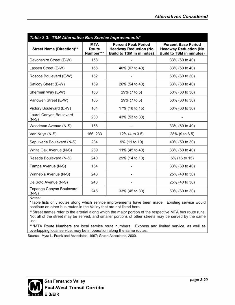
Headways, the length of time between arrivals at bus stops, would be significantly reduced onroutes contained within the TSM alternative. Table 2-3 describes the service improvementsalong TSM routes. Not all San Fernando Valley bus routes were upgraded as a part of the TSMalternative, and therefore not all currently operating San Fernando Valley bus routes are listedbelow.
TSM corridors would offer significant service improvements. Base period headways on manyroutes would be reduced from 60 minutes to 30 or 40 minutes, an improvement of 33 to 50percent. Both east-west and north-south routes would be improved, giving the Valley acomprehensive grid of higher frequency bus service. In general, the length of time between busarrivals on any route would never be more than 40 minutes. Major transit corridors wouldcontinue to be improved, with headways reduced along Sherman Way, Vanowen Street, VanNuys Boulevard, Sepulveda Boulevard, and Reseda Boulevard to 10 minutes or less during peakperiods.

Alternatives Considered
page 2-20
Table 2-3: TSM Alternative Bus Service Improvements*
Street Name (Direction)**MTA
RouteNumber***
Percent Peak PeriodHeadway Reduction (NoBuild to TSM in minutes)
Percent Base PeriodHeadway Reduction (NoBuild to TSM in minutes)
Devonshire Street (E-W) 158 - 33% (60 to 40)
Lassen Street (E-W) 168 40% (67 to 40) 33% (60 to 40)
Roscoe Boulevard (E-W) 152 - 50% (60 to 30)
Saticoy Street (E-W) 169 26% (54 to 40) 33% (60 to 40)
Sherman Way (E-W) 163 29% (7 to 5) 50% (60 to 30)
Vanowen Street (E-W) 165 29% (7 to 5) 50% (60 to 30)
Victory Boulevard (E-W) 164 17% (18 to 15) 50% (60 to 30)
Laurel Canyon Boulevard(N-S) 230 43% (53 to 30) -
Woodman Avenue (N-S) 158 - 33% (60 to 40)
Van Nuys (N-S) 156, 233 12% (4 to 3.5) 28% (9 to 6.5)
Sepulveda Boulevard (N-S) 234 9% (11 to 10) 40% (50 to 30)
White Oak Avenue (N-S) 239 11% (45 to 40) 33% (60 to 40)
Reseda Boulevard (N-S) 240 29% (14 to 10) 6% (16 to 15)
Tampa Avenue (N-S) 154 - 33% (60 to 40)
Winnetka Avenue (N-S) 243 - 25% (40 to 30)
De Soto Avenue (N-S) 243 - 25% (40 to 30)
Topanga Canyon Boulevard(N-S) 245 33% (45 to 30) 50% (60 to 30)
Notes:*Table lists only routes along which service improvements have been made. Existing service wouldcontinue on other bus routes in the Valley that are not listed here.**Street names refer to the arterial along which the major portion of the respective MTA bus route runs.Not all of the street may be served, and smaller portions of other streets may be served by the sameline.***MTA Route Numbers are local service route numbers. Express and limited service, as well asoverlapping local service, may be in operation along the same routes.
Source: Myra L. Frank and Associates, 1997; Gruen Associates, 2000.
Alternatives Considered
page 2-21
2-2.3 Bus Rapid Transit (BRT) From North Hollywood toWarner Center, the Locally Preferred Alternative
Bus Rapid Transit (BRT) represents an improvement over conventional on-street bus service.Buses would operate in an exclusive right-of-way, formerly used by the Southern PacificRailroad (SP ROW, now MTA ROW) for freight and by the Pacific Electric Red Cars onChandler Boulevard. This alternative is similar to Alternative 1 from the February 2000 MIS,with some modifications. Exclusive bus lanes in the rail right of way would remove buses fromstreet traffic, eliminating congestion delays. BRT also decreases end to end travel time bylimiting stops and implementing signal priority at intersections. Because there is no need foroverhead electrification, busways are less expensive to build and less visually intrusive than lightrail. The design of the busway and its stations will support either typical 40-foot buses or longerarticulated buses with increased capacity. Valley-wide transit service would be improved as apart of the BRT alternative. The service improvements of the TSM alternative would beimplemented, as well as additional improvements on select north-south streets that intersect thebusway. Fare prepayment would also be part of the BRT project operation.
A major advantage of operating within exclusive lanes is the consistent and relatively quick,reliable travel times that are possible when compared to on-street bus operation in congestedtraffic. Exclusive lanes and partial traffic signal priority can provide consistent travel times forpatrons using the busway. Determination of bus operating speeds is based on several factors,including the number of station stops, the number of intersection crossings, sight distances andother safety concerns, and the acceleration and deceleration curves of the buses. For thepurposes of this environmental document, an average speed of 37 miles per hour (mph) (29 mphincluding station stops and intersection delay) has been assumed. Furthermore, iIt has beenassumed that in the Chandler Boulevard median, buses would not operate faster than the postedspeed limits on the adjacent north and south roadways. Buses operating on-street would also notexceed posted speed limits.
During Preliminary Engineering, a more detailed analysis of operating speeds assumptions alongthe busway will be made was conducted in consultation with the City of Los AngelesDepartment of Transportation. Based on the more detailed analysis conducted duringPreliminary Engineering, the environmental analysis of the BRT Alternative was revised toreflect a range of operating assumptions for the BRT, specifically in terms of signal delay atintersections. Signal delay for the BRT will likely vary over time as traffic conditions and signaltechnology evolve. Therefore, this EIS/EIR addresses a range of signal delay assumptions thatare detailed in a separate technical appendix available for review at the MTA office. Transitmodel runs were conducted for a range of scenarios with varying levels of signal delay. Thelower-bound set of operating assumptions would result in a runtime of 28.8 minutes for an all-stops bus travelling from North Hollywood to Warner Center. The upper-bound set of operatingassumptions would result in a runtime of 40.0 minutes for an all-stops bus travelling from NorthHollywood to Warner Center. Buses operating on a limited-stop basis, as described in Section2-2.6.3, would require approximately 4½ minutes less to travel from North Hollywood to WarnerCenter. The average speed including all station stops and intersection delay would vary from 29mph to 21 mph. While the Final EIS/EIR analyzes the potential environmental impacts of a
Alternatives Considered
page 2-22
range of operating assumptions, the specific operating parameters would not be determined untilthe design/build phase of the BRT.
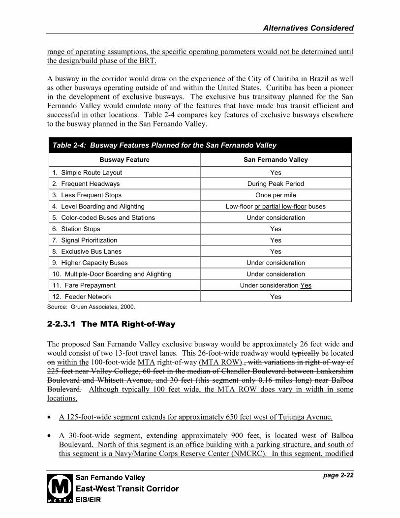
A busway in the corridor would draw on the experience of the City of Curitiba in Brazil as wellas other busways operating outside of and within the United States. Curitiba has been a pioneerin the development of exclusive busways. The exclusive bus transitway planned for the SanFernando Valley would emulate many of the features that have made bus transit efficient andsuccessful in other locations. Table 2-4 compares key features of exclusive busways elsewhereto the busway planned in the San Fernando Valley.
Table 2-4: Busway Features Planned for the San Fernando Valley
Busway Feature San Fernando Valley
1. Simple Route Layout Yes
2. Frequent Headways During Peak Period
3. Less Frequent Stops Once per mile
4. Level Boarding and Alighting Low-floor or partial low-floor buses
5. Color-coded Buses and Stations Under consideration
6. Station Stops Yes
7. Signal Prioritization Yes
8. Exclusive Bus Lanes Yes
9. Higher Capacity Buses Under consideration
10. Multiple-Door Boarding and Alighting Under consideration
11. Fare Prepayment Under consideration Yes
12. Feeder Network YesSource: Gruen Associates, 2000.
2-2.3.1 The MTA Right-of-Way
The proposed San Fernando Valley exclusive busway would be approximately 26 feet wide andwould consist of two 13-foot travel lanes. This 26-foot-wide roadway would typically be locatedon within the 100-foot-wide MTA right-of-way (MTA ROW)., with variations in right-of-way of225 feet near Valley College, 60 feet in the median of Chandler Boulevard between LankershimBoulevard and Whitsett Avenue, and 30 feet (this segment only 0.16 miles long) near BalboaBoulevard. Although typically 100 feet wide, the MTA ROW does vary in width in somelocations.
• A 125-foot-wide segment extends for approximately 650 feet west of Tujunga Avenue.
• A 30-foot-wide segment, extending approximately 900 feet, is located west of BalboaBoulevard. North of this segment is an office building with a parking structure, and south ofthis segment is a Navy/Marine Corps Reserve Center (NMCRC). In this segment, modified

Alternatives Considered
page 2-23
treatment of the right-of-way includes a 12-foot wall along the NMCRC facility property lineand a concrete barrier topped by a wire mesh fence along office building property line inorder to address the unique safety and security concerns of this segment (refer to Volume 3,Plan and Profile Drawings).
• Between Camellia Avenue and Whitsett Avenue, the MTA ROW is 60 feet wide as it runs inthe median of Chandler Boulevard.
• In some locations, the MTA ROW is approximately 225 feet wide, such as near theintersection of Fulton Avenue and Burbank Boulevard, and near Van Nuys and ResedaBoulevards.
The 100-foot-typically wide right-of-way would provide adequate room for landscaping andspace for a potential bikeway adjacent to the busway. In some locations, adjacent streets wouldbe widened into the MTA ROW in order to provide right- or left-turn pockets. Modifiedtreatment of the right-of-way would be necessary in narrower segments. A bicycle/pedestrianfacility was included in the Preliminary Engineering of the BRT Alternative, and would beconstructed with the busway. The City of Los Angeles is currently planning a bikeway as aseparate project. This proposed Class I bikeway would run from Mason Variel Avenue to WhiteOak Coldwater Canyon Avenue and would occupy approximately 22 15 feet of the 100-footright of way. In the Sepulveda Basin, the bikeway alignment would make use of existingbikeways. Along Chandler Boulevard east of Coldwater Canyon Avenue, a Class II bike lanewould be installed with the busway. Buses would be the only vehicles typically allowed withinthe transitway. Signage would be posted that would list restrictions on autos, trucks,motorcycles, bicycles, and pedestrians within the busway lanes. Emergency vehicles would onlyuse the exclusive lanes when responding to emergencies within or immediately adjacent to theright-of-way.
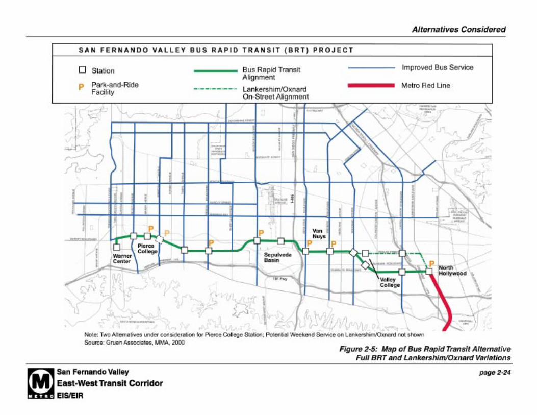
2-2.3.2 Route Alignment
The Bus Rapid Transit Alternative (Locally Preferred Alternative) primarily consists of a fixedbusway, exclusive bus lanes on the SP MTA ROW between the North Hollywood Metro Railstation and the planned Warner Center Transit Hub (see Figure 2-5). An on-street alternativealignment (weekend service option) along Lankershim Boulevard and Oxnard Street in the EastValley is described in Section 2-2.4.
In the East Valley, the alignment extends west from the North Hollywood Metro Red Linestation at Chandler and Lankershim Boulevards. (The alternatives for bus circulation at theNorth Hollywood station are described below.) The alignment continues westward in the medianof Chandler Boulevard, crossing the intersection of Fulton Avenue and Burbank Boulevarddiagonally near Valley College. The route then parallels Oxnard Street to Sepulveda Boulevard(see Figure 2-5). The alignment crosses under the I-405 in an existing underpass, entering theWest Valley.

Alternatives Considered
page 2-25
In the West Valley, the alignment continues along the northern perimeter portion of theSepulveda Flood Control Basin and Recreation Area until just after Balboa Boulevard, where itheads southwest, crossing the Los Angeles River before White Oak Avenue. The alignmentcontinues west in the SP MTA ROW, paralleling Topham Street and then Victory Boulevardafter passing Winnetka Boulevard. Near At the intersection of Victory Boulevard and De SotoVariel Avenue, the alignment leaves the SP MTA ROW and continues south on-street on VictoryBoulevard Variel Avenue to Owensmouth Avenue Oxnard Street. At Owensmouth OxnardStreet, buses would head south west on-street to a terminus at the planned Warner Center TransitHub, along Owensmouth Avenue between Erwin and Oxnard Streets, adjacent to the PromenadeShopping Mall. Buses would return to the MTA ROW via Erwin Street and Variel Avenue.
At the North Hollywood Terminus, several alternatives for access from and to the NorthHollywood Metro Rail Station (see Figure 2-6 and Figure 2-7) are under consideration for the SPROW alignment:
• Alternative 1 – Buses would use the existing bus plaza at the Metro Red Line station on theeast side of Lankershim, as shown on Figure 2-6.
• Alternative 2 - As shown on Figure 2-6, buses travelling east would leave the SP ROW atCamellia Avenue and head east along the one-way south roadway of Chandler Boulevard.Just before Lankershim Boulevard, buses would enter a bus plaza that would incorporate thehistoric Toluca rail depot. This bus plaza would operate as new station at North Hollywood.Bus patrons transferring to the Metro Red Line would cross Lankershim at grade at theintersection of Chandler (South Roadway) and Lankershim. Under consideration is a portalto the Red Line subway on the western side of Lankershim, allowing passengers to transferbetween the busway and the Metro Red Line subway without having to cross Lankershim atgrade. After depositing passengers, buses would head west of the one-way north roadway ofChandler, reentering the busway at Camellia.
Two variations of Alternative 2 are also under consideration (see Figure 2-7).
• Alternative 2a – Buses traveling east from the Laurel Canyon station would continue alongthe exclusive busway within the Chandler Boulevard median, instead of exiting the right-of-way at Camellia Avenue. The busway would pass between existing commercial andindustrial leases in the vicinity of Tujunga Avenue. The bus terminus would be locatedbetween Tujunga Avenue and Lankershim Boulevard. Passengers would get off and boardbuses near the historic Toluca Depot. Buses returning to the Laurel Canyon station wouldoperate on street along North Chandler Boulevard, reentering the SP ROW at CamelliaAvenue. Buses would layover in space accessible via the exclusive busway provided justeast of Tujunga Avenue.
• Alternative 2b – This variation is similar to Alternative 2a. However, buses would not leavethe SP ROW on the return trip west. Buses would turn within the SP ROW and proceedtoward Laurel Canyon Boulevard along the exclusive busway, again passing between theexisting commercial and industrial leases in the vicinity of Tujunga Avenue. Bus layoverspace would be provided within the exclusive busway.
• Alternative 3 – As shown on Figure 2-6, Buses would also leave the SP ROW at CamelliaAvenue, heading east on the south roadway of Chandler Boulevard. Buses would turn left


Alternatives Considered
page 2-27
(north) onto Lankershim Boulevard, and stop on the east side of Lankershim in front of theexisting Metro Red Line subway portal. After dropping off and picking up passengers, buseswould head north two blocks along Lankershim to Cumpston Street, providing enough timeand space for buses to transition from the bus stop on the right side of Lankershim to the leftturn lane. At Cumpston, buses would turn left, heading west to Tujunga Avenue. AtTujunga they would head one block south to the north roadway of Chandler Boulevard.Buses would travel on street to Camellia, where they would enter the SP ROW.
At the western end of the alignment, buses would leave the SP ROW at Variel Avenue andproceed along several potential on-street routes through Warner Center (see Section 2-2.3.5).
During the Preliminary Engineering of the BRT Alternative, the alternatives described in theDraft EIS/EIR for the eastern terminus of the alignment adjacent to the North Hollywood MetroRed Line station (see Figure 2-7 and 2-7a) were investigated and one alternative was selected forfurther refinement (see Volume 3 Plan and Profile Drawings). This alternative, calledAlternative 2c, is similar to Alternative 2b of the Draft EIS/EIR.
In Alternative 2c, buses traveling east from the Laurel Canyon station would continue along theexclusive busway within the Chandler Boulevard median, instead of exiting the right-of-way atCamellia Avenue as in Alternatives 1, 2, and 3. The busway would pass between existingcommercial and industrial uses west of Tujunga Avenue. The bus terminus would be locatedbetween Tujunga Avenue and Lankershim Boulevard. Passengers would be dropped off andpicked up along a bus turnaround north of the historic Lankershim Depot.
Buses would turn within the MTA ROW and proceed west toward Laurel Canyon Boulevardalong the exclusive busway, again passing between the existing commercial and industrial usesin the vicinity of Tujunga Avenue. Bus layover space would be provided within the exclusivebusway. The design of the turnaround developed during Preliminary Engineering would notrequire displacement of the lease at the southeast corner of Tujunga and North Chandler.However, this option has been retained in the Final EIS/EIR should MTA choose to expand thebus turnaround in the future.
Routing for on-street bus service within Warner Center is shown on Figure 2-26.
2-2.3.3 Bus Routing Plan
Figure 2-8, the Busway Routing Plan illustrates how the San Fernando Valley transit networkwill interface with the busway. As a base, the improvements associated with the TSMAlternative (Section 2-2.2) would also be implemented as part of the BRT Alternative. Inaddition, other bus service improvements would be made. Located on the busway is new end toend bus service. In addition, an existing route on Victory Boulevard is rerouted to takeadvantage of the busway. A new feeder route on Reseda also channels onto the busway. Acommuter express route from Thousand Oaks is channeled onto the busway rather thanremaining on the increasingly congested Ventura Freeway, serving selected busway stops only.
Section 2-2.6.3 provides headways and route information for new and existing lines using thebusway. The combined service frequency for all routes using the busway would vary based on


Alternatives Considered
page 2-31
ridership demand. In the immediate future, combined service frequency might result in a busevery 10 minutes during the peak hour along the right-of-way. This DEIS/DEIR Final EIS/EIRevaluates the impacts of the highest potential bus operating frequency of 2½ to 5 minutes in theyear 2020.
The BRT Alternative also includes improved headways on north-south streets. These serviceimprovements would be in addition to the TSM improvements described above. Theseadditional service improvements would facilitate the use of the busway by commuters livingoutside the immediate busway corridor. These headway improvements would be implementedon:
• Woodman Avenue• Woodley Avenue• Balboa Boulevard• Reseda Boulevard• Tampa Avenue• Winnetka Avenue• De Soto Avenue• Topanga Canyon Boulevard
Combined with the improvements associated with the TSM alternative, north-south transitservice would also be improved on Laurel Canyon Boulevard, Van Nuys Boulevard, andSepulveda Boulevard, improving service to every station planned along the busway.
2-2.3.4 Concept Design
The 26-foot wide, at-grade busway would typically be located in the center of the SP MTAROW, which is approximately 100 feet wide. The wide right-of-way provides an opportunity totake the busway beyond conventional bus network design. The busway would be more like atypical rail alignment in terms of its exclusive right-of-way and stations. Furthermore, this widthprovides adequate space for landscaped treatment such as berms, trees, fences/walls, and shrubsto buffer the busway from adjacent homes and businesses (see Figure 2-9 and Figure 2-10).
a. Urban Design Concept
The urban design concept for the right-of-way is a multi-modal transportation facility withwithin a greenway. The route would be landscaped, including trees, defining the busway andsoftening the view from residential areas. The busway concept has also been designed forflexibility. The wide right-of-way would also be maintained, and would be available to alsoaccommodate future transit enhancements such as the planned bikeway and pedestrian pathsdescribed in greater detail below. Figure 2-11 provides conceptual renderings of how thebusway and stations could look within the context of the San Fernando Valley. (Trees in thisfigure and others are shown at maturity and not at time of planting. In general, drought-tolerantground cover and native shrubs would be provided. Appendix K describes the landscape concept


Alternatives Considered
Figure 2-10: Typical Busway Sections, continued
page 2-33
Source: Gruen Associates, 2000.

Alternatives Considered
page 2-35
developed during the Preliminary Engineering phase. The landscape plans will be further refinedwith the community during design development. Station design is described in Section 2-2.3.5.
Several types and heights of fencing would be used along the corridor depending on the adjacentuses and visibility from public streets. For example, picket wire mesh fencing approximately 4to 5 feet high would be used between the busway and the planned bikeway. Taller wire meshfencing would be used at the perimeter of the right-of-way for security purposes, wherenecessary. Noise walls would be incorporated, where necessary, on top of earthen berms oradjacent to the property line, protecting sensitive users.
b. Bike Path
Between Variel and Coldwater Canyon Avenues, except through the Sepulveda Basin, space fora Class I bike path/pedestrian path would be accommodated within the MTA ROW adjacent tothe busway. This path has been developed in conjunction with the City of Los AngelesDepartment of Transportation. Through the Sepulveda Basin (between White Oak and HaskellAvenues), the proposed bicycle/pedestrian alignment would diverge from the MTA ROW andmake use of existing bicycle/pedestrian facilities. Cyclists would rejoin the MTA ROW at eitherend of the Basin. The path, which was designed together with the BRT during PreliminaryEngineering for the BRT Alternative, would typically be 15 feet wide (see Figures 9 and 10).Near BRT stations and at other locations with restricted width, the path would be 8 feet wide.The path would be separated from the busway by an approximately 4- to 5-foot-high wire meshfence. The path would be provided with lighting along most of its length, and cyclists andpedestrians would cross streets at signalized crossings. Along Chandler Boulevard east ofColdwater Canyon, Class II bike lanes would be designated along the North and South Chandlerroadways. The bike lanes would continue to the eastern terminus of the BRT at LankershimBoulevard. Separate environmental documentation for this bicycle/pedestrian facility is beingprepared.
Between Mason Avenue and White Oak Boulevards, the City of Los Angeles plans to construct abike path within the SP ROW adjacent to the busway. Although this bike path is not a part ofthis alternative, space for a continuous bike path would be provided within the right of wayadjacent to the street (Topham Street and Victory Boulevard). The busway would be locatedalongside the bike path with a 12-foot buffer between the two modes, leaving a 30 to 40-footlandscaped buffer adjacent to residential areas. Along other parts of the SP ROW, the buswayhas been designed to incorporate a potential bikeway within the right of way, with the exceptionof the Chandler Boulevard segment where bike lanes could be striped on the street.
c. Chandler Boulevard Segment
Along Chandler Boulevard in the East Valley, the SP MTA ROW is in the median, typically 60-feet wide but 100-feet wide west of Whitsett Avenue. To address community concernsexpressed in previous studies, there are two several busway cross-section options under wereconsideration considered during the development of the Major Investment Study:

Alternatives Considered
page 2-36
• Option 1 locates the 26-foot wide bus transitway in the middle of the 60-foot right-of-wayallowing for approximately 15 feet of landscaping on either side of the busway adjacent toboth sides of Chandler Boulevard (see Figure 2-12). This option was pursued forenvironmental analysis in the Draft and Final EIS/EIR. This allows most existing eucalyptusand recently planted new trees to be preserved, whenever possible and new trees to beplanted, and space for other streetscape amenities. Low Approximately 4- to 5-foot-highfencing might would be provided on either side of the busway., if needed for safetyconsiderations. As a separate project, the bikeway could Class II bike lanes would be stripedon-street next to the parking lane to accommodate the bikeway, and the street would bewidened into the north side of the median to accommodate the bikeway, where necessary to amaximum of 35 feet in each direction.
• Option 2 locates buses on Chandler Boulevard in mixed traffic and the existing medianwould be unchanged from today (see Figure 2-12). After initial consideration, this optionwas not selected for further analysis in the Draft and Final EIS/EIR due to greater noiseimpacts on adjacent sensitive uses and increased operation in congested traffic than Option 1.
Figure 2-13 shows how the busway would operate within the 100-foot-wide right-of-wayWhitsett as a part of Option 1. Twenty-four Approximately 37 total feet would be available oneither side of the busway for potential new landscaping, a bikeway, and pedestrian amenities. Asa part of the BRT Alternative, a number of pedestrian amenities would be constructed within theChandler Boulevard median. These amenities were refined and developed during thePreliminary Engineering of the BRT Alternative. Along Chandler Boulevard, all existingcrossings of the MTA ROW would be retained. On the Jewish Sabbath, pedestrian signalswould operate on a timer and would not need to be manually engaged. Two signalized mid-block crossings of the MTA ROW would be constructed along Chandler Boulevard, one atAgnes Avenue and the other at Goodland Avenue. In addition to the mid-block crossings, twopedestrian paths would be constructed within the MTA ROW paralleling portions of ChandlerBoulevard where sidewalks are not currently installed. The first pedestrian path would beconstructed in the median between Ethel and Coldwater Canyon Avenues, north of the SouthChandler roadway. The second pedestrian path would be constructed between the mid-blockcrossing at Goodland and Bellaire Avenue, south of the North Chandler roadway. In addition, apedestrian path would be constructed on the north side of the realigned North Chandler roadwaynear Ethel and the Chabad facility. Refer to Volume 3 of the Final EIS/EIR for plans of theseamenities. In addition some locations, a few feet could would be taken from both either sides ofthe median to provide extra width along Chandler Boulevard for the on-street bike lanes. Inaddition, portions of the MTA ROW at cross streets would be used to create left-turn pockets.


Alternatives Considered
page 2-39
d. Public Art and Design Excellence
Following policy established by the FTA for design and art in transit projects (Circular9400.1A), MTA commits to the idea that: “Good design and art can improve the appearance andsafety of a facility, give vibrancy to its public spaces, and make patrons feel welcome. Gooddesign and art will also contribute to the goal that transit facilities help to create livablecommunities.” To continue its commitment to these ideals, design excellence would be animportant criterion for selection of busway design team members and for evaluation of designproposals.
To ensure design excellence, the MTA would follow the award-winning model for “Excellencein Public Architecture” established by the General Services Administration of the United Statesgovernment. That process attracts large numbers of qualified design firms through a streamlinedprocess and utilizes the insight of outside peer advisors.
Public Art and the Design Process
As part of the process of designing any of the alternatives, artists would be hired to participate inthe project. MTA Metro Art staff would invite interested members of the residential, business,and institutional communities along the alignment to form a Metro Art Advisory Group. Thisprocess of community participation follows FTA policy (Circular 9400.1A), which states, “Tocreate facilities that are integral components of communities, information about the character,makeup, and history of the neighborhood should be developed and local residents and businessescould be involved in generating ideas for the project.”
A budget would be established for public art that will be based on a percentage of the hard costs(construction costs) for the project and will cover design fees and fabrication and installation ofart elements. Again, as directed by the FTA (Circular 9400.1A), “Funds spent on the artcomponent of the project should be appropriate to the overall costs of the transit project andadequate to have an impact.”
Graphics and Wayfinding
The quality of graphic signage and wayfinding within the system and within the adjacentneighborhood greatly affect the ease and comfort with which patrons use the system. Stationnames, station identification, directional signage, logos, maps, and informational signage wouldadhere to the MTA Graphics Standards. The guiding principle for the standards is to simplifyMetro signage systems in a way that makes sense for patrons, through uniformity in text styles, arational hierarchy of sign sizes, clear directional arrows, and other design elements.
Alternatives Considered
page 2-40
2-2.3.5 Transit Priority/Traffic Signals, Control, and Safety
a. Transit Priority
The City of Los Angeles Department of Transportation (LADOT) has made significant progressin developing the software and hardware that will be implemented to allow transit prioritytreatment at signalized intersections. The use of loop detectors embedded in the pavement inadvance of traffic signals will now allow the traffic signal controllers to detect a bus as a distinctobject separate from a car or truck. Demonstration projects or similar devices have beenimplemented on several arterial streets in 2000 to test the software and hardware.
There are typically three types of interaction (none of which decrease the amount of crossingtime allocated for pedestrians) between the signal system and transit system to provide the mostefficient operation for both the transit system and vehicular traffic.
• Preemption grants the right-of-way to a mass transit vehicle by interrupting the normal signalcycle sequence. (This strategy is not expected to be used in the East-West BRT project.)
• Full Priority may extend or shorten the traffic signal green indication of the transit phase.The transit phase may be a parallel vehicle phase or an independent phase. Full priority alsoallows the skipping of a traffic phase if needed to advance the required transit and/orcompatible vehicle phase. Typically the phase skipped is a low volume phase during thatperiod of time, which results in improved operations for the transit service with minimalimpact to the traffic operation. (This strategy may be considered for low volume smallerstreet crossings.)
• Partial Priority allows the traffic signal controller to advance the start (early green), or retardthe end (extend green) of the transit phase and any compatible vehicle phase. Partial Prioritydoes not skip any vehicle phase to extend or bring up early the transit phase. (This strategywill be used for most of the BRT crossings.)
The concept for the bus priority treatment along the transitway will be to locate the bus detectorsfar enough in advance of each signalized cross street so that the traffic signal system will havesufficient warning to adjust the signal phases on the cross street so that the bus will have thegreatest chance to receive a green indication when it reaches the cross street. In some cases thiswill occur by lengthening the green phase (green extend) for the transitway and the parallelstreet, and in other cases it may occur by shortening the green phase on the north-south crossstreet (early green). The proper location of the advance loop detectors will avoid abrupt changesin a signal cycle (e.g., a green phase will not be truncated prior to a specified minimum amountof time) by placing the detectors far enough in advance of the cross street so that the bustraveling at the planned speed will arrive at the cross street and have a green signal indication.
It may not be feasible to provide this same level of priority treatment for buses traveling in bothdirections, if headways become too short. In that case, the peak direction of passenger demandwould be given the higher level of priority treatment. At each cross street where there are nearbytraffic signals, the transitway will also be signalized and the buses will have their own signal

Alternatives Considered
page 2-41
indications. LADOT will also have to consider the traffic demand on north-south streets indetermining the level of priority for buses.
The BRT Station locations help determine, to some extent, the type of priority that is mostappropriate. A street crossing where the BRT station is on the far side would most likely utilizethe extended feature to assure the bus makes it through the crossing and to the station. While astreet crossing that has the station on the near side would utilize the early green feature to get thebus moving more readily.
b. Traffic Signals, Control, and Safety
Bus Rapid Transit (BRT) signals and vehicle signals will be placed at each crossing to controlthe bus, vehicle, pedestrian, and bicycle traffic at the crossing. Typically the BRT crossings willbe two-phased (BRT phase and vehicle phase) with the exception of the crossings alongChandler Boulevard, the intersection of Fulton Avenue/Burbank Boulevard, and locations wherepre-signals will be placed.
Wherever possible, the bus signals and the adjacent existing intersection signals will beintegrated to create one signalized intersection controlling both automobiles and buses. Only atthe Woodman/Oxnard intersection, where the transit corridor crosses the two streets at a diagonaloffset from the intersection, and at other mid-block locations where signals currently don’t exist,will the bus signals be offset from, but interconnected with, the adjacent traffic signals. In thoseportions of the corridor where the transitway is adjacent to and parallel to an arterial street, thebuses will typically receive a green signal indication simultaneously with the parallel street. Busoperating speeds will be slightly higher than adjacent mixed-flow traffic, but becauseintersection crossings would be controlled with signals, warning devices would not be required.The stop bar for traffic approaching the transit crossing will be located before the transit crossingso that there will not be any traffic stopped between the adjacent traffic signal and the transitcrossing. Pedestrian crossing protection will be provided at all locations permitting suchcrossings, via typical pedestrian signal heads. Pedestrians will be allocated crossing timeaccording to LADOT standards.
At locations where the BRT will run parallel and adjacent to a major roadway (e.g. VictoryBoulevard) “pre-signals” for vehicle traffic will be placed on the leg approaching the BRTcrossing to prevent vehicle queuing on the BRT right of way or between the right of way and theadjacent street. The pre-signals are placed beyond the BRT crossing with the stop bar located inadvance of the BRT crossing. The departure lanes of the intersection crossing the BRT buswaywill also be equipped with an additional traffic signal to control traffic departing the intersection.This will stop vehicles in advance of the BRT crossing and will allow the vehicles alreadybeyond the pre-signal to move through the intersection. This additional safety feature reducesthe potential of vehicles being queued on the BRT right-of-way.
A brief clearance interval will be required in the north-south signal phase to insure that novehicles are stopped on the transit crossing or between the transit crossing and the adjacent east-west street. Turn movements from the adjacent east-west street will also require separate signalphases with red arrows when the transit vehicles are crossing the north-south street. In addition,where necessary separate right turn lanes will be created to hold the vehicles in queue until the

Alternatives Considered
page 2-42
BRT vehicle passes and the right turn lane receives the green arrow. This will be necessary toprevent a left or right turn across the transitway crossing when a transit vehicle is moving inconjunction with the through traffic on the parallel arterial. The signal modifications will alsoinclude “active” No-Right-Turn indications and “Bus Coming” signs to prevent right turns acrossthe BRT crossing from parallel streets and major adjacent driveways. MTA will obtain approvalfrom appropriate state authorities for “Bus Coming” signs.
At locations where the transit corridor is located in the median of a roadway (e.g., alongChandler Boulevard), the buses will run simultaneously with the through traffic on the roadwayand left turn movements will be controlled by specially created exclusive left-turn lanes and redarrows from newly installed left turn phases at the modified signals. Along Chandler Boulevard,buses in the median as well as other east-west vehicle traffic would receive progressive greensignals. Signals would be timed so that vehicles travelling at or near the designated speed limit(35 mph) would receive consistent green lights as they proceed along Chandler Boulevard. Thismethod of synchronizing signals along a road is called “signal progression along a green band”(SPGB) By using SPGB, no additional signal priority would be necessary for the BRT alongChandler Boulevard. Table 2-5 provides a summary of the traffic control strategies at each of 3340 intersections/cross streets.
Crossing protection will be provided for pedestrians in both the median configuration and attypical street intersections with traffic signals.
Table 2-5: Traffic Control Strategies Along the San Fernando Valley East-West TransitCorridor
IntersectionStrategiesTransitway
Cross StreetTransitway Location
vis a visAdjacent Cross Street Modify
SignalNew
Signal
Comments
Tujunga Ave in median X (2) XFull priority SignalProgression along greenband on Chandler (SPGB)
Colfax Ave in median X (SPGB)Agnes Avenue in median X Pedestrian crossing only
Laurel Canyon Blvd in median XFar Side Station, extendgreen SPGB
Corteen Pl in median XFull priority or closecrossing SPGB
Whitsett Ave in median X SPGBBellaire Ave in median X Full priority SPGBGoodland Avenue in median X Pedestrian crossing onlyColdwater Canyon Ave in median X SPGBWB Chandler/ Railroad Transition from median X Full priority SPGB
Ethel Ave mid-block; not adjacent XNew stop bars Partialpriority*
Fulton Ave / Burbank Blvd Diagonal crossing XExclusive BRT phases,partial priority

Alternatives Considered
page 2-43
Table 2-5: Traffic Control Strategies Along the San Fernando Valley East-West TransitCorridor
IntersectionStrategiesTransitway
Cross StreetTransitway Location
vis a visAdjacent Cross Street Modify
SignalNew
Signal
Comments
Oxnard St/ Woodman Ave Diagonal, offset to northand east of intersection X X (2)
Complex signal phasing;extend green, partialpriority, dual stop for BRT
Hazeltine Ave/Bessemer St South of Bessemer X Partial priority
Tyrone Ave South of Bessemer X Park-and-ride access,partial priority*
Van Nuys Blvd mid-way btwn Bessemer &Aetna X (2)
Signals for transitway andPark-and-Ride access; w/bhold at station for green,e/b extend green, partialpriority
Vesper Ave mid-way btwn Bessemer &Aetna X Park-and-ride access,
partial priority*
Cedros Ave mid-way btwn Bessemer &Aetna X Park-and-Ride access
Kester Ave mid-block, not adjacent XNew stop bars, partialpriority
Sepulveda Blvd mid-block, not adjacent XW/b extend green, e/b holdat station for green, partialpriority
Haskell Ave South of Victory XAccess road to park-and-ride, no BRT crossing ofHaskell
Woodley Ave South of Victory XAdjust stop bar (s/bapproach) extend green,pre-signal, partial priority
Balboa Blvd South of Victory X X
Closely spaced separatesignals, w/b hold at stationfor green, e/b extendgreen, partial priority
White Oak Ave North of Oxnard XAdjust stop bar (s/bapproach), pre-signal,partial priority
Zelzah Avenue North of Oxnard X Pedestrian crossing ony
Lindley Ave North of Oxnard XAdjust stop bar (s/bapproach), pre-signal,partial priority
Reseda Blvd North of Oxnard X
Adjust stop bar (s/bapproach)W/b extend green, e/b holdat station for green, pre-signal, partial priority
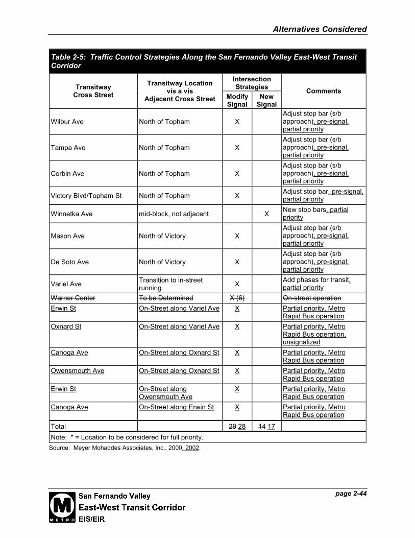
Alternatives Considered
page 2-44
Table 2-5: Traffic Control Strategies Along the San Fernando Valley East-West TransitCorridor
IntersectionStrategiesTransitway
Cross StreetTransitway Location
vis a visAdjacent Cross Street Modify
SignalNew
Signal
Comments
Wilbur Ave North of Topham XAdjust stop bar (s/bapproach), pre-signal,partial priority
Tampa Ave North of Topham XAdjust stop bar (s/bapproach), pre-signal,partial priority
Corbin Ave North of Topham XAdjust stop bar (s/bapproach), pre-signal,partial priority
Victory Blvd/Topham St North of Topham X Adjust stop bar, pre-signal,partial priority
Winnetka Ave mid-block, not adjacent X New stop bars, partialpriority
Mason Ave North of Victory XAdjust stop bar (s/bapproach), pre-signal,partial priority
De Soto Ave North of Victory XAdjust stop bar (s/bapproach), pre-signal,partial priority
Variel Ave Transition to in-streetrunning X Add phases for transit,
partial priorityWarner Center To be Determined X (6) On-street operationErwin St On-Street along Variel Ave X Partial priority, Metro
Rapid Bus operationOxnard St On-Street along Variel Ave X Partial priority, Metro
Rapid Bus operation,unsignalized
Canoga Ave On-Street along Oxnard St X Partial priority, MetroRapid Bus operation
Owensmouth Ave On-Street along Oxnard St X Partial priority, MetroRapid Bus operation
Erwin St On-Street alongOwensmouth Ave
X Partial priority, MetroRapid Bus operation
Canoga Ave On-Street along Erwin St X Partial priority, MetroRapid Bus operation
Total 29 28 14 17Note: * = Location to be considered for full priority.
Source: Meyer Mohaddes Associates, Inc., 2000, 2002.

Alternatives Considered
page 2-45
At 29 28 locations, traffic signals will need to be modified, typically to add the signal phase forthe transit vehicles crossing the roadway or intersection. Some of the modifications also entailrelocating the stop bars and providing pre-signals and clearance intervals for vehicles crossingthe transit corridor. In addition, the signal modifications will include upgrades to signalcontrollers and software to accommodate the transit priority treatment at the crossings.Consideration will be given to the use of pPre-signals and queue cutters will be used to preventtraffic from stopping or blocking the busway.
A total of 14 17 new signals will be installed at crossings where the transit signal is off-set fromthe nearest traffic signal by more than about 100 feet and it would constitute a separate signal,which would be interconnected to the adjacent traffic signal. All minor street crossingsincluding those crossing the park and ride lots adjacent to the Van Nuys station will be signalizedas part of this project. There will not be any non-signalized or stop sign controlled intersections,except when the BRT will be running on-street, such as Metro Rapid Bus in Warner Center andat the National Guard entrance from Hedges Way. The More precise signal operation plan andsignal programming details at more complex intersections will require more detailed analysis insubsequent phases of project development, be developed as part of final design. Considerationwill be given to the use of pre-signals and queue cutters to prevent traffic from stopping orblocking the busway. Two mid-block signalized pedestrian crossings on Chandler Boulevardwill also be provided; one at Agnes Avenue (just east of Laurel Canyon Boulevard), and anotherat Goodland Avenue (just east of Coldwater Canyon Avenue), as well as a signalized pedestriancrossing at Zelzah Avenue.
2-2.3.6 Station Locations and Conceptual Design
The busway alternative includes 11 new 13 station stops spaced approximately 1 mile apart, plusthe including a new bus station adjacent to the North Hollywood Metro Red Line station (seeFigure 2-6 and Figure 2-7) and the existing Warner Center Transit Hub (being planned by theCity of Los Angeles). Stations would be located at major intersections and at higher-densitylocations such as the Van Nuys Civic Center, Pierce and Valley Colleges, Warner Center, andNorth Hollywood. Park-and-ride facilities would be included at six stations, four of whichwould be new lots, one of which would be an expanded facility at Balboa Boulevard, and one ofwhich would be the existing lot at the North Hollywood Metro Red Line station.
a. Station Concept
Each station area would actually be comprised of two separate platforms along the busway, onefor eastbound travel and another for westbound travel. As refined during preliminaryengineering, each platform would be divided into two “zones,” a prepayment zone and theplatform itself. The prepayment zone would typically be located adjacent to the public street,sidewalk, kiss-and-ride, or park-and-ride facility. In this zone, patrons would purchase andvalidate tickets for the BRT, and other amenities such as bicycle racks, bicycle lockers, andtelephones would be located in this area. The other zone, encompassing the BRT platform itself,would be fenced and access would be limited to paid transit patrons.
Alternatives Considered
page 2-46
Station platforms would be able to accommodate three conventional buses or two articulatedbuses. Stations would be designed to accommodate low-floor traditional standard 40-foot or 60-foot single-articulated buses. A canopy, Canopies, for shade and shelter, would partially coverportions of the platforms, including the payment zone. The modular design of the canopy wouldallow as much or as little of the platform to be covered as would be necessary, depending onridership. The modular station design would establish a unifying theme throughout the line,giving the busway corridor a clear visual and functional impression in the context of the Valley.Site amenities such as seating, lighting, screen walls where needed, bicycle racks/lockers, andticket vending machines, may would be included at each station. Artist-designed elements,including screen walls at station entries and decorative paving of platforms, would be located atstations. Stations may may be equipped with an Advanced Travelers’ Information System(ATIS), electronic signage that would inform travelers of the wait time until the next bus andprovide other real-time transitway operating information. During preliminary engineering, amore detailed determination of station amenities will be made.
Park-and-ride facilities at six stations would provide commuters with approximately 3,000 2,900to 3,200 parking spaces in addition to the existing parking spaces at the Metro Red Line stationand at Balboa Boulevard, for a total of approximately 4,000 4,000 to 4,300 spaces. Pedestrianamenities and landscaping would be provided adjacent to the stations, as described above. Park-and-ride lots would also be landscaped. Conceptual drawings do not show all landscaping in thepark-and-ride lots in order to not obscure the underlying parking configurations.
b. Individual Stations
Table 2-6 lists the stations along the busway and the number of park-and-ride spaces.
These new, at-grade stations would be in locations that have current north-south bus routes.Characteristics of individual stations are described below. The station concept graphics in thissection provide an overview of the BRT stations in their context. Refer to Volume 3, Plan andProfile Drawings, for refinements developed during Preliminary Engineering.
North Hollywood Transit Center
The easternmost station would be located adjacent to the existing Metro Red Line NorthHollywood Station. The station would be located either at the existing bus plaza adjacent to theMetro Red Line portal, in a new bus terminus adjacent to the historic Lankershim Depot acrossfrom the existing Red Line portal, or on Lankershim Boulevard. These alternatives are Thisconcept is described in greater detail in Section 2-2.3.1. An existing 850 915 park-and-ridespaces are provided in the Metro Rail parking lot (see Figure 2-6 and Figure 2-7, Figure 2-7a,and Volume 3, Plan and Profile Drawings).
The North Hollywood terminus would be located directly north of the historic LankershimDepot. A portion of rail track along the north side of the building would be retained, and alandscaped plaza at the southeast corner of the site, being restored as part of the overall Depotrestoration, would provide access from the intersection of Lankershim Boulevard and SouthChandler Boulevard to the BRT platforms.

Alternatives Considered
page 2-47
Table 2-6: Station Attributes (Full BRT Alternative)
STATIONS PARK AND RIDE ON-STREET / BUSWAY
North Hollywood1 850 915 spaces –existing2 On-Street Busway
Laurel Canyon Boulevard - BuswayValley College (Fulton Avenue/BurbankBoulevard) - Busway
Woodman Avenue - Busway (South of Oxnard)
Van Nuys Boulevard 1060 981 spaces4 Busway
Sepulveda Boulevard 1200 1210 spaces4 Busway
Woodley Avenue - Busway
Balboa Boulevard3 240 285 spaces (150existing)4 Busway
Reseda Boulevard 400 534 spaces4 Busway
Tampa Avenue - Busway
Pierce College (Mason Avenue/VictoryBoulevard Winnetka Avenue) 350 100-389 spaces4 Busway
De Soto Avenue - BuswayWarner Center Transit Hub (OwensmouthAvenue between Erwin and Oxnard Streets) - On-Street
TOTAL SPACES:4080 4025-4314
(30802960-3249 new spaces)
Notes:(1) Park-and-ride constructed as part of the Metro Red Line, and recently restriped for more compactspaces.(2) All spaces are fully utilized at the present time. However, this park-and-ride could be expanded as apart of joint development at the Metro Red Line site.(3) LADOT existing park-and-ride.(4) Modified based on Preliminary Engineering design; see Volume 3.
Source: Gruen Associates, 2000; MTA, 2001.
Laurel Canyon Station
This station would be located within the median of Chandler Boulevard (see Figure 2-14). Streettrees planted between the left turn pocket and the main roadway would provide a buffer betweenthe stations and residences along the Boulevard. If buses along Chandler Boulevard were tooperate in mixed traffic, station platforms would be located along the curb lanes of Chandler, onthe far sides of Laurel Canyon Boulevard (with respect to the direction of traffic flow). Thestation platforms, left turn pockets, pedestrian crossings and waiting areas, the busway, and somelow landscaping would occupy approximately 300 feet of the median on the east and west sidesof Laurel Canyon Boulevard.


Alternatives Considered
page 2-49
Valley College (Fulton-Burbank) Station
A station to serve Valley College would be located at the intersection of Fulton Avenue andBurbank Boulevard (see Figure 2-15), approximately 1.5 miles from the Laurel CanyonBoulevard station. The busway would cross this intersection at a diagonal. The westboundplatform would be sited at the northwest corner of the intersection and the eastbound platformwould be site at the southeast corner. The wide right-of-way north of this station would alsoprovide room for landscaping or the preservation of existing leases potential new parking, inaddition to a potential City of Los Angeles space for a bike path.
Woodman Avenue Station
A station would be located in the SP MTA ROW, with both platforms just south Oxnard Street,east of Woodman Avenue (see Figure 2-16), about three-quarters of a mile from the ValleyCollege station. New pedestrian crosswalks would be installed, as well as landscaped edgesalong the right of way. Parking along the commercial developments along either side of theright-of-way just east of Woodman Avenue and north of Oxnard Street would be reconfiguredbut maintained. Landscaping would be provided to continue the greenway concept.
Van Nuys Transit Center
Both platforms of this station, a mile from the Woodman Avenue station, would be locatedadjacent to the Van Nuys Civic Center in the former railroad right-of-way between Aetna andBessemer Streets. Parking for up to approximately 1,040 981 cars would be possible in theformer right-of-way (see Figure 2-17 and Figure 2-18). New amenities would include a newplaza adjacent to the station platforms and kiss-and-ride facility, as well as landscaping aroundthe station and park and ride lot. Van Nuys Boulevard currently has some of the heaviest transituse in the Valley, and this station is anticipated to facilitate frequent feeder service andaccommodate a high number of transit users.
Sepulveda Transit Center
This station would be located adjacent to near the San Diego Freeway, about one mile from theVan Nuys Transit Center, and would have the capacity for approximately 1,200 1,210 cars in at aformer drive-in movie theater that is now owned by the MTA (see Figure 2-19). This station hashigh ridership potential because of its location adjacent between to the I-405 Freeway andSepulveda Boulevard. In order to be centrally located close to the park-and-ride lot, platformswould be approximately 700 feet from Sepulveda Boulevard. Lighting, landscaping, and signagewould direct bus riders transferring from buses on Sepulveda Boulevard to the station platforms.Landscaping and an 8-foot-high wall (a community enhancement) would screen the facility fromCameron Woods, the neighborhood to the north. The entire park-and-ride lot would belandscaped.

Alternatives Considered
page 2-509San Fernando ValleyEast-West Transit CorridorEIS/EIR
Figure 2-15: Valley College StationDesign Concept
Source: Gruen Associates, 2000.
Note: Refer to Figure 3-5 for typical conceptual intersection improvements.

Alternatives Considered
page 2-5150San Fernando ValleyEast-West Transit CorridorEIS/EIR
Figure 2-16: Woodman AvenueStation Design Concept
Source: Gruen Associates, 2000.
Note: Refer to Figure 3-7 for typical conceptual intersection improvements.