chapter: 18 state(s): idaho recovery unit name: southwest ... · state(s): idaho recovery unit...
TRANSCRIPT

Chapter: 18
State(s): Idaho
Recovery Unit Name: Southwest Idaho
Region 1U. S. Fish and Wildlife Service
Portland, Oregon
ii
DISCLAIMER
Recovery plans delineate reasonable actions that are believed necessary torecover and/or protect the species. Recovery plans are prepared by the U.S. Fishand Wildlife Service and, in this case, with the assistance of recovery unit teams,State and Tribal agencies, and others. Objectives will be attained and anynecessary funds made available subject to budgetary and other constraintsaffecting the parties involved, as well as the need to address other priorities.Recovery plans do not necessarily represent the views or the official positions orindicate the approval of any individuals or agencies involved in the planformulation, other than the U.S. Fish and Wildlife Service. Recovery plansrepresent the official position of the U.S. Fish and Wildlife Service only after theyhave been signed by the Director or Regional Director as approved. Approvedrecovery plans are subject to modification as dictated by new findings, changes inspecies status, and the completion of recovery tasks.
Literature Citation: U.S. Fish and Wildlife Service. 2002. Chapter 18, SouthwestIdaho Recovery Unit, Idaho. 110 p. In: U.S. Fish and Wildlife Service. Bull Trout(Salvelinus confluentus) Draft Recovery Plan. Portland, Oregon.
iii
ACKNOWLEDGMENTS
This chapter was developed with the assistance of the Southwest IdahoBull Trout Recovery Unit Team, which includes:
Dale Allen, Idaho Department of Fish and GameDave Burns, U.S. Forest ServiceTim Burton, U.S. Bureau of Land Management (formerly U.S. Forest Service)Chip Corsi, Idaho Department of Fish and GameBob Danehy, Boise CorporationJeff Dillon, Idaho Department of Fish and GameGuy Dodson, Shoshone-Paiute TribesJim Esch, U.S. Fish and Wildlife ServiceFrank Fink, Natural Resources Conservation ServiceScott Grunder, Idaho Department of Fish and GameMike Kellett, U.S. Forest ServiceTim Kennedy, Idaho Department of LandsSam Lohr, U.S. Fish and Wildlife ServiceBob Martin, Idaho Department of Fish and GameBen Matibag, U.S. Fish and Wildlife ServiceRoger Nelson, U.S. Forest ServiceDave Parrish, Idaho Department of Fish and GameFred Partridge, Idaho Department of Fish and GameRick Rieber, U.S. Bureau of ReclamationTammy Salow, U.S. Bureau of ReclamationDel Skeesick, Southwest Basin Native Fish Watershed Advisory GroupDon Smith, Alliance for the Wild RockiesBob Steed, Idaho Department of Environmental QualityChuck Warren, Idaho Department of Fish and GameRay Vizgirdas, U.S. Fish and Wildlife Service
Four problem assessments prepared under the Idaho Bull TroutConservation Plan by the Southwest Basin Native Fish Watershed AdvisoryGroup contributed to this chapter. The four problem assessments include theBoise River (Steed et al. 1998), the Deadwood, Middle Fork and South ForkPayette Rivers (Jimenez and Zaroban 1998), the Gold Fork and Squaw creekwatersheds (Steed 1999), and Weiser River (DuPont and Kennedy 2000). TheU.S. Fish and Wildlife Service acknowledges the technical groups for theSouthwest Basin Native Fish Watershed Advisory Group and numerousindividuals who participated in various meetings and discussions in developingthe problem assessments, and who are acknowledged in each assessment.

iv
SOUTHWEST IDAHO
EXECUTIVE SUMMARY
SPECIES CURRENT STATUS
The U.S. Fish and Wildlife Service issued a final rule listing the ColumbiaRiver population of bull trout as a threatened species on June 10, 1998 (63 FR31647). The Southwest Idaho Recovery Unit forms part of the range of theColumbia River population. The Southwest Idaho Recovery Unit includes theBoise River, Payette River, and Weiser River basins. Although there were likelyno historic barriers to bull trout moving among the three basins via the SnakeRiver, today bull trout occupy areas in the basins upstream unsuitable habitat anddams. The basins were included in a single recovery unit because they likelyfunctioned as a unit historically, and they collectively encompass nine keywatersheds identified in the Idaho Bull Trout Conservation Plan (Batt 1996). Allnine key watersheds are administratively addressed by a single watershedadvisory group, the Southwest Idaho Native Fish Advisory Group. However,each river basin is treated as a recovery subunit (Boise, Payette and Weisersubunits) for organization of this recovery unit chapter and because they are nowfunctionally isolated from each other.
In the Boise River Recovery Subunit, bull trout are distributed in threecore areas, all upstream of Lucky Peak Dam. The Arrowrock Core Area includesthe Boise River watersheds upstream of Arrowrock Dam, including the NorthFork Boise River, Middle Fork Boise River, and South Fork Boise Riverdownstream of Anderson Ranch Dam. The Anderson Ranch Core Area includesthe South Fork Boise River watershed upstream of Anderson Ranch Dam. TheLucky Peak Core Area includes Lucky Peak Reservoir and tributaries entering it,namely the Mores Creek watershed. Migratory and resident bull trout occur inboth the Arrowrock and Anderson Ranch core areas. In the Lucky Peak CoreArea, resident bull trout occur in the headwaters of Mores Creek and migratorybull trout occur in Lucky Peak Reservoir. It is not known whether all migratorybull trout in Lucky Peak Reservoir have been entrained from the Arrowrock CoreArea, or that some fish may be produced in the Mores Creek watershed. A totalof 31 local populations currently exist in the Boise River Recovery Subunit.
In the Payette River Recovery Subunit, bull trout are distributed in fivecore areas throughout the basin: (1) the North Fork Payette River Core Areaincludes the watershed upstream of Cascade Dam; (2) the Middle Fork PayetteRiver Core Area includes the watersheds upstream from the confluence with theSouth Fork Payette River; (3) the upper South Fork Payette River Core Areaincludes watersheds upstream of Big Falls, including the Deadwood Riverdrainage downstream of Deadwood Dam; (4) the Deadwood River Core Area
v
includes watersheds in the Deadwood River drainage upstream of DeadwoodDam; and (5) the Squaw Creek Core Area includes watersheds in Squaw Creekupstream from its confluence with the Payette River. Bull trout in these coreareas are primarily resident fish, with relatively low numbers of migratory fishexisting in some areas (e.g., Middle Fork Payette River, South Fork PayetteRiver, and Deadwood Reservoir). A total of 18 local populations currently existin the Payette River Recovery Subunit.
The Weiser River Recovery Subunit consists of a single core area, whichincludes watersheds upstream of and including the Little Weiser River. Bull troutin the Weiser River Core Area are thought to consist only of resident fish. A totalof five local populations currently exist in the Weiser River Recovery Subunit.
HABITAT REQUIREMENTS AND LIMITING FACTORS
A detailed discussion of bull trout biology and habitat requirements isprovided in Chapter 1 of this recovery plan. The limiting factors discussed hereare specific to the Willamette Recovery Unit Chapter. Habitat fragmentation anddegradation are likely the most limiting factors for bull trout throughout theSouthwest Idaho Recovery Unit. Although reservoirs formed by dams in somebasins have allowed bull trout to express adfluvial life histories, dams, irrigationdiversions, and road crossings have formed impassable barriers to fish movementwithin the basins, further fragmenting habitats and isolating bull trout. Landmanagement activities that degrade aquatic and riparian habitats by alteringstream flows and riparian vegetation, such as water diversions, past and currentmining operations, timber harvest and road construction, and improper grazingpractices, have negatively affected bull trout in several areas of the recovery unit. Bull trout are also subject to negative interactions with nonnative brook trout insome streams.
RECOVERY GOALS AND OBJECTIVES
The goal of the bull trout recovery plan is to ensure the long-termpersistence of self-sustaining, complex, interacting groups of bull troutdistributed throughout the species’ native range, so that the species can bedelisted. To achieve this goal the following objectives have been identified forbull trout in the Southwestern Idaho Recovery Unit:
< Maintain current distribution of bull trout and restore distribution inpreviously occupied areas within the Southwest Idaho Recovery Unit.
< Maintain stable or increasing trends in abundance of bull trout.

vi
< Restore and maintain suitable habitat conditions for all bull trout lifehistory stages and strategies.
< Conserve genetic diversity and provide opportunity for genetic exchange.
RECOVERY CRITERIA
Recovery criteria for the Southwestern Idaho Recovery Unit areestablished to assess whether actions are resulting in the recovery of bull trout inthe basin. The criteria developed for bull trout recovery address quantitativemeasurements of bull trout distribution and population characteristics on arecovery unit basis.
1. Maintain current distribution of bull trout in the 54 local populationsidentified, and expand distribution by establishing bull trout localpopulations in areas identified as potential spawning and rearinghabitat. The number of existing local populations by recovery subunitand core area are: Boise River Recovery Subunit, 31 existing localpopulations; Payette River Recovery Subunit, 18 existing localpopulations; and 5 in Weiser River Recovery Subunit. Achievingcriterion 1 entails maintaining existing local populations and encouragingthe establishment of additional bull trout local populations in potentialspawning and rearing habitat in all core areas of the recovery unit. Establishing at least one new local population each in the Lucky Peak,Middle Fork Payette River, North Fork Payette River, Squaw Creek, andWeiser River core areas is necessary to achieve criterion 1, if evaluationsindicate that it is feasible in a specific core area.
2. Estimated abundance of adult bull trout is at least 17,600 individualsin the Southwest Idaho Recovery Unit. The recovered abundance ofadult bull trout for the recovery unit was estimated based on professionaljudgement of the recovery unit team in consideration of surveyed fishdensities, habitats, and potential fish production after threats have beenaddressed. The recovered abundance of adult bull trout by recoverysubunit and core area are: Boise River Recovery Subunit, at least 10,100bull trout; Payette River Recovery Subunit, at least 7,000 bull trout; and atleast 500 in Weiser River Recovery Subunit.
3. Adult bull trout exhibit stable or increasing trends in abundance inthe Southwest Idaho Recovery Unit.
4. Specific barriers to bull trout migration in the Southwest IdahoRecovery Unit have been addressed. Many barriers to bull troutmigration exist within the recovery unit, and this recovery plan

vii
recommends several tasks to identify, assess, and reduce barriers to bulltrout passage. Although achieving criteria 1 through 3 is expected todepend on providing passage at barriers (including barriers due to physicalobstructions, unsuitable habitat, and water quality) throughout all coreareas in the recovery unit, the intent of criterion 4 is to note specificbarriers to address or tasks that must be performed to achieve recovery(i.e., evaluated and appropriately addressed if found to be feasible). Activities necessary to fulfill this criterion for each recovery subunitinclude: continuing to provide passage (e.g., using the existing trap-and-haul program) of bull trout at Arrowrock Dam (task 1.4.2) and identifying,assessing, and remedying potential passage barriers in the Lucky PeakCore Area (task 1.2.4) in the Boise River Recovery Subunit; addressingpassage at the Gold Fork River irrigation diversion (task 1.2.3) andidentifying, assessing, and remedying potential passage barriers in theSquaw Creek and North Fork Payette River Core Areas (tasks 1.2.2, 1.2.3,and 1.2.4) in the Payette River Recovery Subunit; and identifying,assessing, and remedying potential passage barriers in the Weiser Rivercore area (tasks 1.2.1 and 1.2.2). Tasks intended to assess the feasibilityof providing passage should be conducted with coordinated review duringimplementation with the U.S. Fish and Wildlife Service.
ACTIONS NEEDED
Recovery for bull trout in the Southwest Idaho Recovery Unit will entailreducing threats to the long-term persistence of populations and their habitats,ensuring the security of multiple interacting groups of bull trout, and providingaccess to habitat conditions that allows for the expression of various life-historyforms. Seven categories of actions needed are discussed in Chapter 1; tasksspecific to this recovery unit are provided in this chapter.
ESTIMATED COST OF RECOVERY
The estimated cost of bull trout recovery in the Southwest Idaho RecoveryUnit is $7 million spread over a 25-year period. This estimate does not includecosts associated with some activities (e.g., capital improvements for fish passageand protection) for which the feasibility and design options are the outcomes ofrecommended tasks in this chapter, nor does this estimate include costs for tasksthat are normal agency responsibilities under existing authorities. Total costsinclude estimates of expenditures by local, Tribal, State, and Federal governmentsand by private business and individuals. Successful recovery of bull trout in theSouthwest Idaho River Recovery Unit is contingent on removing barriers,improving habitat conditions, providing fish passage, and removal of nonnativespecies. These costs are attributed to bull trout conservation, but other aquaticspecies will also benefit.

viii
ESTIMATED DATE OF RECOVERY
Time required to achieve recovery depends on bull trout status, factorsaffecting bull trout, implementation and effectiveness of recovery tasks, andresponses to recovery tasks. A tremendous amount of work will be required torestore impaired habitat, reconnect habitat, and eliminate threats from nonnativespecies. Three to five bull trout generations (15 to 25 years), or possibly longer,may be necessary before identified threats to the species can be significantlyreduced and bull trout can be considered eligible for delisting.
ix
TABLE OF CONTENTS
DISCLAIMER . . . . . . . . . . . . . . . . . . . . . . . . . . . . . . . . . . . . . . . . . . . . . . . . . . . ii
ACKNOWLEDGMENTS . . . . . . . . . . . . . . . . . . . . . . . . . . . . . . . . . . . . . . . . . . iii
EXECUTIVE SUMMARY . . . . . . . . . . . . . . . . . . . . . . . . . . . . . . . . . . . . . . . . . iv
TABLE OF CONTENTS . . . . . . . . . . . . . . . . . . . . . . . . . . . . . . . . . . . . . . . . . . . ix
INTRODUCTION . . . . . . . . . . . . . . . . . . . . . . . . . . . . . . . . . . . . . . . . . . . . . . . . . 1Recovery Unit Designation . . . . . . . . . . . . . . . . . . . . . . . . . . . . . . . . . . . . 1Geographic Description . . . . . . . . . . . . . . . . . . . . . . . . . . . . . . . . . . . . . . . 2
DISTRIBUTION AND ABUNDANCE . . . . . . . . . . . . . . . . . . . . . . . . . . . . . . . . 7Status of Bull Trout at the Time of Listing . . . . . . . . . . . . . . . . . . . . . . . . 7Current Distribution and Abundance . . . . . . . . . . . . . . . . . . . . . . . . . . . . . 7
REASONS FOR DECLINE . . . . . . . . . . . . . . . . . . . . . . . . . . . . . . . . . . . . . . . . 12Dams . . . . . . . . . . . . . . . . . . . . . . . . . . . . . . . . . . . . . . . . . . . . . . . . . . . . 12Forest Management Practices . . . . . . . . . . . . . . . . . . . . . . . . . . . . . . . . . 15Livestock Grazing . . . . . . . . . . . . . . . . . . . . . . . . . . . . . . . . . . . . . . . . . . 19Agricultural Practices . . . . . . . . . . . . . . . . . . . . . . . . . . . . . . . . . . . . . . . 20Transportation Networks . . . . . . . . . . . . . . . . . . . . . . . . . . . . . . . . . . . . . 21Mining . . . . . . . . . . . . . . . . . . . . . . . . . . . . . . . . . . . . . . . . . . . . . . . . . . . 23Residential Development and Urbanization . . . . . . . . . . . . . . . . . . . . . . 24Fisheries Management . . . . . . . . . . . . . . . . . . . . . . . . . . . . . . . . . . . . . . . 24Isolation and Habitat Fragmentation . . . . . . . . . . . . . . . . . . . . . . . . . . . . 26
ONGOING RECOVERY UNIT CONSERVATION MEASURES . . . . . . . . . . 29
STRATEGY FOR RECOVERY . . . . . . . . . . . . . . . . . . . . . . . . . . . . . . . . . . . . . 32Recovery Goals and Objectives . . . . . . . . . . . . . . . . . . . . . . . . . . . . . . . . 47Recovery Criteria . . . . . . . . . . . . . . . . . . . . . . . . . . . . . . . . . . . . . . . . . . . 50
ACTIONS NEEDED . . . . . . . . . . . . . . . . . . . . . . . . . . . . . . . . . . . . . . . . . . . . . . 54Recovery Measures Narrative . . . . . . . . . . . . . . . . . . . . . . . . . . . . . . . . . 54
IMPLEMENTATION SCHEDULE . . . . . . . . . . . . . . . . . . . . . . . . . . . . . . . . . . 76
REFERENCES CITED . . . . . . . . . . . . . . . . . . . . . . . . . . . . . . . . . . . . . . . . . . . . 88
x
Appendix A. Summary of bull trout information for environmental baselines inbiological assessments by the Boise National Forest. . . . . . . . . . . . . . . . 95
Appendix B. Waters within the Southwest Idaho Recovery Unit appearing onIdaho’s 1998 303(d) list (IDEQ 1998). . . . . . . . . . . . . . . . . . . . . . . . . . 103
Appendix C. List of Chapters . . . . . . . . . . . . . . . . . . . . . . . . . . . . . . . . . . . . . . 110
LIST OF FIGURES
Figure 1. Bull trout recovery units in the United States. The Southwest IdahoRecovery Unit is highlighted. . . . . . . . . . . . . . . . . . . . . . . . . . . . . . . . . . . 1
Figure 2. Boise River Recovery Subunit showing the locations of the Arrowrock,Anderson Ranch, and Lucky Peak Core Areas (see Table 4). . . . . . . . . . 35
Figure 3. Arrowrock Core Area (Boise River Recovery Subunit) showing thelocations of local populations and areas with potential spawning andrearing habitat (see Table 4). . . . . . . . . . . . . . . . . . . . . . . . . . . . . . . . . . . 36
Figure 4. Anderson Ranch Core Area (Boise River Recovery Subunit) showingthe locations of local populations and areas with potential spawning andrearing habitat (see Table 4). . . . . . . . . . . . . . . . . . . . . . . . . . . . . . . . . . . 37
Figure 5. Lucky Peak Core Area (Boise River Recovery Subunit) showing thelocation of the local population (see Table 4). . . . . . . . . . . . . . . . . . . . . . 38
Figure 6. Payette River Recovery Subunit showing the locations of the upperSouth Fork Payette River, Deadwood River, Middle Fork Payette River,North Fork Payette River, and Squaw Creek Core Areas (see Table 6). . 39
Figure 7. Upper South Fork Payette River Core Area (Payette River RecoverySubunit) showing the locations of local populations and areas withpotential spawning and rearing habitat (see Table 4). . . . . . . . . . . . . . . . 40
Figure 8. Deadwood River Core Area (Payette River Recovery Subunit) showingthe locations of local populations and areas with potential spawning andrearing habitat (see Table 4). . . . . . . . . . . . . . . . . . . . . . . . . . . . . . . . . . . 41
Figure 9. Middle Fork Payette River Core Area (Payette River RecoverySubunit) showing the locations of local populations and areas withpotential spawning and rearing habitat (see Table 4). . . . . . . . . . . . . . . . 42

xi
Figure 10. North Fork Payette River Core Area (Payette River Recovery Subunit)showing the locations of local populations and areas with potentialspawning and rearing habitat (see Table 4). . . . . . . . . . . . . . . . . . . . . . . 43
Figure 11. Squaw Creek Core Area (Payette River Recovery Subunit) showingthe locations of local populations and areas with potential spawning andrearing habitat (see Table 4). . . . . . . . . . . . . . . . . . . . . . . . . . . . . . . . . . . 44
Figure 12. Weiser River Recovery Subunit showing the location of the WeiserRiver Core Area (see Table 4). . . . . . . . . . . . . . . . . . . . . . . . . . . . . . . . . 45
Figure 13. Weiser River Creek Core Area (Weiser River Recovery Subunit)showing the locations of local populations and areas with potentialspawning and rearing habitat (see Table 4). . . . . . . . . . . . . . . . . . . . . . . 46
LIST OF TABLES
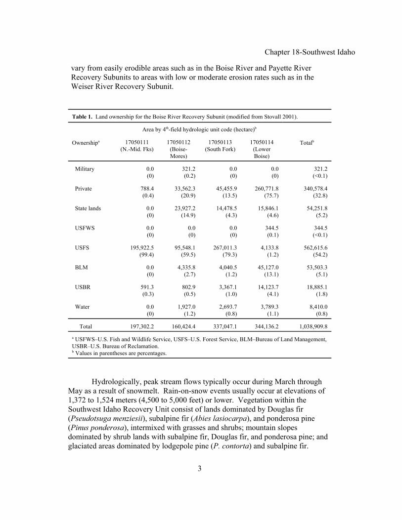
Table 1. Land ownership for the Boise River Recovery Subunit (modified from Stovall 2001). . . . . . . . . . . . . . . . . . . . . . . . . . . . . 3
Table 2. Land ownership for the Payette River Recovery Subunit (modified from Stovall 2001). . . . . . . . . . . . . . . . . . . . . . . . . . . . . 4
Table 3. Land ownership for the Weiser River Recovery Subunit (modified from Stovall 2001). . . . . . . . . . . . . . . . . . . . . . . . . . . . . 5
Table 4. Recovery subunits, core areas, local populations, and currently unoccupied potential spawning and rearing habitat in the
Southwest Idaho Recovery Unit, Idaho. . . . . . . . . . . . . . . . . . . . 33
Table 5. Summary of values for recovery criteria in the Southwest Idaho Recovery Unit . . . . . . . . . . . . . . . . . . . . . . . . . . . . . . . . . . . . . . . 53

Chapter 18-Southwest Idaho
1
Figure 1. Bull trout recovery units in the United States. The Southwest IdahoRecovery Unit is highlighted.
INTRODUCTION
Recovery Unit Designation
The Southwest Idaho Recovery Unit is one of 22 recovery unitsdesignated for bull trout in the Columbia River basin (Figure 1). This recoveryunit includes the Boise, Payette, and Weiser rivers. Although there were likely nobarriers to bull trout moving among the three river basins via the Snake Riverhistorically, today bull trout occupy areas in the basins upstream of dams anduninhabitable areas. The basins were included in a single recovery unit becausethey likely functioned as a unit historically, and they collectively encompass ninekey watersheds identified in the Idaho Bull Trout Conservation Plan (Batt 1996). All nine key watersheds are administratively addressed by a single watershedadvisory group, the Southwest Idaho Native Fish Advisory Group. However,each river basin is treated as a recovery subunit for organization of this recoveryunit chapter and because they are now functionally isolated from each other.

Chapter 18-Southwest Idaho
2
Geographic Description
The Boise River, Payette River, and Weiser rivers are tributaries to theSnake River, which are entirely within the State of Idaho. The river basinsencompass about 2,323,826 hectares (5,742,174 acres) in southwestern Idaho. The Boise River basin contains the largest area (1,038,910 hectares [2,567,147acres]), followed by the Payette River basin (855,393 hectares [2,113,676 acres]),and the Weiser River basin (429,523 hectares [1,061,351 acres]). The threebasins flow south to southwest from mountains in central Idaho. Elevations of thebasins range from over 3,048 meters (10,000 feet) in the Sawtooth Mountains to802 meters (2,631 feet) near the confluence of the Weiser River with the SnakeRiver.
The Southwest Idaho Recovery Unit includes the largest metropolitan areain Idaho, Boise, and the surrounding towns. However, the remainder of therecovery unit is largely rural. Most of the areas currently supporting bull trout inthe recovery unit occur on Federal lands (e.g., Boise National Forest, PayetteNational Forest, and Sawtooth National Forest). In the Boise River RecoverySubunit, over half of the entire area (59.3 percent) is administered by the U.S.Forest Service and Bureau of Land Management (Table 1). A similar percentageof the area in the Payette River Recovery Subunit (56.3 percent) is also managedby the two agencies (Table 2). In the Weiser River Recovery Subunit, about halfof the entire area is under private ownership and 43.4 percent is managed by theU.S. Forest Service and Bureau of Land Management (Table 3). In the BoiseRiver Recovery Subunit, headwaters of the Middle Fork Boise River and NorthFork Boise River occur in designated wilderness areas. In the Payette RiverRecovery Subunit, headwaters of the South Fork Payette River and Middle ForkPayette River occur in designated wilderness areas. Forty roadless areas occur onU.S. Forest Service lands in the recovery unit (Stovall 2001).
The Southwest Idaho Recovery Unit has an upland continental climate. Infrequent, but intense, thunderstorms occur during summer and rainfall increasesin the fall. November and December are usually the wettest months of the year. Average annual precipitation in the Boise River basin is 508 to 1,270 millimeters(20 to 50 inches) (Steed et al. 1998). Based on Snotel (snow telemetry) stationsaround the basin, the maximum snowfall would be over 1,016 millimeters (40inches) snow water equivalents in the mountains, and the minimum would beunder 381 millimeters (15 inches) in the western portion of the recovery unit.
Geology of the Southwest Idaho Recovery Unit consists primarily ofbasalt, Idaho batholith, and other granitic formations (Jimenez and Zaroban 1998;Steed et al. 1998; Steed 1999; DuPont and Kennedy 2000). Natural erosion rates
Chapter 18-Southwest Idaho
3
vary from easily erodible areas such as in the Boise River and Payette RiverRecovery Subunits to areas with low or moderate erosion rates such as in theWeiser River Recovery Subunit.
Table 1. Land ownership for the Boise River Recovery Subunit (modified from Stovall 2001).
Ownershipa
Area by 4th-field hydrologic unit code (hectare)b
Totalb17050111(N.-Mid. Fks)
17050112(Boise-Mores)
17050113(South Fork)
17050114(LowerBoise)
Military 0.0(0)
321.2(0.2)
0.0(0)
0.0(0)
321.2(<0.1)
Private 788.4(0.4)
33,562.3(20.9)
45,455.9(13.5)
260,771.8(75.7)
340,578.4(32.8)
State lands 0.0(0)
23,927.2(14.9)
14,478.5(4.3)
15,846.1(4.6)
54,251.8(5.2)
USFWS 0.0(0)
0.0(0)
0.0(0)
344.5(0.1)
344.5(<0.1)
USFS 195,922.5(99.4)
95,548.1(59.5)
267,011.3(79.3)
4,133.8(1.2)
562,615.6(54.2)
BLM 0.0(0)
4,335.8(2.7)
4,040.5(1.2)
45,127.0(13.1)
53,503.3(5.1)
USBR 591.3(0.3)
802.9(0.5)
3,367.1(1.0)
14,123.7(4.1)
18,885.1(1.8)
Water 0.0(0)
1,927.0(1.2)
2,693.7(0.8)
3,789.3(1.1)
8,410.0(0.8)
Total 197,302.2 160,424.4 337,047.1 344,136.2 1,038,909.8
a USFWS–U.S. Fish and Wildlife Service, USFS–U.S. Forest Service, BLM–Bureau of Land Management,USBR–U.S. Bureau of Reclamation.b Values in parentheses are percentages.
Hydrologically, peak stream flows typically occur during March throughMay as a result of snowmelt. Rain-on-snow events usually occur at elevations of1,372 to 1,524 meters (4,500 to 5,000 feet) or lower. Vegetation within theSouthwest Idaho Recovery Unit consist of lands dominated by Douglas fir(Pseudotsuga menziesii), subalpine fir (Abies lasiocarpa), and ponderosa pine(Pinus ponderosa), intermixed with grasses and shrubs; mountain slopesdominated by shrub lands with subalpine fir, Douglas fir, and ponderosa pine; andglaciated areas dominated by lodgepole pine (P. contorta) and subalpine fir.

Chapter 18-Southwest Idaho
4
Table 2. Land ownership for the Payette River Recovery Subunit (modified from Stovall 2001).
Ownershipa
Area by 4th-field hydrologic unit code (hectare)b
Totalb17050120
(South Fork)17050121
(Middle Fork)17050122(Payette)
17050123(North Fork)
Military 0.0(0)
0.0(0)
0.0(0)
0.0(0)
0.0(0)
Private 3,158.6(1.5)
6,128.1(7.0)
186,920.9(58.2)
91,651.5(38.8)
287,859.2(33.7)
State lands 842.3(90.4)
4,289.7(4.9)
19,912.5(6.2)
29,999.3(12.7)
55,043.9(6.4)
USFWS 0.0(0)
0.0(0)
0.0(0)
0.0(0)
0.0(0)
USFS 197,728.5(93.9)
71,261.4(81.4)
45,285.0(14.1)
97,793.1(41.4)
412,068.0(48.2)
BLM 631.7(0.3)
1,838.4(2.1)
65,839.8(20.5)
2,362.2(1.0)
70,672.1(8.3)
USBR 6,738.4(3.2)
4,027.1(4.6)
1,284.7(0.4)
236.2(0.1)
12,286.3(1.4)
Water 1,684.6(0.8)
0.0(0)
1,605.8(0.5)
14,172.9(6.0)
17,463.4(2.0)
Total 210,784.1 87,544.7 320,848.8 236,215.3 855,392.8
a USFWS–U.S. Fish and Wildlife Service, USFS–U.S. Forest Service, BLM–Bureau of Land Management,USBR–U.S. Bureau of Reclamation.b Values in parentheses are percentages.
Fish Species. Within the Southwest Idaho Recovery Unit, anadromous fishes(i.e., chinook salmon (Oncorhynchus tshawytscha), steelhead (O. mykiss), and perhapsPacific lamprey (Lampetra tridentata)) historically occurred in each of the three riverbasins; the Payette River basin contained the only sockeye salmon (O. nerka) in theupper Snake River basin (Stovall 2001). Construction of impassable dams, first withinthe basins and later downstream from the confluences of the three basins in the SnakeRiver, eliminated natural runs of anadromous fishes from the recovery unit. The lossof these runs and associated nutrients derived from their carcasses is thought to havenegatively affected resident fishes by reducing overall watershed productivity.

Chapter 18-Southwest Idaho
5
Table 3. Land ownership for the Weiser River Recovery Subunit (modified fromStovall 2001).
OwnershipaArea by hydrologic unit code
17050111 (hectare)b
(Weiser)
Military 0.0(0)
Private 215,836.5(50.3)
State lands 25,367.2(5.9)
USFWS 0.0(0)
USFS 122,966.6(28.6)
BLM 63,633.1(14.8)
USBR 430.0(0.1)
Water 1,289.9(0.3)
Total 429,523.3
a USFWS–U.S. Fish and Wildlife Service, USFS–U.S. Forest Service, BLM–Bureauof Land Management, USBR–U.S. Bureau of Reclamation.b Values in parentheses are percentages.
In the Boise River Recovery Subunit, bull trout found in headwater drainagestend to be associated with fish assemblages of low species richness (Steed et al. 1998). These assemblages generally consist of bull trout, rainbow-redband trout(Oncorhynchus mykiss), and sculpin (Cottus bairdi, C. confusus). In mainstem riverand reservoir areas downstream, the fish assemblage is more diverse and includesnative species such as mountain whitefish (Prosopium williamsoni), northernpikeminnow (Ptychocheilus oregonensis), redside shiner (Richardsonius balteatus),and several sucker (Catostomus spp.) and dace (Rhinichthys spp.) species. In additionto hatchery rainbow trout (Oncorhynchus. mykiss) and planted chinook salmon, sixintroduced species are present in the basin; westslope cutthroat trout (O. clarki lewisi),kokanee (O. nerka), brook trout (Salvelinus fontinalis), smallmouth bass (Micropterusdolomieui), yellow perch (Perca flavescens), and brown bullhead (Ictalurusnebulosus).

Chapter 18-Southwest Idaho
6
In the Payette River Recovery Subunit and Weiser River Recovery Subunit,extant native salmonids are bull trout, redband trout, and mountain whitefish (Steed1999; DuPont and Kennedy 2000; Stovall 2001). Other salmonids, hatchery rainbowtrout, cutthroat trout, brook trout, and brown trout (Salmo trutta) have been stocked,with stocking dating to the turn of the century. Stocking of rainbow trout, cutthroattrout, and brown trout occurs in some alpine lakes, such as in the Gold Fork River watershed. Other introduced species in therecovery subunits include such species as smallmouth bass, channel catfish (Ictaluruspunctatus), and common carp (Cyprinus carpio).

Chapter 18-Southwest Idaho
7
DISTRIBUTION AND ABUNDANCE
Status of Bull Trout at the Time of Listing
In the final listing rule (63 FR 31647) the U.S. Fish and Wildlife Serviceidentified two bull trout subpopulations in the Boise River basin (ArrowrockReservoir and Anderson Ranch Reservoir), four in the Payette River basin (BlackCanyon Reservoir, South Fork-Middle Fork Payette River, Deadwood Reservoir,and North Fork Payette River), and two in the Weiser River basin (Little WeiserRiver and East Fork Weiser River) (U.S. Fish and Wildlife Service (USFWS) 1998). Subpopulations were isolated by impassable dams and unsuitable habitat.
At the time of listing (June 1998), insufficient information was available todetermine the status (depressed or strong) or trend (increasing, decreasing, stable) ofthe 8 subpopulations (USFWS 1998). The East Fork Weiser River and North ForkPayette River subpopulations were considered to be at risk of extirpation due tonatural events. The U.S. Fish and Wildlife Service considered dams (2subpopulations), forestry (5 subpopulations), grazing (4 subpopulations), waterquality (5 subpopulations), and introduced species (5 subpopulations) to be threats tothe 8 bull trout subpopulations in the Boise River, Payette River, and Weiser Riverbasins (USFWS 1998). The magnitude of threats was considered high for 4subpopulations and threats were considered imminent for 7 subpopulations. Although subpopulations were an appropriate unit upon which to base the 1998listing decision, the recovery plan has revised the biological terminology to betterreflect the current understanding of bull trout life history and conservation biologytheory. Therefore, subpopulation terms will not be used in this chapter.
Current Distribution and Abundance
Federal and State resource agencies have documented the occurrence of bulltrout throughout the Southwest Idaho Recovery Unit (e.g., Rieman and McIntyre1995; Corley 1997; Dunham and Rieman 1999; Salow 2001). Distribution of bulltrout in the recovery unit comes primarily from presence-absence surveys and basin-wide surveys using electrofishing and snorkeling techniques. Comprehensive dataon bull trout abundance through time in the recovery unit does not exist.
Boise River Recovery Subunit. In the Boise River Recovery Subunit, threelarge dams are impassable barriers to upstream fish movement: Anderson RanchDam on the South Fork Boise River, and Arrowrock Dam and Lucky Peak Dam onthe mainstem Boise River. Fish in Anderson Ranch Reservoir have access to theSouth Fork Boise River upstream of the dam. Fish in Arrowrock Reservoir haveaccess to the North Fork Boise River, Middle Fork Boise River, and lower South

Chapter 18-Southwest Idaho
8
Fork Boise River. The upstream portion of Lucky Peak Reservoir is adjacent to thebase of Arrowrock Dam. The largest tributary to Lucky Peak Reservoir is MoresCreek, in which bull trout inhabit the headwaters (T. Burton, Boise National Forest,in litt. 2000; Boise National Forest, in litt. 2002). Upstream of Arrowrock Dam, bulltrout have been found in 37 subwatersheds (i.e., 6th-field HUCs) and not detected in29 others with apparent suitable habitat for spawning and rearing (Steed et al. 1998).
Bull trout abundance has been estimated in both Arrowrock Reservoir andAnderson Ranch Reservoir. During 1996 through 1997, abundance of adultmigratory bull trout (i.e., fish greater than 300 millimeters (11.8 inches) total length)in Arrowrock Reservoir was estimated at 471 individuals (95 percent confidenceintervals were 389 through 590) (Flatter 1998). Mean total length of bull trout was405 millimeters (standard error was 4.2 millimeters) (15.9 inches, standard error 0.2inches). The estimate of adult bull trout abundance in 1998 was 354 individuals (95percent confidence intervals were 133 through 575) with a mean total length of 387millimeters (standard error was 8.6 millimeters) (15.2 inches, standard error 0.3inches) (R. Rieber, U.S. Bureau of Reclamation (USBR), pers. comm. 2001). During 1999 through 2000, abundance of adult migratory bull trout in AndersonRanch Reservoir was estimated at 368 individuals (95 percent confidence intervalswere 282 through 454) (Partridge 2000a). Range in total length of fish was 220through 740 millimeters (8.7 through 29.1 inches).
The abundance of post-spawning adult bull trout that used the North ForkBoise River was estimated using numbers of bull trout marked at a weir in the NorthFork Boise River during 1999 and recaptured at the weir in 2000 (Salow 2001). Theestimate was 969 individuals (standard deviation was 228), and is biased because itdoes not account for such factors as varying mortality rates between years,recruitment of juveniles to spawners, straying, and individuals that may spawn inalternate years. Salow (2001) evaluated the effects of hypothetical spawnerrecruitment and tag loss rates on the abundance estimate and found that both factors,individually and combined, lower the estimate. For instance, post-spawning adultabundance was 385 individuals when a 60 percent immigration (i.e., due tomaturation of juvenile bull trout) rate was tested.
Payette River Recovery Subunit. In the Payette River Recovery Subunit,Deadwood Dam created Deadwood Reservoir and forms an impassible barrier to fishmovement. Bull trout in the upper Deadwood River and Deadwood Reservoir areisolated from fish in the lower Deadwood River and the South Fork Payette Riverwatersheds. Bull trout in the South Fork Payette River may be able to interact withfish in the Middle Fork Payette River, but a waterfall on the South Fork PayetteRiver (Big Falls) may be a barrier to fish movement (Jimenez and Zaroban 1998). Bull trout inhabiting the North Fork Payette River drainage occur in Gold Fork

Chapter 18-Southwest Idaho
9
River, and are isolated upstream of Cascade Dam and Reservoir, and a diversiondam in the lower Gold Fork River (Steed 1999). Bull trout also occur in North ForkLake Fork Creek in the North Fork Payette River drainage, but likely in very lowabundance (R. Nelson, Payette National Forest, pers. comm.. 2002). Bull trout alsooccur in headwater reaches of a tributary to the Payette River at Black CanyonReservoir, Squaw Creek. Bull trout in Squaw Creek are likely isolated from otherbull trout in the Payette River basin by irrigation diversions and perhaps high watertemperatures (Burton 1999c).
Upstream of Deadwood Dam, spawning and rearing habitat occurs intributaries to the headwater portion of the upper Deadwood River, Deer Creek, andTrail Creek (Burton 1999b). Resident and migratory bull trout occur upstream ofDeadwood Reservoir, however, the abundance of migratory fish is considered lowbased on observations of large fish in Trail Creek. The U.S. Forest Service estimatesthat about 1,160 bull trout reside in the drainage upstream of Deadwood Dam(Burton 1999b; Appendix A), and considers the bull trout population in the upperDeadwood River “weak” (i.e., less than 1,500 individuals) and at high risk ofextirpation. Low bull trout abundance appears to be related to loss of migratoryindividuals, isolation, past rotenone treatments, fragmented habitats, and high levelsof sedimentation.
In the South Fork Payette River drainage, which includes the DeadwoodRiver downstream of Deadwood Dam, bull trout spawning and rearing is known tooccur in watersheds of the upper and middle South Fork Payette River, CanyonCreek, Clear Creek, Whitehawk Creek, and Scott Creek (Jimenez and Zaroban1998). The U.S. Forest Service considers bull trout in Whitehawk-Scott creeks andCanyon Creek “strong” (i.e., greater than 2,000 individuals with more than 500adults) with an estimated 3,315 bull trout in Whitehawk and Scott creeks combined,and 2,653 bull trout in Canyon Creek (Burton and Erickson 1999a; Appendix A). Other groups of bull trout in the South Fork Payette River consist of fewerindividuals (i.e., 224 to almost 1,500; Appendix A). Most bull trout appear to beresidents, but low numbers of migratory fish are also thought to exist (Jimenez andZaroban 1998).
In the Middle Fork Payette River, bull trout spawning and rearing occurs inthe upper portions of the watershed, including the Middle Fork Payette River, BullCreek, and Sixteen to One Creek (Newberry 2002). Streams that presently do notsupport bull trout spawning and rearing but may, with restoration, occur elsewherein the Middle Fork Payette River drainage, such as Lightning Creek and SilverCreek. The U.S. Forest Service estimated bull trout abundance of 2,932 in the upperMiddle Fork Payette River and 2,550 in Bull and Sixteen to One creeks combined(Appendix A). Adult bull trout have been found in the lower reaches of the Middle
Chapter 18-Southwest Idaho
10
Fork Payette River suggesting that some migratory individuals exist (Burton 2000a). The distribution of bull trout in critical early life stages appears to be controlled bysummer maximum temperatures. Bull trout abundance in Bull Creek appears to berelated to brook trout competition, naturally high sediment levels within the roadlessarea, and few migratory fish.
Surveys conducted during 1991 through 1998 detected bull trout in the GoldFork River drainage of the North Fork Payette River and in Squaw Creek, a tributaryto Black Canyon Reservoir (Steed 1999). The U.S. Forest Service has estimated thatabout 1,600 bull trout occur in the Gold Fork River (Newberry 2000). Only one ortwo large fish greater than 305 millimeters (12 inches) have been observed,suggesting that a migratory component may be weak or may no longer exist (Steed1999). Kennally and Rapid creeks, tributaries to Gold Fork River, containapparently suitable but unoccupied habitats. The North Fork Kennally Creek andRapid Creek are largely undisturbed, roadless areas. However, surveys have foundhigh densities of brook trout within the streams. Low bull trout abundance in GoldFork River appears to be related to brook trout competition, high levels of sedimentswithin potential spawning and rearing habitat, increased drainage network densitydue to roads, and a migration barrier formed by an irrigation diversion (Burton1998).
Bull trout have been observed upstream of Cascade Reservoir in the NorthFork Payette River drainage (Steed 1999; Faurot 2001). In 1983, bull trout werecollected by electrofishing in Fisher Creek and Sater Creek, a tributary to FisherCreek. No bull trout were observed during snorkel surveys of Fisher Creek by theU.S. Forest Service in 1995, or during electrofishing surveys of Fisher Creek andother streams in the North Fork Payette River drainage by the Idaho Department ofFish and Game in 1998 and 1999. However, three bull trout were observed in NorthFork Lake Fork drainage during the latter surveys (Faurot 2001).
In the Squaw Creek drainage, bull trout spawning and rearing occurs in upperSquaw Creek and in Third Fork Squaw Creek (Steed 1999). The U.S. Forest Servicehas estimated a total of 62 bull trout in Squaw Creek and 2,388 in Third Fork SquawCreek (Burton 1999c). Bull trout have been observed in the lower reaches of SquawCreek in recent times, suggesting that a migratory component exists. Lowabundance of bull trout appears to be related to high road density and sediment,passage barriers, and brook trout.
Weiser River Recovery Subunit. In the Weiser River Recovery Subunit,bull trout have been found in the headwaters of the Little Weiser River (AndersonCreek, Sheep Creek, and the upper Little Weiser River), the Middle Fork WeiserRiver, the upper Weiser River (East Fork Weiser River and Dewey Creek) and the

Chapter 18-Southwest Idaho
11
Hornet Creek watershed (Hornet, North, Placer, and Olive creeks) (Adams 1994;DuPont and Kennedy 2000; J. DuPont, Idaho Department of Lands (IDL), in litt.1998; DuPont, in litt. 2000). For the Middle Fork Weiser River, McGee et al.(2001) noted that a single adult bull trout was observed in 1994 by Hurley (1995)and that anglers have reported catching bull trout in the headwaters. Bull trout werealso noted in other areas of the mainstem Middle Fork Weiser River during streamsurveys in 1997 (E. Veach, U.S. Forest Service (USFS), in litt. 1998). Bull troutwere not detected during intensive surveys throughout the Middle Fork Weiser Riverin 1999 (Williams and Veach 1999), suggesting that bull trout may be extirpated inthe drainage (McGee et al. 2001).
Most adult bull trout are relatively small in the Weiser River drainage, 100 to200 millimeters (3.9 to 8.0 inches), and are likely residents isolated most of the yearby thermal barriers on the mainstem Weiser River (Adams 1994) or impassiblebarriers (e.g., at road culverts and water diversions). Adams (1994) found bull troutup to 300 millimeters (11.8 inches) total length in the Little Weiser River drainage. To reach this size, bull trout may have migrated downstream to an area of greaterforage production (DuPont and Kennedy 2000). In 1998, the Idaho Department ofLands located a previously unknown population of bull trout along reaches of Statelands in Olive Creek, a tributary of Hornet Creek (DuPont, in litt. 1998). Fish in thiscreek were 100 to 180 millimeters (3.9 to 7.1 inches) total length. A culvert formeda fish passage barrier downstream of the bull trout in Olive Creek until it wasremoved and replaced with a bridge in 1997. Bull trout were also found in Hornet,North, and Placer creeks during additional surveys of State lands in the HornetCreek watershed during 2000 (DuPont, in litt. 2000). No bull trout were over 216millimeters (8.5 inches) total length. No bull trout were observed during surveys ofForest Service lands in the Hornet Creek watershed during 2000 (Williams 2001).
Adams (1994) estimated bull trout density for various habitat types in studyreaches of three streams using daylight snorkel surveys. In Anderson and Sheepcreeks, bull trout density was 5.7 and 5.6 fish per 100 square meters (1,076 squarefeet), respectively, for all habitat types in 1992. Expanding fish density to entirestudy reaches resulted in estimations of 1,433 bull trout in Anderson Creek and1,251 in Sheep Creek. In Dewey Creek, bull trout density was 3.2 fish per 100square meters (1,076 square feet) for pool habitats in 1993. The expanded estimatefor the entire study reach was 166 bull trout. DuPont (in litt. 2000) estimated bulltrout density in the Hornet Creek watershed using single-pass electrofishing surveys. Densities were 4 to 10 fish per 100 square meters (1,076 square feet). Expandingfish density to entire stream reaches suspected to support bull trout resulted in a totalestimate of 2,000 to 4,000 individuals.

Chapter 18-Southwest Idaho
12
REASONS FOR DECLINE
Habitat fragmentation and degradation are likely the most limiting factors forbull trout throughout the Southwest Idaho Recovery Unit. Although reservoirsformed by dams in some basins have allowed bull trout to express adfluvial lifehistories, dams, irrigation diversions, and road crossings have formed impassablebarriers to fish movement within the basins, further fragmenting habitats andisolating bull trout. Land management activities that degrade aquatic and riparianhabitats by altering stream flows and riparian vegetation, such as water diversions,past and current mining operations, timber harvest and road construction, andimproper grazing practices, have negatively affected bull trout in several areas of therecovery unit. Bull trout are also subject to negative interactions with nonnativebrook trout in some streams. The following factors contributing to the decline ofbull trout in the coterminous United States are discussed relative to bull trout in theSouthwest Idaho Recovery Unit.
Dams
In the Boise River Recovery Subunit, three dams (Anderson Ranch,Arrowrock, and Lucky Peak dams) are fish passage barriers. Anderson Ranch andArrowrock dams are operated by the U.S. Bureau of Reclamation; the U.S. ArmyCorps of Engineers operates Lucky Peak Dam. A fourth dam, Atlanta Dam, whichis owned by the U.S. Forest Service and operated by a power company, was apassage barrier until a fish ladder was constructed and began operation in 1999. Habitats created in the reservoirs formed by Arrowrock Dam and Anderson RanchDam have allowed bull trout to express adfluvial life histories.
Anderson Ranch Dam, on the South Fork Boise River, blocks access of bulltrout residing in the lower South Fork Boise River, North Fork Boise River, andMiddle Fork Boise River to the upper portion of the South Fork Boise River basin. The dam is approximately 100 meters high (332 feet) tall and has no provisions foreither upstream or downstream fish passage. Anecdotal information suggestsentrainment of juvenile and adult bull trout may occur during spills prior to May 1,or when the pool is reduced to dead storage during September 30 through May 1(Steed et al. 1998). However, of 48 bull trout collected upstream of AndersonRanch Dam and implanted with radio tags during a study in 1998 and 1999, nonewere found downstream of the dam (Partridge 2000a). Operation of AndersonRanch Dam has had a major alteration on stream flow downstream (Steed et al.1998). During low water years (drought), flows are regulated at three levels, 48cubic meters per second (1,700 cubic feet per second), 17 cubic meters per second(600 cubic feet per second), and 8 cubic meters per second (300 cubic feet persecond).
Chapter 18-Southwest Idaho
13
Arrowrock and Lucky Peak dams have had adverse effects on bull troutinhabiting the lower South Fork, Middle Fork, and North Fork Boise River. Thedams have no provisions for either upstream or downstream fish passage, and haveeliminated access to lower portions of the Boise River basin by migratory fish. Based on bull trout that were radio tagged in Arrowrock Reservoir and latercollected downstream in Lucky Peak Reservoir during 1998, Flatter (1999) foundthat a minimum of 16 percent of the tagged fish were entrained through ArrowrockDam, which equates to 54 bull trout greater than 300 millimeters (11.8 inches) whenextrapolated to include all bull trout estimated in Arrowrock Reservoir. Small bulltrout (i.e., less than 305 millimeters (12 inches)) were more likely to pass throughArrowrock Dam than larger individuals.
Without fish passage structures or a trap-and-haul program, bull trout thatpass through Arrowrock Dam are restricted to Lucky Peak Reservoir and itstributaries. Bull trout inhabit the upper portion of Mores Creek (Burton, in litt.2000; Boise National Forest, in litt. 2002), and extensive surveys for bull trout intributaries of the Mores Creek watershed are planned. The relations and interactionsbetween bull trout that pass through Arrowrock Dam and those inhabiting the upperportion of Mores Creek are presently unknown. However, preliminary geneticanalyses of bull trout inhabiting the headwaters of Mores Creek and elsewhere in theBoise River basin indicate that Mores Creek fish possess levels of heterozygositysimilar to other areas, and that there is little evidence of consistent spatial populationstructuring in the basin (M. Kellett, Boise National Forest (BNF), pers. comm. 2002).
Atlanta Dam is a 14-meter high (45 feet) hydropower facility located on theMiddle Fork Boise River a short distance downstream of the town of Atlanta. It hascompletely blocked access to migratory bull trout since the early 1900s, preventingmigratory fish from using the upper Middle Fork Boise River watershed (Steed et al.1998). Upstream of Atlanta Dam, bull trout occur in the upper Yuba River. Passageat Atlanta Dam was recently restored when the Idaho Department of Fish and Gameconstructed a fish ladder that began operating in 1999.
In the Payette River Recovery Subunit, three major dams have beenconstructed for hydroelectric generation and irrigation water storage. These include: Deadwood Dam on the Deadwood River, Black Canyon Dam on the mainstemPayette River near the town of Emmett, and Cascade Dam on the North Fork PayetteRiver near the town of Cascade. Other smaller dams have been constructedprimarily for irrigation diversions.
Deadwood Dam was built in 1931, primarily for irrigation storage and tosupplement late season flows in the Payette River for use at the Black Canyon Dam

Chapter 18-Southwest Idaho
14
hydroelectric facility (U.S. Bureau of Reclamation (USBR) 1998; Jimenez andZaroban 1998). It is administered by the U.S. Bureau of Reclamation. DeadwoodDam is over 50 meters (165 feet) high, has no provisions for either upstream ordownstream fish passage, and has isolated the bull trout population residing in theupper Deadwood River drainage. It is not known whether bull trout in DeadwoodReservoir pass downstream through the dam or over the spillway, and fish surveysconducted in summer 1998 found no bull trout in the Deadwood River immediatelydownstream of the dam (Jimemez and Zaroban 1998) or to the confluence with theSouth Fork Payette River. In September 1973, Deadwood Reservoir was completelyevacuated for maintenance and repair work on the dam. This released large amountsof silt resulting in high turbidity and low dissolved oxygen levels for several days inthe lower Deadwood River and South Fork Payette River (Jimemez and Zaroban1998).
Flows within the lower Deadwood River are released from DeadwoodReservoir based on irrigation water needs (Jimenez and Zaroban 1998) and water toaugment flows for salmon in the lower Snake River basin (USBR 2001). Historically, monthly mean flows ranged from 0.3 cubic meters per second (9.7cubic feet per second) in fall and winter to 19.1 cubic meters per second (673 cubicfeet per second) in spring and early summer (Jimenez and Zaroban 1998). Deadwood Dam is presently operated to maintain a winter flow of 1.4 cubic metersper second (50 cubic feet per second) and a minimum pool of about 62 million cubicmeters (50,000 acre-feet), which is believed to be not likely to adversely affect bulltrout inhabiting Deadwood Reservoir (USBR 2001). Downstream of DeadwoodDam, summer flows are cooler (i.e., 7 to 10 degrees Celsius [45 to 50 degreesFahrenheit]) than would naturally occur (USBR 2001) and may affect aquaticorganisms (Jimenez and Zaroban 1998). However, summer flows and watertemperatures may increase potential rearing habitat during the summer for juvenilebull trout, if present.
Cascade Dam was constructed on the North Fork Payette River primarily forirrigation water storage in 1948. The dam is about 30 meters (100 feet) high and hasno provisions for either upstream or downstream fish passage. Gold Fork River is atributary of Cascade Reservoir. Bull trout inhabiting Gold Fork River occurupstream of an irrigation diversion dam on the lower Gold Fork River. Thediversion dam has no provisions for either upstream or downstream fish passage. Therefore, dams have isolated bull trout in the Gold Fork River and restricted accessof bull trout from other areas to downstream of Cascade Dam.
Black Canyon Dam was constructed on the mainstem Payette River forirrigation water storage and hydroelectric generation in 1924. The dam is 56 meters(183 feet) high and has no provisions for either upstream or downstream fish

Chapter 18-Southwest Idaho
15
passage. Squaw Creek is a tributary of Black Canyon Reservoir. Although no majordams prevent bull trout inhabiting the upper portions of the Squaw Creek watershedfrom entering Black Canyon Reservoir, irrigation diversions form barriers toimmigrating adults and divert emigrating juveniles into areas with lethal conditions.
In the Weiser River Recovery Subunit, there are numerous water diversionsand at least 15 reservoirs in the Weiser River basin (DuPont and Kennedy 2000). Major reservoirs include the Hornet Creek Reservoirs, C. Ben Ross Reservoir, MannCreek Reservoir, and Lost Valley Reservoir. Reservoirs and water diversions havelikely had long-term changes in downstream water temperatures, flow regimes, andsediment distribution within the basin, which has likely produced unsuitable habitatfor bull trout. Irrigation ditches and water diversions, such as the Gallowaydiversion, are common in the lower elevations, (typically less than 1,250 meters(4,100 feet) and have substantially influenced flows in the Weiser River basin. Insome instances, streams downstream of water diversions are severely dewatered ordry, which influences riparian vegetation, stream temperatures, and sedimentrouting. Except for the Hornet Creek Reservoirs, C. Ben Ross Reservoir, and LostValley Reservoir, as well as some water diversions, most reservoirs and waterdiversions are located downstream of potential bull trout habitat.
Forest Management Practices
In the Boise River Recovery Subunit, fires, insects, and nearby timbermarkets have encouraged the application of numerous forestry practices (Steed et al.1998). These practices include timber harvesting and reforestation, roadconstruction, fire suppression, and other practices associated with forestry. Thesepractices can negatively affect bull trout habitats by increasing sedimentation rates,stream bank and channel instability, and water temperatures; decreasing recruitmentof woody debris, canopy shading, and habitat complexity; and altering thehydrologic regime. High sedimentation rates may reduce pool depth and causechannels to braid throughout bull trout habitats, and may reduce egg and larvalsurvival in spawning and rearing habitat.
Roads exist throughout much of the public and private lands in the BoiseRiver basin and have provided access for several activities, including logging andvarious recreational activities. Past road construction on timber lands of the BoiseNational Forest has negatively affected bull trout (Steed et al. 1998). The primarynegative effects of road construction and timber harvest, combined, are increases insedimentation, fish passage barriers, and habitat degradation (e.g., reducedrecruitment of woody debris, filling of pools, increased stream bank and channelinstability, and decreased riparian canopy cover). For example, several habitatfeatures important to bull trout (e.g., fine sediment, large woody debris, large pools,

Chapter 18-Southwest Idaho
16
and channel conditions) were not adequately functioning for bull trout in somewatersheds of the South Fork Boise River due to moderate and high road densities,passage barriers, and other management activities (Burton and Erikson 1998). Roaddensities throughout the Boise River basin range from 0 to 2.8 kilometers per squarekilometer (0 to 4.5 miles per square mile) in watersheds overall, and 0 to 0.5kilometer per square kilometer (0 to 1.9 miles per square mile) in riparian habitatareas (Appendix B in Steed et al. [1998]). There are over 6,600 culverts and roadcrossings at streams that may be fish passage barriers to adult or juvenile bull troutthroughout the Boise River basin.
Forest management practices, such as fire suppression and timber harvest,are believed by many to have altered fire regime and vegetation composition in areaswith certain vegetation types, increasing the intensity of fires and their potentialeffects on bull trout habitats (e.g., Steed et al. 1998). Rieman et al. (1997) studiedbull trout and redband trout responses to large, intense fires that burned threewatersheds in the Boise National Forest. Although the fires were the most intenseon record, there was a mix of areas that were unburned and severely burned after thefires. Fish were apparently eliminated in some stream reaches, whereas otherscontained relatively high densities of fish. Within a few years after the fires andafter areas within the watersheds experienced debris flows, fish becamereestablished in many reaches and densities increased. In some instances, fishdensities were higher than those present before the fires in streams that were notburned (Rieman et al. 1997). These responses were attributed to spatial habitatdiversity that supplied refuge areas for fish during the fires, the ability of bull troutand redband trout to move among stream reaches, and for bull trout, the presence ofmigratory fish within the system (Rieman and Clayton 1997; Rieman et al. 1997;Burton 2000b).
In the Payette River Recovery Subunit, about 90 percent of the upper SquawCreek watershed is managed by the U.S. Forest Service, and silvicultural activitiessuch as thinning and timber harvest are practiced (Steed 1999). To support theseactivities road maintenance and road construction have been conducted. Timberharvest in the Gold Fork River basin has been concentrated in the lower elevationareas of the watershed where timber values are highest and access is easier than athigher elevations. Although early settlers cleared and removed timber, initial entryof the watershed for commercial timber harvest began in the 1930's by the Boise-Payette Timber Company. To facilitate log removal, railroads were constructedalong the main Gold Fork River and Kennally, Sloans and Flat creeks. By 1938,most of these basins had been harvested. Factors thought to have negatively affectedbull trout in the watershed include timber harvest and associated high road densities,sedimentation, passage barriers, and changes in runoff (Burton 1999c). These

Chapter 18-Southwest Idaho
17
factors have also affected bull trout in other areas of the Payette River basin (i.e.,Deadwood River, Middle Fork Payette River, and South Fork Payette River).
In the Weiser River Recovery Subunit, timber harvest and associated roadconstruction has occurred throughout most of the basin. The amount of theseactivities in some watersheds (e.g., the upper East Fork Weiser River, Middle ForkWeiser River) has likely altered the hydrologic regime from what would occur in anundisturbed condition (McGee et al. 2001), resulting in habitat degradation due tosuch effects as increased stream bed and bank erosion. In the Little Weiser Riverdrainage, large woody debris levels are low in some stream reaches (DuPont andKennedy 2000). Visual inspections of streams in the watershed indicated thatsubstantial amounts of coarse woody debris (0.9 to 10.7 meters (3.0 to 35.0 feet) inlength, 76.2 to 304.8 millimeters (3.0 to 12.0 inches) in diameter) move rapidlythrough the system and the entire drainage would benefit from higher levels of largewoody debris (DuPont and Kennedy 2000). Pool frequency is below U.S. ForestService (1995) management objectives (i.e., Inland Native Fish Strategy- INFISH)throughout the watershed. The average road density on National Forest lands withbull trout throughout the Weiser River basin is nearly 3.1 kilometers per squarekilometer (5.0 miles per square mile) in riparian habitat conservation areas (Stovall2001).
Livestock Grazing
In the Boise River Recovery Subunit, livestock graze on private, State, andFederal lands; monitoring of grazing forage and riparian habitats is limited (Steed etal. 1998). Livestock grazing has occurred in the South Fork Boise River drainagefor more than 100 years at a variety of grazing intensities and has had negativeeffects on aquatic resources (i.e., through reduced riparian vegetation, and increasesin sedimentation, stream bank instability, water temperatures). In the last 20 years,sheep have grazed the majority of the area with only about 10 percent of the totalarea grazed by cattle. Federal cattle allotments are located on the southwesternportion of the drainage and sheep allotments generally on the remainder of theFederal lands. In 1999, the U.S. Fish and Wildlife Service established riparianvegetation standards for grazing allotments to protect bull trout in the SawtoothNational Forest (USFWS 2001a). Some standards have been exceeded and theForest Service has taken measures to improve compliance (Kenney et al. 2001). Onprivate lands, some cattle grazing occurs with relatively high use occurring in theDeer Creek and Grouse Creek watersheds (Steed et al. 1998). The effects ofimproper cattle grazing on riparian habitat are also apparent in the Fall Creek andLittle Smokey Creek drainages. Overall, effects of sheep grazing have beenmoderate to light in the Boise River Recovery Subunit.
Chapter 18-Southwest Idaho
18
In the Payette River Recovery Subunit, there are eight grazing allotments onFederal lands upstream of Deadwood Dam (seven sheep and one cattle) (Jimenezand Zaroban 1998). None of the sheep allotments have been used during the last 15years. The single cattle allotment is located in the Deer Creek watershed and isgrazed on alternate years with light use (Jimenez and Zaroban 1998).
Extensive grazing occurs in the lower third of the Squaw Creek drainageand in the Gold Fork River drainage (Steed 1999). Private lands in the lowerportions of Gold Fork River are managed for intensive cattle grazing, especially inthe Laffin Well Creek, Kennally Creek, and Flat Creek watersheds. Cattle are alsograzed throughout Boise Corporation lands, including an open range cattleallotment. A sheep allotment runs on portions of U.S. Forest Service lands in thePayette National Forest in the Rapid Creek, Camp Creek, and Paddy Creek basinsand also in the Gold Fork Meadow area of the South Fork Gold Fork River. Effectsof grazing from cattle and, to a lesser extent, sheep, are apparent in the Gold ForkRiver watershed, particularly in the Sloans Creek, Flat Creek, Kennally Creek, andMiddle Gold Fork River drainages.
Timber harvest in the Gold Fork River drainage has created a network ofroads and skid trails adjacent to stream channels, providing cattle access to riparianareas (Steed 1999). Cattle trampling has prevented revegetation of skid trails atroad and stream crossings, and along alluvial channels. The combined effects ofgrazing and unvegetated skid trails have resulted in delivery of sediment directly tostreams, as well as preventing the reestablishment of riparian vegetation alongstreambanks and skid trails.
In the Weiser River Recovery Subunit, cattle graze throughout the area. Cattle winter on private lands in the lower elevations and summer on U.S. ForestService lands during May through October (DuPont and Kennedy 2000). Generally, the upland areas are lightly used and some riparian areas are inaccessibleto cattle; however, many meadow areas and stream crossings have been heavilyaffected by cattle (DuPont and Kennedy 2000). Because most of the private, State,and Bureau of Land Management grazing allotments are at lower elevations,grazing primarily affects bull trout foraging, migrating, and overwintering habitat. However, grazing has degraded bull trout spawning and rearing habitat or reducedriparian vegetation in Olive Creek (DuPont and Kennedy 2000), but monitoring ofgrazing forage and riparian habitat in the Weiser River Recovery Subunit hasgenerally been limited.

Chapter 18-Southwest Idaho
19
Agricultural Practices
In the Boise River Recovery Subunit, Arrowrock Reservoir, AndersonRanch Reservoir, and Lucky Peak Reservoir store water used for irrigation ofagricultural lands in the lower Boise River basin. These reservoirs are alsocurrently being used for recreation, flood control, and habitat for aquatic species. Habitats created in the reservoirs formed by Arrowrock Dam and Anderson RanchDam have allow bull trout to express adfluvial life histories, which was not possibleprior to construction of the dams. The reservoirs also provide habitat for introducedfishes that bull trout may prey upon. Overall effects of the dams on bull trout areaddressed in the “Dams” section of this recovery plan, however, operation of thedams for agricultural purposes may be negatively affecting bull trout in thereservoirs by entrainment through the dams and reductions in habitat from reservoirdrawdowns. In addition, losses of bull trout into irrigation diversions have beendocumented on Big Smokey and Willow creeks, both in the South Fork Boise Riverbasin (D. Parrish, Idaho Department of Fish and Game (IDFG), pers. comm. 2000).
Crop production, primarily hay and grain, is limited to relatively small areasof private land in the South Fork Boise River drainage (Steed et al. 1998). Cropproduction can affect bull trout by modifying hydrologic regimes, acceleratingsedimentation, and introducing agricultural chemicals. However, these effects ofagricultural production have not been demonstrated to affect bull trout in the BoiseRiver Recovery Subunit.
In the Payette River Recovery Subunit, the effects of three major damsconstructed for hydroelectric generation and irrigation water storage on bull trout(i.e., passage barriers) and bull trout habitat (i.e., flow regime) were discussedunder the “Dams” section of this recovery plan. These are Deadwood Dam on theDeadwood River, Black Canyon Dam on the mainstem Payette River near Emmett,and Cascade Dam on the North Fork Payette River near Cascade. Other smallerdams have been constructed primarily for irrigation diversions. Irrigationdiversions in the Squaw Creek watershed are suspected to create unsuitable habitatconditions for bull trout (e.g., stream reaches with simplified habitat complexity,elevated water temperatures, and reduced water depths) and may be passagebarriers (Steed 1999). An irrigation diversion on the lower Gold Fork River is afish passage barrier (Steed 1999), and other diversions forming passage barriersexist on streams in which bull trout have been observed in the past (e.g., Lake ForkCreek, Fisher Creek) in the upper North Fork Payette River (Steed 1999; Faurot2001).

Chapter 18-Southwest Idaho
20
In the Weiser River Recovery Subunit, much of the private lands alongstreams has been cleared for agricultural purposes and flood control (DuPont andKennedy 2000). This has reduced or eliminated riparian vegetation, resulting inreduced stream bank stability, large woody debris recruitment, pool habitat, andoverall habitat diversity; and likely elevated summer water temperatures andsediment delivery. In some areas, streams were excavated and channelized toreduce flooding of agricultural lands, which has reduced habitat complexity in suchareas as the Weiser River from Council to Cambridge and on the Little WeiserRiver downstream of C. Ben Ross Reservoir. Numerous water diversions havecreated passage barriers, reduced water quality, and resulted in stream reaches thatare often completely dry during peak irrigation periods (DuPont and Kennedy2000).
About a quarter of the area in the Weiser River basin lies above 1,524meters (5,000 feet) in elevation, which DuPont and Kennedy (2000) consideredlikely to have water temperatures conducive to bull trout spawning and rearing. Most agricultural activities occur on private lands at lower elevations (DuPont andKennedy 2000). Therefore, the effects of agricultural practices on bull trout arelargely responsible for the loss of migratory bull trout through degradation offoraging, migrating, and overwintering habitat.
Transportation Networks
In the Boise River Recovery Subunit, past road construction on timberlandsof the Boise National Forest has negatively affected bull trout (Steed et al. 1998). Within the Boise River basin, road densities in 6th-field HUCs are 0 to 2.8kilometers per square kilometer (0 to 4.5 miles per square mile), and watershedswith the highest road densities are areas where bull trout typically no longer exist. Some watersheds with high road densities include Beaver Creek in the North ForkBoise River drainage and Feather River in the South Fork Boise River drainage. Bull trout are relatively abundant in some roadless areas (e.g., the headwaters of theQueens River and North Fork Boise River) compared to other areas within theBoise River basin (Steed et al. 1998).
In the Payette River Recovery Subunit, the effects of roads on aquatichabitats (e.g., increased sedimentation, reductions in large pools, and migrationbarriers) are limiting factors to bull trout in the Deadwood River, Middle ForkPayette River, and South Fork Payette River basins (Jimenez and Zaroban 1998). Many of the primary access roads within the Middle Fork Payette River basin werebuilt adjacent to the river or within tributary riparian areas. Roads are in poorcondition in much of the basin and road densities vary according to managementactivity. In the South Fork Payette River basin, roads and stream crossings are the

Chapter 18-Southwest Idaho
21
most common factors influencing bull trout, with the lower South Fork PayetteRiver and Clear Creek having the most degraded conditions.
Although the upper portions of the Squaw Creek watershed are roadless, theroad network is primarily adjacent to streams in the lower portion of the drainageand occurs both adjacent to streams and on uplands in the mid-reaches of thedrainage (Steed 1999). The Gold Fork River watershed contains a total of 943kilometers (586 miles) of roads, with an overall mean density of 2.5 kilometer persquare kilometer (4 miles per square mile). This includes 174, 311, and 459kilometers of primary, secondary, and closed roads, respectively (108, 193, and 285miles). Most primary and secondary roads are surfaced with native materials (i.e.,less than 10 percent have been surfaced with gravel). Gold Fork River containshigh levels of fine sediment due to the geology of the drainage and road density insome areas.
The Weiser River Recovery Subunit contains over 4,106 kilometers (2,552miles) of roads (DuPont and Kennedy 2000). Estimates of roads are likely lowbecause some estimates apply only to public lands and may not include all roads. For example, inventories of the Little Weiser River and Middle Fork Weiser Riverdrainages indicate that road estimates may be increased 56 to 70 percent to includenonsystem roads (McGee et al. 2001). Roads adjacent to streams in riparian areasare common throughout the Weiser River Recovery Subunit (DuPont and Kennedy2000). The most common problems with roads on Forest Service lands wereditches on insloped roads, rutted surfaces, eroded banks at crossings, andinsufficient drainage (McGee et al. 2001), which increases sediment delivery tostreams particularly for roads used during wet weather. Mean road density is 2.6kilometers per square kilometer (4.2 miles per square mile) on Forest Service landsin the Middle Fork Weiser River drainage, and 2.4 kilometers per square kilometer(3.7 miles per square mile) in the Little Weiser River drainage. Overall, theaverage road density on Forest Service lands throughout the Weiser River basin isnearly 3.1 kilometers per square kilometer (5.0 miles per square mile) in riparianhabitat conservation areas (Stovall 2001). Roads cross streams at numerouslocations in the basin, and many crossings use culverts that may be complete orpartial barriers to fish passage (DuPont and Kennedy 2000).
Mining
In the Boise River Recovery Subunit, mining has historically affectedsubstantial areas of the Boise River basin (Steed et al. 1998). Dredge mining(commercial bucket) was conducted in several reaches of all the three forks of theBoise River (south, middle, and north), as well as the Mores Creek watershed. Much of the flood plain in mined reaches was turned, leaving cobble piles and
Chapter 18-Southwest Idaho
22
dredge pools. Although bucket dredge mining has not been performed in decades,piles of dredge tailings and pools are still apparent in some areas.
Lode and other forms of placer mining have also been conducted in theBoise River basin, which included processing materials from both river terraces andactive stream channels (Steed et al. 1998). Most historic placer mining occurred inthe upper South Fork Boise River and Middle Fork Boise River, such as near theAtlanta and Featherville-Rocky Bar areas, and Idaho City (Mores Creek drainage). Less extensive mining activity was conducted in the North Fork Boise River andsome of its tributaries. Mining has affected large portions of foraging, migrating,and overwintering habitat. It is uncertain whether potentially toxic chemicals usedin these types of mining have affected bull trout and other native fishes.
The Atlanta mining district was a major producer of gold; large dredge pilesand tailings are still evident (Steed et al. 1998). Materials mined were largelyquartz with arsenopyrite (iron-arsenic-sulfide) and gold. Other old mines in theBoise River basin include an antimony mine near Swanholm Peak, and small goldand silver mines in Black Warrior Creek, Little Queens River, and otherwatersheds. The gold-bearing quartz veins at Rocky Bar are upstream of AndersonRanch Dam, and large placer deposits are evident near Featherville. Commercialmining is still viable in these areas, with the Atlanta deposits the most likely to bereactivated.
Recreational mining using suction dredges occurs in the Boise River basin. Because suction dredges pass gravel from the streambed over a sluice beforedepositing material back into the stream, their operation may damage bull troutredds and spawning habitat (Steed et al. 1998). Dredge operators are regulated bypermits and regulations issued by Idaho Department of Water Resources. There are34 dredge and 10 nondredge mining claims, permits, or abandoned claims in theBoise River basin (Steed et al. 1998). Some areas within the Boise River basinhave restrictions on recreational mining to reduce negative effects on bull trout..
In the Payette River Recovery Subunit, placer and tunnel mining wereconducted historically in the Deadwood River drainage (Jimenez and Zaroban1998). It is uncertain whether drainage from the Deadwood Mine is adverselyaffecting water quality of the Deadwood River. The only active mine operating inthe Deadwood River drainage is a relatively small mine in the Wilson Creekwatershed (Mary Jane Mine). There are no known precious metal mining activitiesin the Middle Fork Payette River (Jimenez and Zaroban 1998). Past and currentaggregate mining occurs in the lower Middle Fork Payette River. In the Gold ForkRiver drainage, gold discoveries in the late 1800's led to prospecting near McCall(Steed 1999). Several large pits in the Paddy Flat area appear to be the result of

Chapter 18-Southwest Idaho
23
hydraulic mining. Although extensive drilling to test for monazite depositsoccurred in the Gold Fork basin, there is no evidence that dredge mining formonazite has occurred.
In the Weiser River Recovery Subunit, effects of mining are not thought tobe a factor affecting bull trout.
Residential Development and Urbanization
Residential development has not taken place throughout much of the theBoise River Recovery Subunit. There are several small communities, such asAtlanta, Featherville, Pine, and Rocky Bar, of which Featherville and thesurrounding area is undergoing the most rapid growth (Steed et al. 1998). Development in Featherville is largely due to recreation. The majority of privateland in the Boise River Recovery Subunit upstream of Arrowrock Dam occurs inthe lower (92 percent) and upper (7 percent) portions of the South Fork BoiseRiver.
Although negative effects of residential development on bull trout in theBoise River Recovery Subunit have not been documented, expected effects wouldbe related to development on the flood plain (Steed et al. 1998). Residentialdevelopment typically includes stream channelization and levee construction, whichcan negatively alter hydraulic characteristics and simplify aquatic habitats. Additional effects include loss of riparian vegetation, road construction and passagebarriers, flow alteration, contaminants from household chemicals and seepage fromseptic systems. Although residential development has not likely been a factor in thedecline of bull trout in the Boise River Recovery Subunit, residential developmentin bull trout habitats increases the likelihood of adverse effects on bull trout.
In the Payette River Recovery Subunit, residential development is notknown to have negatively affected bull trout.
In the Weiser River Recovery Subunit, the basin is sparsely populated in theheadwaters compared to the lower portions where farm communities occur (DuPontand Kennedy 2000). The two major towns within the basin are Council andCambridge. General effects of residential development were previously discussedfor the Boise River Recovery Subunit. It is thought that these effects may havenegatively influenced potential foraging, migrating, and overwintering habitat forbull trout in the Weiser River basin.
Chapter 18-Southwest Idaho
24
Fisheries Management
In the Boise River Recovery Subunit, brook trout have been documented inthe three forks of the Boise River basin (Steed et al. 1998) and in Mores Creek. Inthe North Fork Boise River drainage, brook trout have been observed in MeadowCreek, French Creek, lower Crooked River, Beaver Creek, Edna Creek, Pikes ForkCreek, upper Crooked River, lower Bear River, and Bear Creek. Brook troutdistribution presently appears to be limited to a relatively small area of thedrainage, with most observations in the Crooked River watershed. Hybridizationwith bull trout has been documented in such areas as lower Crooked River, BearCreek, and lower Bear River. Brook trout have been documented from the extremeupper portion of the Middle Fork Boise River drainage, such as in Long Gulch andupper Smith Creek. In the South Fork Boise River drainage, brook trout occur inlower and middle Fall Creek, Salt Creek, and Paradise Creek, and they likely occurin other areas. Brook trout in the upper Middle Fork Boise River and South ForkBoise River are thought to have originated from fish introduced in alpine lakes andstocked streams by State and Federal resource agencies and private individualsduring the 1940's and 1950's. Hybrids between brook trout and bull trout have beenobserved in the two drainages.
Hatchery-reared rainbow trout have been and continue to be stocked in theBoise River basin by the Idaho Department of Fish and Game. Transmission ofwhirling disease from stocked fish to bull trout does not appear to be a factorbecause bull trout appear to be less susceptible than other salmonids, and the IdahoDepartment of Fish and Game does not maintain or plant fish that test positive forwhirling disease. Numerous nonnative species have been introduced into AndersonRanch Reservoir and Arrowrock Reservoirs. Species such as kokanee may be usedby bull trout as a substitute prey base in place of the anadromous fish that onceexisted in the basin. Other nonnative species, such as smallmouth bass, may preyon juvenile bull trout. Recreational fisheries for stocked and introduced fish mayalso expose bull trout to unintended angler mortality.
In the Payette River Recovery Subunit, brook trout are locally abundant insome areas. They have been observed in the upper Middle Fork Payette River (e.g.,Bull Creek) (Jimenez and Zaroban 1998) and are present in the Squaw Creekdrainage and portions of the North Fork Payette River drainage, such as tributariesto Gold Fork River and Lake Fork Creek (Steed 1999). Brook trout have not beendocumented in the Deadwood River drainage or in bull trout spawning and rearinghabitat in the South Fork Payette River basin (Jimenez and Zaroban 1998). Laketrout have been introduced into Payette Lake (Walker 1998), which may havenegatively influenced bull trout in the upper North Fork Payette River.

Chapter 18-Southwest Idaho
25
Numerous nonnative salmonids have been stocked in Deadwood Reservoir,including kokanee, cutthroat trout, rainbow trout, rainbow trout-cutthroat trouthybrids, fall chinook salmon, and Atlantic salmon (Salmo salar) (Jimenez andZaroban 1998). Although stocking species (e.g., chinook salmon and Atlanticsalmon) likely to prey on juvenile bull trout has not occurred since 1998, they mayhave negatively affected bull trout earlier.
Past management activities for the maintenance of Deadwood Dam and tobenefit the kokanee fishery in Deadwood Reservoir may have negatively affectedbull trout. During August through September 1973, the U.S. Bureau ofReclamation completely evacuated Deadwood Reservoir for repair and maintenanceof the dam (Jimenez and Zaroban 1998). During this time, the Idaho Department ofFish and Game treated the reservoir with rotenone and operated Fintrol drip stationsin upstream tributaries to eliminate kokanee spawning. The chemical treatmentapparently extended downstream of the dam killing several nontarget fishes,including bull trout (Jimenez and Zaroban 1998). In September 1992, the IdahoDepartment of Fish and Game also applied rotenone to tributaries in the Deadwooddrainage (i.e., Trail Creek, Beaver Creek, and South Fork Beaver Creek) tosuppress kokanee spawning. Although pre-treatment fish surveys were notconducted, about 40 juvenile bull trout were killed in Beaver Creek (Jimenez andZaroban 1998). The number of bull trout affected by the treatment was likelyunderestimated.
The Idaho Department of Fish and Game constructed a migration barrier onthe Deadwood River upstream of the reservoir in 1978 to limit access of kokanee tospawning areas (Jimenez and Zaroban 1998). The barrier may have restricted bulltrout movement. The barrier was removed in 1980 and replaced with a removablevelocity barrier in 1981, which was breached in 1999. A weir is operated at the siteto collect kokanee eggs for the Idaho Department of Fish and Game hatcherysystem on an as-needed basis typically during mid-August through late September,which may be after bull trout have moved upstream to spawn.
In the Weiser River Recovery Subunit, brook trout were widely stocked inthe early 1900's and they are established in several areas throughout the WeiserRiver basin (DuPont and Kennedy 2000). Although a comprehensive survey forbrook trout has not been conducted for the basin, brook trout are known to co-occurwith bull trout in the upper Little Weiser River, Dewey Creek, and East ForkWeiser River. Hybrids between bull trout and brook trout have been observed inthe Little Weiser River and Dewey Creek (Adams 1994). Bull trout are residing atlower elevations in streams lacking brook trout (Sheep, Anderson, and Olivecreeks) compared to streams with both species, suggesting that brook trout areinfluencing the distribution of bull trout (DuPont and Kennedy 2000).

Chapter 18-Southwest Idaho
26
Rainbow trout have been stocked at the Evergreen Campground, BarrJacobs’ Bridge, Ashley Bridge, and at a few other locations throughout the WeiserRiver basin (DuPont and Kennedy 2000). Rainbow trout distribution overlaps withthat of bull trout in the basin. Although rainbow trout are native to the basin, it isuncertain whether the stocked rainbow trout life histories and habitat needs differfrom those of the native fish, potentially resulting in competition with bull trout(DuPont and Kennedy 2000). Incidental harvest of bull trout by anglers fishing forrainbow trout may be ocurring.
Isolation and Habitat Fragmentation
In the Boise River Recovery Subunit, dams and some culverts at roadcrossings are barriers to bull trout movement. Culverts may present unsuitablewater velocities in which a fish or certain sizes of fish are unable to swim. Culvertswith perched outlets (i.e., located above the stream channel) may beinaccessible to fish (Steed et al. 1998). Depending on the conditions at specificculverts, they may function as partial barriers both seasonally and selectively forfish of certain sizes. Dams and culverts may also cause fish to concentratedownstream where they are vulnerable to predators and anglers. These barriersmay not only affect bull trout, but also their potential prey species such as rainbowtrout.
The U.S. Forest Service has conducted an inventory of culverts in somewatersheds within the Boise River basin (Steed et al. 1998). Because of the highnumbers of culverts in some areas, such as in the extreme example of the 500 to600 culverts in the Beaver Creek, Edna Creek, and Pikes Fork watersheds, it islikely that numerous undocumented barriers exist in other areas of the Boise RiverRecovery Subunit. Culverts thought to be fish barriers have been documented inthe Beaver Creek and Owl Creek watersheds in the North Fork Boise Riverdrainage; Swanholm Creek, Cottonwood Creek, and Roaring River watersheds inthe Middle Fork Boise River and lower South Fork Boise River drainages; and FallRiver, Feather River, Little Smokey Creek, and Trinity Creek watersheds in theupper South Fork Boise River drainage. The overall effects of barriers have likelybeen a reduction in habitat available to migratory bull trout and reduced interactionof individuals from various portions of the basin (e.g., reproduction and geneticexchange).
In the South Fork Boise River drainage, Idaho Department of Fish andGame conducted a survey of culverts at 105 road crossings and identified 26 thatcould be potential barriers to fish passage (Partridge et al. 2000). Seven of theassociated creeks and rivers were considered of sufficient size to support bull trout: Big Water, Fall, Little Water, Steel, Trinity, and Whiskey Jack creeks, and the
Chapter 18-Southwest Idaho
27
Feather River. The culverts on the Feather River (upstream of Featherville) hadbeen previously noted as passage barriers to bull trout (Parrish 1999). However,three migratory bull trout tagged in Anderson Ranch Reservoir were locatedupstream of the culverts in 1999. In the fall of 1999, three drop structures werebuilt below the culverts to facilitate bull trout passage (Partridge 2000b). An angle-iron structure was also built in one culvert to improve conditions for passage. Overall, passage barriers for bull trout may be particularly detrimental in the upperSouth Fork Boise River drainage where Anderson Ranch Dam prevents access byfish from the remainder of the basin and has substantially reduced the area ofhabitat available to fish isolated upstream of the dam. However, Anderson RanchReservoir has provided habitat allowing bull trout to express adfluvial life histories.
In the Payette River Recovery Subunit, there are four or five groups (i.e.,core populations, see Chapter 1) of bull trout that are essentially isolated due to theeffects of various factors. Bull trout are isolated in the upper Deadwood River andGold Fork River by an impassible (i.e., in the upstream direction) dam and anirrigation diversion, respectively. Additional barriers to fish movement likely existin the watersheds upstream of these structures due primarily to culverts at roadcrossings (Jimenez and Zaroban 1998; Steed 1999). Barriers (e.g., irrigationdiversions and road crossings) primarily in foraging, migrating, and overwinteringhabitat, have isolated bull trout in the upper reaches of Squaw Creek. The degree ofconnectivity between bull trout in the Middle Fork Payette River and the SouthFork Payette River is uncertain. Moreover, potential foraging, migrating, andoverwintering habitat in the lower Middle Fork Payette River may not be conduciveto bull trout due to unsuitable temperature and habitat complexity (e.g., lack oflarge pools, large woody debris, and appropriate channel form, and excessivesedimentation). Big Falls is a potential natural barrier to fish movement undersome flow conditions in the South Fork Payette River; however, adult chinooksalmon released in the Payette River have moved above the falls. Because bulltrout in each of the groups within the basin are generally in low abundance with fewor no migratory fish, the groups are highly isolated.
In the Weiser River Recovery Subunit, several types of barriers to migratingadult and juvenile bull trout exist, such as dams, culverts, water diversions, severelydegraded habitat (e.g., subsurface flow and unsuitable water temperature), andnatural waterfalls (Dupont and Kennedy 2000). For example, 17 fish passagebarriers have been identified associated with 143 kilometers (89 miles) of roadswithin the Little Weiser River watershed (McGee et al. 2001). Similarly, roadculverts were identified as passage barriers in the Hornet Creek watershed, whichincluded one each in North Creek and Placer Creek, two in South Fork Olive Creek,and one at the mouth of Grouse Creek (DuPont, in litt. 1998, 2000). Bull troutmovement in the mainstem Weiser River is inhibited or prevented by excessively

Chapter 18-Southwest Idaho
28
warm water temperatures, human-caused physical and thermal barriers, anddewatered streams (McGee et al. 2001).
Construction and operation of reservoirs and water diversions havedegraded habitats, which further contributes to bull trout isolation and habitatfragmentation in the Weiser River basin. Typical effects have been long-termchanges in downstream water temperatures, flow regime, dewatering, and sedimentdynamics in the basin (DuPont and Kennedy 2000). Major reservoirs upstream ofeither existing or potential bull trout habitats include Hornet Creek Reservoirs, C.Ben Ross Reservoir, and Lost Valley Reservoir. Major water diversions blockingbull trout passage are in the Little Weiser River, West Fork Weiser River, East ForkWeiser River, upper Weiser River, and Hornet Creek watersheds. In the lowerportion of the Weiser River basin the Galloway diversion prevents bull trout in theWeiser River from potentially interacting with bull trout from Snake Rivertributaries in Oregon.
Poor water quality associated with habitat degradation has likely contributedto isolation and habitat fragmentation of bull trout in the three recovery subunits. Under the Federal Clean Water Act, States or the U.S. Environmental ProtectionAgency designate water bodies that are failing to meet water quality standards (i.e.,not achieving their beneficial use) as water quality limited under section 303(d) andare required to develop management plans. The 303(d) lists are publishedbiennually. In 1998, a total of 62 water bodies appeared on Idaho’s 303(d) list forthe three river basins making up the Southwest Idaho Recovery Unit (i.e., 26, 24,and 12 in the Boise River, Payette River, and Weiser River basins, respectively(Stovall 2001); Appendix B). The most common pollutant for the three basins isexcess sediment. Although water quality limited stream segments occur throughoutthe basins, some reaches coincide with the current distribution of bull trout andhave likely contributed to their decline.
Chapter 18-Southwest Idaho
29
ONGOING RECOVERY UNIT CONSERVATIONMEASURES
Several activities have been implemented and are ongoing that will improvebull trout distribution, abundance, and their habitats in the Southwest IdahoRecovery Unit. These activities include studies that have and will generateinformation improving our understanding of bull trout needs, their status, andefficacy of recovery activities.
For proposed Federal activities occurring in the three recovery subunits, theBoise National Forest and Payette National Forest are consulting with the U.S. Fishand Wildlife Service pursuant to section 7 of the Endangered Species Act. Duringconsultations, potential effects of proposed activities on bull trout and their habitatsare evaluated, and the activities may be modified to reduce or eliminate negativeeffects on bull trout. Federal activities often include conservation measuresbeneficial to bull trout, such as reducing sediment delivery to streams by closing oraltering forest roads and grazing practices, providing fish passage by replacingimproperly constructed culverts, and conducting fish and habitat surveys (e.g.,Faurot 2001; Kenney et al. 2001. McGee et al. 2001). The current managementdirection of the two National Forests is guided by objectives contained in INFISH(USFS 1995).
Fish passage barriers have been and continue to be evaluated and addressedin various areas of the recovery unit. In the South Fork Boise River drainage forexample, structures were installed in culverts to improve conditions for fish passagein the Feather River (Partridge 2000b), and culverts have been replaced to improvefish passage in other streams in the drainage (e.g., Trinity, Green, Spanish, JohnsonFork, and Whiskey Jack creeks). Culverts have been replaced elsewhere in theother recovery subunits (e.g., Olive Creek in the Weiser River Recovery Subunit). In the Middle Fork Boise River, a fish ladder was constructed at Atlanta Dam toprovide bull trout passage. The U.S. Forest Service estimated there areapproximately 233 kilometers (145 miles) of bull trout spawning and rearing habitatin the Middle Fork Boise River drainage downstream of Atlanta Dam andapproximately 90 kilometers (56 miles) of unoccupied spawning and rearing habitatupstream of Atlanta Dam (Steed et al. 1998). Therefore, the fish ladder at AtlantaDam has increased access for migratory bull trout to 39 percent more spawning andrearing habitat than previously available.
In the Boise River Recovery Subunit, cooperative studies are underwayamong the U.S. Bureau of Reclamation, Idaho Department of Fish and Game, BoiseNational Forest, and the U.S. Forest Service Rocky Mountain Research Station toinvestigate bull trout distribution, movement, and life history. For example, bull

Chapter 18-Southwest Idaho
30
trout movement, abundance, and life history information has been collected in theNorth Fork Boise River and South Fork Boise River using such methods as weirsand a rotary screw trap. In Arrowrock, Lucky Peak, and Anderson Ranchreservoirs, bull trout abundance was estimated using traps and gill nets, and bulltrout movements were estimated using radio telemetry. In tributaries, bull troutdistribution and densities were estimated using snorkel and electrofishing surveys;habitat surveys were also conducted, including water temperature monitoring. Various methods to collect bull trout that pass from Arrowrock Reservoir to LuckyPeak Reservoir are being investigated so that fish may be released back intoArrowrock Reservoir. Several of these studies are associated with biologicalopinions on the operation of U.S. Bureau of Reclamation facilities and thereplacement of valves at Arrowrock Dam, which may negatively affect bull trout inthe reservoir (USFWS 1999, 2001b). Additional ongoing work includes trap-and-haul of bull trout, genetic investigations, assessments of fish movement and habitatsusing archival tags and juvenile telemetry, evaluation of conservation pools inreservoirs (i.e., minimum water levels), and the formation of an advisory group toassist in directing and coordinating studies.
The Idaho Department of Fish and Game has also implemented ongoingconservation measures to benefit bull trout. Bull trout harvest has been prohibitedStatewide since 1994. Fish use of the ladder at Atlanta Dam will be monitoredduring August through 2005. The agency has also conducted a brook troutsuppression study in a tributary of the North Fork Boise River during 1998 through2000. In addition, the agency has conducted creel surveys in conjunction witheducational efforts to investigate anglers’ ability to correctly identify fishes with thegoal of improving angler knowledge of fishes and fishing regulations. Theintensive program of using signs to inform anglers has been successful in reducingbull trout harvest in the Boise River basin and should be expanded.
Under sections 303 and 304 of the Federal Clean Water Act, states or theU.S. Environmental Protection Agency set water quality standards, which combinedesignated beneficial uses and criteria established to protect uses. States or theEnvironmental Protection Agency designate water bodies that are failing waterquality standards as water quality limited under section 303(d) and are required todevelop management plans. Management plans include total Maximum DailyLoads with implementation plans that define site-specific actions and timelines formeeting water quality goals. A total of 62 water bodies, which is about 1,448kilometers (900 miles) of rivers and streams, in the three recovery subunits wasdesigned as water quality limited in the 1998 303(d) list for Idaho (Stovall 2001). These water bodies include some stream segments that are currently occupied bybull trout or contain habitat that could be used by bull trout. Total maximum dailyloads have been approved by the Environmental Protection Agency for Cascade

Chapter 18-Southwest Idaho
31
Reservoir, lower Boise River, Middle Fork Payette River, and lower Payette River,and Idaho Department of Environment Quality expects to complete plans for otherareas in the recovery unit by 2005 and 2006 (Stovall 2001). Ongoingimplementation of completed management plans will improve bull trout habitats.
The Natural Resources Conservation Service and the Farm Services Agencyadminister several programs that provide technical and/or financial assistance, toprivate landowners to address natural resource issues. Resource managementsystems are developed with landowners to address soil, water, air, plant, and animalresource concerns. Programs available to private landowners include theConservation Reserve Program, Environmental Quality Incentives Program,Wetland Reserve Program, and Wildlife Habitat Incentives Program. Resourcemanagement systems developed with landowners identify practices that will reducesoil erosion and sediment delivery to streams, restore riparian and wetlandfunctions and values, reduce water consumption on irrigated agricultural lands, andreduce nutrient and pesticide pollution in water bodies. Typical practicesimplemented include, riparian forest buffers, fencing, use exclusion, irrigationwater management, nutrient and pesticide management, prescribed grazing andlivestock watering facilities away from streams.

Chapter 18-Southwest Idaho
32
STRATEGY FOR RECOVERY
A core area represents the closest approximation of a biologicallyfunctioning unit. The combination of core habitat (i.e., habitat that could supply allthe necessary elements for the long-term security of bull trout including bothspawning and rearing as well as foraging, migrating, and overwintering) and a corepopulation (i.e., bull trout inhabiting a core habitat) constitutes the basic core areaupon which to gauge recovery within a recovery unit. Within a core area, manylocal populations may exist.
Bull trout are currently distributed among three recovery subunits in theSouthwest Idaho Recovery Unit, with individuals occurring in Boise River, PayetteRiver, and Weiser River basins (Figure 2). In the Boise River Recovery Subunit,bull trout occur in three core areas in the basin upstream of Lucky Peak Dam (Table4; Figure 2). The Arrowrock Core Area includes the Boise River watershedsupstream of Arrowrock Dam, including the North Fork Boise River, Middle ForkBoise River, and South Fork Boise River downstream of Anderson Ranch Dam(Figure 3). The Anderson Ranch Core Area includes the South Fork Boise Riverwatershed upstream of Anderson Ranch Dam (Figure 4). The Lucky Peak CoreArea includes Lucky Peak Reservoir and tributaries entering it, namely the MoresCreek watershed (Figure 5). Migratory and resident bull trout occur in both theArrowrock and Anderson Ranch core areas. In the Lucky Peak Core Area, residentbull trout occur in the headwaters of Mores Creek and migratory bull trout occur inLucky Peak Reservoir. It is not known whether all migratory bull trout in LuckyPeak Reservoir have been entrained from the Arrowrock Core Area, or whethersome fish may be produced in the Mores Creek watershed. Within the Mores Creekdrainage, it is uncertain whether the Grimes Creek watershed contains potentialspawning and rearing habitat because it has not been intensively surveyedspecifically for bull trout. Investigating the presence of bull trout and the suitabilityof the watershed for bull trout spawning and rearing is a research need.
In the Payette River Recovery Subunit, bull trout occur in five core areasthroughout the basin (Table 4; Figure 6): 1) the upper South Fork Payette Rivercore area includes watersheds upstream of Big Falls, including the Deadwood Riverdrainage downstream of Deadwood Dam (Figure 7); 2) the Deadwood River CoreArea includes watersheds in the Deadwood River drainage upstream of DeadwoodDam (Figure 8); 3) the Middle Fork Payette River Core Area includes thewatersheds upstream from the confluence with the South Fork Payette River(Figure 9); 4) the North Fork Payette River Core Area includes the watershedupstream of Cascade Dam (Figure 10); and 5) the Squaw Creek Core Area includeswatersheds in Squaw Creek upstream from its confluence with the Payette River
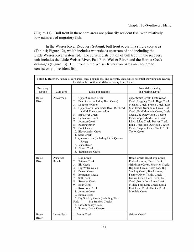
Chapter 18-Southwest Idaho
33
(Figure 11). Bull trout in these core areas are primarily resident fish, with relativelylow numbers of migratory fish.
In the Weiser River Recovery Subunit, bull trout occur in a single core area(Table 4; Figure 12), which includes watersheds upstream of and including theLittle Weiser River watershed. The current distribution of bull trout in the recoveryunit includes the Little Weiser River, East Fork Weiser River, and the Hornet Creekdrainages (Figure 13). Bull trout in the Weiser River Core Area are thought toconsist only of resident fish.
Table 4. Recovery subunits, core areas, local populations, and currently unoccupied potential spawning and rearinghabitat in the Southwest Idaho Recovery Unit, Idaho.
Recoverysubunit Core area Local populations
Potential spawning and rearing habitat1
BoiseRiver
Arrowrock 1. Upper Crooked River2. Bear River (including Bear Creek)3. Lodgepole Creek4. Upper North Fork Boise River (McLeod and McPhearson creeks)5. Big Silver Creek6. Ballentyne Creek7. Johnson Creek8. Roaring River9. Buck Creek10. Blackwarrior Creek11. Steel Creek12. Queens River (including Little Queens River)13. Yuba River14. Sheep Creek15. Rattlesnake Creek
upper Smith Creek, CottonwoodCreek, Logging Creek, Haga Creek,Meadow Creek, French Creek, LostMan Creek, Swanholm Creek, HotCreek, Bald Mountain Creek, EagleCreek, Joe Daley Creek, LeggittCreek, upper Middle Fork BoiseRiver, Pikes Creek, Beaver Creek,Edna Creek, Big Owl Creek, WrenCreek, Trapper Creek, Trail Creek,Taylor Creek
BoiseRiver
AndersonRanch
1. Dog Creek2. Willow Creek3. Elk Creek4. Big Water Gulch5. Beaver Creek6. Boardman Creek7. Salt Creek8. Skeleton Creek9. Bear Creek10. Ross Fork Creek11. Johnson Creek12. Emma Creek13. Big Smokey Creek (including WestFork Big Smokey Creek)14. Little Smokey Creek15. Smokey Dome Canyon
Basalt Creek, Backhorse Creek,Redrock Creek, Carrie Creek,Grindstone Creek, Warwick Creek,Big Peak Creek, North Fork BigSmokey Creek, Skunk Creek,Feather River, Trinity Creek,Grouse Creek, Deer Creek, FallCreek, North Fork Lime Creek,Middle Fork Lime Creek, SouthFork Lime Creek, Hunter Creek,Maxfield Creek
BoiseRiver
Lucky Peak 1. Mores Creek Grimes Creek2
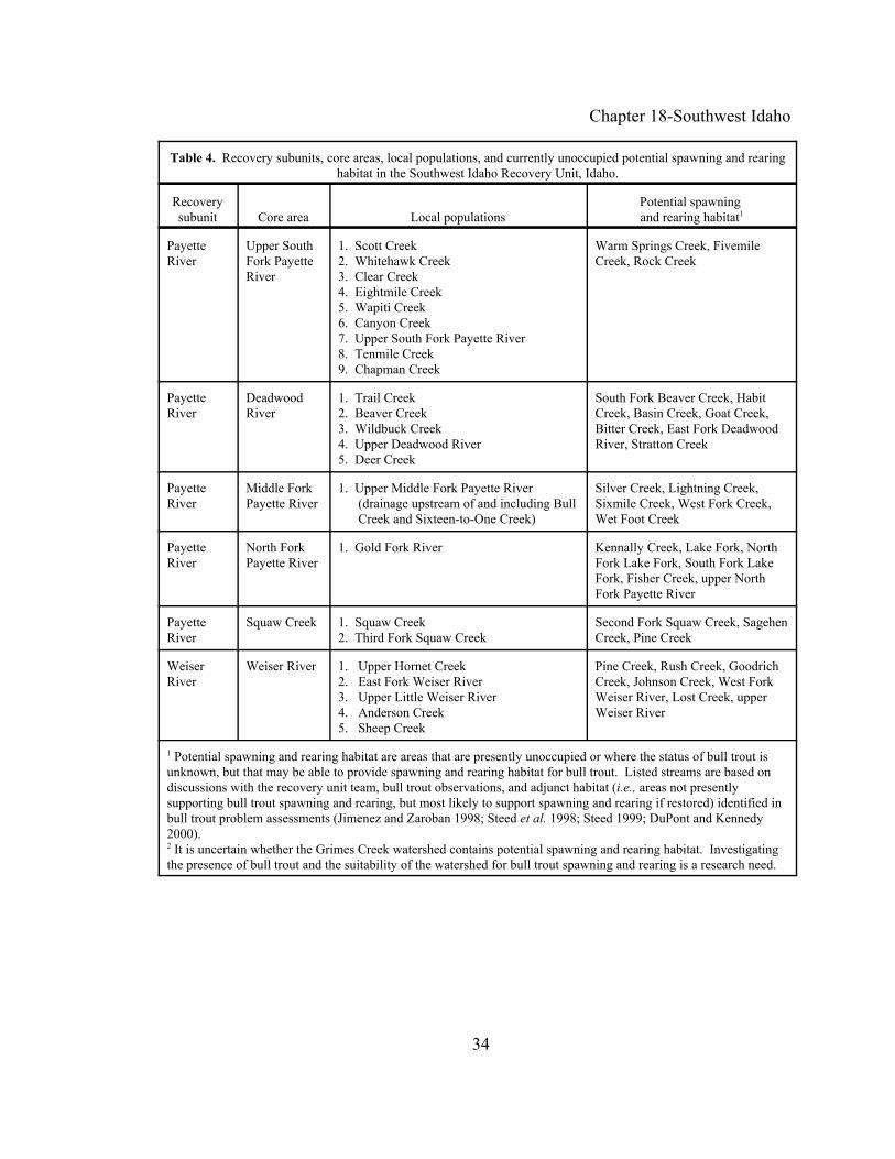
Chapter 18-Southwest Idaho
Table 4. Recovery subunits, core areas, local populations, and currently unoccupied potential spawning and rearinghabitat in the Southwest Idaho Recovery Unit, Idaho.
Recoverysubunit Core area Local populations
Potential spawning and rearing habitat1
34
PayetteRiver
Upper SouthFork PayetteRiver
1. Scott Creek2. Whitehawk Creek3. Clear Creek4. Eightmile Creek5. Wapiti Creek6. Canyon Creek7. Upper South Fork Payette River8. Tenmile Creek9. Chapman Creek
Warm Springs Creek, FivemileCreek, Rock Creek
PayetteRiver
DeadwoodRiver
1. Trail Creek2. Beaver Creek3. Wildbuck Creek4. Upper Deadwood River5. Deer Creek
South Fork Beaver Creek, HabitCreek, Basin Creek, Goat Creek,Bitter Creek, East Fork DeadwoodRiver, Stratton Creek
PayetteRiver
Middle ForkPayette River
1. Upper Middle Fork Payette River (drainage upstream of and including Bull Creek and Sixteen-to-One Creek)
Silver Creek, Lightning Creek,Sixmile Creek, West Fork Creek,Wet Foot Creek
PayetteRiver
North ForkPayette River
1. Gold Fork River Kennally Creek, Lake Fork, NorthFork Lake Fork, South Fork LakeFork, Fisher Creek, upper NorthFork Payette River
PayetteRiver
Squaw Creek 1. Squaw Creek2. Third Fork Squaw Creek
Second Fork Squaw Creek, SagehenCreek, Pine Creek
WeiserRiver
Weiser River 1. Upper Hornet Creek2. East Fork Weiser River3. Upper Little Weiser River4. Anderson Creek5. Sheep Creek
Pine Creek, Rush Creek, GoodrichCreek, Johnson Creek, West ForkWeiser River, Lost Creek, upperWeiser River
1 Potential spawning and rearing habitat are areas that are presently unoccupied or where the status of bull trout isunknown, but that may be able to provide spawning and rearing habitat for bull trout. Listed streams are based ondiscussions with the recovery unit team, bull trout observations, and adjunct habitat (i.e., areas not presentlysupporting bull trout spawning and rearing, but most likely to support spawning and rearing if restored) identified inbull trout problem assessments (Jimenez and Zaroban 1998; Steed et al. 1998; Steed 1999; DuPont and Kennedy2000).2 It is uncertain whether the Grimes Creek watershed contains potential spawning and rearing habitat. Investigatingthe presence of bull trout and the suitability of the watershed for bull trout spawning and rearing is a research need.

Chapter 18-Southwest Idaho
35
Figure 2. Boise River Recovery Subunit showing the locations of the Arrowrock, Anderson Ranch, and Lucky Peak core areas (see Table 4).

Chapter 18-Southwest Idaho
36
Figure 3. Arrowrock Core Area (Boise River Recovery Subunit) showingthe locations of local populations and areas with potential spawning andrearing habitat (see Table 4).
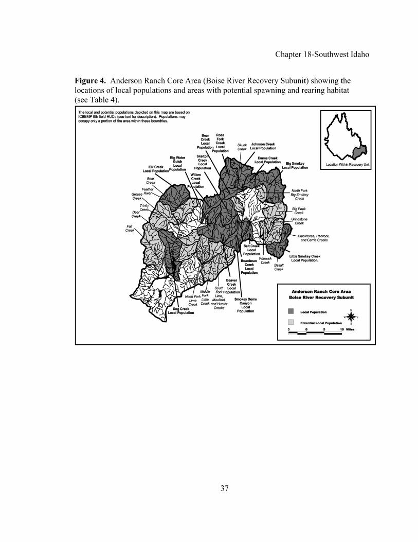
Chapter 18-Southwest Idaho
37
Figure 4. Anderson Ranch Core Area (Boise River Recovery Subunit) showing the locations of local populations and areas with potential spawning and rearing habitat (see Table 4).
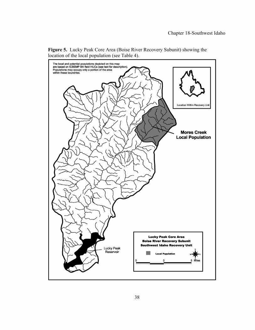
Chapter 18-Southwest Idaho
38
Figure 5. Lucky Peak Core Area (Boise River Recovery Subunit) showing thelocation of the local population (see Table 4).

Chapter 18-Southwest Idaho
39
Figure 6. Payette River Recovery Subunit showing the locations of the upper South Fork Payette River, Deadwood River, Middle Fork Payette River, North Fork Payette River, and Squaw Creek core areas (see Table 6).
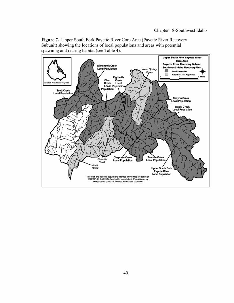
Chapter 18-Southwest Idaho
40
Figure 7. Upper South Fork Payette River Core Area (Payette River Recovery Subunit) showing the locations of local populations and areas with potential spawning and rearing habitat (see Table 4).

Chapter 18-Southwest Idaho
41
Figure 8. Deadwood River Core Area (Payette River Recovery Subunit) showingthe locations of local populations and areas with potential spawning and rearinghabitat (see Table 4).

Chapter 18-Southwest Idaho
42
Figure 9. Middle Fork Payette River Core Area (Payette River Recovery Subunit)showing the locations of local populations and areas with potential spawning andrearing habitat (see Table 4).

Chapter 18-Southwest Idaho
43
Figure 10. North Fork Payette River Core Area (Payette River Recovery Subunit)showing the locations of local populations and areas with potential spawning and rearinghabitat (see Table 4).

Chapter 18-Southwest Idaho
44
Figure 11. Squaw Creek Core Area (Payette River Recovery Subunit) showing thelocations of local populations and areas with potential spawning and rearing habitat(see Table 4).

Chapter 18-Southwest Idaho
45
Figure 12. Weiser River Recovery Subunit showing the location of the Weiser RiverCore Area (see Table 4).

Chapter 18-Southwest Idaho
46
Figure 13. Weiser River Creek Core Area (Weiser River Recovery Subunit)showing the locations of local populations and areas with potential spawning andrearing habitat (see Table 4).

Chapter 18-Southwest Idaho
47
Recovery Goals and Objectives
The goal of the bull trout recovery plan is to ensure the long-term persistenceof self-sustaining, complex, interacting groups of bull trout distributed throughoutthe species’ native range, so that the species can be delisted. To achieve this goalthe following objectives have been identified for bull trout in the Southwestern IdahoRecovery Unit:
< Maintain current distribution of bull trout and restore distribution in previouslyoccupied areas within the Southwest Idaho Recovery Unit.
< Maintain stable or increasing trends in abundance of bull trout.
< Restore and maintain suitable habitat conditions for all bull trout life historystages and strategies.
< Conserve genetic diversity and provide opportunity for genetic exchange.
Rieman and McIntyre (1993) and Rieman and Allendorf (2001) evaluated thebull trout population numbers and habitat thresholds necessary for long-term viabilityof the species. They identified four elements, and the characteristics of those elements,to consider when evaluating the viability of bull trout populations. These four elementsare 1) number of local populations; 2) adult abundance (defined as the number ofspawning fish present in a core area in a given year); 3) productivity, or thereproductive rate of the population (as measured by population trend and variability);and 4) connectivity (as represented by the migratory life history form and functionalhabitat). For each element, the Southwest Idaho Recovery Unit Team classified bulltrout into relative risk categories based on the best available data and the professionaljudgment of the team.
The Southwest Idaho Recovery Unit Team also evaluated each element under apotential recovered condition to produce recovery criteria. Evaluation of theseelements under a recovered condition assumed that actions identified within thischapter had been implemented. Recovery criteria for the Southwest Idaho RecoveryUnit reflect 1) the stated objectives for the recovery unit, 2) evaluation of eachpopulation element in both current and recovered conditions, and 3) consideration ofcurrent and recovered habitat characteristics within the recovery unit. Recovery criteriawill probably be revised in the future as more detailed information on bull troutpopulation dynamics becomes available. Given the limited information on bull trout,both the level of adult abundance and the number of local populations needed to lessenthe risk of extinction should be viewed as a best estimate.
Chapter 18-Southwest Idaho
48
This approach to developing recovery criteria acknowledges that the status ofpopulations in some core areas may remain short of ideals described by conservationbiology theory. Some core areas may be limited by natural attributes or by patch sizeand may always remain at a relatively high risk of extinction. Because of limited datawithin the Southwest Idaho Recovery Unit, the Recovery Unit Team relied heavily onthe professional judgment of its members.
Local Populations. Metapopulation theory is important to consider in bulltrout recovery. A metapopulation is an interacting network of local populations withvarying frequencies of migration and gene flow among them (Meffe and Carroll 1994)(see Chapter 1). Multiple local populations distributed and interconnected throughout awatershed provide a mechanism for spreading risk from stochastic events. In part,distribution of local populations in such a manner is an indicator of a functioning corearea. Based in part on guidance from Rieman and McIntyre (1993), bull trout coreareas with fewer than 5 local populations are at increased risk, core areas with between5 and 10 local populations are at intermediate risk, and core areas with more than 10interconnected local populations are at diminished risk.
For the Arrowrock Core Area, there are currently 15 known local populations;for the Anderson Ranch Core Area, there are 13 known local populations. Based on theabove guidance, bull trout in the these two core areas are at a diminished risk. For the Upper South Fork Payette River Core Area, there are currently nine known localpopulations; for the Deadwood River Core Area, there are five known localpopulations. Based on the above guidance, bull trout in the these two core areas are atan intermediate risk category. For the South Fork Payette River Core Area, SquawCreek Core Area, and Weiser Core Area there are currently two known localpopulations in each core area; for the North Fork Payette River Core Area and LuckyPeak Core Area there is currently one known local population in each core area. Basedon the above guidance, bull trout in the these five core areas are at an increased riskcategory.
Adult Abundance. The recovered abundance levels in the Southwest IdahoRecovery Unit were determined by considering theoretical estimates of effectivepopulation size, historical census information, and the professional judgment ofrecovery team members. In general, effective population size is a theoretical conceptthat allows us to predict potential future losses of genetic variation within a populationdue to small population sizes and genetic drift (see Chapter 1). For the purpose ofrecovery planning, effective population size is the number of adult bull trout thatsuccessfully spawn annually. Based on standardized theoretical equations (Crow andKimura 1970), guidelines have been established for maintaining minimum effectivepopulation sizes for conservation purposes. Effective population sizes of greater than50 adults are necessary to prevent inbreeding depression and a potential decrease in

Chapter 18-Southwest Idaho
49
viability or reproductive fitness of a population (Franklin 1980). To minimize the lossof genetic variation due to genetic drift and to maintain constant genetic variancewithin a population, an effective population size of at least 500 is recommended(Franklin 1980; Soule 1980; Lande 1988). Effective population sizes required tomaintain long-term genetic variation that can serve as a reservoir for future adaptationsin response to natural selection and changing environmental conditions are discussed inChapter 1 of the recovery plan.
For bull trout, Rieman and Allendorf (2001) estimated that a minimum numberof 50 to 100 spawners per year is needed to minimize potential inbreeding effectswithin local populations. In addition, a population size of between 500 and 1,000adults in a core area is needed to minimize the deleterious effects of genetic variationfrom drift.
For the purposes of bull trout recovery planning, abundance levels wereconservatively evaluated at the local population and core area levels. Localpopulations containing fewer than 100 spawning adults per year were classified as atrisk from inbreeding depression. Bull trout core areas containing fewer than 1,000spawning adults per year were classified as at risk from genetic drift.
Productivity. A stable or increasing population is a key criterion for recoveryunder the requirements of the Endangered Species Act. Measures of the trend of apopulation (the tendency to increase, decrease, or remain stable) include populationgrowth rate or productivity. Estimates of population growth rate (i.e., productivity overthe entire life cycle) that indicate a population is consistently failing to replace itselfalso indicate an increased risk of extinction. Therefore, the reproductive rate shouldindicate that the population is replacing itself, or growing.
Since estimates of the total population size are rarely available, the productivityor population growth rate is usually estimated from temporal trends in indices ofabundance at a particular life stage. For example, redd counts are often used as anindex of a spawning adult population. The direction and magnitude of a trend in theindex can be used as a surrogate for the growth rate of the entire population. Forinstance, a downward trend in an abundance indicator may signal the need forincreased protection, regardless of the actual size of the population. A population thatis below recovered abundance levels, but that is moving toward recovery, would beexpected to exhibit an increasing trend in the indicator.
The population growth rate is an indicator of probability of extinction. Thisprobability cannot be measured directly, but it can be estimated as the consequence ofthe population growth rate and the variability in that rate. For a population to beconsidered viable, its natural productivity should be sufficient for the population to

Chapter 18-Southwest Idaho
50
replace itself from generation to generation. Evaluations of population status will alsohave to take into account uncertainty in estimates of population growth rate orproductivity. For a population to contribute to recovery, its growth rate must indicatethat the population is stable or increasing for a period of time. Based on the depressed,likely declining population trend and loss of range within the basin, or the lack ofadequate population trend data, bull trout in all core areas within the Southwest IdahoRecovery Unit are currently at increased risk.
Connectivity. The presence of the migratory life history form within theSouthwestern Idaho Recovery Unit was used as an indicator of the functionalconnectivity of the recovery unit and both core areas. If the migratory life form wasabsent, or if the migratory form is present but local populations lack connectivity, thecore area was considered to be at increased risk. If the migratory life form persists in atleast some local populations, with partial ability to connect with other localpopulations, the core area was judged to be at intermediate risk. Finally, if themigratory life form was present in all or nearly all local populations, and had the abilityto connect with other local populations, the core area was considered to be atdiminished risk.
Migratory bull are present in all or nearly all local populations with the abilityto connect with other local populations in the Arrowrock, Anderson, and Middle ForkPayette river core areas and therefore are considered at diminishing risk. Migratorybull trout may persist in some local populations in the Upper South Fork Payette River,Deadwood River, Squaw Creek, and Weiser River core areas and therefore areconsidered at an intermediate risk. Migratory forms in the North Fork Payette Riverand Lucky Peak core areas are believed to be absent or extremely limited in theirrespective single local populations and therefore are considered at increasing risk.
Recovery Criteria
Recovery criteria for the Southwest Idaho Recovery Unit are summarized inTable 5 and include:
1. Maintain current distribution of bull trout in the 54 local populationsidentified, and expand distribution by establishing bull trout localpopulations in areas identified as potential spawning and rearing habitat. The number of existing local populations by recovery subunit and core area are: Boise River Recovery Subunit, 31 existing local populations (15 in ArrowrockCore Area, 17 in Anderson Ranch Core Area, and 1 in Lucky Peak Core Area);Payette River Recovery Subunit, 18 existing local populations (9 in upper SouthFork Payette River Core Area, 5 in Deadwood River Core Area, 1 in MiddleFork Payette River Core Area, 1 in North Fork Payette River Core Area, 2 in

Chapter 18-Southwest Idaho
51
Squaw Creek Core Area); and 5 in Weiser River Recovery Subunit (thisrecovery subunit constitutes a single core area). Table 4 presents specific localpopulations and areas identified as having potential spawning and rearinghabitat (i.e., presently unoccupied areas that may be able to support localpopulations). Achieving criterion 1 entails: (1) maintaining existing localpopulations; (2) encouraging the establishment of additional bull trout localpopulations in potential spawning and rearing habitat in all core areas of therecovery unit (e.g., by implementing recovery tasks to provide accesses to theareas and restoring habitat), which will contribute to achieving criteria 2 and 3;and (3) implementing activities (i.e., task 5.5.3 in the Boise River RecoverySubunit, task 5.5.4 in the Payette River Recovery Subunit, and task 5.5.2 in theWeiser River Recovery Subunit) intended to evaluate the feasibility ofestablishing additional bull trout local populations in potential spawning andrearing habitat and then implementing activities to establish new localpopulations where feasible. Establishing at least one new local population eachin the Lucky Peak, Middle Fork Payette River, North Fork Payette River,Squaw Creek, and Weiser River core areas is necessary to achieve criterion 1, ifevaluations indicate that it is feasible in a specific core area. Tasks intended toassess the feasibility of establishing additional local populations should beconducted with coordinated review during implementation with the U.S. Fishand Wildlife Service.
2. Estimated abundance of adult bull trout is at least 17,600 individuals in theSouthwest Idaho Recovery Unit. The recovered abundance of adult bull troutfor the recovery unit was estimated based on professional judgement of therecovery unit team in consideration of surveyed fish densities, habitats, andpotential fish production after threats have been addressed. (Estimates ofcurrent abundance and potential abundance of bull trout in the future includeconsiderable uncertainty, for which measures of uncertainty are not presentlyavailable and are likely to vary among specific areas [e.g., population-specificdefinitions of mature bull trout, variability in sample efficiency, andappropriateness of extrapolating sample sites to larger areas.]) The recoveredabundance of adult bull trout by recovery subunit and core area are: BoiseRiver Recovery Subunit, at least 10,100 bull trout (at least 5,000 in ArrowrockCore Area, 5,000 in Anderson Ranch Core Area, 100 in Lucky Peak CoreArea); Payette River Recovery Subunit, at least 7,000 bull trout (at least 5,000in upper South Fork Payette River Core Area, 500 to 5,000 in Deadwood RiverCore Area, 500 to 5,000 in Middle Fork Payette River Core Area, 500 to 5,000in North Fork Payette River Core Area, 500 to 5,000 in Squaw Creek CoreArea); and at least 500 in Weiser River Recovery Subunit (500 to 5,000 in thesingle core area).

Chapter 18-Southwest Idaho
52
3. Adult bull trout exhibit stable or increasing trends in abundance in theSouthwest Idaho Recovery Unit. The intent of this criterion is that adult bulltrout in core areas presently below their recovered abundance exhibit increasingtrends, whereas bull trout in core areas that may be at their recovered abundanceexhibit stable trends.
4. Specific barriers to bull trout migration in the Southwest Idaho RecoveryUnit have been addressed. Many barriers to bull trout migration exist withinthe recovery unit, and this recovery plan recommends several tasks to identify,assess, and reduce barriers to bull trout passage. Although achieving criteria 1through 3 is expected to depend on providing passage at barriers (includingbarriers due to physical obstructions, unsuitable habitat, and water quality)throughout all core areas in the recovery unit, the intent of criterion 4 is to notespecific barriers to address or tasks that must be performed to achieve recovery(i.e., evaluated and appropriately addressed if found to be feasible). Activitiesnecessary to fulfill this criterion for each recovery subunit include: continuingto provide passage (e.g., using the existing trap-and-haul program) of bull troutat Arrowrock Dam (task 1.4.2) and identifying, assessing, and remedyingpotential passage barriers in the Lucky Peak Core Area (task 1.2.4) in the BoiseRiver Recovery Subunit; addressing passage at the Gold Fork River irrigationdiversion (task 1.2.3) and identifying, assessing, and remedying potentialpassage barriers in the Squaw Creek and North Fork Payette River core areas(tasks 1.2.2, 1.2.3, and 1.2.4) in the Payette River Recovery Subunit; andidentifying, assessing, and remedying potential passage barriers in the WeiserRiver Core Area (tasks 1.2.1 and 1.2.2). Tasks intended to assess the feasibilityof providing passage should be conducted with coordinated review duringimplementation with the U.S. Fish and Wildlife Service.
Recovery criteria for the Southwestern Idaho Recovery Unit were established toassess whether recovery actions have resulted in the recovery of bull trout. TheSouthwestern Idaho Recovery Unit Team expects that the recovery process willbe dynamic and require refinements as more information becomes availableover time. While removal of bull trout as a species under the EndangeredSpecies Act (i.e., delisting) can only occur for the entity that was listed(Columbia River Distinct Population Segment), the criteria listed above will beused to determine when the Southwestern Idaho Recovery Unit Recovery Unitis fully contributing to recovery of the population segment.

Chapter 18-Southwest Idaho
53
Table 5. Summary of values for recovery criteria in the Southwest Idaho Recovery Unit
Recovery subunitNumber ofcore areas
Minimumnumber of
localpopulations
Adultabundance
Trend inabundance
Minimumnumber of
barriersaddresseda
Boise River 3 31 >10,100stable or
increasing 2
Payette River 5 18 >7,000stable or
increasing 3
Weiser River 1 5 >500stable or
increasing 2
Total 9 54 >17,600stable or
increasing 7
a Some values are the number of tasks that should be implemented; see preceding text for criterion 4.

Chapter 18-Southwest Idaho
54
ACTIONS NEEDED
Recovery Measures Narrative
In this chapter and all other chapters of the bull trout recovery plan, therecovery measures narrative consists of a hierarchical listing of actions that follows astandard template. The first-tier entries are identical in all chapters and representgeneral recovery tasks under which specific (e.g., third-tier) tasks appear whenappropriate. Second-tier entries also represent general recovery tasks under whichspecific tasks appear. Second-tier tasks that do not include specific third-tier actionsare usually programmatic activities that are applicable across the species’ range; theyappear in italic type. These tasks may or may not have third-tier tasks associated withthem; see Chapter 1 for more explanation. Some second-tier tasks may not besufficiently developed to apply to the recovery unit at this time; they appear in a shadeditalic type (as seen here). These tasks are included to preserve consistency innumbering tasks among recovery unit chapters and intended to assist in generatinginformation during the comment period for the draft recovery plan, a period whenadditional tasks may be developed. Third-tier entries are tasks specific to theSouthwest Idaho Recovery Unit. They appear in the implementation schedule thatfollows this section and are identified by three numerals separated by periods.
The Southwestern Idaho Recovery Unit Chapter should be updated or revised asrecovery tasks are accomplished, environmental conditions change, or monitoringresults or other new information becomes available. Revisions to the SouthwesternIdaho Recovery Unit Chapter will likely focus on priority streams or stream segmentswithin core areas where restoration activities occurred, and habitat or bull troutpopulations have shown a positive response. The Southwestern Idaho Recovery UnitTeam should meet annually to review annual monitoring reports and summaries, andmake recommendations to the U.S. Fish and Wildlife Service.
Boise River Recovery Subunit
1 Protect, restore, and maintain suitable habitat conditions for bull trout.
1.1 Maintain or improve water quality in bull trout core areas or potentialcore habitat.
1.1.1 Reduce sediment production from roads. Activities such asrestricting road use during wet weather, improving road surfaces,removing unnecessary roads, and relocating roads out ofsensitive riparian areas should be used to reduce sediment

Chapter 18-Southwest Idaho
55
delivery to streams. Efforts should initially focus on areas wheresediments are delivered to bull trout spawning and rearinghabitat and watersheds with high levels of fine sediments androad densities in riparian areas greater than or equal to 0.62kilometer per square kilometer (1 mile per square mile). Examples of streams with these characteristics include theBeaver Creek, Edna Creek, Pikes Fork Creek, upper TrinityCreek, and streams within the Feather River drainage.
1.1.2 Evaluate and improve drainage from existing roads. Waterdraining from roads should be directed to slope infiltration areasand not streams to reduce sediment delivery (e.g., by effectivecross-drain spacing and drain dip locations). Examples of areasto initially focus efforts include the Crooked River, BeaverCreek, Edna Creek, Pikes Fork, and Fall Creek watersheds. Allother watersheds in the Boise River Recovery Subunit should beevaluated and road improvements made, where necessary.
1.1.3 Assess the risk of negative effects of historic mine tailings onbull trout, and implement actions to eliminate or reduce them, ifnecessary. Some portions of core areas were subjected toextensive mining activities in the past. The effects of resultingmine tailings on bull trout in the recovery subunit is not known.
1.2 Identify barriers or sites of entrainment for bull trout and implementtasks to provide passage and eliminate entrainment.
1.2.1 Inventory culverts to identify those inhibiting fish passage, anddevelop a program with schedules for their replacement ormodification to improve fish passage. There are over 6,000 roadcrossings in the Boise River Recovery Subunit. Many crossingsconsist of culverts that may be barriers to fish movement. Culverts acting as barriers need to be identified and remedied(e.g., by using concrete box or bottomless arched culverts,bridges, or other means). The Feather River, Trinity Creek andBeaver Creek watersheds should be inventoried first, followedby the Deer Creek, Dog Creek, Nichols Creek, Big Owl Creek,Wren Creek, Trapper Creek, Trail Creek, Swanholm Creek, HotCreek, Cottonwood Creek, and Roaring River watersheds. Improvements to culverts should be implemented according tothe program’s schedules. The program should prioritize culverts

Chapter 18-Southwest Idaho
56
within areas so that agencies can include them in theirmanagement plans to expedite corrections.
1.2.2 Evaluate bull trout use of the fish ladder at Atlanta Dam. Thefish ladder at Atlanta Dam provides migratory bull trout accessto about 90 kilometers (56 miles) of previously unoccupiedspawning and rearing habitat (an increase of 39 percent thanpreviously available). Bull trout were observed using the ladderafter it was initially opened, however the extent that bull troutuse the ladder and it has connected areas upstream anddownstream of Atlanta Dam is not known. Trends in bull troutuse of the ladder through time should be recorded to generatedemographic information useful for evaluating biologicalresponses.
1.2.3 Install screens on the irrigation diversions in Big Smokey andWillow creeks of the Anderson Ranch Core Area. Screens areneeded to prevent fish from entering the ditches at thesediversions.
1.2.4. Evaluate possible barriers to fish passage in the Mores Creekwatershed and improve passage where necessary. In the LuckyPeak core area, bull trout inhabit the headwaters of Mores Creekand Lucky Peak Reservoir. Connectivity between theheadwaters and reservoir is uncertain. The watershed should besurveyed for potential barriers, and approaches to providingpassage developed and implemented where appropriate.
1.3 Identify impaired stream channel and riparian areas and implement tasksto restore their functions.
1.3.1 Evaluate and address suction dredge mining impacts in bull troutspawning and rearing habitat. Appropriate restrictions inlocation (i.e., spawning and rearing habitat) and timing ofsuction dredge activities should avoid potential negative effectsto bull trout and bull trout habitat.
1.3.2 Identify areas where livestock grazing has negatively affectedriparian and aquatic habitats, and implement actions to restoreand improve stream and riparian habitats. For areas wheregrazing has affected bull trout habitat, restoration activities

Chapter 18-Southwest Idaho
57
should reduce sediment production, increase stream bank andstream channel stability, and contribute to the integrity ofriparian vegetation. Potential actions that encourage passiverestoration include fencing and modifying livestock dispersal,timing of use, and herding.
1.4 Operate dams to minimize negative effects on bull trout in reservoirsand downstream.
1.4.1 Establish conservation pools in Anderson Ranch Reservoir andArrowrock Reservoir as per U.S. Fish and Wildlife Service(1999). Bull trout use the two reservoirs as foraging, migrating,and overwintering habitat. The reservoirs are also periodicallydrawn down to low levels. Conservation pools should beestablished to avoid potential negative effects on bull trout andtheir prey. Reasonable and prudent measures for establishingconservation pools are provided in U.S. Fish and WildlifeService (1999).
1.4.2 Identify and implement operational actions and facilitiesnecessary to prevent or reduce fish passage through dams. Makeoperational and structural modifications to Arrowrock Dam toprevent bull trout from passing downstream to Lucky PeakReservoir. Evaluate the potential for bull trout to pass throughAnderson Ranch Dam and implement preventative actions, ifnecessary. Reasonable and prudent measures for dam operationsand the valve replacement project at Arrowrock Dam areprovided in U.S. Fish and Wildlife Service (1999, 2001b). Because the valve replacement project has the potential to affecta major core population within the recovery subunit, it should beimplemented to minimize effects on bull trout and their prey.
1.5 Identify upland conditions negatively affecting bull trout habitats andimplement tasks to restore appropriate functions.
2 Prevent and reduce negative effects of nonnative fishes and other nonnative taxaon bull trout.
2.1 Develop, implement, and enforce public and private fish stockingpolicies to reduce stocking of nonnative fishes that affect bull trout.
Chapter 18-Southwest Idaho
58
2.2 Evaluate enforcement policies for preventing illegal transport andintroduction of nonnative fishes.
2.3 Provide educational material to the public about ecosystem concerns ofillegal introductions of nonnative fishes.
2.4 Evaluate biological, economic, and social effects of control of nonnativefishes.
2.4.1 Evaluate various methods to reduce the abundance of brooktrout. Throughout the range of bull trout, various projects toreduce brook trout abundance have typically had mixed resultsand were conducted in areas where both species occur. A varietyof methods should be developed and evaluated that can be usedto eradicate or substantially reduce brook trout abundance inhabitats where they coexist with bull trout or where theirremoval would facilitate establishment of a new bull trout localpopulation. For instance, aggressive methods can beinvestigated in streams where bull trout do not occur with brooktrout and can encompass relatively large areas (e.g., entiredrainages or portions of drainages of moderate size). Thebiological, economic, and social feasibility of methods to reducebrook trout should be evaluated, especially in areas presentlyunoccupied by bull trout that are necessary for bull troutrecovery (e.g., potential spawning and rearing habitat).
2.5 Implement control of nonnative fishes where found to be feasible andappropriate.
2.5.1 Reduce competition with brook trout where they overlap withbull trout, especially in spawning and rearing habitat. Fromsuccessful methods expected to be developed per task 2.4.1 (e.g.,physical or chemical eradication or suppression of brook trout, orhabitat modifications), select appropriate methods to apply inspecific streams. Efforts should initially focus on the CrookedRiver, Pikes Fork, Salt Creek, and Bear River watersheds.
2.6 Develop tasks to reduce negative effects of nonnative taxa on bull trout.
3 Establish fisheries management goals and objectives compatible with bull troutrecovery, and implement practices to achieve goals.

Chapter 18-Southwest Idaho
59
3.1 Develop and implement State and Tribal native fish management plansintegrating adaptive research.
3.2 Evaluate and prevent overharvest and incidental angling mortality ofbull trout.
3.2.1 Continue and expand public education programs for fishidentification, angling regulations, reasons for protectiveregulations on bull trout, and fish handling practices. Surveyshave indicated that anglers’ inability to correctly identifysalmonids is common. Improving anglers’ ability to correctlyidentify fishes, awareness of regulations, and fish handling willreduce incidental harvest and hooking mortality of bull trout. Educational techniques that can be used in programs includesigns at popular fishing access areas, and flyers and brochures atlicense vendors and resource agency offices. Examples ofadditional locations for signs in the Arrowrock Core Areainclude Swanholm and Phifer creeks.
3.2.2 Continue enforcement of current fishing regulations and increasepatrols. Enforcement actions should focus on areas with thegreatest risk to bull trout such as popular fishing areas atAnderson Ranch and Arrowrock reservoirs and areas usedseasonally by bull trout when they may be particularlyvulnerable to capture (e.g., spawning and staging areas,overwintering areas).
3.3 Evaluate potential effects of introduced fishes and associated sportfisheries on bull trout recovery and implement tasks to minimizenegative effects on bull trout.
3.4 Evaluate effects of existing and proposed sport fishing regulations onbull trout.
3.4.1 Investigate compliance with fishing regulations andopportunities to benefit bull trout. In conjunction with tasks3.2.1 and 3.2.2, evaluate methods to improve anglers’ knowledgeof fishing regulations and issues affecting bull trout. Useinformation generated by this task to improve regulations andangler education.

Chapter 18-Southwest Idaho
60
4 Characterize, conserve, and monitor genetic diversity and gene flow amonglocal populations of bull trout.
4.1 Incorporate conservation of genetic and phenotypic attributes of bulltrout into recovery and management plans.
4.1.1 Collect samples for genetic analysis to contribute to establishinga program to understand the genetic baseline and monitor geneticchanges throughout the range of bull trout (see Chapter 1narrative).
4.1.2 Describe and monitor genetic and phenotypic characteristics ofbull trout in core areas, and incorporate information intomanagement strategies. The interaction of bull trout geneticcomposition with particular environments results in phenotypicdiversity and perhaps local adaptation. Such information forparticular groups of bull trout and their habitats should begenerated and incorporated into management strategies toimprove their effectiveness.
4.2 Maintain existing opportunities for gene flow among bull troutpopulations.
4.2.1 Prevent the establishment of barriers that may inhibit themovement of bull trout within the Boise River Recovery Subunit. Proposed activities that might result in structural barriers orunsuitable habitat conditions for bull trout should be thoroughlyevaluated. If the evaluation finds that an activity would likelycreate a barrier to fish movement, alternatives to the activityshould be pursued if it can not be modified to allow fish passage.
4.3 Develop genetic management plans and guidelines for appropriate useof transplantation and artificial propagation.
5 Conduct research and monitoring to implement and evaluate bull trout recoveryactivities, consistent with an adaptive management approach using feedbackfrom implemented, site-specific recovery tasks.
5.1 Design and implement a standardized monitoring program to assess theeffectiveness of recovery efforts affecting bull trout and their habitats.

Chapter 18-Southwest Idaho
61
5.2 Conduct research evaluating relationships among bull trout distributionand abundance, bull trout habitat, and recovery tasks.
5.3 Conduct evaluations of the adequacy and effectiveness of current andpast best management practices in maintaining or achieving habitatconditions conducive to bull trout recovery.
5.4 Evaluate effects of diseases and parasites on bull trout, and develop andimplement strategies to minimize negative effects.
5.5 Develop and conduct research and monitoring studies to improveinformation concerning the distribution and status of bull trout.
5.5.1 Continue studies on bull trout distribution, abundance, lifehistories, and factors affecting them. Several aspects of bulltrout in the recovery subunit have been investigated relativelyrecently in the Arrowrock and Anderson Ranch core areas (e.g.,distribution, timing of life-history events, age distribution). Thestudies should be expanded to generate information to increaseour knowledge of bull trout and improve recovery tasks and theireffects. Examples of studies include conducting surveys toevaluate bull trout presence and potential habitat in the GrimesCreek watershed, and evaluating effects of agricultural practiceson bull trout and their habitats in the Boise River RecoverySubunit.
5.5.2 Continue studies on the distribution, status, and life history ofbull trout in the Mores Creek watershed. Bull trout wererecently found in upper Mores Creek, a tributary to Lucky PeakReservoir. Systematic surveys need to be conducted in thewatershed to determine bull trout distribution, life historycharacteristics, and other information (e.g., genetic composition)so that their relation to fish in other parts of the basin can beassessed.
5.5.3 Identify unoccupied areas that may be suitable for bull troutspawning and rearing in the Lucky Peak Core Area and developa strategy to establish additional local populations. The core areapresently contains one local population. Establishing additionallocal populations would improve the likelihood of the corepopulation to persist and contribute to recovery. Unoccupiedareas that may support bull trout spawning and rearing need to be

Chapter 18-Southwest Idaho
62
identified and a strategy developed to encourage theestablishment of additional local populations.
5.6 Identify evaluations needed to improve understanding of relationshipsamong genetic characteristics, phenotypic traits, and local populationsof bull trout.
6 Use all available conservation programs and regulations to protect and conservebull trout and bull trout habitats.
6.1 Use partnerships and collaborative processes to protect, maintain, andrestore functioning core areas for bull trout.
6.2 Use existing Federal authorities to conserve and restore bull trout.
6.3 Enforce existing Federal, State, and Tribal habitat protection standardsand regulations and evaluate their effectiveness for bull troutconservation.
7 Assess the implementation of bull trout recovery by recovery units, and reviserecovery unit plans based on evaluations.
7.1 Convene annual meetings of each recovery unit team to review progresson recovery plan implementation.
7.2 Assess effectiveness of recovery efforts.
7.3 Revise scope of recovery as suggested by new information.
Payette River Recovery Subunit
1 Protect, restore, and maintain suitable habitat conditions for bull trout.
1.1 Maintain or improve water quality in bull trout core areas or potentialcore habitat.
1.1.1 Reduce sediment production from roads. Use existing surveysand conduct new surveys to identify areas of sediment deliveryto streams from roads. Use survey results to develop andimplement sediment reduction treatments (e.g., drainmodifications, graveling, road closures and elimination). Focus

Chapter 18-Southwest Idaho
63
initially on areas where sediment delivery from roads has beendocumented such as specific streams in the Squaw Creek, MiddleFork Payette River, and South Fork Payette River core areas.
1.1.2 Investigate effects of sediment and potential toxic materials fromDeadwood Mine on the upper Deadwood River and bull trout. The effects of Deadwood Mine on the Deadwood River and bulltrout are uncertain. If negative effects are observed, develop andimplement actions to correct them.
1.2 Identify barriers or sites of entrainment for bull trout and implementtasks to provide passage and eliminate entrainment.
1.2.1 Inventory culverts to identify those inhibiting fish passage, anddevelop program to improve fish passage. There are numerousculverts in the Payette River Recovery Subunit that may beinhibiting fish movement. Culverts acting as barriers need to beidentified and remedied (e.g., by using concrete box culverts,bridges, or other means).
1.2.2 Replace the culvert identified as a fish barrier in Second ForkSquaw Creek. The absence of bull trout in the Second ForkSquaw Creek is likely influenced by a culvert that has beenidentified as a fish passage barrier. The stream is alsoconsidered to have unoccupied spawning and rearing habitat,which may be suitable for an additional local population. Theculvert replacement project should include an evaluation todetermine the role of other factors in the stream that may affectbull trout (e.g., sediment from roads, cattle grazing).
1.2.3 Identify and implement actions needed to prevent the loss of bulltrout at irrigation diversions and improve fish passage.Irrigation diversions likely entrain and prevent or impair bulltrout movement in various areas of the Payette River RecoverySubunit, especially in the Squaw Creek and North Fork PayetteRiver core areas (i.e., Gold Fork River). Specific actions toprevent fish loss and improve passage need to be developed andimplemented.
1.2.4 Evaluate fish passage at diversions on Lake Fork and FisherCreek and implement actions to prevent fish loss and improvepassage, if necessary. In the North Fork Payette River Core
Chapter 18-Southwest Idaho
64
Area, bull trout were observed in Lake Fork and Fisher Creekduring past surveys. More recent surveys have failed to detectbull trout; consequently, they may be in extremely lowabundance or perhaps extirpated. Passage at the diversions mayhave influenced bull trout in these watersheds and could affectthe potential for the streams to support bull trout in the future.
1.3 Identify impaired stream channel and riparian areas and implement tasksto restore their functions.
1.3.1 Identify areas where livestock grazing has negatively affectedriparian and aquatic habitats, and implement actions to restoreand improve stream and riparian habitats. For areas wheregrazing has affected habitats, restoration activities should reducesediment production, increase stream bank and stream channelstability, and contribute to the integrity of riparian vegetation. Potential actions that encourage passive restoration includefencing and modifying livestock dispersal, timing of use, andherding. For example, fences can be used to exclude livestockfrom sensitive areas in Squaw Creek and a rider can reduceconcentrations of livestock in unfenced areas of Squaw Creekand Gold Fork River.
1.3.2 Investigate and implement methods for restoring habitatconditions in the lower Middle Fork Payette River. Potentialforaging, migrating, and overwintering habitat in the lowerMiddle Fork Payette River has been degraded by excesssedimentation. Sediments have filled pools, increased streamwidth:depth ratios, and reduced habitat complexity. Investigaterestoration methods (e.g., road modifications, increasing riparianvegetation) that reduce sediment delivery, reduce width to depthratios, and increase habitat complexity.
1.4 Operate dams to minimize negative effects on bull trout in reservoirsand downstream.
1.4.1 Evaluate and implement appropriate operations at DeadwoodDam to provide adequate flows and temperatures for bull troutdownstream of the dam. Water released from DeadwoodReservoir may not be conducive to bull trout recovery due toinappropriate temperatures and flow regime. Dam operation

Chapter 18-Southwest Idaho
65
should be evaluated relative to bull trout needs and modified ifnecessary.
1.4.2 Establish a conservation pool in Deadwood Dam. DeadwoodDam is presently operated to maintain a winter flow of 1.4 cubicmeters per second (50 cubic feet per second) and a minimumpool of about 62 million cubic meters (50,000 acre-feet). Although these operations are not believed to adversely affectbull trout inhabiting Deadwood Reservoir, they need to beevaluated relative to recovery of bull trout in both the DeadwoodRiver and South Fork Payette River core areas.
1.5 Identify upland conditions negatively affecting bull trout habitats and
implement tasks to restore appropriate functions.
2 Prevent and reduce negative effects of nonnative fishes and other nonnative taxaon bull trout.
2.1 Develop, implement, and enforce public and private fish stockingpolicies to reduce stocking of nonnative fishes that affect bull trout.
2.2 Evaluate enforcement policies for preventing illegal transport andintroduction of nonnative fishes.
2.3 Provide information to the public about ecosystem concerns of illegalintroductions of nonnative fishes.
2.4 Evaluate biological, economic, and social effects of control of nonnativefishes.
2.4.1 Evaluate various methods to reduce the abundance of brooktrout. Throughout the range of bull trout, various projects toreduce brook trout abundance have typically had mixed resultsand were conducted in areas where both species occur. A varietyof methods should be developed and evaluated that can be usedto eradicate or substantially reduce brook trout abundance inhabitats where they coexist with bull trout or where theirremoval would facilitate establishment of a new bull trout localpopulation. For instance, aggressive methods can beinvestigated in streams where bull trout do not occur with brooktrout and can encompass relatively large areas (e.g., entiredrainages or portions of drainages of moderate size). The

Chapter 18-Southwest Idaho
66
biological, economic, and social feasibility of methods to reducebrook trout should be evaluated, especially in areas presentlyunoccupied by bull trout that are necessary for bull troutrecovery (e.g., potential spawning and rearing habitat).
2.5 Implement control of nonnative fishes where found to be feasible andappropriate.
2.5.1 If feasible, reduce brook trout abundance where they overlapwith bull trout and in areas where bull trout may becomeestablished. In the Gold Fork River drainage, the North Fork ofKennally Creek and Rapid Creek are located in largelyundisturbed and roadless areas. High densities of brook troutwithin these streams make it unlikely that bull trout couldbecome established. The feasibility of reducing brook troutabundance should be evaluated in portions of these streams toinvestigate the possibility of establishing additional localpopulations of bull trout in the core area. Similar evaluationsshould be conducted in the Squaw Creek (i.e., in the mainstemSquaw Creek and Third Fork Squaw Creek) and Middle ForkPayette River (i.e., Bull Creek) core areas with the intent ofimproving abundance of existing local populations of bull trout.
2.6 Develop tasks to reduce negative effects of nonnative taxa on bull trout.
3 Establish fisheries management goals and objectives compatible with bull troutrecovery, and implement practices to achieve goals.
3.1 Develop and implement State and Tribal native fish management plansintegrating adaptive research.
3.2 Evaluate and prevent overharvest and incidental angling mortality ofbull trout.
3.2.1 Continue and expand public education programs for fishidentification, angling regulations, reasons for protectiveregulations on bull trout, and fish handling practices. Surveyshave indicated that anglers’ inability to correctly identifysalmonids is common. Improving anglers’ ability to correctlyidentify fishes, awareness of regulations, and fish handling willreduce incidental harvest and hooking mortality of bull trout. Educational techniques that can be used in programs include

Chapter 18-Southwest Idaho
67
signs at popular fishing access areas, and flyers and brochures atlicense vendors and resource agency offices.
3.2.2 Continue enforcement of current fishing regulations and increasepatrols. Patrols should focus on popular fishing areas and areasused seasonally by bull trout when they may be particularlyvulnerable to capture (e.g., spawning and staging areas,overwintering areas).
3.2.3 Evaluate compliance of angling regulations and incidence of bulltrout poaching in Gold Fork River from Kennally Creekupstream to the confluence of the North Fork and South ForkGold Fork River. Because of low abundance of bull trout in theGold Fork River, every individual is important to the population. If the evaluation indicates that poaching or incidental mortalityof bull trout is substantial, close the watershed to angling until afish identification and fishing regulation education program hasbeen successful in reducing bull trout mortality.
3.3 Evaluate potential effects of introduced fishes and associated sportfisheries on bull trout recovery and implement tasks to minimizenegative effects on bull trout.
3.3.1 Evaluate the effects of fish stocking and the fishery on bull troutin Deadwood Reservoir. Although Atlantic salmon and chinooksalmon were stocked in Deadwood Reservoir prior to 1998 andmay have preyed on bull trout, sterile rainbow trout and kokaneeare the only species currently stocked. Potential effects of thefishery (e.g., poaching and incidental mortality) on bull troutshould be evaluated and corrective actions implemented, ifnecessary.
3.4 Evaluate effects of existing and proposed sport fishing regulations onbull trout.
4 Characterize, conserve, and monitor genetic diversity and gene flow amonglocal populations of bull trout.
4.1 Incorporate conservation of genetic and phenotypic attributes of bulltrout into recovery and management plans.

Chapter 18-Southwest Idaho
68
4.1.1 Collect samples for genetic analysis to contribute to establishinga program to understand the genetic baseline and monitor geneticchanges throughout the range of bull trout (see Chapter 1narrative).
4.1.2 Describe and monitor genetic and phenotypic characteristics ofbull trout in core areas, and incorporate information intomanagement strategies. The interaction of bull trout geneticcomposition with particular environments results in phenotypicdiversity and perhaps local adaptation. Such information forparticular groups of bull trout and their habitats should begenerated and incorporated into management strategies toimprove their effectiveness.
4.2 Maintain existing opportunities for gene flow among bull troutpopulations.
4.2.1 Prevent the establishment of barriers that may inhibit themovement of bull trout within the Payette River RecoverySubunit. Proposed activities that might result in structuralbarriers or unsuitable habitat conditions for bull trout should bethoroughly evaluated. If the evaluation finds that an activitywould likely create a barrier to fish movement, alternatives to theactivity should be pursued if it can not be modified to allow fishpassage.
4.3 Develop genetic management plans and guidelines for appropriate useof transplantation and artificial propagation.
5 Conduct research and monitoring to implement and evaluate bull trout recoveryactivities, consistent with an adaptive management approach using feedbackfrom implemented, site-specific recovery tasks.
5.1 Design and implement a standardized monitoring program to assess theeffectiveness of recovery efforts affecting bull trout and their habitats.
5.2 Conduct research evaluating relationships among bull trout distributionand abundance, bull trout habitat, and recovery tasks.
5.3 Conduct evaluations of the adequacy and effectiveness of current andpast Best Management Practices in maintaining or achieving habitatconditions conducive to bull trout recovery.

Chapter 18-Southwest Idaho
69
5.4 Evaluate effects of diseases and parasites on bull trout, and develop andimplement strategies to minimize negative effects.
5.5 Develop and conduct research and monitoring studies to improveinformation concerning the distribution and status of bull trout.
5.5.1 Conduct additional surveys focusing on migratory bull trout andbull trout habitat. Surveys should be completed in theDeadwood River, Middle Fork Payette River, and South ForkPayette River. Specific streams on which to focus include, Bull,Peace, Valley, upper Silver, and Long Fork Silver creeks.
5.5.2 Compile and synthesize historic information concerning bulltrout presence, distribution, and abundance in the South ForkPayette River basin. Minimal information concerning bull troutin the area have been analyzed. Additional information mayexist.
5.5.3 Conduct comprehensive surveys for bull trout in the upper NorthFork Payette River Core Area. Bull trout were observed in LakeFork and Fisher Creek watersheds during past surveys, but werenot found during subsequent sampling in Fisher Creek. Acomprehensive survey should resample sites where bull troutwere observed in the past and additional sites including areaswhere bull trout may occur.
5.5.4 Develop a strategy to establish new local populations inunoccupied areas identified as having potential spawning andrearing habitat. The Middle Fork Payette River, North ForkPayette River, and Squaw Creek core areas each contain fewlocal populations. Unoccupied areas identified as havingpotential spawning and rearing habitat need to be assessed todetermine the feasibility of encouraging the establishment ofadditional local populations, and a strategy to establish new localpopulations developed.
5.6 Identify evaluations needed to improve understanding of relationshipsamong genetic characteristics, phenotypic traits, and local populationsof bull trout.
6 Use all available conservation programs and regulations to protect and conservebull trout and bull trout habitats.

Chapter 18-Southwest Idaho
70
6.1 Use partnerships and collaborative processes to protect, maintain, andrestore functioning core areas for bull trout.
6.2 Use existing Federal authorities to conserve and restore bull trout.
6.3 Enforce existing Federal, State, and Tribal habitat protection standardsand regulations and evaluate their effectiveness for bull troutconservation.
7 Assess the implementation of bull trout recovery by recovery units, and reviserecovery unit plans based on evaluations.
7.1 Convene annual meetings of each recovery unit team to review progresson recovery plan implementation.
7.2 Assess effectiveness of recovery efforts.
7.3 Revise scope of recovery as suggested by new information.
Weiser River Recovery Subunit
1 Protect, restore, and maintain suitable habitat conditions for bull trout.
1.1 Maintain or improve water quality in bull trout core areas or potentialcore habitat.
1.1.1 Reduce sediment production from roads. Develop acomprehensive transportation management plan that identifiesroads that deliver sediments to streams, and implement activitiesto reduce sediment delivery (e.g., drainage designs, graveling,road closure and elimination).
1.2 Identify barriers or sites of entrainment for bull trout and implementtasks to provide passage and eliminate entrainment.
1.2.1 Inventory culverts to identify those inhibiting fish passage, anddevelop a program to improve fish passage. There are numerousculverts in the Weiser River Recovery Subunit that may beinhibiting fish movement. Culverts acting as barriers need to beidentified and passage improved (e.g., by using concrete boxculverts, bridges, or other means).

Chapter 18-Southwest Idaho
71
1.2.2 Identify facilities and actions needed to prevent the loss of bulltrout at irrigation diversions. Irrigation diversions are thought toentrain and prevent or impair bull trout movement in severalareas of the Weiser River Recovery Subunit, especially inpotential foraging, migrating, and overwintering habitat. Specific actions to prevent fish loss and improve passage need tobe developed and implemented.
1.3 Identify impaired stream channel and riparian areas and implement tasksto restore their functions.
1.3.1 Identify areas where livestock grazing has negatively affectedriparian and aquatic habitats, and implement actions to restoreand improve stream and riparian habitats. For areas wheregrazing has affected habitats, restoration activities should reducesediment production, increase stream bank and stream channelstability, and contribute to the integrity of riparian vegetation. Potential actions include fencing and others that addresslivestock dispersal, timing of use, and herding.
1.4 Operate dams to minimize negative effects on bull trout in reservoirsand downstream.
1.5 Identify upland conditions negatively affecting bull trout habitats andimplement tasks to restore appropriate functions.
2 Prevent and reduce negative effects of nonnative fishes and other nonnative taxaon bull trout.
2.1 Develop, implement, and enforce public and private fish stockingpolicies to reduce stocking of nonnative fishes that affect bull trout.
2.2 Evaluate enforcement policies for preventing illegal transport andintroduction of nonnative fishes.
2.3 Provide information to the public about ecosystem concerns of illegalintroductions of nonnative fishes.
2.4 Evaluate biological, economic, and social effects of control of nonnativefishes.
Chapter 18-Southwest Idaho
72
2.4.1 Evaluate various methods to reduce the abundance of brooktrout. Throughout the range of bull trout, various projects toreduce brook trout abundance have typically had mixed resultsand were conducted in areas where both species occur. A varietyof methods should be developed and evaluated that can be usedto eradicate or substantially reduce brook trout abundance inhabitats where they coexist with bull trout or where theirremoval would facilitate establishment of a new bull trout localpopulation. For instance, aggressive methods can beinvestigated in streams where bull trout do not occur with brooktrout and can encompass relatively large areas (e.g., entiredrainages or portions of drainages of moderate size). Thebiological, economic, and social feasibility of methods to reducebrook trout should be evaluated, especially in areas presentlyunoccupied by bull trout that are necessary for bull troutrecovery (e.g., potential spawning and rearing habitat).
2.5 Implement control of nonnative fishes where found to be feasible andappropriate.
2.5.1 Conduct surveys to determine the distribution of brook trout inthe Weiser River Recovery Subunit. Although brook trout occurwith bull trout in some streams (e.g., upper Weiser River, DeweyCreek, and East Fork Weiser River), brook trout distribution andabundance is not well known throughout the recovery subunit.
2.5.2 Conduct a study on the feasibility of reducing brook troutabundance where they overlap with bull trout and in areas wherebull trout may become reestablished. Brook trout occur with bulltrout in some streams (e.g., upper Weiser River, Dewey Creek,and East Fork Weiser River), and approaches to reduce brooktrout abundance should be evaluated.
2.6 Develop tasks to reduce negative effects of nonnative taxa on bull trout.
3 Establish fisheries management goals and objectives compatible with bull troutrecovery, and implement practices to achieve goals.
3.1 Develop and implement State and Tribal native fish management plansintegrating adaptive research.

Chapter 18-Southwest Idaho
73
3.2 Evaluate and prevent overharvest and incidental angling mortality ofbull trout.
3.3 Evaluate potential effects of introduced fishes and associated sportfisheries on bull trout recovery and implement tasks to minimizenegative effects on bull trout.
3.3.1 Evaluate the effects of fish stocking and the fisheries on bulltrout. Sterile rainbow trout are currently stocked in the WeiserRiver. Potential effects of the fishery (e.g., poaching andincidental mortality) on bull trout should be evaluated andcorrective actions implemented, if necessary.
3.4 Evaluate effects of existing and proposed sport fishing regulations onbull trout.
4 Characterize, conserve, and monitor genetic diversity and gene flow amonglocal populations of bull trout.
4.1 Incorporate conservation of genetic and phenotypic attributes of bulltrout into recovery and management plans.
4.1.1 Collect samples for genetic analysis to contribute to establishinga program to understand the genetic baseline and monitor geneticchanges throughout the range of bull trout (see Chapter 1narrative).
4.1.2 Describe and monitor genetic and phenotypic characteristics ofbull trout in core areas, and incorporate information intomanagement strategies. The interaction of bull trout geneticcomposition with particular environments results in phenotypicdiversity and perhaps local adaptation. Such information forparticular groups of bull trout and their habitats should begenerated and incorporated into management strategies toimprove their effectiveness.
4.2 Maintain existing opportunities for gene flow among bull troutpopulations.
4.2.1 Prevent the establishment of barriers that may inhibit themovement of bull trout within the Weiser River Recovery

Chapter 18-Southwest Idaho
74
Subunit. Proposed activities that might result in structuralbarriers or unsuitable habitat conditions for bull trout should bethoroughly evaluated. If the evaluation finds that an activitywould likely create a barrier to fish movement, alternatives to theactivity should be pursued if it can not be modified to allow fishpassage.
4.3 Develop genetic management plans and guidelines for appropriate useof transplantation and artificial propagation.
5 Conduct research and monitoring to implement and evaluate bull trout recoveryactivities, consistent with an adaptive management approach using feedbackfrom implemented, site-specific recovery tasks.
5.1 Design and implement a standardized monitoring program to assess theeffectiveness of recovery efforts affecting bull trout and their habitats.
5.2 Conduct research evaluating relationships among bull trout distributionand abundance, bull trout habitat, and recovery tasks.
5.3 Conduct evaluations of the adequacy and effectiveness of current andpast Best Management Practices in maintaining or achieving habitatconditions conducive to bull trout recovery.
5.4 Evaluate effects of diseases and parasites on bull trout, and develop andimplement strategies to minimize negative effects.
5.5 Develop and conduct research and monitoring studies to improveinformation concerning the distribution and status of bull trout.
5.5.1 Continue surveys to refine information on bull trout distribution,abundance, life histories, and habitats. Studies should beconducted to generate information to expand our knowledge ofbull trout and improve recovery tasks and their effects in theWeiser River Recovery Subunit.
5.5.2 Develop a strategy to establish new local populations inunoccupied areas identified as having potential spawning andrearing habitat. The Weiser River Core Area contains relativelyfew local populations. Unoccupied areas identified as havingpotential spawning and rearing habitat need to be assessed todetermine the feasibility of encouraging the establishment of
Chapter 18-Southwest Idaho
75
additional local populations, and a strategy to establish new localpopulations developed.
5.6 Identify evaluations needed to improve understanding of relationshipsamong genetic characteristics, phenotypic traits, and local populationsof bull trout.
6 Use all available conservation programs and regulations to protect and conservebull trout and bull trout habitats.
6.1 Use partnerships and collaborative processes to protect, maintain, andrestore functioning core areas for bull trout.
6.2 Use existing Federal authorities to conserve and restore bull trout.
6.3 Enforce existing Federal, State, and Tribal habitat protection standardsand regulations and evaluate their effectiveness for bull troutconservation.
7 Assess the implementation of bull trout recovery by recovery units, and reviserecovery unit plans based on evaluations.
7.1 Convene annual meetings of each recovery unit team to review progresson recovery plan implementation.
7.2 Assess effectiveness of recovery efforts.
7.3 Revise scope of recovery as suggested by new information.
Chapter 18-Southwest Idaho
76
IMPLEMENTATION SCHEDULE
The Implementation Schedule that follows describes recovery task priorities,task numbers, task descriptions, duration of tasks, potential or participating responsibleparties, total cost estimate and estimates for the next 5 years, if available, and comments. These tasks, when accomplished, will lead to recovery of bull trout in the SouthwestIdaho Recovery Unit. Costs estimates are not provided for tasks which are normalagency responsibility under existing authorities.
Parties with authority, responsibility, or expressed interest to implement aspecific recovery task are identified in the Implementation Schedule. Listing aresponsible party does not imply that prior approval has been given or require that partyto participate or expend any funds. However, willing participants will benefit bydemonstrating that their budget submission or funding request is for a recovery taskidentified in an approved recovery plan, and is therefore part of a coordinated recoveryeffort to recover bull trout. In addition, section 7(a)(1) of the Endangered Species Actdirects all Federal agencies to use their authorities to further the purposes of theEndangered Species Act by implementing programs for the conservation of threatenedor endangered species.
Following are definitions to column headings and keys to abbreviations andacronyms used in the implementation schedule:
Priority Number: All priority 1 tasks are listed first, followed by priority 2 and priority3 tasks.
Priority 1: All actions that must be taken to prevent extinction or to prevent the speciesfrom declining irreversibly in the foreseeable future.
Priority 2: All actions that must be taken to prevent a significant decline in speciespopulation, habitat quality, or some other significant negative effect short of extinction.
Priority 3: All other actions necessary to provide for full recovery (or reclassification)of the species.
Task Number and Task Description: Recovery tasks are numbered as in the recoveryoutline. Refer to the action narrative for task descriptions.
Task Duration: Expected number of years to complete the corresponding task. Studydesigns can incorporate more than one task, which when combined, may reduce the timeneeded for task completion.

Chapter 18-Southwest Idaho
77
Responsible or Participating Party: Federal, State, Native American Tribes, non-governmental organizations, or universities with responsibility or capability to fund,authorize or carry out the corresponding recovery task. Additional identified agenciesor parties are considered cooperators in conservation efforts.
Bold face type indicates the agency or agencies that have the lead role for taskimplementation and coordination, though not necessarily sole responsibility.
Identified parties include:
BC Boise CorporationBLM Bureau of Land ManagementEPA Environmental Protection AgencyIDEQ Idaho Department of Environmental QualityIDFG Idaho Department of Fish and GameIDL Idaho Department of LandsIDT Idaho Department of TransportationIDWR Idaho Department of Water Resourceslandowners private landownersNRCS Natural Resources Conservation Serviceoperators diversion operatorsUSACE U.S. Army Corps of EngineersUSBR U.S. Bureau of ReclamationUSFWS U.S. Fish and Wildlife ServiceUSFS U.S. Forest Service
Cost Estimates: Cost estimates are rough estimates and are only provided for generalguidance. Total costs are estimated for both the duration of the task, are itemizedannually for the next 5 years, and include estimates of expenditures by local, Tribal,State, and Federal governments and private business and individuals.
An asterisk (*) in the total cost column indicates ongoing tasks that are currently beingimplemented as part of normal agency responsibilities under existing authorities.Because these tasks are not being done specifically or solely for bull trout conservation,they are not included in the cost estimates. Some of these efforts may be occurring atreduced funding levels and/or in only a small portion of the watershed.
Double asterisk (**) in the total cost column indicates that estimated costs for thesetasks are not determinable at this time. Input is requested to help develop reasonablecost estimates for these tasks.
Triple asterisk (***) indicates costs are combined with or embedded within other relatedtasks.

Chapter 18-Southwest Idaho
1Ongoing tasks are currently being implemented as part of normal agency responsibilities that may benefit bull trout. Because these actions are not specifically beingdone to address bull trout conservation, they are not included in the cost estimates. Some of these efforts may be occurring at reduced funding levels and/or in only a small portionof the watershed
78
Implementation Schedule for the Bull Trout Recovery Plan: Southwest Idaho Recovery Unit, Boise River Recovery Subunit
Prioritynumber
Tasknumber Task description
Taskduration(years)
Responsibleparties
(Alphabetical)
Cost estimates ($1,000)
CommentsTotalcost
Year 1
Year 2
Year 3
Year 4
Year 5
1 1.1.1 Reduce sediment production from roads. 25 IDEQ, IDT,USFS
*** Coordinate withtask 1.1.2.
1 1.1.2 Evaluate and improve drainage fromexisting roads.
25 IDEQ, IDT,USFS
*** Coordinate withtask 1.1.1.
1 1.2.1 Inventory culverts to identify thoseinhibiting fish passage, and develop aprogram with schedules for theirreplacement or modification to improvefish passage.
10 USFS * Ongoing1
1 1.2.3 Install screens on the irrigationdiversions in Big Smokey and Willowcreeks in the Anderson Ranch CoreArea.
1 IDFG, IDWR,NRCS,operators
*
1 1.2.4 Evaluate possible barriers to fish passagein the Mores Creek watershed andimprove passage where necessary.
2 IDFG, IDT,USFS
40 20 20 Cost estimate forevaluation ofbarriers.

Chapter 18-Southwest Idaho
Implementation Schedule for the Bull Trout Recovery Plan: Southwest Idaho Recovery Unit, Boise River Recovery Subunit
Prioritynumber
Tasknumber Task description
Taskduration(years)
Responsibleparties
(Alphabetical)
Cost estimates ($1,000)
CommentsTotalcost
Year 1
Year 2
Year 3
Year 4
Year 5
79
1 1.4.1 Establish conservation pools inAnderson Ranch Reservoir andArrowrock Reservoir.
5 USBR, IDFG,IDWR,USFWS
198 78 30 15 45 30 Ongoing, seeUSFWS 1999;Rieber, USBR, inlitt. 2001.
1 1.4.2 Identify and implement operationalactions and facilities necessary toprevent or reduce fish passage throughdams.
5 USBR, IDFG,IDWR,USFWS
290 40 72 74 52 52 Ongoing, seeUSFWS 1999,2001; Rieber,USBR, in litt. 2001.
1 2.4.1 Evaluate various methods to reduce theabundance of brook trout.
5 BLM, IDFG,USFWS, USFS
250 50 50 50 50 50 Ongoing.
1 2.5.1 Reduce competition with brook troutwhere they overlap with bull trout,especially in spawning and rearinghabitat.
25 BLM, IDFG,USFWS, USFS
*** Task dependent onresults of task2.4.1.
1 4.2.1 Prevent the establishment of barriers thatmay inhibit the movement of bull troutwithin the Boise River RecoverySubunit.
25 BLM, USBR,IDFG, IDL,USFWS, USFS
* Ongoing.
2 1.3.1 Restrict suction dredge mining in bulltrout spawning and rearing habitat.
25 IDL, USFS * No additional costsexpected to existingpermit system.

Chapter 18-Southwest Idaho
Implementation Schedule for the Bull Trout Recovery Plan: Southwest Idaho Recovery Unit, Boise River Recovery Subunit
Prioritynumber
Tasknumber Task description
Taskduration(years)
Responsibleparties
(Alphabetical)
Cost estimates ($1,000)
CommentsTotalcost
Year 1
Year 2
Year 3
Year 4
Year 5
80
2 1.3.2 Identify areas where livestock grazinghas negatively affected riparian andaquatic habitats, and implement actionsto restore and improve stream andriparian habitat.
25 BLM, IDFG,landowners,NRCS, USFS
500 20 20 20 20 20 Cost estimate foridentifying areasaffected by grazing.
2 5.5.1 Continue studies on bull troutdistribution, abundance, life histories,and factors affecting them.
5 BLM, USBR,IDFG, IDL,USFWS, USFS
125 25 25 25 25 25 Ongoing.
2 5.5.2 Continue studies on the distribution,status, and life history of bull trout in theMores Creek watershed.
3 USBR, IDFG,USFS
150 50 50 50 Ongoing.
2 5.5.3 Identify unoccupied areas that may besuitable for bull trout spawning andrearing in the Lucky Peak Core Area anddevelop a strategy to establish additionallocal populations.
3 USBR, IDFG,USFS, USFWS
150 50 50 50 Coordinate withtask 5.5.2.
3 1.1.3 Assess the risk of negative effects ofhistoric mine tailings on bull trout, andimplement actions to eliminate or reducethem, if necessary.
5 EPA, IDEQ,IDFG, IDL,USFWS, USFS
100 20 20 20 20 20 Ongoing, in part. Cost estimate forassessment.
3 1.2.2 Evaluate bull trout use of the fish ladderat Atlanta Dam.
10 IDFG 150 15 15 15 15 15 Ongoing

Chapter 18-Southwest Idaho
Implementation Schedule for the Bull Trout Recovery Plan: Southwest Idaho Recovery Unit, Boise River Recovery Subunit
Prioritynumber
Tasknumber Task description
Taskduration(years)
Responsibleparties
(Alphabetical)
Cost estimates ($1,000)
CommentsTotalcost
Year 1
Year 2
Year 3
Year 4
Year 5
81
3 3.2.1 Continue and expand public educationprograms for fish identification, anglingregulations, reasons for protectiveregulations on bull trout, and fishhandling practices.
25 BLM, IDFG,USFS
250 10 10 10 10 10 Ongoing, costestimate forproduction ofeducationalmaterials.
3 3.2.2 Continue enforcement of current fishingregulations and increase patrols.
25 IDFG * Ongoing.
3 3.4.1 Investigate compliance with fishingregulations and opportunities to benefitbull trout.
25 IDFG *** Ongoing,coordinate withtasks 3.2.1 and3.2.2.
3 4.1.1 Collect samples for genetic analysis tocontribute to establishing a program tounderstand the genetic baseline andmonitor genetic changes throughout therange of bull trout (see Chapter 1narrative).
BLM, USBR,IDEQ, IDFG,IDL, USFWS,USFS
* See Chapter 1.

Chapter 18-Southwest Idaho
Implementation Schedule for the Bull Trout Recovery Plan: Southwest Idaho Recovery Unit, Boise River Recovery Subunit
Prioritynumber
Tasknumber Task description
Taskduration(years)
Responsibleparties
(Alphabetical)
Cost estimates ($1,000)
CommentsTotalcost
Year 1
Year 2
Year 3
Year 4
Year 5
82
3 4.1.2 Describe and monitor genetic andphenotypic characteristics of bull trout incore areas, and incorporate informationinto management strategies.
5 BLM, USBR,IDEQ, IDFG,IDL, USFWS,USFS
100 20 20 20 20 20 Cost estimate forthe collection oftissue duringexisting surveys.
1 1.1.1 Reduce sediment production from roads. 25 IDEQ, IDT,USFS
*
1 1.2.1 Inventory culverts to identify thoseinhibiting fish passage, and developprogram to improve fish passage.
25 IDFG, IDT,USFS
*
1 1.2.3 Identify and implement actions needed toprevent the loss of bull trout at irrigationdiversions and improve fish passage.
25 IDFG, IDWR,NRCS,operators,USFS
*
1 1.4.1 Evaluate and implement appropriateoperations at Deadwood Dam to provideadequate flows and temperatures for bulltrout downstream of the dam.
3 USBR, IDFG,IDWR,USFWS
180 50 50 80 Coordinate withtask 1.4.2. SeeRieber, USBR, inlitt. 2001.
1 1.4.2 Establish a conservation pool inDeadwood Dam.
4 USBR, IDFG,IDWR,USFWS
125 40 30 45 10 Ongoing, seeRieber, USBR, inlitt. 2001.
1 2.4.1 Evaluate various methods to reduce theabundance of brook trout.
5 BLM, IDFG,USFWS, USFS
250 50 50 50 50 50 Ongoing.
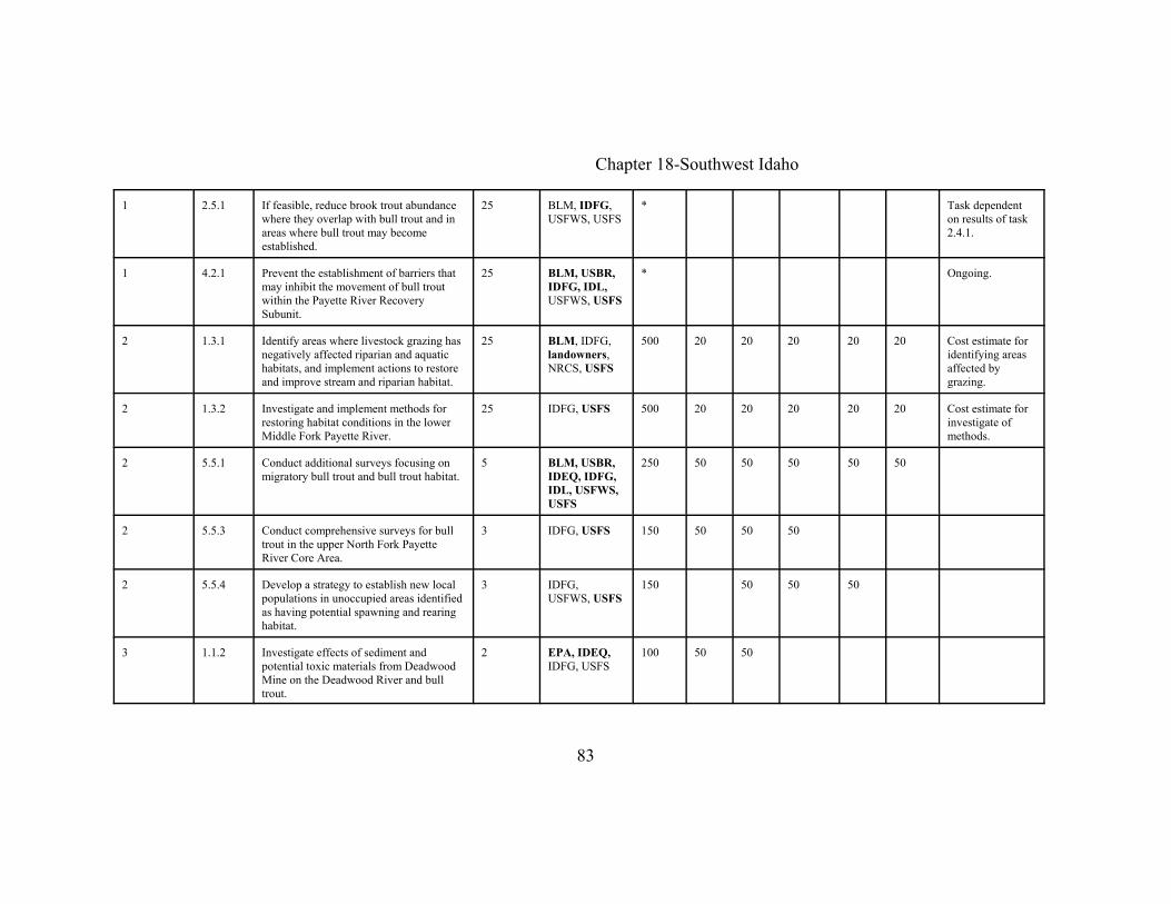
Chapter 18-Southwest Idaho
83
1 2.5.1 If feasible, reduce brook trout abundancewhere they overlap with bull trout and inareas where bull trout may becomeestablished.
25 BLM, IDFG,USFWS, USFS
* Task dependenton results of task2.4.1.
1 4.2.1 Prevent the establishment of barriers thatmay inhibit the movement of bull troutwithin the Payette River RecoverySubunit.
25 BLM, USBR,IDFG, IDL,USFWS, USFS
* Ongoing.
2 1.3.1 Identify areas where livestock grazing hasnegatively affected riparian and aquatichabitats, and implement actions to restoreand improve stream and riparian habitat.
25 BLM, IDFG,landowners,NRCS, USFS
500 20 20 20 20 20 Cost estimate foridentifying areasaffected bygrazing.
2 1.3.2 Investigate and implement methods forrestoring habitat conditions in the lowerMiddle Fork Payette River.
25 IDFG, USFS 500 20 20 20 20 20 Cost estimate forinvestigate ofmethods.
2 5.5.1 Conduct additional surveys focusing onmigratory bull trout and bull trout habitat.
5 BLM, USBR,IDEQ, IDFG,IDL, USFWS,USFS
250 50 50 50 50 50
2 5.5.3 Conduct comprehensive surveys for bulltrout in the upper North Fork PayetteRiver Core Area.
3 IDFG, USFS 150 50 50 50
2 5.5.4 Develop a strategy to establish new localpopulations in unoccupied areas identifiedas having potential spawning and rearinghabitat.
3 IDFG,USFWS, USFS
150 50 50 50
3 1.1.2 Investigate effects of sediment andpotential toxic materials from DeadwoodMine on the Deadwood River and bulltrout.
2 EPA, IDEQ,IDFG, USFS
100 50 50

Chapter 18-Southwest Idaho
84
3 1.2.2 Replace the culvert identified as a fishbarrier in Second Fork Squaw Creek.
1 USFS *
3 1.2.4 Evaluate fish passage at diversions onLake Fork and Fisher Creek andimplement actions to prevent fish loss andimprove passage, if necessary.
2 IDFG, IDWR,operators,USFS
*
3 3.2.1 Continue and expand public educationprograms for fish identification, anglingregulations, reasons for protectiveregulations on bull trout, and fishhandling practices.
25 BLM, IDFG,USFS
* Ongoing.
3 3.2.2 Continue enforcement of current fishingregulations and increase patrols.
25 IDFG * Ongoing.
3 3.2.3 Evaluate compliance of anglingregulations and incidence of bull troutpoaching in Gold Fork River fromKennally Creek upstream to theconfluence of the North Fork and SouthFork Gold Fork River.
3 IDFG *
3 3.3.1 Evaluate the effects of fish stocking andthe fishery on bull trout in DeadwoodReservoir.
3 IDFG 150 50 50 50
3 4.1.1 Collect samples for genetic analysis tocontribute to establishing a program tounderstand the genetic baseline andmonitor genetic changes throughout therange of bull trout (see Chapter 1narrative).
BLM, USBR,IDEQ, IDFG,IDL, USFWS,USFS
* See chapter 1.

Chapter 18-Southwest Idaho
85
3 4.1.2 Describe and monitor genetic andphenotypic characteristics of bull trout incore areas, and incorporate informationinto management strategies.
5 BLM, USBR,IDEQ, IDFG,IDL, USFWS,USFS
100 20 20 20 20 20 Cost estimate forthe collection oftissue duringexisting surveys.
3 5.5.2 Compile and synthesize historicinformation concerning bull troutpresence, distribution, and abundance inthe South Fork Payette River basin.
3 IDFG, USFS 75 25 25 25
Implementation schedule for the bull trout recovery plan: Southwest Idaho Unit, Weiser River Recovery Subunit
Prioritynumber
Tasknumber
Task description Taskduration(years)
Responsibleparties
(Alphabetical)
Cost estimates ($1,000)Comments
Totalcost
Year1
Year 2
Year 3
Year 4
Year 5
1 1.1.1 Reduce sediment production from roads. 25 BC, BLM,IDEQ, IDL,IDT, USFS
* Ongoing.
1 1.2.1 Inventory culverts to identify thoseinhibiting fish passage, and developprogram to improve fish passage.
25 BC, BLM,IDFG, IDL,USFS
* Ongoing
1 1.2.2 Identify facilities and actions needed toprevent the loss of bull trout at irrigationdiversions.
25 IDFG, IDWR,NCRS,operators,USFS
*
1 1.3.1 Identify areas where livestock grazinghas negatively affected riparian andaquatic habitats, and implement actionsto restore and improve stream andriparian habitat.
25 BLM, CDFG,IDL,landowners,NRCS,USFWS, USFS
500 20 20 20 20 20 Cost estimatesfor identifyingareas affected bygrazing.

Chapter 18-Southwest Idaho
Implementation schedule for the bull trout recovery plan: Southwest Idaho Unit, Weiser River Recovery Subunit
Prioritynumber
Tasknumber
Task description Taskduration(years)
Responsibleparties
(Alphabetical)
Cost estimates ($1,000)Comments
Totalcost
Year1
Year 2
Year 3
Year 4
Year 5
86
1 2.4.1 Evaluate various methods to reduce theabundance of brook trout.
5 BLM, IDFG,USFWS, USFS
250 50 50 50 50 50
1 4.2.1 Prevent the establishment of barriers thatmay inhibit the movement of bull troutwithin the Weiser River RecoverySubunit.
Perpetual BLM, IDFG,IDL, USFWS,USFS
* Ongoing.
2 2.5.1 Conduct surveys to determine thedistribution of brook trout in the WeiserRiver Recovery Subunit.
3 BLM, IDFG,USFS
150 50 50 50
2 2.5.2 Conduct a study on the feasibility ofreducing brook trout abundance wherethey overlap with bull trout and in areaswhere bull trout may becomeestablished.
3 BLM, IDFG,USFWS, USFS
150 50 50 50 Task dependenton results of task2.4.1.
2 5.5.1 Continue surveys to refine informationon bull trout distribution, abundance, lifehistories, and habitats.
5 BLM, IDEQ,IDFG, IDL,USFWS, USFS
125 25 25 25 25 25
2 5.5.2 Develop a strategy to establish new localpopulations in unoccupied areasidentified as having potential spawningand rearing habitat.
3 IDFG, IDL,USFWS, USFS
150 50 50 50
3 3.3.1 Evaluate the effects of fish stocking andthe fisheries on bull trout.
3 IDFG 150 50 50 50

Chapter 18-Southwest Idaho
Implementation schedule for the bull trout recovery plan: Southwest Idaho Unit, Weiser River Recovery Subunit
Prioritynumber
Tasknumber
Task description Taskduration(years)
Responsibleparties
(Alphabetical)
Cost estimates ($1,000)Comments
Totalcost
Year1
Year 2
Year 3
Year 4
Year 5
87
3 4.1.1 Collect samples for genetic analysis tocontribute to establishing a program tounderstand the genetic baseline andmonitor genetic changes throughout therange of bull trout (see Chapter 1narrative).
BLM, IDEQ,IDFG, IDL,USFWS, USFS
* See chapter 1.
3 4.1.2 Describe and monitor genetic andphenotypic characteristics of bull trout incore areas, and incorporate informationinto management strategies.
5 BLM, IDEQ,IDFG, IDL,USFWS, USFS
100 20 20 20 20 20 Cost estimate forthe collection oftissue duringexisting surveys.
Chapter 18-Southwest Idaho
88
REFERENCES CITED
Adams, S. 1994. Bull trout distribution and habitat use in the Weiser River drainage,Idaho. M.S. Thesis, University of Idaho, Moscow.
Batt, Governor P. E. 1996. State of Idaho Bull Trout Conservation Plan. Boise, Idaho.
Burton, T. 1998. Biological assessment of ongoing actions, Gold Fork Payette Riverbull trout subpopulation watershed. Boise National Forest, November 12, 1998,Boise, Idaho.
Burton, T. 1999a. Biological assessment of ongoing actions, North and Middle ForksBoise Basin bull trout subpopulation watershed. Boise National Forest, August27, 1999, Boise, Idaho.
Burton, T. 1999b. Biological assessment of ongoing actions, upper Deadwood Riverbull trout subpopulation watershed. Boise National Forest, September 30, 1999,Boise, Idaho.
Burton, T.A. 1999c. Biological assessment of ongoing actions, Squaw Creek bull troutsubpopulation watershed. Boise National Forest, December 14, 1999, Boise,Idaho.
Burton, T. 2000a. Biological assessment of ongoing actions in the Middle Fork PayetteRiver bull trout subpopulation watershed. Boise National Forest, January 10,2000, Boise, Idaho.
Burton, T. 2000b. Effects of uncharacteristically large and intense wildfires on nativefish: 14 years of observations–Boise National Forest. Boise National Forest,October 2000, Boise, Idaho.
Burton, T.A., and J.R. Erickson. 1998. Biological assessment of ongoing actions in thewest half South Fork Boise River bull trout subpopulation watershed, BoiseNational Forest, December 15, 1998, Boise, Idaho.
Burton T., and J. Erickson. 1999a. Biological assessment of ongoing actions South ForkPayette River bull trout subpopulation watershed. Boise National Forest,February 12, 1999, Boise, Idaho.
Chapter 18-Southwest Idaho
89
Burton, T., and J. Erickson. 1999b. Biological assessment of ongoing actions lowerBoise River bull trout subpopulation watershed. Boise National Forest, May 10,1999, Boise, Idaho.
Corley, D. 1997. Upper South Fork Boise River key watershed assessment for bull trout. Boise National Forest, Boise, Idaho.
Crow, J.F. and M. Kimura. 1970. An introduction to population genetics theory. Harperand Row, New York.
Dunham, J.B., and B.E. Rieman. 1999. Metapopulation structure of bull trout: Influences of physical, biotic, and geometrical landscape characteristics. Ecological Applications 9:642-655.
DuPont, J., and T. Kennedy. 2000. Weiser River key watershed bull trout problemassessment. Southwest Basin Native Fish Watershed Advisory Group. February2000.
Faurot, M. 2001. Biological assessment for the potential effects of managing the PayetteNational Forest in the North Fork Payette River section 7 watershed on ColumbiaRiver bull trout and biological evaluation for westslope cutthroat trout, Volume 2: Ongoing and new actions. Payette National Forest, June 2001, McCall, Idaho.
Flatter, B. 1998. Life history and population status of migratory bull trout (Salvelinusconfluentus) in Arrowrock Reservoir, Idaho. Prepared for U.S. Bureau ofReclamation by Idaho Department of Fish and Game, Nampa, Idaho.
Flatter, B. 1999. Investigation of bull trout (S. confluentus) in Arrowrock Reservoir,Idaho. Idaho Department of Fish and Game, 98-07, Boise.
Franklin, I.R. 1980. Evolutionary changes in small populations. Pages 135-149 in M.E.Soule and B.A. Wilcox, eds. Conservation Biology: An Evolutionary-Ecologicalperspective. Sinauer Associates, Sunderland, Massachusetts.
Hurley, M. 1995. A report on the basin wide survey of Middle Fork Weiser River. Prepared under Contract # 53-0256-4-21 with the Payette National Forest.
Idaho Division of Environmental Quality (IDEQ). 1998. Idaho’s 1998 303(d) List. Available at http://www2.state.id.us/deq/water/1998_303d/303dlist.pdf.

Chapter 18-Southwest Idaho
90
Jimenez, J., and D. Zaroban. 1998. Deadwood, Middle Fork and South Fork PayetteRivers key watersheds bull trout problem assessment. Southwest Basin NativeFish Watershed Advisory Group. November 1998.
Kenney, D., J. Shelly, and J. Madden. 2001. 2000 bull trout accomplishments,monitoring, survey, and compliance report for the Fairfield Ranger Districtportion of the upper South Fork Boise River drainage. U.S. Forest Service,Sawtooth National Forest, March 12, 2001, Fairfield, Idaho.
Lande, R. 1988. Genetics and demography in biological conservation. Science241: 1455-1460.
McGee, M., J. Lund, L. Pillers, and R. Nelson. 2001. Biological assessment for thepotential effects of managing the Payette National Forest in the Weiser Riversection 7 watershed on Columbia River bull trout and biological evaluation forwestslope cutthroat trout, Volume 3: Ongoing and new actions. June 5, 2001,Payette National Forest, McCall, Idaho.
Meffe, G.K., and C.R. Carroll. 1994. Principles of conservation biology. SinauerAssociates, Inc. Sunderland, Massachusetts.
Newberry, D.D. 2000. Biological assessment of ongoing actions on the Boise NationalForest in the Gold Fork River bull trout subpopulation watershed on the ColumbiaRiver bull trout population. Boise National Forest, Cascade Ranger District, May2000.
Newberry, D.D. 2002. Biological assessment for the potential effects of the upperMiddle Fork Payette River road rehabilitation project in the Middle Fork PayetteRiver bull trout subpopulation watershed on Columbia River basin bull troutdistinct population segment. Boise National Forest, Cascade Ranger District,February 14, 2002, Boise, Idaho.
Parrish, D. 1999. Addendum to Boise River key watersheds bull trout problemassessment (Draft–January 9, 1998). Idaho Department of Fish and Game,prepared for State of Idaho, Southwest Basin Native Fish Watershed AdvisoryGroup, proposed draft, November 2, 1999.
Partridge, F. 2000a. Monitoring the adfluvial bull trout population in Anderson RanchReservoir and South Fork Boise River. Abstract of presentation made at theTenth Annual Nonpoint Source Water Quality Monitoring Results Workshop,January 11-13, 2000, Boise, Idaho.

Chapter 18-Southwest Idaho
91
Partridge, F. 2000b. Bull trout restoration: Feather River culvert passage completionreport. Idaho Department of Fish and Game, Threatened and Endangered SpeciesReport, Project E-71-1, Section 6, Endangered Species Act, December 2000,Boise, Idaho.
Partridge, F., K. Frank, and C. Warren. 2000. Southwest Idaho bull trout restoration(South Fork Boise River) Completion Report. Idaho Department of Fish andGame, Threatened and Endangered Species Report, Project E-21-1, Section 6,Endangered Species Act, August 2000, Boise, Idaho.
Rieman, B.E., and Allendorf, F.W. 2001. Effective population size and geneticconservation criteria for bull trout. North American Journal of FisheriesManagement 21: 756-764.
Rieman, B.E., and J. D. McIntyre. 1995. Occurrence of bull trout in naturallyfragmented habitat patches of varied size. Transactions of the American FisheriesSociety 124:285-296.
Rieman, B.E., and J.D. McIntyre. 1993. Demographic and habitat requirements forconservation of bull trout. U.S. Forest Service, Intermountain Research Station.General Technical Report INT-302.
Rieman, B.E., and J.L. Clayton. 1997. Wildfire and native fish: Issues of forest healthand conservation of native fishes. Fisheries 22(11):6-15.
Rieman, B. E., D. Lee, G. Chandler, and D. Myers. 1997. Does wildfire threatenextinction for salmonids: Responses of redband trout and bull trout followingrecent large fires on the Boise National Forest. Pages 47-57 in J. Greenlee, editor. Proceedings of the symposium on fire effects on threatened and endangered andhabitats. International Association of Wildland Fire, Fairfield, Washington.
Salow, T.D. 2001. Population structure and movement patterns of adfluvial bull trout(Salvelinus confluentus) in the North Fork Boise River Basin, Idaho. M.S. thesis,Boise State University, Boise, Idaho.
Soule, M. E. 1980. Thresholds for survival: maintaining fitness and evolutionarypotential. Pages 151-170 in M. E. Soule and B. A. Wilcox, editors. Conservationbiology: An evolutionary-ecological perspective. Sinauer and Associates,Sunderland, Massachusetts
Chapter 18-Southwest Idaho
92
Steed, R. 1999. Gold Fork and Squaw Creek key watersheds bull trout problemassessment. Southwest Basin Native Fish Watershed Advisory Group. April1999.
Steed, R., T. Burton, R. Danehy, D. Greegor, S. Grunder, T. Kennedy, and D. Parrish. 1998. Boise River key watersheds bull trout problem assessment. SouthwestBasin Native Fish Watershed Advisory Group. January 1998.
Stovall, S.H., editor. 2001. Boise-Payette-Weiser subbasin summary. Prepared for theNorthwest Power Planning Council. Scott Grunder, Subbasin Team Leader,Idaho Department of Fish and Game. Draft October, 26, 2001.
U.S. Bureau of Reclamation (USBR). 2001. Amended biological assessment for Bureauof Reclamation operations and maintenance in the Snake River basin aboveBrownlee Reservoir. Pacific Northwest Region, Boise, Idaho, November 7, 2001.
U.S. Fish and Wildlife Service (USFWS). 1998. Klamath River and Columbia Riverbull trout population segments: Status summary and supporting documents lists. Prepared by bull trout listing team. Boise, Idaho.
U.S. Fish and Wildlife Service (USFWS). 1999. Biological opinion on the Bureau ofReclamation operations and maintenance activities in the Snake River basinupstream of Lower Granite Dam Reservoir. October 15, 1999. Snake RiverBasin Office, Boise, Idaho.
U.S. Fish and Wildlife Service (USFWS). 2001a. South Fork Boise River WatershedBiological Opinion for Bull Trout–Status Update and Amendments. Snake RiverBasin Office, March 16, 2001, Boise, Idaho.
U.S. Fish and Wildlife Service (USFWS). 2001b. Biological opinion on the ArrowrockDam outlet works rehabilitation project. Provided to the U.S. Bureau ofReclamation by the Snake River Basin Office, Boise, Idaho.
U.S. Forest Service (USFS). 1995. Inland Native Fish Strategy EnvironmentalAssessment. U.S. Department of Agriculture, U.S. Forest Service; Intermountain,Northern, and Pacific Northwest Regions.
Walker, K. 1998. Biological assessment for the potential effects of managing thePayette National Forest in the North Fork Payette River section 7 watershed onColumbia River bull trout Volume 1: ongoing activities. September 11, 1998,Payette National Forest, McCall, Idaho.

Chapter 18-Southwest Idaho
93
Williams, C. 2001. A summary of electrofishing and snorkeling surveys on the westzone of the Payette National Forest, 2000. Payette National Forest, CouncilRanger District, April 2001.
Williams C., and E. Veach. 1999. Are bull trout, Salvelinus confluentus, present in theMiddle Fork Weiser River drainage, Bear Creek drainage, and Crooked Riverdrainage: A study completed by Payette National Forest, Council RangerDistrict. Payette National Forest, Council Ranger District, December 17, 1999.
In Literature
Boise National Forest. in litt. 2002. Fish distribution information from the BoiseNational Forest Aquatic Survey Database in electronic format.
Burton, T. Boise National Forest, in litt. 2000. Email message to Scott Grunder, IdahoDepartment of Fish and Game, July 21, 2000. Subject: Bull trout in Mores Creek.
DuPont, J. Idaho Department of Lands, in litt. 1998. Memo to Don Aldrich, SeniorResource Manger-Forestry, Payette Lakes Area, Idaho Department of Lands, July13, 1998. Subject: Fish survey on Olive and Grouse creeks.
DuPont, J. Idaho Department of Lands, in litt. 2000. Memo to Don Aldrich, SeniorResource Manger-Forestry, Payette Lakes Area, Idaho Department of Lands,October 18, 2000. Subject: Evaluation of fisheries in Hornet, Johnson, andGoodrich creeks.
Rieber, R. U.S. Bureau of Reclamation, in litt. 2001. Information on USBRimplementation and projected budgets for bull trout RPMs.
Veach, E. U.S. Forest Service, in litt. 1998. Middle Fork Weiser River Project File,August 8, 1998. Subject: Bull trout consultation with USFWS.
Personal Communications
Kellett, M. Boise National Forest. Pers. comm. 2002. Conservation with S. Lohr, U.S.Fish and Wildlife Service, on February 21, 2002, concerning email message fromBruce Rieman, Rocky Mountain Research Station, on the preliminary geneticanalyses of bull trout in the Boise River basin.

Chapter 18-Southwest Idaho
94
Nelson, R. Payette National Forest. Pers. comm. 2002. Comments made on draftSouthwest Idaho Recovery Unit chapter distributed March 20, 2002, submitted toS. Lohr, U.S. Fish and Wildlife Service.
Parrish, D. Idaho Department of Fish and Game (IDFG). Pers. comm. 2000. Commentsmade on draft Southwest Idaho Recovery Unit chapter dated March 27, 2000,submitted to S. Lohr, U.S. Fish and Wildlife Service.
Rieber, R. U.S. Bureau of Reclamation. Pers. comm. 2001. Comments made on draftSouthwest Idaho Recovery Unit chapter dated November 15, 2001, submitted toSam Lohr, U.S. Fish and Wildlife Service.

Chapter 18-Southwest Idaho
95
Appendix A: Summary of bull trout information for environmental baselines in biological assessments by the BoiseNational Forest. Subpopulation watersheds and local population watersheds do not necessarily correspond to similar termsused in the listing rule for bull trout and this recovery plan (see sources for specific locations).
Subpopulationwatershed
Local populationwatershed Size1
Growthand
survival2Source Comments in biological assessments
North andMiddle ForksBoise Basin
Bear River 234 0.4101,000
Burton 1999a excessive fines, burned and debris floods afterwards, culvertbarriers and road sedimentation especially in Bear Creek,brook trout present, priorities are road restoration andaddressing brook trout
North andMiddle ForksBoise Basin
Blackwarrior 2,341 0.2220,900
Burton 1999a strong population with migratory fish, good habitats exceptbarriers in some tributaries, need to evaluate effects of sheepgrazing in watershed, priority on investigations of culvertbarriers
North andMiddle ForksBoise Basin
upper Crooked 728 0.994,500
Burton 1999a reduce risk of fire, reduce brook trout competition, reduceroad sedimentation, remove culvert barriers
North andMiddle ForksBoise Basin
Johnson Cr. 556 0.270,000
Burton 1999a mostly wilderness but depressed population, needsinvestigation
North andMiddle Forks Boise Basin
Lostman 87 0.341,000
Burton 1999a
North andMiddle ForksBoise Basin
lower Crooked adjunct,nodal
Burton 1999a reduce fire risks, reduce road sediment production anddrainage, increase bull trout signs, reduce brook troutcompetition, identify culvert barriers
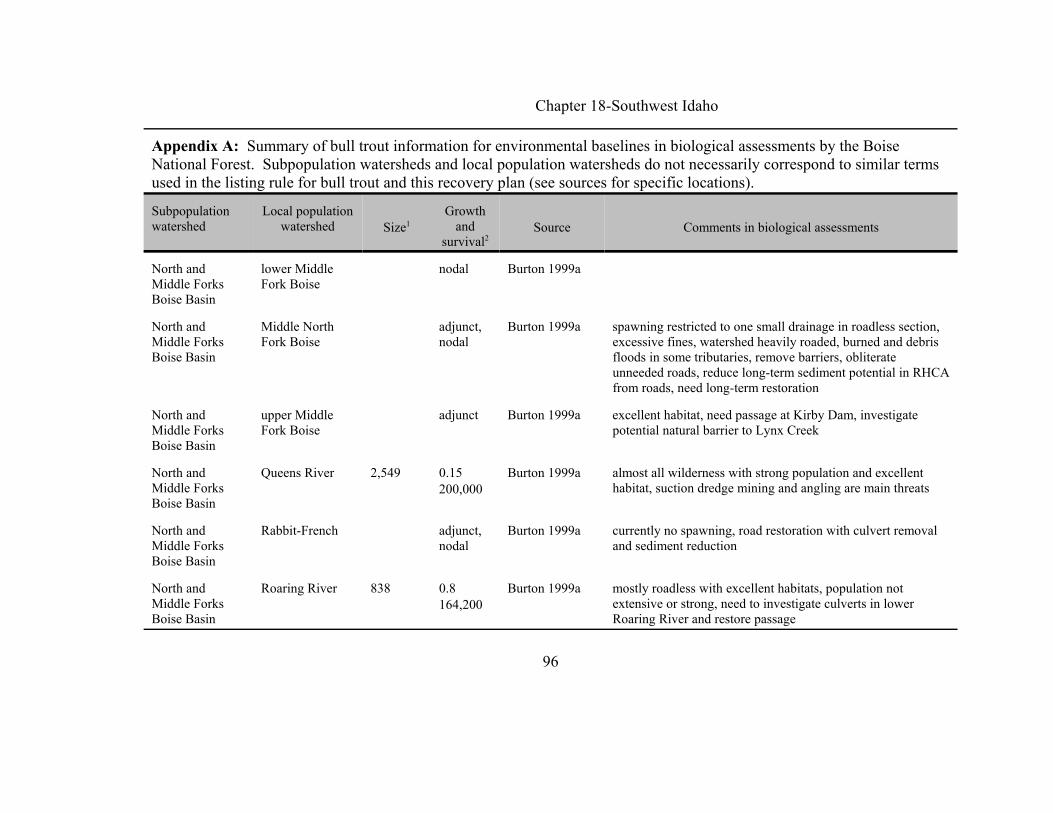
Chapter 18-Southwest Idaho
Appendix A: Summary of bull trout information for environmental baselines in biological assessments by the BoiseNational Forest. Subpopulation watersheds and local population watersheds do not necessarily correspond to similar termsused in the listing rule for bull trout and this recovery plan (see sources for specific locations).
Subpopulationwatershed
Local populationwatershed Size1
Growthand
survival2Source Comments in biological assessments
96
North andMiddle ForksBoise Basin
lower MiddleFork Boise
nodal Burton 1999a
North andMiddle ForksBoise Basin
Middle NorthFork Boise
adjunct,nodal
Burton 1999a spawning restricted to one small drainage in roadless section,excessive fines, watershed heavily roaded, burned and debrisfloods in some tributaries, remove barriers, obliterateunneeded roads, reduce long-term sediment potential in RHCAfrom roads, need long-term restoration
North andMiddle ForksBoise Basin
upper MiddleFork Boise
adjunct Burton 1999a excellent habitat, need passage at Kirby Dam, investigatepotential natural barrier to Lynx Creek
North andMiddle ForksBoise Basin
Queens River 2,549 0.15200,000
Burton 1999a almost all wilderness with strong population and excellenthabitat, suction dredge mining and angling are main threats
North andMiddle ForksBoise Basin
Rabbit-French adjunct,nodal
Burton 1999a currently no spawning, road restoration with culvert removaland sediment reduction
North andMiddle ForksBoise Basin
Roaring River 838 0.8164,200
Burton 1999a mostly roadless with excellent habitats, population notextensive or strong, need to investigate culverts in lowerRoaring River and restore passage

Chapter 18-Southwest Idaho
Appendix A: Summary of bull trout information for environmental baselines in biological assessments by the BoiseNational Forest. Subpopulation watersheds and local population watersheds do not necessarily correspond to similar termsused in the listing rule for bull trout and this recovery plan (see sources for specific locations).
Subpopulationwatershed
Local populationwatershed Size1
Growthand
survival2Source Comments in biological assessments
97
North andMiddle ForksBoise Basin
Silver-Cow 156 1.497,600
Burton 1999a depressed population, historic dredge mining along NorthFork, much is roadless, avoid further destabilization of NorthFork channel
North andMiddle ForksBoise Basin
upper NF Boise 3,566 0.7120,000
Burton 1999a strong population, all in wilderness, excellent habitats, noactions recommended
North andMiddle ForksBoise Basin
Yuba River 1,750 0.7250,000
Burton 1999a mostly roadless, historic mining in lower reaches, suctiondredging is main threat
Lower BoiseRiver
Rattlesnake 1,205 1.1100,000
Burton andErickson 1999b
severely depressed likely due to past grazing and roads, recentwildfires, and high sediment associated with moderate roaddensities; degraded and has experienced logging, roading, andlivestock grazing, and wildfire followed by high rates oferosion and sediment production in the lower part of thewatershed; priority is improving habitat conditions and allownatural healing
Lower BoiseRiver
Lower SouthFork Boise
nodal Burton andErickson 1999b
Lower BoiseRiver
Sheep Creek 2,328 1.461,920
Burton andErickson 1999b
strong local population is strong, many landslides in lowercreek

Chapter 18-Southwest Idaho
Appendix A: Summary of bull trout information for environmental baselines in biological assessments by the BoiseNational Forest. Subpopulation watersheds and local population watersheds do not necessarily correspond to similar termsused in the listing rule for bull trout and this recovery plan (see sources for specific locations).
Subpopulationwatershed
Local populationwatershed Size1
Growthand
survival2Source Comments in biological assessments
98
Lower BoiseRiver
ArrowrockReservoir
Burton andErickson 1999b
UpperDeadwood River
DeadwoodReservoir
371 0.24 39,408
Burton 1999b sediment, potential barriers, and large pools at risk, probablydue to RHCA road sedimentation and inherent erodiability ofdrainage
UpperDeadwood River
UpperDeadwood
789 0.2386,749
Burton 1999b sediment, potential barriers, and large pools at risk, probablydue to RHCA road sedimentation and inherent erodiability ofdrainage
South ForkPayette
Five-Eightmile <1,500 0 Burton andErickson 1999a
need to verify bull trout occurrence (5/1/98), problems withsedimentation, barriers, lack of large woody debris and limitedlarge pools and refugia
South ForkPayette
Canyon Creek 2,653 0.36 94,7000
Burton andErickson 1999a
strong population with few effects to population or habitatfrom management activities
South ForkPayette
Clear Creek 1,100 0.7 74,043
Burton andErickson 1999a
depressed population, sedimentation is a limiting factor, pastfishing pressure has also had an effect on population size andstrength
South ForkPayette
lower Deadwood nodal Burton andErickson 1999a
provides nodal habitat to focal and adjunct habitat upstream,key features include overwintering habitat found in largepools.

Chapter 18-Southwest Idaho
Appendix A: Summary of bull trout information for environmental baselines in biological assessments by the BoiseNational Forest. Subpopulation watersheds and local population watersheds do not necessarily correspond to similar termsused in the listing rule for bull trout and this recovery plan (see sources for specific locations).
Subpopulationwatershed
Local populationwatershed Size1
Growthand
survival2Source Comments in biological assessments
99
South ForkPayette
lower SouthFork Payette
adjunct,nodal
Burton andErickson 1999a
primarily nodal habitat, adjunct habitat in Rock Creek butamount is probably not sufficient in size to for a strong bulltrout population, problems with sedimentation, barriers, lackof large woody debris and limited large pools and refugia
South ForkPayette
Middle SouthFork Payette
224 0.42 22,609
Burton andErickson 1999a
small population, adjacent tributaries provide adjunct habitatand should be evaluated for possible reestablishment of bulltrout, problems with sedimentation, barriers, lack of largewoody debris and limited large pools and refugia
South ForkPayette
upper SouthFork Payette
NA NA Burton andErickson 1999a
watersheds mostly within wilderness and is not affected bymanagement activities
South ForkPayette
Whitehawk-Scott 3,315 0.45 118,398
Burton andErickson 1999a
strong population of bull trout, fishing, barriers, and sedimenttied to roads are primary concerns within the watershed,problems with sedimentation, barriers, lack of large woodydebris and limited large pools and refugia
South ForkPayette
Warm Springs adjunct,nodal
Burton andErickson 1999a
small population in middle South Fork Payette, adjacenttributaries provide adjunct habitat and should be evaluated forpossible reestablishment of bull trout, problems withsedimentation, barriers, lack of large woody debris and limitedlarge pools and refugia

Chapter 18-Southwest Idaho
Appendix A: Summary of bull trout information for environmental baselines in biological assessments by the BoiseNational Forest. Subpopulation watersheds and local population watersheds do not necessarily correspond to similar termsused in the listing rule for bull trout and this recovery plan (see sources for specific locations).
Subpopulationwatershed
Local populationwatershed Size1
Growthand
survival2Source Comments in biological assessments
100
Middle ForkPayette
Bull Creek 142(2,550 inBull and16:1creeks,Newberry (2002))
1.13 35,605
Burton 2000a (Newberry2002)
depressed population, threatened by brook trout in theheadwaters and naturally high sediment levels within theroadless area
Middle ForkPayette
Bulldog/Rattlesnake
nodal Burton 2000a
Middle ForkPayette
Silver Creek adjunct,nodal
Burton 2000a upper portion is adjunct habitat that is heavily affected bybarriers and sediment tied primarily to dispersed recreation,brook trout occur in drainage, opportunities exist to removebrook trout, improve dispersed recreation, and return bull troutto suitable habitat within the drainage
Middle ForkPayette
Upper MiddleFork Payette
2,390(2,932Newberry (2002))
0.61 77,770
Burton 2000a (Newberry2002)
strong population, concerns for brook trout establishment,barriers associated with roads, and sediment levels
Middle ForkPayette
West ForkMiddle ForkPayette
adjunct,nodal
Burton 2000a

Chapter 18-Southwest Idaho
Appendix A: Summary of bull trout information for environmental baselines in biological assessments by the BoiseNational Forest. Subpopulation watersheds and local population watersheds do not necessarily correspond to similar termsused in the listing rule for bull trout and this recovery plan (see sources for specific locations).
Subpopulationwatershed
Local populationwatershed Size1
Growthand
survival2Source Comments in biological assessments
101
Middle ForkPayette
Lower MiddleFork Payette
Burton 2000a provides migratory corridor for bull trout in Bull Creek andupper MF Payette, sediment levels and lack of pools are theprimary concern, weak migratory component
Middle ForkPayette
Middle MiddleFork Payette
Burton 2000a adult bull trout have been observed, but weak migratorycomponent, sediment is concern in lower portion of watershed,steep gradients, small watershed areas, and barriers may be aproblem for bull trout in adjunct habitat within tributaries
Middle ForkPayette
Lightning Creek Burton 2000a adjunct and nodal habitats, current concerns relate to sedimentlevels and large woody debris
Gold ForkPayette River
Gold Fork 1,830(~1,600Newberry (2000))
0.52 183,024
Burton 1998(Newberry2000)
depressed population, threatened by active timber sales, brooktrout, and high road densities and associatedsedimentation/barriers/runoff increases
Gold ForkPayette River
Kennally Creek adjunct Burton 1998 extensive brook trout population, no bull trout observed, roaddensity is high in the lower reaches of watershed
Squaw Creek Main SquawCreek
62 0.3 62,000
Burton 1999c depressed population, threatened by brook trout in theheadwaters and high road densities and associatedsedimentation/barriers/runoff increases
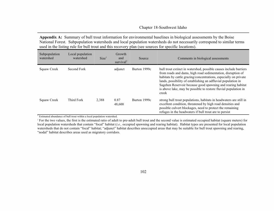
Chapter 18-Southwest Idaho
Appendix A: Summary of bull trout information for environmental baselines in biological assessments by the BoiseNational Forest. Subpopulation watersheds and local population watersheds do not necessarily correspond to similar termsused in the listing rule for bull trout and this recovery plan (see sources for specific locations).
Subpopulationwatershed
Local populationwatershed Size1
Growthand
survival2Source Comments in biological assessments
102
Squaw Creek Second Fork adjunct Burton 1999c bull trout extinct in watershed, possible causes include barriersfrom roads and dams, high road sedimentation, disruption ofhabitats by cattle grazing/concentrations, especially on privatelands, possibility of establishing an adfluvial population inSagehen Reservoir because good spawning and rearing habitatis above lake, may be possible to restore fluvial population increek
Squaw Creek Third Fork 2,388 0.87 48,600
Burton 1999c strong bull trout populations, habitats in headwaters are still inexcellent condition, threatened by high road densities andpossible culvert blockages, need to protect the remainingrefuges in the headwaters if bull trout are to persist
1 Estimated abundance of bull trout within a local population watershed.2 For the two values, the first is the estimated ratio of adult to pre-adult bull trout and the second value is estimated occupied habitat (square meters) forlocal population watersheds that contain “focal” habitat (i.e., occupied spawning and rearing habitat). Habitat types are presented for local populationwatersheds that do not contain “focal” habitat; “adjunct” habitat describes unoccupied areas that may be suitable for bull trout spawning and rearing,“nodal” habitat describes areas used as migratory corridors.

Chapter 18-Southwest Idaho
103
Appendix B: Waters within the Southwest Idaho Recovery Unit appearing on Idaho’s 1998 303(d) list (IDEQ 1998).
HUC1 Water body Boundaries Length (mile) Pollutant(s)
North Fork and Middle Fork Boise River
17050111 Browns Creek Headwaters to Middle Fork Boise River 6.4 sediment
17050111 Buck Creek Headwaters to Middle Fork Boise River 7.2 sediment
Boise-Mores
17050112 Macks Creek Headwaters to Grimes Creek 6.4 sediment
17050112 Minneha Creek Headwaters to Mores Creek 8.8 sediment
South Fork Boise River
17050113 Cayuse Creek Headwaters to South Fork Boise River 3.2 sediment
17050113 Deer Creek Headwaters to Anderson Ranch River 1.3 sediment
17050113 Elk Creek Headwaters to Feather River 7.0 sediment
17050113 Little SmokeyCreek
Headwaters to Carrie Creek 11.3 sediment

Chapter 18-Southwest Idaho
Appendix B: Waters within the Southwest Idaho Recovery Unit appearing on Idaho’s 1998 303(d) list (IDEQ 1998).
HUC1 Water body Boundaries Length (mile) Pollutant(s)
104
17050113 RattlesnakeCreek
Headwaters to South Fork Boise River 16.0 sediment
17050113 Smith Creek Tiger Creek to South Fork Boise River 14.5 sediment
17050113 South Fork BoiseRiver
Anderson Ranch to Arrowrock 28.7 sediment
17050113 Willow Creek Headwaters to Arrowrock 14.9 sediment
Lower Boise River
17050114 Blacks Creek Headwaters to Blacks Creek Reservoir 13.2 sediment
17050114 Boise River Notus to Snake River 15.8 sediment, temperature
17050114 Boise River Star to Notus 21.5 bacteria, nutrients, sediment, temperature
17050114 Boise River Barber Diversion to Star 25.2 sediment
17050114 Boise River Lucky Peak to Barber Diversion 5.2 flow alteration
17050114 CottonwoodCreek
Headwaters to Freestone Creek 6.8 unknown
17050114 Fivermile Creek Headwaters to fifteenmile Creek 28.9 DO, nutrients, sediment
17050114 Indian Creek NY Canal to Boise River 16.6 DO, nutrients, oil/gas, sediment

Chapter 18-Southwest Idaho
Appendix B: Waters within the Southwest Idaho Recovery Unit appearing on Idaho’s 1998 303(d) list (IDEQ 1998).
HUC1 Water body Boundaries Length (mile) Pollutant(s)
105
17050114 Indian Creek Headwaters to NY Canal 39.0 nutrients, sediment
17050114 Lake Lowell DO, nutrients
17050114 Mason Creek Headwaters to Boise River 17.8 DO, nutrients, sediment
17050114 Sand HollowCreek
Headwaters to Boise River 23.6 DO, nutrients, sediment
17050114 Tenmile Creek Headwaters to Fifteenmile Creek 27.2 DO, nutrients, sediment
17050114 Willow Creek Headwaters to Boise River 51.4 unknown
South Fork Payette River
17050120 South ForkPayette River
Wilderness boundary to Payette River 59.4 sediment
Middle Fork Payette River
17050121 Middle ForkPayette River
Big Bulldaog Creek to South Fork Payette River 13.0 sediment

Chapter 18-Southwest Idaho
Appendix B: Waters within the Southwest Idaho Recovery Unit appearing on Idaho’s 1998 303(d) list (IDEQ 1998).
HUC1 Water body Boundaries Length (mile) Pollutant(s)
106
Lower Payette River
17050122 Big WillowCreek
Rock Creek to Payette River 23.4 unknown
17050122 Bissel Creek Headwaters to Payette river 17.0 sediment
17050122 Black CanyonReservoir
nutrients, oil/gas, sediment
17050122 Payette River Black Canyon Dam to Snake River 39.2 bacteria, nutrients, temperature
17050122 Soldier Creek Headwaters to Squaw Creek 9.0 sediment
North Fork Payette River
17050123 Big Creek Horsethief Creek to North Fork Payette River 6.5 sediment
17050123 Boulder Creek Headwaters to Cascade Reservoir 20.4 DO, flow alteration, nutrients, sediment,temperature
17050123 Browns Pond habitat
17050123 Brush Creek Headwaters to North Fork Payette River 5.0 unknown
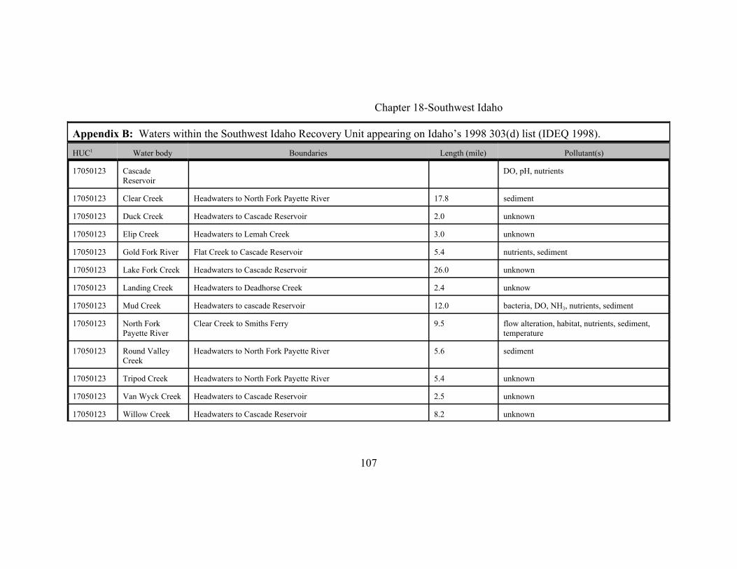
Chapter 18-Southwest Idaho
Appendix B: Waters within the Southwest Idaho Recovery Unit appearing on Idaho’s 1998 303(d) list (IDEQ 1998).
HUC1 Water body Boundaries Length (mile) Pollutant(s)
107
17050123 CascadeReservoir
DO, pH, nutrients
17050123 Clear Creek Headwaters to North Fork Payette River 17.8 sediment
17050123 Duck Creek Headwaters to Cascade Reservoir 2.0 unknown
17050123 Elip Creek Headwaters to Lemah Creek 3.0 unknown
17050123 Gold Fork River Flat Creek to Cascade Reservoir 5.4 nutrients, sediment
17050123 Lake Fork Creek Headwaters to Cascade Reservoir 26.0 unknown
17050123 Landing Creek Headwaters to Deadhorse Creek 2.4 unknow
17050123 Mud Creek Headwaters to cascade Reservoir 12.0 bacteria, DO, NH3, nutrients, sediment
17050123 North ForkPayette River
Clear Creek to Smiths Ferry 9.5 flow alteration, habitat, nutrients, sediment,temperature
17050123 Round ValleyCreek
Headwaters to North Fork Payette River 5.6 sediment
17050123 Tripod Creek Headwaters to North Fork Payette River 5.4 unknown
17050123 Van Wyck Creek Headwaters to Cascade Reservoir 2.5 unknown
17050123 Willow Creek Headwaters to Cascade Reservoir 8.2 unknown

Chapter 18-Southwest Idaho
Appendix B: Waters within the Southwest Idaho Recovery Unit appearing on Idaho’s 1998 303(d) list (IDEQ 1998).
HUC1 Water body Boundaries Length (mile) Pollutant(s)
108
Weiser River
17050124 Cove Creek Headwaters to Weiser River 14.0 nutrients, sediment
17050124 Crane Creek Crane Creek Reservoir to Weiser 12.6 bacteria, nutrients, sediment
17050124 Crane CreekReservoir
nutrients, sediment
17050124 Johnson Creek Headwaters to Weiser River 13.6 unknown
17050124 Little WeiserRiver
Indian Valley to Weiser River 17.2 nutrients, sediment
17050124 Mann Creek Mann Creek Reservoir to Weiser River 13.0 sediment
17050124 North CraneCreek
Headwaters to Crane Creek Reservoir 24.6 bacteria, flow, nutrients, sediment, temperature
17050124 South CraneCreek
Headwaters to Crane Creek Reservoir 9.2 unknown
17050124 Weiser River Galloway Dam to Snake River 12.4 bacteria, nutrients, sediment, temperature, DO
17050124 Weiser River West Fork Weiser River to Little Weiser River 20.8 nutrients, sediment
17050124 Weiser River Little Weiser River to Galloway 32.0 bacteria, nutrients, sediment

Chapter 18-Southwest Idaho
Appendix B: Waters within the Southwest Idaho Recovery Unit appearing on Idaho’s 1998 303(d) list (IDEQ 1998).
HUC1 Water body Boundaries Length (mile) Pollutant(s)
109
17050124 West ForkWeiser River
Headwaters to Weiser River 15.9 unknown
1 Hydrological unit code.

Chapter 18-Southwest Idaho
110
Appendix C: List of Chapters
Chapter 1 - IntroductoryChapter 2 - Klamath River Recovery Unit, OregonChapter 3 - Clark Fork River Recovery Unit, Montana and IdahoChapter 4 - Kootenai River Recovery Unit, Montana and IdahoChapter 5 - Willamette River Recovery Unit, OregonChapter 6 - Hood River Recovery Unit, OregonChapter 7 - Deschutes River Recovery Unit, OregonChapter 8 - Odell Lake Recovery Unit, OregonChapter 9 - John Day River Recovery Unit, OregonChapter 10 - Umatilla-Walla Walla Rivers Recovery Unit, Oregon and WashingtonChapter 11- Grande Ronde River Recovery Unit, OregonChapter 12 - Imnaha-Snake Rivers Recovery Unit, OregonChapter 13 - Hells Canyon Complex Recovery Unit, Oregon and IdahoChapter 14 - Malheur River Recovery Unit, OregonChapter 15 - Coeur d’Alene River Recovery Unit, IdahoChapter 16 - Clearwater River Recovery Unit, IdahoChapter 17 - Salmon River Recovery Unit, IdahoChapter 18 - Southwest Idaho Recovery Unit, IdahoChapter 19 - Little Lost River Recovery Unit, IdahoChapter 20 - Lower Columbia River Recovery Unit, WashingtonChapter 21 - Middle Columbia River Recovery Unit, WashingtonChapter 22 - Upper Columbia River Recovery Unit, WashingtonChapter 23 - Northeast Washington Recovery Unit, WashingtonChapter 24 - Snake River Washington Recovery Unit, Washington