chapter 17 characterization and reconstruction of multiple
TRANSCRIPT

299
IntroductionPORPHYRY copper deposits in the Laramide (ca. 80−50 Ma)province of southwestern North America have received con-siderable attention at the scale of individual orebodies (Titleyand Hicks, 1966; Titley, 1982a). Recent recognition of alter-ation assemblages formed on the distal flanks and roots of thesystems (Seedorff et al., 2008) suggests, however, that a sys-tem-scale understanding of their evolution still remains to bedeveloped. One fact that has hindered a system-scale under-standing so far is the complex normal faulting that dismem-bered most Laramide porphyry systems after their emplace-ment. Faulting commonly separates originally adjacent partsof porphyry systems by kilometers and juxtaposes unrelatedparts of the systems (Proffett, 1977; Stavast et al., 2008).
System-scale understanding of dismembered copper por-phyry systems requires careful attention to postmineralstructural geology. The effects of extension can be removedthrough palinspastic reconstruction of the systems whereby
the dismembered pieces of the hydrothermal systems are putback into context. The exposure of different paleodepths inthe multiple fault blocks then becomes an aid to understand-ing timing and processes of copper porphyry formation. Forexample, root zones beneath mineralization, which wouldmost likely never be drilled in an upright system, can be ex-humed and, therefore, examined in footwall blocks of normalfaults (Seedorff et al., 2008). Exploration in the Basin andRange province can utilize the fact that extension often pre-serves and hides pieces of mineral deposits, leaving vectorstoward mineralization to the structurally aware geologist.
The structural complexities in highly faulted areas of theBasin and Range province have been studied extensively (e.g.,Crittenden et al., 1980; Dickinson, 1991; Davis et al., 2004)and have produced long-standing controversies that center onthe geometry, timing, and magnitude of normal faulting(Wernicke, 1981; Lister and Davis, 1989; Miller et al., 1999;Maher, 2008). Economic geologists working in extended por-phyry systems provided some of the first insights into this de-bate (Lowell, 1968; Proffett, 1977) and continue to refine the
Chapter 17
Characterization and Reconstruction of Multiple Copper-Bearing Hydrothermal Systemsin the Tea Cup Porphyry System, Pinal County, Arizona
PHILLIP A. NICKERSON,† MARK D. BARTON, AND ERIC SEEDORFF
Institute for Mineral Resources, Department of Geosciences, University of Arizona, 1040 East Fourth Street, Tucson, Arizona 85721-0077
AbstractThis study exploits a cross-sectional view of the Laramide magmatic arc in the northern Tortilla Mountains,
central Arizona, that was created by tilting during severe Tertiary extension of the Basin and Range province.Building upon earlier work, we combine the results of geologic mapping of rock types, structures, and hydrothermal alteration styles, with a palinspastic reconstruction, to provide a system-wide understanding ofthe evolution of the composite magmatic and hydrothermal Tea Cup porphyry system.
Geologic mapping revealed the presence of at least three, and possibly four, mineralizing hydrothermal sys-tems in the study area that are associated with widespread potassic, sericitic, greisen, sodic (-calcic), and propy-litic alteration. The alteration envelops both porphyry copper and porphyry molybdenum (-copper) mineral-ization. Two areas flanking compositionally distinct units of the composite Tea Cup pluton are characterized byintense potassic and sericitic alteration. Intense alteration and mineralization akin to iron oxide-copper-goldsystems was recognized in several areas. The U-Pb dating of zircons from porphyry dikes suggests that hydrothermal activity in the study area was short lived (~73−72 Ma). Subsequently, between ~25 and 15 Ma,the Tea Cup porphyry system was tilted ~90° to the east and extended by >200 percent due to movement onfive superimposed sets of nearly planar normal faults. Each fault set was initiated with dips of ~60° to 70°, butmodern dips range from 70° to 15° overturned from the youngest to the oldest set. Tertiary normal faulting resulted in the exposure of pieces of the porphyry system from paleodepths of >10 km.
Palinspastic reconstruction of a ~30-km-long cross section reveals that the Tea Cup pluton formed by sequential intrusion of at least four compositionally distinct units. Each major unit generated its own hy-drothermal system. The most intense alteration in each hydrothermal system formed above the cupolas of eachmajor phase of the pluton. Potassic alteration dominates the core of each system, whereas feldspar-destructiveacid alteration overlaps with the potassic alteration but also extends to higher levels within each system. Deepsodic (-calcic) alteration overlain by iron oxide-rich chlorite-sericite-pyrite alteration flanks these central sys-tems and generally extends 2 to 4 km away from the center of the hydrothermal systems. Greisen-style alter-ation was recognized 1 to 2 km beneath the potassic alteration in one porphyry copper system but overlaps andextends above the exposed porphyry molybdenum (-copper) system. Propylitic alteration occurs in a distal position and surrounds the other alteration styles. The alteration mapping, combined with the palinspastic reconstruction, revealed two covered exploration targets centered on intense potassic alteration, demonstrat-ing that palinspastic reconstruction represents a powerful exploration technique in a district with more than100 years of exploration history.
† Corresponding author: e-mail, [email protected]
© 2010 Society of Economic Geologists, Inc.Special Publication 15, pp. 299–316

understanding of this issue utilizing knowledge gained fromdrill hole data and geophysical methods, which are not com-monly available to structural geologists (Dilles and Gans,1995; Wilkins and Heidrick, 1995; Stavast et al., 2008).
This study describes the rock types, structure, and hydro -thermal alteration and provides a palinspastic reconstruction ofthe Laramide Tea Cup porphyry system in the northern TortillaMountains, Pinal County, Arizona. The results are based onnew field work, combined with earlier mapping by Schmidt(1971), Cornwall and Krieger (1975a, b), Bradfish (1979),Richard and Spencer (1997), and Barton et al. (2005). The newmapping for this study and the work of Barton et al. (2005)paid particular attention to the characterization of hydrother-mal alteration, the recognition of internal variations in the ig-neous rocks, and the structural geology of the area. These fea-tures, in combination with the general geologic patternsreported in earlier work, are critical to interpreting the struc-tural evolution of the study area and thereby reconstructingthe magmatic and related hydrothermal systems at Tea Cup.
Geologic SettingThe Tea Cup porphyry system is located in the northern
Tortilla Mountains of east-central Arizona, the heart of theporphyry copper belt of southwestern North America (Fig.1), and within an area that has been the focus of long-stand-ing investigation (e.g., Ransome, 1903; Cornwall, 1982;Maher, 2008). Major nearby porphyry copper districts in-clude Ray (Phillips et al., 1974), Globe-Miami (Peterson,1962), Superior (Hammer and Peterson, 1968; Manske andPaul, 2002), Poston Butte (Nason et al., 1982), Christmas(Koski and Cook, 1982), Mission-Pima (Barter and Kelly,1982), and Sierrita-Esperanza (West and Aiken, 1982). Ex-ploration for porphyry copper deposits in the region hasebbed and flowed in tandem with copper prices (Lowell,1978; Paul and Manske, 2005), with times of intense explo-ration mainly in the late 19th and middle 20th centuries. Thediscovery of the Resolution deposit near Superior in the mid-1990s has renewed the interest of both junior and major min-ing companies in the region.
300 NICKERSON ET AL.
0361-0128/98/000/000-00 $6.00 300
FIG. 1. Geologic map of south-central Arizona, showing the study area, nearby porphyry copper deposits, the Catalinacore complex, and the Tortilla Mountains (geology from Reynolds, 1988).

The metamorphic basement of the northern Tortilla Moun-tains is represented by the Mesoproterozoic Pinal Schist (ca.1.7 Ga). These crystalline rocks were intruded by the MaderaDiorite at 1.6 Ga and the anorogenic Ruin Granite at 1.4 Ga(Fig. 2). Subsequently, the basement was beveled and uncon-formably overlain by approximately 1 km of dominantly silici-clastic sedimentary rocks of the Proterozoic Apache Groupand Troy Quartzite. Near the time of deposition of the TroyQuartzite, the siliciclastic sedimentary sequence and the un-derlying crystalline rocks were intruded by diabase sheets,sills, and dikes, dated at ~1.1 Ga (Shride, 1967; Wrucke,1989). The diabase sheets are most abundant in the upper 1km of the Ruin Granite and in the overlying sedimentaryrocks of the Apache Group (Howard, 1991). The consistentorientation and depth of emplacement of the sheets and sillsacross much of Arizona and parts of California allows them tobe used as structural markers in the crystalline rock (Howard,1991; Barton et al., 2005; Maher, 2008). The Proterozoicstrata of the Troy Quartzite and Apache Group are discon-formably overlain by approximately 1 to 1.5 km of Paleozoicstrata, mainly carbonate rocks.
During the Laramide, regional contraction (Davis, 1979)produced basement-cored uplifts similar to those of the cen-tral Rocky Mountains, and a large magmatic arc was built onthe western margin of the North American plate (Drewes,1976; Dickinson, 1989). The arc formed between about 84and 61 Ma and shows an overall progression to more felsiccompositions over time (Cornwall, 1982). Contraction clearlypostdates early, relatively mafic magmatism (Willden, 1964).Porphyry copper formation is related to somewhat younger
(74−61 Ma) magmatism of intermediate to silicic composition(Titley, 1982b), which, in the cases of at least certain deposits,postdates reverse faulting (Seedorff et al., 2005a). Arc mag-matism produced numerous intrusions and at least ten por-phyry systems in the surrounding area (Maher, 2008).
A period of tectonic quiescence and erosion characterizedthe post-Laramide period until ~25 Ma (Dickinson, 1991;Howard and Foster, 1996), when extension dismembered andtilted the Laramide porphyry systems and surrounding hostrocks (Barton et al., 2005). In the study area, ~90° eastwardtilting occurred along multiple sets of ~north-south−strikingnormal faults. Synextensional, late Oligocene-early Mioceneconglomerates and alluvial fan deposits comprise the oldestpost-Laramide rocks in the study area. Younger middle Mio -cene sedimentary and igneous rocks associated with a rhyolitedome field appear to overlie the Whitetail Conglomerate in anangular unconformity (Dickinson, 1995; Richard and Spencer,1997). Postextension, newly formed basins were filled withTertiary gravels and widespread pediment surfaces wereformed on older rocks. Today, the landscape is undergoing in-cision as the pediment surfaces are exhumed by downcuttingalong the Gila River (Richard and Spencer, 1997).
Geologic UnitsA wide range of units, from the Proterozoic to the Quater-
nary, are exposed in the study area (Fig. 2).
Proterozoic and Paleozoic rocks
Mesoproterozic igneous and siliciclastic sedimentary rocksconstitute the basement throughout the study area and are
RECONSTRUCTION OF THE TEA CUP PORPHYRY SYSTEM 301
0361-0128/98/000/000-00 $6.00 301
FIG. 2. Geologic map of the study area. The map is based on new mapping and previous work by by Schmidt (1971), Corn-wall and Krieger (1975a, b), Bradfish (1979), Richard and Spencer (1997), and Barton et al. (2005).

the primary host of Laramide hydrothermal alteration andmineralization. The oldest of these is the ca. 1.4 Ga RuinGranite (Dickinson, 1991) usually recognized by 1- to 5-cm-long K-feldspar crystals but is locally represented by anequigranular, fine-grained phase (Richard and Spencer,1997). The Ruin Granite is overlain by sedimentary rocks ofthe Apache Group comprised of siltstones and sandstones ofthe Pioneer Formation, the Dripping Spring Quartzite,Mescal Limestone, and a cap of basaltic flows. The youngerTroy Quartzite crops out in the eastern one-third of the studyarea (grouped with the Apache Group in Fig. 2), as describedby Cornwall and Krieger (1975b).
The ca. 1.1 Ga Sierra Ancha Diabase crops out as sills, flatsheets, and dikes. The unit commonly displays a strong sub-ophitic, diabasic texture. Mineralogically, the diabase consistsof plagioclase laths in a black groundmass of pyroxene andmagnetite. In the study area, the sheets and sills dip verticallyand in the region served as reactive hosts for hydrothermal al-teration and mineralization (Force, 1998).
The Paleozoic section in the study area reaches a thicknessof approximately 1 to 1.5 km. These mostly carbonate rocksare restricted in the eastern one-third of the study area (Fig.2) and consist of the Cambrian Bolsa Quartzite and AbrigoFormation, the Devonian Martin Limestone, the Mississip-pian Escabrosa Limestone, and the carbonate-dominatedPennsylvanian to Permian Naco Group (Cornwall and Krieger,1975b).
Laramide igneous rocks
Laramide volcanic and plutonic rocks are widely distrib-uted in the northern Tortilla Mountains and adjacent areas.The intrusive complexes, including the Tea Cup pluton, lo-calized and generated hydrothermal systems and associatedmineralization.
Williamson Canyon Volcanics: This unit crops out west ofthe Gila River in the southeastern portion of the study area(Fig. 2). It consists of porphyritic, basaltic andesitic volcanicbreccias, with abundant xenoliths of Troy Quartzite andunidentified rock fragments (Willden, 1964; Koski and Cook,1982). The basaltic andesite was extruded as mafic eruptionsduring the early phases of construction of the Laramide arc.
Tea Cup pluton: In its principal exposures, the pluton (Fig.2) is crudely zoned from its outermost marginal phase ofminor biotite-hornblende quartz monzodiorite to main inte-rior phases of hornblende-biotite granodiorite, biotite gran-ite, and westernmost biotite-muscovite ± garnet granodiorite(Barton et al., 2005). The biotite-hornblende quartz monzo-diorite is relatively fine grained (1−4 mm), with 15 to 30 per-cent mafic minerals consisting of hornblende greater than bi-otite; it makes up a small mass on the southeastern edge ofthe pluton and is the oldest of the intrusive phases (Fig. 2).The hornblende-biotite granodiorite has varied grain size(2−8 mm), contains 10 to 15 percent mafic minerals with bi-otite subequal to hornblende, and is mainly equigranular toseriate, with sparse larger (5−15 mm) feldspar and quartzcrystals in its more porphyritic phases. This unit comprisesthe eastern part of the Tea Cup pluton and forms its promi-nent cupola (Fig. 2). The biotite granite occupies the centralpart of the pluton and also crops out southwest of the mainpluton. The unit is comprised of equigranular, medium-
grained leucocratic granitoids with 40 percent 3- to 10-mm-diam anhedral quartz, 25 percent pink subhedral 3-to 4-mm-diam K-feldspar intergrown with 30 to 40 percent subhedralwhite plagioclase in 2- to 4-mm-diam grains, and 2 to 3 per-cent 1-mm-diam biotite (Richard and Spencer, 1997). The bi-otite-muscovite ± garnet granodiorite is an equigranular,medium- to medium-fine−grained, locally aplitic unit. It con-sists of 30 percent quartz in 2- to 4-mm-diam anhedral grains,60 to 70 percent feldspar, mostly plagioclase, in 2-to 6-mm-diam, anhedral grains, and 5 to 7 percent mica, with a variablemuscovite to biotite ratio (Richard and Spencer, 1997).
Porphyry dikes: Several varieties of Laramide dikes occurin the study area (Table 1). Most dikes are strongly por-phyritic with varied contents of quartz, feldspar, hornblende,and mica (biotite ± rare muscovite) phenocrysts. Porphyriticdikes are concentrated in two swarms, one east of the TeaCup pluton and another centered on Box-O Wash (Fig. 2).Several dike types are found in both dike swarms. The dikeshave a preferred orientation striking 070°, with steep dips,and are structural markers.
Tertiary sedimentary and volcanic rocks
Variably dipping late Oligocene to Miocene sedimentaryrocks (Fig. 2) of the Whitetail, Cloudburst, and San ManuelFormations are found across the study area. Locally, thin tuffbeds occur within the sedimentary sequences. They constituteevidence for synextensional sedimentation and provide a keyelement in reconstructing the history and timing of faulting.
Ripsey and Hackberry Wash: The largest exposures of Ter-tiary rocks in the study area occur near Ripsey Wash andHackberry Wash. In Ripsey Wash, the Tertiary rocks are partof the San Manuel Formation, which is comprised of gray tobuff strata of alluvial fan and braided plain facies, with localmegabreccia bodies and interstratified silicic tuffs (Dickin-son, 1991). Exposures of this unit dip as steeply as 45° east inRipsey Wash (Fig. 2). Potassium-argon dating of the silicictuffs yielded ages of 20.3 and 17.5 Ma in this section (Dickin-son, 1991).
Hackberry Wash contains exposures of the San ManuelFormation and the older Cloudburst Formation. The Cloud-burst Formation is lithologically similar to the San ManuelFormation but is reddish in color. Exposures of the Cloud-burst Formation have been tilted as much as 100° to the eastin Hackberry Wash (Maher et al., 2004). A K-Ar date of a tuffnear the basal contact of the Cloudburst Formation yieldedan age of 25.4 Ma just west of Hackberry Wash (Dickinson,1991).
Red Hills area and Donnelly Wash: A small exposure ofWhitetail Conglomerate was mapped near the Red Hillsprospect. It is a dark reddish brown, poorly sorted to massiveconglomerate that probably correlates with the HackberryMember of the Cloudburst Formation (Dickinson, 1991;Maher et al., 2004). Cobbles and rare boulders are comprisedof granitoids, schist, and less abundant felsic volcanic or hy-pabyssal rocks.
An avalanche breccia is located in and near Donnelly Wash(Fig. 2). The unit is comprised of a monolithologic brecciaconsisting of unsorted angular clasts of mostly Ruin Granite(Richard and Spencer, 1997). Similar deposits have beenmapped in the eastern part of the study area by Krieger
302 NICKERSON ET AL.
0361-0128/98/000/000-00 $6.00 302

(1977). In Donnelly Wash, Richard and Spencer (1997) con-sidered these rocks to be younger than the Whitetail Con-glomerate. However, Maher (2008) found evidence that similar deposits to the east represented the base of the cor-relative Cloudburst Formation.
Located structurally above the rock avalanche breccia atDonnelly Wash are volcanic units that crop out extensively inthe western one-third of the study area (Fig. 2). These in-clude several varieties of tuff and basalt. K-Ar and Ar-Ar agedating suggest that these volcanic units range between 19 and15 Ma in age (Richard and Spencer, 1997).
Overlying the volcanic units is an unnamed conglomerate(Fig. 2). It consists of massive, crudely to moderately wellbedded, cobble to boulder conglomerate and poorly sortedgravels. It also contains local synsedimentary volcanic de-posits (Richard and Spencer, 1997).
Hydrothermal Alteration and MineralizationAt least three, and possibly four, hydrothermal systems con-
taining distinctive combinations of potassic, sericitic, greisen,
sodic, sodic (-calcic), and propylitic alteration formed in andsurrounding the Tea Cup pluton (Figs. 3, 4; Table 2; alter-ation terminology is the same as in Seedorff et al., 2005b). Allbut one of these systems have porphyry copper-style alter-ation and mineralization and are localized on cupolas of theTea Cup pluton. The other distinctive system is distal fromthe most intense potassic and sericitic alteration and containslocally intense alteration and mineralization akin to ironoxide-copper-gold (IOCG) systems (e.g., Barton and Johnson,2000; Williams et al., 2005).
Potassic and sodic (-calcic) alteration
Two types of feldspar-stable alteration are prevalent in thestudy area. The core of the hydrothermal system is defined byporphyry copper-style potassic alteration, whereas sodic (-cal-cic) alteration similar to IOCG systems (Barton and Johnson,2000; Williams et al., 2005) is developed in a distal position.
Potassic alteration, which is typified by secondary biotiteand/or K-feldspar plus quartz veins, formed in several distinctcenters. The most intense potassic alteration in the study area
RECONSTRUCTION OF THE TEA CUP PORPHYRY SYSTEM 303
0361-0128/98/000/000-00 $6.00 303
TABLE 1. Laramide Dikes Located in the Study Area
Relative age(1= oldest,
Name Description 7 = youngest) Location Reference
Hornblende 1- to 4-mm phenocrysts include andesine, hornblende, 1 South and east of the Tea Cornwall rhyodacite and sparse quartz and makeup 1 to 30% of the rock; Cup pluton, and throughout and Krieger porphyry groundmass is fine grained, locally trachytic in texture the Box-O Wash dike swarm (1975a)
and consists of plagioclase, hornblende, magnetite, K-feldspar, quartz, sphene, and apatite
Rhyodacite Phenocrysts 1 to 4 mm long make up 10 to 30% of the 2 East of the Tea Cup pluton Cornwall porphyry rock; both phenocrysts and groundmass consist of and Krieger
andesine, biotite, hornblende, magnetite, and sparse quartz (1975a)
Large quartz Dikes have distinctive prominent quartz phenocrysts as well as 3 Widespread in the east of Cornwall rhyodacite plagioclase, biotite, and hornblende phenocrysts; groundmass is the Tea Cup pluton, and to and Krieger porphyry anhedral-granular and consists of K-feldspar, all phenocryst the north Sonora and Kearny (1975a)
minerals, and accessory apatite, allanite, zircon, and sphene quadrangles; less abundant to the west in the Box-O Wash dike swarm
Red Hills dikes Phenocrysts of 2- to 12-mm quartz (3−8%), plagioclase 4 Most highly concentrated Richard and (15−25%), up to 3 cm K-feldspar (2−5%), and 1- to near the Red Hills prospect Spencer 3- mm biotite (1−2%); dikes grade from those with and continue to the east in (1997)prominent quartz to those with prominent plagioclase the Box-O Wash dike swarm
Intermediate Compositionally variable dikes ranging from crystal poor 5 Located mostly north of the Richard and composition light gray felsite with 1 to 3% 1- to 2-mm plagioclase crystals Red Hills prospect in the Spencer dikes to crystal-rich dikes that contain 5 to 25%, 1- to 6- mm Box-O Wash dike swarm (1997)
plagioclase and generally sparse 2- to 4-mm quartz phenocrysts; mafic crystals are 1 to 2 mm of biotite and hornblende; also includes equigranular, microcrystalline to fine-grained diorite to granodiorite dikes
Muscovite- Phenocrysts 0.3 to 4 mm in diam of quartz, plagioclase, 6 Crops out the Box-O Wash Cornwall bearing quartz sanidine, biotite, magnetite and sparse muscovite make up dike swarm and through the and Krieger latite porphyry 10 to 40% of the rock; groundmass is anhedral-granular Tea Cup pluton; in both (1975a)
to aphanitic and is comprised of intergrown K-feldspar, instances there appears to quartz, plagioclase, magnetite, apatite, and sericite be only one dike of this type
Granite Very fine grained to aphanitic groundmass with 10 to 15% 7 A single large dike north of Richard and porphyry 4- to 10-mm-diam quartz crystals, 10% K-feldspar crystals the Red Hills prospect and Spencer
up to 4 cm long, 40% 2- to 4-mm-diam plagioclase west of Box-O Wash (1997)crystals, and 2 to 3% biotite crystals

is near the cupola of the hornblende-biotite granodiorite, im-mediately west of the Kelvin prospect (Figs. 2, 3), where sul-fide-poor veins of quartz-K-feldspar, biotite, quartz, and mag-netite-quartz are abundant (Fig. 4A). A second, distinct areaof widespread potassic alteration is centered just east ofMount Grayback near the cupola of the biotite-muscovite ±garnet granodiorite (Fig. 4B), where it takes the form ofquartz-K-feldspar-muscovite ± biotite ± sulfide veins associ-ated with aplitic to pegmatitic phases of the two-mica granite.Finally, to the west, weak to moderate potassic alteration oc-curs at the Red Hills prospect, where secondary, shreddy tex-tured biotite and quartz ± K-feldspar ± pyrite ± chalcopyriteveins (Fig. 4C) are locally abundant.
In contrast to the potassic alteration that is located inproximal positions, sodic, sodic (-calcic), and rare calcic as-semblages are locally present to the north and widespread tothe south of the zone of most intense potassic alterationnear the cupola of the hornblende-biotite granodiorite(Figs. 2, 3). Sodic assemblages contain quartz, albite, chlo-rite, and epidote, whereas actinolite-oligoclase-epidote andlocal garnet, in areas of leaching of quartz, comprise sodic(-calcic) assemblages (Fig. 4D; Barton et al., 2005; Seedorffet al., 2008).
Acid alteration
Hydrothermal veins containing muscovite with feldspar- destructive envelopes are widespread in each of the severalhydrothermal systems associated with the Tea Cup pluton.Sericitic (Fig. 4E) and greisen (Fig. 4F) alteration styles areboth characterized by secondary muscovite developed at theexpense of feldspars but are distinguished by the relativelycoarse grain size in greisen (Seedorff et al., 2005b, 2008).Pyrite is a common accessory phase, whereas minerals such asmagnetite (-hematite), secondary K-feldspar, chalcopyrite,and molybdenite were only locally observed.
The best developed sericitic alteration is spread over anarea east of the Tea Cup pluton (Figs. 2, 3). In this area,sericitic alteration contains 1 to 5 vol percent pyrite and is as-sociated with sparse porphyry dikes. Exposures near thetowns of Kelvin and Riverside contain zones of sheeted topervasive, fracture-controlled sericitic alteration (Fig. 3) andinclude breccia pipes that are cemented by pyrite and quartzwith or without chalcopyrite.
East of and overlapping with potassic alteration nearMount Grayback (Fig. 3), sericitic alteration takes the form ofcoarse-grained quartz-muscovite-chalcopyrite-molybdenite-pyrite veins and greisen. East of the Red Hills prospect (Figs.2, 3), locally intense quartz-sericite-pyrite alteration is pre-sent in ~20-m-long, steeply dipping, east-west−striking zonesin the Ruin Granite (Fig. 4E).
Greisen-style muscovite ± pyrite ± quartz alteration (Fig.4F) is widely developed west of Mount Grayback and, rarely,in the hornblende-biotite granodiorite located 1 to 2 km westof the Tea Cup cupola (Figs. 2, 3). Greisen locally forms nar-row muscovite-rich veinlets, whereas other zones have widthsof tens of centimeters. The character of the greisen variesalong strike from solely muscovite-rich alteration envelopesto quartz-sulfide–rich cores with muscovite-rich envelopes;locally, both have outer envelopes of K-feldspar (Seedorff etal., 2008).
304 NICKERSON ET AL.
0361-0128/98/000/000-00 $6.00 304
FIG
. 3.
Map
illu
stra
ting
the
dist
ribu
tion
of h
ydro
ther
mal
alte
ratio
n in
the
Tea
Cup
are
a.

RECONSTRUCTION OF THE TEA CUP PORPHYRY SYSTEM 305
0361-0128/98/000/000-00 $6.00 305
FIG. 4. Photographs of Laramide hydrothermal veins. A. K-feldspar-quartz veins in the cupola of the hornblende-biotitegranodiorite. B. Quartz veins with a K-feldspar envelope just east of Mount Grayback in the biotite-granite. C. Oxidizedpyrite + chalcopyrite ± quartz vein with K-feldspar envelope cutting the Ruin Granite in the Red Hills prospect. D. Albite-epidote-chlorite ± garnet sodic (-calcic) alteration of the Ruin Granite on the southeastern flank of the Tea Cup pluton. E.Intense porphyry-style sericitic alteration with oxidized pyrite cubes surrounded by muscovite in the Ruin Granite near Box-O Wash. F. Quartz vein surrounded by coarse-grained muscovite in the biotite-muscovite ± garnet granodiorite west ofMount Grayback. G. Specular hematite-quartz vein in the Red Hills prospect. H. Specular hematite-quartz-sericite brecciafrom the Red Hills prospect.

In contrast to the pyritic sericitic and greisen alteration de-scribed above, sulfide-poor sericitic alteration is intensely de-veloped in the Ruin Granite near the eastern margin of theTea Cup pluton and in the area in and east of the Red Hillsprospect (Figs. 2, 3). The sulfide-poor nature of this sericiticalteration, like the aforementioned sodic (-calcic) alteration,resembles alteration recognized in IOCG systems (e.g., Bar-ton and Johnson, 2000; Williams et al., 2005). Veins of specu-lar hematite-chlorite-quartz ± magnetite ± pyrite (Fig. 4G,H) are pervasive, and locally areas of quartz + specularhematite completely destroy preexisting texture. Surroundingthe most intense areas of sulfide-poor sericite-bearing alter-ation are zones of chlorite ± quartz alteration.
Other styles of alteration
Several styles of low-temperature alteration were observed,although they are not shown on the alteration map of Figure3 due to their widespread nature. Propylitic alteration, char-acterized by chlorite, epidote, and albite, is sporadically de-veloped across the entire study area. Carbonate veins occurwest of Donnelly Wash, where they cut quartz veins in theRuin Granite.
Copper mineralization
Although old prospecting pits are scattered across the entirestudy area, the best developed porphyry copper-style mineral-ization is located at the Kelvin prospect and eastward towardthe towns of Kelvin and Riverside (Fig. 2, 3; Schmidt, 1971;Zelinski, 1973; Corn and Ahern, 1994; Wilkins and Heidrick,1995). Drilling at the Kelvin prospect in the 1970s interceptedzones of mineralization that locally exceeded 0.6 percent cop-per. These zones of significant mineralization were less than100 m thick and are bounded by low-angle faults across whichcopper grades decrease dramatically (Corn and Ahern, 1994).
Hydrothermally altered breccia pipes, with or without cop-per mineralization, occur locally surrounding the eastern andsouthern exposures of the Tea Cup center. The Wooley brecciapipe, drilled in 1974 by ALCOA, is located south of the Kelvinprospect on the west side of Ripsey Wash (Fig. 2; Corn andAhern, 1994). The pipe is ~90 m across and extends ~360 min an east-west direction. Outcrops exhibit angular fragmentsthat are cemented by quartz and sulfide minerals, with a pyriteto chalcopyrite ratio of ~3 to 1. The rock fragments and thesurrounding country rock lack pervasive or disseminatedpyritic alteration. The Sultana breccia, in the Riverside area,
produced minor copper in about 1900, but this is poorly doc-umented. Other, subhorizontal, east-striking, cigar-shapedbreccia bodies that cut Ruin Granite south of Riverside con-tain only pyrite-quartz-sericite alteration (Barton et al., 2005).
Low-grade porphyry molybdenum (-copper) mineralizationis exposed over several km2 on the northern, eastern, andsouthern sides of Mount Grayback (Fig. 3). Mineralization inthis area is spatially and temporally associated with the bi-otite-muscovite ± garnet granodiorite phase of the Tea Cuppluton and the associated potassic to greisen alteration. Smallamounts of molybdenite, in both quartz-poor and quartz-richveinlets and disseminations, are widespread at the surface.However during mapping, no surface disturbances have beennoted that indicate past exploration. The occurrence of min-eralization at Mount Grayback is notable because porphyrymolybdenum mineralization is rarely associated with stronglyperaluminous plutons. Indeed, none of the six subclasses ofporphyry molybdenum deposits of Seedorff et al. (2005a) islinked to two-mica granites.
The Red Hills prospect (Figs. 2, 3) contains a large, verylow grade copper resource that is associated with both sul-fide-rich porphyry copper- and sulfide-poor IOCG-style al-teration (Williams and Forrester, 1995). The Red Hills havebeen explored sporadically since the early 1900s, beginningwith numerous small pits and shafts that explored for oxidizedcopper ores. Since the 1960s, some copper has been pro-duced from small leach pads. Considerable drilling surround-ing the Red Hills identified a low-grade resource that mightcontain as much as 450 million tons (Mt) of 0.10 percent cop-per hosted mainly by porphyry-copper−style quartz ± K-feldspar ± pyrite ± chalcopyrite veins (Williams and For-rester, 1995). In addition, copper oxides are exposed withinseveral fault blocks to the east of the Red Hills. Here, potas-sic alteration decreases abruptly in intensity (Fig. 3), whereasIOCG-style sulfide-poor, specular hematite-bearing sericite(-chlorite) alteration becomes more widespread to the east.
FaultingDuring mapping (Figs. 2, 3, 6) faults were directly observed
in outcrop, and their orientations were measured (Figs. 5−7).In cases where fault rocks (i.e., gouge, cataclasite, and brec-cia) were not exposed, the presence of additional faults couldbe reasonably inferred on the basis of a wide variety of geo-logic evidence. For example, contrasts in rock types (Fig. 7A)or structurally controlled abrupt changes in the style and
306 NICKERSON ET AL.
0361-0128/98/000/000-00 $6.00 306
TABLE 2. Description and Location of Alteration Style, Assemblages, and Veins
Deposit type Alteration style Mineral assemblages Veins Location
Porphyry Potassic K-spar, Qtz, Bt ± Cpy, K-spar-Qtz, Bt, Qtz, Cupolas of hornblende-biotite granodiorite Mol Mt-Qtz and biotite-muscovite ± garnet granodiorite
phases of Tea Cup Pluton; Red Hills ProspectSericitic Ser, Pyr, Qtz, ±Cpy Qtz,-Pyr ±Ser, Qtz, Ser East of Tea Cup Pluton; Red HillsGreisen Qtz, Musc Qtz-Musc Grayback MountainPropylitic Chl, Ept, Qtz, Carb Chl, Ept, Qtz, Carb Widespread
IOCG Sodic, Sodic-Calcic Alb, Ept, Chl, Ept, Chl Southeast flank of the Tea Cup plutonSericitic Hem, Chl, Qtz ± Mt Hem-Chl-Qtz, Qtz-Chl, Red Hills-Box-O Wash; Ripsey Wash
Hem, Mt, Chl,
Notes: Abbreviations: Alb = albite, Bt = biotite, Carb = carbonate minerals, Chl = chlorite, Cpy = chalcopyrite, Ept = epidote, Hb = hornblende, Hem =hematite, Mt = magnetite, Mol = molybdenum, Musc = muscovite, Pyr = pyrite, Qtz = quartz

intensity of hydrothermal alteration within a single lithologicunit were observed (Fig. 7B; also compare Fig. 6 with Fig. 3).
Laramide
At least one Laramide reverse fault characterized by ex-posed zones of hard, flinty cataclasite crops out near the east-ern limit of the Tea Cup pluton (Figs. 2, 6). This fault strikesroughly north-south and has a steep eastward dip. The dia-base sheets are repeated across this zone, but the cataclasticzone is cut in several places by Laramide porphyry dikes andby the cupola of the hornblende-biotite phase of the Tea Cuppluton (Figs. 2, 6). This relationship suggests a minimum ageof ~73 Ma for the fault.
Tertiary
In contrast to the flinty cataclasite associated with theLaramide reverse fault, all other exposed faults are marked by
clay gouge and breccias. These faults commonly offset por-phyry dikes. The faults locally cut sedimentary rock sections,and some are clearly synsedimentary in nature and define themargins of Tertiary basins (Fig. 2). Immediately east of theTea Cup pluton, one of these younger faults intersects andoffsets the Laramide reverse fault (Fig. 6). Where contrastingrock types are juxtaposed, the faults generally place youngerrocks on older rocks, as reflected by omission of parts of thestratigraphic or structural section. Where the rock types oneither side of the fault are similar, but the hydrothermal al-teration is dissimilar, the typical relationship places higherlevels of the system over lower levels, which is thus anotherform of omission of some of the structural section. The fieldobservations thus indicate that the late Oligocene andyounger faults are all normal faults.
Based on fault orientations and relative age relationships,the post-Laramide faults have been grouped into five fault
RECONSTRUCTION OF THE TEA CUP PORPHYRY SYSTEM 307
0361-0128/98/000/000-00 $6.00 307
FIG. 5. Geologic map of Box-O Wash area. In map pattern, faults clearly laterally offset porphyry dikes. Lateral offset ofa distinctive muscovite-bearing quartz latite porphyry dike (Kmpd; dips 80° N in Box-O Wash) helped constraining the ver-tical offset of faults for palinspastic reconstruction. The dip of the fault from set 5 was not measured in outcrop. This faultwas assigned to set 5 based on its crosscutting relationship (right-lateral offset) with a fault from set 3 in Box-O Wash. Theright lateral offset of a fault with a measured westward dip indicates that the younger fault must dip to the east. Only faultsfrom set 5 could produce such offset. A dip of 70° is inferred for the east-dipping fault based on structural measurements onother faults of the same set.
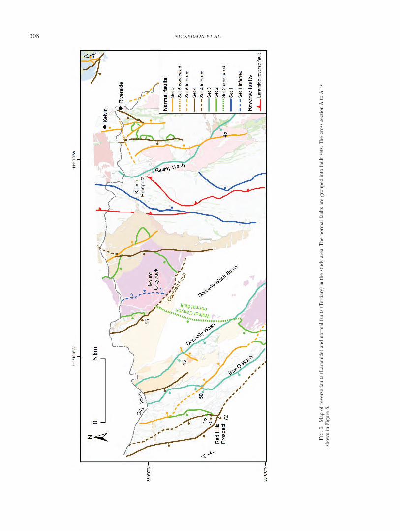
308 NICKERSON ET AL.
0361-0128/98/000/000-00 $6.00 308
FIG
. 6.
Map
of
reve
rse
faul
ts (
Lar
amid
e) a
nd n
orm
al f
aults
(Te
rtia
ry)
in t
he s
tudy
are
a. T
he n
orm
al f
aults
are
gro
uped
into
fau
lt se
ts. T
he c
ross
sec
tion
A t
o A
' is
show
n in
Fig
ure
8.

sets (Figs. 5, 6). In most cases, these assignments can bemade unambiguously. If the dip of the fault could not be de-termined in outcrop, then it was inferred from measurementsmade on faults with a similar relative age (Fig. 5). A brief de-scription of each fault set, listed in order of relative age fromoldest to youngest, is given below.
Set 1: Faults belonging to this first fault set strike generallynorthward and dip ~15° E. A fault of this generation cropsout near Ripsey Wash, and another may be present west ofMount Grayback (Fig. 6). Just outside the study area near thesouthern end of Ripsey Wash, spectacular exposures of a gen-tly southeast-dipping normal fault of this set places Paleozoiclimestone on Proterozoic diabase (Fig. 7A). The offset onfaults of this generation is poorly constrained but appears tobe as great as 3 km.
Set 2: Faults of this set strike generally northward with a dipof ~15° W where measured (Fig. 6). Four faults crop out inthe study area (Fig. 6): one immediately east of the Red Hillsprospect, the Walnut Canyon normal fault (Richard andSpencer, 1997), one east of the Kelvin prospect, and one eastof Ripsey Wash. The fault immediately east of the Red Hillsprospect places Ruin Granite displaying intense sulfide poorIOCG-style sericitic alteration in the hanging wall on Ruin
Granite with moderate propylitic alteration in the footwall.The fault has a dip of 15° W (Fig. 7B). The amount of slip onfaults of this set ranges from 2 to 7 km, using the diabase sillsas markers.
Set 3: Three faults of this set crop out in the study area (Fig.6): one in Box-O Wash, one in Donnelly Wash (Fig. 7C), andone east of Ripsey Wash. They strike generally northward andhave dips of ~45° W. The slip on these faults can be as greatas 2 km. Near Box-O Wash a fault of this generation cuts andoffsets a distinctive muscovite-bearing quartz latite porphyrydike that has a dip of 80° N (Fig. 5). Judging from the offset,the slip at this location was ~700 m.
Set 4: At least eight faults of this set have been observed inthe study area with strikes of ~010° and dips of ~70° W. Theslip on these faults is usually less than 1 km. A well-exposedfault of this generation occurs immediately south of the RedHills prospect. Here the fault dips 72° W and offsets the samedistinctive muscovite-bearing quartz latite porphyry dikementioned above by ~250 m.
Set 5: Numerous faults of this last fault set crop out in thestudy area with strikes of ~350° and dips of ~70° E. The slipon these faults is usually less than 1 km. For clarity, Figure 6only shows faults of this fault set having offsets exceeding 200
RECONSTRUCTION OF THE TEA CUP PORPHYRY SYSTEM 309
0361-0128/98/000/000-00 $6.00 309
FIG. 7. A. Exposure of the first (oldest) set of normal faults near Ripsey Wash, just south of the study area. Outcrops ofPaleozoic (P) limestone rest on Proterozoic diabase sheets (Ydb). The contact (blue line) between the two rock types dipsshallowly to the southeast. B. A low-angle normal fault that bounds the eastern side of the Red Hills prospect and belongsto the second set of faults. In this photograph, the fault places intense hematite and/or magnetite-chlorite-quartz alterationadjacent to weak chlorite-quartz alteration. (Photo taken by George Davis.) C. A fault belonging to the third set of normalfaults exposed in Donnelly Wash and placing Tertiary volcanic units on Proterozoic Ruin Granite.

m. Examples of faults of this fault set are well exposed in theTertiary volcanic units west of Donnelly Wash (Richard andSpencer, 1997).
Structural Interpretation and Palinspastic Reconstruction of Normal Faults
Interpretation
Laramide: Diabase sheets are repeated across the north-south−striking, steeply dipping Laramide fault zone markedby cataclasites (Figs. 2, 6). The lack of a normal fault in an ap-propriate location to create this repetition led Barton et al.(2005) to conclude that the repetition was caused by theLaramide fault. Maher (2008) correlated the Laramide faultzone with the Walnut Canyon thrust fault, which is not to beconfused with the Walnut Canyon normal fault, exposed sev-eral kilometers north of the study area. Breccia pipes exposedin the Ruin Granite east of Ripsey Wash locally contain sedi-mentary rocks and may indicate upward transport of clastsfrom overthrust supracrustal rocks at the time of mineraliza-tion (Barton et al., 2005). Indeed, the reverse fault presentlyexposed about 15 km to the east at Romero Wash (Krieger,1974; Dickinson, 1991) may be the updip continuation of thefaults in the Ruin Granite near the Tea Cup pluton that aremarked by cataclasite. This fault zone belongs to a belt of re-verse faults that is discontinuously exposed from Superiorsouth-southeastward to the Johnny Lyon Hills (Dickinson,1991).
Tertiary: Because the Tertiary normal faults are grouped infault sets of different relative ages, each fault set can be in-terpreted as a sequential generation of faults. Hence, eachgeneration is defined as a set of similarly oriented faults thatmoved more or less contemporaneously. As the normal faultswithin a set cut and extended the Tea Cup porphyry systemand surrounding area, the dip of each fault plane rotated toshallower angles. Once the fault planes of a fault set rotatedto angles that were kinematically unfavorable for slippage(less than ~30°; Anderson, 1951), a new fault set with newfaults planes formed, and it cut and progressively rotated theolder fault sets and the porphyry system. This repeated se-quence of events produced a cumulative eastward tilting of~90° as evidenced by the present-day dips of the oldest synex-tensional Tertiary rocks and the diabase sills. The lack of a sig-nificant penetrative fabric near the mapped normal faultsleads us to conclude that slip and tilting along the five sets ofnormal faults were accommodated in a rigid fashion at thescale of our reconstruction.
Approach to restoring movement on normal faults
Figures 8 and 9 show palinspastic reconstructions of the 32-km-long cross section (Fig. 6) across the study area, for bothrock types and hydrothermal alteration. Displacement alongthe normal faults was removed in sequential order, from theyoungest to the oldest generation of normal faults (panels Athrough F, Fig. 8), as determined by dip measurements andrelative ages. Slip on faults was constrained using observedlateral offsets of dikes and faults and drill hole data. Key mark-ers that were restored include diabase sheets and sills, variousphases of the Tea Cup pluton, textural units of the Ruin Gran-ite, and alteration assemblages. In addition, unconformities of
the same age were placed at similar structural levels. Tertiarysedimentary rocks were restored to horizontal at the timethey were deposited. Small offset faults (slip <200 m) werenot considered in the reconstruction.
Due to the predominance of igneous rocks in the studyarea, a number of uncertainties remain in the restoration. Thethree-dimensional shape of the igneous bodies is unknown,thus the form chosen here is based on plausible relationshipswith the restoration of hydrothermal alteration (Fig. 9) andsymmetry with the map pattern. Also, the tilting of intrusiverocks across the study area is assumed to be nearly 90° basedon the observation that the diabase sheets now dip vertically.However, these sheets have irregular edges and their atti-tudes are difficult to measure in outcrop. Observing the ex-posure across topography in map pattern is a more usefulmeans of determining their dip. As previously mentioned, itwas impossible to measure the dips of some faults in outcrop.In these cases, crosscutting relationships were used to deter-mine the relative age of the fault, and dips measured fromother faults of the same fault set were used (Fig. 5).
Results and uncertainties of the palinspastic reconstruction
Panels A through F of Figure 8 show the stepwise recon-struction of cross section A-A'. Figure 9A shows the inter-preted reconstructed geology with some lateral extrapolationfor illustrative purposes, and Figure 9B is the interpreted hy-drothermal overlay.
The reconstruction of rock types reveals a composite plutonintruding the eastern margin of a basement-cored uplift(Figs. 8, 9). The geometry of the intrusion is not influencedby Laramide reverse faults, which it postdates. In the re-stored section, the hornblende-biotite granodiorite is theshallowest. It is intruded at deeper levels by the biotite gran-ite and at the deepest levels by the biotite-muscovite ± garnetgranite. Outcrops of the biotite-hornblende quartz monzodi-orite lie out of the line of section. The cupola of the horn-blende-biotite granodiorite is shown to lie just beneath themodern surface, although it could lie substantially farther eastor west.
The biotite granite is interpreted to have been shallowestbeneath the Red Hills prospect. This configuration followsfrom the abundance of biotite-bearing, hornblende-absentporphyry dikes in the Red Hills, suggesting they emanatedfrom the biotite granite. The cupola of the biotite-muscovite± garnet granodiorite apparently formed deeper than thecupolas of the other phases of the pluton based on the presentdistribution of hydrothermal features with this phase, and theinference that hydrothermal fluid release formed near thecupola.
In the palinspastic restoration of hydrothermal alteration,three centers of porphyry-related alteration are shown (Fig.9B). Potassic alteration, marked by K-feldspar–quartz and bi-otitic alteration, restores to areas near the cupolas of thehornblende-biotite, biotite, and two-mica phases of the TeaCup pluton. Sericitic alteration is structurally higher andoverlaps the zones of potassic alteration in all three systems.Greisen alteration is restricted to lower levels of the Tea Cuppluton at depths of 7 to 10 km.
As described above, intense sulfide poor IOCG-style sericiticalteration flanks the porphyry-style hydrothermal systems at
310 NICKERSON ET AL.
0361-0128/98/000/000-00 $6.00 310

roughly the same depth as the cupola of the hornblende-bi-otite granodiorite. In Figure 9, the distribution of IOCG-likefeatures reflects the map observations, with intense IOCG-style alteration lying mostly in the 2- to 4-km depth rangenorth and south of the cupola of the hornblende-biotite phaseof the Tea Cup pluton. At the Red Hills prospect, IOCG-stylealteration crosscuts and is crosscut by moderately intense por-phyry style potassic alteration.
The Kelvin prospect (Figs. 2, 3) can be restored to a positionapproximately 1 km above and slightly east of the cupola of thehornblende-biotite granodiorite (Figs. 8, 9). The Red Hillsprospect would be above the inferred cupola of the biotitegranite for reasons discussed above. However, the relativelyweak potassic alteration and abundant porphyry dikes foundin the Red Hills may indicate that the prospect flanks, ratherthan lies directly above, the center of a biotite granite-relatedcupola of a porphyry system. Another possibility is that itcould represent the distal flank of a porphyry system createdby the hornblende-biotite granodiorite. This appears unlikely,however, because potassic alteration, and the abundance of
porphyry dikes, diminishes to the east toward the cupola ofthe hornblende-biotite granodiorite. In either case, the prox-imity of the Red Hills prospect to the Tea Cup pluton in thereconstruction strongly suggests that the porphyry dikes andalteration originate from a phase of the Tea Cup pluton.
Discussion
Comparisons to other Laramide porphyry systems
Previous studies of Laramide porphyry systems in thesouthwestern United States have focused on the spatial andtemporal relationships between igneous and related hy-drothermal activity (e.g., Titley and Hicks, 1966; Titley,1982a; Pierce and Bolm, 1995). Here, we focus on a discus-sion of the age of the intrusions, the distribution of mineral-ization with depth, the occurrence of different styles of hy-drothermal alteration, the depth and level of exposure of theporphyry systems, and the style of extension.
Age of intrusions: Laramide intrusions in the northern Tor-tilla and nearby Dripping Spring Mountains range from 75 to
RECONSTRUCTION OF THE TEA CUP PORPHYRY SYSTEM 311
0361-0128/98/000/000-00 $6.00 311
FIG. 8. Sequential palinspastic reconstruction looking north from A-A'. There is no vertical exaggeration. A. Modern crosssection. B. Removal of 5th set of normal faults (orange faults). C. Removal of 4th set of normal faults (brown faults). D. Re-moval of 3rd set of normal faults (light blue faults). E. Removal of the 2nd set of normal faults (green faults). F. Removal ofthe 1st set of normal faults (dark blue faults).

61 Ma, as demonstrated by recent U-Pb zircon dating (See-dorff et al., 2005a). The age range of magmatism and miner-alization in a cluster of deposits north of the study area nearthe Schultze Granite, including the Globe-Miami, Pinto Val-ley, and Resolution deposits, is from ~69 to 61 Ma. To thesouth in the Tortilla and Dripping Spring Mountains, the por-phyry systems range from ~73 Ma in the Tea Cup pluton to~69 to 66 Ma at the Granite Mountain pluton (Ray deposit),and ~65 Ma at Christmas.
The most important mineralized porphyry systems in east-central Arizona are associated with the Schultze Granite andGranite Mountain plutons (Maher, 2008). These plutons arefelsic, compositionally uniform, and formed by several, ther-mally discrete intrusive events (Seedorff et al., 2005a; Maher,2008). In contrast, the Tea Cup system is composite andprominently zoned over a wide compositional range. The U-Pb zircon ages indicate that this heterogeneity was achievedseveral million years prior to the formation of the SchultzeGranite and Granite Mountain plutons in a single thermalevent of no more than about 1 m.y. duration.
Mineralization and depth of emplacement: Similar to otherporphyry systems in east-central Arizona, the highest copperconcentrations (Kelvin and Red Hills prospects) are locatedstructurally above several cupolas of the Tea Cup intrusivecenter. The cupolas of the hornblende-biotite granodioriteand biotite granite can be restored to a position of about 6 kmbelow the 73 Ma paleosurface, which is within the 1- to 6-kmpaleodepth range of formation for most cupolas of porphyrysystems (Seedorff et al., 2005b).
The top of the biotite-muscovite ± garnet granodiorite isnot well constrained but most likely formed at 5 to 10 km.The molybdenum (-copper) mineralization formed near theapex of the biotite-muscovite ± garnet granodiorite. Althoughthis geometry is typical, the molybdenum occurrence is no-table by its difference from the ordinary subclasses of the por-phyry molybdenum class of deposits (cf. Seedorff et al.,2005b). However, it has some similarities to the CretaceousHarvey Creek occurrence in northeastern Washington(Miller and Theodore, 1982).
Styles of hydrothermal alteration: Both the feldspar-stablepotassic alteration and the feldspar-destructive acid alterationobserved in the Tea Cup porphyry system are common toporphyry systems (Seedorff et al., 2005b). Whereas greisenalteration encountered west of Mount Grayback and locally tothe west of the cupola of the hornblende-biotite granodioriteis only rarely reported from porphyry systems, it is typical ofthe root zones beneath the Miami-Inspiration, Sierrita-Es-peranza, and Ray porphyry systems (Seedorff et al., 2008).
The IOCG-style sodic (-calcic) and sulfide-poor sericitic al-teration observed in and around the Tea Cup pluton is notcommonly reported in Laramide porphyry systems. However,by combining results of this study with observations fromSierrita-Esperanza (Stavast et al., 2008) and other areas inArizona, it appears that IOCG-style alteration may be a wide-spread, albeit typically minor feature of many districts in theLaramide province and not an oddity of a few Jurassic por-phyry systems such as Yerington and other systems (Battlesand Barton, 1995; Dilles et al., 2000). Furthermore, the pres-
312 NICKERSON ET AL.
0361-0128/98/000/000-00 $6.00 312
FIG. 9. A. Hypothetical Laramide cross section showing the composite Tea Cup pluton intruding a basement-cored up-lift. Thick black lines represent the modern surface. Maroon lines mark the paleosurface at 73 and 25 Ma. Abbreviations:Khbg = hornblende-biotite granodiorite, Kbg = biotite granite, Khbg = biotite-hornblende quartz monzodiorite, Kmbg = bi-otite-muscovite ± garnet granodiorite, P = Paleozoic sedimentary rocks, Q = undifferentiated Quaternary deposits, Tc = Ter-tiary conglomerate, Ts= Oligo-Miocene sedimentary rocks, Ya = Proterozoic Apache Group, Yr = Proterozoic Ruin Granite.B. Reconstruction of hydrothermal alteration. No vertical exaggeration.

ence of widespread IOCG-style alteration and mineralizationindicates that IOCG deposits could exist in the Laramide sys-tems of southwestern North America that are distal to, butbroadly contemporaneous with, porphyry copper centers, asis the case at the Pumpkin Hollow (Lyon) deposit in the Yer-ington district, Nevada (Matlock and Ohlin, 1996; Dilles etal., 2000).
Exploration targets in northern Tortilla Mountains
Knowledge and understanding of Tertiary extension in theLaramide porphyry province began to change explorationstrategies in the late 1960s, thus leading to the discovery ofthe Kalamazoo orebody (Lowell, 1968). As time progressed, itbecame clear that tilted and dismembered orebodies werecommon and that all orebodies in the Basin and Range shouldbe assumed to be faulted and tilted until proven otherwise(Seedorff, 1991a; Wilkins and Heidrick, 1995). During thepast decade, the importance of orebody tilting across theBasin and Range province has been emphasized by numerousworkers (e.g., Seedorff et al., 1996; Maher, 2008; Stavast etal., 2008).
Early exploration at Tea Cup initially centered on outcrop-ping mineralization near Riverside. Beginning in the 1960s,exploration geologists recognized that the Tea Cup porphyrysystem was dismembered and possibly tilted and that low-angle faults bounded some altered structural blocks, thusopening the possibility for a larger fault-bounded depositunder cover. Related exploration tested various hypothesesand discovered the mineralized fault blocks at the Kelvinprospect.
The present study reveals at least two potential explorationtargets (Fig. 9A). First, rocks lying under the Tertiary andQuaternary Donnelly Wash basin (Fig. 2) can be restored tostructural levels and distances from the cupola of the horn-blende-biotite phase of the Tea Cup pluton that are similar tothe Kelvin prospect (Fig. 8F). Exposures of the Ruin Granitewest of Donnelly Wash (Fig. 2), which are restored beneath
the West Grayback basin target (Fig. 8F), are dominantlypropylitically altered, but one ~10-m-deep shaft revealed sig-nificant copper oxide mineralization.
The second potential exploration target is the cupola of thebiotite granite phase of the Tea Cup pluton. As discussedabove, the Red Hills may represent the upper levels of a por-phyry system centered on the biotite granite (Fig. 9A). Lowerlevels of this system may lie west or east of the Red Hills. Thearea under cover to the west appears more prospective be-cause potassic alteration exposed in outcrop decreasesmarkedly east of the Red Hills (Figs. 3, 6).
Style of extension and broader exploration implications
The manner in which the crust is extended continues to bea topic of considerable debate. Most controversies center onthe geometry, timing, and magnitude of normal faults in ex-tended terranes (John and Foster, 1993). For example, manyinvestigators have inferred strongly listric faults that flatten atdepth and can be kinematically linked to a low-angle my-lonitic zone as exposed in metamorphic core complexes (Wer-nicke, 1981). In contrast, others recognize that normal faultsoccur in multiple generations and that low-angle faults are cutand offset by younger, high-angle faults (Proffett, 1977). Theamount of curvature on fault planes has dramatic conse-quences on the path of fault blocks during extension and thuscontrols the locations of pieces of dismembered orebodiesafter extension.
A comparison of the geometry, timing, and magnitude ofnormal faults between the study area and other nonmyloniticdomains of large-magnitude extension in the Basin and Rangeprovince is made in Table 3. In the study area, Tertiary nor-mal faults have created ~210 percent extension, based on thepalinspastic reconstruction, and ~90° eastward tilting alongfive sets of normal faults that initiated at high angles of ~55°to 75°. The superposition of five generations of normal faultsproduced greater amounts of tilt and extension than is ob-served in other localities. The 7-km offset along the Walnut
RECONSTRUCTION OF THE TEA CUP PORPHYRY SYSTEM 313
0361-0128/98/000/000-00 $6.00 313
TABLE 3. Comparison of Extended Porphyry Systems and other Areas in Arizona and Nevada
Maximum Curvature of Location Tilting of bedding Sets of Dip of oldest set displacement on normal fault Total (reference) due to extension normal faults of normal faults normal faults (km) planes (/km) extension (%)
Yerington district, 60° 3 10° 4 3°−7° 137NV (Proffett, 1977)
Royston district, NV 50° 2 10° 3.5 130(Seedorff, 1991b)
Caetano Caldera, NV 40-50° 3 5°−20° 6 110(Colgan et al., 2008)
Robinson district, NV 35 west 7 5°(Seedorff et al., 1996) to 65° east
GMSRC1 region, AZ ~4 1°−3° 20−400(Maher, 2008)
Teacup-Red Hills, 90° 5 15°overturned 7 1° 210AZ (Barton et al., 2005; this study)
1 GMSRC = Globe, Miami, Superior, Ray, Christmas

Canyon normal fault (Fig. 6) is greater than any offset associ-ated with other faults. However, Quaternary fill in the Don-nelly Wash basin covers much of the area west of the WalnutCanyon normal fault (Figs. 2, 6, 8A). Normal faults that wouldreduce the estimated amount of slip on the Walnut Canyonnormal fault may lie under the Quaternary cover but are notincorporated into the present reconstruction.
As mentioned earlier, geologic evidence indicates that ex-tension of the Tea Cup hydrothermal systems was accommo-dated in a rigid fashion at the scale of our reconstruction. Ear-lier work in the study area hypothesized that extension wasaccommodated on strongly listric faults (Howard and Foster,1996). Whereas listric faults produce rotation of fault blocks,the results of the present study (Fig. 10), along with the workby Ramsay and Huber (1987), show that cross sections con-structed utilizing strongly listric faults do not conserve masswhen palinspastically restored in a rigid manner. Thus, uti-lization of a cross section similar to Howard and Foster’s(1996) as an exploration tool in the study area is ill-advised.
The amount of extension in the study area (~210%) is asgreat as or greater than what is estimated for some metamor-phic core complexes (e.g., Howard and John, 1987). How-ever, results show that in the study area all higher angle nor-mal faults cut normal faults of lower angles, and that faultgeometries were nearly planar, occurred in generations, andhad maximum displacements less than tens of kilometers.This demonstrates the ability of superimposed sets of initiallyhigh-angle and nearly planar normal faults to dramatically ex-tend the upper crust. It contradicts the notion that extensionon a similar scale to what is observed in metamorphic corecomplexes must be accommodated on strongly listric normalfaults with tens of kilometers of slip.
Ultimately, the importance of the style of extension to anexploration geologist rests in how an ore deposit is dismem-bered. In the northern Tortilla Mountains, mineralization as-sociated with a single intrusive center is spread across morethan 20 km along the extension direction, and more piecesmay lie under cover farther to the west. Although a significantore deposit has yet to be discovered after a century of inter-mittent exploration in the Tea Cup intrusive center, explo-ration has only locally sought covered targets of the types pos-tulated here. Similar dismemberment has been documentedthroughout the Basin and Range province (Table 3), whichruns from Mexico to Canada. Economic geologists in theprovince should not only consider all ore deposits to be tiltedand extended until proven otherwise (Wilkins and Heidrick,1995) but must also understand how the deposits were ex-tended in order to shrewdly explore for new deposits.
Summary and ConclusionsDetailed mapping revealed that the composite Tea Cup
pluton was intruded in four phases that created at least three,possibly four, distinct hydrothermal systems. The broadly co-eval intrusive phases are zoned from distal and early biotite-hornblende quartz monzodiorite to late and deep two-micagranodiorite. Potassic alteration dominates the core of thesystems, with several styles of feldspar-destructive acid alter-ation, most notably sericitic alteration at higher structural lev-els, sodic (-calcic) alteration 2 to 4 km distal on the flanks ofthe systems, and propylitic alteration surrounding the otheralteration types. The central systems vary from porphyry cop-per style at high levels to greisenlike molybdenum (-copper)style within the two-mica granodiorite; distal mineralization isIOCG like in its characteristics.
Superimposed sets of Tertiary normal faults initially devel-oped at high angles and subsequently dismembered the por-phyry system cumulatively creating more than 200 percent ex-tension and 90° eastward tilting. Tilting caused by normalfaulting provides an exceptional cross-sectional view at the pre-sent surface of the porphyry system, from its distal flanks to pa-leodepths of >10 km. This exposure displays multiple vectorstoward possible mineralization, and utilization of palinspasticreconstruction has created two new exploration targets in anarea with more than 100 years of exploration history.
The Basin and Range province stretches from Mexico toCanada and contains numerous Laramide porphyry and othertypes of ore deposits. The manner in which the crust extendshas dramatic effects on where fault blocks, which may containore deposits, are moved. This requires the exploration geolo-gist to have an understanding of different models of extensionand where they are applicable. Here, the power of palinspas-tic reconstruction utilizing superimposed sets of nearly planarnormal faults has been demonstrated in a highly extended ter-rane, which was previously thought to have been extendedalong strongly listric normal faults. Reexamination of any ex-tended orebody thought to have been dismembered alonglistric normal faults should be considered. Although rigorouspalinspastic reconstructions of the type shown here are workintensive, they are made easier with the significant drill holecoverage that often is found in brownfields districts, and theypresent the opportunity to discover new world-class orebod-ies in districts with long exploration histories.
314 NICKERSON ET AL.
0361-0128/98/000/000-00 $6.00 314
FIG. 10. A. Cross section through the study area after Howard and Foster(1996). B. Palinspastic reconstruction of the cross section by Howard andFoster (1996) reveals that the cross section does not conserve mass (i.e., kilo-meter-scale overlaps and gaps between fault blocks) when rigidly restored.Abbreviations: Ktc = Cretaceous Tea Cup pluton, Ts = Oligo-Miocene sedi-mentary rocks, Ya = Proterozoic Apache Group, Yr = Ruin Granite.

AcknowledgmentsReviews by Steven Kesler, Thomas Monecke, and Jon
Spencer improved this manuscript. We thank our coauthorson previous work at Tea Cup— J.G. Brown, G.B. Haxel, T.S.Hayes, E.P. Jensen, D.A. Johnson, R.J. Kamilli, and K.R.Long, as well as D.J. Maher and G.H. Davis for helpful dis-cussions and critical comments throughout the course of thisstudy. D.J. Maher helped in the field and provided regionaldata. Bronco Creek Exploration provided drill hole data forthe area near the Red Hills prospect. PN gratefully acknowl-edges financial support by the Society of Economic Geolo-gists and the Science Foundation Arizona. The project alsobenefited from support provided by the U.S. Geological Sur-vey through the Porphyry Copper Life Cycle project andgrants 02HQAG0088 and 08HQGR0060, and National Sci-ence Foundation grant EAR-0230091 to MB and ES.
REFERENCESAnderson, E.M., 1951, The dynamics of faulting, 2nd ed.: Edinburgh, Scot-
land, Oliver and Boyd, 191 p.Barter, C.F., and Kelly, J.L., 1982, Geology of the Twin Buttes mineral de-
posit, Pima mining district, Pima County, Arizona, in Titley, S.R., ed., Ad-vances in geology of porphyry copper deposits, southwestern North Amer-ica: Tucson, University of Arizona Press, p. 407–432.
Barton, M.D., and Johnson, D.A., 2000, Alternative brine sources for Fe-oxide(-Cu-Au) systems: Implications for hydrothermal alteration and met-als, in Porter, T.M., ed., Hydrothermal iron oxide copper-gold and relateddeposits—a global perspective: Glenside, South Australia, Australian Min-eral Foundation, p. 43–60.
Barton, M.D., Brown, J.G., Haxel, G.B., Hayes, T.S., Jensen, E.P., Johnson,D.A., Kamilli, R.J., Long, K.R., Maher, D.J., and Seedorff, E., 2005, Cen-ter for Mineral Resources: U. S. Geological Survey Scientific InvestigationsReport 2005-5020, 50 p.
Battles, D.A., and Barton, M.D., 1995, Arc-related sodic hydrothermal alter-ation in the western United States: Geology, v. 23, p. 913–916.
Bradfish, L.J., 1979, Petrogenesis of the Tea Cup granodiorite, Pinal County,Arizona: Unpublished M. S. thesis, University of Arizona, 160 p.
Colgan, J.P., John, D.A., Henry, C.D., and Fleck, R.J., 2008, Large-magni-tude Miocene extension of the Eocene Caetano caldera, Shoshone andToiyabe Ranges, Nevada: Geosphere, v. 4, p. 107–130.
Corn, R.M., and Ahern, R., 1994, Structural rotation and structural cover atthe Kelvin porphyry copper prospect, Pinal County, Arizona, in Miller, M.,ed., A geologic tour of the Ray copper deposit and the Kelvin copperprospect, Pinal County, AZ: Arizona Geological Society Spring 1994 FieldTrip Guidebook, 16 April 1994, p. 31–42.
Cornwall, H.R., 1982, Petrology and chemistry of igneous rocks: Ray por-phyry copper district, Pinal County, Arizona, in Titley, S.R., ed., Advancesin geology of the porphyry copper deposits, southwestern North America:Tucson, University of Arizona Press, p. 259-273.
Cornwall, H.R., and Krieger, M.H., 1975a, Geologic map of the Graybackquadrangle, Pinal County, Arizona: U. S. Geological Survey QuadrangleMap GQ-1206, 1:24,000, text 2 p.
——1975b, Geologic map of the Kearny quadrangle, Pinal County, Arizona:U. S. Geological Survey Quadrangle Map GQ-1188, 1:24,000, text 9 p.
Crittenden, M.D., Jr., Coney, P.J., and Davis, G.H., eds., Cordilleran meta-morphic core complexes: Geological Society of America Memoir 153, 490p.
Davis, G.H., 1979, Laramide folding and faulting in southeastern Arizona:American Journal of Science, v. 279, p. 543–569.
Davis, G.H., Constenius, K.N., Dickinson, W.R., Rodríguez, E.P., and Cox,L.J., 2004, Fault and fault-rock characteristics associated with Cenozoicextension and core-complex evolution in the Catalina-Rincon region,southeastern Arizona: Geological Society of America Bulletin, v. 116, p.128–141.
Dickinson, W.R., 1989, Tectonic setting of Arizona through geologic time:Arizona Geological Society Digest 17, p. 1–16.
——1991, Tectonic setting of faulted Tertiary strata associated with theCatalina core complex in southern Arizona: Geological Society of AmericaSpecial Paper 264, 106 p., map scale 1: 125,000.
——1995, Tertiary stratigraphic and structural relationships in the CopperButte area, Teapot Mountain quadrangle, Pinal County, Arizona: ArizonaGeological Survey Contributed Report CR-95-H, 15 p.
Dilles, J.H., and Gans, P.B., 1995, The chronology of Cenozoic volcanism anddeformation in the Yerington area, western Basin and Range and WalkerLane: Geological Society of America Bulletin, v. 107, p. 474–486.
Dilles, J.H., Einaudi, M.T., Proffett, J., and Barton, M.D., 2000, Overview ofthe Yerington porphyry copper district: Magmatic to nonmagmatic sourcesof hydrothermal fluids: Their flow paths and alteration effects on rocks andCu-Mo-Fe-Au ores: Society of Economic Geologists Guidebook Series, v.32, p. 55–66.
Drewes, H., 1976, Tectonic setting of the porphyry copper deposits of south-eastern Arizona and some adjacent areas [abs.]: Arizona Geological SocietyDigest 11, p. 91-92.
Force, E.R., 1998, Laramide alteration of Proterozoic diabase: A likely con-tributor of copper to porphyry systems in the Dripping Spring Mountainsarea, southeastern Arizona: ECONOMIC GEOLOGY, v. 93, p 171–193.
Hammer, D.F., and Peterson, D.W., 1968, Geology of the Magma mine area,Arizona, in Ridge, J.D., ed., Ore deposits of the United States, 1933–1967(Graton-Sales volume): New York, American Institute of Mining, Metallur-gical, and Petroleum Engineers, v. 2, p. 1282–1310.
Howard, K.A., 1991, Intrusion of horizontal dikes: Tectonic significance ofmiddle Proterozoic diabase sheets widespread in the upper crust of thesouthwestern United States: Journal of Geophysical Research, v. 96, p.12,461–12,478.
Howard, K.A., and Foster, D.A., 1996, Thermal and unroofing history of athick, tilted Basin-and-Range crustal section in the Tortilia Mountains, Ari-zona: Journal of Geophysical Research, v. 101, p. 511–522.
Howard, K.A., and John, B.E., 1987, Crustal extension along a rooted systemof irobricate low angle faults, Colorado River extensional corridor, Califor-nia and Arizona, Continental extensional tectonics: Geological Society ofLondon Special Publication 28, p. 299–311.
John, B.E., and Foster, D.A., 1993, Structural and thermal constraints on theinitiation angle of detachment faulting in the southern Basin and Range:The Chemehuevi Mountains case study: Geological Society of AmericaBulletin, v. 105, p. 1091–1108.
Koski, R.A., and Cook, D.S., 1982, Geology of the Christmas porphyry cop-per deposit, Gila County, Arizona, in Titley, S.R., ed., Advances in geologyof the porphyry copper deposits, southwestern North America: Tucson,University of Arizona Press, p. 353–374.
Krieger, M.H., 1974, Geologic map of the Winkelman quadrangle, Pinal andGila Counties, Arizona: U. S. Geological Survey Quadrangle Map GQ-1106, scale 1:24,000, text 8 p.
——1977, Large landslides, composed of megabreccia, interbedded inMiocene basin deposits, southeastern Arizona: U. S. Geological SurveyProfessional Paper 1008, 25 p.
Lister, G.S., and Davis, G.A., 1989, The origin of metamorphic core com-plexes and detachment faults formed during Tertiary continental extensionin the Colorado River region, U.S.A.: Journal of Structural Geology, v. 11,p. 65-94.
Lowell, J.D., 1968, Geology of the Kalamazoo orebody, San Manuel district,Arizona: ECONOMIC GEOLOGY, v. 63, p. 645–654.
——1978, Thirty-year evolution of porphyry copper exploration in southwestUSA Part 2. Case histories of discoveries: Arizona Geological Society Di-gest 11, p. 175–178.
Maher, D.J., 2008, Reconstruction of middle Tertiary extension andLaramide porphyry copper systems, east-central Arizona: UnpublishedPh.D. thesis, University of Arizona, 326 p.
Maher, D.J., Martin, A., Mauel, D., Bryan, D., Hubbs, S.A., and Seedorff, E.,2004, Mid-Tertiary synextensional sedimentation and structure in thenorthern Tortilla Mountains, Pinal County, Arizona: Arizona Geological So-ciety Spring Field Trip Guidebook, 17 April 2004, 27 p.
Manske, S.L., and Paul, A.H., 2002, Geology of a major new porphyry cop-per center in the Superior (Pioneer) district, Arizona: ECONOMIC GEOLOGY,v. 97, p. 197–220.
Matlock, J.A., and Ohlin, H.N., 1996, Lyon copper-iron skarn deposit, Yer-ington mining district, Lyon County, Nevada, in Green, S.M., and Struh-sacker, E., eds., Geology and ore deposits of the American Cordillera: Ge-ological Society of Nevada Field Trip Guidebook Compendium, 1995,Reno/Sparks, p. 121–129.
Miller, E.L., Dumitru, T.A., Brown, R.W., and Gans, P.B., 1999, RapidMiocene slip on the Snake Range-Deep Creek Range fault system, east-central Nevada: Geological Society of America Bulletin, v. 111, p. 886–905.
RECONSTRUCTION OF THE TEA CUP PORPHYRY SYSTEM 315
0361-0128/98/000/000-00 $6.00 315

Miller, F.K., and Theodore, T.G., 1982, Molybdenum and tungsten mineral-ization associated with two stocks in the Harvey Creek area, northeasternWashington: U S Geological Survey Open File Report OF 82-0295, 31p.
Nason, P.W., Shaw, A.V., and Aveson, K.D., 1982, Geology of the PostonButte porphyry copper deposit, in Titley, S.R., ed., Advances in geology ofthe porphyry copper deposits, southwestern North America: Tucson, Uni-versity of Arizona Press, p. 375–385.
Paul, A.H., and Manske, S.L., 2005, History of exploration at the Magmamine, Superior, Arizona: Geological Society of Nevada Symposium 2005,Window to the World, Reno, Nevada, May 2005, Proceedings, v. 1, p.629–638.
Peterson, N.P., 1962, Geology and ore deposits of the Globe-Miami district,Arizona: U. S. Geological Survey Professional Paper 342, 151 p., map scale1:24,000.
Phillips, C.H., Gambell, N.A., and Fountain, D.S., 1974, Hydrothermal al-teration, mineralization, and zoning in the Ray deposit: ECONOMIC GEOL-OGY, v. 69, p. 1237–1250.
Pierce, F.W., and Bolm, J.G., eds., 1995, Porphyry copper deposits of theAmerican Cordillera: Tucson, Arizona, Arizona Geological Society Digest,v. 20, 656 p.
Proffett, J.M., Jr., 1977, Cenozoic geology of the Yerington district, Nevadaand implications for the nature and origin of Basin and Range faulting: Ge-ological Society of America Bulletin, v. 88, p. 247–266.
Proffett, J.M., Jr., and Dilles, J.H., 1984, Geologic map of the Yerington dis-trict, Nevada: Nevada Bureau of Mines and Geology Map 77, scale1:24,000.
Ramsay, J.G., and Huber, M.I., 19831987, The techniques of modern struc-tural geology. Vol. 2: Folds and fractures: New York, Academic Press,309–700 p.
Reynolds, S. J., 1988, Geologic map of Arizona, Arizona Geological SurveyMap M-26, scale 1:1,000,000.
Richard, S.M., and Spencer, J.E., 1997, Geologic map of the North Buttearea, central Arizona: Arizona Geological Survery Open-File Report 97-4,scale 1:24,000, text 18 p.
Schmidt, E.A., 1971, A structural investigation of the northern TortillaMountains, Pinal County, Arizona: Unpublished Ph. D. dissertation, Tuc-son, University of Arizona, 248 p.
Seedorff, E., 1991a, Magmatism, extension, and ore deposits of Eocene toHolocene age in the Great Basin—mutual effects and preliminary pro-posed genetic relationships, in Raines, G.L., Lisle, R.E., Schafer, R.W., andWilkinson, W.H., eds., Geology and ore deposits of the Great Basin: Geo-logical Society of Nevada, Symposium, Reno/Sparks, April 1990, Proceed-ings, v. 1, p. 133−178.
——1991b, Royston district, western Nevada—a Mesozoic porphyry coppersystem that was tilted and dismembered by Tertiary normal faults, inRaines, G.L., Lisle, R.E., Schafer, R.W., and Wilkinson, W.H., eds., Geol-ogy and ore deposits of the Great Basin: Geological Society of Nevada,Symposium, Reno/Sparks, April 1990, Proceedings, p. 359–391.
Seedorff, E., Hasler, R.W., Breitrick, R.A., Fahey, P.L., Jeanne, R.A., Shaver,S.A., Stubbe, P., Troutman, T.W., and Manske, S.L., 1996, Overview of thegeology and ore deposits of the Robinson district, with emphasis on itspost-mineral structure, in Green, S.M., and Struhsacker, E., eds., Geologyand ore deposits of the American Cordillera, Great Basin porphyry de-posits: Geological Society of Nevada Field Trip Guidebook Compendium,1995, 87-91.
Seedorff, E., Barton, M.D., Gehrels, G.E., Johnson, D.A., Maher, D.J.,Stavast, W.J.A., and Flesch, E., 2005a, Implications of new U-Pb dates fromporphyry copper-related plutons in the Superior-Globe-Ray-Christmasarea, Arizona [abs.]: Geological Society of America Abstracts with Pro-grams, v. 37, no. 7, p. 164.
Seedorff, E., Dilles, J.H., Proffett, J.M., Jr., Einaudi, M.T., Zurcher, L.,Stavast, W.J.A., Johnson, D.A., and Barton, M.D., 2005b, Porphyry de-posits: Characteristics and origin of hypogene features: ECONOMIC GEOL-OGY 100TH ANNIVERSARY VOLUME, p. 251–298.
Seedorff, E., Barton, M.D., Stavast, W.J.A., and Maher, D.J., 2008, Rootzones of porphyry systems: Extending the porphyry model to depth: ECO-NOMIC GEOLOGY, v. 103, p. 939–956.
Shride, A.F., 1967, Younger Precambrian geology in southern Arizona: U. S.Geological Survey Professional Paper 566, 89 p.
Stavast, W.J.A., Butler, R.F., Seedorff, E., Barton, M.D., and Ferguson, C.A.,2008, Tertiary tilting and dismemberment of the Laramide arc and relatedhydrothermal systems, Sierrita Mountains, Arizona: ECONOMIC GEOLOGY,v. 103, p. 629–636.
Titley, S.R., ed., 1982a, Advances in geology of the porphyry copper deposits,southwestern North America: Tucson, University of Arizona Press, 560 p.
——1982b, Geologic setting of porphyry copper deposits, in Titley, S.R., ed.,Advances in geology of the porphyry copper deposits, southwestern NorthAmerica: Tucson, University of Arizona Press, 560 p.
Titley, S.R., and Hicks, C.L., eds., 1966, Geology of the porphyry copper de-posits, southwestern North America: Tucson, University of Arizona Press,287 p.
West, R.J., and Aiken, D.M., 1982, Geology of the Sierrita-Esperanza de-posit: Pima mining district, Pima County, Arizona, in Titley, S.R., ed., Ad-vances in geology of the porphyry copper deposits, southwestern NorthAmerica: Tucson, Arizona, University of Arizona Press, p. 433–465.
Wernicke, B., 1981, Low-angle normal faults in the Basin and Rangeprovince: Nappe tectonics in an extending orogen: Nature, v. 291, p.645−648.
Wilkins, J., Jr., and Heidrick, T.L., 1995, Post-Laramide extension and rota-tion of porphyry copper deposits, southwestern United States: Arizona Ge-ological Society Digest 20, p. 109−127.
Willden, R., 1964, Geology of the Christmas quadrangle, Gila and PinalCounties, Arizona: U. S. Geological Survey Bulletin 1161-E, 64 p.
Williams, P.J., Barton, M.D., Johnson, D.A., Fontboté, L., de Haller, A.,Mark, G., Oliver, N.H.S., and Marschik, R., 2005, Iron oxide copper-golddeposits: Geology, space-time distribution, and possible modes of origin:ECONOMIC GEOLOGY 100TH ANNIVERSARY VOLUME, p. 371−405.
Williams, S.A., and Forrester, J.D., 1995, Characteristics of porphyry copperdeposits: Arizona Geological Society Digest 20, p. 21−34.
Wrucke, C.T., 1989, The Middle Proterozoic Apache Group, Troy Quartzite,and associated diabase of Arizona: Arizona Geological Society Digest 17, p.239−258.
Zelinski, W.P., 1973, Geologic evaluation of the Kelvin copper-molybdenumprospect, Pinal County, Arizona: Unpublished M.S. thesis, New Mexico In-stitute of Mining and Technology, 72 p.
316 NICKERSON ET AL.
0361-0128/98/000/000-00 $6.00 316