chapter 14new notes
TRANSCRIPT

Chapter 14Chapter 14
The Ocean FloorThe Ocean Floor

Section Review QuestionsSection Review Questions
Section 14.1 Review questions #1-5 Section 14.1 Review questions #1-5 on page 400 are DUE: Wednesday, on page 400 are DUE: Wednesday, April 16April 16thth..

(14.1) The Vast World Ocean(14.1) The Vast World Ocean
The great oceans of the world cover The great oceans of the world cover about about 71%71% of the Earth's surface and of the Earth's surface and are divided by continents. Each are divided by continents. Each ocean includes smaller bodies of ocean includes smaller bodies of water called seas, bays, and gulfs. water called seas, bays, and gulfs.
OceanographyOceanography is a science that is a science that draws from many other science fields draws from many other science fields to study all aspects of the world to study all aspects of the world oceans.oceans.
Geography of the OceansGeography of the Oceans
If 71% of the Earth’s surface is If 71% of the Earth’s surface is covered by oceans then the covered by oceans then the continents must make up aboutcontinents must make up about
29%29%
How many oceans basins are there How many oceans basins are there actually?actually?
Would you believe Would you believe 5 5

Oceans by nameOceans by name
We will use all 5 ocean basins this year

Ocean TriviaOcean Trivia Almost Almost
surrounded surrounded completely by completely by landland
Largest oceanLargest ocean Ocean with most Ocean with most
storm activitystorm activity Saltiest oceanSaltiest ocean Has most of Has most of
world’s fresh world’s fresh water going into water going into itit
ArcticArctic
PacificPacific IndianIndian AtlanticAtlantic AtlanticAtlantic

Looking at the floorLooking at the floor
Turn to page 396 & 397….. What does Turn to page 396 & 397….. What does the ocean floor look like, what the ocean floor look like, what features are there, What is the shape features are there, What is the shape of the ocean floor basin, etc.of the ocean floor basin, etc.
What do you see and what do you What do you see and what do you think?think?

New Oceanic CrustNew Oceanic Crust
New ocean lithosphere forms at mid-New ocean lithosphere forms at mid-ocean ridgesocean ridges..
New rock that forms there are very hot, New rock that forms there are very hot, therefore less dense then the surrounding therefore less dense then the surrounding rock. rock.
This causes the mid-ocean ridges to rise This causes the mid-ocean ridges to rise above the existing ocean floor.above the existing ocean floor.
As the ocean plate cools it becomes As the ocean plate cools it becomes denser and begins to sink. denser and begins to sink.

Question: What are seamounts and Question: What are seamounts and guyots? guyots?
Seamounts are islands that Seamounts are islands that did notdid not yet reach the ocean surface or yet reach the ocean surface or will will nevernever reach the surface or did reach reach the surface or did reach the surface and sank. the surface and sank.
Guyots are flattened volcanic peaks.Guyots are flattened volcanic peaks.What caused them to flatten on top?What caused them to flatten on top? Wave activityWave activity can cut them off. can cut them off.

So how did they sink? So how did they sink?
As the ocean floor cooled and sank As the ocean floor cooled and sank so did the islands, seamounts, and so did the islands, seamounts, and guyots.guyots.
The shape of the ocean floor is in the The shape of the ocean floor is in the shape of a parabolashape of a parabola. .
Cooling of the ocean floor is faster Cooling of the ocean floor is faster right after it forms and continues to right after it forms and continues to cool slowly. cool slowly.

Distance from the ridgeDistance from the ridge
The distance away from the ridge is The distance away from the ridge is proportional to the square of the proportional to the square of the temperature of the ocean plate.temperature of the ocean plate.
Any curve with the formula y=xAny curve with the formula y=x22 is a is a parabola.parabola.

Sea level changeSea level change
During the Cretaceous period sea level During the Cretaceous period sea level was 300 meters higher causing major was 300 meters higher causing major flooding of the continents. Compare this to flooding of the continents. Compare this to the fact that if all the ice in the world the fact that if all the ice in the world melted sea level would rise 80 meters.melted sea level would rise 80 meters.
When When plate velocities increaseplate velocities increase ridge ridge systems become activesystems become active raising the sea raising the sea floor thus causing continental flooding.floor thus causing continental flooding.

Ocean Seafloor Mineral FactoryOcean Seafloor Mineral Factory Occur where water circulates through the mid-ocean Occur where water circulates through the mid-ocean
ridge like a chemical factory removing metals and ores ridge like a chemical factory removing metals and ores from the ocean crust. from the ocean crust.
Cold water is pulled into the crust, and as it heats up, Cold water is pulled into the crust, and as it heats up, it begins to dissolve out incompatible elements like it begins to dissolve out incompatible elements like metals. metals.
This happens at ocean vents called black smokers This happens at ocean vents called black smokers where the water is turned black. where the water is turned black.
As the warm water rises, metals precipitate out onto As the warm water rises, metals precipitate out onto the seafloor. the seafloor.
As ocean crust moves it drops the metals into the As ocean crust moves it drops the metals into the ocean trench/subduction zone. ocean trench/subduction zone.
Many of the minerals rise to the Earth’s surface in Many of the minerals rise to the Earth’s surface in magma.magma.

Mapping the Ocean FloorMapping the Ocean Floor
The topography of the ocean floor is as The topography of the ocean floor is as diverse as the continents.diverse as the continents.
Features include:Features include:
Chains of volcanoesChains of volcanoes
Mountain rangesMountain ranges
TrenchesTrenches
Submarine plateausSubmarine plateaus
How to Measure the Depth of the How to Measure the Depth of the Oceans…………………Oceans…………………
BathymetryBathymetry – ( – (bathos = depth, bathos = depth, metry = measurementmetry = measurement) is the ) is the measurement of ocean depths and measurement of ocean depths and the charting of the shape the charting of the shape (topography) of the ocean floor.(topography) of the ocean floor.
HMS ChallengerHMS Challenger – first ship – first ship designed to investigation of the designed to investigation of the oceans scientifically.oceans scientifically.
Follow the Challenger journeyFollow the Challenger journey
Technology:Technology:
SonarSonar Satellites Satellites SubmersiblesSubmersibles

Sonar Sonar
SoSound und NNavigation avigation aand nd RRanging anging
Sound travels Sound travels through water at through water at about about 1,500 1,500 meters per meters per secondsecond

Multibeam sonar Multibeam sonar
Charts created form ocean floor profiles.

Magnified 40 times to clearly show the features

Satellites Satellites
Measures the ocean surface height. Measures the ocean surface height. Gravity attracts water to seamounts and Gravity attracts water to seamounts and guyots create a small rise in the ocean guyots create a small rise in the ocean surface and trenches create small surface and trenches create small depressions. depressions.

Submersibles Submersibles
Underwater craft Underwater craft designed to designed to investigate the investigate the deep oceans. They deep oceans. They can record data can record data and pictures at and pictures at extreme ocean extreme ocean depth.depth.

Ocean travel was dangerousOcean travel was dangerous

Short History of Underwater Ocean Short History of Underwater Ocean Exploration and Technology Exploration and Technology
1st submarine1st submarine - - TurtleTurtle HuneleyHuneley - civil war sub - civil war sub SubmarinesSubmarines 1934 – William Beebe – 923 meters in 1934 – William Beebe – 923 meters in
a tethered steel sphere attached to a a tethered steel sphere attached to a ship.ship.
bathyscaphsbathyscaphs -deep diving subs -deep diving subs– 1960, Trieste – Jacques Piccard – 10,912 1960, Trieste – Jacques Piccard – 10,912
meters in the Mariana trench meters in the Mariana trench SCUBASCUBA - - self - contained - underwater self - contained - underwater
breathing – apparatusbreathing – apparatusWho developed scuba gear?Who developed scuba gear?

BathyscaphBathyscaph

AlvinAlvin

Remote submersibles (ROV)

14.2 Ocean Floor Features14.2 Ocean Floor Features
The ocean floor regions are: The ocean floor regions are: The continental marginsThe continental margins The ocean basin floorThe ocean basin floor The mid-ocean ridge.The mid-ocean ridge.

Continental MarginsContinental Margins
Continental MarginsContinental Margins – zone of – zone of transition between continent and transition between continent and adjacent ocean basinadjacent ocean basin
AtlanticAtlantic - Covered with thick layers of - Covered with thick layers of undisturbed sediments. This region undisturbed sediments. This region has very little volcanic or earthquake has very little volcanic or earthquake activity.activity.
Why? Why?
Not associated with plate boundaries.Not associated with plate boundaries.
PacificPacific – The Pacific Ocean crust is – The Pacific Ocean crust is plunging beneath continental crust. plunging beneath continental crust. This is caused by volcanic and This is caused by volcanic and earthquake activity. The result of this earthquake activity. The result of this activity is a activity is a narrow continental narrow continental marginmargin. .

Continental Shelf Continental Shelf
Not all coastlines have a continental shelf.Not all coastlines have a continental shelf. It extends from the shoreline to It extends from the shoreline to
approximately 80 kilometers. It is approximately 80 kilometers. It is approximately 130 meters in depth on its approximately 130 meters in depth on its seaward side. seaward side.
Importance:Importance: Large mineral depositsLarge mineral deposits Oil and natural gas Oil and natural gas Sand and gravel depositsSand and gravel deposits Important fishing groundsImportant fishing grounds

Continental slope Continental slope
Marks the edge of the continental shelf. Is a Marks the edge of the continental shelf. Is a steeper drop to the ocean floor, between steeper drop to the ocean floor, between 50 and 250. 50 and 250.
Submarine canyons: Formed by erosion at Submarine canyons: Formed by erosion at least in part by least in part by turbidity currentsturbidity currents. They . They form when sediments are disturbed by form when sediments are disturbed by volcanic or earthquake activity. The muddy volcanic or earthquake activity. The muddy sediment that is now mixed in the water sediment that is now mixed in the water flows down the continental shelf and slope. flows down the continental shelf and slope.
Or they could have formed????????Or they could have formed????????

Why submarine canyons?Why submarine canyons?
Possibly when sea level was much Possibly when sea level was much lower some rivers crossed the lower some rivers crossed the continental shelf causing erosion to continental shelf causing erosion to form submarine canyons.form submarine canyons.
What could have caused this…….What could have caused this…….
Glaciers forming……… REALLY!!!!!!!Glaciers forming……… REALLY!!!!!!!

Continental Rise Continental Rise
Areas at the base of the continental Areas at the base of the continental slope when sediments have slope when sediments have accumulated. They may be hundreds accumulated. They may be hundreds of miles wide.of miles wide.
Other FeaturesOther Features Trenches: subduction zones, sites of plate Trenches: subduction zones, sites of plate
convergenceconvergenceDeepest is Mariana Trench = 11,022 meters Deepest is Mariana Trench = 11,022 meters
in depthin depth Abyssal plainAbyssal plain SeamountsSeamounts Guyots Guyots Mid-ocean ridges Mid-ocean ridges Hydrothermal vents Hydrothermal vents AtollsAtolls
Mid-ocean ridges Mid-ocean ridges
Are very wide and may occupy ½ of Are very wide and may occupy ½ of the ocean floor, site of divergent the ocean floor, site of divergent plate boundary or sea floor spreading plate boundary or sea floor spreading sites. They are broken into segments sites. They are broken into segments by transform faults.by transform faults.

Hydrothermal vents Hydrothermal vents
Form along mid-ocean ridges. The Form along mid-ocean ridges. The water here is mineral rich; the hot water here is mineral rich; the hot newly formed crust comes in contact newly formed crust comes in contact with cold ocean water causing with cold ocean water causing minerals like sulfur, iron, copper, and minerals like sulfur, iron, copper, and zinc precipitate out and are zinc precipitate out and are deposited. deposited.


Atoll formation and coralsAtoll formation and corals


14.3 Seafloor Sediments 14.3 Seafloor Sediments
TerrigenousTerrigenous – originates on land. – originates on land. They consist primarily of mineral grains that They consist primarily of mineral grains that
were eroded from continental rocks and were eroded from continental rocks and transported to the oceans. transported to the oceans.
Coarse grain materials like sand settle quickly Coarse grain materials like sand settle quickly near the shore. Fine grained sediments like clay near the shore. Fine grained sediments like clay may take years to settle. may take years to settle.
1centimeter of clay may take 50,000 years to 1centimeter of clay may take 50,000 years to form. form.
Terrigenous sediments accumulate much Terrigenous sediments accumulate much quicker in areas like the Gulf of Mexico where quicker in areas like the Gulf of Mexico where the Mississippi enters the ocean. Deposits there the Mississippi enters the ocean. Deposits there may be several kilometers thick.may be several kilometers thick.

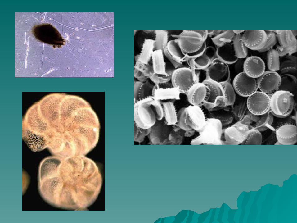
BiogenousBiogenous – consists of shells and – consists of shells and skeletons of marine animals and algae. skeletons of marine animals and algae.
The most common type is calcareous The most common type is calcareous ooze which forms from calcium ooze which forms from calcium carbonate shells and corals. The shells carbonate shells and corals. The shells dissolve as the sink to lower depths. dissolve as the sink to lower depths.
This sediment has the consistency of This sediment has the consistency of thick mud. thick mud.
Other sediments include siliceous Other sediments include siliceous oozeooze which is composed mostly of diatom which is composed mostly of diatom shells made of silica. shells made of silica. PhosphatePhosphate rich rich biogenous sediments come from teeth, biogenous sediments come from teeth, bones and scales of fish.bones and scales of fish.


HydrogenousHydrogenous – consists of – consists of minerals that crystallize directly minerals that crystallize directly from ocean water through various from ocean water through various chemical reactions.chemical reactions.

Common types:Common types: Manganese nodulesManganese nodules – made also of iron and – made also of iron and
other metals, they form around grains of sand other metals, they form around grains of sand and are scatter across large areas of the deep and are scatter across large areas of the deep ocean floor.ocean floor.
Calcium carbonatesCalcium carbonates – form by precipitation – form by precipitation directly from ocean water in warm climates. If directly from ocean water in warm climates. If this sediment is buried it can form limestone.this sediment is buried it can form limestone.
EvaporitesEvaporites – form where evaporation rates are – form where evaporation rates are high and ocean circulation is restricted. As high and ocean circulation is restricted. As water evaporates the remaining water becomes water evaporates the remaining water becomes saturated with dissolved minerals which begin saturated with dissolved minerals which begin to precipitate. These sediments are generally to precipitate. These sediments are generally called “salts.” Three common minerals that called “salts.” Three common minerals that form this way are form this way are halite, gypsum, and calcium halite, gypsum, and calcium sulfatesulfate..
Resources from the Seafloor Resources from the Seafloor Oil and natural gasOil and natural gas – ancient remains of – ancient remains of
microscopic organisms that were buried microscopic organisms that were buried before they could decompose. Exposed to before they could decompose. Exposed to pressure of overlying rocks and the Earth’s pressure of overlying rocks and the Earth’s internal heat the remains were internal heat the remains were transformed into oil and natural gas.transformed into oil and natural gas.
Major offshore reserves: Persian Gulf, Gulf Major offshore reserves: Persian Gulf, Gulf of Mexico, off southern California, North of Mexico, off southern California, North Sea, and the East Indies. Sea, and the East Indies.
Possible new reserves may be off the Possible new reserves may be off the coast of Alaska and the Canadian Arctic, coast of Alaska and the Canadian Arctic, Asian seas, Africa, and BrazilAsian seas, Africa, and Brazil
Problems: pollution of the oceansProblems: pollution of the oceans

Gas hydratesGas hydrates – occurs as methane hydrate or – occurs as methane hydrate or methane. methane.
Gas Hydrate is an Gas Hydrate is an ice-like crystalline solidice-like crystalline solid formed formed from a mixture of water and natural gas, usually from a mixture of water and natural gas, usually methane. They occur in the pore spaces of methane. They occur in the pore spaces of sediments, and may form cements, nodes or sediments, and may form cements, nodes or layers.layers.
These occur beneath permafrost areas on land These occur beneath permafrost areas on land and under the ocean floor at depths below 525 and under the ocean floor at depths below 525 meters. Most oceanic gas hydrates are created meters. Most oceanic gas hydrates are created when bacteria break down organic matter when bacteria break down organic matter trapped in ocean floor sediments. Other gases trapped in ocean floor sediments. Other gases include ethane and propane.include ethane and propane.
Chunks of gas hydrates look like metals and Chunks of gas hydrates look like metals and evaporate quickly when exposed to warm evaporate quickly when exposed to warm temperatures and less pressure.temperatures and less pressure.
An estimated 20 quadrillion cubic meters of An estimated 20 quadrillion cubic meters of methane are locked in sediments. This is double methane are locked in sediments. This is double the Earth’s coal, oil, and natural gas reserves the Earth’s coal, oil, and natural gas reserves combined. combined.

Where are gas hydrates found?


Sand and gravelSand and gravel – used in – used in construction and some are gem construction and some are gem quality. Diamonds, platinum, quality. Diamonds, platinum, titanium, and gold are found in these titanium, and gold are found in these deposits.deposits.
Manganese nodulesManganese nodules – they include – they include iron, copper, nickel, and cobalt.iron, copper, nickel, and cobalt.
Cobalt Cobalt – used to make strong allows – used to make strong allows of other metals. Can make cutting of other metals. Can make cutting tools, magnets, and jet engine parts.tools, magnets, and jet engine parts.


Evaporative saltsEvaporative salts – Of economic – Of economic use is halite which is used in table use is halite which is used in table salt, seasoning of food, curing, salt, seasoning of food, curing, preserving food, agriculture, dying preserving food, agriculture, dying fabrics and de-icing roads.fabrics and de-icing roads.

Problems include …Problems include …
Developing the tools to get them Developing the tools to get them from the ocean floor from the ocean floor
Establishing mining rights.Establishing mining rights.