chapter 11 1 how rock deforms 2 how mountains form of the crust...isostasy stress strain fold fault...
TRANSCRIPT
Key-Term Fold
Before you read
this chapter,
create the
FoldNote entitled “Key-Term
Fold” described in the Skills
Handbook section of the
Appendix. Write a key term
from the chapter on
each tab of the key-
term fold. Under each
tab, write the defini-
tion of the key term.
Sections
1 How Rock Deforms
2 How Mountains Form
What You’ll Learn• How Earth’s crust responds to
stress
• What forms deformed rock
takes
• How forces in the crust cause
mountains to form
Why It’s RelevantMany of the most dramatic
features of Earth’s surface are
the result of deformation of
the crust. Knowing how rock
responds to stress provides a
strong basis for understanding
why and how Earth’s surface
changes.
Deformation of the Crust
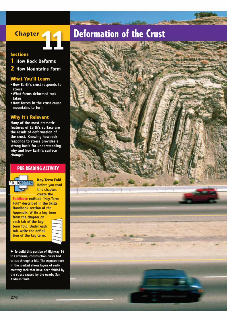
To build this portion of Highway 14
in California, construction crews had
to cut through a hill. The exposed rock
in the roadcut shows layers of sedi-
mentary rock that have been folded by
the stress caused by the nearby San
Andreas fault.
11Chapter
PRE-READING ACTIVITY
270
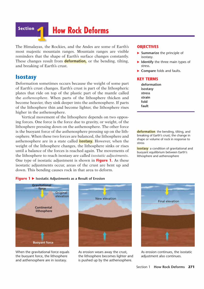
Gravitational force
Continental lithosphere
Buoyant force
Original elevation
New elevationFinal elevation
How Rock Deforms
OBJECTIVES
Summarize the principle of isostasy.
Identify the three main types of stress.
Compare folds and faults.
KEY TERMS
deformation
isostasy
stress
strain
fold
fault
The Himalayas, the Rockies, and the Andes are some of Earth’s
most majestic mountain ranges. Mountain ranges are visible
reminders that the shape of Earth’s surface changes constantly.
These changes result from deformation, or the bending, tilting,
and breaking of Earth’s crust.
IsostasyDeformation sometimes occurs because the weight of some part
of Earth’s crust changes. Earth’s crust is part of the lithospheric
plates that ride on top of the plastic part of the mantle called
the asthenosphere. When parts of the lithosphere thicken and
become heavier, they sink deeper into the asthenosphere. If parts
of the lithosphere thin and become lighter, the lithosphere rises
higher in the asthenosphere.
Vertical movement of the lithosphere depends on two oppos-
ing forces. One force is the force due to gravity, or weight, of the
lithosphere pressing down on the asthenosphere. The other force
is the buoyant force of the asthenosphere pressing up on the lith-
osphere. When these two forces are balanced, the lithosphere and
asthenosphere are in a state called isostasy. However, when the
weight of the lithosphere changes, the lithosphere sinks or rises
until a balance of the forces is reached again. The movements of
the lithosphere to reach isostasy are called isostatic adjustments.
One type of isostatic adjustment is shown in Figure 1. As these
isostatic adjustments occur, areas of the crust are bent up and
down. This bending causes rock in that area to deform.
When the gravitational force equals the buoyant force, the lithosphere and asthenosphere are in isostasy.
deformation the bending, tilting, and breaking of Earth’s crust; the change in shape or volume of rock in response to stress
isostasy a condition of gravitational and buoyant equilibrium between Earth’s lithosphere and asthenosphere
Figure 1 Isostatic Adjustments as a Result of Erosion
As erosion wears away the crust, the lithosphere becomes lighter and is pushed up by the asthenosphere.
As erosion continues, the isostatic adjustment also continues.
Section
1
Section 1 How Rock Deforms 271

Mountains and IsostasyIn mountainous regions, isostatic adjustments constantly occur.
Over millions of years, the rock that forms mountains is worn
away by the erosive actions of wind, water, and ice. This erosion
can significantly reduce the height and weight of a mountain
range, such as the one shown in Figure 2. As a mountain becomes
smaller and lighter, the area may rise by isostatic adjustment in a
process called uplift.
Deposition and IsostasyAnother type of isostatic adjustment occurs in areas where rivers
carrying large amounts of mud, sand, and gravel flow into larger
bodies of water. When a river flows into the ocean, most of the
material that the river carries is deposited on the nearby ocean
floor. The added weight of the deposited material causes the
ocean floor to sink by isostatic adjustment in a process known
as subsidence. This process is occurring in the Gulf of Mexico at
the mouth of the Mississippi River, where a thick accumulation
of deposited materials has formed.
Glaciers and IsostasyIsostatic adjustments also occur as a result of the growth and
retreat of glaciers and ice sheets. When a large amount of water
is held in glaciers and ice sheets, the weight of the ice causes the
lithosphere beneath the ice to sink. Simultaneously, the ocean
floor rises because the weight of the overlying ocean water is less.
When glaciers and ice sheets melt, the land that was covered with
ice slowly rises as the weight of the crust decreases. As the water
returns to the ocean, the ocean floor sinks.
Figure 2 Mt. Katahdin in Baxter State Park, Maine, has been worn down by weathering and erosion. As the mountain shrinks, the crust underneath it is uplifted.
ModelingIsostasyProcedure
1. Fill a 1 L beaker with 500 mL of water.
2. Place a wooden block in the water. Use a grease pencil to mark on the side of the beaker the levels of the top and the bottom of the block.
3. Place a small mass, of about 1 g, on the wooden block. Use a second grease pencil to mark the levels of the top and the bottom of the block.
Analysis
1.What happens to the block of wood when the weight is added?
2.What type of isostatic adjust-ment does this activity model?
5 min
272 Chapter 11 Deformation of the Crust

StressAs Earth’s lithosphere moves, the rock in the crust is squeezed,
stretched, and twisted. These actions exert force on the rock. The
amount of force that is exerted on each unit of area is called stress.
For example, during isostatic adjustments, the lithosphere sinks
and rises atop the asthenosphere. As the lithosphere sinks, the
rock in the crust is squeezed and the direction of stress changes.
As the lithosphere rises, the rock in the crust is stretched and
the direction of stress changes again. Similarly, stress occurs in
Earth’s crust when tectonic plates collide, separate, or scrape
past each other. Figure 3 shows the three main types of stress.
CompressionThe type of stress that squeezes and
shortens a body is called compression.
Compression commonly reduces the
amount of space that rock occupies. In
addition to reducing the volume of rock,
compression pushes rocks higher up or
deeper down into the crust. Much of the
stress that occurs at or near convergent
boundaries, where tectonic plates col-
lide, is compression.
TensionAnother type of stress is tension.
Tension is stress that stretches and pulls
a body apart. When rocks are pulled
apart by tension, they tend to become
thinner. Much of the stress that occurs
at or near divergent boundaries, where
tectonic plates pull apart, is tension.
Shear StressThe third type of stress is shear stress.
Shear stress distorts a body by pushing
parts of the body in opposite directions.
Sheared rocks bend, twist, or break
apart as they slide past each other.
Shear stress is common at transform
boundaries, where tectonic plates slide
horizontally past each other. However,
each type of stress occurs at or near all
types of plate boundaries and in various
other regions of the crust, too.
nl3 Reading Check Which two kinds of stress
pull rock apart? (See the Appendix for
answers to Reading Checks.)
Figure 3 Types of Stress
stress the amount of force per unit area that acts on a rock
Compression
Tension
Shear stress
Section 1 How Rock Deforms 273

StrainWhen stress is applied to rock, rock may deform. Any change in
the shape or volume of rock that results from stress is called strain.
When stress is applied slowly, the deformed rock may regain its
original shape when the stress is removed. However, the amount
of stress that rock can withstand without permanently changing
shape is limited. This limit varies with the type of rock and the
conditions under which the stress is applied. If a stress exceeds
the rock’s limit, the rock’s shape permanently changes.
Types of Permanent StrainMaterials that respond to stress by breaking or fracturing are
brittle. Brittle strain appears as cracks or fractures, as Figure 4
shows. Ductile materials respond to stress by bending or deform-
ing without breaking. Ductile strain is a change in the volume or
shape of rock in which the rock does not crack or fracture. Brittle
strain and ductile strain are types of permanent strain.
Factors That Affect StrainThe composition of rock determines whether rock is ductile or
brittle. Temperature and pressure also affect how rock deforms.
Near Earth’s surface, where temperature and pressure are low,
rock is likely to deform in a brittle way. At higher temperature
and pressure, rock is more likely to deform in a ductile way.
The type of strain that stress causes is determined by the
amount and type of stress and by the rate at which stress is
applied to rock. The greater the stress on rock is, the more likely
rock is to undergo brittle strain. The more quickly stress is applied
to rock, the more likely rock is to respond in a brittle way.
Figure 4 This rock deformation in Kingman, Arizona, is an example of brittle strain.
strain any change in a rock’s shape or volume caused by stress
Analysis 1. What types of stress did you model in steps 2, 3,
and 4?
2. Make a table that lists the charac-teristics of the two substances that you modeled, the stresses that you modeled, and the resulting strain on each model.
3. How does the frozen putty respond to the stress? How does the warm putty’s response to the stress differ from the frozen putty’s response?
Modeling Stress and StrainProcedure1. Put on a pair of gloves, and pick up a
5 cm × 5 cm square of frozen plastic play putty. Hold one edge of the frozen putty in each hand.
2. Try to pull the putty apart by pulling the edges away from each other.
3. Push the edges of the frozen putty toward each other. (You may have to reshape the putty between steps.)
4. Push one edge of the frozen putty away from you, and pull the other edge toward you.
5. Repeat steps 2–4, but use a 5 cm × 5 cm square of warm plastic play putty.
15 min
274 Chapter 11 Deformation of the Crust

Axial plane
Hinge
Limb
MATHPRACTICE
FoldsWhen rock responds to stress by deforming in a ductile way,
folds commonly form. A fold is a bend in rock layers that results
from stress. A fold is most easily observed where flat layers of
rock were compressed or squeezed inward. As stress was applied,
the rock layers bent and folded. Cracks sometimes appear in or
near a fold, but most commonly the rock layers remain intact.
Although a fold commonly results from compression, it can also
form as a result of shear stress.
Anatomy of a FoldFolds have features by which they can be identified. Scientists
use these features to describe folds. The main features of a fold
are shown by the illustration in Figure 5. The sloping sides of
a fold are called limbs. The limbs meet at the bend in the rock
layers, which is called the hinge. Some folds also contain an addi-
tional feature. If a fold’s structure is such that a plane could slice
the fold into two symmetrical halves, the fold is symmetrical. The
plane is called the fold’s axial plane. However, the two halves of a
fold are rarely symmetrical.
Many folds bend vertically, but folds can have many other
shapes, as shown by the photograph in Figure 5. Folds can be
asymmetrical. Sometimes, one limb of a fold dips more steeply
than the other limb does. If a fold is overturned, the fold appears
to be lying on its side. Folds can have open shapes or be as tight
as a hairpin. A fold’s hinge can be a smooth bend or may come
to a sharp point. Each fold is unique because the combination of
stresses and conditions that caused the fold was unique.
nl3 Reading Check Name two features of a fold. (See the
Appendix for answers to Reading Checks.)
Figure 5 Although not every fold is symmetrical, every fold has a hinge and limbs. Can you identify the limbs and hinge of each fold in the photo?
fold a form of ductile strain in which rock layers bend, usually as a result of compression
Units of StressTwo units are commonly used to describe stress or pressure. One unit is the pascal (Pa). A pascal is a measure of force (in newtons) divided by area (in square meters). The other unit of stress is the pound per square inch (psi). If the pressure in a region of Earth’s crust is mea-sured as 25 MPa (megapascals) and as 3,626 psi, how many pounds per square inch does 1 MPa equal? (Note: 1 MPa 1,000,000 Pa)
Section 1 How Rock Deforms 275

Oldest rock
Youngest rock
Types of FoldsTo categorize a fold, scientists study the relative ages of the
rocks in the fold. The rock layers of the fold are identified
by age from youngest to oldest. An anticline is a fold in
which the oldest layer is in the center of the fold. Anticlines
are commonly arch shaped. A syncline is a fold in which
the youngest layer is in the center of the fold. Synclines are
commonly bowl shaped. A monocline is a fold in which both
limbs are horizontal or almost horizontal. Monoclines form
when one part of Earth’s crust moves up or down relative
to another part. The three major types of folds are shown in
Figure 6.
Sizes of FoldsFolds, which appear as wavelike structures in rock
layers, vary greatly in size. Some folds are small enough
to be contained in a hand-held rock specimen. Other folds
cover thousands of square kilometers and can be seen only
from the air.
Sometimes, a large anticline forms a ridge. A ridge is
a large, narrow strip of elevated land that can occur near
mountains. Nearby, a large syncline may form a valley.
The ridges and valleys of the Appalachian Mountains are
examples of landforms that were formed by anticlines and
synclines.
Figure 6 The three major types of folds are anticlines (top), synclines (middle), and monoclines (bottom).
Oil and natural gas form where the remains of organisms, especially marine plants, are buried in an environment that prevents the remains from rapidly decomposing. Over millions of years, chemical reactions slowly change the organic remains into oil and natural gas.
When prospecting for oil and natural gas, oil companies look for porous and permeable rock layers. Porous rock has spaces between rock particles. Permeable rock is rock in which the pore spaces are connected, so fl uids can fl ow through the rock. When a rock layer is both porous and permeable and contains oil or gas, the layer is called a reservoir.
Because oil and natural gas are fl uids that have low densities, they move upward through rock toward Earth’s surface. Oil and gas move through rock layers until they meet an impermeable rock layer or structure, which then traps the oil and gas below it.
In addition to looking for porous and permeable rock layers, petroleum engineers look for rock layers that have been folded. Many folds are anticlines
Oil Trapsin which layers of impermeable rock overlay layers of permeable rock. Because the limbs of the fold slope upward, the oil and natural gas rise through the permeable layer to the crest of the anticline and are trapped there by the impermeable layer. Engineers can then drill through the impermeable layer to reach the oil or gas reservoir.
This oil pump brings oil and natural gas up to the surface.
276 Chapter 11 Deformation of the Crust

Footwall
Hanging wall
FaultsStress does not always cause rock to fold. Near Earth’s surface,
where temperatures and pressure are low, stresses may simply
cause rock to break. Breaks in rock are divided into two catego-
ries. A break along which there is no movement of the surround-
ing rock is called a fracture. A break along which the surrounding
rock moves is called a fault. The surface or plane along which the
motion occurs is called the fault plane. In a nonvertical fault, the
hanging wall is the rock above the fault plane. The footwall is the
rock below the fault plane.
Normal FaultsAs shown in Figure 7, a normal fault is a fault in which the hang-
ing wall moves downward relative to the footwall. Normal faults
commonly form at divergent boundaries, where the crust is being
pulled apart by tension. Normal faults may occur as a series of
parallel fault lines, forming steep, steplike landforms. The Great
Rift Valley of East Africa formed by large-scale normal faulting.
Reverse FaultsWhen compression causes the hanging wall to move upward
relative to the footwall, also shown in Figure 7, a reverse fault
forms. A thrust fault is a special type of reverse fault in which
the fault plane is at a low angle or is nearly horizontal. Because
of the low angle of the fault plane, the rock of the hanging wall is
pushed up and over the rock of the footwall. Reverse faults and
thrust faults are common in steep mountain ranges, such as the
Rockies and the Alps.
nl3 Reading Check How does a thrust fault differ from a reverse fault?
(See the Appendix for answers to Reading Checks.)
Figure 7 Normal and Reverse Faults
Topic: Folding and Faulting
SciLinks code: HQ60589
fault a break in a body of rock along which one block slides relative to another; a form of brittle strain
Reverse fault
Normal fault
Thrust fault
Section 1 How Rock Deforms 277
For a variety of links related to this
subject, go to www.scilinks.org
Developed and maintained by theNational Science Teachers Association

Strike-Slip FaultsIn a strike-slip fault, the rock on either side
of the fault plane slides horizontally in
response to shear stress. Strike-slip faults
got their name because they slide, or slip,
parallel to the direction of the length, or
strike, of the fault. Some strike-slip fault
planes are vertical, but many are sloped.
Strike-slip faults commonly occur at
transform boundaries, where tectonic
plates grind past each other as they move
in opposite directions. These motions
cause shear stress on the rocks at the
edges of the plates. Strike-slip faults also
occur at fracture zones between offset segments of mid-ocean
ridges. Commonly, strike-slip faults occur as groups of smaller
faults in areas where large-scale deformation is happening.
Sizes of FaultsLike folds, faults vary greatly in size. Some faults are so small
that they affect only a few layers of rock in a small region. Other
faults are thousands of kilometers long and may extend several
kilometers below Earth’s surface. Generally, large faults that
cover thousands of kilometers are composed of systems of many
smaller, related faults, rather than of a single fault. The San
Andreas fault in California, shown in Figure 8, is an example of
a large fault system.
Figure 8 The San Andreas fault system stretches more than 1,200 km across California and is the result of two tectonic plates moving in different directions.
1. Summarize how isostatic adjustments affect isostasy.
2. Identify and describe three types of stress.
3. Compare stress and strain.
4. Describe one type of strain that results when rock responds to stress by permanently deforming with-out breaking.
5. Identify features that all types of folds share and features that only some types of folds have.
6. Describe four types of faults.
7. Compare folding and faulting as responses to stress.
CRITICAL THINKING8. Applying Ideas Why is faulting most likely to occur
near Earth’s surface and not deep within Earth?
9. Making Comparisons How would the isostatic adjustment that results from the melting of glaciers differ from the isostatic adjustment that may occur when a large river empties into the ocean?
10. Analyzing Relationships You are examining a rock outcrop that shows a fold in which both limbs are horizontal but occur at different elevations. What type of fold does this outcrop show, and what can you say about the type of stress that the rock underwent?
11. Predicting Consequences You are watching a lab experiment in which a rock sample is being gently heated and slowly bent. Would you expect the rock to fold or to fracture? Explain your reasoning.
CONCEPT MAPPING 12. Use the following terms to create a concept map:
stress, compression, strain, tension, shear stress, folds, and faults.
ReviewSection
278 Chapter 11 Deformation of the Crust
1

Eurasian-Melanesian mountain belt
Circum-Pacific mountain belt
EURASIA
AFRICA
AUSTRALIA
ANTARCTICA
NORTH
AMERICA
SOUTH
AMERICAATLANTIC
OCEAN INDIAN
OCEAN
PACIFIC OCEAN
ATLANTIC
OCEAN
60ºN
30ºN
0º
30ºS
60ºS0º 30ºE 60ºE 90ºE 120ºE 150ºE 180ºE 150ºW 120ºW 90ºW 60ºW 30ºW
How Mountains Form
OBJECTIVES
Identify the types of plate colli-sions that form mountains.
Identify four types of mountains.
Compare how folded and fault-block mountains form.
KEY TERMS
mountain range
folded mountain
fault-block mountain
dome mountain
A mountain is the most extreme type of deformation. Mount
Everest, whose elevation is more than 8 km above sea level,
is Earth’s highest mountain. Forces inside Earth cause Mount
Everest to grow taller every year. Mount St. Helens, a volcanic
mountain, captured the world’s attention in 1980 when its explo-
sive eruption devastated the surrounding area.
Mountain Ranges and SystemsA group of adjacent mountains that are related to each other in
shape and structure is called a mountain range. Mount Everest is
part of the Great Himalaya Range, and Mount St. Helens is part
of the Cascade Range. A group of mountain ranges that are adja-
cent is called a mountain system. In the eastern United States, for
example, the Great Smoky, Blue Ridge, Cumberland, and Green
mountain ranges make up the Appalachian mountain system.
The largest mountain systems are part of two larger sys-
tems called mountain belts. Earth’s two major mountain belts,
the circum-Pacific belt and the Eurasian-Melanesian belt, are
shown in Figure 1. The circum-Pacific belt forms a ring around
the Pacific Ocean. The Eurasian-Melanesian belt runs from the
Pacific islands through Asia and southern Europe and into north-
western Africa.
Figure 1 Most mountain ranges lie along either the Eurasian-Melanesian mountain belt or the circum-Pacifi c mountain belt.
mountain range a series of mountains that are closely related in orientation, age, and mode of formation
Section 2 How Mountains Form 279
Section
2

Ocean trench
Active
volcano
Magma
SUBDUCTION ZONE
Plate Tectonics and MountainsBoth the circum-Pacific and the Eurasian-Melanesian mountain
belts are located along convergent plate boundaries. Scientists
think that the location of these two mountain belts provides evi-
dence that most mountains form as a result of collisions between
tectonic plates. Some mountains, such as the Appalachians, do
not lie along active convergent plate boundaries. However, evi-
dence indicates that the places at which these ranges formed
were previously active plate boundaries.
Collisions Between Continental and Oceanic CrustSome mountains form when oceanic lithosphere and continen-
tal lithosphere collide at convergent plate boundaries. When the
moving plates collide, the oceanic lithosphere subducts beneath
the continental lithosphere, as shown in Figure 2. This type of
collision produces such large-scale deformation of rock that high
mountains are uplifted. In addition, the subduction of the oce-
anic lithosphere causes partial melting of the overlying mantle
and crust. This melting produces magma that may eventually
erupt to form volcanic mountains on Earth’s surface. The moun-
tains of the Cascade Range in the northwest region of the United
States formed in this way. The Andes mountains on the western
coast of South America are another example of mountains that
formed by this type of collision.
Some mountains at the boundary between continental litho-
sphere and oceanic lithosphere may form by a different process.
As the oceanic lithosphere subducts, pieces of crust called ter-
ranes are scraped off. These terranes then become part of the
continent and may form mountains.
Figure 2 The Andes, shown below, are being uplifted as the Pacifi c plate subducts beneath the South American plate.
Cause-and-Effect Map
Create the Graphic Organizer entitled “Cause-and-Effect Map”
described in the Skills Handbook
section of the Appendix. Label the
effect with “Mountain formation.”
Then, fill in the map with causes
of mountain for-
mation and details
about why moun-
tains form.
280 Chapter 11 Deformation of the Crust

Trench
Island arc volcanoes
Oceanic lithosphere
Asthenosphere
Oceanic lithosphere
Subduction zone
Continent B Continent A
Deformed ocean-floor sediments
Magma
Thrust faults
Collisions Between Oceanic Crust and Oceanic CrustVolcanic mountains commonly form where two plates whose
edges consist of oceanic lithosphere collide. In this collision, the
denser oceanic plate subducts beneath the other oceanic plate,
as shown in Figure 3. As the denser oceanic plate subducts,
fluids from the subducting lithosphere cause partial melting
of the overlying mantle and crust. The resulting magma rises
and breaks through the oceanic lithosphere. These eruptions of
magma form an arc of volcanic mountains on the ocean floor.
The Mariana Islands are the peaks of volcanic mountains that
rose above sea level.
Collisions Between ContinentsMountains can also form when two con-
tinents collide, as Figure 4 shows. The
Himalaya Mountains formed from such a
collision. About 100 million years ago, India
broke apart from Africa and Antarctica
and became a separate continent. The
Indian plate then began moving north
toward Eurasia. The oceanic lithosphere
of the Indian plate subducted beneath the
Eurasian plate. This subduction continued
until the continental lithosphere of India
collided with the continental lithosphere
of Eurasia. Because the two continents
have equally dense lithosphere, subduction
stopped, but the collision continued. The
intense deformation that resulted from the
collision uplifted the Himalayas. Because
the plates are still colliding, the Himalayas
are still growing taller.
nl3 Reading Check Why are the Himalayas
growing taller today? (See the Appendix for
answers to Reading Checks.)
Figure 3 The Mariana Islands in the North Pacifi c Ocean are volcanic mountains that formed by the collision of two oceanic plates.
Figure 4 The Himalayas formed when India collided with Eurasia.
281

Types of MountainsMountains are more than just elevated parts of Earth’s crust.
Mountains are complicated structures whose rock formations
provide evidence of the stresses that created the mountains.
Scientists classify mountains according to the way in which the
crust was deformed and shaped by mountain-building stresses.
Examples of several types of mountains are shown in Figure 5.
Folded Mountains and PlateausThe highest mountain ranges in the world consist of folded
mountains that form when continents collide. Folded mountains
form when tectonic movements squeeze rock layers together
into accordion-like folds. Parts of the Alps, the Himalayas, the
Appalachians, and Russia’s Ural Mountains consist of very large
and complex folds.
The same stresses that form folded mountains also uplift
plateaus. Plateaus are large, flat areas of rock high above sea level.
Most plateaus form when thick, horizontal layers of rock are
slowly uplifted so that the layers remain flat instead of faulting
and folding. Most plateaus are located near mountain ranges. For
example, the Tibetan Plateau is next to the Himalaya Mountains,
and the Colorado Plateau is next to the Rockies. Plateaus can also
form when layers of molten rock harden and pile up on Earth’s
surface or when large areas of rock are eroded.Figure 5 Mountains in the
United States
folded mountain a mountain that forms when rock layers are squeezed together and uplifted
Topic: Types of Mountains
SciLinks code: HQ61568
The Sierra Nevada range in California contains many fault block mountains.
The Colorado Plateau is near the Rockies.
Death Valley is a graben that lies between two mountain chains and has the lowest elevation in the U.S.
For a variety of links related to this
subject, go to www.scilinks.org
Developed and maintained by theNational Science Teachers Association
282 Chapter 11 Deformation of the Crust

Fault-Block Mountains and Grabens
Where parts of Earth’s crust have been stretched and broken into
large blocks, faulting may cause the blocks to tilt and drop rela-
tive to other blocks. The relatively higher blocks form fault-block
mountains. The Sierra Nevada range of California consists of
many fault-block mountains.
The same type of faulting that forms fault-block mountains
also forms long, narrow valleys called grabens. Grabens develop
when steep faults break the crust into blocks and one block slips
downward relative to the surrounding blocks. Grabens and fault-
block mountain ranges commonly occur together. For example,
the Basin and Range Province of the western United States con-
sists of grabens separated by fault-block mountain ranges.
Dome Mountains
A rare type of mountain forms when magma rises through the
crust and pushes up the rock layers above the magma. The result
is a dome mountain, a circular structure made of rock layers that
slope gently away from a central point. Dome mountains may
also form when tectonic forces gently uplift rock layers. The
Black Hills of South Dakota and the Adirondack Mountains of
New York are examples of dome mountains.
nl3 Reading Check Name three types of mountains found in the United
States. (See the Appendix for answers to Reading Checks.)
fault-block mountain a mountain that forms where faults break Earth’s crust into large blocks and some blocks drop down relative to other blocks
dome mountain a circular or elliptical, almost symmetrical elevation or structure in which the stratifi ed rock slopes downward gently from the central point of folding
The Ouachita Plateau in Arkansas is much wetter than the Colorado Plateau is.
The Appalachian Mountains stretch from Georgia to Canada and contain many older, more rounded mountains.
This dome mountain is part of the Adirondacks in New York.
Section 2 How Mountains Form 283

Volcanic MountainsMountains that form when magma
erupts onto Earth’s surface are called
volcanic mountains. Volcanic moun-
tains commonly form along convergent
plate boundaries. The Cascade Range
of Washington, Oregon, and northern
California is composed of this type of vol-
canic mountain, two of which are shown
in Figure 6.
Some of the largest volcanic moun-
tains are part of the mid-ocean ridges
along divergent plate boundaries. Magma
rising to Earth’s surface at divergent
boundaries makes mid-ocean ridges vol-
canically active areas. The peaks of these
volcanic mountains sometimes rise above
sea level to form volcanic islands, such as
the Azores in the North Atlantic Ocean.
Other large volcanic mountains form
on the ocean floor at hot spots. Hot spots
are volcanically active areas that lie far
from tectonic plate boundaries. These areas seem to correspond
to places where hot material rises through Earth’s interior and
reaches the lithosphere. The Hawaiian Islands are an example
of this type of volcanic mountain. The main island of Hawaii is
a volcanic mountain that reaches almost 9 km above the ocean
floor and has a base that is more than 160 km wide.
Figure 6 Mount St. Helens (front) and Mount Rainier (back) in the Cascade Range of the western United States are volcanic mountains that formed along a convergent boundary.
1. Describe three types of tectonic plate collisions that form mountains.
2. Summarize the process by which folded mountains form.
3. Compare how plateaus form with how folded mountains form.
4. Describe the formation of fault-block mountains.
5. Explain how dome mountains form.
6. Explain how volcanic mountains form.
CRITICAL THINKING7. Making Connections Explain two ways in which
volcanic mountains might get smaller.
8. Making Connections Explain why fault-block mountains and grabens are commonly found near each other.
9. Analyzing Ideas You are standing on a large, flat area of land and are examining the nearby moun-tains. You notice that many of the mountains have large folds. Are you standing on a plateau or a gra-ben? Explain your answer.
10. Making Predictions Igneous rocks form from cooled magma. Near what types of mountains would you expect to find new igneous rocks?
CONCEPT MAPPING 11. Use the following terms to create a concept map:
mountain range, fault-block mountains, mountain belt, folded mountains, mountain system, dome mountains, and volcanic mountains.
ReviewSection
284 Chapter 11 Deformation of the Crust
2

Mountains make up mountain ranges, which, in turn, make up mountain systems. The largest mountain systems form two major mountain belts.
Four types of mountains are folded moun-tains, fault-block mountains, dome moun-tains, and volcanic mountains.
Mountains commonly form as the result of the collision of tectonic plates.
A mountain is classified according to the way in which the crust deforms when the mountain forms.
mountain range, 279
folded mountain, 282
fault-block mountain, 283
dome mountain, 283
Key Concepts
Tectonic plate movement and isostatic adjustments cause stress on the rock in Earth’s crust.
Stress can squeeze rock together, pull rock apart, and bend and twist rock.
Stress on rock can cause strain, or the deformation of rock. Rock can deform by folding or by breaking to form fractures or faults.
Three types of faults occur in rock: nor-mal faults, reverse faults (including thrust faults), and strike-slip faults.
Key Terms
deformation, 271
isostasy, 271
stress, 273
strain, 274
fold, 275
fault, 277
Sections
1 How Rock Deforms
2 How Mountains Form
11Chapter Highlights
Chapter 11 Highlights 285

Using Key Terms
Use each of the following terms in a separate sentence.
1. isostasy
2. compression
3. shear stress
For each pair of terms, explain how the meanings of the terms differ.
4. stress and strain
5. fold and fault
6. syncline and monocline
7. dome mountains and volcanic mountains
8. folded mountains and fault-block mountains
Understanding Key Concepts
9. When the weight of an area of Earth’s crust increases, the lithosphere
a. sinks. c. rises.
b. melts. d. collides.
10. The force per unit area that changes the shape and volume of rock is
a. footwall. c. rising.
b. isostasy. d. stress.
11. Shear stress
a. bends, twists, or breaks rock.
b. causes isostasy.
c. causes rock to melt.
d. causes rock to expand.
12. When stress is applied under conditions of high pressure and high temperature, rock is more likely to
a. fracture. c. fault.
b. sink. d. fold.
13. Folds in which both limbs remain horizontal are called
a. monoclines. c. synclines.
b. fractures. d. anticlines.
14. When a fault is not vertical, the rock above the fault plane makes up the
a. tension. c. hanging wall.
b. footwall. d. compression.
15. A fault in which the rock on either side of the fault plane moves horizontally in nearly opposite directions is called a
a. normal fault. c. strike-slip fault.
b. reverse fault. d. thrust fault.
16. The largest mountain systems are part of still larger systems called
a. continental margins.
b. ranges.
c. belts.
d. synclines.
17. Large areas of flat-topped rock high above the surrounding landscape are
a. grabens. c. hanging walls.
b. footwalls. d. plateaus.
Short Answer
18. Name two types of deformation in Earth’s crust, and explain how each type occurs.
19. Explain how to identify an anticline.
20. Identify the two major mountain belts on Earth.
21. Describe how the various types of moun-tains are categorized.
22. Identify the two forces that are kept in balance by isostatic adjustments.
23. Compare the features of dome mountains with those of fault-block mountains.
Chapter
11Review
286 Chapter 11 Deformation of the Crust

B
C
D
E
F
Block 1 Block 2
A
B
C
D
E
Critical Thinking
24. Evaluating Ideas If thick ice sheets covered large parts of Earth’s continents again, how would you expect the lithosphere to re-spond to the added weight of the continen-tal ice sheets? Explain your answer.
25. Analyzing Relationships When the Indian plate collided with the Eurasian plate and produced the Himalaya Mountains, which type of stress most likely occurred? Which type of stress is most likely occurring along the Mid-Atlantic Ridge? Which type of stress would you expect to find along the San Andreas fault? Explain your answers.
26. Making Predictions If the force that causes a rock to deform slightly begins to ease, what may happen to the rock? What might hap-pen if the force causing the deformation became greater?
27. Analyzing Processes Why do you think that dome mountains do not always become volcanic mountains?
Concept Mapping
28. Use the following terms to create a concept map: stress, strain, brittle, ductile, folds, fault, normal fault, reverse fault, thrust fault, and strike-slip fault.
Math Skills
29. Making Calculations Scientists calculate that parts of the Himalayas are growing at a rate of 6.1 mm per year. At this rate, in how many years will the Himalayas have grown 1 m taller?
30. Analyzing Data Rock stress is measured as 48 MPa at point A below Earth’s surface. At point B nearby, stress is measured as 12 MPa. What percentage of the stress at point A is the stress at point B equal to?
Writing Skills
31. Creative Writing Write a short story from the perspective of a rock that is being deformed. Describe the stresses that are affecting the rock and the final result of the stress.
32. Writing from Research Look for photos or illustrations of folding and faulting in a particular area. Then, research the geologic history of the area, and write a report based on your findings. Use any photos or draw-ings that you find to illustrate your report.
Interpreting Graphics
The diagram below shows a fault. Use the dia-gram below to answer the questions that follow.
33. Is Block 2 a footwall or a hanging wall? Explain your answer.
34. What type of fault is illustrated? Explain your answer.
35. What type of stress generally causes this type of fault?
Chapter 11 Review 287

11Chapter
288 Chapter 11 Deformation of the Crust
FCAT Prep
For questions 1–6, write your answers on a separate sheet of paper.
1 What is the term for the condition of gravitational equilibrium in Earth’s crust?
A. deformation C. strain
B. isostasy D. stress
2 As a volcanic mountain range is built, isostatic adjustment will cause the crust beneath the volcanic mountain range to do what?
F. cool H. sink
G. shear I. uplift
3 Which of the following statements describes the formation of rock along strike-slip faults?
A. Rock on either side of the fault plane slides vertically.
B. Rock on either side of the fault plane slides horizontally.
C. Rock in the hanging wall moves down relative to the footwall.
D. Rock in the hanging wall is pushed up and over the rock of the footwall.
4 Which of the following can result in mountain formation?
F. deposition and isostasy
G. weathering and erosion
H. strike-slip faulting involving two continental plates
I. subduction of an oceanic plate beneath a continental plate
5 The temperature and pressure changes caused by stress in the Earth’s crust can cause rocks to deform. This deformation can take different forms which depend on the type of stress and rock composition.
Under what conditions is rock likely to respond with brittle or ductile strain?
6 Stress is defined as the amount of force per unit area that is put on a rock. When enough stress is placed on a rock, the rock will become strained. This strain will cause the rock to deform, usually by bending and breaking. For example, if you put a small amount of pressure on the ends of a drinking straw, the straw may not bend—even though you have put stress on it. However, when you put enough pressure on it, the straw will bend, or become strained.
One example of stress is when tectonic plates collide. When plates collide, a large amount of stress is placed on the rocks that make up the plate, especially the rocks at the leading edge of the collision. Because of the stress, these rocks become extremely strained. In fact, even the shapes of the tectonic plates can change as a result of these powerful collisions.
Part A In what ways does rock deform as a result of strain?
Part B What happens to rocks when plates collide?

Test
A
B
Plate Plate
PlatePlate
A
B
Chapter 11 FCAT Prep 289
For questions 7–9, write your answers on a separate sheet of paper.
The diagrams below show a divergent and a convergent plate boundary. Use the map to answer questions 7 and 8.
DIVERGENT AND CONVERGENT PLATE BOUNDARIES
7 Which of the following is most likely to or occur at the boundary shown in diagram B?
F. divergent motion H. mid-ocean ridges
G. transform motion I. active volcanoes
8 What types of plates are most likely shown at the boundary represented in diagram A?
A. two oceanic plates
B. two continental plates
C. an oceanic plate and a continental plate
D. There is not enough information to determine the answer.
The diagram below shows two possible outcomes when pressure (represented by the large arrows) is applied to the rock on the left. Use this diagram to answer question 9.
BASIC ROCK FOLDS
9 What type of deformation is seen in the rock labeled A?
F. brittle H. folding
G. ductile I. monocline
Carefully study all
of the details of
a diagram before
answering the
question or questions
that refer to it.

Continental Collisions
When the subcontinent of India broke away from Africa and Antarctica
and began to move northward toward Eurasia, the oceanic crust on the
northern side of India began to subduct beneath the Eurasian
plate. The deformation of the crust resulted in the formation of the
Himalaya Mountains. Earthquakes in the Himalayan region suggest
that India is still pushing against Eurasia. In this lab, you will create
a model to help explain how the Himalaya Mountains formed as a
result of the collision of the Indian and Eurasian tectonic plates.
Objectives
Model collisions between continents.
Explain how mountains form at convergent boundaries.
Materials
blocks, wooden,
2.5 cm 2.5 cm 6 cm
bobby pins, long (5)
cardboard, thick,
15 cm 30 cm
napkins, paper, light- and
dark-colored
paper, adding-machine,
6 cm 35 cm
ruler, metric
scissors
tape, masking
Safety
1 To assemble the continental-collision model, cut a 7 cm slit
in the cardboard. The slit should be about 6 cm from (and
parallel to) one of the short edges of the cardboard. Cut the
slit wide enough such that the adding-machine paper will
feed through the slit without being loose.
2 Securely tape one wood block along the slit between the
slit and the near edge of the cardboard. Tape the other
block across the paper strip about 6 cm from one end of
the paper. The blocks should be parallel to one another, as
shown in the illustration on the next page.
3 Cut two strips of the light-colored paper napkin that are
about 6 cm wide and 16 cm long. Cut two strips of the
dark-colored paper napkin that are about 6 cm wide and 32
cm long. Fold all four strips in half along their width.Step 8
11Chapter Making Models Lab
290

Cardboard
Wood block
Taped topaper strip
onlyLight
napkinsDark
napkins Tape
Bobby pins Wood block Paper strip
4 Stack the napkin strips on top of each other such that all of
the folds are along the same side. Place the two dark-
colored napkins on the bottom.
5 Place the napkin strips lengthwise on the paper strip. The
nonfolded ends of the napkin strips should be butted up
against the wood block that is taped to the paper strip.
6 Using the bobby pins, attach the napkins to the paper strip,
as shown in the illustration above.
7 Push the long end of the paper strip through the slit in the
cardboard until the first fold of the napkin rests against the
fixed wood block.
8 Hold the cardboard at about eye level, and pull down gently
on the paper strip. You may need a partner’s help. Observe
what happens as the dark-colored napkins contact the fixed
wood block and as you continue to pull down on the paper
strip. Stop pulling when you feel resistance from the strip.
1 Analyzing Data Obtain a
world map of earthquake
epicenters. Study the
map. Describe the pat-
tern of epicenters in the
Himalayan region. Does
the pattern suggest that
the Himalaya Mountains
are still growing?
2 Writing from Research
Read about the breakup
of Gondwanaland and the
movement of India toward
the Northern hemisphere.
Write about stages in
India’s movement. List the
time frame in which each
important event occurred.
1 Evaluating Methods Explain what is represented by the
dark napkins, the light napkins, and the wood blocks.
2 Analyzing Processes What plate-tectonics process is rep-
resented by the motion of the paper strip in the model?
Explain your answer.
3 Applying Ideas What type of mountain would result from
the kind of collision shown by the model?
4 Evaluating Models Explain how the process modeled here
differs from the way the Himalaya Mountains formed.
Extension
Chapter 11 Making Models Lab 291

South American Earthquakes, 2003
175°E 180°E
35°S 35°S
40°S 40°S
45°S 45°S
km
200 4000
38 mm/yr
Hik
uran
giTr
ough
Australian Plate
PacificPlate
North Island
South Island
A lp ine Fau lt
35ºS
40ºS
45ºS45ºS
40ºS
35ºS
170ºE 175ºE 180º
37 mm/yr
38 mm/yr
41 mm/yr
47 mm/yr
0 200 Miles
0 200 Kilometers
SCALE
100
100
N
S
EW
Maximum
shear strain rate
0.0
0.2
0.4 ppm/yr
The map above shows the plate boundary zone of New Zealand. In this region, the Australian plate is moving north, while the Pacifi c plate is moving west. These complex plate movements create areas of tension, compression, and shear stress, which result in strain. Strain is measured in parts per million (ppm) per year (yr). The map on the right shows strain in New Zealand. Use the two maps to answer the questions below.
1. Using a Key What is the highest amount of shear
strain shown on the map?
2. Identifying Locations Using latitude and longitude,
describe the location of the area that has the highest
amount of shear strain.
3. Using a Key What is the approximate length of the
area of maximum shear strain?
4. Understanding Relationships What type of plate
boundary is located along the east coast of the North
Island? Explain your answer.
5. Comparing Areas In what areas might you expect to
fi nd compression? Explain your answer.
6. Making Inferences What type of fault is the Alpine
Fault? Explain your answer.
7. Drawing Conclusions A mountain range known
as the Southern Alps runs through the center of the
South Island. What type of mountains do you think
the Southern Alps are? Explain your answer.
Shear Strain in New Zealand
Map Skills Activity
292 Chapter 11 Deformation of the Crust

Aegean Sea
The History of Tomorrow
The northern oceanic crust of
the African plate, which is the
sea fl oor of the Mediterranean,
is still subducting beneath the
continental crust of Eurasia. As
more oceanic crust subducts,
the Mediterranean Sea will
become smaller. Italy, which
continues to be pushed into
Eurasia, will eventually cease to
exist as we know it. When the
northern coast of the African
continent fi nally collides with
Eurasia, the Mediterranean
Sea will disappear completely.
Of course, this process will
take millions of years, because
tectonic plates move so slowly.
Two of the most breathtaking
regions of the world are the Alps
and the Mediterranean. The Alps,
considered to be among Earth’s
most beautiful mountains, have
become a vast natural playground
for skiers, hikers, and climbers.
The Mediterranean plays host
to travelers from around the
world who wish to sample the
diverse cultures, balmy climate,
and famous beach resorts that
surround the Mediterranean Sea.
Local residents depend
on the sea for their economic
well-being.
Push and Pull
The same natural forces
that uplifted the Alps are
slowly swallowing up the
Mediterranean. The Alps were
formed—and are still being
shaped—by the collision of
two tectonic plates. Italy, part
of which rides on the African
plate, collided with Eurasia
sometime in the past. The
collision formed the Alps, but
it did not stop the movement of
the African plate.
The Disappearing Mediterranean
Santorini, Greece, is an
island in the Aegean Sea.
" The Alps formed when
the African plate collided
with Eurasia.
" The Aegean Sea is part of
the larger Mediterranean Sea,
which is slowly disappearing.
Extension
1. Applying Ideas What do
you think will happen to
the Alps as the African
plate continues to push
northward?
293