chapter 10wso.wroc.pl/images/en/pso_book_ers_final_part3.pdf · chapter 10 land navigation with ......
TRANSCRIPT
WROCŁAW 2013
CHAPTER 10
LAND NAVIGATION WITH A MAP
Mirosław SMOLAREK*
INTRODUCTION
Land navigation is one of the basic skills which are crucial not only for soldiers, but
especially for a commander, who should be a master in land navigation because very often
from abilities of accurate using a map or orientate in an unknown terrain could depend his/her
life or lives of his/her subordinates. That’s why soldiers should master their skills in land
navigation during their whole military carrier.
Those skills are especially important during assignment for pace support operations,
for “classical” military such as patrolling, convoying, transporting etc. Moreover land
navigation skills are essential for SERE1, which should be a basic skill for all military
personnel serving abroad in uncertain, unfriendly or hostile mission environment. In fact
sophisticated technology such as GPS receivers, digital maps etc. can support every kind of
movement of soldiers or troops. But sometimes it happens that in the mission area, a GPS
signal may be too weak or fade in the specific field conditions (e.g. mountainous terrain,
dense vegetation), the device may fail, do not work properly in extreme climatic conditions
(high and low temperatures, high humidity, electronic interference etc.), or simply batteries
can discharge after long use and one cannot find the source to be recharged. In such situations
a soldier has to return to the old proven topographic methods which are maps, compass, sun,
moon, stars and knowledge how to navigate in the terrain.
10.1 LAND NAVIGATION WITH THE MAP
10.1.1 MAP
A map is a flat drawing, a geographic representation of the whole or part of the surface of the
earth, sky or celestial body drawn to scale as seen from above. A map could depict the lie of
the land, elevation and relief surface features, vegetation cover, natural and man-made
phenomena and objects, their locations and height, etc.
There are plenty types of maps for civil use. Some types are road maps; tourist maps; city
maps; geographical, historical, economic etc. atlases and much more. For military purposes
special military maps for land forces, airforce and navy are developed. The standard NATO
map for land forces and land navigation is 1:50 000 topographic map.
The topographic map portrays terrain features in a measurable way (usually through use of
contour lines), as well as the horizontal positions of the features represented. The vertical
positions, or relief, are normally represented by contour lines on military topographic maps.
* COL Mirosław SMOLAREK PhD – Military Academy of Land Forces, Wrocław, Poland
1 Survival, Evasion, Resistance and Escape
2
On maps showing relief, the elevations and contours are measured from a specific vertical
datum plane, usually mean sea level.[1]
COLOURS, MARGINAL INFORMATION AND SYMBOLS
For depicting of the terrain and existing features conventional signs, symbols, labels and
colours are used.
The colours could diverge in different types of maps, nonetheless in principle five basic
colors are applied.
Black – for to identifying the man-made bridges, and secondary roads or paths;
Red – for depicting populated areas, main roads, dangerous or restricted areas;
Blue – for identifying hydrography - sees, lakes, rivers, streams, drainages, swamplands;
Green – for showing vegetation with military significant such as forests, vineyards, orchards
Brown – for depicting all landforms using contours lines
On the map sheet additional explanatory information are included in form marginal
information which are instructions placed around the outer edges of the map so called margin
of information. The most important are: Sheet Name, Sheet Number, Series Name, Edition
Number, Index to Boundaries, Index Adjoining Sheets, and Series Number allow to identify
the map and adjacent sheets.
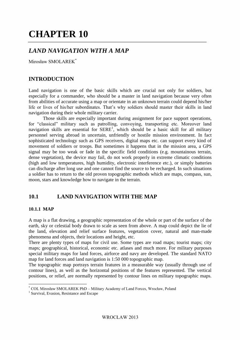
Legend – is located in the lower left margin. Illustrates and identifies some of the symbols on
the map. Every time a map is used, refer to the legend to prevent errors in symbol
identification (figure 2).
Figure 1. Map legend
3
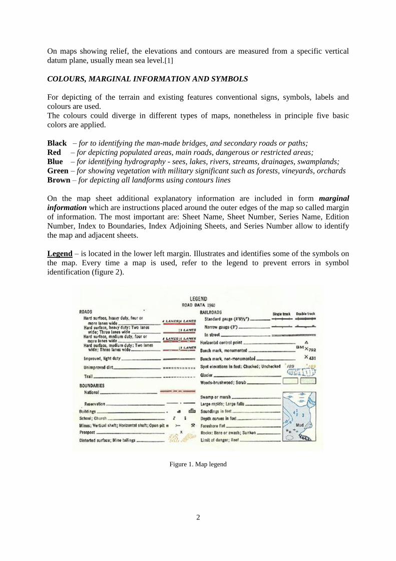
Scale - located at the centre bottom of the margin, below the map face. Usually presented in
two forms: ratio scale as a fraction between the distance on a map and the corresponding
distance on the surface of the earth.
It means that in case of scale 1:50 000 1 cm on the map equals 50 000 cm (500 m) in the
terrain.
Linear scale is a special easy to use "ruler” with which ground distance may be measured
directly without having to convert the ratio scale.
Figure 2. Linear and ratio scales
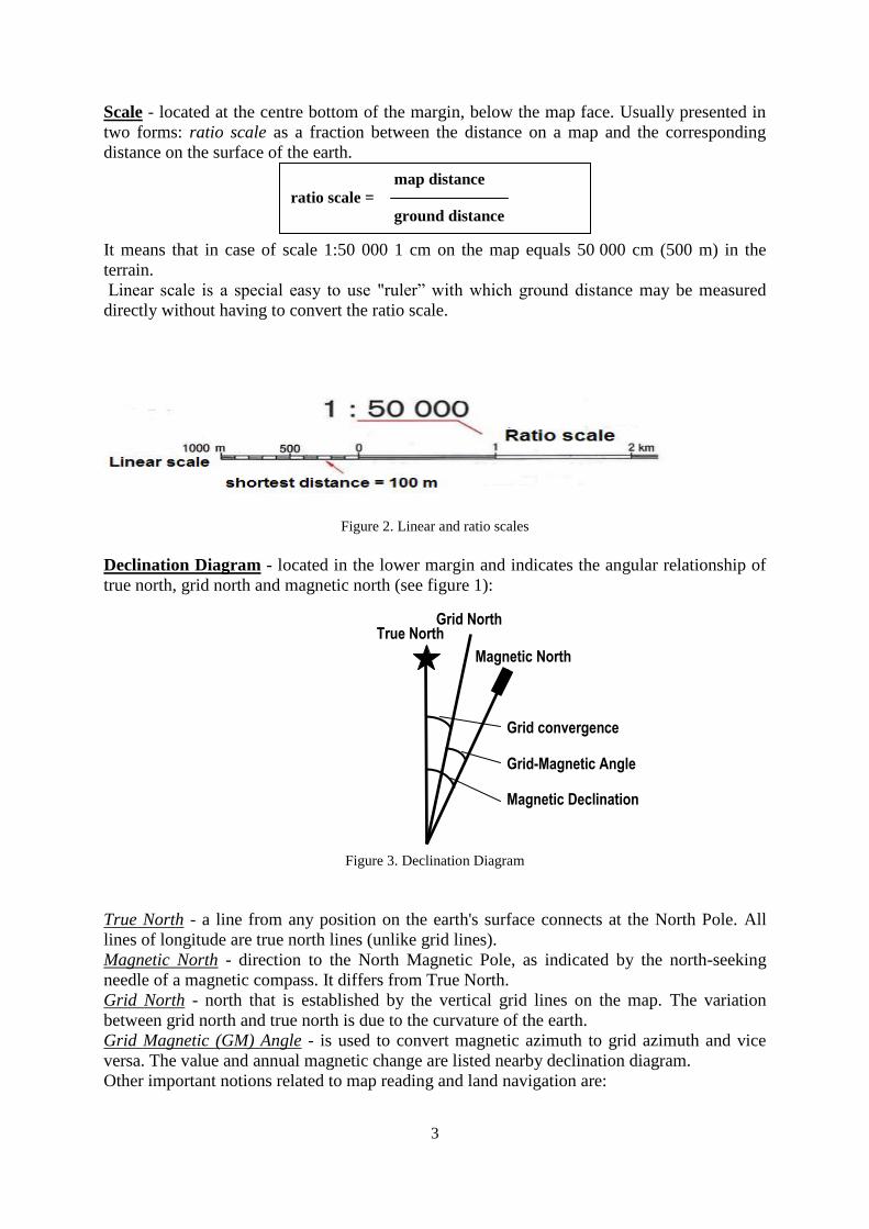
Declination Diagram - located in the lower margin and indicates the angular relationship of
true north, grid north and magnetic north (see figure 1):
Figure 3. Declination Diagram
True North - a line from any position on the earth's surface connects at the North Pole. All
lines of longitude are true north lines (unlike grid lines).
Magnetic North - direction to the North Magnetic Pole, as indicated by the north-seeking
needle of a magnetic compass. It differs from True North.
Grid North - north that is established by the vertical grid lines on the map. The variation
between grid north and true north is due to the curvature of the earth.
Grid Magnetic (GM) Angle - is used to convert magnetic azimuth to grid azimuth and vice
versa. The value and annual magnetic change are listed nearby declination diagram.
Other important notions related to map reading and land navigation are:
map distance
ratio scale =
ground distance
True North Grid North
Magnetic North
Grid convergence
Grid-Magnetic Angle
Magnetic Declination
4
Azimuth (bearing2) – is horizontal direction expressed as the angular distance between the direction of
a fixed point (as the observer's heading) and the direction of the object [4]. The azimuth and the
bearing are measured clockwise and expressed in degrees or mills.
Grid azimuth - determined with a protractor and is measured from grid north.
Magnetic azimuth – obtained from a compass and measured from magnetic north.
Contour Interval - appears in the center lower margin and states the vertical distance
between adjacent contour lines on the map
There are more marginal information on the sheet which allow to better handling of the map.
To use the map in a proper way for locating your standpoint, calculating distances, finding
coordinates unknown locations in terrain or planning march route two other tools are very
useful. They are compass and protractor.
10.1.2 COMPASS
Land navigation requires the use of many tools; the more experienced the navigators, the
more tools they will use. Obvious examples of the simpler tools available are the protractor,
map, compass, and pace count. Less obvious examples, that will take experience to
appreciate, are the terrain, sun, stars, the direction water flows, wildlife, etc. As with any skill,
proficiency in land navigation is based upon a firm knowledge of basic "tools." This portion
of the student hand-out and the corresponding lesson are devoted to two of the most basic
tools: the lensatic compass and your pace count (you have already been exposed to the
protractor and map).
A compass is a navigational instrument that shows directions in a frame of reference that is
stationary relative to the surface of the earth.
Generally there are three types of compasses which use different methods of estimating
magnetic or true north.
Magnetic compass, which is used to determine the direction of magnetic north. The magnetic
compass is made by placing a bit of magnetized iron which is set in a low friction
environment so that it is allowed to move freely. Usually, the north end of the metal very
often phosphorescent piece is marked red so that all directions may be determined. Arrows
are very often phosphorescent for use in the night.
Gyro compass: It is a special type of compass which determines the true north. The tool is
basically a very fast spinning wheel or ball which uses the law of conservation of angular
momentum and the spinning of earth’s axis to point towards the true north. The gyro compass
is commonly used in ships, vehicles for special use where the accurate prediction of true north
is needed.
2 There are some differences between azimuth and bearing. “Azimuth” is the direction given by the compass and
typically in reference to the True North, often expressed in degrees (from 0° to 360
°), always in respect to a
horizontal plane, whereas “bearing” is considerably general because gives an angle of separation between two
points. Expression of bearing can be in reference to either North or South, with the description of the angle going
towards the East or West . Bearing can be expressed in mils or degrees. For example an azimuth of 135° is the
same as the bearing 45°East of South (S 45 E).
5
Astrocompass: depends on the direction of celestial bodies to find true north. The tool is used
where magnetic compass would become erratic and gyro compass stops working (e.g. North
and South poles), but for determining the true north accurate information of time, date,
longitudinal and latitudinal location are needed.
GPS compass: is a relatively new tool which exploits the signal of special satellites systems in
a geo synchronous orbit over the earth to distinguish the exact location and direction. Usually
GPS receivers have a compass function in their menus.
For foot land navigation the most common and cheapest tool is the magnetic compass.
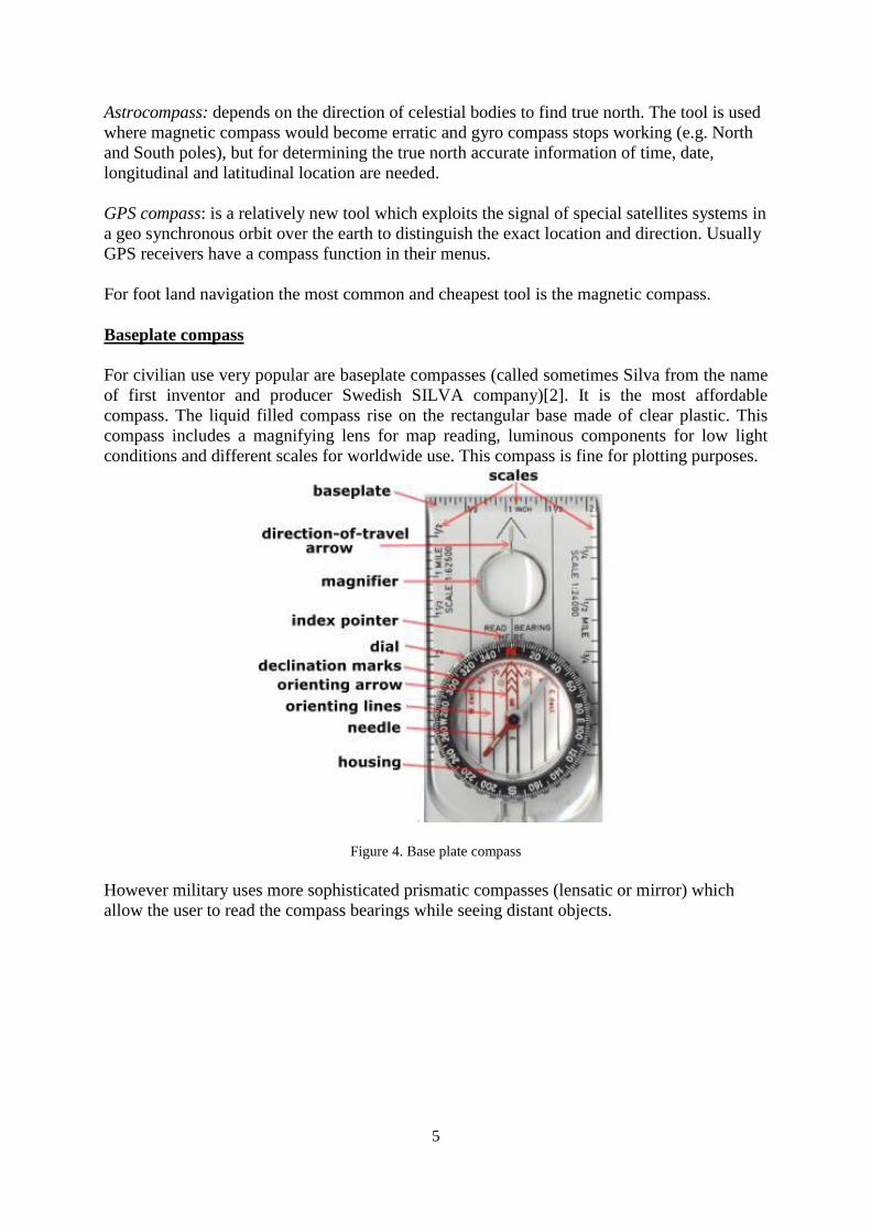
Baseplate compass
For civilian use very popular are baseplate compasses (called sometimes Silva from the name
of first inventor and producer Swedish SILVA company)[2]. It is the most affordable
compass. The liquid filled compass rise on the rectangular base made of clear plastic. This
compass includes a magnifying lens for map reading, luminous components for low light
conditions and different scales for worldwide use. This compass is fine for plotting purposes.
Figure 4. Base plate compass
However military uses more sophisticated prismatic compasses (lensatic or mirror) which
allow the user to read the compass bearings while seeing distant objects.
6
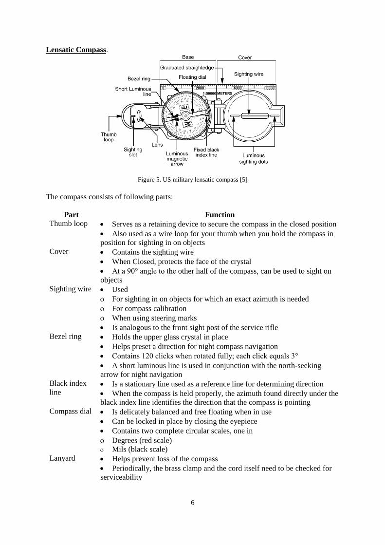
Lensatic Compass.
Figure 5. US military lensatic compass [5]
The compass consists of following parts:
Part Function
Thumb loop Serves as a retaining device to secure the compass in the closed position
Also used as a wire loop for your thumb when you hold the compass in
position for sighting in on objects
Cover Contains the sighting wire
When Closed, protects the face of the crystal
At a 90° angle to the other half of the compass, can be used to sight on
objects
Sighting wire Used
For sighting in on objects for which an exact azimuth is needed
For compass calibration
When using steering marks
Is analogous to the front sight post of the service rifle
Bezel ring Holds the upper glass crystal in place
Helps preset a direction for night compass navigation
Contains 120 clicks when rotated fully; each click equals 3°
A short luminous line is used in conjunction with the north-seeking
arrow for night navigation
Black index
line Is a stationary line used as a reference line for determining direction
When the compass is held properly, the azimuth found directly under the
black index line identifies the direction that the compass is pointing
Compass dial Is delicately balanced and free floating when in use
Can be locked in place by closing the eyepiece
Contains two complete circular scales, one in
Degrees (red scale)
Mils (black scale)
Lanyard Helps prevent loss of the compass
Periodically, the brass clamp and the cord itself need to be checked for
serviceability
7
In order to estimate azimuth with the lensatic compass you have to raise the cover (with the
sighting wire) straight up and raise the sight (lens) to an angle about 45° above the compass
glass.
Next turn the thumb loop all the way down and put your thumb through it. Form a loose fist
under the compass to steady it with your other hand, and raise up to eye level.
Look through the sighting slot, and align the compass by centring the sighting wire in the
sighting slot. After that keeping the compass level and the sights aligned, rotate your entire
body until the sighting wire is aligned on a distant object. Glance down through the lens and
read the magnetic azimuth under the fixed index line on the glass.
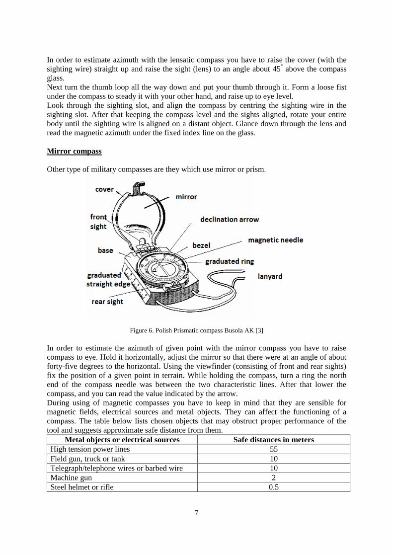
Mirror compass
Other type of military compasses are they which use mirror or prism.
Figure 6. Polish Prismatic compass Busola AK [3]
In order to estimate the azimuth of given point with the mirror compass you have to raise
compass to eye. Hold it horizontally, adjust the mirror so that there were at an angle of about
forty-five degrees to the horizontal. Using the viewfinder (consisting of front and rear sights)
fix the position of a given point in terrain. While holding the compass, turn a ring the north
end of the compass needle was between the two characteristic lines. After that lower the
compass, and you can read the value indicated by the arrow.
During using of magnetic compasses you have to keep in mind that they are sensible for
magnetic fields, electrical sources and metal objects. They can affect the functioning of a
compass. The table below lists chosen objects that may obstruct proper performance of the
tool and suggests approximate safe distance from them.
Metal objects or electrical sources Safe distances in meters
High tension power lines 55
Field gun, truck or tank 10
Telegraph/telephone wires or barbed wire 10
Machine gun 2
Steel helmet or rifle 0.5
8
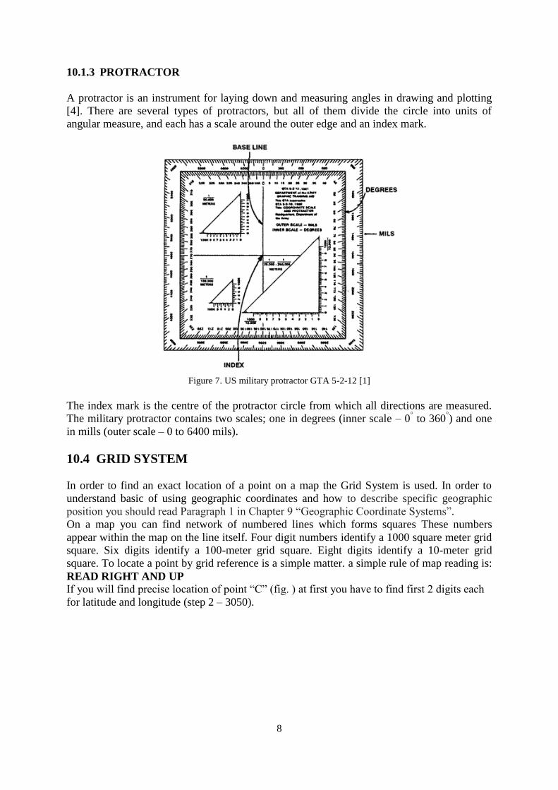
10.1.3 PROTRACTOR
A protractor is an instrument for laying down and measuring angles in drawing and plotting
[4]. There are several types of protractors, but all of them divide the circle into units of
angular measure, and each has a scale around the outer edge and an index mark.
Figure 7. US military protractor GTA 5-2-12 [1]
The index mark is the centre of the protractor circle from which all directions are measured.
The military protractor contains two scales; one in degrees (inner scale – 0° to 360
°) and one
in mills (outer scale – 0 to 6400 mils).
10.4 GRID SYSTEM
In order to find an exact location of a point on a map the Grid System is used. In order to
understand basic of using geographic coordinates and how to describe specific geographic
position you should read Paragraph 1 in Chapter 9 “Geographic Coordinate Systems”.
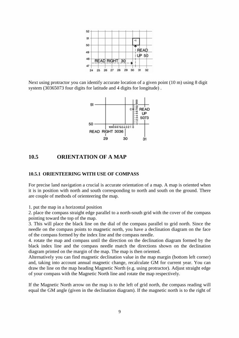
On a map you can find network of numbered lines which forms squares These numbers
appear within the map on the line itself. Four digit numbers identify a 1000 square meter grid
square. Six digits identify a 100-meter grid square. Eight digits identify a 10-meter grid
square. To locate a point by grid reference is a simple matter. a simple rule of map reading is:
READ RIGHT AND UP
If you will find precise location of point “C” (fig. ) at first you have to find first 2 digits each
for latitude and longitude (step 2 – 3050).
9
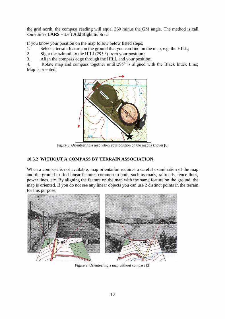
Next using protractor you can identify accurate location of a given point (10 m) using 8 digit
system (30365073 four digits for latitude and 4 digits for longitude) .
10.5 ORIENTATION OF A MAP
10.5.1 ORIENTEERING WITH USE OF COMPASS
For precise land navigation a crucial is accurate orientation of a map. A map is oriented when
it is in position with north and south corresponding to north and south on the ground. There
are couple of methods of orienteering the map.
1. put the map in a horizontal position
2. place the compass straight edge parallel to a north-south grid with the cover of the compass
pointing toward the top of the map.
3. This will place the black line on the dial of the compass parallel to grid north. Since the
needle on the compass points to magnetic north, you have a declination diagram on the face
of the compass formed by the index line and the compass needle.
4. rotate the map and compass until the direction on the declination diagram formed by the
black index line and the compass needle match the directions shown on the declination
diagram printed on the margin of the map. The map is then oriented.
Alternatively you can find magnetic declination value in the map margin (bottom left corner)
and, taking into account annual magnetic change, recalculate GM for current year. You can
draw the line on the map heading Magnetic North (e.g. using protractor). Adjust straight edge
of your compass with the Magnetic North line and rotate the map respectively.
If the Magnetic North arrow on the map is to the left of grid north, the compass reading will
equal the GM angle (given in the declination diagram). If the magnetic north is to the right of
10
the grid north, the compass reading will equal 360 minus the GM angle. The method is call
sometimes LARS = Left Add Right Subtract
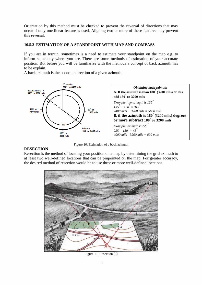
If you know your position on the map follow below listed steps:
1. Select a terrain feature on the ground that you can find on the map, e.g. the HILL;
2. Sight the azimuth to the HILL(295 °) from your position;
3. Align the compass edge through the HILL and your position;
4. Rotate map and compass together until 295° is aligned with the Black Index Line;
Map is oriented.
Figure 8. Orienteering a map when your position on the map is known [6]
10.5.2 WITHOUT A COMPASS BY TERRAIN ASSOCIATION
When a compass is not available, map orientation requires a careful examination of the map
and the ground to find linear features common to both, such as roads, railroads, fence lines,
power lines, etc. By aligning the feature on the map with the same feature on the ground, the
map is oriented. If you do not see any linear objects you can use 2 distinct points in the terrain
for this purpose.
Figure 9. Orienteering a map without compass [3]
Hill
11
Orientation by this method must be checked to prevent the reversal of directions that may
occur if only one linear feature is used. Aligning two or more of these features may prevent
this reversal.
10.5.3 ESTIMATION OF A STANDPOINT WITH MAP AND COMPASS
If you are in terrain, sometimes is a need to estimate your standpoint on the map e.g. to
inform somebody where you are. There are some methods of estimation of your accurate
position. But before you will be familiarize with the methods a concept of back azimuth has
to be explain.
A back azimuth is the opposite direction of a given azimuth.
Figure 10. Estimation of a back azimuth
RESECTION
Resection is the method of locating your position on a map by determining the grid azimuth to
at least two well-defined locations that can be pinpointed on the map. For greater accuracy,
the desired method of resection would be to use three or more well-defined locations.
Figure 11. Resection [3]
Obtaining back azimuth
A. If the azimuth is than 180° (3200 mils) or less
add 180° or 3200 mils
Example: the azimuth is 135°
135° + 180
° = 315
°
2400 mils + 3200 mils = 5600 mils
B. if the azimuth is 180° (3200 mils) degrees
or more subtract 180° or 3200 mils
Example: azimuth is 225°
225° - 180
° = 45
°
4000 mils - 3200 mils = 800 mils

12
In the terrain resection is done in following steps:
1. Orient the map using the compass.
2. Identify two or three known distant locations on the ground and mark them on the
map.
3. Measure the magnetic azimuth to one of the known positions from your location
using a compass.
4. Convert the magnetic azimuth to a grid azimuth.
5. Convert the grid azimuth to a back azimuth. Using a protractor, draw a line for the back
azimuth on the map from the known position back toward your unknown position.
6. Repeat steps 3, 4, and 5 for a second position and a third position, if desired.
7. The intersection of the lines is your location. Determine the grid coordinates to the
desired accuracy.[1]
10.5.4 ESTIMATION OF A STANDPOINT WITHOUT COMPASS Sometimes happens that you have only a map and you do not possess a compass. In
this case you can find nearby a linear object (a road, a river, electric power line etc.) which is
depict on the map. You can orient the map along of the object and next you should find a
distinct point in the terrain presented on the map perpendicular to the linear object. You have
to aim on the object and draw a line. Intersection of the linear object and the perpendicular is
your stand point. For better accuracy you can find other distinguish object and draw the
additional line [fig.12].
Figure 12. Resection without compass
10.5.5 DETERMINING A GRID AND MAGNETIC AZIMUTH USING
A PROTRACTOR
There are two ways you can determine an azimuth. You can use a map to determine a grid
azimuth, or you can use a compass to determine a magnetic azimuth. Furthermore you can
convert a grid azimuth to a magnetic azimuth or a magnetic azimuth to a grid azimuth.
If you plan your route using a map and next you will march using a compass at first you have
to select a start point on the map. Mark it as e.g. point A. Next you should identify an end
13
point on your map (e.g. B). Using the protractor, draw a straight line from point A to B. The
line is your grid azimuth. Place the index of your protractor (in the middle) at the point A and
at the edge of protractor read the value of the grid azimuth ( in degrees or mils). In order to
convert the grid azimuth into the magnetic azimuth you have to find value of GM on the map
margin and recalculate GM for current year. Add or subtract the value respectively and you
will obtain the value of magnetic azimuth which you can use during march with compass.
10.6 LAND NAVIGATION WITH COMPASS [6]
10.6.1 Setting an azimuth
The best method for land navigation is use of a map and a compass. But if you have
only the compass you have to use the azimuth, but you have to be aware about lateral drift
(error). The compass alone, is not enough to eliminate lateral drift . That’s why it is
recommended to use a distant reference landmark. If it is impossible find such kinds of marks
(e.g. because of dense vegetation) you can find intermediate landmarks like big trees, hills etc.
means any landmarks visible when marching. Furthermore in the night you should follow
only the compass. When you follow only compass you have very often to check your
azimuth. It is recommended to prepare your marchroute before with the map in order to
estimate terrain structure, landmarks and azimuths to them. Especially in the night to measure
the covering distance you can count your steps using pace count.
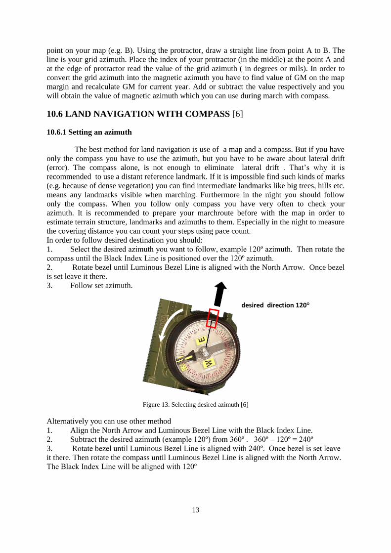
In order to follow desired destination you should:
1. Select the desired azimuth you want to follow, example 120º azimuth. Then rotate the
compass until the Black Index Line is positioned over the 120º azimuth.
2. Rotate bezel until Luminous Bezel Line is aligned with the North Arrow. Once bezel
is set leave it there.
3. Follow set azimuth.
Figure 13. Selecting desired azimuth [6]
Alternatively you can use other method
1. Align the North Arrow and Luminous Bezel Line with the Black Index Line.
2. Subtract the desired azimuth (example 120º) from 360º . 360º – 120º = 240º
3. Rotate bezel until Luminous Bezel Line is aligned with 240º. Once bezel is set leave
it there. Then rotate the compass until Luminous Bezel Line is aligned with the North Arrow.
The Black Index Line will be aligned with 120º
desired direction 120°

14
10.6.2 Bypassing obstacles
Usually there are no straight paths in a terrain, there are plenty irregularities or inaccessible
places (lakes, streams, swamps, dense vegetation etc.), that’s why small detours have been
made in following a general azimuth . The main idea is to be conscious of the detours, keep
them short, and try to zing as often as you sag. If you must make a sizeable detour, you are
better off plotting a new travel bearing.
Bypassing an obstacle which restricts visibility
if you have to bypass a hill or another obstacle for example, which prevent to see opposite site
you should perform following steps:
1. You take a 90º left turn and pace count until you clear the hill.
2. Then turn right 90º and walk till you clear the hill again.
3. Then turn right 90º again and pace count the same amount as the first pace count.
4. At the end of the pace count, turn left 90º and continue on your course bearing.
Figure 14. Bypassing an obstacle which restricts visibility
Bypassing an obstacle which does not restrict visibility
If you during the march will face an obstacle and you can see opposite site (e.g. lakes, ponds,
swamps, fences etc.) you should apply the following method to bypass them:
1. Find on the other side clearly visible intermediate landmark (a tree, big stone etc.)
directly on the same course bearing.
2. Next you walk the obstacle until you get to the landmark
3. continue on your course bearing.
Figure 15. Bypassing an obstacle which does not restrict visibility
REFERENCES [1] FM 3-25.26 Map reading and Land Navigation, Headquarters Department of the Army,
Washington DC, 2001.
[2] Seidman D., Cleveland P., The Essential Wilderness Navigator, Ragged Mountain Press,
Camden 2001.
[3] Tablice poglądowe do nauki topografii wojskowej, Sztab Generalny WP, Warszawa 1998.
[4] Merriam-Webster Collegiate Dictionary, 10th edition, Merriam-Webster, Springfield 1999.
[5] Official U.S. military precision lensatic compass instructional booklet, Cammenga, Michigan
2007.
[6] www.landnavigation.org
HILL
e.g. 90 steps 90 steps
LAKE
LANDMARK
15
CHAPTER 11
BASIC PROCEDURES FOR RADIO COMMUNICATION
Piotr PIETRAKOWSKI*
Rafał PIETRAKOWSKI*
The key to effective employment of joint or combined forces in current and future battle space
is communication. Modern communications capabilities and computers to enable
commanders, planners, and shooters to acquire and share information rapidly. The enhanced
ability to share information improves the ability to find and target the enemy quickly and
precisely. Generally are three primary means of communication available to the infantry
platoon are radio, wire, and messenger.
Usually, the platoon uses one or all of these during an operation. Additionally, the platoon
leader plans an alternate means of communication in case the primary means fails. Radio is
the least secure means of communication. Radio is susceptible to interception and jamming.
Proper radio procedures must be used to reduce the enemy's opportunity to hamper radio
communications. Radio procedures change frequencies and call signs unit SOI (Signal
Operating Instructions). Use established formats to expedite transmissions such as SALUTE.
Messenger is the most secure means of communications. Messengers should vary their routes
and schedules. Platoon leaders weigh the risk associated with using messengers. Although
secure, messengers are the slowest form of communication.
Objective of this paper is to present the basic procedures for radio which are used by soldiers
involved in multinational combined operation.
On the beginning radio operator should preparing the radio set for operation which are
presented below:
Make sure that there is the power source, it is sufficient and ensure correct connection
to the radio set;
Check the antenna and all cable assemblies ensuring tight and correct connection to
the set;
Connect the audio accessories and check proper operation of function switches;
Check the frequency setting on your radio and check the squelch.
Working on the radio operator has to follow the rules transmitting which contained in general
instructions, like:
Decide what you are going to say and make sure it will be clear and brief;
Before sending a long message, write down the entire message to be clear and brief;
Make sure no-one else transmits on the net when you start transmitting;
Remember that you are using relays, therefore press button and wait 2 seconds before
you start to speak;
Maintain a natural rhythm to your speech and speak slowly;
Avoid excessive calling and unofficial transmissions;
* Capt. Piotr PIETRAKOWSKI, PhD – Military Academy of Land Forces, Wrocław, Poland
* 2 LT Rafał PIETRAKOWSKI, MA – 21 Mountain Brigade, Poland
16
Use standard pronunciation. Emphasize vowels sufficiently. Avoid extremes to pitch,
speak in a moderately strong voice, do not shout;
Keep a distance of about 5 cm between the microphone and your mouth. Shield your
microphone from background noises;
If a peek sound appears when key is pressed, turn down the volume on the radios
speaker;
The normal language is English on Multinational radio nets. On lower level nets,
national languages may be used, unless attached units are from another nation;
REMEMBER: You are talking, who is listening?
Current military operation has multinational structure and for better understanding when radio
operators are communicating over the radio he use the phonetic alphabet which is shown in
Table 1. Table 1. Phonetic alphabet [1]
To distinguish numerals from words similarly pronounced, the proword “FIGURES” may be
used preceding such numbers.
Ø – ZERO
1 – WUN
2 – TOO
3 – TREE
4 – FO-WER
5 – FI-YIV
17
6 – SIX
7 – SEVEN
8 – ATE
9 – NINER
Numerals in combinations
12 WUN TOO
44 FO-WER FO-WER
9Ø NINER ZERO
136 WUN TREE SIX
1478 WUN FO-WER SEVEN ATE
19 A WUN NINER ALPHA
5ØØ FI-YIV HUNDRED
7ØØØ SEVEN TH.SAND
16ØØØ WUN SIX TH.SAND
On the table 2 are presented outlines proper procedure words (often called prowords) that
should be used during radio transmissions and their meanings. Prowords are words or phrases
limited to radio telephone procedures used to facilitate communication by conveying
information in a condensed form.
PROWORD MEANING
ACKNOWLEDGE ! Confirm that you have received my message and will comply. (WILCO)
AFFIRMATIVE
NEGATIVE
Yes/Correct
No/Incorrect
ALL AFTER
ALL BEFORE
Everything that you (I) transmitted
after … (Keyword)
Everything that you (I) transmitted
before … (Keyword)
CORRECT
(THAT IS
CORRECT)
What you have transmitted is correct, you are correct.
CORRECTION
-An error has been made in this transmission. It will continue with the last word
(group) correctly transmitted.
-An error has been made in this transmission. The correct version is …
-That which follows is a correct version in answer to your request for verification.
WRONG Your last transmission was incorrect.
The correct version is …
DISREGARD THIS
TRANSMISSION –
OUT
This transmission is an error. Disregard it. (This proword shall not be used to cancel
any message that has been already completely transmitted and for which receipt or
acknowledgement has been received).
DO NOT ANSWER –
OUT
Station(s) called are not to answer this call, acknowledge this message or otherwise to
transmit in connection with this transmission.
DO NOT ANSWER -
OUT
Station(s) called are not to answer this call, acknowledge this message or otherwise to
transmit in connection with this transmission.
SILENCE –
SILENCE –
SILENCE !
Cease all transmissions on this net immediately. Will be maintained until lifted.
SILENCE LIFTED Silence is lifted. The net is free for traffic.
END OF MESSAGE
– OVER (OUT)
This concludes the message just transmitted (and the message instructions pertaining
to a formal message)
END OF TEXT The textual part of a formal massage ends. Stand by for the message instructions
immediately following.
18
FETCH …! I wish to speak on the radio to that person (appointment title).
…SPEAKING Requested person is now using the radio by himself.
FIGURES Numerals or numbers will follow. (This proword is not used with the callsigns, time
definitions, grid references, bearings, distances, etc. especially in fixed-form reports)
FROM
TO
THIS IS
The originator of this form message is indicated by the address designation
immediately following.
The addresses whose designation will immediately follow are to take action on this
formal massage.
This transmission is from the station whose designation immediately follows.
MESSAGE I have an informal message for you.
MESSAGE
FOLLOWS A formal message which requires recording is about to follow.
OVER This is the end of my turn of transmitting. A response is expected. Go ahead transmit.
OUT This is the end of my transmission to you. No answer or acknowledgement is
expected.
OUT TO YOU Do not answer. I have nothing more for you. I shall now call some other station on the
net
READ BACK! Repeat the entire following transmission back to me exactly as received.
I READ BACK The following is my reply to your request to read back
SAY AGAIN Repeat all your transmission.
I SAY AGAIN The following is my reply to your request to read back
SEND ! Go ahead with your transmission.
SEND YOUR
MESSAGE ! Go ahead, transmit: I ready do copy.
… SPEAK SLOWER Reduce the speed of your transmission. (Normally used in connection with request for
repetition)
I SPELL I shell spell the next word, group or equivalent phonetically. (Not used when
transmitting codes groups only)
RELAY TO … Transmit the following message to all addresses or to the address designation
immediately following
RELAY
THROUGH…
Send this message by way of
callsign …
THROUGH ME I am in contact with the station you are calling
MESSAGE PASSED
TO … Your message has been passed to …
ROGER I have received your last transmission satisfactorily.
ROGER SO FAR? Have you received this part of my message satisfactorily?
WILCO I have received your message, under-stand it, and will comply. (To be used only by the
addressee). ROGER and WILCO are never used together.
UNKNOWN
STATION
The identity of the station calling or with whom I am attempting to establish
communication is unknown.
VERIFY
Verify entire message (or portion indicated) with the originator and send correct
version. To be used only at discretion of or by the addressee to which the questioned
message was directed.
I VERIFY That which follows has been verified at your request and is repeated. To be used only
as a reply to VERIFY.
WAIT (WAIT-
WAIT) I must pause for a few seconds.
WAIT OUT I must pause longer than some seconds, and will call you again when ready.
WORD AFTER… The word of the massage to which I have reference is that which follows …
WORD BEFORE… The word of the massage to which I have reference is that which precedes …
WORDS TWICE Communication is difficult. Transmit each phrases (group) twice. This proword can be
used as an order, request or as information.
Table 2. Prowords listed alphabetically [1]

19
A preliminary call will be transmitted when the sending station wishes to know if the
receiving station is ready to receive a message. When communications reception is good and
contact has been continuous, a preliminary call is optional. The following is an example of
a preliminary call— Example of conversation:
The proword THIS IS or FROM is used to indicate the calling station. ALFA THIS IS CHARLIE, MESSAGE, OVER
THIS IS ALFA, SEND, OVER
THIS IS CHARLIE, WATCH FOR FALLEN ROCKS ON ROAD BIRKET, I SPELL: BRAVO
INDIA ROMEO KILO ECHO TANGO – BIRKET, OVER
THIS IS ALFA, WILCO, OVER
To minimize transmission time, use radio checks sparingly or by unit SOP. The following is
an example of a radio check:
The following phrases are for use when initiated and answering queries concerning signal
strength and readability.
RADIO CHECK What is my signal strength and readability,
how do you read me?
YOU ARE Your signal strength and readability is as follows… (I READ YOU)
Reports of signal strength:
LOUD - Your signal is strong.
GOOD - Your signal is good.
WEAK - I can hear you only with difficulty.
VERY WEAK - I can hear you only with great difficulty.
FADING - Your signal is variable, so continuously receiving is difficult.
Reports of readability:
CLEAR -I read you very good.
READABLE -I read you good.
UNREADABLE -You are unreadable.
DISTORTED -You are distorted.
WITH INTERFERENCE- I have problems reading you because of interference.
INTERMITTENT -I receive you periodically.
Example:
52 THIS IS 11 – RADIOCHECK – OVER
THIS IS 52 – YOU ARE LOUD AND CLEAR – OVER
THIS IS 11 – YOU ARE GOOD AND CLEAR – OUT
Sample Messages:
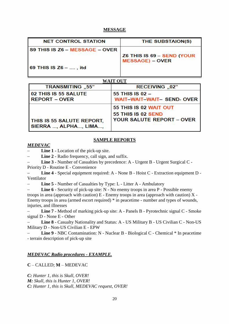
20
MESSAGE
WAIT OUT
SAMPLE REPORTS
MEDEVAC
Line 1 - Location of the pick-up site.
Line 2 - Radio frequency, call sign, and suffix.
Line 3 - Number of Casualties by precedence: A - Urgent B - Urgent Surgical C -
Priority D - Routine E - Convenience
Line 4 - Special equipment required: A - None B - Hoist C - Extraction equipment D -
Ventilator
Line 5 - Number of Casualties by Type: L - Litter A - Ambulatory
Line 6 - Security of pick-up site: N - No enemy troops in area P - Possible enemy
troops in area (approach with caution) E - Enemy troops in area (approach with caution) X -
Enemy troops in area (armed escort required) * in peacetime - number and types of wounds,
injuries, and illnesses
Line 7 - Method of marking pick-up site: A - Panels B - Pyrotechnic signal C - Smoke
signal D - None E - Other
Line 8 - Casualty Nationality and Status: A - US Military B - US Civilian C - Non-US
Military D - Non-US Civilian E - EPW
Line 9 - NBC Contamination: N - Nuclear B - Biological C - Chemical * In peacetime
- terrain description of pick-up site
MEDEVAC Radio procedures - EXAMPLE.
C – CALLED; M – MEDEVAC
C: Hunter 1, this is Skull, OVER!
M: Skull, this is Hunter 1, OVER!
C: Hunter 1, this is Skull, MEDEVAC request, OVER!
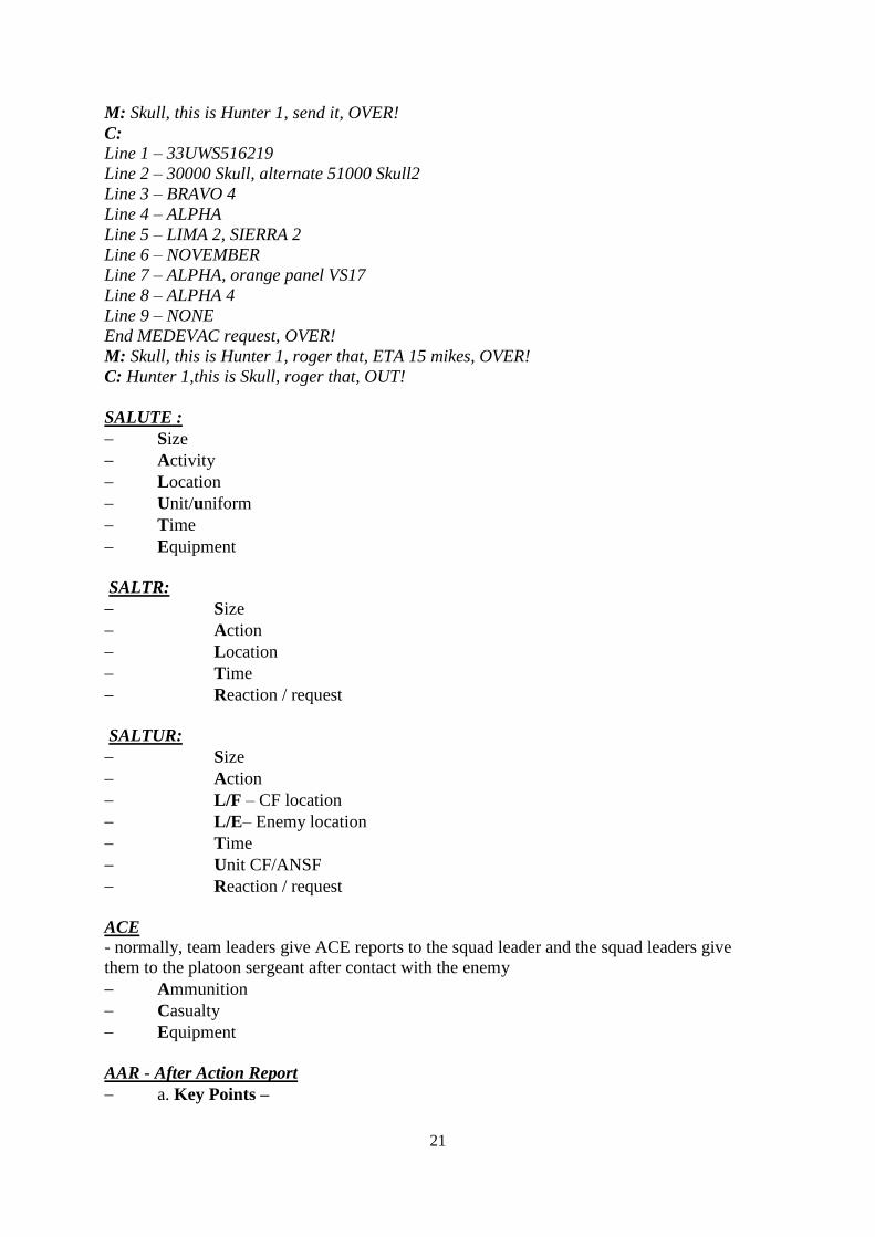
21
M: Skull, this is Hunter 1, send it, OVER!
C:
Line 1 – 33UWS516219
Line 2 – 30000 Skull, alternate 51000 Skull2
Line 3 – BRAVO 4
Line 4 – ALPHA
Line 5 – LIMA 2, SIERRA 2
Line 6 – NOVEMBER
Line 7 – ALPHA, orange panel VS17
Line 8 – ALPHA 4
Line 9 – NONE
End MEDEVAC request, OVER!
M: Skull, this is Hunter 1, roger that, ETA 15 mikes, OVER!
C: Hunter 1,this is Skull, roger that, OUT!
SALUTE :
Size
Activity
Location
Unit/uniform
Time
Equipment
SALTR:
Size
Action
Location
Time
Reaction / request
SALTUR:
Size
Action
L/F – CF location
L/E– Enemy location
Time
Unit CF/ANSF
Reaction / request
ACE
- normally, team leaders give ACE reports to the squad leader and the squad leaders give
them to the platoon sergeant after contact with the enemy
Ammunition
Casualty
Equipment
AAR - After Action Report
a. Key Points –

22
(1) Are conducted during or immediately after each event.
(2) Focus on intended training objectives.
(3) Focus on soldier, leader, and unit performance.
(4) Involve all participants in the discussion.
(5) Use open-ended questions.
(6) Are related to specific standards.
(7) Determine strengths and weaknesses.
(8) Link performance to subsequent training.
b.Format
(1) Introduction and rules.
(2) Review of training objectives.
(3) Commander's mission and intent (what was supposed to happen).
(4) Opposing force (OPFOR) commander's mission and intent (when appropriate).
(5) Relevant doctrine and tactics, techniques, and procedures (TTPs).
(6) Summary of recent events (what happened).
(7) Discussion of key issues (why it happened and how to improve).
(8) Discussion of optional issues.
(9) Discussion of force protection issues (discussed throughout).
(10) Closing comments (summary). [1]
QRF / CAS Request FORM
1. LOCATION OF INCIDENT (Grid + name closest city, road and direction).
2. REINFORCEMENT REQUEST (Info about needs).
3. CALL SIGN (at hot spot).
4. TARGET DESCRIPTION (be brief but accurate)
Description: what the target is
Composition: number of elements
Activity: what the elements are doing
5. TARGET LOCATION
(Describe where a target is in relation to convoy or unit under fire using
geographic directions as reference).
6. TYPE OF TARGET MARKING (pyrotechnic signal – colour, tracers etc.).
7. IDENTIFICATION OF FRIENDLY FORCES
Size: (aprox. number of elements)
Marking of friendly forces: (smoke signal – colour, panel etc.).
8. REMARKS AND BRIEF DESCRIPTION OF THE SITUATION
(as appropriate).
QRF/CAS radio procedures – EXAMPLE.
QRF request form (8-line) passed to TOC on emergency net.
Helicopters en route: „FALCON, FALCON this is CHARLIE, over.”
„CHARLIE, this is FALCON, in 5 minutes on-scene, over” „roger”
„, FALCON”
My position, (marker);
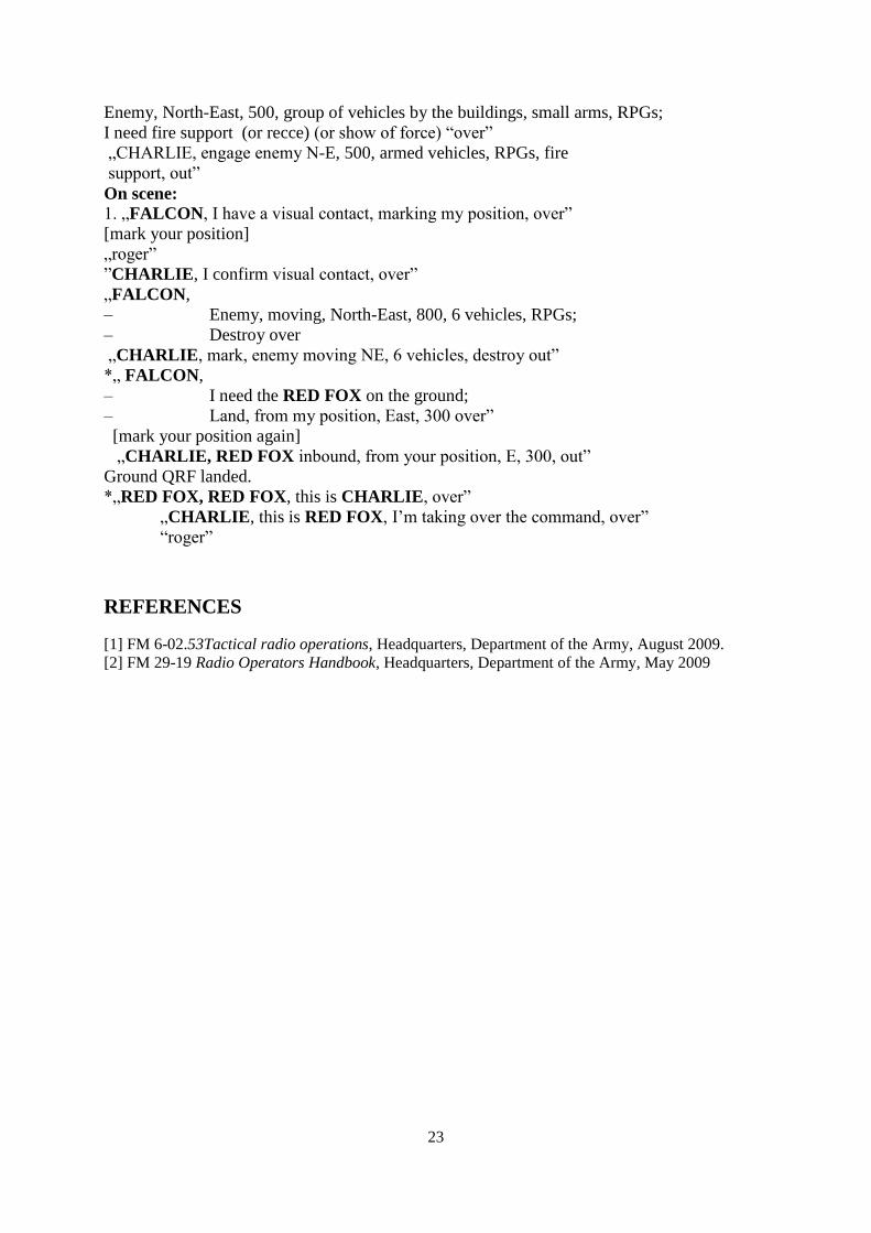
23
Enemy, North-East, 500, group of vehicles by the buildings, small arms, RPGs;
I need fire support (or recce) (or show of force) “over”
„CHARLIE, engage enemy N-E, 500, armed vehicles, RPGs, fire
support, out”
On scene: 1. „FALCON, I have a visual contact, marking my position, over”
[mark your position]
„roger”
”CHARLIE, I confirm visual contact, over”
„FALCON,
– Enemy, moving, North-East, 800, 6 vehicles, RPGs;
– Destroy over
„CHARLIE, mark, enemy moving NE, 6 vehicles, destroy out”
*„ FALCON,
– I need the RED FOX on the ground;
– Land, from my position, East, 300 over”
[mark your position again]
„CHARLIE, RED FOX inbound, from your position, E, 300, out”
Ground QRF landed.
*„RED FOX, RED FOX, this is CHARLIE, over”
„CHARLIE, this is RED FOX, I’m taking over the command, over”
“roger”
REFERENCES
[1] FM 6-02.53Tactical radio operations, Headquarters, Department of the Army, August 2009.
[2] FM 29-19 Radio Operators Handbook, Headquarters, Department of the Army, May 2009

24
25
CHAPTER 12
LIGHT MOTORIZED COMPANY IN PATROLLING – TACTICAL
ENGAGEMENT EXERCISE
Jaroslav KOZŮBEK *
12.1 INTRODUCTORY INFORMATION ABOUT EXERCISE
Tactical engagement exercise (TESEX) is focused onto train trainees in skills of conducting
operation within the scope of NATO Peace Support Operation (PSO). The exercise is located
in fictitious country Islamic republic of Takinistan where the operational environment is
similar as in the Afghanistan in post-war period (stabilization).
In Takinistan are deployed International Security Assistance Forces (ISAF) conducting
NATO-led security mission. The part of ISAF is international Task Force LION (TF LION)
which is deployed in KHANAR province. TF LION consists of four maneuver components:
two light motorized companies – Alpha Company (A-COY) and Bravo Company (B-COY),
one recce company – Charlie Company (C-COY) and one rifle company – Delta Company
(D-COY). TF LION is reinforced by one artillery battery, one wing of attack helicopters, one
wing of transport helicopters and one wing of medical helicopters.
The trainees are part of A-COY which is deployed in forward operation base (FOB)
WARHAUS.
12.1.1 The essential facts about exercise:
Theme: Light Mechanized Company in Patrolling
Goals: To train trainees in preparation and conducting the presence patrol.
Training Tasks:
1. Mission Planning and Order Issue
2. Formation of Column
3. Movement to Assigned Area
4. Observation and Area Control
Time: 300 minutes
Training Method: Tactical Engagement Exercise
Training Tool: tactical virtual simulator VBS2VTK
12.1.2 Operation Task
TF LION mission is to carry out military operations in KHANAR province of Islamic
Republic of Takinistan in order to strengthen influence of the official provincial government
authorities, keep and enlarge safe environment and create conditions for continuing
infrastructure reconstruction and development.
* LTC Eng. Jaroslav KOZŮBEK, PhD - University of Defense, Brno, Czech Republic
26
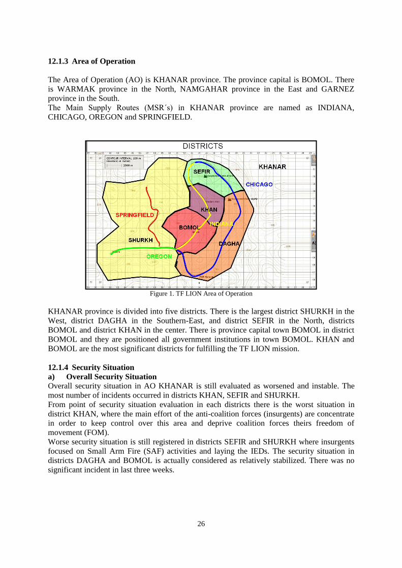
12.1.3 Area of Operation
The Area of Operation (AO) is KHANAR province. The province capital is BOMOL. There
is WARMAK province in the North, NAMGAHAR province in the East and GARNEZ
province in the South.
The Main Supply Routes (MSR´s) in KHANAR province are named as INDIANA,
CHICAGO, OREGON and SPRINGFIELD.
Figure 1. TF LION Area of Operation
KHANAR province is divided into five districts. There is the largest district SHURKH in the
West, district DAGHA in the Southern-East, and district SEFIR in the North, districts
BOMOL and district KHAN in the center. There is province capital town BOMOL in district
BOMOL and they are positioned all government institutions in town BOMOL. KHAN and
BOMOL are the most significant districts for fulfilling the TF LION mission.
12.1.4 Security Situation
a) Overall Security Situation
Overall security situation in AO KHANAR is still evaluated as worsened and instable. The
most number of incidents occurred in districts KHAN, SEFIR and SHURKH.
From point of security situation evaluation in each districts there is the worst situation in
district KHAN, where the main effort of the anti-coalition forces (insurgents) are concentrate
in order to keep control over this area and deprive coalition forces theirs freedom of
movement (FOM).
Worse security situation is still registered in districts SEFIR and SHURKH where insurgents
focused on Small Arm Fire (SAF) activities and laying the IEDs. The security situation in
districts DAGHA and BOMOL is actually considered as relatively stabilized. There was no
significant incident in last three weeks.
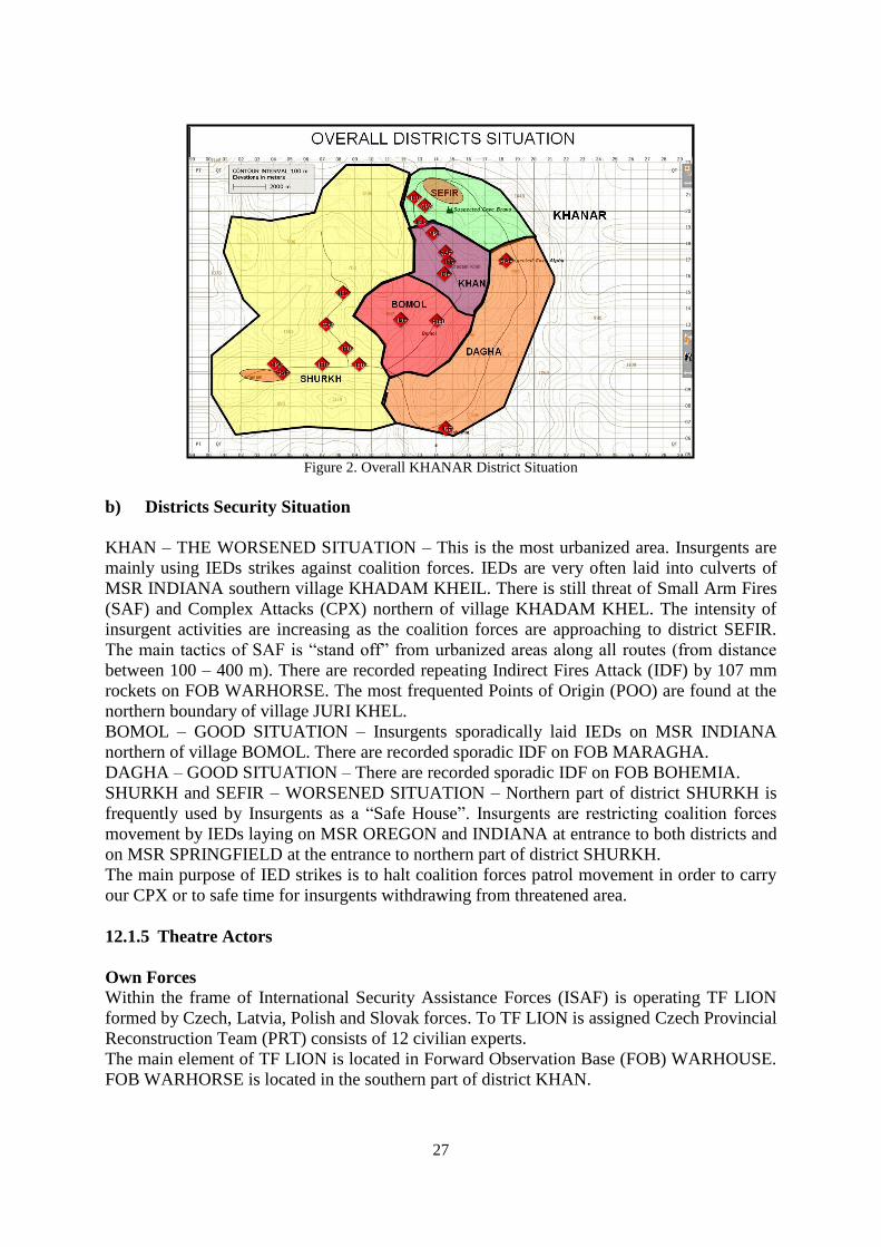
27
Figure 2. Overall KHANAR District Situation
b) Districts Security Situation
KHAN – THE WORSENED SITUATION – This is the most urbanized area. Insurgents are
mainly using IEDs strikes against coalition forces. IEDs are very often laid into culverts of
MSR INDIANA southern village KHADAM KHEIL. There is still threat of Small Arm Fires
(SAF) and Complex Attacks (CPX) northern of village KHADAM KHEL. The intensity of
insurgent activities are increasing as the coalition forces are approaching to district SEFIR.
The main tactics of SAF is “stand off” from urbanized areas along all routes (from distance
between 100 – 400 m). There are recorded repeating Indirect Fires Attack (IDF) by 107 mm
rockets on FOB WARHORSE. The most frequented Points of Origin (POO) are found at the
northern boundary of village JURI KHEL.
BOMOL – GOOD SITUATION – Insurgents sporadically laid IEDs on MSR INDIANA
northern of village BOMOL. There are recorded sporadic IDF on FOB MARAGHA.
DAGHA – GOOD SITUATION – There are recorded sporadic IDF on FOB BOHEMIA.
SHURKH and SEFIR – WORSENED SITUATION – Northern part of district SHURKH is
frequently used by Insurgents as a “Safe House”. Insurgents are restricting coalition forces
movement by IEDs laying on MSR OREGON and INDIANA at entrance to both districts and
on MSR SPRINGFIELD at the entrance to northern part of district SHURKH.
The main purpose of IED strikes is to halt coalition forces patrol movement in order to carry
our CPX or to safe time for insurgents withdrawing from threatened area.
12.1.5 Theatre Actors
Own Forces
Within the frame of International Security Assistance Forces (ISAF) is operating TF LION
formed by Czech, Latvia, Polish and Slovak forces. To TF LION is assigned Czech Provincial
Reconstruction Team (PRT) consists of 12 civilian experts.
The main element of TF LION is located in Forward Observation Base (FOB) WARHOUSE.
FOB WARHORSE is located in the southern part of district KHAN.
28
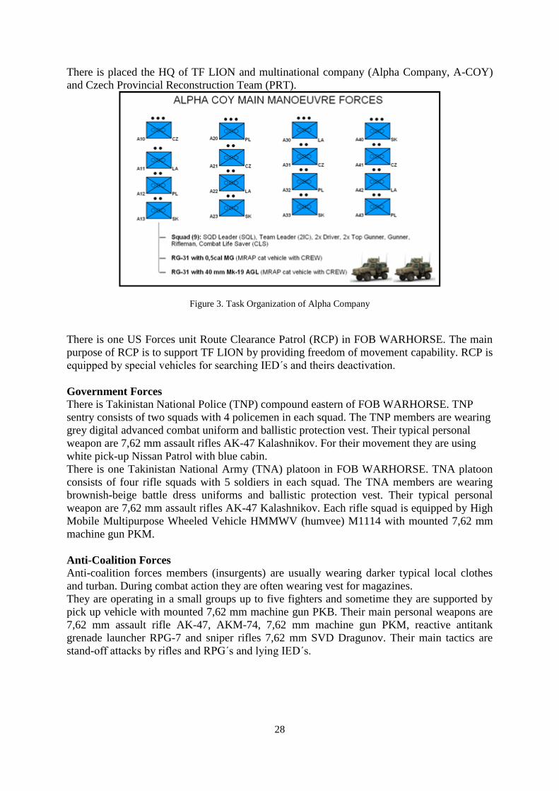
There is placed the HQ of TF LION and multinational company (Alpha Company, A-COY)
and Czech Provincial Reconstruction Team (PRT).
Figure 3. Task Organization of Alpha Company
There is one US Forces unit Route Clearance Patrol (RCP) in FOB WARHORSE. The main
purpose of RCP is to support TF LION by providing freedom of movement capability. RCP is
equipped by special vehicles for searching IED´s and theirs deactivation.
Government Forces
There is Takinistan National Police (TNP) compound eastern of FOB WARHORSE. TNP
sentry consists of two squads with 4 policemen in each squad. The TNP members are wearing
grey digital advanced combat uniform and ballistic protection vest. Their typical personal
weapon are 7,62 mm assault rifles AK-47 Kalashnikov. For their movement they are using
white pick-up Nissan Patrol with blue cabin.
There is one Takinistan National Army (TNA) platoon in FOB WARHORSE. TNA platoon
consists of four rifle squads with 5 soldiers in each squad. The TNA members are wearing
brownish-beige battle dress uniforms and ballistic protection vest. Their typical personal
weapon are 7,62 mm assault rifles AK-47 Kalashnikov. Each rifle squad is equipped by High
Mobile Multipurpose Wheeled Vehicle HMMWV (humvee) M1114 with mounted 7,62 mm
machine gun PKM.
Anti-Coalition Forces
Anti-coalition forces members (insurgents) are usually wearing darker typical local clothes
and turban. During combat action they are often wearing vest for magazines.
They are operating in a small groups up to five fighters and sometime they are supported by
pick up vehicle with mounted 7,62 mm machine gun PKB. Their main personal weapons are
7,62 mm assault rifle AK-47, AKM-74, 7,62 mm machine gun PKM, reactive antitank
grenade launcher RPG-7 and sniper rifles 7,62 mm SVD Dragunov. Their main tactics are
stand-off attacks by rifles and RPG´s and lying IED´s.

29
12.2 PATROL COMMANDER GUIDELINE FOR PATROLLING
This is example for fulfilling operation tasks within NATO Peace Support Operations or
multinational operations conducted in post-war period. The units are deployed in (forward)
operation bases and their main goal is to stabilize the situation in security and socially
disorganized area.
12.2.1 Preparation for Mission
After receiving the order the commander (platoon leader) begins his decision-making process
(Troop Leading Procedure, TLP). If there is enough time the preparation period takes about
4 days.
Under favorable circumstances (known area of mission, simple task, already experienced
unit), but also in the case of lack of time (extra assigned task due to situation change in the
area of operation) it is possible to reduce the preparation phase only to several hours.
4 days before
Commander receives his mission statement by Operational Order (OPORD) or Fragmentary
Order (FRAGO).
After order receiving the commander carry out following activities:
- to check up if the similar mission (for example patrol to escort VIP´s) was performed
into the same area of operation,
- to seek out appropriate documents from previous similar mission (OPORD, Debriefing
etc.),
- to gain desirable information from commander who carried out previous mission
(patrol),
- to request for additional information from Intel Cell (S-2):
o about incidents in area of operation (mission),
o about another access paths (contingency movement roads),
o aerial photographs from UAV,
o terrain profile,
o special geographical maps, etc.
- to specify unit task organizational structure – task organization (TASKORG),
- to clarify time allocation for patrol preparation and fulfillment (time calculation),
- to identify implied tasks for unit preparation and mission fulfillment and to assign
them to subordinate squad leaders.
3 days before
Commander:
- to work on OPORD,
- to control and help subordinates with implied tasks fulfillment,
- to control preparation activities of subordinates and assigned persons (specialist,
VIP´s, etc.)
2 days before
Commander:
- to control and help subordinates with implied tasks fulfillment,
30
- to control preparation activities of subordinates and assigned persons (specialist,
VIP´s, etc.),
- to complete and issue his OPORD (FRAGO).
1 day before
The day before the mission (patrolling) is dedicated for preparation of the vehicles, special
devices (jammers, radios, GPS, battle management systems, etc.) and for practical training on
squad and platoon level. Preparation is related to the tactical activities which are recognized in
commanders OPORD. For example 1st squad, which will be at the front during movement, is
training searching procedures of dangerous places and procedures connected to IED finding,
2nd
squad, which will be in the middle during movement, is training force protection of
escorted persons (very important persons, VIP´s) and reaction to contact, and 3rd
squad, which
is at the end during movement, is training escalation of force (EOF) techniques. The incidents
as the injury of own personal, vehicle damage, small arm fire, RPG strike etc. are trained by
each squad.
After the basic squad training the commander organize cooperative within the scope of whole.
This training is focused on most likely expected activities (incidents) as the short halt / long
halt (drill 5 to 25), all around defense, counter IED measures (5C methodology: Confirm,
Clear, Cordon, Control, Check), maneuver with fire and movement to destroy the enemy,
etc., again progressively with more difficult and complex circumstances (loss of radio
connection, vehicle destroying, mass casualty, etc.)
12.1.2 Mission Fulfillment
T-1h
Drivers:
- to prepare vehicles for movement, to control vehicles technical state, to warm up
engine,
Patrol members:
- to check up personal weapons, ammunition and equipment,
T-45min
Drivers:
- switching on of jammers and transmitters and set them into „stand by“ mode,
Top Gunners (gunners of vehicle mounted weapons):
- technical state of mounted weapons and turret control,
Medics (Combat Life Savers, CLS´s):
- to control carried medical supplies,
- to load medical material into vehicles.
Squad (vehicle) leaders:
- to control switching on and tuning of transmitters,
- to control vehicles readiness
Deputy commander:
- to order patrol vehicles into column according to TASKORG.
Commander:
- to take part in brief update of situation in operation (mission) area (Intel Update).
T-30min
Drivers:
- to check vehicle intercom and radio connection between vehicles,
Squad (vehicles) leaders:
31
- to check radio connection from theirs personal radio stations.
Patrol commander:
- to check radio connection of all communication means with Tactical Operation Centre
(TOC).
T-20min
All:
- to take position in theirs squad formations (vehicles crews).
Squad (vehicle) leaders:
- to control number of members,
- to control obligatory material of each squad member (pre-check inspection),
- to report results of control to patrol commander.
Patrol commander:
- to carry out control of subordinates according to TASKORG,
- to announce place, where the envelope with SPINS (personal recovery codes) will be
deposed,
- to familiarize all patrol members with outcomes of Intel Update.
T-10min
All:
- to board into the assigned vehicles,
Squad (vehicle) leaders:
- to control fastening of all crew members and fitting their weapons into lockers,
- to report readiness for mission.
Commander:
- to report readiness for mission to TOC,
- to wait for permission to begin fulfillment of the mission (could be from higher
commander, or commissioned person).
Time T
Squad (vehicle) leaders:
- to move to the place for weapon charging,
- to organize charging of all squad weapons,
- to control weapon charging,
- to switch jammers from stand-by to full operational state,
- to report fully readiness to patrol commander.
Patrol commander:
- to report leaving of the base to TOC.
12.1.3 Leading the Mission
During the leading of mission the commander must concentrate to the command and control
activities of his unit. Communication with TOC is during movement assured by his driver and
during dismounting by designated person.
To provide actual situational awareness to the higher commander the commander reports to
TOC:
- leaving and returning to the base,
- going through the each checkpoint,
- arrival to location of fulfilling the assigned and implied tasks (for example it could be
project sites, sites of negotiation with local shura representatives, vehicle check points,
blocking (cordon) positions, etc.),
32
- situation report in the case when last report was sent 60 minutes ago (according to
higher commander order, it can be shortened to 30 minutes or prolonged to 120 minutes),
- occurrence of event, which limits further fulfilling of the task (vehicle breakdown,
traffic accidents between civilian vehicles, sudden worsening of weather conditions, strongly
negative reaction of local population to patrol presence, etc.),
- occurrence of the incident (own transport accident, patrol member injury, usage of
own weapons for EOF realization, IED finding or IED strike, UXO finding, small arms fire
on vehicle (unit), RPG attack, population demonstration (riots) etc.),
- observing of atypical (suspicious) activities (roadblock on the road, ...) artificial
shapes (stone piles of different colors or without color, continuous lines of stones) on the road
and its vicinity, significant objects hanging close to the road (clothes parts, tape-recorder
tapes, etc.)
For assuring of unit situational awareness each squad (vehicle) leader report to commander:
- occurrence of event, which limits further fulfilling of the task (vehicle breakdown,
traffic accidents between civilian vehicles, sudden worsening of weather conditions, strongly
negative reaction of local population to patrol presence, etc.),
- occurrence of the incident (own transport accident, patrol member injury, usage of
own weapons for EOF realization, IED finding or IED strike, UXO finding, small arms fire
on vehicle (unit), RPG attack, population demonstration (riots) etc.),
- observing of atypical (suspicious) activities (roadblock on the road, ...) artificial
shapes (stone piles of different colors or without color, continuous lines of stones) on the road
and its vicinity, significant objects hanging close to the road (clothes parts, tape-recorder
tapes, etc.)
- presence of the Allied forces in area of mission,
- occupying and leaving of the assigned position.
Leaders from the first and the last vehicles also report:
- go through checkpoints,
- entry into designated dangerous area (first vehicle) and leaving designated dangerous
area (last vehicle),
- breaking into movement formation by other vehicles,
- significant changes of direction, exiting or driving onto the main road,
- closing of diversions,
- complexity of the column after going through the dangerous areas (last vehicle).
12.1.4 After Mission
Immediately after return to the base:
- to report return to the base to TOC,
- to discharge weapons in weapons charging / discharging area,
- to switch off the jammers.
Till 5 min:
- to gather notes from squad leaders,
- to prepare for HOT WASH-UP procedure (collect all information to refer higher
commander about mission running, confirmation if all task were fulfilled, if there were some
complication in mission area, the behavior and mood of the locals, the technical problems
with vehicles, weapons and devices if they occurred).
Till 20 min:
- to take part in HOT WASH-UP at TOC (commander and designated unit members),
- to hand over envelopes with SPINS,
During day:

33
- to control weapons, vehicles, materials and devices,
- to solve founded technical problems in cooperation with combat service support unit,
- to assure vehicles refueling,
- to collect all obtained materials (photographs, film clips, leaflets, business cards,
newspapers etc.),
- to issue partial tasks to subordinates for working our Debrief presentation (overall
evaluation of the fulfilled mission.)
Day after mission fulfillment:
Commander control preparation of Debriefing presentation. Commander usually assigns his
deputy to work out and complete Debriefing presentation, because at this period he is usually
planning the following mission.
2 days after mission fulfillment:
Commander presents his Debriefing to higher commander and TOC members.
The main purpose of Debriefing is to inform about:
- fulfillment of the assigned tasks,
- situation changes in the operation (mission) area,
- conditions of used routes,
- incidents or circumstances identified during mission,
Further commander gives suggestions and recommendations for following missions with the
same or similar tasks.
12.3 REACT TO IED STRIKE – DETONATION
Step 1. CLEAR:
a) If no vehicle disabled, all vehicles push forward out of detonation site and projected
“kill zone”. If enemy positive ID, engage upon movement.
b) If vehicle disabled, front vehicles push forward and rear vehicles back away. Vehicle
behind the disabled vehicle push to disabled vehicle to hastily cross load personnel and
leave the area.
All able vehicles push away out of kill zone either forward or reverse. Vehicles to the front
are establishing front security and the vehicles to the rear of the disabled vehicles are
establishing rear security. If positive ID of enemy, engage on movement.
Step 2. CORDON:
a) If no disabled vehicle, establish a perimeter (300m small device/ 1000m up to van-
size / 2000m water truck or semi) to the front of detonation site.
b) Disabled vehicle. Establish a perimeter (300m small device/ 1000m up to van-size /
2000m water truck or semi) to the front and rear of detonation site and disabled vehicle.
Step 3. CONTROL:
a) Continue to engage if positive identification of enemy presence. Dismount troop to
maneuver.
(1) Other treat casualty if any.
(2) Radio to Higher and support unit for CAS, air medevac, and reinforcement if needed.
(3) Clear area of enemy and a secondary device.
(4) Maintain scene security after area is cleared. Hold detainees in designated area.
(5) Continue SITREP to Higher.
b) If no enemy sighting, dismount troop for security of area and clear area for a
secondary device and enemy presence. Others treat any casualty. Follow step a(4) & a(5)
above.
34
Step 4. CALL EOD:
Immediately contact Higher for supporting EOD to respond (9-line IED/UXO Spot Report).
Step 5. CHECK:
Maintain scene security until exploitation of site is completed, any disabled vehicle
recovered, any casualty MEDEVAC, and any detainee investigation completed. Make
certain to photograph scene and package IED components.
12.4 Examples of reports
SALTR REPORT
S: SIZE
(1) How many explosion? Type?
A: ACTIVITY:
(1) What is occurring at the scene?
(2) Are there injuries? US/CF/ANA?
L: LOCATION (8 digit grid): Route/IVO village?
T: TIME: DTG of detonation
R REMARKS/ACTIONS:
(1) Actions taken by unit. Pushing through? Establishing security?
(2) Assets/support needed?
(3) Any enemy presence? How many? Weapons or vehicles visible and type?
(4) Any secondary detonation or enemy engagement
9- Line MEDEVAC
Line 1: 8 - 10 digit grid of pickup site
Line 2: Radio Freq, call sign & suffix
Line 3: Number of patients by precedence. Urgent, Priority, or Routine
Line 4: Special equipment required (host or litter basket)
Line 5: Number of patients by type (litter or ambulatory)
Line 6: Security of pickup site
Line 7: Method of marking pickup site (panels, smoke, lights)
Line 8: Patient nationality
Line 9: NBC contamination
NOTE:
(1) Vital signs (BP, pulse, respiration) must be given as soon as possible if not with initial 9-
line.
(2) Type of injuries and location of injuries on the soldier must be given as soon as possible if
not with initial 9-line.
(3) Line 1 to Line 5 report after incident as promptly as possible. Line 6 to Line 9 you can
report later after you secure and mark the pick up site.
35
CHAPTER 13
STAFF WORK IN PEACE SUPPORT OPERATIONS
Stasys VILKINAS*
INTRODUCTION
The term Peace Support Operations are multi-functional operations, conducted impartially,
„normally in support of an internationally recognised organisation such as the United Nations
(UN) or Organisation for Security and Co-operation in Europe (OSCE), involving military
forces and diplomatic and humanitarian agencies”.[1] To mange the complexity of the task
and resources involved in such operations commander must use all his staff and invite special
advisers to facilitate the success in the mission. The commander of the Peace Support Troops
will have to address different aspects during his military planning and execution processes
[2]:
i. legal status of his troops,
ii. the environment which will be faced during the PSO,
iii. parties of the conflict,
iv. influence of the media and other governmental or non-governmental
agencies operating in the area,
v. transfer of responsibilities,
vi. allocation of the multinational contingents and local resources.
The headquarter combined various specialists to support commander at all levels. The good
staff officer must develop and demonstrate some characteristics[3],[4]: competence, initiative,
creativity, flexibility, confidence, loyalty, teamwork, good manager’ and communicators’
skills. Before starting the review of the staff’s personnel’s wok during the preparation and
implementation of PSO, lets remember Prussian Field Marshal Helmuth Karl Bernhard Graf
von Moltke‘ (1800-1891) developed Value matrix to categorize officer in four types[5] and
assume that we got the right personnel in the right position:
i. Smart and Lazy: They are innovative type that does not rush into things,
figures out the easiest way to accomplish a goal, has a strategic mind and
long-term view. In two words – they are a good commander.
ii. Smart and Active: Such officers follows opportunities as they arise in real
time, gets lots of stuff done. Not a great leader but great managers – best
suited for staff officers work.
iii. Dumb and Lazy: Officers who follows orders and best suited for the
administrative work. They do not show too much own initiative but do no
* Maj Stasys VILKINAS MA, - General Jonas Žemaitis Military Academy of Lithuania, Vilnius, Lithuania

36
harm others as perform in a consistent predictable manner. Often inherits
value created by the Smart and Actives ones.
iv. Dumb and Active: These are dangerous and must be eliminated. Does not
follow orders, makes mistakes and pursues own agenda.
During PSO planning and implementation the staff supports commander and their subordinate
and adjacent units. The staff provides Relevant Information (RI) and analysis, make estimates
and recommendations, prepare plans and orders, and monitor execution on behalf of the
commander. The commander give their staff leadership, direction, and guidance, he might
deliver some authority to his staff. Lets get deeper in to a staff‘s functions, relations and
common duties of a staff through the coming paragraphs.
13.1 THE STAFF FUNCTIONS
The staff is organized, managed and structures in order to fulfil three staff functions[3]:
i. support the commander,
ii. assist subordinate units,
iii. keep subordinate, higher, adjacent, supported, and supporting headquarters
informed.
13.1.1 „The primary staff function is to support and advise the commander throughout
the operations process“[3]. Information management is a core tool fore each staff
section to provide control over its field of interest. The commander structures
formal staff processes „to provide the two types of information associated with
decision-making: Common Operation Picture (COP) – related information and
execution information“.[3] To facilitate this function staff produces information
and analysis products for the commander to maintain situation understanding and
make decisions in time. In addition, the staff must control his field of
responsibility and support the commander in communicating throughout the force
to accomplish the mission.
13.1.2 Another very important task for the staff is to assists subordinate units. The staff
establishes and maintains a high degree of coordination and cooperation with
higher, lower, supporting, supported and adjacent units and staffs. „It assists
subordinate units by providing resources the commander allocates to them,
representing subordinates’ concerns to the commander, clarifying orders and
directives, and passing RI quickly”.[3]
13.1.3 The task to Keep Subordinate, Higher, Adjacent, Supported, and Supporting
Headquarters Informed is the last but not least for the staff. There are several rules
to remember when managing information: information should be passed as soon as
possible; the key is relevance, not volume; information should reach recipients
based on their need for it; no answer or, not full information in time is better then
full but late one. „Keeping other headquarters informed contributes to situational
understanding at all headquarters. While commanders are responsible for keeping
their higher and subordinate commanders informed, staffs supplement their
commanders’ direct communications by providing clarification through staff and
technical channels”.[3]

37
13.2 COMMON STAFF ACTIVITIES, RESPONSIBILITIES AND
DUTIES
The staff activities, responsibilities and duties focus to support the commander in making
timely decisions to have the success in the given mission. The following section touches
activities, responsibilities, and duties common to all staff members.
13.2.1 Advising and informing the commander
The staff continuously provides RI to the commander on the progress of planning and
executing PSO. The RI will combine single pieces of information in to the product to create
COP and visualize the situation in AO for the commander to make an appropriate decision.
The single source of information most likely will not be relevant but after the analysis and
combination with another single source information it will help to achieve situational
understanding. Each staff specialist is responsible to provide information and advice within
his field of interest to commander and other staff personnel.
13.2.2 Preparing, updating, and maintaining staff estimates
During the planning and execution of the PSO the staff sections prepare and maintain running
estimates3 to help commanders make decisions. „Effective plans and successful execution
hinge on current staff estimates. Staff estimates always include recommendations for
anticipated decisions. During planning, commanders use these recommendations to select
feasible Courses of Action (COAs) for further analysis. During preparation and execution,
commanders use recommendations from running estimates in decision-making“.[3] Failure in
updating and maintaining running estimates may lead to errors that result in poor plans, bad
decisions, damages and casualties.
13.2.3 Making recommendations
The staff is making recommendations to commander to reach decisions and establish
policies. Those staff specialists also provide recommendations to each other and subordinate
commanders and / or their specialists. Staff oral or written recommendations are only for
information and assistance. The formal or informal recommendations can take the form of
briefings, written estimates or staff studies. „Preparing recommendations includes
coordinating with staff members whose fields of interest the recommendation might affect.
Staff members prepare recommendations in a form that requires only the commander’s
approval or disapproval”.[3]
13.2.4 Preparing plans and orders
To guide the subordinated units commander use plans and orders. „Staffs prepare and issue
plans and orders to execute their commanders’ decisions, coordinating all necessary 3 Running estimate – the continuous assessment of the current situation used to determine if the current operation
is proceeding according to the commander’s intent and if planned future operations are supportable. For more
details see the topic on the Military decision making process in PSO or US FM 5-0 The Operations Process,
2010.
38
details“.[3] The PSO Military Decision Making Process (MDMP) is one off the planning
methodology used within the staff to facilitate preparation of plans and orders. Depending on
the situation, the commander may delegate authority to certain staff members to issue plans
and orders without his personal approval. To ensure consistency in the staff products
commander assign a single staff officer responsible for preparing, finalising and publishing
headquarters plans and orders. Other staff members prepare portions of plans and orders
within their fields of responsibility and interest.
13.2.5 Managing information within fields of interest
The staff personnel manage information related to their fields of interest; however, they are
not merely data collectors and transmitters. They are responsible to collect, process, store,
display, and disseminate information that flows continuously into their headquarters. All staff
sections use different processes to manage data and information (ex. Intelligence use
Intelligence Cycle and Information Management System4). The staff personnel provides
answers to the Commander’s Critical Information Requirements (CCIR) to the commander
and other staff members as quickly as possible, and identify problems affecting their fields of
interest or the entire command for the PSO. Staff members disseminate information using
briefings, electronic mail, staff papers, reports, summaries, etc. They use reports and
summaries extensively to provide information to higher, subordinate, supporting, supported
and adjacent commands.[3]
13.2.6 Identifying and analyzing problems
As the staff continually analyse the data and information they identify current and future
problems or issues that affect mission accomplishment. Once a problem is identified, the staff
specialists searches for the actions or coordination needed to solve it. „Sometimes staff
members have the ability and authority to solve the problem without involving the
commander. If not, once they analyze the problem, they make a recommendation to the
commander for decision”.[3]
13.2.7 Performing staff coordination
„Staff coordination results in making certain that staff actions and subordinate unit operations
fit together in an integrated whole to achieve a unified effort. Good staff coordination requires
personal initiative, a spirit of cooperation, and the genuine interest of each staff member“.[3]
Most of the coordination extends beyond the staff to higher, subordinate, supporting,
supported and adjacent commands. The staff coordination executes through the chain of
command and through the specialist interaction between the headquarters.
13.2.8 Conducting training
All staff members assess training requirements within their fields of interest across the
command and pass them to the overall command training plan, which is maintained by the
operation officer. The training of all staff and subordinate personnel executes prior and during
the PSO. Each staff specialist is responsible to ensure that all staff members, subordinate,
supported and adjacent units are ready for the mission.
4 For more detailed information see US ADP 2-0, Intelligence, 2012.
39
13.2.9 Performing staff assistance visits and inspections
Staff members visit subordinate units to gather information for the commander, observe the
execution of orders, to provide advice and assistance in their fields of interest.[3] Staff
inspections are to determine certain conditions within a subordinate unit, such as compliance
or conformity with policies and regulations. “Inspectors note positive and negative
observations and inform subordinate commanders about the findings”.[4] The commander
determines the time to fix shortcomings for the subordinate and adjacent units.
13.2.10 Performing risk management
„Every staff member integrates risk management into the conduct (planning, preparing,
executing, and assessing) of training and operations. Staff members help their commander
minimize unnecessary risk by assessing hazards within their fields of interest and
recommending controls to reduce or eliminate unnecessary risk “.[3],[6]
13.2.11 Performing staff administrative procedures
All staff members perform administrative procedures to provide continuity for completed
staff actions. The staff personnel is responsible for the management of administrative
activities within their own staff sections.[3]
13.2.12 Exercising staff supervision
The lasts but not least staff responsibility is to exercise supervision of the remaining staff,
units. It involves overseeing operations within individual fields of interest and supervising
staff sections and their personnel.
13.3 STAFF MEMBERS RESPONSIBILITIES
The staff functions and common responsibilities are united staff personnel efforts. The
intention in this section is to introduce readers with the main staff players and their
responsibilities. It is not possible to cover all staff members as they might differ in the
headquarter of each NATO nation, threats and challenges in AO, level of the staff, operation
and / or PSO mission.
The commander is „the father” of all staff and provides leadership, direction, and guidance.
He may do it personally by communicating his intent, decisions or he may pass information to
his staff through orders and guidance. The commander is responsible for all what his staff
does or fails to do. He can delegate some authority to his staff members but final decision, as
well as the final responsibility, remains with him.
The Chief of Staff (COS) is the commander‘s „right hand“ within the headquarters and the
main assistant for directing, coordinating, supervising and training the staff. The commander
normally delegates command of the staff to the COS.
Assistant Chief of Staff for Personnel (ACOS Personnel – S1 (in higher headquarters G1)).
ACOS personnel is „the principal staff officer for all maters concerning human resources
(military and civilian), which include personnel readiness, personnel services, and
40
headquarters management”.[3] He coordinates the subordinated staff activities who supports
him in accomplishing tasks from the commander and COS.
Assistant Chief of Staff for Intelligence (ACOS INT or information during PSO – S-2 (in
higher headquarters G2)). The ACOS is the principal staff officer for all maters concerning
the threat, the environment as it affects the threat, intelligence, and counterintelligence.
Additionally, he might be responsible for the security maters. ACOS INT with his staff is
responsible for intelligence readiness, intelligence tasks, intelligence synchronization, other
intelligence support, counterintelligence and support to security maters.[3] Some nations use
ACOS INT and his staff to plan, manage and operate Intelligence, surveillance and
reconnaissance capabilities.
Assistant Chief of Staff for Operations (ACOS OPS – S-3 (in higher headquarters G3)). He is
„the principal staff officer for all maters concerning training, operations and plans, and force
development and modernization“.[3] Together with his staff, ACOS OPS supervise force
protection, command and control (C2), damage control, base security, activating and
deactivating units. In addition, they coordinate and supervise combat support specialists,
liaison teams and special advisers work.
Assistant Chief of Staff for Logistics (ACOS LOG – S-4 (in higher headquarters G4)). The
ACOS LOG is the principal staff officer for combat service support (logistic) operations and
plans (general), supply, maintenance, transportation and services. Together with his staff
ACOS LOG links the support unit, commander, and rest of the staff. They provide the logistic
awareness to the commander and the rest of the staff about subordinate, supporting and
adjacent units. In brigades, battle groups, battalions and task forces, the S-4 both coordinates
activities and executes requirements for the commander and unit.[3]
Assistant Chief of Staff for Civil-Military Operations (ACOS CIMIC – S-5 (in higher
headquarters G5)). The ACOS CIMIC is responsible for all maters concerning civil-military
operations (NATO Civilian Military Cooperation – CIMIC). ACOS CIMIC together with his
staff personnel establishes the civil-military operations centre, evaluates civil considerations
during mission analysis (identifying the civil centres of gravity), considers Non-government
organizations (NGOs) effects on PSO and prepares the groundwork for transitioning the AO
from military to civilian authorities. They are the primary advisers on the military’s effect on
civilians in the AO, relative to the complex relationship of these people with the terrain,
NGOs and institutions over time. The ACOS CIMIC enhances the relationship between
forces, new players, the civil authorities and people in the AO.[3]
Assistant Chief of Staff Command, Control, Communications and Computer operations
(ACOS C4 OPS – S-6 (in higher headquarters G6)). Most of the nations know this staff
member as ACOS Command and Control (C2). The ACOS C4 OPS „is the principal staff
officer for all maters concerning command, control, communications, and computer
operations“.[3] The ACOS C4 OPS together with his staff advises the commander, staff,
subordinate and adjacent commanders on C4 and information management matters.
41
Information Operations officer. Some nations have separate ACOS (named S7 or G7) with
the staff to manage information operations5, including current OPS, plans and information
operations related targeting. However, most of NATO nations have this officer under the
supervision of ACOS OPS.[3]
There is one more staff member, who must be mentioned in this section. The aid of the
cam[3] is person who serves as an assistant to the commander. He is responsible for the
coordination and organization of all camp activities, including the camp security. No officer
exercises coordinating staff responsibility over the aide-de-camp.
The Public affairs officer (PAO) is responsible for understanding and fulfilling the
information needs of soldiers and the public. Depending on the situation and national
resources PAO might be assigned for full time job or those task are given to one of the staff
members.
Some NATO nations can afford to have several very important positions within the staff
during the PSO [2]: the Legal advisor (LEGAD), the Political advisor (POLAD), the Foreign
& Commonwealth Office (FCO), interpreters, the Humanitarian advisor (HUMAD) and so
on.
a. LEGAD serves an adviser on six core legal issues (international law, military justice,
administrative law, civil law, claims and legal) to commander and COS during the
operation planning and execution.
b. POLAD is usually a Ministry of Defence civil servant appointed to the commander.
He or she will possess broad political experience and will advise on the political
implications of actions, reactions, events and decisions. Normally, the individual will
deploy with and become part of the battalion, battle staff or task force.
c. FCO is a specialist desk officer with relevant country or regional experience. He or
she might be proficient linguists with an understanding of the local culture and
religion.
d. Interpreters become very important in the PSO. The best is to have linguistic
knowledge within the staff personnel. However, the reality is different because
nations have to higher interpreters from their countries or most common is to search
a local, who knows common language.
e. HUMAD provides a valuable linkage with the Humanitarian sector and should be
seen as a full member of the staff. His operates within the International Government
Organisation (IGO) / NGO network.
5 Information operations combines: electronic warfare, computer network operations, psychological operations,
military deception and operations security.

42
13.4 SUMMING-UP
Military staff is the group of officers and enlisted personnel that are responsible for the
administrative, operational and logistical needs of its unit. They are the primary commander’s
supporters for the planning and maintaining the situation awareness during PSO. They are
responsible to manage the flow of information between the commander, subordinate,
supportive, supporting or adjacent unit. Due to the complexity of the PSO staff will be
reinforced with the civilians whose specific knowledge is crucial for the staff in current
operations. This manuscript helps to visualise and understand the basics of the staff and its
relations with commander and units.
REFERENCES
[1] NATO, NATO Peace support operations doctrine, PUBLICINTRLLIGENCE,
http://publicintelligence.net/nato-peace-support-operations-doctrine [2] UK MOD JWP 3-50, 2
nd Edition, The Military Contribution To Peace Support
Operations, 2004. US ADP 2-0, Intelligence, 2012.
[3] US FM 6-0 Mission command: Command and control of armed forces, 2003.
[4] US FM 5-0, The Operations Process, 2010.
[5] Field Marshal Moltke’s Four Types of Military Officer,
http://old-soldier-colonel.blogspot.com/2011/07/field-marshal-moltkes-four-types-
of.html
[6] US FM 100-14 Risk management, 1998