chapter 1 introduction to the jurassic arabian intrashelf
TRANSCRIPT

Chapter 1
Introduction to the Jurassic Arabian Intrashelf Basin
A. O. WilsonIndependent Consultant, London, UK
0000-0001-6685-5501Correspondence: [email protected]
Abstract: The Jurassic Arabian Intrashelf Basin provides the setting for the world’s greatest conventional oil reserves, including the world’slargest oilfield, the supergiant Ghawar field. The stratigraphic interval corresponding to the development and infill of the Arabian IntrashelfBasin is from the uppermost Dhruma Formation to the top of the Hith Anhydrite Formation, spanning the late Bathonian–early Callovianto Tithonian. Many areas of the intrashelf basin have been well described in recent years and the stratigraphic succession has been definedin sequence concepts, but the regional development of the intrashelf basin has not been well synthesized. This Memoir builds on publisheddata to give a regional interpretation of the geological evolution of the Arabian Intrashelf Basin. This introductory chapter reviews some ofthe earlier work, summarizes the key events and elements in the geological history of the Arabian Intrashelf Basin and gives a brief reviewof the history of petroleum exploration in this region. It is intended to serve as an extended abstract to introduce the general setting and sum-marize the contents of this Memoir, including some of the proposed revisions of depositional models, correlations and the sequence nomen-clature, providing a context for considering and evaluating each subsequent chapter. The themes summarized in this chapter are documentedand discussed in much greater detail in the subsequent chapters of this Memoir.
This Memoir is organized as follows: Chapter 2 (Wilson2020a) summarizes the structural history of the basin. Chapter3 (Wilson 2020b) summarizes the lithostratigraphy, biostrati-graphy,87Sr/86Sr dating and sequence stratigraphy. Chapter 4(Wilson 2020c) illustrates the depositional geometry aroundand across the basin. Chapters 5 (Wilson 2020d) and 6 (Wil-son 2020e) further discuss, evaluate, integrate and interpretthe data presented in Chapters 2–4 (Wilson 2020a, b, c) inter-val by interval. The themes include the influence of changesin sea-level and the global climate and the effects of subtletectonics during each phase of basin formation and on theintrashelf basin rim. The illustrations include a regional sum-mary cross-section, cross-sections illustrating the depositionalgeometry of specific areas and facies maps at different phasesof the development and infill of the intrashelf basin. The faciesmaps presented here are more regionally detailed than earlierpublished versions. Chapter 7 (Wilson 2020f) is a discussionof the implications for exploration. Chapter 8 (Wilson 2020g)summarizes this Memoir, including comparisons with theglobal eustatic sea-level curve. Each chapter is written tostand alone and the subdivisions are geological and not segre-gated by geography.
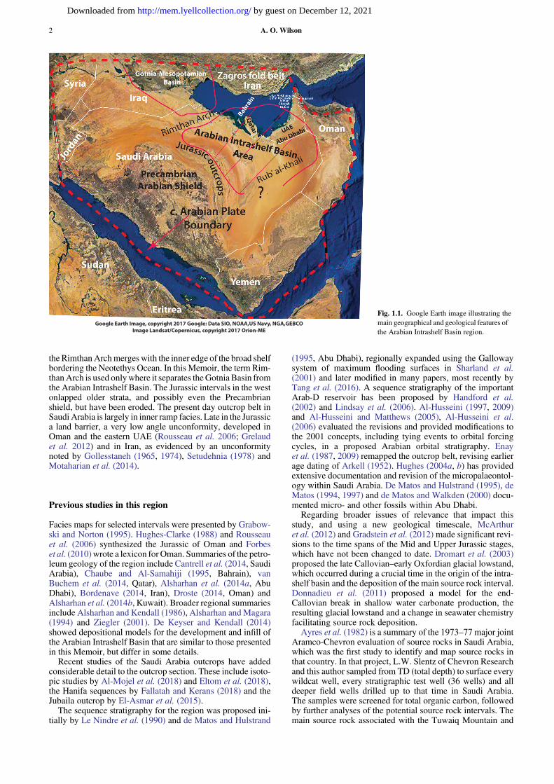
Figure 1.1 is a Google Earth image of the Arabian regionwith the country borders and major tectonic features labelled.The general area of the Arabian Intrashelf Basin is shown, aswell as the southern portion of the generally coeval, but verydifferent, Gotnia–Mesopotamian Basin to the north, which isknown as the Lurestan Basin in Iran (Murris 1980). The Ara-bian Intrashelf Basin may extend southwards into the Rub’al-Khali area. Major present day geographical features includethe huge Rub’ al-Khali sand dune region, the PrecambrianArabian Shield, the Zagros fold belt and the thrust sheets adja-cent to the Arabian plate boundary in Oman. Paleozoic to Cre-taceous outcrops border the Arabian Shield in Saudi Arabia,variably onlapping one another and dipping to the east. TheJurassic outcrop is c. 800 km long in Saudi Arabia. OtherJurassic outcrops are found in the Zagros folds and theMusan-dam thrust sheets. The Jurassic outcrops in Oman are in Tethysshelf to ocean floor facies. Erosional outliers of the intrashelfbasin rim facies occur in Ras Al-Fujairah, in the eastern UnitedArab Emirates (UAE). Jurassic outcrops and rift basins alsooccur in Yemen, but are not covered in this Memoir.
Figure 1.2 shows the general setting of the Arabian Intra-shelf Basin. Figure 1.3 gives the names of oilfields and
indicates in green or red the fields with oil or gas sourcedfrom the Jurassic Arabian Intrashelf Basin (the fields inKuwait with some Jurassic-sourced oil in the Gotnia–Mesopo-tamian Basin are not coloured green). Figure 1.4 shows thelocations of the lines of published cross-sections used to inter-pret the depositional geometry within the Arabian IntrashelfBasin. Figure 1.5 presents the lithostratigraphic nomenclatureacross the area. The age dating used in this Memoir is shownon the left. The ages and stratigraphy together form a complexissue, which is covered extensively in subsequent chapters.These five figures are included to orient those new to thearea to the important features and terminology of this region.
General setting of the Arabian Intrashelf Basin
Figure 1.2 summarizes the extent and key elements of the Ara-bian Intrashelf Basin as interpreted in this Memoir. It is basedon the many references cited, discussed and illustrated in thisMemoir. The basin is largely defined by the area of source rockdeposition shown in olive brown. It may have extended furtherinto theRub’ al-Khali area.Note that thismap shows the generalsetting early in the basin’s history. The proportion of shallowsubtidal facies to basin centre deeper water facies expandedand contracted within each subsequent depositional sequence.(Fig. 1.4 indicates some important sources of published dataused in this Memoir to define the features shown in Fig. 1.2).
The setting is one of an intrashelf basin surrounded by a shal-low rim. The western rim includes the Saudi Arabia outcrop,but the edge of the rim is in the subsurface. A broad shelf rimin the east and south separated it from the Neotethys Ocean.In the north, a much narrower belt of shallow water carbonate,the Rimthan Arch, separated the Arabian Intrashelf Basin andthe Gotnia–Mesopotamian Basin. Both early- and very late-stage dolomitization occurred along the Rimthan Arch. Thevery late dolomitization is facies-destructive and discordantand is associated with subsurface dissolution and breachingof the anhydrite seals (Broomhall andAllan 1985), which com-plicates stratigraphic correlation across the arch. The nameRimthan Arch was initially used only along this narrow belt,but some researchers (e.g. McGuire et al. 1993; Al-Nazghah2011) later also applied this name to the intrashelf basin rimfurther SE in the Berri and Qatif field areas, which is where
From: Wilson, A. O. 2020. The Middle and Late Jurassic Intrashelf Basin of the Eastern Arabian Peninsula.Geological Society, London, Memoirs, 53, 1–19, https://doi.org/10.1144/M53.1© 2020 The Author(s). This is an Open Access article distributed under the terms of the Creative Commons Attribution License(http://creativecommons.org/licenses/by/4.0/). Published by The Geological Society of London.Publishing disclaimer: www.geolsoc.org.uk/pub_ethics
by guest on December 12, 2021http://mem.lyellcollection.org/Downloaded from
the RimthanArchmerges with the inner edge of the broad shelfbordering the Neotethys Ocean. In this Memoir, the term Rim-thanArch is used onlywhere it separates theGotnia Basin fromthe Arabian Intrashelf Basin. The Jurassic intervals in the westonlapped older strata, and possibly even the Precambrianshield, but have been eroded. The present day outcrop belt inSaudi Arabia is largely in inner ramp facies. Late in the Jurassica land barrier, a very low angle unconformity, developed inOman and the eastern UAE (Rousseau et al. 2006; Grelaudet al. 2012) and in Iran, as evidenced by an unconformitynoted by Gollesstaneh (1965, 1974), Setudehnia (1978) andMotaharian et al. (2014).
Previous studies in this region
Facies maps for selected intervals were presented by Grabow-ski and Norton (1995). Hughes-Clarke (1988) and Rousseauet al. (2006) synthesized the Jurassic of Oman and Forbeset al. (2010)wrote a lexicon forOman. Summaries of the petro-leum geology of the region include Cantrell et al. (2014, SaudiArabia), Chaube and Al-Samahiji (1995, Bahrain), vanBuchem et al. (2014, Qatar), Alsharhan et al. (2014a, AbuDhabi), Bordenave (2014, Iran), Droste (2014, Oman) andAlsharhan et al. (2014b, Kuwait). Broader regional summariesinclude Alsharhan and Kendall (1986), Alsharhan andMagara(1994) and Ziegler (2001). De Keyser and Kendall (2014)showed depositional models for the development and infill ofthe Arabian Intrashelf Basin that are similar to those presentedin this Memoir, but differ in some details.
Recent studies of the Saudi Arabia outcrops have addedconsiderable detail to the outcrop section. These include isoto-pic studies by Al-Mojel et al. (2018) and Eltom et al. (2018),the Hanifa sequences by Fallatah and Kerans (2018) and theJubaila outcrop by El-Asmar et al. (2015).
The sequence stratigraphy for the region was proposed ini-tially by Le Nindre et al. (1990) and de Matos and Hulstrand
(1995, Abu Dhabi), regionally expanded using the Gallowaysystem of maximum flooding surfaces in Sharland et al.(2001) and later modified in many papers, most recently byTang et al. (2016). A sequence stratigraphy of the importantArab-D reservoir has been proposed by Handford et al.(2002) and Lindsay et al. (2006). Al-Husseini (1997, 2009)and Al-Husseini and Matthews (2005), Al-Husseini et al.(2006) evaluated the revisions and provided modifications tothe 2001 concepts, including tying events to orbital forcingcycles, in a proposed Arabian orbital stratigraphy. Enayet al. (1987, 2009) remapped the outcrop belt, revising earlierage dating of Arkell (1952). Hughes (2004a, b) has providedextensive documentation and revision of the micropalaeontol-ogy within Saudi Arabia. De Matos and Hulstrand (1995), deMatos (1994, 1997) and de Matos and Walkden (2000) docu-mented micro- and other fossils within Abu Dhabi.
Regarding broader issues of relevance that impact thisstudy, and using a new geological timescale, McArthuret al. (2012) and Gradstein et al. (2012) made significant revi-sions to the time spans of the Mid and Upper Jurassic stages,which have not been changed to date. Dromart et al. (2003)proposed the late Callovian–early Oxfordian glacial lowstand,which occurred during a crucial time in the origin of the intra-shelf basin and the deposition of the main source rock interval.Donnadieu et al. (2011) proposed a model for the end-Callovian break in shallow water carbonate production, theresulting glacial lowstand and a change in seawater chemistryfacilitating source rock deposition.
Ayres et al. (1982) is a summary of the 1973–77 major jointAramco-Chevron evaluation of source rocks in Saudi Arabia,which was the first study to identify and map source rocks inthat country. In that project, L.W. Slentz of Chevron Researchand this author sampled from TD (total depth) to surface everywildcat well, every stratigraphic test well (36 wells) and alldeeper field wells drilled up to that time in Saudi Arabia.The samples were screened for total organic carbon, followedby further analyses of the potential source rock intervals. Themain source rock associated with the Tuwaiq Mountain and
Google Earth Image, copyright 2017 Google: Data SIO, NOAA,US Navy, NGA,GEBCO Image Landsat/Copernicus, copyright 2017 Orion-ME
Fig. 1.1. Google Earth image illustrating themain geographical and geological features ofthe Arabian Intrashelf Basin region.
A. O. Wilson2
by guest on December 12, 2021http://mem.lyellcollection.org/Downloaded from

Hanifa intervals was first identified by Slentz and Chevron lab-oratory manager R.W. Jones’ analyses and interpretation. Theprevious interpretation had been that the oil was sourced bylateral migration from within the Jubaila and Arab-D (reser-voir) intervals (Arabian American Oil Company Staff 1959).The actual analyses had shown only very low (<1%) totalorganic carbon in the Jubaila–Arab-D interval, except forthin beds of moderate richness in some wells at the base ofthe Jubaila Formation in the intrashelf basin.
Slentz continued with the geochemical evaluation and thisauthor regionally correlated and mapped the thickness andrichness of the main source facies using well logs and thin sec-tions of cores and cuttings. R.M. Christensen used Lopatintechniques to model maturation and also evaluated the chro-matographic data. The resulting net source rock by this authorand later published in Ayres et al. (1982), first defined the arealextent of the intrashelf basin in the Eastern Province of SaudiArabia, which was Aramco’s main operating area at thattime. In this Memoir, this isopach is combined with sourcerock data for the intrashelf basin to the east to provide a frame-work for the regional interpretation of the intrashelf basin.
More recent papers and abstracts describing the source rockin the various areas are discussed and used to supplementthis early work in the relevant chapters. These include Frei(1984), Lehner et al. (1984), Wilson (1984), Droste (1990),Cole et al. (1994), Carrigan et al. (1995), Al-Suwaidi et al.(2000), Al-Ibrahim (2014), Al-Ibrahim et al. (2017), Alansariet al. (2016) and Lindsay et al. (2015, 2016). Many other ref-erences are cited in thisMemoir and the data and interpretationsin all of these are used to document, evaluate and interpret theevents that created the Arabian Intrashelf Basin and its vasthydrocarbon resources.
Wireline logs
Despite the many references available for this area spanningmore than 600 × 1000 km, remarkably few wireline logshave been published for the entire upper Dhruma to top Hithinterval. Of those that have been published, many are onlygamma ray logs. Wilson (1985) published an FDC-CNL logand gamma ray log for the interval in the Qatif field in
?
32o
24o
28o
52 o
56 o
60 o
48 o20o44 o
?
NE Limits Hith Anhydrite Seal
Late Jurassic
Exposure, Erosion
Outcrop
Jurassic
Butabul-1
Palaeo-EdgeExtended Westof outcrop
Oman: Present-day structurally
complex mountain outcrops
Include sparse Tethys shelf & shelf
edge Jurassic outrops.
?
N
SoutheastPalaeotradewinds
Rimthan Arch
Qatar arch
facies continuityacross
Intrashelf basinextension ?
Source rock?Hughes et al. 2008
Gotnia-Mesopotamian Basin
??
Late JurassicExposure, Erosion
Palaeozoic
oil & gas
in deeper
traps.
Arabian Intrashelf Basin
10o SouthFacies-Discordant Post-Jurassic
Dashtak-1
Bajocian to early Tithonian, then southward
PalaeonorthTethysOceanMargin
?
200 km
Arabian Intrashelf Basin Jurassic sourced oil, gas
Oil, gas from other source intervals & basins,or uncertain
Arabian Intrashelf BasinGeneral Regional
Setting
?
?
Broad synclinal trough
Fig. 1.2. General setting of the Arabian Intrashelf Basin. Fields sourced from the Arabian Intrashelf Basin Jurassic are coloured green (oil) or red (gas). Themain source rock facies (olive brown) defines the extent of the basinal portion. A main premise in this Memoir is that the intrashelf basin is continuous asshown, with a shallow rim. It may have extended further SW in the Rub’ al-Khali (e.g. Hughes et al. 2008), but that area has not been well documented.Palaeolatitudes and the location within the SE palaeotradewind belt are important factors. The northeastern limits of the Late Jurassic Hith Anhydrite seal areshown: it extends south and west to the outcrops, across the Rimthan Arch into the Gotnia–Mesopotamian Basin and into the Rub’ al-Khali. The outcrop inSaudi Arabia was initially a broad synclinal low (Enay et al. 1987) largely filled by end-Callovian deposits. This map is compiled and drawn from informationcontained in the many sources cited in this Memoir.
Introduction to the Jurassic Arabian Intrashelf Basin 3
by guest on December 12, 2021http://mem.lyellcollection.org/Downloaded from

Saudi Arabia. Handford et al. (2002) published five well logsfrom almost the complete interval in Saudi Arabia. Hohmanet al. (2005) published four Saudi Arabia and seven Qatargamma ray and porosity logs for the Tuwaiq Mountain andHanifa formations. Saner and Abdulghani (1995) publishedseveral Arab–Hith gamma ray and porosity well logs fromthe Abqaiq field. Magara et al. (1993) published sevenArab–Hith well logs in a cross-section across NE SaudiArabia.
For Qatar, van Buchem et al. (2014) published, at a verysmall scale, three complete and one partial log for the entireMesozoic. For the Tuwaiq Mountain to lower Jubaila equiva-lent interval in Abu Dhabi, de Matos and Hulstrand (1995)published eight onshore gamma ray logs. Al-Suwaidi andAziz (2002) published nine offshore gamma ray, density andporosity logs and Al-Silwadi et al. (1996) published a similarset of 13 well logs on- and offshore for the Arab–Hith interval.Other papers with partial well logs include Langdon and Mal-acek (1987), showing two Tuwaiq Mountain and Hanifa welllogs from the Rimthan Arch area. Chaube and Al-Samahiji(1995) published six Hanifa interval well logs from Bahrain.By contrast, good well log coverage for the Jurassic ofOman is available in Rousseau et al. (2006), with 18 Jurassicporosity and gamma ray well logs. Very good coverage is alsoavailable for Kuwait (e.g. Kadar et al. 2015).
The lack of well logs does make a regional interpretationand summary more difficult, but not impossible. There aremany published pieces of data, variably documented, thatcan be assembled as pieces of the puzzle posed by the ArabianIntrashelf Basin, although important details are often missing.Mattner and Al-Husseini (2006) discuss some of these diffi-culties in the context of an Aptian geology question.
General terminology
In older lithic descriptions, the Brankamp and Powers (1958)and Powers (1962) terms calcarenite and calcarenitic lime-stone are used, which roughly correspond to the now com-monly used Dunham (1962) terms of grainstone andwackestone to packstone, respectively.
The edge of the intrashelf basin shallow water facies isreferred to as the intrashelf basin rim or simply as the rim.This is not to be confused with the ramp model term rimmedramp, which implies a steep margin, possibly with reefs at theedge. Deposition in the sequences that formed the ArabianIntrashelf Basin was largely in ramp settings, but generallywith low depositional gradients. There is some variation inthe nature of the edge of the shallow water ramp. These vari-ations are described in their appropriate context in this
32o
24o
28o
52 o
56 o
60 o
48 o20o44 o
Complex structures, with someTethys shelf and shelf edge
Jurassic outcrops
?
Minagish
Burgan
Wafra
ZulufMarjan
KaranJurayd
Abu Sa'fah
Khursaniyah
BerriManifa
Safaniya
Abu HadriyaFadhili
RimthanDibdibah
Suban
Juraybi'at
Watban
EL-HabaFaridah
BakrJaladi
Khurais
Qirdi
Mazalij
Harmaliyah
Jawb
Lughfah
Abqaiq
DammanAwali
Dukhan
Ghasha Murban-Bab
Bu Hasa Shah Shaybah
Ramlah
Asab
Jarn JaphourZakum
Mender Lekhwair
Jaham
Waríah
Kidan N
Kidan S
Butabul-1
Tukhman
Nasr
Umm Shaif
Sahil
Qusahwira
Tinat
Marzouk
Maghrib
Samin
Sharar
Jana
Dhib
JaufNiyashin
HazbahHarqus
Ribyan
Al-Rayyan
Ras Qirtas
Al-Wassmi
Bu’amama
Jarim
North Field
Fazran
‘Ain Dar
Uthamaniyah
Hawiyah
Haradh
Kurayn
Dashtak-1
Abu Jifan Niban
Jafurah
200 km
NArabian Intrashelf Basin Jurassic sourced oil, gas
Oil, gas from other source intervals & basins,or uncertain
Oil in some reservoirs from
Gotnia Basin Jurassic source rocks
Gas, oil in Paleozoic reservoirs
SourcesAl-Husseini 1997
Al-Saad & Sadooni 2001Al- Silwadi et al. 1996
Beydoun 1987Grötsch et al. 2003Cantrell et al. 2014
Esrafili-Dizaji & Rahimpour-Bonab 2019
Exploratory wells
?
Al-Husseini, 1997
?Oil and Gas Fields
and NamesDashed lines approximate borders,
not all shown
Jurassic
Outcrop
Ghawar
Ferdowsi
FerousanSouth Pars
HamoonReshalat
Resalat
AlphaBalal
Fig. 1.3. Names of oil and gas fields in the region. Fields coloured green and red are sourced from the Arabian Intrashelf Basin. Where the Upper Jurassicanhydrite seals thin and become ineffective in eastern Abu Dhabi, some of the oil and gas in Lower Cretaceous reservoirs is interpreted as sourced from theJurassic (Yin et al. 2018).
A. O. Wilson4
by guest on December 12, 2021http://mem.lyellcollection.org/Downloaded from

Memoir. Similarly, the term shelf has been used in somepapers with reference to the intrashelf basin rim. In this Mem-oir, unless otherwise noted, shelf refers to the broad Tethysmargin shelf.
Field names and fields probably sourced from theArabian Intrashelf Basin facies
The fields shown in green or red in Figure 1.2 contain oil or gasthat is likely to have been sourced from the Arabian IntrashelfBasin source rock. The oil in Jurassic reservoirs below theupper Dhruma reservoir includes Marrat oil in Kuwait (Yousifand Nouman 1997), which is not coloured green because mostJurassic reservoirs in Kuwait have oil sourced from the Juras-sic in the Gotnia Basin. The oil in the Faridah and Sharar res-ervoirs in the Dhruma of Saudi Arabia are from pre-LowerFadhili–Uwainat Dhruma source rocks (Ayres et al. 1982;Tang et al. 2016). The oil in these reservoirs has only beenreported for the Faridah and Sharar fields, but there may beother locations.
Other fields coloured yellow in Figure 1.2 have oil or gasfrom other source rocks, such as deeper Paleozoic oil andgas in western Saudi Arabia. The North field offshore Qatarand Iran has Permian Khuff gas, as do the Ghawar and some
of the other anticlinal structures. The fields in northern SaudiArabia and in Kuwait have oil largely in Mid Cretaceous res-ervoirs, possibly sourced from Kazhdumi Mid Cretaceoussource rocks (Ayres et al. 1982; Lehner et al. 1984). The fieldsshown near the south ends of the Ghawar and Khurais fieldsand near and under the Saudi Jurassic outcrop have Siluriansourced oil and gas in Paleozoic reservoirs. The oil and gasin Iran may have been sourced from Jurassic and Cretaceoussource rocks. The fields in the western UAE and Oman (theFahud–Lekhwair area) have oil in Mid Cretaceous reservoirsderived from Cretaceous source rocks. The smaller fields inthe central Oman Ghaba salt basin have oil in Upper PaleozoicandMesozoic reservoirs. In south Oman, there is Paleozoic oilin glacial sediments, partly(?) sourced from Infracambriansource rocks (Beydoun 1987). This summary is extractedfrom Beydoun (1987), Alsharhan and Nairn (1997), Cantrellet al. (2014), Bordenave (2014) and other references listedon Figure 1.2
Introduction to the stratigraphic nomenclature
A major goal of this Memoir is to clarify the various strati-graphic relationships within the area of the Arabian IntrashelfBasin, which is confined to Saudi Arabia, Bahrain, Qatar, theUAE and Oman.
North Field
Butabul-1
31, Hughes =C larke, 1988R ous seau et al., 2006
29,30. de Matos , 1995, & Hulstrand, 1994.
11,19, 32 328, 10, 0, 20, 32 E nay et al.,.,1987
24, Ayres et al. 1982
12, Al-Ibrahim, 2014, Al-S aad & S adooni,2001
Q , Qatif well, Wilson, 1985
1 , Al-Moraikhil et al. 2014
21, L angdon & Malacek 198722,23, 3, McG uire et. al., 1993, Handford et al. 2002
25 C arrigan et al. 1994
26, C haube & S amahiji, 199427, van B uchem et al., 2014
41, Mitchell et al. 1988
49A, R azin et al. 2012
38 Hohman et al 200540, Magara et al. 1992
Al-Suwaidi & Aziz, 2002 Al-Silwadi et al. 1996Al-Suwaidi & Aziz, 2002 Al-Silwadi et al. 1996
Figure numbers and references
32o
24o
28o
52 o
56 o
60 o
48 o20o
44 o
3.7
4.24.3
4.54.4
6.2
Q
6.8
3.19, 5.17
3.19
4.64.8
4.7 3.8,
3.37
.4.1
2, 5
.2
4.10, 4.11
de Matos, 1997Hanifa-Tuwaiq Mtnoutcrop
5.3
4.13
4.13
3.3, 3.7, 4.1, 5.2
Oil
Gas
N
Iran Gas
Mostl
y Oil
Arabian Intrashelf Basin Jurassic sourced fields
Fields, oil, gasfrom other sources
5.2
5.2
Data SourcesFor Some of Figures With Cross Sections
Kuwait, oil in some
reservoirsfrom
Gotnia BasinJurassic
source rocks
Jurassic
Outcrop
3.3, 3.7, 4.1, 5.2, Enay et al.1987 3.8, 3.37, 4.12, 5.2, Al-Suwaidi & Aziz, 20023.19, 5.17, Al-Ibrahim et al. 2017; Al-Saad & Sadooni 2001
3.7, Al-Moraikhi et al. 2014; Kadar et al. 2015
4.2, Langdon and Malacek 19874.3, McGuire et al.1993; Handford et al. 20024.4, Ayres et al. 19824.5, Carrigan et al. 19954.6, 4.8, Chaube & Al-Samahiji 19954.7, van Buchem et al. 20144.8, Frei 19844.10, 4.11, de Matos 1997; de Matos & Hulstrand 1995Not marked: Al-Silwadi et al. 1996, Abu Dhabi Arab-Hith 6.4, 6.5.
4.13, Hughes-Clarke 1988 Rousseau et al. 2006
A. Hohman et al. 2005 Qatar, Saudi Arabia
6.2, Magara et al. 19936.8, Mitchell et al. 19885.4, Razin et al. 2014Q, Qatif field, Wilson 1985
A
Fig. 1.4. Map showing the trends of some of the published cross-sections used to construct the maps and much of the interpretation in this Memoir. Thenumbers refer to the figure numbers in this Memoir and to the references in the yellow box. Not all of the sources used are shown in this figure; these arecredited where they are used in the figures in other chapters.
Introduction to the Jurassic Arabian Intrashelf Basin 5
by guest on December 12, 2021http://mem.lyellcollection.org/Downloaded from

It is important to understand the different nomenclaturesand different interpretations used in the Gulf countries.Nomenclatures were first established early in the explorationof this region and vary from country to country; in somecases they even vary within a given country. Despite this com-plexity in nomenclature, there is remarkable lithostratigraphiccontinuity, especially around the basin rim, in the underlyingDhruma Atash–Lower Fadhili–Uwainat reservoir facies and inthe Jubaila and Arab–Hith formations at the top. The strati-graphic interval within the deeper basin itself is more complex.Another issue has been the initial use of layer cake lithostrati-graphic terminology, which tends to obscure lateral facieschanges between the intrashelf basin centre and its rim.Figure 1.5 shows the Jurassic stratigraphic nomenclature.On the left-hand side are the ages in the older literature asgiven in Powers (1968) and the dating used in this Memoir.
Sugden et al. (1975), in their Lexique Stratigraphique forQatar, observed that the conflicting nomenclatures evolvedin early exploration as a result of physical isolation and alack of communication between the petroleum geologistsworking for different companies in different countries. Morerecently, as can be seen for Qatar in van Buchem et al.(2014) and other papers discussed in this Memoir, the SaudiArabian formation names have increasingly become inter-mixed with the earlier company and country nomenclatures,making the basic lithostratigraphy even more confusing, espe-cially when comparing older literature with newer papers.
Arabian Intrashelf Basin and adjacentGotnia–Mesopotamian Intrashelf Basin
The Arabian Intrashelf Basin section is located stratigraphi-cally between the Jurassic Upper Dhruma Atash–LowerFadhili–Uwainat interval and the top of the Hith (Anhydrite)Formation. A separate intrashelf basin of similar age in Kuwaitand Iraq is the Gotnia–Mesopotamian Intrashelf Basin, but itslithofacies are very different even where similar stratigraphicnames are used, with deeper water facies followed by thicksalt intervals (Kadar et al. 2015). The portion of the Gotnia–Mesopotamian Basin in Iran is known as the LurestanBasin. The name Gotnia Basin by itself is used to refer tothe area of the basin in Kuwait, the southern edge of Iraqand at the NE edge of Saudi Arabia. The section in Iran inareas close to the Arabian Intrashelf Basin is included in theSurmeh Group (Setudehnia 1978).
Age dating
The age dating used in this Memoir is strongly based on theextensive remapping and palaeontology of the Saudi ArabiaJurassic outcrop by Enay et al. (1987), who modified the ear-lier ages summarized in Powers (1968) and revised theammonite zones of Arkell (1952). Microfossils in the outcropand subsurface are strongly controlled by the facies.
TuwaiqMountain
U.FadhiliTuwaiq
Mountain
UwainatLowerFadhili
Fadhili orUwainat
.rbMnaysiHAtash Mbr.
Dhr
uma
Dhruma
TuwaiqMountainTuwaiq
Mountain
Uwainat Uwainat
?
Hanifa HanifaHanifa
Hanifa
Hanifa bayiDnahkuD-bayiD-afinaH
Hadriya
).rbMhayyalU()aliabuJ rewoL(
Arab A B C D
Arab A B C D
Arab A B C D
Arab A B C D
Arab A B C D
Manifa Rayda
Hanifa
? ?
?
Eroded?
?
Rhaetian Minjur Minjur Minjur Minjur Hamlah or Gulailah or Minjur
Lower Mafraq
qarfaM reppU halmaH ro tarraMtarraMtarraMtarraMtarraMnaicraoT
Alan
Mus
AdaiyahMarrat orHamlah
Marrat orHamlah
Neyriz
? Aalenianhiatus ?
Bajocian
Bathonian
UwainatLowerFadhili
UwainatHisyan MbrAtash Mbr
Uwainat Uwainat
Surm
eh
"Lithiotis"
? ? ?
?
Sargelu
Sargelu
/
Dhruma
Hanifa HanifaHanifa
Hanifa
HanifaHanifa-Diyab-Dukhan DiyabOxfordian
(Ulayyah Mbr)(Lower Jubaila)
Kimmeridgian
ArabArab A B C D
Arab A B C D
Arab A B C D
Qatar or Arab I to III, Arab IV or Fahahil
Arab A B
D
Arab A B
D
Sulaiy Sulaiy
LowerRatawi
(Yamana Detrital)
Tithonian(Portlandian)
Berriasian
Ages byEnay et al.1987Al-Husseini1997
GTS 2012
Saudi Outcrop Saudi Subsurface
Formation Reservoir
Bahrain Qatar
(Various terms havebeen used)
UAE(De Matos & Hulstrand 1995)
Onshore Offshore
Sulaiy
Same asOnshoreOolite
SalilHabsh
an
Oman(Hughes-Clark
1988,Rousseau
2006)
Iran (Fars)
(Lurestansame as Iraq)
South Iraq
LexiqueStratigraphique
Kuwait
Karimia- Makhul(Sulaiy in South)
GotniaSalt
LowerNajmah
Fahliyan
ni hemr uS
sr aF l at saoc
Hanifa
? ?
Ages fromPowers 1968
Berriasian
Tithonian(Portlandian)
Kimmeridgian
Oxfordian
Callovian
Bathonian
Bajocian
Toarcian
Rhaetian
Naj
mah
Nao
kele
kan
?
GotniaSalt
MinagishOolite
Makhul
Callovian
(Hawtah Mbr)
Dhr
uma
Fm.
Dhibi Mbr
Sulaiy
C C
Jubaila or Darb
Upper Araej
Minjur
(Setudehnia 1987)
?
Chia Gara
Butmah
As used in this memoir
(thin)Jubaila
See below
(Thin)Najmah
Limestone
Local GapUpper
Najmahorganic-rich
(laminite)
MarratL
U
M
??
Minjur
Upper Butmah
Jubaila Jubaila Jubaila Jubaila
Hith Anhydrite
MandMbr
Upper Araej
?
Kuwait: Marrat=lower Sinemurian to Aalenian.Minjur; Rhaetian to lower Sinemurian.
Yousif and Nouman 1997Al-Moraikhil et al. 2014
Kadar et al. 2015
UAE & Oman. Rayda, Mender Glauconite, Asab interpretedas Kimmeridgian --Tithonian (de Matos & Hulstrand 1995,
Alsharhan et al. 2014) or younger than Hith-Arab by Razin et al. 2012. Part of Jurassic in Oman and UAE eroded
eastward (Rousseau et al. 2006, de Matos1997, de Matos &Hulstrand 1995)
Similar facies in coastal Fars, Iran
Hith HithRimthan
Hith Hith HithManifa
Dhruma
Sharar
Faridah
DhrumaLower Araej
Izhara
Araej
Izhara
Araej
Izhara
Dhruma
JubailaJubaila
orDiyab?
Jubaila
MaximumFloodingSurfaces
Sharland et al.2001
? ? ? ? ?
?
? ? ?
?
?
?Hadriya
Similar to R
ayda?
Hadriya
145 my
152 my
157 my
166 my
168 my
170 my
174 my
<183 my
Several my time gap?
Eroded laterin some areas?
Gap
Lithostratigraphic Nomenclature, Also Maximum Flooding Surfaces, Sharland et al. 2001 as modified in this memoir.
J110
J100J90J80
J70
J60
J50
J40
J30
J20
J10
?
?
Early Jurassichiatus
Lower Hanifa Source Rock In BasinGlacial Lowstand? Gap?
Lowstand?
Hadriya
Del
ta M
embe
r
MFS
164 my End Callovian
RaydaAsab, Mender
See comments below
Local gaps?, variable
(J105)
Precise correlations to section in Kuwait and S. Iraq uncertain
Fig. 1.5. Lithostratigraphic nomenclature. The left-hand side shows both the early age dating of the section in Saudi Arabia, which was adopted in othercountry areas, and the more recent dating in Enay et al. (1987) andAl-Husseini (2009) used in thisMemoir. In thisMemoir, the main interval of the source rockis interpreted to be a lowstand deposit. Modified Sharland et al. (2001) maximum flooding surfaces are also included on the left-hand side. This chart isrepeated inWilson (2020b, Fig. 3.1, Chapter 3, this Memoir). The intervals in Kuwait have been dated using nannofossils, but comparable data are not knownto be available for the interval in Saudi Arabia, hence precise age correlations to Kuwait are not shown in this chart. A general consensus of the correlations isshown in Figure 3.7 in Wilson (2020b, Chapter 3, this Memoir).
A. O. Wilson6
by guest on December 12, 2021http://mem.lyellcollection.org/Downloaded from

Numerous papers by Hughes on Saudi Arabia since the year2000 (e.g. Hughes 2000, 2004a, b, 2008; Hughes et al.2008) have extended the stratigraphic ranges of many of themicrofossils used for dating the Mid- and Late Jurassic agesof the section across the region. De Matos (1997) and deMatos and Hulstrand (1995) are the most thorough biostrati-graphic studies of Abu Dhabi (as noted by Al-Suwaidi andAziz 2002). However, the microfossils they cite for age deter-mination in parts of the section are among those whose ageranges have been extended or otherwise altered bymore recentwork. The apparent discordant ages between Abu Dhabi andSaudi Arabia of the Tuwaiq Mountain and Hanifa intervalsare therefore not supported by more recent data and requirerevision and re-assessment. In other areas, such as in Qatar(Sugden et al. 1975) and Oman (Hughes-Clarke 1988), thedating of the section was originally based on correlationwith Powers (1968), but has been revised to some degree, asin Droste (1990).
87Sr/86Sr dating has also been used and is reviewed and eval-uated in Chapter 3 (Wilson 2020b), including adjustment,where possible, to the revised geological timescale (McArthuret al. 2012). Unfortunately, most of the published 87Sr/86Srdata cannot be reliably used for age dating as a result of thetypes of sample and lack of analytical detail. In many cases,the actual 87Sr/86Sr ratios are not given, so they cannot be com-pared to revised versions of the global 87Sr/86Sr curve.
Carbonate intrashelf basins
An important concept essential to understanding thesequences and history of carbonate-dominated intrashelfbasins is that the rapid aggradation of shallow water faciesaround the rim and local tectonics can separate the depositionwithin a basin from more regional or global influences. Thismay result in a basin becoming cut-off and slightly restrictedduring highstands of sea-level, and even more restricted dur-ing lowstands. Two coeval intrashelf basins in the same regionmay show drastically different depositional patterns. The lateBathonian to Tithonian intervals in the Arabian IntrashelfBasin and the Gotnia–Mesopotamian Basin are comprised oflithofacies sequences that are very different, as shown by com-paring the depositional facies in the stratigraphic section ofthe Arabian Basin with the Gotnia Basin section shown inYousif and Nouman (1997), Al-Moraikhi et al. (2014) andKadar et al. (2015). These facies–stratigraphic differencesare discussed in Chapter 3 (Wilson 2020b). An enclosedbasin may also have a less diverse fossil assemblage and a sal-inity and water chemistry significantly different from those ofthe global ocean.
Carbonate intrashelf basins form by a mixture of tectonicsand differential carbonate deposition. The Bajocian–Bathonian Dhruma Formation below the strata of the ArabianIntrashelf Basin is an example of deposition in an intrashelfbasin formed largely by tectonics, with significant develop-ment of relief beginning in the Triassic and continuing intothe Early Jurassic, illustrated by de Matos (1997, his fig.2.11) and Fig. 2.6 (Wilson 2020a, Chapter 2, this Memoir).The lower Dhruma intervals filled the tectonic relief withupwards-shallowing sequences, each of which filled the avail-able accommodation space without forming a distinct rimaround the basin. Once the accommodation space had beenfilled, the middle to upper Dhruma units blanketed the area.
Main premises and new interpretations
In the Arabian Intrashelf Basin region, as is so often the case inother regions, few ideas and interpretations are truly new or
unique. Although this applies to the concepts presented inthis Memoir, some of the proposed explanations as to howthese all fit together are new. The main premises put forth inthis Memoir are as follows.
• The Arabian Intrashelf Basin is a unique, complete hydro-carbon system.
• The Arabian Intrashelf Basin formed within Abu Dhabi,Qatar, Bahrain, the edge of Oman, and Saudi Arabia asone single basin in the Callovian, within the relativelyopen marine Tethyan shelf but 200–300 km from its outeredge. It was initiated by a major transgression coupledwith minor subsidence. The subsidence was associatedwith Tethys passive margin drift and rifting.
• There are two areas in the single intrashelf basin where theMid and Upper Jurassic section is slightly thicker, whichhave been termed the Rub’ al-Khali Basin in the east andthe Arabian Basin in the west (Ayres et al. 1982; Ziegler2001). However, despite many references to the QatarArch separating the two (e.g. Cole et al. 1994; Ziegler2001; Lindsay et al. 2006), at most there was only a slightridging with subtle thinning between the two areas duringthis time period and any depositional effect is subtle. VanBuchem et al. (2014) stated that the Qatar Arch was notan active structural high and therefore not a major factorduring the Mid- and Upper Jurassic. De Keyser and Kendall(2014) also showed the Arabian Intrashelf Basin as asingle basin.
• Within and around the rim of the single intrashelf basin,there are identifiable coeval depositional and tectonic eventsboth around the margins and in the basin. Because many ofthese events, which formed the Arabian Intrashelf Basindepositional sequences, have previously been assigned todifferent ages in different areas around the basin, much ofthisMemoir consists of documentation, discussion and revi-sions as to how these events are either coeval and/or of dif-ferent ages than were generally documented in the earlierliterature on the area.
• Biostratigraphic and 87Sr/86Sr dating provide a very gene-ral idea of the ages, but in most cases are not precise enoughfor definitive age dating. These general ages are used in con-junction with the interpretation and correlation of the coevaldepositional events to define sequences and the evolution ofthe intrashelf basin. The depositional sequences as definedin earlier work are reviewed and correlated with the basin-wide events and, in some cases, suggested modificationsare presented.
• On the relatively open marine Tethyan shelf, with risingsea-levels and a greenhouse climate, a very productive shal-lowwater carbonate factory built the TuwaiqMountain For-mation carbonate rim (Hadriya reservoir), forming theintrashelf basin. An end-Callovian–early Oxfordian low-stand ended the shallow water carbonate progradation, leav-ing a huge basinal area surrounded by the subaeriallyexposed Tuwaiq Mountain Formation rim.
• The global end-Callovian into early Oxfordian lowstandbrought restricted conditions favouring cyanobacteria–microbial carbonate intrabasinal deposition, which resultedin an exceptionally organic-rich, petrographically uniquelaminated carbonate source rock within the intrashelfbasin. By contrast, other published interpretations ascribethe onset of source rock deposition to anoxic conditionsdeveloped with rising sea-levels. A model (Dromart et al.2003; Donnadieu et al. 2011) for the lowstand having a gla-cial origin is discussed in the context of source rockdeposition.
• Late in the Jurassic, the deposition of the Arab–Hith carbon-ate–evaporite sequences was controlled by a balancebetween eustatic sea-level fluctuations, the development
Introduction to the Jurassic Arabian Intrashelf Basin 7
by guest on December 12, 2021http://mem.lyellcollection.org/Downloaded from

of a land barrier on the broad Tethys shelf and a subtle west-wards tilt. Previous interpretations have not fully acknowl-edged the importance of the land barrier.
The following sections briefly summarize these main premisesin the context of the depositional sequences.
Arabian Intrashelf Basin intervals and sequences
Schematic cross-section showing stratigraphicrelationships
Figure 1.6 is a schematic, roughly to scale, cross-sectionacross the basin from the northern offshore waters of Bahrainand Qatar to the outcrop in Saudi Arabia. This summarizesthe general interpretation of the intrashelf basin interval doc-umented and discussed in this Memoir, interpreted frommany sources, including: Enay et al. (1987, 2009) (Saudioutcrops); Ayres et al. (1982) (within the basin, east–west,Saudi Arabia); McGuire et al. 1993 (eastern rim); Chaubeand Al-Samahiji (1995) (Bahrain, also this author, unpub-lished Bahrain offshore reports 1985–86, cited in Chaubeand Al-Samahiji); van Buchem et al. (2014) (Qatar); andde Matos (1994, 1997); de Matos and Hulstrand (1995);Al-Silwadi et al. (1996), Al-Suwaidi and Aziz (2002) (AbuDhabi). The original cross-sections are shown in Chapter 4(Wilson 2020c). This schematic cross-section shows a transitwhere the intrashelf basin symmetry is well preserved. Else-where, the rim facies of the eastern margin (UAE, Oman)were partly eroded during the Late Jurassic.
Upper Dhruma Formation–Dhruma Atash Sequence: thefoundation for the formation of the intrashelf basin
Prior to the development of the intrashelf basin, the UpperDhruma Atash–Lower Fadhili–Uwainat shallow water car-bonates blanketed the area, forming a very broad, low-reliefplatform (de Matos 1997; Murris 1980; Rousseau et al.2006; Tang et al. 2012; De Keyser and Kendall 2014).
Tuwaiq Sequence: development of the intrashelf basin
Sea-level rise and some subsidence began the deposition of theTuwaiq Mountain Formation depositional sequence (MFSJ40), which begins at the base of the uppermost DhrumaHisyan Member. Slightly greater subsidence in what becamethe basin centre created enough relief for aggradation and pro-gradation to form the shallow intrashelf basin rim. The subsi-dence was probably due to both earlier sediment loading andsubtle tectonic processes. The tectonic contribution was prob-ably associated with westward drift as the Tethys Ocean con-tinued to develop. In the basin, deeper water facies withbenthic forams and the tiny bivalve Bositra buchi accumu-lated, as documented in Hughes (2004a, b; Hughes et al.2008). The deeper water facies are occasionally slightlyorganic-rich. The Tuwaiq Mountain rim facies in the Saudioutcrop include build-ups rich in stromatoporoids with coralsand coralline algae. On the basin rim in the subsurface, theshallow water facies comprise the Hadriya reservoir withgrainstone facies (e.g. Powers 1968; Ayres et al. 1982;McGuire et al. 1993; de Matos 1997; Tang et al. 2012; Lind-say et al. 2015). The Upper Fadhili reservoir below the
?
?
The Sulaiy Depositional Sequence (MFS J110) ends atop the upper Sulaiy Formation reservoir facies. Jurassic-Cretaceous contact is within the Sulaiy interval
Sequence boundaries
Schematic Cross Section Showing General Sedimentary Architecture In Arabian Intrashelf Basin.(Interpreted from cross sections in Chapters 4, 5, 6, this Memoir)
Atash-Lower Fadhili-Uwainat reservoir
qiawuT
niatnuoM
noitamroF
Dhr
uma
Form
atio
nH
anifa
Fm
.
Jubaila Formation
Arab-D reservoir
Arab-D anhydrite
Ara
b F
orm
atio
n
Arab-Canhydritereservoir
anhydritereservoir
reservoir
Arab-B
Arab-A
Hith
Anh
ydrit
e Fo
rmat
ion
Manifa reservoir
Sulaiy Formation
Hanifa reservoir
Hadriya reservoir or equivalent
Hisyan Member
Hadriya reservoir
Upper Fadhili reservoir
Hanifa reservoir
Hanifa anhydriteLate stage Hanifa
Hith Sequence
Arab-B Sequence
Arab-C Sequence
Jubaila
-Arab-D
Sequence(s)
Hanifa
Sequence(s)
Tuwaiq M
ountain
Sequence
Dhruma AtashSequence
Source Rock Lowstand Sequence Tract
MFS J30
MFS J40
MFS J50MFS J60
MFS J70
MFS J80
MFS J90
MFS J110
MFS J100
Kim
mer
idgi
an
-
Ti
thon
ian
mid & upper
Oxfordian
mid
- (p
art o
f ) u
pp
erC
allo
vian
late
Bat
honi
an -
early
Cal
lovi
an
Late Callovian - Early Oxfordian lowstand
Ullayah Mbr. Hawtah Mbr.
“Westward” “Eastward”
Carbonate mud-richShallow water carbonate, reservoir to peritidal facies
Major carbonate source rock facies
Late stage Hanifawackestone in basin
Anhydrite
Gradational boundary ?
Arab-A Sequence (Arab-B anhydrite)
(Arab-C anhydrite)
(Arab-D anhydrite)
MFS J105
MFS J50 in basin
Arab-D reservoir
Lower Fadhili-Uwainat reservoir
post-Hanifa tilt
Fig. 1.6. Schematic cross-section for the intrashelf basin drawn from the eastern to western rims, illustrating the basic depositional architecture as interpretedin this Memoir. The Dhruma Atash sequence formed a relatively flat platform, above which the intrashelf basin formed in the Tuwaiq sequence. A lowstandrestricted the basin and the main source rock interval was deposited. With the subsequent transgression, the Hanifa sequence facies prograded well into thebasin, with progradation extending further from the west than from the east. Hanifa deposition ended with a lowstand, marked by subaqueous anhydrite in thebasin. The Jubaila-Arab-D sequence(s) largely filled the intrashelf basin. The Arab-D anhydrite filled remaining depositional lows and then blanketed theregion. Westward tilt and subsidence began post-Hanifa and continued into the early Tithonian. The Arab-D anhydrite blanketed the region. The Arab-C toArab-A evaporite–carbonate sequences were formed by transgressions, with evaporite deposition followed by shallow water carbonate deposition. Themassive anhydrite interval of the Hith Anhydrite Formation covered the intrashelf basin region. The Jurassic–Cretaceous contact is in the transgressive faciesabove the Hith Anhydrite Formation.
A. O. Wilson8
by guest on December 12, 2021http://mem.lyellcollection.org/Downloaded from

Hadriya reservoir pinches out into the deeper water basin cen-tre carbonate facies (Powers 1968). The Upper Fadhili faciesmay represent facies of a highstand systems tract of a higherorder Tuwaiq Mountain interval sub-sequence formed in anearly phase of sea-level rise, or it may simply be distal faciesof the Hadriya reservoir. The Hadriya reservoir facies pro-graded basinwards in the highstand regressive systems tractphase, but do not extend as far into the basin as the UpperFadhili.
Source rock deposition during a major lowstand sequence(Lower Hanifa lowstand systems tract)
The source rock interval is shown as olive brown in Figure 1.6.Most published interpretations of the source deposition attri-bute it to a deep-water facies at least partly coeval with theTuwaiq Mountain basin rim facies and deposited during a sea-level highstand, with the deeper intrashelf basin centre becom-ing anoxic. By contrast, the interpretation favoured in thisMemoir is for the source rock facies to be post-Tuwaiq Moun-tain and formed when the intrashelf basin was restricted by awidely recognized global end-Callovian lowstand, which con-tinued into the Oxfordian. During this lowstand, the marginswere exposed and shallow water carbonate deposition wasrepressed. The intrashelf basin was restricted, but enough cir-culation from the Tethys Ocean persisted to prevent majorevaporite deposition. The richest source rock depositionacross the Arabian Intrashelf Basin began abruptly, alwaysshowing a very pronounced and sharp basal contact, as indi-cated in core and well logs. It is event-driven and not a productof a gradual change. The source rock is a unique organic-richcarbonate laminite facies with minimal clay, typically charac-terized by micropeloidal (silt-sized) micrograinstone laminaeinterlaminated with very organic-rich laminae. The micrope-loids are interpreted as calcified cyanobacterial cells and theorganic matter as intrabasinal and microbial in origin. Kendallet al. (2007) also interpreted a cyanobacterial origin for theorganic matter. The considerable documentation to supportthis lowstand interpretation is presented in subsequent chap-ters and compared with the highstand systems tract interpreta-tion and with global factors. Recovery from the lowstand wascharacterized by a gradual, but episodic, decrease upwards inorganic richness and a slow return to more normal marineintrashelf basin facies. An upwards-shallowing transitionfrom highstand deposition of source rock would be similar.Other factors distinguishing the lowstand interpretationfavoured in this Memoir v. the highstand systems tract inter-pretation are evaluated in the following chapters.
Hanifa sequence(s): return to normal marine deposition
By the mid-Oxfordian, the rise in sea-level had returned morenormal marine conditions to the intrashelf basin rim and cen-tre. In outcrop, the Hanifa shallow water facies include ooliticgrainstone, with stromatoporoid facies present, but less prom-inent than in the older underlying Tuwaiq Mountain Forma-tion. Enay et al. (1987) documented that the fossil diversityin the outcrop is much lower in the Hanifa Formation thanin the Tuwaiq Mountain Formation, indicating that slightrestriction continued throughout Hanifa deposition. Prograda-tion of the Hanifa facies into the basin formed the Hanifa res-ervoir, which extends further basinwards than the Hadriyareservoir of the upper Tuwaiq Mountain. By late Hanifa dep-osition, the deeper water remnant of the basin was muchsmaller in area than in earlier Hanifa times and was shiftedeastwards due to faster progradation and infill from the west.
In this Memoir, this is attributed to dominant wind directionat the time and resulting higher energy levels in the west(Fig. 1.9). A late Hanifa lowstand resulted in the depositionof beds of subaqueous anhydrite in the remnants of the intra-shelf basin centre and a disconformity on the basin rim. TheHanifa sequences shown are similar to the interpretation sum-marized in Al-Husseini (2009), except that MFS J50 is placedhigher in this Memoir, in the interval where the organic rich-ness decreases. Two informal members are defined in theHanifa Formation in outcrop: the lower Hawtah and theupper Ulayyah (Enay et al. 1987). Sharland et al. (2001)also proposed a local MFS J60 within the Hanifa, which hasbeen interpreted as representing the Ulayyah interval (e.g.Simmons et al. 2007).
Post-Hanifa westwards tilt and subsidence
At end-deposition of the Hanifa sequence, the Hanifa shallowwater rim facies would have been near sea-level around theintrashelf basin rim. Concomitant with the Jubaila transgres-sion, westward structural tilt provided accommodationspace. This subtle structural tilt continued into the early Titho-nian. A greater thickness of Jubaila intrashelf basin facies richin lime mud was deposited to the west, whereas in the east thedeposition of shallow water carbonate facies was almost con-tinuous. In the west, updip of the present day outcrop in SaudiArabia, shallow water facies may have been more prevalent inthe Jubaila.
Jubaila: Arab-D sequence
Sea-level rise and some subsidence again expanded intrashelfbasin deposition, with the Jubaila facies rich in lime mud grad-ing upwards to the shallow water facies of the Arab-D reser-voir. In the outcrop, the shallow water facies are dividedinto two members. The top of the Jubaila Formation is takenwithin the lower portions of the Arab-D reservoir. Prograda-tion into the basin was again initially from the margins, but,as the basin filled, the directions of progradation becamemore complex, forming shoals and variably isolated remnantareas of slightly deeper water. In the latest stages, the energylevels became low, the deposition of higher energy faciesceased and only shallow lagoonal remnant basins remained.These basins were filled by lime mud and the initial depositionof the Arab-D anhydrite.
Handford et al. (2002), Lindsay et al. (2006) andAl-Husseini (2009) assigned two third-order sequences tothe Jubaila–Arab-D and Tang et al. (2016) described theJubaila–Arab-D as a composite second-order sequence. Thissubdivision into two third-order sequences is usually difficultin the subsurface, but there is evidence for this subdivision inthe western Saudi Arabia outcrops.
Late Jurassic Tethys margin land barrier
In the east, a land barrier formed adjacent to the Tethys Oceanas a very low angle unconformity. The interpretation of Rous-seau et al. (2006) is that this unconformity first began todevelop in the Callovian and that it was a major factor in theformation of the Arabian Intrashelf Basin. However, this isan isolated interpretation made in the context of its eastern set-ting and does not take into consideration its relationship withthe rest of the intrashelf basin area. The interpretation in thisMemoir is that the Tethys margin land barrier began later.This is because the mid-Callovian Tuwaiq Mountain rimdeveloped at the same time and in the same way in all other
Introduction to the Jurassic Arabian Intrashelf Basin 9
by guest on December 12, 2021http://mem.lyellcollection.org/Downloaded from

areas around the entire rim, far away from where the land bar-rier later formed. The Hanifa Formation is also similar aroundthe basin rim. Eastwards in the UAE, Grelaud et al. (2012) andRazin et al. (2012) showed Dhruma, Tuwaiq Mountain,Hanifa and Jubaila(?) facies truncated at this unconformity,whereas the Kimmeridgian (Arab Formation) and Tithonianat some times onlapped and at other times were exposed andpartially eroded. The land barrier extended further northwardsaround the basin into Iran (Gollesstaneh 1965, 1974; Setudeh-nia 1978; Motaharian et al. 2014). Cooper et al. (2016) inter-preted the uplift as due to a mild compressive phase in the LateJurassic. Torsvik and Cocks (2016) showed that the openingof the Atlantic Ocean, beginning late in the Jurassic, mayhave generated a subtle compressive force far to the east ofthe Atlantic rift. Murris (1980, his fig. 12) also recognized aland barrier, but interpreted it as confined to the Oxfordianand early Kimmeridgian.
Other interpretations (e.g. Al-Silwadi et al. 1996; Alsharhanet al. 2014a, b) have shown the Late Jurassic eastern marginof the intrashelf basin to be open to the Tethys Ocean, butthe land barrier interpretation is preferred in this Memoir(discussed in Chapters 5 (Wilson 2020d) and 6 (Wilson2020e)).
This Memoir interprets this mild uplift in the east and west-wards tilt as possibly Kimmeridgian and Tithonian and as asignificant factor in the deposition of the Arab–Hith evapo-rites. The uplift and westwards tilt episodically isolated theArabian Intrashelf Basin and also the Gotnia–MesopotamianBasin from the Tethys Ocean, with additional fluctuationssuperimposed by eustatic sea-level rise and fall.
Arab-C to the Hith carbonate–evaporite sequences
By the end of Arab-D deposition, the Arab-D anhydrite com-pleted the infill of the intrashelf basin, leaving a broad andvery flat evaporite platform across the intrashelf basin arearoughly at sea-level (Wilson 1975). The lower sequenceboundaries are at the base of the evaporites. The evaporitesare interpreted as formed by the influx of seawater, with theflooding baffled by the land barrier, resulting in the deposi-tion of gypsum. As the sea-level rise progressed, the watersbecame fresh enough to allow shallow water carbonate depo-sition, forming the Arab-C to Arab-A carbonate reservoirs.The Arab-C to Arab-A sequences show thinning of the car-bonate intervals and thickening of the anhydrites westwardsand/or southwards from the eastern intrashelf basin rim(e.g. Magara et al. 1993; Al-Silwadi et al. 1996). To theeast in Abu Dhabi and northwards into Iran (Setudehnia1978), the anhydrites pinched out or were eroded. The pro-portion of anhydrite also decreases onto the Rimthan Arch.The Hith Anhydrite Formation formed a thick seal, butintra-Hith carbonate beds increase in frequency to the east.The carbonate intervals are shallow subtidal to lagoonal andperitidal. The shallow subtidal facies are often seen as thin,transgressive oolitic beds.
Arabian Intrashelf Basin: a unique depositional feature
The overall intrashelf basin sequence contains a prolific sourcerock, several reservoir intervals, and remarkably extensive andeffective gypsum–anhydrite seals. Continued Tethyan shelfsubsidence and Cretaceous and Tertiary sedimentation buriedthe Arabian Intrashelf Basin facies deeply enough to allowmaturation of the source rock. The timing of maturation wassuch that oil migrating from the exceptionally rich sourcerock was available to charge the reservoirs during the LateCretaceous–Miocene development of the huge anticlinal
structures. Overall, including its limited geographical andstratigraphic extent, the Arabian Intrashelf Basin formed aself-contained hydrocarbon system and became the mostprolific discrete hydrocarbon system in the world.
Plate tectonic setting and implications: Mid- toLate Jurassic
Figure 1.7 shows the general location of the Arabian plate asPangaea separated into Gondwana and Laurasia, with the Ara-bian Intrashelf Basin on the broad shelf adjacent to the Neote-thys Ocean (Torsvik and Cocks 2016). The Neotethys Oceanwas well developed by the Mid-Jurassic, with the Arabianplate occupying a passive margin. Figure 1.7 shows the incip-ient opening of the Atlantic Ocean and the separation of Indiafrom the Arabian plate in the Oxfordian.
Palaeolatitude
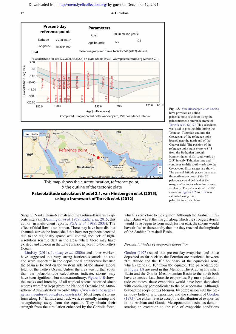
A palaeolatitude of 10° S is shown in Figure 1.2, which wasplotted using a palaeolatitude calculator (Fig. 1.8). Palaeolati-tudes are important because the various depositional modelsproposed in the literature and used or revised in this Memoirrequire a knowledge of the location within palaeowind andstorm belts and the associated wind directions, strengths andwave energy levels and the likelihood of hurricanes impactingthe area. Various sources give different palaeolatitudes andpalaeowind directions. Al-Husseini (1997) showed the Berrifield in Saudi Arabia to be at c. 10° S. Sharland et al. (2001,their figure 3.26, citing several sources) show the equatorcrossing the southern tip of the Qatar peninsula during muchof the AP7 Jurassic megasequence. Handford et al. (2002),Lindsay et al. (2006) and Cantrell et al. (2014) show the gene-ral area of the Ghawar field in the Kimmeridgian at c. 5° S.Al-Nazghah (2011) shows that the equator during the Kim-meridgian trended slightly SW from the base of the Qatarpeninsula.
Figure 1.8 shows a plot of palaeolatitudes from the Batho-nian to Tithonian for a point in the Arabian Intrashelf Basin.The palaeolatitudes were determined for the present latitudeand longitude of (24.8978° N, 49.7321° E) in the Ghawarfield, using the palaeolatitude calculator in van Hinsbergenet al. (2015, Figure 1.8) and Torsvik et al. (2012). The agesare based on the 2012 geological timescale (Gradstein et al.2012, unchanged by 2019), including 95% confidence limits.The reference point is near the northern end of the Ghawarfield. The calculator indicates little change in latitude fromBajocian into Tithonian time, followed by a drift to thesouth in the Tithonian. The orientation of the palaeolatitudeswas also determined using the calculator by picking two pre-sent day positions, which were at 10° S palaeolatitude in theBajocian to early Tithonian and drawing a line through thesepoints, as shown in Figure 1.2. The 95% confidence intervalduring this time period is c. ±3–4° (180–240 nautical milesor 333–444 km).
Palaeotradewind direction, wave energies andwater circulation
Figure 1.9 compares the setting of the Arabian IntrashelfBasin with the palaeotradewinds (5–30° SE). (https://oceanservice.noaa.gov/education/tutorial_currents/04currents2.html). The palaeolatitudes would have placed the easterlyand southern margins of the intrashelf basin on the mostsheltered side of the fringing shallow shelf rim. By contrast,
A. O. Wilson10
by guest on December 12, 2021http://mem.lyellcollection.org/Downloaded from

on the western and northern margins, the trade winds blow-ing across several hundred kilometres of open water withinthe intrashelf basin would have exposed those areas tomuch higher wave energies. In addition, daily heating ofexposed areas updip from the present day western outcropswould have generated sea breezes, further enhancing thewave energy. The area would have been at relativelyhumid latitudes until the Tithonian drift to the south,which would have placed the area on the edges of the lati-tudes of present day deserts.
The Arabian Intrashelf Basin was a huge body of water sep-arated from the open Neotethys Ocean by the broad Tethyanshelf. The fossil diversity after the development of the Tuwaiqsequence was lower (Enay et al. 1987) throughout the rest ofits history. However, as can be seen in Enay et al. (1987) andin the various papers by Hughes and others cited in this Mem-oir – and except for the source rock interval – there was still awide range of organisms, suggesting that the waters in the
basin were only slightly different from normal seawater duringmuch of this time. A partial analogue is the present day Ara-bian Gulf, with slightly increased salinities and a less diversefauna and flora than the Indian Ocean and Red Sea (Barneset al. 1981).
The specific location of passages through which waterwould have flowed into the Arabian Intrashelf Basin fromthe Tethys Ocean has never been defined. The wind directionscreate a general flow across the shelf (as shown in Figure 1.9),which would provide an influx of water during times of risingsea-level and highstands. Lindsay (2014) stated that there wereaccessways (broad channels) in Arab-D time. Some accessmay have existed across the Rimthan Arch to the Gotnia–Mes-opotamian Basin, but wind-driven currents would have forcedwater into the Gotnia–Mesopotamian Basin rather than viceversa. The Gotnia–Mesopotamian Basin itself becameincreasingly restricted during much of the Mid- and LateJurassic, as indicated by the lack of fossil diversity in the
30oN
60oN
30oS
60oS
0o
ICTZ
10oS
10oN
5oS
5oN
Pala
eotr
adew
ind
s
30oN
60oN
30oS
60oS
0o
ITC
Z
10oS
10oN
5oS
5oN
Pala
eotr
adew
ind
s
30oN
60oN
30oS
60oS
0o
ITC
Z
10oS
10oN
5oS
5oN
Pala
eotr
adew
ind
s
Arabian
Plate
Arab
ianP
lateA
rabian
Plate
Proto-Atlantic& Gulf of Mexico
PANGAEA
PANGAEA
Neotethys
PalaeotethysGondw
ana
Gondwana
LaurasiaLaurasiaEastern Asia
Eastern Asia
Tethys Ocean
Tethys Ocean
LaurasiaLaurasiaEastern Asia
Eastern Asia
WestWest
Gondwana
Gondwana
EastEast
GondwanaGondwana Oxfordian
160 myr
Toarcian180 myr
Hettangian201 myrPosition of Arabian Plate
Early to Late Jurassic
Directions of platemovement
Yellow arrows: PalaeotradewindsStrong, persistent easterly windsbetween 5o -30oN and S latitudes.
Intertropical Convergence Zone(ITCZ) between between 10o
N and 10o S latitudes Humid,light winds, generally no hurricanes
Oceanic crust
Continental crust
Portions of the continental margins
Fig. 1.7. Jurassic plate tectonic setting of the Arabian Intrashelf Basin (simplified from Torsvik and Cocks 2016). The general setting is on a passive margin ofthe developing Tethys Ocean after the break-up of Pangea. Tethyan rifting marked by the westwards drift of Gondwana is the main mega-tectonic eventaffecting the Arabian Intrashelf Basin in its Callovian–Tithonian existence. Its location, exposed to palaeotradewinds and the humid ITCZ, is important(Figs 1.8–1.10).
Introduction to the Jurassic Arabian Intrashelf Basin 11
by guest on December 12, 2021http://mem.lyellcollection.org/Downloaded from
Sargelu, Naokelekan–Najmah and the Gotnia–Barsarin evap-orite intervals (Dunnington et al. 1959; Kadar et al. 2015; thisauthor, in multi-client reports; PGA et al. 1988, 2003). Theeffect of tidal flow is not known. There may have been distinctchannels across the broad shelf that have not yet been detecteddue to the regionally sparse well control, the lack of high-resolution seismic data in the areas where these may haveexisted, and erosion in the Late Jurassic adjacent to the TethysOcean.
Lindsay (2014), Lindsay et al. (2006) and other workershave suggested that very strong hurricanes struck the areaand were important in the depositional architecture becausethe basin is located on the western side of the almost globalfetch of the Tethys Ocean. Unless the area was further souththan the palaeolatitude calculations indicate, storms mayhave been significant, but not extraordinary. Figure 1.10 showsthe tracks and intensity of all tropical storms recorded sincerecords were first kept (from the National Oceanic and Atmo-spheric Administration website: https://www.ncei.noaa.gov/news/inventory-tropical-cyclone-tracks). Most tropical stormsform along 10° latitude and track west, eventually turning andstrengthening away from the equator. They obtain theirstrength from the circulation enhanced by the Coriolis force,
which is zero close to the equator. Although the Arabian Intra-shelf Basin was at the margin along which the strongest stormswould have begun to formmuch further east, the storms wouldhave drifted to the south by the time they reached the longitudeof the Arabian Intrashelf Basin.
Normal latitudes of evaporite deposition
Gordon (1975) stated that present day evaporites and thosedeposited as far back as the Permian are restricted between50° latitude and the 10° boundary of the equatorial zone,which extends c. 10° from the equator. The palaeolatitudesin Figure 1.8 are used in this Memoir. The Arabian IntrashelfBasin and the Gotnia–Mesopotamian Basin to the north bothhave extensive Late Jurassic evaporites. By most palaeolati-tude estimates, these evaporites would have been depositedwith continuity perpendicular to the palaeoequator. Althoughbeyond the scope of this Memoir, by comparison with the pre-sent day belts of arid deposition and the statement of Gordon(1975), we either have to accept the distribution of evaporitesin the Arabian and Gotnia–Mesopotamian basins as demon-strating an exception to the rule of evaporitic conditions
174.
1
170.
3
168.
316
6.1
163.
5
157.
3
152.
1
145.
5
Toar
cian
Aal
enia
n
Bajo
cian
Bath
onia
n
Cal
lovi
an
Oxf
ordi
an
Kim
mer
idgi
an
Tith
onia
n
Berr
iasi
an
.Reference point
Palaeolatitude calculator: Model 2.1, van Hinsbergen et al. (2015),using a framework of Torsvik et al. (2012)
Latitude
Longitude
25.9800457
48.8064100
Age:
Age bounds:
Palaeomagnetic ref. frame. Torsvik et al. (2012), default
150 (in million years)
125 175
Plot
Palaeolatitude for site (25.9800, 48.8054) on plate Arabia (503) - www.paleolatitude.org (version 2.1)
Pala
eola
titud
e (d
egre
es)
5.00
0.00
-5.00
-10.00
-15.00
-20.00
-25.00180.0 170.0 150.0 140.0 125.0 120.0
Computed using apparent polar wander path, 95% confidence interval
Age (million years)
ParametersPresent-dayreference point
This map shows the current location, reference point,& the outline of the tectonic plate
Fig. 1.8. Van Hinsbergen et al. (2015)have provided an onlinepalaeolatitude calculator using thepalaeomagnetic reference frame ofTorsvik et al. (2012). This calculatorwas used to plot the drift during theToarcian–Tithonian and into theCretaceous of the reference pointlocated near the north end of theGhawar field. The position of thereference point stays close to 8° Sfrom the Bathonian throughKimmeridgian, drifts southwards by2–3° in early Tithonian time andcontinues to drift southwards into theCretaceous. Error ranges are shown.The general latitude places the area atthe northern portions of the SEpalaeotradewind belt and at themargin of latitudes where hurricanesare likely. The palaeolatitude of 10°shown in Figures 1.2 and 1.9 wasestimated using thispalaeolatitude calculator.
A. O. Wilson12
by guest on December 12, 2021http://mem.lyellcollection.org/Downloaded from

paralleling the equator and/or find an alternative explanation.The website of the evaporite specialist John Warren gives amodel for isolated intracratonic evaporite basins (www.saltworkconsultants.com/ancient-platform.html).
Intertropical Convergence Zone
A latitude of 10° generally marks the entry into the Intertrop-ical Convergence Zone (ITCZ) (Waliser and Somerville1994). The ITCZ is the zone near the equator where easterlytrade winds from both sides of the equator converge anddecrease in strength. It is usually a humid zone with frequentrainfall and its location and other features fluctuate. The north-ern half of the Arabian Intrashelf Basin would have been inthe ITCZ. Isotopic signatures (δ18O) indicating meteoric dia-genesis were found by Al-Mojel et al. (2018) at the disconfor-mities on top of the Tuwaiq Mountain and Hanifa formations.Bray (1997), Bray and Rankey (2002) and Lindsay et al.(2006) found evidence for vadose diagenesis. This authorhas observed that early leaching is not uncommon in carbon-ates in the area (e.g. Wilson 1985). Although the setting of the
Arabian Intrashelf Basin has, in general, been interpreted asvery arid, its palaeogeographical location suggests otherwise.
Exploration history
This section focuses on the discoveries of Jurassic oil sourcedin the Arabian Intrashelf Basin, beginning with Saudi Arabia.This history is important in understanding how the remarkablecontinuity of the Arabian Intrashelf Basin geology has beenobscured because it was initially defined in different ways indifferent countries and oil exploration companies.
Saudi Arabia and Bahrain
This summary of exploration in Saudi Arabia is extracted fromPowers et al. (1966), Beydoun (1987), Alsharhan and Nairn(1997), the book Discovery (Stegner 2007) and accountsfrom geologists this author worked with in Aramco from1973 to 1981. This is a brief history because the subject iscomplex and is covered well in, for example, Beydoun(1987) and Alsharhan and Nairn (1997).
o
o
o o
32o
24o
28o
52 o
56 o
60 o
48 o20o44 o
HIGH
EST W
AVE ENERGY
MODERATE ENERGY
MODERATE ENE RGY
1000 km of wave fetchwind 20 knots
2-3 m waves +/-
LO WEST WAVE ENE
RG
Y
?
m owi
MO
?4o4
MO
E E
LOO WWESVVEA
ee
RRRR
WAVE REFRACTION
WAVE REFRACTION
LOWEST WAVE EN
ERGY
LIMITS HITH ANHYDRITE
Late Jurassic Exposure, Erosion
?
N
Rimthan Arch
Intrashelf basinextension ?
Hughes et al. 2008Energy levels onmargins low to
moderate?
Gotnia-Mesopotamian Basin
?
Jurassic Surmeh High
10o South
SoutheastPalaeotradewinds
Minimal change in la�tude from Bajocian to early Tithonian, then dri�s
south three degrees (Fig. 1.8)
PalaeonorthTethysOceanMargin
Low energy, shallowTethys margin shelf
?Wind driven water flow
across Tethys shelf into basin
Wind driven water flow
Palaeotradewinds controlled energy levels in the basin, affected storm
tracks and strengths & drove waterflow across the broad Tethyan
shelf into the Arabian Intrashelf Basin and onward across the
Rimthan Arch and shelf into the Gotnia-Mesopotamian Basin.
Energy levels across the Arabian Intrashelf Basin
200 km
Slower sedimentation & less progradationSediment-starved,
low progradation
Fig. 1.9. Energy levels around the Arabian Intrashelf Basin on a daily basis were determined largely by the direction of the palaeotradewinds. This map showswhere the highest energy levels would be and the likely directions of water flow across the broad Neotethys margin shelf. The Arabian Intrashelf Basin was ahuge feature, providing a 1000+ km of wave fetch across the basin, which would drive the water flow towards the Gotnia–Mesopotamian Basin to the north.Greater progradation occurred from the higher energy portions, as indicated for the Hanifa Formation in Figure 1.6. Areas on the sheltered sides generally showboth less progradation and thinner intervals in the intrashelf basinal areas, especially for the Hanifa basinal facies.
Introduction to the Jurassic Arabian Intrashelf Basin 13
by guest on December 12, 2021http://mem.lyellcollection.org/Downloaded from

Oil in the Arabian Peninsula area was first discovered inBahrain’s Awali field in 1932 after a concession had beengranted in 1929 to Standard Oil of California (Chevron).The Awali field is in a large surface structure with topographicrelief, forming an elongate and prominent jebel (hill). Thereservoirs discovered were in the Cretaceous zones (Beydoun1987), although the oils were later found to have migratedupwards from the Jurassic along fractures.
On clear days, the prominent Dammam dome jebel on theSaudi Arabian coast could be seen from Bahrain, promptingspeculation of a structural trap similar to the Bahrain Awalifield. Chevron pursued a limited concession in Saudi Arabia,which was granted in 1933 for 66 years. A team was sent inand the first well in Saudi Arabia was drilled in 1935 on theDammam dome. Texas Oil (Texaco) joined with Chevron in1937. Tests in the Cretaceous zones (which were productivein Bahrain) were disappointing, a result which continued asseveral more wells were drilled. At the same time, reconnais-sance exploration teams were criss-crossing eastern SaudiArabia. To the west, in the Jurassic outcrops, they foundDahl Hith, a cavern at the contact of the Hith Anhydritewith the overlying Cretaceous Sulaiy Formation, and recog-nized that the anhydrite seal over shallow water carbonatesshowed a potential Jurassic play. The Dammam dome drillingwas just about to be abandoned when it was decided to deepenthe seventh well. It was drilled through the newly discoveredHith Anhydrite and found a gas cap and oil in the Arab Forma-tion. Shortly thereafter, the Dammam-7 well was producingseveral thousand barrels of oil a day.
After the Damman discovery, field parties mapped theregion further. Structure drilling was used to delineate someapparent surface anticlines and seismic work began. In 1939,the concession was extended to cover the entire area of sedi-mentary rocks in Saudi Arabia. The Abu Hadriya field wasdiscovered in 1939 and the Abqaiq field in 1940. The big
prize – the Ghawar field – was not discovered until 1948,first in the north end Ain Dar area and then far south at itssouthern end at Haradh. The structure was so large that onlyduring 1951–53, after the northern Fazran tip and the middleUthmaniyah, Shedgum and Hawiyah areas were drilled, wasit determined that it really was a single structure and theworld’s largest oilfield: 250 km long and later shown to be30 km wide, with 396 m (1300 ft) of oil column (Alsharhanand Nairn 1997; Afifi 2005).
Other discoveries were made over the same years and insubsequent years. The first offshore oil was found in 1951 inthe supergiant Safaniya field, which has oil primarily in Creta-ceous siliciclastic reservoirs. Its northern extension in Kuwaitis known as the Khafji field. The Safaniya–Khafji field islocated on the north side of, but adjacent to, the RimthanArch and is in the separate Gotnia Basin.
In 1944 the name of the company became the ArabianAmerican Oil Company (Aramco) and in 1948 Standard Oilof New Jersey (Exxon) and Socony Vacuum (Mobil) boughtshares in Aramco. The Saudi Arabia government acquired a25% share in 1973, increasing to 100% ownership in 1980when the company became Saudi Aramco. The chronologyof further discoveries before 1987 is included in Powerset al. (1966) and in Beydoun (1987).
Chronology is only part of the story because the discoveryand development of the Saudi oil reserves is one of the mostcompelling stories in petroleum exploration. In the earlydays, the teams sent to Saudi Arabia had to build their initialbase in Dhahran. Those doing fieldwork had to be adventurerswho were willing to learn to survive and navigate in the desert,learning to drive in the sand by adapting wide aircraft tyreswith a circular tread to stay on top of the soft sand. Theylearned from, and their lives depended on, their Saudi Bedouinguides. Travel across the deserts was slow-going and partieshad to be self-sufficient and spend long times out in thefield. Fieldwork was either curtailed or totally stopped in thehotter summer months. The entire region had to be surveyedand often the weather conditions made establishing preciselocations difficult. Structure drilling to Tertiary horizons wasextensively used until 1961 to identify and further define pros-pects (Powers et al. 1966). A picture of the geology graduallyevolved. Work continued during the Second World War,although fears of invasion hung over the operation. The onlyactual war incident was a bombing raid targeting Bahrain byfour Italian planes from Ethiopia in an ambitious long-rangeattack. One plane separated from the others and bombedDhahran, but none of the bombs did any significant damage,as described in the Aramco World magazine (http://archive.aramcoworld.com/issue/197604/air.raid.a.sequel.htm).
So much oil had been discovered by the late 1950s that thefour owner companies, according to anecdotes among Aramcogeologists, had become concerned about the cost of develop-ing new discoveries when the known reserves would last farbeyond the end of their 1999 concession agreements. As aresult, a programme of drilling off-structure stratigraphic testwells was begun, ultimately resulting in 36 deep wells thatprovided valuable geological control. Some areas were relin-quished, so that by the 1970s Aramco was operating in onelarge area in the Eastern Province and another large area inRub’ al-Khali adjacent to Abu Dhabi and Oman, where theKidan Jurassic gas fields and the Shaybah Aptian Shu’aibaoil had been discovered. Other smaller areas with structureshad also been retained.
As a result of the increased demand for oil and shortages inNorth America, a massive effort began to increase exploration,field development and the Saudi Arabian infrastructure, withAramco heavily involved in all of this. The turnaround wasunderway when this author arrived in Dhahran in 1973, aweek before the October 1973 Arab–Israeli war, the resulting
Fig. 1.10. This image is a track of all known tropical storms/hurricanes(also known as typhoons and cyclones) in modern times from the USNational Oceanic and Atmospheric Administration website: https://www.ncei.noaa.gov/news/inventory-tropical-cyclone-tracks. The greatestnumber of hurricanes form near 10° north or south of the equator, driftwestwards and gradually turn away from the equator. With clockwiserotation south of the equator the strongest winds are on the south sides ofthose storms, where the winds blow in the direction of the westward drift.The Coriolis force is a major factor, generating the rotation and the generalmovement from westwards to southerly. The Coriolis force changes fromzero to a very low level between the equator and latitudes 10° north orsouth of the equator, hence the storms form as shown. As the Coriolis forceis unlikely to have been much different in the Jurassic, a similar setting inall likelihood existed in the Arabian Intrashelf Basin area, most of whichwould have been on the periphery of the hurricane belt.
A. O. Wilson14
by guest on December 12, 2021http://mem.lyellcollection.org/Downloaded from

oil embargo and the huge jump in the price of oil. At that time,only one production geologist was assigned to the entire Gha-war field, whose primary task was to document new data fromthe Arab-D cores in the field and maintain other aspects of thegeological database. Soon after, the four parent companiesbecame deeply involved in work on the fields and Aramco’sexploration staff was increased. The expansion continuedthroughout the 1970s and accelerated after the Saudi govern-ment acquired 100% ownership. Saudi Aramco was againgiven exploration rights to the entire country. A large, modernand well-equipped research laboratory was established and thegeological and geophysical staff increased. The end result wasthat many more aspects of the geology were extensively doc-umented from the 1970s onwards.
Over this same period, universities in Saudi Arabia (and theother Arabian Gulf countries) began to offer geology degrees.Gulf area citizens were also sent to study in other countries.Today, most of the geologists conducting research and explo-ration there are from the Gulf countries. More recently, SaudiAramco has begun to evaluate non-conventional plays, includ-ing those in the main Jurassic source rock (Lindsay et al.2016), and possible stratigraphic traps (Tang et al. 2016; Alha-waj et al. 2016).
Qatar
This Qatar summary was extracted from Beydoun (1987),Alsharhan and Nairn (1997) and Sugden et al. (1975). TheAnglo–Persian oil company was given a concession in Qatarin 1935 and later became the Petroleum Development Com-pany of Qatar (PDQ). Oil was discovered in the Dukhanfield in 1939. Years later, Shell made the offshore discoveryof the Idd Al-Shargi field in 1960 and three other discoveriesnot long after, including the supergiant North Dome Permiangas field. In 1953, PDQ became the Qatar Petroleum Company(QPC). The government company, the Qatar General Petro-leum Company, obtained 60% ownership of the QPC andShell areas. Later, in the 1980s, Wintershall and Sohioobtained areas to explore. Oil in the offshore region is largelyin the Arab-D reservoir and the onshore oil is in the Dukhanfield. There is also a small area with Arab Formation oil inthe North Dome field.
UAE
This UAE summary was extracted from Beydoun (1987),Alsharhan and Nairn (1997) and Yin et al. (2018). Regionallyin the UAE, the Trucial Coast Petroleum Development Com-pany (owned by the Iraq Petroleum Company (IPC) consor-tium) acquired a concession in 1936. The first discoveryonshore Abu Dhabi, the Bab-Murban structure, was made in1954. The company became the Abu Dhabi Petroleum Com-pany and offshore exploration was conducted by the AbuDhabi Marine Areas company. The IPC relinquished the Tru-cial Coast areas and other companies moved in. Some discov-eries have been made in all of the emirates except Fujairah,which is on the Gulf of Oman–Arabian Sea.
Fields with Jurassic oil include AbuAl-Bukhush, Al-Bateel,Al-Bunduq, Arzanah, Belbazem, Bu Jufair, Bu Tini (gas andcondensate), Dlama, Ghasha, Hail (gas and condensate),Mubarraz (gas), Nasr, Satah, Umm al Anbar, Umm Al-Salsaland Yasir. Sharjah’s Sajaa field has Late Jurassic gas and con-densate, which is sealed by the Cretaceous Nahr Umr shales.Most of these have hydrocarbons in the Arab zones, withsome also having hydrocarbons in the Uwainat and LowerAraej reservoirs. In general, hydrocarbons where the Arab–Hith anhydrite seals are effective are interpreted as sourced
from the lower Hanifa source rock. Zakum and other fieldshave oil in early Cretaceous Thamama reservoirs, which,above where the Jurassic anhydrite seals thin and pinch outto become ineffective, may be sourced from the Jurassic. Cre-taceous oil is also interpreted as sourced from the Bab and Shi-laif Cretaceous source basins. Yin et al. (2018) provide arecent summary of the UAE petroleum systems.
Oman
Oman probably does not have Jurassic oil, but exploration inOman has given additional data for understanding the intra-shelf basin, as in Rousseau et al. 2006. Initial exploration,which began in 1937, was by the IPC operating as PetroleumDevelopment of Oman. Except for Shell, the IPC partners leftOman in the 1950s after drilling several dry holes. Discoverieswere ultimately made in three main areas: the Fahud salt basinin the central northern area (closer to the Abu Dhabi and SaudiArabia boundaries, with oil in Cretaceous reservoirs); the cen-tral Oman Ghaba salt basin (oil in Upper Paleozoic and Meso-zoic reservoirs); and in parts of the south Oman salt basin (withoil in Paleozoic reservoirs) (Beydoun 1987). Other companieshave obtained areas in licensing rounds, including Elf, Japexand Occidental Petroleum, with some discoveries.
Exploration history and our understanding of theregional geology
The varied exploration history in this region, contributed to byso many different companies, which, among themselves, werepotential competitors for concessions and market share, is amajor reason why the stratigraphic terminology is so complexand regional synthesis has been so slow to develop. Since1994, many publications in GeoArabia and conferencesoriginated by Gulf Petrolink have considerably improved geo-logical communication between the various countries andcompanies.
An interesting and sometimes frustrating quirk in the docu-mentation of the petroleum geology of the area is due to earlyBritish and American influences: well depths, well logs andthicknesses are in feet, whereas surface measurements are met-ric. However, in some publications, metric measurements areused or intermixed for the subsurface and we need to be care-ful when reading the literature to identify which measurementsystem is used. Scale errors are also not uncommon in pub-lished illustrations.
Table 1.1. 2018 estimates of remaining recoverable oil reserves in theMiddle East region. Bold=All or most Arabian Intrashelf Basin sourced.
Country Barrels of oil
Bahrain 108 000 000Iran 155 600 000 000Iraq 147 233 000 000Kuwait 101 500 000 000Oman 5373 000 000Qatar 25 244 000 000Saudi Arabia (2016, 2018) 266 260 000 000Syria 2 500 000 000United Arab Emirates 97 800 000 000Yemen 3 000 000 000
*Sources: Oil and Gas Journal (2018) and Saudi Aramco Facts and Figures, 2016 –
booklet handed out at the American Association of Petroleum Geologists ICE(October 2017, London, UK).
Introduction to the Jurassic Arabian Intrashelf Basin 15
by guest on December 12, 2021http://mem.lyellcollection.org/Downloaded from

Reserves
The latest estimates of remaining recoverable Middle East oilreserves are published every December in the Oil and GasJournal. The countries in which a very large proportion oftheir oil is sourced from the Jurassic Arabian IntrashelfBasin (as defined in Figs 1.2 and 1.3) are shown in bold inTable 1.1.
The proportion of Jurassic-sourced oil in the UAE is notknown because some of the oil in this country is from Cre-taceous source rocks (Yin et al. 2018). Saudi Arabia has oilfrom sources in the Gotnia Basin in the north and from Cre-taceous source rocks in the NE (Ayres et al. 1982; Lehneret al. 1984), but the largest proportion of the Saudi Arabiaoil is from the Jurassic Arabian Intrashelf Basin. Oilreserves in Bahrain are largely or entirely sourced fromthe lower Hanifa source rocks, but are largely in Cretaceousreservoirs as a result of leakage through the Jurassic anhy-drite seals along faults. Gas reserves are not included inTable 1.1 because much of the gas in countries with Ara-bian Intrashelf Basin source rocks is found in Paleozoicreservoirs.
Funding This research received no specific grant from any fundingagency in the public, commercial, or not-for-profit sectors.
References
Afifi, A.M. 2005. Ghawar, the Anatomy of the World’s Largest OilField. American Association of Petroleum Geologists [Searchand Discovery Article No. 20026].
Alansari, Y., Fateh, A., Shehab, A., Almoulani, G., Ghosh, A.,Ahmed, A. and Thampi, S. 2016. Hanifa-Tuwaiq mountainzone: the edge between conventional and unconventional sys-tems? Extended abstract presented at Geo 2016, the 12th MiddleEast Conference and Exhibition, Bahrain.
Alhawaj, H., Al-Sinan, A., Al-Fuhaid, T.L., Al-Hamad, J. and Man-sour, M.N. 2016. Callovian-aged debris flow stratigraphic playin northeastern Saudi Arabia. Abstract, Geo 2016 12th MiddleEast Conference and Exhibition, Bahrain.
Al-Husseini, M.I. 1997. Jurassic sequence stratigraphy of the westernand southern Arabian Gulf. GeoArabia, 2, 361–382.
Al-Husseini, M.I. 2009. Update to Late Triassic-Jurassic stratigraphyof Saudi Arabia for the Middle East geologic time scale. GeoAr-abia, 14, 145–186.
Al-Husseini, M.I. and Matthews, R.K. 2005. Arabian orbital stratig-raphy: periodic second-order sequence boundaries. GeoArabia,10, 165–184.
Al-Husseini, M.I., Matthews, R.K. and Mattner, J. 2006. Strati-graphic note: orbital-forcing calibration of the Late Jurassic(Oxfordian-early Kimmeridgian) Hanifa Formation, Saudi Ara-bia. GeoArabia, 11, 145–149.
Al-Ibrahim, M.A.H. 2014. Multi-scale sequence stratigraphy, cyclo-stratigraphy, and depositional environment of carbonatemudrocks in the Tuwaiq Mountain and Hanifa Formations,Saudi Arabia. MSc thesis, Colorado School of Mines, http://digitool.library.colostate.edu/R/?func=dbin-jump-full&object_id=420074&local_base=GEN01
Al-Ibrahim, M.A., Mustafa, A., Frederick Sarg, J., Hurley, N.,Cantrell, D. and Humphrey, J. 2017. Depositional environmentsand sequence stratigraphy of carbonate mudrocks using conven-tional geologic observations, multiscale electrofacies visualiza-tion and geochemical analysis: the case of the TuwaiqMountain and Hanifa formations in a basinal setting, Saudi Ara-bia. American Association of Petroleum Geologists Bulletin,101, 683–714, https://doi.org/10.1306/08051615221
Al-Mojel, A.S., Guillaume, D., Razin, P. and Le Nindre, Y.-M.2018. Carbon and oxygen isotope stratigraphy of Jurassic
platform carbonates from Saudi Arabia: implications for diagen-esis, correlations and global palaeoenvironmental changes.Palaeogeography, Palaeoclimatology, Palaeoecology, 511,388–402, https://doi.org/10.1016/j.palaeo.2018.09.005
Al-Moraikhi, R., Verma, N., Mishral, P., Houben, A.J.P., van Hoof,T. and Verreusse, R. 2014. An updated chronostratigraphicframework for the Jurassic of the Arabian platform: Towards aregional stratigraphic standard. Extended abstract presented atGEO-2014, the 11th Middle East Geosciences Conference andExhibition, 10–12 March 2014 [Search and Discovery ArticleNo. 30333].
Al-Nazghah, M.H. 2011. The sedimentology and stratigraphy of theArab-D reservoir, Qatif field. MSc thesis, University of Texas atAustin.
Al-Saad, H. and Sadooni, F.N. 2001. A new depositional model forthe Upper Jurassic Arab ‘D’ reservoir in Qatar. Journal of Petro-leum Geology, 24, 243–264, https://doi.org/10.1111/j.1747-5457.2001.tb00674.x
Alsharhan, A.S. and Kendall, C.G.St.C. 1986. Precambrian to Juras-sic rocks of Arabian Gulf and adjacent areas: their facies, depo-sitional setting, and hydrocarbon habitat. American Associationof Petroleum Geologists Bulletin, 70, 977–1002, https://doi.org/10.1306/94886650-1704-11D7-8645000102C1865D
Alsharhan,A.S. andMagara, K. 1994. The Jurassic of theArabianGulfBasin: facies, depositional setting and hydrocarbon habitat.Cana-dian Society of Petroleum Geologists, Memoirs, 17, 397–412.
Alsharhan, A.S. and Nairn, A.E.M. 1997. Sedimentary Basins andPetroleum Geology of the Middle East. Elsevier.
Alsharhan, A.S., Strohmenger, C.J. and Al-Mansoori, A. 2014a.Mesozoic petroleum systems of Abu Dhabi. American Associa-tion of Petroleum Geologists, Memoirs, 106, 679–711.
Alsharhan, A.S., Strohmenger, C.J., Abdulla, F.H. and Al-Sahlan, G.2014b. Mesozoic stratigraphic evolution and hydrocarbon habi-tats of Kuwait. American Association of Petroleum Geologists,Memoirs, 106, 541–611.
Al-Silwadi, M., Kirkham, A., Simmons, M.D. and Twombley, B.N.1996. New insights into regional correlation and sedimentology,Arab Formation (Upper Jurassic), offshore Abu Dhabi. GeoAra-bia, 1, 6–27.
Al-Suwaidi, A.S. and Aziz, S.K. 2002. Sequence stratigraphy ofOxfordian and Kimmeridgian shelf carbonate reservoirs, off-shore Abu Dhabi. GeoArabia, 7, 31–43.
Al-Suwaidi, A.S., Taher, A.K., Alsharhan, A.S. and Salah, M.G.2000. Stratigraphy and geochemistry of Upper Jurassic DiyabFormation, Abu Dhabi, U.A.E. In: Alsharhan, A.S. (ed.)MiddleEast Models of Jurassic/Cretaceous Carbonate Systems. Soci-ety of Economic Paleontologists and Mineralogists Special Pub-lications, 69, 249–273.
Arabian American Oil Company Staff, 1959. Ghawar oil field.American Association of Petroleum Geologists Bulletin, 43,434–454.
Arkell, W.J. 1952. Jurassic ammonites from Jebel Tuwaiq centralArabia with stratigraphical introduction by R.A. Bramkampand M. Steineke. Philosophical Transactions of the RoyalSociety of London. Series B, Biological Sciences., 236,249–313.
Ayres, M.G., Bilal, M., Jones, R.W., Slentz, L.W., Tartir, M. andWil-son, A.O. 1982. Hydrocarbon habitat in main producing areas,Saudi Arabia. American Association of Petroleum GeologistsBulletin, 66, 1–9.
Barnes, R.S.K., Bassan, P.W., Burchard, J.G. and Price, A.R.G. 1981.Biotopes of the Western Arabian Gulf. Aramco [non-confidential, a base study of Arabian Gulf environments].
Beydoun, Z.R. 1987. The Middle East: Regional Geology and Petro-leum Resources. Scientific Press, Beaconsfield.
Bordenave, M.L. 2014. Petroleum systems and distribution of the oiland gas fields in the Iranian part of the Tethyan region. AmericanAssociation of Petroleum Geologists, Memoirs, 106, 505–540.
Brankamp, R.A. and Powers, R.W. 1958. Classification of Arabiancarbonate rocks. Geological Society of American Bulletin,69, 1305–1131, https://doi.org/10.1130/0016-7606(1958)69[1305:COACR]2.0.CO;2
A. O. Wilson16
by guest on December 12, 2021http://mem.lyellcollection.org/Downloaded from

Bray, R.D. 1997. The Arab-D reservoir exposed: evidence for vadosediagenesis in Ghawar field, Saudi Arabia [abstract]. GeoArabia,2, 481–482.
Bray, R.D. and Rankey, E.C. 2002. Is wetter better? The impact ofpaleoclimate on vadose diagenesis and its implications for reser-voir characterization. Abstract presented at GEO 2002, the 5thMiddle East Geosciences Conference.
Broomhall, R.W. and Allan, J.R. 1985. Regional caprock-destroyingdolomite on the Middle Jurassic to Early Cretaceous Arabianshelf. Paper No. 13697 presented at the Society of PetroleumEngineers Middle East Oil Show, Bahrain, 157–163.
Cantrell, D.L., Nicholson, P.G., Hughes, G.W., Miller, M.A., Buhl-lar, A.G., Abdelbagi, S.T. and Norton, A.K. 2014. Tethyanpetroleum systems of Saudi Arabia. American Association ofPetroleum Geologists, Memoirs, 106, 613–639.
Carrigan, W.J., Cole, G.A. and Jones, P.J. 1995. Geochemistry of theUpper Jurassic Tuwaiq Mountain and Hanifa Formation petro-leum source rocks of eastern Saudi Arabia. In: Katz, B. (ed.)Petroleum Source Rocks. Springer, New York, 67–87.
Chaube, A.N. and Al-Samahiji, J. 1995. Jurassic and Cretaceous ofBahrain: geology and petroleum habitat. In: Al-Husseini, M.I.(ed.) Geo ’94 Proceedings. Vol. 1, 293–305.
Cole, G.A., Carrigan,W.J., Colling, E.L., Halpern, H.I., Al-Khadrawi,M.R. and Jones, P.J. 1994. The organic geochemistry of the Juras-sic petroleum system in Eastern Saudi Arabia. Canadian Societyof Petroleum Geologists, Memoirs, 17, 413–438.
Cooper, D.J.W., Toland, C., Ali, M.Y. and Green, O. 2016. Evolutionof the Arabian continental margin of the northern Dibba Zone,eastern United Arab Emirates and Oman. Journal of AsianEarth Sciences, 129, 254–275, https://doi.org/10.1016/j.jseaes.2016.08.021
De Keyser, T.L. and Kendall, C.G. 2014. Jurassic and CretaceousSedimentary Fill of Intrashelf Basins of the Eastern Margin ofthe Arabian Plate. American Association of Petroleum Geolo-gists [Search & Discovery Article No. 30322].
De Matos, J.E. 1994. Upper Jurassic-Lower Cretaceous stratigraphy:the Arab, Hith, and Rayda formations in Abu Dhabi. In: Sim-mons, M.D. (ed.)Micropalaeontology and Hydrocarbon Explo-ration in the Middle East. Chapman and Hall, London, 81–112.
De Matos, J.E. 1997. Stratigraphy, sedimentation and oil potential ofthe Lower Jurassic to Kimmeridgian of the United Arab Emir-ates: outcrop and subsurface compared. PhD thesis, Universityof Aberdeen, http://ethos.bl.uk/OrderDetails.do?uin=uk.bl.ethos.311260
DeMatos, J.E. and Hulstrand, R.F. 1995. Regional characteristics anddepositional sequences of the Oxfordian and Kimmeridgian,Abu Dhabi. In: Al-Husseini, M.I. (ed.) Geo ’94 Proceedings.Vol. 1, 346–356.
De Matos, J.E. and Walkden, G.M. 2000. Stratigraphy and sedimen-tation of the Middle Jurassic, U.A.E. Society of Economic Pale-ontologists and Mineralogists, Special Publications, 69, 21–36.
Donnadieu, Y., Dromart, G. et al. 2011. Amechanism for brief glacialepisodes in the Mesozoic greenhouse. Paleoceanography, 26,https://doi.org/10.1029/2010PA002100
Dromart, G., Garcia, J.-P., Picard, S., Atrops, F., Lécuyer, C. andSheppard, S.M.F. 2003. Ice Age at the Middle-Late Jurassictransition? Earth and Planetary Science Letters, 213, 205–220, https://doi.org/10.1016/S0012-821X(03)00287-5
Droste, H. 1990. Depositional cycles and source rock development inan epieric intra-platform basin: the Hanifa Formation of the Ara-bian Peninsula. Sedimentary Geology, 69, 281–296, https://doi.org/10.1016/0037-0738(90)90054-W
Droste, H. 2014. Petroleum geology of the Sultanate of Oman. Amer-ican Association of Petroleum Geologists, Memoirs, 106,713–755.
Dunham, R.J. 1962. Classification of carbonate rocks according todepositional texture. In: Hamm, W.E. (ed.) Classification ofCarbonate Rocks, A Symposium. American Association ofPetroleum Geologists, 108–121.
Dunnington, H.V., Wetzel, R. and Morton, D.M. 1959. LexiqueStratigraphique International for Iraq (Mesozoic & Paleozoic),III-10a.
El-Asmar, H.M., Assal, E.M., El-Sorogy, A.S. and Youssef, M. 2015.Facies analysis and depositional environments of the UpperJurassic Jubaila Formation, Central Saudi Arabia. Journal ofAfrican Earth Sciences, 110, 34–52, https://doi.org/10.1016/j.jafrearsci.2015.06.001
Eltom, H., Gonzalez, L., Hasiotis, S., Rankye, E. and Cantrell, D.2018. Paleogeographic and paleo-oceanographic influences oncarbon isotope signatures: implications for global and regionalcorrelations, Middle-Upper Jurassic, Saudi Arabia. SedimentaryGeology, 364, 89–102, https://doi.org/10.1016/j.sedgeo.2017.12.011
Enay, R.C., Le Nindre, Y.-M., Mangold, C., Manivit, J. and Vaslet,D. 1987. Le Jurassique d’Arabie Saoudite centrale: nouvellesdonnees sur la lithostratigraphie, les paleoenvironnements,les faunes d’ammonites, les ages et les correlations. Geobios,Memoire, 9, 13–66, https://doi.org/10.1016/S0016-6995(87)80071-2
Enay, R.C., Alméras, Y. and Hughes, G.W. 2009. Wadi ad Dawasir‘delta’, central Saudi Arabia. GeoArabia, 14, 17–52.
Esrafili-Dizaji, B. and Rahimpour-Bonab, H. 2019. Carbonate reser-voir rocks at giant oil and gas fields in SW Iran and the adjacentoffshore: a review of stratigraphic occurrence and poro-permcharacteristics. Journal of Petroleum Geology, 42, https://doi.org/10.1111/jpg.12741
Fallatah, M. and Kerans, C. 2018. Stratigraphic evolution of theLate Jurassic Hanifa Formation, along the TuwaiqEscarpment: evidence for a carbonate ramp system. SedimentaryGeology, 363, 152–180, https://doi.org/10.1016/j.sedgeo.2017.10.008
Frei, H.P. 1984. Mesozoic source rocks and accumulation in Qatar.Paper presented at the Seminar on Source and Habitat of Petro-leum in the Arab Countries, 1984, Kuwait. Organization of ArabPetroleum Exporting Countries, 115–123.
Forbes, G.A., Jansen, H.S.M. and Schreurs, J. 2010. Lexicon ofOman, Reference Guide to the Stratigraphy of Oman’s Hydro-carbon Basins.Gulf Petrolink–GeoArabia Special Publications,5, www.petrolink.com
Gollesstaneh, A. 1965. Micropaleontological study of the UpperJurassic and Lower Cretaceous of southern Iran. PhD thesis,University College London, http://discovery.ucl.ac.uk/1317627/
Gollesstaneh, A. 1974. Biostratigraphy of the ‘Khami Group’ and theJurassic-Cretaceous stratigraphy of the Fars Province (southernIran). Bulletin du BRGM, 4, 165–197.
Gordon, W.A. 1975. Distribution by latitude of Phanerozoic evapo-rite deposits. The Journal of Geology, 83, 671–684, https://doi.org/10.1086/628161
Grabowski, G.J.Jr, and Norton, I.O. 1995. Tectonic controls on thestratigraphic architecture and hydrocarbon systems of the Ara-bian platform. In: Al-Husseini, M.I. (ed.) Geo ’94 Proceedings.Vol. 1, 413–430.
Gradstein, F.M., Ogg, J.G., Schmitz, F.D. and Ogg, G.N. 2012. TheGeologic Time Scale 2012. Elsevier.
Grelaud, C., Razin, P., Vahrenkamp, V., Popa, D., Al Katheeri, F.,van Laer, P. and Leyrer, K. 2012. Stratigraphic architecture ofthe latest Jurassic–Early Cretaceous, carbonate platform systemof Abu Dhabi, United Arab Emirates (UAE). Paper presented atthe Fourth Arabian Plate Geology Workshop, Late Jurassic/Early Cretaceous Evaporite-Carbonate-Siliciclastic Systems ofthe Arabian Plate, 9–12 December 2012, Abu Dhabi, UnitedArab Emirates.
Grötsch, J., Suwaina, O. et al. 2003. The Arab Formation in centralAbu Dhabi, GeoArabia, 8, 47–86.
Handford, C.R., Cantrell, D.L. and Keith, T.H. 2002. Regional faciesrelationships and sequence stratigraphy of a super-giant reser-voir (Arab-DMember) Saudi Arabia.Gulf Coast Section Societyof Economic Paleontologists and Mineralogists Society of Sedi-mentary Geology, 22, 539–564.
Hohman, J.C., Guthrie, J., Al-Emadi, I.A. and Zahran, M.E. 2005.Sequence stratigraphy of the Jurassic Hanifa Supersequence: astratigraphic framework for understanding the distribution ofmarine restricted source rocks in the Hanifa intrashelf basin.
Introduction to the Jurassic Arabian Intrashelf Basin 17
by guest on December 12, 2021http://mem.lyellcollection.org/Downloaded from

Extended abstract (paper no. 11026) presented at the Interna-tional Petroleum Technology Conference.
Hughes, G.W. 2000. Saudi Arabian Late Jurassic and EarlyCretaceous agglutinated foraminiferal associations and theirapplication for age, palaeoenvironmental interpretation,sequence stratigraphy, and carbonate reservoir architecture.Grzybowski Foundation, Special Publications, 7, 149–165.
Hughes, G.W. 2004a. Middle to Upper Jurassic Saudi Arabian car-bonate petroleum reservoirs: biostratigraphy, micropalaeontol-ogy and palaeoenvironments. GeoArabia, 9, 79–114.
Hughes, G.W. 2004b. Middle to Late Jurassic biofacies of SaudiArabia. Rivista Italiana di Paleontologia e Stratigrafia, 110,173–179.
Hughes, G.W. 2008. Using Jurassic micropaleontology to determineSaudi Arabian carbonate paleoenvironments. Society for Sedi-mentary Geology, Special Publications, 93, 127–152.
Hughes, G.W., Varol, O. and Al-Khalid, M. 2008. Late Oxfordianmicropalaeontology, nannopalaeontology, and palaeoenviron-ments of Saudi Arabia. GeoArabia, 13, 15–46.
Hughes-Clarke, M.W. 1988. Stratigraphy and rock-unit nomencla-ture in the oil-producing area of interior Oman. Journal of Petro-leum Geology, 11, 5–60, https://doi.org/10.1111/j.1747-5457.1988.tb00800.x
Kadar, A.P., De Keyser, T., Neog, N. and Karam, K.A. (with contri-butions from Y –M. Le Nindre and R.B. Davies) 2015. Calcar-eous nannofossil zonation and sequence stratigraphy of theJurassic System, onshore Kuwait. GeoArabia, 2015, 20,125–180.
Kendall, C.G.St.C., Shinn, G. and Janson, X. 2007. Holocene cyano-bacterial mats and lime muds: Links to Middle East carbonatesource rock potential. Poster presented at the American Associ-ation of Petroleum Geologists Annual Meeting, Search and Dis-covery Article #30330 (2014).
Langdon, G.S. andMalacek, S.J. 1987. Seismic stratigraphic study oftwo Oxfordian carbonate sequences, Eastern Saudi Arabia.American Association of Petroleum Geologists Bulletin, 71,403–418.
Lehner, P., Meijer, B. and Kooper, H. 1984.Mesozoic source rocks ofthe Arabian Peninsula. Paper presented at the OAPEC Seminaron Habitat of Petroleum in Arab Countries, 73–118.
Le Nindre, Y.-M., Manivit, J. and Vaslet, D. 1990. Stratigraphiesequentielle du Jurassique et du Cretace en Arabie Saoudite. Bul-letin de la Société Géologique de France, serie 8, 6, 1025–1034,https://doi.org/10.2113/gssgfbull.VI.6.1025
Lindsay, R.F. 2014. Rediscovering the Arab-D reservoir.Abstract presented at the American Association of PetroleumGeologists International Conference and Exhibition, Istanbul,Turkey.
Lindsay, R.F., Cantrell, D.L., Hughes, G.W., Keith, T.H., Mueller,H.W.III, and Russell, S.D. 2006. Ghawar Arab-D reservoir:widespread porosity in shoaling-upward carbonate cycles,Saudi Arabia. American Association of Petroleum Geologists,Memoirs, 88, 97–137.
Lindsay, R.F., Khan, S.Z. et al. 2015. Unconventional Jurassic car-bonate source rocks, Saudi Arabia. Search and Discovery Article#80482. Abstract presented at the American Association ofPetroleum Geologists Annual Convention.
Lindsay, R.F., Simone, S.D., Oyarzabal, F.R., Leyval, I.F., Khan, S.Zand Al-Dhubeeb, A.G. 2016. Jurassic unconventional carbonatesource rocks, Saudi Arabia. Abstract, Geo 2016. 12th MiddleEast Conference and Exhibition, Bahrain.
Magara, K., Khan, M.S., Sharief, F.A. and Al-Khatib, N. 1993.Log-derived reservoir properties and porosity preservation ofUpper Jurassic Arab Formation in Saudi Arabia. Marine andPetroleum Geology, 10, 352–363, https://doi.org/10.1016/0264-8172(93)90080-C
Mattner, J. and Al-Husseini, M.I. 2006. The Middle East late Aptiantectonic event: a debate. GeoArabia, 11, 151.
McArthur, J.M., Howarth, R.J. and Shields, G.A. 2012. Strontiumisotope stratigraphy. In: Gradstein, F.M., Ogg, J.G., Schmitz,M. and Ogg, G. (eds) The Geologic Time Scale 2012. Elsevier,127–142.
McGuire, M.D., Koepnick, R.B., Markello, J.R., Stockton, M.L. andWaite, L.E. 1993. Importance of sequence stratigraphic conceptsin development of reservoir architecture in Upper Jurassic grain-stones, Hadriya and Hanifa reservoirs: Saudi Arabia. Paper pre-sented at the Society of Petroleum Engineers Middle East OilShow, 489–499.
Mitchell, J.C., Lehman, P.J., Cantrell, D.L., Al-Jallal, I.A. and Al-Thagafy,M.A.R. 1988. Lithofacies, diagenesis, and depositionalsequence: Arab-D Member, Ghawar field, Saudi Arabia. Paperpresented at the Society Economic Paleontologists andMineralogists Core Workshop No. 12, Houston, TX, USA,459–514.
Motaharian, A., Aghanabati, A., Ahmadi, V. and Meisami, A. 2014.Biostratigraphy of Jurassic Sediments in High Zagros Belt(Northeast of Shiraz-Iran). MAGNT Research Report, 2,286–294.
Murris, R.J. 1980. Middle East, stratigraphic evolution and oil habi-tat. American Association of Petroleum Geologists Bulletin., 64,597–618.
PGA, Lunn, G.A., Scott, J., Storey, M.W. and Wilson, A.O. 1988.Sedimentary Geology of the Permian to Jurassic of Iraq. Multi-client Report, University of Reading (IPC) Middle East Archive,www.pgal.co.uk
PGA, Lunn, G.A., Scott, J., Sellwood, B.W., Storey, M.W. andWilson, A.O. 2003. Sedimentary Geology of the Mesozoic Out-crops of Iraq: Correlation to the Subsurface and Implicationsfor Hydrocarbon Exploration. Multi-client Report, Universityof Reading (IPC) Middle East Archive, www.pgal.co.uk
Powers, R.W. 1962. Arabian Upper Jurassic carbonate reservoirrocks. American Association of Petroleum Geologists, Memoirs,1, 122–192.
Powers, R.W. 1968. Lexique Stratigraphique International, Asie, VIII, Fs. 10 b1, Arabia Saoudite. Centre Nationale de la Recher-che Scientifique, Paris.
Powers, R.W., Ramirez, L.F., Redmon, C.D. and Elberg, E.I. Jr,1966. Geology of the Arabian Peninsula: Sedimentary Geologyof Saudi Arabia. United States Geological Survey, ProfessionalPapers, 560-D.
Razin, P., Gréland, C., Dujoncquoy, E. and Lebec, A. 2012. LateJurassic and Early Barremian carbonate systems from UnitedArab Emirates to Oman: Regional stratigraphic architectureand controlling factors. GeoArabia, 17, 241–245.
Rousseau, M., Dromart, G., Droste, H. and Homewood, P. 2006.Stratigraphic organisation of the Jurassic sequence in interiorOman, Arabian Peninsula. GeoArabia, 11, 17–50.
Saner, S. and Abdulghani, W.M. 1995. Lithostratigraphy and deposi-tional environments of the Upper Jurassic Arab-C carbonate andassociated evaporites in the Abqaiq field, eastern Saudi Arabia.American Association of Petroleum Geologists Bulletin, 79,394–409.
Setudehnia, A. 1978. The Mesozoic sequence in south-west Iran andadjacent areas. Journal PetroleumGeology, 1, 3–42, https://doi.org/10.1111/j.1747-5457.1978.tb00599.x
Sharland, P.R., Archer, R. et al. 2001. Arabian Plate Sequence Strat-igraphy. GeoArabia, Special Publications, 2.
Simmons, M.D., Sharland, P.R., Casey, D.M., Davies, R.B. and Sut-cliffe, O.E. 2007. Arabian Plate sequence stratigraphy: potentialimplications for global chronostratigraphy. GeoArabia, 12,101–130.
Stegner, W.E. 2007. Discovery! The Search for Arabian Oil. SelwaPress.
Sugden, W., Dubertret, L. and Standring, A.J. 1975. Lexique Strati-graphique International: Asie, Qatar Peninsula. CentreNational de la Recherche Scientifique, Paris.
Tang, D.Z., Lawrence, P., Tan, W., Bakhiet, A., Gregory, G., Whar-ton, S. and Shokair, K.I. 2012. Regional stratigraphic frameworkand exploration concepts of the Tuwaiq Mountain and HanifaFormations, Saudi Arabia. Abstract presented at Geo2012,www.searchanddiscovery.com/abstracts/html/2012/90141geo/abstra.
Tang, D.Z., Setyabudi, H., Bastos, M.A., Schmidt, R., Al-Jamed, M.and Bassam, E. 2016. Regional stratigraphic framework and
A. O. Wilson18
by guest on December 12, 2021http://mem.lyellcollection.org/Downloaded from

exploration concepts for Jurassic carbonate stratigraphic trapsand unconventional resources, eastern Saudi Arabia. Abstractpresented at Geo2016, 12thMiddle East Conference and Exhibi-tion, Bahrain.
Torsvik, T.H. and Cocks, L.R.M. 2016. Earth History and Palaeo-geography. Cambridge University Press, https://doi.org/10.1017/9781316225523
Torsvik, T.H., van der Voo, R. et al. 2012. Phanerozoic polar wander,palaeogeography and dynamics. Earth-Science Reviews, 114,325–368.
Van Buchem, F.S.P., Svendsen, N., Hoch, E., Pedersen-Tatalovic, R.and Habib, K. 2014. Depositional history and petroleum habitatof Qatar. American Association of Petroleum Geologists, Mem-oirs, 106, 641–677.
Van Hinsbergen, D.J.J., de Groot, L.V. et al. 2015. A paleolatitudecalculator for paleoclimate studies (model version 2.1). PLoSOne, 10, e0126946, https://doi.org/10.1371/journal.pone.0126946
Waliser, D.E. and Somerville, R.C.J. 1994. Preferred latitudes of theIntertropical Convergence Zone. Journal of the Atmospheric Sci-ences, 51, 1619–1639, https://doi.org/10.1175/1520-0469(1994)051<1619:PLOTIC>2.0.CO;2
Wilson, J.L. 1975. Carbonate Facies in Geologic History.Springer.
Wilson, A.O. 1984. Jurassic source rocks in the western Arabian Gulfarea. Paper presented at the 1984 Seminar on Source and Habitatof Petroleum in the Arab Countries, Kuwait. Organization ofArab Petroleum Exporting Countries, 501–520.
Wilson, A.O. 1985. Depositional and diagenetic facies in the JurassicArab-C and -D reservoirs, Qatif field, Saudi Arabia. In: Roehl,
P.O. and Choquette, P.W. (eds) Carbonate Petroleum Reser-voirs, Springer, 319–340.
Wilson, A.O. 2020a. Structural development of the Arabian Intra-shelf Basin region. Geological Society, London, Memoirs, 53,https://doi.org/10.1144/M53.2
Wilson, A.O. 2020b. Lithostratigraphy and depositional characteris-tics, age dating and sequence stratigraphy. Geological Society,London, Memoirs, 53, https://doi.org/10.1144/M53.3
Wilson, A.O. 2020c. Depositional geometry at selected locationsaround the basin. Geological Society, London, Memoirs, 53,https://doi.org/10.1144/M53.4
Wilson, A.O. 2020d. Interpretation of the origin and evolution of theArabian Intrashelf Basin and the development of the DhrumaAtash, Tuwaiq and Hanifa sequences. Geological Society, Lon-don, Memoirs, 53, https://doi.org/10.1144/M53.5
Wilson, A.O. 2020e. Jubaila–Arab–Hith sequences.Geological Soci-ety, London, Memoirs, 53, https://doi.org/10.1144/M53.6
Wilson, A.O. 2020f. Implications for exploration.Geological Society,London, Memoirs, 53, https://doi.org/10.1144/M53.7
Wilson, A.O. 2020g. Summary and conclusions. Geological Society,London, Memoirs, 53, https://doi.org/10.1144/M53.8
Yin, S.-Z., Bai, G.-B, Gao, L. and Yu, C.-Y. 2018. A facies andpalaeogeography-based approach for analysis of petroleum sys-tems in United Arab Emirates. Journal of Palaeogeography, 7,168–178, https://doi.org/10.1016/j.jop.2018.02.001
Yousif, F. and Nouman, G. 1997. Jurassic geology of Kuwait. Geo-Arabia, 2, 91–109.
Ziegler, M.A. 2001. Late Permian to Holocene paleofacies evolutionof the Arabian Plate and its hydrocarbon occurrences. GeoAra-bia, 6, 445–503.
Introduction to the Jurassic Arabian Intrashelf Basin 19
by guest on December 12, 2021http://mem.lyellcollection.org/Downloaded from