channel islands - national park service · channel islands. national park service u.s. department...
TRANSCRIPT

Channel IslandsNational Park ServiceU.S. Department of the Interior
Channel Islands National Park
Interpretive GuideSanta Rosa Island
E X P E R I E N C E Y O U R A M E R I C A
timha
ufph
otog
raph
y.co
m

INTERPRETIVE GUIDE
C h a n n e l I s l a n d s
2
1717182122242529313233343536373839404142
Co
nte
nts
Vail & Vickers Ranch AreaHichimin, Place Name
More Sheep RanchVail & Vickers Cattle Ranch
HuntingCowboy Life
HorsesBoats
PierRope House, Chute, Pile Driver
CorralsFencing, Water Resources
Foreman’s House, SchoolhouseBunkhouseHorse Barn
Blacksmith Shop Barn, BoilersScale House, Branding Shed
Main Ranch House Miscellaneous Structures
Hay Fields, EucalyptusCypress Trees, Airstrip
Pier to Water Canyon BeachTrail Guide
Skunk Point 48Mixing Waters
Western Snowy PloverTidepools
Jane L. Stanford Shipwreck
48484952
Other Points of Interest
17
Der
ek L
ohui
s4
Torrey Pines 46
43Native Plants 43
Water Canyon
55
Black MountainCloud Forest, San Miguel Island
55
Carrington Point 56Soft-leaved Island Paintbrush
Pygmy Mammoth5656
East Point 53Abalone Rocks Marsh
Qshiwqshiw, Munchkin Dudleya5354
66WW II Army Camp, Radar Post
Post-War Military Facilities6667
Johnsons Lee
57Geology
LandbirdsTerrestrial Animals
57 5861
Lobo Canyon
How to Use This Guide We recommend you begin with the Trail Guide which provides eight interpretive stops along the 1.75-mile walk from the pier to Water Canyon Beach via Cherry Canyon. Then select another area to visit according to your time, interest, and ability. Also, please note that many of the topics covered in the various locations are applicable to any island location. For a more detailed hiking map, please see the “Hiking Santa Rosa Island” bulletin available at island bulletin boards.

SANTA ROSA ISLAND
N a t i o n a l P a r k
3
Map
N
Telephone Road
W a
t e
r C
a n
y o
n B
e a
c h
Smith High
way
Soledad Road
Che
rry C
anyo
n
Coas
tal R
oad Tele
phone
Road
Wrec
k Roa
d
Ranc
h
B e
c h
e r
s B
a y
Pie
r1
2
3
4
567
8
0.25
mile
s

INTERPRETIVE GUIDE
C h a n n e l I s l a n d s
4
lose to the mainland, yet worlds apart, Santa Rosa Island, along with the other Channel Islands, is home to plants and animals that are found nowhere else on Earth. Like on the Galápagos Islands of South America, isolation has allowed evolution to proceed independently on the islands, fostering the development of nearly 150 endemic or unique plants and animals. Santa Rosa Island is home to 46 of these and some, like the rare munchkin dudleya, are found only on Santa Rosa Island.
C
PierNowhere Else on Earth
Trai
l Gu
ide—
Pier
to
Wat
er C
anyo
n B
each
Isolation has also played a major role in shaping human activities on the island. While the southern California coastal mainland has seen extensive development, the Channel Islands remain undeveloped. The islands’ separation from the mainland by over 25 miles of an often turbulent ocean has limited and directed human use and occupation for thousands of years. And it continues today, giving us a chance to see coastal southern California as it once was.So step back in time and experience the island’s isolation as you walk from the pier through Cherry Canyon and eventually on to Water Canyon Beach. It’s like nowhere else on Earth.
timha
ufph
otog
raph
y.co
m
1Trail Stop

SANTA ROSA ISLAND
N a t i o n a l P a r k
5
Nowhere Else on Earth
W
An island ranch is a study in self-reliance. With no stores, phones…everything has to be fashioned from whatever is on hand; it’s the art of making do.
Gretel Ehrlich, Cowboy Island: Farewell to a Ranching Legacy
hile the isolated island offered ranchers several advantages over the mainland, including no predators and the world’s best fence (the ocean), it created special challenges as well. Supplying such a remote outpost was probably the biggest challenge. The transportation of supplies and stock on and off the island was always an adventure—the distance to the mainland, rough seas, and expense made it very difficult. However, ranchers adapted to the challenges of island life through self-reliance and, as one ranch foreman wrote, “learning to make do with what [they] had.”
No one was better at this than Diego Cuevas, a former ranch foreman, who stated in an oral history that he learned to “fix things by improvising. You had to out there. We didn’t have any stores.” Margaret Vail Woolley, part of the Vail family that owned the island, concurred, “He [Diego] could make anything out of anything. It was remarkable. He was perfect for the island.”
Some of Diego’s inventions included shutting off the generator by creating a timer using ice, cables, and pulleys (which didn’t work), or by using a rat trap, string, and an alarm clock (which did work). He also built a motorized cart to haul slop to the pigs and a diesel-hauling trailer with a tank. He installed a truck engine in a boat given to the ranch by the Air Force and devised a cooling system for it that worked with salt water and a kelp knife
reserving the Past Vail & Vickers Ranch ComplexP
Trail G
uid
e—
Pier to W
ater Can
yon
Beach
2Tr
ail Stop
Unloading cattle, Santa Rosa Island, 1995.
timha
ufph
otog
raph
y.co
m
to protect the rudder and prop, but soon discovered that fishing still was better from the rocks on the island shore.
To be as self-sufficient as possible, island ranchers grew and raised much of their own food, importing deer, elk, quail, pigs, and rabbits. They would make many of their own supplies such as ropes, saddles, candles, and soaps. They often salvaged what they could from shipwrecks and from abandoned military establishments from World War II and the Cold War. And they had specialized boats constructed to transport supplies, cattle, and staff to and from the island.
Ranching began on Santa Rosa Island in 1844 shortly after the island was granted to the Carrillo family by the Mexican government. Then from 1858 to 1901 the More family ran one of the largest sheep ranches in the state, with up to 80,000 sheep. They moved their center of operations from Old Ranch House
continued on next page

INTERPRETIVE GUIDE
C h a n n e l I s l a n d s
6
Vail & Vickers Ranch Complexcontinued
Historic Vail & Vickers ranch house built in the late 1800s.
timha
ufph
otog
raph
y.co
m
2Trail Stop
Trai
l Gu
ide—
Pier
to
Wat
er C
anyo
n B
each
Canyon to Bechers Bay, where they constructed a pier and built the clapboard ranch house, horse barn, and blacksmith shop barn that are still found here today. These buildings, built in the 1860s and 1870s, are some of the oldest wood buildings in Santa Barbara County.
For almost a century after the Mores, Vail & Vickers operated one of the largest and most productive beef cattle ranches in Santa Barbara County, with up to 9,000 head of cattle. Three generations of family members managed the ranch in the traditional system of vaqueros (Spanish for “cowboys”), tending cattle on horseback. The end of ranching in 1998 brought a close to the last working island cattle ranch in the continental United States and an end to a truly unique way of life.
This commitment to ranching traditions preserved a historic landscape that came under the protection of the National Park Service (NPS) with the federal government’s purchase of the island in 1986. Today, the NPS is preserving the historic area so visitors will always have the chance to remember and understand this unique part of the islands’ past.
For more detailed information on ranching history and the historic buildings, please see pages 17–42.

SANTA ROSA ISLAND
N a t i o n a l P a r k
7
timha
ufph
otog
raph
y.co
m
s you walked through the ranch you may have noticed the over 100-year-old eucalyptus grove that runs along the length of the ranch area. Yes, those are eucalyptus. They have been wind pruned by the island’s constant northwest winds, causing them to grow horizontally rather than vertically. This grove was planted by the ranchers for use as a windbreak for farming the adjacent field. Fortunately, the spread of these nonnative trees can be controlled. Many other nonnative plants that reached the islands during the ranching period, however, are not as benign.
What was once an island covered with coastal sage scrub, chaparral, oak scrub, oak woodland, and native grasslands, has given way to nonnative, European grazing grasses and an assortment of weeds, including oats, bromes, foxtails, thistles, and mustard. Today, nearly 25 percent of the plant species found on Santa
Return of the Natives
A Soledad Road—Bridge over Cherry Canyon Creek
Rosa Island are nonnative, consisting of approximately 70 percent of the ground cover.
Native plants that develop in isolation are often vulnerable to competition from nonnative species. Many of these nonnative plants have evolved with grazing pressure, whereas the native island plants have not coexisted with grazers since the pygmy mammoths, nearly 12,000 years ago. During the 1800s up to 80,000 sheep severely overgrazed the island, eliminating most of the native vegetation and creating open, disturbed, and eroded soils that allowed nonnative plants to flourish. Once established, these nonnatives out competed the natives for limited soil and moisture due to their longer germination and growth cycles and continued grazing and browsing by cattle, horses, and pigs.
continued on next page
Plants Endemic Onlyto Santa Rosa Island 1. Soft-leaved paintbrush2. Santa Rosa Island live-forever3. East Point dwarf dudleya4. Hoffmann’s slender-flowered gilia5. Santa Rosa Island Torrey pine6. Santa Rosa Island manzanita
3Tr
ail Stop Trail G
uid
e—
Pier to W
ater Can
yon
Beach

INTERPRETIVE GUIDE
C h a n n e l I s l a n d s
8
Soledad Road—Bridge over Cherry Canyon Creekcontinued
The restoration of the island’s native vegetation is the goal of the NPS. Special focus is being placed on the 36 plants endemic to the islands, those occurring only on the Channel Islands and nowhere else in the world. Six of these occur only on Santa Rosa Island. Today, eight of these endemic plants are listed as endangered species. To ensure the survival of these unique species and encourage the recovery of the island’s native vegetation, cattle (1998), pigs (early 1990s), elk (2012), and deer (2012) have been removed and native plant recovery and nonnative weed control are currently underway.
The recovery has been remarkable. Many native plants are now spreading beyond the buried seed banks and steep canyon walls and cliffs, where they remained protected from grazing for over 150 years, and are reestablishing themselves throughout the island. Like most of the island’s drainages, this one where you are standing used to be almost completely devoid of vegetation except for nonnative grasses and weeds. Today, it’s a thriving riparian habitat with willows, toyon, lemonade berry, lupine, buckwheat, and a variety of other native plants.
You can actually help with this recovery by cleaning your boots and other possessions, such as backpacks, before you visit to make sure you don’t accidentally introduce nonnative species to the island. Together we can ensure the return of native plants throughout Santa Rosa Island.
3Trail Stop
Trai
l Gu
ide—
Pier
to
Wat
er C
anyo
n B
each
Lobo Canyon in 1995 when cattle, horses, deer, and elk grazed the island.
Lobo Canyon in 2007 after cattle were removed in 1998. Deer and elk still grazed the island.
Lobo Canyon in 2012 after cattle, horses, deer, and elk had been removed from the island.
Below are a series of photos taken from the same location in Lobo Canyon over a period of 17 years. These photos show the recovery of native vegetation as nonnative grazing animals were removed from the island.

SANTA ROSA ISLAND
N a t i o n a l P a r k
9
erhaps by now you have been lucky enough to cross paths with an island fox. They are frequently seen in Cherry Canyon as well as around the campground area. The island fox (Urocyon littoralis) lives on six of the eight Channel Islands—San Miguel, Santa Rosa, Santa Cruz, Santa Catalina, San Nicolas, and San Clemente. Each island has its own subspecies, and it is found nowhere else in the world.
The island fox is the largest native mammal on the Channel Islands, but one of the smallest foxes in the world. It is nearly 20 percent smaller than its closest relative, the mainland gray fox. It’s about the size of a house cat, averaging from 12 to 13 inches in height, 23 to 27 inches in length (including tail), and three to six pounds in weight. Similar in appearance to the gray fox, the island fox has a gray back, rufous sides (reddish-brown), and white undersides. There are distinctive black, white, and rufous markings on the face.
PLarge Oak Tree Just Before Switchback to Top of RidgeBack from the Brink 4Tr
ail Stop Trail G
uid
e—
Pier to W
ater Can
yon
Beach
Unlike the nocturnal gray fox, which hunts at night to avoid predators, the island fox is active during daylight hours. As a “generalist omnivore,” it eats almost all available foods on the islands, including fruits, vegetation, insects, mice, and crabs.
Mating takes place in February and March, with pupping usually in April or May. Average litter size is two. The adult males play an important role in the raising of young.
The fossil record for the island fox dates back at least 6,400 years. Since the Channel Islands were never connected to the mainland, scientists currently have two theories on how the fox arrived on the islands. However, due to the scant fossil history, significant questions still remain on the exact mechanism of the initial arrival.
continued on next page

INTERPRETIVE GUIDE
C h a n n e l I s l a n d s
10
Large Oak Tree Just Before Switchback to Top of Ridgecontinued
4Trail Stop
Trai
l Gu
ide—
Pier
to
Wat
er C
anyo
n B
each
One theory is that the island fox’s ancestor, the gray fox, “rafted” to the islands on driftwood, propelled by a storm or currents. During the last ice age, 10–20,000 years ago, ocean levels were up to 400 feet lower than today, narrowing the channel between the islands and mainland to perhaps just four to five miles across and grouping the northern islands together into one large island we call Santarosae. The other theory is that gray foxes were transported to the northern Channel Islands, like they were to the San Nicolas and San Clemente Islands, by American Indians.
The foxes adapted to their new island home, evolving into a dwarf, or smaller, form of the gray fox. Environmental and ecological factors such as overcrowding, reduction in predators, food limitations, and genetic variations could have contributed to the natural selection for a smaller size. As the climate warmed and ocean levels began to rise, Santarosae was divided into the islands of San Miguel, Santa Rosa, Santa Cruz, and Anacapa. Because of a lack of permanent
freshwater, the island fox did not inhabit Anacapa Island.
Between 1994 and 1999, island foxes almost disappeared on San Miguel, Santa Rosa, and Santa Cruz Islands. Predation by nonnative golden eagles caused over a 90 percent decline in the population with just 15 foxes left on Santa Rosa, placing the island fox on the brink of extinction. By 2004, the island fox was listed as a federally endangered species.
A successful recovery effort included captive breeding of island foxes, relocation of golden eagles, and the reestablishment of bald eagles (a natural competitor of the golden eagle). In all, on Santa Rosa Island nearly 100 foxes were released over a six-year period with the final fox set free in 2008. Today, with the population at close to pre-decline numbers, the recovery effort has been recognized as one of the quickest and most successful recoveries of an endangered species.
fox photo
The island fox has recovered from the brink of extinction.
timha
ufph
otog
raph
y.co
m
Stev
e Sm
ith
Bald eagles have been reestablished on Santa Rosa Island and the other Channel Islands.

SANTA ROSA ISLAND
N a t i o n a l P a r k
11
ow that you have reached the top of the ridge, take a moment and rest. As you look across Bechers Bay, you may notice the broad, elevated coastal plain. Geologists call these marine terraces—ancient shorelines carved flat by wave action and exposed through changes in sea level and tectonic uplift of the land. Remnants of this and older marine terraces can be found around much of the island’s coastline. You’re actually standing on an older marine terrace right now while a future marine terrace (called a wave-cut platform) is being created by wave erosion at the base of the sea cliffs below you.
The islands’ first shoreline was created around five million years ago, when compressional forces, caused by the ramming of Baja California into southern California, resulted in folding and faulting of marine sediments and volcanic rocks
NTop of RidgeGeographical Isolation
(deposited between 15–30 million years ago) and the eventual uplift of the islands. These compressional forces are still ongoing, making this area geologically active today. Earthquakes are quite common. A major fault that runs east-west through the center of Santa Rosa Island has moved nearly 10 miles, and all the islands continue to be uplifted.
Ever since these compressional forces caused the islands to emerge from the sea, they have been separated from the mainland. For decades, scientists assumed that the two were connected by a land bridge, but as bathymetric information (or topography) of the sea floor improved, it revealed that even during periods of lowest sea levels (about 17,000 years ago), the islands still remained isolated by at least four miles of ocean. It is this continuous geographical isolation that has shaped island life.
Trail G
uid
e—
Pier to W
ater Can
yon
Beach
continued
Although never connected to the mainland by a land bridge, the four northern islands were once part of the Pleistocene “super island” known as Santarosae, nearly four times as large as the combined areas of the modern Channel Islands. The dark-shaded area on the map depicts the ancient coast of Santarosae and California around 20,000 years ago when sea level was approximately 350 feet lower than it is today. As the ice sheets and glaciers melted and the sea level rose, only the highest parts of Santarosae remained as modern islands. (Adapted from a map by geologist Tom Rockwell)
Tr
ail Stop5
Stev
e Sm
ith
INTERPRETIVE GUIDE
C h a n n e l I s l a n d s
12
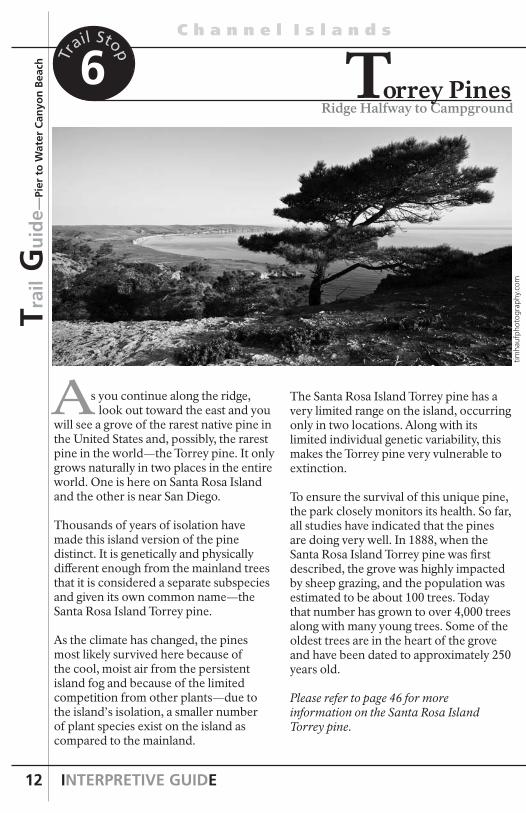
s you continue along the ridge, look out toward the east and you will see a grove of the rarest native pine in the United States and, possibly, the rarest pine in the world—the Torrey pine. It only grows naturally in two places in the entire world. One is here on Santa Rosa Island and the other is near San Diego.
Thousands of years of isolation have made this island version of the pine distinct. It is genetically and physically different enough from the mainland trees that it is considered a separate subspecies and given its own common name—the Santa Rosa Island Torrey pine.
As the climate has changed, the pines most likely survived here because of the cool, moist air from the persistent island fog and because of the limited competition from other plants—due to the island’s isolation, a smaller number of plant species exist on the island as compared to the mainland.
A
Ridge Halfway to CampgroundTorrey Pines
Trai
l Gu
ide—
Pier
to
Wat
er C
anyo
n B
each
The Santa Rosa Island Torrey pine has a very limited range on the island, occurring only in two locations. Along with its limited individual genetic variability, this makes the Torrey pine very vulnerable to extinction.
To ensure the survival of this unique pine, the park closely monitors its health. So far, all studies have indicated that the pines are doing very well. In 1888, when the Santa Rosa Island Torrey pine was first described, the grove was highly impacted by sheep grazing, and the population was estimated to be about 100 trees. Today that number has grown to over 4,000 trees along with many young trees. Some of the oldest trees are in the heart of the grove and have been dated to approximately 250 years old.
Please refer to page 46 for more information on the Santa Rosa Island Torrey pine.
timha
ufph
otog
raph
y.co
m
6Trail Stop

SANTA ROSA ISLAND
N a t i o n a l P a r k
13
f you were to walk along the edge of the marine terrace below, you would discover tiny fragments of broken shells glittering in the soil and piles of shells falling out from the cliff edge. How did these shells get there? Must be the ocean at work—or is it?
Archeologists identify this as a “midden,” a debris pile containing remnants of those societies who came before—the Chumash and their ancestors. This midden is just one of over 700 archeological sites on Santa Rosa Island that have been discovered, ranging from small temporary camps to larger villages. In fact, the oldest human remains yet discovered in North America came from Santa Rosa Island’s remote northwest shoreline and date back over 13,000 years.
Spanish mission records indicate that up to 1,200 Chumash lived in eight villages distributed around the island’s coast, including a village here in Bechers Bay (near the ranch area). On the terrace above Southeast Anchorage there is a prehistoric village site dating back at least 7,500 years ago, where depressions in the ground mark individual thatched hut locations.
These midden sites offer us a window into the Chumash world. By examining these sites, archeologists can piece together a picture of their ancient island life. The Island Chumash were skilled crafts people and seafarers with a vast knowledge of the world around them and how to use it for their survival. The predominance of shells and fish bones within the midden reveal that although the islanders exploited terrestrial plant resources, such as acorns and cherries,
IA Window into Their World
On Ridge Overlooking Campground Entrance
7Tr
ail Stop Trail G
uid
e—
Pier to W
ater Can
yon
Beach
they subsisted primarily on fish, shellfish, and other marine organisms. They often plied the channel in search of this rich variety of marine food, traveling in tomols (canoes) made of redwood or pine planks caulked with tar from natural seeps.
The midden also reveals that other items not available in this isolated island environment had to be obtained from villages on the mainland or other islands. One of the principal products manufactured and traded by the islanders were shell beads, which were the currency of trade in the Chumash area and throughout California. Chert microdrills were used to bore holes in pieces of olivella snail shells to produce these beads.
timha
ufph
otog
raph
y.co
m
continued on next page

INTERPRETIVE GUIDE
C h a n n e l I s l a n d s
14
On Ridge Overlooking Campground Entrance
Taking from or disturbing archeological sites or artifacts is a violation of state and federal law. The archeological sites around the Channel Islands are a testament to the importance of the Chumash and other American Indians. Archeological sites are sacred to Chumash peoples today, are protected by federal law, and are a vital nonrenewable scientific resource. Please help us in protecting and preserving this rich part of California’s heritage.
7Trail Stop
Trai
l Gu
ide—
Pier
to
Wat
er C
anyo
n B
each
continued
Not only did the islands have an abundance of olivella shells, but also, even more importantly, Santa Cruz Island (which lies to the east) had considerable natural deposits of chert, a hard durable silica rock. Eastern Santa Cruz Island was the center for manufacturing chert microdrills, as this location had chert of the proper type and quality for such tools. One particular site contains evidence of the highest density of microdrill production in North America. Other sites on Santa Rosa and Santa Cruz Islands have been labeled by archeologists as “bead factories,” with amazing amounts of discarded drills and bead debris.
Santa Rosa Island was not isolated enough to protect the Chumash from the diseases the Spanish brought with them as they began colonizing California in the late 1700s. By the early 1800s, the island Chumash had been devastated by measles, other introduced epidemics, drought, and the disruption of their trade-based economy. The last of the Chumash
islanders would leave their traditional island home in 1822.
Although much has been lost, enough remains to remind us of this unique part of the island’s past. These midden sites, along with today’s descendants of the Island Chumash, remind us on another level how important and sacred these isolated islands are.
SANTA ROSA ISLAND
N a t i o n a l P a r k
15
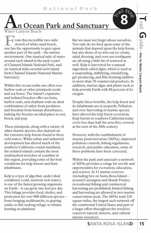
rom this incredible two-mile stretch of white sand beach, one has the opportunity to gaze upon another part of the park—the marine environment. One nautical mile of water around each island in the park is part of Channel Islands National Park, and six nautical miles around each island form Channel Islands National Marine Sanctuary.
Within this ocean realm one often sees harbor seals or other pinnipeds (seals and sea lions). The island’s expansive and isolated beaches offer sea lions, harbor seals, and elephant seals an ideal combination of safety from predators and freedom from human disturbance, making the beaches an ideal place to rest, breed, and pup.
These pinnipeds, along with a variety of other marine species, also depend on the extensive kelp forests found in these cold waters. While urban and industrial development has altered much of the southern California coastal mainland, the isolated islands contain the most undisturbed stretches of coastline in this region, providing some of the best conditions for kelp forests and their inhabitants.
Kelp is a type of alga that, under ideal conditions (cold, nutrient-rich water), is one of the fastest growing organisms on Earth—it can grow two feet per day. This foliage provides food, shelter, and protection for over 800 different species—from foraging nudibranchs, to grazing snails, to fish seeking refuge, to whales feasting on plankton.
Water Canyon Beach
8Tr
ail Stop
But we must not forget about ourselves. Not only do we feed upon some of the animals that depend upon the kelp forest, but also those of us who eat ice cream, salad dressing, and even use toothpaste are all using a little bit of seaweed as well. Kelp is harvested for a natural ingredient called algin, which is used as a suspending, stabilizing, emulsifying, gel-producing, and film-forming additive in more than 70 commercial products. In addition, marine algae and plants such as kelp provide Earth with 80 percent of its oxygen.
Despite these benefits, the kelp forest and its inhabitants are in jeopardy. Pollution and over-harvesting of marine species have altered the kelp forest ecosystem. Kelp forests in southern California today cover less than half the area they covered at the turn of the 20th century.
However, with the establishment of marine protected areas (MPAs), improved pollution controls, fishing regulations, research, and public education, some of these problems have been corrected.
Within the park and sanctuary a network of MPAs provides a refuge for sea life and opportunities for recreation, education, and science. In 11 marine reserves (including two on Santa Rosa Island—around Carrington and Skunk Points), recreational fishing and commercial harvesting are prohibited; limited fishing and harvesting are allowed in two marine conservation areas. The MPAs total 318 square miles, the largest such network off the continental United States and part of a larger effort throughout the world to conserve natural, historic, and cultural marine resources.
Trail G
uid
e—
Pier to W
ater Can
yon
Beach
continued An Ocean Park and Sanctuary
F
INTERPRETIVE GUIDE
C h a n n e l I s l a n d s
16
n 1980 Congress established Channel Islands National Park to protect, preserve, and teach us about the islands’ fragile resources and unique past, including the Island Chumash and those who came after them, the island fox that recovered from the brink of extinction, the restoration of the islands’ native plants, the complicated geologic story, the Santa Rosa Island Torrey pine that occurs nowhere else on Earth, the kelp forest and its inhabitants that depend on these isolated islands for survival, and the wide variety of other natural and cultural resources not mentioned in this trail guide. By understanding these resources and the role isolation plays on these islands, we can help preserve them for future generations to study and enjoy.
The National Park Service needs your help as well. We encourage you to explore and learn more about Santa Rosa Island and the rest of the Channel Islands. But don’t stop there. In recognizing the importance of these islands, take your awareness to the action level. Make every effort to safeguard—to preserve—the plants, animals, and artifacts found not only within this park, but also throughout the world as well.
Protecting the Islands
Water Canyon Beach
8Trail Stop
Trai
l Gu
ide—
Pier
to
Wat
er C
anyo
n B
each
continued
I
santa rosa photostim
hauf
phot
ogra
phy.
com

SANTA ROSA ISLAND
N a t i o n a l P a r k
17
continuedHichimin The second largest historic Chumash village on Santa Rosa Island, Hichimin, was located within the Vail & Vickers ranch area near the mouth of Ranch House Canyon. Current research and radiocarbon dating suggests that this site was first occupied 650 years ago. At the time of European contact (Juan Rodríguez Cabrillo’s voyage in 1542) the village was home to approximately 75 Chumash, including many high-ranking families, a powerful chief, and tomol (plank canoe) owners.
Although Chumash occupation of Santa Rosa Island ended in the early 19th century, many individuals today can trace their ancestry to specific villages on the island and retain a lively interest in the preservation and management of their heritage. Between three and ten thousand Chumash live in California today.
Place NameAccording to Channel Islands historian Marla Daily, Bechers Bay, as we know it today, has had a variety of different names throughout history.
An 1871–72 US Coast Survey map lists it as Mores Harbor. An unpublished US Coast Survey map by Stehman Forney from 1873 simply lists it as N.W. Anchorage. Yet another US Coast Survey map from 1882 labels it as Bechers Bay. News accounts in 1877 and 1910 and a 1952 US Geological Survey Map describe it as Beechers Bay. However, the 1974 and 1993 US Geological Survey maps list it as Bechers Bay.
The Santa Barbara historian Clif Smith speculated that the bay was named for explorer and naval officer Sir Edward Belcher (who was stationed off the west coast in the 19th century), and the name was just misspelled.
Vail & Vickers ranch area Vail &
Vickers R
anch
Area
Given all this, it’s probably best just to follow island rancher Al Vail’s advice to Marla Daily: “Either one works, but I’ve always called it Bechers and spelled it that way.”
More Sheep Ranch Ranching began on Santa Rosa Island in 1844 shortly after the island was granted to the Carrillo family by the Mexican government. From 1858 to 1901 the More family ran one of the largest sheep ranches in the state on the island with up to 80,000 sheep.
Marvels of the New West, published in 1888, reprinted a long article from the San Francisco Call about the “mammoth” sheep ranch of A. P. More:
The island is divided into four quarters by fences running clear across at right angles; and the sheep have not to be herded like those ranging about the foothills. Four men are employed regularly the year round to keep the ranch in order and to look after the sheep; and during shearing time fifty or more shearers are employed.
These men secure forty or fifty days’ work; and the average number of sheep sheared a day is about ninety, for which five cents a clip is paid; thus, $4.50 a day is being made by each man, or something over $200 for the season, or over $400 for 90 days out of the year. Although the shearing of 90 sheep a day is the average, a great many will go as high as 110; and one man has been known to shear 125.
Although no herding is necessary, about two hundred or more trained goats are kept on the island continually, which to all intents and purposes take the place
continued on next page
INTERPRETIVE GUIDE
C h a n n e l I s l a n d s
18
Vai
l & V
icke
rs R
anch
Are
a of the shepherd dogs so necessary tomountainous districts where sheep are raised.
To prevent the sheep from contracting disease, it is necessary to give them a washing twice a year. Moore [sic] having so many on hand, found it necessary to invent some way to accomplish this . . . After experimenting for some time, he had a ditch dug eight feet in depth, a little over one foot in width, and one hundred feet long. In this he put six hundred gallons of water, two hundred pounds of sulphur, one hundred pounds of lime, and six pounds of soda, all of which is heated to one hundred and thirty degrees. The goats lead the sheep into a corral or trap at one end, and the animals are compelled to swim through to the further end, thus securing a bath and taking their medicine at one and the same time.
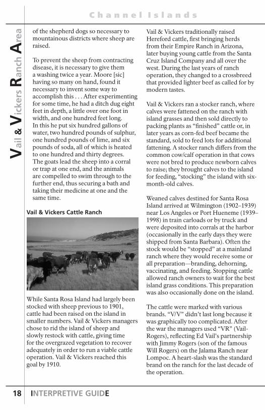
Vail & Vickers Cattle Ranch
While Santa Rosa Island had largely been stocked with sheep previous to 1901, cattle had been raised on the island in smaller numbers. Vail & Vickers managers chose to rid the island of sheep and slowly restock with cattle, giving time for the overgrazed vegetation to recover adequately in order to run a viable cattle operation. Vail & Vickers reached this goal by 1910.
Vail & Vickers traditionally raised Hereford cattle, first bringing herds from their Empire Ranch in Arizona, later buying young cattle from the Santa Cruz Island Company and all over the west. During the last years of ranch operation, they changed to a crossbreed that provided lighter beef as called for by modern tastes.
Vail & Vickers ran a stocker ranch, where calves were fattened on the ranch with island grasses and then sold directly to packing plants as “finished” cattle or, in later years as corn-fed beef became the standard, sold to feed lots for additional fattening. A stocker ranch differs from the common cow/calf operation in that cows were not bred to produce newborn calves to raise; they brought calves to the island for feeding, “stocking” the island with six-month-old calves.
Weaned calves destined for Santa Rosa Island arrived at Wilmington (1902–1939) near Los Angeles or Port Hueneme (1939–1998) in train carloads or by truck and were deposited into corrals at the harbor (occasionally in the early days they were shipped from Santa Barbara). Often the stock would be “stopped” at a mainland ranch where they would receive some or all preparation—branding, dehorning, vaccinating, and feeding. Stopping cattle allowed ranch owners to wait for the best island grass conditions. This preparation was also occasionally done on the island.
The cattle were marked with various brands. “V/V” didn’t last long because it was graphically too complicated. After the war the managers used “VR” (Vail-Rogers), reflecting Ed Vail’s partnership with Jimmy Rogers (son of the famous Will Rogers) on the Jalama Ranch near Lompoc. A heart-slash was the standard brand on the ranch for the last decade of the operation.

SANTA ROSA ISLAND
N a t i o n a l P a r k
19
Vail &
Vickers R
anch
Area
From the harborside corrals, vaqueros loaded the calves through chutes and ramps onto a vessel, either a barge, Vaquero, or Vaquero II. The vessels had pens aboard to regulate the number and weight of animals. Loading preferably occurred in the dark. After a voyage of five to eight hours the livestock were unloaded onto the pier at Bechers Bay. After about three days in pens at the ranch house, where they would be fed and observed, calves were distributed to one of the six pastures on the island.
The total number of cattle depended on the past weather, abundance of grass, and general range condition. During some dry years managers kept the ranch half stocked; the usual stocking level would reach about 6,000 to 7,000 head at the “spring peak.” The largest number of cattle on the island at one time, consisting largely of calves, was about 9,000.
Vail & Vickers stocked the island using a double season strategy, where an overlap occurred between new calves and finished cattle that gave them two green seasons. From a new 300- to 450-pound calf arriving in the winter and early spring to a 750- to 1,000-pound feeder steer ready for shipping the following late spring and early summer, a steer spent roughly eighteen months on the island, gaining about 600 pounds.
While the herds could wander freely throughout the large pastures on the island, they tended to stay in groups in particular areas. The cowboys kept an eye on them but didn’t interfere unless necessary, to doctor them or improve pasture utilization. Even at roundup time, the cowboys avoided roping cattle; instead they kept the cattle gentle by not “running ‘em.” No supplementary feed was necessary. If the range conditions became poor, cattle were shipped off the
island rather than import feed, which was expensive and labor intensive.
At roundup and shipping time the island came alive. The roundup followed a 100-year-old tradition of vaqueros tending cattle on horseback. The roundup, an icon of the romance of the West, is in reality a hard, dirty job that requires concentrated preparation, precise execution and judgment—and a good spell of rest when it is all over. The art of the roundup has been fully understood only by those who have participated in the activity. It requires a sure horseman or horsewoman on a good horse, both possessing agility and endurance; a knowledge of the land being worked, coupled with a good eye and a sense of how a steer thinks; and, perhaps most importantly, the ability to work as a team with little direct communication.
The island cowboys and their family members spent three months in the spring on roundups around the island. Before the 1960s, cowboys gathered cattle to roundup grounds across the island mostly without the benefit of corrals. The eventual use of corrals throughout the island made roundups easier and faster and cut the number of cowboys needed. After being rounded up, the cattle were moved to smaller pastures close to the ranch in Bechers Bay and then eventually to the pens at the ranch, where they were carefully weighed in the scale house and assigned pens for shipment on the boat or barge.
During the Vail & Vickers years, a variety of vessels were used to ship the cattle to the mainland, including the Mildred E., Santa Rosa Island, Vaquero, Santa Cruz, barges and landing crafts, and, beginning in 1958, the Vaquero II. What follows is one person’s account of the loading
continued on next page

INTERPRETIVE GUIDE
C h a n n e l I s l a n d s
20
Vai
l & V
icke
rs R
anch
Are
a operation:
The boat used for this unusual operation, the Vaquero II, is basically a shallow-drafted, floating cattle pen built especially for this purpose. The original Vaquero was pressed into service during World War II and never returned to Santa Rosa. The Vaquero II, a smaller boat, holds 100 head … I watched the boat pull alongside the dock one morning. It was 4:00 am, dark and cold. An overhead light illuminated the end of the pier. Silhouettes of the cowboys could be seen against the morning sky. The voice of the foreman rose above the crashing of the waves on the beach.
When all was ready the overhead light was switched off then on, a signal to the cowboys to start the first group of 15 down the pier. Three vaqueros on horseback galloped behind the stampede. When the cattle reached the first planks of the pier they tried to stop, but the vaqueros cracked their whips and yelled, as their horses reared in the air. The herd was pushed reluctantly down the pier into a chute, forcing them to go single file. They were encouraged to keep moving with electric cattle prods or hot shots. Finally, each steer scrambles down the rusty ramp to the boat, where they were packed in so tightly they could not move.
As dawn broke, the Vaquero II, low in the water, began its journey, a journey it and the Vaquero before it had completed hundreds of times for more than 90 years. From Santa Rosa Island the Vaquero II lumbers the 55 miles to Port Hueneme where the cattle are sold at auction.
The sale price was based on weight on the island at the time of shipping. Cattle lost some weight on the boat trip to the
mainland and even more during shipping to feed lots. Vail & Vickers shipped cattle by rail in the early years and later by truck, to feed lots all over the West, including the Rockies states and the Midwest. Vail & Vickers owned a feedlot at Walnut, California, until around 1984. After 120–150 days of feeding on grains and supplements, the cattle were slaughtered and sent to markets as choice beef.
Cultural changes in the country after World War II helped raise public awareness of the importance and fragility of the resources on the Channel Islands. The booming post-war economy brought increased visitors and residents to California, especially to the scenic coastal areas, which saw greatly increased development. Events like the Santa Barbara oil spill and the discovery of the effects of DDT on seabird populations heightened environmental awareness and calls for protection of coastal resources.
On March 5, 1980, President Jimmy Carter redesignated the Channel Islands National Monument islands of Anacapa and Santa Barbara as a national park and added Santa Cruz, San Miguel, and Santa Rosa Islands.
In 1986 the National Park Service acquired Santa Rosa Island from Vail & Vickers for nearly $30 million. The ranching operation continued until 1998 when the final roundup brought a close to the last working island cattle ranch in the continental United States and an end to a truly unique way of life.

SANTA ROSA ISLAND
N a t i o n a l P a r k
21
Vail &
Vickers R
anch
Area
Hunting—Pigs, Deer, and Elk
Hunting had a long tradition on Santa Rosa Island, with the earliest reference dating back to 1853. Nonnative pigs, deer, and elk were all privately andcommercially hunted on the island.
PigsThe origin of pigs on the island has not been determined, although it is known that sometime after 1844 Alpheus Thompson raised “a lot of hogs.” Since then, pigs had become a source of delight to the hunter and a bother to the rancher. Charles Holder wrote in 1910 that “years ago wild pigs were placed on the island and are now ‘wild hogs’ . . . dangerous to approach or hunt on foot.” Al Vail stated that hogs inhabited the island long before Vail & Vickers took possession of the island in late 1901. In the early 1930s, according to Vail, they traded hogs for Catalina Island quail, shipping them over on the Vaquero.
Arthur Sanger, who hunted hogs on the island between 1910 and 1917, described “wild hogs weighing as much as 150 and 200 lbs. with curved tusks six inches long. They have the appearance of large hyenas, high heavy shoulders and low rumps.” He continued, “Many times they charged us with their teeth snapping with a grinding noise as if they wanted us to know what to expect if they reached us, but they never did. At the time I will admit that I felt more like running than shooting. We had
some exciting experiences and we learned that if you corner or wound a tusker, he will always charge you.”
Not only was pig hunting a popular sport on the island, it also became a necessary means to keep the population in check and slow the damage caused by their voracious rooting. Vail claimed that the hogs ate the cattle’s molasses blocks and dug up valuable soil, which caused erosion, encouraged weeds, and reduced pasture productivity.
The NPS decided to eliminate the feral pigs, citing soil disturbance and the nonnative status of the approximately 500 to 4,000 animals (the population varied wildly depending on island conditions). The 1984 supplement to the General Management Plan noted that feral pigs, not to mention livestock, elk, and deer, would be removed from Santa Rosa Island. A major eradication effort in 1991 and 1992 eliminated all pigs from the island.
Elk and DeerThe elk and deer herds originated with the desire of the ranch owners to make the island “a sportsman’s paradise.” Walter Vail’s sons, N. R., Mahlon, and Ed were ranchers and businessmen and worked to import elk and deer as a source of income and for their pleasure and that of visitors.
The first record of elk on the island came from a writer that visited the island in 1892 and reported on an ill-tempered pet female elk that “weighed as much as an ordinary horse.” N. R. Vail wrote that around 1905 they obtained three elk from Oregon and a few years later a bull. One story goes that around 1908 an old elk that had been the mascot for the Elks Club in Long Beach was retired and
E. K
. Sm
ith C
olle
ctio
n
E. K. Smith, born on Santa Rosa Island, hunted regularly with his family.
continued on next page

INTERPRETIVE GUIDE
C h a n n e l I s l a n d s
22
taken to the island. Other family members recalled that the elk were imported in the 1910s. In 1911 a local newspaper reported on a herd of nine elk on Santa Rosa Island, stating, “it is an ideal range for them, and the day may come when the island may be well stocked with this species of game, now becoming extinct in other portions of the continent. Absolute protection is guaranteed them on the island.” By 1994, the elk population had grown to approximately 900.
Margaret Vail Woolley said that the elk “were brought over with the idea that someday they’d be hunted, or at least they’d be meat producers and be profitable.” Difficulty in getting fresh meat to shore, the depression, and refrigeration problems hindered those plans, and the elk were hunted only sporadically.
Family members and friends of the Vails and the Vickers enjoyed elk hunting. In the 1950s, under Ed Vail, a number of prominent men came to the island to hunt not only elk but also deer and pigs, including Governor (and later Chief Justice of the Supreme Court) Earl Warren, Bing Crosby (who had a ranch in Nevada and sold cattle to the Vails), and newspaper publisher and More descendant Thomas Storke.
Deer have been reported on Santa Rosa Island as early as 1880. The Vails brought deer over from Arizona’s Kaibab National Forest in 1929–30. By 1994, the deer population had grown to approximately 1,000.
The Vail family began hosting commercial hunts for elk, deer, and pigs as early as 1979. Multiple Use Managers Inc. was hired to help manage the herds and to operate the commercial hunts. This business relationship lasted for the entire 32 year run of the commercial hunting program on Santa Rosa Island.
The federal government purchased the island in 1986 and Vail & Vickers retained a 25 year right to use and occupy most of the ranch complex at Bechers Bay. The NPS also permitted the hunting operation for that period. The deer and elk were eliminated in 2011.
Cowboy Life
The life of a cowboy, as personified in tales of the old west, had perhaps its ideal venue on Santa Rosa Island. Although without a saloon to saunter down to in the evening and lacking in shoot-outs, island cowboys were isolated from mainland progress and hence hung on to a passing way of life for a few extra decades. Once left at the Bechers Bay pier, the cowboy did almost nothing but be a cowboy, day and night. Life revolved around the bunkhouse, tack room, and range, as the men herded cattle, fixed fences and cared for their tack and horses.
Al Vail, for 25 years a cowboy then 36 more as ranch manager, described the life of a Vail & Vickers employee: “A cowboy does a little o’ everything. You know, the reason for the island is to run cattle . . . in between when we’re shipping cattle there’s lots of other work, like fence building, breaking colts, do anything that comes along as far as maintaining a ranch.”
Vai
l & V
icke
rs R
anch
Are
a
E. K
. Sm
ith C
olle
ctio
n
A large group of vaqueros and Vail family members line up in front of the ranch house at roundup time in the 1940s.

SANTA ROSA ISLAND
N a t i o n a l P a r k
23
Vail & Vickers needed six or seven men to handle the day-to-day ranch duties and, before building corrals around the island in the 1950s and 1960s, required even more for roundups. Most cowboys tended to be happy with the island life, and the managers were lucky to have steady crews, especially in the 1930s and 1940s. Vail spoke on the hiring practices at the ranch:“Most of the personnel we have we get through word of mouth . . . We never had any luck going through an appointment agency . . . If the guy’s a good cowpuncher and he says his friend is a good cowpuncher then you hire him.”
Many cowboys followed the Vail family from their ranch in Arizona to Santa Rosa Island in the years after the island was purchased. One of the most storied of the old Arizona cowboys was Juan Ayon, who spent over 50 years chasing cattle, building fences, cooking, and keeping gardens on the island. Ayon was born in 1887 in Mexico and worked at the Empire Ranch for many years, forming a bond with the Vail family that lasted three generations. He is thought to have arrived at Santa Rosa Island around 1911. It has been written that:
Juan, who was heavy-set with a short, stocky build, had great physical strength, and possessed many talents. He was not only an experienced cowboy, but also a good ranch hand as well—he milked cows, built fences, broke horses, nurtured the island’s garden, and occasionally worked as the island cook (he always gave that assignment a fight and often ended up cooking only for himself!). Apparentlyhis reputation of having a curmudgeon-like personality combined with a slightly humorous nature was well-deserved.
Many of the cowboys, like Jesus Bracamontes, came from Mexico. Jesus was born in January 1925 in Sonora,
Mexico, and spent his whole life as a cowboy in Mexico and the United States; he worked for more than 35 years on Santa Rosa Island. During WWII the Vails enrolled in the Bracero Program, created by the Farm Security Administration and the Mexican government to help staff agricultural operations at a time when labor was short. The program granted temporary visas to 2.6 million Mexican citizens and helped find them work in the United States.
Cowboys worked seven days a week, sunrise to sunset. They were allowed four days paid leave on the mainland every six to eight weeks, or every month if not working cattle (vaqueros were also given longer vacations to go home to Mexico). It was an isolated life, where you couldn’t run to town when you wanted. Office manager Tom Thornton took care of supplies for the cowboys:
They’d send us a shopping list or call over after the phone became a very common and very easy thing to use. A simple matter. They would hope that [the clothes] fit. They always buy their shoes large so they can get thick socks or thinner socks. Buy their leather to make their chaps and to make saddles and buy their rope for their lassoes etc. You are dealing with a real family over there.
The risks of isolation, of getting injured or seriously ill out on the island, didn’t seem to bother many of the cowboys. Bill Wallace, who was hired in 1948 and was ranch foreman from 1968 to 1999, probably put it best when he said, “I’ve been out here just about fifty years. Well, once you get out here, it’s damned hard to find a reason to ever go back. I only go into town when I absolutely have to. That’s about once or twice a year. And that’s too [expletive deleted] much.”
Vail &
Vickers R
anch
Area
continued on next page
E. K
. Sm
ith C
olle
ctio
n

INTERPRETIVE GUIDE
C h a n n e l I s l a n d s
24
Vai
l & V
icke
rs R
anch
Are
a
Tom Thornton speculated on why Vail & Vickers was so successful in getting and keeping good cowpunchers on the ranch:
[T]he Vail & Vickers cowboys are probably the best fed cowboys in the world. They get what they want. Al has no restrictions on . . . reasonable foods. So they eat very well. Probably that’s one reason they stay so long. They are probably the best paid cowboys in the country. There is nothing “pickey-unish” about Santa Rosa people.
Santa Rosa Island provided a unique backdrop for ranch life. While it was not the life for everyone, many of the cowboys and foremen stayed on for much of their working lives, dedicated to the island traditions and their employers. Those traditions contributed to the preservation of the “old ways” on Santa Rosa Island, a place almost untouched by the hurry of city life and pressures of development from nearby suburbs. The end of ranching in 1998 brought to a close a truly unique way of life in coastal California.
Horses
Santa Rosa Island’s herds of horses served many purposes. Foremost, they worked at the most critical times of ranch operation: roundups and moving cattle. They also provided transportation, labor, and recreation for visitors and family.
Ranch managers kept about forty head of riding horses as well as twelve to fifteen brood mares. Additional horses, including yearlings, resting, and retired horses, brought the number to well over a hundred. The horses, mainly quarter horses, were bred and raised for ranch use. Known around southern California as a fine herd of cattle horses, each was trained by the cowboys and foremen to perform the jobs unique to the island.
Diego Cuevas spoke of the ranch philosophy on horses:
Important part of the island was the horses, was number one . . . you gotta learn from the horses, teach ‘em to lead, got to teach ‘em so you can walk to and touch and play with their feet and make them gentle. That’s one of the most important parts. So you have the job, the cowboy gotta do all those things like that. You know, train the horses from beginning from baby to three or four years old. So you can drive it and then
E. K
. Sm
ith C
olle
ctio
n
Two unidentified vaqueros in the 1940s display typical island dress and a riata, or lasso.
E. K
. Sm
ith C
olle
ctio
n
Ed Vail at the main ranch, 1940s.

SANTA ROSA ISLAND
N a t i o n a l P a r k
25
Vail &
Vickers R
anch
Area
you start teaching it how to respond to the reins. Once you do that you start teaching it how to work cows. And you try your best to make a good gentle horse at the same time. Working horse and gentle horse. Lot of the horses they see that they begin to get to be gentle and nice, you can play with them and they make good kid horses, because on the island you always have somebody that never ride a horse and then you can put him on the horse and you can trust him.
A cowboy would be assigned five or six horses to ride and take care of. Usually he would break his own horses, train them, and use them exclusively at roundups.
Working island horses spent their time in the House Field, roughly 640 acres west of the ranch complex. When not working or past their prime, horses were turned out in the high elevations of Soledad Mountain and Pecho Peak. Ranch workers sowed oat fields in the flat areas east and south of the ranch house to produce feed for the horses; ranch workers cut and baled oat hay in May, weather permitting.
Earlier in the century, horses performed most of the transport labor, hauling wagons of materials to various parts of the island. The first ranch vehicle, a Fordson tractor, arrived in 1939, and island managers started to use trucks in the 1950s, but horses remained the favored mode of transportation. The Vail children and their friends looked forward to island visits, which afforded the freedom of riding in the hills, searching out pigs, and having picnics in favorite spots.
BoatsVail & Vickers, as well as their neighbors on the Channel Islands, operated unique livestock businesses wherein their location required a transportation system entirely relying on boats and, to a smaller extent, aircraft. From the time of Alpheus Thompson shipping cattle and sheep on a small schooner to the final shipment of cattle off Santa Rosa Island, boats have played a key role in ranch operations. Santa Rosa Island owners almost always had a boat specifically for transporting livestock, supplies, and personnel. Few other places in the Americas operated this way, and the Vail & Vickers ranch was among the last.
Mildred E., 1901–1909The wooden, two-masted Mildred E. was built in 1884 in Meteghan, Nova Scotia, and was registered by Walter L. Vail and J. V. Vickers in December 10, 1901. Vail & Vickers used Mildred E. in island service for a short time. In 1903 the firm had the Santa Rosa Island constructed expressly for livestock transport, leaving Mildred E. to few duties. Proving unsatisfactory to the needs of the company, Vail & Vickers abandoned Mildred E. in 1909, claiming she was unfit for service.
Santa Rosa Island, 1903–1915 Some confusion has existed as to the Santa Rosa and the Santa Rosa Island. They were actually two different vessels. A. P. More’s sailing schooner Santa Rosa wrecked in San Miguel Island’s Cuyler Harbor in November 1899. Vail & Vickers contracted construction of the 87-foot, gasoline schooner Santa Rosa Island in Wilmington, California in 1903. Vail & Vickers put her to work hauling sheep off the island by July of 1903.
After the ranch owners obtained the Vaquero, three of Walter Vail’s sons—N. R., Ed and Banning—took the Santa Rosa
continued on next page
E. K
. Sm
ith C
olle
ctio
n

INTERPRETIVE GUIDE
C h a n n e l I s l a n d s
26
Vai
l & V
icke
rs R
anch
Are
a Island on a four-month voyage to Mexico in 1915, leaving San Pedro for Cabo San Lucas, the Gulf of California, and Mazatlán. They and their friends, with a hired captain and cook, spent their time “fishing, hunting, trading with the locals of coastal fishing villages, and socializing with Mazatlán’s upper society of the day.” Apparently the boat was sold shortly after the trip to Mexico and entered service in the South Pacific.
OnwardSmaller boats served the island’s smaller needs for transportation to and from Santa Barbara for supplies and provisions. Vail & Vickers’ power boat Tortuga operated around Santa Rosa Island in the early 1910s, hauling supplies and mail for various camps on the island. Little else is known of it or of Colleen, another small vessel on the island. Vail & Vickers purchased the 64.5 feet long motor launch Onward for $7,737 in 1921 to perform errands around the island and channel in the 1920s and 30s. C.W. Smith, ranch foreman, used her for various tasks, including retrieving lumber from a wreck that came in handy for building corrals. Smith reportedly took Onward to Santa Barbara after the 1925 earthquake to check on damage there. The Vails kept her on a mooring at Bechers Bay. Vail & Vickers sold Onward in August 1942 to the DeLuxe Water Taxi Company, hoping to stave off the potential military seizure of the main island boat Vaquero, reasoning that the government would not take their only vessel; the attempt failed.
Vaquero, 1913–1943To bring consistency and reliability to the island cattle transportation challenges, Vail & Vickers commissioned a new cattle boat in 1913 and christened her Vaquero. She was not the first Vaquero to operate in southern California waters. Harris Newmark recalled that a steamer Vaquero offered excursions from San Pedro to
Santa Catalina in August of 1871. Vail & Vickers registered Vaquero in 1914.
William Muller built Vaquero as a sturdy workhorse of a ship. She measured 121 feet and was “beamy,” or wide, in order to handle the cattle cargo and of a shallow draft to allow navigation close to shore.
Rigged with two masts, she had six staterooms to sleep 18, a galley and dining room, and two toilets in the single deckhouse. Three generators supplied electricity for lights, an icebox, and a 25-watt radiophone. Two fuel tanks held 2,000 gallons each, and two water tanks stored a total of 1,800 gallons. She was originally powered by a gasoline engine, which was replaced in 1928 with a Western Enterprise six-cylinder diesel.
The holds, divided into five cattle pens, had a capacity of about 10,000 cubic feet, or 200 head of cattle, which constituted seven carloads (rail cars) on the mainland. The deck, equipped with 3.5-foot gunnels topped with two-by-sixes to hold the
E. K
. Sm
ith C
olle
ctio
n
The original Vaquero, circa 1940.

SANTA ROSA ISLAND
N a t i o n a l P a r k
27
Vail &
Vickers R
anch
Area
cattle in, was divided into ten pens. A ramp would be deployed to load and unload the cattle to and from the deck and holds.
The Vails docked Vaquero at San Pedro for many years, loading and unloading cattle at nearby Wilmington. The 115-mile trip to the island from Wilmington took at least twelve hours, and in the worst weather up to 23 hours, providing somewhat of an adventure when the Vail family came out to the island many times during the year. Margaret Vail Woolley recalled the family’s first trip to the island on the Vaquero around 1928:
My mother decided to trick us out in little yachtsman’s uniforms. So she did—little white pants, little hats. We were so cute . . . and cold and filthy but over we went and slept. There were cabins on the Vaquero then . . . we could get our whole family in the rear cabin by doubling up considerably.
On a typical weekend trip to Santa Rosa Island, the family would board Vaquero after school on Friday and sleep aboard in the staterooms during the overnight trip. A cook made hot meals in the cozy galley, a popular spot to stay warm during winter voyages. After spending Saturday and Sunday on the island, the family departed Sunday night, arriving in time for Monday morning school. During the 1930s, Russ
Vail recalled, “the vessel was used a little more easily in those days,” with cheaper fuel and labor costs, so the Vail family traveled to and from the island on the boat regularly.
Vaquero not only shipped the supplies and cattle for Santa Rosa Island, but also contracted with the other islands’ operators. In 1937 Vaquero transported much of Edwin Stanton’s new sheep to Santa Cruz Island and regularly transported Robert Brooks’ sheep to and from San Miguel Island and Ed Vail’s sheep to and from San Nicolas Island. The Vails hired out Vaquero for other purposes in the off-season, including hauling supplies to southern California ports, as a fishing barge off Santa Monica, for wreck salvage, and, at one point in the 1930s, acting as a mother ship for a whaling operation. Vaquero captain Claude Morris recalled some of the memorable off-season voyages:
The Hollywood studios used the boat for many movies. One early one was “Laurel and Hardy Go to Sea.” Other trips were hauling turtles from Turtle Bay in Mexico, tuna from San Diego, beans from Port Hueneme . . . . Catalina Island had an over population of rattlesnakes, so we hauled a group of young wild pigs to Catalina from Santa Rosa Island. Deer . . . were taken to Santa Rosa for sport hunting.
At least once Vail & Vickers delivered cattle to San Francisco, according to Morris, and made a short run to Gaviota across the channel: “There was no dock in Gaviota, so the cattle were just pushed overboard and herded ashore with skiffs, as the cattle would often swim out to sea.”
The United States’ entry into World War II caused a chain of events that would alter the sea transport of Vail &
E. K
. Sm
ith C
olle
ctio
n
continued on next page
E. K
. Sm
ith C
olle
ctio
n
Cattle in their pens aboard Vaquero, 1930s.

INTERPRETIVE GUIDE
C h a n n e l I s l a n d s
28
Vai
l & V
icke
rs R
anch
Are
a Vickers cattle for many years to come. In December 1942 Vail received a letter from Commander G. W. D. Dashiell, the port director at San Pedro’s Naval Transportation Service, informing him that the US Army would requisition Vaquero for wartime service. Vail had reportedly sold their smaller boat Onward in an attempt to circumvent taking of the Vaquero. The tactic didn’t work, so Vail renewed the ships papers on January 1, 1943 and Vail delivered the boat to the Army at San Pedro on January 14th, ending thirty years’ service by the sturdy and unique cattle boat of Santa Rosa Island.
Vaquero then traveled across the Pacific Ocean under its own power. She was spotted off Biak Island in New Guinea, painted green, but its fate after 1944 is unknown. However, one researcher traced the boat up to 1954 when it was still in use by the Army.
Barges and Landing Craft, 1943–1959
The Navy was aware of the need for beef in the war effort and, being sympathetic to the Vails’ predicament, made available landing barges to ship Santa Rosa Island cattle. The Navy used the event as an exercise, using three LCTs (landing craft) and transporting 3,000 head of cattle to the beach at Ventura. Of the landing methods, Al Vail explained simply, “Well, you drop the ramp and kick ‘em off .
. . most of ‘em didn’t even have to go through the water.”
Unfortunately for the Vails, by the fall of 1943 the landing craft were needed elsewhere. Ed Vail hired Edwin Stanton’s island schooner Santa Cruz to restock the island that fall, but found that the Santa Cruz was “totally inadequate for that size job.” Vail & Vickers turned to the only answer they could at the time— hiring barges and tugs to make the cattle movements.
For almost fifteen years following the war, the Vails used rented barges and tugs to move cattle to the mainland. At one point they bought and converted a landing craft for the job, but it sank off west Santa Cruz Island in rough weather. The barges were equipped with pens and loaded from the Bechers Bay pier using cattle chutes, as they had on the Vaquero. Occasionally, to unload calves that typically balked at entering the chute on the pier, the cowboys built a ramp of sand to the beached barge and drove the livestock ashore or drove them ashore simply by opening the pens and shooing the calves out into the shallow water.
Vaquero II, 1959–1999
After more than 15 years hauling island cattle by barge and tug, and no doubt tired of the inconvenient and costly method of transport, Vail & Vickers contracted with Lindwall Boat Works in Santa Barbara to
Sant
a Ba
rbar
a M
useu
m o
f N
atur
al H
isto
ry
A vaquero waits on shore as a tug and cattle barge are seen in the background.
Dew
ey L
ivin
gsto
n
Vaquero II during her last year in operation, 1998.

SANTA ROSA ISLAND
N a t i o n a l P a r k
29
Vail &
Vickers R
anch
Area
construct a 64'6" wooden cattle boat. Six open cattle pens constituted the bulk of the boat’s square footage, with a capacity of about 100 head of adult cattle or 210 calves. The boat would be half the size of the original Vaquero and hold half the number of livestock as cargo, but would be faster and more efficient both in operation and crew requirements (it required only a skipper and a deckhand). In February 1959, the boat was delivered to Santa Barbara Harbor for launch and the Vails christened the boat Vaquero II.
Vaquero II became a landmark at Santa Barbara Harbor. Operation between Port Hueneme and Santa Rosa Island for cattle shipments took about five hours. It made regular runs to the island (about every ten days) with food and supplies from its homeport at Santa Barbara Harbor, a trip of about three hours. Considered to be the last operating wooden cattle boat on the Pacific Coast, it handled the island cattle shipments with few breakdowns and enjoyed a reputation for seaworthiness.
The Vails also used Vaquero II to haul Stanton Ranch cattle and sheep from Santa Cruz Island after their venerable schooner Santa Cruz wrecked off anchor in a storm in 1960. Vaquero II hauled Santa Cruz Island livestock for 26 years, including the final shipment of cattle after Carey Stanton’s death in 1987. The Gherini family of east Santa Cruz Island also employed Vaquero II for their sheep shipments after their boat Hodge wrecked in 1976. Vaquero II held up to 600 sheep.
Los Angeles Herald-Examiner columnist Cholly Angeleno wrote of the challenges an uninitiated passenger might have faced on what must have been Vaquero II in the early days:
I remember when one of [the Vails’]
cattle ships stopped over at Catalina, with Ed Vail skippering the vessel. He promptly invited Hook Beardslee and me to take “the cruise” to Santa Rosa to pick up some cattle. But when we got aboard ship we promptly declined the offer. The farmyard aroma was stifling!
With the end of ranching in 1998, Vail & Vickers donated Vaquero II in 1999 to a nonprofit organization and it was converted for other uses.
Pier
For nearly 150 years, Santa Rosa Island owners maintained a pier to accommodate shipping cattle, sheep, and supplies. The first pier on Santa Rosa Island was constructed in June 1859, presumably at Bechers Bay near or at the present site of the pier. George R. Barclay, captain of the steamer Goliah, constructed the pier for a fee of $500 plus almost $1,500 in materials. By the end of the year this first wharf was destroyed in a storm.
The second ranch pier at Bechers Bay was built by the More family around 1872 or 1873 and it may have been entirely rebuilt in 1913. The pier underwent major repairs in 1945 undertaken by a contractor for the Army Corps of Engineers. Ranch crews repaired the decking in 1983 with lumber salvaged from the Air Force pier at Johnsons Lee. As of 1984 the pier was
continued on page 31
Dew
ey L
ivin
gsto
n
Dew
ey L
ivin
gsto
n
The pier with Vaquero II tied up, 1998.

INTERPRETIVE GUIDE
C h a n n e l I s l a n d s
30
Vai
l & V
icke
rs R
anch
Are
a
1
3
2
811
9
7
4
6
105
12 13
14
15
16
20 19
18
17
22 21
1. Pier 2. Rope House, Cattle Chute, and Pile Driver 3. Foreman’s House 4. Cattle Dipping Vat 5. Corrals 6. Little Red House Site 7. Scale House and Branding Shed 8. Schoolhouse 9. Bunkhouse10. Cypress Trees11. Horse Barn12. Corral Outhouse13. Blacksmith Shop Barn and Matanza Boilers14. Pig Pen15. Hay Field16. Eucalyptus Windbreak17. Main Ranch House18. Russ Vail House19. Old Reservoir20. WWII Storage Building21. Metal Shed22. NPS Buildings23. Airstrip
23
Vail and Vickers Ranch Area Map

SANTA ROSA ISLAND
N a t i o n a l P a r k
31
Vail &
Vickers R
anch
Area
described as approximately 572 feet long, with the width varying from 20 feet 3 inches to 37 feet at the end. At the east end of the pier the Vails constructed a wooden A-frame structure that held the cattle chute and a metal boom for loading and unloading heavy materials from boats and barges. The cattle chute would be lowered to the boat or barge deck off the A-frame.
The pier endured constant battering by surf and swells. With the pier a vital part of the lifeline between island and mainland, maintenance was a regular part of cowboy life. At times, the structural integrity of the pier was questionable. Margaret Vail Woolley spoke of the risks of walking on the pier “wondering if you’re going to be flung into the ocean:”
Every several years, there would be a storm that was strong enough to throw the boards off the dock so there’d be a big blank space. A lot of the boards would wash ashore down the coast and the cowboys would go get ‘em and bring ‘em back and stick them on again . . . Every now and then the pilings had to be replaced or repaired . . . and that was a kind of a casual program that went on year after year. They just patched together enough to use and then wait for it to blow up again, which made sense.
Shortly after purchasing the island, the NPS rehabilitated the pier in 1987 to increase safety and provide better visitor access. These repairs were considered temporary, and in 2012 the park completed the construction of an entirely new pier on the same footprint as the old pier.
One of the most infamous island events occurred on the pier on June 31, 1884, when A. P. More, the island owner at the
time, killed Ah You, the island cook. A newspaper initially reported that Ah You, who had been working on the island for about 16 months, felt ill and wanted to leave the island on the schooner Santa Rosa, which was docked at the pier. More accosted him and, after “the drawing of weapons,” shot the man in the head. Ah You died after arriving at the mainland.
An inquest revealed a number of probable inaccuracies in the news article. According to information gathered at the hearing, Ah You had been working unhappily as a laborer and wished to leave the island. Failing to inform More of his plans, he attempted to sneak aboard the schooner, but was seen by More who ordered that You’s belongings be removed from the schooner. Ah You allegedly attacked More with a knife, inciting More to shoot Ah You in the head. Participants in the inquest seemed to favor More over the Chinese employee. Nevertheless, the case was thrown out because the shooting occurred out on the pier some 30 feet seaward from the low-tide line, where jurisdiction could not be defined.
Rope House, Cattle Chute, and Pile Driver
Nearby lies a stiff-leg davit (a small crane) that was used on the former pier and the cattle chute for loading cattle off the pier to a boat. A wooden pile driver also remains in the yard near the pier. The pile driver was transported here for use
continued on next page
The pier with cattle chute, 1944.

INTERPRETIVE GUIDE
C h a n n e l I s l a n d s
32
Vai
l & V
icke
rs R
anch
Are
a in repairing the pier during World War II and has been used for repairs since that time, including the 1987 reconstruction of the pier by park personnel.
On the bluff near the entrance to the pier sits a rope house that was used to store lines, buoys, and other equipment for boat and shipping activities. It was relocated to this area and its date of construction and original location are unknown. The rope house was stabilized, placed on a new foundation, and reroofed by the NPS in 2003.
Corrals
Remote corrals are to the rancher as computers are to the writer—they can get along without them but they save time and energy and add to the efficiency of the operation. The circulation of livestock on the island depended on the location of roundup grounds and the various construction designs of the corrals. On Santa Rosa Island, two kinds of corral enclosures were used and still exist: the corrals at the ranch complex that were used for a number of functions, including
holding, treatment, and shipping, and the roundup corrals scattered around the island, where cattle would be herded from the surrounding rangelands into the corral (with the help of a wing fence), separated as necessary, and moved to the ranch complex at Bechers Bay for shipment.
Main Ranch CorralsThe extensive corrals at the ranch complex at Bechers Bay performed an important function in sorting and caring for cattle. They saw most use around the time of shipping, as newly arriving calves could be sorted and penned and outgoing steers lodged temporarily while being weighed and evaluated. Horses occupied the horse corral adjacent to the horse barn at roundup time.
Their layout is complex, with particular corrals used for various activities such as weighing stock, doctoring, observation, watering, and selection. The long pen paralleling the eucalyptus windbreak was used for holding cattle newly brought in for processing.
The next pen north is a watering pen, with a large trough centrally located. This pen was used for watering animals before and after shipping. It also doubled as a baseball field with local rules that included anything hit over the fence was out and anything in the water tank was a home run. To the west of the water pen is a multiuse corral adjacent to the blacksmith shop barn and rarely used for livestock except for passing through. The pens east of the horse barn were the most active at shipping time, with larger pens for holding cattle awaiting processing feeding into smaller pens that funneled the animals into either the scales, squeeze chute, dip vat, or shipping pens.
A row of six smaller pens connected by a narrow lane is aligned with the land end of the pier. These were used to separate
Dew
ey L
ivin
gsto
n
The shipping pens at the main ranch, 2000.
E. K
. Sm
ith C
olle
ctio
n
The pier with pile driver in operation.
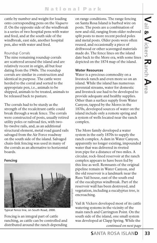
SANTA ROSA ISLAND
N a t i o n a l P a r k
33
Vail &
Vickers R
anch
Area
continued on next page
cattle by number and weight for loading onto corresponding pens on the Vaquero II. On the opposite side of the windbreak is a series of two hospital pens with water and feed, and at the south side of the windbreak, east side, another hospital pen, also with water and feed.
Roundup CorralsThe nine remaining roundup corrals are scattered around the island and are relatively recent in origin, all but four dating from the 1960s. The roundup corrals are similar in construction and identical in purpose. The cattle were herded to the corral and sorted to the appropriate pen, i.e., animals to be shipped, animals to be treated, animals to be released back to pasture.
The corrals had to be sturdy as the strength of the recalcitrant cattle could break through a weak fence. The corrals were constructed of posts, usually retired utility poles or railroad ties, with two-by-twelve rails, and, as an additional structural element, metal road guard rails salvaged from the Air Force roadway on the south side of the island. Salvaged chain-link fencing was used in many of the corrals as an alternative to horizontal boards.
Fencing
Fencing is an integral part of cattle ranching, as cattle can be controlled and distributed around the ranch depending
on range conditions. The range fencing on Santa Rosa Island is barbed wire on posts. The posts are a combination of new and old, ranging from older redwood split posts to more recent peeled poles and metal posts. Older posts were often reused, and occasionally a piece of driftwood or other scavenged materials made do. The fence lines on the island date back to the More era, with some lines depicted on the 1874 map of the island.
Water ResourcesWater is a precious commodity on a livestock ranch and even more so on an island. While the island has numerous perennial streams, water for domestic and livestock use had to be developed to provide adequate and healthy supplies. Other than a surface supply from Water Canyon, tapped by the Mores in the 1870s, developed sources of water on the island include only a remote spring and a system of wells located near the ranch complex.
The More family developed a water system in the early 1870s to supply the ranch complex. A dam in Water Canyon, apparently no longer existing, impounded water that was delivered in riveted iron pipe for a distance of two miles. A circular, rock-lined reservoir at the ranch complex appears to have been fed by this line as well. Remnants of the original pipeline remain in Water Canyon, and the old reservoir is a landmark near the Russ Vail house, east of the south end of the eucalyptus windbreak. Part of the reservoir wall has been destroyed, and vegetation, including a eucalyptus tree, is encroaching.
Vail & Vickers developed most of its cattle watering systems in the vicinity of the main ranch and Carrington Point. On the south side of the island, one small system was developed at Clapp Spring. While the
Dew
ey L
ivin
gsto
n
Typical fence line, on South Road, 2000.

INTERPRETIVE GUIDE
C h a n n e l I s l a n d s
34
Vai
l & V
icke
rs R
anch
Are
a island was well watered by natural sources (perennial streams), these sites needed development because of concentrations of cattle and lack of natural sources.The major source of water for ranch operations is located in the appropriately named Windmill Canyon west of the ranch house. At an unknown date before the 1930s someone drilled or dug a well and installed a windmill and a redwood storage tank. Water from this reliable source fed by gravity the ranch houses, outbuildings, and troughs in the ranch complex.
For some time the Vails used a tractor or old Army vehicle on jacks to pump water from the well. Later the Vails built a pump house. As of 1984, two hand-dug wells, measuring four by four feet and 40 feet deep, were present; one was active, with a storage tank in place. In the late 1980s the NPS replaced and updated the well, windmill, and pump system. Water is piped from the sources in Windmill Canyon also to the NPS housing, campground, and main ranch residences.
Clapp Spring, near the top of San Augustin Canyon, produces a fine and reliable water source. Water from the spring runs by gravity through a pipe from the springhouse at the source to a concrete watering trough on the Sierra Pablo road. No one knows who found and developed the spring. Clapp Spring allegedly got its name from an incident when its pure water cured an
old cowboy’s venereal disease. True or not, the water is excellent. Ranch workers bottled it in five-gallon containers for drinking water.
Foreman’s House
Ranch hands built a new house for the foreman in 1965. Located on a flat area north of the road from the pier to the bunkhouse and barns, the builders ran into “nothing but rock” as they dug out the area for the foundation. The building was constructed out of various materials, most salvaged, including windows left over from a construction job in Santa Barbara, and doors, walls, some cabinetry, and other items from the Air Force base at Johnsons Lee. Cowboys did the construction work, interspersing it with their other ranch responsibilities—it took about eight months to complete. The foreman’s house has three bedrooms and two bathrooms.
Schoolhouse
The isolation of island life posed a problem for families of the full-time workers when school time came. So a
Dew
ey L
ivin
gsto
n
Dew
ey L
ivin
gsto
n
The trough at Clapp Spring, 1999.
Tina
Ste
phen
s

SANTA ROSA ISLAND
N a t i o n a l P a r k
35
Vail &
Vickers R
anch
Area
continued on next page
Dew
ey L
ivin
gsto
nTi
na S
teph
ens
school was created in one of the small, older buildings on the ranch, possibly the same one that had served as a school during the More period on the island. However, E. K. Smith, former ranch employee who was born on the island, believed that his father, former ranch foreman C.W. Smith, and a Santa Barbara carpenter converted a small generator building into the school in the early 1920s.
Whatever the origin of the schoolhouse, a number of teachers were hired from Los Angeles, lived in their own room in the bunkhouse, and held classes for grades one through nine in the small one-room building.
During the 1920s and early 1930s, eight to ten children attended the school, including E. K. According to Woolley, “it was a little room . . . with a bunch of old desks, inkwells and all that. . . . Dad had a teacher for the youngsters of the workers there, like the Smiths and the Lopezes and the Gomezes . . . it was just a standard school, but it was one gal taking care of all of ‘em!”
Smith remembered it as “just like a regular school:”
We would go to school at 8 o’clock, and we had a recess and then went home at 3:00 or 3:30. At recess we’d play baseball in the corrals and stuff. We were assigned desks. They were the kind that we would just shove all our books in from the back end. My dad made the desks when he made the school. They taught us everything: penmanship, typing—they had two typewriters—and all the regular stuff: math, spelling, geography and history.
The school closed around 1932 when many of the students reached high school age. E. K. Smith recalled the difficult transition from the small island school
to a big Santa Barbara High School: “We were the last graduating class—1932. After that, they sent us over to the mainland for high school. It was hard at first. Those mainland kids gave me a rough time. Laughing at me, you know, because I was island-born. It took a long time to get used to that life.”
After the school was discontinued, it was used for guest quarters and to house ranch workers. A room was added in the early 1960s to make a more comfortable home. It was occupied by cowboys with spouses until 1999.
Bunkhouse
The current bunkhouse was built in 1970 after the original bunkhouse burned to the ground in 1969. The original bunkhouse, actually a complex of three buildings—the foreman’s residence, the bunkhouse, and the cookhouse—had been built either by Alpheus Thompson in 1855 or by the More family around 1870.It was described by Edward Vail in 1901 as a “large two-story ranch house” and was used by Vail & Vickers to house the foreman and the crew’s dining room. Men slept in a long, one-story shed adjacent to the larger building.
The bunkhouse burned to the ground on the night of November 3, 1969. Ranch cook Howard Anderson, according to Bill Wallace, former ranch superintendent, “had gotten drunk and went to sleep with a cigarette in the bed. He was sleeping upstairs in the bunk house.” A fire started
E. K
. Sm
ith

INTERPRETIVE GUIDE
C h a n n e l I s l a n d s
36
Vai
l & V
icke
rs R
anch
Are
a and was doused by Wallace and a cowboy. Later, the fire erupted again and quickly devoured the old house, cookhouse, and bunkhouse and killed Anderson.
After surveying the damage, Al Vail and Wallace sketched out a replacement bunkhouse on a napkin while returning to Santa Barbara on the Vaquero II. An architect put the plans on paper and, over the following year, Bill Wallace and his cowboys built the new bunkhouse, using much salvaged Air Force material, including doors, plumbing, toilets, basins, and lumber.
Horse Barn
The horse barn, sometimes called the saddle barn, no doubt dates from the heyday of the More sheep era. It was probably built in the mid-1870s and contains graffiti dating from the 1880s. It is presumed that the Mores used the barn for horse stables, tack rooms, wagon and feed storage, and lodging for visiting sheep shearers during the season.
No documents have been found that definitively state the uses of the barn by the Mores, although the fiesta described in an 1893 article may have taken place in this building:
For the “Spaniards,” the grand finale was always a kind of fiesta, mostly dancing in the shearing barns that were swept clean, with polished floors and gay decorations. To the music of guitars and a piano they celebrated the end of another strenuous season of labor with its neatly stored harvest of precious wool.
Vail & Vickers used the barn for stabling horses, tack rooms, feed storage, vehicle storage, and mechanic’s shop. The Navy used part of the barn to store their vehicles until the 1970s, and Vail & Vickers parked their trucks and tractor there often. A photograph of the barn taken in the 1910s shows it painted white. The Vails installed a corrugated metal roof in the 1950s and painted the barn red at that time.
The barn is the largest structure in the ranch complex. It is a four-level building
Dew
ey L
ivin
gsto
n
E. K
. Sm
ith
The bunkhouse complex, 1930. The bunkhouse where the vaqueros slept is in the right foreground, with the foreman’s residence and cookhouse partly obscured by trees.
E. K
. Sm
ith
The foreman’s house.
E. K
. Sm
ith
The ruins of the foreman’s house and bunkhouse following the fire of 1969.

SANTA ROSA ISLAND
N a t i o n a l P a r k
37
Vail &
Vickers R
anch
Area
with a long main gable flanked by shed roofs in a traditional California barn design (rectangular footprint, simple roof line, vertical board siding, no adornment).
The barn can be divided for description purposes into three long rooms. The east portion is a long shed containing a colt shed, horse stalls with feed bins, and an area with saddle racks where horses were prepared for ranch use. On the northern side of this area are two tack and storage rooms with a stairway up to the loft.
The central portion of the barn is two stories with wood plank floors and large door openings at either end. The lower part was used for feed storage, a carpenter shop, a tack room, and an area for storing fence materials. One wall contains graffiti dating to the 1880s and 1890s. The larger area of the upper story of the central barn was used for storing additional feed; the use of this area as seasonal lodging is likely. Historical graffiti is found on the west wall of the loft near the north end. The inscriptions, appearing in black paint or ink, include: “John Hicks/Nov. 11, 1896/Santa Rosa/Island;” “Henry Lopez/Oct. 31/1896” (Lopez’ inscription is accompanied by fancy but crude decorations); and “[?] May 1, 1897.”
The west portion is another shed off the main structure, with an old rough wood floor laid diagonally and otherwise one large room open at both ends with large doorways. A mechanic’s pit is located near the north end of this room. Maintenance by the NPS to this barn and the blacksmith shop barn has included painting, reroofing, and upgrading the electrical system.
Blacksmith Shop Barn and Matanza Boilers
This building has been called the blacksmith shop, freezer barn, generator barn, and a barn-utility building. It was probably constructed in the early 1870s and housed the original blacksmith shop and other workshops and utility areas. It was originally twice the size with two side-by-side, gable-roofed sheds, the western one sheltering the More’s massive matanza boilers. In 1876 a drought brought on the collapse of the wool market in California, resulting in a matanza (Spanish for “slaughter”)in which thousands of sheep were killed for their tallow. The island had been supporting up to 45,000 sheep, thousands of which would starve and, as a commodity, would go to waste. The events attracted the attention of the Santa Barbara press, resulting in an article describing the spectacle:
The slaughter of sheep for their pelts and tallow on Santa Rosa Island is still going on and will continue for some time. 25,000 sheep are to be killed, which will leave from 15,000 to 20,000 on the island. The matanza works
continued on next page
Dew
ey L
ivin
gsto
n
Dew
ey L
ivin
gsto
nD
ewey
Liv
ings
ton

INTERPRETIVE GUIDE
C h a n n e l I s l a n d s
38
Vai
l & V
icke
rs R
anch
Are
a erected by the firm are said to be among the largest and most complete on the coast. The kettles are of enormous size, large enough to take in several hundred sheep at a time. The number of carcasses boiled daily averages about 1,200. The fires are kept burning from Monday morning to Saturday evening. The sheep are skinned, the intestines taken out and the carcasses thrown into the kettles. After going through the kettles, the carcasses are thoroughly mashed up, the bones being softened so they will pulverize under the pressure of the hand. The offal is fed to hogs. In consequence of the sheep not being very fat in this year of short feed, the amount of tallow from each sheep is comparatively small; still under this systematic mode of treatment, a fair price, considering the year, can be realized per head. The skins are salted, dried and packed for market. These operations require a large force of men.
Sometime after 1948 ranch crews removed the western structure, leaving the boilers exposed to the elements. The remaining building was used by Vail & Vickers as a blacksmith shop, generator house, slaughterhouse, and cold storage that held a freezer for making ice. The building contains six rooms—a maintenance/repair shop once housing a blacksmithy, a former generator room equipped with two diesel generators, a workshop equipped with a saw and grinder, a butcher room with a loading dock out its door, and two walk-in freezers.
Scale House and Branding ShedAround 1910 Vail & Vickers built two small but functional buildings in the corrals. The scale house held a livestock scale with instruments for precise weighing of incoming and outgoing cattle. Al Vail took pride in the correct weights at shipping time, which determined the
amount of income Vail & Vickers would acquire from a sale after roundup. Weights also determined the pattern of loading cattle on the cattle boats and barges.
Near the scale house is the branding shed (or chute shed), a utilitarian shelter housing the ranch squeeze chute (this squeeze chute was installed in the 1960s to replace an older wooden one) and equipment used for processing incoming cattle and others as needed. The squeeze chute held cattle while they were vaccinated, dehorned, and castrated.
Branding, traditionally used to identify cattle on the range between ranches, was not truly necessary on the island, as there were no other ranches bordering the Vail & Vickers ranch. Finished beef didn’t need brands because they went straight to slaughterhouses. Nevertheless, the Vails marked their cattle with various brands. A “V/V” didn’t last long because it was graphically too complicated. After the war the managers used “VR” (Vail-Rogers), reflecting Ed Vail’s partnership with Jimmy Rogers (son of the famous Will Rogers) on the Jalama Ranch near
E. K
. Sm
ith
The branding shed and scale house, 1930.
Branding shed, 1999.
Dew
ey L
ivin
gsto
n

SANTA ROSA ISLAND
N a t i o n a l P a r k
39
Vail &
Vickers R
anch
Area
Lompoc. A heart-slash was the standard brand on the ranch for the last decade of the operation.
Main Ranch House
The main ranch house, also known as the Upper House, or Vail & Vickers Ranch House, was most likely built after 1869 during the More era.
The original form of the house was a two-story, gable-roofed rectangle with a one-story shed running the full length of the west side, forming an almost square floor plan. The roofs were clad with wood shingles. A brick chimney served a fireplace in the north bedroom on the second floor. At least two outbuildings stood adjacent to the house, a kitchen with a tall brick chimney, which was later absorbed into the mass of the house, and an outhouse. The Mores planted Monterey cypress trees as a windbreak to the north and east and planted two trees directly in front of the house, framing the porch.
A writer in 1893 described the “cozy ranch house, behind a group of high-shouldered Monterey cypress, squeezed out of shape by the wind. . . . Here the owner of the island lives while at home in his island kingdom.” Another writer who visited the island in the 1890s described the “hacienda or ranch house of the Mores standing near a grove of cypress trees distorted and beaten down by the strong trade winds. From here one can
look out on a little village made up of the various buildings appertaining to the business of shearing sixty thousand sheep—one of the largest herds in Southern California . . . .”
When Vail & Vickers purchased a share of the island in 1901 the picturesque two-story ranch house became the family headquarters, with generations of both families lodging there during visits and work periods. The Vail family, possessing the active role in running the island ranch, had the most impact on the life of the old house, performing maintenance and making the most use of it.
With the original floor plan, one entered the front door to a narrow hallway. Immediately on either side were doors into the two front bedrooms. At the end of the hall was a door into the living room, a long rectangular room across the back of the house with a woodstove in the northeast corner. The bathroom was equipped with a tub and a hot water tank. Water was heated in pipes that ran through the wall and through the woodstove in the living room and stored in the water tank in the bathroom.
On the south side of the living room, there was a breezeway with a wood washbasin. The kitchen was a small, gable-roofed building attached to the south side of the ranch and had a woodstove with brick chimney. Upstairs in the house there were two bedrooms; the northern (larger) one was heated by a fireplace with a hung brick chimney.
Beginning in 1950 the Vail family made a number of alterations to the ranch house. The most notable included changing the interior layout, expanding the kitchen, and adding a cabin on the south side.
Additional maintenance by the NPS has
continued on next page
E. K
. Sm
ithD
ewey
Liv
ings
ton
Dew
ey L
ivin
gsto
n

INTERPRETIVE GUIDE
C h a n n e l I s l a n d s
40
Vai
l & V
icke
rs R
anch
Are
a included painting, reroofing, burying electrical services, replacing the front porch posts and flooring, and repairing and stabilizing the 1873 outhouse in the yard behind the house.
Miscellaneous StructuresCorral Outhouse
The long-abandoned ranch outhouse is located on the side of the gully overlooking Ranch House Canyon across the road to the north from the barns. The corral outhouse was stabilized, placed on a new foundation, and reroofed by NPS in 2003.
Little Red House Site
An old, red, two-room house, probably a remnant of the More occupation, stood near the bend in the eucalyptus trees by the pier. A red outhouse stood nearby. Cowboys and their families lived in the house. Later the house was used for storage. The ranch supply of dynamite sat in the building for years until becoming deteriorated and dangerous. With the help of Navy experts, the house and its
contents were burned, leaving only the outhouse, which was stabilized, repaired, placed on a new foundation, and reroofed by NPS in 2003.
WWII Storage Building
The US Army built a small complex of buildings, including two storage sheds and a barracks, south of the ranch house in 1943 as the transit base for the radar station situated on another part of the island. The buildings became property of Vail & Vickers after the war, and all but one were removed. The Vails used this remaining building for storage.
NPS Buildings
Since the late 1980s the NPS has constructed a number of buildings for island rangers and maintenance workers. South of the upper ranch house, a generator building, fuel storage building, and solar panels provide electrical power and fuel.
In 1998-99 the NPS constructed a residential compound for rangers, researchers, and maintenance personnel on a hill above the ranch complex. At a
Tina
Ste
phen
sTi
na S
teph
ens
Tina
Ste
phen
sTi
na S
teph
ens

SANTA ROSA ISLAND
N a t i o n a l P a r k
41
Vail &
Vickers R
anch
Area
site across Windmill Canyon the NPS constructed a maintenance and water supply facility with a shop, pumphouses, storage tanks, and utility buildings.
Metal Shed
Near the south end of the eucalyptus windbreak, in the vicinity of a former barn, stands a corrugated metal shed. It was built around 1980 and held tractors, a harvester, and various ranching equipment.
Russ Vail House
In 1988 Russ Vail built a prefabricated home on the east side of the eucalyptus windbreak. It was meant to be temporary so was constructed on a foundation of pressure treated wood.
Pig Pen
Located in the eucalyptus windbreak and attached to the corral fence is a simple, yet sturdy, pig pen. Date is unknown. continued on next page
Hay Fields
The mile-long, level marine terrace fronting Bechers Bay invited tillage by the island ranchers and may have been a factor in relocating the ranch complex from Rancho Viejo in 1870. The fields are bounded by the ocean cliffs to the east and the eucalyptus windbreak and airstrip fence to the west. The fields stretch more than a mile from the Carrington Pasture fence on the north to Water Canyon on the south.
During the Vail & Vickers era these large fields were annually plowed and planted with barley, alfalfa, and oat hay. Vegetables and potatoes also were planted inside (east of) the eucalyptus windbreak. The fields have been abandoned and are covered in high grasses and encroaching coyote brush and other native vegetation.
Eucalyptus Windbreak
At an unknown date (but approximately 100 years ago), island owners planted a windbreak of eucalyptus trees west of the ranch complex with the intention of
Tina
Ste
phen
sTi
na S
teph
ens
Tina
Ste
phen
s
Dew
ey L
ivin
gsto
n
Tina
Ste
phen
s
Tilled hay fields, 1948.
S.B.
Mus
eum
of
Nau
tura
l His
tory

INTERPRETIVE GUIDE
C h a n n e l I s l a n d s
42
Vai
l & V
icke
rs R
anch
Are
a protecting the agricultural fields to its east from the heavy winds blowing down from the hills. Planted in a dense row, the windbreak consists of about 225 to 250 mature blue gum (Eucalyptus globulus), red river gum (Eucalyptus camaldulensis), and forest red gum (Eucalyptus tereticornis) trees in a line almost half a mile long. All are bent to an extreme angle by the prevailing westerly wind, which makes them appear to be growing horizontally. Eucalyptus windbreaks were a common element on 19th century coastal California ranches and farms; settlers imported the trees beginning in the 1850s.
Cypress Trees
The Monterey cypress (Hesperocyparis macrocarpa), native to the Monterey peninsula on the north-central California coast, is a staple element on historic coastal ranches as windbreaks and decorative trees. The ranch complex has three units of cypress windbreaks— at the ranch house, the barn, and the bunkhouse.
Early in its history, the ranch house was practically surrounded by the trees. Photographs taken in 1903 show already-mature trees at the front of the house and young trees in a line along the north yard fence. Two trees had been planted directly in front of the house, one on each side of the entry porch. One remains and is estimated to have been planted around 1870 when the house was built.A row of Monterey cypresses line a
portion of the road between the horse barn and bunkhouse. Depicted in 1903 photographs as a young, straight row, many have died and/or been removed. These trees are approximately 105 years old. The NPS has replaced some of the dead trees with young Monterey cypresses.
The barn row of Monterey cypress trees continues on the west side of the bunkhouse, then turns east to surround the house on the north. All are mature trees, remnants of the original dense lines planted before 1900.
Airstrip
In a flyer’s eyes, Santa Rosa Island is blessed with a number of suitable flat areas for landing small planes, but the owners restricted flights and landings throughout their tenure. The Vails and others started flying over to the island in the 1930s, landing on a section of hay field southeast of the ranch house, which eventually developed into the “official” landing strip on the island.
This airstrip was slowly improved as use became more common, but not until 1988 was the strip graded into a level surface, eliminating a low hump near the center. Today, the Bechers Bay airstrip has been graded into a serviceable dirt strip, lengthened, and equipped with a windsock. Channel Islands Aviation, the official park airline concessioner, flies visitors regularly to the island using this airstrip.
Tina
Ste
phen
s
Tim
Hau
f
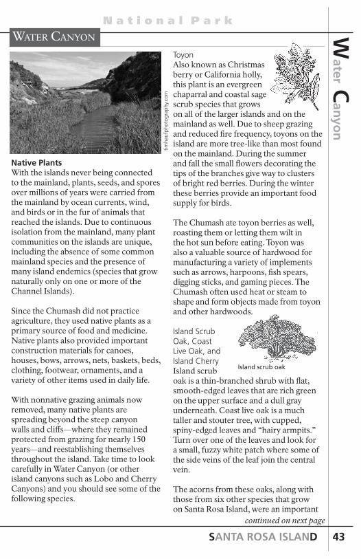
SANTA ROSA ISLAND
N a t i o n a l P a r k
43
ToyonAlso known as Christmas berry or California holly, this plant is an evergreen chaparral and coastal sage scrub species that grows on all of the larger islands and on the mainland as well. Due to sheep grazing and reduced fire frequency, toyons on the island are more tree-like than most found on the mainland. During the summer and fall the small flowers decorating the tips of the branches give way to clusters of bright red berries. During the winter these berries provide an important food supply for birds.
The Chumash ate toyon berries as well, roasting them or letting them wilt in the hot sun before eating. Toyon was also a valuable source of hardwood for manufacturing a variety of implements such as arrows, harpoons, fish spears, digging sticks, and gaming pieces. The Chumash often used heat or steam to shape and form objects made from toyon and other hardwoods.
Island Scrub Oak, Coast Live Oak, and Island CherryIsland scrub oak is a thin-branched shrub with flat, smooth-edged leaves that are rich green on the upper surface and a dull gray underneath. Coast live oak is a much taller and stouter tree, with cupped, spiny-edged leaves and “hairy armpits.” Turn over one of the leaves and look for a small, fuzzy white patch where some of the side veins of the leaf join the central vein.
The acorns from these oaks, along with those from six other species that grow on Santa Rosa Island, were an important
continued on next page
Tim
Hau
f
Water canyon
Island scrub oak
timha
ufph
otog
raph
y.co
mNative PlantsWith the islands never being connected to the mainland, plants, seeds, and spores over millions of years were carried from the mainland by ocean currents, wind, and birds or in the fur of animals that reached the islands. Due to continuous isolation from the mainland, many plant communities on the islands are unique, including the absence of some common mainland species and the presence of many island endemics (species that grow naturally only on one or more of the Channel Islands).
Since the Chumash did not practice agriculture, they used native plants as a primary source of food and medicine. Native plants also provided important construction materials for canoes, houses, bows, arrows, nets, baskets, beds, clothing, footwear, ornaments, and a variety of other items used in daily life.
With nonnative grazing animals now removed, many native plants are spreading beyond the steep canyon walls and cliffs—where they remained protected from grazing for nearly 150 years—and reestablishing themselves throughout the island. Take time to look carefully in Water Canyon (or other island canyons such as Lobo and Cherry Canyons) and you should see some of the following species.
Water C
anyo
n

INTERPRETIVE GUIDE
C h a n n e l I s l a n d s
44
food source for the Island Chumash and many other California Indian groups. Each fall acorns were gathered, hulled, dried, and stored in large granary baskets. When prepared, acorns were ground into meal, leached to remove the tannic acid and bitter flavor, and cooked into mush. Other seeds and herbs may have been added to enhance the (generally bland) flavor.
Although the Island Chumash gathered acorns, oaks are less abundant on the islands than on the mainland. To increase their supply of acorns and other medicinal and food plants, the islanders engaged in trade or undertook gathering expeditions to the mainland. The island Chumash also compensated for the short supply of acorns by substituting other plant foods in their place. One important alternative was island cherry. Most often, island cherry grows as a large shrub. However, in deep, moist soils and sunshine it can grow to a forty-foot tree. This plant blooms from spring through early summer. When ripe, the fruit ranges in color from dark purple to black and is characterized by a large seed and pulpy flesh. In addition to eating the pulp, the pits were boiled in several changes of water to release the toxic chemicals. Then the pits were mashed to the consistency of refried beans and eaten.
Monkey FlowerMonkey flower is common in chaparral throughout California. Known as “sticky” monkey flower because the deep green leaves secrete a gluey substance, they bloom from January to May and were named for the monkey
Wat
er C
anyo
n
face that sometimes can be seen within the orange to pale yellow flowers. A mainland species, endemic island species, and a hybrid between the two occur here on Santa Rosa Island. The island endemic species differs from the mainland species in the lack of sticky leaves and its bright red flowers. The hybrid produces peach or bronze-colored flowers. These plants are commonly seen on rock walls where the nonnative animals could not reach.
Lemonade Berry Lemonade berry is a shrub with thick, leathery leaves. The Chumash would steep the sticky, lemon-tasting berries in water to make juice, or they would suck on them like candy. One should be careful, however, since lemonade berry belongs to the same family as poison oak and can trigger a skin rash in those sensitive to it.
Santa Cruz Island IronwoodThousands of years ago the Channel Islands had a moister climate, as did much of southern California. Different plant communities and different animals, such as pygmy mammoths, existed on the islands. The Santa Cruz Island ironwood is a relic of this earlier environment. Fossil evidence indicates that ironwoods once grew on the mainland as far north as Washington and as far east as Nevada.
Today the ironwood grows only on islands in locations where conditions approximate California’s earlier, wetter climate. Small groves of these trees are often found on Santa Rosa and Santa Cruz Islands, where they grow mostly in north-facing canyons cooled by fog. In fact, fog is an important element in
Island cherry

SANTA ROSA ISLAND
N a t i o n a l P a r k
45
and lots of cactus. Fields of it, acres of it.” Edwin Stanton on neighboring Santa Cruz Island, an avid student of agricultural science, used cochineal insects to rid his island of native prickly pear cactus. The cochineal insects appear as small, silvery white mounds on the cactus pads. These insects weaken and eventually kill the cactus by sucking sap from the plant. Both Mrs. Woolley and Al Vail speculated that Stanton’s “bugs” migrated to Santa Rosa Island and eliminated most of the cacti. Mrs. Woolley noted that “it just died by the acre.”
The Chumash harvested the sweet prickly pear fruit and used its beet-red juice as a paint and dye. The long, sharp cactus thorns were used for decorative ear piercing and tattooing. Vertical and transverse lines were commonly tattooed on the cheeks and chin, although tattoo designs were applied also to the forehead, arms, and other parts of the body. To create a dark blue tattoo, the skin was pricked with a cactus thorn and the punctures rubbed with charcoal. When the wounds healed the pigment was sealed under the skin.
Dudleya (Live-forever)Perhaps no plant is more versatile in adapting to different habitats than dudleya. These low-growing, fleshy succulents with a waxy coating commonly grow on dry, rocky outcroppings like the walls of Water Canyon.
However, they also can be found on stabilized sand dunes, grasslands, and scrub habitats in conditions varying from full sun to shade. This adaptability is reflected in the variety of dudleyas found on the Channel Islands, including four species on Santa Rosa Island.
Water C
anyo
n
continued on next page
the ironwood’s successful adaptation and survival. Moisture from fog collects on the leaves and drips down to the soil surrounding the trunk, thereby increasing the amount of water available to the tree. This also helps to sustain the other larger tree species on Santa Rosa and the other islands.
Ironwood has dark green, highly serrated, finger-like leaves and in summer produces many small white flowers.
Poison OakPoison oak grows on all of the Channel Islands except Santa Barbara Island and is readily identified in spring as a three-leafed shrub or vine with bronze-green foliage. During late summer and fall the leaves turn a red or rust color and white berries develop. Poison oak can cause allergic reactions and rashes if it comes in contact with the skin. Please do not touch. The Chumash used poison oak to treat warts, cankers, and skin cancer and to staunch blood flow.
Coastal Prickly PearThe coastal prickly pear is a cactus that blooms in May and June, producing a shiny yellow flower with dense layers of petals. The plant’s shallow root system spreads over a wide area to extract maximum moisture while its sharp spines reflect the sun and wind to help protect the plant from deyhydration. The spines also helped protect the plant from cattle, sheep, elk, deer, and pigs, allowing it to spread into the overgrazed sage scrub and grasslands. Forney’s map of 1873 depicted numerous thickets of cactus across the island. Mrs. Woolley said, “the thing I remember most vividly is that when I was young there was lots

INTERPRETIVE GUIDE
C h a n n e l I s l a n d s
46
The Torrey pine is the rarest native pine in the United States and, possibly, the rarest pine in the world. It only grows naturally in two places. One is here on Santa Rosa Island and the other is near San Diego. Scientists think that it never was a very abundant pine, probably always needing to be near the coast, but they do believe that in the past it occurred in more places along the coast. Unfortunately, specific places cannot be identified because of lack of fossil records. Furthermore, at the moment, it is not known which Torrey pine forest (Santa Rosa Island or San Diego) is the oldest.
There is much debate on how and when the Torrey pine arrived on Santa Rosa Island. To date, researchers have yet to agree on an arrival date. Some have suggested several million years ago while others have suggested between 5,000 and 43,000 years ago. The seeds were most likely transported from the mainland by birds, possibly jays that are known to transport seeds a long distance, or possibly by cones floating across the ocean. The other possible explanation is that the Chumash or their ancestors brought them over. The Chumash were excellent seamen and traders and they did use Torrey pines. If that is true, the trees couldn’t be much more than 13,000 years old (since this is the oldest human date from the islands). However, until it can be established by either fossil evidence or genetic variation that the trees were here before the Chumash, this possibility cannot be discounted.
Thousands of years of isolation on Santa Rosa made this island version of the Torrey pine distinct. It is genetically different enough from the mainland trees that it is considered a separate subspecies and given its own common name—the Santa Rosa Island Torrey pine (subspecies differ from each other in various ways but
Wat
er C
anyo
n
On these canyon walls one can find candleholder and Greene’s dudleya. These Channel Island endemics also occur on San Miguel and Santa Cruz Islands. The other dudleya species, Santa Rosa Island live-forever and munchkin dudleya, occur just on Santa Rosa Island and they grow only on the island’s eastern tip. See page 58 for more information about these unique dudleyas.
Wild CucumberAnother plant that evolved to deal with the dry conditions of southern California (average rainfall on Santa Rosa is approximately 19 inches) is the vine-like wild cucumber that often can be seen along the hillsides in the oak understory. This plant has an immense, poisonous, fleshy root, or underground tuber, that stores water and nutrients.
Wild cucumber is one of the very first flowers to bloom from January to June. The plant sprawls over trees, shrubs, and the ground, leaving a tangle of dried stems and leaves by midsummer. In spring however, the wild cucumber forms large, egg-shaped, bright green fruits covered with big soft green prickles that turn hard and spiny as the fruits dry.
Inside are large seeds. The Chumash made necklaces of these seeds, polishing them along their oiled bodies. They were used also as marbles by Chumash children.
Other Native Plant SpeciesOther plants to look for include giant coreopsis, scouring rush, coastal goldenbush, indian pink, Santa Cruz Island buckwheat, island red buckwheat, and California poppy.
Torrey Pines
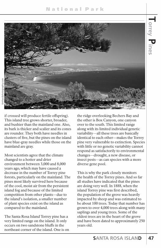
SANTA ROSA ISLAND
N a t i o n a l P a r k
47
if crossed will produce fertile offspring). This island tree grows shorter, broader, and bushier than the mainland one. Also, its bark is thicker and scalier and its cones are rounder. They both have needles in clusters of five, but the pines on the island have blue-gray needles while those on the mainland are gray.
Most scientists agree that the climate changed to a hotter and drier environment between 3,000 and 8,000 years ago, which may have caused a decrease in the number of Torrey pine forests, particularly on the mainland. The pines most likely survived here because of the cool, moist air from the persistent island fog and because of the limited competition from other plants—due to the island’s isolation, a smaller number of plant species exist on the island as compared to the mainland.
The Santa Rosa Island Torrey pine has a very limited range on the island. It only occurs on two sandstone bluffs in the northeast corner of the island. One is on
To
rrey Pin
es
timha
ufph
otog
raph
y.co
m
the ridge overlooking Bechers Bay and the other is Box Canyon, one canyon over to the south. This limited range along with its limited individual genetic variability—all these trees are basically identical to each other—makes the Torrey pine very vulnerable to extinction. Species with little or no genetic variability cannot respond as satisfactorily to environmental changes—drought, a new disease, or insect pests—as can species with a more diverse gene pool.
This is why the park closely monitors the health of the Torrey pines. And so far all studies have indicated that the pines are doing very well. In 1888, when the island Torrey pine was first described, the population of the grove was heavily impacted by sheep and was estimated to be about 100 trees. Today that number has grown to over 4,000 trees along with many saplings and young trees. Some of the oldest trees are in the heart of the grove and have been dated to approximately 250 years old.

INTERPRETIVE GUIDE
C h a n n e l I s l a n d s
48
Western Snowy Plover
Skunk Point is one of the few locations in southern California that still supports breeding and wintering populations of western snowy plovers, a federally threatened shorebird species. Its extensive back dune area and sandy shoreline provide important nesting and foraging areas. Other locations on Santa Rosa, San Miguel, and Santa Cruz Islands also support smaller populations.
The Pacific coast population of western snowy plovers has declined due to many factors. Recreational and other human disturbance, loss of habitat to urban development, introduction of beachgrass and other nonnative species, and expanding predator populations have all contributed to a decline in active nesting areas and in the size of the breeding and wintering populations.
Within the park the population numbers have declined as well. For example, on Santa Rosa Island it is estimated that less than 30 breeding pairs were on the island in 2002, down from 60 pairs in 1993. However, an estimated 200 birds still wintered on the island’s beaches that same year.
To avoid disturbance and help the western snowy plovers recover, several of the islands’ beaches are closed to recreational use from March 15th to September 15th, including Skunk Point. A recovery plan has also been implemented within its entire range that has helped the population increase by nearly 25 percent.
timha
ufph
otog
raph
y.co
m
Mixing of Waters and the Diversity of Marine Life
The Channel Islands lie within a large embayment known as the Southern California Bight—an area just below Point Conception where the California coastline turns sharply to the east. Within this area, the seafloor is composed of canyons, banks, escarpments, sea mounts, and deep basins (the Santa Cruz Basin is deeper than the Grand Canyon). Nutrient-rich waters upwelling from these depths mix and mingle with cool waters from the north (California Current) and warm southern waters (California Countercurrent), creating the Santa Barbara Gyre—a swirling eddy that circulates nutrients and supports a wealth of marine plants and animals, from giant kelp forests and blue whales to tiny crabs and plankton. Here, northern and southern species overlap, creating a transition zone between the Oregonian and Californian marine biogeographic provinces.
The Channel Islands also serve as the meeting ground for seabirds and shorebirds that rarely occur together, such as black oystercatchers from the north and American oystercatchers from the south. Both species, as well as hybrids between the two, nest on the islands. Other northern birds, such as pelagic cormorants and pigeon guillemots, overlap with additional southern species, such as Scripps’s murrelets and California brown pelicans.
Skunk Point
Dan
Ric
hard
s
Sku
nk
Poin
t

SANTA ROSA ISLAND
N a t i o n a l P a r k
49
Sku
nk P
oin
t
Tidepools
Due to their relative isolation and protection, the tidepools in Channel Islands National Park are some of the best within southern California. Anemones, sea stars, urchins, limpets, periwinkles, chitons, barnacles, mussels, and many other beautiful species can be seen at numerous pristine tidepool sites. The most accessible sites on Santa Rosa Island include the rocky outcropping just before Skunk Point as well as near the pier in Bechers Bay and at East Point.
Intertidal life has adapted to the sea and the land. When looking at a tidepool area, notice how plants and animals may be found in certain areas and not in others. Those living in the upper splash zone are tolerant to sunlight, heat, and water loss and have either a means to “shelter” themselves or the ability to move into an area of greater moisture. An animal with a tightly closed shell or a shell firmly attached to rock will hold water within so that it does not require water surrounding it at all times. Animals found in rock crevices and submerged pools usually require more moisture to prevent them from drying out.
Because space is a limiting factor, there is competition between organisms. Many animals and plants are found in a small area. Some may live on each other or use an old shell as a surface on which to live. This is one important reason why collecting is not permitted—you may be
taking away a home.
Although hardy against the forces of nature, the plants and animals of the intertidal zone cannot entirely endure the impact of humans. Since individuals interact with one another, minute changes in the area could disrupt the entire community. While exploring, please keep in mind these tidepool tips:
• Watch your step! The rocks can be very slippery and there may be small animals on them.
• Keep an eye on the waves. The surge can sneak up on you.
• Take your time and look carefully. Tidepool organisms are often very small and camouflaged.
• Do not collect anything! Not only is it unlawful, but if animals and shells are taken, there may be nothing left for others to enjoy.
• If you pick up an animal to observe, please place it back where it was found. That particular spot is its home territory.
• Although you may not know the animals by name, through simple observation a great deal of information can be learned. Consider, for example, what keeps it from drying out? Why doesn’t it get swept out to sea? Does it search for food or wait for food to come to it?
Take time to look carefully in the tidepools and you should see some of the following species.
continued on next page
timha
ufph
otog
raph
y.co
m

INTERPRETIVE GUIDE
C h a n n e l I s l a n d s
50
Sku
nk
Poin
t California Mussel
Mussels anchor themselves with tough, fibrous threads. Shells up to six inches long protect these animals. Their gills provide the mussels with oxygen and help them capture food. When the tide is in, they open just enough to filter the seawater for tiny floating plants and animals. As one of the most abundant animals in the intertidal zone, mussels are also a key food source for others in the food chain.
Chiton
Chitons cling to the rocks with their foot at low tides. When the tide is high and it is safe, they venture out to eat by scraping algae, bacteria, and diatoms off the rocks. Chitons blend in well with the rocks in the intertidal zone. Their shells are made of eight overlapping plates. Like pill bugs on land, these armored animals roll up to protect themselves from predators. The three-inch-long mossy chitons are one of several species here. Their mossy looks come from the stiff hairs that fringe their edges and the algae that often grow on their shells.
Snails
Snails are abundant in the intertidal zone. Varieties include black and brown turban snails and periwinkles. At low tide some nestle tightly in crevices. Most snails graze on algae, scraping them off the rock with a rough, tongue-like radula.
Snails can withdraw into their shells, behind a trapdoor-like bony plate called an operculum. This protects them from predators and water loss. Some exude mucus that coats their shells and helps them stick to the rocks and hold in precious moisture.
Barnacles
Related to crabs and shrimp, barnacles cluster on surfaces at every level of the intertidal zone. They attach themselves headfirst and use their feathery legs to absorb oxygen and net food that floats by. Barnacles’ shells are a series of connected, overlapping plates. Some are volcano shaped and some are camouflaged to their surroundings. Varieties include the acorn, pink, and gooseneck barnacles.
Kat
hy d
eWet
-Ole
son
Kat
hy d
eWet
-Ole
son
Kat
hy d
eWet
-Ole
son
Kat
hy d
eWet
-Ole
son

SANTA ROSA ISLAND
N a t i o n a l P a r k
51
Sku
nk P
oin
t Algae
Algae are near the bottom of the tidepool food web. They use photosynthesis to capture light energy from the sun. Large algae cling to the rocks and seafloor with root-like holdfasts. Algae range in size from single-celled organisms to 150-foot-long giant kelp. Rockweed algae grow to 10 inches in the intertidal zone. They mark the high-tide line like “bathtub rings.” Coralline algae, once mistaken for coral, are crunchy due to calcium carbonate in their cell walls. They range from flat to three inches in height.
Sea Star
Sea stars use hundreds of suction-cupped feet to move and capture food, which they eat with stomachs in the center of their bodies. Bat stars have extra webbing between their arms. They graze over algae and rocks in the intertidal zone, eating tiny algae, plants, and animals. The most common sea stars found in the intertidal zone are the ochre stars. Up to 18 inches across, they can be found in ochre (orange), yellow, red, brown, or purple. They feed upon mussels from the intertidal zone, freeing up habitat for other species that thrive there.
Striped Shore Crab
These crabs live on the sand, mud, or rocks near tidepools, splitting their time between land and sea. They eat algae and animals—dead or alive. Striped shore crabs make the tiny clicking sounds that are heard near tidepools. As they outgrow their shells, they cast them off. The new underlying soft shells harden quickly. Striped shore crabs are common on the Channel Islands. They are striped in black and green, with red or purple claws, and grow to two inches in diameter.
Anemone
The giant green anemone and the slightly smaller aggregate anemone are both common in tidepools. They look very similar to one another. However, the giant green anemone is usually solitary, and the aggregate anemone lives in colonies of many individuals. Both are blue-green in color, which comes from algae living inside of them. Their tentacles capture and paralyze small animals, dragging them to their central mouths to be digested. At low tide they retract their tentacles to stay moist. Sand and gravel stick to their surfaces, serving as camouflage. They grow to 10 inches wide.
continued on next page
Kat
hy d
eWet
-Ole
son
Kat
hy d
eWet
-Ole
son
Kat
hy d
eWet
-Ole
son
Kat
hy d
eWet
-Ole
son

INTERPRETIVE GUIDE
C h a n n e l I s l a n d s
52
Sea Urchin
Sea urchins live in the intertidal zone to 100 feet in depth. At low tide, they take shelter from waves in rock cavities. At other times they roam in search of their favorite foods, giant kelp and other algae. Urchins have hard, round shells called tests, covered with spines. Spines can break off in human skin and be painful and hard to remove. Related to sea stars, they have similar tube feet that stick out between their spines for maneuvering and capturing prey. They also have a central mouth with strong jaws and sharp teeth.
Sandcastle Worm
The sandcastle worm is about two inches long and forms tubes of cemented sand grains that shield the worm’s body. These worms build huge colonies of honeycombed, reef-like structures that often appear like a rock to the casual observer. If you look closely you can see the openings of individual worm houses.
Sku
nk
Poin
t Jane L. Stanford Shipwreck
Amid the plentiful driftwood along the north side of Skunk Point on Santa Rosa Island, a careful eye will observe distinctive fragments of a large wooden ship. In one spot, a series of ship’s knees (massive braces that tie a vessel’s deck to the side of the hull—think shelf brackets) juts from the sand. Further east 80 feet of massive timbers, tied together with thick iron pins (“drifts” in nautical speak) form the remnants of a massive backbone (or keelson).
These are the remains of the Jane L. Stanford, the largest wooden ship to wreck within Channel Islands National Park. Over 215 feet long and 41 feet wide, Hans Bendixen made the Jane L. Stanford specifically for carrying lumber across the Pacific Ocean to destinations such as South Africa and Australia. The ship was rigged as a four-masted barkentine, with square sails on her foremast.
By 1926 the Jane L. Stanford, no longer competitive in her original trade, became a fishing barge off Los Angeles and then Santa Barbara, a typical fate for older sailing ships. In 1929 a steamer entering Santa Barbara rammed the ship. Damaged beyond repair but unsinkable, the hulk was a serious navigation hazard. The Coast Guard cutter Tamaroa towed her near Skunk Point where 26 naval
Kat
hy d
eWet
-Ole
son

SANTA ROSA ISLAND
N a t i o n a l P a r k
53
wrecking mines blew the wreck apart over four days, scattering wreckage along two miles of beach. The distant explosions precipitated numerous calls to the Santa Barbara police, thirty miles away.
The Jane L. Stanford is just one of over 140 documented shipwrecks in the waters of Channel Islands National Park and Channel Islands National Marine Sanctuary. The significant number of shipwrecks within these boundaries can largely be attributed to prevailing currents and weather conditions, combined with natural hazards.
The shipwreck remains of the Channel Islands reflect the diverse range of activities and nationalities that traversed the Santa Barbara Channel. European sailing and steam vessels, California-built Chinese junks, American coastal traders, vessels engaged in island commerce and a Gold Rush-era sidewheel steamers have all been lost in these waters.
Today, park and sanctuary archeologists and partners study shipwrecks to learn more about these relics of history, shedding new light on the remarkable stories of our maritime heritage.
continued on next page
Nat
iona
l Mar
itim
e M
useu
m S
an F
ranc
isco
Abalone Rocks Marsh
Just north of East Point is Abalone Rocks Marsh, the second largest wetland on the northern islands (Prisoners Harbor wetland on Santa Cruz is the largest). This rare habitat (over 90 percent of California’s coastal wetlands have been eliminated) provides respite from the long, dry summers for a diverse array of species, including the island fox. The wetland also serves as a resting and feeding stop for migratory birds and nesting habitat for resident waterfowl.
Sediment column analysis from the marsh has revealed fire and vegetation change on Santa Rosa Island. As the climate changed, forest communities were replaced by mixed grassland and scrub communities around 12,000 years ago. After about 6,900 years ago, precipitation increased and a variety of communities developed, including grassland, oak grassland, pine woodland, and coastal scrub. During the historic period, vegetation changed significantly to grasslands with the introduction of nonnative grazing animals.
Fires appear to have been more frequent in the wetter periods than in the drier periods, with a probable increase after about 6,900 years ago as Island Chumash settlement and cultural complexity increased. This suggests that Island Chumash burning was an important ecosystem component on the northern Channel Islands.
East Point
timha
ufph
otog
raph
y.co
m
East P
oin
t

INTERPRETIVE GUIDE
C h a n n e l I s l a n d s
54
Qshiwqshiw
Near Abalone Rocks Marsh is a prehistoric midden site that has been radiocarbon dated to more than 7,000 years ago, as well as a historic Chumash village, Qshiwqshiw. Radiocarbon dating suggests that this village was first populated over 1,000 years ago. Ethnographic records indicate that Qshiwqshiw was the largest of Santa Rosa’s historic villages, with about 120 inhabitants and four important Chumash chiefs. Many living Chumash descendants can trace their ancestry to this village.
The area around East Point is dotted with other archeological sites, spanning several millennia. The majority of these sites are small campsites. It is presumed that, during the course of cultural evolution on the islands, the inhabitants of Santa Rosa Island moved from a foraging strategy (moving their campsites seasonally to be near a particular resource) to a collection strategy, where people lived in centralized residential bases (such as a village) and made excursions to resource areas.
It is not yet known when or how this shift was accomplished. Studying the relationship of these smaller sites and contrasting them with the larger sites across the landscape and through time may one day help us answer this question.
Munchkin Dudleya
The munchkin dudleya or munchkin live-forever (Dudleya gnoma) is a rare species of succulent plant in the stonecrop family that is endemic to Santa Rosa Island. It exists in only one single population composed of about 3,200 plants in three colonies near East Point.
During the years that the island was inhabited by nonnative herbivores, such as cattle and sheep, the NPS protected this unique species by fencing off the population. Today, with the nonnative herbivores removed, the munchkin dudleya along with another nearby endemic, the Santa Rosa Island live-forever (Dudleya blochmaniae subsp. insulris), are both recovering. However, with a limited gene pool and the fact that a single severe event, such as a drought, could eliminate the entire population, monitoring and research of these species still continues.
timha
ufph
otog
raph
y.co
m
Mic
hael
War
d
East P
oin
t
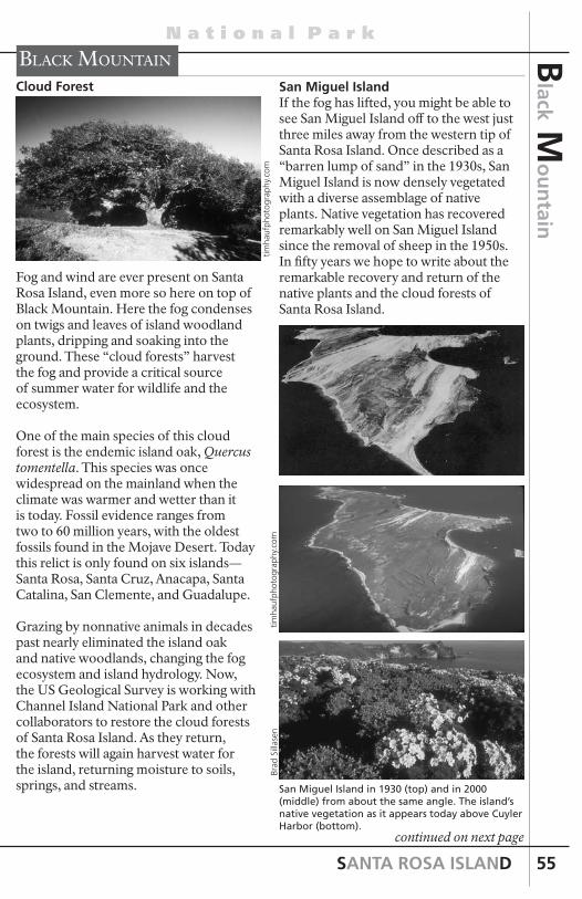
SANTA ROSA ISLAND
N a t i o n a l P a r k
55
continued on next page
Black Mountain
Cloud Forest
Fog and wind are ever present on Santa Rosa Island, even more so here on top of Black Mountain. Here the fog condenses on twigs and leaves of island woodland plants, dripping and soaking into the ground. These “cloud forests” harvest the fog and provide a critical source of summer water for wildlife and the ecosystem.
One of the main species of this cloud forest is the endemic island oak, Quercus tomentella. This species was once widespread on the mainland when the climate was warmer and wetter than it is today. Fossil evidence ranges from two to 60 million years, with the oldest fossils found in the Mojave Desert. Today this relict is only found on six islands—Santa Rosa, Santa Cruz, Anacapa, Santa Catalina, San Clemente, and Guadalupe.
Grazing by nonnative animals in decades past nearly eliminated the island oak and native woodlands, changing the fog ecosystem and island hydrology. Now, the US Geological Survey is working with Channel Island National Park and other collaborators to restore the cloud forests of Santa Rosa Island. As they return, the forests will again harvest water for the island, returning moisture to soils, springs, and streams.
San Miguel IslandIf the fog has lifted, you might be able to see San Miguel Island off to the west just three miles away from the western tip of Santa Rosa Island. Once described as a “barren lump of sand” in the 1930s, San Miguel Island is now densely vegetated with a diverse assemblage of native plants. Native vegetation has recovered remarkably well on San Miguel Island since the removal of sheep in the 1950s. In fifty years we hope to write about the remarkable recovery and return of the native plants and the cloud forests of Santa Rosa Island.
San Miguel Island in 1930 (top) and in 2000 (middle) from about the same angle. The island’s native vegetation as it appears today above Cuyler Harbor (bottom).
timha
ufph
otog
raph
y.co
mBr
ad S
illas
entim
hauf
phot
ogra
phy.
com
Black M
ou
ntain

INTERPRETIVE GUIDE
C h a n n e l I s l a n d s
56
Carrington Point
Soft-leaved Island Paintbrush
Out on the bluffs and sand dunes above Carrington Point grows the endemic soft-leaved island paintbrush, Castilleja mollis. Although once found on San Miguel, today this rare plant species is only found on Santa Rosa Island and in just two locations.
The island paintbrush must grow beneath the canopy of coast goldenbush or other shrubs because it is semi-parasitic. It makes some of its own nutrients, but relies on a host plant to provide most of its nutrients and sugars.
In 1997, this paintbrush was listed as endangered as a result of trampling by nonnative herbivores, competition with nonnative grasses for water and other nutrients, and large gaps in the goldenbush canopy. However, with the removal of cattle in 1998, this species has begun to recover. Further recovery is expected with the recent removal of nonnative deer and elk in 2012.
Channel Islands Pygmy Mammoth
In 1994, geologists who were surveying an ancient sand dune just to the west of Carrington Point discovered bones of a pygmy mammoth sticking out from an eroding bluff. After a 10-day excavation, the discovery proved to be the world’s most complete fossil of this species. About 95 percent of the skeleton was almost perfectly preserved because sand had covered the body soon after the mammoth’s death.
This specimen was determined to be a male that was 5.5 feet tall and had weighed approximately 2,000 pounds. With worn teeth and signs of arthritis, paleontologists estimated this mammoth to be about 50 years old at the time of death, 12,840 years ago. The cause of death was most likely old age.
The Channel Islands pygmy mammoth’s ancestors were 14-foot, 20,000-pound Columbian mammoths that roamed the mainland. About 30,000 years ago, some of these Columbian mammoths swam to the ancient Channel Islands. At that time sea level was about 300 feet lower than it is today, and the four northern islands were joined together to form a “super island” known as Santarosae that was only about four miles from the mainland. Mammoths were probably just as seaworthy as their descendants, modern elephants. With their snorkel-like
Car
rin
gto
n P
oin
t
timha
ufph
otog
raph
y.co
m
Bill
Faul
kner

SANTA ROSA ISLAND
N a t i o n a l P a r k
57
trunks and buoyancy, elephants have been known to swim up to 23 miles. With ample food and no predators, the island mammoths thrived at first. However, as the climate changed and glaciers and ice sheets melted and the sea level rose, the island habitat shrank and food became scarce. Smaller mammoths had an advantage as they could survive with less food and water during seasonal shortages.
Within less than 20,000 years, a process of natural selection bred these mammoths to be usually less than 6.5 feet at the shoulder—less than half the height of their mainland ancestors. These small mammoths became a new species, the Channel Islands pygmy mammoth.
Theories about the extinction of pygmy mammoths and Columbian mammoths, as well many other large animals around 10,000 years ago, include climate change, human hunters, viruses carried by humans, or some combination of these. However, while there is evidence of people hunting mammoths on the mainland, there is no evidence on the Channel Islands. Furthermore, there is still no proof that humans and pygmy mammoths even coexisted on the Channel Islands.
continued on next page
Channel Islands pygmy mammoth with its ancestor, the Columbian mammoth.
Lo
bo C
anyo
n
Lobo canyon
Geology
Lobo Canyon is cut into a sequence of thickly bedded coarse sandstone and interbedded white tuffaceous siltsone. Some of the interesting landforms seen in the canyon are a result of a hard crust forming at the surface of the outcrop, probably from calcite deposited by groundwater or surface water. Once this crust is eroded through, the underlying softer rock is sculpted by wind and water into elaborate landforms, including honeycombed shapes called tafoni.
Just before where the road begins to climb to the west out of Lobo Canyon is a block slide covering about 27 acres, which may have occurred during the December 1812 Santa Barbara Channel earthquake. A block slide is one in which the slide body remains relatively intact. This slide has moved about 100 feet in a northeast direction. The leading edge of the slide is found in Lobo Canyon about 1,000 feet downstream from the road, where it supports a dense growth of oaks and toyons and a year-round spring. The slide also dammed Lobo Canyon as evidenced by ponded sediment upstream from the slide in the parking area.
timha
ufph
otog
raph
y.co
m
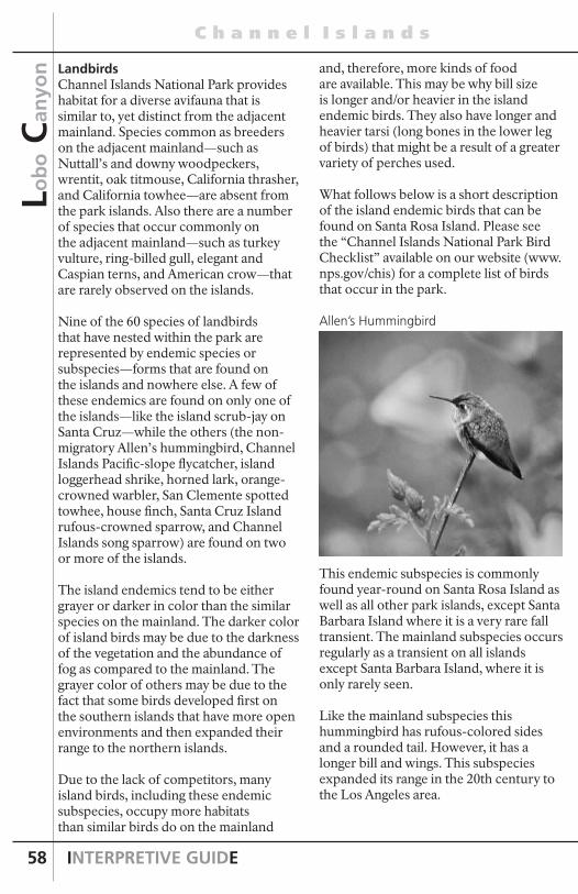
INTERPRETIVE GUIDE
C h a n n e l I s l a n d s
58
and, therefore, more kinds of food are available. This may be why bill size is longer and/or heavier in the island endemic birds. They also have longer and heavier tarsi (long bones in the lower leg of birds) that might be a result of a greater variety of perches used.
What follows below is a short description of the island endemic birds that can be found on Santa Rosa Island. Please see the “Channel Islands National Park Bird Checklist” available on our website (www.nps.gov/chis) for a complete list of birds that occur in the park.
Allen’s Hummingbird
This endemic subspecies is commonly found year-round on Santa Rosa Island as well as all other park islands, except Santa Barbara Island where it is a very rare fall transient. The mainland subspecies occurs regularly as a transient on all islands except Santa Barbara Island, where it is only rarely seen.
Like the mainland subspecies this hummingbird has rufous-colored sides and a rounded tail. However, it has a longer bill and wings. This subspecies expanded its range in the 20th century to the Los Angeles area.
LandbirdsChannel Islands National Park provides habitat for a diverse avifauna that is similar to, yet distinct from the adjacent mainland. Species common as breeders on the adjacent mainland—such as Nuttall’s and downy woodpeckers, wrentit, oak titmouse, California thrasher, and California towhee—are absent from the park islands. Also there are a number of species that occur commonly on the adjacent mainland—such as turkey vulture, ring-billed gull, elegant and Caspian terns, and American crow—that are rarely observed on the islands.
Nine of the 60 species of landbirds that have nested within the park are represented by endemic species or subspecies—forms that are found on the islands and nowhere else. A few of these endemics are found on only one of the islands—like the island scrub-jay on Santa Cruz—while the others (the non-migratory Allen’s hummingbird, Channel Islands Pacific-slope flycatcher, island loggerhead shrike, horned lark, orange-crowned warbler, San Clemente spotted towhee, house finch, Santa Cruz Island rufous-crowned sparrow, and Channel Islands song sparrow) are found on two or more of the islands.
The island endemics tend to be either grayer or darker in color than the similar species on the mainland. The darker color of island birds may be due to the darkness of the vegetation and the abundance of fog as compared to the mainland. The grayer color of others may be due to the fact that some birds developed first on the southern islands that have more open environments and then expanded their range to the northern islands.
Due to the lack of competitors, many island birds, including these endemic subspecies, occupy more habitats than similar birds do on the mainland
Lob
o C
anyo
n

SANTA ROSA ISLAND
N a t i o n a l P a r k
59
Lo
bo C
anyo
n
continued on next page
Channel Islands Pacific-slope Flycatcher
This subspecies is considered a summer resident on Santa Rosa, Santa Cruz, and Anacapa Islands. Mainland Pacific-slope flycatchers are fairly common spring and fall transients on all of the park islands. When seen in the summer it is almost certain to be the endemic subspecies.
This bird is considered a subspecies, but some ornithologists think that it should be a separate species. It is grayer, has a longer bill, longer tarsi, longer toes, longer wings, and a longer tail length than the mainland subspecies. There are also voice and genetic differences between those found on the islands and on the mainland.
Like most flycatchers, this bird is an insect eater and can be seen flying out to get insects and then returning to its perch. It also gets some of its insect food by gleaning trees and shrubs. In addition, this bird is a cavity nester and migrates for the winter, probably to Mexico.
Island Loggerhead Shrike
This bird is a year-round resident of both Santa Rosa and Santa Cruz Islands and on some years it can be seen on San Miguel and Anacapa Islands. It is also on Santa Catalina.
It only differs slightly from the San Clemente loggerhead shrike, a federally listed endangered bird. Differences can be found in the DNA, and the call is distinctive. Like many island endemics, the island loggerhead shrike is darker in color and its bill is longer than the mainland bird. However, the length of the wings is shorter.
The loggerhead shrike prefers open habitat with scattered trees and shrubs or fences where it can perch. It feeds on a variety of items depending on what is available, and the males frequently impale their food on fences or twigs.
Its nests are concealed in tall shrubs such as lemonade berry, toyon, and island cherry, and generally it has one brood of babies a year.

INTERPRETIVE GUIDE
C h a n n e l I s l a n d s
60
Lob
o C
anyo
n
Horned Lark
The horned lark is a ground subspecies found in the grasslands and is a common or year-round resident of all park islands except Anacapa Island, where it is a rare transient. There is no mainland subspecies on the islands.
The island subspecies shows all of the characteristics typical of change on the island birds, including darker color; a longer, broader bill; longer tarsi; and longer toes. It also has shorter wings and tail and some streaking on its belly. Food consists of seeds and insects.
Orange-crowned Warbler
This island subspecies is a resident on all the park islands. The non-endemic orange-crowned warbler can be seen during the fall and spring on all of the islands as it migrates through. The color
of the endemic subspecies is darker than the corresponding mainland bird, and it also has a longer bill, longer tarsi, longer toes, shorter wing length, and different song, and is more heavily streaked with olive below. The island subspecies tends to nest off the ground in oak trees, lemonade berry shrubs, and coreopsis plants, while the mainland bird is generally a ground nester.
This subspecies can also be found on a few places on the Palos Verdes Peninsula and on Point Loma in addition to the islands. It is thought that these birds developed their unique characteristics on the islands and then expanded their range to the mainland. On the mainland this species exists in isolation from the other subspecies of orange-crowned warblers. Those that breed on the islands now, however, remain on the islands all year.
San Clemente Spotted Towhee
Within the park, the endemic San Clemente spotted towhee is a year-round resident only on Santa Rosa Island. It also is a resident on Santa Catalina Island and, historically, it was on San Clemente Island. The mainland subspecies is a common year-round resident of Santa Cruz Island and can, at times, be seen on the other park islands. The island subspecies is grayer and has longer tarsi.
Brad
Sill
asen
And
reas
Tre
pte

SANTA ROSA ISLAND
N a t i o n a l P a r k
61
Lo
bo C
anyo
n
continued on next page
This bird favors areas that have considerable leaf litter on the ground and also have overhead branches. It obtains its food either in the litter or from the branches and leaves of bushes and trees. Food consists of insects in all stages of their lives and other arthropods as well as vegetable matter. It is a ground nester in areas with a lot of cover for protection.
Channel Island Song Sparrow
This bird is a year-round resident on all Channel Islands except Santa Barbara Island where it was a former year-round resident. It tends to be grayer than the mainland species. It prefers dense shrubby vegetation and tends to build heavier nests and locate them on the leeward side of a shrub because of the winds.
Terrestrial AnimalsThe number of different animal species found on the Channel Islands, defined as species diversity, is small compared to what would likely be found on a mainland area of similar size. The level of species diversity on islands reflects the challenges to a species of first arriving and then of adapting to unique island conditions.
Consequently, the ecology of islands is often simpler, but the relationships between species are more important and the persisting animals (and plants) are often different than what might be found in mainland habitats.
For example, the park islands support only four native terrestrial mammals—the island fox, island deer mouse, harvest mouse, and island spotted skunk. The island fox, deer mouse, and spotted skunk have all evolved into unique species found only on the Channel Islands. In addition, the island fox and island deer mouse have actually evolved into a separate subspecies on each island.
The number of reptile and amphibian species is likewise low and includes four lizards, one salamander, one frog, and two nonvenomous snakes. None of these species is found on all of the islands, and no island supports all the species.
For example, the island night lizard, a threatened species found nowhere else in the world, occurs on only three islands, one within the park (Santa Barbara Island) and two owned by the US Navy outside park boundaries.
What follows below is a short description of the native terrestrial animals that can be found on Santa Rosa Island.
Santa Rosa Island Fox
Please see pages 9-10 for information on the Santa Rosa Island fox.
Brad
Sill
asen
Tim
Coo
nan

INTERPRETIVE GUIDE
C h a n n e l I s l a n d s
62
Lob
o C
anyo
n
Santa Rosa Island Deer Mouse
The endemic island deer mouse is the only native terrestrial mammal found on all the Channel lslands. Each island has an endemic subspecies. It is slightly larger than its mainland relative. The island deer mouse does carry hantavirus, however, and should be avoided.
This nocturnal creature can be found in just about every island habitat and is a very important part of the island ecosystem, providing an important food source for foxes, hawks, and owls.Park research has shown that island deer mouse population densities are higher than anywhere else in the world. However, population dynamics on different islands vary in response to numerous factors, including predator diversity, vegetation, community structure, and climate. For example, monitoring data show that deer mouse densities on San Miguel Island are strongly limited by the endangered island fox, whereas on Santa Barbara Island, where there are no foxes, mouse densities are much more variable. In addition, research has revealed that rainfall is a strong driver of deer mouse population dynamics. High winter rainfall encourages plant growth that provides food resources, while drought reduces plant growth and limits mouse productivity. However, abundant winter rain combined with cold temperatures
may actually increase winter mortality and reduce the number of mice that survive from fall to spring.
Food selection of the island deer mouse is dependent on both habitat and season. In the spring, it feeds heavily on larvae from lepidopterans (moths and butterflies) and other insects. In the fall seeds become a major food source and are stored in caches for use during the winter.
The island deer mouse breeding season occurs during the spring and summer months with generally two litters produced. Due to the diverse habitat of the Channel Islands, nesting is found in the natural cover of the landscape. The deer mouse will nest alone on most occasions but will sometimes nest with a deer mouse of the opposite sex.
Island Spotted Skunk
The island spotted skunk is endemic to the two largest Channel Islands, Santa Cruz and Santa Rosa. Unlike the island fox and the island deer mouse, the island spotted skunk shows little differentiation between the two islands (slightly longer body on Santa Rosa Island) as well as the mainland subspecies, suggesting recent colonization.
In recent times the species was limited in numbers. However, the island spotted skunk populations on both islands began
Cat
hy S
chw
emm

SANTA ROSA ISLAND
N a t i o n a l P a r k
63
Lo
bo C
anyo
n
continued on next page
increasing in the late 1990s, coincident with the decline in island foxes caused by golden eagle predation. As the only two terrestrial carnivores on the islands, skunks and foxes are natural competitors. Surveys during 2011 estimated that there were approximately 3,000 skunks on Santa Rosa Island.
Habitat preferences are similar to those of the mainland subspecies. On Santa Rosa Island, it prefers rocky canyon slopes, cactus patches, chaparral, coastal sage scrub, open woodland, other scrub-grassland communities, and riparian habitat along streams.
The island spotted skunk is nocturnal, with activity beginning at dusk, peaking during the early evening, and then continuing intermittently until dawn.
It is carnivorous, consuming island deer mice and insects along with occasional lizards. Jerusalem crickets are the most frequent prey, but other prey includes grasshoppers, crickets, beetles, caterpillars, earwigs, and ants. Seasonal fruits and berries are eaten as well.
The island spotted skunk mates in September and October and, following delayed implantation and 210 to 310 days of gestation, gives birth in April and May to two to six babies. It nests in cavities, burrows, and other natural crevices, as it does on the mainland. Dens are constructed in roots and earth under shrubs, cavities in rocks, open grassy areas, road cuts, human-made structures, and trunks and roots of oaks. Individuals use several dens distributed throughout their home range; some dens are used by two or more individuals either sequentially, or for females, simultaneously.
Island Fence Lizard
The island fence lizard is endemic to Channel Islands National Park’s three northerly islands, Santa Cruz, Santa Rosa, and San Miguel. Although it is a distinct subspecies, it is physically similar in appearance to various mainland subspecies of the western fence lizard, one of the most common lizards in California. This species is sometimes called the “blue belly lizard,” due to the vivid blue coloration seen on the abdomen of adult males.
The island fence lizard prefers open sunny areas, including stream banks, beach driftwood, grassy hillsides, and human settlements. It can be seen in the early morning, sunning on rocks, logs, and fences.
The island fence lizard eats small invertebrates such as crickets, spiders, ticks, and scorpions, and, occasionally, smaller lizards.
It mates in the spring. The female lays one to three clutches numbering from three to 17 eggs from April to July. The eggs hatch in about 60 days, from July to September.

INTERPRETIVE GUIDE
C h a n n e l I s l a n d s
64
Lob
o C
anyo
n
Southern Alligator Lizard
Within the park, the southern alligator lizard is found on San Miguel, Santa Rosa, and Santa Cruz Islands. It is also found throughout California.
Preferred habitat for the alligator lizard includes grassland, open forest and chaparral, and oak woodlands. Individuals can be found under rocks, logs, boards, trash, and other surface cover. However, the alligator lizard does not typically bask in the sun out in the open or on top of a rock like many other lizard species.
The alligator lizard is carnivorous, feeding on various invertebrate species and, occasionally, on small, young mammals and birds. During the cold winter months it hibernates in underground dens, emerging in early spring.
Mating occurs between April and May with five to 20 eggs laid between May and July. Eggs are placed in rock crevices or burrows of rodents and hatch after 11 weeks. The alligator lizard reaches its maturity in about 18 months and can live as long as 15 years.
Santa Cruz Island Gopher Snake
This endemic snake is found only on Santa Cruz and Santa Rosa Islands. It is a dwarf race rarely exceeding three feet in length. By contrast, the Pacific gopher snake, its mainland cousin, can reach seven feet in length.
The Santa Cruz Island gopher snake is a habitat generalist and can be found in all types of vegetation. But it is most common in open areas such as grasslands, dry streambeds, and oak and chaparral woodlands.
Due to the more limited fauna of the islands, the Santa Cruz Island gopher snake has a less varied diet than other subspecies of gopher snakes. Its diet includes mice, lizards, bird eggs, and nestlings. A powerful constrictor, the gopher snake kills prey by suffocating them in body coils or by pressing the animals against the walls of their underground burrows.
In spring, juveniles and adults emerge from rodent burrows or rock fissures, where they hibernate during the colder months of fall and winter. Adults reproduce in May with females depositing clutches (generally four to six eggs) from late June through July and hatchlings emerging in September and October.
Kat
hy d
eWet
-Ole
son

SANTA ROSA ISLAND
N a t i o n a l P a r k
65
Baja California Treefrog
This frog is found on Santa Cruz, Santa Rosa, and Catalina Islands. It is the only native frog known to inhabit the Channel Islands. However, the tree frog is probably the most abundant frog found in the western United States. It utilizes a wide variety of habitats, including stream channels, forests, woodland, chaparral, grassland, pastures, desert streams and oases, and urban areas.
The Baja California treefrog can change color based on the temperature and humidity, reducing the likelihood that it will become a meal for predators. Its diet consists of invertebrates, which are located by vision and then caught using its large, sticky tongue. Tadpoles are suspension feeders, eating a variety of prey including algae, bacteria, protozoa, and organic and inorganic debris.
Breeding and egg laying occurs between November and July, with females laying on average between 400 to 750 eggs in small, loose, irregular clusters of 10 to 80 eggs each. Tadpoles metamorphose in about two to two and one-half months, generally from June to late August. In summer there are often large congregations of new metamorphs along the banks of breeding pools. Metamorphosed juveniles leave their birth pond soon after transformation, dispersing into adult habitats.
Lo
bo C
anyo
n
continued on next page
Channel Islands Slender Salamander
This salamander is found on Santa Cruz, San Miguel, Santa Rosa, and Anacapa Islands and is the only endemic amphibian found on any of the California islands. This secretive creature occurs in grassland, coastal sage scrub, chaparral, riparian, oak woodland, and pine forest communities. It has been found under rocks and logs, especially near streams. Dense populations have been found in open areas near the ocean.
This salamander is lungless. This means it breathes through its skin, requiring it to live in damp environments on land, not in water, and to move about on the ground only during times of high humidity. However, the cool marine climate of the Channel Islands, including summer fog, provides enough moisture for this species to be active all year.
This salamander uses a projectile tongue to capture prey, which include small invertebrates (earthworms and small slugs), a variety of terrestrial arthropods (sowbugs and millipedes), and insects (springtails, aphids, caterpillars, small beetles, beetle larvae, and ants).
Thirteen to 20 eggs are laid while the female is below ground during late fall and winter. Hatchlings emerge during winter and early spring. The adults and young animals migrate to the surface during the early rains in the fall and winter. The timing of this cycle is highly dependent on weather and varies greatly between wet and dry years.
Cha
rles
Dro
st

INTERPRETIVE GUIDE
C h a n n e l I s l a n d s
66
Joh
nso
ns L
eeJohnsons lee
World War II Army Camp and Radar Post
Located along the Soledad Road to Johnsons Lee are the ruins of a coastal defense site built by the US Army in 1943. Prior to the December 7, 1941, bombing of Pearl Harbor by Japan, the United States activated a number of defense mechanisms on the Pacific Coast, but this event put coastal defenses at the forefront of military activity in California. Following the attack, at least three Japanese attacks occurred on the California coast, including the torpedoing of a freighter off Los Angeles and a submarine firing on the Ellwood Oil Field near Santa Barbara. The evolving war in the Pacific spawned a network of coastal lookout stations and aircraft warning installations from San Diego to the Canadian border. The Navy established coastal lookouts on all of the Channel Island, and radar posts on Santa Barbara and Santa Rosa Islands.
The station consisted of a technical radar site overlooking the ocean near SouthPoint, the housing and operations camp on a small, dry pond near Pecho Peak, and storage buildings and a barrack at Bechers Bay. The housing and operations camp had sixteen wood-frame buildings, including seven barracks, a mess hall, a bath house, a motor repair building, a generator building, various storage sheds, and a pit latrine. A water supply system was composed of one or two dams in upper Water Canyon and a lift system to a water tank, which then fed the water by gravity to the camp. The radar station included a buried concrete radio building, mobile anti-aircraft gun, buried five-room concrete operations or bunker building, generator house, storage building, pit latrine, water tank, and radar beacon unit.
One of the most fascinating structures remaining at this Army camp is the flagstaff base, a concrete slab in the shape of a star, measuring 10 feet in diameter.A four-inch pipe supported the flagstaff, and the builders of the camp inscribed the date and their detachments in the slab: “26 AUG 1943 / 770 / MP BATTALION / CO C / THIRD PLATOON” and “LAFW / 658 SIGNAL / AW CO / DET SIX.” These inscriptions have provided the only clue as to who occupied the base: the 770th Military Police Battalion, Company C, Third Platoon and the Los Angeles Air Defense Wing, 658th Signal Corps Aircraft Warning Company, Detachment Six. Their activities, other than manning
Santa Rosa Island’s Army camp in 1944.
Radar building on Soledad Peak, 1944.
Flagstaff and barracks at the Army camp, 1944.

SANTA ROSA ISLAND
N a t i o n a l P a r k
67
Jo
hn
son
s Lee
the radar site as a forward observation and warning system or watching post, which requires a relatively small crew, remains somewhat of a mystery. It is likely that the military police battalion used the island for training and provided general protection.
After the Battle of Midway in June of 1942 the Japanese threat diminished, thus lessening the importance of outposts like this. The site was eventually abandoned by the end of 1945. The Army turned the camp over to Vail & Vickers, who used the buildings for a while, then disassembled them for materials or moved small ones to other locations on the island.
Post-War Military FacilitiesIn moves to upgrade post-war readiness, and accelerated by Cold War tensions with the USSR and China after World War II, the branches of the military used the momentum gained in wartime research and development of detection and weapons systems to establish new defense and communication systems throughout the world. The West Coast saw much of
this development, especially in missile technology and radar communications, and these relatively new disciplines would be represented on the Channel Islands from the 1940s through the 1990s. On Santa Rosa Island, the Air Force and Navy established complex communications systems that followed in the footsteps of the relatively primitive World War II-era facilities there.
US Navy OperationsIn 1952, the US Naval Air Missile Test Center installed a communications station (including receiver and transmitting building and barracks) on Navy Hill on Santa Rosa to track missiles fired from its installations at Point Mugu and San Nicolas Island. After 1985 the Navy abandoned the site and removed the buildings. However, as late as 1993 an unmanned EATS (Extended Area Test System) Ground Reference Station sat on Black Mountain, under the operation of the Naval Air Warfare Center Weapons Division, successor to the Pacific Missile Test Center.
continued on next page
Crew at Santa Rosa Island’s Army camp, 1944.

INTERPRETIVE GUIDE
C h a n n e l I s l a n d s
68
Joh
nso
ns L
ee
The US Air Force activated the 669th Aircraft Control and Warning (ACW) Squadron on May 5, 1950, at Fort MacArthur. The squadron’s mission would be to detect, identify, and track air traffic in southern California as a defense against enemy invasion. The detection system would be directly linked to armed air defense stations throughout the area that could respond instantly to any attack or threat. After tests, Air Force officials chose Santa Rosa Island for the operations site, making use of the protected area on the central southern shore called Johnsons Lee.
Completed in 1952, the station consisted of the radar, transmitting, and receiving facilities located at the top of what is now referred to as Vail Peak (elevation 1,589 feet) and a cantonment area for personnel near the shore at Johnsons Lee. The cantonment included five two-story barracks for the airmen, dining hall, training and recreation buildings, offices, warehouses and maintenance facilities, dispensary, concrete pier, modern paved road between the Johnsons Lee facilities and the communications station, and landing strip.
Los Angeles Times feature reporter
Charles Hillinger and photographer Howard Maxwell visited the island in 1956, as the first representatives of the press allowed to tour the secret facility. According to Hillinger, the station was staffed by up to 300 men, including about 30 civilians. Personnel worked seven days a week, six hours on and twelve hours off, during an eighteen-month tour of duty with three days a month leave. Upone arrival via a 78-foot PT boat from Port Hueneme, men were off-loaded in a cage, lowered and raised to the boat deck by a crane.
Men were assigned duty depending on their training and skills. Most did technical work, involving monitoring air traffic on large scopes, while others performed guard duty and patrol. Civilians took care of most maintenance and repair.
The cantonment included numerous venues for entertainment and relaxation, according to Hillinger:
Hobby shops, recreational facilities, television (with reception exceptionally good on all the Islands), nightly movies, fishing trips on calm days in four light boats, archery, badminton, baseball and
Air Force base at Johnsons Lee seen from the pier, August 1965.
Air Force base at Johnsons Lee seen from the pier, August 1965.
Santa Rosa Island Air Force Station at Johnsons Lee

SANTA ROSA ISLAND
N a t i o n a l P a r k
69
Jo
hn
son
s Lee
tennis provide activity for lonely hours. The camp library, stocked with donated books, rates high in popularity.
Hillinger noted that lack of women was the only drawback to many of the men. Vail & Vickers prohibited women and children to take up residence at the base. The lease prohibited “any person of school age, unless such person be an active member of the Armed Forces . . . . There are no schools on Santa Rosa Island, and therefore, Owner does not pay any school tax.” Otherwise, morale was “surprisingly good.”
The Air Force Base and cattle ranch interacted well, according to most sources. Ed and Al Vail visited the station regularly and Air Force men came to the ranch headquarters. The facility had a bar that attracted island workers. Once Ed and Al Vail, after receiving “first class invitations,” dressed in tuxedos and brought the Vaquero II around for a formal party with the “big brass.” The Air Force invited island cowboys to the movies and to beer parties on the beach. The commanding officer allowed the ranch to take parts and tires from the motor pool and shared stores. Diego Cuevas recalled receiving a huge four-foot wheel of cheese given as a gift for ranch workers.
In 1962 an Air Force study concluded that cost of support and operation at the station was just too high and recommended that the operation could be moved without significant sacrifice of radar coverage to a site at Point Conception. In 1963, the station was closed and the The Islander, the squadron’s newsletter, published its last edition with its headline reading “Santa Rosa Island Bids a Fond Farewell” and reporting of the base closing party, complete with “delicious” steak dinners, softball, tug-of-war, and relay races.
The Air Force then abandoned the facility, leaving all buildings, utilities, and much equipment to Vail & Vickers. At the time of abandonment by the Air Force, the site consisted of at least forty buildings and structures. Vail & Vickers soon made use of their bounty. Ranch workers used salvaged materials all over the island for buildings, including the new foreman’s residence and replacement bunkhouse and roundup corrals. Cowboys used the guardrail left on the military road as railing at all the roundups, resulting in some of the sturdiest corrals existing in California. The Air Force left the water plant, heating and steam systems, cots, mattresses, lamps and the like. In the motor pool the cowboys found an abandoned compressor, car lift, fuel tanks, and pumps.
Not all of the staggering amount of materials and buildings could be used, and the facilities lay deteriorating for more than 30 years, used as occasional shelter by boaters, and continually picked over by the ranch crew for odds and ends. After a few years of NPS use as island headquarters, from about 1987 to 1990, the site was abandoned except for one building. In the late 1980s the Army Corps of Engineers removed asbestos and underground storage tanks, and the NPS then burned most of the buildings. After completing environmental and historical studies, in 1991 and 1992 the National Park Service buried the remaining foundations of the facility, removed the pier ruins, and revegetated the terrain. Only one building of the base remains in place, Building 147, the auto maintenance shop, which is now used by park personnel as a remote storage and study base.

INTERPRETIVE GUIDE
C h a n n e l I s l a n d s
70
Part
ing S
ho
tsParting shots
Sand dunes at China Camp.
Black Rock Point Cove with Santa Rosa Island Torrey pines.
timha
ufph
otog
raph
y.co
mtim
hauf
phot
ogra
phy.
com

SANTA ROSA ISLAND
N a t i o n a l P a r k
71
Partin
g Sh
ots
Santa Rosa Island Torrey pines with Skunk Point and Santa Cruz Island in the distance.
Mouth of Lobo Canyon.
timha
ufph
otog
raph
y.co
mtim
hauf
phot
ogra
phy.
com

National Park ServiceU.S. Department of the Interior
E X P E R I E N C E Y O U R A M E R I C A
Channel Islands National Park1901 Spinnaker DriveVentura, CA 93001805-658-5730
This publication was produced with funds donated by Western National Parks Association (wnpa.org). All proceeds from this booklet support the National Park Service.
Printed on 100% recycled paper.
2013Written and designed by Derek Lohuis
Contributions by Dewey Livingston