changing the face of the game and golf
TRANSCRIPT
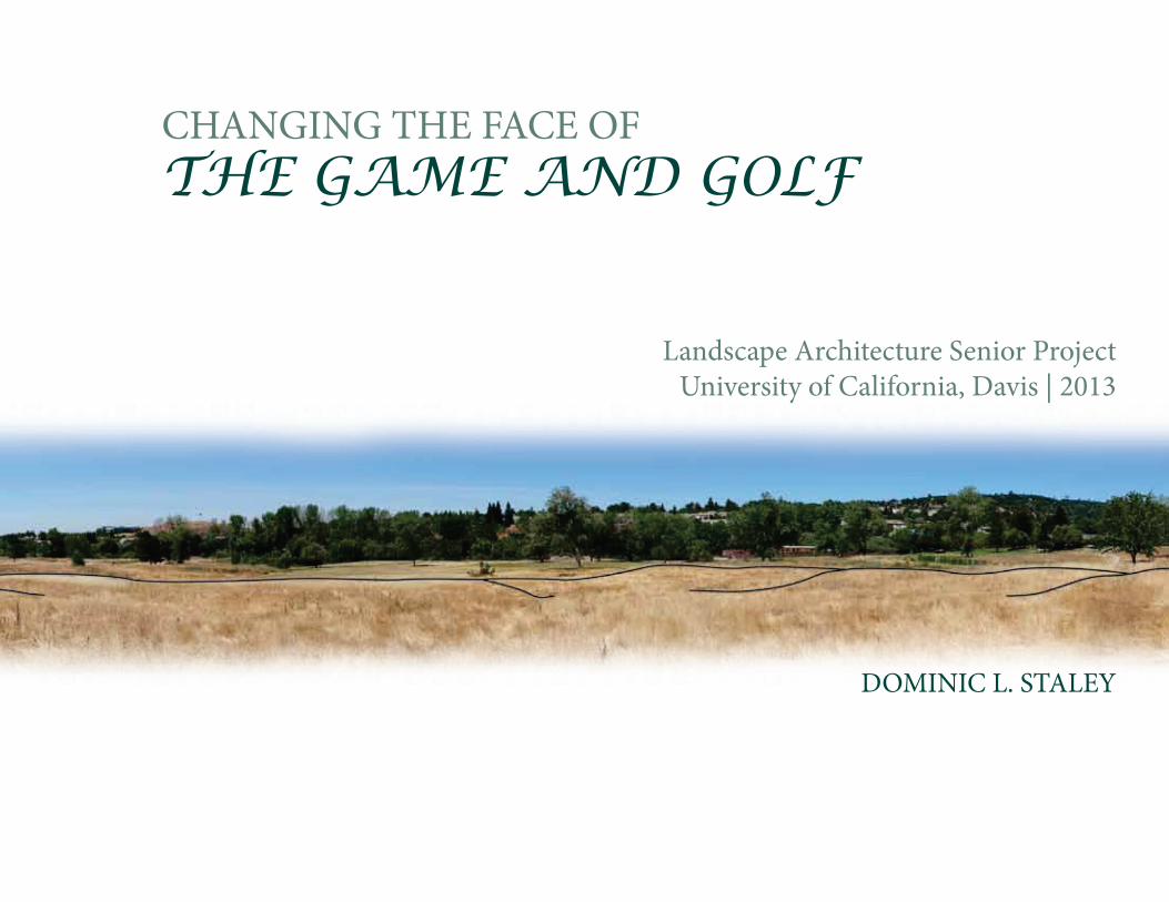
DOMINIC L. STALEY
CHANGING THE FACE OFTHE GAME AND GOLF
Landscape Architecture Senior ProjectUniversity of California, Davis | 2013

ACCEPTED AND APPROVED BY:
E. Byron McCulley
Jeff Loux
Andrea Howard
Professor, Program of Landscape Architecture, University of California, Davis
Assistant Professor, Program of Landscape Architecture, University of California, Davis
Principle Planner, Parker Development Company, El Dorado Hills, CA
Steven Wheeler
Associate Professor, Program of Landscape Architecture, University of California, Davis
A Senior Design ProjectPresented to the College of Agricultural and Environmental Sciences
University of California, Davis
In partial fulfillment of the requirementsfor the degree of
Bachelor of Landscape Architecture

ABSTRACT
Sustainable golf course landscape developments present a unique opportunity to preserve and
create wildlife habitat. Golf course maintenance and development organizations have been particularly
cognizant of their environmental responsibilities for a short period of time and are currently responsive
to new design strategies. The specific focus of this project is to develop environmentally sound and cost
effective guidelines to make insightful decisions on planning, design, maintenance, and water usage of
a golf course to enhance local communities, ecologically and economically. Based on recent community
evaluation, El Dorado Hills residents would appreciate the proposed golf course incorporated with the use
of natural resources to provide important green space, with the added benefits of a clean environment and
cost efficient fairway maintenance.

DEDICATION
This project is dedicated to my family and friends for constantly supporting me my whole life and allow-
ing me to do what I love and to do it to the very best of my ability. I wouldn’t be who I am today if it weren’t for my
amazing, demonstrably loving, and supportive father.

ACKNOWLEDGEMENTS
I would like to thank my committee members E. Byron McCulley, Jeff Loux and Andrea Howard forhelping me during the year producing this project.
To Byron: Special thanks for providing your knowledge and expertise in the field ofLandscape Architecture.
To Jeff: I also like to express my gratitude to you for helping me making my project a success.
To Andrea: Thank you for providing valuable information as well as permission for myobservation of your golf course and community development.
To my classmates: Your support and the fond memories of our amazing times will never be forgotten.

PREFACE
My study in the disciplines of the recreation environment has its origins in a small, hillside area on the central part
of El Dorado Hills, California what was known for El Dorado Golf Course. Throughout the latter half of my high
school years I had became fond of the golf course before it came into closure in the year of 2007. This site was the
most memorable golf course I have ever experienced with the adaptation of my perspectives in the wild. It was
through my love of golfing in this environment that had entirely changed my outlook of the nature. It has come into
my attention where my interest lies for this for this Senior Project topic.
The goal of this project is to focus on the consideration for renovation of the El Dorado Hills Golf Course, and
the environmental approach in the area. The Parker Development, the original developer of the Serrano Community
that surrounds the majority of the El Dorado hills GC, now owns the facility. Since the research, the El Dorado Hills
GC municipal featured an 18-hole executive length golf course, driving range and a clubhouse. The purpose of this
project is to analyze the current conditions with an evaluation of the local golf course and to provide an overall
master plan including clubhouse expansion, improved practice facilities, and a pedestrian trails throughout the
9-hole course.

CONTENTSWhat’s Inside...
110
17
25IN
TRO
DU
CTI
ON
RESE
ARC
H
SITE
AN
ALY
SIS
SITE
DES
IGN

LIST OF FIGURESFigure 1.1 - Image of Pinehurst No. 2 - Pinehurst, North CarolinaFigure 1.2 - Image of Cypress Point Club - Monterey, CaliforniaFigure 1.3 - Point graph- created by David Burger, ENH 130 Turfgrass ManagementFigure 1.4 - Bar graph- created by David Burger, ENH 130 Turfgrass ManagementFigure 1.5 - Image of St. Andrews, The Old Course - ScotlandFigure 1.6 - Image of LaHinch Golf Course - County Clare, IrelandFigure 1.7 - Image of Royal County Down Golf Course - Newcastle, N. IrelandFigure 1.8 - Pebble Beach Golf Links - Monterey, CaliforniaFigure 1.9 - Troon Golf & Country Club - Scottdale, ArizonaFigure 1.10 - Balsams Resort - Dixville Notch, New Hampshire
Figure 2.1 - Lake Tahoe Golf Course – Example of the Scorecard used for playing a 9-hole tournamentFigure 2.2 - Illustration of the Fairway- designed by Dominic StaleyFigure 2.3 - Image of Oak Quarry Golf Course, Riverside, CaliforniaFigure 2.4 - Image of the Tee Box at Pebble Beach Golf LinksFigure 2.5 - Image of the Green at Serrano Golf Course Figure 2.6 - Image of the Fairway, place unknown Figure 2.7 - Image of the Rough at Diamond Oak Golf CourseFigure 2.8 - This photo was taken at the Callippe Preserve Golf CourseFigure 2.9 - Image of a fox captured at the Callippe Preserve Golf Course. Figure 2.10 - The first hole of the course and the native landscape materials are easily identified in this picture.Figure 2.11 - La Jolla Country Club, San Diego – William P. BellFigure 2.12 - A map of Bidwell Park Golf Course and native hiking trail systems around the course.Figure 2.13 - This recent photo of the trails close to the golf course that can be seen from the 16th hole.Figure 2.14 - Standing atop of the canyon, you can see the golf course lies the bottom of the native landscapeFigure 2.15 - Aerial Image of Parris Island Golf CourseFigure 2.16 - Proposed Master Plan for Parris Island Golf Course – designed by Clyde Johnston
1
2
Figure 3.1 - Data Information – Rate of population in El Dorado Hills, WikipediaFigure 3.2 - El Dorado Hills Location (Map Quest) - Sacramento CountyFigure 3.3 - Golf Course Information – Length, Slope, Rating and size of Par Figure 3.4 - El Dorado hills Golf Course (View of the Clubhouse) – Photo by Dominic StaleyFigure 3.5 - Illustration of Map of Inventory – designed by Dominic StaleyFigure 3.6 - Illustration of Map of Inventory – designed by Dominic StaleyFigure 3.7 - El Dorado hills Golf Course (View of the wetland) – Photo by Dominic StaleyFigure 3.8 - El Dorado hills Golf Course (View of the 17th hole) – Photo by Dominic StaleyFigure 3.9 - Illustration of Physical Review – designed by Dominic StaleyFigure 3.10 - El Dorado hills Golf Course (View of the abandoned course) – Photo by Dominic StaleyFigure 3.11 - Dark Horse Golf Course; Auburn, California. Photo by Keith Foster.Figure 3.12 - Dark Horse Golf Course; Auburn, California. Photo by Scott Hopper.Figure 3.13 - Effect of terrestrial buffer zones on golf course; Florida. Photo by R. Boone, MD.Figure 3.14 - Photoshop of Opportunity – designed by Dominic StaleyFigure 3.15 - Veenker Memorial Golf Course; Iowa. Photo by John Newton.Figure 3.16 - Elkhart Municipal Golf Course; Michigan. Photo by Dan Spalding.Figure 3.17 - Charlie Vettiner Golf Course in Louisville, Kentucky. Source: Worldgolf.comFigure 3.18 - Photoshop of Constraint – designed by Dominic Staley
Figure 4.1 - Scorecard created by Dominic Staley for the new El Dorado Hill Golf Course CommunityFigure 4.2 - Image taken by Keith Foster, at Dark Horse Golf CourseFigure 4.3 - Final Masterplan, created by Dominic Staley. Photoshop and AutoCADFigure 4.4 - Section View A, created by Dominic Staley. Illustrator and PhotoshopFigure 4.5 - Section View B, created by Dominic Staley. Illustrator and PhotoshopFigure 4.6 - Clubhouse Enlargement, designed by Dominic Staley. Illustrator and PhotoshopFigure 4.7 - Practice Facility, enlarged and created by Dominic Staley. PhotoshopFigure 4.8 - Perspective, rendered by Dominic Staley
LIST OF FIGURES
3
4

Introduction1
PINEHURST NO. 2 - PINEHURST, NORTH CAROLINA
CYPRESS POINT CLUB - MONTEREY, CALIFORNIA
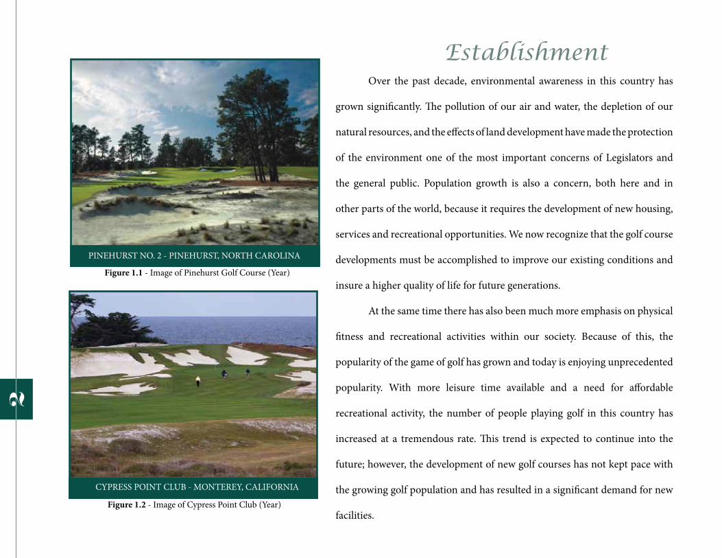
Establishment Over the past decade, environmental awareness in this country has
grown significantly. The pollution of our air and water, the depletion of our
natural resources, and the effects of land development have made the protection
of the environment one of the most important concerns of Legislators and
the general public. Population growth is also a concern, both here and in
other parts of the world, because it requires the development of new housing,
services and recreational opportunities. We now recognize that the golf course
developments must be accomplished to improve our existing conditions and
insure a higher quality of life for future generations.
At the same time there has also been much more emphasis on physical
fitness and recreational activities within our society. Because of this, the
popularity of the game of golf has grown and today is enjoying unprecedented
popularity. With more leisure time available and a need for affordable
recreational activity, the number of people playing golf in this country has
increased at a tremendous rate. This trend is expected to continue into the
future; however, the development of new golf courses has not kept pace with
the growing golf population and has resulted in a significant demand for new
facilities.
2
Figure 1.1 - Image of Pinehurst Golf Course (Year)
Figure 1.2 - Image of Cypress Point Club (Year)

One of the fastest growing participant sports in the U.S.
- Baby boomer retirementsAround since at least 1457
-Banned in Scotland as a threat to archery practice
-St. Andrews (Home of Golf) 1957
18 numbered holes- This project will focus on only 9 holes
including an expansion to a clubhouse and a practice facilities.
6000 to 7500 yards in total length- For all golf courses typically
Course usually cover 75 to 200 acres- The size of the El Dorado Hills Golf Course is
approximately 80 acres.
Golf Courses in U.S.
3
Figure 1.3 - Point graph of Number of Golf Coursein U.S. (Year)
Figure 1.4 - Bar Graph of Number of Courses in each State (Year)
Golf is unlike most other sports in that it does not involve a standard playing field or arena. Instead, golf
utilizes the landscape, and for that reason, maintains an intimate relationship with the environment. This relationship
between golf courses and the environment has become a priority within the golf industry. Through research and
analysis, I am striving to find the most environmentally responsible approach to the development of new golf courses
and the management of existing facilities.
The development of a golf course has become more of a complex process. To deal with this, a thorough
research and analysis of the site is required to meet the ability to design the golf course. A golf course presents the
opportunity to meet a need for recreational amenities while preserving green space that will provide benefits for the
future development of an area. The green space around the golf course can serve as a protective zone, known as a
buffer, between sensitive environmental areas and development. The buffer, which contains extensive turfed areas
and vegetation, will also protect water quality by providing stabilization against soil erosion and weather impacts.
Efficient and responsible maintenance practices for the golf course will promote the proper use and
conservation of water resources. A golf course can also provide enhancement to the environment by incorporating
areas for conservation and the promotion of wildlife habitat. These types of benefits will provide the necessary
design strategies to meet all the needs for a successful golf course development.
4

The Growth of Golf The game of golf as we know it today originated in the British Isles
hundreds of years ago. Along the coast of Scotland, where rivers like the Forth
and Eden empty into the sea, the land referred to as “linksland” was formed
by the forces of nature into very particular features and often stretched across
long distances. Nearby towns utilized the linksland mainly for agricultural
purposes and grazing livestock, but because of its unique characteristics of
this natural setting and the fact that it was mostly under public ownership, the
townspeople created courses and played golf.
As the number of people interested in golf steadily increased, early
courses were either expanded or ones “discovered” in the linksland. These golf
courses served as a focal point around which towns grew, providing recre-
ational activity and open space for the townspeople. Golf became a part of
everyday life for many of these small towns; even people who did not play the
game, still visited courses to explore the nature and the aesthetics of the turf.
ST. ANDREWS, THE OLD COURSE - SCOTLAND
LAHINCH G.C. - COUNTY CLARE, IRELAND
5
Figure 1.5 - Image of St. Andrews Golf Course (Year)
Figure 1.6 - Image of LaHinch Golf Course (Year)

It is believed that the very first golf tournament in U.S. was played in Charleston, South Carolina. The game
was first played in 1888 by the infamous “Apple Tree Gang” from Yonkers, New York, on a three-hole golf course
(Wind, 1975). The course was created and named by the developer from Scotland, where he first introduced golf as
a sport in the United States. However, the history of golf ’s built environment during the 20th century has reflected
the changing face of the game in terms of the type of golf courses built and those who played the game. What may
surprise many people is that golf has evolved from being a game played predominately by the upper class at private
clubs to a game mostly played by the middle class at public golf courses. In the boom periods of the 1920’s and
1960’s, because society was not aware of the ecological issues, many golf courses were built without regard for the
environment, economic, or social consequence. Unfortunately, most of the golf courses built during the most recent
boom period in the “golf course construction” were not sustainable at all. It turned out to be hazardous to the health
and economic strength of the golf industry. Too much money was spent on building courses and the maintenance of
these golf courses is also too expensive, so currently, it’s expensive to play golf. El Dorado Hills golf course was being
considered in re-developing, but the income of the total net for all of the improvement would most likely fail. The
role on this golf course has lost it’s motivation and the participants begins to disappear slowly.
Golf is now enjoying its greatest popularity in this country alone. Now in this country the majority of the
people of all ages and backgrounds are experiencing the pleasure and recreational benefits of the game.
6

past The first golf course of the British Isles came about in
linksland areas because the land was ideally suited to the game.
Linksland are characterized by distant features such as dunes or small
hills and numerous hollows, covered with native grasses and few if any,
trees. The soil in the linksland is typically sand-based with excellent
drainage, and provides ideal conditions for growing grass. Recognizing
These inherent characteristics, it was more convenient for the early
golfers to walk among the dunes and select certain grassy hallows as
the first golf holes. There were no standards to follow for laying out a
golf course at this time, so a series of holes were simply selected with,
routing that often ran along the coast and returned near to the starting
point. The number of holes varied from course to course, and when it
became desirable to enlarge the golf course, the players could
simply venture farther into the linksland and discover more holes.
There was very little construction involved in these initial
courses because of their advantageous settings and natural features.
DEVELOPMENT OF THE GOLF COURSE
ROYAL COUNTY DOWN G.C. - NEWCASTLE, N. IRELAND
7
Even when the first man-made modifications occurred, they were
done in concert with the existing land. Construction techniques
were primitive at that time, relying on hand labor and equipment
drawn by mules or oxen. The early architects were limited in what
could be done to alter the landscape in building a new course. They
worked carefully with the topography and existing features to avoid
excessive disturbance, as well as time and expense in construction.
Figure 1.7 - Image of Royal County Down Golf Course (Year)
present
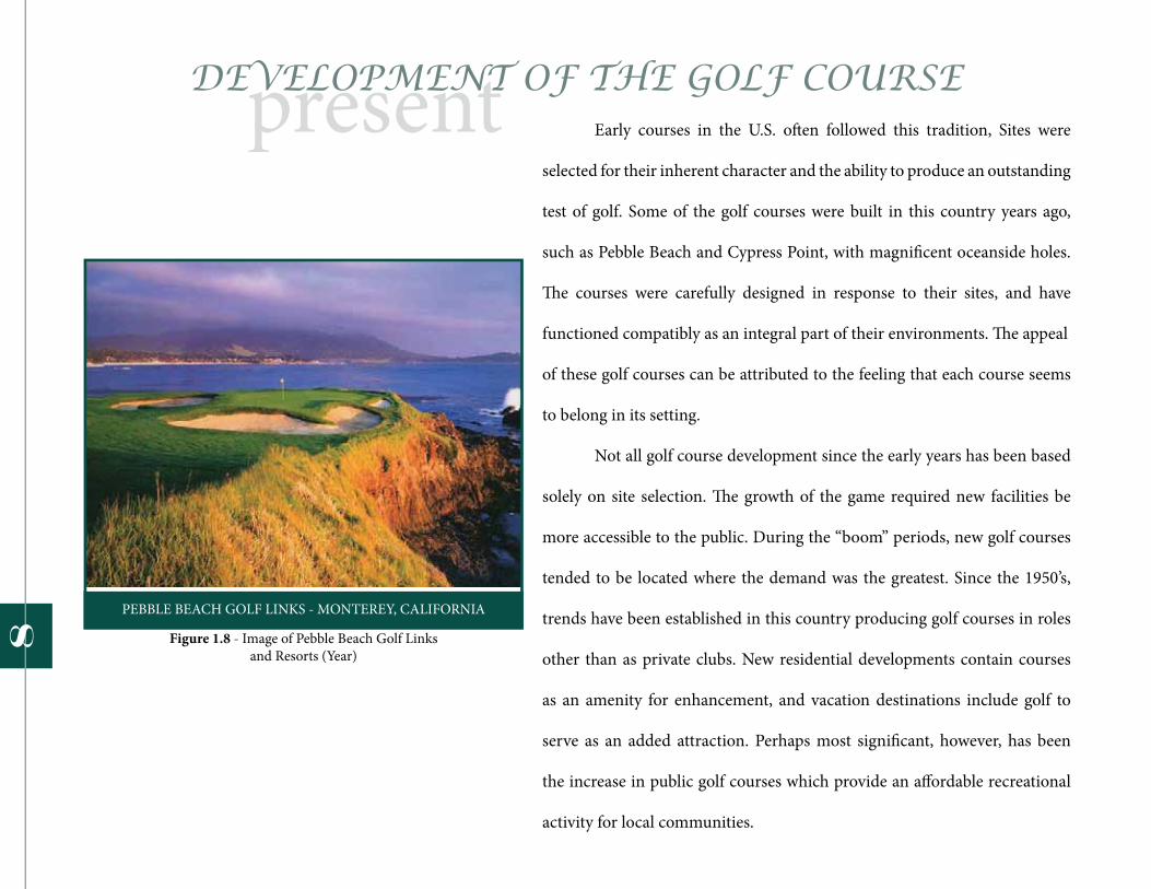
PEBBLE BEACH GOLF LINKS - MONTEREY, CALIFORNIA
Early courses in the U.S. often followed this tradition, Sites were
selected for their inherent character and the ability to produce an outstanding
test of golf. Some of the golf courses were built in this country years ago,
such as Pebble Beach and Cypress Point, with magnificent oceanside holes.
The courses were carefully designed in response to their sites, and have
functioned compatibly as an integral part of their environments. The appeal
of these golf courses can be attributed to the feeling that each course seems
to belong in its setting.
Not all golf course development since the early years has been based
solely on site selection. The growth of the game required new facilities be
more accessible to the public. During the “boom” periods, new golf courses
tended to be located where the demand was the greatest. Since the 1950’s,
trends have been established in this country producing golf courses in roles
other than as private clubs. New residential developments contain courses
as an amenity for enhancement, and vacation destinations include golf to
serve as an added attraction. Perhaps most significant, however, has been
the increase in public golf courses which provide an affordable recreational
activity for local communities.
DEVELOPMENT OF THE GOLF COURSE
8 Figure 1.8 - Image of Pebble Beach Golf Links and Resorts (Year)

future
TROON GOLF & COUNTRY CLUB - SCOTTSDALE, ARIZONA
Today, most if not all, sites are being selected for demographic
and economic purposes as well as for their suitability as golf courses.
Modern construction methods have made it possible to build golf
courses in locations where there is a demand for new facilities. Not
all locations, though, offer sites with an outstanding natural character.
More often, they contain no significant land forms, water features, trees,
or scenery.
In some cases golf courses have been specifically developed to
enhance the visual quality of featureless sites and provide an attractive
green, open space.
DEVELOPMENT OF THE GOLF COURSE
“Sites that have been mismanaged or abandoned after
extensive use as agricultural fields, stone quarries, gravel pits,
landfills, sludge disposal sites or other operations which degrade
the land, can be reclaimed, improved and beautified through use
as a golf course,” quoted by William Love, Chairman of American
Society of Golf Course Architects.
9
Figure 1.9 - Image of Troon Golf and Country Club (Year)

Environmental Issues of the Golf Course
BALSAMS RESORT - DIXVILLE NOTCH, NEW HAMPSHIRE
Before obtaining the site is to thoroughly review the process
and evaluate before determining its impact and benefit to area
residents. The size of the site and land use in a golf course
require that these issues be raised and addressed. Over the last
few decades, the environmental movement has focused our
attention on the issues involved in land development, and it has
also led to a much more sensitive, responsive approach to how
golf courses are planned, designed, built, and managed.
Every proposed golf course will present a unique case because existing conditions vary and no two sites are ever exactly the same. There will be specific issues based on location, site characteristics, climate and local regulations. However, it is important to concern certain environmental issues before selecting the location during the processes.
1. Will the golf course alter or eliminate wetland and other sensitive environmental areas on the site that will be affected by the golf course?
2. What impact will the golf course have on the ecological systems of the site, such as plant life and wildlife habitat?
3. How will the golf course affect the existing character of the site through renovation of the topography and vegetative cover?
4. Does the golf course constitute the elimination of open or green space by making use of a site which is currently undeveloped?
It is essential to identify and address these issues in the initial stages of
planning and design for the development. A responsive approach to
the issues will avoid impacts as well as cost delays in the development
process, and will result in the successful completion of the golf course
that is beneficial as an amenity and environmentally compatible use
of the site.
10
Figure 1.10 - Image of Balsams Resort and Golf Course (Year)

11


Research13
14
The goal is to express my research question prior from my early statement about creating a sustainable golf course
on abandoned 18-hole course. My questions were from the following: What will change if there was a proposed golf
course on a abandoned site where there was once a golf course for a long time? Will the city committees come into
consideration in revitalizing a new sustainable golf course? Finally, this project will not only becomes a golf course,
but an evironmentally and ecologically developed landscape.
While the characteristics of the fairways on the traditional golf course design seems to be deeply restricted, which
lead to a subject of this proposal with a new solution to developing and maintaining a large scale fairway. In the rest
of this proposal, any future programs or projects of the golf course should be used designed thoroughly and cared
with respect for the nature. Good environment practice and design is the result of a multitude of elements and a
detailed understanding of how these elements interrelate on this specific site in a specific location. Prioritize of the
environmental steps in this project is significant to the achievement of making a better golf course by understanding
the role of identity in the natural habitat. The statement above, in which I have a desire to find a solution, implement
an excellent outline for this project that will create an effective design for sustainable golf course in El Dorado Hills.
Intention

The Game of Golf
Example of the typical scorecard at the Old Brockway Golf Course in Lake Tahoe. As for this project, a 9-hole golf course scorecard will be similar to this one below
as shown.
Par 3 hole
Player is expected to hit the green from stroke played from the tee
(Up to 200 yards)
Par 4 hole
Player is expected to hit the ball from the tee onto a fairway located between the tee
and green(220 to 420 yards)
Par 5 hole
Player is expected to hit the ball from the tee onto a fairway and then onto the
fairway again before hitting the green(465 to 550 yards)
• Typically, 18 holes are played in a round• Golfers limited to the use of 14 golf clubs• Each hole started on a tee and ended on a green• Par: A predetermined number of strokes that a scratch (or 0 handicap) golfer should require to complete a hole• Typically, a par score for 18 holes is 72 In golf, lower scores are better A par score of 9 holes is 36
15
Figure 2.1 - Lake Tahoe Golf Course Scorecard (9-hole) (Year)

Philosophy of the Fairway
Types of Hazards
1. Long grass2. Nonturf vegetation
3. Slopes4. Mounds
5. Depressions6. Grass traps
7. Sand bunkers (traps)8. Rocks, boulders, and stone
9. Man-made structures10. Trees11. Water
An appropriate way to design the fairway is the direction within 15 degrees from the tees to the centerline. Containment
mounting outside of 15 degree angle on either side of the centerline will not
compound the golfer’s problems on errant shots.
Red TeeFor novice and senior player tee is
approximately 600 sq. ft.10 % of total Tee Area
White TeeFor average male players and advanced female, junior, and senior players. Tee is
approximately 900 sq. ft.
Blue TeeFor advanced make golfers and female
professional players. Tee is approximately 1200 sq. ft. 20 % of total Tee
Types of Hazards
7. Sand bunkers (traps)8. Rocks, boulders, and stone
9. Man-made structures
An appropriate way to design the fairway is the direction within 15 degrees from the tees to the centerline. Containment
mounting outside of 15 degree angle on either side of the centerline will not
compound the golfer’s problems on
Red TeeFor novice and senior player tee is
approximately 600 sq. ft.10 % of total Tee Area
White TeeFor average male players and advanced female, junior, and senior players. Tee is
approximately 900 sq. ft.
Blue TeeFor advanced make golfers and female
professional players. Tee is approximately 1200 sq. ft. 20 % of total Tee1
6
Figure 2.2 - Illustration of the Fairway (Year)

Golf Courses Benefit People and Wildlife
• Provides wildlife habitat• Protects topsoil from water and wind erosion• Improves community aesthetics• Absorbs health and reduces stress for more than 24.5 million golfers• Improves air quality• Captures and cleanses runoff in urban areas• Discourages pests (e.g. ticks and mosquitoes)• Restores damaged land areas (e.g. former landfill or mining sites)• Makes substantial contributions to the community’s economy
Oak Quarry Golf Course - Riverside, CARestores damaged land areas (former mining site)
17
Figure 2.3 - Image of Oak Quarry Golf Course (Year)

Golf Courses Characteristics
TeesDesirable characteristics: LevelSmoothFirmDenseUniformClose cut
Greens Desirable characteristics:UniformSmoothFirmDrainageCompactionResilientVery close cut
18
Figure 2.4 - Image of the Tee Box at Pebble Beach Golf Links (Year)
Figure 2.5 - Image of the Green at Serrano Golf Course (Year)

Golf Courses Characteristics
Fairways Desirable characteristics:
DenseUniformSmooth
FirmResilient
RoughDesirable characteristics:
Conditions insuring some degree of penaltyEase in finding golf ball
Soil erosion controlMinimal maintenance requirements
19
Figure 2.6 - Image of the Fairway, place unknown (Year unkown, but very recent)
Figure 2.7 - Image of the Rough atDiamond Oak Golf Course (Year)

Case Studies: Callippe Preserve Golf Course The exercise of this case studies has greatly increased my analyzing skills and provided me to discover the main opportunities and constraints of this project’s site for the development. Callippe Preserve Golf Course is the first case study to provide as much information as possible for the environmental restoration and habitat mitigation. This golf course is located approximately 45 minutes east of San Francisco; the 18-hole course was designed and developed in November 2005, by Brian Costello, of SMP Golf Design Group. In the 145-acre project, it was proved to be a challenge because it runs along the valley where its main waterway branches that housed many federally endangered species. The design’s main focus was the avoidance, the restoration and mitigation combined with the application of the best landscape practices to allow for drainage and high quality irrigation on this site. Reduced sedimentation and runoff has established new riparian habitats and wetland areas to create a new home for wildlife species. The golf course was sensitively moved because of the existing and valued natural environment in the area. This project was very successful and dedicated for achievement in environmental planning, wildlife and habitat management, with chemical reduction and safety in water conservation (1.2.1 Marketing, 2005).
Course Description
18-Hole Championship Golf Course
Private Country Club
There are five sets of tees on this par 72 course: the black
tees play at 6,748 yards. The blue tees measure 6,409
yards, then the white tees at 6,024 yards, the gold tees
total 5,560 yards, and the red tees at 4,788 yards.
20
Figure 2.10 Figure 2.11
Figu
re 2
.8
Figure 2.9

Case Studies: La Jolla Country Club
This project was a complete 18-Hole Master Plan and completed in November, 1993 by Cary Bickler. Included was a Hole-by-Hole Evaluation and Colored Rendering. Plans also encompassed a new driving range, practice facility, maintenance yard, and nursery green. A separate Tree Master Plan was a second phase of the work. La Jolla Country Club is situated above the small Southern California village of La Jolla on a magnificent site with Pacific Ocean views, canyons and natural rolling terrain. The original golf course, designed by William Bell in 1927, is a glistening example of his classic golf course architecture. The 18-Hole Master Plan placed emphasis on 6 holes that had previously been redesigned over the years, and had been taken out of character from Mr. Bell’s original theme. A primary consideration was to redesign new greens with contours that were playable, manageable and congruent with the original design intent and character of the traditional style golf course.
Course Description
18-Hole Championship golf Course
Private Country Club
Blue Tees 6,685 Par 72
White Tees 6,260 Par 72
Red Tees 5,970 Par 74
New Green Tees 5,335 Par 74
The tree theme at La Jolla Country Club was expressed by the use of Canary Island pine and eucalyptus. The pines gave masses of dense, dark green background, while the skyline and horizon were defined by the eucalyptus. These theme trees combined well to present a good design basis, however due to the random planting of a large variety of other plant and tree species by Green Committees throughout the years, the landscaping had become a botanical collection of misplaced trees. Open space between trees is of equal aesthetic importance in tree and landscape composition.
Due to tree groupings growing into each other there was a lack of positive and negative space balance. Beautiful trees and plantings that were hidden by the overgrowth of other trees were defined and brought into view by removing and pruning trees. This enhanced the overall value of the course plant and tree-scape. It also reclaimed the original course strategy by eliminating trees that interfered with the corridors of play.
21
Figu
re 2
.12

Case Studies: Bidwell Park Golf Course
These three photos above inspired me to create a natural golf course for my project and has taught me a great deal about preserving and conserving a natural wildlife habitat. John and Annie Bidwell donated the land for Bidwell Park in 1905 for recreational use.
Course Description
18-Hole Championship golf Course
Municipal Golf Course
Black Tees 6,363 Par 70
Middle Tees 5,991 Par 68
Forward Tees 5,440 Par 71
22
Figure 2.13
Figure 2.14
Figure 2.15
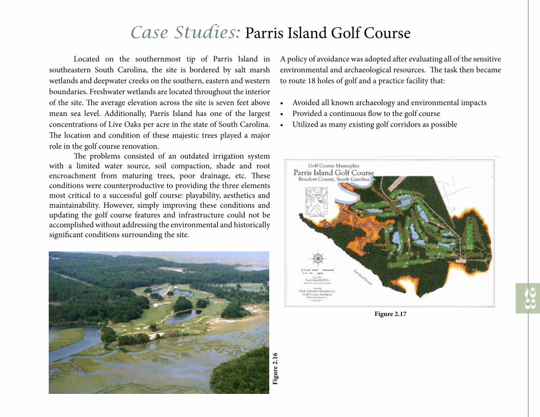
Case Studies: Parris Island Golf CourseLocated on the southernmost tip of Parris Island in
southeastern South Carolina, the site is bordered by salt marsh wetlands and deepwater creeks on the southern, eastern and western boundaries. Freshwater wetlands are located throughout the interior of the site. The average elevation across the site is seven feet above mean sea level. Additionally, Parris Island has one of the largest concentrations of Live Oaks per acre in the state of South Carolina. The location and condition of these majestic trees played a major role in the golf course renovation.
The problems consisted of an outdated irrigation system with a limited water source, soil compaction, shade and root encroachment from maturing trees, poor drainage, etc. These conditions were counterproductive to providing the three elements most critical to a successful golf course: playability, aesthetics and maintainability. However, simply improving these conditions and updating the golf course features and infrastructure could not be accomplished without addressing the environmental and historically significant conditions surrounding the site.
A policy of avoidance was adopted after evaluating all of the sensitive environmental and archaeological resources. The task then became to route 18 holes of golf and a practice facility that:
• Avoided all known archaeology and environmental impacts• Provided a continuous flow to the golf course• Utilized as many existing golf corridors as possible
23
Figure 2.17
Figu
re 2
.16


Site Analysis25

Social Context
The community of El Dorado Hills lies on the western edge
of El Dorado County, 25 miles east of Sacramento, in the lower
Sierra Nevada foothills. Because of its desirable location proximate
to Sacramento, Lake Tahoe, and the Sierra Nevada, El Dorado
Hills has long attracted visitors, and more recently, residents and
businesses. Present day residents of El Dorado Hills enjoy prime
recreational areas including lakes, mountains, and rivers, as well as
the amenities of a growing commercial and business community.
Like other desirable communities of its kind, El Dorado
Hills faces many of the challenges that accompany fast-paced
development. While El Dorado Hills has fought to maintain a semi-
rural character over the years, a growing population and a thriving
housing market threaten to change the nature of the community. The
steadily increasing population brings with it an ever-expanding need
for services: schools, fire and water service, and planning. Further,
fast pace development of the type experienced by El Dorado Hills
produces a mounting demand for parks and recreation facilities.
To the north, this area is bounded by two of the community’s
greatest assets, Folsom Lake and the Folsom Lake State Recreation
Area. To the east lies the neighboring communities of Cameron
Park and Marble Valley. The planning area borders the community
of Latrobe to the south, and to the west, the Sacramento County line
and the City of Folsom.
As its location in the Sierra Nevada foothills implies, the El Dorado
Hills community is host to a variety of terrains, from gently rolling
hills to steep inclines. Two major north-south ridgelines run
through the community, forming two valleys. The valleys drain
northward into the American River Watershed and Folsom Lake,
and southward into the Consumnes River Watershed.
El Dorado Hills Population
Population in 2010 42, 108
Population Growth Rate Very Rapidly
Population Projected 58, 831
26
Figure 3.1 - Rate of Population in El Dorado Hills

Regional Context
The subject property is the El Dorado Hills Golf Course, golf facility located along the heavily
traveled Highway 50 in the Heart of east Sacramento suburbs, 24 miles east of downtown Sacramento,
California. The golf facility includes one executive-length (par 61) 18-hole golf course (opened 1964),
as well as a driving range, pro shop, and snack bar.
El Dorado Hills G.C.
27Figure 3.2 - Location of the El Dorado Hills Golf Course (mapquest.com)
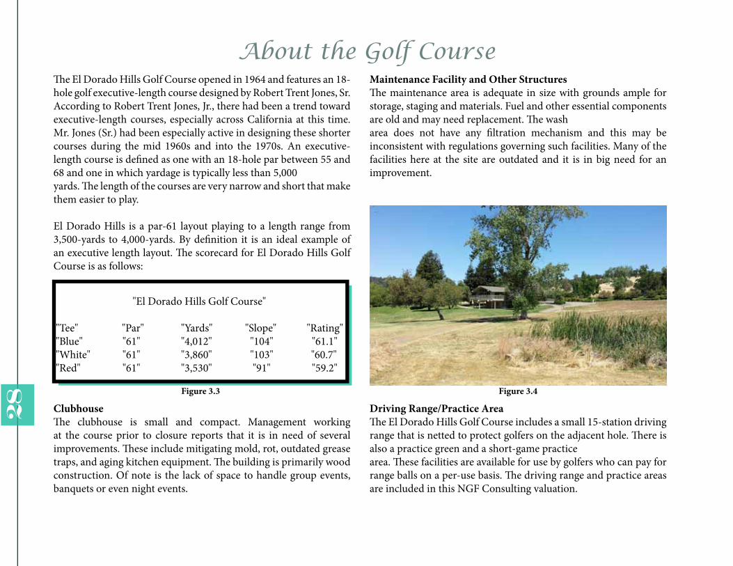
The El Dorado Hills Golf Course opened in 1964 and features an 18-hole golf executive-length course designed by Robert Trent Jones, Sr. According to Robert Trent Jones, Jr., there had been a trend toward executive-length courses, especially across California at this time. Mr. Jones (Sr.) had been especially active in designing these shorter courses during the mid 1960s and into the 1970s. An executive-length course is defined as one with an 18-hole par between 55 and 68 and one in which yardage is typically less than 5,000yards. The length of the courses are very narrow and short that make them easier to play.
El Dorado Hills is a par-61 layout playing to a length range from 3,500-yards to 4,000-yards. By definition it is an ideal example of an executive length layout. The scorecard for El Dorado Hills Golf Course is as follows:
"El Dorado Hills Golf Course"
"Tee" "Par" "Yards" "Slope" "Rating""Blue" "61" "4,012" "104" "61.1""White" "61" "3,860" "103" "60.7""Red" "61" "3,530" "91" "59.2"
About the Golf Course
ClubhouseThe clubhouse is small and compact. Management working at the course prior to closure reports that it is in need of several improvements. These include mitigating mold, rot, outdated grease traps, and aging kitchen equipment. The building is primarily wood construction. Of note is the lack of space to handle group events, banquets or even night events.
Maintenance Facility and Other StructuresThe maintenance area is adequate in size with grounds ample for storage, staging and materials. Fuel and other essential components are old and may need replacement. The washarea does not have any filtration mechanism and this may be inconsistent with regulations governing such facilities. Many of the facilities here at the site are outdated and it is in big need for an improvement.
Driving Range/Practice AreaThe El Dorado Hills Golf Course includes a small 15-station driving range that is netted to protect golfers on the adjacent hole. There is also a practice green and a short-game practicearea. These facilities are available for use by golfers who can pay for range balls on a per-use basis. The driving range and practice areas are included in this NGF Consulting valuation.
28 Figure 3.3 Figure 3.4

Inventory of Facilities The existing facility consists of an 18-hole, executive-length golf course with returning nines. A practice range (driving range) is of limited length and width, but is proximal to the clubhouse. The clubhouse is two levels. The maintenance area is generous in size. The facility sits in a sloping valley bordered by hills, a freeway and collector streets. A major arterial street serving residential areas bisects the course adjacent to the clubhouse. Residential and retail uses surround the course, although proximity to these uses is distant given the steep hillsides and dense vegetation along the golf course.
PROPERTY BOUNDARYWATER BODYCART PATHEXISTING BUILDINGHAZARD AREASCOURSE LENGTHDRIVING RANGE/PRACTICE AREAOPEN SPACE/MAINTENANCE FACILITYVIEWS
LEGEND
NORTHSCALE: 200’ - 0”
29
Figure 3.5
Figure 3.6

Current SituationLand surrounding the golf course consists of primarily open space parcels, although there are more parcels in the maintenance facilities. The open space parcels are interconnected to development agreements that require a certain acreage of open space be maintained as part of the community. The existing golf course occupies roughly 80 acres of improved turf and area in addition to maintenance and clubhouse areas. However, the data found of a parcel from El Dorado County lists the total golf course parcel as 98.371 acres. The difference between the two figures is perimeter areas that have been largely left in their original, undisturbed state.
Site OverviewThe setting of the course is quintessentially northern California. The golf course lies in a linear configuration below hills and along a drainage creek. The land is very suitable for golf with gentle slopes, occasional ridges and rising (steeper) slopes where tees was placedto make some holes more interesting. Several ponds and connecting ditches add interest—and difficulty. Many of these ponds aremethods of collecting drainage. A few ponds were added over the years for the same reason, to serve as drainage areas for naturally seeping water that reaches the surface. The golf course has very good views with some territorial views across the greater area of El Dorado Hills and the community. The course is typical of 1960s shaping and features. Most features have been artificially shaped via earthwork. A few green sites and tees are more naturally set into the terrain. These tend to be the most interesting holes. The shaping work is not overdone and seems to fit well to the landscape and terrain. Of note is that the existing golf course has a significant acreage devoted to maintained turf. Of the total golf course parcel, roughly 80% is covered by areas that require maintenance and continual care: turf, rough areas, and ponds/waterways. In a contemporary development of the same general type and configuration it would be likely that only 60-70% of the total land area would be covered in turf, or perhaps just 60 acres.
30
Figure 3.7 Figure 3.8

Physical ReviewThis evaluation comprises a physical assessment of the existing El
Dorado Hills golf facility owned by Parker Development. The method for evaluating the facilities involved a physical site visit to the facility
and interviews with staff charged with caring the facilities. Additional data was sought from professionals familiar with the golf course, its
operations and from available plan and aerial data. The evaluation covers the base facility: the golf course,
golf amenities, and maintenance operations.
750800
PROPERTY BOUNDARYHILL TOPDRAINAGE PATHRIDGE LINEWATER BODYEXISTING TREEEXISTING VEGETATIONEXISTING BUILDINGFLATTER AREASSTEEPER AREASCOURSE DIRECTIONCART PATHHAZARD AREAS
LEGEND
NORTHSCALE: 200’ - 0”
31
El Dorado Hills Blvd.
Serrano Parkway
HWY 50
Figure 3.9
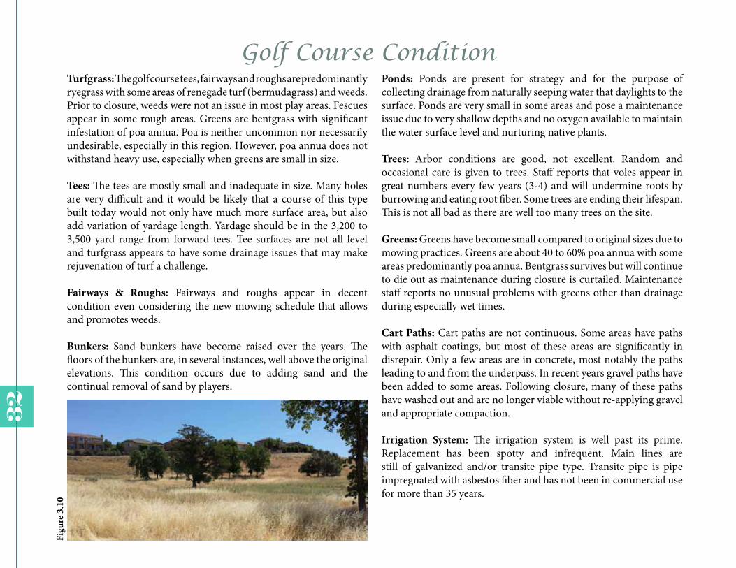
Ponds: Ponds are present for strategy and for the purpose of collecting drainage from naturally seeping water that daylights to the surface. Ponds are very small in some areas and pose a maintenance issue due to very shallow depths and no oxygen available to maintain the water surface level and nurturing native plants.
Trees: Arbor conditions are good, not excellent. Random and occasional care is given to trees. Staff reports that voles appear in great numbers every few years (3-4) and will undermine roots by burrowing and eating root fiber. Some trees are ending their lifespan. This is not all bad as there are well too many trees on the site.
Greens: Greens have become small compared to original sizes due to mowing practices. Greens are about 40 to 60% poa annua with some areas predominantly poa annua. Bentgrass survives but will continue to die out as maintenance during closure is curtailed. Maintenance staff reports no unusual problems with greens other than drainage during especially wet times.
Cart Paths: Cart paths are not continuous. Some areas have paths with asphalt coatings, but most of these areas are significantly in disrepair. Only a few areas are in concrete, most notably the paths leading to and from the underpass. In recent years gravel paths have been added to some areas. Following closure, many of these paths have washed out and are no longer viable without re-applying gravel and appropriate compaction.
Irrigation System: The irrigation system is well past its prime. Replacement has been spotty and infrequent. Main lines are still of galvanized and/or transite pipe type. Transite pipe is pipe impregnated with asbestos fiber and has not been in commercial use for more than 35 years.
Golf Course ConditionTurfgrass: The golf course tees, fairways and roughs are predominantly ryegrass with some areas of renegade turf (bermudagrass) and weeds. Prior to closure, weeds were not an issue in most play areas. Fescues appear in some rough areas. Greens are bentgrass with significant infestation of poa annua. Poa is neither uncommon nor necessarily undesirable, especially in this region. However, poa annua does not withstand heavy use, especially when greens are small in size.
Tees: The tees are mostly small and inadequate in size. Many holes are very difficult and it would be likely that a course of this type built today would not only have much more surface area, but also add variation of yardage length. Yardage should be in the 3,200 to 3,500 yard range from forward tees. Tee surfaces are not all level and turfgrass appears to have some drainage issues that may make rejuvenation of turf a challenge.
Fairways & Roughs: Fairways and roughs appear in decent condition even considering the new mowing schedule that allows and promotes weeds.
Bunkers: Sand bunkers have become raised over the years. The floors of the bunkers are, in several instances, well above the original elevations. This condition occurs due to adding sand and the continual removal of sand by players.
32
Figu
re 3
.10

1
1
2
2
3
4
5
5
6
6
Opportunity
The buffer zone around the pond integrate the wildlife habitat between the sensitive environment area and the playing turf. In order to do so, the native landscape must be provided to welcome the wildlife habitat, such as deer, jack rabbit, and other species.
This picture is from the golf course located at Auburn, California. And illustrates how fairways are blended with both native landscape and a new sustainable landscape with all California native species.
A golf course can also provide enhancement to the environment by incorporating areas for conservation and the promotion of wildlife habitat.
Opportunities1) Integrate habitat on left side of
fairway.2) Integrate habitat behind greens.3) Integrate sensitive environments
between tee boxes and start of fairway.
4) Integrate habitat around tee boxes.
5) Naturalize pond edges that are out of play.
6) 80m between centerlines provides opportunity for large core habitat and continuous vegetated
corridors.
33
Figure 3.11
Figure 3.12
Figure 3.13 Figure 3.14

Constraint
1
1
12
2 3
3
3
4
4
“When you golf, you golf. It’s part of the game,” said Scott McMurray, general manager of Elkhart Municipal Golf Course, in Michigan. The reason for the closure was the budget and could not cover the fees for the expensive maintenance facility, which is responsible for keeping the aesthetic of the wide green fairway.
Small landing zone is a great way to prevent taking over the natural area, but it is highly dangerous to wildlife species and the environment since the landing of the golf ball could possibly damage the native landscape.
Golf carts can damage the golf course in two different forms, soil compaction and turf injury. It can be easily fixed by adding curbs on the cart path to keep the motorized cart off the turf.
Constraints1) Locate terrestrial habitat
sufficient distance from tees and greens.
2) Pond edges in front of target areas are not suitable for
naturalization.3) Habitat must be integrated outside of the 60m clearance.
4)Habitat around landing zones face more pressure to be
maintained.
34
Figure 3.18
Figure 3.15
Figure 3.16
Figure 3.17

1
1
12
2 3
3
3
4
4
35


Site Design37
38
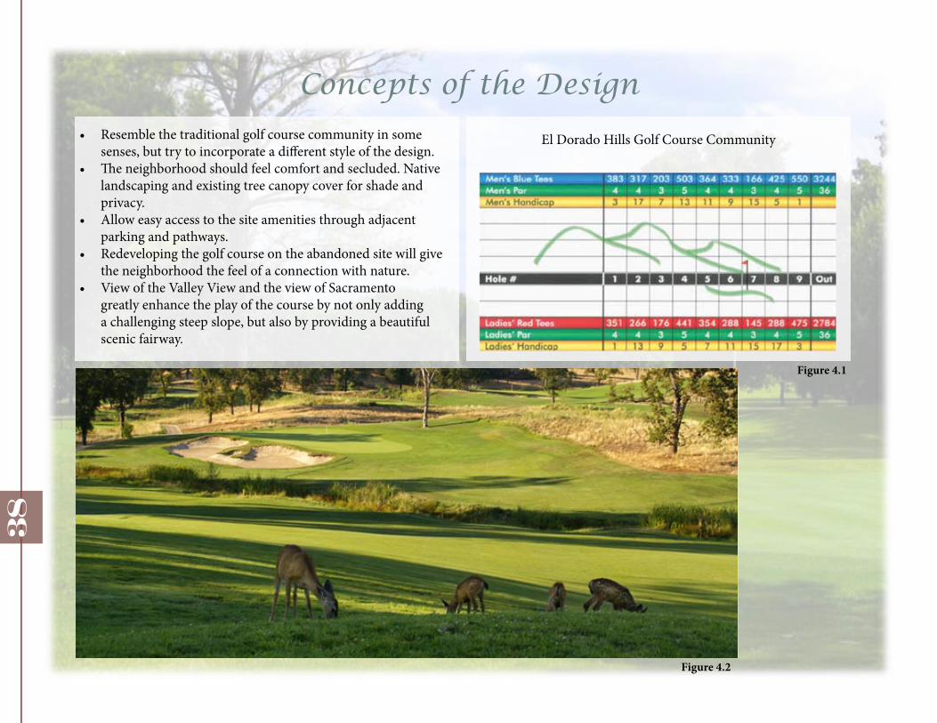
Concepts of the Design• Resemble the traditional golf course community in some
senses, but try to incorporate a different style of the design.• The neighborhood should feel comfort and secluded. Native
landscaping and existing tree canopy cover for shade and privacy.
• Allow easy access to the site amenities through adjacent parking and pathways.
• Redeveloping the golf course on the abandoned site will give the neighborhood the feel of a connection with nature.
• View of the Valley View and the view of Sacramento greatly enhance the play of the course by not only adding a challenging steep slope, but also by providing a beautiful scenic fairway.
El Dorado Hills Golf Course Community
Figure 4.1
Figure 4.2
Master Plan
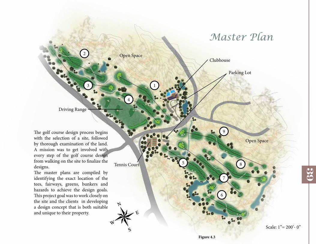
The golf course design process begins with the selection of a site, followed by thorough examination of the land. A mission was to get involved with every step of the golf course design from walking on the site to finalize the designs. The master plans are compiled by identifying the exact location of the tees, fairways, greens, bunkers and hazards to achieve the design goals. This project goal was to work closely on the site and the clients in developing a design concept that is both suitable and unique to their property.
Scale: 1”= 200’- 0”
1
2
3
4
5
6
7
8
9
Clubhouse
Parking Lot
Tennis Court
Driving Range
Open Space
Open Space
39
Figure 4.3

Golf Course Dimensions
Hole 1 Par 4 - 396 yds
Hole 2 Par 3 - 290 yds
Hole 3 Par 5 - 505 yds
Hole 4 Par 4 - 365 yds
Hole 5 Par 4 - 371 yds
40
41
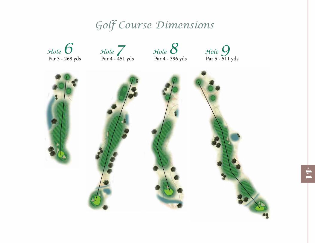
Golf Course Dimensions
Hole 6 Par 3 - 268 yds
Hole 7 Par 4 - 451 yds
Hole 8 Par 4 - 396 yds
Hole 9 Par 5 - 511 yds

42
Number of Par
Par 3 Hole 6 - 805 ft
Par 5 Hole 9 - 1,534
The length of each hole from the tee placement to the pin determines par values for each hole primarily, though not exclusively. A par-three hole will range between 100–250 yards from the tee to the pin. Par-four holes range between 250–450 yards, although tournament players will often encounter par-four holes as long as 500 yards or more, as it is not uncommon for short par-five holes for normal play to be turned into par-four holes in championship play. Par-five holes are typically between 450–600 yards, but in the modern game, holes of over 600 yards are becoming more common in championship play. Other relevant factors in setting the par for the hole include the terrain and obstacles (such as trees, water hazards, hills, or buildings) that may require a golfer to take more (or fewer) shots.
Par 4 Hole 4 - 1,097

Section Views
Two sections are provided you to get a sense of the elevation of the fairway from tee box to the hole. There are several new vegetations included, which are mulberry and zelkova trees. Appropriate turfgrass for this golf course fairways are the mixture of Kentucky Bluegrass and Tall Fescue. Tee boxes and the greens are to be highly maintained at all time to keep the function and a clean, shaved texture for a better swing at the ball. As for the rest of the vegetations, the native grasses are kept aside of the turfgrass to present a rough area and a feel of the natural environment.
43
Section View B: Green Hole
Section View A: Tee Box
AB
Figure 4.4
Figure 4.5

Clubhouse and RecreationAmenities
The project includes design of two-story clubhouse to accommodate the goals of the golf course. The clubhouse is a 3,000 square foot traditional pavilion shaped structure that contains the pro shop, management offices, restrooms and a bar/grill dining. The cart/banquet pavilion downstairs is a rectangular 3,000 square feet dual purpose structure that can hold 50 golf carts as well as serve as a banquet pavilion. Seating capacity for this space can range from 150 to 180 for any events. This site includes many amenities for residents and guests, such as wedding receptions, family/olympic pool, and eight full tennis court. Number of parking lot is reduced to 100 since the conversion of the golf course holes.
44
Tennis Court
Serrano ParkwayClubhouseEntrance
Parking Lot
Parking Lot
Parking Lot
Pool
Wetland
Figu
re 4
.6

Practice Facility
Call them Driving Ranges or call them golf learning centers, but they are usually called practice facilities in some way, shape or form. This driving range deliver very simple 15-bay driving ranges with great target greens or complete a range, chipping area, bunker area, putting green area, and a wide area spread over 20 acres to practice your driving and iron skills.
45
Tee Area
Target Green
Target Green
Target Green
Figure 4.7
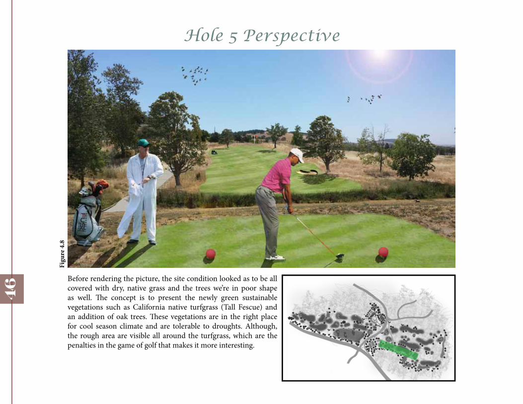
Hole 5 Perspective
Before rendering the picture, the site condition looked as to be all covered with dry, native grass and the trees we’re in poor shape as well. The concept is to present the newly green sustainable vegetations such as California native turfgrass (Tall Fescue) and an addition of oak trees. These vegetations are in the right place for cool season climate and are tolerable to droughts. Although, the rough area are visible all around the turfgrass, which are the penalties in the game of golf that makes it more interesting.
46
Figu
re 4
.8
Bibliography
1. 1.2.1 Marketing, . “Callippe Environmental Approach.” Play Callippe. 1. (2013): n. page. Web. 1 Mar. 2013. <http://www.playcallippe.com/environment/callippe-environmentalapproach>.
2. Fazio, Tom. Golf Course Designs. 1. 1. New York: Harry N. Abrams, Inc., 2000. 17-155. Print.
3. Hundley, Heather, and Andrew C. Billings. Media Explorations of Identity in Golf. 1. 1. New Jersey: Hampton Press, 2010. 34-106. Print.
4. Lilly, Sharon. Golf Course Tree Management. 1. 1. Michigan: Ann Arbor Press, 1999. 61-85. Print.
5. R. Jarrett, Albert. Golf Course and Grounds: Irrigation and Drainage. 1. 1. New Jersey: Prentice-Hall, Inc., 1985. 42-53, 147-165. Print.
6. Simpkin, Ameila. “Upper Bidwell Park, Chico, CA.” HoppingDeer. Ameila Simpkin, 5 Mar. 2013. Web. Web. 19 Mar. 2013. <http://hoppingdeer.wordpress.com/>.
7. Hueber, David. “Code Blue for U.S. Golf Course Real Estate Development: Code Green for Sustainable Golf Course Redevelopment.” Clemson University. 1.1 (2010): 6-23. Web. 19 Mar. 2013.
8. Hurdzan, Michael. Golf Course Architecture. 2nd ed. 1. Hoboken, New Jersey: John Wiley and Sons, Inc., 2006. 124-19. Print.
9. Graves, Robert, and Geoffrey Cornish. Golf Course Design. 1st ed. 1. Canada: John Wiley and Sons, Inc., 1998. 3-166. Print.
47