changes to suburban bus services to support the elizabeth...
TRANSCRIPT
Changes to suburban bus services to support the Elizabeth line Technical Note July 2017
1 INTRODUCTION
1.1 The Elizabeth line opens in stages from December 2018. The railway is forecast to change some existing travel patterns as well as the volume of travel on certain bus routes. In addition to the Elizabeth line, significant growth in population and jobs is forecast in a number of areas served by the railway. The Elizabeth line is expected to act as a catalyst for growth.
1.2 This paper summarises and explains the reasoning behind the proposed changes to the bus network to support the Elizabeth line. Study area
1.3 This note covers the bus network that serve stations from Acton Main Line to West Drayton / Heathrow in the west and Whitechapel to Abbey Wood / Harold Wood in the East.
1.4 A review of buses in the West End resulted in the recent ‘Changes to buses in Central London’ consultation (https://consultations.tfl.gov.uk/buses/west-end-bus-changes/). This review took into account both the Elizabeth line and significant changes in demand resulting from other rail improvements and slower traffic speeds. Further reviews of the central London network are expected to support the Elizabeth line and other initiatives including the possible pedestrianisation of Oxford Street. For these reasons this note focuses on ‘suburban’ London. Structure of the note
1.5 Section 2 briefly describes the Elizabeth line and its forecast effect on the bus network.
1.6 A key consideration is that the Elizabeth line is not happening in isolation and that other influences – primarily new development, traffic speeds and stakeholder aspirations – have also been taken into account. Section 3 provides an overview of these issues.
1.7 Section 4 explains the approach to reviewing bus services and how the network is
designed in London.
1.8 The next sections provide more detail of the services changes by geographical area. Section 5 covers Southeast London; section 6 Northeast London and section 7 West London, which will be the last section of the Elizabeth line to be opened.
1.9 Finally there is a summary and glossary. Maps of the bus service changes are in an
appendix to this note.
1.10 Additional detail on the planning of the bus network changes around major growth areas can be found in accompanying bus planning notes (https://tfl.gov.uk/corporate/publications-and-reports/bus-network-development-papers).
2 THE ELIZABETH LINE AND THE BUS NETWORK Route, Service Pattern, Implementation
2.1 The Elizabeth line is shown in Figure 1 below. In simple terms the implementation of the Elizabeth line is as follows and depicted in Figure 2 to Figure 4 below:
December 2018: Abbey Wood branch opens, running via central London to Paddington.
May 2019: Shenfield branch now runs through central London to Paddington although additional journeys operate between Shenfield and Liverpool Street station. This branch joins with the Abbey Wood branch to provide a very high frequency in the core section between Whitechapel and Paddington.
December 2019: The Elizabeth line is fully opened with trains operating across London to Heathrow and the West.
2.2 Also of note is that new trains are being introduced that can carry more passengers
than current trains on routes into Liverpool Street and Paddington.
2.3 The Elizabeth line consists of both existing rail lines e.g. West Drayton – Paddington and entirely new sections e.g. the Abbey Wood branch. For some the change will primarily be higher capacity trains and / or improved direct links into the Central Activities Zone while for others it will be an entirely new travel opportunity.
2.4 The impact will be both immediate i.e. when the railway opens and longer term e.g. as people make choices on where to live and work due to the connections afforded by the railway.
2.5 In broad terms the forecast effect of the Elizabeth line is to decrease bus demand, especially on parallel bus corridors. This is because it is expected that some passengers will use the travel opportunities offered by the Elizabeth line who would otherwise have used the bus network. This modal shift is the same effect which has been noticed following recent improvements to Underground and Overground rail networks. Of course, it does not mean that every bus passenger will transfer to rail.
2.6 However, there are some bus corridors feeding into Elizabeth line stations which are
forecast to see growth in demand. This is where some people change their travel patterns by getting a different bus to before and then continue their journey by Elizabeth line.
2.7 Figure 5 visually depicts the modelled change in bus demand as a result of the
Elizabeth line opening. Green represents a reduction in bus demand and red an increase. The thicker the line the bigger the change in demand.
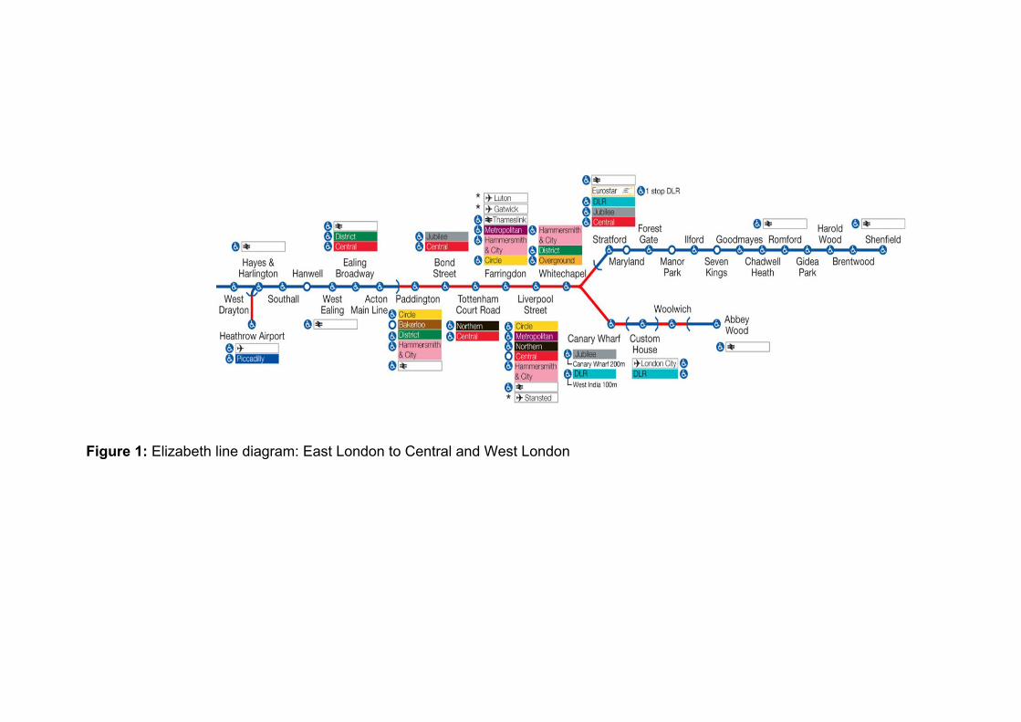
Figure 1: Elizabeth line diagram: East London to Central and West London

Figure 2: Elizabeth line December 2018
Figure 3: Elizabeth line May 2019
Figure 4: Elizabeth line December 2019
TfL Rail
Shenfield branch
Elizabeth line Shenfield
branch opens
Elizabeth line fully
open
TfL Rail Heathrow
branch
Elizabeth line Abbey
Wood branch opens

Figure 5: Forecast change in bus passenger flows as a direct result of the Elizabeth line (modelled year 2021)

3 OTHER INFLUENCES ON THE BUS NETWORK Introduction
3.1 The Elizabeth line represents a significant improvement to travel in London but it is not the only factor influencing travel demand on the bus network. This section summarises some of those issues which have also been taken account of within the review of bus services. Population & Jobs Growth
3.2 Population growth has a significant influence on bus passenger demand. London’s population is estimated to have broken the previous high watermark set in 1939 and now stands at 8.8 million. The population is forecast to grow to 9.25 million by 2021 (Source: GLA Interim 2015-based population projections).
3.3 Jobs and the economy are another influence on bus demand and travel patterns. An extra 170,000 jobs are forecast by 2021 (Source: LTS model assumptions).
3.4 This growth is expected across London and at the local level will be influenced by particular development sites. However, it is expected to be particularly concentrated in Growth and Opportunity areas. Figure 6 shows where the resulting increase in bus demand is forecast to materialise on the bus network.
Figure 6: Percentage change in bus boardings
3.5 In reviewing local networks, a judgement has been made on the delivery timescales of new development. The changes proposed are designed to provide enough capacity until broadly 2021. For example, although progress is being made in the Beam Park / London Riverside Opportunity Area, significant change in demand is considered unlikely before 2021. However, large developments in the Isle of Dogs are being

constructed now and are therefore much more certain to influence travel demand by 2021. Traffic Speeds
3.6 There has been a strong correlation between falling traffic speeds and the fall in bus demand over the past two years and this represents a risk to future bus demand materialising on the network to the extent that is forecast.
Figure 7: Change in network average bus speeds by 4 week period 2013/14–2016/17
Figure 8: Changes in network bus ridership by week 2014 – 2017

3.7 Figure 7 shows changes in bus speeds by period on the network as a whole for the years 2013/14 to 2016/17. Figure 8 shows changes in passenger trips by week at the network level from 2014 to Spring 2017. It can be seen that bus speeds reduced from 2013/14 to 2015/16 before levelling off during 2016/17. Meanwhile usage fell in 2015 compared to 2014 and again in 2016. It now looks to be stabilising at around 2016 levels.
3.8 Although changes in bus speeds has been a particular feature of central and inner London due to roadworks, outer London has not been immune due to some recent growth in traffic (see Figure 9).
Figure 9: Trends in Road Traffic (Vehicle km), all motor vehicles
Stakeholder aspirations 3.9 Input from stakeholders is an important part of developing bus service changes.
Regular dialogue occurs at various levels between TfL and a variety of stakeholders and there have been a series of meetings with the London Boroughs affected by the Elizabeth line to discuss its implication for the bus network. Broadly, stakeholder feedback has been a desire to see improved links to Elizabeth line stations so as to maximise its benefit to local communities. There has also been concern that the forecast reduction in demand may lead to reductions in bus service provision.
3.10 The formal consultation process, that this document is part of, is a further way of
understanding the issues around proposed changes and provides an opportunity for further consideration and amendments.
4 APPROACH TO PLANNING BUS SERVICE CHANGES Methodology
4.1 The primary objective has been to ensure capacity provided by the bus network will be sufficient to meet passenger demand when the Elizabeth line opens up until broadly 2021.
4.2 The approach has been to analyse current demand data on routes in the vicinity of the Elizabeth line and add on forecast change in demand. Forecast change in demand has been based upon the impact of both the Elizabeth line and future growth. Some interpretation has been made of this based on the likelihood of new development opening.
4.3 Consideration has also been given to providing new connections based upon stakeholder aspirations and likely demand, especially demand generated by major new developments. The average length of ride on the bus network is around 2.2 miles so long distance links to Crossrail have not been considered.
4.4 Inevitably, where current frequencies cannot be justified based on forecast demand or where capacity can be provided in a more cost effective way, this has been investigated further to allow those resources to be deployed more effectively elsewhere.
4.5 The approach to the service change design has had regard to our Service Planning
Guidelines (http://content.tfl.gov.uk/bus-service-planning-guidelines.pdf). This seeks to provide routes that are as comprehensive, simple, frequent and reliable as possible within a framework of being value for money.
4.6 Since monitoring of capacity and demand is an on-going process, scope exists to amend capacity in response to changes in local circumstances relatively quickly.
BUS SERVICE CHANGES IN SOUTHEAST LONDON Overview
4.7 The Elizabeth line will serve two stations in Southeast London and primarily affect the boroughs of Greenwich and Bexley. The combined population of both these boroughs is expected to increase by around 30,000 by 2021 with an additional 7,500 jobs created. Impact of the Elizabeth line on bus services
4.8 The Elizabeth line will serve the existing (but re-designed) Abbey Wood station and a new station at Woolwich.
4.9 The new station in Woolwich is located to the north east of the existing Woolwich Arsenal station meaning interchange between National Rail and the DLR with the Elizabeth line will require exiting the station. To improve interchange and access into Woolwich town centre an improved pedestrian crossing is being provided. This will require banning the left turn from Woolwich New Road into Beresford Street currently used by route 161.
4.10 The current North Kent rail lines provide access into London Bridge, Charing Cross
and Cannon Street. In addition many people use the bus to access North Greenwich for the Jubilee line and onward connection to Canary Wharf and central London, including the West End. Bus passengers also rail-head into Woolwich for the DLR and onward connections to the Royal Docks, Isle of Dogs and the City. The impact of the Elizabeth line is forecast to redistribute demand across Abbey Wood, Woolwich and North Greenwich stations. This is because the Elizabeth line will give direct links and additional capacity to Custom House, Canary Wharf and the London Central Activities Zone that the DLR and Jubilee currently provide. At a more granular level the better quality interchange at Abbey Wood compared to Woolwich may also have some influence.
4.11 The net result is increased demand on most bus corridors into Abbey Wood; an increase in demand on most corridors into Woolwich, except those from the east where Abbey Wood has abstracted demand; and a significant decrease into North Greenwich station including from travel across Woolwich. Demand between Woolwich and North Greenwich is estimated to fall by around 15%. (See Figure 5). Other travel demand considerations
4.12 The riverside south of the Thames from Deptford to the London boundary is an area identified for growth.
4.13 North Greenwich is a key component of that growth with major development planned on the peninsula that is progressing relatively quickly. Demand from this new development is expected to broadly replace that demand lost as a consequence of the Elizabeth line.
4.14 Kidbrooke Village is currently being redeveloped. The number of housing units is expected to exceed those on the previous Ferrier Estate from 2020. Demand generated from this development will particularly affect route 178 over time.

4.15 Peabody will be redeveloping South Thamesmead which, in time, is predicted to result in additional trips on the Thamesmead to Abbey Wood and Woolwich corridors, although this is not expected to be significant before 2021.
4.16 There has been some employment growth in the Bexley Riverside area but major development is still at a fairly early stage. However, there are many smaller sites within the region which cumulatively will contribute towards increases in bus demand. Stakeholder aspirations
4.17 Royal Borough (RB) of Greenwich wish to see capacity keep pace with new demand. They have also requested quicker links, such as from Thamesmead to Woolwich and from the south of the Borough to the Elizabeth line e.g. the area between Eltham and Mottingham.
4.18 London Borough (LB) of Bexley have also requested quicker access to the Elizabeth line such as from the area southeast of Abbey Wood. They also wish to promote regeneration in the Borough, e.g. through access to jobs around Church Manorway.
4.19 Where there are no existing bus links to Elizabeth line stations, demand has been
examined in order to assess where new links could be provided. Areas which are closest to the new stations but have no direct link have formed the priority as this is where demand will be highest and less influenced by access to other rail stations. ABBEY WOOD
Figure 10: Bus Routes in Abbey Wood
4.20 Figure 10 shows the current bus network around Abbey Wood. Abbey Wood station is served by routes 180, 229, 244, 469 and the B11. Capacity
4.21 Bentham Road and Crossway form the western and eastern bus corridors into Abbey Wood from Thamesmead. Routes 244 and B11 provide 9 buses per hour (bph) into Abbey Wood via Bentham Road and route 229 provides 6 bph via Crossway. Both these corridors are anticipated to require additional capacity.
4.22 Route 180 provides direct links from Upper Belvedere to Abbey Wood via Yarnton Way. It was recently increased in frequency to 6 bph and no further capacity is expected to be required.
4.23 Routes 229 and 469 provide direct links from Erith and Belvedere to Abbey Wood via Abbey Road at a combined frequency of 10 bph. Current capacity is expected to be more than sufficient to meet future demand.
4.24 The B11 also provides links from the south e.g. the Lodge Hill area to Abbey Wood via New Road. The current 4 bph frequency is expected to be sufficient to meet future demand but for many trips journey times are slow due to the Lodge Hill loop.
4.25 From the west route 180 provides direct links to the station via McLeod Road. Route
469 provides alternative links via Eynsham Drive. Capacity is expected to be sufficient to meet increased demand into Abbey Wood station as it is the contra-peak direction. Woolwich will of course continue to be attractive for many rail passengers. Connectivity
4.26 It has been noted that most compass points around Abbey Wood have good quality direct links to the Elizabeth line. However a broad arc from Belvedere to Bexleyheath to the southeast of Abbey Wood has either no direct link or the direct bus takes an indirect routeing (e.g. routes 299 and B11). Since these locations are relatively close to Abbey Wood and located between the two National Rail corridors, demand for the Elizabeth line is expected to be relatively high.
4.27 Providing new links from the area around Welling was discounted partly because the rail link from Welling to central London will continue to remain attractive to passengers and because there are already good bus links into Woolwich. Proposals
4.28 New route 301: It is proposed to introduce a new route between Bexleyheath and Woolwich Town Centre, operating at 5 bph Monday to Saturday daytimes and 4 bph during evenings and Sundays using 70 capacity single deck buses. It would operate from Bexleyheath Market Place via Long Lane, Brampton Road, Knee Hill, Harrow Manor Way, Bentham Road, Central Way, Nathan Way, Plumstead Road and Beresford Street to terminate at the Woolwich Ferry roundabout.
4.29 Route 244 would be converted to double deck operation at current frequencies.
4.30 Route B11: In connection with the 301 and 244, it is proposed to restructure the B11 and reduce Monday to Saturday daytime frequencies to 3 bph. It would have the same routeing between Bexleyheath and its new terminus at South Thamesmead, Yarnton Way meaning it would no longer serve Bentham Road & Thamesmead Town Centre.

4.31 Together the 301, 244 and B11 scheme provide:
additional frequency and significant extra capacity between Thamesmead and Abbey Wood via the Bentham Road corridor which, as noted above, is expected to be at risk of crowding. Specifically the scheme increases frequency by 1 bph and provides an additional 320 spaces per hour in each direction despite the B11 being withdrawn.
A more direct bus routeing between Bexleyheath and Abbey Wood (route 301) saving an estimated 7 minutes in the peaks
Creates new direct connections on route 301 to locations southeast of Abbey Wood such as Long Lane.
4.32 The disbenefit of the scheme is:
around 200 direct trips per day will be broken on the B11.
It results in a 1 bph frequency reduction on the B11 but capacity will be sufficient to meet demand.
4.33 Route 469: It is proposed to divert it away from Abbey Road. At Belvedere it would
run via Picardy Road, Woolwich Road and New Road to its current line of route at existing frequencies.
This would introduce a 4 bph service into Abbey Wood from the Woolwich Road area thus significantly improving connectivity.
There would be some disbenefit to through passengers who would have a longer journey time and some passengers on Abbey Road who get a reduced frequency. Around 130 trips per day would be broken. However Abbey Road passengers will continue to be served by the high frequency 229 service. Passengers from Erith and West Street will also have the option of route 180 for links into Abbey Wood (see below).
4.34 Routes 129, 180 and 472: It is proposed to restructure these routes and amend
frequencies. The objectives of the scheme are to better match capacity with changes in demand as this redistributes between Abbey Wood, Woolwich and North Greenwich stations. As discussed above, it is expected that demand to travel across Woolwich will decrease but increase into Abbey Wood. Meanwhile demand for travel into North Greenwich is expected to decrease from Woolwich and the east but be replaced by demand from new development resulting in a broadly similar level within the peninsula as now. A further objective is to contribute to regeneration plans in Bexley Riverside.
4.35 Route 472: It is proposed to restructure the 472 to operate between North Greenwich and Abbey Wood. In Thamesmead the current loop working would be removed. It would no longer serve Bentham Road. Instead it would be extended to Abbey Wood from Crossway via Harrow Manor Way. This would increase frequencies from 6 to 13.5 bph into Abbey Wood from the Crossway corridor where demand will increase.
4.36 Between Thamesmead and Woolwich it would be diverted to serve Western Way
rather than Nathan Way so as to provide quicker journeys. It would run non-stop between Belmarsh / Princess Alice and Pettman Crescent. Nathan Way would remain served by new route 301.

4.37 Frequencies would be reduced to 7.5 bph Monday to Friday daytimes. Weekend frequencies would also be reduced – to 6 bph on Saturday shopping hours and 5 bph on Sundays. This is to better match capacity with demand across Woolwich and enable resources to be better utilised elsewhere.
4.38 Route 180 would be withdrawn between Westcombe Hill and Lewisham and instead run to North Greenwich station via Millennium Village at existing frequencies. By doing this capacity is retained on the Greenwich peninsula.
4.39 It would also be restructured at its eastern end. It would be rerouted at Belvedere to
run via Church Manorway, Lower Road, West Street, Erith Town Centre and Fraser Road to terminate at Erith Quarry. It would no longer serve Fisher’s Way which would break around 180 trips per day. However, it would serve businesses on Church Manorway including two large grocery distribution centres that are now operating. The extension would also provide links from the Erith Quarry residential development.
4.40 Route 129 would be extended to Lewisham town centre, Molesworth Street via
Trafalgar Road and Greenwich Church Street. Frequencies would be reduced in the weekday peaks from 7.5 to 5 bph to better match capacity with demand. This change maintains some of the links affected by the re-routeing of the 180. The net effect is to break around 770 trips per day on route 180. However the 129 extension will also create new direct travel opportunities from Lewisham Road to North Greenwich. WOOLWICH
4.41 As well as having existing National Rail and DLR links, Woolwich is an important town centre. It is served by 17 bus routes. Capacity
4.42 Routes 244 and 380 connect West Thamesmead with Woolwich via Whinchat Way, providing a combined frequency of 13 bph during the busiest hour. Both use single deck buses. An additional AM peak journey was recently introduced on route 380. Route 472 provides an alternative link between Thamesmead and Woolwich and onwards to North Greenwich. As already noted some demand between Thamesmead and Woolwich is expected to move to Abbey Wood but additionally demand between Woolwich and North Greenwich is estimated to fall.
4.43 Other corridors from the east are expected to either see a moderate fall in demand e.g. those served by 177, 469 and 180 or a slight increase e.g. those served by routes 96, 422. These demand changes can be accommodated at current frequencies.
4.44 Routes 51, 53 and 291 provide links from Plumstead Common with the 291
connecting Woodlands Estate using single deck buses. Demand is expected to increase as a result of the Elizabeth line with the 291 expected to be crowded.
4.45 Routes 122, 161, 178, 244 and 469 provide a wide range of links from the south, including Shooters Hill, Eltham, Kidbrooke, Lewisham and Mottingham before merging on the Grand Depot Road corridor. Demand is expected to increase from the south with additional capacity required, specifically on the single deck routes 178 and 244.
4.46 Corridors to the west of Woolwich (Woolwich Church Street and Artillery Place) have
their capacity set by peak flows into North Greenwich and inner London. There is

sufficient capacity available to meet future demand into Woolwich and scope to reduce capacity westbound, hence the changes to the 472. Connectivity
4.47 With Woolwich being an established town centre it is already well connected to its hinterland. There have been requests for improved links from an area broadly defined as between Eltham and Mottingham stations. Large parts of this area is open space with route 161 currently providing direct, high frequency links from the western side. Further, Eltham and Mottingham stations will continue to be attractive for many passengers. Therefore it is not expected that there will be sufficient demand to justify the additional cost of new bus services into this area.
4.48 To the south west of Woolwich at Rochester Way, there is no direct link to an Elizabeth line station. However, this is served by route 132, which provides a fast link to North Greenwich Station and it is considered that this would remain the most attractive option for accessing links provided on the Elizabeth line.
4.49 As previously noted, improved pedestrian connectivity to the Woolwich station in the town centre is likely to result in the left turn being banned from Woolwich New Road into Beresford Street affecting route 161. Proposals
4.50 Routes 178, 244 and 291: As previously noted, these routes are expected to be crowded due to predicted extra demand. It is therefore proposed to convert them to double deck operation at current frequencies.
4.51 Route 161: It is proposed to reroute the 161 in Woolwich Town Centre to accommodate the new pedestrian crossing. Towards North Greenwich it would run via Wellington Street and John Wilson Street. It would no longer serve Beresford Street. NORTH GREENWICH
4.52 North Greenwich is a key destination on the bus network with it representing the busiest point for many routes. This is due in large part to many passengers accessing the Jubilee line. The Elizabeth line is expected to reduce this demand only for it to be replaced by demand from additional housing on the Peninsula and nearby. It is currently assumed that the demand change at North Greenwich itself will be broadly neutral.
4.53 The changes to the 129 and 472 frequencies and the restructuring of the 180 means frequencies on the peninsula remain broadly the same.
4.54 The extension of the 129 to Lewisham will provide an alternative link between
Lewisham and North Greenwich assisting route 108. It also provides new connections from the Lewisham Road area to North Greenwich and the peninsula.
5 BUS SERVICE CHANGES IN NORTHEAST LONDON Overview
5.1 The East London sub-region is forecast to see the largest growth of all the London sub-regions. Within the Boroughs of Havering, Barking & Dagenham, Redbridge, Newham and Tower Hamlets, the population is expected to grow by 120,000 by 2021 and jobs by 55,000. Impact of the Elizabeth line on bus services
5.2 The Elizabeth line in northeast London consists of the existing Shenfield branch that will benefit from new direct links to central and west London as well as trains designed to carry more people. It also consists of the new Abbey Wood branch that will serve two new stations at Canary Wharf and Custom House representing a significant enhancement to existing rail services. Together the two branches join at Whitechapel providing a very high frequency through the core section.
5.3 Bus demand is generally expected to reduce as a consequence of the Elizabeth line opening and especially on the Romford Road corridor between Ilford and Stratford (see Figure 5).
5.4 However, a number of corridors are expected to see an increase in demand. These
corridors typically feed into Elizabeth line stations and are a good representation of some people changing their travel patterns by getting a different bus to usual and continuing their journey by Elizabeth line. Such corridors include:
Cambridge Heath Road on the approach to Whitechapel station
The approach to Custom House station from the north – either on the Prince Regent Lane corridor or the Freemasons Road corridor
East Ham High Street North towards Manor Park station
The approach from the south to Chadwell Heath station
Corridors approaching Romford and Harold Wood stations Other travel demand considerations
5.5 Assuming bus journey times remain attractive, new trips generated by new development are expected to more than offset much of the demand reduction from transference to the Elizabeth line. New development is particularly focused on growth and opportunity areas. In the northeast these include:
City Fringe / Whitechapel
Isle of Dogs / Poplar
Stratford / Lower Lee Valley including West Ham
Royal Docks
Town centres e.g. Barking, Ilford and Romford
London Riverside incorporating Barking Riverside and Beam Park
5.6 Progress on new development is at varying stages from still at the early planning phase through to already built and occupied. Some interpretation has been required to estimate the extent to which new travel demand might materialise by 2021. Since monitoring of capacity and demand is an on-going process, scope exists to amend capacity relatively quickly.
Stakeholder aspirations 5.7 Boroughs have generally requested improved bus access to Elizabeth line stations as
a way of increasing the benefit of the railway and supporting local objectives and priorities. They have also expressed concern regarding potential reduction in frequency due to decreased travel demand by bus.
5.8 LB Havering see the Elizabeth line supporting their regeneration aspirations, especially for Romford and Harold Hill. LB Redbridge also see the Elizabeth line supporting regeneration and have particularly expressed concern over reduced frequencies on route 86. LB Newham have requested improved north – south links to maximise the connectivity to the improvements planned in the Royal Docks such as Custom House station and the jobs forecast from new developments like those at ABP near Beckton Park. London City Airport are also keen to have good access to Custom House station. LB Waltham Forest have requested quicker access to Stratford and LB Tower Hamlets want to ensure transport capacity can accommodate forecast development growth while having regard to local considerations. Whitechapel
5.9 The South Tower Hamlets review (https://tfl.gov.uk/corporate/publications-and-reports/bus-network-development-papers) noted that a connection from the Commercial Road corridor to Whitechapel through Stepney might generate significant demand. This was because there are no direct bus links at present and because Whitechapel will benefit from the full frequency of the Elizabeth line. There is also significant development planned which will add to its attractiveness as a destination beyond current attractions including the hospital and market. Tower Hamlets Town Hall is also expected to relocate to Whitechapel in future.
5.10 It is proposed to re-route the 115 via Whitechapel. The re-routeing is estimated to cost 1 PVR (peak vehicle requirement) and break approximately 850 trips (3.5%) per day. However, it is expected to generate around 1,600 new trips.
5.11 The potential new routeing from Commercial Road would be via Jubilee Street,
Stepney Way, Sidney Street and Whitechapel Road to current line of route. Alternatively it could use Stepney Way towards Aldgate only and Ashfield Street towards East Ham.
5.12 Either routeing would require highway interventions to enable buses to operate. LB
Tower Hamlets have indicated that they would take a view on the re-routeing and the associated highway works once responses to consultation are known.
5.13 No changes are proposed to route 254 (or 106) despite the prediction of increased demand from Cambridge Heath Road to Whitechapel. Route 254 provides 10 bph (and the 106 a further 7.5 bph) and the busiest point is at Amhurst Park in the opposite direction (towards Holloway). Consequently it is expected that current capacity will be sufficient to meet future additional demand. Canary Wharf
5.14 Canary Wharf has good bus connections. The review of bus services in South Tower Hamlets particularly considered ways of increasing bus capacity in the Isle of Dogs due to the Elizabeth line and significant levels of new development, much of which is being constructed and occupied now. The review resulted in the restructuring of routes 135, 277 and D3 in September 2016 to provide the necessary capacity required on the

busy Westferry Road corridor. It also resulted in the restructuring and conversion of the D8 to double deck operation in October 2016 providing additional capacity into Canary Wharf. The restructuring of the 135, 277, D3 and D8 also provided new direct journey opportunities.
5.15 The Wood Wharf development is expected to create a new road link from Preston’s Road into the Canary Wharf Estate. The opening of the road will create the opportunity to improve links from the east side of the Isle of Dogs to Canary Wharf. This will be subject to further analysis once the road and development is nearer to completion.
5.16 No further changes are proposed beyond those already implemented.
Custom House
5.17 The new Elizabeth line serving the existing DLR station together with regeneration plans for 25,000 new homes and 60,000 more jobs in the wider Royal Docks prompted a review of bus services in South Newham: (https://tfl.gov.uk/corporate/publications-and-reports/bus-network-development-papers) As part of the review LB Newham were keen to see the Royal Docks and the Elizabeth line linked with the north of the Borough. The resulting ideas identified in that review have formed the basis for further detailed evaluation. This has resulted in similar but modified schemes which also sought to reduce costs. The following changes are proposed:
Route 104 / 304. It is proposed to split route 104 into two routes. Route 104 would operate between Stratford and Beckton via Lonsdale Avenue and Woolwich Manor Way at 7.5 bph. New route 304 would operate between Manor Park station and Custom House via Lonsdale Avenue and Newham University Hospital at 6 bph. This would be dependent upon the Council providing a bus standing facility at Custom House.
Route 300. It is proposed to restructure the route in the Beckton area. It would operate along the whole length of Tollgate Road and then use the southern section of Prince Regent Lane and Victoria Dock Road to Custom House station and then use Freemasons Road and New Barn Street to return to line of route on Barking Road. This would mean it no longer serving Stansfeld Road and Prince Regent Lane north of the A13.
Route 474: It is proposed to re-route the 474. It would still operate between Manor Park and Canning Town (Hermit Road) via East Ham and North Woolwich. However at Connaught Bridge it would be diverted to serve Custom House and Keir Hardie Estate instead of North Woolwich Road. It would also be re-routed, eastbound only, via Factory Road near Woolwich Ferry to remove the double run and help it run more reliably by avoiding queues for the ferry.
Route 330: In conjunction with proposals for the 474, the 330 would be extended from its current terminus at Canning Town to serve North Woolwich Road. One option is to extend it as far as the south side of Connaught Bridge. A second option is to extend it further still to Custom House station but this will be subject to available funding and the Council providing bus standing facilities.
Route 241: It is proposed to curtail the route at either Custom House station if the Council provides a bus stand or nearby if not. It is also proposed to extend it at its northern end to support regeneration of the Queen Elizabeth Olympic Park. It is proposed to extend the route from Stratford City bus station to the
Here East employment centre at East Wick via Westfield Avenue and Waterden Road.
5.18 The benefit of the schemes are:
It creates new direct links to Custom House from its hinterland (see Figure 11). This includes North Woolwich, London City airport, West Beckton and the Lonsdale Avenue area north of the A13.
Provides additional capacity on the Prince Regent Lane and Freemasons Road corridors which modelling suggests is required.
Provides other new links including improved access to the hospital through the creation of the 304 route and improved north-south links e.g. the extension of the 330.
5.19 The drawback of the schemes are:
Some passengers will lose their existing direct bus route. The scale of the disruption is around 600 passenger trips per day or 2.6% of all daily trips on route 104; 650 (7%) on route 300; 350 (3%) on route 474 and 400 (5%) on route 241. This loss of direct trips is expected to be offset by new trips generated by the re-routeings.
The proposals for routes 104, 304, 241 and the option to extend the 330 to Custom House are all dependent upon the provision of a suitable bus terminus at Custom House station. TfL have been in discussion with LB Newham regarding such a facility and they are investigating possibilities as part of the wider masterplanning of the area but there is a risk that either it will not be provided or will not be available when the station opens in December 2018.
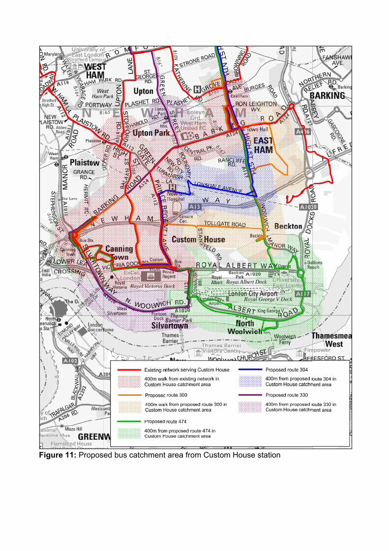
Figure 11: Proposed bus catchment area from Custom House station
Stratford, Maryland, Forest Gate, Manor Park 5.20 Route 25 passes close to all these stations, and others, and is discussed below.
5.21 With regard to other routes, current bus provision is expected to be sufficient to meet
changes in demand from the Elizabeth line, population growth and new development in the near future. This is due to a number of reasons. In many instances the busiest point on some routes are in locations some distance from the above stations meaning additional demand can be accommodated at existing frequencies. Another reason is timescales for some new developments are longer than initially expected and so passenger growth will appear later. A further explanation is slower bus speeds are reducing bus travel demand. However, demand will continue to be monitored and the bus network adjusted accordingly.
5.22 The stations are all existing with long established bus connections. However, some of them stations will benefit from schemes already described. These include the split of route 104 into the 104 and 304 that serve Stratford and Manor Park stations and the extension of route 241 to East Wick which will improve connections into Stratford station. Another example is the conversion of the D8 to double deck operation providing additional capacity to Stratford station.
5.23 LB Newham intend to return the Stratford gyratory to two-way working. This provides
the opportunity to simplify bus routeings and better serve Stratford station. Changes to bus routeings as a consequence of the highway changes are the subject of a separate consultation. Ilford, Seven Kings, Goodmayes
5.24 These stations are also existing with long established bus routes serving them. Current capacity is sufficient to meet expected changes in demand. It is worth noting that the EL3 which serves Goodmayes station was increased in frequency in February 2017. However the primary justification for this was not the Elizabeth line but to provide sufficient capacity into Barking town centre on the busy Longbridge Road corridor and into Barking from the expanding Barking Riverside development. Access to Goodmayes station has nevertheless been improved by the frequency increase. Chadwell Heath
5.25 Access to Chadwell Heath station has already been significantly improved. Between October 2015 and April 2016, routes 62, 173 and 368 were all converted to double deck operation and their frequencies increased. This was in response to rising demand from population growth and predicted increases in demand along the bus corridors to Chadwell Heath station from the south (see Figure 5). No further changes are proposed at this time but this will be monitored. Romford, Gidea Park, Harold Wood
5.26 As can be seen in Figure 5, a number of bus corridors into Romford and Harold Wood stations are expected to see an increase in demand. A number of developments have opened or are close to opening in Harold Hill such as the Kings Park development on the former Harold Wood hospital site.
5.27 It is proposed to increase the frequency on route 174 from 7.5 bph to 10 bph and convert route 256 to double deck operation at existing frequencies.

5.28 It is also proposed to introduce new route 497 to operate between Harold Hill (Hilldene Avenue) and Harold Wood station at 2 bph Monday to Saturdays and hourly on Sundays and evenings. As well as improving access to the Elizabeth line the route would bring more people within 400m of a bus route and improve links to healthcare and shops.
5.29 More detail on the above can be found in the review of bus services in Harold Hill. (https://tfl.gov.uk/corporate/publications-and-reports/bus-network-development-papers) Route 25
5.30 Route 25 operates between Ilford and Oxford Circus and has considerable parallels to the Elizabeth line. As seen in Figure 5, demand is expected to fall on the Romford Road corridor into Stratford and in Central London. It has also seen a significant decrease in passenger usage in recent years driven largely by lower bus speeds from highway modernisation.
5.31 Consultation has recently closed on changes to route 25 and associated changes to route 425. Specifically, from late summer 2017, the frequency will reduce to 10 bph although that reduction is offset between Stratford and Ilford by the extension of route 425. More detail on this scheme can be found in section 6.3 of the West End Services Review. (https://consultations.tfl.gov.uk/buses/west-end-bus-changes/user_uploads/west-end-services-review-november-2016.pdf).
5.32 With the opening of the Elizabeth line, usage is predicted to fall further at some of the busiest points on the route, including central London and Romford Road. In addition bus speeds continue to be an issue in central London which, due to the route’s length, has significant implications for the ability to run the service reliably.
5.33 It is therefore proposed to make further amendments to route 25. Specifically the proposal is to shorten the route to operate between Ilford and Holborn Circus only. Frequencies would also be reduced to 8 bph Monday to Saturday daytimes and 6 bph evenings and Sundays.
5.34 The benefits of the scheme are to better match capacity with demand which permits
the resource saved to be better utilised elsewhere on the network. The new structure is also expected to improve the reliability of the service. However, it will mean 5,540 passengers or 10% of all trips on the route will no longer have a direct bus service. Lower frequencies also means longer wait times for passengers although it remains a high frequency service, especially where it is paralleled by other bus routes. Outside London
5.35 Route 498 provides cross boundary links between Romford and Brentwood. No changes are proposed at this time.
6 BUS SERVICE CHANGES IN WEST LONDON Overview
6.1 This section covers the Elizabeth line from Acton Main Line station to West Drayton and Heathrow Airport. This affects the boroughs of Brent, Ealing, Hillingdon and Hounslow. These boroughs are expected to have seen population increase by around 40,000 by 2021 and jobs by 15,000. Many of the large developments enabling this increase are located relatively close to the Elizabeth line. Impact of the Elizabeth line on bus services
6.2 This will be the last section of the Elizabeth line to open. From 8 December 2019, the line will serve the existing rail stations on the Great Western Main Line (GWML) between Paddington and Reading along with Heathrow Airport.
6.3 In the sector between the Piccadilly line to the south and the Central line to the north, the Elizabeth line creates new direct links into central and east London improving journey times for many. New trains will also provide some additional capacity. The forecast impact on bus services (see Figure 5) is to:
Increase demand on feeder routes into Elizabeth line stations, sometimes at the expense of access to the Piccadilly and Central line stations. This change is typically on North-South corridors and is particularly pronounced at Southall and Hayes & Harlington stations.
Decrease demand on some routes that run parallel to the Elizabeth line. In particular demand is expected to reduce significantly between Southall and Ealing Broadway where the Uxbridge Road runs close to four stations. Essentially the expectation is that a proportion of bus passengers will transfer to the train.
Other travel demand considerations
6.4 Whereas the Elizabeth line sometimes acts to reduce bus demand, population and jobs growth acts to increase demand, assuming bus journey times remain attractive. New development is particularly focused on growth and opportunity areas. In the West the main concentrations of development that have particularly informed bus service changes include:
North Acton. This is located near to Acton Main Line station and predominantly consists of high density residential development. To the north east is the larger Park Royal / Old Oak Common opportunity area. However major development related to this is beyond 2021 and will require a further review of the bus network.
Gillette Corner. Located about 2 miles south of Ealing Broadway station, this forms part of the wider intensification of the current employment corridor called the “Golden Mile”. New office accommodation has recently been built with further development expected.
Southall Opportunity Area. The masterplan envisages 6,000 new homes and 3,000 jobs. A major element is Southall Waterside (formerly Southall Gas Works). This is a plan for 3,750 new homes immediately to the west of Southall station and bounded by the railway line and Grand Union Canal. Much of the site is further than 400m from the bus network and a road link across the Canal and Yeading Brook to Pump Lane is envisaged. Work on phase 1 is expected to begin shortly. The area around Merrick Road (Southall East / Havelock) also
forms a major component of the opportunity area with future highway improvements expected.
Hayes town centre. Surrounding Hayes & Harlington station is Hayes town centre. This is designated a housing Zone with up to 5,000 new homes planned.
Heathrow Airport. The bus network will continue to be reviewed as proposals to develop the airport evolve.
6.5 Progress on new development is at varying stages from early planning stage through
to already built and occupied. Some interpretation has been required to estimate the extent to which new travel demand might materialise. This will be monitored and if necessary capacity can be amended relatively quickly. Stakeholder aspirations
6.6 Boroughs have generally requested improved bus access to Elizabeth line stations as a way of increasing the catchment of the railway and supporting local objectives and priorities.
6.7 LB Ealing see the Elizabeth line as improving rail services in the borough. They are generally supportive of improving access by public transport to Elizabeth line stations particularly on north-south feeder links. They are also supportive of increasing capacity on services where required while minimising the number of buses standing and stopping at Haven Green. LBs Ealing and Brent have requested better links between Park Royal and the Elizabeth line at Acton Main Line.
6.8 LB Hillingdon have requested that frequencies are enhanced between Hayes &
Harlington station and Stockley Park on route U5. They have also requested better links from Long Lane.
6.9 LB Hounslow have requested a link between the western end of the “Golden Mile”
employment area and the Elizabeth line. LB Harrow have also requested improved links to the Elizabeth line. Acton Main Line
6.10 Demand to travel to the station by bus is forecast to see a modest increase, driven largely by new development e.g. at North Acton. Current bus frequencies are determined by a need to meet peak demand in locations some distance from Acton Main Line station and so capacity is not a key issue.
6.11 Access to the station is a bigger issue and affected by the nature of the highway network. Currently the station entrance is directly served by route 266 in both directions and route 260 northbound only. Route 440 also serves stops 300m north of the entrance. One-way systems and severance by the dual carriageway Western Avenue reduce the quality of interchange for passengers.
6.12 Direct links to Acton Main Line from Park Royal are therefore northbound only. Route
440 provides direct links between the station and the South Acton and Chiswick catchment area but the routeing is circuitous.
6.13 In addition to accessing Elizabeth line stations consideration has been given to operational issues. Route 266 is challenging to operate reliably due to the length of its route and the various congestion hotspots it passes through. This is reflected in it only
occasionally meeting its relatively low performance standard over the past two years. LB Hammersmith & Fulham have particularly raised concerns about this.
6.14 To address these issues it is proposed to restructure routes 266, 391 and 440 and introduce two new routes.
6.15 Route 266 would be shortened to operate between Brent Cross and Acton High Street
(Town Hall) only. This will improve reliability and reduce its exposure to road congestion. It would no longer serve Acton High Street, Askew Road and Hammersmith. Frequencies would remain unchanged.
6.16 Night route 266 would be renumbered N266 but otherwise unchanged i.e. it would
continue to operate between Brent Cross and Hammersmith. This is possible as traffic conditions are better at night.
6.17 Route 440 would continue to operate between Gunnersbury and Stonebridge Park at existing frequencies but would be re-routed in three different locations: Chiswick, Acton Main Line Station and Park Royal.
6.18 In the south it would be re-routed at Wellesley Road to run the full length of Heathfield
Terrace, then Chiswick High Road and Acton Lane before re-joining the current line of route at Bollo Lane. This removes the loop via Fisher’s Lane and Acton Green.
6.19 It is proposed to also re-route it via Horn Lane to serve Acton Main Line station and no
longer run via West Acton (Twyford Avenue and Noel Road).
6.20 Finally a small re-routeing would occur southbound at Park Royal ASDA with the route serving stop D on Park Royal Road at the front of the supermarket instead of stop K to the side of the store. This more direct routeing has been enabled through the provision of improved pedestrian crossing facilities.
6.21 New route 218 would operate between Hammersmith and North Acton station at 6 bph Monday to Saturday daytimes and 4 bph Sundays and all evenings using single-deck vehicles. The route would replace the withdrawn 266 between Hammersmith and Acton High Street via Askew Road. It would then replace route 440 in West Acton serving Uxbridge Road, Twyford Avenue, Noel Road, Westfields, Northfields and Eastfields Roads to Horn Lane before terminating at North Acton station.
6.22 Route 391 would be restructured to operate between Richmond and Hammersmith
bus station. The route would continue to use single deck buses and frequencies would be reduced to 4 bph Monday to Saturday daytimes and 3 bph Sundays and all evenings. The is allows the creation of a new route.
6.23 New route 306 would be introduced to run between Acton (Bromyard Avenue) and
Sands End via Askew Road and Hammersmith bus station at 5 bph Mondays to Saturdays and 4 bph Sundays and all evenings. Double deck buses would be used.
6.24 The benefits of these schemes are:
Improved access to Acton Main Line station by creating new direct links from Chiswick, South Acton, Park Royal and Stonebridge Park.

The creation of new direct links from West Acton to Acton Vale, Askew Road and Hammersmith. While route 218 would not serve Acton Main Line station entrance it will still be useful for some passengers.
Reduced journey times for through passengers achieved by more direct routeings. This includes those travelling on route 440 either side of Park Royal ASDA (277 trips), Horn Lane (423 trips) and Chiswick High Road (390 trips).
Improved reliability for around 28,000 trips per weekday made on the 266 routeing.
Significantly improved waiting times on Horn Lane and higher frequencies in West Acton.
Capacity is better matched with demand, especially on Askew Road through the creation of the double deck 306 route.
6.25 The drawbacks of this scheme are:
Around 2,000 trips per weekday would be broken for the whole scheme (6% of all trips on the 266 and 440 combined). Around 1,100 of these trips are route 266 passengers that currently travel between stops north of North Acton and east of Acton High Street. A further 650 trips are broken to and from Horn Lane to east of Acton High Street. Around 280 trips are broken by re-routeing the 440 away from West Acton despite route 218 providing an alternative. These passengers would need to changes buses.
Longer wait times for passengers on the restructured part of route 391 between Richmond and Hammersmith. However capacity will be sufficient to meet demand.
6.26 Planning work will be undertaken to support longer term regeneration of Wembley, Park Royal and Old Oak Common. However, the proposed restructuring would enable a future extension of the 218 to the Old Oak Common development area. Ealing Broadway, West Ealing and Hanwell
6.27 Good bus links exist to each of these stations, especially Ealing Broadway with it being located in an important town centre. Even so access to the northeast of Ealing town centre is indirect and there is a small residential area which is more than 400m from the bus network.
6.28 East-West travel demand is expected to significantly reduce east of Southall into Ealing Broadway as the Elizabeth line abstracts some usage from the bus network along Uxbridge Road (routes 207, 427, 483, 607, E2, E7, E8, E11) and Gordon Road (route E1).
6.29 Travel demand into each station is expected to grow on all north-south corridors into each station. Part of this change is due to the attraction of the Elizabeth line e.g. passengers opting to use it instead of the Piccadilly line and partly due to new development e.g. the Golden Mile. LB Hounslow have requested direct links between the western end of the Golden Mile and the Elizabeth line.
6.30 Additional capacity is forecast to be required on the South Ealing Road (route 65) and
Castlebar Hill (route 297 and E10) corridors leading into Ealing Broadway. Elsewhere current capacity is forecast to be sufficient to meet increases in demand.

6.31 Improvements have already been made to some bus routes serving Ealing Broadway, West Ealing and Hanwell stations. These were:
Day route 83 was replaced within LB Ealing by route 483 to improve reliability and create new connections on 10 September 2016. (Route N83 remained unchanged).
Routes E8 and E9 were converted to double-deck vehicles to increase capacity between Ealing Broadway and Boston Manor, Hanwell, North Ealing and Greenford on 28 May 2016.
Route E8 was also extended to Hounslow town centre via Isleworth.
6.32 Consultation has recently closed on a proposal to re-route the 112 via Madeley Road instead of using Ealing Common and The Mall. The purpose of the scheme is to improve journey times between Ealing Broadway and Hanger Lane by taking a more direct route, and improve access to the bus network for those living northeast of Ealing town centre. A decision on the scheme is expected in summer 2017 following analysis of the consultation responses.
6.33 The following additional changes are proposed to address the issues already described:
Route 112. In addition to the above consultation, it is proposed to extend the route (at existing frequencies) from its current Ealing Broadway (Haven Green) terminus to Osterley, Tesco via South Ealing Road and Great West Road. The scheme is dependent upon the provision of a bus stand and turning facility being provided at Gillette Corner. TfL are in discussion with LB Hounslow and developers over this.
Route 427. It is proposed to restructure the route to operate between Uxbridge and Southall, Merrick Road. This means it would no longer operate on the Uxbridge Road between Southall and Acton Central removing the parallel with the Elizabeth line. Routes 207 and 607 will continue to provide the same links and be supported by several other routes that run along the Uxbridge Road for some distance. Frequencies would also be reduced from 7.5 bph to 6 bph Monday to Saturday daytimes.
Route E1 currently operates at 8 bph in the very busiest weekday peak hours and 6 bph at other times. Frequencies would be changed to 6 bph at all times during the day on Monday – Saturdays. Sunday shopping period frequencies would be reduced from 6 to 5 bph to better match capacity with demand.
Route E10 would be converted to larger dual-door single-deck vehicles and increased in frequency from 4 to 5 bph Monday to Saturday daytimes, making it a high frequency route. Evening frequencies would also be increased to 3 bph.
6.34 The benefits of the schemes are:
Capacity is better matched to demand on east-west corridors allowing resource to be redeployed elsewhere for better effect.
Additional capacity, higher frequencies and better resilience provided on South Ealing Road by extending the 112 over the route 65 corridor.
Additional capacity and lower waiting times on the Castlebar Hill corridor due to the E10 changes.
New direct links created by route 112 between Golden Mile, South Ealing, Ealing town centre, Hanger Lane, Stonebridge Park, Neasden and Brent Cross.
This includes linking the new development in the Golden Mile and the Elizabeth line to promote growth and regeneration.
It removes a terminating service from Haven Green.
6.35 The drawbacks of these schemes are:
Lower frequencies for users of the E1 and those travelling along the Uxbridge Road. However sufficient capacity will continue to be provided to avoid crowding. Uxbridge Road will continue to be very well served by buses and route E1 will still remain a high frequency route.
The shortening of route 427 will break around 1,200 (5%) passenger trips with todays travel patterns although the number inconvenienced is expected to be lower as some passengers transfer to the train. Those passengers who are affected would have to change buses. However the restructuring will improve links into Southall station as discussed below.
Southall
6.36 Southall station is currently served by routes 105, 120, 195, H32, 482 and E5. Routes 95, 207, 427 and 607 also serve the town centre to the north but do not stop outside the station.
6.37 East-west demand is forecast to reduce although the decrease is much more pronounced east of Southall. Corridors leading into Southall from the north and south are expected to see an increase in demand with extra capacity required on the Lady Margaret Road corridor.
6.38 South of the town centre is the focus for new development. Southall Waterside (Gas
Works) is a major development site in excess of 400m from the bus network. A new road is planned through the development and onwards to Pump Lane west of the Canal and Yeading Brook.
6.39 Development is also planned in the future to the east and southeast of Merrick Road.
6.40 The following changes are proposed in response to the above issues:
Route 120 would be increased in frequency to meet demand from Northolt, Lady Margaret Road, Heston and Hounslow to the Elizabeth line. It would increase to 7.5 bph on Monday to Saturday daytimes (8 bph weekday AM peak) and to 5 bph on all evenings.
Route 95 would be rerouted to run the full length of Somerset Road so as to join Lady Margaret Road further north than at present and provide a more direct (and therefore faster) routeing between Greenford and Southall. It would no longer serve Cornwall Avenue, Dormer’s Wells Lane and Burns Avenue which would continue to be served by the 105. The 95 would also be extended from Southall Broadway to the eastern end of the proposed Southall Waterside development and serve Southall station for the Elizabeth line. The extension to Southall Waterside is subject to the provision of a bus stand and turning facility as part of the new development. TfL are in discussion with the Borough and the developer over such a facility.
Route E5 would be rerouted. From Telford Road it would run directly via Burns Avenue to Lady Margaret Road avoiding North Road, Allendale Avenue and Denbigh Road. People living nearby would still be within 400m of a bus route.

Route 427. As already noted the route would be shortened and no longer operate between Southall and Acton Central with frequencies reduced from 7.5 bph to every 6 bph Monday to Saturday daytimes. At Southall Broadway it would be extended to Merrick Road near its junction with Bridge Road via South Road and Southall station.
Route H32 would be extended to Hayes & Harlington station. It would be rerouted at Southall Elizabeth line station to serve the Southall Waterside site, Pump Lane and Hayes town centre. This change is dependent upon progress of the Southall Waterside development and the necessary new roads being built. It would no longer run between Southall station and Southall Broadway, replaced by routes 95 and 427.
6.41 The benefits of these schemes are:
Extra capacity on the Lady Margaret Road corridor into Southall.
Improved journey times to the Elizabeth line by providing more direct routeings. Around 1,900 through passengers will benefit from a quicker journey on both routes 95 and E5.
Better matches capacity with demand by curtailing route 427 and changes to routeings at Dormer’s Wells. This allows resources to be re-deployed elsewhere.
Creation of new direct links e.g. between Uxbridge Road/Southall Broadway and South Road and Southall station.
Support for new housing by providing new routes into Southall Waterside which would otherwise be remote from the bus network. The proposals for routes 95 and H32 would link the development to the north, east and south as well as the Elizabeth line.
6.42 Although not a formal proposal at this stage, the changes also set the foundations to
support further new development. Scope exists to extend route 427 to Havelock Estate via Middlesex Business Park development at a later date. This will be dependent upon development timescales and necessary infrastructure and funding being secured as well as consultation.
6.43 The drawbacks of the schemes are:
On route 95, there would be 170 (2%) broken links per weekday. These are trips from stops in Dormer’s Wells to stops east of Greenford. Passengers could use route 105 or E5 and change to route 95 at Greenford Broadway.
On route E5, there would be no broken links but 760 passengers currently using its Hail-and-Ride section would need to walk further to fixed stops on Burns Avenue where it would run instead. Routes 95 and 120 may also be a nearer alternative.
Two pairs of stops within Dormer’s Wells would have a reduced frequency from 11 to 6 bph as routes 95 and E5 would no longer serve them. These are used by 1,100 passengers per weekday. However nearby stops on Allenby Road would still have 11 bph.
On route 427, around 1,200 (5%) trips per weekday would be broken, predominantly between Hayes and stops east of Southall Broadway that are not served by route 607. Some passengers could walk slightly longer to stops that are served by route 607, change buses at Southall Broadway or change to the Elizabeth line at Southall station. The number of actual broken links is
expected to be lower as travel patterns change once the Elizabeth line starts service.
Hayes & Harlington and Heathrow Airport
6.44 Hayes & Harlington station is directly served by 10 routes. In addition routes 427, 607 and U7 serve the Uxbridge Road corridor but do not directly serve the station or town centre. Heathrow Airport is similarly well served.
6.45 In general, corridors leading into Hayes from the north are expected to experience significant growth in usage whereas east-west demand on Uxbridge Road is expected to reduce slightly. In comparison to Hayes & Harlington, change in bus demand to Heathrow is less significant. More capacity will be required around Church Road, Coldharbour Lane and Yeading Lane. Other corridors and routes have spare capacity due to their busiest points being elsewhere.
6.46 Consideration has also been given to operational issues, particularly the reliability of route 140 due to its length and the impact road congestion has.
6.47 The network will need to continue to be kept under review as new development
planned at Hayes and the surrounding area comes forward.
6.48 Changes to some bus services serving Hayes and Heathrow have already been introduced to meet Elizabeth line changes as well as current issues:
Route 90 was fully converted to double-deck vehicles to increase capacity between Yeading, Hayes and Harlington Corner on 29 August 2015.
Route 285 was also converted to double-deck buses to increase capacity between Heathrow, Feltham, Teddington and Kingston on 27 June 2015.
Routes 350 and U5 were changed on 29 April 2017 (see section below on West Drayton).
6.49 The following changes are proposed to improve reliability, capacity, create new links
and speed up journey times to Hayes & Harlington station.
New express route X140 would be introduced between Harrow Bus Station and Heathrow Airport via Hayes & Harlington to provide quicker journeys by running a limited stop service. Double deck buses would be used and frequencies would be 5 bph Monday to Saturday daytimes and 4 bph on Sundays and evenings. The X140 would follow existing route 140 except between Harrow Bus Station and South Harrow (running via Lower Road), and Heathrow Airport and Harlington Corner northbound (running via Tunnel Road roundabout exit slip to Bath Road). It would only stop at Harrow Bus Station, South Harrow station, Northolt Park station, Northolt station, Yeading White Hart, Yeading Willow Tree Lane, Hayes (The Grapes), Hayes town centre, Hayes & Harlington station, Harlington Village, Harlington Corner and Heathrow Airport, Central Bus Station.
New route 278 would be introduced between Ruislip and Heathrow Airport, Central Bus Station via Hayes & Harlington station. It would run the full length of Long Lane and via Hillingdon, Hayes End, Church Road and Hayes town centre. It would run at 5 bph Monday to Saturday daytimes and 3 bph Sundays and all evenings using double-deck buses. This route would replace one trip on route 697 and two journeys on route 698.
Day route 140 would be withdrawn between Hayes & Harlington station and Heathrow to improve reliability by shortening the route (replaced by routes 278 and X140). It would also be reduced in frequency to 7.5 bph during Monday to Saturday daytimes and 5 bph during Sundays and evenings. Overall, there would be an increase in frequency on the corridor between Harrow and Heathrow due to the introduction of routes 278 and X140.
Night route 140 would be renumbered N140 but otherwise remain unchanged as traffic conditions at night are better.
Route 223 would be withdrawn between Harrow Bus Station and Northwick Park Hospital to remove excess capacity between these two locations.
6.50 The benefits of this scheme are:
Improved reliability by shortening route 140.
Faster journeys for around 8,900 passenger trips per day between Harrow, Northolt, Yeading, Hayes & Harlington and Heathrow, where no orbital rail links are available. The maximum journey time saving is between Harrow Bus Station and Heathrow Airport where 20 minutes would be saved during the peaks.
Additional capacity provided between Hayes & Harlington station, Yeading, Hayes, The Grapes, Northolt, Harrow, Church Road and Hayes End.
Route 278 provides new orbital links from Hillingdon, Long Lane, Ickenham and Ruislip to the Elizabeth line, Hayes and Heathrow Airport. It would provide new local links from Long Lane and Hillingdon Circus to Ickenham, West Ruislip station and Ruislip town centre.
Excess capacity removed between Northwick Park Hospital and Harrow Bus Station, and between Harrow Bus Station and Harrow Weald allowing resources to be better re-deployed elsewhere. A high frequency service would still be available between all these locations.
6.51 This scheme has the following drawbacks:
Around 1,800 trips per weekday would be broken for the whole scheme across two existing routes. This consists of around 1,400 links by splitting route 140 – these passengers would need to change once to complete their journeys. These are passengers that currently travel between stops more than 400 metres away from proposed route X140 travelling from one side of Hayes town centre to the other. It also consists of around 400 trips per weekday would be broken by withdrawing route 223 between Northwick Park Hospital and Harrow Bus Station. These passengers would have to change once at the hospital or at Kenton. This would have no impact on direct links to the hospital.
Around 1,600 trips per weekday would need to walk further to access the X140 compared to the all-stops 140 but no more than 400m. Many of these passengers would then benefit from faster on-bus journeys.
A reduction in frequency from 8 bph to 5 bph for around 1,150 trips per weekday travelling between stops at Heathrow and Harlington that are not served by route X140. A further 2,200 trips would experience reduced frequency between Heathrow and Hayes on route 278 but will have 2-5 other high frequency parallel routes available to complete their journey depending on their precise journey.
West Drayton 6.52 West Drayton station is located west of the Heathrow branch meaning train
frequencies will be slightly lower. It is served by routes 222, 350, 698, U1, U3 and U5.
6.53 New development is anticipated in the West Drayton area but this is not expected to be significant before 2021. In the interim Hillingdon Hospital and Brunel University will continue to be important passenger destinations.
6.54 Corridors leading into West Drayton from both the north and south are forecast to
experience some growth in usage but in general current service provision is expected to be sufficient to cope. The exception is Porters Way and Falling Lane (served by the U5) where in the very height of the morning peak additional capacity is required.
6.55 As a consequence it is planned to run additional peak hour journeys on route U5
towards Uxbridge on weekday mornings. This is planned to be introduced from September 2017 and will provide the necessary capacity during a short period of high demand at Hayes, Stockley Park, West Drayton, Hillingdon Hospital and Brunel University.
6.56 This complements other changes at West Drayton that were introduced on 29 April 2017. These were:
Routes 350 and U5 swapped their alignments between Hayes and Stockley Park. Route 350 now runs via Botwell Common and route U5 now runs via North Hyde Road.
Routes 350 and U5 also swapped their vehicle type. Route 350 now uses single-deck vehicles while route U5 now uses double-deck buses. Route 350 was also reduced in frequency from every 12 minutes during Monday to Friday daytimes to every 20 minutes and from every 20 minutes to every 30 minutes during evenings. Weekend daytimes were left unchanged.
6.57 No further changes are proposed at this time.

7 SUMMARY
7.1 A total of 40 bus route changes are proposed for the reasons presented in the main text. The schemes seek to achieve a number of objectives, including:
Supporting the opening of the Elizabeth line by providing sufficient capacity to meet predicted future demand
Supporting the opening of the Elizabeth line through providing new connections or quicker connections where demand is expected to be sufficient to justify the additional cost
Supporting regeneration and housing by improving bus routes that serve new development
Addressing operational issues on bus routes to improve the passenger experience
Rebalancing bus provision in line with changes in demand to ensure resources are being used efficiently.
Way forward
7.2 Consultation will be undertaken on the service changes. Following analysis of the responses, the next step will be determine whether or not a specific scheme should proceed or whether it should be amended in some way.
7.3 Other considerations will also need to be taken account as part of coming to a final decision. This includes TfL’s financial position and the affordability of the schemes.
7.4 In some instances physical constraints e.g. new stands may be a barrier to delivery.
7.5 Precisely when service changes will be made will be subject to further consideration
but would broadly align with the various phases of the Elizabeth line opening.
7.6 Finally the bus network will be kept under review enabling further changes to be made to bus services in the future.
GLOSSARY BPH Buses per hour in each direction. Buses are scheduled to operate at even intervals.
Buses Per Hour Interval
2 bph Every half hour
3 bph Every 20 minutes
4 bph Every 15 minutes
5 bph Every 12 minutes
6 bph Every 10 minutes
7.5 bph Every 8 minutes
Central Activities Zone (CAZ) The Central Activities Zone or Central Business District is London’s centre containing high concentrations of business together with Government institutions and strategic retail, culture and leisure attractions. It is broadly the area within zone 1. EWT (Excess Wait Time) Reliability (or punctuality) is measured in Excess Wait Time i.e. the additional time the average passenger has to wait compared to the service running to schedule. Growth Areas (consisting of Opportunity Areas and Intensification Areas) Growth areas are those locations particularly suited for accommodating the increase in homes and jobs identified in the London Plan. Opportunity areas are brownfield sites that have significant capacity for development – more so than Intensification Areas. Intensification Areas are built up places that can support higher densities than now. Passenger Trip or link A journey made by a passenger on one bus between point A and point B. A ‘broken link’ or ‘broken trip’ is when a passenger will be required to change buses due to a network redesign scheme, when they previously had a through bus (based on weekday data). PVR (Peak Vehicle Requirement) Peak Vehicle Requirement is the number of buses required to operate the level of service on a route. The average network cost per PVR is around £250,000, which includes all associated costs such as vehicle leasing costs, driver wages and fuel. Peak Journeys These are additional journeys which operate in the very busiest hour, often in one direction, to add necessary additional capacity at the height of the peak. These journeys operate over and above quoted frequencies (e.g. 6 bph). 400m walk distance This is the common standard at which people on average are willing to walk to a bus service.

South-East London Maps

BexleyheathBexleyheath
ThamesmeadThamesmead
Bexleyheath
Bexleyheath
Bexley
Erith
Belvedere
Erith
AbbeyWood
Thamesmead
PlumsteadWoolwichArsenal
Woolwich
WoolwichDockyard
Charlton
WestcombePark
Greenwich
DeptfordBridge
Elverson Road
Cutty Sark forMaritime
Greenwich
Lewisham
MazeHill
North Greenwich
Lewisham
Greenwich
Isle ofDogs
Catford
Eltham
Eltham
Mottingham
Woolwich
River Thames
River Thames
Queen ElizabethHospital
A208ROA
COURT R
OAD
WELL HALL ROAD
ACAD
EMY
ROAD
A205
BLACKFEN ROADBEXLEY ROADA210
A210
LEE H IGH ROAD
LEWISHAM
RD
A221
1A20
6
TRAFALGARRD
WOOLWICH ROAD
WOOLWICH
CHURCH ST
LONG LANE
KNEE HILL
HARROW M
ANORW
AY
BE
N
T H A M
N A
TH
AN WA YWES
TERN WAY
CENTRAL WAY
CR O SSWAY
RD
EASTERN WAY
EASTERN WAY
AVEN
UERD
PICK
FORD
LAN
E
A2 SHOOTERS HILL ROADSHOOTERS HILL ROAD
SHOOTERS HILL
BELLEGROVE ROAD
PARK VIEWROAD BROADWAY
WATLING ST
LODGE
OKEHAMPTON
HILL
CRESCENT
ERITH ROAD
FRASER RD
WEST ST
MANO
RW
AY
YARNTON WAY
LOW ER ROA D
PI
CAR
DY
RD
WOOLW
ICH ROAD
NEW
ROA
DABBEY ROAD
CHU
RCH
ALSIKE RD
MCLEOD RD
SEWELL RD
EYN S HAM
DR
HIGH STREET
BOST ALL HILL
BEXL
EY R
OAD
ERIT
H RO
AD
WIC
KHA
MUP
PER
L AN
E
WIC
KHAM LANE
A102
A2
A2A2
A2
A20
A20
A13
ALBERT ROAD
ROYA
L DOCK
S R
OAD
ROYAL ALBERT WAY
CREEK RD
NST
WESTHORNE AVENUE
BROWNHILL ROAD
HIGH
STR
E ET
A21
BARING ROAD
A212
KIDBROOKE P ARK ROAD
A211
BLA CKWALL TUNNEL
SOU
THERN APPROACH
MAN
CHE
STER
ROA
D
WESTFERRY RO
AD
BUGSBY’SWAY
Contains Ordnance Survey data© Crown copyright 2017
Proposed routesB11, 129, 161, 180, 469, 472plus new route 301
Proposed route 301
Proposed route 469
Proposed route 472
Proposed start/end of route161
301
469
472
Proposed route B11
Proposed route 129
Proposed route 161
Proposed route 180
B11
129
161
180
Only routes affected are shown
180
472
B11472
469469469469
301
301
161 180129
B11
129
towardsChislehurst
161

WoolwichArsenal
Woolwich
WoolwichDockyard Plumstead
Abbey Wood
Belvedere
Barnehurst
Bexleyheath
Welling
Falconwood
King George V
Plumstead
Woolwich
Abbey Wood
Belvedere
West Heath
Erith Marshes
Thamesmead
Bexley
Bexleyheath
Barnehurst
LesnesAbbeyWoods
Frank’sPark
PlumsteadCommon
RepositoryWoods
OxleasWood
ElthamCommon
WoolwichCommon
River Thames
BelmarshPrison
HMPThameside
MuseumsA206
PLUMSTEAD ROAD
WAY
NATHAN
ROAD
BENT
HAM ROAD
CENTRAL
A2041
KNEE H
ILLBRAM
PTON ROAD
LONG LANE
WOO
LWIC
H
ROAD
A207SHOOTERS HILL
DOVER ROADBELLEGROVE ROAD DOVER ROAD
A207PARK VIEW ROAD
A207 BROADWAY
A2
PLUMSTEAD HIGH STREETA206
BO RSTALL HILL WOOLWICH ROAD
A206ERITH ROAD
FRASER ROAD
WESTERN WAY
WAY
DAN
SON
RD
BEXL
EY R
OAD
ERIT
H R
OAD
JOHN WILSON
STREET
A205
WOO
LWIC
HCO
MM
ON
ACAD
EMY
ROAD
WES
T H
ALL
RD
YARNTON WAY
YARNTON WAY
EASTERN WAY
EASTERN WAY
A2016
A2016
EYNSHAM DRIVE
BASI
LDON
ROA
D
McLEOD ROAD
UPPE
R W
ICKH
AM L
ANE
WICKHAM LANE
LODG
E H
ILL
BEDO
NW
ELL
RO
ADKING HAROLDS
WAY
OKEHAMPTON CRES.
PARSONAGE
MANORWAY
BROOK STREET
ELSA ROAD
BRA
MPT
ON
ROA
D
CHU
RCH ROAD
BELV
EDER
E R
OADRO
AD
HUD
SON
PLUMSTEAD COMMON ROAD
NIGHTINGALE PL
HA-HA ROAD KING’S HIGHWAY
PLUM
LAN
E
SHRE
WSB
URY
LANE
BURA
GE
ROA
DARTILLERY
PLACE
HILLREACH
B213ABBEY ROAD
PICA
RDY
MAN
ORW
AY
WOOLWICH CHURCH
STREET
NEW R
D
WOOLW
ICH
ALBION RD
LONGLEIGH LANE
A207
GIPS
Y R
OAD
CARLYLE
ABBEY WOOD ROADLOWER ROAD
Proposed route 301
Proposed start/end of route301
301Only routes affected are shown
Contains Ordnance Survey data© Crown copyright 2017
301
301
301301
301301
301301301301
301301
301301
301301
301301
Proposed newroute 301
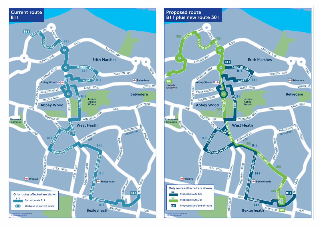
Abbey WoodBelvedere
BexleyheathWelling
Abbey Wood
Belvedere
West Heath
Erith Marshes
Bexleyheath
B
LesnesAbbeyWoods
PlumsteadCommon
ROAD
BENT
HAM ROAD
CENTRAL
A2041
KNEE HILLBRAM
PTON
ROAD
LONG LANE
WOO
LWIC
H R
OAD
A207 BROADWAY
A206
BO RSTALL HILL WOOLWICH ROAD
A206ERITH ROAD
WAY
DAN
SON
RD
BE
ERIT
H R
OAD
YARNTON WAY
YARNTON WAY
EASTERN WAY
EASTERN WAY
A2016
A2016
EYNSHAM DRIVE
BASI
LDON
ROA
DUP
PER
WIC
KHAM
LAN
E
WICKHAM LANE
LODG
E H
ILL
BEDO
NW
ELL
RO
ADKING HAROLDS
WAY
OKEHAMPTON CRES.
PARSONAGE
MANORWAY
BROOK STREET
ELSA ROAD
BRA
MPT
ON R
OAD
ALBION RD
LONGLEIGH LANE
A207
GIPS
Y R
OAD
CARLYLE
ALSIKE ROA
D
NEW
ROA
D
AVEN
UE
ROA
DPI
CKFO
RD L
ANE
ABBEY WOOD RD
McLEOD ROAD
LOWER RDABBEY ROAD
Contains Ordnance Survey data© Crown copyright 2017
Current route B11
Start/end of current routeB11
B11Only routes affected are shown B11
B11
B11
B11
B11
B11
B11
B11
B11
B11
B11
Current routeB11
Abbey WoodBelvedere
BexleyheathWelling
Abbey Wood
Belvedere
West Heath
Erith Marshes
Bexleyheath
B
LesnesAbbeyWoods
PlumsteadCommon
ROAD
BENT
HAM ROAD
CENTRAL
A2041
KNEE H
ILLBRAM
PTON
ROAD
LONG LANE
WOO
LWIC
H R
OAD
A207 BROADWAY
A206
BO RSTALL HILL WOOLWICH ROAD
A206ERITH ROAD
WAY
DAN
SON
RD
BE
ERIT
H R
OAD
YARNTON WAY
YARNTON WAY
EASTERN WAY
EASTERN WAY
A2016
A2016
EYNSHAM DRIVE
BASI
LDON
ROA
DUP
PER
WIC
KHAM
LAN
E
WICKHAM LANE
LODG
E H
ILL
BEDO
NW
ELL
RO
ADKING HAROLDS
WAY
OKEHAMPTON CRES.
PARSONAGE
MANORWAY
BROOK STREET
ELSA ROAD
BRA
MPT
ON
ROA
D
ALBION RD
LONGLEIGH LANE
A207
GIPS
Y R
OAD
CARLYLE
ALSIKE ROA
D
NEW
ROA
D
AVEN
UE
ROA
DPI
CKFO
RD L
ANE
ABBEY WOOD RD
McLEOD ROAD
LOWER RDABBEY ROAD
Proposed route B11
Proposed route 301
Proposed start/end of routeB11
B11
301
Only routes affected are shown
Contains Ordnance Survey data© Crown copyright 2017
301
301
301301 301301
301301
301301
301301
301301 B11
B11
B11
B11
B11
B11
B11
B11
B11
towardsWoolwich
Proposed routeB11 plus new route 301

Erith
Belvedere
Erith
Belvedere
AbbeyWood
BelvedereIndustrial
Estate
Frank’s Park
LessnessHeath
ErithQuarry
Lesnes AbbeyWoods
Erith Marshes
South Mere
River Thames
eyd
WOOLWICH ROAD
FRITH ROAD
EASTERN WAY
EASTERN WAY
BRONZE AGE WAY
BRONZE AGE WAY
QUEEN’S
ROAD
KNEE HILL
NEW ROAD
WOO
LWICH ROAD
PICA
RDY
ROA
D
LOWER ROAD
PICARDYGILBERTSTREETRD
ABBEY ROAD
HARRO
W M
AN
OR WAY
YARNTON WAY
MULB
ER
RY
WAY
FISHER’S WAY
PICA
RDY
MAN
ORW
AY
HUXL
EY R
OAD
ALBERT RD
HERON
HILL
AUGU
STIN
E’S
STRO
AD
ALSI
KE R
OAD
ALSIKE ROAD
PEMBROKE ROAD
BATTLE ROAD
PARKSIDE ROADHALT ROBIN ROAD
YARNTON WAY
PICARDY
ANDERSON MULBERRY
MANORWAY
WAYWAY
CHURCH M
ANORWAY
LOWER ROAD
WEST STREET
ERITH HIGH ST
BEXLEY RD
FRASER ROAD
BEXLEY ROAD
BROOK STREET
UPPER PARK ROAD
UPPER ABBEY RDHA
ILEY
ROA
D
MARAN
WAY
CARLTON ROADPARK CRESCENT
RIVE R
DALE ROAD
CRAB
TREE
MAN
ORW
AY N
ORTH
NORM
AN ROADBELVEDERE ROAD
BEDONWEL ROAD
BEDONWEL ROAD
A MBERLEY ROAD
NOR
MAN
RD
WAL
NUT
TREE
RD
HAROLD AVE
HOLLY HILL ROAD
STATION
RDSTN
towardsQueen Elizabeth Hospital
180
469469
180
180
180
469469
180
469469
469469
180
469469
469469
469469
towardsNorth Greenwich
180
Contains Ordnance Survey data© Crown copyright 2017
Current routes180 and 469 Current route 180
Current route 180
Start/end of current route180
180
469469
Only routes affected are shown
Erith
Belvedere
Erith
Belvedere
AbbeyWood
BelvedereIndustrial
Estate
Frank’s Park
LessnessHeath
ErithQuarry
Lesnes AbbeyWoods
Erith Marshes
South Mere
River Thames
eyd
WOOLWICH ROAD
FRITH ROAD
EASTERN WAY
EASTERN WAY
BRONZE AGE WAY
BRONZE AGE WAY
QUEEN’S
ROAD
KNEE HILL
NEW
ROAD
WOOLW
ICH ROAD
PICA
RDY
ROA
D
LOWER ROAD
PICARDYGILBERTSTREETRD
ABBEY ROAD
HARRO
W M
AN
OR WAY
YARNTON WAY
MULB
ER
RY
WAY
FISHER’S WAY
PICA
RDY
MAN
ORW
AY
HUXL
EY R
OAD
ALBERT RD
HERON
HILL
AUGU
STIN
E’S
STRO
AD
ALSI
KE R
OAD
ALSIKE ROAD
PEMBROKE ROAD
BATTLE ROAD
PARKSIDE ROADHALT ROBIN ROAD
YARNTON WAY
PICARDY
ANDERSON MULBERRY
MANORWAY
WAYWAY
CHURCH M
ANORWAY
LOWER ROAD
WEST STREET
ERITH HIGH ST
BEXLEY RD
FRASER ROAD
BEXLEY ROAD
BROOK STREET
UPPER PARK ROAD
UPPER ABBEY RD
HAIL
EY R
OAD
MARAN
WAY
CARLTON ROADPARK CRESCENT
RIVE R
DALE ROAD
CRAB
TREE
MAN
ORW
AY N
ORTH
NORM
AN ROADBELVEDERE ROAD
BEDONWEL ROAD
BEDONWEL ROAD
A MBERLEY ROAD
NOR
MAN
RD
WAL
NUT
TREE
RD
HAROLD AVE
HOLLY HILL ROAD
RDSTN
towardsQueen Elizabeth Hospital
180
469469
180
180
180
180
180
180
469469
180
469469
469469
469469
469469
469469
469469
towardsNorth Greenwich
180
Contains Ordnance Survey data© Crown copyright 2017
Proposed routes180 and 469 Proposed route 180
Proposed route 469
Proposed start/end of route180
180
469469
Only routes affected are shown
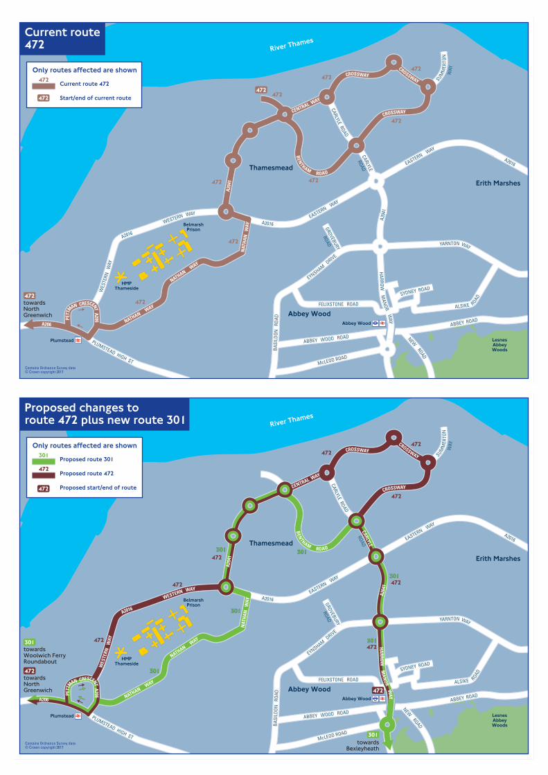
Plumstead
Abbey Wood
Thamesmead
Abbey Wood
Erith Marshes
BelmarshPrison
HMPThameside
LesnesAbbeyWoods
River Thames
A206
PLUMSTEAD HIGH ST
WES
TERN
W
AY
A2016
WESTERN WAY
A204
1
CARLYLE
ROAD
CARLYLE ROAD
CENTRAL WAY
A204
1
NAT
HAN
W
AY
NATHAN WAY
NATHAN WAY
YARNTON WAY
EASTERN WAY
A2016
A2016EASTERN WAY
HARROW M
ANOR W
AY
EYNSHAM DRIVE
BASI
LDON
RO
AD
McLEOD ROAD
PETT
MAN CRESCENT A206
BEN
THAM ROAD
ABBEY ROAD
ABBEY WOOD ROAD
CROSSWAY
CROSSWAYCROSSWAY
SUMM
ERTO
NW
AY
GROVEBURY
ROAD
FELIXSTONE ROAD RUSHDENE
SYDNEY ROAD
ALSIKE ROAD
NEW ROAD
Current route 472
Start/end of current route472
472Only routes affected are shown
Contains Ordnance Survey data© Crown copyright 2017
472
472
472472
472
472
472
472
towardsNorthGreenwich
472
472
Current route472
Plumstead
Abbey Wood
Thamesmead
Abbey Wood
Erith Marshes
BelmarshPrison
HMPThameside
LesnesAbbeyWoods
River Thames
A206
PLUMSTEAD HIGH ST
WES
TERN
W
AY
A2016
WESTERN WAY
A204
1
CARLYLE
ROAD
CARLYLE ROAD
CENTRAL WAY
A204
1
NAT
HAN
W
AY
NATHAN WAY
NATHAN WAY
YARNTON WAY
EASTERN WAY
A2016
A2016EASTERN WAY
HA
RROW
MA
NOR W
AY
EYNSHAM DRIVE
BASI
LDON
RO
AD
McLEOD ROAD
PETT
MAN CRESCENT A206
BEN
THAM ROAD
ABBEY ROAD
ABBEY WOOD ROAD
CROSSWAY
CROSSWAYCROSSWAY
SUMM
ERTO
NW
AY
GROVEBURY
ROAD
FELIXSTONE ROAD RUSHDENE
SYDNEY ROAD
ALSIKE R
OAD
NEW ROAD
Proposed route 301
Proposed route 472
Proposed start/end of route472
472
301Only routes affected are shown
Contains Ordnance Survey data© Crown copyright 2017
472
472 472
472
472
472472
472
301301
301301 301301
301301
301301towardsWoolwich FerryRoundabout
301
towardsBexleyheath
301
towardsNorthGreenwich
472
472
301301
Proposed changes toroute 472 plus new route 301

LE G
RAN
D
New CrossNew CrossGate
St. John’s
Lewisham
Blackheath
Greenwich
Maze Hill
Island Gardens
Cutty Sark forMaritime Greenwich
Deptford Bridge
ElversonRoad
Mudchute
Crossharbour
South Quay
WestcombePark
North Greenwich
Charlton
WoolwichDockyard
Deptford
Deptford
Isle ofDogs
Greenwich
Charlton
Hornfair
KidbrookeBlackheath
New Cross
Lewisham
GreenwichPark
Whit eld’sMound
MudchutePark
MaryonWilson
Park RepositoryWoods
WoolwichCommon
BlackheathPark
CharltonPark
River Thames
National MaritimeMuseum
02 Arena
The RoyalObservatory
(Museum)
LOAMPIT HILL
LEWISHAM WAY
A20
A20
LEE HIGH ROAD
THURSTON RD
BROOKMILL RD
MOL
ESW
ORTH
STRE
ETA2
211
LEWISHAM
ROAD
GREE
NW
ICH
SOUT
H S
TREE
TROMNEY ROAD
TRAFALGAR ROAD WOOLWICH RD
WOOLWICH ROAD
A206
WOOLWICH CHURCH
STREET
A102
PEAR
TREE
WAY
SO
UTHER
NW
AY
WEST PARKSIDE
LEW
ISGR
OVE
CREEK ROAD
EVELYN STREET
DEPTFORD CHURCHSTREET
A102
A102
A2
KIDBROOKE PARK ROAD
PRES
TON
’S R
OAD
MANCHESTER
ROAD
A1206
WESTFERRY ROAD
GREENWICH HIGH RD B211 OLD DOVER RD
CHARLTON ROAD
STRA
THED
ENRO
AD
LOMBARD
WAY
ANCHOR AN
D HOPE
LANE
CHARLTON CHURCH
LANE
HORNFAIR
ROADBUSBY’S WAY
HILLREACH
LITTL
E HEA
TH
CHARLTON PARK
ROADHA-HA
ROAD
CHARLTON PARK LANE
STADIU
M
ROAD
OF WALE
S
PRIN
CERO
AD
MON
TPEL
IER
ROW
LEE ROA
D
LEE TERRACE
BELMONT HILL
BLAC
KWAL
LLA
NE
MAZE HILL
CHARLTON WAY SHOOTERS HILL ROAD
A207
SHOOTERS HILL
ROADA2
SHOOTERS HILL ROADB LACKHEATH HILL
BLACKHEATHROAD
A2NEW CROSS ROAD
TRANQUILVALE
GOFFERS RD
A2
KIDBROOKE
PARK ROAD
Current route 129
Current route 180
Start/end of current route
Only routes affected are shown
180
180
129
Contains Ordnance Survey data© Crown copyright 2017
Current routes129 and 180 129
129
129
129180
180
towardsCrabtree Manorway North
180
180
180
180
180
129
LE G
RAN
D
New CrossNew CrossGate
St. John’s
Lewisham
Blackheath
Greenwich
Maze Hill
Island Gardens
Cutty Sark forMaritime Greenwich
Deptford Bridge
ElversonRoad
Mudchute
Crossharbour
South Quay
WestcombePark
North Greenwich
Charlton
WoolwichDockyard
Deptford
Deptford
Isle ofDogs
Greenwich
Charlton
Hornfair
KidbrookeBlackheath
New Cross
Lewisham
GreenwichPark
Whit eld’sMound
MudchutePark
MaryonWilson
Park RepositoryWoods
WoolwichCommon
BlackheathPark
CharltonPark
River Thames
National MaritimeMuseum
02 Arena
The RoyalObservatory
(Museum)
LOAMPIT HILL
LEWISHAM WAY
A20
A20
LEE HIGH ROAD
THURSTON RD
BROOKMILL RD
MOL
ESW
ORTH
STRE
ETA2
211
LEWISHAM
ROAD
GREE
NW
ICH
SOUT
H S
TREE
T
ROMNEY ROADTRAFALGAR ROAD WOOLWICH RD
WOOLWICH ROAD
A206
WOOLWICH CHURCH
STREET
A102
PEAR
TREE
WAY
SO
UTHER
NW
AY
WEST PARKSIDE
LEW
ISGR
OVE
CREEK ROAD
EVELYN STREET
DEPTFORD CHURCHSTREET
A102
A102
A2
KIDBROOKE PARK ROAD
PRES
TON
’S R
OAD
MANCHESTER
ROAD
A1206
WESTFERRY ROAD
GREENWICH HIGH RD B211 OLD DOVER RD
CHARLTON ROAD
STRA
THED
ENRO
AD
LOMBARD
WAY
ANCHOR AN
D HOPE
LANE
CHARLTON CHURCH
LANE
HORNFAIR
ROAD
BUSBY’S WAY
HILLREACH
LITTL
E HEA
TH
CHARLTON PARK
ROADHA-HA
ROAD
CHARLTON PARK LANE
STADIU
M
ROAD
OF WALE
S
PRIN
CERO
AD
MON
TPEL
IER
ROW
LEE ROA
D
LEE TERRACE
BELMONT HILL
BLAC
KWAL
LLA
NE
MAZE HILL
CHARLTON WAY SHOOTERS HILL ROAD
A207
SHOOTERS HILL
ROADA2
SHOOTERS HILL ROADB LACKHEATH HILL
BLACKHEATHROAD
A2NEW CROSS ROAD
TRANQUILVALE
GOFFERS RD
A2
KIDBROOKE
PARK ROAD
Proposed route 129
Proposed route 180
Proposed start/end of route
Only routes affected are shown
180
180
129
Contains Ordnance Survey data© Crown copyright 2017
Proposed routes129 and 180 129 180
129
129
129
129180
129180 180
180
129
towardsErith Quarry
180
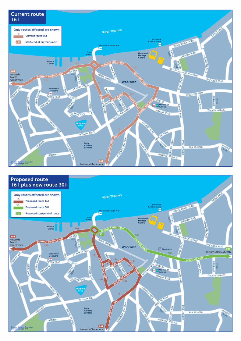
Woolwich South Pier
WoolwichRoyal Arsenal
Woolwich
RoyalArtilleryBarracks
GreenwichHeritageCentre
WoolwichArsenal
PondWharf
AquaticCentre
MulgravePond
WoolwichDockyard
River Thames
WOO
LW
ICH NEW
ROAD
BURR
AGE
ROA
D
BURRAGE ROAD
WAVERLEYROADRAGLAN ROAD
CONDUIT
ROAD
ANGLESEA ROAD
WOOLW
ICH
NEW
ROA
D
SANDY HILL ROAD
VINCENT ROAD
WALMER TERRACE
MAXEY RO AD
TOM CRIBB ROAD
DUKE OF WELLINGTON AVENUE
ARSENAL
WAY
ESSE
X S
TREE
T
CADOGAN ROAD
ARMSTRONG ROAD
KINGSM
AN STREET
WELLINGTON STREET
ARTILLERY PLACE
HILLREACH
REPOSITORY ROAD
FRANCES STREET
FRANCES STREET
WOODHILL
SAM
UEL STREET
RECTORY PLACE
BELSON ROAD
CRESCENT ROAD
MULGRAVE ROAD
GORMANROAD
HARE STREET
POWIS STREETWOOLWICH CHURCH STREET
WOOLWICH HIGH STREET
BERESFORD STREET
PLUMSTEAD ROADJOHN WILSON
STREET
GRAN
D D
EPOT
ROAD
ST MARY STREET
SPRAY ST
INVE
RMOR
EPL
ACE
MARLBOROUGH ROAD
HOPTON
ROAD
PROSPECT
VALE
GREENHILL
GREENLAW
STREET
CHURCH
HILL
BORGARD RD
BLOO
MFI
ELD
ROA
D
FREDERICK PLACE
POLYTECHNIC
ST
MARKET ST
EREBUS DRIVE
THOMAS STREET
CALDERWOOD STREET
MONK ST 161
161
161
161
161
161
towardsNorthGreenwich
161
towards Chislehurst161Contains Ordnance Survey data
© Crown copyright 2017
Current route161
Current route 161
Start/end of current route161
161Only routes affected are shown
Woolwich South Pier
WoolwichRoyal Arsenal
Woolwich
RoyalArtilleryBarracks
GreenwichHeritageCentre
WoolwichArsenal
Woolwich
PondWharf
AquaticCentre
MulgravePond
WoolwichDockyard
River Thames
WOOLW
ICH NEW
ROA
D
BURR
AGE
ROA
D
BURRAGE ROAD
WAVERLEYROADRAGLAN ROAD
CONDUIT
ROAD
ANGLESEA ROAD
WOOLW
ICH
NEW
ROA
D
SANDY HILL ROAD
VINCENT ROAD
WALMER TERRACE
MAXEY RO AD
TOM CRIBB ROAD
DUKE OF WELLINGTON AVENUE
ARSENAL
WAY
ESSE
X S
TREE
T
CADOGAN ROAD
ARMSTRONG ROAD
KINGSM
AN STREET
WELLINGTON STREET
ARTILLERY PLACE
HILLREACH
REPOSITORY ROAD
FRANCES STREET
FRANCES STREET
WOODHILL
SAM
UEL STREET
RECTORY PLACE
BELSON ROAD THOMAS STREET
CALDERWOOD STREET
CRESCENT ROAD
MULGRAVE ROAD
GORMANROAD
HARE STREET
POWIS STREETWOOLWICH CHURCH STREET
WOOLWICH HIGH STREET
BERESFORD STREET
PLUMSTEAD ROADJOHN W
ILSON STREET
GRAN
D D
EPOT
ROAD
ST MARY STREET
SPRAY ST
INVE
RMOR
EPL
ACE
MARLBOROUGH ROAD
HOPTON
ROAD
PROSPECT
VALE
GREENHILL
GREENLAW
STREET
CHURCH
HILL
BORGARD RD
BLOO
MFI
ELD
ROA
D
FREDERICK PLACE
POLYTECHNIC
ST
MARKET ST
EREBUS DRIVE
MONK ST
301 301301
301301161
161
161 161
161
161
161
161
towardsNorthGreenwich
161
towards Chislehurst161
towards Bexleyheath301
Contains Ordnance Survey data© Crown copyright 2017
Proposed route161 plus new route 301
Proposed route 161
Proposed route 301
Proposed start/end of route301
161
301
Only routes affected are shown

North-East London Maps

AldgateEast
Whitechapel
Aldgatetowards
East Ham
115
115115
115
COMMERCIAL ROADCOMMERCIAL ROAD
CANN
ON STREET ROAD
NEW
ROAD
LEMAN STREET
COMM
ERCIAL STREET OSBORN ST
BRICK LANE
WHITECHAPEL ROAD
WHITECHAPEL ROAD
VALLANCE ROAD
CAM
BRID
GE H
EATH
ROA
D
CABLE STREETCABLE STREET
ROYAL MINT STREET
MIN
ORIES
STREETST BOTOLPH
MAN
SELL STREET
THE HIGHWAY
THE HIGHWAY
PRESCOT STREET
ALIE STREET
DUKE’S PLACE
HOUNDSDITCH
CHURCH LNW
HITE
STEPNEY GREEN
WHITECHAPEL HIGH ST
ALDGATE HIGH ST
STEPNEY WAY
JUBI
LEE
STR
EET
SIDNEY STREET
SIDN
EY S
TREE
T
The Royal LondonHospital
WatneyMarket
TheEast LondonMosque
LondonMetropolitanUniversity
WhitechapelGallery
Spitalfields
Whitechapel
Contains Ordnance Survey data© Crown copyright 2017
Current route115 Current route 115
Start/end of current route115
115Only routes affected are shown

AldgateEast
Whitechapel
Aldgatetowards
East Ham
115115
115115
115115
115
115
115
115
115
115 115
COMMERCIAL ROAD
COMMERCIAL ROADCAN
NON
STREET ROAD
NEW
ROAD
LEMAN STREET
COMM
ERCIAL STREET OSBORN ST
BRICK LANE
VALLANCE ROAD
CAM
BRID
GE H
EATH
ROA
D
CABLE STREET
ROYAL MINT STREET
MIN
ORIES
MAN
SELL STREET
THE HIGHWAY
PRESCOT STREET
ALIE STREET
DUKE’S PLACE
HOUNDSDITCH
CHURCH LNW
HITE
STEPNEY WAY
JUB
ILEE
STR
EET
CABLE STREET
THE HIGHWAY
WHITECHAPEL ROAD
WHITECHAPEL HIGH STREET
WHITECHAPEL ROAD
STREETST BOTOLPH
ALDGATE HIGH ST
SIDN
EY S
TREE
T
SIDNEY STREET
ASHFIELDSTREET
Spitalfields
Whitechapel
The Royal LondonHospital
WhitechapelGallery
LondonMetropolitanUniversity
TheEast LondonMosque
WatneyMarket
Proposed route115 Proposed route 115 option 1
Proposed route 115 option 2
Start/end of current route
Elizabeth line
115
115
115
Only routes affected are shown
Contains Ordnance Survey data© Crown copyright 2017
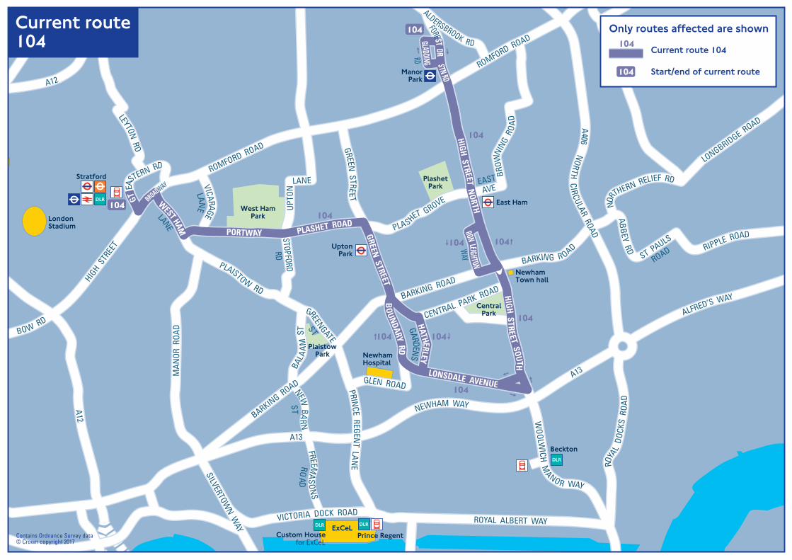
NewhamHospital
NewhamTown hall
LondonStadium
er
ExCeL
104
Beckton
Custom Housefor ExCeL
Stratford
UptonPark
East Ham
ManorPark
Prince Regent
West HamPark
PlaistowPark
PlashetPark
CentralPark
104
104 104
104
104
104
104104
104
ALFRED’S WAY
A13
NEWHAM WAY
A13
A406 NORTH
CIRCULAR ROAD
FOREST DR
BARKING R OAD
BARKING ROAD
BARKING ROAD
NORTHERN RELIEF RD
ABBEY RD
PRINCE REGEN
T LANE
GREENGATE
ST
PLAISTOW RD
WEST HAM
LANE
STOPFORDRD
MAN
OR R
OAD
GT E
AS
TERN RD
ROMFORD ROAD
ROMFORD ROAD
BROADWAY
HIGH S
TREE
T
BOW RD
A12
PORTWAY PLASHET ROAD
GREEN STREET
HATHERLEYGARDEN
S
RON LEIGHTONWAY
HIGH STREET SOUTH
GLEN ROADLONSDALE AVENUE
BO
UNDARY RD
CENTRAL PARK ROAD
GREEN STREET
PLASHET GROVE
GLADDINGRD STN RD
HIGH STREET NORTH
WOOLW
ICH M
ANOR WAY
ROYA
L D
OCKS
RO
AD
GH RD LEYTON
LEYTON RD
A12
BROW
NING
RO
AD
AVEEASTVICARAGE
LANE
RIPPLE ROAD
ST PAULS
ROAD
LONGBRIDGE ROAD
ROYAL ALBERT WAY
SILVERTOWN W
AY
VICTORIA DOCK ROAD
W
UPTO
N LANE
FREE MA
SON
SRO
ADST
NEW BA
RN
ALDERSBROOK RD
BAL A
AM
ST
Current route104 Current route 104
Start/end of current route104
104Only routes affected are shown
Contains Ordnance Survey data© Crown copyright 2017
NewhamHospital
NewhamTown hall
LondonStadium
er
ExCeL
104
Beckton
Custom Housefor ExCeL
Prince Regent
Stratford
UptonPark
East Ham
ManorPark
West HamPark
PlashetPark
PlaistowPark
CentralPark
NewhamCollege
The Royal DocksCommunity School
304
304 304
304
304
304
304
304
104
104104
104
104
ALFRED’S WAY
A13
NEWHAM WAY
A13
A406 NORTH
CIRCULAR ROAD
ALDERSBROOK RD
FOREST DR
BARKING R OAD
BARKING ROAD
BARKING ROAD
NORTHERN RELIEF RD
ABBEY RD
PRINCE REG
ENT LA
NE
GREENGATE
ST
PLAISTOW RD
WEST HAM
LANE
STOPFORDRD
MAN
OR R
OAD
GT E
AS
TERN RD
ROMFORD ROAD
ROMFORD ROAD
BROADWAY
HIGH S
TREE
T
BOW RD
A12
PORTWAY PLASHET ROAD
GREEN STREET
HATHERLEYGARDEN
S
RON LEIGHTONWAY
HIGH STREET SOUTH
GLEN ROADLONSDALE AVENUE
BO
UNDARY RD
CENTRAL PARK ROAD
GREEN STREET
PLASHET GROVE
GLADDINGRD STN RD
HIGH STREET NORTH
WOOLW
ICH M
ANOR WAY
ROYA
L D
OCKS
RO
AD
GH RD LEYTON
LEYTON RD
A12
BROW
NING
RO
AD
AVEEASTVICARAGE
LANE
RIPPLE ROAD
ST PAULS
ROAD
LONGBRIDGE ROAD
ROYAL ALBERT WAY
SILVERTOWN W
AY
VICTORIA DOCK ROAD
W
UPTO
N LANE
FREEMASO
NS
ROADST
NEW BA
RN
BAL A
AM
ST
Proposed routes104 and 304
104
104
304
Proposed route 104
Proposed route 304
Proposed start/end of route
Elizabeth line
Only routes affected are shown
Contains Ordnance Survey data© Crown copyright 2017

NewhamTown hall
ExCeL Civic CentreRoyal
Albert
Beckton
CustomHouse
for ExCeL
Prince Regent
UptonPark
Plaistow
East Ham
WordsworthHealth Centre
Canning Town
RoyalVictoria
NewhamHospital
NewhamCollege
The Royal DocksCommunity School
West HamPark
PlaistowPark
PlashetPark
CentralPark
King George VPark
300300
300300300300
300300
300300
300300 300300
ALFRED’S WAY
A13
NEWHAM WAY
A13
A406 NORTH CIRCULAR ROAD
BARKING RO AD
BARKING ROAD
BARKING ROAD
FA
ABBEY RD
PRINCE REGE N
T LANE
GREENGATE
ST
PLAISTOW ROAD
WEST HAM
LANE
STOPFORDRD
MAN
OR R
OAD
ROMFORD ROADHIG
H STR
EET
PORTWAY PLASHET ROAD
GREEN STREET
RON LEIGHTON
WAY
HIGH STREET SOUTH
GLEN ROAD
LONSDALE AVENUE
BOUNDARY RD
GREEN STREET
PLASHET GROVE
HIGH STREET NORTH
WOOLW
ICH M
ANOR WAY
ROYA
L D
OCKS
RO
AD
ON ROAD BROW
NIN
G
ROAD
ROYAL ALBERT WAY
SILVERTOWN W
AY
VICTORIA DOCK ROAD
FREEMA
SON
S RD
STNEW
BARN
STAN
SFELD ROAD
TOLLGATE ROAD
PARK AVENUE
FOLKESTONE
GOOSELEY
ROAD
LAN E
VICARAGE
LANEUP
TON
LANE
BALA
AM
STR
EET
Current route300 Current route 300
Start/end of current route300300
300300Only routes affected are shown
Contains Ordnance Survey data© Crown copyright 2017
NewhamTown hall
ExCeL Civic Centre
Beckton
UptonPark
Plaistow
East Ham
Canning Town
RoyalVictoria
Prince Regent
WordsworthHealth Centre
RoyalAlbertCustom
Housefor ExCeL
NewhamHospital
NewhamCollege
West HamPark
PlashetPark
CentralPark
The Royal DocksCommunity School
King George VPark
PlaistowPark
300300
300300
300300
300300 300300
300300
300300
ALFRED’S WAY
A13
NEWHAM WAY
A13
A406 NORTH CIRCULAR ROAD
BARKING RO AD
BARKING ROAD
BARKING ROAD
FA
ABBEY RD
PRINCE REGEN
T LAN
E
GREENGATE
ST
PLAISTOW ROAD
WEST HAM
LANE
STOPFORDRD
MAN
OR R
OAD
ROMFORD ROADHIG
H STR
EET
PORTWAY PLASHET ROAD
GREEN STREET
RON LEIGHTON
WAY
HIGH STREET SOUTH
GLEN ROAD
LONSDALE AVENUE
BOUNDARY RD
GREEN STREET
PLASHET GROVE
HIGH STREET NORTH
WOOLW
ICH M
ANOR WAY
ROYA
L D
OCKS
RO
AD
ON ROAD BROW
NIN
G
ROAD
ROYAL ALBERT WAY
SILVERTOWN W
AY
VICTORIA DOCK ROAD
FREEMA
SON
S RD
STNEW
BARN
TOLLGATE ROAD
PARK AVENUE
FOLKESTONE
GOOSELEY
ROAD
LAN E
VICARAGE
LANE
STAN
SFELD ROAD
UPTO
N LANE
BALA
AM
STR
EET
Proposed route300
300
300Proposed route 300
Proposed start/end of route
Elizabeth line
Only routes affected are shown
Contains Ordnance Survey data© Crown copyright 2017

NewhamTown hall
O2
ExCeLCustom
Housefor ExCeL
PrinceRegent
UptonPark
Canning Town
Hermit Road
RoyalVictoria
WestSilvertown Pontoon
Dock
Beckton
GallionsReach
Cyprus
London CityAirport
King George V
East Ham
Manor Park
Royal Albert
West HamPark
PlaistowPark
PlashetPark
CentralPark
The Royal DocksCommunity School
474
474
PIERRD
474 474
474
474
474
474
River Thames
A
A13
NEWHAM WAY
A13
A406 NORTH CIRCU
LAR ROAD
ALDERSBROOK RD
BARKING R OAD
BARKING ROAD
BARKING ROAD
ILFORD LANE
PRINCE REGEN
T LANE
GREENGATE
STPLAISTOW RD
STOPFORDRD
MAN
OR R
OAD
ROMFORD ROAD
ROMFORD ROAD
PORTWAY PLASHET ROAD
GREEN STREET
HIGH STREET SOUTH
GLEN ROADLONSDALE AVENUE
BO
UNDARY RD
GREEN STREET
PLASHET GROVE
HIGH STREET NORTH
ROYA
L D
OCKS
RO
AD
A12
CONNAUGHT
ROADALBERT ROAD
ROYAL ALBERT WAY
SILVERTOWN W
AY
NORTH WOOLWICH ROAD
VICTORIA DOCK ROAD
WOOLW
ICH MA
NOR WAY
WOOLW
ICH MAN
OR WA
Y
FREEMASO
NS RD
NEW BA
RNST
BAL A
AM
ST
CON
NAU
GHT
BRID
GE
RON LEIGHTONWAY
HARTMANNRD
BROW
NING
RO
AD
FOREST DR
WOOD
GRAN
GE
ROA
D
Current route 474
Start/end of current route474
474Only routes affected are shown
Contains Ordnance Survey data© Crown copyright 2017
Current route474
ExCeL
O2
CustomHousefor ExCeL
UptonPark
Canning Town
Hermit Road
RoyalVictoria
WestSilvertown Pontoon
Dock
Beckton
GallionsReach
Cyprus
King George V
East Ham
Manor Park
London CityAirport
Royal AlbertPrinceRegent
West HamPark
PlaistowPark
PlashetPark
CentralPark
The Royal DocksCommunity School
474
474
PIERRD
474 474
474
474
474
River Thames
A
A13
NEWHAM WAY
A13
A406 NORTH CIRCU
LAR ROAD
ALDERSBROOK RD
BARKING R OAD
BARKING ROAD
BARKING ROAD
ILFORD LANE
PRINCE REGEN
T LANE
GREENGATE
STPLAISTOW RD
STOPFORDRD
MAN
OR R
OAD
ROMFORD ROAD
ROMFORD ROAD
PORTWAY PLASHET ROAD
GREEN STREET
HIGH STREET SOUTH
GLEN ROADLONSDALE AVENUE
BO
UNDARY RD
GREEN STREET
PLASHET GROVE
HIGH STREET NORTH
ROYA
L D
OCKS
RO
AD
CONNAUGHT
ROAD ALBERT ROAD
ROYAL ALBERT WAY
SILVERTOWN W
AY
NORTH WOOLWICH ROAD
VICTORIA DOCK ROAD
WOOLW
ICH MA
NOR WAY
WOOLW
ICH MAN
OR WA
Y
FREEMASO
NS RD
NEW BA
RNST
BAL A
AM
ST
CON
NAU
GHT
BRID
GE
RON LEIGHTONWAY
HARTMANNRD
BROW
NING
RO
AD
FOREST DR
WOOD
GRAN
GE
ROA
D
Contains Ordnance Survey data© Crown copyright 2017
474
474Proposed route 474
Proposed start/end of route
Bus stop served
Bus stop not longer served
Elizabeth line
Only routes affected are shown
Proposed route474
BWoolwichFerry
474
474
474
ALBERT ROAD
STTOORR
E R
OAADD
PIER RD
PIER ROAD
See inset above
NewhamHospital
nm
ExCeL
O2
WestSilvertown Pontoon
Dock
CustomHouse
for ExCeL
Prince Regent
UptonPark
Canning Town
Plaistow
Maryland
RoyalVictoria
Forest Gate
WansteadPark
Stratford
London CityAirport
Royal Albert
West HamPark
PlashetPark
CentralPark
PlaistowPark
330
330
330330
330330
NEWHAM WAY
A13
K RD
BA
BARKING ROAD
BARKING ROAD PRINCE REGEN
T LANE
GREENGATE
ST
HIGH ST
PLAISTOW ROAD
STOPFORDRD
MAN
OR R
OAD
GT E
ASTERN RD
ROMFORD ROAD
ROMFORD ROAD
BROADWAY
HIGH S
TREE
T
A12
PORTWAY PLASHET ROAD
GREEN STREET
HIGH STREET SOUTH
GLEN ROAD
LONSDALE AVENUE
BOUNDARY RD
GREEN STREET
PLA SHET GROVE
STN RD
HIGH STREET NORTH
LEYTON
LEYTON RD
CONNAUGHTR D ALBERT ROAD
ROYAL ALBERT WAY
SILVERTOWN W
AY
NORTH WOOLWICH ROAD
VICTORIA DOCK ROADEAST INDIA DOCK RD
FREEMA
SON
S RD
NEW BA
RN
ST
CON
NAU
GHT
BRID
GE
UPTON LAN
EW
OODG
RANGE
ROAD
WEST HAM
LANE
BALA
AM
ST
HARTMANNRD
Current route 330
Start/end of current route330
330Only routes affected are shown
Contains Ordnance Survey data© Crown copyright 2017
Current route330

NewhamHospital
nm
ExCeL
O2
WestSilvertown Pontoon
Dock
CustomHouse
for ExCeL
Prince Regent
UptonPark
Canning Town
Plaistow
Maryland
RoyalVictoria
Forest Gate
WansteadPark
Stratford
London CityAirport
Royal Albert
West HamPark
PlashetPark
CentralPark
PlaistowPark
330
330
330
330
NEWHAM WAY
A13
K RD
BA
BARKING ROAD
PRINCE REGEN
T LANE
GREENGATE
ST
HIGH ST
PLAISTOW ROAD
STOPFORDRD
MAN
OR R
OAD
GT E
ASTERN RD
ROMFORD ROAD
ROMFORD ROAD
BROADWAY
HIGH S
TREE
T
A12
PORTWAY PLASHET ROAD
HIGH STREET SOUTH
GLEN ROAD
LONSDALE AVENUE
BOUNDARY RD
PLA SHET GROVE
STN RD
HIGH STREET N
ORTH
LEYTON
LEYTON RD
CONNAUGHTR D ALBERT ROAD
ROYAL ALBERT WAY
EAST INDIA DOCK RD
FREEMA
SON
S RD
NEW BA
RN
ST
BALA
AM
STUPTON
LANE
R OAD
WEST HAM
LANE
BARKING ROAD
GREEN STREET
GREEN STREET
SILVERTOWN W
AY
NORTH WOOLWICH ROAD
VICTORIA DOCK ROAD
WO
OD
GR
ANGE
COON
NA
UUG
HTT
BRID
GE
HARTMANNRD
Contains Ordnance Survey data© Crown copyright 2017
330
330Proposed route 330
Proposed start/end of route
Future option
Elizabeth line
Only routes affected are shownProposed route330
NewhamHospital
ExCeLPrince Regent
UptonPark
Canning Town
Plaistow
Maryland
RoyalVictoria Custom
Housefor ExCeL
Stratford City
Hermit Road
West HamPark
PlaistowPark
241
241
NEWHAM WAY
A13
BARKING R
OAD
BARKING ROAD
PRINCE REGEN
T LANE
GREENGATE ST
HIGH ST
PLAISTOW ROAD
WEST HAM
LANE
STOPFORDRD
MAN
OR R
OAD
GREA
T EA
STERN ROAD ROMFORD ROAD
BROADWAY
Stratford
HIGH S
TREE
T
A12
PORTWAYPLASHET ROAD
GREEN STREET
GLEN ROAD
BOUNDARY RD
GREEN STREET
PL
A
LEYTON ROAD
VICARAGE LANESILVERTOW
N WAY VICTORIA DOCK ROAD
VICTORIA DOCK ROAD
EAST INDIA DOCK ROAD
FREEMASO
NS RO
AD
NEW BARN
ST
BALA
AM
STR
EET
THE
GRO
VE
MONTF
ICH
ET R
OA
D
APPLEBY RD
RADLAND RD
RUSCOERD
Contains Ordnance Survey data© Crown copyright 2017
Current route241 Current route 241
Start/end of current route241
241Only routes affected are shown
LondonStadium
CopperBox
Here East
ExCeL
Canning Town
Plaistow
Maryland
RoyalVictoria
Stratford City
CustomHouse
for ExCeL
StratfordWest Ham
Park
PlaistowPark
241
241
A13
BARKING ROAD
GREENGATE
ST
HIGH ST
PLAISTOW ROAD
WEST HAM
LANE
STOPFORDRD
MAN
OR R
OAD
GREA
T EA
STERN ROAD ROMFORD ROAD
BROADWAY
BOW ROAD
HIGH S
TREE
T
A12
A12
PORTWAY PLASHET ROAD
LEYTON ROAD
A12
VICARAGE LANE
SILVERTOWN W
AY
V
VICTORIA DOCK ROAD
AD
EAST INDIA DOCK ROAD
FREEMASO
NS ROAD
NEW BARN
ST
BALA
AM
STR
EET
THE
GRO
VE
MONTF
ICH
ET R
OA
D
WATERDEN
ROADWESTFIELD
AVENUE
LOWER LEA CROSSING
ASPEN WAY
Proposed route241
241
241Proposed route 241
Proposed start/end of route
Elizabeth line
Only routes affected are shown
See Stratford gyratoryconsultation
Contains Ordnance Survey data© Crown copyright 2017

TANGENT
Harold Wood
Central Park
Tesco
HaroldHill
HaroldWood
Central ParkLeisure Centre
Hilldene AvenueShops
St. Ursula'sPrimary Schools
HilldenePrimary School
London South BankUniversity
Havering Campus
Harold WoodPolyclinic
KingsPark
RavensbourneSchool
Drapers' BrooksidePrimary Schools
BroadfordPrimarySchool
497
497
497
497
DAGNAM PARK DRIVE
NORTH H
ILL DRIVE
HILLDENE AVENUE
STRAIGHT ROAD
STRAIGHT ROAD
GUBBIN
S LANE
GOOSHAYS DRIVE
SQUIRRELS HEATH ROAD
SOUTHEND ARTERIAL ROAD A127
A12
MAI
N ROAD
COLCHESTER ROAD
COLCHESTER ROAD A12
LISTER AVE
WHITELANDS W
AY
ASHTON RD
FARIN
GDON AVENUE
CHATTERIS AVENUE
ST. C
LEM
ENTS
AVENUE
PETERSFIELD AVENUE
TANGENT
LINK
Proposed route 497
Start/end of proposed route
Elizabeth line
497
497Only routes affected are shown
Contains Ordnance Survey data© Crown copyright 2017
Proposed route497

HANOVER
OxfordCircus
TottenhamCourt Road
LeicesterSquare
Holborn
ChanceryLane
CityThameslink
Farringdon
towardsIlford
2525
25
25
PORTLAND PLACE
REGENT STREET
HANOVER
PICCADILLY
REGENT STREETHAYM
ARKET
REGENT STREET
OXFORD STREET
GOODGE ST
MORTIMER STREET
SHAFTES
BURY AVEN
UE
BLOOMSBURY WAY
PROCTER ST
NEW OXFORD ST
EUSTON ROAD
TOTTENHAM COURT ROAD
BLOOMSBURY ST
GOWER STREET
KINGSWAY
WATERLOO
BRIDGE
ALDWYCH
STRAND
VICTORIA EMBANKMENT
STRAND
HIGH HOLBORN HOLBORN HOLBORN VIADUCTNEWGATE
STREET
STREET
OXFORD STREET
THEOBALDS ROAD FARRINGDON
ROADFARRIN
GDON ST
BLACKFRIARSBRIDGE
SOUTHWARK STREETSTAMFORD STREET
PALL MALL
GRAYS INN ROAD ROSE
BERY
AVE
NUE
CLERKENWELL ROAD
HIGH HOLBORN
CHARING CROS
S ROAD
NORTHUMBERLANDAVENUE
CHARTERHOUSE STREET
WOBURN
PLACE
SOUTHAMPTON
ROW
Holborn
Clerkenwell
Strand
BloomsburyFitzrovia
Soho
St. Giles
RussellSquare
BloomsburySquare
Lincoln’s InnFields
BedfordSquare
CavendishSquare
HanoverSquare
BritishMuseum
NationalGallery
Royal Courtsof JusticeRoyal Courtsof Justice
TrafalgarSquare
St. Bartholomew’sHospital
SmithfieldsMarket
TateModern
RoyalNationalTheatre
River Thames
Contains Ordnance Survey data© Crown copyright 2017
Current route25 Current route 25
Start/end of current route25
25Only routes affected are shown
Farringdon
ChanceryLane
CityThameslink
25
towardsIlford
25
25
KINN
GG EE
DDWW
AARDD
HOLBORN VIADUCT
NEWGATE STREET
FARRINGDON
ROAD
FARRINGDON
STREET
STREET
SNOW HILL
CHARTERHOUSE STREET
HOLBORN
GRAYS INN ROAD
HATTON GARDEN
S
LEATHER LANE
BALDWIN’S GARDENS
KIRBY STREET
CHARTERHOUSE STREET
FARRINGDON
FETT
ER L
ANE
NEW F
ETTE
R L
ANE
WEST SMITHFIELD
ALDERSGATE STREET
ANGEL STREET
ST.-M
ARTI
N’S
-LE-
GR
AND
KIN
G E
DW
ARD
OLD
BAI
LEY
GILT
SPUR
ST
REET
HOSIER LANE
SMIT
HFIEL
D STR
EET
ST J
OHN
STR
EET
COWCROSS STREET
GREVILLE STREET
STRE
ET
CHANCERY LAN
E
WEST SMITHFI
ELD
Holborn
St. Bartholomew’sHospital
Old Bailey
SmithfieldsMarket
Contains Ordnance Survey data© Crown copyright 2017
Proposed route25 Proposed route 25
Start/end of proposed route
Elizabeth line
25
25Only routes affected are shown

West London Maps
StamfordStamfordBrookBrook Hammersmith
Goldhawk Road
RavenscourtRavenscourtParkParkChiswickChiswick
ParkPark
GunnersburyGunnersbury
North ActonNorth Acton
RavenscourtPark
StamfordBrook
TurnhamGreen
ChiswickPark
ActonTown
EalingCommon
Gunnersbury
WillesdenJunction
Harlesden
StonebridgePark
Neasden
DollisHill Willesden
Green
Kilburn
WembleyStadium
KensalGreen
KensalRise
SouthActon
KewBridge
Shepherd’sBush
ActonCentral Shepherd’s
Bush Market
Wood Lane
WhiteCity
LatimerRoad
EastActonActon
Main Line
North Acton
West Acton
ParkRoyal
HangerLane
LadbrokeGrove
FISHER’SLANEAC TO
N LA
STANDARD RD
ABBEY ROAD
CHAS
E RO
AD
VICT
ORIA RD
OLD
OAK
LANE
ST
N RDCRAVEN PK RD
CHUR
CH R
OAD
HIGH ROADW
ALM L
ANE
HORN
LAN
E
TWYFORD AVEN
UE
NOEL ROAD
GLENTHORNROAD
PADDENSWICK RD
ASKEW
ROAD
THE VALEHIGH STREET
UXBRIDGE ROAD
WELLESLEY RD
BOLLO LANE
BOLLO BRIDGE RD
MINERVA RD
CHISWICK HIGH RDKING STREET
NORTH END
RDKING ST
HAMMERSMITH ROAD
BROMYARD AVE
Contains Ordnance Survey dataContains Ordnance Survey data© Crown copyright 2017© Crown copyright 2017
Contains Ordnance Survey data© Crown copyright 2017
Proposed bus route
Road no longer served by propsed routes
Proposed start/end of route
Current start/end of route
Elizabeth line
Proposed routes 218, 266,306, 391, 440 and N266
266
266
266 N266
440
218
218
218
N266
N266
218.440
218.266440.N266218
440440
440
440
440
440
266
266
266266
266266
N266
N266
N266 N266
440
towardsBrent CrossShoppingCentre
306towards
Fulham, Sands End
391towards Richmond
218
266
440 391
391391
440
266
218.266440.N266
266266
218.266
218
391
306
266
N266440
440
440
306306
306306
Stop D will now be served southbound
instead of stop K

KING ST Hammersmith
GoldhawkGoldhawkRoadRoadSouthSouth
ActonActon
KewKewBridgeBridge
KensingtonKensington(Olympia)(Olympia)
EastEastActonActon
GoldhawkRoad
BaronsCourt
RavenscourtRavenscourtParkPark
ChiswickChiswickParkPark
GunnersburyGunnersbury
North ActonNorth Acton
RavenscourtPark
StamfordBrook
TurnhamGreen
ChiswickPark
ActonTown
EalingCommon
Gunnersbury
SouthActon
KewBridge
Kensington(Olympia)
Acton Central
EastActon
North Acton
WestActon
NorthEaling
Park Royal
ActonMain Line
FIISHHER’SFISHER’S
LANEAC TON LA
CHAS
E R
DVI
CTOR
IA RD
HORN
LAN
E
TWYFORD AVEN
UE
NOEL ROAD
GLENTHORNROOADROAD
PADDENSWICK RD
ASKEW ROAD
THE VALEHIGH STREET
UXBRIDGE ROAD
WELLESLEY ROAD
BOLLO LANE
BOLLO BRIDGE RD
WESTWAY
UXBRIDGE ROAD
GOLDHAWK ROAD
SHEP
HERD’
S B
USH
RD
CHISWICK HIGH RD
HOLLAND ROAD
GREAT WEST ROAD
NORTH CIRCULAR ROAD
OLD OAK ROAD
Contains Ordnance Survey dataContains Ordnance Survey data© Crown copyright 2017© Crown copyright 2017
Contains Ordnance Survey data© Crown copyright 2017
Proposed route 266
Current route 266
Proposed route N266
Proposed start/end of route
Current start/end of route
Elizabeth line
Proposed changes toroutes 266 and N266
266266
266 N266
440
N266
N266
N266
N266N266266266
266266
N266
N266N266N266
N266
266
266
266
266
266266266
266266
266266
266266
266
N266
N266
towards Brent Crosstowards Brent CrossShopping CentreShopping Centretowards Brent Crosstowards Brent CrossShopping CentreShopping Centretowards Brent CrossShopping Centre
266
266
266
266
266N266
Route 266 would run betweenActon Town Hall andBrent Cross Shopping Centre
The night portion of the routewould continue to run betweenHammersmith bus station andBrent Cross Shopping Centre.It would be renumbered N266
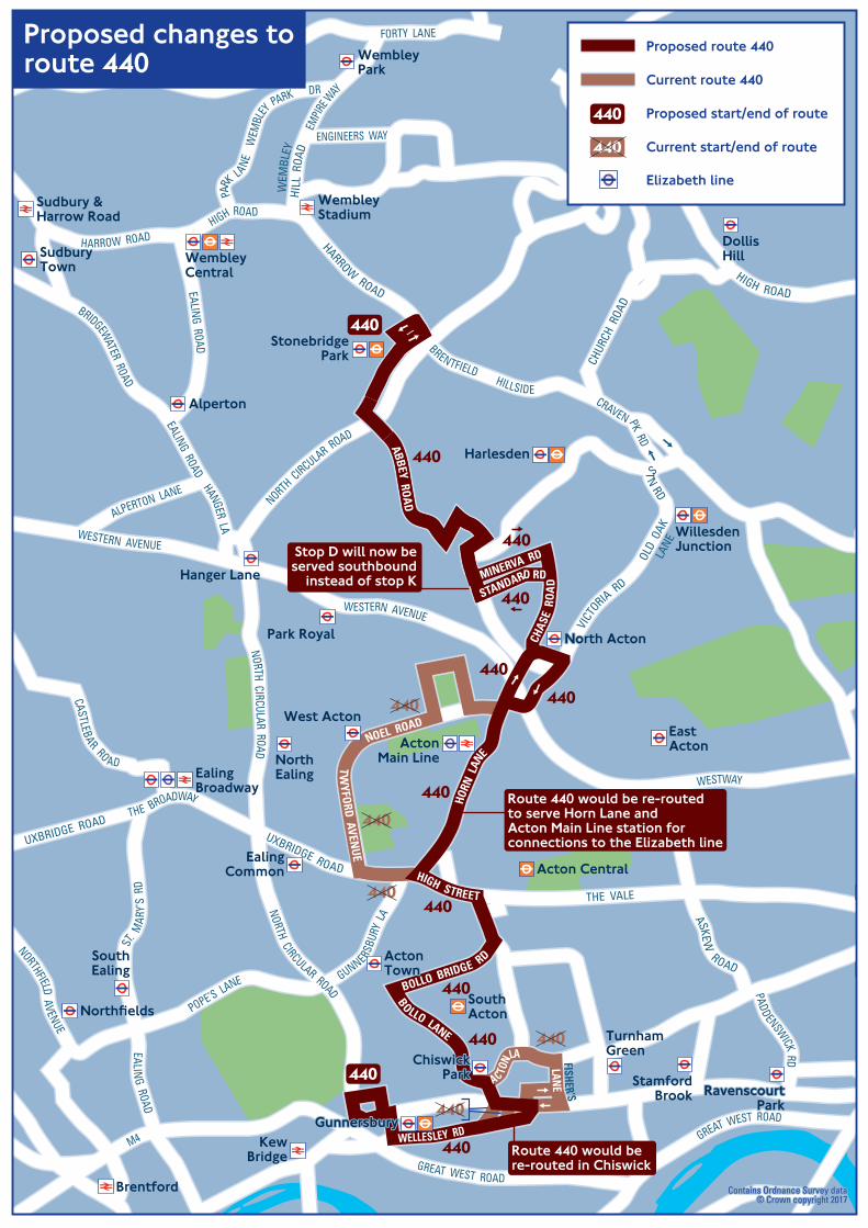
G
RavenscourtRavenscourtParkPark
ChiswickChiswickParkPark
GunnersburyGunnersbury
North ActonNorth Acton
RavenscourtPark
StamfordBrook
TurnhamGreen
ChiswickPark
ActonActonTownTownActonTown
SouthEaling
Northfields
EalingCommon
Gunnersbury
WillesdenJunction
Harlesden
StonebridgePark
Neasden
DollisHill
WembleyStadium
Sudbury &Harrow Road
KG
SouthActon
KewBridge
Brentford
WembleyCentral
SudburyTown
Alperton
WembleyPark
Acton Central
EastActonActon
Main Line
North Acton
West Acton
NorthEaling
Park Royal
Hanger Lane
EalingBroadway
FISHER’SLANEAC TO
N LA
STANDARD RD
ABBEY ROAD
HARROW ROADHI
LL R
OAD
WEM
BLEY
ENGINEERS WAY
CHAS
E RO
AD
VICT
ORIA RD
OLD
OAK
LANE
ST
N RD
CRAVEN PK RD
CHUR
CH R
OAD
HIGH ROAD
HORN
LAN
E
TWYFORD AVEN
UE
NOEL ROAD
PADDENSWICK RD
ASKEW
ROAD
THE VALE
HIGH STREET
UXBRIDGE ROAD
WELLESLEY RD
BOLLO LANE
BOLLO BRIDGE RD
MINERVA RD
WEM
BLEY
PARK DR
PARK LANE
GREAT WEST ROAD
NORTH CIRCULAR R OADNORTH CIRCULAR ROAD
NORTH CIRCULAR ROAD
HARROW ROADHIGH ROAD
UXBRIDGE ROADTHE BROADWAY
EMPIR
E WAY
WESTERN AVENUE
WESTERN AVENUE
WESTWAY
M4
GREAT WEST ROAD
HANGER LA
EALING ROAD
BRIDGEWATER ROAD
ALPERTON LANE
EALING ROAD
FORTY LANE
CASTLEBAR RO AD
EALING ROAD
ST. M
ARY’
S R
D
GUNNERSBU
RY L
A
POPE’S LANE
NORTHFIELD AVENUE
HILLSIDE
BRENTFIELD
Proposed route 440
Current route 440
Proposed start/end of route
Current start/end of route
Elizabeth line
440
440
Proposed changes toroute 440
Contains Ordnance Survey dataContains Ordnance Survey data© Crown copyright 2017© Crown copyright 2017
Contains Ordnance Survey data© Crown copyright 2017
440
440440
440
440
440
440
440
440
440
440
440
440
440
440
440
440
Route 440 would be re-routedto serve Horn Lane andActon Main Line station forconnections to the Elizabeth line
Stop D will now beserved southbound
instead of stop K
Route 440 would bere-routed in Chiswick

ActonMain Line Line
Hammersmith
GoldhawkGoldhawkRoadRoadSouthSouth
ActonActon
KewKewBridgeBridge
EastEastActonActon
KensingtonKensington(Olympia)(Olympia)
GoldhawkRoad
Barons Court
ChiswickChiswickParkPark
GunnersburyGunnersbury
North ActonNorth Acton
RavenscourtPark
StamfordBrookTurnham
GreenChiswick
Park
ActonTown
EalingCommon
Gunnersbury
SouthActon
KewBridge
ActonCentral
ActonMain Line
EastActon
North Acton
LadbrokeLadbrokeGroveGrove
LadbrokeGrove
WestActon
NorthEaling
Kensington(Olympia)
AC TON LA
TWYFORD AVEN
UE
NOEL ROAD
GLENTHORNROADROAD
PADDENSWICK RD
ASKEWROAD
THE VALEHIGH STREET
UXBRIDGE ROAD
WELLESLEY RD
BOLLO LANE
BOLLO BRIDGE RD
WESTWAY
UXBRIDGE ROAD
GOLDHAWK ROAD
SHEP
HERD’
S B
USH
RD
HOLLAND RD
GREAT WEST ROAD
NORTH CIRCULAR ROAD
CHAS
E RD
HORN
LAN
E
KING ST
BROMYARD
AVENUE
CHISWICK HIGH ROAD CHISWICK HIGH ROAD KING STREET HAMMERSMITH ROADNORTH END O R AD
ROADEASTFIELDS
A4000
OLD OAK ROAD
Contains Ordnance Survey dataContains Ordnance Survey data© Crown copyright 2017© Crown copyright 2017Contains Ordnance Survey data© Crown copyright 2017
Proposed route 218
Proposed start/end of route
Elizabeth line
Proposed new route 218
218
440
218
218
218
218
218218218
218
218
218
218
Route 218 would run betweenNorth Acton andHammersmith bus station
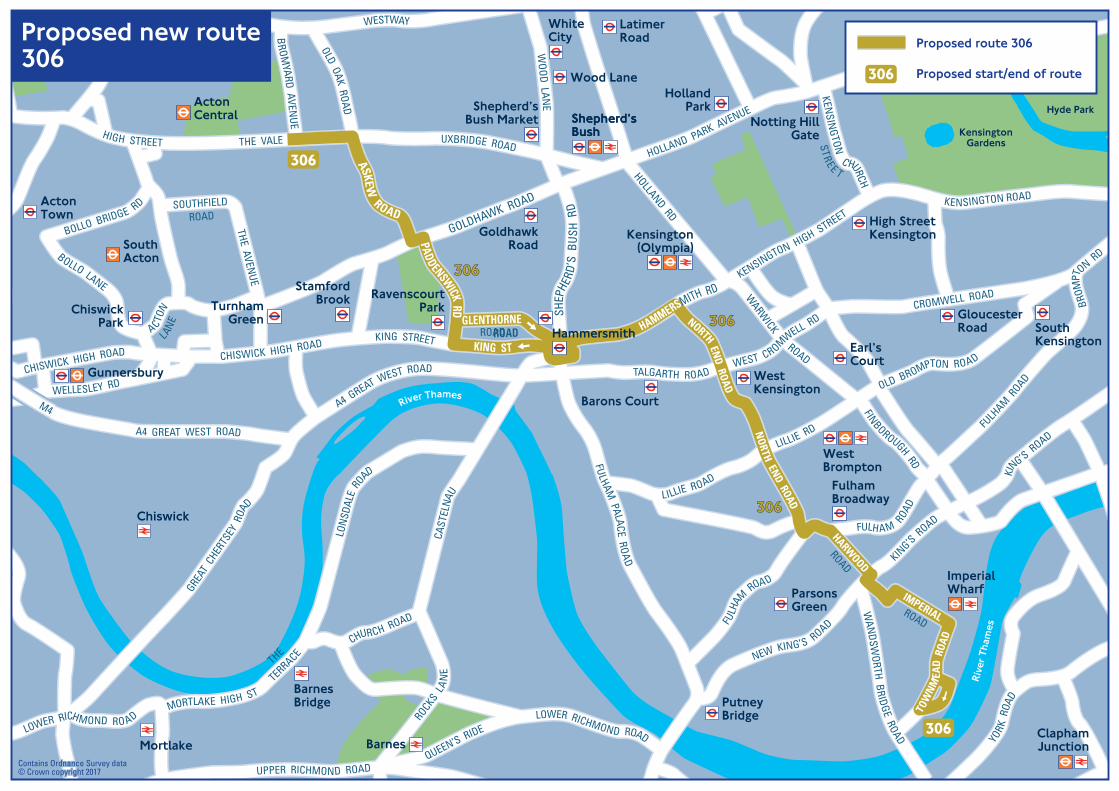
Main Line Line
Hammersmith
GoldhawkRoad
Barons Court
WestKensington
Earl’sCourt
High StreetKensington
HollandPark
Notting HillGate
GloucesterRoad South
Kensington
RavenscourtPark
StamfordBrookTurnham
GreenChiswick
Park
ActonTown
Gunnersbury
SouthActon
ActonCentral
Main Line
Kensington(Olympia)
WestBrompton
FulhamBroadway
ParsonsGreen
PutneyBridge
ClaphamJunction
ImperialWharf
River Thames
Rive
r Tha
mes
WhiteCity
LatimerRoad
Wood Lane
Shepherd’sBush Market Shepherd’s
BushShepherd’sBush
BarnesBridge
Chiswick
Mortlake Barnes
KensingtonGardens
Hyde Park
ACTON
LANE
YFORD
GLENTHORNEROADROAD
PADDENSWICK RD
ASKEW ROAD
THE VALEHIGH STREET
WELLESLEY RD
BOLLO LANE
BOLLO BRIDGE RD
WESTWAY
UXBRIDGE ROAD
GOLDHAWK ROAD
SHEP
HERD
’S B
USH
RD
HOLLAND RD
ROAD
HORN
LAN
KING ST
CHISWICK HIGH ROAD CHISWICK HIGH ROADKING STREET
HAMMERSMITH RD
NORTH END ROAD
OLD OAK ROAD
WOOD LAN
E
KENSINGTON ROAD
KENSINGTON HIGH STREET
A4 GREAT WEST ROAD
M4
FULHAM PALACE ROAD
ROCKS LA
NE
CAST
ELNA
U
SOUTHFIELDROAD
THE AVENUE
HARWOOD
ROAD
NORTH END ROAD
KING’S R
OAD
KING’S R
OAD
NEW KING’S ROAD
WAN
DSWORTH B
RIDGE ROAD
TOW
NMEA
D R
OAD
IMPERIALROAD
WARW
ICK ROAD
OLD BROMPTON ROAD
LILLIE RD
LILLIE ROAD
FULH
AM ROAD
FULHAM ROA
D
FINBOROUGH RD
GREAT
CHER
TSEY
ROA
D
A4 GREAT WEST ROAD TALGARTH ROADWEST CROMWELL RD
CROMWELL ROAD
BRO
MPT
ON RD
CHURCH ROAD
THE
TERRACE
MORTLAKE HIGH ST
LOWER RICHMOND RO AD
BROM
YARD AVENUE
HOLLAND PARK AVENUE
YORK
ROA
D
LON
SDAL
E ROAD
FULH
AM ROAD
KENSIN
GTON C HURCH
STREE T
UPPER RICHMOND ROAD
LOWER RICHMOND ROAD
QUEEN’S RIDE
Contains Ordnance Survey dataContains Ordnance Survey data© Crown copyright 2017© Crown copyright 2017Contains Ordnance Survey data© Crown copyright 2017
Proposed new route306
Proposed route 306
Proposed start/end of route 306
306306
306306
306306
306
306

OsterleyTesco
DraytonGreen
Castle Bar Park
SouthGreenford
Perivale
Hanger Lane
West Acton
EalingCommon
North Ealing
Park Royal
Alperton
BostonManor
Northfields
SouthEaling
GunnersburyPark
LammasPark
WalpolePark
EalingCommon
RoyalBotanicGardens
BostonManorPark
Syon Park
Brentford
Syon Lane
Kew BridgeGunnersbury
South Acton
Acton Town
EalingActon
Perivale
PitshangerPark
OsterleyPark
EalingEalingBroadwayBroadwayEalingBroadway
West EalingHanwell
MM44
WWEESSTTEERRNN AAVVEENNUUEE AA4400
UXBRIDGE ROAD
A4 GREAT W
EST ROAD
WWEESSTTEERRNN AAVVEENNUUEE AA4400
MM44M4
UXBRIDGE ROAD
UXBRIDGE ROAD
BOSTON MAN
OR RD
HIGH STREET
A4 GREAT W
EST ROAD
M4
BOSTON ROAD
WESTERN AVENUE A40
EALING ROAD
RUISLIP ROAD EAST
POPE’S LANE
EALING
LANELITTLE
NORTH
FIELD AVENUE
ARGYLE ROAD
ARGYLE ROAD
EALING ROAD
SOUTH EALING RO
AD
ST MAR
Y’S
RO
AD
EALING
HIGH
GREEN
ST
WINDM
ILL ROAD
CASTL EBARROAD
SCOTCH
COMMON
SYON L ANE
ALPERTON LANE
GREENFORD AVENUE
HORSEDEN LANESOUTH
WESTERN AVENUE A40
A406 NORTH CIRCULAR ROAD
A406 N
ORTH
CIRCULAR ROAD
M4CHISWICK HIGH RD
BRIDGEKEW
RD
LONDON ROAD
ABBEY ROA D
GUNNE RSBU
RY L
ANE
HIGH ST
UXBRIDGE ROAD
NORTH CIRCULAR
ROA
D
NORTH CIRCULAR
ROA
D
MADELEY ROAD
112
towards Stonebridge Park,Neasden and Brent Cross
112
112
112
112
112
112
Route 112 via Madeley Roadis subject to the outcomeof a separate consultation
Proposed route112
Contains Ordnance Survey data© Crown copyright 2017
Proposed route 112
Proposed start/end of route
Elizabeth line
112
112Only routes affected are shown

WestActon
NorthEaling
Park Royal
Alperton
GunnersburyPark
LammasPark
WalpolePark
EalingCommon
RoyalBotanicGardens
BostonManorPark
OsterleyPark
Syon Park
RavenorPark
SouthallPark
MinetCountry
Park
Ealing
Acton
Southall
PerivaleNortholt
Greenford
Hayes
PitshangerPark
DraytonGreen
Castle Bar Park
SouthGreenford
Perivale
Greenford
Hanger Lane
BostonManor
Osterley
Hounslow East
Northfields
SouthEaling
Brentford
Kew BridgeGunnersbury
Kew Gardens
Syon Lane
Isleworth
SouthActon
EalingCommon
ActonTown
ActonCentral
Harlesden
NorthActon
Riv
er Thames
ActonOld
Town Hall
Southall
HanwellWest Ealing
EalingBroadway
ActonMain Line
Hayes &Harlington
AA44 BBAATTHH RROOAADDAA44 GGRREEAATT WWEESSTT RROOAADD
CCHHUURRCCHH RROOAADD
NNOORRTTHH CC
IIRRCCUULLAARR RROOAADD
CCHHUR
CH
AA4400 WWEESSTTEERRNN AAVVEENNUUEE
AA4400
WWEESSTTEERRNN AAVVEENNUUEE
A406
NOR
TH
CIRCULA R
ROA
D
MM44
UUXXBBRRIIDDGGEE RROOAADD
AA44 GGRREEAATT WWEESSTT RROOAADD
TTHHEE PPAARRKKWWAAYY
AA4400
TTHHEE PP
AARRKKWW
AAYY
TTHHEE
PPAARR
KKWWAAYY
MM44MM44
MM44
THE BROADWAY UXBRIDGE ROADUXBRIDGE ROAD
BOSTON MANOR RD
HIGH STREET
A4 GREAT WEST ROAD
M4M4
M4
BOSTON ROADGR
EENF
ORD
ROA
D
GREE
NFO
RD R
OAD
A40 WESTERN AVENUE
A40
EALING RD
MERRICK RD
SOUT
H R
D
TEN
TELO
W L
ANE
RUISLIP ROAD EAST
RUISLI P ROAD
POPE’S LANE
NORTH
F IELD AVE
ARGYLE RO
AD
ARGYLE ROAD
SOUTH EALIN G RD
WINDMILL RD
CASTLEB AR
RD
SYON LANE
WINDM
IL L LANE
WESTERN RO AD
HAYES RD
NORTH HYDEROAD
THORNCLIFFE
ROAD
NOR
WOOD ROAD
LADY
MAR
GARE
T R
OAD
NORTH HYDE LA N
E
KEN
SING
TON
ROA
D
KINGS AVE
ALLE
NBY R
OAD
HAVELOCK ROAD
C ON VENT WAY
PUMPLANE
THE P
ARKW
AY
THE PARKWAY
THE
PAR
KWAY
RE
G INA
RD
RUISLIP ROAD
GREENFORD AVENUE
HORSEDEN LAN
ESOUTH
NORTH C
IRCULAR ROAD
A406 N
ORTH CIRCULAR ROAD
NORTH CIRCULAR ROAD
M4
LONDON ROAD
ABBEYR
O AD
PP
HIGH STREET
UXBRIDGE ROAD
A40
WESTERN AVENUE
HORN
LAN
EACT
ON LANE
HILLSID E
CH
PARK ROYAL RD
GUNNER
SBURY
LANE
ACTON
LANE
CHISWICK HIGH ROAD
CHURCH ROAD
A4 GREAT WEST ROAD
VICA
RAGE
FA
RM R
D
A4 BATH ROAD SPRING GROVE RD
HES
T
ON ROAD
BRIDGERD
112
towardsHillingdon andUxbridge
427
427
427
427
427
Contains Ordnance Survey data© Crown copyright 2017
Current route427
Current route 427
Current start/end of route427
427Only routes affected are shown

WestActon
NorthEaling
Park Royal
Alperton
GunnersburyPark
LammasPark
WalpolePark
EalingCommon
RoyalBotanicGardens
BostonManorPark
OsterleyPark
Syon Park
RavenorPark
SouthallPark
MinetCountry
Park
Ealing
Acton
Southall
PerivaleNortholt
Greenford
Hayes
PitshangerPark
DraytonGreen
Castle Bar Park
SouthGreenford
Perivale
Greenford
Hanger Lane
BostonManor
Osterley
Hounslow East
Northfields
SouthEaling
Brentford
Kew BridgeGunnersbury
Kew Gardens
Syon Lane
Isleworth
SouthActon
EalingCommon
ActonTown
ActonCentral
Harlesden
NorthActon
Riv
er Thames
Merrick Road
Southall
HanwellWest Ealing
EalingBroadway
ActonMain Line
Hayes &Harlington
AA44 BBAATTHH RROOAADDAA44 GGRREEAATT WWEESSTT RROOAADD
CCHHUURRCCHH RROOAADD
NNOORRTTHH CC
IIRRCCUULLAARR RROOAADD
CCHHUR
CH
AA4400 WWEESSTTEERRNN AAVVEENNUUEE
AA4400
WWEESSTTEERRNN AAVVEENNUUEE
A406
NOR
TH
CIRCULA R
ROA
D
MM44
UUXXBBRRIIDDGGEE RROOAADD
AA44 GGRREEAATT WWEESSTT RROOAADD
TTHHEE PPAARRKKWWAAYY
AA4400
TTHHEE PP
AARRKKWW
AAYY
TTHHEE
PPAARR
KKWWAAYY
MM44MM44
MM44
THE BROADWAY UXBRIDGE ROADUXBRIDGE ROAD
BOSTON MANOR RD
HIGH STREET
A4 GREAT WEST ROAD
M4M4
M4
BOSTON ROADGR
EENF
ORD
ROA
D
GREE
NFO
RD R
OAD
A40 WESTERN AVENUE
A40
EALING RD
MERRICK
ROAD
SOUT
H R
D
TEN
TELO
W L
ANE
RUISLIP ROAD EAST
RUISLI P ROAD
POPE’S LANE
NORTH
F IELD AVE
ARGYLE RO
AD
ARGYLE ROAD
SOUTH EALIN G RD
WINDMILL RD
CASTLEB AR
RD
SYON LANE
WINDM
IL L LANE
WESTERN RO AD
HAYES RD
NORTH HYDEROAD
THORNCLIFFE
ROAD
NOR
WOOD ROAD
LADY
MAR
GARE
T R
OAD
NORTH HYDE LA N
E
KEN
SING
TON
ROA
D
KINGS AVE
ALLE
NBY R
OAD
HAVELOCK ROAD
C ON VENT WAY
PUMPLANE
THE P
ARKW
AY
THE PARKWAY
THE
PAR
KWAY
RE
G INA
RD
RUISLIP ROAD
GREENFORD AVENUE
HORSEDEN LAN
ESOUTH
NORTH C
IRCULAR ROAD
A406 N
ORTH CIRCULAR ROAD
NORT
H CIRCULAR ROAD
M4
LONDON ROAD
ABBEYR
O AD
PP
HIGH STREET
UXBRIDGE ROAD
A40
WESTERN AVENUE
HORN
LAN
EACT
ON LANE
HILLSID E
CH
PARK ROYAL RD
GUNNER
SBURY
LANE
ACTON
LANE
CHISWICK HIGH ROAD
CHURCH ROAD
A4 GREAT WEST ROAD
VICA
RAGE
FA
RM R
D
A4 BATH ROAD SPRING GROVE RD
HES
T
ON ROAD
BRIDGERD
112
427
427
towardsHillingdon andUxbridge
427
Contains Ordnance Survey data© Crown copyright 2017
Current route 427
Current start/end of route
Proposed route427
Proposed route 427
Proposed start/end of route
Elizabeth line
427
427Only routes affected are shown
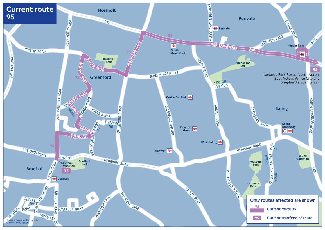
Southall
Hanwell
SouthallTown Hall
EalingBroadwayDrayton
Green
Castle Bar Park
SouthGreenford
Perivale
Hanger Lane
West Ealing
Boston
Northfields
SouthEaling
RavenorPark
SouthallPark
Ealing
Southall
Perivale
Northolt
Greenford
GunnersburyPark
LammasPark
WalpolePark
EalingCommon
PitshangerPark
AA440066
UUXXBBRRIIDDGGEE RROOAADD
ALLE
NBY R
OAD
WESTERN AVENUE A40
AA4400
TTHHEE
PPAARR
KK WWAAYY
M4
M4
THE BROADWAY HIGH ST UXBRIDGE ROAD
UXBRIDGE ROAD
M4
BOSTON ROADGR
EENF
ORD
ROA
D
GREE
NFO
RD R
OAD
WESTERN AVENUE A40
A40
EALING ROAD
A406
A406
MERRICK ROAD
SOUT
H R
OAD
T ENTE
LOW
LANE
RUISLIP ROAD EAST
RUISLI P ROAD
POPE’S LANE
EALING
LANELITTLE
NORTH
FIELD AVENUE
ARGYLE ROAD
ARGYLE ROAD
SOUTH EALING
ST MAR
Y’S
RO
AD
EALING
HIGH
GREEN
ST
CASTLEBAR R OAD
SCOTCH
COMMON
WINDM
ILL LANE
WESTE
RN ROAD
KIN
G ST
THE GR
EEN
NORW OOD RD
LADY
MAR
GARE
T R
OAD
KEN
SIN
GTON
RO
AD
ALLENB
Y ROAD
SOMERSET ROAD
BURNS AVE
KINGS AVENUE
FLEMINGRD
TELFO
RDRD
ALLE
NBY R
OAD
HAVELOCK ROAD
DUDLEYRD
THE
PAR
KWAY
NORTH CIRCULAR ROA
D
RUISLIP ROAD
CORNWALL
AVENUE
DORMER’S WELLS
LANE
ALPERTON LANE
GREENFORD AVENUE
HORSEDEN
LANE SOU
TH
95
95
9595
95
towards Park Royal, North Acton,East Acton, White City and
Shepherd’s Bush Green
95
95
Current route95
Contains Ordnance Survey data© Crown copyright 2017
Current route 95
Current start/end of route95
95Only routes affected are shown

Southall
SouthallTown Hall
EalingBroadway
Castle Bar Park
SouthGreenford
Hanger Lane
West Ealing
Boston
Northfields
SouthEaling
RavenorPark
SouthallPark
Ealing
Perivale
Northolt
Greenford
SouthallWaterside
Hanwell
DraytonGreen
Perivale
GunnersburyPark
LammasPark
WalpolePark
EalingCommon
PitshangerPark
UUXXBBRRIIDDGGEE RROOAADD
WESTERN AVENUE A40
M4
M4
THE BROADWAY HIGH ST UXBRIDGE ROAD
UXBRIDGE ROAD
M4
BOSTON ROADGR
EENF
ORD
ROA
D
GREE
NFO
RD R
OAD
WESTERN AVENUE A40
EALING ROAD
A406
MERRICK ROAD
SOUT
H R
OAD
TENTE
LOW
LANE
RUISLIP ROAD EAST
RUISLI P ROAD
POPE’S LANE
EALING
LANELITTLE
NORTH
FIELD AVENUE
ARGYLE ROAD
ARGYLE ROAD
SOUTH EALING
ST MAR
Y’S
RO
AD
EALING
HIGH
GREEN
ST
CASTLEBAR R OAD
SCOTCH
COMMON
WINDM
ILL LANE
WESTE
RN ROAD
KIN
G ST
THE GR
EEN
NORW OOD RD
LAD
Y M
ARG
ARET
ROA
D
KEN
SIN
GTON
RO
AD
ALLENB
Y ROAD
SOMERSET ROAD
BURNS AVE
KINGS AVENUE
FLEMINGRD
ROADDENBIGH
TELFO
RDRD
ALLE
NBY R
OAD
HAVELOCK ROAD
DUDLEYRD
NORTH CIRCULAR ROA
D
RUISLIP ROAD
CORNWALL
AVE
DORMER’S WELLS
LANE
ALPERTON LANE
AA4400
TTHHEE
PPAARR
KK WWAAYY
A40
THE
PAR
KWAY
GREENFORD AVENUE
HORSEDEN
LANE SOU
TH
AA440066
A406
95
95
9595
95
95
95
towards Park Royal, North Acton,East Acton, White City and
Shepherd’s Bush Green
Proposed route95
Contains Ordnance Survey data© Crown copyright 2017
Proposed route 95
Proposed start/end of route
Elizabeth line
95
95Only routes affected are shown

DraytonGreen
Castle Bar Park
SouthGreenford
Perivale
BostonManor
Northfields
SouthEaling
LammasPark
WalpolePark
RavenorPark
SouthallPark
Ealing
Southall
Perivale
Greenford
PitshangerPark
PerivaleTesco
MedwayParade
Toplocks Estate/Glade Lane
Southall
Hanwell
EalingBroadway
West Ealing
HAVELOCK ROAD
NORWOO
D ROAD
WESTERN AVENUE A40
M4
WESTERN AVENUE A40
UUXXBBRRIIDDGGEE RROOAADD
THE PARKW
AY
AA4400
TTHHEE
PPAARR
KKWWAAYY
THE
PAR
KWAY
MM44
M4
M4
THE BROADWAY HIGH ST UXBRIDGE ROADUXBRIDGE ROAD
UXBRIDGE ROAD
M4
BOSTON ROAD
GREE
NFOR
D R
OAD
GREE
NFO
RD R
OAD
GREENFORD ROAD
WESTERN AVENUE A40
A40
EALING ROAD
MERRICK RO
AD
SOUT
H R
OAD
TENTE
LOW
LANE
RUISLIP ROAD EAST
RUISLI P ROAD
PO
EALING
LANELITTLE
NORTHFIELD
AVENUE
ARGYLE ROAD
ARGYLE ROAD
SOUTH
ST MAR
Y’S
RO
AD
EALING
HIGH
GREEN
ST
CASTLEBAR R OAD
SCOTCH
COMMON
WINDM
ILL LANE
WESTERN RO AD
RD
LIF
KING ST
T HE GR
EEN
NORWOO
D ROAD
LADY
MAR
GARE
T R
OAD
KEN
SIN
GTON
RO
AD
ALLENB
Y ROAD
SOMERSET ROAD
BURNS AVE
KINGS AVENUE
FLEMINGRD
TELFO
RDRD
ALLE
NBY R
OAD
HAVELOCK ROAD
DUDLEYRD
C
THE
PAR
KWAY
R EGINA
RO
AD
RUISLIP ROAD
CORNWALL
AVE
DORMER’S WELLS LA
NE
ALPERTON LANE
GREENFORD AVENUE
HORSEDEN LANESOUTH
ROADDENBIGH
E5
E5
E5
E5
E5
E5
E5
E5
Contains Ordnance Survey data© Crown copyright 2017
Current routeE5
Current route E5
Current start/end of routeE5
E5Only routes affected are shown
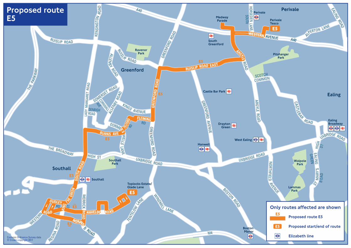
DraytonGreen
Castle Bar Park
SouthGreenford
Perivale
BostonManor
NorthfieldsSouthEaling
LammasPark
WalpolePark
RavenorPark
SouthallPark
Ealing
Southall
Perivale
Greenford
PitshangerPark
PerivaleTesco
MedwayParade
Toplocks Estate/Glade Lane
Southall
EalingBroadway
West EalingHanwell
HAVELOCK ROAD
NORWOO
D ROAD
WESTERN AVENUE A40
M4
WESTERN AVENUE A40
UUXXBBRRIIDDGGEE RROOAADD
THEPA
RKWAY
AA4400
TTHHEE
PPAARR
KKWWAAYY
THE
PARK
WAY
MM44
M4
M4
THE BROADWAY HIGH ST UXBRIDGE ROADUXBRIDGE ROAD
UXBRIDGE ROAD
M4
BOSTON ROAD
GREE
NFOR
D R
OAD
GREE
NFO
RD R
OAD
GREENFORD ROAD
WESTERN AVENUE A40
A40
EALING ROAD
MERRICK RO
AD
SOUT
H R
OAD
TENTE
LOW
LANE
RUISLIP ROAD EAST
RUISLI P ROAD
POPE’S LANE
EALING
LANELITTLE
NORTHFIELD
AVENUE
ARGYLE ROAD
ARGYLE ROAD
SOUTH EALING RO
AD
ST MAR
Y’S
RO
AD
EALING
HIGH
GREEN
ST
CASTLEBAR R OAD
SCOTCH
COMMON
WINDM
ILL LANE
WESTERN
RO AD
RD
LIF
KING ST
T HE GR
EEN
NORWOO
D ROAD
LADY
MAR
GARE
T R
OAD
KEN
SIN
GTON
RO
AD
ALLENB
Y ROAD
SOMERSET ROAD
BURNS AVE
KINGS AVENUE
FLEMINGRD
TELFO
RDRD
ALLE
NBY R
OAD
HAVELOCK ROAD
DUDLEYRD
C
THE
PAR
KWAY
R EGINA
RO
AD
RUISLIP ROAD
CORNWALL
AVE
DORMER’S WELLS
LANE
ALPERTON LANE
GREENFORD AVENUE
HORSEDEN LANESOUTH
ROADDENBIGH
E5
E5
E5
E5
E5
E5
E5
E5
Contains Ordnance Survey data© Crown copyright 2017
Current route 427
Current start/end of route
Proposed routeE5
Proposed route E5
Proposed start/end of route
Elizabeth line
E5
E5Only routes affected are shown
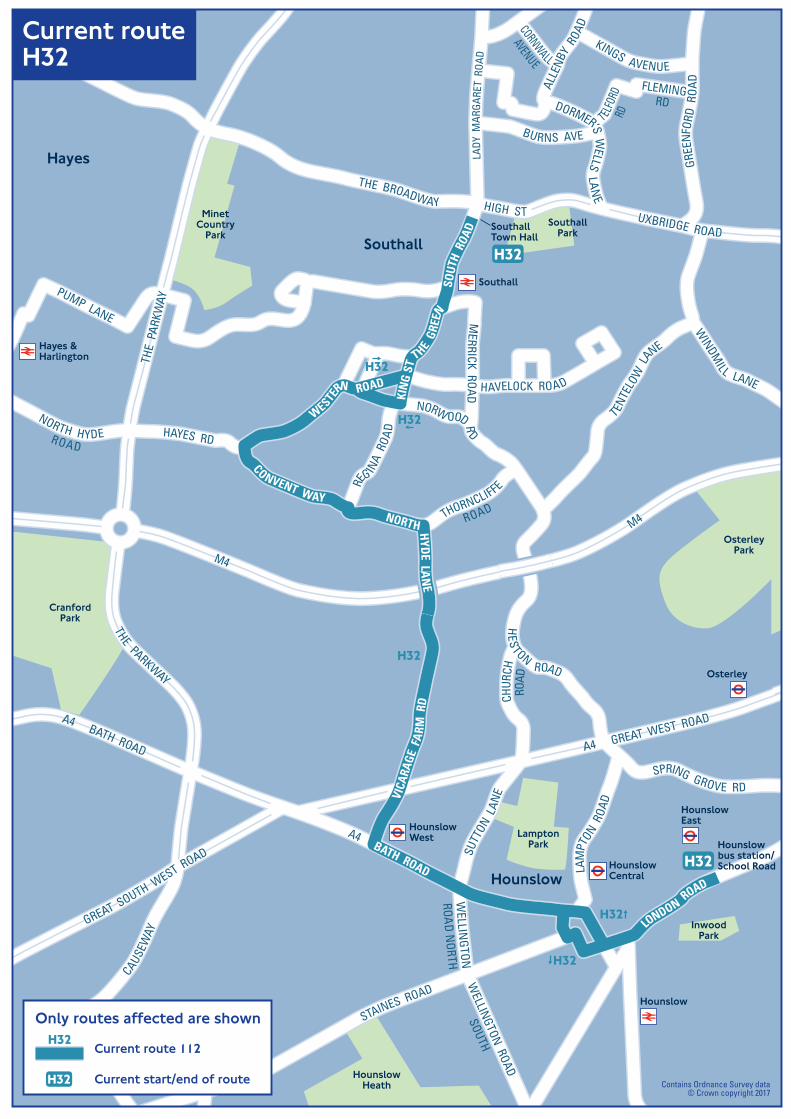
SouthallPark
LamptonPark
HounslowHeath
Southall
OsterleyPark
MinetCountry
Park
Osterley
HounslowEast
HounslowCentral
HounslowWest
InwoodPark
CranfordPark
Hounslowbus station/School Road
SouthallTown Hall
Hounslow
Hayes
Hounslow
Southall
Hayes &Harlington
GGRREEAATT SSOOUUTTHH WWEESSTT RROOAADD
UUXXBBRRIIDDGGEE RROOAADD
A4 GREAT W
EST ROAD
THE
PAR
KWAY
MM44
MM44
THE BROADWAY HIGH ST UXBRIDGE ROAD
M4
M4
GREE
NFO
RD R
OAD
MERRICK ROAD
SOUT
H R
OAD
TENTE
LOW
LANE
WINDM
ILL LANE
WESTE
RN ROAD
HAYES RD
NORTH HYDEROAD
THORNCLIFFE
ROAD
KIN
G ST
THE G
REEN
NORW OOD RD
LADY
MAR
GARE
T R
OAD
NORTH HYDE LAN
E
SO
BURNS AVE
KINGS AVENUE
FLEMINGRD
TELFO
RDRD
ALLE
NBY
ROAD
HAVELOCK ROAD
CONVENT WAY
PUMP LANE
RE
G INA
ROA
D
CORNWALL
AVENUE
DORMER’S WELLS LAN
E
AA44 BBAATTHH RROOAADD AA44 GGRREEAATT WWEESSTT RROOAADD
TTHHEE PPAARRKKWWAAYY
TTHHEE
PPAARR
KKWWAAYY
THE PARKWAY
THE
PAR
KWAY
A4 GREAT WEST ROAD
VICA
RAGE
FA
RM R
D
A4 BATH ROAD
SPRING GROVE RD
HES
TON ROAD
GREAT SOUTH WEST ROAD
WELLINGTON ROAD
SOUTH
WELLIN
GTONROA
D NORTH
SUTT
ON L
ANE
CHUR
CHRO
AD
LAM
PTON R
OAD
A4 BATH ROAD
FAGG’S ROAD
CAUSEW
AY
LONDON R
OAD
STAINES ROAD
H32
H32
H32
H32
H32
H32
H32
Current routeH32
Contains Ordnance Survey data© Crown copyright 2017
Current route 112
Current start/end of routeH32
H32Only routes affected are shown
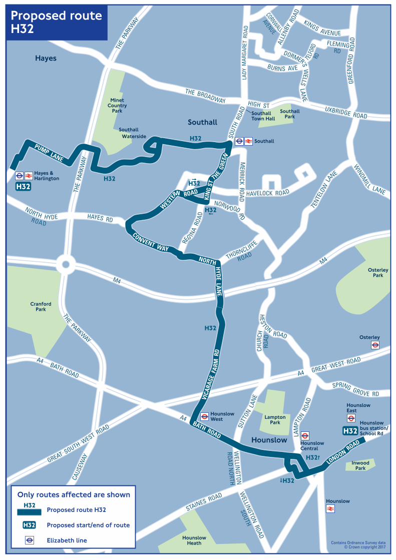
SouthallPark
LamptonPark
HounslowHeath
Southall
OsterleyPark
MinetCountry
Park
Osterley
InwoodPark
CranfordPark
SouthallTown Hall
Hounslow
Hayes
SouthallWaterside
HounslowEast
HounslowCentral
HounslowWest
Hounslowbus station/School Rd
Hounslow
Southall
Hayes &Harlington
GGRREEAATT SSOOUUTTHH WWEESSTT RROOAADD
UUXXBBRRIIDDGGEE RROOAADD
A4GREAT WEST ROAD
TTHHEE
PPAARR
KKWWAAYY
MM44
MM44
THE BROADWAY HIGH ST UXBRIDGE ROAD
M4
M4
GREE
NFO
RD R
OAD
MERRICK ROAD
SOUT
H R
OAD
T ENTE
LOW
LANE
WINDM
ILL LANE
WESTE
RN ROAD
HAYES RD
NORTH HYDEROAD
THORNCLIFFEROAD
KIN
G ST
THE G
REEN
NORW OOD RD
LADY
MAR
GARE
T R
OAD
NORTH HYDE LAN
E
SO
BURNS AVE
KINGS AVENUE
FLEMINGRD
TELFO
RDRD
ALLE
NBY
ROAD
HAVELOCK ROAD
CONVENT WAY
PUMP LANE
THE
PAR
KWAY
RE
G INA
ROA
D
CORNWALL
AVENUE
DORMER’S WELLS
LANE
AA44 BBAATTHH RROOAADD AA44 GGRREEAATT WWEESSTT RROOAADD
TTHHEE PPAARRKKWWAAYY
TTHHEE
PPAARR
KKWWAAYY
THE PARKWAY
THE
PAR
KWAY
A4 GREAT WEST ROAD
VICA
RAGE
FA
RM R
D
A4 BATH ROAD
SPRING GROVE RD
HES
TON ROAD
GREAT SOUTH WEST ROAD
WELLINGTON ROAD
SOUTH
WELLIN
GTONROA
D NORTH
SUTT
ON L
ANE
CHUR
CHRO
AD
LAM
PTON R
OAD
A4 BATH ROAD
FAGG’S ROAD
CAUS
EWAY
STAINES ROAD
LONDON R
OAD
H32
H32
H32
H32
H32
H32
H32
H32
H32
Contains Ordnance Survey data© Crown copyright 2017
Proposed routeH32
Proposed route H32
Proposed start/end of route
Elizabeth line
H32
H32Only routes affected are shown
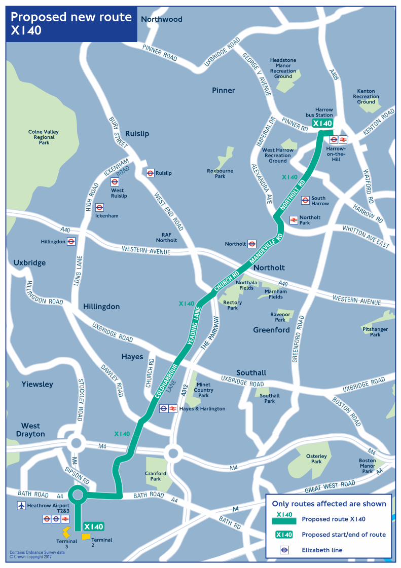
Harrowbus Station
Heathrow AirportT2&3
Hayes & Harlington
Ruislip
Northolt
WestRuislip
Ickenham
SouthHarrow
Harrow-on-the-
Hill
NortholtPark
Hillingdon
Greenford
Uxbridge
WestDrayton
Yiewsley
Ruislip
Pinner
Northolt
Southall
Terminal3
Terminal2
Colne Valley Regional
Park
RoxbournePark
West HarrowRecreation
Ground
HeadstoneManor
RecreationGround
KentonRecreation
Ground
RavenorPark
RectoryPark
NorthalaFields
MarnhamFields
PitshangerPark
OsterleyPark
MinetCountry
Park SouthallPark
CranfordPark
Hayes
Hillingdon
RAFNortholt
BostonManorPark
Northwood
AA4400
MM44
MM44
MM44
WWEESSTTEERRNN AAVVEENNUUEE
AA4400
M4
M4
M4
M4
M4
WWEESSTTEERRNN AAVVEENNUUEEWESTERN AVENUE
A40
WESTERN AVENUE
A40
BATH RD
BATH ROAD A4
A4A4
GREAT WEST ROADGREAT WEST ROAD
A4A4
A315
KENTON ROAD
WHITTON AVE EAST
ALEXANDRA AVE
IMPE
RIAL
DR
BOSTON ROAD
HILL INGDON ROAD
UXBRIDGE ROAD
UXBRIDGE ROADSTOCKLEY ROAD
DAWLEY ROA
D
MANDEV
ILLE R
D
CHURCH RD
THE
PARK
WAY
THE
PARK
WAY
A312
A312CH
URCH
RD GR
EEN
FORD
ROA
D
NORTHOLT
RD
PINNER RD
GEORGE V AVENUE
HARROW RD
WATFO
RD RD
UXBRIDGE ROAD
PINNER ROAD
WEST END ROAD
BURY STR EET
LON
G L
ANE
YEA
DIN
G L
ANE
SIPSON RD
A409
COLD
HARB
OUR
LANE
BATH ROAD A4
ICKENHAM
ROAD
HIGH
ROA
D
UXBRIDGE ROAD
X140
X140
X140
X140
X140
Contains Ordnance Survey data© Crown copyright 2017
Proposed route X140
Proposed start/end of route
Elizabeth line
X140
X140Only routes affected are shown
Proposed new routeX140
X140_proposed.ai 1 29/06/2017 10:08X140_proposed.ai 1 29/06/2017 10:08
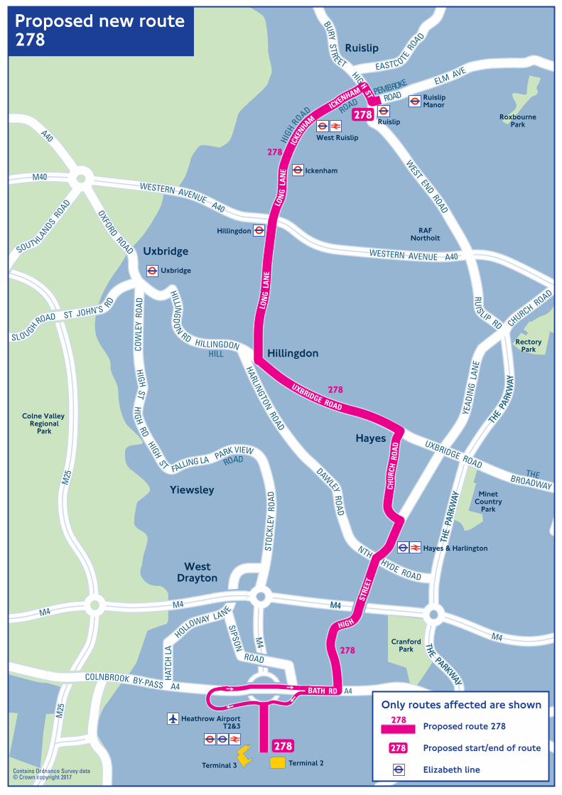
Heathrow AirportT2&3
Ruislip
RuislipManor
West Ruislip
Ickenham
Hillingdon
Uxbridge
Hayes & Harlington
Hillingdon
Hayes
Yiewsley
WestDrayton
Uxbridge
Ruislip
MinetCountry
Park
RectoryPark
RAFNortholt
RoxbournePark
Colne Valley Regional
Park
CranfordPark
Terminal 3 Terminal 2
MM44
MM44
MM2255
MM2255
MM44
MM4400
MM44
WWEESSTTEERRNN AAVVEENNUUEE AA4400
WWEESSTTEERRNN AAVVEENNUUEE AA4400
M4M4M4
M25
M25
M4
BATH ROAD
BATH RD A4
A4
BURY STREET
YEAD
ING
LAN
E
COLNBROOK BY-PASS A4
M4
M4THE PARKWAY
THE PARKWAY
ST JOHN’S RD
SLOUGH ROAD
STOC
KLEY
RO
AD
PARK VIEWROAD
FALLING LA
HIGH ST
HIG
H RDHIGH ST
COW
LEY
ROA
D
HARLINGTON ROAD
DAW
LEY ROA
D
NTH HYDE ROAD
CHURCH ROAD
THE
PARK
WAY
THE
PARK
WAY
THE
PAR
KWAY
THE
PAR
KWAY
RUIS LIP RD
WEST END ROAD
CHUR
CH R
OAD
HIGH
STRE
ET
ELM AVE
A40
OXFORD ROAD
HILLING
DO
N RD HILLINGDONHILL
UXBRIDGE ROAD
UXBRIDGE ROAD
BROADWAY
THE
SOUT HLANDS R
OAD
WESTERN AVENUE A40
WESTERN AVENUE A40
M40
ROADPEMBROKE
ICKENHAM
ROAD
ICKE
NHAM
HIGH
ROAD
LON
G L
ANE
LON
G L
AN
E
HIGH ST
HOLLOWAY LANE
HATC
H LA
SIPSON ROAD
EASTCOTE R
OA
D
278
278
278
278
278
Contains Ordnance Survey data© Crown copyright 2017
Proposed new route278
Proposed route 278
Proposed start/end of route
Elizabeth line
278
278Only routes affected are shown
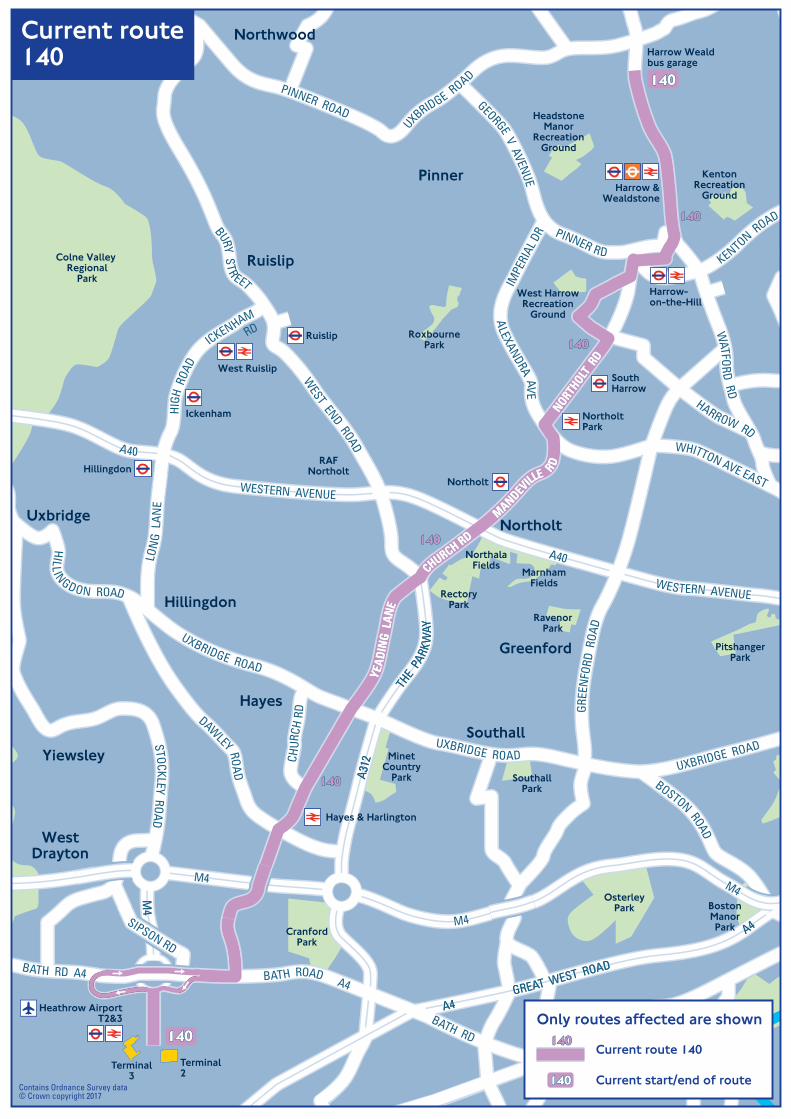
Greenford
Uxbridge
WestDrayton
Yiewsley
Ruislip
Northwood
Pinner
Northolt
Southall
Colne Valley Regional
Park
RoxbournePark
West HarrowRecreation
Ground
HeadstoneManor
RecreationGround
KentonRecreation
Ground
RavenorPark
RectoryPark
NorthalaFields
MarnhamFields
PitshangerPark
OsterleyPark
MinetCountry
Park SouthallPark
CranfordPark
Hayes
Hillingdon
RAFNortholt
BostonManorPark
Heathrow AirportT2&3
Terminal3
Terminal2
Harrow Wealdbus garage
Ruislip
Northolt
West Ruislip
Ickenham
SouthHarrow
Harrow-on-the-Hill
Harrow &Wealdstone
NortholtPark
Hillingdon
Hayes & Harlington
AA4400
MM44
MM44
MM44
WWEESSTTEERRNN AAVVEENNUUEE
AA4400
M4
M4
M4
M4
M4
WWEESSTTEERRNN AAVVEENNUUEEWESTERN AVENUE
A40
WESTERN AVENUE
A40
BATH RD
BATH ROAD A4
A4A4
GREAT WEST ROAD
GREAT WEST ROAD
A4A4
A315
KENTON ROAD
WHITTON AVE EAST
ALEXANDRA AVE
IMPE
RIAL
DR
BOSTON ROAD
HILL INGDON ROAD
UXBRIDGE ROAD
UXBRIDGE ROADSTOCKLEY ROAD
DAWLEY ROA
D
MANDEV
ILLE R
D
MANDEV
ILLE R
D
CHURCH RD
CHURCH RD
THE
PARK
WAY
THE
PARK
WAY
A312
A312CH
URCH
RD GR
EEN
FORD
ROA
D
NORTHOLT
RD
NORTHOLT
RD
PINNER RD
GEORGE V AVENUE
HARROW RD
WATFO
RD RD
UXBRIDGE ROAD
PINNER ROAD
WEST END ROAD
BURY STR EET
LON
G L
ANE
YEA
DIN
G L
ANE
YEA
DIN
G L
ANE
SIPSON RD
ICKENHAMRD
HIGH
ROA
D
UXBRIDGE ROAD
BATH RD A4
140140140
140140140
140140140
140140140
140140140
140140140
Current route140
Contains Ordnance Survey data© Crown copyright 2017
Current route 140
Current start/end of route140140140
140140140Only routes affected are shown
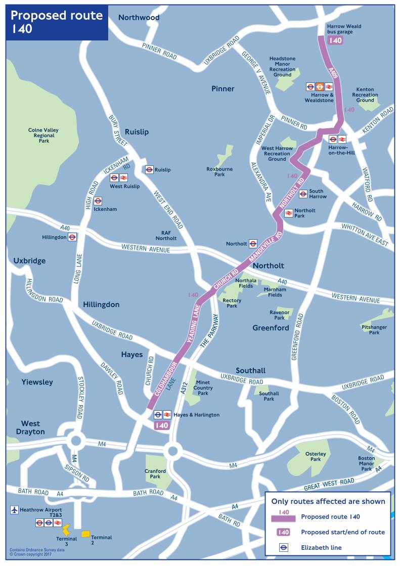
Harrow Wealdbus garage
Hayes & Harlington
Ruislip
Northolt
West Ruislip
Ickenham
SouthHarrow
Harrow-on-the-Hill
Harrow &Wealdstone
NortholtPark
Hillingdon
Greenford
Uxbridge
WestDrayton
Yiewsley
Ruislip
Northwood
Pinner
Northolt
Southall
Terminal3
Terminal2
Colne Valley Regional
Park
RoxbournePark
West HarrowRecreation
Ground
HeadstoneManor
RecreationGround
KentonRecreation
Ground
RavenorPark
RectoryPark
NorthalaFields
MarnhamFields
PitshangerPark
OsterleyPark
MinetCountry
Park SouthallPark
CranfordPark
Hayes
Hillingdon
RAFNortholt
BostonManorPark
Heathrow AirportT2&3
AA4400
MM44
MM44
MM44
WWEESSTTEERRNN AAVVEENNUUEE
AA4400
M4
M4
M4
M4
M4
WWEESSTTEERRNN AAVVEENNUUEEWESTERN AVENUE
A40
WESTERN AVENUE
A40
BATH RD
BATH ROAD A4
A4A4
GREAT WEST ROADGREAT WEST ROAD
A4A4
A315
KENTON ROAD
WHITTON AVE EAST
ALEXANDRA AVE
IMPE
RIAL
DR
BOSTON ROAD
HILL INGDON ROAD
UXBRIDGE ROAD
UXBRIDGE ROADSTOCKLEY ROAD
DAWLEY ROA
D
MANDEV
ILLE R
D
CHURCH RD
THE
PARK
WAY
THE
PARK
WAY
A312
A312CH
URCH
RD GR
EEN
FORD
ROA
D
NORTHOLT
RD
PINNER RD
GEORGE V AVENUE
HARROW RD
WATFO
RD RD
UXBRIDGE ROAD
PINNER ROAD
WEST END ROAD
BURY STR EET
LON
G L
ANE
YEA
DIN
G L
ANE
SIPSON RD
A409
COLD
HARB
OUR
LANE
BATH ROAD A4
ICKENHAMRD
HIGH
ROA
D
UXBRIDGE ROAD
140
140
140
140
140
Proposed route140
Contains Ordnance Survey data© Crown copyright 2017
Proposed route 140
Proposed start/end of route
Elizabeth line
140
140Only routes affected are shown

Heathrow AirportT2&3
Hayes & Harlington
Greenford
Uxbridge
WestDrayton
Yiewsley
Ruislip
Northwood
Pinner
Northolt
Southall
Terminal3
Terminal2
Colne Valley Regional
Park
RoxbournePark
West HarrowRecreation
Ground
HeadstoneManor
RecreationGround
KentonRecreation
Ground
RavenorPark
RectoryPark
NorthalaFields
MarnhamFields
PitshangerPark
OsterleyPark
MinetCountry
Park SouthallPark
CranfordPark
Hayes
Hillingdon
RAFNortholt
BostonManorPark
Harrow Wealdbus garage
Ruislip
Northolt
West Ruislip
Ickenham
SouthHarrow
Harrow-on-the-Hill
Harrow &Wealdstone
NortholtPark
Hillingdon
AA4400
MM44
MM44
MM44
WWEESSTTEERRNN AAVVEENNUUEE
AA4400
M4
M4
M4
M4
M4
WWEESSTTEERRNN AAVVEENNUUEEWESTERN AVENUE
A40
WESTERN AVENUE
A40
BATH RD
BATH ROAD A4
A4A4
GREAT WEST ROADGREAT WEST ROAD
A4A4
A315
KENTON ROAD
WHITTON AVE EAST
ALEXANDRA AVE
IMPE
RIAL
DR
BOSTON ROAD
HILL INGDON ROAD
UXBRIDGE ROAD
UXBRIDGE ROADSTOCKLEY ROAD
DAWLEY ROA
D
MANDEV
ILLE RD
CHURCH RD
THE
PARK
WAY
THE
PARK
WAY
A312
A312CH
URCH
RD GR
EEN
FORD
ROA
D
NORTHOLT
RD
PINNER RD
GEORGE V AVENUE
HARROW RD
WATFO
RD RD
UXBRIDGE ROAD
PINNER ROAD
WEST END ROAD
BURY STR EET
LON
G L
ANE
YEA
DIN
G L
ANE
SIPSON RD
A409
COLD
HARB
OUR
LANE
BATH RD A4
ICKENHAMRD
HIGH
ROA
D
UXBRIDGE ROAD
N140
N140
N140
N140
N140
N140
Route N140
Contains Ordnance Survey data© Crown copyright 2017
Route N140
Start/end of route
Elizabeth line
N140
N140Only routes affected are shown
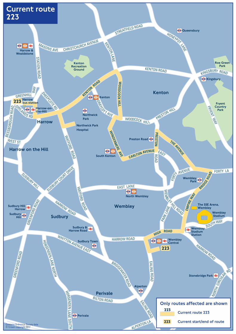
Harrowbus station
Northwick ParkHospital
NorthwickPark
Preston Road
Kingsbury
Queensbury
WembleyPark
WembleyCentral
Harrow &Wealdstone
North Wembley
South Kenton
Kenton
Stonebridge Park
Alperton
Perivale
Sudbury Town
SudburyHill
Sudbury HillHarrow
Sudbury &Harrow Road
WembleyStadiumStation
Harrow-on-the-Hill
FryentCountry
Park
Roe GreenPark
KentonRecreation
Ground
Kenton
Wembley
Harrow
Harrow on the Hill
Sudbury
Perivale
WembleyStadium
The SSE Arena,Wembley
EDGWARE
ROAD
A5
WWEESSTTEERRNN AAVENUE
A40
WESTERN A
NORT
H C
IRCU
LA
R RD
NORT
H C
IRCU
LA
R RD
FRYENT WAY
HONEYPOT LANE
KINGSBURY ROAD
KENTON ROAD
WHITTON AVENUE EAST
EALING ROAD
FORTY LA
EAST LANE
HARROW ROAD
WATFORD ROAD
WATFORD ROAD
THE AVENUE
WO
OD
COCK H
ILL
WIN
DERMERE AVE
CARLTON AVENUE
PRESTON
BRIDGE
ROA
D
EMPI
RE W
AY
HIGH ROAD
KENTON ROAD
LOWLANDS RD
BRIDGEWATER RO
AD
EALING ROAD
FORT
Y AVENUE
PARK
LAN
E
SUDBURY COURT DRIVE
GREE
NFO
RD R
OAD
GREE
NFO
RD R
OAD
SUDBURY HILL
BESS
BORO
UGH
ROAD
GREENHILL WAY
SHEEPCOTE RD
STATION ROAD
EAST
WEM
BLEY HILL ROAD
ROAD
HARROW ROAD
HARROW ROAD
SOUTHWAY
STREATFIELD ROAD
CHRISTCHURCH AVENUEMASONS AVE
HORSENDEN
LAN
E SOUTH
HO
R SENDEN LAN
E NORTH
BILTON ROAD
ALPERTON LA
WEST ST
KENTON LANE
40
223
223
Current route223
Contains Ordnance Survey data© Crown copyright 2017
Current route 223
Current start/end of route223
223Only routes affected are shown
VET A
TOAYC
DR
WOODCOCK HIL LPRESTON HILL

Harrowbus station
Northwick ParkHospital
NorthwickPark
Preston Road
Kingsbury
Queensbury
WembleyPark
WembleyCentral
Harrow &Wealdstone
North Wembley
South Kenton
Kenton
Stonebridge Park
Alperton
Perivale
Sudbury Town
SudburyHill
Sudbury HillHarrow
Sudbury &Harrow Road
WembleyStadiumStation
Harrow-on-the-Hill
FryentCountry
Park
Roe GreenPark
KentonRecreation
Ground
Kenton
Wembley
Harrow
Harrow on the Hill
Sudbury
Perivale
WembleyStadium
The SSE Arena,Wembley
EDGWARE
ROAD
A5
WWEESSTTEERRNN AAVENUE
A40
WESTERN A
NORTH
CIR
CULA
R RD
NORTH
CIR
CULA
R RD
FRYENT WAY
HONEYPOT LANE
KINGSBURY ROAD
KENTON ROAD
WHITTON AVENUE EAST
EALING ROAD
FORTY LA
EAST LANE
HARROW ROAD
WATFORD ROAD
WATFORD ROAD
THE AVENUE
WO
OD
COCK H
ILL
WIN
DERMERE AVE
CARLTON AVENUE
PRESTON
BRIDGE
ROA
D
EMPI
RE W
AY
HIGH ROAD
KENTON ROAD
LOWLANDS RD
BRIDGEWATER RO
AD
EALING ROAD
FORT
Y AVENUE
PARK
LAN
E
SUDBURY COURT DRIVE
GREE
NFO
RD R
OAD
GREE
NFO
RD R
OAD
SUDBURY HILL
BESS
BORO
UGH
ROAD
GREENHILL WAY
SHEEPCOTE RD
STATION ROAD
EAST
WEM
BLEY HILL ROAD
ROAD
HARROW ROAD
HARROW ROAD
SOUTHWAY
KENTON LANE
STREATFIELD ROAD
CHRISTCHURCH AVENUEMASONS AVE
HORSENDEN
LAN
E SOUTH
HO
R SENDEN LAN
E NORTH
BILTON ROAD
ALPERTON LA
WEST STDRAYCO
TT AVEPRESTON HILL
WOODCOCK HILL
40
223
223
Proposed route223
Contains Ordnance Survey data© Crown copyright 2017
Proposed route 223
Proposed start/end of route223
223Only routes affected are shown