changes in patterns of marine-resource
TRANSCRIPT


CHANGES IN PATTERNS OF MARINE-RESOURCE
(SHELLFISH) EXPLOITATION DURING THE
EARLIEST PERIOD OF HUMAN OCCUPATION
(1200/1100 BC TO 700/600 BC) OF BOUREWA (LAPITA)
SETTLEMENT, SOUTHWEST VITI LEVU ISLAND, FIJI.
by
Tony Ahikau Heorake
A thesis submitted in fulfillment of the
requirement for the degree of Master of Science in Environmental Science
Copyright © 2009 by Tony Ahikau Heorake
Division of Geography
School of Islands and Oceans
Faculty of Science, Technology and Environment
The University of the South Pacific
December, 2009
id2173203 pdfMachine by Broadgun Software - a great PDF writer! - a great PDF creator! - http://www.pdfmachine.com http://www.broadgun.com


Dedication
This thesis is dedicated in honour and memory of Diana Su�uliseuha�akenitaoha-
Heorake for her inspiration.
Acknowledgements
I am indebted to the following people and organisations for their assistance, guidance
and advice during various stages of preparing this thesis. Tagio tumas lo iufala
everiwan.
My supervisor, Professor Patrick Nunn (The University of the South Pacific)
for introducing me to the Lapita phenomena. I sincerely thank Paddy for his
enthusiasm, support, critical comments, and guidance throughout the
fieldwork and writing of this thesis. Also for providing me with relevant
literature and maps and diagrams.
Field research work for this thesis was conducted as part of a major fieldwork
conducted by Professor Patrick Nunn, Roselyn Kumar and Sepeti Matararaba
in mid-2005 with funds from the University of the South Pacific and the
Government of France.
For field support I am indebted for the companionship and assistance of fellow
USP students who participated during Phase 3 of Research work at the
Bourewa settlement and especially Roselyn Kumar, Sepeti Matararaba and
Patrick Nunn who helped direct the mid-2005 fieldwork at Bourewa.
I wish to particularly thank the Turanga na Tui Gusuituva and the family of
the late Tai Dido for hospitality, companionship and friendship. The people of
Vusama Village also provided full support, friendship, accommodation and
hospitality throughout the fieldwork. Vinaka Vakalevu.

The University of the South Pacific Research Committee for providing funds
for the various stages of this thesis, particularly for enabling the preparation of
shells for quantification and analysis and radiocarbon age determination of
four (4) marine shell samples at the University of Waikato Radiocarbon
Dating Laboratory, New Zealand.
Dr Alan Hogg of the University of Waikato Radiocarbon Dating Laboratory,
New Zealand provided the analysis of the four (4) marine shell samples from
Pits X2 and X3 at Bourewa (Appendix 1).
Mr. Johnson Seeto of the Institute of Marine Resources (IMR), USP for his
assistance with shell identification and classification and support throughout
of my lab work.
I am also grateful to the following - Alex Morrison, Janet Davidson,
Frédérique Valentin, Frank Thomas, Judith Amesbury, Julie Field and
Katherine Szabó, for providing me with appropriate literature, advice and
valuable information. Alex Morrison also enabled me to access the University
of Hawaii Library electronic resources which I am truly thankful.
My appreciation also to the following student research assistants for their
assistance in preparing the sampled shells for identification, quantification and
analysis � Dudley Fugui, Florence Bata�anisia, John Mark Maefiti, William
Fikutoa, Willie Vaiyu and Jeffrey Osi.
I thank Roselyn Kumar for permission and generously supplying Figures 1.2
and 2.2.
My sincere gratitude and deepest appreciation to Jennifer Talitha Mitini for
her constant support, assistance and encouragement throughout the preparation
of this thesis. I am also indebted to Diana I�iekeni Su�uliseuha�akenitaoha for
her patience and understanding.

Abstract
This thesis examines the changes in patterns of marine-resources (shellfish)
exploitation during the earliest period of human occupation (1200/1100 BC to
700/600 BC) of Bourewa (Lapita) settlement, southwest Viti Levu Island, Fiji. The
goal of this thesis is to analyse and report on the shellfish exploitation at the Bourewa
site and explain the composition of the shell assemblage and factors that influence
change over time. Shellfish quantification methods like NISP, MNI, Weight and Size
have been utilised to address the composition and structure of the shell midden.
Radiocarbon dates were obtained from four (4) shallow marine shells of Pits X2 and
X3, while additional dates were taken during other field seasons. Optimal foraging
theory models are also used to assess variability in shellfish abundance and foraging
efficiency throughout the sites occupation. The data analysis has revealed some small
but important shifts in shellfish variability from bottom to top of the midden. There is
an apparent reduction in the shell size of most common bivalves and an increase in
the exploitation of smaller shellfish species which indicate a shift in shellfish and
habitat use over time � from Shoreline Sandy/Muddy species to Intertidal/Coral Reef
species. Other shellfish species like Tridacna gigas and Hippopus hippopus were
present during Lapita times but are now extirpated in Fiji. The sustained predation on
the shellfish population at Bourewa also resulted in a broadening of the resource base
(diet breadth) as large abundant species are preferentially exploited and adversely
impacted. The changes in shellfish species and habitats also reflect changing sea level
after the mid-Holocene and the expansion of the reef area. The findings of this study
will be useful for people studying Pacific marine resource use in general and in
particular those interested in the utilisation of shellfish resources (species and
habitats) during the Lapita era.

i
Table of Contents Page
Chapter 1. Introduction 1
1.1. Introduction 1
1.2. The Fiji Islands 2
1.3. Prehistoric settlement of the Fiji Islands 4
1.4. Lapita in Fiji 6
1.5. Aims and objectives of this thesis 8
1.5.1. Primary aim 9
1.5.2. Secondary aim 9
1.5.3. Objectives 10
1.6. Notes on how time is explained in this thesis 11
1.7. Organisation and scope of this thesis 11
Chapter 2. Settlement history of the Southwest Pacific and the Fiji
Islands 14
2.1. Introduction 14
2.2. Prehistoric settlement of the Pacific Islands 14
2.2.1. Early human colonisation of the Pacific Islands (Pre-Lapita Phase)
15
2.2.2. Human settlement of Near and Remote Oceania (Lapita Phase) 18
2.2.3. Lapita colonisation of Oceania: Express Train to Polynesia (ETP)
and Indigenous Melanesian Origins (IMO) models 22
2.2.4. Nature of Lapita settlement in Oceania 25
2.2.5. Settlement of the Pacific during the last millennium (Post-Lapita
Phase) 29
2.3. Lapita in the context of the Fiji Islands 31
2.3.1. Possible (Lapita) colonisation route of the Fiji Islands 33
2.3.2. Lapita settlement pattern in Fiji 34
Chapter 3. Literature Review: prehistoric human subsistence, human-
environment interactions and foraging theory models 38
3.1. Introduction 38
id16618677 pdfMachine by Broadgun Software - a great PDF writer! - a great PDF creator! - http://www.pdfmachine.com http://www.broadgun.com

ii
3.2. Perspectives on prehistoric subsistence in the Pacific Basin 38
3.2.1. Subsistence during early Pleistocene to late Pleistocene 39
3.2.2. Subsistence during late Pleistocene to mid-Holocene 40
3.2.3. Subsistence after the mid-Holocene 43
3.3. Subsistence during Lapita times in Oceania - Oceanic Strandloopers versus
Horticulture/Agriculture 44
3.3.1. Oceanic Strandloopers 45
3.3.2. Horticulturalists/Agriculturalists 46
3.3.3. Recent advances in reconstructing subsistence economies in Oceania
47
3.4. Human-environment interactions in pre-modern (Pacific) societies 51
3.4.1. Human impact on resources 52
3.4.2. Prehistoric (human) interactions in the Fiji Islands 54
3.4.3. Previous shellfish studies in Fiji 56
3.4.4. Impact of environmental change on resources 60
3.5. Optimal Foraging Theory Models 62
3.5.1. Prey Choice model 63
3.5.2. Patch Choice model 64
3.5.3. Central Place model 64
Chapter 4. Methodology 67
4.1. Introduction 67
4.2. Methodology 67
4.2.1. Definition of NISP 69
4.2.2. Limitations of NISP 70
4.2.3. Strengths of NISP 71
4.2.4. Definition of MNI 72
4.2.5. Limitations of MNI 73
4.2.6. Strengths of MNI 74
4.2.7. Definition of Weight 74
4.2.8. Limitations of Weight 75
4.2.9. Strengths of Weight 76
4.2.10. Definition of Size 77
4.2.11. Limitations of Size 78

iii
4.2.12. Strengths of Size 78
Chapter 5. Site description, field excavations and field and laboratory
methods 79
5.1. Introduction 79
5.2. Geotectonic development of the Fiji Islands 79
5.2.1. Palaeogeography of the Rove Peninsula 80
5.2.2. Geography of the Rove Peninsula 85
5.3. Lapita-era sites and field excavations along the Rove Peninsula 86
5.3.1. Phase 1 excavations at Rove Beach and Bourewa settlement 88
5.3.2. Phase 2 excavations at Bourewa settlement, Qaranibourewa and
Qaramatatolu Caves and Qoqo Island 89
5.3.3. Phase 3 excavations at Bourewa settlement 91
5.3.4. Post-2005 excavations along the Rove Peninsula 94
5.4. Field methods 95
5.4.1. Shell sampling 95
5.4.2. Sieving 96
5.5. Laboratory methods 97
5.5.1. NISP (Number of Individual Specimens) quantification 98
5.5.2. MNI (Minimum Number of Individuals) quantification 99
5.5.3. Weight quantification 101
5.5.4. Shell Size measurement 101
5.5.5. Summary 104
Chapter 6. Results and analysis 105
6.1. Introduction 105
6.2. Stratigraphic Profiles of Pits X1, X2, X3, X5 and X6 105
6.2.1. Stratigraphy of Pit X1 111
6.2.2. Stratigraphy of Pit X2 111
6.2.3. Stratigraphy of Pit X3 112
6.2.4. Stratigraphy of Pit X5 112
6.2.5. Stratigraphy of Pit X6 112
6.3. Chronology of the Rove Peninsula and Radiocarbon Dates for Pits X2 and
X3 113

iv
6.3.1. Chronology of the Rove Peninsula 113
6.3.2. Radiocarbon Dates for Pits X2 and X3 115
6.4. Shellfish quantification and analysis 116
6.4.1. MNI, NISP and Weight 116
6.4.2. Shell Weight Density analysis 120
6.4.3. Shell Size analysis 121
6.5. Analytical Zones for Shell analysis 123
6.5.1. Shellfish Habitats and Usage 125
6.5.2. Shellfish MNI by Zone for Shoreline Sandy/Muddy Habitat 129
6.5.3. Shellfish MNI by Zone for Intertidal/Coral Reef Habitat 130
6.6. Assessing Shellfish Species and Habitats through Foraging Theory Models
132
6.6.1. Analysing Shellfish Foraging through Prey Choice 133
6.6.2. Prey Choice in the Shoreline Sandy/Muddy Habitat 134
6.6.3. Prey Choice in the Intertidal/Coral Reef Habitat 134
6.6.4. Analysing Shellfish Habitat utilisation through Patch Choice 137
6.7. Measuring Shellfish Diversity and Abundance 139
6.7.1. Diet Breadth and NTAXA analyses 140
6.7.2. Evenness analysis 142
6.7.3. Relative Abundance analysis 144
Chapter 7. Interpretation and discussion 147
7.1. Shellfish Species of Bourewa 147
7.1.1. Stratigraphy and Radiocarbon Dating 147
7.1.2. MNI and NISP 150
7.1.3. Shell Weight Density 154
7.1.4. Shell Size 155
7.2. Shellfish Habitat Usage 156
7.2.1. Foraging in the Shoreline Sandy/Muddy Habitat 157
7.2.2. Foraging in the Intertidal/Coral Reef Habitat 163
7.2.3. Shellfish Diversity and Abundance 169
7.3. Implications of archaeological shellfish data for marine resources
management 171

v
Chapter 8. Conclusion 175
8.1. Introduction 175
8.2. Conclusion 175
8.2.1. Human subsistence patterns as revealed by the Bourewa shellfish
and habitat analyses 176
8.2.2. Environmental impact on shellfish resources 179
References 182-201

vi
List of Tables Page
Table 2.1. Radiocarbon dates for some of the older settlement sites for selected
islands in Melanesia, Polynesia and Micronesia. 30
Table 6.1. Bourewa, the relationship between radiocarbon dates and the
Analytical Zones delineated for the entire shell assemblage.
Note: * The different Periods used as in Nunn (2007a). 115
Table 6.2. Bourewa, radiocarbon dates for four (4) marine shellfish specimens
from Pits X2 and X3 excavated in mid-2005. All dates provided by
Alan Hogg of the University of Waikato Radiocarbon Dating
Laboratory, New Zealand. 115
Table 6.3. Bourewa shellfish (Bivalves) MNI, NISP, Weight and Relative
Frequencies. Note: p means the taxa are present although their NRE�s
(non-repetitive elements) could not be positively identified or
determined. Note: * Extirpated species. 118
Table 6.4. Bourewa shellfish (Gastropods) MNI, NISP, Weight and Relative
Frequencies. 119-120
Table 6.5. Shell height frequency for Strombus gibberulus gibbosus for Pits X2
and X3, Bourewa. 123
Table 6.6. Shell length frequency for Codakia punctata for Pits X2 and X3,
Bourewa. 123
Table 6.7. Shell length frequency for Fimbria fimbriata for Pits X2 and X3,
Bourewa. 123
Table 6.8. Shellfish Analytical Zones and revised aggregates for the entire
Bourewa shell assemblage based on weight and radiocarbon sequence.
125
Table 6.9. Bourewa shellfish Habitat Usuage by MNI and weight through time.
127-128
Table 6.10. Shellfish MNI per zone for the Shoreline Sandy/Muddy Habitat at
Bourewa. Note: p means present. 129
Table 6.11. Shellfish MNI per zone for the Intertidal/Coral Reef Habitat at
Bourewa. Note: p means present. 131
Table 6.12. The five most abundant shellfish species by MNI at Bourewa and their
relative abundances over time (percentages in parentheses). 145

vii
List of Figures Page
Figure 1.1. Map of the Pacific Islands showing the Fiji Islands. 3
Figure 1.2. Map of the Fiji Islands, including the location of the Bourewa Lapita
site, Viti Levu Island. 3
Figure 1.3. Map of the Fiji Islands, showing the locations of the main islands on
which evidence of Lapita-era occupation (approximately 3050-2500
BP) has been found. Lapita sites on the main islands of Viti Levu and
Vanua Levu have names underlined. The inserted map shows the
Lapita sites known in southwest Viti Levu Island. 5
Figure 1.4. The location of Bourewa and other known Lapita-era sites including
the famous Sigatoka Dunes, southwest Viti Levu Island. 5
Figure 2.1. The colonisation of the Pacific Islands, showing the region first settled
during the Lapita era (dark shading). 16
Figure 2.2. Map showing the divisions of Near Oceania and Remote Oceania. 20
Figure 2.3. Distribution of selected Lapita sites in Oceania from the Bismarck
Archipelago to Samoa. 20
Figure 2.4. Map showing some of the best dated Lapita sites in Fiji including the
Bourewa site. 36
Figure 2.5. Map showing a speculative Lapita colonisation model for the Fiji
Islands. 36
Figure 5.1. Palaeogeographic reconstruction of the Rove Peninsula, southwest
Viti Levu Island. A. Map of island 4000 cal yrs BP. B. Map of island
3100 cal yrs BP. C. Map of island 2500 cal yrs BP. D. Map of island
2400 cal yrs BP. E. Present day map of the Rove Peninsula. 81
Figure 5.2. The Lapita sites of the Rove Peninsula which include the old Bourewa
site. All sites were located on smaller islands off the coast of large
Viti Levu Island in Lapita times. A. Map of modern island with
fringing reef and mangrove areas. B. Map of island during Lapita era.
85
Figure 5.3. Bourewa excavation map of the pits excavated during Phases 1 to 3
and the extent of the dentate-stamped potsherds recovered during
surface collection at Bourewa. Pits with prefixes TP and X were

viii
excavated during Phases 1 and 3 respectively. Pits B1, B2, B3, B4,
L3, L4, RB2, RB3 and TP3 were dug during Phase 2. 88
Figure 5.4. Post-2005 excavations at Bourewa settlement. A. Photo of the
Bourewa area excavated during the November 2007 � February 2008
field season. Area A is left and Area C is right of the white Land
Cruiser. B. Teddy Fong sieving and collecting pottery sherds for
quantification and analysis. 94
Figure 5.5. The three most common shellfish species excavated at Bourewa
settlement site. 103
Figure 6.1. A. Map of the main Fiji Islands showing the location of Lapita sites.
B. Map of area of southwest Viti levu where Bourewa and other
Lapita sites are located (dark shadings represent mangroves). C. Map
of the Bourewa Lapita site showing the modern coastline, former sand
spit and the locations of pits excavated in June-July 2005. The shells
sampled from Pits X1, X2, X3, X5and X6 (dark shadings) are being
analysed in this thesis. 106
Figure 6.2A-C. Stratigraphic profiles of Pits X1, X2 and X3, Bourewa site. 108
Figure 6.2D-E. Stratigraphic profiles Pits X5 and X6, Bourewa site (continued). 109
Figure 6.3. The relationship between the various layers of the pits excavated at
Bourewa settlement. Pits X1, X2, X3, X5 and X6. 110
Figure 6.4. Shell weight density analysis for the five pits at Bourewa. Pits X3, X5
and X6 comprise relatively fewer shells compared to Pits X1 and X2.
121
Figure 6.5. Foraging efficiency across all zones of the Shoreline Sandy/Muddy
Habitat at Bourewa � Codakia punctata and Anadara antiquata. 135
Figure 6.6. Foraging efficiency across all zones of the Shoreline Sandy/Muddy
Habitat at Bourewa � Codakia punctata, Batissa violacea, Fimbria
fimbriata and Anadara antiquata. 135
Figure 6.7. Foraging efficiency across all zones of the Intertidal/Coral Reef
Habitat at Bourewa � Trochus niloticus and Strombus gibberulus
gibbosus. 136
Figure 6.8. Foraging efficiency throughout all zones of the Intertidal/Coral Reef
Habitat at Bourewa � Trochus niloticus, Turbo chrysostomus,
Strombus gibberulus gibbosus and Cypraea annulus. 136

ix
Figure 6.9. The comparative indices showing the relationship between Shoreline
Sandy/Muddy and Intertidal/Coral Reef taxa and foraging efficiency
through time. 138
Figure 6.10. NTAXA for total shell assemblage. 141
Figure 6.11. NTAXA for Intertidal/Coral Reef Habitat. 141
Figure 6.12. NTAXA for Shoreline Sandy/Muddy Habitat. 141
Figure 6.13. Evenness indices across all zones for the entire Bourewa shell
assemblage. 143
Figure 6.14. Evenness indices across all zones of the Intertidal/Coral Reef Habitat,
Bourewa. 143
Figure 6.15. Evenness indices across all zones of the Shoreline Sandy/Muddy
Habitat, Bourewa. 143
Figure 7.1. Top: Hippopus hippopus. Bottom: Tridacna gigas. 167

x
Appendices (on CD-Rom supplied)
Appendix 1. Radiocarbon Age Determination Data for shell samples (Wk
20281, Wk 20282, Wk 20283 and Wk 20284) for Pits X2 and X3,
Bourewa settlement.
Appendix 2. Shellfish Data - MNI, NISP and Weight quantification, Bourewa.
Appendix 3. Bourewa Shellfish Analysis - Data used to determine MNI, NISP
and Weight per pit, spit and analytical zone, Bourewa.
Appendix 4. Data for Relative Abundances Analysis of shellfish species (MNI,
NISP and Weight), Bourewa.
Appendix 5. Data for Bourewa Shell Weight Density Analysis.
Appendix 6. Data for Shell Size Analysis of the three most common shell
species for Pits X2 and X3, Bourewa.
Appendix 7. Data for classifying shellfish based on Habitat Types and Usage
per zone for Bourewa.
Appendix 8. Data for calculating Foraging Efficiency Indices for the different
shellfish habitats at Bourewa.
Appendix 9. Data for calculating NTAXA and Shannon�s Evenness Indices for
the different shellfish species and habitats at Bourewa.
Appendix 10. Data for calculating Relative Abundances of the five most
abundant taxa at Bourewa.

1
Chapter 1. Introduction
1.1 Introduction
This thesis examines the changes in patterns of marine-resource (shellfish)
exploitation during the earliest period of human occupation (1200/1100 BC to
700/600 BC) of Bourewa settlement, southwest Viti Levu Island, Fiji (Figures 1.1
and 1.2).
It reports on the mid-2005 geoarchaeological excavations, sampling and dating of
shells from Pits X1, X2, X3, X5 and X6 at the Bourewa site. An analysis of the
shellfish species and habitats exploited during the Lapita occupation of Bourewa is
also discussed and presented here. This thesis is part of a larger research project
directed by Professor Patrick Nunn of the University of the South Pacific (USP),
Roselyn Kumar of the Institute of Applied Sciences (IAS), USP, and Sepeti
Matararaba of the Fiji Museum.
The Bourewa site was first discovered in December 2003 by a team of researchers
from the University of the South Pacific and the Fiji Museum (Kumar and Nunn,
2003; Kumar et al., 2004; Nunn et al., 2004). It is located on the former Vusama
Island, now known as the Rove Peninsula. Since its discovery, Bourewa has been the
subject of numerous geoarchaeological excavations and publications by various
collaborators. At least six field seasons have been conducted at the Bourewa site
involving local, regional and international archaeologists, scientists, students and
volunteers.
Other Lapita-era sites discovered along the Rove Peninsula over the recent past are
Waikereira, Tomato Patch, Jugendar�s Farm, Rove and Qoqo Island, though they
appear to post-date Bourewa. These sites have provided significant clues to the
Lapita colonisation and settlement of the Rove Peninsula and the Fiji Islands. It is
expected that through this study the impact of both human and environmental factors
on shellfish species and habitats will be examined, analysed and discussed.
id17247283 pdfMachine by Broadgun Software - a great PDF writer! - a great PDF creator! - http://www.pdfmachine.com http://www.broadgun.com

2
This particular report is based on the mid-2005 geoarchaeological excavations and
sampling of shells from Pits X1, X2, X3, X5 and X6 at Bourewa. It examines the
composition (structure) and abundance of shellfish species from different
environmental habitats along the Rove Peninsula. It presents the results and analysis
of shells excavated at Bourewa and the radiocarbon ages of shallow marine shells
sampled from different stratigraphic layers in Pits X2 and X3. A discussion on the
nature of shellfish exploitation and the impact of environmental change on the
subsistence strategies of the Bourewa Lapita people is also presented here. This study
also highlights the implications of prehistoric subsistence (impacts) practices for
modern resource management of shellfish resources for Fiji including other tropical
Pacific islands.
Sections 1.2, 1.3 and 1.4 describe the geography, prehistory and Lapita settlement of
the Fiji Islands. The aims and objectives of this thesis are outlined in section 1.5,
while the various abbreviations for time used here are explained in section 1.6.
Section 1.7 explains the organisation and scope of this thesis.
1.2 The Fiji Islands
The Fiji Islands are located in the southwestern Pacific, northeast of Australia, west
of Tonga and east of Vanuatu (Figure 1.1). Fiji straddles the latitude 18 0S and
longitude 179 0E with the International Dateline passing through its central-islands
group. The Fiji Archipelago comprises more than 300 islands with a land area of
about 18,270 km2. Rotuma Island which lies far north of the main island groups is
politically part of Fiji.
As illustrated in Figures 1.2 and 1.3, the two largest islands - Viti Levu and Vanua
Levu, are surrounded by subgroups of volcanic islands in the west (Yasawa group),
centre (Lomaiviti group), and south (Kadavu and Yasayasamoala groups). The
scattered Lau group of eastern Fiji comprises mostly smaller limestone islands. Other
higher volcanic islands include Taveuni, Gau and Ovalau - where the former capital
of Fiji � Levuka is located.

3
Fiji has a tropical marine climate with seasonal temperature variations. A cool dry
season between the months of May and October and a hot wet (cyclone) season
between November and April. Fiji�s physical environment also varies from wet and
dry sides on the larger islands generally influenced by the southeast trade winds and
island topography.
The Fiji Islands were initially inhabited about three millennia ago by the Lapita
people. The first European explorers made contact with Fiji only recently during the
seventeenth century. In 1874, Fiji came under British colonial rule but gained
political independence in 1970. Although Fiji still has a large subsistence-based
sector, its economy is dependent on income from tourism, export of sugar, garments,
timber, fish, gold including coconut oil, and overseas remittances (from Fiji nationals
working and residing overseas).

4
The major ethnic groups in Fiji include, indigenous Fijians and Indo-Fijians.
Indigenous Fijians (predominantly Melanesians with a Polynesian admixture)
comprise more than half of the population followed by Indo-Fijians and others
(Europeans, other Pacific Islanders and Chinese). The major religions in Fiji include
Christianity, Hinduism, Islam and other sects and creeds.
1.3 Prehistoric settlement of the Fiji Islands
The Fiji Islands were initially colonised by the Lapita people around as early as 1220
BC or 1100 BC with the settlement of the Bourewa site (Figures 1.3 and 1.4) (Nunn
et al., 2004; Nunn, 2007a). According to Nunn and others, Bourewa is the �probable
founder� settlement site in the Fiji Islands since it was occupied much earlier than
any other dated settlement sites in Fiji (Nunn et al., 2005a).
The Lapita people were the first people to colonise and inhabit the islands of the
western tropical Pacific, east of the Reef/Santa Cruz group and Vanuatu. Their
colonisation of Fiji occurred after an arduous journey that crossed the largest ocean
gap in the Lapita world - between the Reef/Santa Cruz group and Fiji. They probably
sailed to Fiji on large bamboo rafts or �double-hulled� canoes. After making initial
contact with the islands in western Fiji, they traveled along the extensive barrier reef
system on southwestern Viti Levu Island and eventually landed at Bourewa where
they established their settlement (Nunn et al., 2005a; Nunn 2007a).
The Bourewa settlement was founded on offshore Vusama Island during Lapita times
(Nunn et al., 2004; Nunn, 2005) when sea-level was much higher than today (Nunn
and Peltier, 2001). The settlement was established on a 70-80 m sand spit that
partially enclosed a small tidal inlet (embayment). Based on the distribution of
dentate-stamped potsherds found on the site, its area could be at least 12,500 m2
(Nunn, 2007a). Sometime after the end of the Lapita period in Fiji as sea-level
continued to fall, the Tuva Estuary became shallower and narrower gradually causing
Vusama Island to be joined with mainland Viti Levu (Nunn, 2005).
5
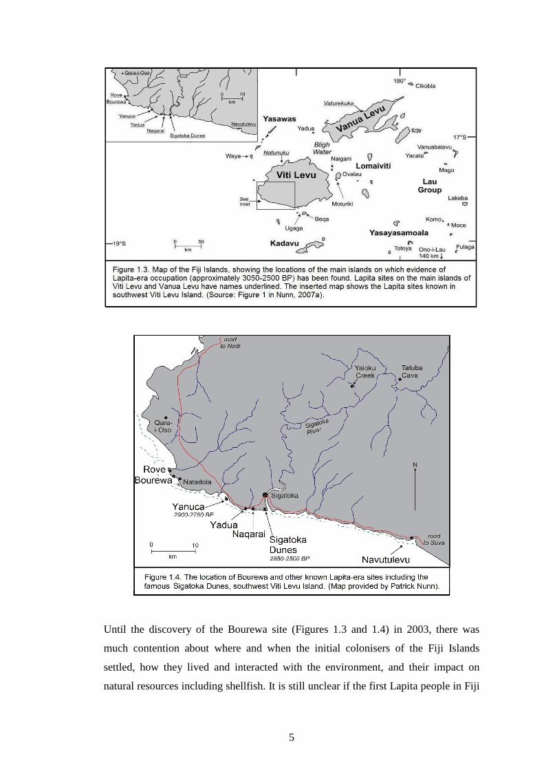
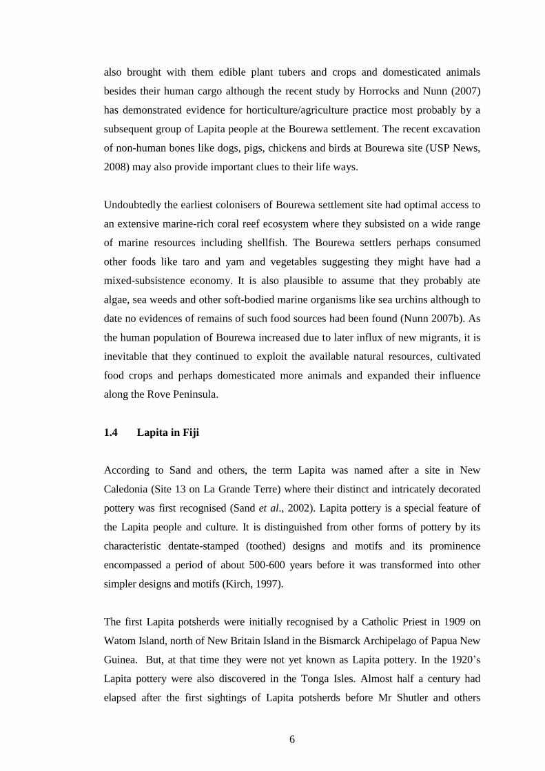
Until the discovery of the Bourewa site (Figures 1.3 and 1.4) in 2003, there was
much contention about where and when the initial colonisers of the Fiji Islands
settled, how they lived and interacted with the environment, and their impact on
natural resources including shellfish. It is still unclear if the first Lapita people in Fiji
6
also brought with them edible plant tubers and crops and domesticated animals
besides their human cargo although the recent study by Horrocks and Nunn (2007)
has demonstrated evidence for horticulture/agriculture practice most probably by a
subsequent group of Lapita people at the Bourewa settlement. The recent excavation
of non-human bones like dogs, pigs, chickens and birds at Bourewa site (USP News,
2008) may also provide important clues to their life ways.
Undoubtedly the earliest colonisers of Bourewa settlement site had optimal access to
an extensive marine-rich coral reef ecosystem where they subsisted on a wide range
of marine resources including shellfish. The Bourewa settlers perhaps consumed
other foods like taro and yam and vegetables suggesting they might have had a
mixed-subsistence economy. It is also plausible to assume that they probably ate
algae, sea weeds and other soft-bodied marine organisms like sea urchins although to
date no evidences of remains of such food sources had been found (Nunn 2007b). As
the human population of Bourewa increased due to later influx of new migrants, it is
inevitable that they continued to exploit the available natural resources, cultivated
food crops and perhaps domesticated more animals and expanded their influence
along the Rove Peninsula.
1.4 Lapita in Fiji
According to Sand and others, the term Lapita was named after a site in New
Caledonia (Site 13 on La Grande Terre) where their distinct and intricately decorated
pottery was first recognised (Sand et al., 2002). Lapita pottery is a special feature of
the Lapita people and culture. It is distinguished from other forms of pottery by its
characteristic dentate-stamped (toothed) designs and motifs and its prominence
encompassed a period of about 500-600 years before it was transformed into other
simpler designs and motifs (Kirch, 1997).
The first Lapita potsherds were initially recognised by a Catholic Priest in 1909 on
Watom Island, north of New Britain Island in the Bismarck Archipelago of Papua New
Guinea. But, at that time they were not yet known as Lapita pottery. In the 1920�s
Lapita pottery were also discovered in the Tonga Isles. Almost half a century had
elapsed after the first sightings of Lapita potsherds before Mr Shutler and others

7
excavated large quantities of decorated (dentate-stamped) potsherds in New Caledonia
where the collection was named Lapita pottery (Chino, 2002).
While it is plausible that the Fiji Islands were colonised by people who originated
from either the Bismarcks or Santa Cruz/Reef Group or Vanuatu, various
colonisation models have been proposed to describe the nature of Lapita settlement
in Fiji. For example Clark and Anderson (2001) broadly characterised two major
migration phases which included the initial settlement of western Fiji, followed by
the expansion and occupation of eastern Fiji. Kumar (2004) also postulated at least
four colonisation routes that were followed by the Lapita people as they settled the
Fiji Islands.
According to Kumar�s model, the first route involved the settlement of the southwest
Viti Levu Island via the Bligh Waters. The second group traveled northeast and
perhaps settled on Vanua Levu Island, (though this is conjectural), or they settled on
northern Viti Levu Island and/or central Fiji (Lomaiviti group). Another group,
which perhaps originated from Bourewa settlement sailed southwards and colonised
the southern group of islands like Beqa and Kadavu, while the fourth group (which
originated from either central Fiji or Viti Levu Island) settled the eastern part of the
Fiji Islands mostly in the Lau group (Figure 2.5) (Kumar, 2004).
The Bourewa settlement was subsequently abandoned after 500-600 years of
continuous occupation. By the end of the Lapita period, the Bourewa settlers
migrated and colonised other locations along the Rove Peninsula and/or settled in
other places along southwest Viti Levu Island or other islands of Fiji (Kumar, 2004;
Nunn et al., 2004, 2005b; Nunn, 2007a).
There are no available evidences (or clues yet) to suggest any post-Lapita occupation
of the Bourewa settlement, but preliminary dates (post-Lapita) obtained from human
burials excavated during the mid-2005 field season (Nunn, 2007a) suggest that the
site may have had some post-Lapita cultural significance. Perhaps the site was later
used for burial although it is uncertain if it was a cemetery associated with any
ritualistic practices as in other Lapita sites like Teouma, on north Efate Island,
Vanuatu (Shing et al., 2005). There are indications though that the site could be a

8
significant place for the post-Lapita settlers of the Rove Peninsula but the extent to
which this is so, is yet to be determined and analysis of the human remains is still in
progress.
Almost a century ago Indo-Fijian farmers leased the land where the Bourewa
settlement was founded and planted sugar cane crops. During the mid-2005 field
season the Bourewa site was part of a sugar cane farm formerly cultivated by Mr
Ram Lal and family. Today the land on which the Bourewa settlement is located is
owned by the Shangri-La group of companies.
1.5 Aims and objectives of this thesis
The analysis of shellfish remains from archaeological sites has been conducted on
most Pacific Islands in the recent past to understand many aspects of prehistoric
settlement and subsistence behaviour including human and non-human impacts on
shellfish resources. In Fiji, several studies have demonstrated the impact of human
predation on shellfish resources while inferring that environmental change may have
been important as well (Morrison and Cochrane, 2008; Nunn et al., 2006; Thomas et
al., 2004).
This study attempts to understand particularly the impact of both human-induced
pressures and environmental change on the availability and abundance of shellfish
resources over space (different environmental habitats/ecosystems) and time (phases
of occupation) by analysing the shells sampled from the Bourewa settlement�s shell
midden.
Since Bourewa was colonised against a backdrop of both climatic and sea-level
changes during and after the mid-Holocene, an understanding of the interplay
between human and environmental factors is important (Nunn, 2005) for interpreting
shellfish abundance and variability. The analysis of the Bourewa shells will enable a
better understanding of the way early humans (Lapita people) in Fiji interacted and
impacted shellfish species and habitats and how environmental factors (sea-level fall)
influenced their choices and actions, their preferences and subsistence behaviour
over time. An understanding of this interrelationship will also be useful for informing

9
resource managers, policy makers and resource owners with management scenarios
to manage the exploitation of marine resources especially shellfish species and
habitats.
The character and composition (structure) of the shell midden at Bourewa settlement
can inform us about the variability of shellfish species and habitats targeted by
foragers and types of shellfish they preferred, collected and consumed. The shellfish
analysis should allow us to examine their subsistence strategies and how they were
able to alter their bahaviour due to changes in shellfish resources.
1.5.1 Primary aim
Shellfish resources were an integral part of the initial Lapita colonisers of both Near
and Remote Oceania (Davidson and Leach, 2001; Nunn, 2007b). By conducting an
analysis of the shells sampled from the Bourewa shell midden during the mid-2005
field season this study aims to determine the nature of shellfish exploitation during
the Lapita era in Fiji especially during the 500-600 years of settlement at Bourewa.
As in most faunal (shellfish) analysis, this study employed methods such as MNI,
NISP, weight and size to quantify and analyse the shellfish species sampled from Pits
X1, X2, X3, X5 and X6. This analysis intends to understand the subsistence
strategies of the Lapita people on the shellfish species and habitats along the Rove
Peninsula and trace their changes through time as well.
1.5.2 Secondary aim
The impact of environmental change particularly sea-level fall on shellfish resources
in the Pacific is well documented (Amesbury, 2007; Kirch and Yen, 1982; Morrison
and Cochrane, 2008; Spennemann, 1987). As suggested by Nunn et al., (2004,
2005a) and Nunn (2007a), the Bourewa settlement was occupied during a period
when environmental conditions were also changing especially after the mid-
Holocene sea-level maxima, so this study also aims to understand the nature of sea-
level and its impact on available marine resources and human behaviour during
Lapita times.

10
Although isolating the human and non-human factors will be challenging, a review
of the literature citing several examples illustrating the impact of sea-level change on
shellfish resources on different tropical Pacific Islands will be outlined and described
to provide a backdrop for understanding the impact of sea-level change on the
Bourewa shells. Based on the case studies and a recent palaeogreographic
reconstruction of the Rove Peninsula (Nunn, 2005) and shellfish analysis of Qoqo
Lapita site Nunn et al., 2006), inferences will also be made regarding the possible
impact of sea-level change on certain shellfish species and habitats along the Rove
Peninsula.
1.5.3 Objectives
Since the first geoarchaeological dig at the Bourewa settlement site, many significant
finds have been analysed and published by various collaborators. Examples include
Dickinson (2005), Horrocks and Nunn (2007), Nunn (2005), Nunn et al., (2004,
2005a, 2005b), Nunn (2007a) and Szabó (2006). The foregoing publications have
been important for understanding the presence of prehistoric people in southwest Viti
Levu Island though a comprehensive shellfish study is required to understand the
nature of human impact on shellfish species and habitats along the Rove Peninsula
particularly during the Lapita period.
This thesis proposes to specifically,
(i) examine and understand the nature and pattern of marine-resources
(shellfish) exploitation from the period of initial human (Lapita)
occupation of Bourewa until 600 years later � from 1200/1100 BCE to
700/600 BCE,
(ii) understand the nature of subsistence strategies of the Bourewa settlers,
(iii) explain the nature of environmental change during the period of human
occupation of Bourewa (e.g. sea-level change),
(iv) link marine-resource (shellfish) exploitation by the early human (Lapita)
settlers of Bourewa to environmental change, and,
(v) understand particularly in terms of modern resource management, the
interrelationship between human (resources) exploitation and
environmental change.

11
1.6 Notes on how time is explained in this thesis
The following abbreviations of time are used throughout this thesis to explain
various references to time.
AD � Anno domini (indicate the number of years after the traditional date of
Christ�s birth).
BC � Before Christ (indicate the time before the Christian era).
BCE � Before Common Era (indicate the time before the Christian era, used
particularly by non-Christians).
cal yr BP (or cal BP) � calibrated years before present (before present =
1950).
years BP (or BP) � years before present (before present = 1950).
ka � thousand years ago.
Ma � million years ago.
1.7 Organisation and scope of this thesis
This thesis is divided into eight chapters. Each chapter outlines, describes, explains,
and discusses the major themes of the thesis.
The second chapter outlines the prehistoric settlement of the Pacific Islands including
Fiji (section 2.2). It discusses the colonization of Pacific Islands, presents the debate
over human colonisation of Near and Remote Oceania, outlines the nature of Lapita
settlement in Oceania, and describes the recent settlement of the Pacific during the
last millennium (subsections 2.2.1 to 2.2.5). Lapita in the context of Fiji (section 2.3)
including their colonisation route and settlement patterns in the Fiji Islands are also
described here (subsections 2.3.1 and 2.3.2).
Chapter three reviews the major prehistoric subsistence trends in ancient times,
discusses human-environmental interactions in the Pacific including the Fiji Islands,
and describes three important foraging models that are important for understanding
the shellfish analysis at Bourewa. The objective of section 3.2 is to outline the
perspectives on prehistoric subsistence in the Pacific Basin in ancient times. Section

12
3.3 reviews Lapita subsistence in Oceania, outlines the current debate relating to
subsistence practices in the Pacific, and explains some of the recent advances in
reconstructing subsistence economies in Oceania (subsections 3.3.1 to 3.3.3). Section
3.4 reviews human-environmental interactions in pre-modern (Pacific) societies and
previous shellfish studies in Fiji, while optimal foraging theory models which
explain human predation patterns are outlined in section 3.5.
Chapter four describes the methodology and outlines a theoretical overview of
underlying concepts and terms in zooarchaeology that are used in this thesis. A
review of some important terminologies and quantification methods commonly used
in faunal analysis and theories associated with the study of faunal remains including
invertebrate marine shellfish is provided here as well.
While the quantification methods are critically examined, the overall objective of this
chapter is to ground the shellfish analysis in anthropological and archaeological
practice. The methods used to quantify shells in this thesis include NISP (number of
individual specimens) (subsections 4.2.1 to 4.2.3), MNI (minimum number of
individuals) (subsections 4.2.4 to 4.2.6), Weight (subsections 4.2.7 to 4.2.9), and Size
(subsections 4.2.10 to 4.2.12). These quantification methods have been selected
because of their appropriateness for this particular shellfish analysis.
Chapter five describes the study site, major excavation phases, and the field and
laboratory methods employed to sample the shells for quantification and analysis.
Section 5.2 briefly outlines the geotectonic history and development of the Fiji
Islands providing a backdrop for understanding the geography and palaeogeography
of the Rove Peninsula and the Bourewa site. Section 5.3 outlines the history of
excavations conducted along the Rove Peninsula and describes the major phases of
fieldwork carried out from 2003 to 2005. Post-2005 field excavations are briefly
described here as well. Sections 5.4 and 5.5 briefly explain the field and laboratory
methods employed by the research team and the author to recover, sample and
quantify the shellfish species excavated during the mid-2005 field season at the
Bourewa settlement site.
13
Chapter six presents the results and analysis of the Bourewa shell assemblage.
Section 6.2 describes the excavation profiles of Pits X1, X2, X3, X5 and X6 and the
radiocarbon dates obtained for the different levels of each pit. Section 6.3 outlines
the radiocarbon chronology and dating of Pits X2 and X3. The objective of these
sections is to illustrate the various stratigraphic layers and provide an overview of the
general composition and context of the pits, the palaeogeography, and the occupation
levels of the Bourewa Lapita site. Section 6.4 presents the analysis of MNI, NISP,
weight quantification, and size measurements for the Bourewa shells. The analytical
zones delineated for the shell assemblage and their analysis are presented in section
6.5. Section 6.6 presents the analysis of shellfish species and habitats using foraging
theory models and the analysis of shellfish species diversity and relative abundances
is presented in section 6.7.
Chapter seven provides the interpretation and discussion of the results and analysis
presented in chapter six and relates them to the aims and objectives of this thesis.
Section 7.1 interprets the shellfish analysis. Subsection 7.1.1 interprets the
stratigraphy and radiocarbon ages of the pits sampled at the Bourewa site.
Subsections 7.1.2 to 7.1.4 interpret and discuss the MNI, NISP, weight, and size
analyses. Section 7.2 interprets the shellfish habitat usage at Bourewa including
foraging in the Shoreline Sandy/Muddy and Intertidal/Coral Reef Habitats and
shellfish diversity and abundance. Section 7.3 discusses the implications of
archaeological shellfish studies like the Bourewa shellfish analysis for marine
resources management in general and in particular Fiji.
Finally, chapter eight provides a summary of the results and analysis and outlines
both human and non-human impacts on shellfish species and habitats as indicated by
the Bourewa shellfish data.

14
Chapter 2. Settlement history of the southwest Pacific and the Fiji
Islands
2.1 Introduction
This chapter outlines the human settlement history of the Pacific Islands and Fiji. It
traces the migration of the early colonisers of the Pacific region (section 2.2) and
describes the nature of Lapita settlement in the Fiji Islands (section 2.3).
According to Dalzell, �the Pacific Islands were among the last parts of the world to
be settled by humans, settlement in most having occurred within the last two or three
millennia� (Dalzell, 1998:238). Due to the nature of the Pacific region, many
scholars are fascinated by the colonisation of the Pacific Islands given the vast
ocean-distances that were crossed by humans from Southeast Asia and the Bismarcks
to as far as Easter Island in eastern Polynesia (Hurles et al., 2003).
2.2 Prehistoric settlement of the Pacific Islands
Several works have outlined the prehistoric settlement of the Pacific Islands. These
include Spriggs (1997) who traced the prehistoric settlement of �Island Melanesia�
by people who originated from Asia and Kirch (1997) who described the expansion
of the Lapita phenomena into both Near and Remote Oceania particularly during the
mid-Holocene period. Roger Green also proposed the concept of Lapita Cultural
Complex (LCC) (Green, 1979, 1982), to describe Lapita and its associated trappings
and intrusion into the Pacific region, while Kirch (2003) provided a concise summary
of the human colonisation of the Pacific Islands. Bellwood (1980) and Irwin (1992)
also outlined a chronology of the prehistoric settlement of the Pacific Islands.
Based on these works, at least three major pulses of human migration into the Pacific
Islands have been broadly recognised. These are referred to here as - the Pre-Lapita,
Lapita, and Post-Lapita Phases. These migration phases spanned the late Pleistocene
to the late Holocene and were generally characterised by an eastward trend which
originated from somewhere in the Southeast Asian region.
15
The first migration phase (pre-Lapita) was marked by the settlement of both Sahul
(Australia and New Guinea) and parts of Island Melanesia during the late-Pleistocene
by mainly Papuan-language speaking people of continental Asia or Island Southeast
Asian (ISA) origin (Spriggs, 1997). The second migration phase (Lapita) saw the
wholesale migration of Roger Green�s Lapita Cultural Complex from the Bismarck
Archipelago, into the Solomon Islands, Vanuatu, New Caledonia, Fiji, Tonga and
Samoa beginning sometime around 4000-3500 years ago. This episode also included
the settlement of the central and eastern regions of Micronesia (Kirch, 1997, 2003).
Around the turn of the last millennium, the third migration phase (post-Lapita)
undertaken by descendents of the Lapita people occurred. This stage is characterised
by the settlement and colonisation of most of the eastern, northern, central, and
southern Polynesia and possibly the colonisation by Pacific Islanders of the Panama
region of Central America (Nunn, 1999; Nunn and Britton, 2001) (Figure 2.1).
2.2.1 Early human colonisation of the Pacific Islands (Pre-Lapita Phase)
Archaeological evidence demonstrates that modern humans (Homo sapiens) first
appeared in the fossil record in Southeast Asia about 40,000 BP (Shutler and Shutler,
1975). While recent controversial evidence from Australia suggests even older dates
for the presence of modern humans in Australia, Tasmania and New Guinea (or
Greater Australia) (O�Connell and Allen, 1998), the initial colonisation of parts of
Island Melanesia and the Bismarcks occurred sometime between 35,000 and 29,000
years ago (Kirch, 2003; Spriggs, 1997) and by 29,000 BP people had already
colonised the Bismarcks and possibly certain parts of the western Solomon Islands
(Hurles et al., 2003).
The first phase of human movement into the western Pacific region occurred during
the Pleistocene epoch; a period characterised by cooler global temperatures,
increased glaciers, and lower sea levels. Besides others, these conditions rendered the
sea gaps between most continents and islands narrower than present and had
significant implications for human migration and technological and cultural
exchange.

16
During this time, sea-level in most parts of the world was substantially lower and
certain regions which are now separated by expansive seawater gap were once
connected. For instance, mainland New Guinea was once joined with Australia (and
Tasmania) forming a super-continent called Sahul (Nunn, 1999). The continental
shelves of Sunda (Greater Southeast Asia) were also exposed and the sea gap
between the islands of Bali and Lambok was narrower which might have enabled
modern humans to cross from Sunda to Sahul relatively easily (Rapaport, 2006).
During this time the islands of Buka, Bougainville, the Shortlands, Choiseul, Santa
Isabel, and Ngella were also joined together when sea-level was lower forming a
larger landmass which Spriggs referred to as �Greater Bougainville� (Leavesley,
2006:190).
Although the fall in sea level to about 150 m below present during the Pleistocene
period was responsible for significant increase in landmasses and migration of people
and certain fauna across land bridges, the continental shelves of Sunda and Sahul
were never connected (O�Connell and Allen, 1998). Due to lower sea levels during
the Pleistocene period, anatomically modern humans were able to cross the Wallace
Line from Island Southeast Asia into mainland New Guinea (O�Connell and Allen,
1998; Rapaport, 2006). Their subsequent crossing into Island Melanesia implied they

17
probably had appropriate seafaring knowledge and skills, though sailing technology
was not yet invented until the mid-Holocene. So it is plausible to assume that they
could have utilised simple boats or bamboo rafts to cross the narrow water gaps
between Southeast Asia and mainland New Guinea or Island Melanesia (Irwin,
1992).
The early human colonists of the Pacific Islands were mostly hunter-gatherers
(Kirch, 2003; Nunn, 1999; Spriggs, 1997) and they exploited resources from the
tropical rainforests and inshore marine habitats and established extensive
communication and exchange networks that linked different island communities
together (Kirch, 1997; Leavesley, 2006).
In his investigations of economies, technological and social complexities in the
Bismarck Archipelago, Leavesley (2006) examined evidences of human colonisation
and behaviour from several New Ireland Pleistocene sites. By synthesising the
archaeological data and settlement dates, Leavesley was able to identify six pulses of
human deposition that are important for understanding the late-Pleistocene and
Holocene colonisation of the Bismarcks and Solomon Islands. He demonstrated that
the initial settlement of the Bismarcks occurred around 39,500 BP followed by the
settlement of Manus at least about 20,000 BP. There was a settlement hiatus after the
Last Glacial Maximum (LGM) and by 15,000 BP people re-occupied most sites in
central and southern New Ireland including the initial occupation of northern New
Ireland sites. The settlement of western New Britain and Buka occurred slightly later,
while all of the New Ireland sites were occupied around 12,000 to 10,000 BP. By
about 8000 BP people had apparently abandoned all the sites on New Ireland. These
inland sites were abandoned probably due to migration of people to the coastal
regions where there would be abundant resources that can sustain the islands
expanding populations.
The Holocene period (last 10,000 years of Earth history), was marked by a warmer
period and rising sea level around most parts of the world including the Pacific
region (Nunn, 1997, 1999). This period also witnessed significant cultural changes
occurring in certain places within Near Oceania. For example, Pavlides (2006) who
examined a site on West New Britain Island (dating between 10,000 and 3600 years

18
ago) revealed several important cultural processes and social changes in Oceania�s
prehistory and amongst these were gradual changes in the way people interacted with
the environment, with more intensive resource management occurring in the mid-
Holocene period.
According to Nunn (1997, 1999), the mid-Holocene period is marked by cooler
conditions, increased precipitation, lowering sea level, increased sedimentation of
foreshore areas, and vegetation change on some Pacific Islands. This period also saw
the advent of the Lapita people in the central, eastern Pacific and parts of the
northern Pacific. The arrival of humans into the Oceania region has been associated
with the introduction of fire, exotic biota, and vegetation change on most islands,
although climatogenic factors maybe have had significant impact on island
environments resulting in the development of certain physical landscapes like
grasslands on certain islands.
David Roe (1993) who re-examined and analysed a 6000-year long cultural sequence
from the Vatuluma Posovi (Poha) Cave on northwest Guadalcanal Island, highlighted
the sites association with pre-Lapita population occupation and intrusion of this
region of the central Solomon Islands. During the same study, Roe also identified a
3000-year old cultural sequence coinciding with the Lapita colonisation of Oceania.
But, as Kirch (1997) highlighted extensive fieldwork and research are required
throughout the main Solomon chain to ascertain a much clearer and finer settlement
pattern and chronology for this region including the period immediately before the
Lapita colonisation of Oceania because as Pavlides states, �the mid-Holocene is
perhaps the most elusive phase in Melanesian prehistory� (Pavlides, 2006:207).
2.2.2 Human settlement of Near and Remote Oceania (Lapita Phase)
The second phase of human colonisation of the Pacific region is characterised by the
intrusion of Roger Green�s Lapita Cultural Complex into Oceania. It also marked the
initial settlement of parts of Oceania which were perhaps devoid of human
inhabitants prior to the advent of the Lapita people (Figure 2.1 and 2.3) (Kirch,
1997).

19
About 3300 BP the Lapita people expanded into the southeast Solomon Islands from
the Bismarcks. Based on archaeological evidence, the colonisation of Vanuatu, New
Caledonia and/or other more remote archipelagoes, did not occur until after 3300 BP
because they reached the Fiji Islands about 3050 BP, and by 2900 BP Tonga was
colonised (Horrocks and Nunn, 2007).
When the Lapita people migrated into the western Pacific about four or three and a
half millennia ago, they encountered a range of island types, sizes, habitats and
ecosystems (Nunn, 2005). Due to the nature and character of the different islands, the
initial colonisers of most tropical Pacific Islands had to adjust to a range of
conditions in order to adapt to the different island environments. In many instances
the interaction between humans and the islands has lead to changes in both human
behaviour as well as the environments of the islands that were colonised (Kirch,
1997; Nunn, 2005).
In the early 1990s, Roger Green delineated the southwest Pacific region (excluding
Australia) into two sub-regions - Near Oceania and Remote Oceania (Green, 1991a)
(Figure 2.2). Besides aiming to discourage the use by scholars of Oceanic culture
history of the classical terms - Melanesia and Polynesia, Green attempted to highlight
the distinct nature and character of these sub-regions including their island
environments and their potential impact on human colonisation and behaviour.
Today, this concept is widely used by Oceanic archaeologists because it seems to
accurately �convey a more meaningful historical division of Oceanic island
geography than that implied by the classical terminologies� such as Melanesia,
Polynesia or even Micronesia (Walter and Sheppard, 2006:137).
The ecological differences between the islands of Near and Remote Oceania are
paramount for understanding human colonisation of the Pacific Islands and their
interactions with island environments. In terms of island ecology and biogeography,
Near and Remote Oceania exhibit distinct environmental characters. For example
Near Oceania (Papua New Guinea and the archipelagoes of the Bismarcks and
Solomon Islands) comprise relatively larger landmasses and narrow water gaps, so
the inter-visible islands would not hinder migration by potential human colonists like

20
the Lapita people and the dispersal and translocation of diverse flora and fauna from
island to island (Kirch, 1997).
In contrast, Remote Oceania which includes all islands north, east and southeast of
the main Solomon chain as farther east as the Fiji-Samoa-Tonga triangle, is mostly
separated by huge expanses of seawater. For instance, according to Kirch (1997) the
sea gap between the Reef/Santa Cruz group and the Fiji Islands spans over 850 km
rendering it to be the largest ocean-distance in the Lapita world. The Lapita people
marked the first colonisers to have crossed this uninterupted ocean gap and settled
the islands of the eastern and southern Lapita provinces of Remote Oceania.
The Near Oceania region is biogeographically and ecologically richer than Remote
Oceania with a decline in the diversity of native flora and fauna from western to
eastern Pacific. The larger islands of the Bismarcks and Solomons for example
hosted a wide range of indigenous and endemic species of mammals, reptiles,

21
avifauna, and abundant marine resources. All these protein sources in addition to
tubers, seeds, fruits and nuts had contributed to the diet of the early humans who
colonised Near Oceania (Kirch, 1997).
By comparison, the ecosystems of the region beyond the main Solomon Islands are
generally impoverished and the richness of indigenous flora and fauna decreased
markedly (Kirch, 1997). Thus Remote Oceania �lacks natural populations of most
cultivated Oceanic plants and their close relatives� which were important for
sustaining human settlement and the growth of large populations (Horrocks and
Nunn, 2007:740). Despite being environmentally poor, Remote Oceania contained a
host of bird taxa and its seas and coral reefs were bountiful with marine resources
almost similar to Near Oceania. So the early hunter-gatherers of the Oceania region
developed a system of food production and relied on the exploitation of marine
resources (Kirch, 1997).
According to Nunn (2007b) and Nunn and Heorake (2009), when the Lapita people
encountered island environments in Remote Oceania their subsistence options were
significantly less than they are today. For instance, there were fewer reefs and those
that existed at the ocean surface probably hosted less diverse ecosystems. Coastal
lowland landscapes were also less extensive, offering fewer options for
horticulture/agriculture. Despite these limiting factors, several case studies from
different parts of the tropical Pacific that indicated that the Lapita people clearly
made sense of their world by optimising access to desired albeit scarce food
resources. Thus, throughout the Lapita world as we see it today, smaller-island
settlements were more common than those on larger islands.
Some examples of Lapita settlements that were established on smaller islands during
Lapita times include Malo on Temotu Neo Island, Temotu group, southeast Solomon
Islands, Bourewa on southwest Viti Levu Island, Fiji, and northern Tongatapu Island
around the Fanga �Uta lagoon. These sites were chosen because of their proximity to
expanding coral reefs particularly after the mid-Holocene sea-level maxima and for
security against potential attackers and disease-carrying insects. Perhaps these people
also allowed their commensal animals to run free on these islands because they
would be comparatively easy to catch again when needed. Besides the general

22
preference of the Lapita people for occupying smaller islands they also settled on
tombolos and sand spits. Although they appear today as vulnerable locations, these
locations were deliberately selected by the Lapita people because they provided
optimal access to marine and intertidal food resources (Nunn, 2007b; Nunn and
Heorake, 2009).
2.2.3 Lapita colonisation of Oceania: Express Train to Polynesia (ETP) and
Indigenous Melanesian Origins (IMO) models
According to Spriggs, by the first millennium BC Island Melanesia became bigger,
larger, and expanded as it had received its next group of human settlers � the Lapita
people who belonged within a new cultural tradition, used pottery, and practiced
agriculture/horticulture. This second colonisation pulse saw the intrusion of the
Lapita Cultural Complex into both Near and Remote Oceania and cultural exchanges
between Lapita and older Island Melanesian cultures (Spriggs, 1997).
Figure 2.3 shows the locations of some of the islands in the southwest Pacific where
evidence of Lapita-era settlement sites has been found. The extent of the Lapita
colonisation of Oceania stretched from the Mussau group of islands in the Bismarck
Archipelago of Papua New Guinea in western Melanesia, through to the Solomon
Islands, Vanuatu, New Caledonia, Fiji, Tonga and Samoa (Terrell, 1997; Spriggs,
1997) and extends even to �Uvea, Futuna and probably Rotuma (Kirch,1997).
Though we now have a much clearer idea about the distribution of the Lapita
settlement sites within Oceania, Bedford (2006) noted that in the 1970s Lapita
origins and its associated trappings were widely debated by researchers and
archaeologists. As a result of this contention many theories and models of Lapita
colonisation were developed and postulated. For our purpose, two opposing models
for explaining the Lapita colonisation of Oceania are useful. These models are
discussed below.
First is the �Express Train to Polynesia� (ETP) theory and second, the �Indigenous
Melanesian Origins� (IMO) theory (Bedford, 2006; Kirch, 1997; Summerhayes,
2001). As highlighted by Bedford (2006) these models attempt to explain the origins

23
of the Lapita people and describe the nature of their migration, technology, and
culture as they expanded into both Near and Remote Oceania.
The ETP model proposes a significant and very rapid population intrusion (wholesale
migration) of Austronesian-speaking peoples with their domesticated animals,
elements of material culture, and technology, and pottery into the Bismarck region
from somewhere in Southeast Asia. It assumes that subsequent changes in the pottery
style are due to subsequent isolation of populations over long periods of time
(Summerhayes, 2001) and perhaps cessation of constant contact and trade between
island populations (Kirch and Yen, 1982).
According to the ETP model, the migrating Austronesians passed through Melanesia
en route to Polynesia in the mid-late second millennium BC. It is regarded as the fast
train model because the colonisation of the Bismarcks preceded Fiji about 3000 km
away to the east by only about a century, thus persuading proponents of this model to
suggest that the rate of colonisation was very rapid. But according to Kirch, the
�express train� concept is somewhat misleading because such a train would have
made several stops in Melanesia dropping off �boxcars full of colonists� suggesting
cultural exchange and perhaps intermarrying with the inhabitants of Near Oceania
before proceeding eastward into Remote Oceania (Kirch (1997:45).
In contrast the IMO model postulates that key aspects of the Lapita culture were
largely developed within the Bismarck Archipelago without any input from outside
the Near Oceania region (or from the Southeast Asian region). Essentially, advocates
of the Melanesian indigenist model argue that �Lapita is wholly an indigenous
development out of earlier social and economic configurations in the Bismarcks,
with the acquisition of pottery being the only contribution from the west� (Kirch,
1997:46). Apparently, the model assumes that the Lapita culture arose from internal
social and economic developments of the previous 35,000 or so years of occupation
of Island Melanesia (Summerhayes, 2001). Additionally extreme variants of the
indigenist theory refute the concept of a Lapita Cultural Complex as proposed by
Roger Green and stressed that the dentate-stamped pottery was only a �trade ware�
which the Lapita people utilised in trade or exchange networks between island
communities (Kirch, 1997).

24
As noted by Bedford et al., (2006), over the years archaeologists have taken sides on
the issue of Lapita origins and development. So, whether or not it was largely an
indigenous development in the Bismarck region with limited contact with Island
Southeast Asia or, if it was primarily a Southeast Asian intrusion or, something in
between, is still a matter of contention. As a consequence of the ongoing debate
several research projects were established by archaeologists to re-examine and
address issues associated the origin, settlement pattern, subsistence economy and
other important aspects of the Lapita phenomena.
A case in point is the �Lapita Homeland Project� established during the 1980s in the
Bismarck Archipelago, Papua New Guinea by Patrick Kirch and others (Bedford,
2006). Despite being very significant and useful for understanding many aspects of
Lapita, the project fell short of completely resolving the origin question, but it did
encourage some modifications of the opposing views and the development and
proposition of other theories like the �Slow Train Model� which is a variant of the
�Express Train Model� (Summerhayes, 2001) and Roger Green�s �Triple-I� model
of �Intrusion/Innovation/Integration� (Green, 1991b:298).
According to Kirch (1997:46), Roger Green�s model �recognizes that some aspects
of Lapita must be accounted for by intrusion, the movement of people and their
cultures into the Bismarck Archipelago where existing populations were then
integrated into a new cultural pattern which itself underwent certain innovations�.
Bedford (2006) states that although the �Triple-I� model at least provides an outline
for potential processes, Spriggs (1997) suggests that a shortened time line is required
to accommodate for the integration component. Both the Express Train and Slow
Train models suggest that the Lapita Cultural Complex developed in the Bismarck
Archipelago before colonising groups migrated to Remote Oceania (Summerhayes,
2001).
In Kirch�s literary model of �the beach�, a holistic approach is posited where various
aspects of the Lapita Cultural Complex like, new settlement patterns, economic
systems, and regional exchange plus linguistic and biological patterns in Near and
Remote Oceania must be considered and not just the elaborate pottery (Kirch, 1997).

25
Other Lapita origin theories have been proposed by scholars including, the
�Entangled Bank� and �Slow Boat� models (Hurles et al., 2003).
2.2.4 Nature of Lapita settlement in Oceania
The other talking point amongst many archaeologists is the rate of Lapita expansion
into Oceania. As such Clark and Anderson noted the emergence of two hypotheses
for explaining the nature of Lapita dispersal. Firstly, �Lapita settlement was
restricted to the Bismarcks for 200-300 years before an explosive phase of eastward
expansion which occurred so rapidly that no chronological gradient can be discerned
in the radiocarbon record�. Secondly, �Lapita movement was incremental, occurring
as a series of colonisation fronts� as it advanced eastward into the central Pacific
(Clark and Anderson, 2001:77).
While Kirch (1997) proposed a slightly longer time span of 300-500 years, Terrell
(1997) suggested a slightly lesser span. Terrell posited that since Lapita pottery
showed up in the archaeological record of New Caledonia, Vanuatu, Fiji, Tonga, and
Samoa soon after it appeared in western Melanesia, it must have taken less than 100-
200 years for Lapita to spread from the Bismarcks to the Fiji-Tonga-Samoa region.
Kirch also calculated an average rate of dispersal in the order of 9-15 kilometers per
year (Kirch, 1997:62). Thus Bedford and others suggested that, �if this is the case
then the posited 3300 BP date for Lapita settlement in the Bismarcks leaves only a
very short time interval before people set out to explore, discover and colonise the
western parts of Remote Oceania� (Bedford et al., 2006:824). Based on their
demographic simulation of Lapita dispersal, Di Piazza and Pearthree (1999)
summarised the rate of Lapita colonisation of the Pacific Islands as perhaps the
fastest human migration in prehistory.
The Lapita people migrated from the Bismarcks and into the main Solomon chain
around 3500-3200 BP (Di Piazza and Pearthree, 1999; Spriggs, 1997). Kirch (1997)
noted that the early Lapita settlement of the Bismarck Archipelago may have
occurred between 1550-1400 BC (3500-3350 cal BP) while the settlement of the
Reef/Santa Cruz group occurred around 1100 BC (3050 cal BP). The Lapita people

26
then expanded southwards through Vanuatu and New Caledonia establishing
settlements there around 1000 BC (2950 cal BP) although recent archaeological data
from the Teouma site in Vanuatu has pegged the initial human colonisation to around
3200-3000 cal BP (Bedford et al., 2006). During this same period, perhaps slightly
later the Lapita people must have crossed the open-ocean gap between the
Reef/Santa Cruz group of eastern Solomon Islands and the Fiji Islands while Tonga
and Samoa were colonised possibly from Fiji a few centuries later.
Kirch (1997) who provided a comprehensive account of the Lapita people described
their character, origin, history, settlement patterns, ceramics, technology, artifacts,
livelihoods, subsistence and colonisation of the Pacific Islands and stated that the
Lapita people were the common ancestors of the Austronesian-speaking
Melanesians, the Polynesians and some Micronesians. The term �Lapita� is derived
from Site 13 in Kone, New Caledonia (the site of Lapita itself) where their distinctly-
decorated pottery was initially recognised (Sand et al., 2002). Today the term has
come to represent more than just the pottery itself. For example, Kirch (1997:10)
noted that �Green saw the Lapita Cultural Complex as based on a sophisticated
horticultural-fishing economy, with fairly large villages occupying beaches and
offshore islets, and using a broad range of distinctive material culture including
various kinds of stone, shell, and bone implements�.
The Lapita people initially lived along the coast as transient hunter-gatherers and
horticulturists/agriculturalists. They gathered, collected and gleaned shellfish from
the near-shore marine environment including coral reefs, fished and depended on the
land for food and other materials. They were skilled potters, toolmakers and
craftsmen. They cultivated fruit trees, food gardens and harvested roots, tubers, fruits
and leaves from crops and trees they planted and probably kept animals such as pigs,
chicken and dogs (Kirch, 1997).
Although Anderson and O�Connor (2008) highlighted reservations regarding the �out
of Taiwan� model, re-evaluations of data from Island Southeast Asia has compelled
Nunn to contend that the Lapita people originated from somewhere in southern
China and Taiwan possibly direct descendants of the present-day aboriginal people
of Taiwan. Genetic (DNA) evidence also lends support to this proposition. So, as
27
Nunn suggested that the Lapita people migrated through Halmahera Island in the
Molucca Sea and the Bismarck Archipelago in northeast Papua New Guinea between
2000-1500 BC (3950-3450 cal BP). They later colonised the Solomons, Vanuatu,
New Caledonia, Fiji, Tonga and Samoa including parts of Micronesia (Nunn, 1999).
Evidence from settlement sites, tools, and the characteristic dentate-stamped Lapita
pottery, testify to the development and history of the Lapita people (Kirch, 1997) and
a general eastward colonisation trend (Nunn, 1999). The early Lapita sites generally
comprise hamlets or villages where houses were constructed and elevated on posts or
stilts situated over tidal reef flats or along shorelines. Plant and animal remains
excavated from these sites indicate a mixed-subsistence economy with
horticulture/agriculture and marine resource exploitation. Exchange networks were
established where substantial quantities of exotic materials like obsidian, chert, shell
artifacts, ornaments, pottery and other materials were traded between communities
(Kirch, 1997).
The ability of the Lapita people to traverse vast ocean-distances in boats, canoes and
rafts to migrate to new lands around three thousand years ago indicate that they had
appropriate skills and technology. Leavesley (2006) stated that the late Pleistocene
colonists of Near Oceania also possessed comparative skills and watercrafts.
Similarly Pavlides (2006:205) also noted that the �main elements of social and
economic organisation more usually associated with later Lapita settlement were
already in place by about 4000 years ago� in Near Oceania.
But Nunn (1999) suggested that the early inhabitants of Papua New Guinea and
Solomon Islands were probably constrained by their inability to voyage over great
ocean distances though their later relatives - the Lapita people, possessed advanced
navigational skills and were equipped with suitable vessels. These attributes probably
enabled them to successfully navigate open ocean-distances in search of other islands
in the South Pacific although to date no trace or evidence of their boats, canoes or
rafts had been found.
After the Lapita people colonised the islands beyond the main Solomons chain, their
migration eastward was very rapid (Kirch, 1997). For example their settlement of the

28
southeast Solomons, Vanuatu, New Caledonia, Fiji, Samoa and Tonga occurred only
within a few hundred years and in many places the Lapita era was somewhat short-
lived lasting only for 200-300 years (Anderson and Clark, 1999; Bedford, 2003)
before it was either replaced or integrated into other post-Lapita cultures. But, at the
Bourewa site, Fiji Islands, the Lapita settlement period was much longer spanning
some 500-600 years (Nunn, 2007a).
While the issue of what compelled or motivated the Lapita people to migrate to other
islands and/or search for new homelands is still unclear, there are several important
considerations that may explain the reasons for the Lapita diaspora. These include,
push factors like, population pressure and preference for marine resource-rich
offshore islets/islands motivated them to colonise new lands, while trading
opportunities for new resources to exploit and the social organisation of the Lapita
people were important pull factors (Kirch (1997).
In his work along the Sepik coast of New Guinea, John Terrell suggested that by the
second millennium BC newly formed lagoons along New Guinea's northern coastline
and elsewhere probably fueled prehistoric cultural change in the southwestern
Pacific. The naturally increasing abundance of certain wild resources encouraged
growth of human populations along the Sepik coast following the expansion of these
lagoonal systems. This subsequently extended human social and economic horizons
in all directions including eastward toward the Solomons and westward toward
Island Southeast Asia (Terrell, 1997). Nunn recently pointed out (in support of
Kirch) that, perhaps the major motivating factor for the migration and colonisation of
the Pacific Islands by the Lapita people was marine-food resource availability
perhaps due to high sea level and the expansion and development of marine-rich
coral reefs on many islands in the Pacific (Nunn, 2007b).
It has been suggested that environmental change may have been an important pull
factor in encouraging people to move to other islands as well. For example, Nunn
and Heorake (2009) noted that during the past few thousand years, the tropical
Pacific had become much drier and this aridity might have been the driver of cross-
ocean exploration and migration. Nunn also suggested that climatic conditions then
were relatively cooler than today and were associated with increased frequency of El

29
Niño events (Nunn, 2007b). During an El Niño onset, a westerly wind event in the
far western Pacific pushes the West Pacific Warm Pool (an area of convergence in
the western Pacific) towards the east. Once the warm pool gradually drains to the
east, the convection now draws winds from both east and west and that pushes the
warm pool further east. This results in cooler, drier conditions in the western Pacific
while the east experiences much warmer, wetter conditions (Kessler, 2009). The
occurrence of persistent westerly winds during an El Niño event may have been
utilised by the Lapita people to migrate from west (Bismarck Achipelago) to east
(Samoa-Tonga region). Recently Anderson et al. (2006) proposed the idea that an El
Niño event or several of them, may have facilitated the exploration of the Pacific in
what is generally regarded as an �against-the-wind migration� where movement was
eastward against the trade winds.
2.2.5 Settlement of the Pacific during the last millennium (Post-Lapita Phase).
In Table 2.1, the settlement dates for selected islands in Melanesia, Polynesia and
Micronesia are provided. The dates from Table 2.1 and �from the archaeological
evidence, there appears to be a pause of 500 to 1000 years before permanent
settlement of the eastern-most islands of Polynesia� (Hurles et al., 2003: 533). In
Nunn�s (1999) synthesis of the earliest known settlement sites and dates for selected
Pacific islands a generalised settlement trend suggest that older settlement sites were
founded in Melanesia and parts of Micronesia whilst Polynesia comprised mostly
younger sites.
The settlement of most parts of Polynesia as illustrated Figure 2.1 and Table 2.1
occurred only within the last millennium, marking the third wave of human
migration into the Pacific. This phase of human settlement is characterised by the
occupation of the islands farther east, south, and north of the Samoa-Tonga region
mostly by the descendants of the Lapita people. They settled the Marquesas (~1650
BP), Hawaii (~1300 BP), Easter Island (~1180 230 BP), Society Islands (<1200
BP), and Cook Islands (~1140 BP). New Zealand, Henderson Islands and Mangareva
were settled between 900-700 BP (Nunn, 1999). According to Nunn and Britton
(2001) Pacific Islanders probably migrated farther east of Easter Island and possibly

30
established settlements in parts of Central America like the Panama region sometime
around AD 1514 (Figure 2.1).
In summary, based on the available information and radiocarbon dates obtained from
different sites, some parts of Island Melanesia were initially settled during the
Pleistocene and most of the Holocene period while other parts were settled by the
Lapita people particularly after the mid-Holocene. The Lapita period marked the
time of rapid human settlement in both Near and Remote Oceania. During the past
one thousand years, descendants of the Lapita people migrated farther south, north,
and east and settled the region we now refer to as Polynesia and even as far as the
west coast of Central America (Nunn and Britton, 2001).

31
2.3 Lapita in the context of the Fiji Islands
While Anderson and Clark (1999) did not record any evidences for Lapita in Fiji that
predates 2900 cal BP (950 BCE), recent evidences from Bourewa settlement point to
even earlier period of human occupation for the Fiji Islands. The recent Fiji dates
from Nunn and others� work along the Rove Peninsula has provided strong support
for a contemporaneously early Lapita settlement between the Reef/Santa Cruz-
Vanuatu region and the Fiji Islands (Nunn et al., 2004). While Bedford et al. (2006)
confirmed that Vanuatu was settled slightly earlier than Fiji, Nunn et al., (2004)
suggested that the Lapita settlement at Bourewa was established sometime between
1220-970 BCE (3170-2920 cal BP).
Research work for example by Clark and Anderson (2001), Kumar (2004) and Nunn et
al. (2004) have also provided additional dates to the scheme proposed by Anderson
and Clark (1999) and most of these sites were settled prior to 2900 cal BP (850 BC).
These include; Naitabale (Moturiki Island) (1220-540 BC), Ugaga (Beqa) (1150-850
BC), Qoqo Island (1000-800 BC), Yanuca (950-800 BC), Naigani (900-750 BC),
Lakeba (900 BC), Mago (850-650 BC) and Waya (850-450 BC). Other important
Lapita settlement sites on Viti Levu Island include the famous Sigatoka Dunes (750-
550 BC), Rove Beach site (750-550 BC) and Natunuku (> 550 BC) (Nunn et al., 2004,
2006; Nunn, 2005). There is also a possible Lapita presence at Navutulevu village on
south Viti Levu Island (Figure 1.3).
The founder site of Nukuleka on Tongatapu Island, Tonga dates to about 950 BC
(2900 cal BP) (Burley and Dickinson, 2001) while the Mulifanua site on Upolu
Island, Samoa contains dentate-stamped pottery sherds with Early Eastern Lapita
motifs (Green and Davidson, 1974). Apparently, the islands in the Fiji-Tonga-Samoa
region were devoid of human inhabitants prior the Lapita colonisation of Remote
Oceania so the Lapita people were undoubtedly the first settlers of this part of the
Lapita world three millennia ago (Kirch, 1997; Nunn, 1999).
The Lapita people also expanded into eastern and central Micronesia in the last few
centuries of the first millennium BC. Of particular significance is the historical,

32
linguistic and archaeological evidence confirming the existence of two distinct
regions within Micronesia. The first (western Micronesia), had links with people who
may have originated from the Philippines and moved through Palau and the
Marianas. The second suggests initial settlement of the central and eastern
Micronesia region contemporaneous with the Lapita people who settled the Bismarck
Archipelago and the Solomon Islands (Kirch, 1997). Based on the presence of red-
slipped pottery, some decorated with lime-filled, impressed designs and well
radiocarbon-dated sites, Kirch (2003) argued that humans settled the Marianas and
Palau no later than 1500 BC (3450 cal BP) or possibly as early as 2000 BC (3950 cal
BP).
Despite our current understanding of the Lapita occupation of Oceania and the
contention over Lapita settlement patterns and why people settled where they did, the
Lapita people first arrived in Fiji sometime about 3170 cal BP (1220 BC) (Nunn et
al., 2004). As reported by Nunn (1999) and Kirch (2000), the Lapita people arrived
in Fiji most probably from the Bismarck Archipelago and/or eastern Solomon Islands
or Vanuatu (Bedford and Spriggs, 2008; Nunn, 2005, 2007a).
Their journey crossed an ocean-distance of some 850 km between the Reef/Santa
Cruz group and the Fiji Islands about three millennia ago (Kirch, 1997). According
to Clark and Anderson (2001:84) this episode marked a voyage that traversed �the
longest uninterrupted sea passage in the Lapita world�. They probably encountered
uninhabited islands in the Fiji group and were able to occupy a range of island types
and sizes (Nunn, 2005). They initially settled on coastal open sites and sometimes
later moved inland and occupied sites like caves and rockshelters (Kumar et al.,
2004). There were also no earlier colonists with whom they needed to compete for
land and resources (Lepofsky, 1988) so it was assumed they exploited a range of sea
foods and ate well (Nunn, 2007b).
Based on the types of motifs and designs drawn on a range of potsherds excavated at
various sites in Fiji, researchers like Gifford (1951) and Green (1963) were able to
reconstruct a ceramic sequence for the Fiji Island. Although certain improvements and
33
additions have been made since, their scheme is still widely relevant today. Kumar
(2007:67) reported that Simon Best (1984) also divided the Fijian ceramic sequence
into four major chronological phases. According to Kumar, these are,
Sigatoka Phase � 2850 -2500 cal yr BP (this is the Lapita ceramic complex
period characterised by both dentate stamped pottery and Lapita incised ware),
Navatu Phase � 2100-950 cal yr BP (is characterised by carved paddle
impressed pots usually linked with Level 2 ceramics from the Sigatoka Sand
Dune site),
Vuda Phase - 950-250 cal yr BP (featuring mostly plain pots become while
decorated pots are rare with some incising and appliqué), and,
Ra Phase - 250-100 cal yr BP (are commonly associated with incised pots and
a marked increase in the use of appliqué).
The foregoing chronological sequence is useful for understanding the transformation in
the forms of pots and the types of designs and motifs associated with different
prehistoric settlement intervals, but the issue of when and where the early colonists
first settled in the Fiji Islands is still contentious.
A generalised settlement scheme proposed by Clark and Anderson (2001) revealed
despite limited radiocarbon dates, a general pattern of west to east colonisation trend
for the Lapita settlement of Fiji dating back to around 2900 cal BP (850 BC)
(Anderson and Clark, 1999). Based on their model it appears that the Lapita people
initially settled in the western and/or southwest part of Viti Levu Island before
exploring and/or expanding into the northern, central and eastern regions of Fiji.
Linguistic evidence (e.g. Geraghty, 1983) also lends support to this assertion. These
two regions have distinctive languages, where eastern Fiji for example, has languages
similar to the Tonga-Samoa region including the commonly spoken Bauan dialect.
2.3.1 Possible (Lapita) colonisation route of the Fiji Islands
The dichotomous colonisation model proposed by Clark and Anderson (2001) for the
Fiji Islands has been useful but, the migratory trends of the Lapita people based on

34
recent studies are more complex. According to Kumar (2004), at least four pathways
were followed by the Lapita people when they encountered the Fiji Islands.
Based on Kumar�s hypothesis, and as illustrated in Figure 2.5, the first group of
colonisers entered Fiji through the sea gap between northern Yasawas and Vanua Levu
Island and probably travelled southward along the leeward coasts of Viti Levu Island.
They sailed along the extensive reef system off western Viti levu Island and met land
and eventually founded their settlement at Bourewa on Vusama Island (Nunn, et al,
2004). Most probably another group went north-eastward and settled on Vanua Levu
Island. Although no radiocarbon dates were obtained from coastal and inland sites on
Vanua Levu, Parke (2000) recorded evidences of a Lapita presence on the second
largest island in the Fiji group. The radiocarbon dates for the Matanamuani site on
Naigani Island might signify a slightly earlier Lapita presence or thrust into northern
Fiji suggesting population movement through the Bligh Waters (Anderson and Clark,
1999) which may lend support to presence of this second group in this area. The recent
dates for the Naitabale site on Moturiki Island also suggest a contemporaneous
colonisation route via northern Fiji (Nunn et al., 2005b), perhaps reaffirming previous
suggestions by Anderson and Clark (1999).
Kumar (2004) suggested that from Bourewa, a third group sailed along southwest Viti
Levu Island before expanding to the east via Beqa and Kadavu. The islands of Mago
and Lakeba in the Lau group were probably settled by a later (fourth) group that
originated from Moturiki and/or Naigani. Totoya was perhaps colonised by people
from Viti Levu possibly around the same time that the other islands in the Lau group
were settled. Although the model by Kumar (2004) proposed the colonisation of the
Lau group of islands of Eastern Fiji by people who originated from either the central or
southern Fiji, Burley and Clark (2003) contended that since the Tongan Archipelago
were settled prior to Eastern Fiji, it is plausible to assume that perhaps some islands of
the Lau group may have been colonised by people who originated from Tonga.
2.3.2 Lapita settlement pattern in Fiji
The pattern of Lapita settlement in the Fiji Islands is such that there was no apparent
preference for any particular size of island. As postulated by Nunn (2005), the nature

35
of Lapita colonisation in the Fiji Islands indicates that both large and small islands
were colonised by the Lapita people, unlike in Near Oceania where most early Lapita
sites were established on smaller islands. As shown in Figures 2.4 and 2.5, the Lapita
people settled on both Viti Levu and Vanua Levu Islands as well as other medium
and smaller-sized islands during various times of the Lapita era.
In a proposed model describing the pattern of earliest human settlement in Fiji based
on investigations of four Lapita sites on Viti Levu Island, Kumar et al. (2004)
demonstrated that early Lapita settlements were exclusively established on open
coasts like tombolos and sand spits, while later ones were founded farther inland and
mostly associated with caves and rockshelters. On Vanua Levu Island for example,
Parke (2000) also confirmed a similar settlement pattern.
This settlement pattern observed for the Fiji Islands is also mirrored elsewhere in
both Near Oceania and Remote Oceania. It has been argued that access to abundant
marine resources was an important factor in site selection and establishment,
particularly during the earliest stages of settlement. The initial colonists deliberately
settled coastal regions for optimal access to important food sources (Nunn, 2007b).
Nunn argued that the availability of abundant marine foods was an important
consideration when selecting settlement sites rather than access by water craft,
proximity to fresh water, and land suitable for horticulture which Lepofsky (1988)
noted as were the major considerations for the selection of settlement sites on other
Pacific Islands.
Nunn (2005) also demonstrated that in Fiji both open and closed sites were occupied
during the Lapita period. Open Lapita sites were mostly located on smaller offshore
islands (e.g. Bourewa, Rove and Qoqo), tombolos (e.g. Qoqo, Matanamuani and
Natunuku) and sand spits (e.g. Bourewa, Naitabale, Yadua and Navutulevu). These
sites were all strategically located to optimise access to the available marine
resources adjacent to these sites.

36
This settlement trend has been observed elsewhere in the Pacific where most Lapita
sites were founded close to abundant marine resources. For example, the Malû (SZ-
23) and Bianga-Mepala (SZ-45) sites in the Reef/Santa Cruz group, southeast
Solomon Islands, the site of Lapita itself (sites 13, 13A, 13B and 14) in New
Caledonia, the Lapita cemetery site of Teouma on Efate Island, Vanuatu, and
Northern Tongatapu Island, Tonga. It appears the motivating factor for the initial
establishment of Lapita settlements on coastal regions and offshore islands in Fiji as
elsewhere was perhaps to optimise access to a broad fringing coral reef where a
range of marine resources can be optimally exploited (Nunn 2005, 2007a, b; Nunn
and Heorake, 2009).
37
Rockshelters and caves characterise the closed, inland settlements sites in Fiji.
According to Kumar and others, factors that were influential in the founding of
inland settlements in Fiji include increasing population pressures, susceptibility of
coastal regions to frequent natural disasters and storms, cross-island trading networks
and, the intentional exploitation of inland resources (Kumar et al., 2004). Nunn and
Kumar (2004) also noted the transient movement of humans after initial arrival in
Fiji into the interior of Viti Levu Island along the upper Sigatoka Valley. They
suggested that during their explorations for inland resources early humans might
have lit fires along the Yaloku Creek, though it is possible that the fires could have
been the result of a Pacific-wide drought period that also affected Fiji at that time.
Although no radiocarbon dates were obtained, archaeological investigations
conducted in northern Fiji had led to significant discoveries including the first
reported Lapita site on Vanua Levu Island - an inland site at Vaturekuka and
identification of an early site characterised by pot covers with phallus-shaped vertical
handles (Parke, 2000). Parke also suggested that the Lapita people explored inland
areas for a number of reasons. These include exploitation of inland fauna such as
birds and lizards, search for fine-grained source rocks for manufacturing stone tools
like adzes, and for agriculture/horticulture activities along the fertile valley floor of
major river systems.

38
Chapter 3. Literature review: prehistoric human subsistence, human-
environment interactions and foraging theory models
3.1 Introduction
This review chapter is divided into three parts. The first part (sections 3.2 and 3.3)
describes the nature of prehistoric subsistence practices in the Pacific basin and
outlines the main features of these subsistence patterns. Part two (section 3.4) discusses
human-environment interactions in pre-modern (Pacific) societies and the third part
(section 3.5) explains the different foraging theories that are useful for understanding
human predation on the shellfish species and habitats along the Rove Peninsula.
The objectives of this chapter are to,
outline the major trends in prehistoric subsistence in the Pacific basin,
explain the nature of subsistence practices during Lapita times in Oceania,
describe human-environment interactions in the tropical Pacific in pre-
modern times, and
explain the foraging theory models that are important for understanding and
interpreting faunal assemblages including shellfish species and habitats.
3.2 Perspectives on prehistoric subsistence in the Pacific Basin
The interaction between humans and resources in pre-modern times has revealed
several trends in human subsistence practices particularly in relation to the proportion
of marine resources exploited for sustenance by humans. According to Nunn,
archaeological studies have revealed three major subsistence trends. Firstly, during the
early Pleistocene � late Pleistocene humans exhibited low dependence on the marine
environment where they consumed minimal amount of marine foods. Secondly, during
the late Pleistocene � mid-Holocene they incorporated relatively more marine food into

39
their diet and thirdly after the mid-Holocene, most coastal settlements were
increasingly dependent on marine food resources (Nunn, 2007b).
In general, throughout human prehistory the relative proportion of marine foods
consumed by humans appear to have gradually increased over time. When the Lapita
people expanded into both Near and Remote Oceania about three thousand years ago
they had adopted a mixed subsistence economy where they consumed relatively high
proportions of terrestrial food as well to supplement their predominantly marine diet
(Davidson and Leach, 2001).
3.2.1 Subsistence during early Pleistocene to late Pleistocene
Although modern humans (Homo sapiens) did not appear in the fossil record before
about 50,000 years ago in the Pacific Basin, a 300,000 year-old �hominid site� in
France called Terra Amata and a 130,000 year-old site in South Africa exemplify two
of the earliest known sites for marine resource utilisation particularly shellfish
consumption (Szabó, 2002). Szabó explained that these deposits of shells and fish
bones, fishhooks and shell artefacts show that Neanderthals occasionally consumed
marine resources despite a major portion of their diet comprising terrestrial foods.
Szabó also noted that within the Australasia region, Vietnam, Australia and the
Bismarck Archipelago of Papua New Guinea represent some early sites containing
evidence for both marine and freshwater molluscs exploitation. These sites date from
about 35,000 to 11,000 years ago. Apparently modern humans, unlike their hominid
cousins, had a relatively broader diet because they consumed more marine foods and
exploited a wider range of food sources.
Several factors are important in order to understand the nature of subsistence practices
during the Pleistocene in the Pacific region. Firstly, the Pleistocene period is generally
marked by lower sea levels and cooler temperatures. As such Nunn (1999) noted that
lower sea levels and cooler global temperatures associated with the Last Glacial
Maximum (LGM) were major limiting factors because cooling of most of the worlds�
oceans had affected marine resources availability. Coral reef growth for most parts of
the Pacific was also affected by cooler temperatures thereby influencing other marine

40
organisms that inhabited and depended on coral reefs for food and survival (including
protection against predators).
Secondly, lack of secure sites and archaeological data that date back to the Pleistocene
are also limiting factors. Since many sites in the Sunda Shelf comprised low
archaeological sampling and depaupeate faunal record, possible earlier or older sites or
phases are yet to be discovered and securely analysed. So, detailed identifications and
analyses of the assemblages are limiting attempts to understand the nature of human
subsistence during this period particularly regarding the exploitation of marine
resources (Anderson and O�Conner, 2008).
Due to the absence of sufficient archaeological data for the late Pleistocene period,
Kirch (1997) cautioned that it can be tempting to speculate on the life ways of early
colonists of Near Oceania (the islands of New Guinea, the Bismarcks, and the
Solomon Islands). But, recent data from the New Guinea highlands indicate that the
early settlers of this area had adapted to non-coastal environments by at least 25,000
years BP, while New Ireland coastal sites contained faunal remains of extinct forest
birds. Evidence from the Matenkupkum site on New Ireland also indicates some
utilisation of low-level fishing skills and technology with shellfish and echinoderms
mostly targeted by hunter-gatherers (Leavesley, 2006). Thus Leavesley suggested that
perhaps soon after their arrival in the archipelagos of the Bismarcks and Solomons,
these early colonists may have also utilised the available coastal marine resources,
though their diet comprised relatively more terrestrial foods.
3.2.2 Subsistence during late Pleistocene to mid-Holocene
After more than ten millennia of human settlement in Near Oceania several important
environmental and cultural changes were taking place. Amongst these were changes in
sea level after the Last Glacial Maximum (LGM) and an increase in the number of
sites with shell midden deposits. Szabó (2002) noted that as sea-level rose after the last
ice age, favourable environmental conditions for expansion of shellfish and fish
populations were created thus attracting prehistoric people to the coastal regions on
both continents and islands. The huge shell mounds found for example in coastal sites
in the United States, Australia and parts of Europe indicate that the people who

41
occupied these sites probably depended heavily on shellfish as a food source. Kirch
(1997) also suggested that the rapid rise in sea level due to melting of land ice masses
resulted in inundation of coastal regions causing certain settlements to be established
inland while encouraging coral reef development and rich marine life, thus triggering a
change in subsistence strategies for exploiting marine resources.
Besides changes in settlement patterns and subsistence strategies, Near Oceania also
witnessed other significant developments during this period. For instance, the
appearance of obsidian flakes from New Britain in New Ireland archaeological sites,
bones of the Gray Cuscus (Phalanger orientalis) in the Bismarck Archipelago sites at
about 18-20,000 years ago, and the marsupial (Thylogale brunii) in the Balof cave
sequence, New Ireland about 7000 years ago. It is plausible to assume that these
volcanic rocks and animals could only have reached these islands had people carried
them there (translocation). Thus, these developments meant huge implications for
exchange networks between island groups and communities, perhaps increased
voyaging by people across different islands and the change in peoples� attitudes
towards the environment (Kirch, 1997). As Gosden (1993) noted, perhaps these data
represent a shift from people moving about the landscape to ensuring that resources
were brought to them or their settlements. A cultural transformation that Gosden
described as, changing from nomadism to sedentism.
Around the Pleistocene - Holocene boundary, Kirch (1997) pointed out some notable
innovations towards plant domestication and crop cultivation within Near Oceania.
Amongst these were important domesticated crops such as sugar cane, banana,
Pueraria lobata, and Cordyline fruticosum in the New Guinea region. Kirch also noted
that the Kuk Swamp record (highlands region of New Guinea) demonstrates that taro
(Colocasia esculenta) cultivation had already occurred about 9000 cal BP, but Fullagar
et al. (2006), argued for an even earlier date for processing of taro (Colocasia
esculenta) and yam (Dioscorea sp.) which dates back to around 10,200 cal BP.
By the beginning of the Holocene period, people within mainland New Guinea were
already cultivating trees, root and tuber crops including taro, yam and other plants
especially in the wetlands of the New Guinea highlands (Fullager et al., 2006).
Hurles et al. (2003) also noted that around 9000 cal BP, cultivation of tree crops and
42
other plants was already in place in certain parts of Near Oceania. Archaeological
evidence too has demonstrated that horticultural practices were already established in
the New Guinea highlands region during the Holocene, establishing it as one of the
global centers for horticultural development (Kirch, 2000, 2003).
Kirch (1997) suggested that aroids like Cyrtosperma chamisonis and Alocasia
macrorrhiza, were also cultivated and there is ample evidence for the domestication of
a number of fruit and nut-bearing trees like coconut, breadfruit, and the hard-shelled
nut Canarium almond. Although the mid-Holocene archaeological record in Near
Oceania remains sketchy due to changes in settlement patterns and scarcity of data, it
appears there was a hiatus in settlement after most sites were abandoned around 8000
cal BP (Leavesley, 2006) only to be re-occupied within the last 2000 years (Kirch,
1997).
Of the few sites that yielded significant archaeological data prior to the appearance of
the Lapita people in Near Oceania, Kirch (1997) noted the Dongan Village site
(northern New Guinea) dating to about 5800 years BP, Matthew Spriggs� Nissan
Island (Halika Phase) site and David Roe�s 6000-year-old Vatuluma Posovi (Poha
Cave) and Vatuluma Tavuro sites (Guadalcanal Island, Solomon Islands). Some of
these sites contain well-preserved fossils of important tree crops, nut and fruit crops
including the sago palm which implies the presence of an agricultural-dominated
economy.
There is also evidence for hunting of a range of terrestrial fauna while fishing and
shellfish gathering contributed a large proportion of their diet with indications of the
use of some form of sophisticated fishing technologies. It is apparent that the people
who occupied these sites employed a mixed-subsistence strategy incorporating both
terrestrial and marine food resources into their diet. Hence as Kirch (1997:41-42)
stated the �millennia of familiarity with coasts, reefs, and lagoons also led to increased
knowledge of the sea�s resources and of how to capture these�.
Generally the beginning of the Holocene period witnessed increased number of
settlements and the establishment of exchange networks between different island
communities. There was also evidence for crop cultivation and plant domestication and

43
the availability of a range of resources which people can exploit. Despite these cultural
developments and marine innovations, Kirch suggested that the overall orientation of
Old Melanesia during this period appears to have been still more towards the land
rather that the sea (Kirch, 1997).
3.2.3 Subsistence after the mid-Holocene
From the Bismarcks to the southeastern Solomon Islands, Vanuatu, New Caledonia,
Fiji, Tonga and Samoa, numerous evidences of the variety of flora and fauna
exploited by the Lapita people testify to their culture, skills, technology and impact
on the environment (or resources). The colonising populations of both Near and
Remote Oceania initially lived along the coast as transient hunter-gatherers and
horticulturists/agriculturalists who subsisted on wild foods and animals present on
the islands they inhabited. They consumed animals such as marsupials, reptiles, sea
birds, fruit bats, and rats, while wild forest plant foods also provided staples (Kirch,
1997; Leavesley, 2006).
The Lapita people also ate fish, shellfish and other invertebrates mostly derived from
mangrove swamps, inshore coral reefs, and lagoons. They also exploited and
supplemented their diet with tubers, seeds, fruits and nuts of wild plants. Fruit trees
and food gardens were cultivated and they also domesticated animals (Kirch, 1997).
Kirch noted that certain animals and plants were purposely domesticated and
transported by the Lapita people to different Pacific Islands as an essential part of
their strategy for settling new islands and as a basis for food production. Several
examples of animals that were domesticated and transported by the Lapita people as
part of the colonisation strategy include dogs, pigs and chickens (Kirch, 1984, 1997).
Despite the persuasion of current evidence suggesting that the Lapita people may
have employed a mix-subsistence economy which means they depended on both the
terrestrial and marine environments for their subsistence, there is still contention over
the subsistence strategies of the Lapita people who colonised Oceania (Davidson and
Leach, 2001).

44
3.3 Subsistence during Lapita times in Oceania - Oceanic Strandloopers
versus Horticulture/Agriculture
The objectives of this section are to,
outline the debate over Lapita subsistence economies and the recent advances
in reconstructing subsistence economies of the Lapita people,
explain the concept of Oceanic Strandloopers and Horticulture/Agriculture by
providing the context for understanding the apparent trends in subsistence
practices in Remote Oceania, and
describe some of the important subsistence studies from different parts of
Oceania where the Lapita people had colonised.
Since the first excavations of Lapita settlement sites in Oceania, archaeologists have
continuously debated whether or not the Lapita people were primarily hunter-
gatherers or if they also practiced horticulture/agriculture. Davidson and Leach
(2001) who reviewed the debate on Lapita subsistence practices ably provided an
overview of the nature of subsistence economies of colonising populations in the
Pacific Islands. Other researchers who have enhanced our understanding of the life
ways of the Lapita people through their work include, Anderson (2003); Burley et al.
(2001); Crowther (2005); Green (1979); Groube (1971); Horrocks and Bedford
(2004); Horrocks and Nunn (2007); Leach et al. (2000, 2003); Nagaoka (1988) and
Swadling (1986).
One of the major factors fueling the subsistence debate has been the lack of plant
food remains in the archaeological record for most Lapita sites in Oceania (Horrocks
and Bedford, 2004; Horrocks and Nunn, 2007). Consequently, issues of Lapita
subsistence have divided archaeologists into two opposing camps that continue to
advance their views, despite Nagaoka�s (1988:131) caution that, �Lapita economies
will not fit a simple dichotomy between strandlooper and horticultural� models.
Hence, while the debate continues, recent evidences suggest that there is sufficient
support for some form of a mixed-subsistence economy which echoes similar views
as those posited by Nagaoka (1988) and Davidson and Leach (2001).

45
3.3.1 Oceanic Strandloopers
The Oceanic Strandlooper model was first proposed by Groube in the 1970s to
explain subsistence practices by the Lapita people based on evidences recorded in the
Tonga Isles (Groube, 1971). The model is premised on three factors � lack of
evidence of domesticated plant materials, absence of pig bones, and the presence of
rich shell middens at most Lapita sites. According to Kirch, Groube�s Oceanic
Strandlooper model, �was influenced by the rich shell middens associated with Early
Eastern Lapita pottery in Tonga and by the apparent absence of pig bone from these
sites� Kirch (1997:194). A similar observation was recorded by Burley (1998) in the
Ha�apai faunal collections. In particular Burley noted the marginal evidence for the
presence of pig and dog bones and suggested that agriculture (or animal
domestication) played only a secondary role in the early Tongans subsistence
economies implying that the early colonists may not have brought with them such
commensal animals.
The argument by some archaeologists (e.g. Anderson, 2003; Burley et al., 2001;
Groube, 1971) that the lack of domesticated plant materials in the archaeological
record means that the early Lapita people were mostly �Oceanic Strandloopers� who
subsisted primarily on marine food resources as they settled on the islands they
inhabited is very persuasive. Anderson (1996) also lend support to this proposition
by stating that while resource availability is the main driver for Pacific colonisation,
the role of agriculture and/or horticulture during post-initial settlement was either
secondary or limited.
As such, the Lapita people apparently had a �restricted maritime, lagoonal economy�
and subsequently developed horticulture or agriculture which later on enabled them
to colonise islands in Fiji, Tonga and the rest of the Pacific (Davidson and Leach,
2001; Horrocks and Bedford, 2004; Horrocks and Nunn, 2007).
The main point of contention of the Strandlooper model is that, the early colonists of
Remote Oceania obtained their food resources largely by fishing and shellfishing
(Davidson and Leach, 2001) and probably only �shifted from reef exploitation to
agriculture in the later half of the first millennium BC� (Swadling, 1986:145). Thus

46
horticulture/agriculture or the cultivation and domestication of certain plants and
animals were not significant components of the initial Eastern Lapita subsistence
economy. But, recent findings from older Lapita sites like Bourewa in Fiji (Horrocks
and Nunn, 2007) may be contesting the reliability and consistency of the
Strandlooper model for Remote Oceania.
3.3.2 Horticulturalists/Agriculturalists
In contrast to the Oceanic Strandlooper model, some archaeologists strongly
maintain that the Lapita economy had always included a major
horticultural/agricultural component. For instance, Green (1979) questioned the
Strandlooper model based on his work in the Reef/Santa Cruz group, southeast
Solomon Islands. In his synthesis Green cited important cultural developments like
the location of Lapita sites, settlement size, pits (used for food storage), cooking
ovens, pottery cooking vessels, adzes, vegetable scrapers and peelers and other tools
which he argued point to some degree of horticultural practice by the Lapita people
of Remote Oceania. In support of Green, Kirch (1997) stated that such indirect
evidences strongly implied horticultural practices and therefore may have weakened
the Oceanic Strandlooper concept.
In fact archaeological evidences collated from various places within Oceania have
allowed Kirch (1997:192-255) to reconstruct subsistence economies of the Lapita
people and showed that they had wide ranging diets and cuisines. Davidson and
Leach (2001:118) are also convinced �that people cannot live satisfactorily on a diet
that consists largely of fish and shellfish� implying that the Lapita diet might have
also included a certain portion of plant foods that obviously supplemented their
marine foods.
In their comparison of the faunal remains from archaeological sites in Remote
Oceania, Davidson and Leach (2001:116) noted some major distinctions and queried
Patrick Kirch�s �transported landscape� concept. They questioned the idea of
whether or not the early colonisers of the Pacific Islands and their crops �arrived
everywhere with the first canoes rather than progressively over a longer period� or if

47
agricultural (domesticated) crops were also introduced by subsequent migrants over
time.
A case in point is the recent Bourewa pollen data reported by Horrocks and Nunn
(2007). According to Horrocks and Nunn it appears that the evidence for
horticultural practices at Bourewa coincided with the same period when Eastern
Lapita motifs became prominent at the site, thus, begging the idea whether they were
contemporaneous. The initial colonisers of Bourewa may not be directly responsible
for the introduction of taro and yam to that area (though it is possible), but, it was
perhaps the later Lapita migrants who brought these cultivars to Bourewa settlement.
Despite the persuasive nature of both the Oceanic Strandlooper and
Horticulture/Agriculture models, the debate over Lapita subsistence economies
particularly in Remote Oceania is far from being resolved. A comparative and
detailed quantitative assessment of the available archaeological data and faunal
abundances from within both Near and Remote Oceania is important to provide a
comprehensive picture of Lapita subsistence economies. This is especially required
in order to shift away from the dichotomous and simplistic nature of the contentions
and advance a much more refined and reliable scheme for understanding subsistence
practices based on recent evidences and data (Nagaoka, 1988).
3.3.3 Recent advances in reconstructing subsistence economies in Oceania
It is common for archaeologists studying shell middens to often observe a very
productive lagoon or coral reef nearby and immediately assume that prehistoric people
just had to consume sea food to get their nutritional requirements due to their
proximity with the ocean. Often it is difficult to appreciate that the lack of arable land
for crop cultivation does not necessarily imply there was no horticulture/agriculture
being practiced but, actually root and tree crops like taro, yam, and breadfruit, may
comprise a significant component of most Pacific Islanders diet as well.
It is plausible to assume that prehistoric people may have also consumed far more
terrestrial food than they ate fish and shellfish. So, to properly understand Lapita diet,
analysing and quantifying fish bones and shells is not sufficient. For shell or fishbone

48
studies, a comparative collection is required to identify and analyse the site�s
composition. For full dietary reconstruction the composition of different kinds of foods
and how this gets into peoples' bones and hair and can be examined to analyse the
proportion of food acquired from the sea and/or the land.
Despite our current knowledge of the different types of food resources consumed by
the Lapita people (Kirch, 1997) and the debate over the types of food they ate,
determining what proportion of food types (terrestrial or marine) comprised the diet of
prehistoric people has been subjected to much conjecture and recent research (Janet
Davidson pers. comm., 2007). In recent years, particular scientific methods used in
analysing stable isotopes in human tissues for example has provided very useful
empirical data for better understanding of the diet of the Lapita people and their
descendants.
Szabó (2002) noted that recent advances in scientific techniques have enabled the
assessment of the relative proportions of marine and terrestrial food sources in
prehistoric human diet. For instance, the use of Multiple Isotope Signatures (ä13C,
ä15N and ä34S) is being utilised in reconstructing prehistoric (Lapita) human diet
from archaeological bone (Leach et al., 2000, 2003). Other methods include the
direct identification of fossil plant starch residues, pollen and phytoliths in soil
sediments, pottery, and tools and artifacts (Crowther, 2005; Horrocks and Bedford,
2004; Horrocks and Nunn, 2007). These techniques have enhanced the assessment of
Lapita diets in both Near and Remote Oceania and have proved very useful for
refining our understanding of the nature of subsistence practices by the Lapita
people.
While humans survived in Near Oceania by hunting and gathering for thousands of
years, there is now direct evidence for the use of economic and/or domesticated
plants by the Lapita people (Kirch, 1997). The Watom study by Leach et al. (2000)
demonstrated where plant and seafood fits into the overall scheme of Lapita diet at
Watom, New Britain Island, Papua New Guinea. For example, stable Isotope
analysis of human bone from six individuals from the Reber-Rakival Lapita burial
site on Watom Island recorded the relative contribution of both plant and marine
food sources in the Watom prehistoric diet. The Watom diet consisted of fish and

49
land herbivores as the main protein sources, while plant foods contributed most of
the energy requirements. The study by Leach et al. (2000:149), therefore shows that
�approximately 64% of the diet at Watom came from land-based food and 36% from
the sea�.
Through the technique of light microscopy, Crowther (2005) also demonstrated the
presence of starch residues preserved on undecorated pottery sherds from Anir, on
New Ireland, Papua New Guinea. The study by Crowther has identified
microbotanical starch residues and raphides belonging to the aroid Colocasia
esculenta (taro) and presented a strong case for plant-food processing that
particularly involved undecorated Lapita pottery and the general association of
pottery with cooking or boiling of starchy food for consumption.
In their study of the Naitabale site, Moturiki Island, Fiji, Nunn et al. (2007) also
demonstrated that terrestrial plants were an important component of the diet at
Naitabale contributing relatively more than marine species. But that the woman named
Mana had a mixed marine-terrestrial diet, where marine species such as shellfish and
fish were dominant protein sources. The analysis of non-human bones at the Naitabale
site also supports this conclusion.
Another plant-fossil evidence that lends support to horticultural practice during the
Lapita era in Remote Oceania comes from Vanuatu. Based on an examination by
Horrocks and Bedford (2004) of plant microfossils in 14 coralline soil and potsherd
samples from a 2700 BP (750 BC) Lapita site on Uripiv Island, they have identified
starch grains, calcium oxalate crystals and xylem of introduced aroid (non-
Colocasia). According to Horrocks and Bedford the Uripiv data represents the first
direct evidence of Lapita horticulture in Remote Oceania. It demonstrates that
introduced Araceae grew on Uripiv during Lapita times or people had utilised it for
horticulture or food preparation. These data also support plant evidence from Lapita
sites in the Bismarcks and add to the indirect evidences from Near and Remote
Oceania which confirm that horticulture was an integral component of the Lapita
economy.

50
Although the Naitabale site study has been informative, we may never know for
certain what foods the people who first settled at Bourewa consumed, how they lived
and impacted the natural environment (resources), and how the environment
influenced their behaviour (actions). But, the best possible answers to these questions
may be obtained from studying and understanding the plant (fossil) and faunal
(shellfish) evidences from the Bourewa settlement.
During the June-July 2005 field season at the Bourewa site, soil samples obtained for
plant microfossil analysis yielded significant results. The preliminary soil analysis of
the Bourewa Lapita-era site has revealed the presence of both Colocasia esculenta
(introduced taro) and Dioscorea esculenta (lesser yam). This is perhaps the first for
the Fiji Islands (Horrocks and Nunn, 2007). It is most likely that if such analysis is
conducted on a range of other older sites within the Fiji Archipelago the chances of
verifying the widespread consumption of plant foods during Lapita times will be
enhanced.
The Uripiv and Bourewa data though provide very compelling evidence for Lapita
horticulture/agriculture practices in Remote Oceania. Like the Uripiv data of
Horrocks and Bedford (2004), the Bourewa results suggest that horticulture was an
important component of the Lapita subsistence economy and especially the
domestication of root crops by Eastern Lapita populations. Horrocks and Nunn
(2007) suggested that, since the extent of natural distribution of terrestrial aroids in
Oceania extends east only as far as Vanuatu, the Bourewa finds, besides providing
evidence of food processing horticulture/agriculture, are undoubtedly anthropogenic
introductions. These root crops were definitely introduced into the Fiji Islands by the
Lapita people during the second phase of occupation at Bourewa settlement (Nunn,
2007a).
The Bourewa data also demonstrate that the colonising populations of Remote
Oceania and Fiji in particular had a mixed-subsistence economy where they
incorporated plant foods, fish and shellfish in their diet. New data generated from
recent research both in Vanuatu and Fiji are challenging some of the old subsistence
theories, in particular the Oceanic Strandlooper concept and its relevance certainly to
parts of Remote Oceania.

51
The evidence for horticulture/agriculture in Vanuatu and Fiji also lends further
support to previous research on Lapita subsistence in the Bismarcks and the
Reef/Santa Cruz Group that highlighted the importance of aroids like taro and yam to
early Pacific peoples (e.g. Kirch, 1997). In their reconstruction of the subsistence
economy of pre-European Maori who lived on the shores of Cook Strait, central New
Zealand, Davidson and Leach (2001) also concluded that the first Maori settlers had
consumed both cultivated plant food and fat while essential caloric energy was
derived from sea mammals as they established their gardens, which essentially
implied they had a mixed-subsistence economy. So, it may only be plausible to
suggest that perhaps sooner more evidence for horticulture/agriculture practices will
be uncovered in the Fiji-Tonga-Samoa region which up to now has proved quite
elusive.
3.4 Human-environment interactions in pre-modern (Pacific) societies
This section outlines the nature of prehistoric interactions between humans and the
environment in the Pacific Islands. It describes human-environment interactions in
Fiji as a backdrop for understanding human predation pressures on resources
including the shellfish at the Borewa Lapita site.
Human and non-human causations of environmental change in island environments
have been the subject of much interest and study in Fiji recently (e.g. Field, 2004;
Morrison and Cochrane, 2008; Nunn, 2003). In most instances prehistoric
populations have been portrayed as principally responsible for resource depression
and/or extirpation and extinction of certain flora and fauna on islands while minimal
attention has been given to the impact of environmental change on resources and
human behaviour over time (Nunn, 2003). Drawing on recent studies, the cases
presented here largely strive to illustrate the interplay between humans and the
environment in the earliest period of human settlement on selected parts of the world
and the Pacific Islands.

52
3.4.1 Human impact on resources
The impact of prehistoric populations on the natural environment and its resources is
well documented. Recent studies have demonstrated that humans were responsible
for the decline and demise of certain flora and fauna on most continents and islands
(Allen, 1992; Athens, 1997; Butler, 2000; Grayson, 2001; Hunt and Kirch, 1997;
Kirch, 1982; Nagaoka, 2001, 2002; Simone and Navarro, 2002).
Studies done in both North and South America have indicated that several factors
have been important contributors to the decline in certain resources by humans.
Butler (2000) for example, noted the impact of changing demography and human
predation pressure on mammal and fish resources from eight sites on the Columbia
River (Oregon, USA). Simone and Navarro (2002) also reported on the impact of
steady hunting pressure by hunter-gatherers from the mid-Holocene on local marine
resources like sea birds at Chan Chan site, southern Chile. They explained that due to
the diversity of the coastal resources, hunter-gatherers who occupied this area
developed appropriate technology to exploit these resources.
In the Bismarck Archipelago island of New Ireland, Papua New Guinea, Steadman
and others have documented at least 50 bird species that once lived there are now
extinct including at least 12 which were not previously recorded. New Ireland was
settled from about 35,000 years ago and, since the avian bones date from 15,000 to
6000 years old, they suspected that the avian extinctions were most probably due
primarily to humans (Steadman et al., 1999).
Other parts of the Pacific region where human impact on the environment had
apparently led to vegetation change and extinction or extirpation of terrestrial
resources are also outlined here. For example, in New Caledonia, Stevenson (1999,
2004) reported a late-Holocene vegetation record for the southwest coast of the main
island, La Grande Terre. Through pollen analysis, charcoal analysis, radiocarbon
dating and stratigraphic analysis, significant changes were found in the sedimentary
history of the Lac Saint Louis swamp. Between 6000-5500 BP the sediment record
indicates rapid floodplain development associated with postglacial sea-level rise. The
pollen record from 5500-3000 BP reflects certain vegetation changes to the coastal

53
landscape associated with the stabilisation of sea level. These landscape changes
particularly around 3000 BP have been associated with the advent of humans in New
Caledonia. By around 2000 BP the yam terraces surrounding the Lac Saint Louis
area may have been constructed and used. The archaeological records for Lac Saint
Louis and Plum sites indicate that forest cover was extensive prior to human arrival
and that charcoal accumulation increased significantly after 3000 BP and 2500 BP
respectively.
Although climatic fluctuations could be important in environmental change since
New Caledonia was first settled (around 3000 years ago), the data show that since the
Lapita period, humans have been the principal perpetrators of environmental change,
a pattern that is believed to be widespread across the region and farther east. As
reported by Stevenson et al. (2001), the impact of the initial colonisers of New
Caledonia on the environment is significant. Humans were principally responsible
for altering the vegetation of the valleys to savannas and converting the lowland
forest to stunted woodland species.
In Tonga, Steadman�s (1999) study on bird extinction and the impact of early-human
settlers on the Tongan environment highlighted that the rate and degree of vertebrate
extinction on Pacific Islands were influenced by both human and nonhuman factors.
The Lapita occupation of Tonga occurred some time after 3000 years BP and the
Lapita sites that Steadman examined have yielded abundant bones of bird species
that are now extinct so it is plausible to assume that human factors were important in
the demise of these bird species.
According to Dalzell (1998), the interaction of prehistoric human populations with
their natural (island) environment based on archaeological studies in the Pacific show
that human predation has caused resource depletion on several sites in islands like
Matenkupkum (New Ireland, PNG), Mussau (Papua New Guinea), Tikopia
(Solomon Islands), Tongatapu (Tonga), Aitutaki (Cook Islands), Mangaia (Cook
Islands) and Kapingamarangi and Nukuoro (Federated States of Micronesia). In
Dalzell�s synthesis the archaeological record of anthropogenic impact particularly on
Pacific coastal fisheries resources, also reveal a long-term subsistence exploitation
pattern of fish and invertebrates from nearshore coral reefs and lagoons and
54
underscores the importance of molluscs as a food source for early colonists of the
Pacific Islands. Dalzell also stated that perhaps the decline in the abundance of
molluscs through harvest pressure and environmental effect had subsequently led to a
greater reliance on finfish capture and the development of agriculture.
Other examples of human impact on resources include Swadling (1986) who
documented the impact of early colonisers of the Reef/Santa Cruz Group (Solomon
Islands) on certain marine shellfish species. In Tonga, Spennemann (1987)
documented the impact of initial human settlers on Tongatapu Island on shellfish size
and availability within the Fanga �Uta Lagoon. Nunn and others also pointed out that
intense exploitation of wild resources is characteristic of most colonising populations
on island environments and the archaeological (shellfish) data from both the
Naitabale site and Qoqo Island (Fiji Islands) also lend support to increased human
predation pattern on shellfish resources (Nunn et al., 2006, 2007).
3.4.2 Prehistoric (human) interactions in the Fiji Islands
Both human-induced resource stress and environmental impact on resources have
been demonstrated throughout Fiji�s prehistory. While humans have had significant
impacts on certain terrestrial fauna (e.g. Worthy et al., 1999), environmental change
(associated sea-level fall) had also influenced the abundance of both terrestrial and
marine resources over time. In some instances environmental impact on resources
was responsible for causing societal change, increased competition, and conflicts in
most parts of Fiji in the recent (post-Lapita) past (e.g. Field, 2004; Nunn, 2003;
Morrison and Cochrane, 2008).
The impact of early humans on some of Fiji�s vertebrate fauna in prehistory had
resulted in the demise of certain species. For example, the study by Worthy et al.
(1999) of the Volivoli and Qara-ni-vokai Caves in the lower Sigatoka area exemplify
a case of possible prehistoric human impact on a range of megafauna on Viti Levu
Island, Fiji. The Fiji Islands are generally regarded as a land without mammals, but
the fossil remains of some megafauna recorded by Worthy and others comprising a
frog, an iguana, a terrestrial crocodile, a possible tortoise, a dodo-sized pigeon, a
megapode, and numerous birds indicate that various vertebrate species of Amphibia,
55
Reptilia and Aves were present prior to the initial human colonisation of the Fiji
Islands but these are now locally extinct. According to Worthy et al., the
disappearance of these species coincided with the arrival of humans in the Sigatoka
area.
Worthy et al. (1999) also stated that since there was no evidence of major climate
change during the last 6000 years of Fijian prehistory, the probability of this
extinction (or extirpation) being due to natural forces is insignificant. Therefore, it is
plausible to assume that when people first arrived in Fiji about 3000 years ago and
especially around the Sigatoka area and began influencing the environment, some of
these ancient Fijian endemics became early casualties of human contact (actions).
Continuous and perhaps widespread clearance of forests and increased utilisation of
the natural resources may have contributed to the extinction/extirpation of the other
megafaunal species as well. The degree of human impact on other islands within the
Fiji group is difficult to ascertain but this particular study provides invaluable
insights into the impact of early humans on the environment and its implication for
other parts of the Pacific Islands.
Through an interdisciplinary study, Dickinson et al. (1998) also hypothesised a role
for humans in the exacerbation and enhanced development of the sand dunes at the
mouth of the Sigatoka River after initial human (Lapita) settlement of the area. They
suggested that when humans first occupied this area, dune formation was minimal
but deforestation (presumably by humans) in the upper regions of the Sigatoka
Valley became an important contributing factor in dune development.
Although the degree of early human impact on inland vegetation in the Sigatoka area
(and particular flora) is debatable, Nunn and Kumar (2004) demonstrated the
probable and/or intentional use of fire by the Lapita people along the Yaloku Creek
in the upper Sigatoka Valley. They proposed that the use of land fires can cause
death and destruction to both plants and animals, and exposed soils to rain rendering
them prone to soil erosion. The eroded soils entered the river system and were
transported downstream and into the Pacific Ocean. Ocean currents and waves
carried the sediments ashore and were then blown onland by the southeast trade
winds and eventually accumulated as dunes near the Sigatoka River mouth.

56
According to Clark and others, when humans arrived on Totoya Island (southeast
Fiji), the landscape was different from today. Sea level was relatively higher than
present and the coast was exposed with less land area. The shrub - cibicibi
(Cynometra insularis) dominated the forest flora on Totoya Island. But as human
activity like forest clearance increased, soil accumulation in lowland areas led to the
natural progradation of the coastal plains and the expansion of mangroves. The use
of fire as an agricultural tool was also widespread on the island and this contributed
to the expansion of existing grassland vegetation at that time. Totoya Island
exemplifies human impact as the principal agent of environmental change on the
landscape and vegetation of a small island although natural factors may also have
been important. Hence, when considering environmental change during the initial
stage of human colonisation and settlement on small islands like Totoya, the role of
humans may have been very significant (Clark et al., 1999).
Although no ethnographic data on shellfishing currently exists for the Rove
Peninsula, shellfishing and fin fishing in Fiji is done collectively and exclusively by
women (Randy Thaman pers. comm., 2005). During shellfishing trips and, as
observed along the Rove Peninsula during the mid-2005 field season, the women of
Bourewa would walk at low tide along the reef flat and mudflat or into the adjacent
lagoon towards the reef edge to pick up or dig out shellfish from the sand and mud,
or under rock boulders and/or collect those shellfish that are embedded in rock
crevices or grazing on the reef flat. Sometimes they would wade into the Tuva River
to pick out freshwater mussels and other shellfish species from the river bed (Tai
Dido and Laisani pers. comm., 2005).
3.4.3 Previous shellfish studies in Fiji
The analysis shellfish species recovered from different archaeological sites in the Fiji
Islands are not uncommon. In her review of Lapita shellfishing within the Pacific
region, Swadling (1986) highlighted some of the earliest shellfish analysis conducted
in the Fiji Islands. These investigations include Gifford (1951) who examined coastal
sites on Viti Levu Island - two near Narewa village, one at the base of Navatu rock
and the other on the left bank of the Vuda River, all on Viti Levu Island. Groube
(1971) also investigated the shell middens at Natunuku and Yanuca, and Birks and
57
Birks (1967) excavated at the Sigatoka Dunes, southwest Viti Levu Island, where
they noted that no bone or shells had survived.
Nagaoka (1988) also summarised the results of other shellfish studies conducted on
smaller offshore islands in central and eastern Fiji. These studies are among the
earliest to examine marine resource use in the Fiji Islands. Examples include Best
(1981) and Kay (1984) - site VL 21/5 on Naigani island, Hunt (1980) - site VL 16/81
on Yanuca, and Best (1984) - sites 101/7/196 and 101/7/197 on Lakeba island.
There was a hiatus in mollusc studies associated with prehistoric settlement sites in
Fiji until most recently. For instance in 2004, Thomas and others published their
analysis of the shellfish remains excavated from the Qaranilaca Cave, Vanuabalavu
Island (Thomas et al., 2004), while Katherine Szabó also analysed shellfish remains
from the Kulu site, Beqa Island (Katherine Szabó pers. comm., 2005). Morrison and
Cochrane were also involved in shellfish studies in the Yasawa group of islands,
western Fiji where they studied and analysed the shellfish assemblage from the Natia
Beach site (Morrison and Cochrane, 2008).
The University of the South Pacific in collaboration with the Fiji Museum also
conducted excavations at several early to late/post-Lapita sites within Fiji and
analysed their faunal remains including shellfish. These include the recently
discovered sites on Moturiki Island namely Naitabale (Nunn et al., 2007) and the
Lapita-era sites along the Rove Peninsula, southwest Viti Levu Island like Qoqo
Island and Bourewa settlement (Nunn et al., 2004, 2005a, 2006; Nunn, 2007a).
In their analysis of the shellfish remains from the Qaranilaca Cave site, Thomas et al.
(2004) recorded several important observations. Although the Qaranilaca Cave
sequence is not Lapita in age (only covering the last 1000 years), in general, the
shellfish species recovered from the site indicate that they were collected from
various marine habitats on the island. Thomas et al. attributed the reduction in the
size of Anadara antiquata to both human predation and environmental change due to
sea-level fall, while noting that the association between shell size reduction and
environmental change is only weakly supported by actual data. They also suggested
that shellfish use at the Qaranilaca Cave may reflect both availability of a range of

58
shellfish resources and the preferences of the cave users while environmental change
may have been an important factor in influencing shellfish abundance as well.
Archaeological evidence from two Lapita-era sites in Fiji - namely Naitabale
(Moturiki Island) and Qoqo Island, (southwest Viti Levu Island) that were settled
sometime between 1000-650 BC has revealed the importance of marine food
resources to their early colonists. The analyses of both shell assemblages indicated
that shellfish utilisation was intense during the initial period of human settlement and
gradually declined towards its later stages presumably because other food resources
were increasingly being exploited over time (Nunn et al., 2006, 2007). At Naitabale
for instance, Nunn et al. (2007) reported that gastropods were the dominant shellfish
taxa while at Qoqo Island bivalves accounted for about 89% of the total shellfish by
weight (Nunn et al., 2006).
The contrasting scenarios between these two sites may in fact reflect the different
types of environment associated with each site and especially the impact of sea-level
change on the availability of certain shellfish resources. For example, while the
Naitabale site was located close to an extensive coral reef system where foragers
were expected to encounter reef-dwelling shells like gastropods (Nunn et al., 2007),
Qoqo Island�s proximity to a river estuary dictated that mostly bivalves were
collected from the estuarine habitats nearby (Nunn et al., 2006). So it is obvious from
their archaeological records that the different environmental settings were important
determining factors in the availability and the types of shellfish taxa that were
present at both locations. Additionally Thomas et al., (2004) also noted that
preference may be important in the selection of shellfish species thus influencing the
composition of the shell assemblage.
At the Naitabale site, Nunn et al. (2007) also recovered evidence of a range of
marine inshore fish species and large quantities of shellfish. They suggested that
these inshore fish species were either caught with baited hook or captured with nets
or spears. Although they recorded the presence of pig, dog, chicken, and turtle bones
in the assemblage, these were scattered throughout the site and might not have been
associated with the earliest period of Lapita occupation. Other important faunal
remains found at Naitabale include the Pacific rat (Rattus exulans) and possibly a

59
fruit bat (Pteropus sp.). Based on their analysis of shell weight, Nunn et al.
concluded that shellfish utilisation was intense during the early occupation phase of
the island but decreased later on signifying the role of humans on the shellfish
resources.
The shell weight density analysis of the shells excavated from six pits at the
Naitabale site also demonstrated that the pits situated inland relative to the modern
beach yielded much higher densities, while pits closest to the modern shoreline had
the lowest shell density. According to Nunn et al., those pits with low shell density
signify the later occupation of the site while those with high densities indicate the
earlier occupation phase of the site where it was assumed shellfish utilisation was
relatively intense.
For Qoqo Island, the shellfish analysis by Nunn et al. (2006) showed that large
marine species such as Trochus niloticus and Tridacna sp. decreased in abundance
from lower to upper levels over time. A similar pattern emerges when smaller-sized
species like Anadara antiquata, Gafrarium pectinatum and Codakia punctata were
considered. They concluded that the predation pattern for Qoqo Island is essentially
the same as in most early settlement sites across the Pacific where large-sized
bivalves were mostly targeted by the early colonists (Swadling, 1986; Spennemann,
1987).
In addition, Nunn et al. (2006) also reported the presence of the freshwater mussel
Batissa violacea and its decline towards the present as marking the transformation of
the Qoqo area from an open-coast to a mangrove environment as a result of sea-level
fall and shoaling of the Tuva Estuary. This observation suggests that, although
human predation may be important, the impact of environmental change especially
sea-level fall on the shellfish habitats and availability of Batissa violacea and other
shellfish species should not be underestimated. It may imply that environmental
change may have been an important factor in the decline of this particular freshwater
bivalve.
An example of a situation where both human and non-human factors played equally
significant roles in the abundance of shellfish resources is illustrated by the Natia

60
Beach study, Fiji (Morrison and Cochrane, 2008). Although the Natia Beach site is
post-Lapita, Morrison and Cochrane had demonstrated that during Fiji�s prehistory
both human and non-human factors were important in influencing shellfish
abundance and availability. The variations observed in the shellfish accumulated at
the Natia site during the different periods of its occupation, indicate that while
human predation was important, environmental change associated with climate
variability and sea-level fall also altered regional and local environmental conditions
thereby affecting certain marine shellfish resources.
At Natia Beach, Morrison and Cochrane (2008) demonstrated that, although shellfish
utilisation remained stable for approximately 1600 years after initial colonisation, by
around 650 BP there was a marked change coinciding with environmental change
associated with the transition between the Little Climatic Optimum (LCO) and Little
Ice Age (LIA). During this transition period (also named the �AD 1300 Event�) sea
level and temperature fell abruptly, resulting in a decline in marine-resource
availability and death for most of the reef-dwelling species that humans depended on
for subsistence. These environmental changes resulted in increased human-induced
pressures on the scarce and limited marine resources thereby triggering societal
disharmony and conflicts within the Fiji archipelago (Nunn, 2000; Field, 2004;
Morrison and Cochrane, 2008).
3.4.4 Impact of environmental change on resources
Although the foregoing cases are widely believed to demonstrate human impact on
resources and island environments, the issue of whether humans alone were solely
responsible for resource depression on most Pacific Islands has been debated for
many years. For example, Nunn (2003) noted that while some researchers have
argued that humans have been solely responsible for resource depression, and
extinction and/or extirpation of certain fauna and flora on many Pacific Islands,
others have maintained that non-human agents are equally important. So, although
resource depression is commonly associated with human actions, Nunn cautioned
that such environmental changes may occur even without human presence and can
influence the abundance of certain resources.

61
Nunn (2003) also stated that certain changes in the environment may largely be
determined by both the nature of island environments and the intentions of humans
who colonised different islands. But more long-lasting environmental changes due to
fluctuations in sea level and climatic conditions have been more pronounced than the
�marginal disruptions� caused by forest clearance and species introduction to island
biota. Therefore, although archaeological studies have highlighted the role and
impact of colonising populations on natural resources, Nunn (2003:219) has argued
that �the character of early interactions was decided by both the nature of a particular
environment and the intentions of the human settlers�.
Currently our understanding of the impact of environmental change on marine
ecosystems is somewhat limited but recent analyses of a range of data from
archaeological sites within Oceania have highlighted the significant impact of sea-
level change during the Holocene period on the adaptations of prehistoric peoples.
For instance, Nunn (1994) discussed the interaction between environmental change
and the early human settlers of the Pacific Islands, Dickinson and others investigated
the impact of sea-level change on archaeological sites in Tonga (Dickinson et al.,
1994), and Gosden and Webb (1994) studied the importance of archaeological and
geomorphological evidence in the creation of landscapes in Papua New Guinea.
Other studies that have also reported the impact of environmental change on natural
(marine) resources in the Pacific Islands include Kirch and Yen (1982) and
Spennemann (1987). In her analysis of shifts in mollusc-collecting strategies and
environmental change during the Prehistoric Period in the Mariana Islands Amesbury
(1999, 2007) has demonstrated the impact of sea-level change on the demise of
mangrove habitat and mangrove-associated shellfish (Anadara antiquata), the
increase in favourable habitats for Strombus sp., and the consequent shift in shellfish-
collecting strategies from mangroves to coral reefs.
The impact of environmental changes particularly the �AD 1300 Event� on food
resources in the Fiji Islands is also demonstrated by Field (2004), Morrison and
Cochrane (2008) and Nunn (2000, 2003). These researchers have recorded that
significant environmental disruptions due to sudden changes in sea level and climatic

62
conditions have led to scarcity of marine and terrestrial food resources and in turn
caused societal conflicts, disharmony, and settlement change.
3.5 Optimal Foraging Theory Models
For faunal remains like shells, material traces can be examined by archaeologists
through the application of formal evolutionary ecology models which can trace
declines in foraging efficiency and changes in habitat use (Stephens and Krebs,
1986).
These foraging models predict the types of species and habitats likely to be affected
by human predation and the conditions that can influence subsistence shifts.
Archaeologists also utilise a particular set of data to reconstruct the past and account
for what is being reconstructed. In general these models adopt certain principles
derived from such fields as Behavioural Ecology (BE) and apply them to human
subsistence behaviour (Bird and O�Connell, 2006). An example of a theoretical
framework that is often used by archaeologists to understand human foraging
behaviour is the Optimal Foraging Theory (OFT) (Stephens and Krebs, 1986).
According to Smith (1983), Optimal Foraging Theory is drawn from human
Behavioral Ecology which derived its principles from neo-Darwinian evolution.
Human behavioral ecology (or evolutionary ecology as it is sometimes known)
examines the variations in human behaviour through the application of evolutionary
biological models. Bird and O�Connell (2006:146) noted that despite foraging theory
being grounded in a set of assumptions it specifically �assumes that foraging
behavior has been �designed� by natural selection to respond to changing conditions
in a way that yields the greatest possible benefit for the individual forager�s survival
and reproductive success�.
Since Optimal Foraging Theory models are usually applied to faunal data for
analysing prehistoric human foraging strategies, the models premised on maximising
the rate of nutrient intake to enhance fitness and free up time to pursue other fitness-
related activities (Bird and O�Connell, 2006). Smith (1983) also noted that foraging
models are applicable and appropriate to a broad range of animal species yet robust

63
and accurate to explain the behaviour of foragers. In Gremillion (2002), some of the
methodological problems and solutions associated with foraging theory and
hypothesis testing in archaeology were explored. Despite the many advances in the
application and understanding of the Optimal Foraging Theory, a major critique is it
being regarded as a form of �ecological determinism� because of its neo-Darwinian
origins (Smith, 1983:626).
The following Optimal Foraging Theory models - Prey Choice Model (Diet
Breadth), Patch Choice Model, and Central Place Theory are used in thesis since they
are most applicable and appropriate to the Bourewa shellfish analysis. In general
these models pose pertinent questions regarding subsistence strategies such as what
people consumed, where and how long they foraged and where they lived or
processed their food.
3.5.1 Prey Choice Model
The prey choice model is applied to examine changes in foraging efficiency and
measure the net (energy) return rate per unit time (Morrison and Cochrane, 2008;
Nagaoka, 2002). Since one of the goals of foraging is to maximise the rate of
nutrients (energy) obtained from the prey item, the model predicts that foragers
usually select the largest prey upon encounter to optimise energy return (gain). Thus
the predator's strategy is to take the highest-ranked prey when encountered. Now if
foragers encounter large prey items they will most likely be taken, while smaller
ones will be bypassed (Butler, 2000). Normally prey body size is used as a proxy for
prey rank so large-bodied taxa are regarded as high-ranked resources, while small-
bodied taxa are lower ranked. The prey choice model also assumes that low-ranked
prey items will only be captured and/or incorporated into the diet if there is a
significant decline in high-ranked prey items and foraging efficiency (Bird and
O�Connell, 2006; Butler, 2001; Morrison and Cochrane, 2008; Nagaoka, 2002).
Since the relative abundance of high-ranked taxa influences dietary choices, the prey
choice model can be employed to track changes in high-ranked species in the
environment. If there is a decline in foraging efficiency, the ratio of large-bodied

64
prey to smaller prey will decrease over time and the diet breadth of the foragers will
also expand, resulting in increased species diversity (richness) (Nagaoka, 2002).
3.5.2 Patch Choice Model
The patch choice model examines how foragers decide which environmental habitats
to forage in and how long they should remain in a particular area. Thus the patch
choice model predicts that high-ranked prey tends to be susceptible to resource
depression and the habitats exploited will increase while the time allocated to a
particular habitat will change only if foraging efficiency falls across all habitats. The
patch choice model also assumes that, if the energy return rate of high-ranked
habitats declines, foragers will shift their attention to lower-ranked habitats
(Nagaoka, 2002).
Additionally when high-ranked prey abundance decreases, foragers tend to select
younger, smaller individuals leading to decrease in the overall size of the target
species (Morrison and Cochrane, 2008). Now, since the types of habitats are ranked
on the basis of the size of the resources that are found within them, a habitat which
contains abundant high-ranked, larger prey items is generally regarded as a
productive habitat, while a less productive habitat usually comprises low-ranked,
smaller prey items (Bedford, 2006). Any shifts in the habitats being exploited can be
traced by the ratio of taxa between more productive and less productive habitats
(Morrison and Cochrane, 2008).
3.5.3 Central Place Model
The main assumption of the central place model is that most of the prey items
collected will be returned to a central location or place like a base camp or settlement
site for preparation and consumption. The central place model predicts that those
resources closer to the central place will be initially targeted and depleted while
resources further away will be exploited and/or added to the diet as energy return
rates decline (Nagaoka, 2001, 2002). In such a case, the distance from the camp site
to the resources is insignificant and is usually ignored during the analysis (Bedford,
2006). But there are situations where the prey items may be large, heavy or bulky for

65
the forager(s) to transport to the base camp or settlement site so the items would be
processed where they were found and only their edible parts taken to the base camp
(Bird et al., 2002). So in most cases shell remains of large animals may not end up in
the midden deposit.
Essentially shellfish foraging usually fits an optimal foraging model and the
collection strategies employed by foragers to seek prey within different habitats are
generally aimed at maximising the net energy gained per unit of energy expended
(Bedford, 2006). But not all foraging models can be applied to the study of shellfish
due to their sedentary nature and generally no substantial energy expenditure is
involved in the process of foraging. Examples of several archaeological studies that
have applied foraging models are known (Allen, 2003; Allen et al., 2001; Cannon,
2003; Grayson, 2001; Jerardino, 1997; Jones, 2004; Mannino and Thomas, 2002;
Morrison and Hunt, 2007, Morrison and Cochrane, 2008; Nagaoka, 2000, 2001,
2002).
Bedford (2006) also applied two models of the Optimal Foraging Theory to shell
assemblages from various sites in the Vanuatu Archipelago and suggested that, while
factors such as cultural preferences can influence collection strategy, foraging theory
models have been useful in predicting the shellfish collecting behaviour of early Ni-
Vanuatuans. Morrison and Cochrane (2008), who examined the shellfish remains at
Natia Beach, Nacula Island, Fiji, also applied the foraging models to their shellfish
analysis. Their study demonstrates that foraging models are very useful in
understanding both the roles of human predation and environment change on the
inshore shellfish species and habitats at Natia Beach.
Several ethnographic and ethnoarchaeological studies have also applied models as
developed in foraging theory to measure foraging efficiency, transport, and compare
subsistence patterns based on ethnographic and archaeological shellfish data. Some
examples are known (Bird and Bird, 2000, 2002; Bird et al., 2002; Thomas, 2002).
Smith (1983) and Winterhalder and Smith (2000) also provided a critical review of
the Optimal Foraging Theory and its anthropological application.

66
These three foraging theory models described above (prey choice, patch choice and
central place) are used in this thesis to analyse and interpret the Bourewa shellfish
species and habitats and understand subsistence strategies of the Bourewa Lapita
people. The analysis and interpretation of the Bourewa shellfish data is presented in
chapters six and seven respectively.
67
Chapter 4. Methodology
4.1 Introduction
Over many years archaeologists have been studying past human behavior and culture
by examining and analysing their material consequences. They routinely study refuse
and have developed an array of methods for understanding many aspects of what
they examined. In the process they developed theories, procedures and generated
information that assist in linking the material remains with aspects of past (human)
behavior (Bird and O�Connell, 2006).
This chapter defines and critically examines the four main methods employed to
quantify and analyse the shellfish taxa sampled from the Bourewa site (Pits X1, X2,
X3, X5 and X6). These are minimum number of individuals (MNI), number of
identifiable specimens (NISP), weight and size. Each of the subsections (4.2.1 to
4.2.12) defines and explains the limitations and strengths of each quantification
method and their appropriateness to this study.
4.2 Methodology
According to Nanfro (2004), the methodology of zooarchaeology starts with an
understanding of the terms and concepts that are important in quantifying and
comparing faunal remains. The term methodology as commonly used in any research
or fieldwork generally refers to the methods or approaches used in a particular field to
investigate, examine the finds of the study (or research). In this case it refers to the
methods commonly applied to quantifying zooarchaeological faunal remains. It
involves the different strategies and/or approaches employed by the researcher(s) to
collect, sample and record the required information and data for purposes of analysis
and testing various hypotheses.
In Lyman�s (1994b) review of quantitative units, three important concepts are
distinguished - measurements, terms and units. Lyman defined measurements as
results of observations made on phenomena with a scale based on set rules where

68
symbols are assigned to each observation per phenomenon. The name or label given to
a quantitative unit is regarded as a term. Quantitative units are of different levels or
scales of mathematical power of which there are two distinct types - observational
units and analytical units. Observational units are physical properties of a phenomenon
that can be directly measured using one�s senses while analytical units consist of
modified observational units that may be used to indirectly observe and infer the
property of the phenomena being studied.
Although Lyman (1994b) further categorised analytical units into derived and
interpretive units, for purposes of this paper the basic distinction of quantitative units
into observational and analytical units is sufficient. The quantitative units employed in
this study include minimum number of individuals (MNI), number of identifiable
specimens (NISP), weight and size.
In any zooarchaeological study three major stages (identification, analysis, and
interpretation) are important for characterising faunal data and understanding the
environment (habitats) and the animals represented (Reitz and Wing, 1999). According
to Clason (1972) the identification stage is concerned with obtaining, collecting
primary data and the analytical stage with deriving and extrapolating secondary data.
Reitz and Wing (1999) described primary data as any information obtained during the
identification stage by the researcher(s) through measurements like elements
represented, taxonomic identification, specimen count, modifications and pathologies,
anatomical features of age and sex measurements, and specimen weight. Secondary
data is derived from primary data by means of indices and other quantification
techniques such as relative frequencies of taxa, sex ratios, age classes, dietary
contributions and procurement strategies.
Lyman (1994a) also described primary data as observational units and secondary data
as analytical products. While primary data is objective and subsequent investigators
can replicate similar results, secondary data is subjective, has an interpretive element
and future researchers should be able to extrapolate secondary data from primary data
(Reitz and Wing, 1999). The proper recording and quantification of primary data

69
during the identification stage is important because secondary data and subsequent
analyses may be at fault or suspect if primary data are not accurately recorded.
The four key methods employed here to identify, quantify and compare shellfish data
to form the basis of the primary data have been selected because of their
appropriateness and interpretive capacities to the research goals of this study. These
are minimum number of individuals (MNI), number of identifiable specimens (NISP),
weight and size. Each of the methods is defined and critically evaluated based on its
potential for contributing to the understanding of the structure and composition of the
Bourewa shell assemblage and taphonomic issues associated with the site and its
environs. Secondary (analytical) data is derived from these raw data and then
interpreted and discussed in chapter seven of this thesis.
4.2.1 Definition of NISP
NISP is defined as the number of identified specimens per taxon. As is used here
�identified� means identified to taxon or genus/species level. NISP is a count
approach, which is the primary basis for quantifying data for both vertebrates and
invertebrates (also see Reitz and Wing, 1999; Mason et al., 1998). A specimen is
regarded here as an isolated shell. A taxon refers to a subspecies, species, genus,
family or higher taxonomic category. NISP as an observational unit can be directly
counted or measured and whose quantification depends on recognition, use of
comparative specimens, and the most reasonable taxonomic assignment Lyman
(1994b).
Numerous faunal studies have utilised NISP counts in their analysis including some
regional and local studies of shellfish assemblages excavated from archaeological sites
or through ethnographic studies. For example, at Qaranilaca Cave, Vanuabalavu Island
and Naitabale site, Moturiki Island, NISP quantification was also employed by
researchers to understand the impact of human predation on shellfish species from
these coastal sites in Fiji (Thomas et al., 2004; Nunn et al., 2007). Thomas (2002), in
his evaluation of shellfish collection strategies in Western Kiribati employed NISP,
MNI and weight quantification methods to assess the appropriateness of foraging
models as they apply to the Kiribati shellfish data.

70
In her preliminary analysis of the Qoqo Island (southwest Viti Levu, Fiji) shell
midden, Yuen (2005:6) describes NISP as �the sum of left and right valves and
fragments for all identifiable bivalve shells, or the total count of apices, spires or
columellas and fragments for all identifiable gastropods�. Hence, in such a context,
NISP is a count of the total of all shells and fragments of an identified taxon from a
given stratigraphic context. For the present study the sum of identifiable shells
(including fragments) for each species or genus by spit is quantified as NISP and
recorded in the appropriate category. Any unidentifiable shell taxon is quantified in an
additional category � referred to here as �unidentified/miscellaneous�. All other shell
fragments not counted as MNI (see below) have been quantified as NISP.
4.2.2 Limitations of NISP
In his �Quantitative Zooarchaeology�, Grayson (1984:20-24) explained 11 classical
criticisms of the NISP method. Although his critique specifically targeted NISP
counting as is used in vertebrate analysis, most of the issues he raised are equally
appropriate and applicable for invertebrate quantification. Effectively these criticisms
addressed issues relating to three major areas. These are �potential interdependence� of
the units being quantified (criticisms 3, 5, 6 and 11), decisions/choices,
competencies/skills of analysts examining the faunal assemblages or remains
(criticisms 2 and 7), and its failure to not address �substantial issues� (criticisms 8 and
10).
Nagaoka (1988) also noted that overestimation of the number of bones or individuals
in an assemblage is inevitable when fragments from a single bone or individual are
counted separately. The number of diagnostic skeletal elements for a particular taxon
may also affect NISP count because most taxa have only one or two diagnostic bones
resulting in certain taxon being underrepresented. When applied to shellfish
quantification, overestimation can be an issue when diagnostic elements of shells are
missing thereby creating room for fragments of the same shell specimen to be
quantified more than once, thus often exaggerating the numbers.
Lyman (1994b) contended that NISP does not account for intertaxonomic variations,
and it can be biased due to taphonomic processes, and the uncertainty with what NISP
71
actually measures. Lyman also highlighted the issue of whether NISP truly measures
variables like, �the relative abundances of taxa that were walking around the
landscape, the abundance of taxa that were killed by human hunters, or the abundances
of taxa recovered from an excavation� Grayson (1984:18) noted that in her classic
examination of Tabûn and Wad caves using NISP count, Bate (1937) inappropriately
assumed that changes in taxonomic frequencies reflected changes in frequencies of the
animals in the surrounding environment. Due to the numerous criticisms leveled at the
use of NISP as a quantification method, Grayson also stressed that it is now common
practice in most faunal studies to combine both counts of number of identified
specimens (NISP) with minimum number of individuals (MNI), as is the case in this
study.
4.2.3 Strengths of NISP
NISP is an observational unit can be empirically observed (Lyman, 1994b), is reliable
(Mason et al., 1998), can be commonly used to estimate relative frequencies of taxa
(Reitz and Wing, 1999), and has become a frequently used quantification tool to
address most research questions in archaeological faunal studies (Lyman, 1994b).
NISP has been commonly used in many studies to complement MNI count (Mason et
al., 1998). For example, if a shell specimen has lost its countable part due to
fragmentation, it may not be counted as MNI but will be estimated as NISP
(fragments). NISP count can be utilised especially where it is difficult to distinguish
the right or left or top or bottom valves of fragmented symmetrical and asymmetrical
bivalves respectively.
In addition, as is used here, shell fragments of the same taxon are counted and recorded
separately to avoid inflating NISP counts. So, as suggested by Katherine Szabó (pers.
comm., 2006), where there is a fragment of a known shell taxa, like Anadara or
Saccostrea species, but it is not the portion chosen to be quantified, it would not be
counted as �1� for MNI purposes because the countable bit may be in the next spit. It
would be recorded as �p� (for present) in the MNI column and then assigned a value of
�1� (or whatever it is) in the NISP fragment count column. In this manner the NISP
approach is appropriate for quantifying shells when and where MNI is not applicable
72
or adequate, especially where the degree of shell fragmentation is high (Mason et al.,
1998), which is not the case for the Lapita shell midden at Bourewa.
4.2.4 Definition of MNI
MNI refers to the minimum number of individual animals necessary to account for a
set of identified faunal remains (Lyman, 1994b). As is used in this analysis, MNI is a
measure of the minimum number of individual shellfish based on the number of
diagnostic elements or non-repetitive elements (NREs) identified for a particular
shellfish taxon in the assemblage. The selection and counting of NREs for various
shellfish taxa establishes the MNI count. According to Mason et al. (1998:307), NRE
is �any hard shell skeletal element that is diagnostic of a single species or genus and
can only be counted a limited and set number of time for one individual to have been
present�. Some commonly selected NREs for shellfish include spires, aperture or
columella for certain gastropods, and hinges or umbos (beaks) for most bivalves.
As an example, for all species of Turbo that are highly fragmented, the columella side
of the aperture that takes in the umbilicus is usually counted, otherwise spires are
sufficient. As used in this study, MNI counts for gastropods were determined by the
presence of >50% of the columella (eg. Turbo spp.), >50% of the top whorl (eg.
Strombus spp.), >50% of the entire specimen (eg. Trochus spp.), >50% of the canal
termination (eg. Cypraea spp.) and the valve suture (eg. Lambis lambis) (Bird et al.,
2002).
For bivalves, hinges and umbos are usually counted. So for cockle-shaped bivalves
like, Veneridae, Cardiidae and Lucinidae, their hinges and umbos tend to face in
towards each other. The left valves have their umbos and hinges slanting in towards
the right and the right valves have their umbos and hinges slanting left (Katherine
Szabó pers. comm., 2006). All MNIs for bivalves were therefore estimated by the
presence of more than fifty percent of the umbos and/or hinges. All left and right
valves for each shellfish species were paired and scored as single individuals. Extra
valves without a complement were then counted as individuals (Bird et al., 2002).

73
4.2.5 Limitations of MNI
In recent years, proponents of the use of MNI approach in shellfish quantification, for
example Mason et al. (1998), persuasively argued for the analysis of shellfish count
using MNI rather than weight, but there are associated weaknesses with quantifying
shellfish using MNI alone. Glassow for instance, highlighted some important factors
that can restrict the utilisation of NREs in quantifying shellfish data. He noted some
major problems in defining and using shellfish MNI. These include, �NREs are often
difficult to define, are differentially preserved, and tend to bias samples toward taxa
with larger more durable shells as well as larger individuals within taxon� (Glassow,
2000:410).
Claassen (1998) also cited two reasons that can cause MNI count to be weak. Firstly,
that MNI is best derived by the side of the creature with the highest NRE count (or the
largest count of umbos or from the apex) but in most sites not all NREs have survived
to count them. It is also rare for all surviving shells to be excavated and be quantified
in the laboratory. Secondly, that one hundred percent of the surviving sample is
available to the investigator, but it is impossible for all the surviving shells to be
recovered during excavation and be counted. Practically, in most studies only a sample
of the set of shellfish in the entire assemblage for example is recovered and considered
for analytical purposes (Grayson, 1984).
Notwithstanding the use of MNI calculations to avoid the impact of fragmentation on
NISP count, intense shell fragmentation can also affect NREs and that may result in
underestimation of the shellfish abundance. Where shells are highly fragmented, NREs
like spires and apertures are often useless because spires tend to be less diagnostic than
other parts of the shell and apertures are frequently broken so a more reliable part of
the gastropod aperture is usually preferred for quantification purposes. The countable
bit(s) may vary from species to species though in general the most robust or most
distinctive part(s) are usually quantified (Katherine Szabó, pers. comm., 2006).
Grayson (1984) noted that MNI count could be affected by aggregation, whether it is
by different spits or arbitrary levels or strata, so care must be taken when counting
shells from various spits that are combined to form analytical units particularly when
quantifying bivalves.

74
4.2.6 Strengths of MNI
Although the MNI approach has been criticised, Mason et al. (1998) are adamant that
MNI is the most appropriate measure for addressing most research questions about
environmental change and resource overexploitation because MNI is a discrete
measurement that is usually represented by a number of distinct values like NRE count
data. Hence, Mason and others consider MNI estimates to be more reliable than weight
when assessing the taxonomic abundance of shellfish taxa in an archaeological
assemblage. The use of shellfish NREs also provides analysts with a basis for
estimating the number of individual shellfish taxa in an assemblage, determining the
relative proportions of different taxa, and thereby understanding the relative
importance of habitats from which shellfish were collected or foraged (Glassow,
2000).
According to Mason et al. (1998), some common research areas and issues that can be
addressed using MNI shell data include marine habitats exploited for shellfish
consumption, local environmental change due to increased sedimentation or variation
in sea level, overexploitation of shellfish taxa by human foragers, and the contribution
of different shellfish taxa to prehistoric human diet. They also argued that MNI based
on NRE count data is the best measure of taxonomic abundance.
4.2.7 Definition of Weight
As is the case here, when �using the weight method, all fragments from a sample are
identified to the most specific taxon possible and then the fragments assignable to each
taxon are weighed separately� (Mason et al., 1998:308). All the NISP (including
fragments) and MNI (NREs) that have been identified for each taxon by spit were
weighed using an electronic balance. For the Bourewa shell assemblage, the gross
weights of all shellfish species per spit for each test pit were calculated and recorded.
As noted by Amesbury (1999:350-352) in her study of the shellfish taxa on Guam,
�the shells were identified to the family level and, when possible, to genus or species,
and counted and weighed. Whole shells and fragments were counted and weighed
separately. Percentages by weight of the total weight of identified shell were calculated
for the various taxa�.

75
4.2.8 Limitations of Weight
Despite the adoption by faunal analysts of counting measures like MNI (using NREs)
and NISP to quantify archaeological faunal collections, the weight method is still
popular today. But over the years it has rarely been critically examined. A major
drawback of weight quantification is associated with time. Quantifying shellfish
weight is often time-consuming and may limit shellfish information to very small
samples (Mason et al., 1998). This is the case with the Bourewa shell midden where
the quantity of shells excavated was very large and only a representative amount
(sample) of the entire shell assemblage could be quantified and analysed.
Mason et al. (1998) argued that shellfish weight is not an appropriate measure for
addressing certain research issues because,
shell weight vary among different taxa,
fragmentation and chemical dissolution may result in loss of shell mass.
[Chemical dissolution or diagenesis is a process that is common in soils with
low pH level (or acidic soils). The high acid concentration in the soil can
dissolve/affect different shell taxon at different rates. Generally weaker shells
are susceptible to shell dissolution which can cause underestimation of a site�s
shell weight (mass)].
loss of mass may occur through screening during the recovery process. The use
of larger screen mesh sizes can result in shell loss and the use of NREs like
umbos may cause disproportionate representation of heavier shelled species
compared with lighter shelled ones (Mason et al., 1998; Claassen, 1998).
it is a ratio scale measure with no infinite number of values.
weight measures lack meaning and if converted to percentages cannot estimate
the number of individuals and,
it is incompatible with mathematical ecology routines and multivariate
statistical techniques that require specific abundance measures.
Morrison and Cochrane (2008:5-7) noted that, �while shell weights can be useful for
certain types of analysis, they may be problematic when modeling the potential
impact of predation on populations of prey species. Different age and size classes in
76
a taxon vary by shell weights, so a gross weight of shell remains per taxon can hide a
great deal of potentially valuable information�. Hence it may not provide much
information about the shell assemblage (Katherine Szabó pers. comm., 2006).
4.2.9 Strengths of Weight
Although the weight method does have its limitations, shellfish weight data can be
utilised to aid us in understanding many issues relating to prehistoric life ways. For
instance, when comparing the reliability of count verses weight data in analysing
archaeological shell assemblages, Glassow (2000:407) favoured the use of weight
method because weight can provide meaningful data to address research problems of
interest to shell analysts whereas NREs are difficult to define and identify.
Unlike vertebrate analysts who are constrained and have no choice but to use NISP or
MNI, shellfish analysts can utilise the weight method as an additional, complementary
quantifying technique or tool. Shellfish analysts should be able to estimate the quantity
of shellfish meat consumed by the inhabitants of a site through the weight method.
Weight data can also be employed in analyses concerned with the contribution of
shellfish and other food products to human diets. Weight proportions can be utilised to
trace changes in shellfish habitats or intensification of shellfish collecting effort or
foraging efficiency and human predation (Morrison and Cochrane, 2008). The use of a
range of mesh sizes can compensate for the apparent biases in weight data as well
(Glassow, 2000).
Glassow (2000) contended that shell weight data can enable researchers to examine
and understand the relative contribution of shellfish taxa to the diet of a site�s
prehistoric inhabitants, the proportion of food value obtained from particular shellfish
habitats, and the amount of effort expended in acquiring shellfish of a particular taxon
or from a particular habitat. He stated that, where appropriate, the shell data can also be
utilised by analysts to convert shell weight into meat or protein weight, or identify
patterns of change in proportions of shell weight by taxon and perhaps be able to
explain which shellfish were consumed at the site, and/or what habitats were exploited,
and if shellfish proportions had changed over time and space.

77
4.2.10 Definition of Size
The type of quantifying methods used to measure shell size depends very much on the
research goals and the types of shellfish (bivalves or gastropods) remains recovered
from an archaeological site. As stated by Claassen (1998), size measurements can be
used to define stratigraphy, estimate season of harvest, and explore modes of harvest.
But what and how do archaeologists actually measure when shells come in different
shapes, forms and sizes?
In their analysis of the shellfish remains from the Naitabale site, Moturiki Island Nunn
et al. (2007) measured the lengths and diameters for Anadara antiquata, and basal
diameters of Trochus niloticus and Tectus pyramis. Although their data did not reveal
any statistically significant change in species size over time, they note that any change
in species size can inform us about both human predation and/or important
environmental factors. Swadling (1986) also measured hinge length for the bivalve
Anadara sp. and basal diameter (or width) of Trochus in her analysis of Lapita sites in
the Reef/Santa Cruz group. Claassen (1998:108) also noted that archaeologists who
quantify shell size usually take measurements of �valve height and length for bivalves
and valve height and aperture height for univalves�. In their study of the Natia Beach
shell assemblage, Morrison and Cochrane (2008:8) quantified shell length of the two
most common bivalves by measuring the �longest axis along the posterior/anterior
dimension of the shell�.
For the Bourewa shell assemblage, the three most abundant shellfish taxa � Codakia
punctata (MNI =7562), Fimbria fimbriata (MNI =1005) and Strombus gibberulus
gibbosus (MNI=893) were measured and analysed. Both Claassen�s (1998) and
Morrison and Cochrane�s (2008) size measurement techniques have been adapted for
this purpose. Only whole or complete specimens of the three shell taxa were measured
for size by spit and pit (especially Pits X2 and X3). Broken specimens including
fragments were not considered. Each shell taxon was measured using a digital caliper
and the results averaged (to determine the mean shell size) for each species.

78
4.2.11 Limitations of Size
Since shellfish size measurements can be applied only to whole or complete shell
specimens, the size method is not appropriate for analysing shell assemblages that are
highly fragmented. In such cases size measurement is limited and may not be a reliable
indicator of human predation or even environmental change.
Shells that are sampled from any site can be biased in two ways. First, it is often
common during the recovery or sampling stage to select large-sized shells over small-
sized ones, thereby creating greater average means than the unbiased samples.
Secondly, there is high chance that foragers, collectors, or gleaners may collect, gather,
or glean shellfish from different populations with varying sizes but that these become
mixed in the sites thus rendering the assemblage mean to become smaller compared to
the mean of any one population. As observed, fragmentation is not a major issue with
the Bourewa shell assemblage since most of the shell specimens measured, are
relatively intact (Claassen (1998).
4.2.12 Strengths of Size
Shellfish size data can provide researchers with a range of information that is useful for
understanding prehistoric human impact and non-human influences on shellfish
resources. According to Morrison and Cochrane (2008), the changes in shell size may
reflect the effect of human predation and/or environmental change. Any variations in
shell size can also indicate human impacts on shell morphology. Shellfish size (length
or diameter) is also useful for comparing different shellfish populations and for
determining the kind of factors that can influence shellfish variability at a particular
site (Frank Thomas pers. comm., 2007). As noted by Claassen (1998), size is often
analogous to age so large-sized shell specimens may indicate a relatively older or
mature specimen.

79
Chapter 5. Site description, excavations and field and laboratory
methods
5.1 Introduction
This chapter has three parts. The first describes the geology of the Fiji Islands
(section 5.2), reconstructs the palaeogeography, and describes the geography of the
Rove Peninsula (subsections 5.2.1 and 5.2.2). The second part (section 5.3) outlines
the discovery and excavation of Lapita-era sites between 2002 and 2007 and
particularly describes the mid-2005 field season. It intends to outline the history and
development of geoarchaeological work conducted over almost half a decade along
the Rove Peninsula and relates its importance to the Lapita archaeology of the Fiji
Islands (subsections 5.3.1 to 5.3.5). The third part (sections 5.4 and 5.5) explains the
field and laboratory methods employed to collect, quantify, and analyse the shells
sampled for this study.
5.2 Geotectonic development of the Fiji Islands
Various authors have described the general geology of the Fiji Islands. For example,
Kroenke (1984) who reconstructed the Cenozoic tectonic history and development of
the Fiji Islands, while Reddy (1995) and Nunn (1998) provided concise summaries of
the geological and tectonic history of different parts of Fiji. The account provided here
derived from the above works explains the Fiji Islands as a series of oceanic island arcs
that were the result of at least three (or perhaps four) major stages of island arc
development and numerous volcanic and tectonic events.
Almost 40-30 Ma (million years ago) volcanism linked to the interaction of the Indo-
Australian and Pacific Plates along the now abandoned Norfolk � New Caledonia
Ridge was responsible for generating the first stage of island arc development in Fiji.
This episode created some of the oldest known rocks on Viti Levu Island, like the
lower Wainimala Group. Towards the late-Miocene, the upper Wainimala Group was
deposited while volcanism related to the Vitiaz Trench probably ceased around 20-10

80
Ma. The Wainimala rocks are widely exposed inland of the Bourewa archaeological
site and most of the greenstone tools found or excavated at Bourewa for instance are
dacite that were probably derived from these rock formations (Nunn et al., 2004).
The second stage is associated with the intrusion of the Colo Plutonics and the
Medrausucu Range in the interior of Viti Levu Island about 10-5.5 Ma, and the uplift
of limestone formations such as Volivoli, Qalimare and Tatuba groups along the upper
Sigatoka Valley. The Volivoli Limestone and associated sedimentary rocks belonging
to the early Quaternary Cuvu Group underlie the entire Rove Peninsula with often
pebbly, infertile silt-clay soils (Nunn et al., 2004).
The third stage (5.5-3 Ma) was contemporaneous with volcanism in the northern part
of Viti Levu Island, the formation of the Rakiraki and Tavua volcanoes and the
intrusion of the monzonite sill in central Viti Levu. A possible Late Rifting (fourth)
Stage occurred between 3-0.3 Ma. Episodes of tectonic uplift and tilting from the
Pliocene to the Quaternary period are widespread on Viti Levu Island as exemplified
by updoming in regions such as the Navua Plateau and elsewhere on southern Viti
Levu Island. The savanna grasslands that are widespread on the leeward side of Viti
Levu Island including the Rove Peninsula probably originated during the Last Glacial
Maximum when climatic conditions were drier and cooler than present (Nunn, 1997).
5.2.1 Palaeogeography of the Rove Peninsula
While tectonic uplift and/or subsidence were insignificant due to the relative stability
of the southern section of Viti Levu Island during the Holocene period, the coastal
evolution of the Rove Peninsula and its suitability for human habitation were
principally influenced by falling sea level and changing climatic conditions (Nunn
and Peltier, 2001; Nunn, 2005).
Around 4000 cal yrs BP (2050 BC), sea level around Fiji as elsewhere in the Pacific
region had been falling after it reached a maximum high stand of about 2.1 meters
about a couple of centuries earlier (Nunn and Peltier, 2001). During this time
Vusama, Rove, Likuri and Navo islands were located offshore at the entrance of the
Tuva Estuary (Figure 5.1A). The higher sea-level stand ensured only a few narrow

81
discontinuous fringing reefs had formed while pockets of reefs were established
along the western side of the Vusama Island, away from the freshwater influx of the
Tuva River (Nunn, 2005).
As illustrated in Figure 5.1B, during the initial Lapita colonisation of Bourewa
around 3100 cal yrs BP (1150 BC), sea level had fallen to about 1.5 m higher than
present (Nunn and Peltier, 2001). The reefs which lagged behind during the mid-
Holocene high stand had finally caught up with ocean surface causing coastal
progradation and extension of the reef area. Mangroves also expanded along the
sides of the Tuva River. By this time, parts of the current fringing reefs along the
northwest and southwest coast of Vusama Island had already caught up with the sea
surface so it is suggested that the expansion and upgrowth of the fringing coral reefs
probably set the stage for attracting early colonising populations to its ecologically
rich inshore marine resources (Nunn, 2005; Nunn, 2007b; Nunn and Heorake 2009).
Throughout the Lapita period, the Tuva Estuary was wider and deeper than today. At
its entrance and along its southern windward side and sheltered from the freshwater
influx of the Tuva River, coral reef development was enhanced by the nutrient rich
long-fetch waves driven by the southeast trade winds (Nunn, 2005; Nunn, 2007b).

82
Towards the end of the Lapita period in Fiji (Figure 5.1C), mean sea level had fallen to
around 0.9 m above present while mangroves and the reefs northwest of Vusama
Island continued to expand. As the Lapita occupation of the Bourewa site was
approaching its end about 2500 BP (550 BC), the Tuva Estuary became shallower and
narrower causing Vusama and Rove islands to be connected to mainland Viti Levu
(Nunn, 2005). Around this time also the Bourewa settlers expanded and settled in other
nearby locations like Rove, Waikereira, Jugendar�s Farm (JF) and Tomato Patch (TP)
(Nunn, 2007a).
Nunn (2005) explained that factors such as upward growth of most reefs, sea-level
stability, and the wetter climatic conditions in Fiji during the Lapita period were
responsible for enhanced shoreline progradation and expansion of the reef floor.
Continuous transportation and deposition of terrigenous sediments into the estuary,
coastal progradation, and sea-level fall contributed to infilling and shoaling of the Tuva
Estuary. Mangrove development and other coastal processes predominantly influenced
by the Southeast Trade Winds along the estuary and probably a large magnitude storm
subsequently caused the attachment of Vusama Island to mainland Viti Levu.
By 2400 cal yrs BP (450 BC) (Figure 5.1D) the Lapita occupation of the Rove
Peninsula as elsewhere in Fiji and the Pacific had ceased. Most of the Lapita sites
were abandoned and probably the descendants of the Lapita people migrated to other
parts of the Fiji Islands and established new settlements there (Nunn, 2007a). Today
the Rove Peninsula hosts one of the oldest Lapita sites (Bourewa) situated close to
the largest expanse of fringing reefs in the Fiji Islands, extending to a breadth about 3
km in places (Figure 5.1E) (Nunn et al., 2004; Nunn, 2005; Nunn 2007a).
According to Nunn and others, the location of Vusama Island and the environmental
conditions and nutrient-rich long-fetch waves driven by the prevailing trade winds
had undoubtedly encouraged healthy reef development along its windward coast and
the presence of abundant marine resources. This is evidenced by the richness of the
shellfish taxa present at the Bourewa shell midden. The shellfish analysis on nearby
Qoqo Island also suggested that marine shellfish were abundant there during early
Lapita times. The falling sea level had caused shoaling of the Tuva Estuary and
encouraged the expansion of the mangrove forest along the sides and small bays of

83
the river thereby creating an estuarine environment that may have affected the
availability and abundance of certain marine shellfish (Nunn et al., 2006).
The fall in sea level after the mid-Holocene also transformed Vusama Island by
exposing the coastal plains and created attractive environments for human settlement
and perhaps crop production (Nunn, 2007a, b). The recent evidence for horticultural
practice at Bourewa indeed demonstrates that, not only were marine resources
important for human subsistence but the coastal plain and perhaps the area behind the
Bourewa settlement were utilised for food crop cultivation by the Lapita people who
colonised Bourewa (Horrocks and Nunn, 2007).
According to Nunn, the Bourewa settlement was founded on a �sand spit extending 70-
80 m southeastwards parallel to the present coast from a mainland promontory� (Nunn,
2007a:167). Although Nunn suggested that the earliest settlement at Bourewa was
established on beach-barrier islands that were later transformed into a sand spit as sea
level fell, it is also possible that the sand spit formed just prior to the first group of
Lapita settlers arriving at Bourewa. A tidal embayment was formed at the back of the
elongated sand spit parallel to the present coast (Nunn, 2007a:168, Figure 7).
During the mid-2005 field season, several posthole features were excavated within the
central region of the Bourewa sand spit which suggests that platforms, houses or
perhaps dwellings were built on stilts that stood over the sea. The sand spit was awash
during high tide and the settlers discarded their food remains like hard parts of shells
and other marine foods into the sea under their dwellings (Nunn, 2007a). The
accumulation of the shell midden at the site is testament to the rich inshore marine
environment and their exploitation of the different shellfish species and habitats.
While there were no major tectonic movements during the period of Lapita occupation
of Bourewa, Nunn et al. (2005b) reported important Quaternary landforms like
limestone epiphreatic (water table) or vadose caves along the Rove Peninsula that were
formed by past tectonic, marine and fluvial processes prior to the Holocene. These
caves may have played significant roles in the life ways of the early colonisers of
Bourewa settlement. A case in point is the Qaranibourewa Cave, where the Lapita
settlers of Bourewa could have used to fetch fresh water and maybe for shelter during

84
violent storms. It is plausible that such a cave might have formed during wetter climate
conditions, like in the middle Holocene (6000-3000 BP) or alternatively, they may
have formed when the relative relief of the area was much greater, as it was when sea
level was 120 m lower during the Last Glacial Maximum (18,000 BP) (Nunn, 1999).
Other limestone caves located along the Rove Peninsula include Qaramatatolu and the
Rove Beach Caves (Nunn et al., 2005b).
Nunn had stated that understanding the nature of environmental change during Lapita
times is important for it can provide valuable clues to how past tropical coastlines
appeared and evolved and assist us understand their influences on human behaviour
and resource availability. There is no doubt that throughout Lapita times smaller
offshore island settlements were common in Fiji. Perhaps the Lapita people
deliberately chose smaller-island locations because of their association with abundant
marine resources (Nunn, 2005, 2007a). It appears that in a broad sense many Lapita
settlements on Pacific Islands were founded on offshore islands that later became
transformed due to environmental change after Lapita times.
According the Nunn the palaeogeographic reconstruction of some early Lapita sites of
the western tropical Pacific has revealed that areas that are now parts of larger islands
were formerly smaller offshore islands. For example, Malü (SZ-23) and Bianga-
Mepala (SZ-45) sites on Tömotu Neo Island and other Lapita sites on Tömotu Noi
Island, southeast Solomon Islands. Their palaeogeographic reconstruction has revealed
that they were initially located on smaller offshore islands during Lapita times and
later became attached to the mainland. On northern Tongatapu Island most of the
Lapita sites located around the present Fanga �Uta Lagoon were also established on
smaller offshore islands during the Lapita era (Nunn and Heorake, 2009). The
Naitabale site was also located on the offshore Moturiki Island of Fiji around 1000 BC.
Like the Bourewa site most of these Lapita sites were purposely established for
optimal access to the adjacent reef flat for resources (Nunn et al., 2007; Nunn and
Heorake, 2009) and maybe in offshore locations for protection against diseases such as
malaria or dengue (Kirch, 1997).

85
5.2.2 Geography of the Rove Peninsula
The Rove Peninsula is a 35-m high limestone promontory, about 3 km2 in area
located on southwest Viti Levu Island, Fiji (Figures 5.1E and 5.2A). Its northern
boundary is at Likuri Island near the entrance of the Tuva River. The western and
southern limits of the peninsula are bordered by a broad fringing reef extending up to
3 km offshore in places that terminates at Natadola Harbour (Nunn et al., 2004;
Nunn, 2007a).
Figures 5.2A and 5.2B illustrate the geography and palaeogeographic reconstruction
of the Rove Peninsula. As explained by Nunn (2005, 2007a), the entire Rove
Peninsula comprised a number of offshore islands throughout the Lapita era when
sea level was around 1.5-2 m higher than today. By the time the Lapita occupation of
this area was approaching its end, sea-level had fallen to about 0.95 m. Coupled with
increased sedimentation due to much wetter conditions, sea level fall has caused in
the shoaling of the Tuva Estuary and the subsequent joining of the offshore islands to
mainland Viti Levu.
86
Based on the shellfish analysis from Qoqo Island and proxy environmental data,
Nunn et al. (2006) and Nunn (2005) demonstrated that the Tuva Estuary used to be
an open-coast during Lapita times but was later converted to a mangrove forest and
coastal lowland. Today the Rove Peninsula�s coral reef system � one of the largest in
Fiji, continues to host a range of inshore marine resources that are increasingly being
stressed by human activities both upland and along the coastal zone. The mangroves
and reefs play an important role in the subsistence livelihoods of the present
population who live along the Rove Peninsula as well as those living inland (Tai
Dido pers. comm., 2005).
The principal Fijian village along the Rove Peninsula is known as Vusama. It is
located a few kilometres northeast of the Bourewa site and hosts a population of
about 300. The village is situated on an elevated ridge overlooking offshore Likuri
and Qoqo Island, which lies in the adjacent mangrove forest north of Vusama village.
Indo-Fijian farmers have been farming the Bourewa area for almost half a century
with sugar cane crops although recently the farmlands, including the Bourewa site
itself, has been bought for tourism development by the Shangri-La group of
companies.
5.3 Lapita-era sites and field excavations along the Rove Peninsula
This section describes the Lapita-era sites discovered and excavated by researchers
from the University of the South Pacific (USP) and the Fiji Museum between 2003
and 2007/2008. It provides the background on the history and development of work
conducted over almost half a decade along the Rove Peninsula. The Lapita-era sites
described here include Qoqo, Rove, Bourewa, Waikereira, Jugendar�s Farm (JF) and
Tomato Patch (TP) (Figure 5.2B).
The Qoqo Island site is located on a bedrock island surrounded by mangroves
adjacent to the mouth of the Tuva River. While Qoqo Island is 30 minutes walking
distance north from Vusama village, Rove and Bourewa sites are about a kilometer
away from the village. The other Lapita-era sites � Waikereira, Jugendar�s Farm and
Tomato Patch, are located a few hundred meters southeast of the present Bourewa
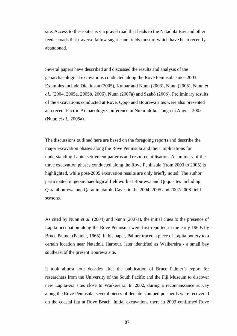
87
site. Access to these sites is via gravel road that leads to the Natadola Bay and other
feeder roads that traverse fallow sugar cane fields most of which have been recently
abandoned.
Several papers have described and discussed the results and analysis of the
geoarchaeological excavations conducted along the Rove Peninsula since 2003.
Examples include Dickinson (2005), Kumar and Nunn (2003), Nunn (2005), Nunn et
al., (2004, 2005a, 2005b, 2006), Nunn (2007a) and Szabó (2006). Preliminary results
of the excavations conducted at Rove, Qoqo and Bourewa sites were also presented
at a recent Pacific Archaeology Conference in Nuku�alofa, Tonga in August 2005
(Nunn et al., 2005a).
The discussions outlined here are based on the foregoing reports and describe the
major excavation phases along the Rove Peninsula and their implications for
understanding Lapita settlement patterns and resource utilisation. A summary of the
three excavation phases conducted along the Rove Peninsula (from 2003 to 2005) is
highlighted, while post-2005 excavation results are only briefly noted. The author
participated in geoarchaeological fieldwork at Bourewa and Qoqo sites including
Qaranibourewa and Qaranimatatolu Caves in the 2004, 2005 and 2007/2008 field
seasons.
As cited by Nunn et al. (2004) and Nunn (2007a), the initial clues to the presence of
Lapita occupation along the Rove Peninsula were first reported in the early 1960s by
Bruce Palmer (Palmer, 1965). In his paper, Palmer traced a piece of Lapita pottery to a
certain location near Natadola Harbour, later identified as Waikereira - a small bay
southeast of the present Bourewa site.
It took almost four decades after the publication of Bruce Palmer�s report for
researchers from the University of the South Pacific and the Fiji Museum to discover
new Lapita-era sites close to Waikereira. In 2002, during a reconnaissance survey
along the Rove Peninsula, several pieces of dentate-stamped potsherds were recovered
on the coastal flat at Rove Beach. Initial excavations there in 2003 confirmed Rove

88
Beach as a post/late Lapita-era site, but the find inspired further investigations and
triggered a series of geoarchaological excavation projects which yielded significant
finds elsewhere along the Rove Peninsula. For example, the discovery of Bourewa
Lapita site and the subsequent identification of other Lapita-era sites in the area like
Qoqo, Waikereira, Jugendar�s Farm and Tomato Patch (Kumar and Nunn, 2003;
Kumar et al., 2004).
5.3.1 Phase 1 excavations at Rove Beach and Bourewa settlement
The first phase of geoarchaeological excavations along the Rove Peninsula
commenced at Rove Beach in December 2003 (Kumar and Nunn, 2003). The Rove
Beach site is located at the northern tip of the former Rove Island bordered to the
northeast by mangroves and on the west by an extensive coral reef (Figure 5.2A).
During Lapita times, Rove was an offshore island completely separated from
Vusama Island (Figure 5.2B). Toward the end of the Lapita era, Rove was attached

89
to Vusama as a result of sea-level fall, increased sedimentation and mangrove
expansion. Today the site is heavily eroded with mostly notched-rim potsherds
recovered during the 2003 excavation season. Radiocarbon dates indicate that Rove
Beach was occupied around 750�550 BC (2700-2500 cal BP), which makes it a
late/post Lapita site. At the time of its Lapita occupation, the Rove settlement would
have been established on an offshore island that was at least 1 km2 in area (Nunn,
2005).
During excavations at Rove Beach in 2003, a reconnaissance along the rest of the Rove
Peninsula shoreflat led to the discovery of the Bourewa site. Four test pits were dug at
Bourewa site at that time and preliminary results revealed significantly high
proportions of dentate-stamped and decorated potsherds with Western Lapita motifs
and dates ranging from at least 1220-970 BC (3170-2920 cal BP) (Nunn et al., 2004).
Based on these finds and the general features of the site, it became clear that Bourewa
was a very special Lapita-era site in Fiji, hence, the need for more extensive
excavations and detail analysis of its contents.
5.3.2 Phase 2 excavations at Bourewa settlement, Qaranibourewa and
Qaramatatolu Caves and Qoqo Island
The second phase of fieldwork conducted in November-December 2004 targeted the
area�s major cave sites � Qaranibourewa and Qaramatatolu and included surveying and
delimiting the Bourewa site by test excavations and surface collections (Figure 5.3).
Test excavations were conducted on nearby Qoqo Island, another Lapita-era site on the
Rove Peninsula (Nunn et al., 2006; Nunn, 2007a).
The Qaranibourewa Cave is located approximately 200 m inland east of the Bourewa
Lapita site. Although there were no traces of human occupation there earlier than AD
1000, the cave is the largest found along the Rove Peninsula. The second largest cave -
Qaramatatolu, was probably inhabited between AD 750 and AD 1250. The shellfish
remains excavated at this cave site indicate it used to be an open-coast location, while
the adjacent mangrove forest was probably formed only within the last few hundred
years (Nunn et al., 2005b).

90
Nunn and others suggest that these caves would probably have been well known to the
Lapita occupants of the Rove Peninsula. The Qaranibourewa Cave in particular might
have been important in the life ways of the Bourewa settlers. The cave could have been
a major source of freshwater for the settlers of Bourewa (Nunn et al., 2005b). While
there are other smaller caves located within the area, potential uses for caves like
Qaramatatolu, for example, could have been as fishing outpost and/or shellfish-
processing sites although such scenarios are conjectural.
Four dentate-stamped potsherds and two notched rims (immediately post-dentate)
recovered during surface collection on Qoqo Island lead to excavations there in
December 2004. Nunn et al. (2006:205) described Qoqo as �a bedrock island (40,000
m2) reaching 32 m above sea level, located in the 7.3 km2 mangrove swamp at the
mouth of the Tuva River�. Five test pits excavated on Qoqo Island confirmed a
Lapita-era occupation site established on a tombolo � a bar of sand and gravel that
connected two separate hills or islands. Radiocarbon dates from both marine shellfish
and charcoal from Pits F1 and R2 indicate that the earliest occupation occurred
sometime between 1000-800 BC (2950-2750 cal BP). It is likely that the tombolo
was sheltered from wave action during Lapita times and later became surrounded by
an extensive mangrove forest.
Shellfish analysis of the Qoqo Island shell assemblage reveal a predation pattern
whereby colonisers initially consumed a range of marine shells but larger shellfish
taxa became less common towards the end of its Lapita occupation. This could mean
that the human colonisers of Qoqo Island were heavily predating on larger shellfish
taxa up to a point where fewer larger taxa were readily available so their diet
broadened and incorporated smaller-sized shellfish taxa. Alternatively, as sea level
was falling and the local environment was changing due to shoaling of the Tuva
Estuary, the diversity and abundance of certain freshwater shellfish taxon like
Batissa violacea was affected by the changing environmental conditions (Nunn et al.,
2006).
Subsequent field surveys and surface collection of potsheds conducted by the
research team along the shoreflat from Bourewa to Natadola beach during Phase 2
resulted in the discovery of three new Lapita-era sites. These are Waikereira (or

91
properly Covularo), Jugendar�s Farm and Tomato Patch (Nunn et al., 2005a; Nunn,
2007a). Nunn (2007a) reported that at Waikereira dentate-stamped potsherds were
collected from the cane fields on the slope at the back of the bay about 2-4 m above
present mean sea level. Dentate-stamped potsherds were also found on slopes about
2-5 m high at Jugendar�s Farm and Tomato Patch. These three smaller bays are
located southeast of the present Bourewa Lapita site.
5.3.3 Phase 3 excavations at Bourewa settlement
In mid-2005, the Phase 3 of geoarchaeological fieldwork was conducted that focused
largely on the Bourewa site itself (Figure 5.3). A review of the main findings of the
mid-2005 excavations is given in Nunn (2007a). According to Nunn (2007a:7), �the
principal aim of the Phase 3 research at Bourewa was to excavate the center of the
site, where the earliest cultural deposits were assumed to exist�. A team of 32
researchers spent four weeks (June-July 2005) excavating the Bourewa site. Nunn
reports that a total of 27 test-pits (each 2 m2) and trenches were excavated within the
�hot spot� region of the site. An area approximately 127 m2 with a total volume of
material of 103 m3 were sieved, sampled and prepared for analyses.
The Bourewa site is a typical �open� Lapita site located on a sand spit at the mouth
of a tidal embayment. The site probably extended about 250-300 m along the coast
and 40-70 m inland. During high tide, the site would be awash and most of the
dwellings were probably built on stilt posts in Lapita times. It appears that the
inhabitants of Bourewa discarded their �kitchen� refuse including the hard parts of
shells, broken pottery, stone tools and artifacts, and shell ornaments into the sea
below (Nunn, 2007a).
The discarded shell remains and other materials accumulated into a huge coastal
shell midden exposed along the fringe of the Bourewa site readily observed today as
protruding out of the beach sand during low tide. The shell midden actually built up
the sea floor to such an extent that it eventually became dry land as sea level fell
(Nunn, 2007a). Kirch (1997) noted that a situation similar to Bourewa occurred at

92
several Lapita-era sites in the Bismarck Archipelago of Papua New Guinea, where
the Lapita people occupied stilt houses or platforms that were built over the lagoon.
The preliminary results and analysis of the mid-2005 field season finds (excluding
shellfish) are described in Nunn (2007a). Some of the significant cultural materials
recovered during the mid-2005 excavation include large quantities of shellfish and
decorated (dentate-stamped, notched rims) and plain potsherds, stone tools and flakes,
shell artifacts and ornaments, and non-human bones. Postholes, earth oven (lovo)
stones, and a single piece of obsidian rock were also recovered. The excavation of
sixteen human burials was also significant, although preliminary analysis of the
skeletal remains suggest they are post-Lapita in age.
The three field seasons of geoarchaeological excavations along the Rove Peninsula
have provided significant clues to the nature of the settlement and behaviour of the
early colonisers of the Rove Peninsula almost three millennia ago. Nunn suggested
that the recovery of dentate-stamped pottery at higher elevations (between 2-5 m) at
Waikereira, Jugendar�s Farm and Tomato Patch might represent population
�overflow� from Bourewa. The single piece of obsidian recovered during the 2005
field season was perhaps transported to Bourewa (Fiji) from the Kutau-Bao mine on
the Talasea Peninsula on New Britain Island, (Papua New Guinea), possibly via the
trading routes that existed during Lapita times implying a journey of at least 3250 km
(Nunn, 2007a).
Nunn (2007a:10) also stated that even though analysis is continuing, �a cursory
examination of the decorated sherds obtained during Phase 3 shows that the site
contains a comparatively high proportion of potsherds with motifs that are normally
found in the Western and Far Western Lapita provinces�. While preliminary petrologic
or mineralogical analyses of the Bourewa potsherds indicate they were manufactured
locally, the motifs on the decorated potsherds suggest they were probably created by
people who were associated with and/or originated from the southeastern Solomons
and/or the Bismarck Archipelago (Nunn pers. comm., 2005).

93
The identification of aroid starch and pollen of taro and lesser yam by Horrocks and
Nunn (2007) also confirmed the suspicion that the Lapita people who colonised
Bourewa must have practiced agriculture/horticulture at some point during their
occupation of Bourewa site. They perhaps consumed starchy root crops and probably
vegetables besides relying heavily on marine food resources for subsistence.
Horrocks and Nunn also note that this is the first evidence of crop (aroid) cultivation
or domestication east of the Vanuatu Archipelago. Similar evidence might be found
in other archaeological sites within Remote Oceania. This particular find adds further
evidence to over three decades of debate on the nature of prehistoric Pacific
subsistence practices in the Remote Oceania region.
While the exploitation of the marine fauna (particularly shellfish resources) and
horticultural practices at Bourewa may provide clues to the life ways of early settlers
of the Rove Peninsula, radiocarbon dates for selected shells and charcoals from
Bourewa, Rove and Qoqo also hint at the nature of the evolution of their settlement
pattern. The radiocarbon dates obtained so far for the Bourewa site point to it as the
�founder settlement site� from which later populations and/or new migrants
expanded into other locations along the Rove Peninsula and possibly other parts of
Viti Levu Island and Fiji (Nunn et al., 2004, 2005a).
According to Nunn, three major periods of settlement have been recognised. These
are characterised by initial colonisation of Bourewa site (around 1200/1100 BC or
3150/3050 cal BP), subsequent �expansion� and/or influx of new migrants into Qoqo
Island (about 1000-800 BC or 2950-2750 cal BP), and �overflow� into Rove Beach
(sometime between 750-550 BC or 2700-2500 cal BP) and nearby bays, Waikereira,
Jugendar�s Farm and Tomato Patch along the Rove Peninsula (Nunn et al., 2004,
2006; Nunn, 2007a).
It appears that the Bourewa site was never re-settled after it was abandoned at the
end of the Lapita period in Fiji. But the discovery of post-Lapita human burials
(subject to revision and re-dating) at the site during the mid-2005 and 2007/2008
field seasons suggest that Bourewa may have been a significant cultural (or spiritual)
site even after the Lapita period. Although this proposition is conjectural, it is
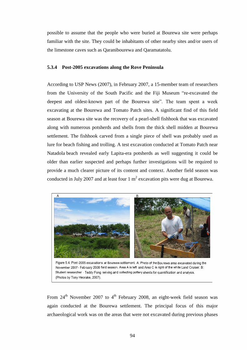
94
possible to assume that the people who were buried at Bourewa site were perhaps
familiar with the site. They could be inhabitants of other nearby sites and/or users of
the limestone caves such as Qaranibourewa and Qaramatatolu.
5.3.4 Post-2005 excavations along the Rove Peninsula
According to USP News (2007), in February 2007, a 15-member team of researchers
from the University of the South Pacific and the Fiji Museum �re-excavated the
deepest and oldest-known part of the Bourewa site�. The team spent a week
excavating at the Bourewa and Tomato Patch sites. A significant find of this field
season at Bourewa site was the recovery of a pearl-shell fishhook that was excavated
along with numerous potsherds and shells from the thick shell midden at Bourewa
settlement. The fishhook carved from a single piece of shell was probably used as
lure for beach fishing and trolling. A test excavation conducted at Tomato Patch near
Natadola beach revealed early Lapita-era potsherds as well suggesting it could be
older than earlier suspected and perhaps further investigations will be required to
provide a much clearer picture of its content and context. Another field season was
conducted in July 2007 and at least four 1 m2 excavation pits were dug at Bourewa.
From 24th November 2007 to 4th February 2008, an eight-week field season was
again conducted at the Bourewa settlement. The principal focus of this major
archaeological work was on the areas that were not excavated during previous phases

95
of fieldwork � these are Areas A and C (Figure 5.4A). Several interesting finds were
also recovered during this fieldwork. These include evidence for stilt platforms, a
separate dumping site for shellfish remains, and a �Lapita jewellery box� containing
shell bracelets and rings. Adzes, axes, stone chisels and a range of animal bones of
dogs, rats and chickens were also recovered. Another significant find was that of a
finely decorated lime-filled dentate-stamped potsherd with designs that suggest close
links with the Bismarck Archipelago of Papua New Guinea (USP News, 2008).
Like the mid-2005 field season, this recent excavation phase also recovered large
volumes of shells. The analysis of these finds is still in progress.
5.4 Field Methods
The following outlines the field methods employed in this study and some of the
factors that can influence the recovery, quantification and analysis of shellfish
remains from the Bourewa site. These include sampling methods (section 5.4.1) and
screen mesh size (subsection 5.4.2) (Nagaoka, 1988). In the lab, the sampled shells
were cleaned, washed and quantified (subsections 5.5.1 to 5.5.4).
5.4.1 Shell sampling
As reported by Nunn (2007a), the mid-2005 excavations in the center of the Bourewa
settlement covered a huge area (126.93 m2) and a considerable quantity of materials
(103 m3) was excavated and recovered. All the excavated materials were dry-sieved
and the artifacts, potsherds and shells, collected, sampled and bagged.
Of the 27 pits (and trench extensions) excavated during the mid-2005 field season,
shellfish taxa from only 5 pits (X1, X2, X3, X5 and X6) were randomly sampled for
identification, classification, quantification and analysis. These five pits were dug
just behind the modern beach berm at Bourewa site where a large proportion of
Lapita potsherds with Western motifs was recovered. Ideally, all the shellfish taxa
excavated from the Bourewa site should be analysed and reported, but owing to their
large quantity, only randomly sampled specimens were obtained for quantification
and analysis.

96
A key to selecting the shellfish sample for this study is its representation of the entire
shell assemblage so that appropriate inferences can be made. Each test pit was
sampled to obtain a representative quantity of shells that can be analysed to minimise
the effect of variations in sample sizes (Grayson, 1984). All the shellfish taxa within
a particular spit (arbitrary 10-cm level) by pit were initially combined then divided
into four equal parts. Each group was numbered I, II, III and IV and a number was
randomly picked. The selected cluster of shells was then bagged and appropriately
labeled while the rest of the shells were later discarded at the site. Thus 25% of the
shells in each spit by pit were sampled for analyses.
The bagged shells were properly packed and transported to the USP�s Marine Studies
Program postgraduate laboratory for cleaning and prepared for analysis. Four student
assistants washed and cleaned the shells with soft brush (or toothbrush) in the
laboratory. The cleaned shells were dried and repacked in newly labeled plastic bags.
For each spit by pit, gastropods and bivalves were bagged separately and
appropriately labeled to facilitate identification, classification and quantification.
5.4.2 Sieving
Throughout the entire field season in mid-2005, a 10-mm mesh size was used to
recover the shells and other materials. This strategy is employed to ensure
consistency and avoid analytical discrepancies because, as Nagaoka (1988) noted,
the utilisation of different screen sizes to recover faunal remains can influence the
assessment of taxonomic richness and diversity due to differential recovery rates.
Nagaoka also stated that larger screen sizes tend to recover a smaller amount of
faunal materials, favour larger animals, and only fewer shellfish taxa can be
recovered.
In her experiment on the effects of differential recovery techniques of Pacific Island
fish remains, Nagaoka (2005) noted that fish remains may be affected by individual
body size, the general body size of individual families, as well as the shape of
particular skeletal elements. Generally, larger individuals have greater chance of
recovery, while some elements for particular taxa are more susceptible to increased

97
fragmentation thus affecting the element�s size, shape, and identifiability. Aspects of
the archaeological taphonomic history, such as differential preservation or
fragmentation are also important.
For the mid-2005 excavations at Bourewa, a 10-mm mesh sieve (1 cm2) was used all
throughout the entire field excavation season. No wet sieving or switch in screen size
was conducted on the faunal remains. As with the field excavations at Rove Beach
and Qoqo Island, the same mesh (size) sieve was utilised to allow for comparisons
between the three sites and limiting biases or other complicating factors. All the
materials excavated at the Bourewa site were dry sieved and the shell remains
bagged and appropriately labeled by spit and pit. Inevitably any shellfish taxa that
are smaller than the mesh size used would not be recovered during the sieving
process but because the shell taxa are relatively large specimens and well intact, this
is not of particular concern for the analyses.
5.5 Laboratory Methods
The team of excavators including the author sampled the shells on site but no field
specimen catalogue was on hand so all the shells were brought back to the University
of the South Pacific Marine Studies Laboratory for identification, classification and
analysis. The shellfish specimens were compared and verified with a shellfish
reference collection held in the University Herbarium. A specimen collection of
each shellfish species from the Bourewa shell assemblage was also made for
reference purposes. The collection is kept in safe storage at the Marine Studies
Program Laboratory, USP.
The shells were identified by the author with the assistance and guidance of Mr
Johnson Seeto of the Institute of Marines Resources (IMR) at the University of the
South Pacific (USP). General texts such as, �Marine Shells of the Pacific�
(Cernohorsky, 1972), �New Zealand Shells� (Child, 1974), �Compendium of Sea
Shells� (Abbott and Dance, 1982, 2000), �Shells� (Claassen, 1998), �Zooarchaeology�
(Reitz and Wing, 1999), �Quantitative Units and Terminology in Zooarchaeology�
(Lyman, 1994b), and other shell references from the Fiji Islands held at the PIMRIS

98
(Pacific Islands Marine Resources Information System) Library of USP were used to
identify, classify, quantify and analyse the shellfish taxa.
Estimates for MNI were based on paired elements (valves) and non-repetitive elements
(NREs) for both bivalves and gastropods. Shell weight data were recorded for all shell
specimens (Number of Identified Specimens - NISP) of each species by spit and pit.
Shell-size measurements were conducted on the three most abundant shellfish sampled
from Pits X2 and X3 � Codakia punctata, Fimbria fimbriata and Strombus gibberulus
gibbosus.
The utility of NISP, MNI, weight and size was conducted in the lab to quantify the
shellfish taxa at Bourewa. The Bourewa shell data � MNI, NISP, Weight, and size
quantification are provided in Appendix 2 on the CD-Rom submitted with this thesis.
These quantification methods are appropriate and versatile for counting shellfish
species from most archaeological sites (Glassow, 2000). Although Grayson (1984)
suggested that these quantification methods can be problematic if used on their own,
when utilised together they offer an opportunity to address many issues like the
relative importance of certain taxa rather than a simple value of absence or presence
(Fitzpatrick and Kataoka, 2005).
Shellfish classification was done to species level where possible, or genus or family
if this was not. While all the shells were weighed, the number of identifiable
specimens (NISP) and minimum number of individuals (MNI) were quantified and
ranked in order of abundance. Ranking the shellfish taxa generally indicate the type
of shellfish collected and the habitats exploited and targeted by shellfish collectors.
Inferences were then made regarding the foraging strategies used by the shellfish
collectors and testing of assumptions as derived from optimal foraging models
(Bedford, 2006).
5.5.1 NISP (Number of Individual Specimens) quantification
Since NISP is a basic quantification (Lyman, 1994b), all the shellfish specimens
from each identified species (including fragments) were appropriately counted and

99
weighed. Where it is not practically possible to identify any shell fragment(s), these
were categorised as �unidentifiable specimens�. Only NISP counts and weights were
done for shell fragments.
The utilisation of the NISP method in archaeological studies in Oceania and the Fiji
Islands is not uncommon. The recent Naitabale study (Moturiki Island, central Fiji)
employed NISP to calculate the relative frequency of different shellfish taxa present at
the site (Nunn et al., 2007). Thomas et al. (2004) also utilised the number of individual
specimen counts and relative abundances to analyse the shellfish taxa from Qaranilaca
Cave on Vanuabalavu Island, Fiji. In her synthesis of archaeofaunal remains from
excavated Lapita sites on different Pacific Islands, Nagaoka (1988) reported five study
sites in the Solomon Islands, New Caledonia and Fiji where she conducted the NISP
method to quantify their shellfish remains.
In Yuen�s (2005) preliminary shell analysis of Pit F1 excavated at Qoqo Island in
2004, a count of all identifiable fragments and whole shells was conducted. Her results
reveal a strong correlation between NISP and MNI proportions where those species
that had high NISP counts also had similarly high MNI values. Hence, as Grayson
(1984) noted, NISP estimates may provide a rough proxy for MNI counts. Thus
Nagaoka (1988) stated that shellfish analysts should report NISP together with MNI
counts when quantifying faunal remains.
5.5.2 MNI (Minimum Number of Individuals) quantification
The MNI count for gastropods is straightforward but for bivalves the right and left
sides (valves) were initially distinguished using their characteristic features and
NREs like umbos and hinges before to each valve was counted. All the quantified
shellfish taxa were then recorded on an Excel spread sheet. For purposes of weight
quantification, a digital scale was used to weigh the different shellfish species (NISP)
including fragments by spit and pit.
Mason et al. (1998:308-309) stated that in order to calculate MNI for bivalves, �the
most accurate approach is to identify right and left hinges or umbos separately and
quantify the higher of the two counts, or to count the total number of hinges or umbos

100
per taxon and divide the sum by two�. Bivalve shells were separated into left and right
sides for each identified species (or genus) and the higher count out of the two valves
taken to estimate the MNI. As an example, if there are 4 left valves and 3 right valves
of the bivalve Codakia punctata, the MNI is 4. The sum of individual left and right
valve counts is also recorded in the MNI column.
Since the Bourewa site was dug in arbitrary units (10-cm spits) rather than aggregating
only natural stratigraphic layers, there are a number of bags from the same spits so the
highest value for each taxon per spit is recorded. If spits 1, 2 and 3 are from the same
stratigraphic layer and spit one has 4 right and 4 left valves of Codakia punctata, spit
two has 1 right and 4 left and spit three has 3 right and 2 left valves. The MNI is not
4+4+3; it is 10 (4+4+2) as the sum of the left valves in the three spits are higher than
the right valves (Katherine Szabó pers. comm., 2005).
Additionally, as Katherine Szabó (pers. comm., 2005) suggested and used in her
analysis of the Kulu shellfish assemblage, Fiji Islands, shell fragments of known
species without NREs were not counted for MNI purposes but were recorded as �p�
for present in the MNI column and then assigned a value of �1� (or whatever it is) in
the NISP column. For asymmetrical bivalves like Chamidae, Spondylidae or
Ostreidae, their MNI is quantified as �bottom� or �top� instead of �right� or �left�
valves respectively, as in other symmetrical bivalves and given an appropriate value as
NISP. Where either the bottom or top valve cannot be readily determined, their MNI
are also recorded as present (p) and an appropriate value given for NISP.
Several archaeological studies in Fiji have utilized the MNI method to analyse shellfish
remains. These include Best�s (1984) analysis of two sites on Lakeba Island, eastern
Fiji (sites 101/7/196 and 101/7/197) and Thomas et al. (2004) who conducted MNI
analysis on the shellfish remains excavated from a large sea cave - Qaranilaca Cave on
the southern tip of Vanuabalavu Island. In their study of marine (shellfish) resource
depression at Natia Beach, Nacula Island, western Fiji, Morrison and Cochrane (2008)
also utilised MNI data to test if resource depression can be traced by a decrease over
time in the ratio of large to small-bodied prey species.

101
5.5.3 Weight quantification
Many archaeologists and researchers still use the weight method to quantify and
analyse variability in shellfish assemblages and trace resource exploitation. For
example, Amesbury (1999) used shellfish weight to understand species composition of
the archaeological marine shell assemblages in Guam where she noted that changes in
species composition were linked to environmental changes in Tumon Bay and East
Agana Bay. At Qoqo Island, Nunn and others also conducted weight analysis to
demonstrate that larger marine shellfish species were abundant in the lower levels but
were few in the upper levels (Nunn et al., 2006).
In this study, both MNI and NISP were weighed including shell fragments. The shell
weight for each taxa is then recorded in the appropriate column of the shell
quantification sheet and then recorded on an Excel spread sheet.
5.5.4 Shell size measurement
Shell-size measurements were conducted only on intact specimens of the three most
abundant shellfish species of the Bourewa assemblage. These are Codakia punctata
(MNI = 7562), Fimbria fimbriata (MNI = 1005) and Strombus gibberulus gibbosus
(MNI = 893) (Figures 5.5A, B and C). Appendix 6 on the CD-Rom provides the
shell-size measurement data for the three most abundant taxa at Bourewa settlement.
A digital caliper was used to measure their dimensions. Fragmented shellfish
specimens of these three species were not measured.
The shellfish diagrams illustrated in Claassen (1998:19, 109 and 110) provide useful
guides for shell-size measurements for these shellfish taxa. For Strombus gibberulus
gibbosus, both aperture height and shell height were measured but only the latter
dimension was considered in this analysis. The right side and left sides of the
bivalves Codakia punctata and Fimbria fimbriata were initially differentiated before
their dimensions were recorded. The valve height and valve length of the two
bivalves were measured. In this analysis, valve height was not considered. Generally
the cockle-shaped bivalve families like Veneridae, Cardiidae, and Lucinidae have
their hinges and umbos facing in towards each other. Left valves have their umbos,

102
hinges slanting in towards the right, while right valves have their umbos, hinges
slanting left (Katherine Szabó pers. comm., 2005).
Swadling (1986) also employed shell size measurements to examine changes in the
shellfish sizes of excavated molluscs over time at the Reef/Santa Cruz sites � SE-RF-2,
SE-RF-8 and SE-RF-6. In her analysis of site SE-RF-2, Swadling demonstrated size
reduction for two gastropods and one bivalve species. She noted that proportionately
older, more mature and larger species of Trochus niloticus and Anadara antiquata
were recovered in the lower layer (�Layer 2�) compared to the upper layer (�Layer 1�)
while Tectus pyramis also showed progressively younger individuals throughout the
site�s occupation. Archaeological studies in Fiji that have utilised shell-size
measurements to understand human predation on shellfish resources include Nunn et
al. (2007) and Morrison and Cochrane (2008).
Although it is inevitable that over time, even intact shells will develop chipping
along their edges, it is important that shellfish specimens be intact in order to
accurately measure them otherwise the results could become skewed. The
measurement of fragmented shells will produce relatively lower size (average) values
as compared to intact specimens and subsequently result in lowering of the overall
shell-size mean value. Thus, as is the case here, shells that were highly chipped or
broken were not measured. All measurements were done for intact shells only and
recorded on an Excel spread sheet. A digital caliper proved more practical than
analogue ones for these kinds of measurements due to their accuracy and
appropriateness for measuring shells that are generally irregular in shape.
For purposes of this particular size analysis, only the shellfish specimens from Pits
X2 and X3 were sampled for shell-size measurements since these pits were securely
dated and well stratified: for example, Pit X2 at 90 cm (2817-2696 cal BP) and 20
cm (2705-2358 cal BP) depth and Pit X3 at 70 cm (2826-2605 cal BP) and 30 cm
(2877-2700 cal BP) depth. Nunn (2007a) also dated charcoal and marine shells at the
lower depths (> 120 cm) of Pits X2 and X3 and his dates reveal a range from about
3140-2867 cal BP to 2758-2526 cal BP. Since these dates were obtained from
specific layers of each pit, any significant changes in shellfish size within these
layers can be pegged to certain time periods and be compared.

103
The mean size of shellfish specimens for the upper and middle layers of Pits X2 and
X3 were calculated and compared. It is plausible to suggest that any changes or
differences in the shell size between these two layers might be attributable to human
predation and/or environmental factors (Nunn et al., 2007). As Morrison and
Cochrane (2008) stated, any changes in shellfish morphology are normally due to the
possible impact of human predation on shellfish resources. Thus, any significant
change in the mean shell size within these different layers can be verified and
explained as associated with predation or environmental change.

104
5.5.5 Summary
According to Glassow (2000:413), MNI is considered most useful �for developing
measures of collecting effort especially if NREs are well preserved� and weight is
�most convenient for developing measures of relative dietary importance of shellfish
taxa, especially if samples from a site are small and dispersed or if shells are highly
fragmented or low in density�. Both MNI and weight have equal utility and each
method can be understood by considering the nature of the shell assemblage and the
particular research questions being asked. The weight approach is most reliable if
assemblages consist of highly fragmented shells while MNI is more appropriate if
shells are in large fragments and quantities per excavation unit are not too high.
While MNI and weight measurements both have their strengths and weaknesses for
shell analysts, MNI is used for most of the analyses in this study. Mason and others
recognised that MNI provides a more reliable and valid measure than weight and
contend that count data is most appropriate for addressing taxonomic abundance of
shellfish or fauna from an archaeological context (Mason et al., 2000:760).
Overall, the utilisation of MNI, NISP, weight or size to assess the Bourewa shell
assemblage can assist in measuring relative abundance of shellfish taxa, identify and
understand human subsistence practices, and indicate palaeoenvironmental conditions
during Lapita times. These methods have been utilised to determine species
abundance, species composition, the relative frequency of different shellfish taxa,
evaluate habitat exploitation, and examine the influence of environmental factors like
sea-level and climate change. These non-human factors can also influence changes in
species distribution, sedimentation, coastal progradation or erosion, mangrove
development and the evolution of coastlines.

105
Chapter 6. Results and analysis
6.1 Introduction
This chapter presents the results and analysis of the shells sampled and quantified for
the five test pits (X1, X2, X3, X5 and X6) excavated at Bourewa settlement during the
mid-2005 field season. Data for the shellfish analyses are provided in Appendices 1 to
10 on the CD-Rom supplied.
The stratigraphic profiles of the five test pits at Bourewa are shown in section 6.2
with diagrams (Figures 6.2A-E and 6.3). This chapter also describes their content and
context and illustrates where radiocarbon dates were derived for each test pit
(subsections 6.2.1 to 6.2.5). Section 6.3 describes the radiocarbon chronology of the
Rove Peninsula and presents the radiocarbon dates obtained from shallow marine
shells by the author for Pits X2 and X3. Section 6.4 presents the shellfish
quantification and analysis of the Bourewa shells based on MNI, NISP, and weight
quantifications and size measurements.
Section 6.5 outlines and describes the three analytical zones (A, B and C) delineated
for the Bourewa shell assemblage based on near-equal shell weight distribution for
each zone. The results of shellfish habitat usage and shellfish MNI analysis per zone
for different shellfish habitats are presented in subsections 6.5.1 to 6.5.3.
Section 6.6 presents the shellfish species and habitat analyses based on the
application of foraging theory models. The objective of this section is to assess the
changes in foraging efficiency within different shellfish habitats. Section 6.7 presents
the analysis of shellfish diversity and abundance by measuring diet breadth and
NTAXA, evenness, and relative abundances.
6.2 Stratigraphic Profiles of Pits X1, X2, X3, X5 and X6
As illustrated in Figure 6.1C, the five test pits described here were excavated along
the axis of the former Bourewa sand spit where a thick shell midden occurred. These
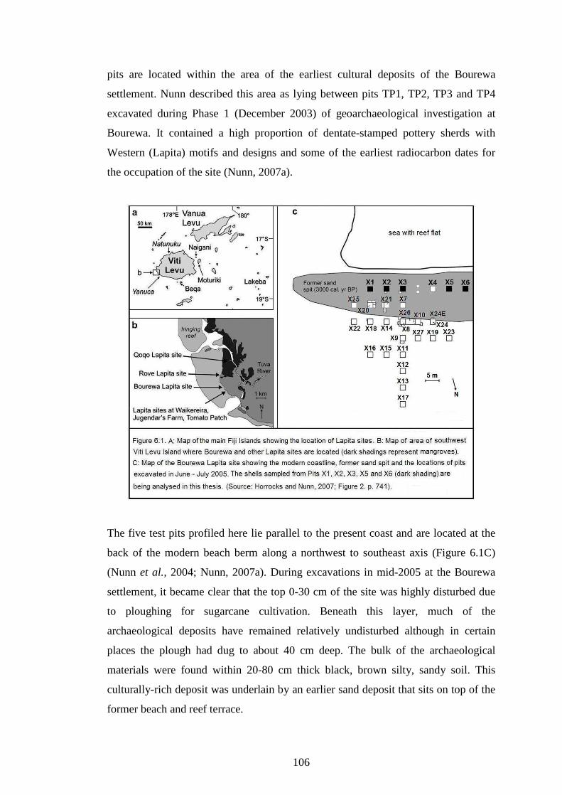
106
pits are located within the area of the earliest cultural deposits of the Bourewa
settlement. Nunn described this area as lying between pits TP1, TP2, TP3 and TP4
excavated during Phase 1 (December 2003) of geoarchaeological investigation at
Bourewa. It contained a high proportion of dentate-stamped pottery sherds with
Western (Lapita) motifs and designs and some of the earliest radiocarbon dates for
the occupation of the site (Nunn, 2007a).
The five test pits profiled here lie parallel to the present coast and are located at the
back of the modern beach berm along a northwest to southeast axis (Figure 6.1C)
(Nunn et al., 2004; Nunn, 2007a). During excavations in mid-2005 at the Bourewa
settlement, it became clear that the top 0-30 cm of the site was highly disturbed due
to ploughing for sugarcane cultivation. Beneath this layer, much of the
archaeological deposits have remained relatively undisturbed although in certain
places the plough had dug to about 40 cm deep. The bulk of the archaeological
materials were found within 20-80 cm thick black, brown silty, sandy soil. This
culturally-rich deposit was underlain by an earlier sand deposit that sits on top of the
former beach and reef terrace.

107
The excavations at Bourewa settlement so far have revealed the character and
context of the site, particularly in terms of preservation conditions and changing site
use, expansion and development in association with the possible influx and out-
migration of the Lapita people at the site. Some significant finds include the earliest
and most extensive collection of Lapita potsherds with a high proportion of Western
(Lapita) motifs, a range of stone tools and shell artifacts, other exotic materials like
obsidian rock (sourced from Talasea mine in Papua New Guinea) and possibly a
separate shell midden �dumping area�. Several post-hole features associated with
Lapita culture and settlement patterns as observed in Near Oceania by Patrick Kirch,
and human remains (though post-Lapita in age) were also excavated (Nunn, 2007a).
A total volume of about 23.4 cubic meters (m3) of material was excavated from these
five pits during the mid-2005 field season. The location and stratigraphy of the five
test pits at Bourewa settlement, their composition, context, and the conditions of
removal are presented in Figures 6.2A-E.
Each test pit was 2 m2 and 4 meters apart except between Pits X3 and X5, which is
separated by 15 m (Figure 6.1C). Pit X4 is not included in this particular analysis.
Although the pit profiles are not drawn to scale, Figure 6.3 illustrates the generalised
stratigraphic sections of the five test pits and how their layers are linked based on
their character and content.

108

109

110

111
6.2.1 Stratigraphy of Pit X1
Pit X1 has at least four stratigraphic layers of varying composition and content
(Figure 6.2A). Underlying the top three cultural layers is a sterile layer of beach
sand, compacted in places. While the top layer (L.I) (0-18 cm) is composed of dark
brown silt, some occasional shells and rootlets, it appears to be disturbed as a result
of ploughing for sugarcane cultivation. The second layer (L.II) (18-32 cm) is
undisturbed and consists of dark brown silt with shells accounting for about 65% by
volume. The third layer (L.III) (32-58 cm) is composed of light brown silty sand, and
shells account for about 75% by volume. The fourth layer (L.IV) (58-127 cm) is
mostly yellow (palaeo-beach) sand with only a few shells. This layer is underlain by
compacted calcareous bedrock.
A charcoal sample (Wk 17541) that was recovered from Pit X1 at a depth of 105 cm
yielded a calibrated radiocarbon date range of 2710-2350 cal BP (Nunn, 2007a).
6.2.2 Stratigraphy of Pit X2
Pit X2 consists of three stratigraphic layers (Figure 6.2B). The top layer (L.I) (0-37
cm) is made up of dark brown silt with occasional shells and rootlets. Like Pit X1,
the top 20 cm of this layer is disturbed by ploughing for sugarcane. The middle layer
(L.II) (37-93 cm) contains the bulk of the shells accounting for 80% by volume with
a matrix composed of dark brown silty material. The bottom layer (L.III) (93-130
cm) is predominantly yellow sand with occasional shells and is part of the former
beach sand.
Three radiocarbon dates have been determined from three marine shell specimens at
different depths for Pit X2 � one by Patrick Nunn and the other two by the author.
These dates were obtained from three marine shell samples � Wk 17548 (2760-2520
cal BP), Wk 20281 (2870-2690 cal BP) and Wk 20282 (2850-2670 cal BP) (Nunn,
2007a). The OXCal plots for shell samples Wk 20281 and Wk 20282 are provided in
Appendix 1 (CD-Rom supplied).
112
6.2.3 Stratigraphy of Pit X3
Pit X3 consists of three stratigraphic layers (Figure 6.2C). The top layer (0-49 cm) is
composed of dark brown silt with occasional shells and rootlets. Again, the top 20
cm of layer I (L.I) is relatively disturbed. The middle layer (L. II) (49-96 cm)
contains bulk of the shells making up 80% by volume. The bottom layer (L. III) (96-
160 cm) is mostly sterile yellow sand with small number of shells.
Six radiocarbon dates were determined from five shallow marine shell specimens and
a charcoal sample from Pit X3 � two by the author and four by Patrick Nunn. These
are samples � Wk 17542 (3150-2860 cal BP), Wk 17546 (2780-2530 cal BP), Wk
17573 (3070-2850 cal BP), Wk 17549 (2880-2700 cal BP), Wk 20283 (2830-2600
cal BP) and Wk 20284 (2880-2700 cal BP) (Nunn, 2007a). The OXCal plots for shell
samples Wk 20283 and Wk 20284 are provided in Appendix 1 (CD-Rom supplied).
6.2.4 Stratigraphy of Pit X5
Pit X5 is relatively shallow and consist of at least three stratigraphic layers or
possibly four (Figure 6.2D). The top layer (L.I) (0-19 cm) consists of dark brown silt
with occasional shells and rootlets. The middle layer (L.II) (19-36 cm) comprises
70% shells and is composed of dark brown silt material. A narrow band of dark
brown silty material (about 2 cm thick) lies between the middle and bottom layers
(L.IIa). The latter layer (L.III) is composed mostly of yellow sterile sand which is
compacted in places. No radiocarbon dates were obtained from Pit X5.
6.2.5 Stratigraphy of Pit X6
Pit X6 consists of possibly four layers. The top layer (L.I) (0-20 cm) consists of
mostly dark brown silt with occasional shells. The middle layer (L.II) (20-36 cm)
also contains dark brown silty material and about 70% of shells by volume. As
observed in Pit X5 a narrow band of dark brown silt (L.IIa) (about 2 cm thick) is
embedded between the second and the bottom layers of Pit X6. Radiocarbon ages of
2940-2740 cal BP (Wk17968) and 2850-2670 cal BP (WK17547) were determined
for two marine shellfish samples recovered from Pit X6 at depths of 68 cm and 94

113
cm respectively (Nunn, 2007a). A possible posthole feature is exposed in the south
wall of Pit X6 (Figure 6.2E).
In both Pits X5 and X6 there is a relatively darker layer (L. IIa) which clearly
separates both layer II and layer III. This particular layer is not present in the other
pits (X1, X2, and X3). In Pit X6, there is a post-hole feature which may lend support
to the idea that the settlers of Bourewa inhabited houses or platforms that were built
on stilts (Nunn, 2007a). An Atactodea striata shell excavated from the posthole was
dated to around 2940-2740 cal BP.
6.3 Chronology of the Rove Peninsula and Radiocarbon Dates for Pits X2
and X3
Archaeological evidence for human colonisation of the Fiji Islands prior to 3000 cal
yrs BP was long regarded as equivocal although recent published dates for the
Bourewa settlement suggest it may date from as early as 3170-2920 cal BP (1220-970
BC) (Nunn et al., 2004; Nunn, 2005).
Prior to the discovery of the Bourewa settlement, it appears that the Lapita sites on
Naigani and Moturiki islands contained the earliest human settlement dates in the Fiji
Islands (Nunn et al., 2004). But with the publication of recent radiocarbon dates for the
Bourewa site, this has seemingly pushed back the earliest known date for human
occupation of the Fiji Islands by over a century more than previously known (Nunn,
2005, 2007a).
6.3.1 Chronology of the Rove Peninsula
The radiocarbon dates obtained during geoarchaeological field excavations (Phases 1-
3) along the Rove Peninsula has now placed Bourewa as the �probable founder�
settlement site for the Fiji Islands. These dates demonstrate that they are earlier than
any other dated Lapita sites in Fiji. Archaeological evidence from Bourewa settlement
also reveal a significant proportion of Far Western (Lapita) ceramic decorative styles
and forms and an obsidian rock traced to the Talasea mine on New Britain Island,
Papua New Guinea (Nunn et al., 2004, 2005a; Nunn, 2007a). The radiocarbon dates

114
and cultural evidence from the Bourewa site also support the suspicion that Fiji was
perhaps settled only slightly later than the Reef/Santa Cruz Group and Vanuatu.
At least three major phases of occupation were associated with the human
colonisation of the Bourewa settlement, referred to as Periods A, B and C (Figure 12
in Nunn, 2007a:173 and Table 6.1). Nunn also suggested that these periods were
generally characterised by population increase and/or expansion of the settlement,
influx of new migrants and/or movement of people from elsewhere, the settlement of
other nearby sites, and the introduction of horticultural/agricultural crops and
innovations, and Eastern Lapita motifs to Bourewa. The Lapita occupation period at
Bourewa spanned almost 500-600 years.
More than 24 radiocarbon dates were obtained from Bourewa settlement and they
generally fall within the three major periods of occupation of the Bourewa sand spit
and the settlement of other nearby locations. According to Nunn (2007a), the earliest
stage of settlement (Period A) was marked by the arrival of the initial settlers perhaps
on the first canoes who occupied the centre of the Bourewa sand spit some time
between 3139-2795 cal BP (2089-845 BC).
Around 2850 cal BP (900 BC) (Period B), the settlement expanded along its length
both southeast and northwest along the axis of the Bourewa sand spit. In a broad
sense this phase also marked the initial settlement of Qoqo Island by new migrants
and/or Bourewa settlers sometime about 2950-2760 cal BP (1000-810 BC) (Nunn et
al., 2006). It is also characterised by the introduction and perhaps intensification of
taro and lesser yam cultivation and a predominance of Eastern Lapita style motifs at
Bourewa settlement (Nunn, 2007a).
The Rove Beach site, which was established on an offshore island during Lapita times
was settled perhaps around the late/post Lapita period about 2710-2510 cal BP (750-
550 BC). Rove was occupied shortly after Qoqo Island. Further settlement expansion
occurred within the Bourewa site particularly along its periphery during Period C. It
was perhaps during this stage also that Bourewa settlement experienced the overflow
of people into adjacent bays like Waikereira, Jugendar�s Farm and Tomato Patch.
Dentate-stamped potsherds were also recovered from Waikereira, Jugendar�s Farm and

115
Tomato Patch � these are suspected to be mostly late/post Lapita sites (Nunn et al.,
2004; Nunn, 2007a).
6.3.2 Radiocarbon Dates for Pits X2 and X3
Four additional radiocarbon dates from shallow water marine shellfish specimens of
Trochus niloticus were derived from various depths of Pits X2 and X3 (Table 6.2).
These specimens were sent by the author to the University of Waikato Radiocarbon
Dating Laboratory, New Zealand in 2006 for radiocarbon age determination. The
shells were physically and chemically pretreated before dating. They had their
surfaces cleaned, washed in an ultrasonic bath and tested for recrystallisation
(aragonite). They were then washed using 2 moles of diluted Hydrochloric acid for
180 seconds, rinsed and dried (Alan Hogg pers. comm., 2007).

116
The selected shellfish specimens, two from each pit, were obtained from both the
middle and upper layers since the lower layers of the shell midden for both pits were
already sufficiently dated by Professor Patrick Nunn (Table 2 in Nunn, 2007a:174).
Samples Wk 20282 and Wk 20281 were taken from Pit X2 at depths of 20 cm (2705-
2358 cal BP) and 90 cm (2817-2696 cal BP) and samples Wk 20284 and Wk 20283
were obtained from Pit X3 at depths of 30 cm (2877-2700 cal BP) and 70 cm (2826-
2605 cal BP) respectively. The results from these four shells seem to support the
broad interpretation for the occupation periods of the Bourewa sand spit except Wk
20284 (2877-2700 cal BP). The earlier end of this range may fall into Period B (or
middle layer).
Table 6.2 provides the radiocarbon dates for the four shell samples obtained from
various levels of Pits X2 and X3. For details of calibration and other parameters
used, like OXCal plots for shell samples Wk 20281, Wk 20282, Wk 20283 and Wk
20284, refer to Appendix 1 on the CD-Rom supplied. These were provided by
Professor Alan Hogg of the Waikato Radiocarbon Dating Laboratory. The four
radiocarbon dates for Pits X2 and X3 fall within the age range obtained for the
Bourewa settlement by Nunn (2007a).
6.4 Shellfish Quantification and Analysis
The following subsections present the results and analysis of the shell count (MNI
and NISP) and weight for Pits X1, X2, X3, X5 and X6 and the shell size
measurements for the three most common shellfish species for Pits X2 and X3. The
data for these analyses are provided in Appendices 2, 3 and 4 on the CD-Rom.
6.4.1 MNI, NISP and Weight
Tables 6.3 and 6.4 present the MNI, NISP and weight analysis and the relative
frequencies of both the bivalves and gastropods present in the Bourewa shell
assemblage. Data on which these analyses are based are provided in Appendices 3
and 4 on the CD-Rom.

117
After identifying and classifying the shells based on their non-repetitive elements
(NREs) and other characteristic features, the different shellfish species were then
quantified and weighed. For bivalves, the right and left valves were quantified and
weighed separately, while for gastropods, quantification and weighing were
straightforward.
For the sampled Bourewa shells, bivalves account for 16 families and 25 species
while gastropods comprise 25 families and 83 species. The entire assemblage
comprises a total of 41 families and 108 species of which five gastropod families
contribute about 50% of the total number of shellfish taxa present. These are
Turbinidae, Strombidae, Cypraeaidae, Muricidae and Conidae. Although gastropods
account for the most rich and diverse species they are significantly fewer compared
to bivalves in terms of abundance (MNI, NISP) and weight.
Overall the sampled shell assemblage contains about 255 kg of identifiable shells
comprising 21,505 NISP and 11,426 MNI. Unidentifiable shell specimens amount to
198 g.
Bivalves comprise the bulk of the shellfish assemblage, accounting for 81% MNI,
90% NISP, and 83% of the total weight, while gastropods make up the rest. Of all the
bivalves sampled and quantified, the most abundant species is Codakia punctata
comprising about 81% MNI, 79% NISP and 65% weight of the entire shell
assemblage. Other important bivalves such as, Fimbria fimbriata, Anadara antiquata
and the freshwater shellfish Batissa violacea, respectively account for 17% MNI,
17% NISP and 27% weight.
While the remaining bivalve taxa represent less than 2% MNI, 4% NISP and 8%
weight, the following shellfish taxa were undoubtedly consumed regularly by the
inhabitants of Bourewa. These include a number of Anadara and Codakia species,
Periglypta puerpera, Gafrarium tumidium and a range of common rock oysters.
These shellfish species are still commonly sold in markets and consumed in villages
Fiji wide.

118
Although gastropods comprise fewer than 20% of the total shellfish assemblage,
three species (Strombus gibberulus gibbosus, Trochus niloticus and Turbo
chrysostomus) account for more than half of all gastropods quantified. Collectively
they account for 63% MNI, 63% NISP and 59% weight of all gastropods present in
the shell assemblage.
Despite their relatively low abundances, some large-sized gastropods were obviously
targeted due to their edible meat. They include those of the families Turbidae (e.g.
Turbo crassus and Turbo setosus), Strombidae (e.g. Strombus luhuanus and Lambis
lambis), Trochinidae (e.g. Trochus radiatus and Trochus pyramis), Muricidae and
Conidae (e.g. Conus eburneus and Conus marmoreus).
A significant find during this field season, as in subsequent excavation phases, was
the recovery of two shellfish species of the Tridacnidae family � commonly referred
to as giant clams due to their relatively large size. These are Tridacna gigas and
Hippopus hippopus. The meat of an individual animal would be sufficient to feed a

119
large-sized family or even a dozen or more people. Currently these bivalve species
are locally extinct (extirpated) in the Fiji Islands and it was only recently that efforts
were made to successfully re-introduce and breed them in Fiji (Leon Zann pers.
comm., 2005). While Tridacna gigas and Hippopus hippopus are extirpated, other
clam species like Tridacna maxima and Tridacna squamosa can still be found on
most reefs in Fiji, including on the Rove Peninsula fringing reef.
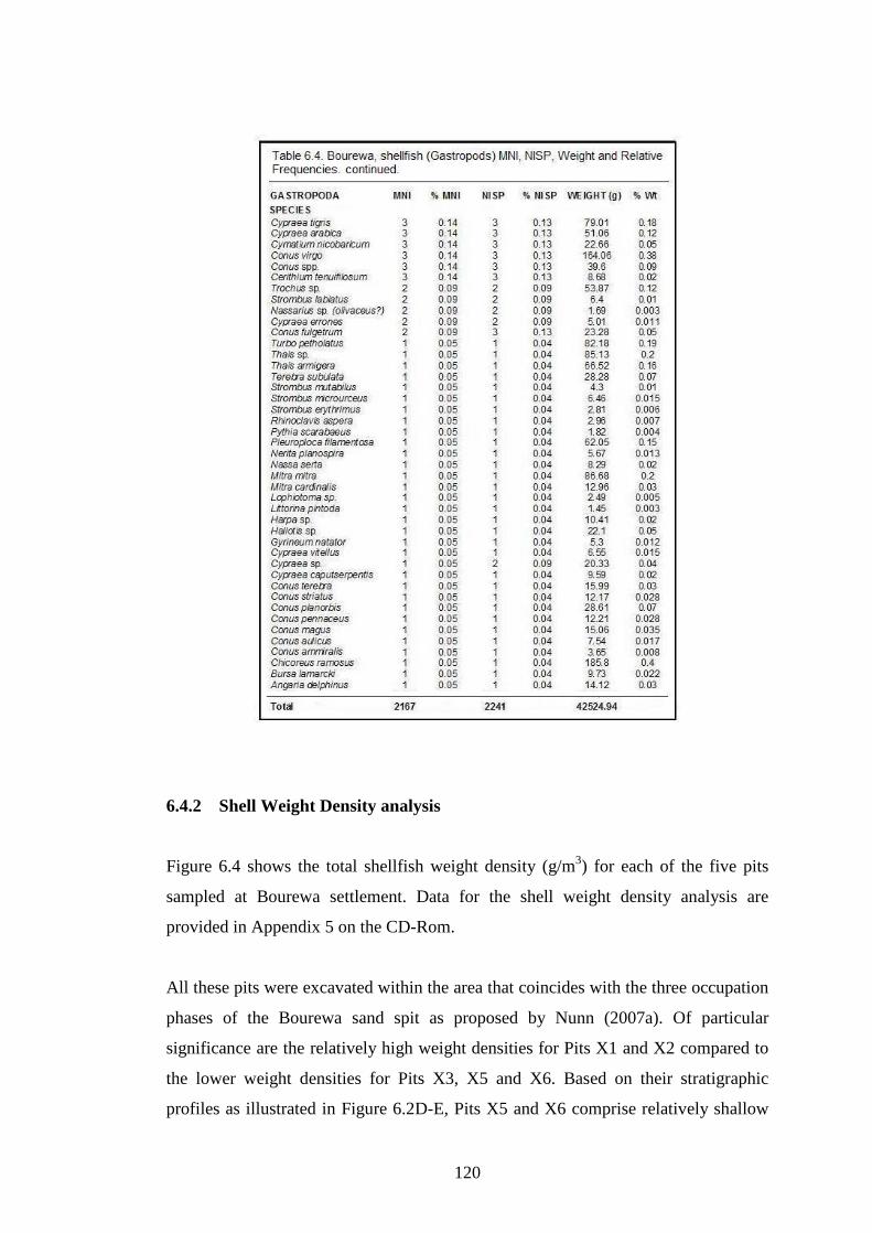
120
6.4.2 Shell Weight Density analysis
Figure 6.4 shows the total shellfish weight density (g/m3) for each of the five pits
sampled at Bourewa settlement. Data for the shell weight density analysis are
provided in Appendix 5 on the CD-Rom.
All these pits were excavated within the area that coincides with the three occupation
phases of the Bourewa sand spit as proposed by Nunn (2007a). Of particular
significance are the relatively high weight densities for Pits X1 and X2 compared to
the lower weight densities for Pits X3, X5 and X6. Based on their stratigraphic
profiles as illustrated in Figure 6.2D-E, Pits X5 and X6 comprise relatively shallow

121
cultural layers and may have been located on an elevated section of the former beach
ridge during Lapita times, though Pit X3 was the deepest of all the five pits.
It also appears that Pits X5 and X6 are located within the region that was settled
slightly later, perhaps during the second phase (Period B) of settlement of the
Bourewa sand spit and/or possibly during the expansion stage (Period C) and
subsequent settlement of the site�s peripheral regions (Nunn, 2007a). Pit X3 in
general comprised relatively fewer shells by volume, hence its lower weight density.
6.4.3 Shell Size analysis
Shell length and height measurements were conducted on intact shell specimens of
the three most abundant shellfish species at Bourewa settlement - Codakia punctata
(MNI = 7484) and Fimbria fimbriata (MNI = 975) and Strombus gibberulus
gibbosus (MNI = 828) for Pits X2 and X3 only. While length measurements were
carried out for Codakia punctata and Fimbria fimbriata, for Strombus gibberulus
gibbosus shell height was measured. The results of these measurements were tallied
and then related to approximate length and height groups as provided in Tables 6.5,
6.6 and 6.7. Data for this analysis are provided in Appendix 6 on the CD-Rom.

122
As illustrated in Table 6.2, in a broad sense, Layer 1 (Upper layer) of both Pits X2
and X3 ranged from 2705-2358 cal BP and 2877-2700 cal BP, though the latter may
fall well within the Layer 2. Layer 2 (Middle layer) spanned the dates 2817-2696 cal
BP and 2826-2605 cal BP, and Layer 3 (Bottom layer) has been dated from between
2878-2702 cal BP and 3140-2867 cal BP. Except for the Layer 1 date range of 2877-
2700 cal BP which may well be placed in Layer 2, all other date ranges seem to
correspond with the occupation periods proposed by Nunn (2007a) for the Bourewa
settlement.
As demonstrated by the radiocarbon dates (Table 6.2), it is clear that the Upper layer
(Layer 1) is relatively younger than the Middle layer (Layer 2), while the Bottom
layer (Layer 3) is older than both layers above. The shell size measurements for both
pits were aggregated to provide a large enough sample for analysis.
Table 6.5 reveals that more than half (53%) of the Layer 1 deposit population of
Strombus gibberulus gibbosus are less than 40 mm in height, whereas 47% had
attained this height or more in Pits X2 and X3. A greater proportion (55%) of large-
sized (≥ 40 mm) Strombus gibberulus gibbosus are found in the Middle layer (Layer
2) compared to 47% in the Upper layer (Layer1) of Pits X2 and X3.
As shown in Table 6.6, there is no significant difference in the percentage of large
shells of Codakia punctata between the two layers of the midden. In fact, it appears
that large Codakia punctata shells (> 40 mm) were marginally common in the Upper
layer (Layer 1) (67.2%) compared to the Middle layer (Layer 2) (65.2%) of both pits.
This means that there is no size reduction recorded through time for Codakia
punctata; instead there seems to be similar proportions of larger Codakia shells
within both layers of the midden. For Fimbria fimbriata, large-sized shells (> 40
mm) are more common in Layer 2 (92%) than in Layer 1 (87%) of the midden
(Table 6.7).

123
6.5 Analytical Zones for Shellfish analysis
The shells recovered from the five test pits at Bourewa settlement are unevenly
distributed within the midden deposit. In general, fewer shells have been recovered
from both the top (0-30 cm) and the bottom (> 80 cm) levels while larger proportions
(between 65% to 80% by volume) are concentrated around the central levels (30-80
cm) of the midden.
The uneven nature of the shells within each of the test pits may influence various
aspects of the analysis like correlation between sample size and the number of taxa
present (NTAXA), relative abundance of different shellfish species, and evenness.
124
According to Grayson (1984), a large sample size usually covaries with a higher
number of species compared to a smaller sample, thus any observed pattern may be
driven primarily by the size of the sample.
As highlighted by Morrison and Cochrane (2008), unequal sample sizes and
temporal duration of excavation levels can also cause problems when analysing
species diversity and relative proportions of prey items as well. Hence the relative
abundances of prey items can be strongly correlated with the sample size (Grayson
1984). Grayson and Delpech (1998) showed that differential time sampling can also
create bias when assessing species diversity. Thus to avoid analytical issues and
allow for greater comparability, the different spits should be aggregated to form near-
equal sample sizes and temporal durations (Morrison and Cochrane, 2008).
So, to account for any bias arising from varying sample sizes, some mitigating
actions were taken. The shellfish taxa from various spits within similar natural strata
and context were combined for analysis. Since these test pits were excavated in
arbitrary 10-cm spits they should provide the minimum comparable analytic units.
The quantitative shellfish analyses were conducted on the assemblages within similar
stratigraphic levels of the five test pits. Subsequently the shells from the various
layers of the five pits were combined to form near equal size samples (by weight) for
analysis. These aggregated units then form three main analytical zones (A, B and C)
(Table 6.8) which coincides with the three layers of the Bourewa shell assemblage
(Table 6.1).
Based on the radiocarbon chronology of the Rove Peninsula and the Bourewa shell
midden itself, the bottom layer (Zone C) dates from at least 3140-2867 cal BP in Pit
X3 (121 cm depth) to around 2705-2358 cal BP (Zone A) in Pit X2 (20 cm depth).
Table 6.8 shows the relationship between the main analytical zones and revised
shellfish aggregates and radiocarbon sequence for the Bourewa shell assemblage.
The combined spits for the five test pits form three analytical units (Zones A, B and
C) based on their stratigraphic context, near equal shell weights and secure
radiocarbon dates. Data on which this analysis is based is provided in Appendix 3 on
the CD-Rom.
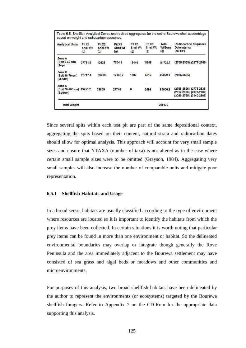
125
Since several spits within each test pit are part of the same depositional context,
aggregating the spits based on their content, natural strata and radiocarbon dates
should allow for optimal analysis. This approach will account for very small sample
sizes and ensure that NTAXA (number of taxa) is not altered as in the case where
certain small sample sizes were to be omitted (Grayson, 1984). Aggregating very
small samples will also increase the number of comparable units and mitigate poor
representation.
6.5.1 Shellfish Habitats and Usage
In a broad sense, habitats are usually classified according to the type of environment
where resources are located so it is important to identify the habitats from which the
prey items have been collected. In certain situations it is worth noting that particular
prey items can be found in more than one environment or habitat. So the delineated
environmental boundaries may overlap or integrate though generally the Rove
Peninsula and the area immediately adjacent to the Bourewa settlement may have
consisted of sea grass and algal beds or meadows and other communities and
microenvironments.
For purposes of this analysis, two broad shellfish habitats have been delineated by
the author to represent the environments (or ecosystems) targeted by the Bourewa
shellfish foragers. Refer to Appendix 7 on the CD-Rom for the appropriate data
supporting this analysis.
126
These shellfish habitats are broad-based and attempt to account for the location
where the prey items were most likely to be foraged so as to minimise the overlap of
prey across other environments through the different ecological habitats. This did not
deter or hinder foragers gathering shellfish resources from within a range of habitats.
According to Nagaoka (2000), prey distribution is often clumped and not patchy so
certain prey items are more likely to be encountered in particular areas and not
randomly distributed within the environment. So foragers tend to focus on specific
habitats and not search for prey in all environments at one time (Morrison and
Cochrane, 2008).
The habitat zones created by the author for the Bourewa shell assemblage broadly
divide shellfish resources based primarily on the location of where they were most
likely taken. These two analytical habitats have been delineated for the Bourewa
shell assemblage - the Intertidal/Coral Reef and Shoreline Sandy/Muddy Habitats.
The Intertidal/Coral Reef Habitat consists of a range of marine micro-ecosystems and
communities located along the coral reef flat. The shellfish taxa foraged in this
habitat are generally filter feeders or algal grazers. They are either mobile or
sedentary or are embedded in crevices in the coral substratum. Other species may be
found in the sand pockets adjacent to rock boulders or scavenging on algae on the
coral reef flat. A notable species within this zone is Trochus niloticus which can
inhabit up to 20 m depth along the seaward coral reef slope (Abbott and Dance,
2000). Other shellfish species of the Trochidae, Strombidae and Conidae families can
also be found in the intertidal and coral reef zones.
The Shoreline Sandy/Muddy Habitat incorporates sandy and muddy, mangroves and
estuarine environments and communities. The shellfish species commonly foraged in
this region are subsurface shallow dwellers that burrow in the sand and/or mud, or
aggregate in high densities, and prefer mostly soft substrates. They also inhabit areas
where water movement is quite subdued though not necessarily free flowing.
As indicated in Table 6.9, the most abundant shellfish taxa recovered from the
Bourewa assemblage were most likely to be foraged from the Shoreline
Sandy/Muddy Habitat. It appears that throughout the period of occupation at

127
Bourewa settlement, certain changes occurred in the shellfish collection strategies in
terms of the available shellfish species and habitats being targeted.
There was a mixed foraging strategy on shellfish species and habitats targeted by the
shellfish collectors. It appeared they favoured those shellfish species and habitats that
were accessible, resource-rich, and closer to the settlement site. For example, meaty
bivalves such as Codakia punctata and Fimbria fimbriata which inhabit soft sandy
substrates located closer to the site were preferred although other species such as
Trochus niloticus and Strombus gibberulus gibbosus from further away were popular
as well. The latter species became targeted as the other shellfish taxa gradually
declined in abundance, perhaps due to increased human predation or environmental
change.

128
Perhaps some foragers did venture farther away from the site, targeting the
freshwater bivalve Batissa violacea that could be collected from the banks of the
Tuva River or other nearby rivers or streams. The two mangrove species, Gafrarium
tumidum (Spennemann, 1987) and Anadara antiquata (Tebano and Pauley, 2001),
were also present in relatively large proportions in the shell assemblage suggesting
that foragers also targeted both the mangroves and the intertidal lagoons for available
shellfish.
In Pit X1, Zones A, B and C all show a predominance of shellfish (MNI and weight)
derived mostly from the Shoreline Sandy/Muddy Habitat. The shellfish species from
the Shoreline Sandy/Muddy Habitat were once again predominant in all Zones for
Pits X2 and X3. Again the shellfish species from the Shoreline Sandy/Muddy Habitat
were predominant in Zones A and B of Pit X5. While Zones A and C of Pit X6
reveal the predominance of shellfish from the Shoreline Sandy/Muddy Habitat, this
changed in Zone B where shellfish species from the Intertidal/Coral Reef Habitat
became dominant.
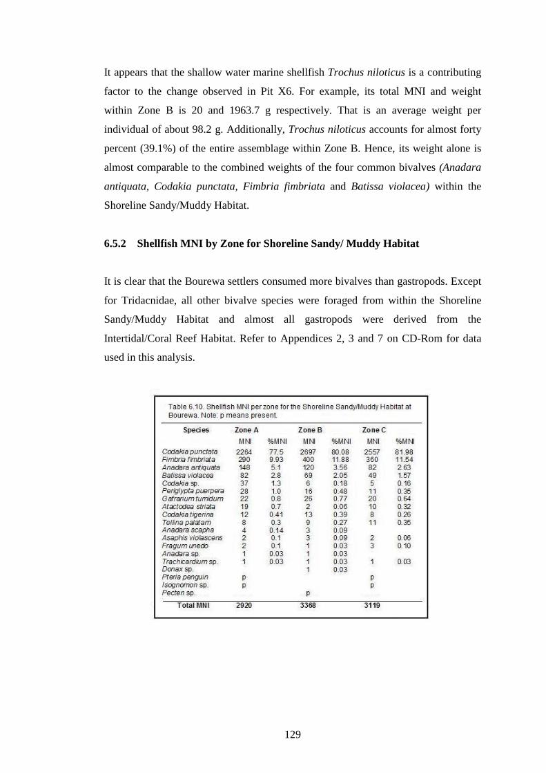
129
It appears that the shallow water marine shellfish Trochus niloticus is a contributing
factor to the change observed in Pit X6. For example, its total MNI and weight
within Zone B is 20 and 1963.7 g respectively. That is an average weight per
individual of about 98.2 g. Additionally, Trochus niloticus accounts for almost forty
percent (39.1%) of the entire assemblage within Zone B. Hence, its weight alone is
almost comparable to the combined weights of the four common bivalves (Anadara
antiquata, Codakia punctata, Fimbria fimbriata and Batissa violacea) within the
Shoreline Sandy/Muddy Habitat.
6.5.2 Shellfish MNI by Zone for Shoreline Sandy/ Muddy Habitat
It is clear that the Bourewa settlers consumed more bivalves than gastropods. Except
for Tridacnidae, all other bivalve species were foraged from within the Shoreline
Sandy/Muddy Habitat and almost all gastropods were derived from the
Intertidal/Coral Reef Habitat. Refer to Appendices 2, 3 and 7 on CD-Rom for data
used in this analysis.
130
As shown in Table 6.10, both Codakia punctata and Fimbria fimbriata comprise the
bulk of shellfish from the Shoreline Sandy/Muddy Habitat. Both these species have
also revealed decreasing trends in their relative proportions from Zone C to A, while
other bivalves show increasing trends. For example, Codakia punctata steadily
declined from 82% (MNI) in Zone C to 80% (MNI) in Zone B and subsequently
decreased to 78% (MNI) during Zone A. Although there was some stability during
Zone B, a general declining trend is also recorded for Fimbria fimbriata through
time.
In contrast, other edible bivalve species like Anadara antiquata, Batissa violacea,
Periglypta puerpera, Codakia spp., Gafrarium tumidum and Atactodea striata have
all increased through time in spite of their relatively low proportions. Collectively
they all account for 5.9 (%MNI) in Zone C, 7.5 (%MNI) in Zone B and 12.1
(%MNI) during Zone A (Table 6.10).
6.5.3 Shellfish MNI by Zone for Intertidal/Coral Reef Habitat
The edible shellfish species Strombus gibberulus gibbosus reveal an increasing trend
from Zone C to A, while Turbo spp. declined during the same period. Trochus spp.
consumption remained fairly steady throughout the sites occupation. The proportions
of the other gastropods were significantly lower (Table 6.11).
Both Tridacna gigas and Hippopus hippopus which usually inhabit the soft
substrates of coral reef areas also decreased in relative abundance from 1.3% (MNI)
during Zone C to 0.8% (MNI) during Zone B and 0.4% (MNI) in Zone A. While
Tridacna gigas has declined over time, most notably is the complete absence of
Hippopus hippopus during Zone A, which may indicate its possible demise and/or
significantly low abundance level around the end of the Lapita era. But since there
are no data from other nearby sites of the presence of Hippopus hippopus after the
Lapita era, it is still difficult to corroborate this assertion. Evidently both species of
Tridacnidae shellfish have been shown to be significantly low in abundance in the
Bourewa shell assemblage.
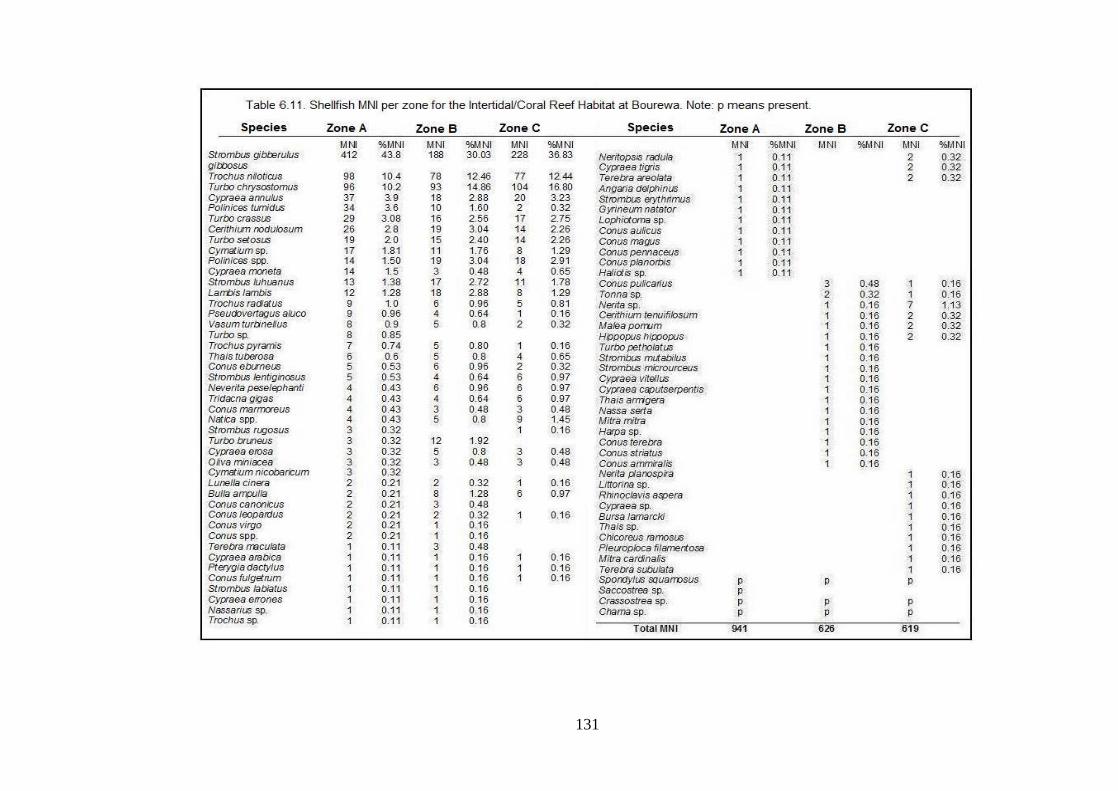
131

132
6.6 Assessing Shellfish Species and Habitats through Foraging Theory
Models
The following subsections provide the results of the analysis conducted on the
shellfish species and habitats using foraging theory models - prey and patch choice
and central place to understand the roles of human and non-human factors on marine
resources. As described by Morrison and Addison (2008:23) foraging models have a
range of applications including to �provide a theoretical basis for examining
temporal shifts in resource exploitation as a result of human resource depression,
environmentally induced decreases in prey abundance, and changes in harvesting
technology�.
In order to examine whether or not the temporal or spatial composition of the
archaeo-shellfish assemblage varies through time, theoretically derived hypotheses
aimed at explaining any variability were developed. This is to ensure that the
relationships between theory, method, and research questions are clearly examined
and assessed. Essentially these questions attempt to establish how humans impacted
the near-shore marine environment, the type of shellfish species and habitats
targeted, and whether shellfish species and habitats changed over time.
Foraging theory models are used to investigate and evaluate resource depression by
assessing human foraging strategies and the types of shellfish species and habitats
affected by human predation. The structure of the shell midden at Bourewa was
characterised according to environmental habitats exploited, NTAXA, evenness, and
relative abundances. Comparative indices were used to compare large to small
shellfish species as well as for different habitats.
Shell sizes were determined by measuring shell length and height of the three most
abundant shellfish species. NTAXA was calculated by comparing the number of taxa
present. Shannon's Evenness Index (E) calculations were used to evaluate evenness
of the shellfish taxa in each habitat. Relative abundance measures were conducted to
understand important trends in the proportions of the five most abundant shellfish
taxa through time.
133
6.6.1 Analysing Shellfish Foraging through Prey Choice
The prey choice model is used to measure changes in foraging efficiency � the net
return rate per unit time (Morrison and Cochrane, 2008; Nagaoka, 2002). Since the
goal of foraging is to maximise the rate of nutrients (or energy) obtained from the
prey item, the prey choice model predicts that foragers usually select or prefer prey
with the highest energy return rate. Thus the model holds that a predator's most
efficient strategy is to capture the highest-ranked prey over low-ranked prey upon
encounter (Butler, 2000). So, high-ranked prey will always be taken while less
profitable ones will be bypassed by foragers. The model also predicts that low-
ranked prey items will be captured and incorporated into the diet only when there is a
significant decline in foraging efficiency (Nagaoka, 2002).
In most archaeological studies, prey body size and prey rank are related, so body size
is often used as a proxy for energy return rate. Thus large-bodied prey are generally
regarded as high-ranked resources, while small-bodied prey are usually lowly ranked
(Bird and O�Connell, 2006; Butler, 2001; Morrison and Cochrane, 2008; Nagaoka,
2002).
The relative abundance of high-ranked species can also influence dietary choices so
the prey choice model can be used to trace changes in the availability of high-ranked
shellfish species within an environmental habitat (Nagaoka, 2002). When there is a
decline in foraging efficiency, this is usually indicated in the archaeological record
by a decrease in the ratio of high-ranked prey relative to low-ranked prey, and a
widening (or expansion) of the diet breadth resulting in increased species diversity
(or richness). Changes in mean size and age of prey items can also be used to
measure foraging efficiency (Morrison and Cochrane, 2008). According to them, a
simple measure of comparative abundance of large and small prey is the Large
Abundance Index (AI) calculated as;
AI = ∑ MNI large taxon/∑(MNI large taxon + MNI small taxon)

134
6.6.2 Prey Choice in the Shoreline Sandy/Muddy Habitat
As explained earlier, the prey choice model predicts that a decline in the ratio of
large-bodied to small-bodied prey indicates declining foraging efficiency. This
assumption is examined here using two common shellfish species from the Shoreline
Sandy/Muddy Habitat. The ratio between Codakia punctata (MNI = 7484, average
size of 10 cm) and Anadara antiquata (MNI = 344, average size of 6 cm) (Abbott
and Dance, 2000) in the Shoreline Sandy/Muddy Habitat demonstrates that their
proportions steadily declined earlier to later within all periods (Figure 6.5). Thus it
appears that foraging efficiency steadily decreased within the Shoreline
Sandy/Muddy Habitat during the time Bourewa was occupied. Weight measurements
for these two shellfish taxa also support this general trend.
When the ratio of other abundant high-ranked (Codakia punctata and Fimbria
fimbriata) and low-ranked shellfish species (Batissa violacea and Anadara
antiquata) are measured, it is also evident that foraging efficiency steadily declined
through all three zones (Figure 6.6). These shellfish species comprise about 97%
(MNI) of the prey items within the Shoreline Sandy/Muddy Habitat and 78% (MNI)
of the Bourewa shell assemblage. Data for this analysis are provided in Appendix 8
on the CD-Rom.
6.6.3 Prey Choice in the Intertidal/Coral Reef Habitat
The following examines the predictions proposed by the prey choice model for the
Intertidal/Coral Reef Habitat. The prey choice model assumes that if the ratio of large
to small-bodied prey decreases through time then foraging efficiency is declining.
Data for this analysis are provided in Appendix 8 on the CD-Rom.
To investigate the impact of humans on the shellfish species derived from the
Intertidal/Coral Reef Habitat, the contribution of the two most abundant shellfish
species is compared. For example, Trochus niloticus (MNI = 253) with an average
height of 120 mm is a high-ranked prey, while Strombus gibberulus gibbosus (MNI
= 828) which has a mean size (height) of 42.5 mm is a low-ranked prey in terms of
both weight and size (Abbott and Dance, 2000).

135
When the quantities of Trochus niloticus and Strombus gibberulus gibbosus are
compared, their abundance indices decrease over time especially from Zone B to A
(Figure 6.7). This trend suggests that foraging efficiency within the Intertidal/Coral
Reef Habitat declined during this period. The shell weight quantities for these two
shellfish species also produce/indicate similar trends though there was a slight
decline in the weight of Strombus gibberulus gibbosus during Zone B.

136
A declining trend in foraging efficiency is also demonstrated when the ratio of other
abundant Intertidal/Coral Reef shellfish species are compared (Figure 6.8). For
instance, when the proportion of the two most abundant large-bodied taxa (Trochus
niloticus and Turbo chrysostomus) were compared to the two most abundant small-
bodied taxa (Strombus gibberulus gibbosus and Cypraea annulus), a marked decline
in foraging efficiency particularly from Zone B to A is also demonstrated.
These four shellfish species constitute a large proportion (67% MNI) of the
Intertidal/Coral Reef shellfish taxa. Thus the overall foraging efficiency within the
Intertidal/Coral Reef Habitat generally decreased through time. This indicates that
within the Intertidal/Coral Reef Habitat, the quantity of large, profitable prey
declined relative to smaller, less profitable ones, most plausibly due to increasing
human predation pressures.

137
6.6.4 Analysing Shellfish Habitat Utilisation through Patch Choice
The patch choice model examines how foragers decide which habitats to forage in
and how long they should remain in a certain area (Nagaoka, 2002). Nagaoka stated
that the patch choice model predicts that (i) high-ranked prey normally targeted by
foragers tend to be susceptible to resource depression and (ii) if foraging efficiency
markedly falls across certain habitats the number of habitats exploited will increase
and/or the time allocated to a habitat will change. Data for this analysis are provided
in Appendix 8 on the CD-Rom.
According to the patch choice model, if the overall return rate of high-ranked
habitats decline, foragers will begin to target low-ranked habitats. When high-ranked
prey abundance decreases, foragers tend to select younger, smaller individuals
leading to a decrease in overall size of targeted prey items within the habitat
(Nagaoka, 2000, 2002). Bedford (2006:237) suggested that since �patch types are
ranked on the basis of the resources that are located within a patch�, habitats with
high-ranked prey will be considered as productive habitats (high-ranked).
Conversely less productive habitats are usually associated with low-ranked prey
items.
In order to investigate human impact on the different shellfish habitats at Bourewa, a
comparison is made between the three most abundant shellfish species within the
Shoreline Sandy/Muddy Habitat with the three most abundant shellfish species in the
Intertidal/Coral Reef Habitat. Any shift in habitat exploitation, for instance from a
high-ranked habitat to a low-ranked one can be traced by the ratio of shellfish
species present in a productive habitat to those in a less productive one. Also based
on habitat productivity rankings, resource depression and decreases in foraging
efficiency can be traced by a shift from more productive habitats to less profitable
ones (Nagaoka, 2000, 2002).
A comparative Abundance Index (AI) between large and small prey items found
within each shellfish habitat at Bourewa was developed using the following formula,
where Shoreline Sandy/Muddy taxa are higher-ranked than the Intertidal/Coral Reef
taxa.

138
AI = ∑ (Shoreline Sandy/Muddy taxa) / ∑ (Shoreline Sandy/Muddy +
Intertidal/Coral Reef taxa)
The ratio of the three most abundant shellfish species of the Shoreline Sandy/Muddy
Habitat (Codakia punctata, Fimbria fimbriata and Anadara antiquata) are compared
to the three most abundant species from the Intertidal/Coral Reef Habitat (Strombus
gibberulus gibbosus, Trochus niloticus and Turbo chrysostomus). The Shoreline
Sandy/Muddy Habitat species constitute an average prey size of 83 mm, while the
Intertidal/Coral Reef Habitat is slightly less profitable with an average prey size of
78 mm. The comparative indices were used to trace the relationship between the
Shoreline Sandy/Muddy and the Intertidal/Coral Reef taxa and determine if there
was a shift in foraging strategy through time.
The Shoreline Sandy/Muddy Habitat is regarded as the most profitable habitat based
on its overall prey size, weight and abundance of its shellfish taxa, although the
Intertidal/Coral Reef Habitat comprised the most diverse shellfish taxa in the entire
shell assemblage. Despite the higher average sizes of the shellfish species within the
Shoreline Sandy/Muddy Habitat, the Intertidal/Coral Reef Habitat also hosted

139
several large-sized shellfish species like Tridacna spp. and Lambis lambis but are
relatively low in terms of abundance.
Out of all the shells represented at Bourewa settlement, only three shellfish species
from the Shoreline Sandy/Muddy Habitat comprise the bulk (87.5%) of the entire
shell assemblage. These are common shell remains found in other Fijian
archaeological contexts as well (Thomas et al., 2004; Nunn et al., 2006, 2007).
The analysis indicates that there was a steady use of the Shoreline Sandy/Muddy
Habitat during Zones C and B but during Zone A there was a substantial shift in
focus toward the Intertidal/Coral Reef Habitat (Figure 6.9). Thus during Zone A,
increasingly diverse shells were also targeted by the Bourewa settlers as is reflected
by the nature and composition of shellfish species within the Intertidal/Coral Reef
Habitat.
There was also a steady decrease in the abundance of Codakia punctata, Fimbria
fimbriata and Anadara antiquata across all periods within the Shoreline
Sandy/Muddy Habitat. This may signify an expansion or shift in shellfish collection
strategies from the Shoreline Sandy/Muddy Habitat to increasing focus on shellfish
like Strombus gibberulus gibbosus, Trochus niloticus and Turbo chrysostomus which
were usually collected from the Intertidal/Coral Reef Habitat. There was perhaps a
focus also on the collection of other shellfish species like Batissa violacea,
Periglypta puerpera and Gafrarium tumidum which were mostly foraged from the
Shoreline Sandy/Muddy Habitat though in relatively lower quantities.
6.7 Measuring Shellfish Diversity and Abundance
The following subsections analyse the shellfish diversity and abundance of the
Bourewa shell assemblage. These include measuring diet breadth and NTAXA and
evenness. The relative abundances of the five most common shell taxa are also
compared to indicate changes in their proportions over time. Data for these analyses
are provided in Appendices 9 and 10 on the CD-Rom.

140
6.7.1 Diet Breadth and NTAXA analyses
Diet breadth involves measuring the number of prey items included in the diet. It
considers the taxonomic richness (or diversity of species) of the entire assemblage
and the habitats from which these prey items were derived. One of the assumptions
of the prey choice model is that, as the proportion of large, more profitable prey
decreases over time, foraging efficiency will decline and the diet breadth will widen
(or expand) to include smaller, less profitable prey items. Diet breadth can be
assessed by examining the changes in taxonomic richness and the relationship
between richness and sample size (Nagaoka, 2000).
Richness is measured by comparing the number of taxa (NTAXA) present in the
various analytic units (or zones) within the shell assemblage. In general, a rich
sample consists of a large number of species but a poor sample only has a few
species (Nagaoka, 2000; Grayson and Delpech, 1998).
The entire Bourewa shell assemblage shows an increase in taxonomic richness from
Zone C to B but it remains stable during A. As revealed in Figure 6.10, Zone C has
70 items while Zones B and A contains 79 and 77 items respectively, which may not
be very significant, given that this assemblage was only sampled, albeit it clearly
indicates a rise in NTAXA. A similar assessment was conducted for both the
Intertidal/Coral Reef and Shoreline Sandy/Muddy Habitats to determine if the same
trend is also evident within these two habitats.
The results of the NTAXA analysis for the Intertidal/Coral Reef Habitat show that
diet breadth generally expanded from Zone C to B with an increase in NTAXA from
55 to 62 items, but from Zone B to A there was an increase by only one prey item
(Figure 6.11). For the Shoreline Sandy/Muddy Habitat NTAXA also increased
through time especially during Zone C to B but remained steady during Zone A
(Figure 6.12).
Though NTAXA measurements are useful, they have limitations as well. For
example, NTAXA does not directly measure or provide detailed information on the

141
relative contributions of individual taxa to the entire assemblage (Morrison and
Cochrane, 2008).
According to Nagaoka (2000, 2002), another criticism of using NTAXA as a
measure of diet breadth is the tendency of NTAXA to correlate with sample size.
She cautions that, if the two variables covary, it is sometimes difficult to determine
whether the changes in NTAXA over time are due to changing diet or simply
influenced by varying sample sizes. But archaeologists can utilise the relationship
between NTAXA and sample size (NISP) and/or supplement NTAXA analysis with

142
evenness measures. Appendix 9 on the CD-Rom provides the NTAXA data for this
analysis.
6.7.2 Evenness analysis
The following examines evenness in shellfish use and tests if it varies temporally
within the entire shellfish assemblage, Intertidal/Coral Reef and Shoreline
Sandy/Muddy Habitats. Shannon�s Evenness data for this particular analysis are
provided in Appendix 9 on the CD-Rom.
Evenness is the measure of the proportional amount of different shellfish species
represented in the entire shell assemblage (Nagaoka, 2001, 2002). As explained
earlier, the prey choice model predicts that as larger, high-ranked prey decrease,
foraging efficiency will decline and the diet breadth will expand to include smaller,
low-ranked prey. Thus evenness is expected to increase as foragers attempt to offset
declining foraging efficiency (Morrison and Cochrane, 2008). This means that
foragers will incorporate other shellfish taxa into their diet thereby broadening their
dietary range. Although evenness measures do not track changes in specific taxa or
their position in a ranked-order set (Nagaoka, 2000), they can supplement diet
breadth measurements by offering researchers the ability to monitor the relative
importance of specific species through time (Morrison and Addison, 2008).
Evenness is calculated using Shannon�s Evenness Index (E) (Grayson and Delpech,
1998; Grayson, 1984). The formula for Evenness is;
Evenness = -∑(pi ln [pi]) / ln [NTAXA]
(where pi is the proportional contribution of each item)
(ln is the natural log of pi )
(NTAXA is number of taxa)
Morrison and Cochrane (2008) stated that in an even assemblage, the contribution of
each taxa to the entire assemblage will be about the same so that evenness will be
fairly low, while in a highly uneven assemblage where only a few taxa are dominant,
evenness indices will be high. As an example, an index measure of zero (0)

143
demonstrates that only one species is predominant while an index value of one (1)
indicates that each species is represented in equal amounts (or proportions)
(Nagaoka, 2000).
The evenness analysis reveals that evenness increased throughout all zones of the
entire shell assemblage (Figure 6.13). While evenness increased from Zone C to B
and then declined during Zone A of the Intertidal/Coral Reef Habitat (Figure 6.14),

144
evenness increased across all zones of the Shoreline Sandy/Muddy Habitat (Figure
6.15).
An increase in the evenness indices suggests that large, high-ranked preys are
declining while smaller, lower-ranked preys were increasingly incorporated into the
assemblage (or diet), suggesting resource depression and a more diverse diet. Thus,
if evenness values increase through time, it indicates that the diet breadth is
expanding to include other resources, usually less profitable ones. Conversely, if the
evenness values remain fairly steady through time, it means that diet breadth is stable
(Morrison and Addison, 2008; Nagaoka, 2000).
Although evenness calculations have proved useful in measuring prey diversity, the
method does have its shortcomings. For instance, evenness values often do not
consider changes in prey ranks, they do not reflect similar resource-use patterns, and
do not indicate changes in the relationships between taxa and their proportions
(Nagaoka, 2001). Thus the rank and relative abundance of each taxon must be
examined separately to determine if changes in evenness truly reflect a shift from
high to low-ranked prey.
6.7.3 Relative Abundance analysis
Relative abundance measures are most helpful in two ways. Firstly, they indicate
where the changes in proportions of shellfish taxa are occurring and secondly, since
the samples are of near equal sizes, the absolute abundance of the taxa does not
always affect the comparison of percentages between the analytical zones (Morrison
and Cochrane, 2008).
Since the three analytical zones delineated for the Bourewa shell assemblage
comprise roughly similar sample sizes (in terms of shell weight), any observed
changes in the relative abundance of certain taxa should reflect human impact on the
resources, though environmental factors cannot be completely ignored. Other factors
that may also influence relative abundance measures are human preference for
certain shellfish taxa, the assignment of children to collect shellfish, and the
declaration of taboo on certain shellfish species. In their study of the shellfishing

145
strategies among Meriam children of Torres Strait Islands, Bird and Bird (2000)
demonstrated that the prey choice of children differs from adults and children usually
collect a wide range of shellfish resources and the resources that they collect are
most likely to end up in middens because high-ranked prey are more often processed
in the field. On the other hand, when a particular ban is imposed on certain shellfish
resources due to some kind of customary practices these too may be unlikely to be
foraged by shell collectors.
A number of notable trends have emerged from evaluating the relative abundance
measures (MNI) of five most common shellfish at Bourewa. Table 6.12
demonstrates that the two top-ranked shellfish species (Codakia punctata and
Fimbria fimbriata) decreased in relative abundance through all zones within the
assemblage. For instance, from 78.0 %MNI (Zone C) to 77.5 %MNI (Zone B) and to
66.1 %MNI (Zone A). In contrast, Strombus gibberulus gibbosus, Anadara antiquata
and Trochus nioticus show increases in relative abundance particularly during Zone
B (9.7 %MNI) to Zone A (17.0 %MNI).
A significant increase in relative abundance is observed for Strombus gibberulus
gibbosus during Zone A, where it changed ranks with Fimbria fimbriata from third
(3rd) in Zone B (4.7 %MNI) to second (2nd) during Zone A (10.7 %MNI). An
increase in relative abundance is also noted for Anadara antiquata through all three
zones. The Intertidal/Coral Reef species Trochus niloticus also increased in its

146
relative abundance particularly during Zone A. Despite the varying trends in relative
abundances for the five shellfish species of the Bourewa shell assemblage, upon
closer investigation it is clear that overall there is a general decline in relative
abundance of the shellfish taxa through time.
Refer to Appendix 10 on the CD-Rom for data from which the analysis of this
section is derived.

147
Chapter 7. Interpretation and discussion
This chapter interprets the results and analysis of the Bourewa shell assemblage
(data). A discussion of the results is also provided. There are three sections to this
chapter. These are section 7.1 - shellfish species of Bourewa, section 7.2 - shellfish
habitat usage, and section 7.3 - implications of archaeological shellfish data for
marine resources management.
Subsection 7.1.1 interprets the stratigraphic context and radiocarbon dates for the top
and middle layers of both Pits X2 and X3, while subsections 7.1.2 to 7.1.4 interpret
the shellfish analysis in terms of MNI, NISP, shellfish weight density, and size, and
the types of shellfish species targeted by the Lapita people along the Rove Peninsula.
Subsections 7.2.1 to 7.2.3 discuss the foraging trends within the two main shellfish
habitats delineated for Bourewa and shellfish diversity and abundance. Finally,
section 7.3 discusses the implications of archaeological shellfish data for
contemporary marine resources management strategies by providing various
scenarios for resource managers.
7.1 Shellfish species of Bourewa
The Bourewa shellfish data provide useful information for understanding many
aspects of human-environment relationship including, the types of shellfish species
and habitats being exploited, local environmental changes (like lagoon or
bay/estuary shoaling), that can be inferred from shifts in the exploitation and
changing proportions of shellfish species, increased foraging pressure on particular
shellfish species and habitats, and the diversity of shellfish taxa consumed by
humans at the settlement site.
7.1.1 Stratigraphy and Radiocarbon Dating
At least three broad cultural strata can be identified from the five pits sampled at the
Bourewa Lapita site (Figures 6.2A-C, 6.2D-E and 6.3). When the layers are
correlated based on their content and context, generally the top layer (L.I) ranged

148
from 0-20 cm deep in most pits or even to 40 cm deep in certain pits. It consists of
mostly dark silty soil with occasional shells and plant roots and other debris. The top
section of this layer is the most disturbed due to ploughing for sugarcane. The
middle layer (L.II) ranged from 20-30 cm in depth for Pits X1, X5 and X6 to as
much as 30-90 cm in Pits X2 and X3. On average it ranges from 40-70 cm in depth
for the sampled pits. It comprises the bulk of cultural materials including about 60-
80% of the shells sampled. This layer contains dark silty soil and is associated with
the main Lapita period at Bourewa. Below 50-70 cm depth in most pits, it is mostly
sterile beach sand - part of the former sand spit, though in some places it may
contain small quantities of shells and other materials. Underlying this layer is the
underlying compacted sand or the former coral reef platform, which can be identified
in most pits.
Based on the stratigraphic context of the radiocarbon dates obtained during Phases 1-
3 for the Bourewa settlement and especially for Pits X2 and X3, the earliest period of
occupation of Bourewa may have occurred sometime around 3140-2867 cal BP
which corresponds to Zone C (or Layer III). Zone B (or Layer II) was deposited
around 2826-2605 cal BP which correlates to the middle period, while Zone A (or
Layer I) dates back to sometime about 2705-2358 cal BP, the recent period.
Over 24 radiocarbon determinations have been obtained for the Bourewa settlement
thus making it one of the most securely dated Lapita sites in the Pacific (Nunn,
2007a). Based on the analysis of the cultural strata and radiocarbon dates at
Bourewa, the suggested interpretation of the deposits is as follows.
Zone C (3140-2867 cal BP): represents initial occupation phase of the
Bourewa sand spit by the Lapita people with the establishment of a
permanent settlement with shelters/houses that were probably built on stilts
(Nunn, 2007a). Shellfish exploitation and habitat utilisation during this
period focused on a range of large-sized shellfish species mostly bivalves that
were obtained from the Shoreline Sandy/Muddy Habitat along the Rove
Peninsula.

149
These shellfish species include Codakia punctata and Fimbria fimbriata,
Anadara antiquata, Periglypta puerperal, and Gafrarium tumidum including
the freshwater bivalve Batissa violacea. These shellfish taxa can be usually
collected during low tides. Large clam shellfish species like Tridacna gigas
and Hippopus hippopus, mostly foraged from the intertidal reef zone, were
also consumed by the early Bourewa settlers. They also consumed large
gastropods like Trochus niloticus and Turbo spp. as well as a range of
strombid species including Lambis lambis. Shells like Conus spp. were also
used to manufacture shell ornaments and artefacts.
There was a designated shellfish dumping area at the Bourewa sand spit
where the settlers discarded their shell refuse. Over time these shells
accumulated to form the thickest part of the midden. It is clear from the shell
weight density analysis that this shellfish dump site is most likely to be
located within the vicinity of Pits X1, X2 and perhaps Pit X3. This is
somewhere adjacent to the western entrance of the Bourewa tidal inlet
(Figure 6.1C) (Also refer to Nunn, 2007a).
Zone B (2826-2605 cal BP or 2877-2700 cal BP): the Bourewa settlement
experienced population expansion and/or influx of new migrants which
coincided with intense (or increased) shellfish species and habitat
exploitation. There was continued permanent habitation of the Bourewa site,
while some settlers may have migrated to other nearby locations like Qoqo
Island. The falling sea level also resulted in expansion of the coastal lowland
area that may have favoured innovations like crop cultivation. As such this
episode also witnessed the introduction of root crops like taro and yam.
Eastern Lapita motifs appear during this time at the site as well (Nunn,
2007a).
Based on the shellfish analysis it is plausible to suggest that falling sea level
may have encouraged the availability of certain reef-dwelling gastropods like
Strombus gibberulus gibbosus, other Strombus spp., and Trochus niloticus

150
perhaps due to expansion of the coral reefs and other intertidal habitats along
the Rove Peninsula.
Zone A (2705-2358 cal BP): significant increase in shellfish and habitat
exploitation occurred during this period resulting in shifts in the utilisation of
certain shellfish species and habitats. For example, the declining abundance
of bivalves like Codakia punctata and Fimbria fimbriata, while gastropods
like Strombus gibberulus gibbosus and Trochus niloticus including the
bivalve Anadara antiquata increased in relative abundances. There was
continued cultivation of root crops and tubers. Out-migration of settlers from
Bourewa to Rove Beach, Waikereira, Jugendar�s Farm and Tomato Patch
also occurred as the Lapita period was approaching its end (Nunn, 2007a).
During the later stages of occupation of the Bourewa site especially from
Zone B to A, the consumption of Codakia punctata and Fimbria fimbriata
gradually declined while shellfish species like Anadara antiquata, Batissa
violacea, Perigypta puerpeara and Gafrarium tumidum, Strombus gibberulus
gibbosus and Trochus niloticus were more abundant. Most notable during
this later phase of settlement at Bourewa (Zone A) is the absence of the giant
clam Hippopus hippopus, though it is unclear if this is directly related to
human subsistence practices.
This settlement phase also witnessed the shift in shellfish habitat usage where
the Bourewa settlers focused more on shellfish species from the
Intertidal/Coral Reef Habitat.
7.1.2 MNI and NISP
The general pattern of shellfish exploitation at Bourewa reveals three major
subsistence trends which were probably associated with the demographics of the site
and the analytical zones delineated for the shell assemblage (Table 6.1). These are
Zones A, B and C. As outlined above these zones coincide with the three periods
delineated by Nunn (2007a) for the Bourewa site. Zone A which is the top layer

151
corresponds to Period C. Zone B is the middle layer and is linked to Period B, while
Zone C the bottom layer correlates with Period A.
During the initial period of Lapita settlement of the Bourewa site (Zone C), shellfish
exploitation was relatively low perhaps due to the small number of the initial
colonising population. Shellfish exploitation gradually increased during the second
phase of settlement (Zone B), possibly due to in situ population increase and/or as a
result of an influx of people (perhaps new migrants) from elsewhere to Bourewa.
The second phase also witnessed the introduction of taro and yam (Horrocks and
Nunn, 2007) and the production of pottery with mostly Eastern Lapita motifs (Nunn,
2007a), implying some degree of agriculture innovation perhaps to sustain
population increase and perhaps offset declining shellfish stocks. According to
Nunn, this phase (or Period B) also witnessed an expansion in occupation of the
Bourewa sand spit itself � along its axis where shellfish remains were
indiscriminately discarded.
Towards the end of the Lapita period in Fiji and the occupation of the Bourewa
settlement (Zone A), shellfish exploitation was still consistently high, possibly
reflecting extension and/or expansion of the site to its peripheral areas due to
increasing population, despite the outward movement (migration) and overflow of
people to other nearby locations like Rove, Waikereira, Jugendar�s Farm and Tomato
Patch. It is plausible to suggest that during this period the Bourewa settlers may have
also increased their utilisation of other food crops like taro and yam to supplement
their predominantly marine (shellfish) diet (Horrocks and Nunn, 2007). In fact the
general pattern of shellfish exploitation at Bourewa seems to mirror the three major
phases of human occupation of the Bourewa sand spit as posited by Nunn (2007a).
The Bourewa shellfish data contrasts markedly with that of the Naitabale site
(Moturiki Island, Fiji) where gastropods comprised the bulk of the shells quantified
(Nunn et al., 2007). At nearby Qoqo Island, 5 km north of the Bourewa settlement,
the shellfish data indicate that comparatively fewer gastropods were represented,
while more bivalves were consumed (Nunn et al., 2006). The Qoqo and Bourewa
shellfish data reveal that bivalves appear to be the most dominant shellfish taxa,
something that is expected given the proximity of these sites.

152
While it is possible that the Bourewa shellfish analysis could indicate changes in
subsistence pattern, other shellfish studies from the Fiji Islands tend to suggest that
shellfish exploitation by early colonisers may reflect the local availability of shellfish
resources (Nagaoka, 1988) and/or both availability and preference for certain
shellfish species (Clark et al., 2001). It is plausible to assume from the results and
analysis that shellfish exploitation at Bourewa might reflect a combination of both
local availability of shellfish taxa and the preference for certain shellfish species. It
seems that bivalves were relatively abundant within the shell assemblage compared
to gastropods suggesting that the Bourewa settlers preferred bivalves over
gastropods. While the abundance of certain important shellfish species declined over
time, the Bourewa inhabitants continued to exploit meaty bivalves that were
relatively close, easy to forage, and process.
As the results and analysis reveal, the shellfish species most frequently targeted by
the settlers at Bourewa include Codakia punctata, Fimbria fimbriata, Strombus
gibberulus gibbosus, Anadara antiquata, Turbo chrysostomus, Trochus niloticus,
and Batissa violacea. Except for Strombus gibberulus gibbosus and Turbo
chrysostomus, all the other shellfish species are relatively big animals in terms of
size and were undoubtedly targeted for their proportionally large meat content, close
proximity to the site, and relative abundance.
Although their presence in the shell assemblage is significantly low, large-sized
bivalves like Tridacna gigas and Hippopus hippopus were perhaps important food
sources for the Bourewa settlers as well. Due to their large bulky size, it could be
inferred that foragers may have foraged and processed most of these large animals,
discarded their shells where they were found, and only brought back the edible parts
to the site for consumption (Bird et al., 2002). This observation is confirmed by the
relative abundance of other smaller Tridacnidae (eg. Tridacna maxima and Tridacna
squamosa) recovered during post-2005 field seasons at the Bourewa settlement. It
appears that the smaller Tridacnidae species were easier to transport across distances
of more than 2 km along the reef flat than the larger and heavier taxa. So the obvious
option for the foragers would be to extract the meat of Tridacna gigas or Hippopus
hippopus and discard their shells on the reef.

153
Alternatively, it is plausible to assume that the low abundance of the larger Tridacna
shells such as Tridacna gigas and Hippopus hippopus may in fact be a true reflection
of their already low natural abundance and availability in the wild, particularly on
the reefs around the then offshore island. Since the natural distribution of
Tridacnidae decline eastwards from Near Oceania to Remote Oceania (Kirch, 1997),
it is inevitable that the abundance of large-sized Tridacnidae taxa in the Bourewa
shell assemblage would be expected to be relatively low compared to other
abundant, yet smaller Tridacnidae species.
Nunn (2007a) also noted that Szabó�s (2006) analysis of the numerous shell artefacts
and worked shells from Bourewa indicate a low rate of reworking of Tridacna shells
(8%) which might indicate that they were perhaps not manufactured locally, though
fragments of the large Tridacnidae shells in the assemblage indicate that perhaps
some of the larger Tridacna shells were sometimes transported back to the site for
various purposes and uses.
Although shellfish species of the Conidae family were relatively few in abundance,
the diversity of Conus species in the shell assemblage may signify their importance
as a source for manufacture of shell ornaments like bracelets and rings. This
observation is confirmed by the recent discovery of a �Lapita jewellery box� at
Bourewa settlement (USP News, 2008). As was revealed by the mid-2005 dig, most
of these cone shells also had their spires broken or removed perhaps deliberately to
be used for manufacture of shell ornaments since some of these species are
poisonous and unsuitable for human consumption.
Apparently the Bourewa settlers collected shellfish from a range of habitats where
bivalves in particular were abundant. Bivalves can be foraged from various habitats
adjacent to the settlement like mudflats, mangroves, and the coral reef flats. Due to
their proximity to the site, most bivalves could have been easily accessed, collected
and processed. These shellfish taxa are also shallow burrowing organisms so they
would not require advanced technology (or skills) to acquire. They can be easily
picked or gathered up by hand or dug up with a stick from the sand or mud. Less
mobile persons, like children and the elderly can gather such species easily.

154
It seems that during the initial stages of occupation at Bourewa, the primary focus of
the settlers was on large-sized bivalves of the Shoreline Sandy/Muddy Habitat but
later on they also incorporated smaller-sized gastropod species from the
Intertidal/Coral Reef Habitat into their diet. This shift in subsistence strategy may
indicate that, either larger shellfish resources were being stressed by increased
human predation pressures, or that the settlers had adopted a strategy to allow for
exploited shellfish species to repopulate and/or recover from heavy predation. The
former seems more probable.
Alternatively, the observed changes in shellfish species could possibly be due to
environmentally induced effects on shellfish species within both the Shoreline
Sandy/Muddy and Intertidal/Coral Reefs Habitats, especially the effects of sea-level
fall after the mid-Holocene on the Fiji marine environment, although this assertion is
contentious.
7.1.3 Shell Weight Density
Based on the shell weight density analysis and the general stratigraphy of the site, it
is possible to demonstrate that Pits X1, X2 and X3 were located lower than the other
pits. Now, if Pits X5 and X6 were situated on a slightly elevated portion of the
Bourewa sand spit during Lapita times, it is plausible to assume that the discarded
shell remains in this region might have tumbled down toward the lower part of the
sand spit, thus accounting for their relatively low shell densities. Alternatively the
Lapita people could have carried their rubbish and discarded it along the edge of the
sand spit adjacent to the entrance of the tidal inlet thereby creating the thickest part
of the midden there. It is also suspected that there was a designated shell dumping
site at the Bourewa settlement site somewhere in the vicinity of Pits X1 and X2. This
assertion is strongly supported by recent excavations at Bourewa settlement (USP
News, 2008).
The pattern of shell weight densities also confirms the suggestion for the possible
extension/expansion of the Bourewa settlement itself which coincided with
population increase and/or influx of new migrants into Bourewa. This trend is
associated with the gradual decline of sea level during the latter part of the Lapita
155
era. Sea-level fall probably encouraged later migrants to settle the peripheral regions
and along the northwest section of the sand spit (Nunn, 2007a). That may mean the
initial settlement was established around the vicinity of Pits X1, X2 and maybe X3
(during Zone C) and, as human numbers increased and sea-level fell, the settlement
expanded northwestwards to the region of Pits X5 and X6 (particularly during Zone
B to A). This observation seems to lend support to the settlement pattern proposed
for the Bourewa site by Nunn (2007a).
7.1.4 Shell Size
The shell size measurements for the combined shells of Layer 1s and 2s for Pits X2
and X3 have demonstrated that over time significant observable changes in shell size
have been noted for both Strombus gibberulus gibbosus and Fimbria fimbriata.
These two species reveal a decrease in their shell sizes from middle (Layer 2) to
upper layer (Layer 1), while no significant size change is observed for Codakia
punctata. So, although Codakia punctata may have declined in abundance through
time, it did not experience any significant change in size, while both Fimbria
fimbriata and Strombus gibberulus gibbosus exhibited some degree of size reduction
from the middle to top layer of Pits X2 and X3.
These trends probably reflect moderate rather than heavy levels of shellfish
exploitation. Since Codakia punctata is the most abundant shell species and yet does
not show any significant size reduction is noteworthy as it is possible that other
factors besides predation may have been important. It may also signify a shift in
shellfish exploitation to other intertidal/reef shellfish species over time so as to allow
Codakia punctata to recover from human predation pressures. There is an apparent
sustained predation pressure on the shellfish population which is indicated by a
broadening of the resource base as the larger abundant species are preferentially
exploited and adversely impacted. Alternatively, this may reflect the resilience of
Codakia punctata despite increased human consumption due to its relatively high
natural abundance.

156
7.2 Shellfish Habitat Usage
This section interprets and discusses the human predation patterns on shellfish
species and their habitats based on the application of the different foraging models
described earlier (chapter 3) in this thesis.
Shellfish analysis for the entire shell assemblage shows a predominance of bivalves
mostly derived from the Shoreline Sandy/Muddy Habitat. In all the five pits
analysed, a common trend is that both Shoreline Sandy/Muddy and Intertidal/Coral
Reef Habitats were utilised during all periods of occupation, but the principal
preference of the Lapita people was clearly for the Shoreline Sandy/Muddy Habitat
which hosted a variety of large fleshy bivalves. These shellfish species include for
example Codakia punctata, Fimbria fimbriata, Batissa violacea, Anadara antiquata,
Gafrarium tumidum and Periglypta puerpera. They were relatively abundant, cost-
effective to acquire, forage and perhaps only required simple technology and skills to
process, thus making them the most attractive and energy efficient food resources for
the Bourewa settlers.
The next habitat of importance was the Intertidal/Coral Reef Habitat which hosted
other important shellfish resources. Foraging within this particular habitat focused
primarily on shellfish species such as Strombus gibberulus gibbosus, Trochus
niloticus, and Turbo chrysostomus including other Trochus and Turbo species.
Although these shellfish species comprise more than 60% of all gastropods
consumed, they account for only approximately 12% of the entire Bourewa shell
assemblage by MNI. The Intertidal/Coral Reef Habitat also hosted other shellfish
species that were important in the life ways of the Bourewa settlers though they
comprise only a small proportion of the entire Bourewa shell assemblage.
In her analysis of the shell-derived artifacts and pieces of worked shells from the
Bourewa site, Szabó (2006) demonstrated that Tridacna shells were reworked to
produce rings and double-perforated long units. These shell artifacts were perhaps
used as decorations for necklaces, armbands, and/or other ceremonial purposes.
While this study has demonstrated that Tridacna species were present and important
during Lapita times, Tridacna gigas and Hippopus hippopus are now extirpated in

157
the Fiji Islands. Whether or not humans were principally responsible for the demise
of these two shellfish taxa is contentious, though the natural distribution of
Tridacnidae shellfish decreases from western to eastern Pacific (Kirch, 1997).
Other shellfish species that were important in the lifeways of the Lapita people
include cone shells (Conidae family). As observed during the various phases of field
excavations at Bourewa, certain large-sized Conus species may have been collected
purposely to manufacture shell ornaments like bracelets and rings (USP News,
2008).
From the shellfish analysis, it appears that in general shellfish from the Shoreline
Sandy/Muddy Habitat were commonly preferred by the Bourewa settlers, but
towards the end of the Lapita occupation of the site their subsistence practices
shifted towards the Intertidal/Coral Reef Habitat which may signify some level of
resource depression and declining foraging efficiency within the Shoreline
Sandy/Muddy Habitat.
7.2.1 Foraging in the Shoreline Sandy/Muddy Habitat
As the results and analysis reveal, the three most common shellfish species of the
Shoreline Sandy/Muddy Habitat in terms of MNI and NISP count are Codakia
punctata, Fimbria fimbriata and Anadara antiquata. These three species are
common within the Indo-Pacific region. Mature specimens of Codakia punctata can
grow up to 10 cm in shell length and are found mostly in coral sand or burrowing in
shallow sand and soft substrate. Fimbria fimbriata can grow up to 9 cm in shell
length and normally inhabits coral sand or shallow water. Anadara antiquata is
usually found burrowing in sandy substrates and adult animals can grow up to
around 6-8 cm in length (Abbott and Dance, 2000; Lamprell and Whitehead, 1992).
Another important shellfish species of the Shoreline Sandy/Muddy Habitat is the
freshwater bivalve Batissa violacea. These four bivalve taxa altogether account for
almost 97% (MNI) of Shoreline Sandy/Muddy Habitat and 79% (MNI) of the entire
shell assemblage at Bourewa.

158
Codakia punctata is a shallow marine shellfish that burrows in sand substrates along
coral reefs, mostly in mudflat areas. They can be found up to 20 m depth in shallow
sublittoral waters and grow to a maximum length of 10 cm, though commonly to 6
cm and, as observed at Bourewa, most species attained an average of about 5 cm in
shell length. Codakia punctata is widespread in the Indo-Pacific region and has been
utilised to manufacture lime or for shellcraft (Abbott and Dance, 2000).
A notable feature on most of the Codakia punctata shells examined at Bourewa is
chipping along the edges of both valves which may be consistent with the use of
some instrument or tool to open the shell in order to extract the meat inside the shell
(see Figure 5.8). Although initially it was suspected that this could be due to the
impact of equipment used to till and plough the soil for sugarcane cultivation, this
assertion is no longer tenable because numerous shell samples located deeper within
the shell midden also reveal chipping along their edges.
As shown by the Bourewa data for the Shoreline Sandy/Muddy Habitat (Table 6.10),
Codakia punctata appears to have steadily declined in relative abundance through
time, though not very significantly. This may imply a couple of scenarios; firstly that
human predation was generally stable though increasing through all periods:
secondly, that environmental change (particularly sea-level fall) throughout the
Lapita occupation of Bourewa site might have reduced (or impacted) the natural
availability of Codakia punctata. It seems clear that the first people of Bourewa may
have had access to bountiful amounts of Codakia punctata but it was perhaps unable
to withstand both increased human predation and perhaps changing environmental
conditions, hence its gradual decline over time. Alternatively during the settlement
of Bourewa, foragers may have intentionally shifted their foraging strategies to
incorporate other shellfish species so that fewer Codakia punctata shells were
collected. Another reason for the declining consumption of Codakia punctata over
time is it may be that people collected smaller quantities to allow the species to
recover.

159
Fimbria fimbriata is a filter-feeding reef-dwelling shell that usually burrows in
shallow coralline sand. It is an important food source and its shell can be used as raw
material for shellcraft and to manufacture lime. It can grow up to a maximum length
of 9 cm (Abbott and Dance, 2000).
In general like Codakia punctata, Fimbria fimbriata also exhibits a decreasing trend
in its relative abundance through time for the Shoreline Sandy/Muddy Habitat (Table
6.10). Although stability was recorded from Zone C to B, Fimbria fimbriata declined
in abundance especially during Zone A. Unlike Codakia punctata, the decline
observed for Fimbria fimbriata particularly toward the end of the Lapita-era at
Bourewa may in fact reflect the increased human predation pressure on this already
declining shellfish species. During this time as suggested by Nunn (2007a), the
human population of Bourewa is likely to have been increasing as a result of in situ
population increase and/or influx of new migrants which also resulted in an
expanded occupation of the Bourewa site.
Tebano and Pauley (2001) noted that in Fiji, Anadara antiquata is associated with
mangroves and muddy sands close to mangroves. It would be expected that a gradual
expansion of mangroves around Qoqo Island towards the end of the Lapita era, for
instance, would naturally favour an increase in abundance of Anadara antiquata.
But instead of an increase in abundance of Anadara antiquata at the Qoqo site, the
shell weight data indicate a decrease towards the upper layers. Hence the observed
decline in abundance of Anadara antiquata at Qoqo Island is more likely to reflect
intense human harvesting pressure (Nunn et al., 2006). In her analysis of shellfish
excavated from site SE-RF-2 in the Reef/Santa Cruz Group of Solomon Islands,
Swadling (1986) also observed changes in the shell size of Anadara antiquata which
she attributed to intense predation by the colonising population although she noted
that these resources were far from being completely depleted.
Based on the Bourewa shell data for the Shoreline Sandy/Muddy Habitat, Anadara
antiquata shows a general increase in relative abundance from 2.6% MNI in Zone C
to 3.6% MNI in Zone B and to 5.1% MNI during Zone A (Table 6.10). At Bourewa,
it appears that the increase in mangrove development along the Tuva Estuary may
have contributed to an increase in the abundance of Anadara antiquata that came to

160
the attention of the Bourewa settlers as an alternative food source. It would also be
possible for Anadara spp. to thrive on the muddy sands adjacent to the Bourewa
settlement site and other nearby small bays due to increased sedimentation, reef
expansion, and favourable environmental conditions along the Rove Peninsula.
Today Anadara spp. can still be collected along the extensive sand flat near the
Bourewa settlement site.
Alternatively, the increase in the consumption of Anadara antiquata during Zone A
may also signify a shift from dependence on shellfish taxa like Codakia punctata and
Fimbria fimbriata, which were gradually declining in abundance, to other large-sized
edible shellfish like Anadara antiquata.
Several case studies from certain Pacific Islands exemplify the impact of
environmental change on shellfish resources, particularly sea-level change during the
mid-Holocene period and its impact on the abundance of Anadara antiquata. For
instance, in Tonga, Spennemann (1987) recorded changes in the sizes of Anadara
antiquata and Gafrarium tumidum which he attributed to local environmental change
in the Fanga �Uta lagoon and which subsequently affected the relative abundance of
these two shellfish species. The demise of the mangrove ecosystem in parts of
Micronesia during the mid-Holocene period also influenced the abundance of
Anadara species; Amesbury (2007) reports the impact of environmental change
during the Prehistoric Period in the Mariana Islands and argues that sea-level change
was principally responsible for eliminating mangrove habitats and mangrove-
associated shellfish species like Anadara antiquata.
While human predation during Lapita times was an important factor in the decline of
Anadara antiquata at Qoqo Island (Nunn et al., 2006), environmental change
particularly associated with changing lagoon conditions like water quality and
salinity of the Tuva Estuary may have contributed to the increase in abundance of
Anadara antiquata as revealed by the Bourewa data though this assertion needs to be
further investigated.

161
Batissa violacea is a freshwater estuarine shellfish species that has a purplish shell
and a thick glossy or hairy periostracum (Abbott and Dance, 2000). Its presence in
the Bourewa shell assemblage may provide clues to subsistence change in general
and in particular to the nature of changing environmental conditions along the Rove
Peninsula like the expansion of the mangroves and shoaling of the Tuva Estuary.
The Bourewa shellfish data indicates that Batissa violacea increased in its relative
proportions over time. For example, in Zone C - 1.6% MNI, Zone B - 2.1% MNI and
Zone A - 2.8% MNI (Table 6.10). In contrast to Bourewa, the consumption of
Batissa violacea at nearby Qoqo Island declines towards the present (Nunn et al.,
2006).
As Nunn and others suggested, the Qoqo area was gradually transformed from an
open coast to a mangrove environment during Lapita times implying its human
occupants may have sought other reef-dwelling shellfish resources in order to sustain
their life ways (Nunn et al., 2006). Possibly the changing environmental conditions
at Qoqo and the shoaling of the Tuva Estuary also impacted the availability and
abundance of Batissa violacea here as the freshwater quality declined (and became
more brackish due to falling sea level).
Since Bourewa was settled sometime earlier than Qoqo Island, the settlers may have
collected Batissa violacea from the banks (sides) of the Tuva River when they were
probably common prior to the expansion of the mangroves and shoaling of the Tuva
Estuary. As the local environmental conditions changed, freshwater shellfish species
like Batissa violacea were placed at a distinct disadvantage and perhaps would be
expected to decrease in abundance although this was not the case at Bourewa. While
the expansion of the mangroves and increased human predation may have had an
impact on the abundance of Batissa violacea at Qoqo Island, at Bourewa the
apparent consumption of Batissa violacea was increasing from Zone C to A. This
trend may imply that the Bourewa settlers were foraging farther inland along the
banks and smaller tributaries of the Tuva River to collect Batissa violacea.
When the Lapita people arrived at Bourewa, they were perhaps presented with a
broad spectrum of shellfish resources that were associated with the nearby mudflats
162
and lagoons, small mangrove stands, rivers, and the expanding coral reef floor. The
most common bivalve species (Codakia punctata, Fimbria fimbriata, Anadara
antiquata and Batissa violacea) are relatively large animals with proportionally large
meat yields so they probably were attractive food resources, understandably targeted
by foragers for consumption. Since they inhabit shallow sandy and/or muddy
environments (habitats), they tend to be readily available and easily accessible to
shellfish gatherers particularly at low tide.
It appears that the strategy of the Bourewa settlers to subsistence was perhaps to
weigh the costs and benefits of foraging, so they targeted prey that were cost
effective and energy efficient. Although the Bourewa settlers collected other
shellfish from the Intertidal/Coral Reef Habitats, initially they focused on the nearby
Shoreline Sandy/Muddy Habitats which abounded with a range of edible shellfish
taxa. As the most common shellfish species were becoming stressed they ventured
father away from the settlement to forage and collect from other shellfish families
like Corbiculidae, Veneridae, Strombidae, Turbinidae, and Trochidae.
This kind of foraging strategy (behaviour) is also reflected archaeologically
elsewhere in the Pacific Islands (Amesbury, 1999; Anderson, 1981; Nagaoka, 1988,
2001; Spennemann, 1987), by ethnographic studies among the Meriam children of
the Torres Strait Islands (Bird and Bird, 1997), and by mollusk gatherers in Western
Kiribati (Thomas, 2002) where larger prey species were usually preferred over
smaller prey.
As predicted by foraging theory, the Bourewa data indicate that when large high-
ranked prey items decline in abundance due to intense human predation pressure,
foragers will target smaller low-ranked prey and less profitable habitats and
incorporate them into their diet. Intense human predation within a high-ranked
shellfish habitat like the Shoreline Sandy/Muddy Habitat has lead to decline in high-
ranked prey items and decreasing foraging efficiency which may have caused a shift
in subsistence strategies to focus on less profitable preys and low-ranked habitats
such as the Intertidal/Coral Reef Habitats.

163
7.2.2 Foraging in the Intertidal/Coral Reef Habitat
The Intertidal/Coral Reef Habitat appears to have hosted the most diverse shellfish
taxa within the Bourewa shell assemblage. Of these Strombus gibberulus gibbosus is
by far the most abundant gastropod species. Other important shell taxa include
Trochus niloticus and Turbo chrysostomus (Table 6.11). At the Naitabale site,
Moturiki Island, Fiji, Nunn et al. (2007) reported that Strombus spp. were also the
most abundant shellfish taxa in the entire shell assemblage accounting for about 43%
MNI of all gastropods present in the assemblage but at Bourewa they only account
for a small proportion (19% MNI) of the entire shell assemblage.
Strombus gibberulus gibbosus is the largest of three subspecies and commonly
inhabits the sandy areas of the coral reef flat up to 10 m in depth. Mature individuals
can grow up to 5.5 cm in height (Abbott and Dance, 2000). A characteristic of the
Strombus species is that they normally live together in aggregates (Catterall and
Poiner, 1983). This particular behavioural trait elevates the cost-benefit perspective
and profitability of this species despite its relatively smaller size, thus making them
particularly susceptible to over harvesting by foragers. Thus, if an individual animal
is encountered within a habitat, the chances of others being discovered and collected
are relatively high (Nunn et al., 2007).
Based on Table 6.11, Strombus gibberulus gibbosus generally increased through
time although there was a slight decline recorded during Zone B; relevant data are
Zone C (37% MNI), Zone B (30% MNI) and Zone A (44% MNI). For other
Strombidae taxa there was a slight increase shown from Zone C to B (2.9% to 3.8%
MNI respectively) but their relative abundance declined during Zone A (2.5% MNI).
Due to their nature, Strombus species can provide important information about both
human predation and environmental change occurring along the Rove Peninsula
during Lapita times. For example, Amesbury (2007) suggests that environmental
change during the Holocene period in the Mariana Islands was principally
responsible for the expansion of Strombus habitats and abundance and subsequently
caused shellfish-collecting strategies to shift from mangroves to coral reefs. As such,
Amesbury demonstrates the increase in abundance of Strombus species coincided
164
with Holocene sea-level fall, in which mangrove communities were disadvantaged
leading to decline in certain mangrove shellfish species and the subsequent change in
foraging to focus on coral reef species like Strombus gibberulus gibbosus. So, it can
be suggested that any variability in the presence of Strombus gibberulus gibbosus at
Bourewa may provide clues to the changing environmental conditions of the
expanding reefs around Vusama Island during Lapita times. Thus as the results
reveal, reef dwelling shellfish species such as Strombus gibberulus gibbosus were
increasingly being consumed over time as the changing environmental conditions
may have favoured their relative abundance.
Trochus niloticus is a large-sized gastropod found mostly associated with the Indo-
Pacific region. Mature, adult specimens of Trochus niloticus can grow up to 13-15
cm in height. They are usually located on the shallow reef flat feeding on algae or
grazing at depths of 20 m (Abbott and Dance, 2000). Trochus species are herbivores,
carnivores or detritus feeders that live mostly on hard substrates but some crawl on
sand or mud substrates and are both seasonal and continuous spawners (Gimin and
Lee, 1997). Their dispersal of larvae is often spatially limited which makes
replenishment in heavily exploited adult stock challenging (Nunn et al., 2007).
Trochus species are commonly located in the intertidal and shallow sublittoral zones
(Wilson, 1993) and large adults are sedentary with limited movements, so with their
delicious meat they are also a particularly attractive resource usually targeted by
shellfish collectors (Nunn et al., 2007). Trochus shells too have been known to be
used to manufacture a range of artifacts including fishhooks and ornaments. At
Bourewa, Nunn (2007a:169) reports the discovery of �a piece of a composite
fishhook made from Trochus niloticus� shell. Though it is uncertain whether this
fishhook was manufactured locally or brought in or traded from elsewhere, this
particular find demonstrates another important role of Trochus species in the life
ways of the Bourewa settlers.
In her analysis of the effects of exploitation on the shellfish resources in the
Reef/Santa Cruz Group, southeast Solomon Islands, Swadling (1986) demonstrated
that at site SE-RF-2, the shells of Trochus niloticus in the upper layers were
markedly fewer and younger than in the lower layers, where larger and older
165
specimens were more frequent. For the Qoqo Island shell assemblage, Nunn and
others also recorded a similar pattern as observed at the SE-RF-2 site for Trochus
niloticus. They noted that larger marine shellfish species like Trochus niloticus and
Tridacna species were common in the lower layers but were less so in the upper
layers (Nunn et al., 2006).
Based on the Bourewa shellfish analysis, the relative proportions of Trochus
niloticus declined over time. As shown in Table 6.11, the utilisation of Trochus
niloticus was steady from Zone C (12.4% MNI) to B (12.4% MNI) but notably
declined during Zone A (10.4% MNI). This trend in the abundance of Trochus
niloticus is most probably due to increased human predation.
Turbo chrysostomus is also commonly found within the Indo-West Pacific region
and is usually located within the intertidal and sublittoral zones of the coral reefs.
Mature, adult specimens can be 6 cm in diameter (Abbott and Dance, 2000). The
interior of their operculum may be white, gold, brown, yellow, or dark green, golden
brown at the outer margin (Wilson, 1993). They also provide valuable food resources
for coastal shellfish collectors including those at Bourewa settlement.
At Bourewa, Turbo chrysostomus is among other Turbo species targeted mainly for
its delicious meat and can be easily accessed and foraged/collected on the intertidal
reef flat. The Bourewa shellfish analysis reveals that Turbo chrysostomus had
declined in relative abundance throughout all periods from 16% (MNI) during Zone
C to 14.9% (MNI) in Zone B and to 10.2% (MNI) during Zone A (Table 6.11). Thus
like in the case of Trochus niloticus, this declining trend is also associated with
human predation.
Hippopus hippopus (commonly referred to as the Horse�s Hoof, Bear Paw or
Strawberry Clam) (Figure 7.1) is one of the giant clam species of the Tridacnidae
family which are limited to the tropical waters of the Indo-Pacific region (Abbott and
Dance, 2000). Compared to other Tridacna species, Hippopus hippopus has a narrow
basal orifice, closed with tight-fitting teeth. It can grow up to 40 cm in length, and
has heavy valves with radial ribbings on them. Hippopus hippopus are sedentary

166
filter feeders and have a symbiotic relationship with dinoflagellete algae
zooxanthellae in the mantle tissue (Copland and Lucus, 1988).
Characteristically the clam can supplement its food/nutrients by photosynthesis of
the zooxanthellae. Thus its phototrophic nature dictates that most Hippopus hippopus
species are found in relatively shallow clear water, no more than 20 m deep. As such,
this behaviour makes them easy targets for foragers. Adult Hippopus hippopus are
simultaneous hermaphrodites with gonads containing both sperm and egg tissues.
Although growth rates during their juvenile development phase are generally slow,
thereafter their growth is faster. So larger Tridacna species such as Hippopus
hippopus may grow more rapidly compared to other smaller species (e.g. Tridacna
crocea, Tridacna maxima and Tridacna squamosa) (Copland and Lucus, 1988).
Unlike smaller Tridacnidae clams that remain attached or embedded in hard coral
substrates throughout their lives, Hippopus hippopus are found mostly in sandy coral
rock (Pasaribu, 1988), sand or rubble areas (Taniera, 1988), and on shallow reef or
sea grass flats with slightly muddy or sandy substrates (Goven et al., 1988).
Hippopus hippopus are large shellfish species containing large amounts of edible
meat. Since they are not attached to any hard substrate or embedded in the coral reef,
this increases their susceptibility to collection by human foragers.
Tridacna gigas (Figure 7.1), another giant clam is the largest species of the
Tridacnidae family. They are limited to the tropical waters of the Indo-Pacific and
may weigh up to 200 kg, grow to more than a meter in length, and are located
offshore and near reefs at depths up to 20 m (Abbott and Dance, 2000). Like
Hippopus hippopus, Tridacna gigas is a hermaphroditic filter feeder, but can
supplement its food/nutrients by photosynthesis of the symbiotic zooxanthellae
attached to its mantle, and remain unattached to any hard substratum (Copland and
Lucus, 1988).
A recent report on the status of giant clams from various tropical Pacific countries
has highlighted that both Tridacna gigas and Hippopus hippopus are either absent
and/or rare. For example, in Tonga, Langi and Aloua (1988) confirmed the absence
of Hippopus hippopus in the Tonga Archipelago. Although there have been reported
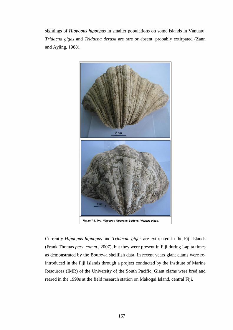
167
sightings of Hippopus hippopus in smaller populations on some islands in Vanuatu,
Tridacna gigas and Tridacna derasa are rare or absent, probably extirpated (Zann
and Ayling, 1988).
Currently Hippopus hippopus and Tridacna gigas are extirpated in the Fiji Islands
(Frank Thomas pers. comm., 2007), but they were present in Fiji during Lapita times
as demonstrated by the Bourewa shellfish data. In recent years giant clams were re-
introduced in the Fiji Islands through a project conducted by the Institute of Marine
Resources (IMR) of the University of the South Pacific. Giant clams were bred and
reared in the 1990s at the field research station on Makogai Island, central Fiji.
168
At Qoqo Island, Nunn et al. (2006) reported that Tridacna species were common
during the early period of settlement but became rarer later on. A similar pattern is
also observed for Bourewa. Human predation could be an important factor in the
reduction of both Tridacna gigas and Hippopus hippopus at Qoqo and Bourewa.
Nunn (2007a) citing collaborative work done by Szabó (2006), reported that
Tridacna shells comprise a small proportion (8%) of the reworked shell artifacts at
the Bourewa site, possibly reflecting their relative abundance and availability during
Lapita times. Perhaps due to their attractiveness as food, they were exploited beyond
replenishment and consequently became extirpated, although environmental change
may be important, but detailed work is required to support this assertion.
It is clear that overexploitation has led to the extirpation of giant clams like Tridacna
gigas and Hippopus hippopus in most parts of the northern and southern Pacific
(Copland and Lucus, 1988). So, it is plausible to suggest that perhaps increased
human predation by the Bourewa settlers may be responsible for the demise of these
two Tridacnidae species along the Rove Peninsula.
Although the Intertidal/Coral Reef Habitat comprised fewer shellfish species than the
Shoreline Sandy/Muddy Habitat, the abundance index measures suggest that diet
breadth had also been expanding through time. This conclusion is also supported by
the diversity (richness) of shellfish species associated with the Intertidal/Coral Reef
Habitat though it may only reflect a moderate resource depression trend within the
Intertidal/Coral Reef Habitat rather than a heavy level of exploitation.
As predicted by the patch choice model, foraging efficiency within both the
Shoreline Sandy/Muddy and Intertidal/Coral Reef Habitats appear to have decreased
through time. Such a declining trend in foraging efficiency particularly within the
Intertidal/Coral Reef Habitat during Zone B to A coincides with the time when the
Bourewa area was experiencing an influx of new migrants and concomitant increase
in its population. The settlement experienced expansion along its peripheral areas to
accommodate the new residents (Nunn, 2007a) so perhaps this population growth
placed additional pressures on the available shellfish resources.

169
The results of the prey and patch choice analysis suggest a decrease in the use of the
Shoreline Sandy/Muddy Habitat over time particularly from Zone B to A. The
increased utilisation over time of the Intertidal/Coral Reef Habitat is not necessarily
reflected in the decrease in Codakia punctata but indicates that other Shoreline
Sandy/Muddy Habitat shellfish species like Fimbria fimbriata had also declined in
abundance. So a shift in the utilisation of shellfish resources from the Shoreline
Sandy/Muddy Habitat to the Intertidal/Coral Reef Habitat during Zone A, probably
signify a decline in foraging efficiency. This trend is reflected by the increasing
proportion of both Strombus gibberulus gibbosus and Trochus niloticus especially
during Zone A (Table 6.12) which are coral-reef dwelling shellfish species.
Alternatively, this observed trend could be due to the impact of the changing
environmental conditions (sea level) along the Rove Peninsula as the Lapita
occupation of Bourewa was approaching its end. It is plausible to infer from the
Bourewa shellfish data that the declining sea level toward the end of the Lapita era in
Fiji may have favoured certain coral-reef dwelling shellfish families like Strombidae
and Trochidae over most bivalve shells. Perhaps sea-level fall would have
disadvantaged certain shellfish species of the Shoreline Sandy/Muddy Habitat due to
the gradual loss of their habitats, while coral reefs and mangroves were expanding
thus favouring shellfish species within the Intertidal/Coral Reef Habitat. This
situation is exemplified by observations also recorded by Amesbury (2007) for the
Mariana Islands, Kirch and Yen (1982) on Tikopia Island, Solomon Islands, and
Spennemann (1987) for Tongatapu Island, Tonga.
7.2.3 Shellfish Diversity and Abundance
Overall the NTAXA analysis shows an increase through all periods within the
Intertidal/Coral Reef Habitat. The NTAXA assessment for the Shoreline
Sandy/Muddy Habitat reveals that from Zone C to B, diet breadth increased from 15
items to 17 items but it decreased to 16 items during Zone A (Figure 6.12). Even
though diet breadth appears to have increased through time within the Shoreline
Sandy/Muddy Habitat, its expansion is not comparable to that of the Intertidal/Coral
Reef Habitat.
170
The NTAXA analysis demonstrates that diet breadth expanded significantly during
Zone B within both the Intertidal/Coral Reef and Shoreline Sandy/Muddy Habitats
but only slightly within Zone A. Generally the NTAXA analysis of the shell
assemblage represents a diversified and generalised diet breadth which indicates
declining foraging efficiency over time.
Evenness analysis for the entire shellfish assemblage demonstrates that evenness
remained fairly steady within Zone C to B and increased during Zone A (Figure
6.13). As such there is a general increase in the relative contribution of the different
shellfish taxa to the shell assemblage over time.
Although the evenness values for the entire assemblage are notably fairly lower, this
indicates widening of diet breadth to include other shellfish resources and may
suggest overall decline in foraging efficiency. So for Bourewa, evenness did vary
through time because evenness indices are all between 0.33 and 0.42. Thus, it can be
broadly interpreted as indicating that the relative contribution of the different
shellfish species at Bourewa did change over time. As such it would appear that
some level of resource depression is occurring particularly toward the end of the
Lapita period (Zone A).
For the Intertidal/Coral Reef Habitat (Figure 6.14), evenness remains similar through
time, though there is a slight increase during Zone B. Overall this trend seems to
indicate that diet breadth is relatively stable over time. In contrast, the evenness trend
for the Shoreline Sandy/Muddy Habitat (Figure 6.15) is similar to that of the entire
shell assemblage. Evenness within the Shoreline Sandy/Muddy Habitat indicates
widening of the diet breadth to include other low-ranked shellfish resources which
would signal that resource depression had been occurring.
The relative abundance measures for the five common shellfish species (Codakia
punctata, Fimbria fimbriata, Strombus gibberulus gibbosus, Anadara antiquata and
Trochus niloticus) lend support to the interpretations provided for both the diet
breadth and NTAXA and evenness analyses of the Bourewa shellfish. Upon
inspection, the total percentages of these five shellfish taxa also decreased though
time for example, from 88.4% during Zone C to 87.2% during Zone B, and to 83.2%

171
during Zone A (Table 6.12). It is evident that while these shellfish species had
declined, their proportional contributions became more evenly distributed through
time.
Based on the relative abundance analysis, it appears that while Codakia punctata had
been declining, other shellfish species (Fimbria fimbriata, Strombus gibberulus
gibbosus, Anadara antiquata and Trochus niloticus) increased over time. Such
analysis may signify several important trends, (i) diet breadth is expanding (ii)
resource depression is occurring (iii) foraging efficiency is declining and (iv) there is
a shift in subsistence strategy to incorporate other low-ranked shellfish resources into
the diet perhaps to either offset the impact of declining shellfish resources, or allow
exploited species to recover from increased stress due to increased human predation.
7.3 Implications of archaeological shellfish data for marine resources
management
The Bourewa shellfish data have shown how human exploitation can be related to
environmental change and in terms of modern resources management it can provide
resource managers with numerous scenarios. These are summarised here:
The shellfish resources of the Rove Peninsula have been continuously
exploited for many centuries by the Lapita people, a period extending some
500-600 years. Thus the Bourewa shell assemblage is amongst some of the
oldest known continuously exploited shellfish resources in the Eastern Lapita
Province and particularly in the Fiji Islands.
As a food source for early Lapita settlers of Bourewa, shellfish resources
undoubtedly have been an important component of their diet and perhaps
played a significant role in their life ways. Although certain habitats
experienced declines in large-sized mollusc resources, the early settlers also
utilised other shellfish resources and habitats to perhaps offset declining
shellfish stocks. Increased predation may have caused early human
populations of Bourewa to exploit other marine resources like fin fish, sea

172
turtles, echinoderms and other invertebrates and/or to develop
horticultural/agricultural practices while crop cultivation was important as
well during the middle stages of settlement at Bourewa (Horrocks and Nunn,
2007).
The Bourewa shellfish data suggest that the exploitation on sessile
invertebrates, such as molluscs, can be quantitatively determined by
examining the shell assemblage. While it is possible that long-term
subsistence exploitation can markedly reduce the average size composition of
mollusc populations and the species structure of communities, the Bourewa
shellfish analysis reveal moderate level of shellfish exploitation and relative
stability. Although no significant reduction in shell size is being recorded for
the most common shellfish species (Codakia punctata) at Bourewa, other
shellfish like Strombus gibberulus gibbosus and Fimbria fimbriata did reveal
some level of shell size reduction.
The archaeological record for subsistence shellfish on the reefs and in
lagoons along the Rove Peninsula suggests overall long-term stability and
continuity. Changes in relative composition and abundance of shellfish taxa
in the temporal sequence possibly resulting more from increased foraging
activities, although the impact of sea level change may have been important
as well but further investigation is required.
In general it can be demonstrated from the shellfish analysis that while the
subsistence practices of the Bourewa settlers on shellfish resources have shown some
degree of change over Fiji�s prehistory especially from about 1200/1100 to 700/600
BC, other important horticultural/agricultural innovations were also practiced at
Bourewa. Although sea-level change during the mid-Holocene period may have
possibly influenced the availability of certain shellfish resources and habitats along
the Rove Peninsula, human predation patterns remain steady. As stated by Dalzell
(1998), the patterns of fisheries exploitation in the Pacific may have significantly
changed only from the period of European expansion (colonialism) and the intrusion
of European, American and Asian traders during the era of commercial fisheries in

173
the Pacific and as a result of abrupt environmental changes like those that occurred
during the �AD1300 Event� in Fiji (Field, 2004; Morrison and Cochrane, 2008;
Nunn, 2003).
According to Dalzell (1998:247-249), the archaeological (evidence) record can be
utilised by managers of fisheries resources to develop possible management
scenarios or strategies. These include;
(i) to �reinforce the social and cultural importance of fisheries, and to help
ascertain traditional property rights, even though these may have declined
through European colonisation and progressive urbanisation�. An
example of traditional management practice which is common in many
Pacific Islands and emphasises traditional rights is Customary Marine
Tenure (CMT). This practice is based on the principle of clans, chiefs
and/or communities claiming exclusive rights to fishing areas while
excluding outsiders from these areas which essentially contrasts markedly
with the concept of the �tragedy of the commons� which is observed in
areas with open access (Hickey, 2001). Hickey also recognises that CMT
practices can complement contemporary management strategies to
effectively manage marine resources.
(ii) to �be used comparatively with sources from colonial era and post-
colonial era for developing fishery management initiatives in the Pacific
Islands�. As noted by Dalzell (1998), during the colonial and post-
colonial period in the Pacific region many factors have been important in
influencing the perception and behaviour of Pacific islanders towards
marine resource utilisation and management. A case in point is the
influence of religious beliefs, doctrines like those observed by the
Seventh Day Adventists (SDA) where certain marine animals (including
shellfish) are not allowed for human consumption. This aspect of religion
can be encouraged and combined with archaeological data to develop
proper and appropriate management strategies for managing marine
(shellfish) resources in different Pacific island situations.

174
(iii) to �provide a rich vein of information about long-term subsistence
exploitation of reef and lagoon fisheries resources�. Archaeological data
from most parts of the Pacific have shown that marine resource utilisation
have been important to the life ways of prehistoric populations (Nunn,
2007b; Nunn and Heorake, 2009) so an understanding of the way ancient
peoples interacted with resources could also provide resource managers
with useful management tools and strategies. An example is the Bourewa
shellfish data which spans a period of 500-600 year-long human
subsistence history. Such data will be vital to develop management
scenarios for marine resource managers especially when it considers the
long-term interplay between both human and non-human factors.
(iv) to �develop and adopt multi-disciplinary approaches to coastal fisheries
management by making use of broader range of information sources as
inputs into the management process, particularly where conventional
fisheries data are poor or even completely lacking�. The scarcity of
fisheries data is one of the important factors contributing to inappropriate
fisheries management practices and ineffective and unclear fisheries
policy initiatives in most Pacific Islands. As highlighted by Aqorau,
countries like the Solomon Islands have to employ the �precautionary
approach� principle to fisheries management due to lack of proper
fisheries data (Aqorau, 2001). But, fisheries managers could incorporate
archaeological data to assist in designing and developing relevant and
effective fisheries management strategies and policies because numerous
archaeological (marine faunal) studies that have been conducted in most
Pacific Islands in the recent past can provide very useful baseline data.
Archaeological analysis like the Bourewa shellfish study can provide marine
resource managers with a robust and effective management tool for understanding
modern resource management practices particularly for shellfish species and habitat
exploitation.

175
Chapter 8. Conclusion
8.1 Introduction
This chapter provides a summary of the results and analysis of the shellfish species
and habitats at Bourewa in relation to the aims and objectives of this thesis.
8.2 Conclusion
According to Nunn and Heorake (2009), one of the keys to understanding early
human-environment interactions is to know the types of resources that people
exploited, the environments they encountered, and how environmental change
influenced their subsistence strategies and behaviour over time. For most Pacific
islands, human and non-human factors have been important in influencing the
lifeways of the pre-historic peoples, the selection of various island environments for
establishment of settlements, and the exploitation of their resources.
The geoarchaeological excavations at the Bourewa Lapita site over the past few
seasons have provided new opportunities to understand the life ways of the first
people who settled the Fiji Islands, lived and utilised the marine shellfish resources
that were available to them at that time. In particular, by studying the shells
recovered from the mid-2005 archaeological dig at Bourewa, inferences about
human subsistence behaviour and their impact on the shellfish species and habitats,
and the influence of environmental change on shellfish resources could be made.
As such, based on the Bourewa shellfish and habitat analyses, two possible
explanations have been posited to explain the variability in the shellfish species and
habitat usage at Bourewa. The first is associated with human-induced subsistence
pressure on shellfish species and habitats while the second is linked to environmental
impact particularly the possible influence of sea-level fall (after the mid-Holocene)
on certain shellfish species and habitats along the Rove Peninsula. These two
scenarios are discussed in subsections 8.2.1 and 8.2.2.
176
8.2.1 Human subsistence patterns as revealed by the Bourewa shellfish and
habitat analyses
As Nunn (2007b) suggests, the proximity and availability of abundant marine
resources on tropical Pacific Islands during Lapita times were a major drawcard for
the selection and settlement of most Lapita sites. In Fiji, the Bourewa site was
selected by the Lapita people principally due to the presence of and access to
abundant marine resources including shellfish located on an unusually nearby broad
fringing coral reef. It is evident that when the first Lapita people arrived at Bourewa
some three thousand years ago, there were plenty of shellfish resources from which
they could select and collect from nearby shellfish habitats for consumption. These
shellfish species were energy efficient and essentially no specialised skills were
required to forage and prepare these shells (Nunn and Heorake, 2009).
Through the utilisation of various faunal quantitative methods (MNI, NISP, weight,
and size) and analysis, characterising the structure and composition of the shell
midden at Bourewa is possible. While gastropods constitute the most diverse
shellfish taxa in the shell assemblage, bivalves compose the most abundant and high-
ranked shellfish species. From the shellfish analysis it appears that the Bourewa
settlers consumed mostly bivalves which were generally large-sized, meaty and
energy efficient. This is evident from the quantity of bivalves excavated at the
Bourewa site. The common bivalve shellfish include; Codakia punctata, Fimbria
fimbriata, Anadara antiquata, Batissa violacea, Strombus gibberulus gibbosus,
Trochus niloticus and Turbo chrysostomus. Today most of these shellfish species can
still be gleaned and collected on reefs in the Fiji Islands including along the Rove
Peninsula, though some are becoming rarer due to over harvesting. Other large-sized
bivalves like Tridacna gigas and Hippopus hippopus which were present during
Lapita times are now extirpated in the Fiji Islands.
Analysis of the Bourewa shellfish assemblage using different foraging models (prey
choice, patch choice and central place) has allowed for testing various assumptions
and predictions concerning human foraging efficiency and the utilisation of shellfish
species and habitats along the Rove Peninsula. The results and analysis indicate that

177
both shellfish species and habitats were subjected to human predation pressures
during Fiji�s prehistory especially during the Lapita era.
The Bourewa shellfish analysis demonstrates that foraging efficiency within both the
Shoreline Sandy/Muddy and Intertidal/Coral Reef Habitats generally declined
through time. Although the Shoreline Sandy/Muddy Habitat remained important
during Zones C and B, it decreased in status during Zone A. This trend coincided
with a shift in foraging emphasis to other shellfish species and habitats that were
exploited over time. Present evidence also suggests that during the middle to the end
of the Lapita period (Zones B to A) at Bourewa, the Lapita people began
increasingly targeting a range of diverse shellfish species from the Intertidal/Coral
Reef Habitat, as those species within the Shoreline Sandy/Muddy Habitat had
gradually declined both in relative abundance and status.
Shellfish diversity and NTAXA increased during all the zones of the Intertidal/Coral
Reef and the Shoreline Sandy/Muddy Habitats. Evenness measures demonstrate that
evenness also increased during Zone C to B but decreased during Zone A of the
Intertidal/Coral Reef Habitat, while evenness increased during all periods within the
Shoreline Sandy/Muddy Habitat. These results suggest that foragers were targeting
more diverse shellfish species within the Shoreline Sandy/Muddy Habitat indicating
declining foraging efficiency, broadening of their diet and changes in their
subsistence strategies.
Based on the Bourewa shellfish analysis, it is possible that human induced resources
depression within the Shoreline Sandy/Muddy Habitat has led to a shift toward the
use of the Intertidal/Coral Reef Habitat especially towards the end of the Lapita
period. This means that as the Shoreline Sandy/Muddy shellfish taxa were
increasingly stressed, foragers began targeting shellfish species from the
Intertidal/Coral Reef Habitat and over time foraging efficiency within both habitats
also declined as more diverse shellfish (and low-ranked) species from both habitats
were being targeted and incorporated into their diet.
Additionally, the incorporation of other shellfish species into their diet resulted in an
expansion of their diet breadth and declining foraging efficiency. The decline in their

178
foraging efficiency also led to the consumption of small-sized, less profitable prey.
Consequently they were also collecting shellfish species that were located farther
away from the settlement site. This means that foragers were also spending more
time in collecting shells within the different shellfish habitats.
It is important to note that this study does not suggest or imply that the early settlers
of Fiji in general may have had profound negative impact on other islands, but these
results can only be applied to prehistoric marine (shellfish) resources use at the
Bourewa settlement. Also this study does not suggest mismanagement of marine
ecosystems in Fijian prehistory, but it does demonstrate a shift in foraging to other
low-ranked shellfish species and habitats from increased human predation or perhaps
to allow for the exploited species and habitats to repopulate and recover. This shift in
subsistence strategy also coincided with the later introduction and cultivation of root
crops like taro and yam at Bourewa and the possibility of environmental impact on
certain shellfish species. The present study can not demonstrate the influence of
horticulture/agriculture on shellfish usage, but it is clear that
horticultural/agricultural practices were important during the middle stage of Lapita
occupation of Bourewa (Horrocks and Nunn, 2007).
Generally the Bourewa shellfish data suggest that the Lapita people were principally
�people of the sea�. They utilised shellfish resources from a range of ecosystems like
mangroves, mudflats, and coral reefs, and perhaps caught and ate turtles, sharks and
other marine (pelagic) finfish and invertebrates and perhaps seaweed and marine
algae (Nunn, 2007b). It is can be inferred from the available data that shellfish
resources along the Rove Peninsula were generally plentiful during Lapita times and
the Bourewa settlers consumed large quantities of available shellfish species. The
initial Lapita settlers of Bourewa were principally consuming large quantities of
shellfish from a range of shellfish habitats along the Rove Peninsula and probably
their diet comprised primarily of shellfish. Perhaps later on during Lapita times,
terrestrial foods like taro became incorporated into their diet, though marine food
resources like shellfish still played an important role.
A notable trend is the presence of a range of edible small-sized bivalves and
gastropods albeit fewer in abundance. These shellfish species were most probably

179
foraged by children. As observed by Bird and Bird (2000, 2002) in the foraging
behaviour of the Meriam children of Torres Strait Islands, it can be assumed that
small-sized shellfish species of Bourewa were collected and perhaps taken and
consumed at the site by the children. Bird and Bird (2000) also noted that adult
foragers do not usually collect small-sized shellfish species, but it is children who are
most likely to collect low-ranked shellfish species either as part of their play and/or
for consumption. That is probably how these small-sized shellfish taxa ended up in
the shell midden thus contributing to the structure of the midden deposit at Bourewa.
Some examples of these smaller-sized shellfish species include Cypraea annulus,
Cypraea moneta, Polinices tumidus, Polinices spp., Natica spp., Cerithium
nodulosum, Cymatium sp. and Neverita peselephanti.
8.2.2 Environmental impact on shellfish resources at Bourewa
Another explanation for the observed changes in shellfish species and habitat usage
at Bourewa is associated with the possibility of environmentally induced effect
particularly the influence of sea-level change on certain shellfish species within both
the Shoreline Sandy/Muddy and Intertidal/Coral Reefs Habitats. It is clear that the
occupation of the Bourewa site and other locations along the Rove Peninsula by the
Lapita people occurred at a time when the environment was also experiencing
significant changes both regionally and locally, so an understanding of the nature of
environmental change occurring during the Lapita occupation of Bourewa and its
impact on marine resources along the Rove Peninsula is important.
As posited by Nunn (2005), sea-level and climatic changes have been major factors
in the subsequent changes in prehistoric settlement patterns on most Pacific Islands
including Fiji. The development and upgrowth of coral reefs and expansion
mangroves on Vusama Island and the subsequent shoaling of the Tuva Estuary were
possibly linked to sea-level fall after the mid-Holocene which may have had an
impact on the abundance and availability of certain shellfish resources. The impact
of sea-level change on the availability shellfish species in the Pacific Islands is well
documented (Amesbury 1999, 2007; Kirch and Yen 1982; Spennemann, 1987) and
also inferred for the Qoqo Island Lapita site in Fiji (Nunn et al., 2006). In fact due to

180
the proximity of Qoqo to Bourewa, the impact of sea-level fall on the faunal records
of both sites would be somewhat similar.
Recent studies have suggested that localised sea-level fall after the mid-Holocene
period had had significant impact on certain shellfish species and the subsistence
behaviour of prehistoric Pacific peoples. For example, the fall in sea level on some
Pacific Islands like the Marianas, Tikopia Island, and Tongatapu Island had resulted
in shellfish habitat (environmental) change thus favouring certain shellfish species
over others (Amesbury, 2007; Kirch and Yen, 1982; Spennemann, 1987).
It can be inferred form the present shellfish data that the fall in sea-level during
Lapita times was important in influencing the abundance and availability of certain
shellfish habitats and species along the Rove Peninsula. For example the decline in
abundance of the freshwater bivalve Batissa violacea from Zone C to A can be
attributed to the shoaling of the Tuva Estuary due to sea level fall and increased
sedimentation. There is also an increase in the consumption of the reef-dwelling
gastropods Strombus gibberulus gibbosus and Trochus niloticus which also
coincided with coral reef expansion and upgrowth along the Rove Peninsula. These
two cases may signify environmental influence on the availability of these shellfish
taxa during Lapita times. While on the one hand sea-level fall may have been
responsible for the decline of the freshwater bivalve Batissa violacea, on the other
hand it had encouraged the availability of mostly coral-reef dwelling shells like those
belonging to the Strombidae and Trochidae families.
There is also a marked decline over time in the relative abundance of Codakia
punctata while other common shellfish taxa like Fimbria fimbriata and Anadara
antiquata have increased. The present study can posit that these trends are linked
with sea-level change during and after the mid-Holocene. It has been suggested that
the fall in sea level after the mid-Holocene has been responsible for the declining
abundance of certain shellfish species in some Pacific islands (Amesbury, 2007;
Kirch and Yen, 1982; Spennemann, 1987). The Bourewa shellfish data also show
that shellfish abundance and availability were linked with sea-level change during
Lapita times. The impact of falling sea level on the availability of some shellfish
species like Batissa violacea, Strombus gibberulus gibbosus and Trochus niloticus

181
and the subsistence strategies of the Bourewa (Lapita) people has been demonstrated.
The present study also provides clues to the link between sea-level change and the
availability of shellfish species and habitats along the Rove Peninsula during Lapita
times.
Based on the Bourewa shellfish data and analysis, both human and non-human
factors have played major roles in influencing shellfish species and habitats during
the Lapita era in Fiji. While the impact of early human predation on shellfish species
along the Rove Peninsula has been demonstrated, this study also highlights the
possible influence of sea-level fall (change) on shellfish species and habitats and the
shifts in subsistence strategies of the early Lapita people in Fiji.

182
References
Abbott, R. T. and Dance, S. P., 1982. Compendium of seashells. Dunnot, New York.
Abbott, R. T. and Dance, S. P., 2000. Compendium of seashells. El Cajon, CA:
Odyssey.
Allen, M. S., 1992. Temporal variation in Polynesian fishing strategies: The
Southern Cook Islands in regional perspective. Asian Perspectives 31:183-
204.
Allen, M. S., 2003. Human Impact on Pacific Nearshore Marine Environments. In:
Sand, C. (Ed.). Pacific Archaeology: assessments and prospects. Proceedings
of the International Conference for the 50th anniversary of the first Lapita
excavation (July 1952), Koné-Nouméa 2002. Le Cahiers de I�Archaélogie en
Nouvelle-Calédonie 15. pp. 317-325.
Allen, M. S., Ladefoged, T. N. and Wall, J. J., 2001. Traditional Rotuman Fishing in
Temporal and Regional Context. International Journal of Osteoarchaeology
11:56-71.
Amesbury, J. R., 1999. Changes in species composition of archaeological marine
shell assemblages in Guam. Micronesica 31:347-366.
Amesbury, J. R., 2007. Mollusk collecting and environmental change during the
Prehistoric Period in the Mariana Islands. Coral Reefs 26:947-958.
Anderson, A. J., 1981. A model of prehistoric collecting on the rocky shore. Journal
of Archaeological Science 8:109-120.
Anderson, A. J., 1996. Adaptive voyaging and subsistence strategies in the early
settlement of East Polynesia. In: Akazawa, T. and Szathmány, E. (Eds.).

183
Prehistoric Mongoloid Dispersals, pp. 357-71. Oxford University Press:
Oxford.
Anderson, A. J., 2003. Initial human dispersal in Remote Oceania: Pattern and
explanation. In: Sand, C. (Ed.). Pacific Archaeology: assessments and
prospects. Proceedings of the International Conference for the 50th
anniversary of the first Lapita excavation (July 1952), Koné-Nouméa 2002.
Le Cahiers de I�Archaélogie en Nouvelle-Calédonie 15. pp. 71-84.
Anderson, A. and Clark, G., 1999. The age of Lapita settlement in Fiji. Archaeology
in Oceania 34:31-39.
Anderson, A. and O�Connor, S., 2008. Indo-Pacific Migration and Colonisation �
Introduction. Asian Perspectives 47(1):2-11.
Anderson, A., Roberts, R., Dickinson, W., Clark, G., Burley, D., de Biran, A., Hope,
G. and Nunn, P., 2006. Times of sand: Sedimentary history and archaeology
at the Sigatoka dunes, Fiji. Geoarchaeology 21:131-154.
Aqorau, T., 2001. Sustainable management and development of Solomon Islands
Fishery Resources: new directions in fisheries policy. Pacific Economic
Bulletin 16(2):120-125.
Athens, J. S., 1997. Hawaiian native lowland vegetation in prehistory. In: Kirch, P.
V. and Hunt, T. L. (Eds.). Historical Ecology in the Pacific Islands:
Prehistoric Environmental and Landscape Change. Yale University Press,
New Haven. pp. 248-270.
Bate, D. M. A., 1937. Paleontology: The fossil fauna of the Wady El-Mughara
Caves. In: Garrod, D. A. E. and Bate, D. M. A. (Eds.). The Stone Age of Mt.
Carmel: Excavations at the Wady El-Mughara. Volume 1, Oxford. Oxford
University Press. pp. 135-240.

184
Bedford, S., 2003. The timing and nature of Lapita colonisation in Vanuatu: the haze
begins to clear. In: Sand, C. (Ed.). Pacific Archaeology: assessments and
prospects. Proceedings of the International Conference for the 50th
anniversary of the first Lapita excavation (July 1952), Koné-Nouméa 2002.
Les Cahiers de l�Archeologie en Nouvelle-Calédonie 15. pp. 147-158.
Bedford, S., 2006. Pieces of the Vanuatu Puzzle: Archaeology of the North, South
and Centre. Terra Australis, Volume 23. Pandanus Books.
Bedford, S. and Spriggs, M., 2008. Northern Vanuatu as a Pacific Crossroads: The
Archaeology of Discovery, Interaction, and the Emergence of the
�Ethnographic Present�. Asian Perspectives 47(1):95-120.
Bedford, S., Spriggs, M. and Gegenvanu, R., 2006. The Teouma Lapita site and the
early settlement of the Pacific Islands. Antiquity 80:812-828.
Bellwood, P. S., 1980. The peopling of the Pacific. Scientific America 234(5):138-
147.
Best, S., 1981. Excavations at Site VL 21/5 Naigani Island, Fiji: A Preliminary
Report. Auckland: Department of Anthropology, University of Auckland.
Best, S., 1984. Lakeba: The Prehistory of a Fijian Island. PhD Dissertation,
University of Auckland, New Zealand.
Bird, D. W. and Bird, R. B., 1997. Contemporary shellfish gathering strategies
among the Meriam of the Torres Strait Islands, Australia: testing predictions
of a central place foraging model. Journal of Archaeological Science 24:39-
63.
Bird, D. W. and Bird, R. B., 2000. The Ethnoarchaeology of Juvenile Foragers:
Shellfishing Strategies among Meriam Children. Journal of Anthropological
Archaeology 19:461-476.

185
Bird, D. W. and Bird, R. B., 2002. Children on the reef: slow learning or strategic
foraging? Human Nature 13(2):269-297.
Bird, D. W. and O�Connell, J. F., 2006. Behavioural Ecology and Archaeology.
Journal of Archaeological Research 14:143-188.
Bird, D. W., Richardson, J. l., Veth, P. M. and Barham, A. J., 2002. Explaining
Shellfish Variability in Middens on the Miriam Islands, Torres Strait,
Australia. Journal of Archaeological Science 29:457-469.
Birks, L. and Birks, H., 1967. A brief report of excavations at Sigatoka, Fiji. New
Zealand Archaeological Association Newsletter 10(1):16-25.
Burley, D. V., 1998. Tongan archaeology and the Tongan Past, 2850-150 BP.
Journal of World Prehistory 12(3):337-392.
Burley, D. V. and Dickinson, W. R., 2001. Origin and significance of a founding
settlement in Polynesia. National Academy of Science, Proceedings
98:11829-11831.
Burley, D. V. and Clark, J. T., 2003. The archaeology of Fiji/West Polynesia in the
Post-Lapita era. In Sand, C. (Ed.). Pacific Archaeology: Assessments and
Prospects. Proceedings of the International Conference for the 50th
anniversary of the first Lapita excavation (July 1952), Koné-Nouméa 2002.
Les Cahiers de l�Archaéologie en Nouvelle-Calédonie 15. pp. 235-254.
Burley, D. V., Dickinson, W. R., Barton, A. and Shutler, R. Jr., 2001. Lapita on the
periphery: New data on old problems in the Kingdom of Tonga. Archaeology
in Oceania 36:89-104.
Butler, V. L., 2000. Resource depression on the Northwest Coast of North America.
Antiquity 74:649-661.

186
Butler, V. L., 2001. Changing Fish Use on Mangaia, Southern Cook Islands
Resource Depression and the Prey Choice Model. International Journal of
Osteoarchaeology 11:88-100.
Cannon, M. D., 2003. A model of central place forager prey choice and an
application to faunal remains from the Mimbres Valley, New Mexico.
Journal of Anthropological Archaeology 22:1-25.
Catterall, C. P. and Poiner, I. R., 1983. Age- and sex-dependent patterns of
aggregation in the tropical gastropod Strombus luhuanus. Marine Biology
77:171�182.
Cernohorsky, W. O., 1972. Marine Shells of the Pacific. Vol. 2. Pacific Publications.
Sydney.
Child, J., 1974. New Zealand Shells. Auckland: William Colling.
Claassen, C., 1998. Shells. Cambridge University Press, Cambridge.
Clark, G. and Anderson, A., 2001. The pattern of Lapita settlement in Fiji.
Archaeology in Oceania 36:77-88.
Clark, J. T., Cole, A. O. and Nunn, P. D., 1999. Environmental change and human
Prehistory on Totoya Island, Fiji. In: Galipaud, J. C. and Lilley, I. (Eds.). The
Pacific from 5000 to 2000 BP: Colonization and transformations. pp. 227-
240.
Clark, G., Anderson, A. and Matararaba, S., 2001. The Lapita site at Votua, northern
Lau Islands, Fiji. Archaeology in Oceania 36:134-145.
Clason, A. T., 1972. Some remarks on the Use and Presentation of
Archaeozoological Data. Helinium 12(2):139-153.
Copland, J. W. and Lucus, J. S., 1988. Giant clams in the Asia and the Pacific.
Australian Centre for International Agricultural Research.

187
Crowther, A., 2005. Starch residues on undecorated Lapita pottery from Anir, New
Ireland. Archaeology in Oceania 40:62-66.
Dalzell, P., 1998. The role of archaeological and cultural-historical records in long-
range coastal fisheries resources management strategies and policies in the
Pacific Islands. Ocean and Coastal Management 40:237-252.
Davidson, J. and Leach, F., 2001. The Strandlooper concept and economic naivety.
In: Clark, G. R., Anderson, A. J. and Vunidilo, T. (Eds.). The Archaeology of
Lapita Dispersal in Oceania: Papers from the Fourth Lapita Conference,
June 2000. Canberra: Australian National University, Pandanus Books, pp.
115-123.
Dickinson, W. R., 2005. Petrography of sand tempers in Lapita potsherds from
Bourewa, southwest Viti Levu, Fiji. Unpublished Petrographic Report WRD-
250.
Dickinson, W. R., Burley, D. V., Nunn, P. D., Anderson, A., Hope, G., de Biran, A.,
Burke, C. and Matararaba, S., 1998. Geomorphic and archaeological
landscapes of the Sigatoka Sand Dune site, Viti Levu, Fiji. Asian
Perspectives 37:1-31.
Field, J. S., 2004. Environmental and climatic considerations: a hypothesis for
conflict and the emergence of social complexity in Fijian prehistory. Journal
of Anthropological Archaeology 23(1):79-99.
Fitzpatrick, S. M. and Kataoka, O., 2005. Prehistoric fishing in Palau, Micronesia:
evidence from the Northern Rock Islands. Archaeology in Oceania 40:1-13.
Fullagar, R., Field, J., Denham, T. and Lentfer, C., 2006. Early and mid-Holocene
tool-use and processing of taro (Colocasia esculenta), yam (Dioscorea sp.)
and other plants at Kuk Swamp in the highlands of Papua New Guinea.
Journal of Archaeological Science 33:595-614.

188
Geraghty, P. A., 1983. The History of the Fijian Languages. Oceanic Linguistics
Special Publication No. 19. Honolulu: University of Hawaii Press.
Gifford, E. W., 1951. Archaeological excavations in Fiji. University of California
Archaeological Records 13:189-288.
Gimin, R. and Lee, C. L., 1997. The reproductive cycle of Trochus niloticus in King
Sound, Western Australia. In: Lee, C. L. and Lynch, P. W. (Eds.). Trochus
status, hatchery practices and nutrition. Proceedings of a workshop held at
Northern Territory University, 6-7 June 1996. Australian Centre for
International Agricultural Research, Canberra.
Glassow, M. A., 2000. Weighing verses Counting Shellfish Remains: A Comment
on Mason, Peterson and Tiffany. American Antiquity 65(2):407-414.
Gosden, C., 1993. Understanding the settlement of the Pacific Islands in the
Pleistocene. In: Smith, M. A., Spriggs, M. and Fankhauser, B. (Eds.). Sahul
in Review: Pleistocene Archaeology in Australia, New Guinea and Island
Melanesia. pp. 131-136. Occasional Papers in prehistory, No. 24. Canberra:
Department of Prehistory, Australian National University.
Gosden, C. and Webb, J., 1994. The creation of a Papua New Guinean landscape:
Archaeological and geomorphological evidence. Journal of Field
Archaeology 21:29-51.
Goven, H., Nicholas, P. V. and Tafea, H., 1988. Giant clam resource investigations
in Solomon Islands. In: Copland, J. W. and Lucus, J. S. (Eds.). Giant clams
in the Asia and the Pacific. Australian Centre for International Agricultural
Research.
Grayson, D., 1984. Quantitative Zooarchaeology: Topics in the Analysis of
Archaeological Faunas. Academic Press, New York.

189
Grayson, D., 2001. The archaeological record of human impacts on animal
populations. Journal of World Prehistory 15(1):1-68.
Grayson, D. and Delpech, F., 1998. Changing diet breadth in the Early Upper
Paleolithic of southwestern France. Journal of Archaeological Science
25:1119-1129.
Green, R. C., 1963. A suggested revision of the Fijian sequence. Journal of the
Polynesian Society 72:235-253.
Green, R. C., 1979. Lapita. In: Jennings, J. (Ed.). The Prehistory of Polynesia.
Cambridge: Harvard University Press. pp. 27-60.
Green, R. C., 1982. Models for the Lapita cultural complex: an evaluation of some
current proposals. New Zealand Journal of Archaeology 4:7-19.
Green, R. C., 1991a. The Lapita Cultural Complex: current evidence and proposed
models. In: Bellwood, P. (Ed.). Indo-Pacific Prehistory 1990: Proceedings of
the 14th Congress of the Indo-Pacific Prehistory Association. pp. 195-305.
Canberra: Indo-Pacific Prehistory Association.
Green, R. C., 1991b. A reappraisal of the dating of some Lapita sites in the
Reef/Santa Cruz group of Southeast Solomons. Journal of Polynesian Society
100:197-207.
Green, R. C. and Davidson, J. M., 1974. A radiocarbon and stratigraphic sequence for
Samoa. In: Green, R. C. and Davidson, J. M. (Eds.). Archaeology in Western
Samoa, Volume 2. Auckland: Auckland Institute and Museum Bulletin 7:212-
224.
Gremillion, K. J., 2002. Foraging Theory and Hypothesis Testing in Archaeology:
An Exploration of Methodological Problems and Solutions. Journal of
Anthropological Archaeology 21:142-164.

190
Groube, L., 1971. Tonga, Lapita pottery, and Polynesian origins. Journal of the
Polynesian Society 80:278-316.
Horrocks, M. and Bedford, S., 2004. Microfossil analysis of Lapita deposits in
Vanuatu reveals introduced Araceae (aroids). Archaeology in Oceania 39:67-
74.
Horrocks, M. and Nunn, P. D., 2007. Evidence for introduced taro (Colocasia
esculenta) and lesser yam (Dioscorea esculenta) in Lapita-era (c. 3050-2500
cal. yr BP) deposits from Bourewa, southwest Viti Levu Island, Fiji. Journal
of Archaeological Science 34:739-748.
Hunt, T. L., 1980. Towards Fiji's Past: Archaeological Research on Southwestern
Viti Levu. Unpublished M.A. Thesis, University of Auckland, New Zealand.
Hunt, T. L. and Kirch, P. V., 1997. The Historical Ecology of Ofu Island, American
Samoa, 3000 BP to the Present. In: Kirch, P. V. and Hunt, T. L. (Eds.).
Historical Ecology in the Pacific Islands: Prehistoric Environmental and
Landscape Change. Yale University Press, New Haven.
Hurles, M. E., Matisoo-Smith, E., Gray, R. D. and Penny, D., 2003. Untangling
Oceanic settlement: the edge of the knowable. Trends in Ecology and
Evolution 18(10):531-540.
Irwin, G., 1992. The Prehistoric Exploration and Colonisation of the Pacific.
Cambridge University Press, Cambridge.
Jerardino, A., 1997. Changes in shellfish species composition and mean shell size
from a late Holocene record of the west coast of Southern Africa. Journal of
Archaeological Science 24:1031-1044.
Jones, E. L., 2004. Dietary evenness, prey choice, and human-environment
interactions. Journal of Archaeological Science 31:307-317.

191
Kay, R. M. A., 1984. Analysis of Archaeological Material from Naigani. M.A.
Thesis, University of Auckland, New Zealand.
Kessler, W. S., 2009. Measuring Solomon Sea currents with ocean gliders: A pilot
study. A talk given to Year III Science teacher-trainees of the School of
Education, Panatina Campus, Honiara, Solomon Islands.
Kirch, P. V., 1982. The ecology of marine exploitation in prehistoric Hawaii. Human
Ecology 10:455-476.
Kirch, P. V., 1984. The Evolution of Polynesian Chiefdoms. Cambridge: Cambridge
University Press.
Kirch, P. V., 1997. The Lapita Peoples: Ancestors of the Oceanic World. Oxford:
Blackwell.
Kirch, P. V., 2000. On the Road of the Winds: An Archaeological History of the
Pacific Island before European Contact. University of California Press,
Berkley.
Kirch, P. V. and Yen, D. E., 1982. Tikopia: The Prehistory and Ecology of a
Polynesian Outlier. Bishop Museum Bulletin No. 238. Honolulu: Bishop
Museum Press.
Kroenke, L. W., 1984. Cenozoic tectonic development of the Southwest Pacific. United
Nations ESCAP, CCOP/SOPAC Technical Bulletin 6.
Kumar, R., 2004. The first people in Fiji: a report on the current state of knowledge
about when and where they settled. Institute of Applied Sciences, University
of the South Pacific, Suva, Fiji. pp. 14-18.
Kumar, R., 2007. Petrographic character and provenance of Lapita-era potsherds
from Moturiki Island in central Fiji: implications for early human ceramic
exchange. Unpublished MSc Thesis, University of the South Pacific, Fiji.

192
Kumar, R. and Nunn, P. D., 2003. Inland and coastal Lapita settlement on Vitilevu
Island, Fiji: new data. Domodomo 16:15-20.
Kumar, R., Nunn, P. D. and Dickinson, W. R., 2004. The emerging pattern of
earliest human settlement in Fiji: four new Lapita sites on Viti Levu Island.
Archaeology in New Zealand 47:108-117.
Lamprell, K. and Whitehead, T., 1992. Bivalves of Australia. Volume I. Crawford
House Press, Bathurst.
Langi, V. and Aloua, H., 1988. Status of giant clams in Tonga. In: Copland, J. W.
and Lucus, J. S. (Eds.). Giant clams in the Asia and the Pacific. Australian
Centre for International Agricultural Research.
Leach, F., Quinn, C. J., Lyon, G. L., Haystead, A. and Myers, D. B., 2000. Evidence
of prehistoric Lapita diet at Watom Island, Papua New Guinea, using stable
isotopes. New Zealand Journal of Archaeology 20:149-159.
Leach, F., Quinn, C. J., Morrison, J. and Lyon, G., 2003. The use of multiple isotope
signatures in reconstructing prehistoric human diet from archaeological bone
from the Pacific and New Zealand. New Zealand Journal of Archaeology
23:31-98.
Leavesley, M., 2006. Late Pleistocene Complexities in the Bismarck Archipelago.
In: Lilley, I. (Ed.). Archaeology in Oceania: Australia and the Pacific
Islands. Blackwell, pp. 189-204.
Lepofsky, D., 1988. The environmental context of Lapita settlement locations. In:
Kirch, P. V. and Hunt T. L. (Eds.). Archaeology of the Lapita Cultural
Complex: a critical review. Thomas Burke Memorial Washington State
Museum Research Report 5. Seattle. pp. 33-47.
Lyman, R. L., 1994a. Relative abundance of skeletal specimens and taphonomic
analysis of vertebrate remains. Palaios 9:288-298.

193
Lyman, R. L., 1994b. Quantitative Units and Terminology in Zooarchaeology.
American Antiquity 59(1):36-71.
Mannino, M. A. and Thomas, K. D., 2002. Depletion of a resource? The impact of
prehistoric human foraging on intertidal mollusc communities and its
significance for human settlement mobility and dispersal. World Archaeology
33 (3):452-74.
Mason, R. D., Peterson, M. L. and Tiffany, J. A., 1998. Weighing verses Counting:
Measurement Reliability and the California School of Midden Analysis.
American Antiquity 63(2):303-324.
Mason, R. D., Peterson, M. L. and Tiffany, J. A., 2000. Weighing and Counting
Shell: A Response to Glassow and Claassen. American Antiquity 65(4):757-
761.
Morrison, A. E. and Hunt, T. L., 2007. Human Impacts on the Nearshore
Environment: An Archaeological Case Study from Kaua�i, Hawaiian Islands.
Pacific Science 61(3):325-345.
Morrison, A. E. and Cochrane, E. E., 2008. Investigating shellfish deposition and
landscape history at the Natia Beach site, Fiji. Journal of Archaeological
Science 35:2387-2399.
Morrison, A. E. and Addison, D. J., 2008. Assessing the role of climate change and
human predation on marine resources at Fatu-ma-Futi site, Tutuila Island,
American Samoa: a agent based model. Archaeology in Oceania 43:22-34.
Nagaoka, L., 1988. Lapita subsistence: the evidence of non-fish archaeofaunal
remains. In: Kirch, P. V. and Hunt, T. L. (Eds.). Archaeology of the Lapita
cultural complex: a critical review. Thomas Burke Memorial Washington
State Museum Research Report No. 5, Seattle. pp. 117-133.

194
Nagaoka, L., 2000. Resource Depression, Extinction and Subsistence Change in
Prehistoric Southern New Zealand. PhD. Dissertation, University of
Washington, Seatle.
Nagaoka, L., 2001. Using diversity indices to measure changes in Prey Choice at the
Shag River Mouth site, Southern New Zealand. International Journal of
Osteoarchaeology 11:101-111.
Nagaoka, L., 2002. The Effects of Resource Depression on Foraging Efficiency, Diet
Breadth and Patch Choice use in Southern New Zealand. Journal of
Anthropology and Archaeology 21:419-442.
Nagaoka, L., 2005. Differential recovery of Pacific Island fish remains. Journal of
Archaeological Science 32:941-955.
Nanfro, C. E., 2004. An Analysis of Faunal Remains from the Bird Hammock Site
(8Wa30). MA Thesis, Florida State University College of Arts and Sciences.
Nunn, P. D., 1994. Oceanic Islands. Oxford, Blackwell.
Nunn, P. D., 1997. Keimami sa vakila na liga ni Kalou (Feeling the hand of God):
Human and Nonhuman Impacts on the Pacific Islands Environments. Suva,
Fiji. School of Social and Economic Development, The University of the
South Pacific, (3rd Revised Edition), 72 pp.
Nunn, P. D., 1998. Sea-level change in the Pacific: past, present and future. In:
Terry, J. (Ed.). Climate and environmental change in the Pacific Basin. Suva:
School of Social and Economic Development, University of the South
Pacific. pp. 103-111.
Nunn, P. D., 1999. Environmental Change in the Pacific Basin: chronologies,
causes, consequences. London: Wiley.

195
Nunn, P. D., 2000. Environmental catastrophe in the Pacific Islands about AD 1300.
Geoarchaeology 15:715-740.
Nunn, P. D., 2003. Nature-society interactions in the Pacific Islands. Geografiska
Annaler 85:219-229.
Nunn, P. D., 2005. Reconstructing tropical paleoshorelines using archaeological
data: examples from the Fiji Archipelago, southwest Pacific. Journal of
Coastal Research, Special Issue 42:15-25.
Nunn, P. D., 2007a. Echoes from a distance: research into Lapita occupation of the
Rove Peninsula, southwest Viti Levu, Fiji. In: Bedford, S., Sand, C. and
Connaughton, S. (Eds.). Oceanic Explorations: Lapta and Western Pacific
Settlement. Canberra: Australian National University. Terra Australis,
26:163-176.
Nunn, P. D., 2007b. Reefs and Seafood in Ancient Times: interactions between
people and marine resources in pre-modern times in the Pacific Islands. JICA
Marine Studies Seminar Series. University of the South Pacific, Suva, Fiji
Islands.
Nunn, P. D. and Britton, M. R., 2001. Human-environment relationships in the
Pacific Islands around A.D.1300. Environment and History 7:3-22.
Nunn, P. D. and Peltier, W. R., 2001. Far-field test of the ICE-4G (VM2) model of
global isostatic response to deglaciation: empirical and theoretical Holocene
sea-level reconstructions for the Fiji Islands, Southwest Pacific. Quaternary
Research 55:203-214.
Nunn, P. D. and Kumar, R., 2004. Alluvial Charoal in the Sigatoka Valley, Viti Levu
Island, Fiji. Palaeogeography, Plalaeoclimatology, Palaeoecology 214:153-
162.

196
Nunn, P. D. and Heorake, T. A., 2009. Understanding the place properly:
palaeogeography of selected Lapita sites in the western tropical Pacific
Islands and its implications. In: Sheppard, P. J., Thomas, T. and
Summerhayes, G. R. (Eds.). Lapita: Ancestors and Descendants. Auckland:
New Zealand Archaeological Association, Monograph 28, pp. 235-254.
Nunn, P. D., Kumar, R., Matararaba, S., Ishimura, T., Seeto, J., Rayawa, S.,
Kuruyawa, S., Nasila, A., Oloni, B., Ram, A. R., Saunivalu, P., Singh, P. and
Tegu, E., 2004. Early Lapita settlement site at Bourewa, southwest Viti Levu
Island, Fiji. Archaeology in Oceania 39:139-143.
Nunn, P. D., Heorake, T., Kuilanisautabu, L., Matararaba, S., Ishimura, T., Kumar,
R., Nakoro, E. and Tegu, E., 2005a. The probable founder site in the Fiji
Islands: Bourewa, off southwest Viti Levu Island. Paper presented at the
Oceania Exploration Conference, Nuku�alofa, Tonga, 1-7 August, 2005
(Symposium 6). (Unpublished paper).
Nunn, P. D., Pene, C., Matararaba, S., Kumar, R., Singh, P., Dredregasa, I.,
Gwilliam, M., Heorake, T., Kuilanisautabu, L., Nakoro, E., Narayan, L.,
Pastorizo, M. R., Robinson, S., Saunivalu, P. and Tamini, F., 2005b. Human
occupations of caves of the Rove Peninsula, southwest Viti Levu Island, Fiji.
The South Pacific Journal of Natural Science 23:16-21.
Nunn, P. D., Matararaba, S., Kumar, R., Pene, C., Yuen, L. and Pastorizo, M. R.,
2006. Lapita on an island in the mangroves? The earliest human occupation
at Qoqo Island, southwest Viti Levu, Fiji. Archaeology in New Zealand
49(3):205-212.
Nunn, P. D., Ishimura, T., Dickinson, W. R., Katayama, K., Thomas, F., Kumar, R.,
Matararaba, S., Davidson, J. and Worthy, T., 2007. The Lapita occupation of
Naitabale, Moturiki Island, Central Fiji. Asian Perspectives 46:96-132.

197
O�Connell, J. F. and Allen, J., 1998. When did humans first arrive in Greater
Australia and why is it important to know? Evolutionay Anthropology pp.
132-146.
Palmer, B., 1965. Lapita style potsherds from Fiji. Journal of Polynesian Society
75:373-377.
Parke, A. L., 2000. Coastal and inland Lapita sites in Vanua Levu, Fiji. Archaeology
in Oceania 35:116-119.
Pasaribu, B. P., 1988. Status of giant clams in Indonesia. In: Copland, J. W. and
Lucus, J. S. (Eds.). Giant clams in the Asia and the Pacific. Australian Centre
for International Agricultural Research.
Pavlides, C., 2006. Life before Lapita: New Developments in Melanesia�s Long-
Term History. In: Lilley, I. (Ed.). Archaeology in Oceania: Australia and the
Pacific Islands. Blackwell. pp. 205-227.
Rapaport, M., 2006. Eden in Peril: Impact of Humans on Pacific Island Ecosystems.
Island Studies Journal 1(1):109-124.
Reitz, E. J. and Wing, E. S., 1999. Zooarchaeology. Cambridge University Press.
Reddy, D. P., 1995. Plate Tectonic History of Fiji. Mineral Resources Department:
MRD Information Notes 10. Ministry of Lands, Mineral Resources and
Energy, Suva, Fiji.
Roe, D., 1993. Prehistory Without Pots: Prehistoric Settlement and Economy of the
North-west Guadalcanal, Solomon Islands. Unpublished PhD. Dissertation,
Australian National University.
Sand, C., Kirch, P. V. and Coil, J., 2002. Old sites, new insights: a reanalysis of the
1952 Gifford and Shutler New Caledonia collections. In: Bedford, S., Sand,
C. and Burley, D. (Eds.). Fifty Years in the Field. Essays in Honour and

198
Celebration of Richard Shutler Jr�s Archaeological Carrier. Auckland: New
Zealand Archaeological Association Monograph 25. pp. 173-188.
Shing, R., Bedford, S., Spriggs, M. and Regenvanu, R., 2005. Ripot long saed blong
stadi long Akioloji long Teouma, 2004. Vanuatu National Cultural Council.
Simone, A. and Navarro, X., 2002. Human exploitation of seabirds in coastal
southern Chile during the mid-Holocene. Revista Chilena de Historia Natural
75:423-431.
Shutler, R. and Shutler, M. E., 1975. Oceanic Prehistory. Blackwell Publishing.
Spennemann, D. H. R., 1987. Availability of shellfish resources on prehistoric
Tongatapu, Tonga: effects of human predation and changing environment.
Archaeology in Oceania 22:81-96.
Smith, A. E., 1983. Anthropological Applications of Optimal Foraging Theory: A
Critical Review. Current Anthropology 24(5):625-651.
Spriggs, M., 1997. The Island Melanesians. Blackwell Publishers Ltd, Oxford and
Massachusetts.
Steadman, D. W., 1999. The prehistoric extinction of South Pacific birds:
catastrophe verses attrition. In: Galipaud, J-C. and Lilley, I. (Eds.). The
Pacific from 5000-2000 BP: Colonisation and Transformations. Editions de
IRD, Paris. pp. 375-386.
Steadman, D. W., White, P. J. and Allen, J., 1999. Prehistoric birds from New
Ireland, PNG: Extinctions on a large Melanesian Island. Proc. Natl. Acd. Sci.
USA, Vol. 96:2563-2568.

199
Stephens, D. W. and Krebs, J. R., 1986. Foraging Theory. Princeton: Princeton
University Press.
Stevenson, J., 1999. Human impact from the palaeoenvironmental record on New
Caledonia. In: Galipaud, J.-C., Spriggs, M. and Lilley, I. (Eds.). The South
Pacific, 5000 to 2000 BP: Colonisations and Transformations. ORSTOM,
Noumea, New Caledonia.
Stevenson, J., 2004. A late Holocene record of human impact from the southwest
coast of New Caledonia. The Holocene 14(6):888-898.
Stevenson, J., Dodson, J. R. and Prosser, I. R., 2001. A late Quaternary record of
environmental change and human impact from New Caledonia.
Palaeogeography, Palaeoclimatology, Palaeoecology 168:97-123.
Summerhayes, G. R., 2001. Far Western, Western, and Eastern Lapita:
A Re-Evaluation. Asian Perspectives 39(1-2):109-138.
Swadling, P., 1986. Lapita shellfishing: Evidence from sites in the Reef/Santa Cruz
Group, southeast Solomons. In: Anderson, A. (Ed.). Traditional Fishing in
the Pacific: Ethnographical and Archaeological Papers from the Fifteenth
Pacific Science Congress. Pacific Anthropological Records No. 37.
Honolulu: Department of Anthropology, B. P. Bishop Museum. pp. 137-148.
Szabó, K., 2006. Shell artifacts from the Lapita site of Bourewa, Viti Levu, Fiji.
Unpublished Report, RSPAS. The Australian National University.
Taniera, T., 1988. Status of giant clam in Kiribati. In: Copland, J. W. and Lucus, J.
S. (Eds.). Giant clams in the Asia and the Pacific. Australian Centre for
International Agricultural Research.

200
Tebano, T. and Paulay, G., 2001. Variable recruitment and changing environments
create a fluctuating resource: The biology of Anadara uropigimelana
(Bivalvia: Arcidae) on Tarawa Atoll. Atoll Research Bulletin 488:1-15.
Terrell, J., 1997. Colonisation of the Pacific Islands. The Field Museum, Chicago.
Paper given at the Society for American Archaeology meetings, Nashville.
Thomas, F. R., 2002. An evaluation of central-place foraging among mollusk
gatherers in western Kiribati, Micronesia: Linking behavioral ecology with
ethnoarchaeology. World Archaeology 34:182�208.
Thomas, F. R., Nunn, P. D., Osborne, T., Kumar, R., Areki, F., Matararaba, S.,
Steadman, D. and Hope, G., 2004. Recent archaeological findings at
Qaranilaca Cave, Vanuabalavu Island, Fiji. Archaeology in Oceania 39:42-
49.
Walter, R. and Sheppard, P., 2006. Archaeology in Melanesia: A Case Study from
the Western Province of Solomon Islands. In: Lilley, I. (Ed.). Archaeology in
Oceania: Australia and the Pacific Islands. Blackwell, pp. 137-159.
Wilson, B., 1993. Australian Marine Shells. (Part I). Odyssey Publishing.
Winterhalder, B. and Smith, E., 2000. Analysing adaptive strategies: Human
behavioural ecology at twenty-five. Evolutionary Anthropology 7:51-72.
Worthy, T. H., Anderson, A. J. and Molnar, R. E., 1999. Megafaunal expression in a
land without mammals - the first fossil faunas from terrestrial deposits in Fiji
(Vertebrata: Amphibia, Reptilia, Aves). Senckenbergiana Biologica 79:237-
242.
Yuen, L., 2005. Analysis of shells from the Qoqo Island Lapita settlement site, Fiji.
SC405 Unpublished Project Report. University of the South Pacific, Suva,
Fiji.

201
Zann, L. P. and Ayling, A. M., 1988. Status of giant clams in Vanuatu. In: Copland,
J. W. and Lucus, J. S. (Eds.). Giant clams in the Asia and the Pacific.
Australian Centre for International Agricultural Research.
Internet References Cited
Chino, K., 2002. Lapita Pottery-Ties in the South Pacific: Wave of Pacifika Vol. 8.
Sasakawa Pacific Island Nations Fund (SPINF), Tokyo, Japan.
(http://www.spf.org/spinf/news/pdf/wop8.pdf)
Di Piazza, A. and Pearthree, E., 1999. The spread of the Lapita people: a
demographic simulation. Journal of Artificial Societies and Social Simulation
2(3). http://www.soc.surrey.ac.uk/JASSS/2/3/4.html
Hickey, F. R., 2001. Traditional Marine Resource Management in Vanuatu � Sacred
and Profane: World views and transformations. In: Haggan, N., Brignall, C.
and Wood, L. (Eds.). Putting Fisher�s Knowledge to Work. Conference
Proceedings held at the Fisheries Centre, University of British Columbia,
August 27-30. pp. 117-137.
http://www.fisheries.ubc.ca/archive/publications/reports/report11_1.php
Kirch, P. V., 2003. Introduction to Pacific Island Archaeology.
file:///C|/public_html/pdf/pacislands.htm (1of 5)
Szabó, K., 2002. Prehistoric Shellfish Gathering.
http://www.manandmollusc.net/history_food.html
The USP News, 2007. School of Geography continues excavation work on early
human settlement site in Fiji. http://www.usp.ac.fj/news/story.php?id=169
The USP News, 2008. Incredible new finds from Fiji�s earliest settlement.
http://www.usp.ac.fj/news/story.php?id=237