cercla site investigation/removal action … · withdrawal of water from ... just north of the...
TRANSCRIPT
DOCUMENT CONTROL NO. l^.
CERCLA SITE I N V E S T I G A T I O N / R E M O V A L ACTION REPORT
FORSite access-iblity at Vertac Chemicals,
Jacksonville, Pulaski Co, AR
Prepared forERA - REGION VI
EMERGENCY RESPONSE BRANCH
0
•moo
I I
Gerald M. FontenotDeputy Project Officer
By
Roy F. Weston, Inc.Technical Assistance Team
DATE
7/11/86

0( Suite 814, Cotton Exchange Buildingr\ 608 North St. Paul Street, Dallas, TX 752U1 • (214i 88U-093U
TECHNICAL ASSISTANCE TEAM FOR EMERGENCY RESPONSE REMOVAL AND PREVENTIONEPA CONTRACT 68-01-6669
DATE: July 1 1 , 1986 Hazit#: AR0141
TO: Mary Ellen Crowley, OSCEPA Region VI, Emergency Response Branch
THRU: Gerald Fontenot, Deputy Project OfficerEPA Region VI, Emergency Response Branch
THRU: Michael G. Warner, TAT Leader //?^^Region VI, Technical Assistance Team
fTeaiFROM: Shekhar Subramaniam, TAT Member u 'r-
Region VI, Technical Assistance Team - Dallas ^in
SUBJECT: Site Accessibility to Public at Vertac, Jacksonville, Arkansas Q
TDD#: 06-8607-06 0
Background
The Vertac Chemical Corporation pesticide plant lies on the site of a formerWorld War II ordnance plant. Pesticides have been produced on the site since1948 by three former companies. Effluent from the plant is believed to be thesource which led to contamination of the existing Jacksonville wastewatertreatment plant system as well as an abandoned wastewater treatment facility.Sampling has confirmed the presence of dioxin at both treatment plants as wellas Bayou Meto and Rocky Branch Creek. This report assesses the accessibility ofthe contaminated areas to the public.
Field Investigation
On July 8, 1986, TAT members Shekhar Subramaniam and David Gray accompanied OSCMary Ellen McClary on an investigation at the Vertac Site in Jacksonville,Arkansas. The TATs visited the wastewater treatment plants and investigatedareas in the vicinity of Bayou Meto and Rocky Branch Creek. Problems associatedwith each of the above areas are addressed and recommendations made.
Principal Contaminants
The primary contaminants of concern in off-site areas include:
2,3,7,8 - TCDD, 2,4-dichlorophenoxyacetic acid (2,4-D), 2,4,5-trichloro-phenoxy acetic acid (2,4,5-T), silvex, chlorinated phenols and benzenes.
In this report, the generic term "dioxin" is used for 2,3,7,8-TCDD.
Roy F. Weston, Inc. 09111343
SPILL PREVENTION & EMERGENCY RESPONSE DIVISIONIn Association with ICF Inc., Jacobs Engineering Group Inc., C.C.Johnson & Associates, Inc., and Tetra Tech, Inc.,

^H7/Vt>. /v/r *'//•/
06-8607-06Page 2
Environmental Sampling
The off-site areas of concern which include the two treatment plants. Bayou Metoand Rocky Branch Creek were sampled on three occasions. In December 1983,seventy-four sediment and soil samples were collected in the off-site studyarea. In June 1984, twenty-one soil samples were collected in areas within 600feet of Bayou Meto that, judged by visual inspection, had been frequentlyflooded. Only one of these contained measurable levels (0.43 ppb) of dioxin.In August 1984, 225 field samples of soil and sediments were collected fordioxin analysis, 29 additional samples were collected for background and qualitycontrol. Seventy-nine of the 225 field samples contained measurable amounts ofdioxin ranging from 1.0 ppb to more than 200 ppL. (\,
Wastewater Treatment Plant (WWTP) System <r"•
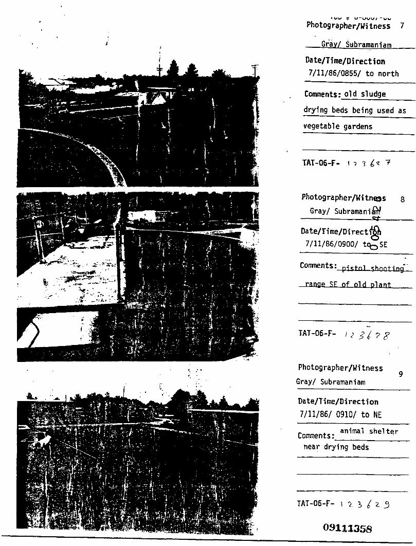
Samples from the abandoned sludge drying beds indicated dioxin levels of 6.5y\(ppb). The TAT observed that these beds were being used as vegetable gardensoThe City Beautification Department has been growing tomatoes and cabbage on th^drying beds. Significant levels of dioxin have also been confirmed in thedigester and c1ar t tier.
In the existing wastewater system, dioxin levels of 37.9 ppb were found in theaeration lagoon. The oxidation ponds were also found contaminated. Samplestaken from manholes indicated dioxin levels ranging from 10.9 ppb to 200 ppb.These manholes have been known to overflow in the past. The oxidation lagoonsappear nearly full and have inadequate retention time left. Of special concernis the fact that the oxidation lagoons would be subject to inundation by floodsequal to or greater than a 5 year flood. An animal shelter located within 200feet of the drying beds generates considerable traffic through the area. Agarage adjacent to the drying beds is used by the Beautification Department.
Rocky Branch Creek
The Rocky Branch and the Bayou Meto downstream of the Yertac Site flow adjacentto several residential subdivisions, individual homes, agricultural lands,industrial and commercial areas, and recreational areas such as DuPree Park. Inthe Rocky Branch channel and floodplain, dioxin levels in the 1984 sedimentsamples ranged from the detection limit of 0.02 to 7.58 ppb. The highest levelsof dioxin were found near the West Lane dead end (3.01 ppb) and near the end ofHines Drive (7.58 ppb). These levels are of particular concern because of theirproximity to residences. The TAT's investigation of the creek confirmed theabsence of a fence along several sections of the creek in the residential area.While levels of dioxin found along the east leg of the creek were notsignificant, additional sampling may be required to assure that TCDDcontamination does not exist in the residential areas east and south of theVertac Plant.
09111344

06-8607-06Page 3
Bayou Meto
"f^ C^r-i^ci^cr^ '• ^ ^w^wu^flJ^ 07^ J?
~7^/^ ^^LC-C^^S^L^L^ <^ /^n^es -^e^a^ ^^i/- /^yt^c^f 7^ Sz '^^^^^J^ 4^u; ^ r
^^V^<. /?^^^ / 'fk^-^^£>S, /0- L <^£/ 'y'0- - . 0
{/
Bayou Meto Channel and floodplains sediment samples in 1984 showedconcentrations of dioxin ranging from the detection limit to 2.1 ppb. Thehighest dioxin concentrations were found between the WWTP outfall and a pointabout 2,000 feet downstream of the Highway 161 bridge. Withdrawal of water fromthe bayou for agricultural uses raises public health concerns.
RecommendationsAn assessment of the fencing required to restrict access as well as othermeasures are considered here: ^
s—1. Restrict general public access, including Jacksonville Department o .
Beautification employees, to the abandoned and existing WWTP facilitiesLwhere potential health and safety hazards exist. This would requiteinstallation of a fence running east-west, just north of the sludge dryinybeds up to the animal shelter. The fence should be located north of tl®drying beds and include the garages used by the Beautification Department(refer to site sketch). The existing fence along the southern and westernperimeter appear adequate. The heavily wooded areas around the oxidationponds and lagoons form a natural barrier around the existing facility. Itis recommend that warning signs be placed along the right of way.
2. Many of the residential yards incorporate the Rocky Branch Creek (West Fork)banks as part of the yard. While the yards are fence, gaps occur at pointswhere several dead end streets run up to the creek. A 150 foot section ofthe creek would have to be fenced at each location where the followingstreets, viz, Alta Cove, Braden St., West and Hines Cove intersect thecreek.
3. While levels of dioxin confirmed along the east fork of the creek are notsignificant, warning signs should be placed along the trails due to trafficfrom the adjacent Brookhaven Apartments.
4. The highest dioxin concentration in the sediments from Bayou Meto was in thevicinity of the Highway 161 bridge. A warning sign at this location wouldbe appropriate.
These measures would help mitigate the threat of exposure to these contaminantsand should be implemented without further delay.
5. Ensure the adequacy of existing control measures on the Vertac Site to avoidunacceptable releases, spills, or discharges of 2,3,7,8-TCDD and othercontaminants of concern to the WWTP. Where existing measures are determinedineffective, implement additional on-site remedial measures.
09111345

06-8606-07Page 4
6. Perform sampling and analysis of surface soil around manholes that aredowngradient of the Vertac Site, have a history of overflow, or have thepotential to overflow.
7. Prevent the continued degradation of Bayou Meto and Rocky Branch by thetransport of contaminants of concern from both on-site and off-site sourcesof contamination.
8. Reduce the potential for a major release of 2,3,7,8-TCDD contaminatedmaterial and other contaminants of concern from the oxidation lagoons due toa major flood event.
9. The police shooting range portrays features that reveal the possibleexistence of some previous treatment works that may have been covered afterbeing abandoned. This area should be sampled if it was part of the oldtreatment works.
While recommendations 1-4 address the issues of immediate concern, the othermeasures merit consideration as it would prevent accentuation of the problem. <! "Jacksonville City Landfill and Rogers Road Site
i
The old Jacksonville City Landfill and Rogers Road Landfill, at Jacksonvi"11(Arkansas, were investigated by TAT Shekhar Subramaniam on July 8, 1986 to asse,site accessibility. Both sites had been fenced and secured earlier. No sign'sof attempted entry or damage to the fences were evident. The TAT is satisffSythat public access at these site has been restricted.
SS/cac

TITLE: Vertac-Off-site contaminated areas ^p^ Location Map
SCALE: 1-24_000_
LOCATION: Jacksonville, Pulaski Co. AR ORIGINATOR: Shekhar Subramamam
_______________________ DATE: 7/11/86 ^ :6-8607-06
DCN. TAT-06-F-- f ^L\ ? 09111^''^

I'.acks-onviTle, A'R
r',;'-;!,i ro
none ^9111348
•"- S'.e'r'r.cr
Fub! c~":-r;"'.cm

TITLE: Vertac- off site contaminated areas MAP: site sketchS C A L E : none
LOCATION- Jacksonville, Pulaski CoArkansas
ORIGINATOR: Shekhar Subramamam
DATE: 7/lv86 TDP: 6-8607-06
DCN. TAT-06-F-_(^ ..?//^_ ''^111349

TITLE- Jacksonville City Landfill. Map. Location Map
SCALE: 1:24 000
LOCATION: Jacksonville, Lonoke Co, AR ORIGINATOR: Shekhar Subramamam
DATE:7/11/86 TDD:6-8607-06
DCN. TAT-06-F—_J Z,^./^?

TITLE:Jacsonvi ' l le City Landfill MAP: Site Sketch
SCALE: non6 •
LOCATION:Jacksonville, Lonoke Co, AR
09111351
ORIGINATOR: shekhar Subramaniam
DATE: 7/11/86 TDD:6-8607"06

LOCATION: Jacksonville, Pulaski Co, AR ORIGINATOR: Shekhar Subramamam
DATE: 7/11/86 TDD: 6-8607-06
DCN. TAT-06-F— » ^ g / / 9

Originator
PHONE CONVERSATION RECORD
Conversation with: Pa«» ~7 t /6 l 0 'Name F- - •3^ „,_ ^ TIme———L^L0______AM/PlvT"^
Company ^^»L (A^JLe^- 7^^^^^ 2 , (/-
Address C^^ 0 ^e^r^ I^^J^
Phone.
Subject
a-0fTginator Placed Call
D Originator Received Call
W.O. NO. ^C ^
Notes: L'/^ fi^-.^^/r'^-.^c'^ t)^/=>r N~r\^A^{^^ }L<^^/^/f^P________&|t,.^4^ ^v^ ' ^, r-L^(^^ ELJ^JA .__________________________^
g ^ ., J- ^ L'J 0 i^^L^ . ^ 2 - 2- 3£-^_____pn^4/~ ^ ~^L yC^x ^r . <^>< r %e^ ^^^-^ A' ,_^~r^.
^._ ^ .-. < < ^//3-.^ . ' ^ /^ . , A^ ^ 7, t _________^ig^^ - R- p- C^-^^ V./^^- ^<-f ^^^/-^ ^ - ^^L. ^•^/.^
D File- Pollow-Up-Action:.
D Tickle File-D Follow-Up By:.D Copy/Route To:
09111353Originator's Initials-
^^Originator
PHONE CONVERSATION RECORD
Conversation with:
NameName ________________________ Time____Company "J^ ^ -S. 'A- ^/I^^^J <f^£/-^
Address I ^1 7 c - ^ f^ " fy?t/ ^a/ B^Originator Placed Call
D Originator Received Call
W.O. NO.^o I . q9 2- -Z t;/^Phone -
Subject
Notes:.
n... 7 , f ,U
( / S'V AM/RAJ^
-a-
o-o~
D File- Follow-Up-Action:.
D Tickle File-Q Follow.Up By:
D Copy/Route To:
Originator's Initials.
RFW 1in-A-S3 09111354

riginator
PHONE CONVERSATION RECORD
Conversation with:Name C L'.Company.
Address
/
fe^^Lt'/vi .- ?
tft-
Phone.
"y /° ^nato Y / / / 0
Time--/———/-
/I
)riginator Placed CallQ Originator Received CallW.O. NO. ^^ ^X"
Subject
Notes:.
/
,
'.\!i^
ei/v\
V^eA-«,
1^ „
•Y^T'^C^^^.
/^^t.A ^
^
\.
'
k,\^^xfJ
•Cx«^/
s ,-?^>y•V/^t-l
n^g^t-
—^
<-, /' sA.^f\f^^J^-
-©-
D File. Follow-Up-Action:.0 Tickle File-D Follow-UpBy:
n Copy/Route To:
Originator's Initials.
09111355

• • * w fc.^/3 * U^||L.( ^ n i fc.i*fc.«»^
Gray/ Me Clary __
Date/Tlme/Di rection7/08/86/0947/ To west
Comments: view of creekfrom Alta Cove
TAT-06-F- ' ? _ ? . / Z <
Photographer/Witness 2Gray/ McClary—————————————^————
Date/Time/Di rection^7/11/86/0950 / to §<juth
„ . creek near West; StComments:______0_____
TAT-06-F- •', ^2^
4'hotographer/Witness
Rray/ Mr r.lary
Date/Time/Direction7/11/86/ 0935/ to west
Comments: dead end- Braden St
TAT-06-F- ( -L -^ / ^ ^
09111356

IUU ff 0-OOU/-UOPhotographer/Witness 4
Gray/ McClary
Date/Time/Direction7/11/86/1015/ to south
Comments: Mines cove dead end
adjacent to creek
TAT-06-F- ?. ^ Z -'
Photographer/Witness^ 5Gray/ McClary c\f
—————————————^-———Date/Time/Direction ln
07/11/86/1020/ to weg)
Comments: tra i1 a 1 on c •K
bank along east branch
TAT-06-F- I ? z i 2 :
Photographer/Witness
Gray/ McClary
Date/Time/Di rection7/11/86/ 1025/ to west
Comments: BrnfflfhUYnn apartment'
adjacent to east branch of en
TAT-06-F- | -i. Z C 2- /
1 UU V U~WJ{ -UU
Photographer/Witness 7
Gray/ Slibramam'am
Date/Time/Dlrection7/11/86/0855/ to north
Comments : o 1 d sludge
drying beds being used as
vegetable gardens
TAT-06-F- i •? ? 7
Photographer/Witnoss 8Gray/ Subramama^/
——————————st————
Date/It me/Di rect®»7/11/86/0900/ to^SE
Comments: p-j^ni chn^jng-
ranap SF of niri plant.
TAT-06-F- i ^ ^ 7 y
Photographer/Witness9
Gray/ Subramam'am
Date/Time/Direction7/11/86/ 0910/ to NE
Comments: anima1 sheuer
near drying beds
TAT-06-F- i ? .3 , / z 3
09111358

Gray/ Subramamam
Date/Time/Direction7/11/86/0915/ to SW
Comments: view of filter beeand entrance to existingfacility
TAT-06-F- » •i. " 3 -c
Photographer/Witness 11
Gray/ Subramaniam(s^
Date/Time/Directloir
7/11/86/0918/ to N1»t—————————irrCornments :oxidationC|orids '
0
TAT-06-F- ' ; ^ C '-? ^
Thotographer/KTtness -^
Gray/ Subramaniam
Date/Twe/Direction
7/11/86/ 0920/ to N
Conments: Lagoon #1
TAT-06-F- • ^ ^
09111359