ceos seismic pilot
TRANSCRIPT

Status Report on the Seismic Hazards Pilot
Philippe Bally (ESA) Stefano Salvi (INGV) Theodora Papadopoulou (ARGANS c/ ESA)
WG Disasters #6 Vancouver, USA 6-8 September, 2016

2
Outline
• Seismic Hazards pilot - Status • Results from pilot work to date
1. EO data access for pilot users 2. EO processing 3. Awareness - Promotion of results 4. Observations strategy
• Issues and risks identified • Sustainability strategy

3
Seismic Hazards pilot - Status

4
Seismic Hazards pilot - Status
As of today: • A Collaboration of ESA, NASA, ASI, CNES, DLR, JAXA, and other
partners: INGV, NOA, UNAVCO, COMET+, University of Miami, University of Pavia, ISTerre/IPGP and CNR IREA.
• The GEP is available since March 2015: supports both EO data access, EO data processing and e-collaboration.
• Strong collaboration with the Supersite initiative GSNL. • Continued collaboration of pilot group with EO mission operators (e.g.
Sentinel-1 mission manager) to optimize coverage against thematic priority areas of the Pilot.
• Validation of InSAR based velocity measurements is completed over California. Turkey preliminary results are available.
• Supported response to earthquakes in 2016: Nepal, Greece, Ecuador and Italy.
5
Seismic Hazards pilot - Objectives
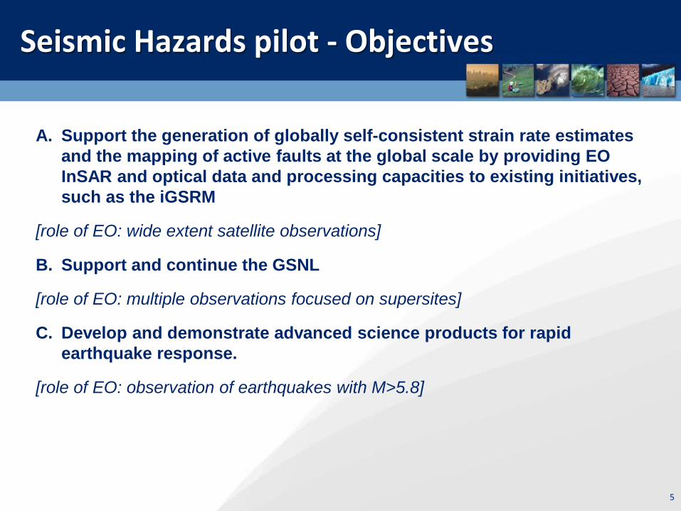
A. Support the generation of globally self-consistent strain rate estimates and the mapping of active faults at the global scale by providing EO InSAR and optical data and processing capacities to existing initiatives, such as the iGSRM
[role of EO: wide extent satellite observations]
B. Support and continue the GSNL
[role of EO: multiple observations focused on supersites]
C. Develop and demonstrate advanced science products for rapid earthquake response.
[role of EO: observation of earthquakes with M>5.8]

6
Overview of activities (1)
Objective A: • Validation of InSAR based velocity measurements over California is completed
(since September 2015). • Turkey validation of interseismic strain measurements : Preliminary results with
Senitnel-1 are available. Results withTSX data will be completed at the end of the pilot.
• Creep on China (Haiyuan) and Iran (Shahdad) active faults: on-going work.
CEOS priority areas masks are available on the GEP GeoBrowser: ─ Seismic Pilot Volcano Pilot

7
Overview of activities (2)
Objective B: • The pilot continued to support the Gorkha earthquake Event Supersite. • Gorkha earthquake COSMO-SkyMed data recently made available through
the GEP, via a connection with the ASI Data Gateway (only for authorised users who have signed the ASI license form).
• CEOS continues to support Permanent Supersites, see GSNL presentation. • Historical COSMO-SkyMed data for the GSNL to be accessed through the GEP. Objective C: • ALOS 2 data obtained through the Seismic pilot for the Gorkha Event
Supersite (since JAXA does not support GSNL), ongoing work is focusing on post-seismic deformation (a paper on the earthquake is in review).
• On-going analysis of the Lefkada (Greece) earthquake of November 2015. • On-going analysis of the Muisne (Ecuador) earthquake of April 2016. • Response to the Amatrice (Italy) earthquake of August 2016.

8
Results from pilot work in the period March 2016- August 2016
1. EO data access for pilot users
9
EO data access for Pilot users
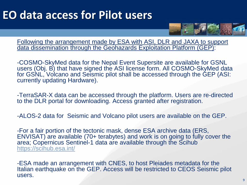
Following the arrangement made by ESA with ASI, DLR and JAXA to support data dissemination through the Geohazards Exploitation Platform (GEP): -COSMO-SkyMed data for the Nepal Event Supersite are available for GSNL users (Obj. B) that have signed the ASI license form. All COSMO-SkyMed data for GSNL, Volcano and Seismic pilot shall be accessed through the GEP (ASI: currently updating Hardware). -TerraSAR-X data can be accessed through the platform. Users are re-directed to the DLR portal for downloading. Access granted after registration. -ALOS-2 data for Seismic and Volcano pilot users are available on the GEP. -For a fair portion of the tectonic mask, dense ESA archive data (ERS, ENVISAT) are available (70+ terabytes) and work is on going to fully cover the area; Copernicus Sentinel-1 data are available through the Scihub https://scihub.esa.int/ -ESA made an arrangement with CNES, to host Pleiades metadata for the Italian earthquake on the GEP. Access will be restricted to CEOS Seismic pilot users.

Sentinel-1 made available (in raw as well as SLC format) starting with CEOS Pilot targets and with the goal to gradually provide global coverage. Sentinel-2 are made available on the platform since March 2016. Sentinel-3 data will be available shortly. ERS & Envisat SAR data: • Current ENVISAT ASAR IM Level-0 Data • Current ERS SAR IM Level-0 Data
Available ERS, Envisat & Copernicus Sentinel-1 SAR & Sentinel-2 data
ERS & ENVISAT Level-0 data available as of February 2016.
10
(70+ terabytes)

11
Available Copernicus Sentinel-1A SAR data
S-1 RAW data available as of August 2016
S-1 SLC data available as of August 2016
Since November 2015, all Sentinel-1 products contain Restituted orbits (generally good for InSAR, no need to
await Precise orbits).
SLC products now available for almost all
S-1 acquisitions

12
Copernicus Sentinel-2A data accessible through the GEP
There no are several Optical processing chains on the GEP (STEMP of INGV, the MPIC chain of Univ. Strasbourg, Orpheo Toolbox, etc).

GEP supporting the GSNL and the Volcano pilot
COSMO-SkyMed data collections over Nepal available through the GEP (only for authorized users having signed the ASI license form).
ALOS-2 images over Chile and Ecuador volcanoes are available through the GEP. The ALOS-2 collections for the Volcano pilot will reach up to 11 terabytes.

Seismic Pilot: Yearly Quotas for 2016
Agency ASI CNES Pleiades
CSA DLR ESA JAXA ALOS-2
NASA USGS Landsat
-8
Number of
Images
300 50 2 on request
* 100 - -
Notes: ESA: large dataset through the GEP (ERS & ENVISAT 70+ Terabytes and Copernicus Sentinel-1 & Sentinel-2 gradually) DLR (TerraSAR-X): quota is assigned after request CNES (Spot): no quota provided NASA and USGS data are already open access.
14
DLR: Provided 65 images after a request for the Lefkada earthquake. Data acquisitions are on-going. DLR: Provided 296 images over the NAFS under Objective A. An account is being set up. JAXA: The 2015 and 2016 quota (200 images) can be ordered until March 2017.

Data requests for Obj. A
15
Overview of ALOS-2 data (prepared by Erwan Pathier) Requested 67 images in 2015: Turkey (38 products), Nepal interseismic (10 products), Central Andean Subduction (9 products), Taiwan (10 products) Discussions ongoing for the Y2016 data request plan.
Overview of COSMO-SkyMed data (prepared by Barry Parsons) Areas proposed: China (Haiyuan) and Iran (Shahdad). 2 scenes for Haiyuan and 1 scene for Shahdad every 16 days use ~70 scenes per year out of the allocation. Acquisition is ongoing. Need to discuss continuation after october 2017.
Overview of TerraSAR X data Request approved for 296 TerraSAR-X archive images over the North Anatolian Fault.

Data requests for Obj. C
16
Gorkha earthquake in Nepal: -27 ALOS-2 co- post-seismic images are available. Lefkada earthquake (GR): - 65 TerraSAR-X scenes (strimap) for post-seismic analysis over Lefkada are being acquired starting on 01-12-2015. - 4 Co-seismic Radarsat-2 images used. - 60 COSMO-SkyMed stripmap scenes, including co- and post-seismic coverage, are being acquired. Amatrice earthquake (IT): - 4 ALOS-2 stripmap images used. - Sentinel-1A & Sentinel1B data used. - Special high frequency coverage by CosmoSkyMed activated through
Italian Civil Protection. - Pleiades and Radarsat-2 orders on-going.

17
Results from pilot work in the period March 2016- August 2016
2. EO processing
18
Amatrice, Central Italy earthquake of 24 August 2016, Mw 6.0

19
2016 Central Italy Earthquake: Activation
• On 24 August 2016 at 3:36 CEST an Mw 6.0 earthquake hit Central Italy ina sparsely populated area. Many buildings in the villages of Amatrice, Accumoli and Arquata del Tronto collapsed and caused nearly 300 fatalities.
• The day of the earthquake the Seismic Pilot was activated by INGV, to provide access to EO data to all pilot contributors and generate scientific support products for Obj. C. JAXA, CSA, ASI, and ESA accepted to support the pilot requests.
• INGV & IREA-CNR (pilot team) are members of the national Civil Protection Service and provide direct support to the government.
• The Copernicus EMS was activated by the Italian Civil Protection
authority (DPC) for Rapid Damage Mapping.
Gregorio Borgia/AP Photo

20
2016 Central Italy Earthquake: Sentinel-1 interferogram by CNR IREA
Interferogram generated by CNR-IREA, exploiting ALOS-2 acquisitions of 27th January 2016 and 24th August 2016.
This activity has been developed within the IREA support actions to the National Department of Civil Protection and in the ESA Geohazards Exploitation Platform (GEP) project. Sentinel1 data are copyright of Copernicus (2015).

21
2016 Central Italy Earthquake: Ground displacement map generated by CNR IREA using Sentinel-1 data
Scientists from CNR IREA combined Sentinel-1 radar acquisitions over central Italy from before and after the 24 August 2016 earthquake: 15 August, 21 August and 27 August 2016. The result shows vertical ground subsidence, reaching about 20 cm in correspondence to the Accumoli area, and lateral movement of up to 16 cm. The blue line indicates the location of the fault trace.

22
2016 Central Italy Earthquake: earthquake source model generated by INGV
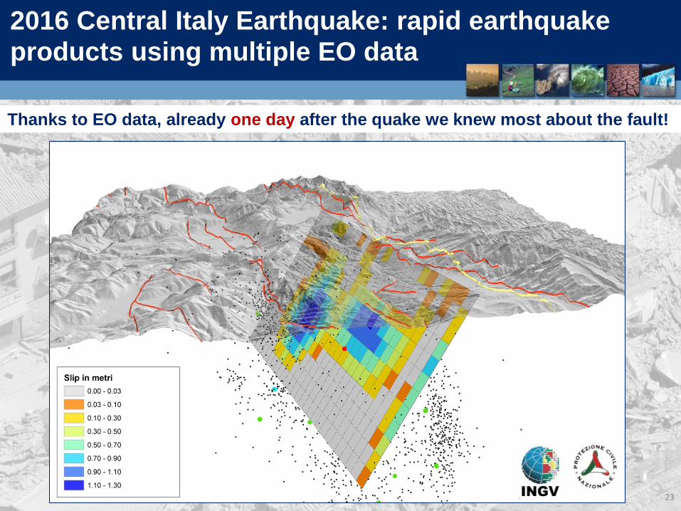
Preliminary earthquake source model generated using co-seismic ground deformation measurements from ALOS-2 and Sentinel-1 interferograms The data were modelled to calculate the location, geometry and amount of slip on the source fault. The slip is distributed mainly in two patches with maximum values of about 1.3m.
23
2016 Central Italy Earthquake: rapid earthquake products using multiple EO data
Thanks to EO data, already one day after the quake we knew most about the fault!

24
2016 Central Italy Earthquake: CosmoSkyMed interferogram generated by INGV
High Resolution Cosmo-SkyMed interferogram shows many surface effects

25
2016 Central Italy Earthquake: map of the additional stress loaded on the nearby faults
Using the source models obtained from InSAR data, INGV has calculated the additional stress loaded on the other large faults present in the area. Some faults have large stress increase and their rupture may be clock advanced. This important information for the Civil Protection.
26
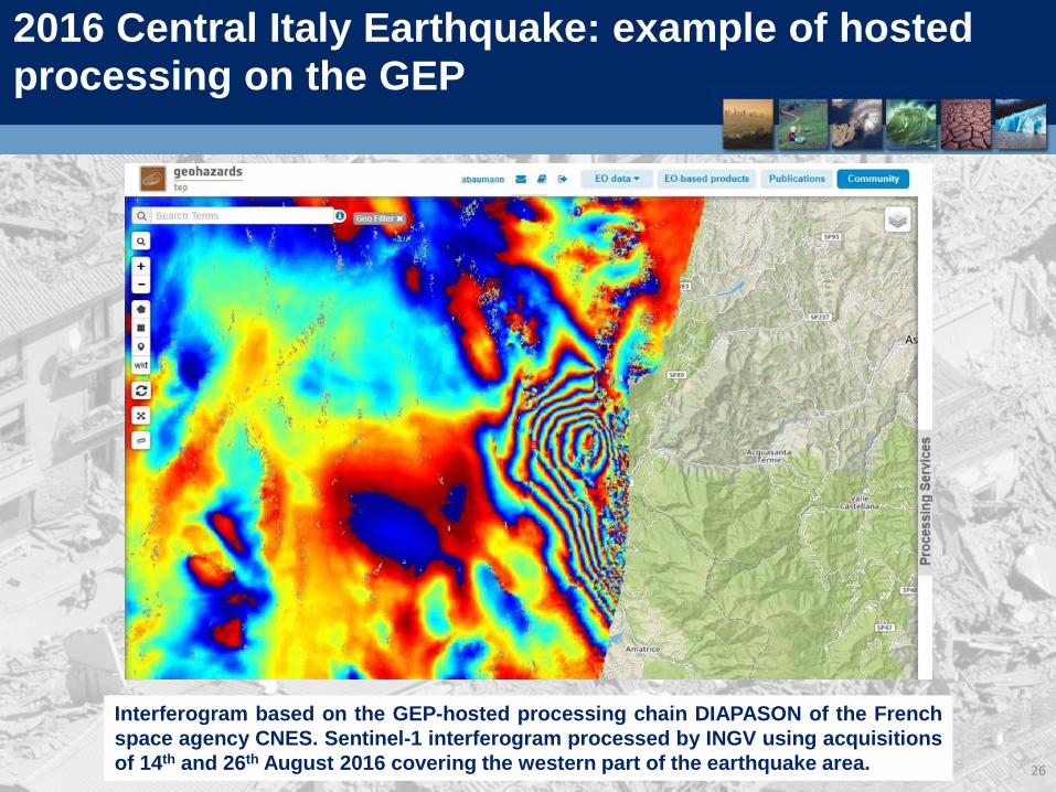
2016 Central Italy Earthquake: example of hosted processing on the GEP
Interferogram based on the GEP-hosted processing chain DIAPASON of the French space agency CNES. Sentinel-1 interferogram processed by INGV using acquisitions of 14th and 26th August 2016 covering the western part of the earthquake area.

27
2016 Central Italy Earthquake: example of hosted processing on the GEP
SAR interferogram generated using the GEP SBAS chain through a 6-days Sentinel1 –A/B image pair. S1-B exceptionally provided by ESA during the satellite commissioning phase. The zoomed portion of the interferogram highlights the surface deformation produced by the Central Italy earthquake.

28
Ecuador earthquake of 16 April 2016

2016 Ecuador Earthquake: Sentinel-1 Interferogram & Displacement map by CNR IREA
29
INTERFEROGRAM AND DISPLACEMENT MAP GENERATED BY CNR-IREA, EXPLOITING COPERNICUS SENTINEL-1 AQCUISITIONS OF 12 AND 24 APRIL 2016.
*First Seismic pilot results used by an end user (DPC).

2016 Ecuador Earthquake: CNR IREA results shared with the Italian Civil Protection Department (DPC)
30
• CNR-IREA is Center of Competence (CoC) on DInSAR for the Italian Civil Protection Department (DPC)
• In case of major (Mw >6) and shallow earthquakes occurred within the Italian territory, CNR-IREA has the mandate to fast provide DPC with DInSAR Earth surface deformation maps, as soon as the post-seismic SAR acquisition is available.
• Generated deformation maps are used by DPC and others DPC’s CoC to understand the extension of the area affected by displacement and better focus the activities during emergency.
• Maps can also be used to model the seismogenic fault in order to increase the knowledge on the earthquake causes.
• DPC could also ask to provide displacement measurements for earthquakes occurred abroad, in the framework of international collaborations with foreign Authorities, as in the case of the April 16th earthquake in Ecuador.
31
Lefkada earthquake of 17 November 2015

2015 Greece Earthquake: Co-seismic analysis over Lefkada by NASA JPL
32
Sentinel-1A 12-day pairs on ascending and descending using prototype processing modules with the JPL ISCE as part of the ARIA project. SRTM version 3 DEM was used in the coregistration step. The unwrapped phase was converted to range change and is contoured with 5 cm contours in the maps. The USGS National Earthquake Information Center epicenter for the Lefkada Earthquake and uncertainty is plotted with a red star and error ellipse. The two interferograms have been converted to a prototype interferogram archive product in HDF5 format and uploaded to the UNAVCO SSARA Interferogram archive.

33
Validation results of the global strain rate modelling activity
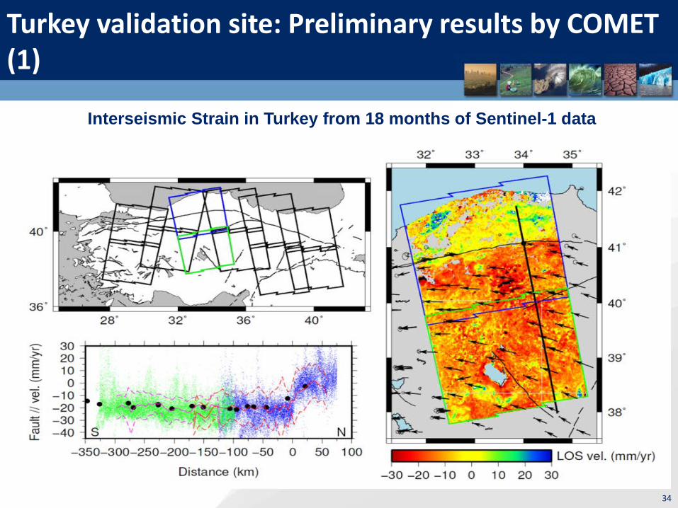
Turkey validation site: Preliminary results by COMET (1)
34
Interseismic Strain in Turkey from 18 months of Sentinel-1 data

Turkey validation site: Preliminary results by COMET (2)
35
Comparison (below) between (a) line-of-sight deformation measured by Sentinel-1 over 18 months, and (b) east-west velocities from 7 years of Envisat data. Both data sets show a strong change in colour across the North Anatolian Fault, where tectonic strain is accumulating. Note the different colour scales as one is LOS motion and one is E-W.

36
Helping pilot users with on demand processing
(GEP)

37
GEP Roadmap

38
GEP: an innovative response
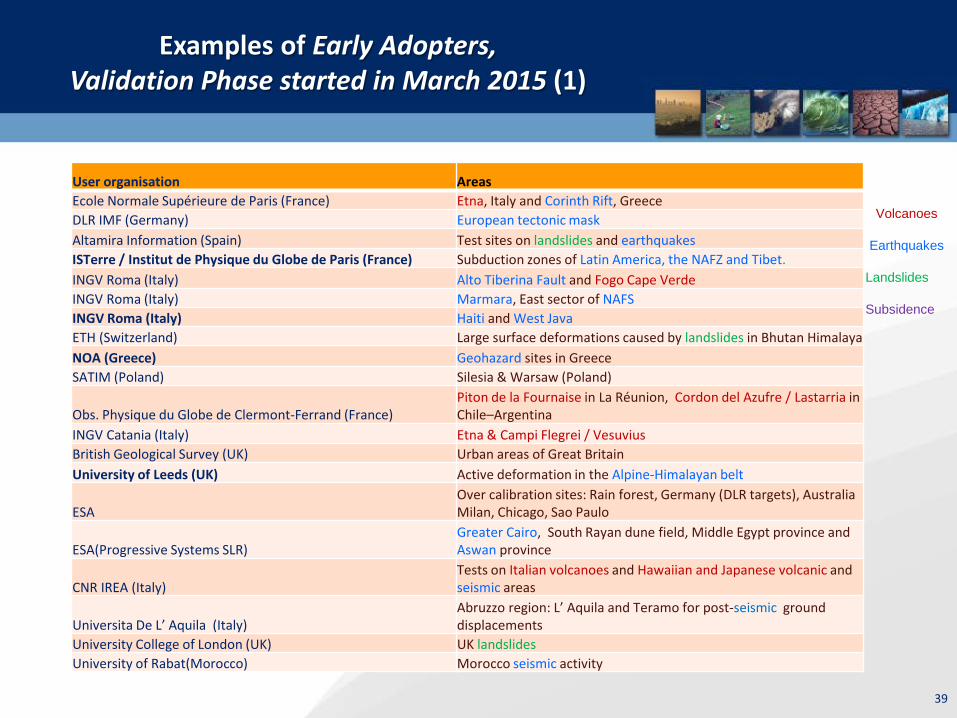
Examples of Early Adopters, Validation Phase started in March 2015 (1)
User organisation Areas Ecole Normale Supérieure de Paris (France) Etna, Italy and Corinth Rift, Greece DLR IMF (Germany) European tectonic mask Altamira Information (Spain) Test sites on landslides and earthquakes ISTerre / Institut de Physique du Globe de Paris (France) Subduction zones of Latin America, the NAFZ and Tibet. INGV Roma (Italy) Alto Tiberina Fault and Fogo Cape Verde INGV Roma (Italy) Marmara, East sector of NAFS INGV Roma (Italy) Haiti and West Java ETH (Switzerland) Large surface deformations caused by landslides in Bhutan Himalaya NOA (Greece) Geohazard sites in Greece SATIM (Poland) Silesia & Warsaw (Poland)
Obs. Physique du Globe de Clermont-Ferrand (France) Piton de la Fournaise in La Réunion, Cordon del Azufre / Lastarria in Chile–Argentina
INGV Catania (Italy) Etna & Campi Flegrei / Vesuvius British Geological Survey (UK) Urban areas of Great Britain University of Leeds (UK) Active deformation in the Alpine-Himalayan belt
ESA Over calibration sites: Rain forest, Germany (DLR targets), Australia Milan, Chicago, Sao Paulo
ESA(Progressive Systems SLR) Greater Cairo, South Rayan dune field, Middle Egypt province and Aswan province
CNR IREA (Italy) Tests on Italian volcanoes and Hawaiian and Japanese volcanic and seismic areas
Universita De L’ Aquila (Italy) Abruzzo region: L’ Aquila and Teramo for post-seismic ground displacements
University College of London (UK) UK landslides University of Rabat(Morocco) Morocco seismic activity
Volcanoes
Earthquakes Landslides Subsidence
39
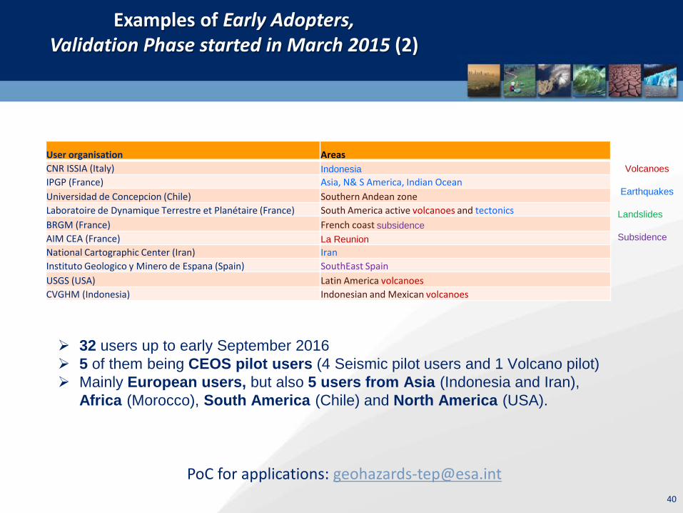
Examples of Early Adopters, Validation Phase started in March 2015 (2)
PoC for applications: [email protected]
User organisation Areas CNR ISSIA (Italy) Indonesia IPGP (France) Asia, N& S America, Indian Ocean Universidad de Concepcion (Chile) Southern Andean zone Laboratoire de Dynamique Terrestre et Planétaire (France) South America active volcanoes and tectonics BRGM (France) French coast subsidence AIM CEA (France) La Reunion National Cartographic Center (Iran) Iran Instituto Geologico y Minero de Espana (Spain) SouthEast Spain USGS (USA) Latin America volcanoes CVGHM (Indonesia) Indonesian and Mexican volcanoes
Volcanoes
Earthquakes Landslides Subsidence
40
32 users up to early September 2016 5 of them being CEOS pilot users (4 Seismic pilot users and 1 Volcano pilot) Mainly European users, but also 5 users from Asia (Indonesia and Iran),
Africa (Morocco), South America (Chile) and North America (USA).

41
Results from pilot work in the period March 2016- August 2016
3. Awareness – Promotion of results

42
Awareness – Promotion of results
CEOS Pilot users can promote their results through: • CEOS website (http://ceos.org/ ) • GSNL portal (http://www.earthobservations.org/gsnl.php )
• Geohazards Exploitation Platform ( https://geohazards-
tep.eo.esa.int/ ).

Example of promotion of results on the GEP for the Central Italy Earthquake (1)
All products generated on GEP for the Central Italy earthquake were gathered under a link on the carousel of GEP’s homepage: direct access to results

Example of promotion of results on the GEP for the Central Italy Earthquake (2)
A number of posts were published on the GEP Blog concerning CEOS data collections, first products generated by CEOS Seismic pilot team etc.
45
Publications
• Papadopoulos et al. (2016), The Mw6,5 earthquake of 17 November 2015 in Lefkada Island and the seismotectonics in the Cephalonia Transform Fault (Ionian Sea, Greece), Geophysical Research Abstracts, Vol. 18, EGU2016-9041-1, 2016 (accepted, NOA, Obj. C)
• Yue H. et al. (2016), Depth varying rupture properties during the 2015 Mw 7.8 Gorkha (Nepal) earthquake, Tectonophysics, In Press
• 2 papers under preparation for the Lefkada event (NOA)

46
Results from pilot work in the period March 2016- August 2016
4. Observations strategy

47
Observations strategy
• Continues exchanges between Seismic Hazards pilot lead and Sentinel-1 mission Project Manager in order to cover the entire tectonic mask.
• Study of the examination of the gaps of existing acquisition plans over megacities in areas of high seismic risk: Most sites are at least partially covered by SAR sensor and are:
-sites with high repeat coverage using Sentinel-1 and ALOS-2 -sites with rare coverage using ascending or descending acquisitions from Radarsat-2, TerraSAR X, and COSMO-SkyMed. https://sites.google.com/a/ingv.it/satellite-monitoring-of-geohazard-prone-megacities---satgeomeg/home
48
Issues and risks identified

49
Issues & risks identified
• User base consists essentially of EO and geophysical science users. The way to reach end-users is through a science user.
• Earthquake response: difficult to identify end-users in advance as earthquake location and time are not predictable
• Accounting of data accessed can be difficult in absence of user feedback.
• Organizing data supply to users has been time-consuming. • Moving from standalone processing to an ecosystem of hosted
services is time consuming and requires changes of behavior. However, low level tasks (data selection, data fetching, selection of set up of processing chains) are not a burden to users anymore, showing direct benefit to users.

50
Sustainability strategy

51
• On a global basis, the GSNL initiative is looking at sustainability issues in its new implementation plan for the GEO 2017-2019 Workplan. A further integration with the CEOS DRM Observation strategy is desirable.
• Concerning activities in Europe, the EO Innovation Europe initiative is considered to link space technology and non-space research networks. For instance the EPOS activity is an example: The GEP as baseline contributor to EPOS in Europe The tectonics community in Europe is moving from traditional EO processing methods to innovative methods. In particular, EPOS:
o has started its implementation plan (EPOS IP) o is considering the GEP as a potential tool to support the EPOS user community o the EPOS IP is defining services to users with a long-term operational objective o to build the service capability, funding mechanisms are defined and they include
access and use of satellite EO and EO capabilities.
*EPOS: European Plate Observing System
A detailed analysis of data gaps, awareness gaps and capacity gaps is under preparation. See draft of Sustinability strategy.
Ideas for sustainability of the Seismic pilot (1)

52
Ideas for sustainability of the Seismic pilot (2)
During earthquake crises the contribution of EO is fundamental and needs to be maintained:
• Target 1: using satellite EO during the crisis for rapid damage mapping. This is fully addressed outside the CEOS DRM (e.g. the International Charter, Sentinel Asia, the Copernicus EMS).
• Target 2: using satellite EO during the crisis to support operational seismology with scientific support products. This is performed by the CEOS pilot (Obj. C) and is supported by the GEP
• Target 3: using satellite EO after the crisis for better understanding the earthquake. Also supported by the pilot under Obj. C
• Target 4: using satellite EO to support reconstruction. This is fully addressed by the Recovery Observatory.
53
Some ideas
The GEP can address some of the existing gaps concerning data, technology, capacity and awareness: Data gaps Main issue is the cost of commercial satellites: the cost can be reduced with on-
line data exploitation (e.g. with the GEP ), that allows on-line processing and sharing of results without supplying the imagery to the user.
Technology gaps The GEP allows users from places with poor Internet access to work on the
Cloud without downloading large files. Capacity gaps The GEP provides simpler/automated EO processing chains (although complex
chains generally require flexibility and are reserved to expert users). Awareness gaps A single point of access to data, tools and resources can help maximizing
awareness/training.

54
For discussion
• Should the Pilot become a permanent activity like the Charter: no legal status, little bureaucracy, optimizing data access to users? What could be the differences?
• Are there really cost issues in provision of EO data for Disasters?
• Do we want to organize a conference (e.g. the SANTORINI Conference)
to test the CEOS approach against real user needs?
55