centre for spatial data infrastructure and land administration department of geomatics, the...
TRANSCRIPT

Centre for Spatial Data Infrastructure and Land AdministrationDepartment of Geomatics, The University of Melbourne
Key Factors Influencing Regional SDI Key Factors Influencing Regional SDI Development and Relevance to Global and Development and Relevance to Global and
other Levels other Levels
Abbas Rajabifardand
Ian Williamson
GSDI 6Budapest, September/ 2002

Centre for Spatial Data Infrastructure and Land AdministrationDepartment of Geomatics, The University of Melbourne
OverviewOverview
• Introduction & Background
• SDI – Nature and components
• SDI Development Models
• Human and Community Issues
• Asia-Pacific region: a case study
• Outcomes
• Key Factors Influencing Regional SDI Development
• Conclusion

Centre for Spatial Data Infrastructure and Land AdministrationDepartment of Geomatics, The University of Melbourne
Introduction & BackgroundIntroduction & Background
Part of a results of a main topic
SDI DiffusionSDI Diffusion
• Concept and Nature of SDI
• SDI Hierarchy
• Relationships Among Different SDIs
• SDI Development Models

Centre for Spatial Data Infrastructure and Land AdministrationDepartment of Geomatics, The University of Melbourne
Spatial Data InfrastructureSpatial Data Infrastructure
• SDI is whole about facilitation and coordination of the exchange and sharingsharing of spatial data;
• SDI is an initiative necessary for the effective collection, management, access, delivery and utilisation of spatial data;
Centre for Spatial Data Infrastructure and Land AdministrationDepartment of Geomatics, The University of Melbourne
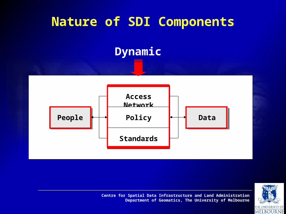
Nature of SDI Components
PeoplePeople
Access Network
Policy
Standards
DataData
Dynamic

Centre for Spatial Data Infrastructure and Land AdministrationDepartment of Geomatics, The University of Melbourne
ObstaclesObstacles
• Technical issues– lack of data, standards, metadata, search
engines, communication network/bandwidth
• Economic/financial issues– cost sharing
• Social/institutional/organisational issues– awareness, education, pricing, security,
freedom of access
• Political/legal issues– sensitive data, intellectual property

Centre for Spatial Data Infrastructure and Land AdministrationDepartment of Geomatics, The University of Melbourne
Global SDI
Regional SDI
National SDI
State SDI
Local SDI
Corporate SDI
Less detailed dataLess detailed data
Global Planning
Regional Planning
National Planning
State Planning
Local Planning
More detailed Data
The success of developing any type of SDIs, heavily depends to on individuals realising the need to
cooperate with each other.
Hierarchy of SDI

Centre for Spatial Data Infrastructure and Land AdministrationDepartment of Geomatics, The University of Melbourne
Relationships Among Different SDIs
Regional SDIs
National SDIs
Corporate SDI
Global SDI
State SDIs
Local SDIs

Centre for Spatial Data Infrastructure and Land AdministrationDepartment of Geomatics, The University of Melbourne
SDI Development ModelsSDI Development Models
• Product-Based Modelroduct-Based Model: (linked) database(s)
• Process-Based ModelProcess-Based Model: strategy required to manage information assets

Centre for Spatial Data Infrastructure and Land AdministrationDepartment of Geomatics, The University of Melbourne
Product-Based ModelProduct-Based Model
...the main aim of an SDI initiative being to link existing and upcoming databases databases of the respective political/administrative levels of the community.
PeoplePeople DataData
Policy
Access Network
StandardsDefinition Collection IntegrationDataBase Creation Dissemination
Technology Components

Centre for Spatial Data Infrastructure and Land AdministrationDepartment of Geomatics, The University of Melbourne
...the main aim of an SDI initiative as defining a frameworkframework to facilitate the management of information assets.
Process-Based ModelProcess-Based ModelBorder of Social SystemBorder of Social System
Knowledge Infrastructure and Capacity Building
Communication Channel
Coordination Facilitation
PeoplePeople
SDI Facility
Metadata directory

Centre for Spatial Data Infrastructure and Land AdministrationDepartment of Geomatics, The University of Melbourne
Process-Based ModelProcess-Based ModelBorder of Social SystemBorder of Social System
Knowledge Infrastructure and Capacity Building
Communication Channel
Coordination Facilitation
PeoplePeople
SDI Facility
Metadata directory
..or the objectives behind the design of an SDI are to provide better communication channelscommunication channels for sharing and using data assets.

Centre for Spatial Data Infrastructure and Land AdministrationDepartment of Geomatics, The University of Melbourne
Process-Based ModelProcess-Based ModelBorder of Social SystemBorder of Social System
Knowledge Infrastructure and Capacity Building
Communication Channel
Coordination Facilitation
PeoplePeople
SDI Facility
Metadata directory
Awareness Knowledge Infrastructures
Persuasion Decisions Utilisation
Communication Channels
Participation

Centre for Spatial Data Infrastructure and Land AdministrationDepartment of Geomatics, The University of Melbourne
Human and Community IssuesCommunities/people concerned are expecting to reap benefits from their investment in SDI in terms of improved corporate performances and cooperation.
Therefore • It is essential to understand the significance of human and community issues, as much as technical issues as they determine the long running success of an SDI innovation; • Developing a successful SDI must be seen as a socio-technical, rather than a purely technical exercise.

Centre for Spatial Data Infrastructure and Land AdministrationDepartment of Geomatics, The University of Melbourne
Socio-Technical Viewpoint
Techno-CentricSpatial data community
Focus on technology Technology push Because it’s possible Others are developing Specified by technologist Static in nature
Techno-CentricSpatial data community
Focus on technology Technology push Because it’s possible Others are developing Specified by technologist Static in nature
Socio-TechnicalSpatial data community
People and technology Demand pull Because it’s needed We need it Specified by Users dynamic in nature
Socio-TechnicalSpatial data community
People and technology Demand pull Because it’s needed We need it Specified by Users dynamic in nature
(Adopted from Petch and Reeve 1999)
Centre for Spatial Data Infrastructure and Land AdministrationDepartment of Geomatics, The University of Melbourne
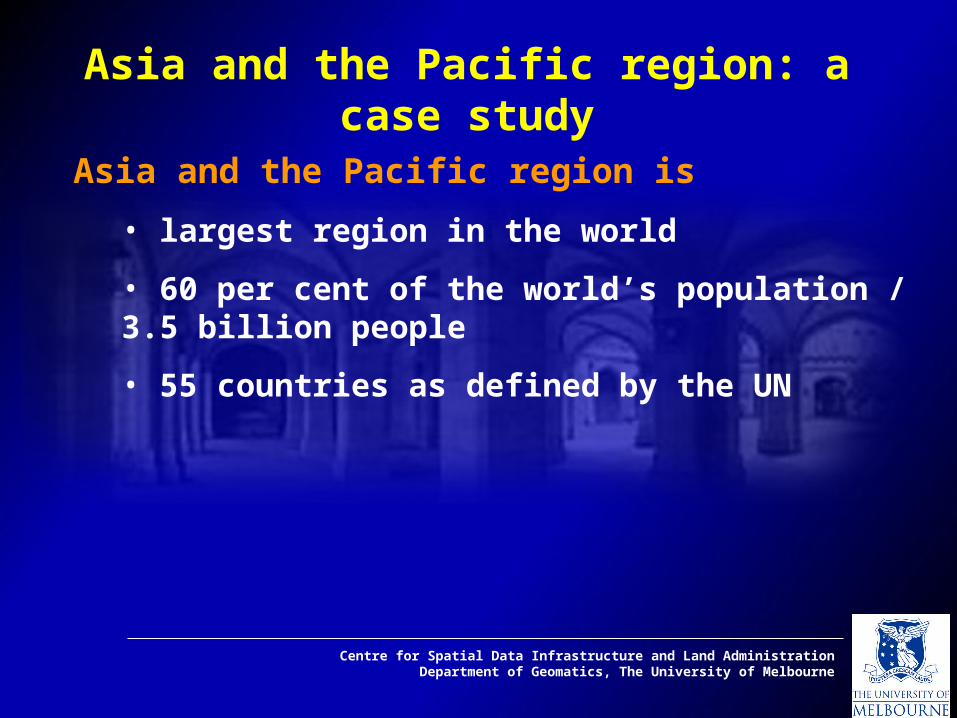
Asia and the Pacific region is
• largest region in the world
• 60 per cent of the world’s population / 3.5 billion people
• 55 countries as defined by the UN
Asia and the Pacific region: a case study

Centre for Spatial Data Infrastructure and Land AdministrationDepartment of Geomatics, The University of Melbourne

Centre for Spatial Data Infrastructure and Land AdministrationDepartment of Geomatics, The University of Melbourne
Regional Organisations• APEC
• APCC
• ASEAN
• SAARC
• UN-ESCAP
• UNRCC-AP
Main Objectives of Regional Cooperation Acceleration of economic growth, social progress and cultural development;
Promotion of regional peace and stability;
More effective collaboration to improve the agricultural, industrial, trading, transport and communications sectors of the regional economy;
Promotion of regional cooperation for ecological and environmental protection.
•APNIC
• ECO •AAECP,
• etc.
Asia and the Pacific region: a case study

Centre for Spatial Data Infrastructure and Land AdministrationDepartment of Geomatics, The University of Melbourne
Asia-Pacific region has complex social and political environments, typified by competing and often conflicting priorities and motivations.
Asia and the Pacific region: a case study
Every case in this region is unique
• national context,
• language and characteristics
(size, population, political systems, varied infrastructures and skills),
• national traditional and cultural attitude, and
• the peoplepeople who participate, develop and use SDIs

Centre for Spatial Data Infrastructure and Land AdministrationDepartment of Geomatics, The University of Melbourne
Major difficulty • different data structures
• specifications and
• standards
Formation ofFormation of PCGIAP, PCGIAP, 19941994• Vision for APSDIAPSDI
• SDI Conceptual Model
Institutional framework, Technical standards,
Fundamental datasets, and Access networks
Asia-Pacific Region and Regional SDI activities
Lack of Coordination

Centre for Spatial Data Infrastructure and Land AdministrationDepartment of Geomatics, The University of Melbourne
Current Progress of PCGIAP and APSDI development
PCGIAP successfully implementedPCGIAP successfully implemented
• a regional precise geodesy network,
• defined a regional geodesy datum,
• developed and approved a policy on sharing fundamental data, developed guidelines on custodianship, and the definition of
APSDI. Other projectsOther projects
• Asia-Pacific Regional Geodetic Project (APRGP)
• Administrative Boundaries pilot project and specification
• APSDI Data Node
• Clearinghouse Project
(PCGIAP-website 2001)

Centre for Spatial Data Infrastructure and Land AdministrationDepartment of Geomatics, The University of Melbourne
Other Issues involved in the Progress
• Low rate of participation in PCGIAP activities,
• The organisational structure of PCGIAP,
Member nations are represented on the Permanent Committee
by directorates of national survey and mapping organisations
and or equivalent national agencies.
• The APSDI conceptual model

Centre for Spatial Data Infrastructure and Land AdministrationDepartment of Geomatics, The University of Melbourne
Some Reasons for the Limited Support
Lack of awareness of the value of SDIs;
Defining the SDI;
The incompatibility of the current conceptual and organisational model with the perceived needs of users; and
The complexity of different issues such asdiverse political, cultural and economical positions of members.

Centre for Spatial Data Infrastructure and Land AdministrationDepartment of Geomatics, The University of Melbourne
• Based on the participation rate, Regional SDI remains an innovative conceptan innovative concept among member nations.
• The theories of innovation diffusion will provide a useful framework for the study of Regional SDI development.
Some Reasons for the Limited Support

Centre for Spatial Data Infrastructure and Land AdministrationDepartment of Geomatics, The University of Melbourne
Diffusion Theory
DiffusionDiffusion is a process by which an innovation is
communicated through certain channels over
time among the members of a social system.
(Rogers 1983)

Centre for Spatial Data Infrastructure and Land AdministrationDepartment of Geomatics, The University of Melbourne
Organisational innovation process model (adapted from Rogers 1995)
RoutinizingAgenda-setting Matching Redefining/Restructuring
Initiation Implementation
Decision
Clarifying
General organisational problems that may create a perceived need for innovation.
Fitting a problem from the organisation’s agenda with an innovation.
The innovation is modified and re-invented to fit the organisation, and organisational structures are altered.
The relationship between the organisation and the innovation is defined more clearly.
The innovation becomes an ongoing element in the organisation’s activities, and loses its identify.
Organisational Innovation Process ModelOrganisational Innovation Process Model

Centre for Spatial Data Infrastructure and Land AdministrationDepartment of Geomatics, The University of Melbourne
Agenda-setting Matching
Initiation
Decision
Current conceptual model of Regional SDI
13
2
Current approach for Regional SDI development1 -Innovation, 2- Communication channel, 3- Time
Current Approach by PCGIAPCurrent Approach by PCGIAP

Centre for Spatial Data Infrastructure and Land AdministrationDepartment of Geomatics, The University of Melbourne
Agenda-setting Matching
Initiation
DecisionSocial system 4
Current conceptual model of Regional SDI
13
2
Border of Social System
Extended conceptual model1- Innovation, 2- communication channel, 3- time, 4- social system
Suggested Approach for the ResearchSuggested Approach for the Research

Centre for Spatial Data Infrastructure and Land AdministrationDepartment of Geomatics, The University of Melbourne
Influencing Factors for an SDI Development
Environmental FactorsEnvironmental Factors
External FactorsExternal Factors
Internal FactorsInternal Factors
Political
Development Issues
Cultural

Centre for Spatial Data Infrastructure and Land AdministrationDepartment of Geomatics, The University of Melbourne
Other External Factors
Technological PressureAPSDI
Development
APSDI
Development
Regional Organisations
Economic Conditions
Regional Governments
Political Climate
Market Pressure
Financial Stability
Regional SecurityOther Internal Factors
Border of Social System
Asia-Pacific Region
Organisational Structure of Coordinating Agency
Globalisation
Global SDI Initiative
Global Economic
External Factor Internal Factor
Environmental Factors

Centre for Spatial Data Infrastructure and Land AdministrationDepartment of Geomatics, The University of Melbourne
Influencing Factors for an SDI Development
Technology
Economic
Partnerships
Human Factors
Policies
Protection & Security
Conceptual
Environmental FactorsEnvironmental Factors
Capacity FactorsCapacity Factors
SDI Organisation Factors
SDI Organisation Factors
Political
Development Issues
Cultural
ParticipationParticipation

Centre for Spatial Data Infrastructure and Land AdministrationDepartment of Geomatics, The University of Melbourne
Recommendations
Environmental FactorsEnvironmental Factors
Capacity FactorsCapacity Factors
SDI Organisation Factors
SDI Organisation Factors
ParticipationParticipation
Redesign Future StrategyBased on Social System
Redesign Future StrategyBased on Social System
Modify SDI Conceptual Model
Modify SDI Conceptual Model
Adopt Process-based Model
Adopt Process-based Model
Organisational RestructureOrganisational Restructure
Factors

Centre for Spatial Data Infrastructure and Land AdministrationDepartment of Geomatics, The University of Melbourne
ConclusionConclusion
Regional SDIRegional SDI is a voluntary-base initiative in nature;
At the higher levels of SDIs:more coordinationcoordination than implementationimplementation.
The development of a Regional SDIRegional SDI is much
more challenging than the development of a
National SDI initiative within a nation.

Centre for Spatial Data Infrastructure and Land AdministrationDepartment of Geomatics, The University of Melbourne
Global SDI
Regional SDI
National SDI
State SDI
Local SDI
Corporate SDI
SDI Hierarchy
Strategic Management
Operational
Functional
Process-Based Model
Process-Based Model
Product-Based Model
Product-Based Model
Similar Organisational Structure Pyramid
National SDI
ConclusionConclusion

Centre for Spatial Data Infrastructure and Land AdministrationDepartment of Geomatics, The University of Melbourne
Thank youThank you