centennial water supply project executive summary - … wsip_nid_executive summary.pdf · 1 a.1:...
TRANSCRIPT
1
A.1: Executive Summary Nevada Irrigation District - Centennial Water Supply Project Water Storage Investment Program
1. Describe the project facilities and operations.
Nevada Irrigation District’s (NID) water supply system is a “store and
release” system, in that reservoirs store snow melt and seasonal rains for
release during the typically dry irrigation seasons. Based on the timing of
seasonal events, NID’s water supply management is dependent on a
combination of springtime snowmelt and winter period rains to fill existing
storage reservoirs. While there is some natural runoff during the summer
months, much of this water is required to meet necessary environmental
flows in the rivers; therefore, the irrigation season demand is met primarily
with withdrawals from storage reservoirs. Careful management and
operation of storage reservoirs is essential to capture the maximum
amount of runoff, minimize spillage from reservoirs, and ensure there is
sufficient area available in reservoirs to accommodate runoff during the
spring snow melt and storm events.
NID’s water supply comes from four main sources: natural runoff
(including snowmelt) from the contributing watershed area, carryover
storage, contract water purchases, and recycled water. NID’s existing
system capability is able to meet customer demands based on available
water from these four sources.
As water demand within NID’s service area increases, events such as
drought and climate change create challenges for NID in maintaining a
sustainable water system. According to NID’s Raw Water Master Plan
(2011), studies indicate that the margin between average watershed runoff
volume and demand is diminishing. Increased future demands in the
service area will result in increased demand on water storage and greater
drawdown of NID’s reservoirs, especially during summer months when
there is little natural runoff.
Currently, NID’s water system relies too heavily on the water bank
provided by the annual mountain snowpack. With warmer temperatures
likely, NID needs mid-elevation storage that can capture runoff from
rainstorms and snowstorms from both the mountain division and the lower
division watersheds. Without this capability, NID will be unable to
sufficiently collect and conserve water and prepare the region to weather
extended droughts. NID’s goal is to continue to provide a dependable,
sustainable, high-quality water supply to its customers. NID needs this
Proposed Project to offset anticipated system deficiencies, taking into

2
consideration increasing customer demands and the likelihood of regularly
occurring multi-year droughts due to seasonal hydrologic variability
exacerbated by climate change.
NID is proposing to construct the Centennial Reservoir (Proposed Project)
to provide drought and climate change relief and improve water supply
reliability for NID’s customers. The Proposed Project involves the
construction of a new dam that would form a 110,000 acre-foot reservoir
on the Bear River between the existing Rollins Reservoir and Combie
Reservoir. The Proposed Project would extend upriver from just above
the existing Lake Combie for slightly over six miles to a point west of the
Town of Colfax, approximately two miles downstream of the existing
Rollins Dam. Low impact public recreational opportunities are anticipated
to be included with the Proposed Project. A new raw water conveyance
pipeline to serve NID customers adjacent to the proposed reservoir on the
Nevada County side, as well as a Bear River bridge crossing to replace
the existing bridge crossing are also included as part of the Proposed
Project.
Additional detail about the project and its operations are found in the
Eligibility Tab, A.3 Project Description and the Benefit Calculation,
Monetization, and Resiliency Tab, A.2 Project Operations.
2. Describe how the project is integrated into one or more state water
systems, including use of new water sources such as recycled water
or storm water capture. The summary must include information
such as the project’s inclusion in an integrated regional water
management plan, other integrated planning documents, or
interactions with existing projects and operations that support the
description of integration.
NID’s current service area covers 287,000 acres in Nevada and Placer
counties providing water supply for irrigation, municipal, domestic and
industrial purposes. NID also has storage reservoirs and distribution
facilities in Sierra and Yuba counties.
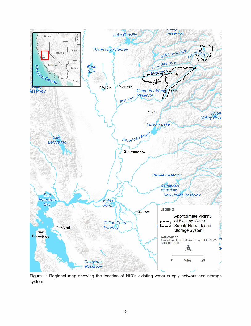
NID currently has water supply networks and storage facilities located in
four major watersheds: 1) the Middle Yuba River; 2) tributaries of the
South Yuba River; 3) Deer Creek; and 4) the Bear River. All four of these
watersheds ultimately flow into the Feather River, and are part of the
Sacramento River basin, which drains into the Sacramento-San Joaquin
Delta, and then into San Francisco Bay. Figure 1 illustrates the general
regional location of the NID’s existing water supply network and storage
system.
3
Figure 1: Regional map showing the location of NID’s existing water supply network and storage
system.

4
Facilities located in the Middle Yuba and South Yuba river watersheds
belong to NID’s Mountain Division. From Mountain Division reservoirs and
diversions, NID water flows through the Bowman-Spaulding Canal to
Pacific Gas and Electric’s (PG&E’s) Lake Spaulding. It is then routed
down either the South Yuba Canal to the Deer Creek watershed, where
water is then supplied to NID customers in Scotts Flat and the Nevada
City-Grass Valley area, or down the PG&E Drum System along the Bear
River where the water is used to generate power for NID and PG&E
before supplying NID customers in southern Nevada County and Placer
County through various diversion facilities. Collectively, these facilities
make up NID’s Yuba-Bear system.
NID’s Yuba-Bear Hydroelectric Project is operated in conjunction with
PG&E’s Drum-Spaulding Project under a consolidated contract. NID and
PG&E established a Water Management Committee that meets regularly
to coordinate reservoir and canal system operations. The committee
operates the joint system with the following objectives and priorities:
• Operate NID’s system in conjunction with PG&E’s Drum-Spaulding
system to maximize the use of water for power generation and
consumptive use, and minimize spillage;
• Water supply needs and regulatory requirements are given the
highest priority; power generation and recreation are given a lower
priority.
• Operate to maximize reasonable and beneficial uses within NID’s
water rights.
• Fulfill all requirements of contracts/agreements (PG&E, Placer
County Water Agency [PCWA], California Department of Fish and
Wildlife, State Water Resources Control Board, Federal Energy
Regulatory Commission [FERC], customers, special agreements,
etc.).
Supporting Studies
The following previous studies by NID and others were referenced during
development of project alternatives to meet future demands for water
within the NID service area.
NID Raw Water Master Plan 2011
NID’s Raw Water Master Plan (RWMP) from 2011 is the second update to
its 1985 RWMP. The purpose of this series of reports is to: 1) verify water
supply, quantify expected future demand, and evaluate the adequacy of
the existing water conveyance system to accommodate current and future

5
demand; and 2) identify capital improvement projects required to meet
future demand for water within the NID service area. The 2011 update
focuses on the latter of the two.
Major Findings/Conclusions
Major findings related to the adequacy of the existing storage conveyance
system in the RWMP include:
• By 2032, projected consumptive demand is expected to approach
the average annual runoff volume from NID’s watersheds.
• Climate change forecasts estimate that the temperature by mid-
century will increase by as much as 5 degrees Celsius and will
reduce NID’s Mountain Division snowpack by as much as 40
percent. Precipitation will fall as rain instead of snow as the snow
line moves higher in elevation. Variations between wet years and
dry years will become greater, resulting in greater flood potential
and longer, more intense drought periods.
• By 2032, forecasted water supply will be sufficient to address a
single dry year without restrictions, but not a multi-year drought
period.
The following sections summarize measures identified in the RWMP, as
updated, to meet future demand for water within the NID service area.
Increase Conservation – District Facilities and Service Area
Conservation should become routine rather than the first step under a
drought contingency plan. Conservation measures include improving
customer delivery efficiencies and strategies, managing NID land use
development and best practices in watersheds, refining of system
operations.
Reduce System Losses
Overall system losses are estimated to be approximately 10 percent of
customer delivery volume. While it is infeasible to phase out all open-ditch
delivery systems within NID’s service area, canals with the highest loss
rates and maintenance issues are being prioritized for containment and/or
potential improvement. Alternatives for reducing system losses for open
ditches include installation of impervious lining or piping of flows.
NID has already begun to make improvements to existing ditches.
Completed improvement projects include the Banner-Cascade pipeline
project, the Cunningham siphon realignment project, the Drum-Spaulding
Canal flume replacement project, and the Mount Vernon Road siphon

6
project. Current ongoing improvement projects include the Combie Phase
I Canal, Bear River Siphon Replacement Project, and the Newtown Canal
partial encasement project.
Increase Reservoir Storage
Increasing reservoir storage would provide drought and climate change
mitigation, meet projected future water supply needs, and improve water
supply reliability for NID customers. Two ways to increase reservoir
storage include dredging of existing reservoirs with high rates of sediment
accumulation, and by creating additional storage by raising existing dams
or constructing a new dam.
2015 Capital Improvement Program for the RWMP
NID’s existing water delivery system was further analyzed in the 2015
Capital Improvement Program (CIP) analysis, to determine flow
requirements in individual canal segments under 2032 projected
demands. Canal segments were identified for potential upgrade to
provide more capacity and conveyance capability. Segments were
evaluated based on: (1) facility importance; (2) capacity; (3) difficulty of
construction; (4) environmental constrains; and (5) NID input. The
analysis identified the number of appurtenances (e.g., spoils, checks, and
gaging station) and linear objects (e.g., flumes, open channel canals, and
siphons) included in each canal segment. The evaluation process was
used to prioritize various capital improvement projects.
1957 DWR California Water Plan (Bulletin No. 3)
The California Water Plan is a state-wide master plan to guide and
coordinate the planning and construction by all water agencies for the
control, protection, conservation, and distribution of California’s water
resources for the benefit of all areas of the State and for all beneficial
purposes. The report served to evaluate both existing supply and future
demand, and identify watersheds with surplus water resources.
The California Water Plan considered the Yuba and Bear rivers as a
single unit, as it described potential development within these two
watersheds. The following bulleted list identifies projects for future
development that are relevant to NID:
• New diversion and diversion tunnel from the North Fork Yuba River
below Haypress Creek to proposed Jackson Meadows Reservoir.
Water would then be diverted to Lake Spaulding (existing) and then
to the Bear River.

7
• New diversion and diversion tunnels at Fordyce Creek, Rattlesnake
Creek and the South Yuba River to an enlarged Lake Valley
Reservoir. Water would be returned to the South Yuba River at
Lake Spaulding (existing) through a new power drop.
• Increased diversions out of Lake Spaulding (existing) through the
existing Drum and South Yuba canals.
• New Canal and power drop into proposed Rollins Reservoir,
downstream of Dutch Flat Powerhouse (Chicago Park).
• New Rollins Reservoir and Powerhouse
• Increase the existing South Yuba Canal capacity
• Increase the capacity of Scotts Flat Reservoir (existing)
• Increase the capacity of Spaulding #2 and Deer Creek
powerhouses (existing)
The California Water Plan identified future development possibility on the
Bear River totaling 342,000 acre-feet (ac-ft), 100,000 ac-ft for the
proposed Rollins Reservoir and 242,000 ac-ft for an enlarged Camp Far
West Reservoir. Construction of Rollins Reservoir was completed in 1965
by NID and Camp Far West was enlarged in 1963 by South Sutter
Irrigation District. Current gross storage in this reach (Rollins Reservoir,
Lake Combie, and Camp Far West Reservoir) is approximately 176,000
ac-ft. The remaining balance, 166,000 ac-ft, indicates additional
development capacity within the watershed.
1926 NID Reconnaissance Project on Bear River
NID’s initial development plan of the Bear River (as of May 1924) included
a diversion dam on the Bear River below Greenhorn River (Rollins), a dam
on South Wolf Creek, and a diversion canal between the two. It was
noted that this plan was flawed because of the prohibitive cost to construct
the South Wolf Creek Reservoir. The purpose of the 1926 Bear River
reconnaissance project was to consider alternative dam sites to replace
the proposed South Wolf Creek Reservoir.
Four potential dam sites were investigated: 1) Rollins, 2) Combie
Crossing, 3) Dog Bar, and 4) Parker. The following conclusions were
made based on the reconnaissance project:
• The Rollins Dam site is not favorable because of the relatively
steeper channel gradient than the other sites, and it would quickly
fill with mining debris.

8
• The Combie dam site is adequate, but the stream bed is at an
elevation of 1,500 ft, which is less than the optimal 1,700 ft
elevation required to serve Penn Valley.
• The Dog Bar Dam site is adequate, but is wider than the dam site
at Parker, making it a more expensive option than Parker. Also,
Dog Bar reservoir storage relative to the dam height would be less
than for Parker reservoir storage.
• The Parker Dam site is the best and most economical reservoir site
for storage of water on the Bear River.
Based on its findings that the Parker Dam site was the best location for a
new dam on the Bear River, the reconnaissance project included results of
a topographical survey of the potential inundation area and a cost
estimate for a rock fill dam of various heights ranging from 130 ft to 330 ft.
A diversion tunnel was proposed from Parker Reservoir to serve Penn
Valley. This tunnel is no longer a proposed feature of the project. The
Parker Dam site is generally consistent with the present day proposed
Centennial Dam site.
2015 Urban Water Management Plan
Urban Water Management Plans (UWMP) are prepared by California's
urban water suppliers to support their long-term resource planning, and
ensure adequate water supplies are available to meet existing and future
water demands.
Every urban water supplier that either provides over 3,000 ac-ft of water
annually or serves more than 3,000 customers is required to assess the
reliability of its water sources over a 20-year planning horizon and prepare
an UWMP every five years.
NID’s UWMP includes a description of the water supply sources,
magnitudes of historical and projected water use, and a comparison of
water supply water demands during normal, single-dry, and multiple-dry
years. Also described is NID’s water conservation program and drought
contingency Plan.
UWMPs are to be adopted and submitted every five years to the California
Department of Water Resources (DWR). Therefore, the 2015 UWMP
builds upon, updates, and reports on data since the 2010 UWMP.
2012 Agricultural Water Management Plan
The Agricultural Water Management Plan (AWMP) was prepared by NID
in accordance with California Water Code Section 10820 (a), which
requires all agricultural water suppliers that provide water to 10,000 or

9
more irrigated acres to prepare a plan every five years. According to the
California Department of Water Resources, the AWMP Act states that
agricultural water suppliers should make every effort to assure the
appropriate level of reliability in its water service to sufficiently meet the
needs of its customers during normal, dry, and multiple dry years. The
AWMP includes descriptions of the service area, water supplies, water
balance, climate change and efficient water management practices,
including the Drought Contingency Plan.
Drought Contingency Plan
NID adopted an updated Drought Contingency Plan in November 2015 to
address limited water supplies due to either drought conditions or
distribution infrastructure failures. The primary objective of this Plan is to
identify water demand reduction goals and to recommend demand
management measures. The Drought Contingency Plan is a supplement
to NID’s UWMP and AWMP. The plan involves the calculation of
projected supply shortages at the end of the runoff season (typically late
spring) and the implementation of a demand reduction goal, if applicable.
3. Describe how the project increases the flexibility of the water
system(s) it is integrated with, including references to analyses,
data, documents, or studies included in other parts of the application
that support the added flexibility.
The proposed Centennial Reservoir would operate as a “fill-and-spill”
project, with a prioritization of maximizing reservoir storage during the
winter and early spring runoff period. During the water delivery period (late
spring through early fall), Centennial Reservoir would be used in
coordination with NID’s existing reservoir network to provide water to
customers in NID’s lower Bear River watershed service area. Centennial
Reservoir would be managed in coordination with NID’s Rollins Reservoir
upstream, as well as Lake Combie downstream, with diversions made to
PG&E’s Bear River Canal and NID’s Combie Phase I Canal (see Figure
2). Centennial Reservoir will be used in conjunction with NID’s existing
Rollins Reservoir to expand the total storage capability in the Bear River
watershed, allowing NID to capture additional natural runoff in the Bear
River watershed.
Under without-project conditions, releases from Rollins Reservoir are
made to meet NID and PG&E’s Bear River Canal Diversion Dam diversion
demands, and releases to the Bear River below the Bear River Canal
Diversion Dam located immediately below Rollins Reservoir. Releases to
the Bear River are typically the maximum of 1) NID’s diversion demand in
the Combie Phase I Canal at Lake Combie, or 2) the FERC license

10
minimum instream flow requirement. In most months the Combie Phase I
Canal demand exceeds the minimum instream flow requirement.
Under With-project conditions, releases to the Bear River below the Bear
River Canal Diversion will meet the minimum instream flow only, assuming
Centennial Reservoir storage will be used to augment minimum flow
releases from Rollins Reservoir to meet the full Combie Phase I Canal
demand. This modification to Rollins Reservoir operations allows Rollins
to reserve more water in carryover storage to offset drought impacts to
NID and PG&E deliveries sourced by water from the Bear River Canal.
Additional detail on with and with-project conditions are found in the
Benefit Calculation, Monetization, and Resiliency Tab, A.1 Project
Conditions.

11
Figure 2: Bear River facilities map.

12
4. Describe how the added quantity of water in the water system due to
the project, or other metric, is important to increasing water system
reliance and achieving public benefits.
Future increases in water demand within NID’s service area coupled with
anticipated events, such as drought and climate change, create
challenges for NID in maintaining a sustainable water system. In order for
NID to continue to provide a dependable and quality water supply,
additional water storage is needed to enhance NID’s water supply
management capabilities. The proposed project is primarily a water
supply project intended to supplement NID’s available water supply in dry
years and in multi-year droughts. Under coordinated operations with
Centennial Reservoir, Rollins Reservoir storage remains higher,
particularly in drier years, contributing to increased carryover storage and
deficit reductions in both the Bear River Canal and Combie Phase I Canal
deliveries, as compared to Without-project conditions.
In addition to non-public water supply benefits, the project also provides
ecosystem (Physical Public Benefits Tab, A.1 Ecosystem Priorities
Worksheets) and recreation public benefit (Physical Public Benefits Tab,
A.2 Recreation Studies). Rollins Reservoir recreation benefits are
enhanced when reservoir water levels are higher during the May through
September period when recreation demand is highest. Centennial
Reservoir is able to maintain recreation and in-reservoir ecosystem
benefits in all but the driest of years under 2030 and 2070 conditions.
5. Describe the project’s ability to contribute to sustainable
groundwater management.
On May 10, 2017, NID’s Board of Directors adopted a resolution
establishing NID’s membership in the West Placer Groundwater
Sustainability Agency, the Groundwater Sustainability Agency responsible
for implementing the California Sustainable Groundwater Management Act
of 2014 (SGMA) in a portion of the North American Sub-Basin located in
western Placer County. The District is contributing technical expertise and
funding towards basin management activities. The District does not utilize
groundwater as an existing or planned source of water due to limited
groundwater availability within NID’s service area (per California
Department of Water Resources, Bulletin 118). The Proposed Project is
not expected to directly contribute to sustainable groundwater
management, but may provide the opportunity for regional conjunctive
use.

13
6. Describe the project’s ability to expand beyond its current capacity
including any planned phases of expansion and explain the current
status of any expansion described.
The dam height at Centennial is limited by topographical constraints
between the Bear River and Wolf Creek watersheds, therefore the size of
the reservoir cannot be any larger. If expansion were needed, NID would
consider other measures as part of a water supply program.
7. Describe the physical and economic magnitude of public and non-
public benefits.
The benefits of the proposed project include non-public benefits of water
supply and public benefits of ecosystem habitat and recreation visitation
days. The physical and economic magnitude of these benefits are
summarized in Table 1 and presented in detail in the Benefits
Monetization Tab.
Table 1. Physical and Economic Benefits
Benefit Type Physical
Benefit – 2030
conditions
with climate
change
Physical
Benefit – 2070
conditions
with climate
change
Economic
Benefit over
the planning
horizon (2015
Dollars)
Non-public Benefit – Water
Supply
3.8 TAF 11.2 TAF $221 million
Public Benefit – Ecosystem
Habitat
201 acres of net
wetlands
created
201 acres of net
wetlands
created
$5 million
Public Benefit – Recreation 277,683 visitor
days per year
277,683 visitor
days per year
$45 million
8. Describe other relevant information the applicant deems necessary
to inform the Commission.
The proposed project is still in the development stages. The construction
of the proposed project will lead to several public benefits, including some
that, at this time have not yet been fully evaluated and therefore, cannot
yet be monetized. However, an environmental document and feasibility
study are still under development. These studies would involve more field
surveys and numerical modeling to fully quantify these benefits, but it is
anticipated that all of the benefits once quantified, if possible, would justify
the costs of the project.