cef action n° 2014-it-tm-0319-s · sistemi territoriali spa - società inhouse della regione del...
TRANSCRIPT

CEF Action n° 2014-IT-TM-0319-SStudy for standard enhancement and interconnection of
national systems of RIS-Italy
L’evoluzione dei sistemi informatici asupporto della navigazione: il progetto RIS
Luca Crose – AIPo Navigazione – General Technical Manager
Forwarding&Logistics meet Industry
Milan, 1th February 2018
1

2
Study for standard enhancement and interconnection of national system of RIS – Italy
I partners
SISTEMI TERRITORIALI Spa - società inhouse della Regione del Veneto;
AIPO Agenzia Interregionale per il fiume PO - ente strumentale dellequattro Regioni rivierasche (Lombardia, Emilia-Romagna, Veneto, Piemonte);RAM SpaMINISTERO DELLE INFRASTRUTTURE E TRASPORTI Direzione Generale perla vigilanza sulle Autorità Portuali, le infrastrutture portuali ed il trasportomarittimo e per vie d'acqua interneRAM Spa – Rete Autostrade Mediteranee Spa in qualità di soggettoattuatore del Ministero;
PROVINCIA DI MANTOVA;
ASPO – Azienda Speciale per il Porto di Chioggia.

Reference standards
3
EU Directive 2005/44/EC on harmonised river information services (RIS)
• Commission Regulation (EC) No 414/2007 concerning technical
guidelines for the planning, implementation and operational
use of RIS
• Commission Regulation (EC) No 415/2007 - technical
specifications for VTT
• Commission Regulation (EC) No 416/2007 - technical
specifications for NtS
• Commission Regulation (EU) No 164/2010 - technical
specifications for ERI
EU Directive 2005/44/EC not yet adopted by Italy
Other standards (e.g. CCNR documents, PIANC Guidelines)
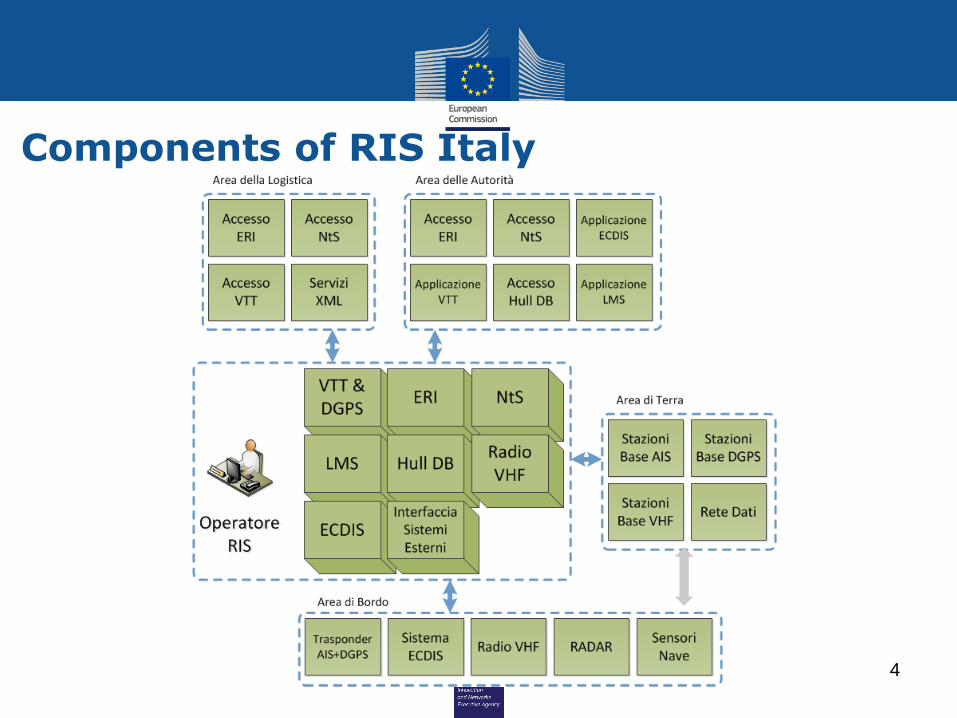
Components of RIS Italy
4

Components of RIS Italy RIS Centres
(hypothesis)Coordinates
Altitude (asl)
Boretto 44° 54' 22.97''N 10° 33' 28.48''E 26 m
Cavanella D’Adige 45° 6' 36.65''N 12° 14' 36.28''E 0 m
AIS/VHF Base Stations Coordinates Altitude (asl)
Bosco Chiesanuova 45°38'1.71"N 11° 2'16.90"E 1245 m
Canneto Pavese 45° 3'32.10"N 9°17'1.47"E 280 m
Monte Cassio 44°35'46.50"N 10° 3'44.17"E 899 m
Monte Catone 44°20'39.62"N 11°37'39.59"E 280 m
Monte Ricco 45°15'15.23"N 11°44'32.52"E 324 m
Pedrosa 46° 9'32.00"N 13°24'6.00"E 777 m
Col Visentin 46° 3'16.19"N 12°16'56.60"E 1736 m
Locks Coordinates
Isola Serafini 45° 5'29.86"N 9°54'23.49"E
Acquanegra 45° 9'17.71"N 9°53'29.77"E
Cremona 45° 8'19.28"N 9°59'2.45"E
San Leone 45° 4'42.14"N 10°58'41.03"E
Governolo 45° 5'4.83"N 10°57'16.32"
Trevenzuolo 45° 5'48.76"N 11° 6'23.48"E
Torretta 45° 5'29.24"N 11°18'37.72"E
Canda 45° 1'51.57"N 11°29'46.75"E
Bussari 44°59'47.04"N 11°43'41.82"E
Baricetta 45° 3'16.54"N 12° 0'7.08"E
Volta Grimana 45° 1'43.30"N 12°11'20.96"E
Cavanella d'Adige (sud) 45° 6'18.13"N 12°14'34.49"E
Cavanella d'Adige (nord) 45° 6'36.48"N 12°14'36.26"E
Brondolo 45°11'3.17"N 12°16'16.98"E
Pontelagoscuro 44°53'7.14"N 11°36'14.79"E
Valpagliaro 44°49'2.58"N 11°51'21.64"E
Valle lepri 44°42'26.43"N 12° 5'36.28"E
Ports Coordinates
Cremona 45° 8'19.28"N 9°59'2.45"E
Boretto 44°54'22.58"N 10°33'26.19"E
Mantova 45° 7'48.72"N 10°51'33.99"E
Rovigo 45° 2'4.04"N 11°48'37.45"E
5

Components of the Prototype
6

Accesso portale web
7
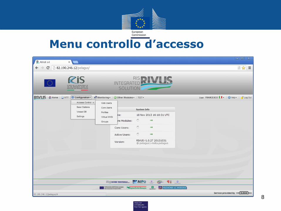
Menu controllo d’accesso
8

Profili utente
9

Definizione utenti WEB
10

VTT- Configurazione Stazioni base AIS
11
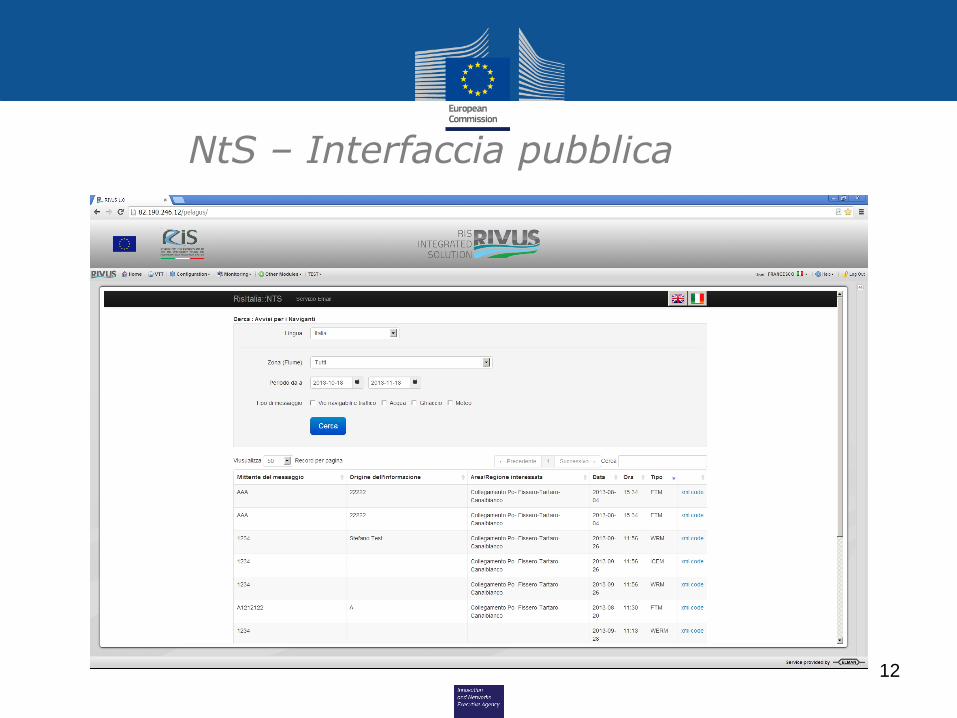
NtS – Interfaccia pubblica
12

NtS – Interfaccia pubblica
13

LMS – Dettagli richiesta
14

LMS – Gestione raggruppamenti
15

16
Act. 1.1 Project managementAct. 1.2 Communication and Dissemination
ACTIVITY 1: Project management communication and dissemination –
Coordinator: Sistemi Territoriali

17
ACTIVITY 1.1 Project Management
The project management activities include:
1. The Project management and coordination;
2. Kick-off event organisation and implementation;
3. The administration of the financial resources of the project and timely
execution of all payments to partners, in line with the project budget and
contractual obligations;
4. The continuous monitoring and evaluation of the progress of the planned
activities of the project, workplan and tasks;
5. The continuous monitoring of information flows;
6. The preparation and submission of all administrative and financial
reporting in compliance with the contractual rules and obligations;
7. The organisation and enforcement of quality control procedures;
8. The adoption of risk management measures as appropriate.
18
ACTIVITY 1.2 Communication and DisseminationThe communication and the dissemination activities will be articulated in the
following measures:
1. Set up and publishing of a website;
2. Local stakeholder communication strategy;
3. Transnational cross fertilisation with similar projects in the EU;
4. Effective communication interfaces and dissemination channels, with events,
publications, participation to seminars and events at local, national and
EU level;
5. Non media dissemination materials (leaflets) describing the project
objectives, the pilot activities and expected outcomes in a concise way;
6. Media coverage of the project;
7. Raise awareness campaign towards inland and sea ports, relevant public
authorities and policy makers in the programme area;
8. Prepare a Final public event;
9. Final multimedia dissemination output.

19
Act. 2.1 bIENC Implementation inside existing IENCAct. 2.2 Integration between bIENC and RIVUSAct. 2.3 NtS evolution by means of web services
ACTIVITY 2 Inland ECDIS and NTS Upgrade Coordinator: AIPo
20
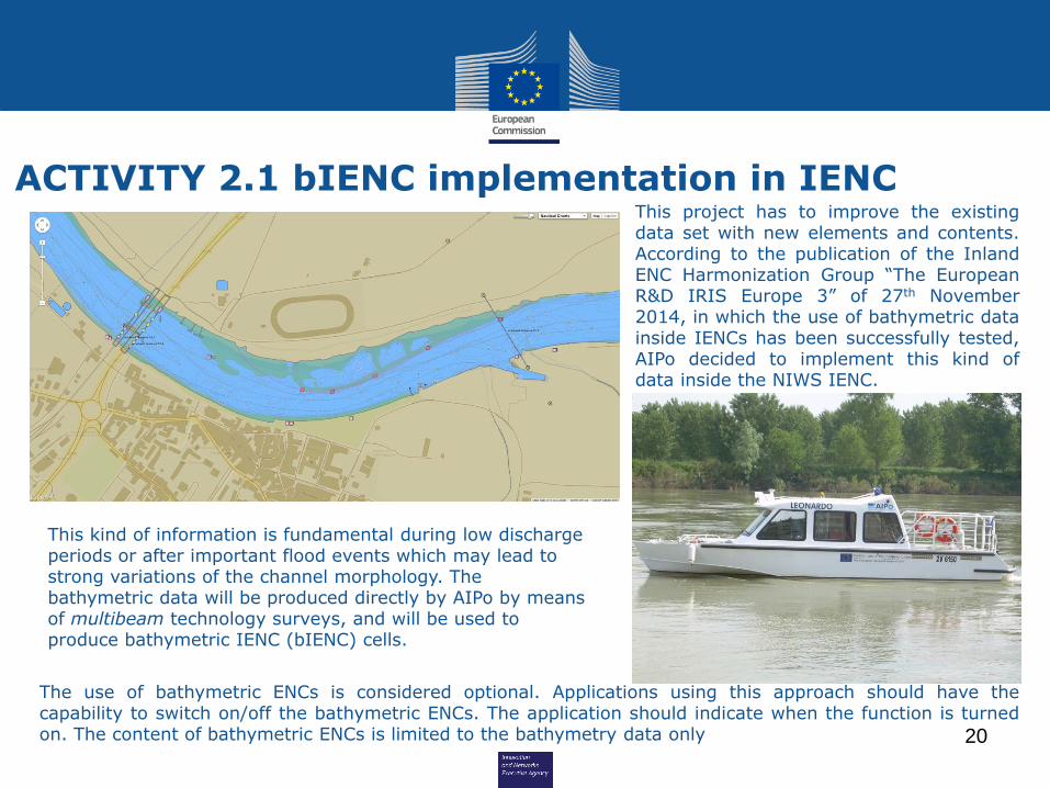
ACTIVITY 2.1 bIENC implementation in IENC
This kind of information is fundamental during low discharge periods or after important flood events which may lead to strong variations of the channel morphology. The bathymetric data will be produced directly by AIPo by means of multibeam technology surveys, and will be used to produce bathymetric IENC (bIENC) cells.
The use of bathymetric ENCs is considered optional. Applications using this approach should have thecapability to switch on/off the bathymetric ENCs. The application should indicate when the function is turnedon. The content of bathymetric ENCs is limited to the bathymetry data only
This project has to improve the existingdata set with new elements and contents.According to the publication of the InlandENC Harmonization Group “The EuropeanR&D IRIS Europe 3” of 27th November2014, in which the use of bathymetric datainside IENCs has been successfully tested,AIPo decided to implement this kind ofdata inside the NIWS IENC.

21
ACTIVITY 2.2 Integration between RIVUS and bIENC
RIVUS Network
RIS
LA
NInternetIENC Chart database
RIVUS Web Server & GIS
IENC Chart Server
VTT operator
Ch
art
sG
IS la
ye
rsGIS
presentation
External user
/ Skipper
Chart download
bIENC
Chart producer
bIENCCharts
The diagram displays the relations between these RIVUS modules and operators/users,where black lines show the physical connections and red lines represent logical flow ofdata.

22
ACTIVITY 2.3 NtS evolution by means of web serviceThe web-service interface should be adopted as the new NtS standard. This kind of innovationallows the completely autonomous information flux between RIS provider and users, creating a “twoway” communication system instead of the present “one way”.
The NtS web-service feature will comply with the specification emitted by the Federal Waterways Engineering Service Centre Information Technology of the BMVBS (DLZ-IT BMVBS), version 1.0.3.0, or as amended in future version of the standard.
The NtS web services will be seamlessly integrated with the RIVUS application
Such as, all the NtS messages published by the RIS operators using the RIVUS web userinterface, will be available for distribution through the web service
meteorological alerts
area restrictions
water depths levels

23
Act. 3.1 RIVUS Mobile DevelopmentAct. 3.2 RIVUS Mobile web services
ACTIVITY 3 Safety Improvement for the NIWS Coordinator: AIPo

24
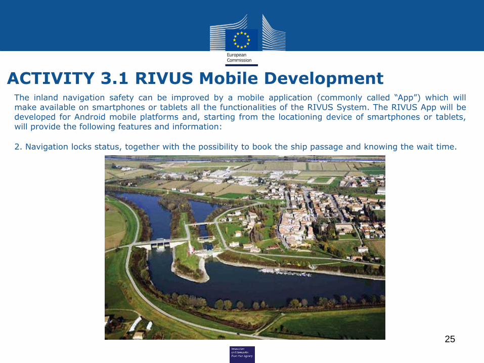
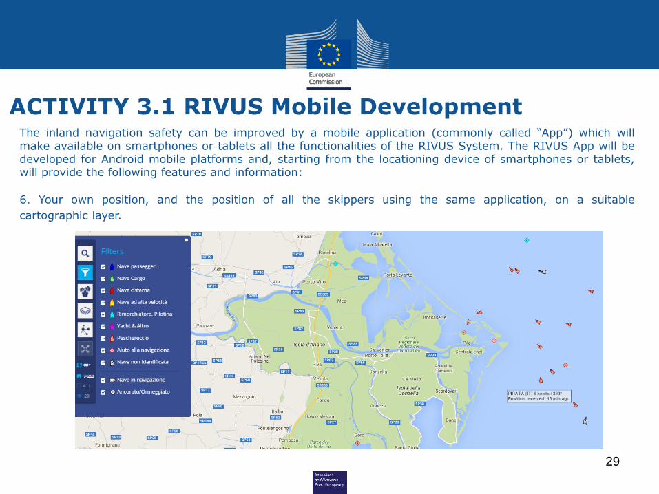
ACTIVITY 3.1 RIVUS Mobile DevelopmentThe inland navigation safety can be improved by a mobile application (commonly called “App”) which willmake available on smartphones or tablets all the functionalities of the RIVUS System. The RIVUS App will bedeveloped for Android mobile platforms and, starting from the locationing device of smartphones or tablets,will provide the following features and information:
1. Real time water levels information coming from the NIWS gauges network.
25
ACTIVITY 3.1 RIVUS Mobile DevelopmentThe inland navigation safety can be improved by a mobile application (commonly called “App”) which willmake available on smartphones or tablets all the functionalities of the RIVUS System. The RIVUS App will bedeveloped for Android mobile platforms and, starting from the locationing device of smartphones or tablets,will provide the following features and information:
2. Navigation locks status, together with the possibility to book the ship passage and knowing the wait time.

26
ACTIVITY 3.1 RIVUS Mobile DevelopmentThe inland navigation safety can be improved by a mobile application (commonly called “App”) which willmake available on smartphones or tablets all the functionalities of the RIVUS System. The RIVUS App will bedeveloped for Android mobile platforms and, starting from the locationing device of smartphones or tablets,will provide the following features and information:
3. Fairway condition, for example dredging areas, presence of hydraulic works areas or limited navigationconditions.

27
ACTIVITY 3.1 RIVUS Mobile DevelopmentThe inland navigation safety can be improved by a mobile application (commonly called “App”) which willmake available on smartphones or tablets all the functionalities of the RIVUS System. The RIVUS App will bedeveloped for Android mobile platforms and, starting from the locationing device of smartphones or tablets,will provide the following features and information:
4. Shallow water cross sections or reaches along the navigation channel.

28
ACTIVITY 3.1 RIVUS Mobile DevelopmentThe inland navigation safety can be improved by a mobile application (commonly called “App”) which willmake available on smartphones or tablets all the functionalities of the RIVUS System. The RIVUS App will bedeveloped for Android mobile platforms and, starting from the locationing device of smartphones or tablets,will provide the following features and information:
5. Notice to Skippers.
meteorological alerts
water depths levels
29
ACTIVITY 3.1 RIVUS Mobile DevelopmentThe inland navigation safety can be improved by a mobile application (commonly called “App”) which willmake available on smartphones or tablets all the functionalities of the RIVUS System. The RIVUS App will bedeveloped for Android mobile platforms and, starting from the locationing device of smartphones or tablets,will provide the following features and information:
6. Your own position, and the position of all the skippers using the same application, on a suitable
cartographic layer.

30
ACTIVITY 3.1 RIVUS Mobile DevelopmentThe inland navigation safety can be improved by a mobile application (commonly called “App”) which willmake available on smartphones or tablets all the functionalities of the RIVUS System. The RIVUS App will bedeveloped for Android mobile platforms and, starting from the locationing device of smartphones or tablets,will provide the following features and information:
7. The position, the navigation track and the velocity of commercial ships equipped with AIS.

31
ACTIVITY 3.2 RIVUS Mobile web service
RIVUS Network
RIS
LAN
Internet /
3G / 4GNtS
VTT operator
AIS+Apptracks
External user
/ Skipper
NtS download
VTT / GIS
LMS
LMS reservation
AIS tracks
App track
The diagram displays the relations between the enhanced RIVUS modules andexternal users exchanging data with the RIS centres using the mobile App, whereblack lines show the physical connections and red lines represent logical flow ofdata.
External user / skipper

32
Act. 4.1 AIS involved Authorities armonizationAct. 4.2 Functional requirement for RIS and NMSW InterfaceAct. 4.3 Functional requirement for RIS and SafeSeaNet Interface
ACTIVITY 4 Inland Maritime Integration Coordinator: MIT
33
ACTIVITY 4.1 AIS involved Authorities armonization
This sub activity will consist in the review of the organization of the reporting inthe inland waterway, to standardize the format and structure as by Directive2010/65. The Directive 2010/40 on Intelligent Transport Systems (ITS) will alsobe taken into account referring to road/rail systems and their interfaces with theother mode of transport (e.g. inland waterways).
In inland ports different type of ICT tools exist but they are often not connectedwith each other and more often not harmonised with River Information Services.In order to increase effectiveness and competiveness in this task the Integratedbetween Inland Port Information Management System, Logistics Data Systemswill be studied. Close cooperation will be realised with all inland port stakeholdersof multimodal logistic chain in the considered area. Conclusion on the useful RISservices for the benefit of operations in inland ports will be drawn andrecommendations and best practices will be elaborated
34
ACTIVITY 4.2 Functional Requirement for RIS andNMSW Interface
This sub activity will study the interdependence between RIS and the NationalMaritime Single Window (NMSW) and the necessary actions.
Any connections between RIS and the information system of the Customs andMonopolies (AIDA) will be evaluated.
The sub activity will analyse the structures of these two systems and elaborate anAction Plan of the activities necessary to match them and will define the functionalrequirements for RIS and NMSW interface
In particular, the required formalities related to ship arriving in or departing fromports and their relevant data contents will be examined to identify which sets ofdata may be exchanged between the systems through an interface, properlyimplemented to adopt the principles set at EU level by the relevant directives andby EMSA's NSW prototype.

35
ACTIVITY 4.3 Functional Requirement for RIS andSafeSeaNet Interface
This sub-activity will study the interdependence between RIS and the SafeSeaNetsystem and all the necessary actions to harmonize these two system. TheSafeSeaNet is a vessel traffic monitoring and information system, established inorder to enhance:
1. Maritime safety2. Port and maritime security3. Marine environment protection4. Efficiency of maritime traffic and maritime transport
The sub activity will analyse the structure of these two systems and elaborate anAction Plan of the activities necessary to match them and will define the functionalrequirements for RIS and SafeSeaNet interface.

36
Act. 5.1 Automatic Switching of Inland Maritime mode on-board AISAct. 5.2 Trasmission of DGNSS Corrections Using AIS base stationsAct. 5.3 Exploiting Redundancy of Maritime and Inland AIS NetworkAct. 5.4 Testing of Integration Benefits from the on-board prospectives
ACTIVITY 5 System Test for Inland-Maritime Integration
Coordinator: Sistemi Territoriali

37
ACTIVITY 5.1 Automatic switching of inland/maritime mode of on-board AIS
The objective of this sub-activity is to complement the functionality of the on-board inland ECDIS software with the following features:
1. Detection of events related to vessel entrance in areas under the jurisdictionof the maritime authority or in areas covered by RIS;
2. Notification of event occurrence to the skipper through information displayedon the ECDIS;
3. Automatic switching of AIS device to maritime or inland mode, depending onthe area entered.
The sub-activity will include the following tasks:
1. Definition of the areas where inland and maritime modes are required for theon-board AIS;
2. Design and implementation of the software module which detects access tothe above defined areas and interacts with the ECDIS and the AIS device todisplay the entrance events and to switch the AIS mode as relevant.
38
ACTIVITY 5.2 Transmission of DGNSS correctionsusing AIS base stations
The sub-activity will include the following tasks:
1. Study to optimize the placement of DGNSS reference stations in order to
minimize costs and grant the 1 meter accuracy in all the identified areas
where this is needed;
2. Study to identify the AIS base stations (inland and maritime) for the DGNSS
transmissions to cover all the above identified areas;
3. Definition of intervals of DGNSS transmissions from AIS base stations to
avoid accuracy degradation without impacting on AIS channel loading;
4. Implementation of DGNSS transmissions using the AIS stations of the VTT
39
ACTIVITY 5.3 Exploiting redundancy of maritimeand inland AIS network
Given the relevant geographical overlapping of the areas of interest of maritimeand inland services, and the use of standard and compatible AIS technology inboth systems, it is practical to implement a communication link between the twosystems, with the following advantages:
1. the AIS networks may complement each other whereas Base Stations of onesystem provide additional or better coverage than the Base Stations of theother one;
2. the AIS networks may act as mutual failover systems whereas Base Stationsfrom one system provide coverage which overlaps that of the Base Stations ofthe other one.
3. reliability and coverage of both inland and maritime AIS network may beenhanced while saving on cost and number of installations at the same time.

40
ACTIVITY 5.3 Exploiting redundancy of maritimeand inland AIS network
The sub-activity will include the following tasks:
1. Design and implementation of the communication link between the maritimeand inland systems to grant a mutual exchange of AIS data in areas ofinterest.
2. Study of the coverage obtained with the Base Stations already installed in thetwo networks, identifying gaps and the best sites to install new devices with aview to enhance the coverage for both systems. Areas where AIS coverageshould be improved include the western leg of the river Po, the Ferrarawaterway and the great lakes of northern Italy. New installations coveringthese areas would provide benefits to both the administrations.
3. Deployment of new AIS Base stations identified as described above and otherrequired infrastructure like data links and connections to the RIS centres.

41
ACTIVITY 5.4 Testing of integration benefitsfrom the on board perspective
The sub-activity will include the following tasks:
1. testing of on board AIS and ECDIS behaviour, as designed in sub-activity 5.1,when transiting from inland waterways to maritime navigation and vice versa.
2. testing of improvement of positioning quality on board when DGNSS signals,implemented as per sub-activity 5.2, are received.
3. testing of enhancement of coverage of AIS signals as expected from theimprovement of coverage and redundancy brought in by sub-activity 5.3.