cedar point wind energy facility project description report … · 2011-11-15 · cedar point wind...
TRANSCRIPT

CEDAR POINT WIND ENERGY FACILITY PROJECT DESCRIPTION REPORT
File No. 160960709 November 2011
Prepared for:
Suncor Energy Products Inc. 150 6th Avenue SW Calgary AB T2P 3E3
Prepared by:
Stantec Consulting Ltd. Suite 1 - 70 Southgate Drive Guelph ON N1G 4P5


CEDAR POINT WIND ENERGY FACILITY PROJECT DESCRIPTION REPORT
Executive Summary
Suncor Energy Products Inc. (“Suncor”) is a Canadian energy company that is responding to the Government of Ontario's initiative to promote the development of renewable, pollution-free electricity in the province. Suncor is proposing to develop the Cedar Point Wind Energy Facility (the Project) within the Town of Plympton-Wyoming and the Municipality of Lambton Shores, both within Lambton County, Ontario. The proposed Project was awarded a Feed-In-Tariff (FIT) contract with the Ontario Power Authority (OPA) in July, 2011 for up to 100 MW (FIT Contract F-002175-WIN-130-601). The Project was previously known as the Camlachie-Cedar Point Wind Project; however the size and scale of the previous project has changed and is now being proposed as the Cedar Point Wind Energy Facility.
The proposed Project Boundary is approximately 21,500 hectares in size. It is envisioned that the proposed Project will include 33 to 62 wind turbines. The number of turbines will be dependent upon final selection of make and model of the wind turbine most appropriate for the proposed Project as well as stakeholder input. The proposed Project would also include access roads, up to three meteorological towers (met tower), electrical collector lines, two substations and a transmission line which would connect the Project with the provincial high voltage transmission system. Temporary components during construction may include storage and staging areas at the turbine locations, crane pads or mats, staging areas along access roads, delivery truck turnaround areas, and a central laydown area. The proposed Project Boundary is shown in Appendix A along with the previously proposed boundary of the Camlachie-Cedar Point Wind Project.
Suncor has retained Stantec Consulting Ltd. (Stantec) to help prepare the Renewable Energy Approval (REA) application, as required under O. Reg. 359/09. According to subsection 6.(3) of O. Reg. 359/09, the proposed Project is classified as a Class 4 Wind Facility. The Project Description Report is one component of the REA application for the proposed Project, and has been prepared in accordance with Item 10, Table 1 of O. Reg. 359/09, and the Ministry of the Environments’ (MOE) “Technical Guide to Renewable Energy Approvals” (July 2011).
The following table summarizes the requirements of this report as specified under O. Reg. 359/09.
Project Description Report Requirements (as per O. Reg. 359/09 – Table 1)
Requirements Completed Section Reference
• Any energy sources to be used to generate electricity at the renewable energy generation facility.
2.2
• The facilities, equipment or technology that will be used to convert the renewable energy source or any other energy source to electricity.
2.3
• If applicable, the class of the renewable energy generation facility. 1.1

CEDAR POINT WIND ENERGY FACILITY PROJECT DESCRIPTION REPORT Executive Summary November 2011
Project Description Report Requirements (as per O. Reg. 359/09 – Table 1)
Requirements Completed Section Reference
• The activities that will be engaged in as part of the renewable energy project.
2.5 and 2.6
• The name plate capacity of the renewable energy generation facility. 2.1
• The ownership of the land on which the project location is to be situated.
1.2
• Any negative environmental effects that may result from engaging in the project.
3.0
• An unbound, well-marked, legible and reproducible map that is an appropriate size to fit on a 215 millimetre by 280 millimetre page, showing the project location and the land within 300 metres of the project location.
Appendix A

CEDAR POINT WIND ENERGY FACILITY PROJECT DESCRIPTION REPORT
i
Table of Contents
1.0 INTRODUCTION .......................................................................................................... 1.1 1.1 PROJECT OVERVIEW ................................................................................................ 1.1 1.2 PROJECT LOCATION ................................................................................................. 1.2 1.3 CONTACTS.................................................................................................................. 1.2 1.4 AUTHORIZATIONS REQUIRED .................................................................................. 1.3
1.4.1 Provincial............................................................................................................ 1.3 1.4.2 Municipal ............................................................................................................ 1.4 1.4.3 Federal ............................................................................................................... 1.5
2.0 PROJECT INFORMATION .......................................................................................... 2.1 2.1 NAMEPLATE CAPACITY OF THE PROJECT .............................................................. 2.1 2.2 ENERGY SOURCES .................................................................................................... 2.1 2.3 PROJECT COMPONENTS .......................................................................................... 2.1
2.3.1 Wind Turbine Generators ................................................................................... 2.1 2.3.2 Electrical Interconnection ................................................................................... 2.2 2.3.3 Access Roads .................................................................................................... 2.2 2.3.4 Operations and Maintenance Building ................................................................ 2.3 2.3.5 Transformer Substation ...................................................................................... 2.3 2.3.6 Met Tower .......................................................................................................... 2.3 2.3.7 Water Crossings ................................................................................................. 2.3
2.4 TEMPORARY COMPONENTS .................................................................................... 2.4 2.5 PROJECT SCHEDULE ................................................................................................ 2.4 2.6 PROJECT ACTIVITIES ................................................................................................ 2.4
2.6.1 Waste Generation .............................................................................................. 2.5 2.6.2 Emissions ........................................................................................................... 2.6 2.6.3 Hazardous Materials .......................................................................................... 2.6 2.6.4 Sewage and Stormwater Management ............................................................... 2.7 2.6.5 Water-taking Activities ........................................................................................ 2.7
3.0 DESCRIPTION OF POTENTIAL ENVIRONMENTAL EFFECTS ................................. 3.1 3.1 PROJECT RELATED SETBACKS ............................................................................... 3.8 3.2 COMPARISON OF REA AND MUNICIPAL SETBACK REGULATIONS ...................... 3.9
4.0 CLOSURE .................................................................................................................... 4.1
5.0 REFERENCES ............................................................................................................. 5.1

CEDAR POINT WIND ENERGY FACILITY PROJECT DESCRIPTION REPORT
Table of Contents
ii
List of Tables
Table 1.1: Key Provincial Permits and Authorizations .............................................................. 1.4 Table 1.2: Key Municipal Permits and Authorizations .............................................................. 1.4 Table 1.3: Key Federal Permits and Authorizations ................................................................. 1.5 Table 2.1: Potential Turbine Nameplate Capacities ................................................................. 2.1 Table 2.2: Typical Turbine Description .................................................................................... 2.2 Table 2.3 : Project Schedule Overview .................................................................................... 2.4 Table 2.4 :Key Project Activities ............................................................................................... 2.4 Table 3.1: Environmental Features and Potential Effects Screening Checklist ........................ 3.1 Table 3.2: Project Related Setbacks ........................................................................................ 3.8
List of Appendices
Appendix A Figures

CEDAR POINT WIND ENERGY FACILITY PROJECT DESCRIPTION REPORT
1.1
1.0 Introduction
1.1 PROJECT OVERVIEW
Suncor Energy Products Inc. (“Suncor”) is proposing to develop the Cedar Point Wind Energy Facility (the Project) within the Town of Plympton-Wyoming and the Municipality of Lambton Shores, both within Lambton County, Ontario. The proposed Project Boundary is approximately 21,500 hectares in size. The Project was awarded a Feed-In-Tariff (FIT) contract with the Ontario Power Authority (OPA) in July, 2011 for up to 100 MW (FIT Contract F-002175-WIN-130-601).
Suncor’s Wind Project History
Suncor has two proposed wind power projects under development within Lambton County. These projects include the Camlachie Wind Energy Facility, planned as a 20 MW facility southwest of the town of Camlachie, and the Cedar Point Wind Energy Facility as described herein. The Cedar Point Wind Energy Facility is proposed to be completed in two phases a Phase I of 50 MW and a Phase II of 100 MW. The Camlachie Wind Energy Facility and the Phase I of the Cedar Point Wind Energy Facility (previously introduced to the community as the Camlachie-Cedar Point Wind Project) were not successful at receiving transmission capacity in the form of a FIT Contract to date. These projects remain at the top of the list in a long list of projects awaiting new transmission capacity called the FIT Project Reserve managed by the OPA.
Facility Description
The number of turbines will be dependent upon final selection of make and model of the wind turbine most appropriate for the proposed Project. To build a 100 MW wind facility, the number of turbines is dependant on the nameplate size of each individual wind turbine. Further details are provided in Section 2.1.
The proposed Project would also include access roads, up to three meteorological towers (met tower), electrical collector lines, two substations and a transmission line which would connect the Project with the provincial high voltage transmission system. Temporary components during construction may include storage and staging areas at the turbine locations, crane pads or mats, staging areas along access roads, delivery truck turnaround areas, and a central laydown area. The proposed Project Boundary is shown in Appendix A along with the previously proposed boundary of the Camlachie-Cedar Point Wind Project. Project development activities will continue and if successful, construction is scheduled in summer 2013 and commercial operation by summer 2014.
Suncor has retained Stantec Consulting Ltd. (Stantec) to help prepare the Renewable Energy Approval (REA) application, as required under O. Reg. 359/09. According to subsection 6.(3) of O. Reg. 359/09, the proposed Project is classified as a Class 4 Wind Facility. The Project

CEDAR POINT WIND ENERGY FACILITY PROJECT DESCRIPTION REPORT November 2011
1.2
Description Report is one component of the REA application for the Project, and has been prepared in accordance with Item 10, Table 1 of O. Reg. 359/09, and the Ministry of the Environments’ (MOE) “Technical Guide to Renewable Energy Approvals” (July 2011).
1.2 PROJECT LOCATION
The proposed Project will be located on privately owned lands. The legal description of the parcels of land that will ultimately be used for the Project will be provided as part of the REA application.
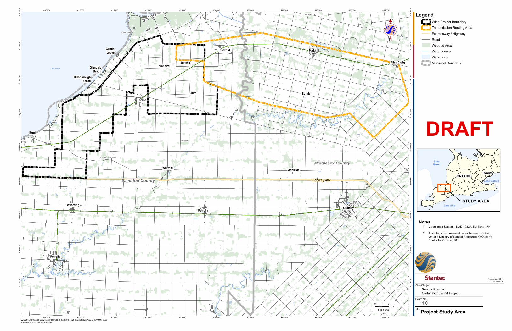
The proposed Project will be located within the Town of Plympton-Wyoming and the Municipality of Lambton Shores, both within Lambton County. The area is located approximately 20 km north-east of the city of Sarnia. A map showing the proposed Project Boundary is provided in Appendix A.
In accordance with O. Reg. 359/09, the Project Location includes all land and buildings/structures associated with the project and any air space in which the project will occupy. This includes structures such as turbines, access roads, power lines, and maintenance facilities as well as any temporary work areas (the “construction envelope” for the project) which are required to be utilized during the construction of the project.
Although O. Reg. 359/09 considers the REA process in terms of the Project Location, the siting process for wind projects is an iterative process, and thus the full Project Location is not available at Project outset. Therefore, a Project Boundary has been developed to examine the general area within which the Project Location will be sited. The proposed Project Boundary is shown in Appendix A. There are no Provincial Parks or Conservation Reserves located within the Project Boundary.
The Project’s power is to connect to the Ontario power grid. This transmission line routing will be included in the REA approval process. The transmission line is proposed to be overhead monopole 115 kV transmission line. Routing is still being determined and the transmission routing area is also provided in Appendix A.
1.3 CONTACTS
The name of the applicant and proponent for the proposed Project is Suncor Energy Products Inc. The contact information for the proponent is:
Dianne Zimmerman Manager, Strategic Relations, Renewable Energy 150 6th Ave SW Calgary, AB T2P 3E3 Tel: (519) 719-9181 Email: [email protected]

CEDAR POINT WIND ENERGY FACILITY PROJECT DESCRIPTION REPORT November 2011
1.3
Christopher Scott Project Developer 150 6th Avenue SW Calgary, AB T2P 3E3 Telephone: (519) 328-0424 Email: [email protected]
The lead consultant for preparation of the Renewable Energy Approval application is Stantec Consulting Ltd. The consultant’s office and Project contact(s) are:
Mark Kozak Project Manager Stantec Consulting Ltd. 70 Southgate Drive, Suite 1 Guelph, ON N1G 4P5 Telephone: (519) 836-6050 Fax: (519) 836-2493 Email: [email protected] Marnie Dawson Senior Project Manager Stantec Consulting Ltd. 70 Southgate Drive, Suite 1 Guelph, ON N1G 4P5 Telephone: (519) 836-6050 Fax: (519) 836-2493 Email: [email protected]
1.4 AUTHORIZATIONS REQUIRED
At the federal, provincial and municipal level multiple permits, licenses and authorizations may be required to facilitate the development of the proposed Project, in addition to the REA. The ultimate applicability of all permits, licenses and authorizations will be determined and be based on the Project’s design.
1.4.1 Provincial
The following is a list of key permits and approvals that may be required at the provincial level; however additional permits may also be required. The ultimate applicability of each permit will be determined throughout the REA process based on the proposed Project design and discussions[SF1] with provincial agencies.

CEDAR POINT WIND ENERGY FACILITY PROJECT DESCRIPTION REPORT November 2011
1.4
Table 1.1: Key Provincial Permits and Authorizations Key Permit / Authorization Administering Agency Rationale
Customer Impact Assessment
Hydro One Networks Inc. (HONI)
Integration of project with Hydro One and its impact on customers
Connection Cost Recovery Agreement (CCRA)
HONI Recovery of costs to grid operator of changes to allow connection
System Impact Assessment
Independent Electrical System Operator (IESO)
Integration of project with IESO-controlled transmission system
Approval of Connection IESO Electrical interconnect with IESO regulated network Development, Interference with Wetlands, and Alterations to Shorelines and Watercourses Permit
Ausable Bayfield Conservation Authority and St. Clair Region Conservation Authority
Work within floodplains, water crossings, river or stream valleys, hazardous lands and within or adjacent to wetlands. Projects requiring review, Fisheries Act authorization and/or assessment under the Canadian Environmental Assessment Act are forwarded to the Department of Fisheries and Oceans (DFO)
Certificate of Inspection Electrical Safety Authority (ESA)
A record that electrical work complies with the requirements of the Ontario Electrical Safety Code.
Generator’s License Ontario Energy Board (OEB) Generation of electrical power for sale to grid Special vehicle configuration permit
Ministry of Transportation (MTO)
Use of non-standard vehicles to transport large components
Transportation Plan MTO Adherence to road safety and suitability Change of Access and Heavy/Oversize Load Transportation Permit
MTO Compliance with provincial highway traffic and road safety regulations
Wide or excess load permit
MTO Transportation of large or heavy items on provincial highways
1.4.2 Municipal
Several permits and authorizations may also be required from the Town of Plympton-Wyoming, the Municipality of Lambton Shores, and Lambton County.
Table 1.2: Key Municipal Permits and Authorizations
Key Permit / Authorization Rationale Municipal Consent, Work within the municipal R.O.W
Required for works in municipal road allowances
Road Cut Permit May be required for access roads from county roads or works to county roads Pre-Condition Road Survey Assessment of pre-construction road conditions for engineering staff Building Permit Compliance with building codes Entrance Permit Entrance from county roads Fire Safety Agreement Authorization and agreement for fire & rescue services considering wind
turbines Municipal Road Use Agreement Authorization and agreement for the use of municipal right of ways Transportation Plan Adherence to road safety and suitability Additional Plans related to general engineering (e.g. silt fencing, lot grading, plan of services, etc.), water,
Required supporting information/plans

CEDAR POINT WIND ENERGY FACILITY PROJECT DESCRIPTION REPORT November 2011
1.5
Table 1.2: Key Municipal Permits and Authorizations
Key Permit / Authorization Rationale wastewater, storm water, transportation, and geotechnical
1.4.3 Federal
It is expected that a Federal Screening report will not be required for the proposed Project, as it is not anticipated that it will cause a ‘trigger’ under the Canadian Environmental Assessment Act (CEAA). However, the agency consultation program for the Project will include federal departments and agencies typically interested in wind power projects (e.g., NavCanada, Transport Canada, etc.). All required federal permits and approvals required for the proposed Project will be determined during the REA process, but may include those listed below.
Table 1.3: Key Federal Permits and Authorizations
Permit / Authorization Administering Agency Rationale Aeronautical Obstruction Clearance
Transport Canada – Aviation Division Turbine lighting and marking
Land Use Clearance NavCanada Aeronautical safety mapping and designations
Navigational Clearance Transport Canada – Marine Division Crossing a navigable watercourse

CEDAR POINT WIND ENERGY FACILITY PROJECT DESCRIPTION REPORT
2.1
2.0 Project Information
2.1 NAMEPLATE CAPACITY OF THE PROJECT
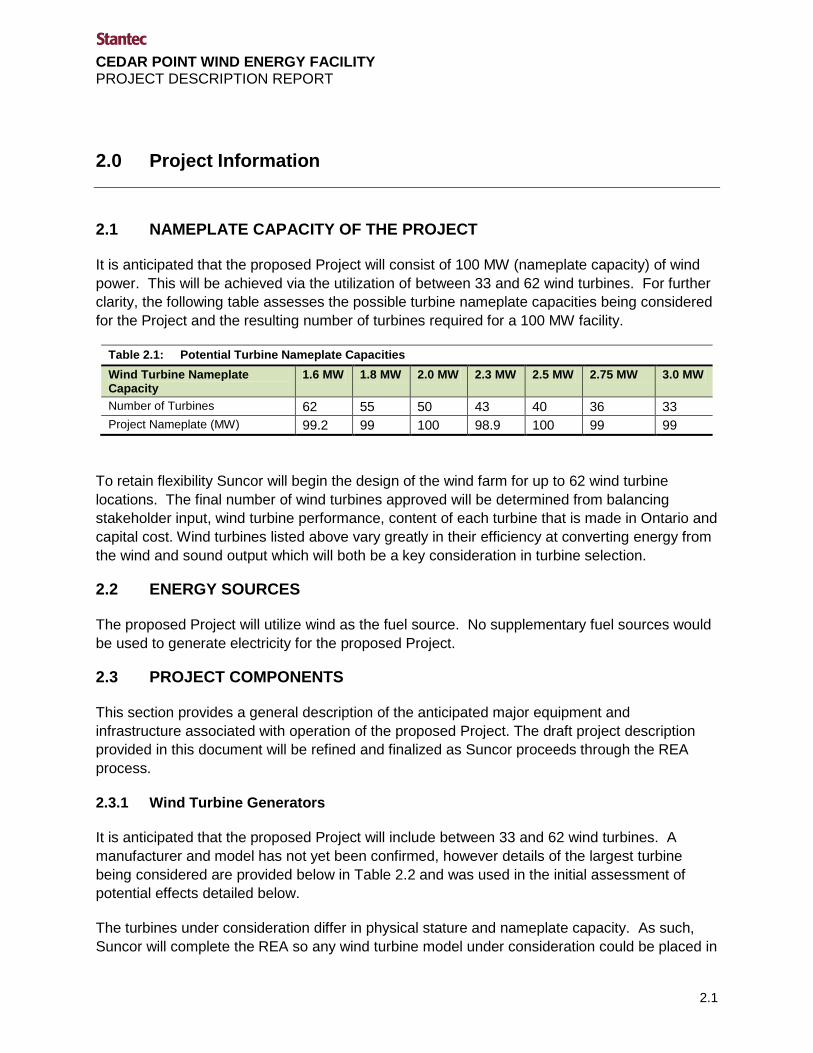
It is anticipated that the proposed Project will consist of 100 MW (nameplate capacity) of wind power. This will be achieved via the utilization of between 33 and 62 wind turbines. For further clarity, the following table assesses the possible turbine nameplate capacities being considered for the Project and the resulting number of turbines required for a 100 MW facility.
Table 2.1: Potential Turbine Nameplate Capacities Wind Turbine Nameplate Capacity
1.6 MW 1.8 MW 2.0 MW 2.3 MW 2.5 MW 2.75 MW 3.0 MW
Number of Turbines 62 55 50 43 40 36 33 Project Nameplate (MW) 99.2 99 100 98.9 100 99 99
To retain flexibility Suncor will begin the design of the wind farm for up to 62 wind turbine locations. The final number of wind turbines approved will be determined from balancing stakeholder input, wind turbine performance, content of each turbine that is made in Ontario and capital cost. Wind turbines listed above vary greatly in their efficiency at converting energy from the wind and sound output which will both be a key consideration in turbine selection.
2.2 ENERGY SOURCES
The proposed Project will utilize wind as the fuel source. No supplementary fuel sources would be used to generate electricity for the proposed Project.
2.3 PROJECT COMPONENTS
This section provides a general description of the anticipated major equipment and infrastructure associated with operation of the proposed Project. The draft project description provided in this document will be refined and finalized as Suncor proceeds through the REA process.
2.3.1 Wind Turbine Generators
It is anticipated that the proposed Project will include between 33 and 62 wind turbines. A manufacturer and model has not yet been confirmed, however details of the largest turbine being considered are provided below in Table 2.2 and was used in the initial assessment of potential effects detailed below.
The turbines under consideration differ in physical stature and nameplate capacity. As such, Suncor will complete the REA so any wind turbine model under consideration could be placed in

CEDAR POINT WIND ENERGY FACILITY PROJECT DESCRIPTION REPORT November 2011
2.2
the turbine positions being investigated for this REA. The table below provides the stature of the largest turbine under consideration.
Table 2.2: Typical Turbine Description Operating Data Specification General Cut-in wind speed (m/s) 3.0 (12.6 km/hr) Cut-out wind speed (m/s) 25 (90 km/hr) Rotor Number of rotor blades 3 Rotor diameter (m) 113 m Blade length (m) 55 m Tower Hub height (m) 99.5 m Tip height (m) 154.5 m
2.3.2 Electrical Interconnection
Using a typical wind turbine generator as an example, a step-up transformer, expected to be located within each wind turbine tower or on a concrete pad outside the base of each turbine, is required to transform the electricity created by the turbine to a standard operating power line voltage (i.e. 690 Volts (V) to 34.5 kilovolts (kV)).
From each step-up transformer, underground 34.5 kV collector lines will carry the electricity to the municipal road allowances (in most cases following the turbine access roads to minimize impacts) or via cross-country routes. Within the municipal road allowances, the electricity will be transported by a mixture of overhead and buried electrical collector lines to a central substation. On all private lands, 34.5 kV collector lines form turbines will be buried. The central substation will collect the power from the wind turbine generators and transform the power from 34.5kV to 115 kV. From the central substation, approximately 35 km of 115 kV above ground transmission line will be constructed which will connect the Project to the Hydro One Networks Inc. (HONI) electrical system. At the connection point, a transformer substation will be constructed to transform the generated electricity from 115kV to 500kV. The final location of all electrical components will be determined throughout the REA process including input from Project stakeholders.
2.3.3 Access Roads
Existing provincial and municipal roads will be used to transport project-related components, equipment and personnel to the Project Location. The proposed Project will be installed on private lands. Access to these lands will be required for installation and operation of the project components. Project infrastructure including new access roads will follow the Provincial Policy Statement which states:

CEDAR POINT WIND ENERGY FACILITY PROJECT DESCRIPTION REPORT November 2011
2.3
Alternative energy systems and renewable energy systems shall be permitted in settlement areas, rural areas and prime agricultural areas in accordance with provincial and federal requirements. In rural areas and prime agricultural areas, these systems should be designed and constructed to minimize impacts on agricultural operations.
All access road locations will be discussed with the property owner to reduce the impacts on the agricultural operations of the property.
2.3.4 Operations and Maintenance Building
During the early years of the proposed Project, operations will be remotely conducted from Suncor’s maintenance building located in Thamesville, ON. Should a need be identified to require a local operations facility, Suncor will make arrangements to identify and procure a centralized maintenance facility that considers all of Suncor’s operational wind farms in Ontario.
2.3.5 Transformer Substation
Associated with the proposed Project will be two substations, which will be located on private land. The size of the substations will be determined and examined during the REA process and through regulations and consultation with HONI. All substations will be built in accordance with the current regulations and standards.
2.3.6 Met Tower
Suncor currently has two active 60 m tubular guyed met towers which were installed in 2006 and 2008. An 80 m lattice tower was installed in 2005 and removed in 2010. The met towers have been used to identify the quality of the wind resource for the proposed Project. The wind data collected will be used to determine the best orientation of the wind turbines such that wake loses from adjacent wind turbines is minimized. These towers are prospecting towers and may be removed upon reaching commercial operation. During construction, up to three permanent met towers will be installed within the Project Boundary as per requirements by the Independent Electrical System Operator (IESO). These met towers are guyed lattice towers with monitoring sensors at various heights. The met towers are used for two functions: to complete a power performance study to confirm performance of the wind turbines installed and to provide data to the IESO to support their wind forecasting activities and operations of the electrical system. The met towers will remain and be maintained for the duration of the Project’s operating life.
2.3.7 Water Crossings
All water crossings will require permit approval from the Ausable Bayfield Conservation Authority and St. Clair Region Conservation Authority and possibly the Ministry of Natural Resources (MNR). The final configuration and route for the access roads and collector lines will be determined as part of the REA process. All temporary crossings would comply with various Department of Fisheries and Oceans (DFO) Ontario Operational Statements, where applicable.

CEDAR POINT WIND ENERGY FACILITY PROJECT DESCRIPTION REPORT November 2011
2.4
2.4 TEMPORARY COMPONENTS
Temporary components during construction may include storage and staging areas at the turbine locations, crane pads or mats, staging areas along access roads, delivery truck turnaround areas, central laydown area(s), crane paths and associated watercourse crossings. The final configuration and location of these components will be determined as part of the REA process and will be considered as part of the Project Location.
2.5 PROJECT SCHEDULE
The table below provides an overview of the projected dates associated with the proposed Project.
Table 2.3 : Project Schedule Overview
Milestone Approximate Date Submission of the Draft PDR November 2011 Initiate Public REA Process January 2012 REA technical studies and consultation Ongoing through 2012 Public Meeting #1 February 2012 Draft REA Reports to Public March/April 2012 Public Meeting #2 May/June 2012 REA Submission July 2012 Start of Construction June 2013 Commercial Operation Date (COD) July 2014 Repowering/Decommissioning Approximately 20 years after COD
2.6 PROJECT ACTIVITIES
Suncor is currently developing a comprehensive Stakeholder Plan to meet the needs of the community. As input and as a first step, Suncor is meeting with key stakeholders in the community to better understand the interests and needs of each community. Suncor will then determine what the best approach is to fully engage our community members. Suncor will also be following the Canadian Wind Energy Association's "Best Practices for Community Engagement and Public Consultation." Additional information about our efforts in this area will be posted on the Project website and in future Project Description Reports.
A general overview of the activities during construction, operation, and decommissioning phases of the proposed Project are provided below.
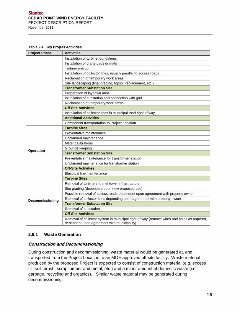
Table 2.4 :Key Project Activities Project Phase Activities
Construction
Turbine Sites Delineation of temporary work areas Completion of necessary site grading Access road construction and culvert installation
CEDAR POINT WIND ENERGY FACILITY PROJECT DESCRIPTION REPORT November 2011
2.5
Table 2.4 :Key Project Activities Project Phase Activities
Installation of turbine foundations Installation of crane pads or mats Turbine erection Installation of collector lines, usually parallel to access roads Reclamation of temporary work areas Site landscaping (final grading, topsoil replacement, etc.) Transformer Substation Site Preparation of laydown area Installation of substation and connection with grid Reclamation of temporary work areas Off-Site Activities Installation of collector lines in municipal road right of way
Additional Activities Component transportation to Project Location
Operation
Turbine Sites Preventative maintenance Unplanned maintenance Meter calibrations Grounds keeping Transformer Substation Site Preventative maintenance for transformer station Unplanned maintenance for transformer station Off-Site Activities Electrical line maintenance
Decommissioning
Turbine Sites Removal of turbine and met tower infrastructure Site grading (dependent upon new proposed use) Possible removal of access roads dependent upon agreement with property owner Removal of collector lines depending upon agreement with property owner Transformer Substation Site Removal of substation Off-Site Activities Removal of collector system in municipal right of way (remove wires and poles as required, dependent upon agreement with municipality)
2.6.1 Waste Generation
Construction and Decommissioning During construction and decommissioning, waste material would be generated at, and transported from the Project Location to an MOE approved off-site facility. Waste material produced by the proposed Project is expected to consist of construction material (e.g. excess fill, soil, brush, scrap lumber and metal, etc.) and a minor amount of domestic waste (i.e. garbage, recycling and organics). Similar waste material may be generated during decommissioning.

CEDAR POINT WIND ENERGY FACILITY PROJECT DESCRIPTION REPORT November 2011
2.6
All wastes will be handled and recycled or disposed of by a certified contractor in accordance with provincial and municipal regulatory requirements.
Operation Lubricating and hydraulic oils/grease associated with proposed Project maintenance and operation would be used for the facility, during standard operation and maintenance activities. Although the exact oil and grease requirements for the proposed Project are not known at this time, oil changes will be completed in accordance with oil analysis recommendations. Waste including used oils/grease will not be stored on-site and all wastes will be removed and disposed of by a certified contractor in accordance with provincial and municipal regulatory requirements. Some wind turbines under consideration do not have a gear box significantly reducing the use of oil at the Project.
2.6.2 Emissions
Construction and Decommissioning During construction, dust and acoustic emissions will be generated as a result of operating heavy equipment and due to construction related traffic and various construction activities (e.g., excavation, grading, etc.). Similar emissions may be expected during decommissioning. Construction works will adhere to applicable Municipal by-laws associated with construction activities (e.g. noise emissions, work hours, dust suppressants, etc.) and amendments will be obtained if required.
Operation During operations, minor localized air emissions would occur from the periodic use of maintenance equipment to repair Project infrastructure over the life of the proposed Project and from personnel vehicles and waste management haulers travelling to and from the operations and maintenance building. Acoustic emissions from the proposed Project (turbines and substation) will be assessed in detail during the REA process. All emissions will be managed within the limits set by provincial regulatory requirements.
2.6.3 Hazardous Materials
Hazardous materials on-site are limited to fuel, lubricating oils, and other fluids associated with project construction, maintenance and operation. These materials are contained within project components and/or temporary construction equipment. Typical containment facilities and emergency response materials will be maintained on-site as required. No hazardous materials or wastes will be stored on-site during operation and maintenance of the proposed Project with the exception of materials being used within operating equipment. The disposal of any hazardous materials will be in accordance with provincial and municipal regulatory requirements (O. Reg. 347) and will be removed and disposed of by a certified contractor with the appropriate manifests in place.
CEDAR POINT WIND ENERGY FACILITY PROJECT DESCRIPTION REPORT November 2011
2.7
2.6.4 Sewage and Stormwater Management
Sanitary waste generated by the construction crew will be collected via portable toilets and wash stations supplied by the construction contractor. Disposal of these wastes will be the responsibility of the contracted party and will be done in accordance with regulatory requirements.
To support the substation, a septic system may need to be installed. This system will be designed to the standard specifications for the area as defined by the MOE and/or County.
Stormwater management works may be required in association with the substation. The specific requirement for these works will be assessed during the REA process.
2.6.5 Water-taking Activities
Construction and Decommissioning There is potential for surface water to be encountered during the installation of the turbine foundations, turbine access roads, underground collector lines, substation, and operations and maintenance building. The surface waters typically collect in excavations where agricultural drainage tiles are cut during construction. As such, it is possible that some dewatering activities may be required when installing these project components; however groundwater withdrawal amounts are anticipated to be well below 50,000 L/d.

CEDAR POINT WIND ENERGY FACILITY PROJECT DESCRIPTION REPORT
3.1
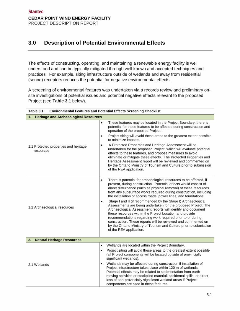
3.0 Description of Potential Environmental Effects
The effects of constructing, operating, and maintaining a renewable energy facility is well understood and can be typically mitigated through well known and accepted techniques and practices. For example, siting infrastructure outside of wetlands and away from residential (sound) receptors reduces the potential for negative environmental effects.
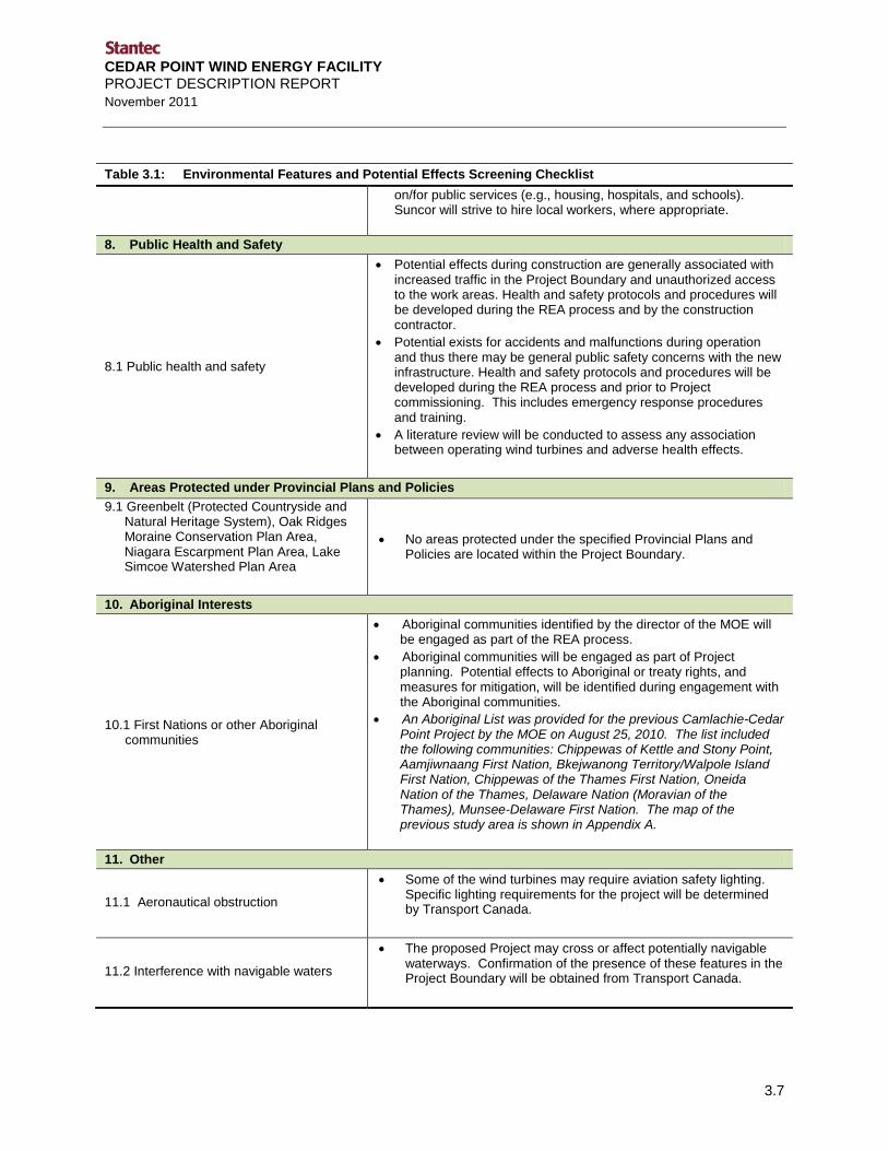
A screening of environmental features was undertaken via a records review and preliminary on-site investigations of potential issues and potential negative effects relevant to the proposed Project (see Table 3.1 below).
Table 3.1: Environmental Features and Potential Effects Screening Checklist 1. Heritage and Archaeological Resources
1.1 Protected properties and heritage resources
• These features may be located in the Project Boundary; there is potential for these features to be affected during construction and operation of the proposed Project.
• Project siting will avoid these areas to the greatest extent possible to minimize impacts.
• A Protected Properties and Heritage Assessment will be undertaken for the proposed Project, which will evaluate potential effects to these features, and propose measures to avoid eliminate or mitigate these effects. The Protected Properties and Heritage Assessment report will be reviewed and commented on by the Ontario Ministry of Tourism and Culture prior to submission of the REA application.
1.2 Archaeological resources
• There is potential for archaeological resources to be affected, if present, during construction. Potential effects would consist of direct disturbance (such as physical removal) of these resources from any subsurface works required during construction, including the installation of access roads, power lines, and foundations.
• Stage I and II (if recommended by the Stage I) Archaeological Assessments are being undertaken for the proposed Project. The Archaeological Assessment reports will identify and document these resources within the Project Location and provide recommendations regarding work required prior to or during construction. These reports will be reviewed and commented on by the Ontario Ministry of Tourism and Culture prior to submission of the REA application.
2. Natural Heritage Resources
2.1 Wetlands
• Wetlands are located within the Project Boundary. • Project siting will avoid these areas to the greatest extent possible
(all Project components will be located outside of provincially significant wetlands).
• Wetlands may be affected during construction if installation of Project infrastructure takes place within 120 m of wetlands. Potential effects may be related to sedimentation from earth moving activities or stockpiled material, accidental spills, or direct loss of non-provincially significant wetland areas if Project components are sited in these features.

CEDAR POINT WIND ENERGY FACILITY PROJECT DESCRIPTION REPORT November 2011
3.2
Table 3.1: Environmental Features and Potential Effects Screening Checklist • If Project infrastructure is located within 120 m of a provincially
significant wetland, an Environmental Impact Study will be conducted to identify the potential effects and propose measures to avoid, eliminate, or mitigate these effects. The Environmental Impact Study report will be reviewed and commented on by the Ontario Ministry of Natural Resources prior to submission of the REA application.
2.2 Areas of Natural and Scientific Interest
(ANSIs) • No ANSIs are located within the Project Boundary.
2.3 Valleylands and hazard lands
• No valleylands are located within the Project Boundary. Hazard lands are located within the Project Boundary and will be confirmed as part of the REA process; there may be potential for these lands to be crossed with Project infrastructure, particularly watercourse crossings.
• Potential effects may be related to the installation of watercourse crossings and are related to erosion or an increase in instability of these slopes.
• Permit applications to local conservation authorities and/or the Department of Fisheries and Oceans for watercourse crossings will be obtained prior to construction, and will include standard mitigation measures for slope stabilization for each watercourse crossing.
2.4 Woodlands
• Wooded areas are located within the Project Boundary, and some are likely to be determined as significant.
• Potential effects may result from direct vegetation removal for project related infrastructure or damage to root systems from adjacent infrastructure.
• If Project infrastructure is located within 120 m of significant woodland, an Environmental Impact Study will be conducted to identify the potential effects and propose measures to avoid, eliminate, or mitigate these effects. The Environmental Impact Study report will be reviewed and commented on by the Ontario Ministry of Natural Resources prior to submission of the REA application.
2.5 Provincial parks and conservation reserves
• No provincial parks are located within the Project Boundary. • No conservation reserves are located within the Project Boundary.
2.6 Other designated natural areas • No other designated natural areas have been identified within the
Project Boundary.
2.7 Significant wildlife species and wildlife habitat
• Species at risk and their habitat are likely to be present within the general area of study for the Project. Area habitats may support such species and there is potential to affect these species directly, and indirectly (e.g. disruption/alteration of the habitat).
• Significant wildlife habitat may be present in the Project Boundary. If Project infrastructure is located within 120 m of significant wildlife habitat, an Environmental Impact Study will be conducted to identify the potential effects and propose measures to avoid, eliminate, or mitigate these effects. The Environmental Impact Study report will be reviewed and commented on by the Ontario Ministry of Natural Resources prior to submission of the REA application.

CEDAR POINT WIND ENERGY FACILITY PROJECT DESCRIPTION REPORT November 2011
3.3
Table 3.1: Environmental Features and Potential Effects Screening Checklist
2.8 Other wildlife and wildlife habitat
• Birds, mammals, amphibian and reptile species are known to use the area within the Project Boundary. Construction and operation of the proposed Project has the potential to disturb wildlife (including mortality from direct collisions with project infrastructure) and wildlife habitat.
• The majority of Project infrastructure will be located on lands that are already a source of disturbance to wildlife, including right-of-ways and agricultural lands.
2.9 Significant flora species and vegetation communities
• Significant flora species are located within the general area of study for the proposed Project.
• There is potential to affect these species during construction, however most of the Project will be located within areas already cleared for rural and agricultural use. Potential effects may result from direct removal of vegetation or from works within 120 m of the feature.
2.10 Other flora species and vegetation communities
• The proposed Project will be mostly located within areas already cleared for rural and agricultural land uses. Potential effects may result from direct removal of vegetation or introduction of non-native species to existing vegetation communities.
2.11 Fish and fish habitat
• Project related works may be within areas of fish and fish habitat (watercourse crossings). Additional potential effects may be related to the installation of watercourse crossings (e.g. sedimentation). Where required, mitigation measures are available to reduce or eliminate potential effects.
• Permit applications to local conservation authorities and/or the Department of Fisheries and Oceans for watercourse crossings will be obtained prior to construction, and will include standard mitigation measures for protection of fish and fish habitat for each watercourse crossing.
• If Project infrastructure is located within 120 m, or within, an area of fish habitat, an Environmental Impact Study will be conducted to identify the potential effects and propose measures to avoid, eliminate, or mitigate these effects. The Environmental Impact Study report will be reviewed and commented on by the Ontario Ministry of Natural Resources prior to submission of the REA application.
3. Water Bodies
3.1 Surface water (watercourses) quality, quantities, or flow
• Watercourses will be confirmed in the Project Boundary during on-site investigations.
• Construction (e.g., culverts for access road crossings) may be proposed within surface water courses and limited works (e.g. stringing overhead power lines) may be proposed within 30 m of a watercourse. Turbines and transformers will not be located within 30 m of these features.
• The proposed development does not involve the storage or consumption of surface water.
• The proposed development will not require significant alteration of surface runoff patterns.
• Surface water quality could be affected by accidental spills/releases to the environment and sedimentation and/or

CEDAR POINT WIND ENERGY FACILITY PROJECT DESCRIPTION REPORT November 2011
3.4
Table 3.1: Environmental Features and Potential Effects Screening Checklist erosion during construction of access roads. Possible mitigation measures may include the establishment of a Spills Prevention Plan, Emergency Response Plan, and the utilization of silt fencing during the construction phase.
• If Project infrastructure is located within 120 m of a water body, a Water Body and Assessment Report will be prepared that identifies and assesses potential effects and proposes measures to avoid, eliminate, or mitigate these effects.
3.2 Groundwater quality, quantity, or movement
• It is possible that some dewatering activities may be required when installing Project infrastructure (e.g. tower foundations). Geotechnical investigations will gather information related to location and depth of groundwater in the Project Boundary.
• Withdrawal quantities will likely be below 50,000 l/d and are unlikely to affect groundwater quality or quantity.
• There is potential to affect water quality of water wells in close proximity to the construction sites. Groundwater quality could be affected by accidental spills/releases to the environment.
• In the event that groundwater quality is negatively affected, Suncor will provide a temporary potable water supply to residents until corrective actions are completed.
4. Air Quality
4.1 Emissions of pollutants or greenhouse gases
• Construction equipment will generate emissions of pollutants and greenhouse gases; however this will be short in duration and limited in extent.
• Operation of the proposed Project will not result in negative effects on air quality since any emissions of pollutants or greenhouse gases are generated by the wind turbines.
4.2 Emission of dust or odour
• During construction dust may be generated from earthmoving or vehicular activity – any emissions will be short in duration and limited to the lands surrounding the work areas.
• No odour emissions are expected to result from construction, operation, or decommissioning of the proposed Project.
5. Environmental Noise
5.1 Emission of noise
• There will be an increase in ambient environmental noise during construction related to increased traffic, the operation of construction equipment and construction activities.
• Mechanical and aerodynamic noise will be emitted from the wind turbines. Noise is emitted from transformers.
• There is potential for limited environmental noise effects at sensitive receptors.
• A detailed environmental noise impact assessment will be undertaken as per the MOE’s document Noise Guidelines for Wind Farms - Interpretation for Applying MOE NPC Publications to Wind Power Generation Facilities (October 2008). Noise assessments are also required by the MOE for transformer substation.
6. Land Use and Resources
6.1 Existing land uses • The proposed Project is located in a predominantly rural and agricultural area.

CEDAR POINT WIND ENERGY FACILITY PROJECT DESCRIPTION REPORT November 2011
3.5
Table 3.1: Environmental Features and Potential Effects Screening Checklist • Lands for Project infrastructure will be required for the lease period. • During the lease period, portions of these lands will be changed
from their present land use. Potential effects are related to the change in land use (i.e., from agricultural use to Project related use). However, landowners will be financially compensated for the leased land and each turbine only requires approximately 1 -2 acres of land and Suncor will pay any associated increase in taxes for the turbine area.
6.2 Local businesses and facilities
• It is anticipated that area businesses will benefit financially from spending associated with construction and operations activities and fulfilling operational supplies (e.g. aggregate material).
6.3 Recreation areas
• It is not anticipated that construction activities will directly affect recreation areas.
• Increased noise during construction may interfere with nearby recreational uses (e.g. hunting).
• No effects are anticipated during the operation phase.
6.4 Landfill sites and waste disposal
• Construction wastes, such as excavated soils, equipment packaging and wrappings, and scraps, will be produced.
• The proposed Project will generate waste associated with turbine construction, maintenance and operation, and decommissioning. A waste collection and management plan will be developed for each phase of the proposed Project.
• No negative effects are anticipated on local landfill sites.
6.5 Agricultural Lands
• Project infrastructure will potentially occupy areas of agricultural land and potential effects are related to the change in use of the agricultural land.
• The operation of the proposed Project is not anticipated to negatively affect the use of adjoining agricultural lands, field crop production, or livestock pasturing, all of which can occur in close proximity to the proposed Project.
• The 2005 Provincial Policy Statement contains policies that support the establishment of renewable energy generation facilities in rural and agricultural areas.
6.6 Mineral, aggregate, or petroleum resources
• There are designated aggregate resource sites within the Project Boundary.
• No potential effects are anticipated to existing mineral or aggregate resources given their proximity to the Project Boundary.
• There are known petroleum resources within the Project Boundary (i.e., gas wells).
• If Project infrastructure is located within 75 m of petroleum wells or works, it will be identified during works as part of the MNR’s APRD process. A report will be prepared and reviewed and commented on by the MNR. Additional consultations will be undertaken with the Petroleum Resources Centre to avoid potential effects to these features.
6.7 Forest resources • Construction of the proposed Project is not anticipated to affect any merchantable forest resources.

CEDAR POINT WIND ENERGY FACILITY PROJECT DESCRIPTION REPORT November 2011
3.6
Table 3.1: Environmental Features and Potential Effects Screening Checklist
6.8 Game and fishery resources, including creating access to previously inaccessible areas
• The proposed Project will be developed on private lands, thus new public access will not be created to previously inaccessible areas.
• There may be potential fisheries resources affected by the construction of the proposed Project during work near/in water (see items 2.6, 2.7, 2.8, and 2.11 including the proposed mitigation measures).
6.9 Remediation of contaminated land
• History of the area is rural and agricultural, therefore there is limited potential for contaminated sites, however the possibility of encountering such lands cannot be completely ruled out.
• In the event that contaminated soils are encountered, the soil will be removed and disposed of in accordance with MOE guidelines (O. Reg. 347) and at a MOE approved facility.
6.10 Telecommunications network
• There is potential to interfere with telecommunications networks. Potential effects may be due to infrastructure being located within the “line of sight” of telecommunications networks, or due to interference with radar systems.
• A Phase 1 assessment has been completed. Consultation with appropriate agencies regarding potential effects to these systems will be undertaken once the Notice to Engage is published.
7. Provincial and Local Infrastructure
7.1 Provincial and other major infrastructure
• Potential for an increase of traffic during construction on provincial roads. Potential effects are related to traffic congestion/safety and road damage from construction equipment and excess loads.
• A Traffic Management Plan will be created prior to Project construction to mitigate any potential traffic related effects.
• Additional provincial infrastructure in the Project Boundary includes Hydro One operated transmission lines.
• Other provincial and major infrastructure in proximity to the Project Location, when known, will be identified as part of the records reviews and site investigations completed for the REA process.
7.2 Local infrastructure and services
• The transport of equipment and supplies during the construction phase will result in additional (temporary) road use and traffic to the Project Locations.
• Excess loads and numerous truck trips may deteriorate local road conditions.
• Municipal consultation will include discussions regarding mitigation and potential compensation should municipal roads be affected by the proposed Project.
• During operation, supplies will be intermittently delivered to the Project as required.
• Other local infrastructure in proximity to the Project Location will be identified in consultation with local municipalities. Discussions with local municipalities will include measures to avoid or mitigate potential effects to this infrastructure.
• The construction period will result in additional demand for local goods and services.
• A limited number of operating personnel may be required to maintain the facility; therefore there will be only a nominal demand
CEDAR POINT WIND ENERGY FACILITY PROJECT DESCRIPTION REPORT November 2011
3.7
Table 3.1: Environmental Features and Potential Effects Screening Checklist on/for public services (e.g., housing, hospitals, and schools). Suncor will strive to hire local workers, where appropriate.
8. Public Health and Safety
8.1 Public health and safety
• Potential effects during construction are generally associated with increased traffic in the Project Boundary and unauthorized access to the work areas. Health and safety protocols and procedures will be developed during the REA process and by the construction contractor.
• Potential exists for accidents and malfunctions during operation and thus there may be general public safety concerns with the new infrastructure. Health and safety protocols and procedures will be developed during the REA process and prior to Project commissioning. This includes emergency response procedures and training.
• A literature review will be conducted to assess any association between operating wind turbines and adverse health effects.
9. Areas Protected under Provincial Plans and Policies 9.1 Greenbelt (Protected Countryside and
Natural Heritage System), Oak Ridges Moraine Conservation Plan Area, Niagara Escarpment Plan Area, Lake Simcoe Watershed Plan Area
• No areas protected under the specified Provincial Plans and Policies are located within the Project Boundary.
10. Aboriginal Interests
10.1 First Nations or other Aboriginal communities
• Aboriginal communities identified by the director of the MOE will be engaged as part of the REA process.
• Aboriginal communities will be engaged as part of Project planning. Potential effects to Aboriginal or treaty rights, and measures for mitigation, will be identified during engagement with the Aboriginal communities.
• An Aboriginal List was provided for the previous Camlachie-Cedar Point Project by the MOE on August 25, 2010. The list included the following communities: Chippewas of Kettle and Stony Point, Aamjiwnaang First Nation, Bkejwanong Territory/Walpole Island First Nation, Chippewas of the Thames First Nation, Oneida Nation of the Thames, Delaware Nation (Moravian of the Thames), Munsee-Delaware First Nation. The map of the previous study area is shown in Appendix A.
11. Other
11.1 Aeronautical obstruction
• Some of the wind turbines may require aviation safety lighting. Specific lighting requirements for the project will be determined by Transport Canada.
11.2 Interference with navigable waters
• The proposed Project may cross or affect potentially navigable waterways. Confirmation of the presence of these features in the Project Boundary will be obtained from Transport Canada.

CEDAR POINT WIND ENERGY FACILITY PROJECT DESCRIPTION REPORT November 2011
3.8
Based upon the above screening of environmental features and potential effects, experience gained as part of the Project planning process, and the requirements of the REA process, the following Project-specific issues and potential negative effects have been identified and are expected to be further analysed as part of the REA application process:
• Heritage and Archaeological Resources; • Natural Heritage Resources; • Water Bodies; • Air, Odour, Dust; • Environmental Noise; • Land Use and Resources; • Provincial and Local Infrastructure; and, • Public Health and Safety.
Detailed descriptions of the potential effects, mitigation measures, and net effects to these features during the construction, operation, and decommissioning phases of the proposed Project will be provided in the REA application and summarized in the final Project Description Report.
3.1 PROJECT RELATED SETBACKS
A key component of the REA process is the establishment of common setbacks for all renewable energy facilities in the Province. Where Project related infrastructure will be located within the 120 m setback from natural features, additional analysis (i.e., Environmental Impact Study) will be provided in the REA application and summarized in the final Project Description Report. Setbacks (e.g., non-participating receptors, significant wildlife habitat, etc.) have not yet been finalized as site investigations and other analyses have not yet been completed to confirm the locations of the features and the location of the Project infrastructure has not been finalized.
Key setbacks which will be applied throughout the design of the proposed Project are as follows:
Table 3.2: Project Related Setbacks Feature Setback Distance Study Alternative When Within Setback
Non-participating receptor 550 m (from turbine base)
An Environmental Noise Impact Assessment will be completed for the Project according to MOE Noise Guidelines.
Public road right-of-way and railway right-of-way
Turbine blade length + 10 m (from the centre of the turbine base)
N/A
Property line
Turbine height (excluding blades) (from the centre of the turbine base)
Does not apply to parcels of land if the abutting parcel of land is a participant in the Project or if it is demonstrated that the wind turbine will not result in adverse impacts on nearby business, infrastructure, properties or land use activities.

CEDAR POINT WIND ENERGY FACILITY PROJECT DESCRIPTION REPORT November 2011
3.9
Table 3.2: Project Related Setbacks Feature Setback Distance Study Alternative When Within Setback
Provincially significant southern wetland 120 m
Development not permitted within feature. Development and site alteration may be possible within setback area; EIS required.
Provincially significant ANSI (Earth Science) 50 m
Development and site alteration may be possible within natural feature and setback area; EIS required.
Provincially significant ANSI (Life Science) 120 m
Development and site alteration may be possible within natural feature and setback area; EIS required.
Significant valleyland 120 m Development and site alteration may be possible within natural feature and setback area; EIS required.
Significant woodland 120 m Development and site alteration may be possible within natural feature and setback area; EIS required.
Significant wildlife habitat 120 m Development and site alteration may be possible within natural feature and setback area; EIS required.
Lake
120 m from the average annual high water mark
Development and site alteration may be possible within setback area; additional report required. No turbine or transformer located within a lake or within 30 m of the average annual high water mark.
Permanent or intermittent stream
120 m from the average annual high water mark
Development and site alteration may be possible within setback area; additional report required. No turbine or transformer located within a permanent or intermittent stream or within 30 m of the average annual high water mark.
Seepage area 120 m
Development and site alteration may be possible within setback area; additional report required. No turbine or transformer located within 30 m of a seepage area.
3.2 COMPARISON OF REA AND MUNICIPAL SETBACK REGULATIONS
Prior to the Green Energy Act both the Municipality of Lambton Shores and the Town of Plympton-Wyoming identified the potential of the wind energy resource in their communities. As a result they worked diligently with wind industry members, and planners from other municipalities with wind experience to develop zoning by-laws and policies related to wind energy conversion systems. In many cases, rules for wind energy development differed significantly between jurisdictions in Ontario. The Green Energy Act attempted to provide a single set of rules in the Province for projects to adhere to. Suncor is currently conducting a comparison of REA requirements and Municipal by-laws that are in place for Plympton-Wyoming and Lambton Shores.


CEDAR POINT WIND ENERGY FACILITY PROJECT DESCRIPTION REPORT
4.1
4.0 Closure
This Draft Project Description Report has been prepared by Stantec for Suncor in accordance with Item 10, Table 1 of Ontario Regulation 359/09, and the “Technical Guide to Renewable Energy Approvals” (July 2011).
This report has been prepared by Stantec for the sole benefit of Suncor, and may not be used by any third party without the express written consent of Suncor and Stantec. The data presented in this report are in accordance with Stantec’s understanding of the proposed Project as it was presented at the time of the Report.
STANTEC CONSULTING LTD.
Marnie Dawson Senior Project Manager [email protected] Phone: (519) 836-6050 Fax: (519) 836-2493
Mark Kozak Project Manager [email protected] Phone: (519) 836-6966 x276 Fax: (519) 836-2493


CEDAR POINT WIND ENERGY FACILITY PROJECT DESCRIPTION REPORT
5.1
5.0 References
Ontario Ministry of the Environment. July 2011. Technical Guide to Renewable Energy Approvals.
O. Reg. 359/09. 2009. Ontario Regulation 359/09 made under the Environmental Protection Act Renewable Energy Approvals Under Part V.0.1 of the Act.


CEDAR POINT WIND ENERGY FACILITY PROJECT DESCRIPTION REPORT
Appendix A
Figures

Forest
Warwick
Jura
KinnairdJericho
Thedford
Errol
Huron Heights
HillsboroughBeach
GlendaleBeach
GustinGrove Parkhill
Ailsa Craig
Bornish
Adelaide
StrathoyWyoming
Petrolia
Petrolia
Lake Huron
Warwick
Plympton-Wyoming
Lambton Shores
Kettle Point 44
Highway 402Lambton County
Middlesex County
405000
405000
410000
410000
415000
415000
420000
420000
425000
425000
430000
430000
435000
435000
440000
440000
445000
445000
450000
450000
455000
455000
4745
000
4745
000
4750
000
4750
000
4755
000
4755
000
4760
000
4760
000
4765
000
4765
000
4770
000
4770
000
4775
000
4775
000
4780
000
4780
000
4785
000
4785
000
Client/Project
Figure No.
Title Project Study Area1.0
Suncor EnergyCedar Point Wind Project
November, 2011160960709
Notes
Legend
1.2.
Coordinate System: NAD 1983 UTM Zone 17NBase features produced under license with theOntario Ministry of Natural Resources © Queen'sPrinter for Ontario, 2011.
W:\active\60960709\drawing\MXD\PDR\160960709_Fig1_ProjectStudyAreas_20111117.mxdRevised: 2011-11-18 By: dharvey
Wind Project BoundaryTransmission Routing AreaExpressway / HighwayRoadWooded AreaWatercourseWaterbodyMunicipal Boundary
Lake Ontario
Lake Erie
LakeHuron
STUDY AREA
TorontoONTARIO
0 1 2km
1:175,000
DRAFT


Forest
Warwick
Jura
KinnairdJericho
Thedford
Errol
Huron Heights
HillsboroughBeach
GlendaleBeach
GustinGrove
South Kettle Point Lakeshore Marshes (SC 49)
Warwick Conservation Area
West Warwick Woods (SC 54)
Uttoxeter Swamp (SC 41)Bear Creek Source Woodlot
Spicebush Swamp (SC 43)
Highway 402Highway 402
Egremont Road
Lakesh
ore Road
Townsend Line
Michigan Line
Zion Line
Birnam Line
Cedar Point Line
Brus
h Roa
d
Fores
t Roa
d
Jura Line
Uttox
eter R
oad
Thomson Line
Hillsb
oro R
oad
Jeric
ho R
oad
Douglas Line
Fisher Line
Proof Line
Elarto
n Roa
d
Brick Yard Line
Aberarder Line
North
ville R
oad
Bethe
l Roa
d
Oil H
eritag
e Roa
d
1St S
choo
l Roa
d
Quak
er Ro
adGo
rdon R
oad
Army
Cam
p Roa
d
Ridge Road
Hyslop Line
Nauv
oo R
oad
Fulle
r Roa
d
Kinna
ird R
oad
Chalk Line
Hickory Creek Line
Rawli
ngs R
oad
Warw
ick Vi
llage
Roa
d
Caml
achie
Roa
d
London
Line
Flemi
ng R
oad
Hubbard Line
Mand
aumi
n Roa
d
O'Brie
n Roa
d
Blue H
eron R
oad
Ravenswood Line
Kennedy Line
Farmers Line
Decker Road
Macfa
rlane
Roa
d
Queen Street
Indian Lane
Kerrig
an R
oad
Widder Road
Lake Road Ipperwash Road
Minie
lly Ro
ad
Fairw
eathe
r Roa
d
Wright Line
Unde
rpass
Roa
d
Sideroad Middle
Petticoat Line
Stewa
rdson
Roa
d
Bruce Scott Road
Plowin
g Matc
h Roa
d
Sitter Road
Centr
e Side
road
Tamarack Line
South
Plym
pton R
oad
Main Street
Salt R
oad
Bluepoint Drive
West
Ipperw
ash R
oad
Elmsle
y Roa
d
Powe
r Roa
d
Kingscourt RoadWans
tead R
oad
Allen S tre et
Glendale Drive
King S
treet
Lakeside Street
Bonn
ie Do
one R
oad
Lake View Haven Drive
Culle
n Driv
e
Oak Avenue
Cliff Road
Rear Street
Shirley Lane
Devonshire Road
Ravenswood LineRavenswood Line
Gordo
n Roa
d Kennedy Line
Lake Huron
Warwick
Plympton-Wyoming
Lambton Shores
Sarnia
Kettle Point 44
Lambton County
400000
400000
405000
405000
410000
410000
415000
415000
420000
420000
425000
425000
430000
430000
4760
000
4760
000
4765
000
4765
000
4770
000
4770
000
4775
000
4775
000
4780
000
4780
000
Client/Project
Figure No.
Title Wind Project Study Area2.0
Suncor EnergyCedar Point Wind Project
November, 2011160960709
Notes
Legend
1.2.
Coordinate System: NAD 1983 UTM Zone 17NBase features produced under license with theOntario Ministry of Natural Resources © Queen'sPrinter for Ontario, 2011.
W:\active\60960709\drawing\MXD\PDR\160960709_Fig2_WindProjectStudy_20111117.mxdRevised: 2011-11-18 By: dharvey
Wind Project BoundaryTransmission Routing AreaExpressway / HighwayRoadWooded AreaWatercourseWaterbodyMunicipal BoundaryProvincially Significant WetlandOther/Locally Significant WetlandANSI, Provincially Significant Earth ScienceANSI, Provincially Significant Life Science
Lake Ontario
Lake Erie
LakeHuron
STUDY AREA
TorontoONTARIO
0 1 2km
1:100,000
DRAFT


Forest
Warwick
Jura
KinnairdJericho
Thedford Parkhill
Ailsa Craig
Bornish
Adelaide
StrathoyPetrolia
South Kettle Point Lakeshore Marshes (SC 49)
Warwick Conservation Area
West Warwick Woods (SC 54)
Bear Creek Source Woodlot
Spicebush Swamp (SC 43)
Centr
e Roa
d
Nairn Road
Townsend Line
Zion Line
Egremont Drive
Coldstream Road
Kerw
ood R
oad
Birnam Line
Arko
na R
oad
West Corner Drive
Bornish Drive
Petty Stree
t
Jura Line
Sexto
n Roa
d
Brick Yard Line
Sylva
n Roa
d
Argyle S
treet
Egremont Road
Cuddy Drive
1St S
choo
l Roa
d
Elm Tree Drive
North
ville R
oad
Scho
ol Ro
ad
Jeric
ho R
oad
Seed
Roa
d
Fernhi
ll Drive
Elarto
n Roa
d
Cassidy Road
Confederation Line
Mullifarry Drive
Poplar Hill Road
Bethe
l Roa
d
Parkhill Drive
Elliot Drive
Army
Cam
p Roa
d
Cedar Point Line
Mcewen
Drive
Napperton Drive
Quak
er Ro
ad
Ridge Road
Ausable Drive
Maguire Road
Gordo
n Roa
d
Sprin
gban
k Roa
d
Bog Line
Rodd
ick R
oad
Nauv
oo R
oad
Mooresville Drive
Kinna
ird R
oad
New Ontario Road
Elginfield Road
Greystea
d Drive
Amiens Road
Rawli
ngs R
oad
Charlton
Drive
Hickory Creek Line
Wilso
n Roa
d
Wisb
each
Roa
d
Warw
ick Vi
llage
Roa
dChalk Line
Proof Line
Fort R
ose R
oad
Pike R
oad
Hask
ett R
oad
Lakeshore Road
Hedley D
rive
Pete
Sebe
Roa
d
Mcgillivray Drive
Glengyle
Drive
Donn
elly R
oad
Hickory D
rive
Langan Drive
Mcinn
is Ro
ad
Mcevoy Road
Glasgow Street
Bethe
sda R
oad
London
Line Ilde
rton Road
Ivan Drive
Wood Road
River Drive
Unde
rpass
Roa
d
Scotchm
ere Drive
Olde Drive
Aberdeen Road
Ravenswood Line Mcguffin Hills Drive
Walkers D
rive
Brinsley Road
Gran
d Ben
d Roa
d
River Road
Bear Creek Road
Brow
n Roa
d
Farmers Line
Pran
ce R
oad
Mclea
n Roa
d
Decker Road
Godk
in Ro
ad
Kings
court
Roa
d
Wyatt
Roa
d
Ipperwash Road
Lieury Road
Newe
ll Roa
d
Haig Line
Morse
Roa
d
Crathie Drive
Robo
tham
Road
Griev
es R
oad
Creamery RoadElliot
t Roa
d
Quee
n Stre
et
Mark Settlement Drive
Outer Drive
Salem Road
Kennedy Line
Wardell Drive
Avenue Drive
Skinner D
rive
Inadale
Drive
Union Drive
Hans
ford R
oad
Mccubbin Road
Sinclair
Drive
Islan
d Roa
d
Scou
t Roa
d
Sitter Road
Komoka Road
Willsie Line
Charl
ton R
oad
Ausable Road
Thomson Line
West
Ipperw
ash R
oad
Saxton Road
Petticoat Line
Walker Road
Boot
Hill R
oad
Mcint
yre R
oad
Harm
ony R
oad
Lamon Drive
Everg
reen R
oad
Tamarack Line
Drum
mond
Roa
d
Cedar Swamp Road
Salt R
oad
Hagm
ier R
oad
Rock Glen Road
Quake
r Lane
Powe
r Roa
d
Queens Avenue
Came
ron R
oad
East Parkway Drive
Ross Road
Bingo
Roa
d
Fletcher Road
Ann S
t ree t
Lazy Lane
Elginfield Road
Hedley D
rive
Kennedy Line
Highway 402
Mcgillivray Drive
Gordo
n Roa
d
Ravenswood Line
Thomson Line
9
8
7
65
43
21
1310
Middlesex County
Lambton County
420000
420000
425000
425000
430000
430000
435000
435000
440000
440000
445000
445000
450000
450000
455000
455000
460000
460000
4755
000
4755
000
4760
000
4760
000
4765
000
4765
000
4770
000
4770
000
4775
000
4775
000
4780
000
4780
000
4785
000
4785
000
Client/Project
Figure No.
Title Transmission Line Routing Area3.0
Suncor EnergyCedar Point Wind Project
November, 2011160960709
Notes
Legend
1.2.
Coordinate System: NAD 1983 UTM Zone 17NBase features produced under license with theOntario Ministry of Natural Resources © Queen'sPrinter for Ontario, 2011.
W:\active\60960709\drawing\MXD\PDR\160960709_Fig3_TransmissionLineStudyArea_20111118.mxdRevised: 2011-11-18 By: dharvey
Wind Project BoundaryTransmission Routing Area
Proposed Turbine LocationAccess RoadUnderground Collector LineExpressway / HighwayRoadWooded AreaWatercourseWaterbodyMunicipal BoundaryProvincially Significant WetlandOther/Locally Significant WetlandANSI, Provincially Significant Earth ScienceANSI, Provincially Significant Life Science
Lake Ontario
Lake Erie
LakeHuron
STUDY AREA
TorontoONTARIO
0 1 2km
1:125,000
DRAFT


Forest
Warwick
Jura
KinnairdJericho
Thedford
Errol
Huron Heights
HillsboroughBeach
GlendaleBeach
GustinGrove
WyomingPetrolia
South Kettle Point Lakeshore Marshes (SC 49)
Warwick Conservation Area
West Warwick Woods (SC 54)
Uttoxeter Swamp (SC 41)Bear Creek Source Woodlot
Spicebush Swamp (SC 43)
Highway 402Highway 402
Egremont Road
Lakesh
ore Road
Townsend Line
Michigan Line
Zion Line
Birnam Line
Cedar Point Line
Brus
h Roa
d
Fores
t Roa
d
Jura Line
Uttox
eter R
oad
Thomson Line
Hills
boro
Roa
d
Jeric
ho R
oad
Douglas Line
Fisher Line
Proof Line
Elarto
n Roa
d
Brick Yard Line
Aberarder Line
North
ville
Road
Bethe
l Roa
d
Oil H
erita
ge R
oad
1St S
choo
l Roa
d
Quak
er Ro
adGo
rdon R
oad
Army
Cam
p Roa
d
Ridge Road
Hyslop Line
Nauv
oo R
oad
Fulle
r Roa
d
Kinna
ird R
oad
Chalk Line
Hickory Creek Line
Rawl
ings R
oad
Warw
ick Vi
llage
Roa
d
Caml
achie
Roa
d
London
Line
Flemi
ng R
oad
Hubbard Line
Mand
aumi
n Roa
d
O'Br
ien R
oad
Blue H
eron
Roa
d
Ravenswood Line
Kennedy Line
Farmers Line
Decker Road
Macfa
rlane
Roa
d
Q ueen Street
Indian Lane
Kerrig
an R
oad
Widder Road
La ke Road Ipperwash Road
Minie
lly R
oad
Fairw
eathe
r Roa
d
Wright Line
Unde
rpass
Roa
d
Sideroad Middle
Petticoat Line
Stew
ards
on R
oad
Bruce Scott Road
Plowi
ng M
atch R
oad
Sitter Road
Centr
e Side
road
Tamarack Line
South
Plym
pton R
oad
Main Street
Salt R
oad
Bluepoint Driv e
West
Ipper
wash
Roa
d
Elmsle
y Roa
d
Powe
r Roa
d
Kingscourt RoadWans
tead R
oad
Allen S tre et
Glendale Drive
King S
treet
Lakeside StreetBo
nnie
Doon
e Roa
d
Lake View Haven Drive
Culle
n Driv
e
Oak Avenue
Cliff Roa
d
Rear Street
Shirley Lane
Devonshire Road
Ravenswood LineRavenswood Line
Gordo
n Roa
d Kennedy Line
Lake Huron
Warwick
Plympton-Wyoming
Lambton Shores
Sarnia
Kettle Point 44
Lambton County
Middlesex County
400000
400000
405000
405000
410000
410000
415000
415000
420000
420000
425000
425000
430000
430000
435000
435000
4755
000
4755
000
4760
000
4760
000
4765
000
4765
000
4770
000
4770
000
4775
000
4775
000
4780
000
4780
000
Client/Project
Figure No.
Title Project Boundary Comparison4.0
Suncor EnergyCedar Point Wind Project
November, 2011160960709
Notes
Legend
1.2.
Coordinate System: NAD 1983 UTM Zone 17NBase features produced under license with theOntario Ministry of Natural Resources © Queen'sPrinter for Ontario, 2011.
W:\active\60960709\drawing\MXD\PDR\160960709_Fig4_ProjectComparison_20111117.mxdRevised: 2011-11-18 By: dharvey
Wind Project BoundaryTransmission Routing AreaProject Boundary - PreviousExpressway / HighwayRoadWooded AreaWatercourseWaterbodyMunicipal BoundaryProvincially Significant WetlandOther/Locally Significant WetlandANSI, Provincially Significant Earth ScienceANSI, Provincially Significant Life Science
Lake Ontario
Lake Erie
LakeHuron
STUDY AREA
TorontoONTARIO
0 1 2km
1:125,000
DRAFT
