cdpmn and enhancing drought and flood plans · 2014-02-08 · enhancing exisiting drought and flood...
TRANSCRIPT

CDPMN:CDPMN:Enhancing Exisiting Drought and
Flood Plans
Adrian R. TrotmanC ibb I tit t f M t l d H d lCaribbean Institute for Meteorology and Hydrology
CARIWIN Regional Seminar
14-15 January, 2010
Georgetown GuyanaGeorgetown, Guyana

Drought is a natural hazard originating from aDrought is a natural hazard originating from a deficiency of precipitation that results in a water shortage for some activities or some groupsgroups.

: a deficiency of precipitation
(intensity) from expected or “normal” that extends over a season or longer period of time g p(duration) . . .
Meteorological drought
d i i ffi i t t t th d d fand is insufficient to meet the demands of human activities and the environment (impacts)(impacts).
Agricultural drought
H d l i l d htHydrological drought
Socio-economic drought
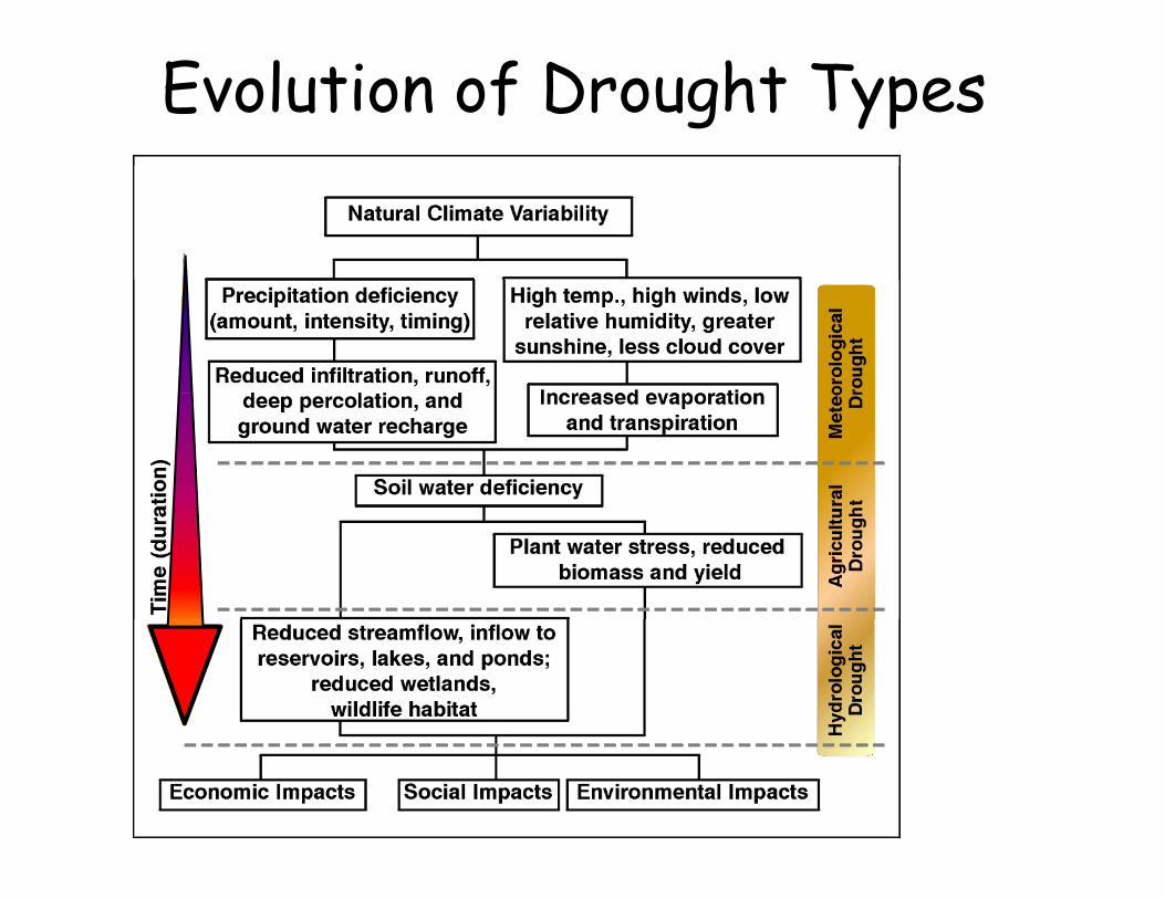
Evolution of Drought Types

Natural and Social Dimensions of Drought
Decreasing emphasis on the natural event (precipitation deficiencies)Increasing emphasis on water/natural resource management
Increasing complexity of impacts and conflicts
MeteorologicalAgricultural
Water Supply
Hydrological
RainfallDeficienciesHeat Stress
Meteorological
SoilsCrops
Water SupplySnow DepthRecreation
TourismHydropowerHeat Stress Crops
RangeLivestockForests
Hydropower
Socio-economic Societal Impact
Time/Duration of the event
Societal Impact

The Cycle of Disaster ManagementThe Cycle of Disaster Management

Let’s keep in mind…
• Precipitation status monitored using a number of indicesAttributes of the CDPMN
• Precipitation status monitored using a number of indices• …Standardized Precipitation Index; Palmer Drought
Severity Index; Crop Moisture Index• Other indicators (e.g. water levels, state of vegetation
and ecosystems)• Final precipitation status determined, by consensus, by aFinal precipitation status determined, by consensus, by a
network of persons from different sectors, institutions and communities embracing the diversity in definitions and impacts of droughtand impacts of drought
• Short term and seasonal precipitation forecasts to provide a projection of future drought (1 - 6 months possible)possible)

BarbadosBarbados
• Groundwater accounts for for the largestGroundwater accounts for for the largest proportion of the island’s water resources at 79% and for 98.6% of the public water psupply
• consistenty been ranked among the ten y gmost water scarce countries in the world
• 300 m3 / capita/ yearp y• The frequency of drought in Barbados is
about 3 in 10 yearsy

BarbadosBarbados
• Domestic Users (including unaccounted-Domestic Users (including unaccountedfor-water) account for more than 60% of the total water abstractedthe total water abstracted
• Sustainable Water Management Strategy and Action Plan by the Barbados Waterand Action Plan by the Barbados Water Authority (BWA)

BarbadosBarbados
The main elements of the strategy include:The main elements of the strategy include:• Demand Reduction
S l A t ti• Supply Augmentation• Water Quality Protection• Public Education• Capacity Building and NetworkingCapacity Building and Networking

Response Stages to Water ShShortage
• Stage 1 Voluntary Conservation MeasuresSt 2 M dit W t U R t i ti• Stage 2 Manditory Water Use Restrictions
• Stage 3 More Stringent Manditory Restrictions

How can monitoring help?How can monitoring help?

Wet Season SPIEdgecumbe, Barbadosg ,
Edgecumbe SPI Jul-Dec (6-mth)
2
3
0
1
56 64 72 80 88 96 04 12 20 28 36 44 52 60 68 76 84 92 00
-2
-1 185
186
187
188
188
189
190
191
192
192
193
194
195
196
196
197
198
199
200
-3
Indices can indicate history of timing, duration and severity of droughty g, y g
Important for impact studies and adaptation considerations
As expected, the SPI showing similar cyclical trends as the rainfall

GuyanaGuyana
• Guyana rainfall averaging approxGuyana rainfall averaging approx. 2500mm
• Competition for water during dry season• Competition for water during dry season• Drought during the dry season canimpact
h ilheavily

Guyana National Development Strategy 2001 2010Strategy 2001-2010
• A standardised national electronic water information systemA standardised national electronic water information system • Periodic assessments of both surface and ground water resources,
and their utilizable component on a basin - wise basis, will be conducted Th l i f t ill t k i t t l d bilit d• The planning of water use will take into account land capability and will be supportive of land improvement
• Low rainfall areas will be made less vulnerable to drought-associated problems through soil moisture conservation measures p gand the transfer of surface water from surplus areas where feasible
• Hydropower development will receive prime consideration • Those hydrometeorological stations which now exist but are not
being utilised will be reactivated In addition the number of stationsbeing utilised will be reactivated. In addition the number of stations will be increased, in order to improve the design network for enhancing forecasting capabilities.
• Real time data transmission from remote stations to the central station ia satellite ill be effectedstation via satellite will be effected

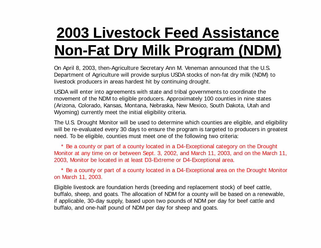
2003 Livestock Feed Assistance2003 Livestock Feed AssistanceNN F t D Milk P (NDM)F t D Milk P (NDM)NonNon--Fat Dry Milk Program (NDM)Fat Dry Milk Program (NDM)On April 8, 2003, then-Agriculture Secretary Ann M. Veneman announced that the U.S. Department of Agriculture will provide surplus USDA stocks of non-fat dry milk (NDM) to p g p p y ( )livestock producers in areas hardest hit by continuing drought.
USDA will enter into agreements with state and tribal governments to coordinate the movement of the NDM to eligible producers. Approximately 100 counties in nine states (Arizona, Colorado, Kansas, Montana, Nebraska, New Mexico, South Dakota, Utah and (Wyoming) currently meet the initial eligibility criteria.
The U.S. Drought Monitor will be used to determine which counties are eligible, and eligibility will be re-evaluated every 30 days to ensure the program is targeted to producers in greatest need. To be eligible, counties must meet one of the following two criteria:
* Be a county or part of a county located in a D4-Exceptional category on the Drought Monitor at any time on or between Sept. 3, 2002, and March 11, 2003, and on the March 11, 2003, Monitor be located in at least D3-Extreme or D4-Exceptional area.
* Be a county or part of a county located in a D4-Exceptional area on the Drought Monitor Be a county or part of a county located in a D4 Exceptional area on the Drought Monitor on March 11, 2003.
Eligible livestock are foundation herds (breeding and replacement stock) of beef cattle, buffalo, sheep, and goats. The allocation of NDM for a county will be based on a renewable, if applicable, 30-day supply, based upon two pounds of NDM per day for beef cattle andif applicable, 30 day supply, based upon two pounds of NDM per day for beef cattle and buffalo, and one-half pound of NDM per day for sheep and goats.

U.S. Drought Monitor Usage by FSAU.S. Drought Monitor Usage by FSA
• State FSA Committees are authorized to approve emergency haying and/or grazing of certain land enrolled in the Conservation Reserve Program (CRP) f t ithi th i St t h th U S D ht itfor an area or county within their State when the U.S. Drought monitor attains D3 or D4.
• Informs FSA at the National Office of conditions in areas seeking approval of g ppemergency haying and/or grazing of CRP which has not attained D3 or D4.
• Informs FSA at the National Office of drought conditions to support requests for funding under the Emergency Conservation Programfor funding under the Emergency Conservation Program.
• Lack of moisture verification for prolonged precipitation deficiencies that exceed the D2 level for review of prevented planted claims for nonirrigated crops.

• U.S. Drought Monitor Usage by FSA
• Food, Conservation, and Energy Act of 2008 authorizes the Livestock Forage Disaster Program
Grazing loss because of drought on owned or leased grazing– Grazing loss because of drought on owned or leased grazing land or pastureland that is physically located in a county experiencing:
• D2 intensity for at least 8 consecutive weeks during normalD2 intensity for at least 8 consecutive weeks during normal grazing period will be eligible to receive payment equal to 1 monthly payment
• D3 intensity during the normal grazing period will be eligible to receive a payment equal to 2 monthly payments
• D3 intensity for at least 4 weeks or a D4 intensity any time during the grazing period will be eligible to receive a payment equal to 3 monthly paymentspayment equal to 3 monthly payments

Why Monitor?Why Monitor?
• Existing severity• ProjectionsProjections• Mitigate/reduce impacts• Relief..Relief..• …Based on known/historical impacts• Aid in developing drought and flood plansAid in developing drought and flood plans

NO REASON WHY SIMILARNO REASON WHY SIMILAR CANNOT BE DONE IN THE
CARIBBEANCARIBBEAN

THE QUESTION IS…THE QUESTION IS…
WHO DOES IT?

ALL OF USALL OF US