ccea gce specification in geography geogra… · ccea gce geography from september 2018 . version...
TRANSCRIPT
GCE
For first teaching from September 2018For first award of AS level in Summer 2019For first award of A level in Summer 2020Subject Code: 3910
CCEA GCE Specification in
GeographyVersion 3: 25 October 2018

CCEA GCE Geography from September 2018
Version 3: 25 October 2018
Contents 1 Introduction 3 1.1 Aims 4 1.2 Key features 4 1.3 Prior attainment 4 1.4 Classification codes and subject combinations
4
2 Specification at a Glance
5
3 Subject Content 7 3.1 Unit AS 1: Physical Geography 9 3.2 Unit AS 2: Human Geography 13 3.3 Unit AS 3: Fieldwork Skills and Techniques in Geography 17 3.4 Unit A2 1: Physical Processes, Landforms and Management 19 3.5 Unit A2 2: Processes and Issues in Human Geography 27 3.6 Unit A2 3: Decision Making in Geography
35
4 Scheme of Assessment 36 4.1 Assessment opportunities 36 4.2 Assessment objectives 36 4.3 Assessment objective weightings 36 4.4 Quality of written communication 37 4.5 Synoptic assessment at A2 37 4.6 Higher order thinking skills 37 4.7 Reporting and grading
37
5 Grade Descriptions
38
6 Guidance on External Assessment 42 6.1 Unit AS 1: Physical Geography 42 6.2 Unit AS 2: Human Geography 42 6.3 Unit AS 3: Fieldwork Skills and Techniques in Geography 43 6.4 Unit A2 1: Physical Processes, Landforms and Management 44 6.5 Unit A2 2: Processes and Issues in Human Geography 44 6.6 Unit A2 3: Decision Making in Geography
44
7 Links and Support 45 7.1 Support 45 7.2 Curriculum objectives 45 7.3 Examination entries 46 7.4 Equality and inclusion 46 7.5 Contact details 47

CCEA GCE Geography from September 2018
Version 3: 25 October 2018
This specification is available online at www.ccea.org.uk
Subject Code QAN AS Level QAN A Level
3910 601/8393/7 601/8394/9
A CCEA Publication © 2016
CCEA GCE Geography from September 2018
3 Version 3: 25 October 2018
1 Introduction This specification sets out the content and assessment details for our Advanced Subsidiary (AS) and Advanced GCE courses in Geography. First teaching is from September 2018. Students can take:
• the AS course as a final qualification; or • the AS units plus the A2 units for a full GCE A level qualification. We assess the AS units at a standard appropriate for students who have completed the first part of the full course. A2 units have an element of synoptic assessment (to assess students’ understanding of the subject as a whole), as well as more emphasis on assessment objectives that reflect higher order thinking skills. The full Advanced GCE award is based on students’ marks from the AS (40 percent) and the A2 (60 percent). The guided learning hours for this specification, as for all GCEs, are:
• 180 hours for the Advanced Subsidiary level award; and • 360 hours for the Advanced level award. We will make the first AS awards for the specification in 2019 and the first A level awards in 2020. The specification builds on the broad objectives of the Northern Ireland Curriculum. If there are any major changes to this specification, we will notify centres in writing. The online version of the specification will always be the most up to date; to view and download this please go to www.ccea.org.uk
CCEA GCE Geography from September 2018
4 Version 3: 25 October 2018
1.1 Aims This specification aims to encourage students to:
• develop a lifelong interest in Geography; • draw together different areas of knowledge, skills and understanding; • develop higher order thinking skills, for example independent learning, creative
thinking and problem-solving; • apply their knowledge and skills to real world situations; • work with others in groups; • carry out research and present their findings in different formats; • develop advanced study skills that help them prepare for third level education; • provide extended responses and evidence of quality of written communication; and • demonstrate that they understand and can apply key concepts. 1.2 Key features The following are important features of this specification.
• It includes six externally assessed units. • It allows students to develop their subject knowledge, understanding and skills. • Assessment at A2 includes more question types, more demanding evaluative
tasks, extended writing, and synoptic assessment that encourages students to develop their understanding of the subject as a whole.
• It can give students a sound basis for progression to higher education. • A range of support is available, including specimen assessment materials,
exemplar schemes of work and teacher guidance. 1.3 Prior attainment Students do not need to have reached a particular level of attainment before beginning to study this specification. However, the specification builds on the knowledge, understanding and skills developed in GCSE Geography. 1.4 Classification codes and subject combinations Every specification has a national classification code that indicates its subject area. The classification code for this qualification is 3910. Please note that if a student takes two qualifications with the same classification code, universities and colleges that they apply to may take the view that they have achieved only one of the two GCEs. The same may occur with any two GCE qualifications that have a significant overlap in content, even if the classification codes are different. Because of this, students who have any doubts about their subject combinations should check with the universities and colleges that they would like to attend before beginning their studies.
CCEA GCE Geography from September 2018
5 Version 3: 25 October 2018
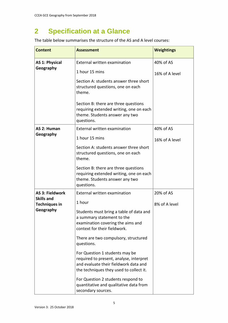
2 Specification at a Glance The table below summarises the structure of the AS and A level courses:
Content
Assessment Weightings
AS 1: Physical Geography
External written examination
1 hour 15 mins
Section A: students answer three short structured questions, one on each theme. Section B: there are three questions requiring extended writing, one on each theme. Students answer any two questions.
40% of AS 16% of A level
AS 2: Human Geography
External written examination
1 hour 15 mins
Section A: students answer three short structured questions, one on each theme.
Section B: there are three questions requiring extended writing, one on each theme. Students answer any two questions.
40% of AS 16% of A level
AS 3: Fieldwork Skills and Techniques in Geography
External written examination
1 hour
Students must bring a table of data and a summary statement to the examination covering the aims and context for their fieldwork.
There are two compulsory, structured questions.
For Question 1 students may be required to present, analyse, interpret and evaluate their fieldwork data and the techniques they used to collect it.
For Question 2 students respond to quantitative and qualitative data from secondary sources.
20% of AS 8% of A level
CCEA GCE Geography from September 2018
6 Version 3: 25 October 2018
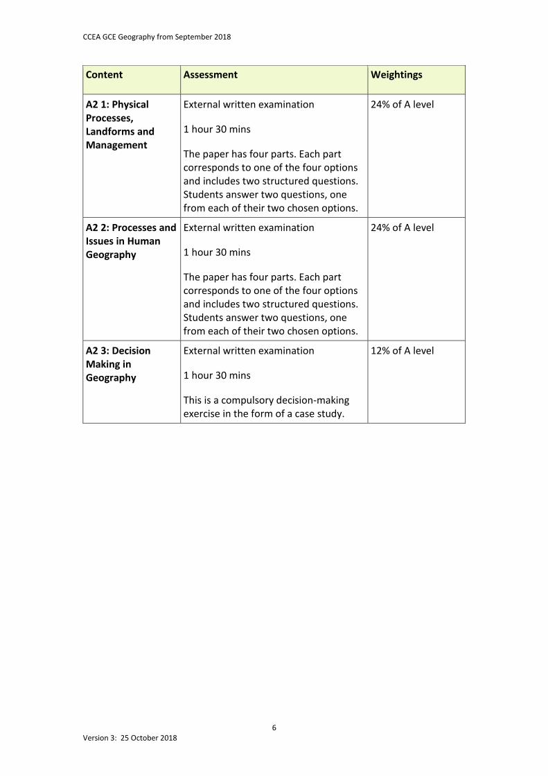
Content
Assessment Weightings
A2 1: Physical Processes, Landforms and Management
External written examination 1 hour 30 mins The paper has four parts. Each part corresponds to one of the four options and includes two structured questions. Students answer two questions, one from each of their two chosen options.
24% of A level
A2 2: Processes and Issues in Human Geography
External written examination 1 hour 30 mins The paper has four parts. Each part corresponds to one of the four options and includes two structured questions. Students answer two questions, one from each of their two chosen options.
24% of A level
A2 3: Decision Making in Geography
External written examination 1 hour 30 mins This is a compulsory decision-making exercise in the form of a case study.
12% of A level
CCEA GCE Geography from September 2018
7 Version 3: 25 October 2018
3 Subject Content We have divided this course into six units: three units at AS level and three units at A2. This section sets out the content and learning outcomes for each unit. Skills and techniques Teachers should incorporate the skills and techniques listed below into the teaching of the subject content. They should encourage students to use the internet and to use ICT for collecting, sorting, recording and presenting geographical information. Through their geographical studies, students need to become familiar with the following skills and techniques: Data collection Students must develop their data collection skills. At AS level students should:
• observe and collect primary data at first-hand from physical and/or human environments using equipment, surveys or questionnaires; and
• carry out sampling methods such as: − random; − systematic; − stratified; − pragmatic; and − point, line or quadrat.
At AS and A2 levels students should:
• analyse and interpret geographical information from the following secondary sources: − public maps, including Ordnance Survey maps at a range of scales; − photographs; − satellite images; − surface pressure or synoptic charts; and − remotely sensed images and data, both quantitative and qualitative.
CCEA GCE Geography from September 2018
8 Version 3: 25 October 2018
Data processing Students must also develop their data processing skills. They must be aware of Geographical Information Systems (GIS) to assist geographical understanding. At AS and A2 levels, students must develop the ability to:
• construct, analyse and interpret dot, flow line, choropleth and isoline maps; • draw annotated sketch maps; • construct, analyse and interpret scatter graphs, line graphs, bar graphs, pie charts,
proportional graphs and triangular graphs; • use methods of statistical analysis including mean, median, mode and range,
Spearman’s rank correlation, nearest neighbour analysis and, for A2 level only, chi-squared and location quotient; and
• improve their investigative skills by collecting and processing data from relevant secondary and/or primary geographical sources (for A2 only).
Please note that all mapping, drawing and graphical techniques should follow geographical conventions with regard to title, key, scale, frame and direction arrow.

CCEA GCE Geography from September 2018
9 Version 3: 25 October 2018
3.1 Unit AS 1: Physical Geography This unit is concerned with physical processes and systems and human interaction with them. Students investigate fluvial environments, local and global ecosystems, and the processes that shape weather and climate. They study physical processes and environments at a range of scales and in a range of places. They have opportunities to use a range of technologies, including GIS, to enhance knowledge and understanding.
Assessment for this unit is a written examination that includes both short and extended questions. For more details, see Section 6.
Content
Learning Outcomes Spatial Context Requirement
1 (a) Processes that shape fluvial environments
Students should be able to:
(i) explain how the drainage basin operates as an open system with inputs, outputs, stores and transfers of energy and matter;
(ii) understand storm and annual hydrographs (regimes) and explain the factors that influence them − relief, basin size and shape, soil, geology, land use, drainage density and precipitation;
(iii) understand river processes –
erosion (abrasion/corrasion, attrition, hydraulic action, solution/corrosion), transportation (suspension, solution, saltation, traction), and deposition (Hjulström curves); and
For (i) to (iv) general reference to places for illustration purposes only
(iv) explain the formation of river landforms – waterfalls, rapids, meanders, pools and riffles, oxbow lakes, levees, floodplains and deltas (arcuate and bird’s foot).
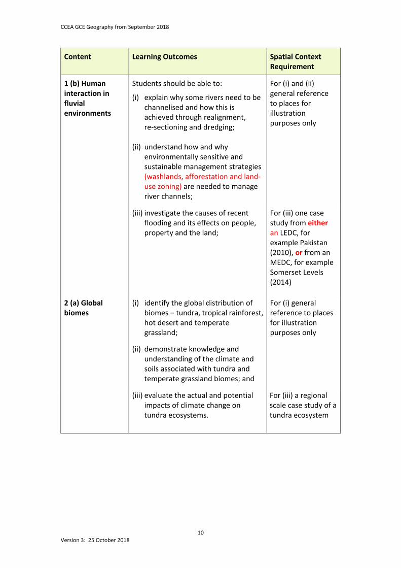
CCEA GCE Geography from September 2018
10 Version 3: 25 October 2018
Content
Learning Outcomes Spatial Context Requirement
1 (b) Human interaction in fluvial environments
Students should be able to:
(i) explain why some rivers need to be channelised and how this is achieved through realignment, re-sectioning and dredging;
(ii) understand how and why
environmentally sensitive and sustainable management strategies (washlands, afforestation and land-use zoning) are needed to manage river channels;
For (i) and (ii) general reference to places for illustration purposes only
(iii) investigate the causes of recent flooding and its effects on people, property and the land;
For (iii) one case study from either an LEDC, for example Pakistan (2010), or from an MEDC, for example Somerset Levels (2014)
2 (a) Global biomes
(i) identify the global distribution of biomes − tundra, tropical rainforest, hot desert and temperate grassland;
(ii) demonstrate knowledge and understanding of the climate and soils associated with tundra and temperate grassland biomes; and
For (i) general reference to places for illustration purposes only
(iii) evaluate the actual and potential impacts of climate change on tundra ecosystems.
For (iii) a regional scale case study of a tundra ecosystem
CCEA GCE Geography from September 2018
11 Version 3: 25 October 2018
Content
Learning Outcomes Spatial Context Requirement
2 (b) Small scale ecosystems
Students should be able to:
(i) demonstrate knowledge and understanding of how ecosystems function, including: − the biotic and abiotic
components; − inputs, outputs, transfers and
stores of energy and matter; − trophic structure − autotrophs,
heterotrophs, decomposers, trophic levels and pyramids; and
− general cycling of nutrients (including the nutrient cycling model);
For (i) one small scale case study of an ecosystem, for example Breen Wood
(ii) demonstrate knowledge and understanding of plant succession: − seral stages, climatic climax
vegetation and plagioclimax vegetation;
For (ii) one case study of plant succession at the small or regional scale, for example Umbra sand dunes
3 (a) The processes that shape our weather and climate
(i) demonstrate knowledge and understanding of the global energy balance, including vertical and horizontal heat transfers in the atmosphere and the role of ocean currents;
(ii) demonstrate knowledge and
understanding of the general circulation of the atmosphere, including surface pressure belts, winds, the tri-cellular model, jet streams and upper westerly winds (in relation to the pressure gradient and Coriolis forces) ; and
For (i) and (ii) study of global patterns of precipitation, surface temperature, pressure and winds
(iii) explain the factors that influence air temperature, including latitude, distance from the sea/continentality, altitude, ocean currents and seasonality.
For (iii) general reference to places for illustration purposes only
CCEA GCE Geography from September 2018
12 Version 3: 25 October 2018
Content
Learning Outcomes Spatial Context Requirement
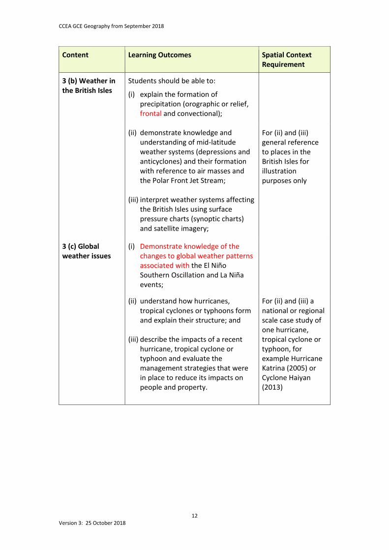
3 (b) Weather in the British Isles
Students should be able to:
(i) explain the formation of precipitation (orographic or relief, frontal and convectional);
(ii) demonstrate knowledge and understanding of mid-latitude weather systems (depressions and anticyclones) and their formation with reference to air masses and the Polar Front Jet Stream;
(iii) interpret weather systems affecting
the British Isles using surface pressure charts (synoptic charts) and satellite imagery;
For (ii) and (iii) general reference to places in the British Isles for illustration purposes only
3 (c) Global weather issues
(i) Demonstrate knowledge of the changes to global weather patterns associated with the El Niño Southern Oscillation and La Niña events;
(ii) understand how hurricanes, tropical cyclones or typhoons form and explain their structure; and
(iii) describe the impacts of a recent
hurricane, tropical cyclone or typhoon and evaluate the management strategies that were in place to reduce its impacts on people and property.
For (ii) and (iii) a national or regional scale case study of one hurricane, tropical cyclone or typhoon, for example Hurricane Katrina (2005) or Cyclone Haiyan (2013)
CCEA GCE Geography from September 2018
13 Version 3: 25 October 2018
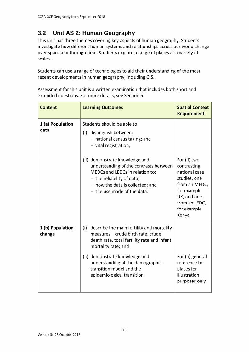
3.2 Unit AS 2: Human Geography This unit has three themes covering key aspects of human geography. Students investigate how different human systems and relationships across our world change over space and through time. Students explore a range of places at a variety of scales. Students can use a range of technologies to aid their understanding of the most recent developments in human geography, including GIS. Assessment for this unit is a written examination that includes both short and extended questions. For more details, see Section 6.
Content
Learning Outcomes Spatial Context Requirement
1 (a) Population data
Students should be able to:
(i) distinguish between: − national census taking; and − vital registration;
(ii) demonstrate knowledge and understanding of the contrasts between MEDCs and LEDCs in relation to: − the reliability of data; − how the data is collected; and − the use made of the data;
For (ii) two contrasting national case studies, one from an MEDC, for example UK, and one from an LEDC, for example Kenya
1 (b) Population change
(i) describe the main fertility and mortality measures − crude birth rate, crude death rate, total fertility rate and infant mortality rate; and
(ii) demonstrate knowledge and understanding of the demographic transition model and the epidemiological transition.
For (ii) general reference to places for illustration purposes only
CCEA GCE Geography from September 2018
14 Version 3: 25 October 2018
Content
Learning Outcomes Spatial Context Requirement
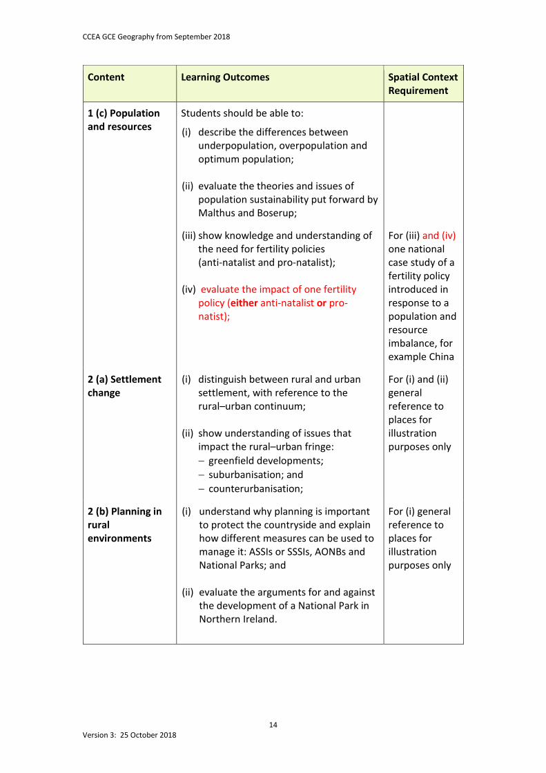
1 (c) Population and resources
Students should be able to:
(i) describe the differences between underpopulation, overpopulation and optimum population;
(ii) evaluate the theories and issues of population sustainability put forward by Malthus and Boserup;
(iii) show knowledge and understanding of the need for fertility policies (anti-natalist and pro-natalist);
(iv) evaluate the impact of one fertility policy (either anti-natalist or pro-natist);
For (iii) and (iv) one national case study of a fertility policy introduced in response to a population and resource imbalance, for example China
2 (a) Settlement change
(i) distinguish between rural and urban settlement, with reference to the rural–urban continuum;
(ii) show understanding of issues that
impact the rural–urban fringe: − greenfield developments; − suburbanisation; and − counterurbanisation;
For (i) and (ii) general reference to places for illustration purposes only
2 (b) Planning in rural environments
(i) understand why planning is important to protect the countryside and explain how different measures can be used to manage it: ASSIs or SSSIs, AONBs and National Parks; and
(ii) evaluate the arguments for and against
the development of a National Park in Northern Ireland.
For (i) general reference to places for illustration purposes only
CCEA GCE Geography from September 2018
15 Version 3: 25 October 2018
Content
Learning Outcomes Spatial Context Requirement
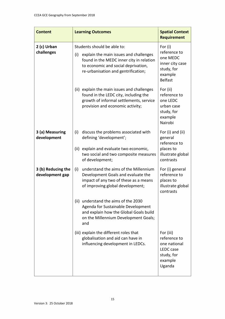
2 (c) Urban challenges
Students should be able to:
(i) explain the main issues and challenges found in the MEDC inner city in relation to economic and social deprivation, re-urbanisation and gentrification;
For (i) reference to one MEDC inner city case study, for example Belfast
(ii) explain the main issues and challenges found in the LEDC city, including the growth of informal settlements, service provision and economic activity;
For (ii) reference to one LEDC urban case study, for example Nairobi
3 (a) Measuring development
(i) discuss the problems associated with defining ‘development’;
(ii) explain and evaluate two economic,
two social and two composite measures of development;
For (i) and (ii) general reference to places to illustrate global contrasts
3 (b) Reducing the development gap
(i) understand the aims of the Millennium Development Goals and evaluate the impact of any two of these as a means of improving global development;
For (i) general reference to places to illustrate global contrasts
(ii) understand the aims of the 2030 Agenda for Sustainable Development and explain how the Global Goals build on the Millennium Development Goals; and
(iii) explain the different roles that globalisation and aid can have in influencing development in LEDCs.
For (iii) reference to one national LEDC case study, for example Uganda
CCEA GCE Geography from September 2018
16 Version 3: 25 October 2018
Content
Learning Outcomes Spatial Context Requirement
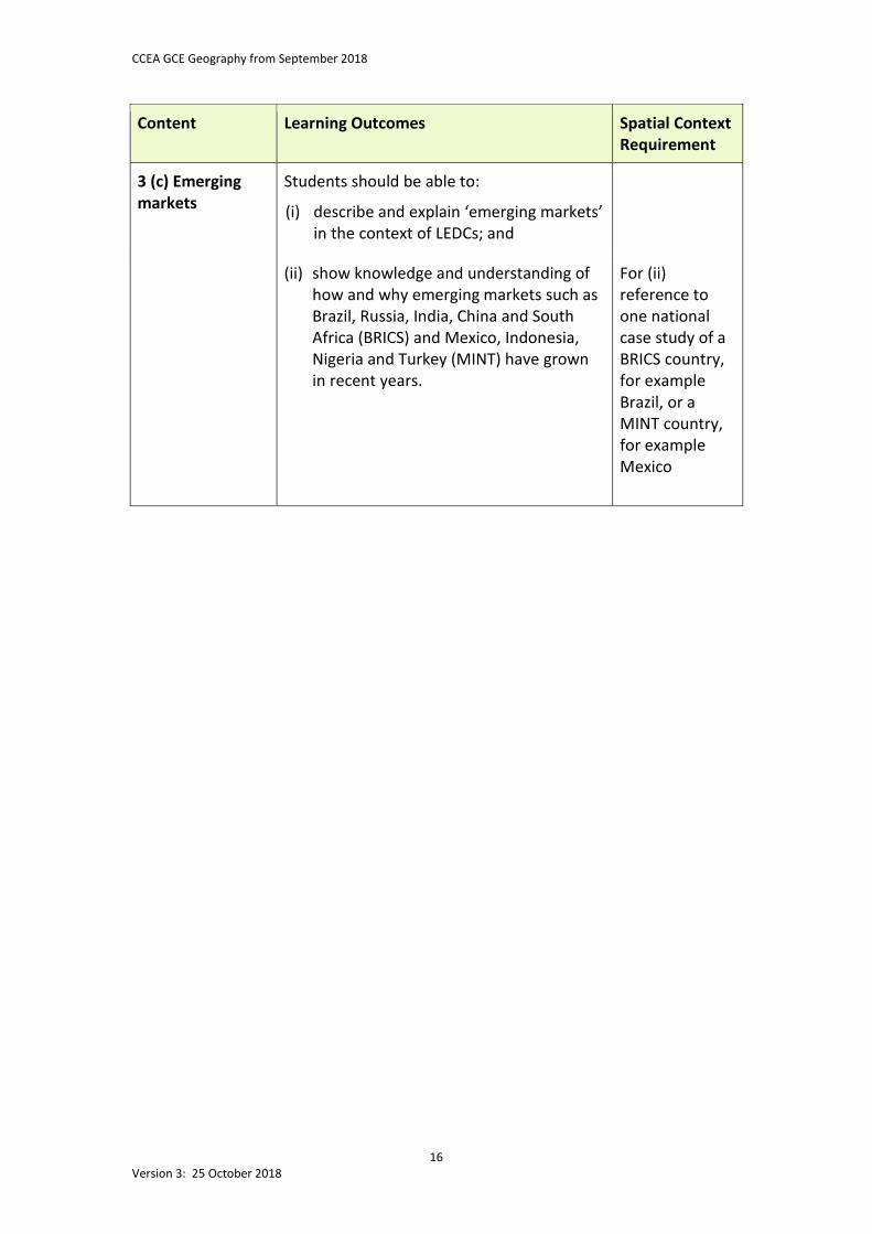
3 (c) Emerging markets
Students should be able to:
(i) describe and explain ‘emerging markets’ in the context of LEDCs; and
(ii) show knowledge and understanding of how and why emerging markets such as Brazil, Russia, India, China and South Africa (BRICS) and Mexico, Indonesia, Nigeria and Turkey (MINT) have grown in recent years.
For (ii) reference to one national case study of a BRICS country, for example Brazil, or a MINT country, for example Mexico
CCEA GCE Geography from September 2018
17 Version 3: 25 October 2018
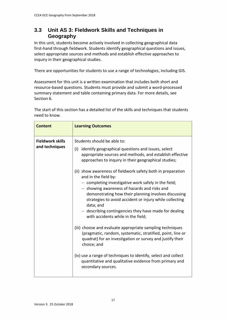
3.3 Unit AS 3: Fieldwork Skills and Techniques in Geography
In this unit, students become actively involved in collecting geographical data first-hand through fieldwork. Students identify geographical questions and issues, select appropriate sources and methods and establish effective approaches to inquiry in their geographical studies. There are opportunities for students to use a range of technologies, including GIS. Assessment for this unit is a written examination that includes both short and resource-based questions. Students must provide and submit a word-processed summary statement and table containing primary data. For more details, see Section 6. The start of this section has a detailed list of the skills and techniques that students need to know.
Content Learning Outcomes
Fieldwork skills and techniques
Students should be able to:
(i) identify geographical questions and issues, select appropriate sources and methods, and establish effective approaches to inquiry in their geographical studies;
(ii) show awareness of fieldwork safety both in preparation
and in the field by: − completing investigative work safely in the field; − showing awareness of hazards and risks and
demonstrating how their planning involves discussing strategies to avoid accident or injury while collecting data; and
− describing contingencies they have made for dealing with accidents while in the field;
(iii) choose and evaluate appropriate sampling techniques
(pragmatic, random, systematic, stratified, point, line or quadrat) for an investigation or survey and justify their choice; and
(iv) use a range of techniques to identify, select and collect quantitative and qualitative evidence from primary and secondary sources.
CCEA GCE Geography from September 2018
18 Version 3: 25 October 2018
Content Learning Outcomes
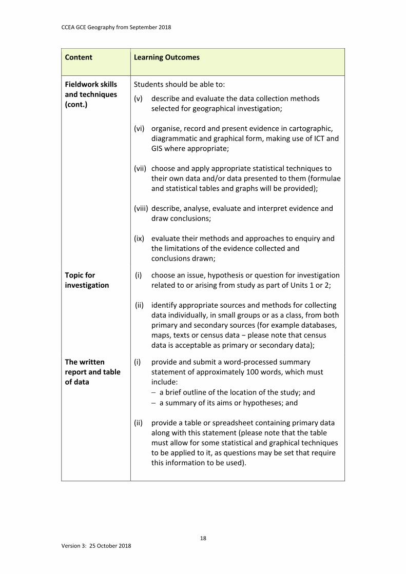
Fieldwork skills and techniques (cont.)
Students should be able to:
(v) describe and evaluate the data collection methods selected for geographical investigation;
(vi) organise, record and present evidence in cartographic,
diagrammatic and graphical form, making use of ICT and GIS where appropriate;
(vii) choose and apply appropriate statistical techniques to their own data and/or data presented to them (formulae and statistical tables and graphs will be provided);
(viii) describe, analyse, evaluate and interpret evidence and draw conclusions;
(ix) evaluate their methods and approaches to enquiry and the limitations of the evidence collected and conclusions drawn;
Topic for investigation
(i) choose an issue, hypothesis or question for investigation related to or arising from study as part of Units 1 or 2;
(ii) identify appropriate sources and methods for collecting
data individually, in small groups or as a class, from both primary and secondary sources (for example databases, maps, texts or census data − please note that census data is acceptable as primary or secondary data);
The written report and table of data
(i) provide and submit a word-processed summary statement of approximately 100 words, which must include: − a brief outline of the location of the study; and − a summary of its aims or hypotheses; and
(ii) provide a table or spreadsheet containing primary data
along with this statement (please note that the table must allow for some statistical and graphical techniques to be applied to it, as questions may be set that require this information to be used).
CCEA GCE Geography from September 2018
19 Version 3: 25 October 2018
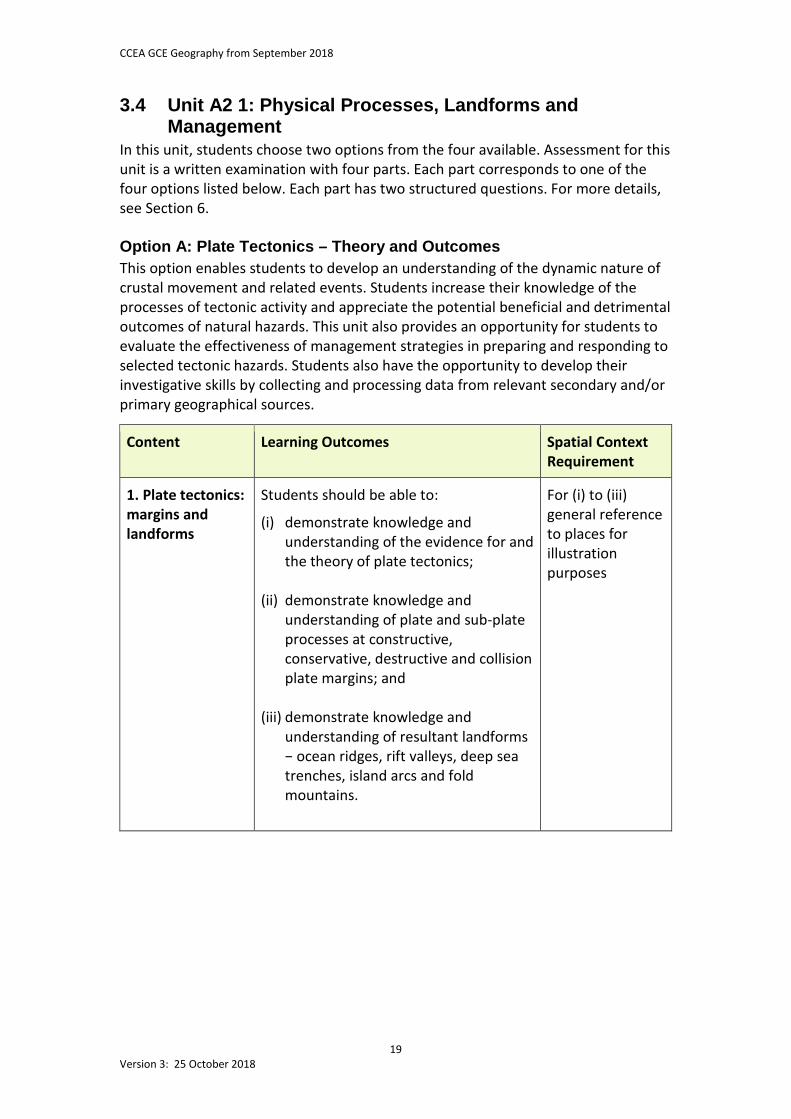
3.4 Unit A2 1: Physical Processes, Landforms and Management
In this unit, students choose two options from the four available. Assessment for this unit is a written examination with four parts. Each part corresponds to one of the four options listed below. Each part has two structured questions. For more details, see Section 6. Option A: Plate Tectonics – Theory and Outcomes This option enables students to develop an understanding of the dynamic nature of crustal movement and related events. Students increase their knowledge of the processes of tectonic activity and appreciate the potential beneficial and detrimental outcomes of natural hazards. This unit also provides an opportunity for students to evaluate the effectiveness of management strategies in preparing and responding to selected tectonic hazards. Students also have the opportunity to develop their investigative skills by collecting and processing data from relevant secondary and/or primary geographical sources.
Content Learning Outcomes Spatial Context Requirement
1. Plate tectonics: margins and landforms
Students should be able to:
(i) demonstrate knowledge and understanding of the evidence for and the theory of plate tectonics;
(ii) demonstrate knowledge and understanding of plate and sub-plate processes at constructive, conservative, destructive and collision plate margins; and
(iii) demonstrate knowledge and understanding of resultant landforms − ocean ridges, rift valleys, deep sea trenches, island arcs and fold mountains.
For (i) to (iii) general reference to places for illustration purposes
CCEA GCE Geography from September 2018
20 Version 3: 25 October 2018
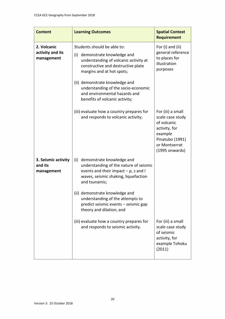
Content Learning Outcomes Spatial Context Requirement
2. Volcanic activity and its management
Students should be able to:
(i) demonstrate knowledge and understanding of volcanic activity at constructive and destructive plate margins and at hot spots;
(ii) demonstrate knowledge and understanding of the socio-economic and environmental hazards and benefits of volcanic activity;
For (i) and (ii) general reference to places for illustration purposes
(iii) evaluate how a country prepares for and responds to volcanic activity;
For (iii) a small scale case study of volcanic activity, for example Pinatubo (1991) or Montserrat (1995 onwards)
3. Seismic activity and its management
(i) demonstrate knowledge and understanding of the nature of seismic events and their impact − p, s and l waves, seismic shaking, liquefaction and tsunamis;
(ii) demonstrate knowledge and
understanding of the attempts to predict seismic events − seismic gap theory and dilation; and
(iii) evaluate how a country prepares for and responds to seismic activity.
For (iii) a small scale case study of seismic activity, for example Tohoku (2011)
CCEA GCE Geography from September 2018
21 Version 3: 25 October 2018
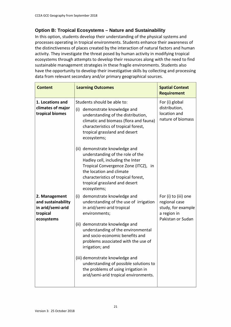
Option B: Tropical Ecosystems – Nature and Sustainability In this option, students develop their understanding of the physical systems and processes operating in tropical environments. Students enhance their awareness of the distinctiveness of places created by the interaction of natural factors and human activity. They investigate the threat posed by human activity in modifying tropical ecosystems through attempts to develop their resources along with the need to find sustainable management strategies in these fragile environments. Students also have the opportunity to develop their investigative skills by collecting and processing data from relevant secondary and/or primary geographical sources.
Content Learning Outcomes Spatial Context Requirement
1. Locations and climates of major tropical biomes
Students should be able to: (i) demonstrate knowledge and
understanding of the distribution, climatic and biomass (flora and fauna) characteristics of tropical forest, tropical grassland and desert ecosystems;
(ii) demonstrate knowledge and
understanding of the role of the Hadley cell, including the Inter Tropical Convergence Zone (ITCZ), in the location and climate characteristics of tropical forest, tropical grassland and desert ecosystems;
For (i) global distribution, location and nature of biomass
2. Management and sustainability in arid/semi-arid tropical ecosystems
(i) demonstrate knowledge and understanding of the use of irrigation in arid/semi-arid tropical environments;
(ii) demonstrate knowledge and understanding of the environmental and socio-economic benefits and problems associated with the use of irrigation; and
(iii) demonstrate knowledge and
understanding of possible solutions to the problems of using irrigation in arid/semi-arid tropical environments.
For (i) to (iii) one regional case study, for example a region in Pakistan or Sudan
CCEA GCE Geography from September 2018
22 Version 3: 25 October 2018
Content Learning Outcomes Spatial Context Requirement
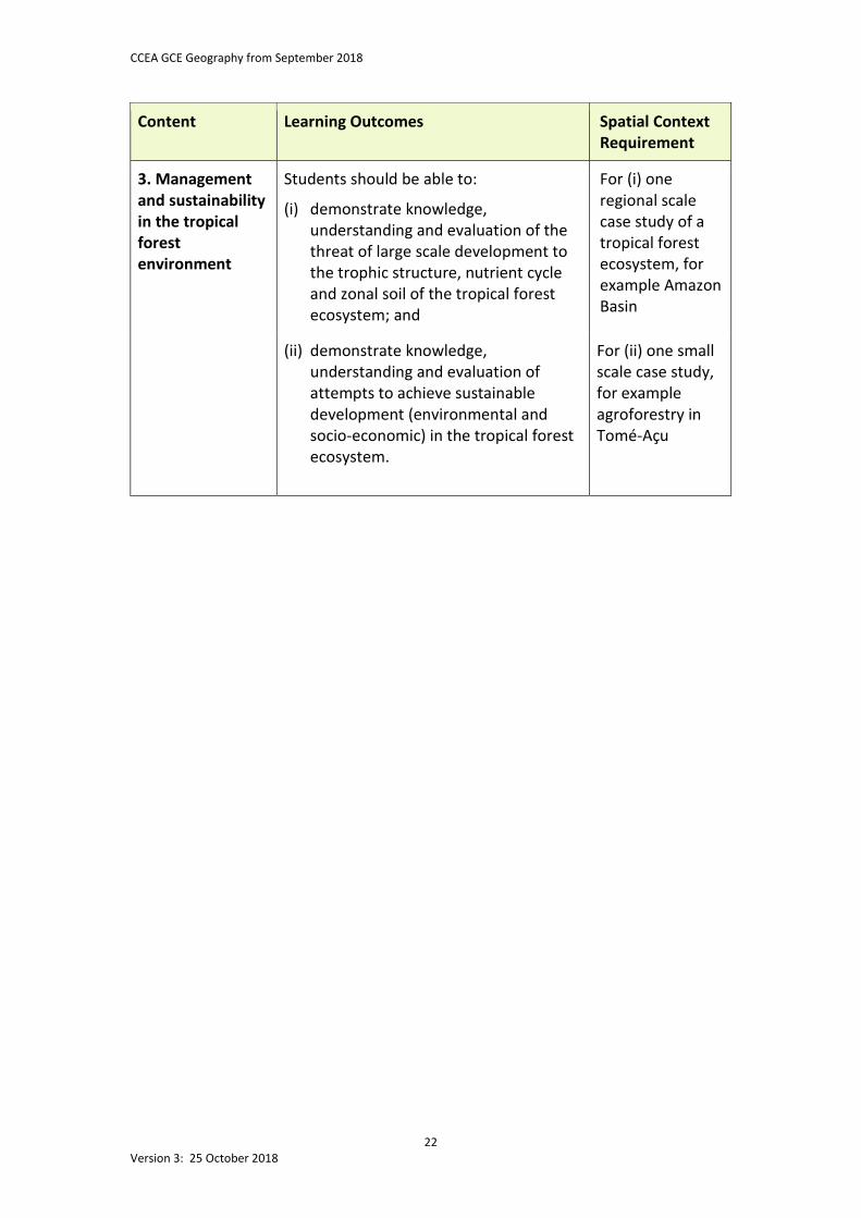
3. Management and sustainability in the tropical forest environment
Students should be able to:
(i) demonstrate knowledge, understanding and evaluation of the threat of large scale development to the trophic structure, nutrient cycle and zonal soil of the tropical forest ecosystem; and
For (i) one regional scale case study of a tropical forest ecosystem, for example Amazon Basin
(ii) demonstrate knowledge, understanding and evaluation of attempts to achieve sustainable development (environmental and socio-economic) in the tropical forest ecosystem.
For (ii) one small scale case study, for example agroforestry in Tomé-Açu
CCEA GCE Geography from September 2018
23 Version 3: 25 October 2018
Option C: Dynamic Coastal Environments This option enables students to gain a deeper understanding of coastal systems and processes by developing their understanding of the nature and potential threat of dynamic adjustments to coastal environments over time. Students investigate the changing role and nature of management in coastal environments and evaluate the effectiveness of management strategies. Students also consider the need for sensitivity and sustainability of human activity in coastal environments. They have the opportunity to develop their investigative skills by collecting and processing data from relevant secondary and/or primary geographical sources.
Content Learning Outcomes
Spatial Context Requirement
1. Coastal processes and features
Students should be able to:
(i) demonstrate knowledge and understanding of coastal processes − wave action, refraction, erosion, transport, swash and drift-aligned coasts;
(ii) demonstrate knowledge and understanding of the formation of landforms at: − high-energy coasts: headlands,
cliffs, arches, stacks and stumps; and
− low-energy coasts: beaches and dunes, spits, tombolos and bars;
For (i) and (ii) general reference to places for illustration purposes
2. Regional coastlines
(i) demonstrate knowledge and understanding of the processes (eustatic and isostatic) and features (fjords, rias, raised beaches and relict landforms) associated with coastlines of submergence and emergence; and
For (i) general reference to places for illustration purposes
(ii) demonstrate knowledge and understanding of the threat of rising sea levels due to climate change on the human and physical environment.
For (ii) one regional or national scale study of a coastline under threat from sea level rise in an LEDC, for example Kiribati
CCEA GCE Geography from September 2018
24 Version 3: 25 October 2018
Content Learning Outcomes
Spatial Context Requirement
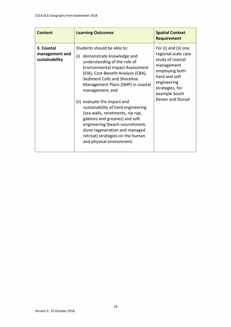
3. Coastal management and sustainability
Students should be able to:
(i) demonstrate knowledge and understanding of the role of Environmental Impact Assessment (EIA), Cost-Benefit Analysis (CBA), Sediment Cells and Shoreline Management Plans (SMP) in coastal management; and
(ii) evaluate the impact and sustainability of hard engineering (sea walls, revetments, rip-rap, gabions and groynes) and soft engineering (beach nourishment, dune regeneration and managed retreat) strategies on the human and physical environment.
For (i) and (ii) one regional scale case study of coastal management employing both hard and soft engineering strategies, for example South Devon and Dorset
CCEA GCE Geography from September 2018
25 Version 3: 25 October 2018
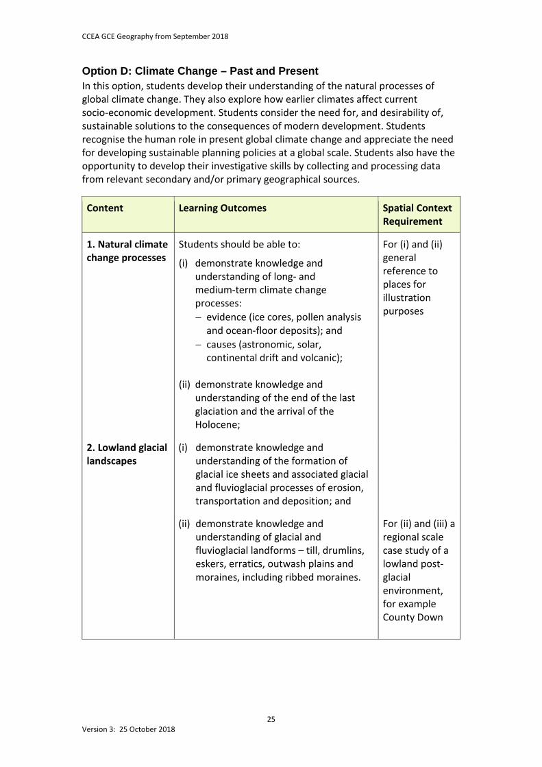
Option D: Climate Change – Past and Present In this option, students develop their understanding of the natural processes of global climate change. They also explore how earlier climates affect current socio-economic development. Students consider the need for, and desirability of, sustainable solutions to the consequences of modern development. Students recognise the human role in present global climate change and appreciate the need for developing sustainable planning policies at a global scale. Students also have the opportunity to develop their investigative skills by collecting and processing data from relevant secondary and/or primary geographical sources.
Content Learning Outcomes Spatial Context Requirement
1. Natural climate change processes
Students should be able to:
(i) demonstrate knowledge and understanding of long- and medium-term climate change processes: − evidence (ice cores, pollen analysis
and ocean-floor deposits); and − causes (astronomic, solar,
continental drift and volcanic);
(ii) demonstrate knowledge and understanding of the end of the last glaciation and the arrival of the Holocene;
For (i) and (ii) general reference to places for illustration purposes
2. Lowland glacial landscapes
(i) demonstrate knowledge and understanding of the formation of glacial ice sheets and associated glacial and fluvioglacial processes of erosion, transportation and deposition; and
(ii) demonstrate knowledge and understanding of glacial and fluvioglacial landforms – till, drumlins, eskers, erratics, outwash plains and moraines, including ribbed moraines.
For (ii) and (iii) a regional scale case study of a lowland post-glacial environment, for example County Down
CCEA GCE Geography from September 2018
26 Version 3: 25 October 2018
Content Learning Outcomes Spatial Context Requirement
2. Lowland glacial landscapes (cont.)
Students should be able to:
(iii) demonstrate knowledge and understanding of the benefits and problems of socio-economic development in lowland post-glacial environments;
3. Current global climate change: human causes and impacts
(i) demonstrate knowledge and understanding of the evidence for recent climate change and links to human activities (enhanced greenhouse effect);
(ii) demonstrate knowledge and understanding of the present and potential impacts of climate change;
For (i) and (ii) general reference to places in both MEDCs and LEDCs for illustration purposes
4. Managing global climate change
(i) demonstrate knowledge and understanding of attempts to address global climate change through mitigation (carbon capture and reducing greenhouse gas emissions) and adaptation (reducing vulnerability); and
(ii) evaluate the progress of international
action on climate change, including the Kyoto Protocol and the role of the Intergovernmental Panel on Climate Change (IPCC).
For (i) and (ii) general reference to places at an international scale
CCEA GCE Geography from September 2018
27 Version 3: 25 October 2018
3.5 Unit A2 2: Processes and Issues in Human Geography In this unit, students choose two options from the four available. Assessment for this unit is a written examination with four parts. Each part corresponds to one of the four options listed below. Each part has two structured questions. For more details, see Section 6. Option A: Cultural Geography In this option, students appreciate that cultural geography has become a significant element of human geography. The study of cultural geography helps students to understand that significant spatial and social differences in culture exist, in spite of globalisation. Students also examine the significance of social constructions on nature and the landscape. This unit also gives students an awareness of the complex nature of migration as well as its social, economic and political impacts at a range of scales. Students develop an appreciation of the cultural transformations that the development of cyberspace has brought about. Students also have the opportunity to develop their investigative skills by collecting and processing data from relevant secondary and/or primary geographical sources.
Content Learning Outcomes Spatial Context Requirement
1. Cultural geography
Students should be able to:
(i) understand and explain: − why cultural groups exist; − the differences between cultural
groups; and − the expression of cultural
nationalism;
(ii) understand and explain social inequalities (social exclusion and discrimination) in relation to ethnicity, gender, race, religion, sexuality and social class;
(iii) understand and explain social
constructions of nature and landscape − landscapes as human systems, natural and cultural landscapes; and
For (i) to (iii) general reference to places for illustration purposes
2. Migration (i) explain push and pull factors in migration − economic, social, political, cultural and environmental factors, and barriers to migration.
CCEA GCE Geography from September 2018
28 Version 3: 25 October 2018
Content Learning Outcomes Spatial Context Requirement
2. Migration (cont.)
Students should be able to:
(ii) demonstrate knowledge and understanding of the implications of migration for service provision, economic activity and social stability;
(iii) distinguish between voluntary and
forced migration and describe migration processes, including those adopted by undocumented migrants;
For (ii) those implications that are relevant to one small scale case study of out-migration, for example Achill Island, and one urban case study of in-migration, for example Delhi
(iv) discuss immigration (documented and undocumented) as a political issue and governments’ responses to it;
For (iv) one case study of government response to immigration at the national or international scale, for example the European Union, USA or Australia
3. The geographies of cyberspace
(i) understand that the development of cyberspace has led to changes in socio-economic activity and has helped to produce international cultures; and
(ii) recognise that global contrasts
remain, brought about by economic, social and political issues.
For (i) and (ii) general reference to places for illustration purposes
CCEA GCE Geography from September 2018
29 Version 3: 25 October 2018
Option B: Planning for Sustainable Settlements This option enables students to understand that sustainability relates to both the environment and society by exploring the rationale underpinning sustainability. Students consider the impact of urban settlements, urban systems and transport on the environment. They also consider the role of people in planning and designing settlements in an attempt to make them more efficient and sustainable. Students also have the opportunity to develop their investigative skills by collecting and processing data from relevant secondary and/or primary geographical sources.
Content Learning Outcomes
Spatial Context Requirement
1. Sustainable development
Students should be able to:
(i) explain sustainability with reference to social and environmental considerations;
(ii) demonstrate knowledge and
understanding of urban ecological and carbon footprints; and
(iii) understand how sustainability is
related to waste management, energy consumption and water supply.
For (i) and (ii) general reference to places for illustration purposes
For (iii) one case study of a city, for example Belfast or Birmingham
CCEA GCE Geography from September 2018
30 Version 3: 25 October 2018
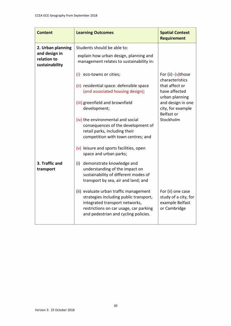
Content Learning Outcomes
Spatial Context Requirement
2. Urban planning and design in relation to sustainability
Students should be able to:
explain how urban design, planning and management relates to sustainability in:
(i) eco-towns or cities;
(ii) residential space: defensible space (and associated housing design);
(iii) greenfield and brownfield development;
(iv) the environmental and social consequences of the development of retail parks, including their competition with town centres; and
(v) leisure and sports facilities, open space and urban parks;
For (ii)–(v)those characteristics that affect or have affected urban planning and design in one city, for example Belfast or Stockholm
3. Traffic and transport
(i) demonstrate knowledge and understanding of the impact on sustainability of different modes of transport by sea, air and land; and
(ii) evaluate urban traffic management strategies including public transport, integrated transport networks, restrictions on car usage, car parking and pedestrian and cycling policies.
For (ii) one case study of a city, for example Belfast or Cambridge
CCEA GCE Geography from September 2018
31 Version 3: 25 October 2018
Option C: Ethnic Diversity This option enables students to understand how to define ethnicity. They investigate the processes that create and maintain ethnic diversity and evaluate the social, economic and spatial outcomes of this diversity. Students enhance their understanding of the causes, the nature of and possible responses to conflict. Students also have the opportunity to develop their investigative skills by collecting and processing data from relevant secondary and/or primary geographical sources.
Content
Learning Outcomes Spatial Context Requirement
1. The definition of ethnicity
Students should be able to:
(i) explain the factors that define ethnicity − race, nationality, language and religion;
(ii) explain how role, residential
concentration, age and gender influence perceived ethnic and social identity;
For (i) and (ii) general reference to places for illustration purposes only
2. The processes that create and maintain ethnic diversity
(i) demonstrate knowledge and understanding of the processes creating ethnic diversity − colonisation, annexation and international migration;
For (i) the role of those processes that created ethnic diversity in one country, for example Jamaica or France
(ii) demonstrate knowledge and understanding of the processes maintaining ethnic diversity − segregation and multiculturalism; and
(iii) demonstrate knowledge and understanding of the economic, social and spatial outcomes of ethnic diversity.
For (ii) and (iii) the role of those processes and their outcomes for one ethnically diverse city, for example Jerusalem or Belfast
CCEA GCE Geography from September 2018
32 Version 3: 25 October 2018
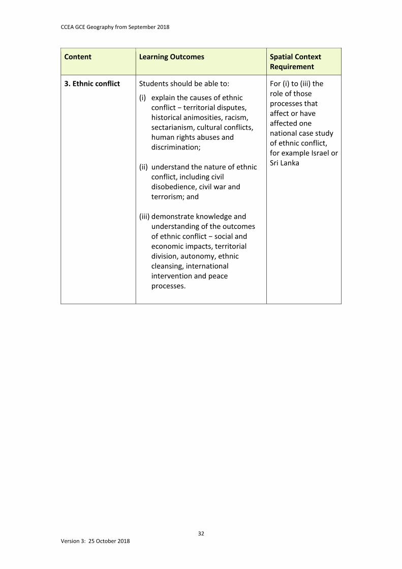
Content
Learning Outcomes Spatial Context Requirement
3. Ethnic conflict Students should be able to:
(i) explain the causes of ethnic conflict − territorial disputes, historical animosities, racism, sectarianism, cultural conflicts, human rights abuses and discrimination;
(ii) understand the nature of ethnic conflict, including civil disobedience, civil war and terrorism; and
(iii) demonstrate knowledge and understanding of the outcomes of ethnic conflict − social and economic impacts, territorial division, autonomy, ethnic cleansing, international intervention and peace processes.
For (i) to (iii) the role of those processes that affect or have affected one national case study of ethnic conflict, for example Israel or Sri Lanka
CCEA GCE Geography from September 2018
33 Version 3: 25 October 2018
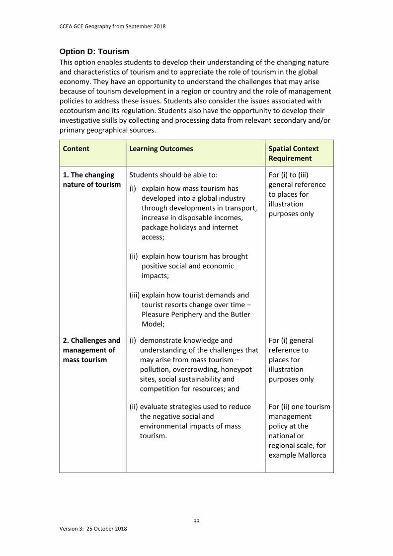
Option D: Tourism This option enables students to develop their understanding of the changing nature and characteristics of tourism and to appreciate the role of tourism in the global economy. They have an opportunity to understand the challenges that may arise because of tourism development in a region or country and the role of management policies to address these issues. Students also consider the issues associated with ecotourism and its regulation. Students also have the opportunity to develop their investigative skills by collecting and processing data from relevant secondary and/or primary geographical sources.
Content
Learning Outcomes Spatial Context Requirement
1. The changing nature of tourism
Students should be able to:
(i) explain how mass tourism has developed into a global industry through developments in transport, increase in disposable incomes, package holidays and internet access;
(ii) explain how tourism has brought
positive social and economic impacts;
(iii) explain how tourist demands and
tourist resorts change over time − Pleasure Periphery and the Butler Model;
For (i) to (iii) general reference to places for illustration purposes only
2. Challenges and management of mass tourism
(i) demonstrate knowledge and understanding of the challenges that may arise from mass tourism – pollution, overcrowding, honeypot sites, social sustainability and competition for resources; and
For (i) general reference to places for illustration purposes only
(ii) evaluate strategies used to reduce the negative social and environmental impacts of mass tourism.
For (ii) one tourism management policy at the national or regional scale, for example Mallorca
CCEA GCE Geography from September 2018
34 Version 3: 25 October 2018
Content
Learning Outcomes Spatial Context Requirement
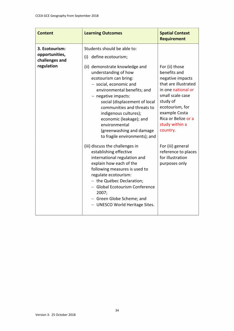
3. Ecotourism: opportunities, challenges and regulation
Students should be able to:
(i) define ecotourism;
(ii) demonstrate knowledge and understanding of how ecotourism can bring: − social, economic and
environmental benefits; and − negative impacts:
social (displacement of local communities and threats to indigenous cultures); economic (leakage); and environmental (greenwashing and damage to fragile environments); and
For (ii) those benefits and negative impacts that are illustrated in one national or small scale case study of ecotourism, for example Costa Rica or Belize or a study within a country.
(iii) discuss the challenges in establishing effective international regulation and explain how each of the following measures is used to regulate ecotourism: − the Québec Declaration; − Global Ecotourism Conference
2007; − Green Globe Scheme; and − UNESCO World Heritage Sites.
For (iii) general reference to places for illustration purposes only
CCEA GCE Geography from September 2018
35 Version 3: 25 October 2018
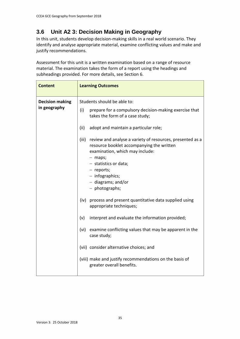
3.6 Unit A2 3: Decision Making in Geography In this unit, students develop decision-making skills in a real world scenario. They identify and analyse appropriate material, examine conflicting values and make and justify recommendations. Assessment for this unit is a written examination based on a range of resource material. The examination takes the form of a report using the headings and subheadings provided. For more details, see Section 6.
Content Learning Outcomes
Decision making in geography
Students should be able to:
(i) prepare for a compulsory decision-making exercise that takes the form of a case study;
(ii) adopt and maintain a particular role;
(iii) review and analyse a variety of resources, presented as a
resource booklet accompanying the written examination, which may include: − maps; − statistics or data; − reports; − infographics; − diagrams; and/or − photographs;
(iv) process and present quantitative data supplied using
appropriate techniques;
(v) interpret and evaluate the information provided; (vi) examine conflicting values that may be apparent in the
case study;
(vii) consider alternative choices; and
(viii) make and justify recommendations on the basis of greater overall benefits.
CCEA GCE Geography from September 2018
36 Version 3: 25 October 2018
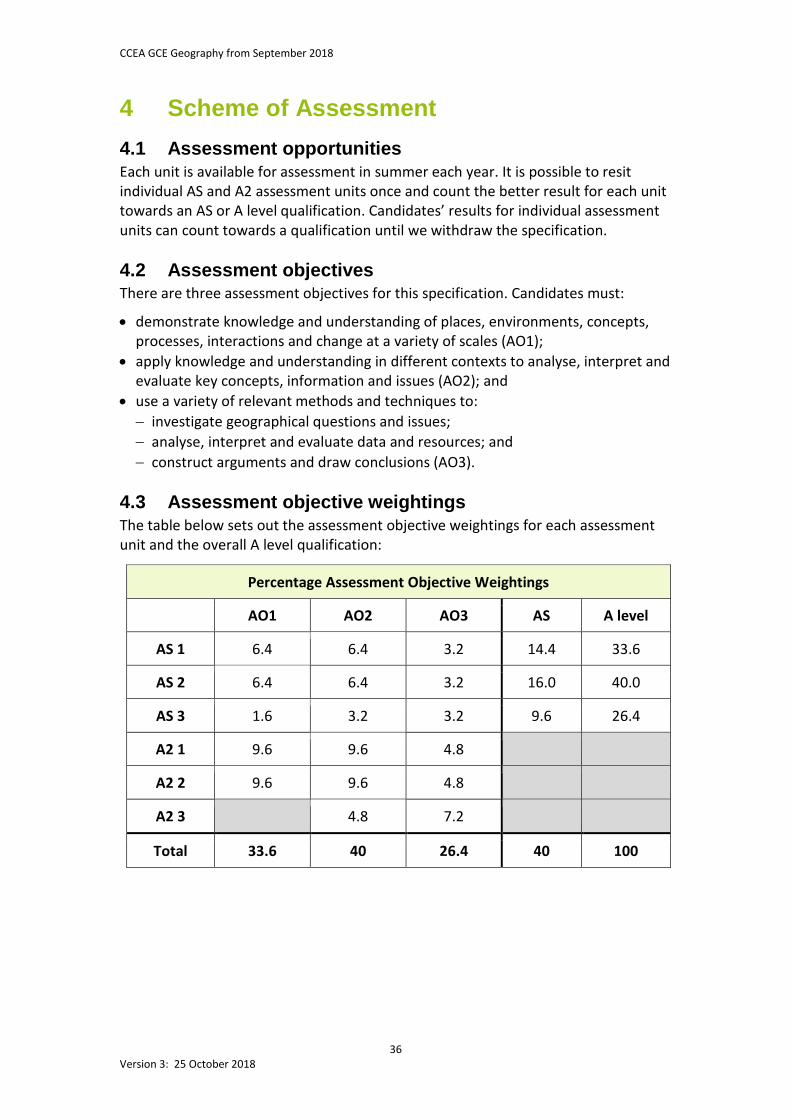
4 Scheme of Assessment 4.1 Assessment opportunities Each unit is available for assessment in summer each year. It is possible to resit individual AS and A2 assessment units once and count the better result for each unit towards an AS or A level qualification. Candidates’ results for individual assessment units can count towards a qualification until we withdraw the specification. 4.2 Assessment objectives There are three assessment objectives for this specification. Candidates must:
• demonstrate knowledge and understanding of places, environments, concepts, processes, interactions and change at a variety of scales (AO1);
• apply knowledge and understanding in different contexts to analyse, interpret and evaluate key concepts, information and issues (AO2); and
• use a variety of relevant methods and techniques to: − investigate geographical questions and issues; − analyse, interpret and evaluate data and resources; and − construct arguments and draw conclusions (AO3).
4.3 Assessment objective weightings The table below sets out the assessment objective weightings for each assessment unit and the overall A level qualification:
Percentage Assessment Objective Weightings
AO1 AO2 AO3 AS A level
AS 1 6.4 6.4 3.2 14.4 33.6
AS 2 6.4 6.4 3.2 16.0 40.0
AS 3 1.6 3.2 3.2 9.6 26.4
A2 1 9.6 9.6 4.8
A2 2 9.6 9.6 4.8
A2 3 4.8 7.2
Total 33.6 40 26.4 40 100
CCEA GCE Geography from September 2018
37 Version 3: 25 October 2018
4.4 Quality of written communication In AS and A level Geography, candidates must demonstrate their quality of written communication. They need to:
• ensure that text is legible and that spelling, punctuation and grammar are accurate so that meaning is clear;
• select and use a form and style of writing that suit their purpose and complex subject matter; and
• organise information clearly and coherently, using specialist vocabulary where appropriate.
Quality of written communication is assessed in responses to questions and tasks that require extended writing. 4.5 Synoptic assessment at A2 The A2 assessment units include some synoptic assessment, which encourages candidates to develop their understanding of the subject as a whole. In our GCE Geography, synoptic assessment involves:
• building on material from the AS units; and • bringing together and making connections between areas of knowledge and skills
that they have explored throughout the course. 4.6 Higher order thinking skills The A2 assessment units provide opportunities to demonstrate higher order thinking skills by incorporating:
• a wider range of question types to address different skills, for example case studies and open-ended questions;
• more demanding evaluative tasks, for example an unseen decision-making task; and • extended writing where appropriate. 4.7 Reporting and grading We report the results of individual assessment units on a uniform mark scale that reflects the assessment weighting of each unit. We award AS qualifications on a five grade scale from A to E, with A being the highest. We award A level qualifications on a six grade scale from A* to E, with A* being the highest. To determine candidates’ grades, we add the uniform marks obtained in individual assessment units. To be awarded an A*, candidates need to achieve a grade A on their full A level qualification and at least 90 percent of the maximum uniform marks available for the A2 units. If candidates fail to attain a grade E, we report their results as unclassified (U). The grades we award match the grade descriptions in Section 5 of this specification.
CCEA GCE Geography from September 2018
38 Version 3: 25 October 2018
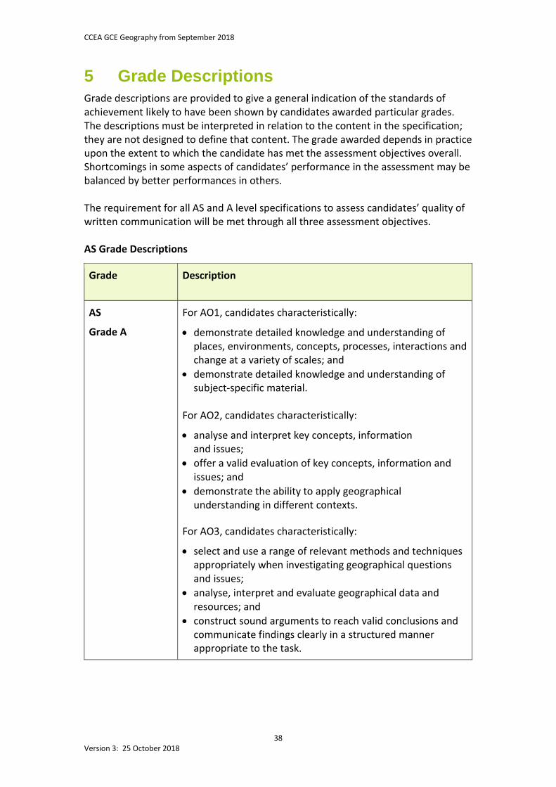
5 Grade Descriptions Grade descriptions are provided to give a general indication of the standards of achievement likely to have been shown by candidates awarded particular grades. The descriptions must be interpreted in relation to the content in the specification; they are not designed to define that content. The grade awarded depends in practice upon the extent to which the candidate has met the assessment objectives overall. Shortcomings in some aspects of candidates’ performance in the assessment may be balanced by better performances in others. The requirement for all AS and A level specifications to assess candidates’ quality of written communication will be met through all three assessment objectives. AS Grade Descriptions
Grade Description
AS
Grade A
For AO1, candidates characteristically:
• demonstrate detailed knowledge and understanding of places, environments, concepts, processes, interactions and change at a variety of scales; and
• demonstrate detailed knowledge and understanding of subject-specific material.
For AO2, candidates characteristically:
• analyse and interpret key concepts, information and issues;
• offer a valid evaluation of key concepts, information and issues; and
• demonstrate the ability to apply geographical understanding in different contexts.
For AO3, candidates characteristically:
• select and use a range of relevant methods and techniques appropriately when investigating geographical questions and issues;
• analyse, interpret and evaluate geographical data and resources; and
• construct sound arguments to reach valid conclusions and communicate findings clearly in a structured manner appropriate to the task.
CCEA GCE Geography from September 2018
39 Version 3: 25 October 2018
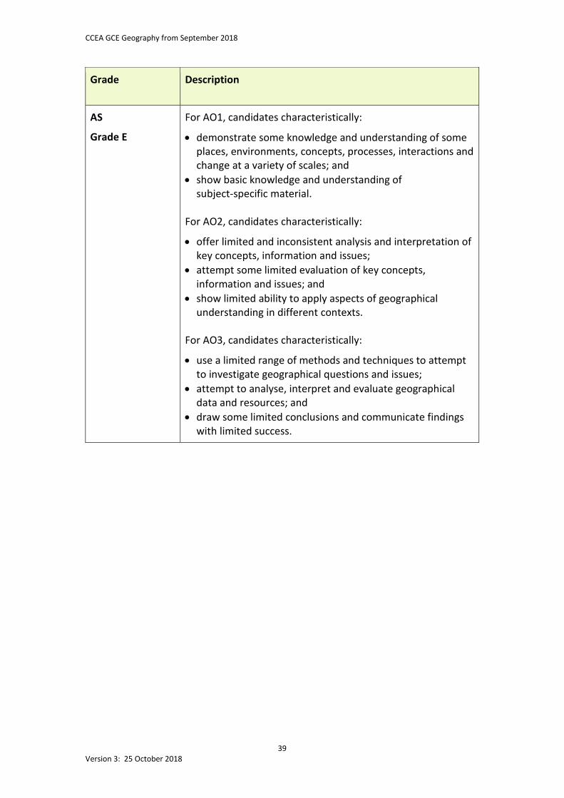
Grade Description
AS
Grade E
For AO1, candidates characteristically:
• demonstrate some knowledge and understanding of some places, environments, concepts, processes, interactions and change at a variety of scales; and
• show basic knowledge and understanding of subject-specific material.
For AO2, candidates characteristically:
• offer limited and inconsistent analysis and interpretation of key concepts, information and issues;
• attempt some limited evaluation of key concepts, information and issues; and
• show limited ability to apply aspects of geographical understanding in different contexts.
For AO3, candidates characteristically:
• use a limited range of methods and techniques to attempt to investigate geographical questions and issues;
• attempt to analyse, interpret and evaluate geographical data and resources; and
• draw some limited conclusions and communicate findings with limited success.
CCEA GCE Geography from September 2018
40 Version 3: 25 October 2018
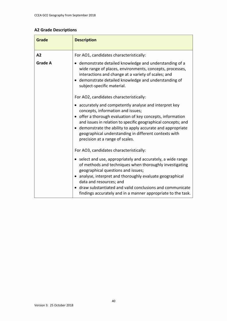
A2 Grade Descriptions
Grade Description
A2
Grade A
For AO1, candidates characteristically:
• demonstrate detailed knowledge and understanding of a wide range of places, environments, concepts, processes, interactions and change at a variety of scales; and
• demonstrate detailed knowledge and understanding of subject-specific material.
For AO2, candidates characteristically:
• accurately and competently analyse and interpret key concepts, information and issues;
• offer a thorough evaluation of key concepts, information and issues in relation to specific geographical concepts; and
• demonstrate the ability to apply accurate and appropriate geographical understanding in different contexts with precision at a range of scales.
For AO3, candidates characteristically:
• select and use, appropriately and accurately, a wide range of methods and techniques when thoroughly investigating geographical questions and issues;
• analyse, interpret and thoroughly evaluate geographical data and resources; and
• draw substantiated and valid conclusions and communicate findings accurately and in a manner appropriate to the task.
CCEA GCE Geography from September 2018
41 Version 3: 25 October 2018
Grade Description
A2
Grade E
For AO1, candidates characteristically:
• demonstrate some knowledge and understanding of some places, environments, concepts, processes, interactions and change at a variety of scales; and
• show basic understanding of subject-specific material. For AO2, candidates characteristically:
• show some attempts to analyse and interpret key concepts, information and issues with varying degrees of success;
• offer some evaluation of key concepts, information and issues with variable success; and
• show some ability to apply geographical understanding in different contexts with some degree of accuracy.
For AO3, candidates characteristically:
• use a range of methods and techniques to investigate geographical questions and issues with varying degrees of success;
• show some attempts to analyse, interpret and evaluate geographical data and resources; and
• draw some straightforward conclusions and communicate findings with some degree of success.
CCEA GCE Geography from September 2018
42 Version 3: 25 October 2018
6 Guidance on External Assessment There are six external assessment units in this specification, three at AS level and three at A2:
• Unit AS 1: Physical Geography; • Unit AS 2: Human Geography; • Unit AS 3: Fieldwork Skills and Techniques in Geography; • Unit A2 1: Physical Processes, Landforms and Management; • Unit A2 2: Processes and Issues in Human Geography; and • Unit A2 3: Decision Making in Geography. The external assessment focuses on candidates’ knowledge, understanding and analysis of the content of each unit. 6.1 Unit AS 1: Physical Geography This assessment unit is a 1 hour 15 minute written examination. Candidates answer five questions from two sections. Section A has three compulsory, short, structured questions. Each question is worth 15 marks. In Section B candidates choose two out of three questions requiring extended writing. Each question is worth 15 marks. In both Sections A and B, questions focus mainly on one of the three main elements in the unit content. 6.2 Unit AS 2: Human Geography This assessment unit is a 1 hour 15 minute written examination. Candidates answer five questions from two sections. Section A has three compulsory, short, structured questions. Each question is worth 15 marks. In Section B, candidates choose two out of three questions requiring extended writing. Each question is worth 15 marks. In both Sections A and B, questions focus mainly on one of the three main elements in the unit content.
CCEA GCE Geography from September 2018
43 Version 3: 25 October 2018
6.3 Unit AS 3: Fieldwork Skills and Techniques in Geography
This assessment unit is a one hour written examination. Candidates answer two compulsory questions. Candidates choose an issue, hypothesis or question for investigation related to or arising from their study as part of AS Units 1 or 2. They identify appropriate sources and methods for collecting data. They can do this either individually, in small groups, or as a class. These sources and methods must be from both primary and secondary sources (for example databases, maps, texts or census data). We accept census data as primary or secondary data. The written report and table of data When they have gathered the data, candidates must provide:
• a summary statement of approximately 100 words; and • a table of data. The summary statement must include:
• the title; • details of the location of the study (candidates can include a map, if appropriate); and • a statement of the aims and hypotheses to be tested or questions to be answered. Candidates must not address other elements of the fieldwork investigation in this summary statement. We set questions that require the candidates to draw on their knowledge and experience of fieldwork skills as detailed above, from planning to drawing conclusions and evaluation. The table of data must include:
• primary and secondary data essential to investigate the aim of the study; • data they have collected for all variables relevant to the proposed aim/purpose of
the study, outlined in the summary statement; • quantitative data (numerical scores) essential to allow for graphical
representation and statistical analysis (candidates can include qualitative data, if relevant);
• normal conventions, including a title with all variables clearly stated along with precise units of measurement; and
• the inclusion of raw data only (candidates should not include averages or other statistical calculations).
We expect candidates to use ICT to present both their summary statement and their table of data. Candidates must attach their summary statement and table of data accompanied by a completed cover sheet to the script at the end of the examination. We do not assess the summary statement or the table of data.
CCEA GCE Geography from September 2018
44 Version 3: 25 October 2018
Question 1 is a multipart compulsory question. Parts of Question 1 may require the candidate to analyse, interpret and evaluate the data they have presented and the techniques they used to collect it. We expect candidates to demonstrate their understanding of and ability to apply fieldwork techniques, as well as their graphical, cartographical, statistical, analytical, interpretative and evaluative skills. The question is worth 30 marks. Question 2 is a multipart compulsory question. Parts of this question may require the candidate to analyse, interpret and evaluate secondary data drawn from related aspects of physical and human geography and the techniques used to collect it. The question is worth 30 marks. 6.4 Unit A2 1: Physical Processes, Landforms and
Management This assessment unit is a 1 hour 30 minute written examination. It has four parts. Each part corresponds with one of the four options listed in the subject content. Each of these parts includes two structured questions. Candidates must answer two questions, one from each of their two chosen options. Each question is worth 35 marks, and has at least one extended element with a minimum of 15 marks. 6.5 Unit A2 2: Processes and Issues in Human Geography This assessment unit is a 1 hour 30 minute written examination. It has four parts. Each part corresponds with one of the four options listed in the subject content. Each of these parts includes two structured questions. Candidates must answer two questions, one from each of their two chosen options. Each question is worth 35 marks, and has at least one extended element with a minimum of 15 marks. 6.6 Unit A2 3: Decision Making in Geography This assessment unit is a 1 hour 30 minute written examination. Candidates must complete a decision-making exercise. This takes the form of a case study and is worth 60 marks. We present candidates with a variety of resources. Candidates must analyse, interpret and evaluate the information provided. They take on a particular role and examine values arising from the case study.
Candidates make recommendations, based on the case study, and justify them. We advise candidates to spend 30 minutes reading the question and selecting appropriate information before attempting to write their answers.
CCEA GCE Geography from September 2018
45 Version 3: 25 October 2018
7 Links and Support 7.1 Support The following resources are available to support this specification:
• our Geography microsite at www.ccea.org.uk • specimen assessment materials; and • guidance notes for teachers. We also intend to provide:
• past papers and mark schemes; • Chief Examiner’s reports; • schemes of work; • centre support visits; • support days for teachers; • a resource list; and • exemplification of standards. 7.2 Curriculum objectives This specification supports centres to build on the broader Northern Ireland Curriculum objectives to develop the young person:
• as an individual; • as a contributor to society; and • as a contributor to the economy and environment. It can contribute to meeting the requirements of the Northern Ireland Entitlement Framework at post-16 and the provision of a broad and balanced curriculum. Curriculum Progression from Key Stage 4 This specification builds on learning from Key Stage 4 and gives students opportunities to develop their subject knowledge and understanding further. Students will also have opportunities to continue to develop the Cross-Curricular Skills and the Thinking Skills and Personal Capabilities shown below. The extent of this development depends on the teaching and learning methodology the teacher uses. Cross-Curricular Skills • Communication: − Talking and Listening − Reading − Writing
• Using Mathematics • Using ICT
CCEA GCE Geography from September 2018
46 Version 3: 25 October 2018
Thinking Skills and Personal Capabilities • Problem Solving • Working with Others • Self-Management For further guidance on the skills and capabilities in this subject, please refer to the supporting schemes of work. 7.3 Examination entries Entry codes for this subject and details on how to make entries are available on our Qualifications Administration Handbook microsite, which you can access at www.ccea.org.uk Alternatively, you can telephone our Examination Entries, Results and Certification team using the contact details provided. 7.4 Equality and inclusion We have considered the requirements of equality legislation in developing this specification and designed it to be as free as possible from ethnic, gender, religious, political and other forms of bias. GCE qualifications often require the assessment of a broad range of competences. This is because they are general qualifications that prepare students for a wide range of occupations and higher level courses. During the development process, an external equality panel reviewed the specification to identify any potential barriers to equality and inclusion. Where appropriate, we have considered measures to support access and mitigate barriers. We can make reasonable adjustments for students with disabilities to reduce barriers to accessing assessments. For this reason, very few students will have a complete barrier to any part of the assessment. It is important to note that where access arrangements are permitted, they must not be used in any way that undermines the integrity of the assessment. You can find information on reasonable adjustments in the Joint Council for Qualifications document Access Arrangements and Reasonable Adjustments: General and Vocational Qualifications, available at www.jcq.org.uk In GCE Geography, requirements are sufficiently flexible for all candidates to participate.

CCEA GCE Geography from September 2018
47 Version 3: 25 October 2018
7.5 Contact details If you have any queries about this specification, please contact the relevant CCEA staff member or department:
• Specification Support Officer: Arlene Ashfield (telephone: (028) 9026 1200, extension 2291, email: [email protected])
• Principal Officer: Margaret McMullan
(telephone: (028) 9026 1200, extension 2285, email: [email protected]) • Examination Entries, Results and Certification
(telephone: (028) 9026 1262, email: [email protected]) • Examiner Recruitment
(telephone: (028) 9026 1243, email: [email protected]) • Distribution
(telephone: (028) 9026 1242, email: [email protected]) • Support Events Administration
(telephone: (028) 9026 1401, email: [email protected]) • Information Section (including Freedom of Information requests)
(telephone: (028) 9026 1200, email: [email protected]) • Moderation
(telephone: (028) 9026 1200, extension 2236, email: [email protected]) • Business Assurance (Complaints and Appeals Manager: Heather Clarke)
(telephone: (028) 9026 1244, email: [email protected]).

CCEA GCE Geography from September 2018
48 Version 3: 25 October 2018
Summary of Changes since First Issue (all document changes are marked in red) Revision History Number
Date of Change Page Number Change Made
Version 1 N/A N/A First issue
Version 2 17 July 2018 3, 10, 11, 12, 14, 26, 30, 34
Amendments and deletions to text.
Version 3 25 October 2018 30 Section 2 bullets changed to numbered bullets