causal chain analysis · 2015-07-29 · causal chain analysis 87 this section aims to identify the...
TRANSCRIPT
86 GIWA REGIONAL ASSESSMENT 39 BRAZIL CURRENT CAUSAL CHAIN ANALYSIS 87
This section aims to identify the root causes of the environmental and socio-economic impacts resulting from those issues and concerns
that were prioritised during the assessment, so that appropriate policy interventions can be developed and focused where they will
yield the greatest benefits for the region. In order to achieve this aim, the analysis involves a step-by-step process that identifies the
most important causal links between the environmental and socio-economic impacts, their immediate causes, the human activities
and economic sectors responsible and, finally, the root causes that determine the behaviour of those sectors. The GIWA Causal chain
analysis also recognises that, within each region, there is often enormous variation in capacity and great social, cultural, political and
environmental diversity. In order to ensure that the final outcomes of the GIWA are viable options for future remediation, the Causal
chain analyses of the GIWA adopt relatively simple and practical analytical models and focus on specific sites within the region. For
further details, please refer to the chapter describing the GIWA methodology.
Patos-Mirim Lagoon system
Causal chain analysisLanna, A.E., Marques, M., Abdallah, P.R. and M. Polette
Introduction
In addition to its environmental, economic and social importance, both
in Brazil and Uruguay, the Mirim Lagoon stands out because it is the
only transboundary water body in GIWA region 39 Brazil Current. The
Patos-Mirim Lagoon system is located on the coastal plain of Rio Grande
do Sul in Brazil, which lies between 29° 18’ and 33° 48’ S, occupying
a strip adjacent to the Atlantic Ocean, 620 km long by approximately
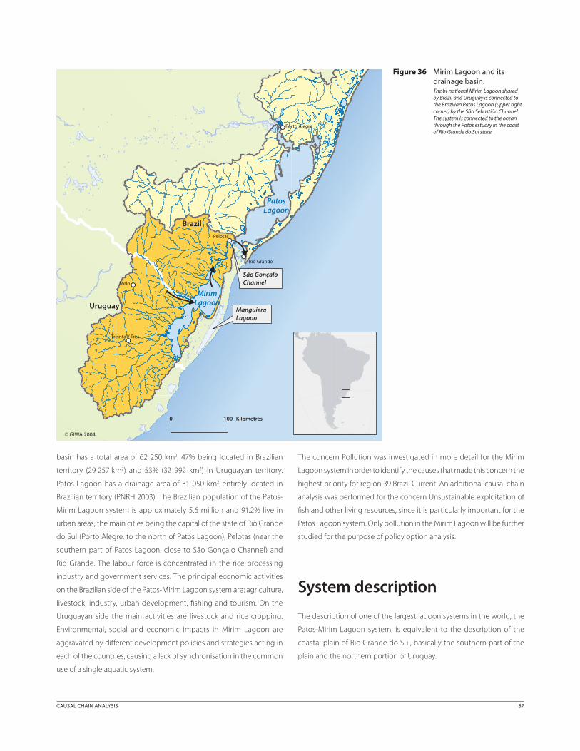
70 km wide (Figure 46).
In 1963 the Bi-national Commission for Development of the Mirim
Lagoon Basin (CLM) was created to promote development in this
catchment area, shared by Brazil and Uruguay. The strategic importance
of Mirim Lagoon is illustrated by the fact that it is considered one of the
most important freshwater resources in Uruguay.
Quaternary sand plains where sand dunes, lagoons, littoral fields and
swamps predominate represent the dominant landscape along the
southern Brazilian coast. Several economic activities such as fishing,
cattle raising, agriculture and tourism are well developed (Tagliani 2002).
The central landscape of the coastal area is dominated by the Patos-
Mirim-Mangueira Lagoon system, and this system constitutes one of
the largest lagoon systems in the world. It includes several temperate
habitats, saline wetlands, submerged fields and estuarine areas.
The shallow estuarine waters provide habitats that are essential to
coastal fishing in the south of Brazil, which in the past accounted for
approximately 25% of the total Brazilian catch.
Mirim Lagoon, together with the São Gonçalo Channel, is 185 km
long (in the south-north direction) with a total surface of 3 750 km2,
2 750 km2 (73% of the surface) in Brazilian territory, and 1 000 km2 (27%
of the surface) in Uruguayan territory. The Mirim Lagoon drainage
86 GIWA REGIONAL ASSESSMENT 39 BRAZIL CURRENT CAUSAL CHAIN ANALYSIS 87
basin has a total area of 62 250 km2, 47% being located in Brazilian
territory (29 257 km2) and 53% (32 992 km2) in Uruguayan territory.
Patos Lagoon has a drainage area of 31 050 km2, entirely located in
Brazilian territory (PNRH 2003). The Brazilian population of the Patos-
Mirim Lagoon system is approximately 5.6 million and 91.2% live in
urban areas, the main cities being the capital of the state of Rio Grande
do Sul (Porto Alegre, to the north of Patos Lagoon), Pelotas (near the
southern part of Patos Lagoon, close to São Gonçalo Channel) and
Rio Grande. The labour force is concentrated in the rice processing
industry and government services. The principal economic activities
on the Brazilian side of the Patos-Mirim Lagoon system are: agriculture,
livestock, industry, urban development, fishing and tourism. On the
Uruguayan side the main activities are livestock and rice cropping.
Environmental, social and economic impacts in Mirim Lagoon are
aggravated by different development policies and strategies acting in
each of the countries, causing a lack of synchronisation in the common
use of a single aquatic system.
The concern Pollution was investigated in more detail for the Mirim
Lagoon system in order to identify the causes that made this concern the
highest priority for region 39 Brazil Current. An additional causal chain
analysis was performed for the concern Unsustainable exploitation of
fish and other living resources, since it is particularly important for the
Patos Lagoon system. Only pollution in the Mirim Lagoon will be further
studied for the purpose of policy option analysis.
System description
The description of one of the largest lagoon systems in the world, the
Patos-Mirim Lagoon system, is equivalent to the description of the
coastal plain of Rio Grande do Sul, basically the southern part of the
plain and the northern portion of Uruguay.
Figure 36 Mirim Lagoon and its drainage basin.The bi-national Mirim Lagoon shared by Brazil and Uruguay is connected to the Brazilian Patos Lagoon (upper right corner) by the São Sebastião Channel. The system is connected to the ocean through the Patos estuary in the coast of Rio Grande do Sul state.
Uruguay
Brazil
São GonçaloChannel
ManguieraLagoon
PatosLagoon
MirimLagoon
Yaguarón
Pelotas
Rio Grande
Melo
Porto Alegre
Treinta Y Tres
0 100 Kilometres
© GIWA 2004

88 GIWA REGIONAL ASSESSMENT 39 BRAZIL CURRENT CAUSAL CHAIN ANALYSIS 89
Location, demographic settings and sanitationPatos Lagoon (30° 30’S and 32° 12’S) has a surface area of approximately
10 150 km2, and is 250 km long and 40 km wide. It is relatively shallow,
with mean depths of 5 m. It is connected to the Atlantic Ocean through
the Barra do Rio Grande channel, which is 20 km long, 1 to 2 km wide
and 12 m deep. The small tidal range of 0.32 m at the mouth of the
Lagoon limits the intrusion of salt water, which reaches only to a point
known as Ponta da Ilha da Feitoria. Seawater can penetrate further
north when the water level of the Patos Lagoon is low (Calliari &
Tagliani 2000a). The Patos-Mirim Lagoon system on the Brazilian side
is responsible for a GNP of 5.5 billion USD, corresponding to 24% of the
total GNP generated by all the 467 municipalities of Rio Grande do Sul
state (IBGE 2000). Some of the main cities of Rio Grande do Sul state,
such as Porto Alegre (the capital, in the north of Patos Lagoon), Pelotas
(in the southern segment of the Patos Lagoon) and Rio Grande (in the
estuarine region) are located in this region (Calliari & Tagliani 2000a).
In 2002, the whole basin of Patos Lagoon had an urban population of
4 778 870 and a rural population of 434 979 inhabitants (PNRH 2003).
The Brazilian population of Mirim Lagoon/São Gonçalo Channel Basin
includes an urban population of approximately 306 708 inhabitants,
whereas only 53 203 persons live in the rural area (PNRH 2003). The
fraction of town dwellers in these two basins (Patos and Mirim) is
higher than 85%. According to PNRH (2003), 93.1% of the households
are connected to the water supply system, a figure that is higher than
the Brazilian national average (89.2%). However, sewerage covers only
12.1% of the households in Rio Grande do Sul, which is well below the
national average (52.5%). The percentage of sewage treated in the
state of Rio Grande do Sul is even lower (6.4%), well below the national
average (20.7%).
The São Gonçalo Channel connects the Mirim and Patos lagoons from
southwest to northeast. The channel is 62 km long, 200 to 300 m wide
and 6 m deep. A port at Pelotas, bridges and a dam are located on this
channel. The flow in the channel can be in both directions, depending
on the water levels in the lagoons and the wind. A dam was constructed
to prevent saltwater intrusion into the Mirim Lagoon during drought
periods.
Mirim Lagoon’s eastern boundary is the Atlantic Ocean, over 250 km,
from the fortress of Santa Tereza (department of Rocha in Uruguay) up
to the Rio Grande Bar (Rio Grande do Sul state in Brazil). To the north,
the boundary is an arc that extends from the municipality of Rio Grande
to Canguçu; to the west, from Canguçu to Bagé, following the dividing
line of the departments of Cerro Largo and Treinta y Tres. To the south,
it is limited by part of the dividing line between the department of
Lavalleja, and in an arc from Piraraia to the fortress of Santa Tereza.
The Brazilian side corresponds to the areas of the municipalities in the
far south of the state of Rio Grande do Sul, while the Uruguayan side
includes the departmentos in the north and northeast of the country.
The municipalities on the Brazilian side of Mirim Lagoon Basin are:
11 municipalities existing before the 1960s: Santa Vitória do Palmar,
Rio Grande, Pelotas, Jaguarão, Herval do Sul, Arroio Grande, Pedro
Osório, Pinheiro Machado, Piratini, Canguçu and Bagé, plus another
nine municipalities created after 1960. On Uruguayan territory, there
are five departamentos (political and administrative units): Cerro Largo,
Treinta y Tres, Lavalleja, Rocha and Maldonado. In 1995, the total
Uruguayan population of the Mirim Lagoon Basin was 185 000. The rural
population is widely dispersed, only 1.09 inhabitants/km2. Most rural
dwellers depend on livestock activities. Some 80% of the population
lives in urban centres of which three have more than 25 000 inhabitants,
13 have 1 000 to 10 000, and 17 have fewer than 1 000 inhabitants.
The rice industry is an important business for these smaller towns and
cities whose populations provide various business services and urban
amenities - housing, electricity, water, sanitation and communications
- with the labour force in jobs created by local government. Along
the Atlantic coast, tourism is increasingly the mainstay of income
generation.
Geology and geomorphology The evolutionary history of the Patos-Mirim Lagoon system was
decisively influenced by the development of a complex multiple
barrier, resulting from eustatic changes in the sea level during the
Quaternary (Villwock 1984). At least four successive transgressive-
regressive cycles deposited discontinuous sand barriers parallel to the
coast. Littoral transport generated by waves progressively isolated the
lagoon system, except for the channel, through which the waters of the
extensive drainage basin reach the ocean. In general, the system can
be classified as a partially closed lagoon (Calliari et al. 1998). At the peak
of the transgressive process, which took place during the Holocene
(5 100 BC), a higher sea level formed a marine abrasion cliff on the
Multi-complex barrier, as well as in the lagoon terraces existing at the
margins of the Patos-Mirim. The following regression closed the barrier
(isolating the Patos Lagoon system) through the deposition of the last
barrier (Barrier IV). This last event also allowed the installation of a retro-
barrier lagoon system, the best known of which is Mangueira Lagoon
in the extreme southern portion of the coastal plain. The vast lagoon
terraces along the São Gonçalo Channel, as well as a complex system of
elongated sand spits formed during this last event (Calliari 1997, Calliari
& Tagliani 2000a).

88 GIWA REGIONAL ASSESSMENT 39 BRAZIL CURRENT CAUSAL CHAIN ANALYSIS 89
Hydrography There are three main lagoons in the area: Patos, Mirim and Mangueira,
and an additional number of small lagoons distributed along the
coastline. These water bodies receive waters from the two drainage
basins (Patos-Mirim) which cover 60% of Rio Grande do Sul state and
a small portion of the Uruguayan territory. All of this water, after being
collected by the lagoonal bodies on the western border, is discharged
into the Atlantic Ocean via the Rio Grande Channel (Calliari & Tagliani
2000a).
On the Uruguayan side, the strip of land between the Mirim Lagoon
Basin and the Atlantic Ocean is named in Spanish Vertiente Atlántica
and is numbered as 89 in Figure 2. The eastern border of both
lagoons (Patos and Mirim) is characterised by a long sandy strip,
which extends laterally to the ocean. Since it is a flat area and has a
high permeability and porosity, the drainage pattern is poor. Major
watercourses are insignificant. However thousands of small washouts
(ephemeral creeks), which drain the dune fields, located behind the
frontal dunes, contribute with significant amounts of freshwater and
sand size sediment to the surf zone. Both the ephemeral creeks and all
the other small water bodies represented by ponds and swamps play
a very important ecological role for the coastal avifauna. To the west
of the lagoon system the drainage network is very different, being a
transition between the highlands of the shield and the low flat areas
of the coastal plain. The main watercourses are directed from west to
east. The more important watercourses that enter the coastal lagoon
system include the following rivers from south to north: Jaguarão or
Yaguarón in Spanish (the River that defines the border between Brazil
and Uruguay and therefore is a bi-national river), Piratini, Pelotas, Turuçu
(Arroio Grande), Camaquã and Jacuí. As they reach the low flat areas of
the coastal plain, close to the regional base level, they start to meander
in open valleys with weak currents. The sediment load (mainly sand)
is deposited in such areas. Uruguayan rivers which flow into the Mirim
Lagoon are: San Miguel, San Luis, Estero, Pelotas, Tacuarí and Cebollatí
- with its tributaries Altérez, Olimar and Parao.
The São Gonçalo Channel, which connects the Mirim Lagoon to the
Patos Lagoon, is exceptionally important from several environmental
and socio-economic standpoints since it is the only outflow of Mirim
Lagoon. Until 1977, when a dam was built, salinisation problems were
common, causing serious problems to the rice cultures irrigated by its
waters. Additionally, the potable water for Rio Grande municipality
came from the São Gonçalo, through a 20 km long constructed channel.
Except for sandstone, basalt and volcano-clastic rock formations near
29°, which offer a certain degree of shelter, the 653 km long coastline
between 29° S and 35° S is totally exposed. Beaches are composed of
fine quartz sand, and most (95%) have a low gradient. Only a 45 km
stretch of shore south of Albardão lighthouse (33° S) is composed of
coarse shell fragments and fine quartz sands. These beaches display a
higher gradient (4°), erosional scarps at the backshore, and frequently
well developed beach cusps (Calliari & Klein 1993, Calliari & Klein 1995,
Klein & Calliari 1995, Seeliger et al. 1997). Based on morphodynamic
characteristics, the beaches are considered generally intermediate, but
immediately south of 32° and 33° S the beaches are dissipative and
intermediate/reflective, respectively.
The Mirim Lagoon has a mean annual flow of 440 m³/s and Patos
Lagoon, 647 m³/s. The mean specific flow of Mirim Lagoon is 15 l/s/km2
and Patos Lagoon is 21 l/s/km². Sediments of fluvio-marine and aeolian
origin associated with acid and basic volcanic rocks predominate in the
portion corresponding to the Patos-Mirim Basin, located in Rio Grande
do Sul. The sediments form porous aquifers, with a mean discharge of
2 m³/h, which could possibly reach 10 m³/h (PNRH 2003). The
productivity of the groundwater wells increases in the area of the
Guaraní Aquifer (mainly located in GIWA region 38 Patagonian Shelf),
with discharges ranging from 30 to 70 m³/h. The volcanic rocks form
fractured aquifers, with wells having flows ranging from 5 to 50 m³/h
(PNRH 2003). Along the whole coastline of the basin, there are porous
aquifers associated with marine and alluvial sediments, with wells
discharging around 5 m³/h. In these regions there is a risk of saline
intrusion and the aquifer is highly vulnerable to contamination
(PNRH 2003). The situation concerning water availability and demand
for the Patos-Mirim system is presented in Table 17. The total water
demand in the Patos Lagoon Basin is 62.8 m³/s, which is 9.7% of the
mean flow in the Basin. The total demand is higher in the Mirim Lagoon/
São Gonçalo Basin, 101.3 m3/s. Of the two lagoons, irrigated agriculture,
particularly for rice fields, imposes the highest pressure on the water
resources.
Table 17 Water demand in Patos Lagoon and Mirim Lagoon basins.
DemandPatos Lagoon basin Mirim Lagoon basin
m3/s % m3/s %
Human 0.4 0.6 1.1 1.1
Animal 0.9 1.4 0.8 0.8
Irrigation 61.1 97.3 98.4 97.1
Industrial 0.4 0.6 1.0 1.0
Total 62.8 100 101.3 100
Mean annual flow (m3/s) 647 440
(Source: PNRH 2003)

90 GIWA REGIONAL ASSESSMENT 39 BRAZIL CURRENT CAUSAL CHAIN ANALYSIS 91
Climate According to IBGE (1986), the climate in the state of Rio Grande do
Sul is characterised by the presence of abundant rainfall, without
defining the existence of a dry period throughout a normal year. The
total annual mean precipitation varies from 1 200 mm in the littoral
strip to 1 700 mm in the northern areas of the state. The climate in the
coastal area, between latitudes 29° and 34° S, is controlled by the high
pressure centre of the South Atlantic anticyclone, whose latitudinal
migration causes the injection of polar air into the lower latitudes
(polar frontal system) at 6 to 10-day intervals, modifying and influencing
the seasonal cycle of the climate. The closeness of the sub-Tropical
Convergence Zone and the stabilising influence of the Patos-Mirim
Lagoon system give the coastal region a temperate-warm and marine
characteristic. Associated with the fauna and flora distribution pattern,
it characterises a temperate-warm biogeographical transition zone
(Klein 1998, Seeliger & Costa 1998). The inter-annual rainfall variations
in the southwest Atlantic, with long periods of rain or drought, appear
to be associated to the effects of the El Niño Southern Oscillation
Cycle effects over the global climate (see Assessment, Global change),
directly influencing the amount of continental freshwater discharged,
and therefore the biogeochemical processes in coastal and marine
ecosystems of the Southwest Atlantic (Klein 1998). In the Köppen
classification, the Rio Grande do Sul coastal plain is included in type “C”
(sub-tropical and humid), characterised by a mean annual temperature
of 17.5°C, January and February being the warmest months and June
and July the coldest (Moreno 1961). Wind is the main agent responsible
for the coastal dynamics since it acts markedly on the development and
migration of the coastal dune field. The strong influence of the South
Atlantic Anticyclone determines a wind regime for the south coast of
Brazil, with a predominance of winds from the northeast quadrant in
the months of spring and summer, and of the west-southwest winds
in the winter months, associated with the passage of cold fronts
(Tomazelli 1993). The Holocene dune field of Rio Grande do Sul, with
a mean width ranging from 5 to 8 km along the more than 600 km
coastline, according to Tomazelli (1993), corresponds to one of the
most significant active eolian systems in Brazil. The age of the dune
field was estimated as less than 1 500 years which is interpreted as
possibly resulting from a rise in the relative sea level, associated with
a tendency to coastal erosion, making sediments previously retained
by embryonic and frontal dunes available (Tomazelli 1993). The dune
field is controlled by a system of high-energy winds, whose dominant
direction (northeast-southwest) drives the free dunes inland, at a
rate of 10 to 38 m/year, transgressing over lagoons, lakes, and coastal
swamps. This situation, which is responsible for the segmentation of
many lagoons in a rosary along the coast, creates a critical situation for
one of the ecologically most important areas for the migratory cycle
of sea birds and coastal birds in the south of Brazil - the Peixe Lagoon
National Park, in the municipality of Mostardas, state of Rio Grande
do Sul. Climate instability is the cause of loss of productivity in these
sectors, as well as of disturbances in urban life (frequent flooding) and
in the health of the population (Calliari & Tagliani 2000b).
The portion of Mirim Lagoon basin in Uruguayan territory is defined as
temperate-humid “Cfa” type, according to Köppen’s classification. The
average annual temperature is 19°C. The rainfall reaches an annual value
of 1 400 mm in the northeast, the boundary between Uruguay and
Brazil, which is considered the region with the highest average rainfall
in Uruguay (Corsi 1978).
Soil The soil distribution on the coastal plain displays a more or less
uniform pattern with a distribution roughly parallel to the current
coastline (Delaney 1962). This suggests firm control by the geological-
geomorphologic evolution of the region. Generally, the higher areas
of the crystalline basement to the west are characterised by the
predominance of non-hydromorphic soils, with abundant rock outcrops
which are not recommended for agricultural purposes. In the transition
from the coastal plain, the wavy topography characterises the “coxilhas”
formed by rocks of granitic composition where the yellow-red podzolic
soils predominate. Such soils are moderate to well drained, with variable
fertility and there is some restriction to their use due to their high
susceptibility to laminar erosion. In these regions, agriculture plays a
significant role and some areas have actually been used as multi crop
areas by small properties (BDT 2001). In the Quaternary sedimentary
domain, the gentle relief displays elevations ranging from 20 to 60 m.
In such areas the hydromorphic minerals (plain-soils with low humidity)
predominate. These areas are highly favourable to annual rice cultures
which are periodically irrigated. On the inundated plains, at the border
of the lagoon bodies, hydromorphic diversified soils occur. Due to the
high risk of inundation (saltwater intrusion in the Lagoon) they are used
as pasture for cattle during the summer months. In the barrier islands
region at the lagoon margins there is a widespread use of lagoon
terraces for irrigated rice culture (Tagliani 2002). Soils with medium
fertility and poor drainage consist of a mixture of fine sand and clay. The
higher areas, corresponding to the Pleistocene marine barriers, are used
for grasslands (cattle) and onion crops on small properties. In partly
flooded areas (beach ridges of Rio Grande), and the borders of the sea
and lagoon, the soil is too sandy for agriculture (hydromorphic podzol
and quartzy sands), but extensive portions of these areas are being
used for forest plantation of Pine. The quartzy sands of the beaches and
dunes do not have any potential agricultural use, although they are of
value for conservation. The constantly flooded plains are constituted
90 GIWA REGIONAL ASSESSMENT 39 BRAZIL CURRENT CAUSAL CHAIN ANALYSIS 91
from completely sandy and clayey soils, badly to very badly drained
(humic gley, not very humic gley, thiomorphic organic soil, solonchack,
hydromorphic podzol), that are also not appropriate for agriculture and
are only used for livestock in the summer months (Tagliani 2002).
Vegetation The combination of geological, geomorphological, climatic, hydrologic
and pedological attributes, as discussed above, determines the
composition of plant cover in the region. A survey performed by
Tagliani (2002) for the central portion of the coastal plain, identified
a pattern of distribution for the vegetation and current land use. The
survey generally describes the situation found throughout the coastal
plain, especially as regards current uses. The vegetation of the Pioneer
Formation Areas (IBGE 1986) is typical of the first occupation phases of
new soils, and is independent of the climate and sparsely distributed
throughout the coastal plain. The species may be non-woody and
woody with a variable range of botanical forms adapted to the different
soil conditions. None of the 1 072 species of Phanerogams analysed by
Rambo (1954) is endemic, and non-woody species of the central Brazil
savannahs predominates (Tagliani 2002).
In the areas of marine influence, the distribution of the plant community
shows a direct association with the geomorphology. This in turn has
conditioned the development of different soils in the region. The relief
in this area shows a great variety of forms, reflecting not only the origin
of the Quaternary region, but also the high natural dynamism induced
by the wind. Even with the micro changes in the relief, which favour
the preferred location of woody or non-woody species, the region is
relatively homogeneous in the floristic sense. With the exception of a
few woody species, the areas that are not flooded are wide fields formed
mostly by grass, rushes (juncos) and cyperaceous. The anthropogenic
activities have strongly modified the natural landscape, characteristically
represented by cattle and rice and onion cultures, besides the
intense use of land for pine. The woody species are associated with
watercourses, in the primary forest, at the side of the barrier, scarps and
lagoon terraces (Tagliani 2002, Calliari & Tagliani 2000a).
Forest plantation with exotic species occupies a large area. Pine is
more frequent than Eucalyptus. Both occupy old sandy fields. In
São José do Norte city, the pine forests occupy an area of 12 839 ha
and the eucalyptus only 2.6 ha. However, in the city of Rio Grande, the
area occupied by pine is about 2 727 ha, while eucalyptus occupies
only discontinuous areas with a total of 5 094 ha. The pine forests in
both municipalities were planted preferentially over obliterated dunes
and eolian aspersion sheets behind the active dune fields (Calliari &
Tagliani 2000a).
The wetlands are an important element in determining the natural
landscape, and constitute low altitude water-saturated areas, lying on
quaternary plains and covered with hydrophilic vegetation. With the
intense dynamics resulting from the physical process operating in the
area, there is a growing tendency to increase the wetlands as a result
of the transgressive sand sheets. The vegetation, which grows over
the unconsolidated quartz sands, constitutes a continuous strip along
the barrier island. Non-woody plants exclusively colonise the coastal
foredunes, whilst woody climax vegetation is restricted to older inland
dunes (Seeliger et al. 1997). Owing to the recent formation of the
coastal plain, most species are migrants from neighbouring provinces,
and endemic species are rare. The terrains that lie more distant from
the coastline, as well as the obliterated dunes, display a higher diversity
and biomass mainly due to a more stable substrate which is under the
influence of the water table. Seeliger (1992) identified 71 foredune
species which exhibit perennial, as well as annual species (Cordazzo
& Seeliger 1987). In the Uruguayan portion of the Mirim Lagoon, those
wetlands still preserved are extremely important resting sites for birds
such as Phimosus infuscatus and Plegadis chihi (Threskiornitidae). Field
surveys have identified 500 members of Phoenicopterus chilensis, 262
Cygnus melanocoryphus and 293 Coscoroba coscoroba, 1 563 Anas
georgica and 1 804 Dendrocygna bicolour (Menegheti 1998).
The littoral fields represent the predominant vegetation community
in regional terms. They include all the non-woody formations of low
height and similar taxonomic composition according to the habitat
occupied. The geomorphology occupied by these fields includes
terraces, barriers, eolian sheets, obliterated dunes and beach ridges.
Changes in composition and structure are due to well-defined soil-
related factors. The native forests are characterised by a restinga (coastal
sandspit) forming elongated narrow clusters parallel to the coastline
(Calliari & Tagliani 2000a).
Intertidal marshes occupy the island borders and margins of the Patos
Lagoon estuary, and are essentially flooded by brackish water, and
occupied by annual and perennial tidal marsh and wetland plants
(Costa & Davy 1992). According to Costa (1987), there are approximately
70 species in the lower estuarine marsh flora. This community plays an
essential role in the stability of the substrate, controlling erosion, serving
as habitat for several organisms and constituting an important source
of detritus for the estuarine food chain (Cordazzo & Seeliger 1998). This
plant community is found predominantly in the estuarine portion of
the Patos Lagoon around the city of Rio Grande, where it occupies an
area of 59 km2.

92 GIWA REGIONAL ASSESSMENT 39 BRAZIL CURRENT CAUSAL CHAIN ANALYSIS 93
Economy Due to better access, the north coast of Rio Grande do Sul state has
the most popular bathing resorts, giving rise to a more homogeneous
urban settlement along the coast. As one moves away from the
coastline towards the slopes of the Serra do Mar Mountains, agriculture
and livestock activities are developed on small properties. It should be
mentioned that fishing is a highly important and traditional activity
throughout the lagoon system. It is the oldest economic activity in the
region, involving, throughout the system, a large number of artisanal
fisheries. The development process that this region underwent, allowed
industrial fishery plants to be established in the municipality of Rio
Grande, and the mode of fishing became industrial. Fishing activities
have an economically important role in creating income and jobs in
the region. The presence of the Rio Grande Channel, which connects
the Patos Lagoon and the Atlantic Ocean in the extreme south of Brazil,
enabled the development of port activities, and consequently the
setting up of various industries (fertilisers, oil/petrol, fishing, soybean
derivates, etc.). They constitute an industrial district in the municipality
of Rio Grande, which is very important in the socio-economic context
of the Patos-Mirim Lagoon region as it creates income and jobs. In
terms of agricultural aptitude, a large part of the area studied consists
of soils for annual crops, and approximately 3 500 000 ha are potentially
suitable for rice cultivation. The crop stands out as the main activity
developed in the Patos-Mirim Lagoon system, especially in the Mirim
Lagoon Basin (both on the Brazilian and the Uruguayan side), where
irrigation represents the main water demand. Most of the water
consumption comes from the cultivation of rice by flooding. The
increasing importance of the rice cultivation for the economy of the
state of Rio Grande do Sul is illustrated by the fact that in 2002/2003,
rice cultivation in Rio Grande do Sul occupied 951 000 ha and produced
5 million tonnes. Compared to the values registered during the 1920s
(1922/1923), these figures represented an increase of 2.5 times the
productivity, 11.2 times the cultivated area and 27 times the total annual
production (Agroagenda 2003).
Environmental impacts Among environmental impacts acting on the Patos-Mirim Lagoon
system, there are those that are due to natural causes and those that
are due to anthropogenic activities. The main immediate causes of
environmental impacts are sea level rise, agriculture and livestock. In
the Uruguayan portion of Mirim Lagoon Basin, for instance, there are
significant wetland areas replaced by rice plantation, which has caused
habitat and community modification as well as pollution related to
changes in the sediment transport dynamics, nutrients and chemical
pollutants run-off from agriculture areas.
Suspended solids transport/sedimentation dynamics
Erosion along with other immediate causes have produced loss of
habitats in the Patos-Mirim system. The vulnerability of the Lagoon
system and its adjacent lands to sea level rise was briefly addressed
by Muehe and Neves (1995a, b). Besides erosion in the coastal area,
sea level rise causes an increase in salt water intrusion with impacts on
fisheries and water uses such as irrigation. The major impacts related to
erosion are loss of habitat and loss of public and private property. The
combination of mesoscale tropical storms and tides of larger amplitude
produce marked erosion along the Rio Grande do Sul coastline and
along the margins of the lagoons. Such a combination has a greater
probability of occurring during April and May. Many areas of the Patos
estuary are undergoing severe erosion processes, especially around the
islands of Torotama (Figure 37) Leonídio, the beaches of Laranjal and the
inner portion close to the Patos Lagoon inlet (Calliari & Tagliani 2000b).
Deforestation is present throughout the Patos-Mirim system. The areas
have been occupied with livestock, agriculture and urban areas. This
resulted in the releases of large amount of suspended solids, ultimately
changing the water quality and increasing the turbidity. Increasing
sedimentation also requires more frequent dredging, aggravating the
Table 18 Main economic activities in the Patos-Mirim Lagoon system.
Sector Economic activity
Primary sector
AgricultureDeforestation/Reforestation with Pinus and Eucalyptus. Production of rice, soybean, corn, vegetables, greens and fruits, annual crops.
Livestock Breeding of cattle, pigs and sheep.
Fishing Fishing activity - fish catch.
Secondary sector
IndustryRice processing, chemistry (fertilisers), oil production, food, tanneries etc.
Tertiary sector Tourism/Port Trade and services.
(Source: PNRH 2003)
Figure 37 Erosion at Torotama Island. (Photo: Lauro Júlio Calliari)

92 GIWA REGIONAL ASSESSMENT 39 BRAZIL CURRENT CAUSAL CHAIN ANALYSIS 93
sediment erosion-transport-deposition cycle. Siltation causes loss of
habitats in the Patos-Mirim system and impacts on navigation activities,
which require more frequent dredging, increasing the frequency
of impacts on the quality of water, particularly turbidity with great
influence on primary productivity and the trophic chain (PNRH 2003).
Inadequate occupation of flood plains or lakes and rivers
Floods frequently occur in the Patos-Mirim basin and they affect mainly
the low-income populations living in the cities. They are usually the
result of inadequate occupation of the flood plains. Periodical floods
occur on the large flood plains around the lagoon systems and the main
water courses affecting over 500 000 ha in a 10 to 15 year period. Low-
income neighbourhoods on the outskirts of cities occupy regions that
are not appropriate for housing, causing deforestation, which worsens
erosion, among other effects.
Discharge of untreated domestic sewage and industrial
effluents and agriculture run-off
The discharge of untreated domestic sewage and industrial effluents is
concentrated mainly in the Patos Lagoon in the region of Pelotas and Rio
Grande municipalities in Brazil. With urban and industrial development,
there has been a significant increase in the emission of these effluents.
The level of effluent treatment is very low, significantly compromising
the quality of surface sources of water. The contamination caused by
the excessive use of pesticides and fertilisers on the rice crops, although
not fully studied in the Patos-Mirim system, is another important factor
that involves environmental aspects of chemical pollution.
Unsustainable exploitation of fish
The impacts on fish and fisheries must also be considered for the
Patos-Mirim system. Chemical pollution in the lagoon system may
contribute to the reduction of fish stocks, aggravating the impacts of
inappropriate fishing practices, which have been used throughout the
economic development of the Patos-Mirim system, constituting a risk
of extinction of these resources.
Besides reduction of fish stocks, changes in the composition of species,
biological diversity, the food chain structure, as well as the extinction of
fish species have been observed, especially those with high commercial
value. Especially in the Patos Lagoon, overexploitation of fish has been
one of the main environmental problems. Over the years, urbanisation,
development of fishing technologies and processing, and market has
put pressure on the natural resources. This affects the lagoon system by
extinction and change in the species composition, as well as impacting
the living resources of the sea, which is related to changes in the food
web and in biological diversity.
Socio-economic impactsSocio-economic impacts identified in the Mirim Lagoon and addressed
in the Causal chain analysis are mainly associated to pollution due to
land use, in which there is an outstanding presence of rice plantation,
cattle and pig raising and urban development, the latter more intense
in the Brazilian portion of the Basin. In Patos Lagoon, in addition to the
mentioned activities, industrial development and tourism are placed
among the important economic activities. The socio-economic
impacts described below are associated with the concern Pollution
and also with Habitat and community modification and Unsustainable
exploitation of fish. The socio-economic impacts are:
Higher cost of water treatment due to pollution, since all the water
that supplies the city of Rio Grande, for instance, comes from the
São Gonçalo Channel and Mirim Lagoon;
Increasing health risks and costs associated with pollution affecting
the population that lives in the Patos-Mirim Basin;
Increasing risk to human health and costs associated with flooding
and irregular occupation of coastal areas in the Patos-Mirim
system;
Increasing risks of international conflicts, as a consequence of the
deterioration of the water quality in the bi-national water body
Mirim Lagoon;
Transaction costs involved in the negotiation processes of water
use in order to treat different types of pollution, and to solve
institutional conflicts inherent to fishing activities;
Fewer options for the development of tourist activities (ecotourism)
and aquaculture, since loss of significant wetland areas, the
presence of erosion, chemical pollution and nutrient discharge
modify the quality of the water resources. The aesthetic value,
which is a crucial factor for tourism may also be reduced;
Loss of income due to the unsustainable exploitation of fish in
the region. The economic impact shows itself in lower catches in
extractive fishing, especially of fish with a high market value. The
social impact of overexploitation practices is poverty for most of
the people in the sector i.e. the artisanal fishermen, who have no
alternatives for income at present.

94 GIWA REGIONAL ASSESSMENT 39 BRAZIL CURRENT CAUSAL CHAIN ANALYSIS 95
Methodology
The methodological procedure to assemble the causal chains for
Pollution and Overexploitation of fish in the Patos-Mirim Lagoon
system consisted of: (i) system characterisation (site, geography, soil,
vegetation, climate, hydrography); (ii) identification of the predominant
socio-economic activities in the study area; (iii) identification of the
main environmental impacts due to the pressures exerted by the
economic activities; and (iv) identification of the main socio-economic
impacts present in the Patos-Mirim Lagoon system and their links to
the environmental impacts. The immediate causes and the economic
activities that generate the environmental and socio-economic
impacts were identified. Considering the information collected (socio-
economic/environmental impacts, activities in different sectors and the
links between them), the root causes common to the environmental
problems were identified.
Throughout the Patos-Mirim system inadequate land occupation in the
estuarine areas is common, mostly associated with the phenomenon
of urbanisation in the Patos Lagoon basin and agriculture/livestock
in Mirim Lagoon basin. Erosion and sedimentation/silting processes
are derived from land use, and cause serious environmental impacts,
especially loss of habitat in the system. The Mirim Lagoon Basin
was occupied with livestock, and this was the predominant activity
throughout the economic development process until recently, when
rice fields expanded in the Basin. In contrast, in Patos Lagoon, industrial
and port activities have historically been the most important activities.
In this context they are important in order to identify root causes of
pollution. These two economic activities are concentrated in the
municipality of Rio Grande. The discharge of industrial effluents from
e.g. fertiliser-producing plants and oil refineries into the estuary of Patos
Lagoon without appropriate treatment is responsible for contamination
of the lagoon with heavy metals and other substances.
Causal chain analysis for Unsustainable exploitation of fish – Patos Lagoon
One of the concerns chosen for Causal chain analysis in the Patos-
Mirim Lagoon system was unsustainable exploitation of fish (Figure 38),
which is an environmental concern of highest importance worldwide,
Increased vulnerability to
invasion by alien species
Economic High market value of some species
leading to the increasing pressure
DemographicHigh concentration of people, particularly in
the Patos Lagoon Basin
TechnologicalImproper use of the available technology
Knowledge Deficient education
and training on sustainable
exploitation of fish
Urbanisation Increasing
regional/localmarkets and consumption
FisheriesIncreasing fleet
and pressure over the fish
stocks
IndustryIncreasing
demand of raw material for the food industry
Excessive effort over species with high market value
Discharge of pollutants and
increasing nutrient discharge
Over- exploitation
Excessiveby-catch and
discard
Reduced capacity to meet
human needs (food)
Loss of income
Potential risk for conflicts between
users and countries sharing
the aquatic system
Loss of recreational
values
Changes in the aquatic food web
Depletion of key species
Changes in the aquatic habitats and community
structure
Aquatic ecosystem degradation
Employment reduction
Institutional weakness, leading
to lack of enforcement
Socio-economicPoverty among
artisanal fishermen
GovernanceLack of
implementation of an integrated
bi-national management plan
AgricultureRun-off of
pesticides and fertilisers from
agriculture areas
Impacts on the biological and
genetic diversity
Destructive fishing
practices
Decreasing fish viability due to
pollution and diseases
Loss of cultural heritage
Unsustainable exploitation of fish and other
living resources
Socio-economic impacts
GIWA concern
Environmental impacts
GIWA issues
Immediate causes
Sectors/ Activities Root causes
Figure 38 Causal chain diagram for the concern Unsustainable exploitation of fish and other living resources in Patos-Mirim Lagoon system.

94 GIWA REGIONAL ASSESSMENT 39 BRAZIL CURRENT CAUSAL CHAIN ANALYSIS 95
addressed by the United Nation Conference on Environment and
Development (Chapter 17 in UNCED 1992). As mentioned previously
in this section, fishing activities are very important in the Patos-Mirim
system, particularly in Patos Lagoon, in various ways: social, historical,
cultural, environmental and economic. Since the end of the 19th century,
fishing has been an economic activity in the region. Fishing activities
benefit from the migrations of crustaceans and fish into and out of
the Patos Lagoon estuary. This estuary is the most important breeding
and growth area for most of the fish and crustaceans commercially
exploited on the southern coast of Brazil (Chao et al. 1986). This region
concentrates most of the subsistence and small-scale (artisanal) fishing
in the south (Chao et al. 1986, Reis 1994). More than 90% of the total catch
of artisanal fishing in the state of Rio Grande do Sul comes from Patos
Lagoon and the adjacent coast. The landed catch of artisanal fishing of
teleostei fish and the adjacent marine region ranges from 43 705 tonnes
(1972) to 13 121 tonnes (1989), and at one point represented 42.6% of the
total catch landed in the port of Rio Grande. However, in recent years,
this type of fishing has undergone a strong decline and is now simply
an alternative means of subsistence (Reis 1994, Haimovici et al. 1998).
The current picture is so serious that, according to data from CEPERG/
IBAMA (Monteiro & Caldasso 2001) the mean catch landed by artisanal
fishing in Patos Lagoon and the adjacent marine region, during the
period from 1998 to 2001, was 8 396 tonnes per year, which is a fraction
of historical levels. Artisanal fishing in the estuary, which at one time
point involved approximately 10 000 fishermen, now involves less than
4 000 (Reis et. al. 1994, Reis & D’Incao 2000). Reis (1994) ascribes the
current low landings to factors such as the high proportion of juveniles
captured, the fishing of adults during reproductive periods, overfishing,
and environmental degradation.
According to Abdallah (1998), the introduction of synthetic nets and
modern transport and storage, after 1945, and the federal public
policy of incentives to fishing in Brazil, implemented in the mid-1960s,
contributed to the current state by encouraging increased production,
without taking into account the size of the fish stocks. This, together
with the lack of research and planning, the use of inadequate
fishing methods and the lack of enforcement, caused the collapse
of estuarine stocks of miragaia, corvina and bagre (catfish) by the
1970s. One of the main fishing products in the Patos Lagoon Estuary
is now the pink shrimp, camarão-rosa (Penaeus paulensis). A region in
the Patos Lagoon Estuary recognised as having a high potential for
the natural production of camarão-rosa is the Saco da Mangueira, an
environmental conservation area located near the access channel to
the port of Rio Grande and next to an urban area occupied by dense
industrial activities e.g. fertiliser industries, oil refinery, soybean oil
processing plant, and others. In this context, effects on the Patos
Lagoon estuary are clearly seen, specifically in the Mangueira Lagoon.
Industrial and domestic effluents are constantly discharged into the
Patos Lagoon Estuary due to the lack of public sanitation and sewage
treatment. Landfill and clandestine/irregular occupations without any
kind of urban infrastructure are common on the banks of Mangueira
Lagoon. Different types of solid waste are disposed into this lagoon,
which causes bad odours and pollute the site, affecting the health of the
people living on the banks (EIA/PRG 1998). This scenario contributes
also to the reduction of camarão-rosa viability. This information
supports the identification of root causes for the concern Unsustainable
exploitation of fish, which are shown in the causal chain (Figure 38) and
are briefly discussed below.
Root causesDemographic: High concentration of people
There are high concentrations of people, particularly in the Patos
Lagoon Basin. Larger population encourages illegal fishing, both
because of the market pressure in order to obtain more products
for consumption and due to the possibility of working in a segment
inherent to the Patos-Mirim Lagoon region: artisanal fishing.
Economic: Market pressure
The existence of a strong market for fishing products has contributed
over time to more dynamic economic mechanisms to boost fishing
activities. Because of the possibilities of revenues from fishing, the
fishing economy became strong and production increase-oriented.
Because this was done in a disorganised way it led to a process of
economic self-destruction and, especially, to the exhaustion of the
environmental resource (due to overexploitation).
Technological: Improper use of technology
One of the root causes that culminate in the unsustainable exploitation
of fish is the presence of modern technologies at the disposal of the
fisheries process. As instruments and boats were developed with
equipment to find and catch fish faster, there was higher production.
However, many of these technologies are not sustainable, for instance,
in terms of the ideal size of the fish captured, and therefore these
improvements render the fish extinct.
Governance: Lack of implementation of a bi-national integrated
management plan
In order to achieve sustainable fishing in the Patos-Mirim Lagoon
system legitimacy and effectiveness of an integrated management
plan is required. This plan should involve both Uruguay and Brazil.
Currently, isolated measures are observed, such as establishing periods
of closed fishing season, based on agreements among a number of
96 GIWA REGIONAL ASSESSMENT 39 BRAZIL CURRENT CAUSAL CHAIN ANALYSIS 97
stakeholders. These initiatives, although positive, are insufficient to
eliminate overexploitation and destructive practices and to change
the mindset in the fisheries sector. There is a proposal to integrate
the different segments involved in this activity but, in practice, few
really participate, and there are mainly isolated actions. In a complex
productive system, those actions do not have the strength to
change the current trend. In the context of fishing in the Patos-Mirim
system, the existence of conflicts among different actors involved in
fisheries (IBAMA, federal, state and municipal governments, research
and extension institutes and universities, city administrations, local
secretariats, local organisations, etc.), creates obstacles to orienting
the activity towards a sustainable path. The scenario described above
justifies the assumption that governance, or the lack of skill in social,
political, technical and economic organisation, is one of the main root
causes of the presence of an unsustainable activity in the Patos-Mirim
Lagoon system.
Institutional: Lack of enforcement
This root cause is present in most explanations of the lack of
effectiveness of rules and laws established in Brazil. In the specific
case of the Patos-Mirim Lagoon system, inefficient enforcement
contributes to the existence of unsustainable exploitation of fish. This
lack of enforcement occurs for several reasons; economic (low pay for
the inspectors), institutional weakness, and social and cultural aspects
(issues of ethics, principles and values).
Knowledge: Deficient education and training regarding
sustainable exploitation of fish
Knowledge of how to support sustainable fishing is not yet widely
disseminated in the Patos-Mirim system. Much research has been
performed to increase the knowledge about the fish biology and
some initiatives have been supported by the government to develop
sustainable fishing (IBAMA 2002). However, following the rest of the
world, the studies have frequently focused on the biological aspects,
rather than management aspects (Dolmann 2003). Managerial changes
are necessary to eliminate the unsustainable practices not only in Patos-
Mirim Lagoon system but all over the Brazil Current region. Besides
incomplete information, there is a lack of trained people working in
the sector. This is easy to understand if we consider that training and
technical support in different economic sectors have usually focused
on productivity and profit maximisation, instead of focusing on
sustainability. Only during recent years, the concept of sustainability
became really part of the Brazilian government agenda and can be
found in important national programmes, for instance, related to
agriculture (Silva 1999), coastal management, and fisheries (Instituto
do Milênio 2004).
Socio-economic: Poverty among artisanal fishermen
The low income of artisanal fishermen in the Patos-Mirim Lagoon
system is a root cause of unsustainable fishing. The working conditions
characterised by instability and temporary employment favour lack of
awareness among fishermen. The activity performed by many of them
(especially the temporary fishing of the camarão rosa (Penaeus paulensis)
- new scientific name Farfantepenaeus paulensis - in the Patos Lagoon
estuary) is focused on exploitation for immediate sale of the products,
without taking into account the future existence of the resource. This
is a mindset that acts together with disrespect to the existing fishery
rules, rendering these instruments inefficient.
Selected root causesAfter this brief description of root causes of unsustainable exploitation
of fish, the following main root causes are highlighted for the policy
options: Knowledge, Economy and Governance. They were considered
the most important among those surveyed, and provide a relevant
contribution to the unsustainable exploitation of the fish in the Patos-
Mirim system, acting more objectively and directly. Ways of mitigating
the problem may be more effective when these root causes are
eliminated.
Causal chain analysis for Pollution – Mirim Lagoon The causal chain diagram for the concern Pollution in Mirim Lagoon
is presented in Figure 39. Over the years, agricultural activity has
intensified rice cultivation, which occupies a large area around Mirim
Lagoon, using the lagoon system to support the production. The
activity currently demand 97.1% of the water used from the Mirim
Lagoon and is dependent on the use of agro-chemicals such as
pesticides and fertilisers. The presence of these activities for almost
30 years has generated contaminated run-off to the Lagoon, decreasing
the water quality and contaminating the living aquatic resources, which
in turn contributes to the reduction of the fish stocks. Reduction in soil
fertility has impacted the economy in a region where agriculture is one
of the most important sectors.
Root causesGovernance 1: Lack of implementation of a bi-national
integrated management plan for the Mirim Lagoon Basin
The diplomatic relations between Brazil and Uruguay have
been strengthened during the last years due to three factors
(Radiobrás 2003): (i) gradual development of the integration ideal

96 GIWA REGIONAL ASSESSMENT 39 BRAZIL CURRENT CAUSAL CHAIN ANALYSIS 97
illustrated by the establishment of the eastern South America common
market, MERCOSUR; (ii) affinities between countries regarding regional
and international problems as expressed in different arenas; and
(iii) revitalisation of transboundary contracts and agreements. According
to recent agreement, priority should be given to the common agenda in
environment and agriculture sector (Radiobrás 2003). The energy sector
has been one of the important economic activities that brought the
countries together. Additionally, Brazil is the main business partner
of Uruguay. In 1998 Brazil imported 34.4% (790 million USD) of total
Uruguayan exports. In the same year, Brazil exported 719 million USD
to Uruguay, which represented 20.1% of the total imports of Uruguay.
The transboundary cooperation between the countries had as the
institutional starting point the General Commission of Brazilian-
Uruguayan Coordination (CGC), and then, the Commission for Joint
Development of Transboundary Zones (CDZF). Among existing
bi-national commissions, there is The Commission for Development of
Mirim Lagoon Basin (CLM). The initiatives of integrated water resource
management for Mirim Lagoon Basin have received attention during
recent years. There have been several initiatives (studies, projects and
programmes) inside Brazil but they have failed in implementing a
bi-national integrated action plan for sustainable development of the
Basin. An example of such an attempt was the Regional Program of the
Mirim Lagoon Basin, PR35, by the FAO/UNO at the end of the 1960s and
the beginning of the 1970s (Borba 2002). This programme included a
comprehensive study of the Basin, to provide an instrument that
would help in establishing institutional agreements regarding the use
of the water and land resources. Such a programme should highlight
not only the possibilities of investments to develop the area, but also
produce, via technical reports, a strategy for sustainable resource use
to be supported by both countries. A mixed Brazil-Uruguay Committee
was established to deal with matters related to the Mirim Lagoon. In
practice, this document has not been used since the mid-1970s.
Socio-economic impacts
GIWA concern
Environmental impacts
GIWA issues
Immediate causes
Sectors/ Activities Root causes
Governance 2Institutional weakness and lack of autonomy of the
state agencies at the required level, considering
the pressures from the economic sectors
Governance 1Lack of implementation of
a bi-national integrated management plan for Mirim Lagoon Basin
Economic Absence of efficient
economic instruments to promote sustainable use of
water and land
Knowledge Insufficient information and training in sustainable use of natural resources, suchas best land and water use
practices
AgricultureDeforestation and
wetland replacement by rice plantation
AgricultureIntensive use of pesticides and
fertilisers
AgricultureImproper land
use techniques
Alteration of erosion /
sedimentation rates
Increase discharge of
nutrients
Suspended solids
Potential risk for international
conflicts
Potential risk for institutional
conflicts
Costs of dredging
Costs associated to water treatment
Reduction of future uses and options
Pollution
Loss of wetland areas and migratory species
Reduced viability of
aquatic species
Changes in community structure
Reduction of primary
productivity
Increased risk to human health
Industry Insufficient
treatment of effluents
Discharge of heavy metals,
persistent organic
compounds and others
Eutrophication
Chemical pollution
Reduction of the Fisheries sector
due to decreasing fish viability
AgricultureRun-off from
livestock areas
Demographic High concentration of
human population in the coastal zone and irregular
land occupation
UrbanisationInsufficient
treatment of wastewater
Socio-economicPoverty among the
inhabitants in the drainage area, disorganised land
occupation and ineffectiveness of economic control
Figure 39 Causal chain diagram for the concern Pollution in Mirim Lagoon. Note: Some causes in the economic sectors (e.g. deforestation and wetland replacement by rice plantation) also contribute to Habitat and community modification.

98 GIWA REGIONAL ASSESSMENT 39 BRAZIL CURRENT CAUSAL CHAIN ANALYSIS 99
Attempts to implement different projects proposed in the report
failed to activate institutionally the Regional Program of the Mirim
Lagoon Basin, PR35. The lack of harmonised legal instruments between
countries, among other constraints, made it impossible to implement
an integrated management plan for the Mirim Lagoon Basin. Besides
the difficulty in establishing international agreements and consensus,
the Mirim Lagoon Basin encounters the same difficulty on a national
level. Water use conflicts that arise are dealt by different institutions,
which often have superimposed roles to play as far as enforcing the law.
Even if the Mirim Lagoon on the Brazilian side, is located in a single state
(Rio Grande do Sul), many entities co-exist, and their actions are often
not integrated. Most of them have legal attributes that influence water
use, protection and management. For instance, The Brazilian National
Agency of Waters (ANA) and the Ministry of the Environment (MMA)
are responsible for water rights assignment in the Mirim Lagoon and
Jaguarão River.
On the state level, the Environment State Secretariat of Rio Grande do
Sul is responsible for the water rights assignment in the tributaries of
the Mirim Lagoon that flows in the state territory. As to environmental
licensing, there is the Brazilian Institute of the Environment and
Renewable Natural Resources (IBAMA), and the Rio Grande do Sul
State Foundation for Environmental Protection (FEPAM). The lack of
communication between these entities that are responsible for the
environment may lead to conflicts. There is a lack of integration for this
institutional arrangement to work efficiently and effectively. A much
simpler political/administrative system is found in the Uruguayan side
of the Basin, where four departments share the portion of the Basin in
the Uruguayan territory, but the central government is in charge.
Governance 2: Institutional weakness and lack of autonomy
of state agencies at the required level, considering the current
pressures of economic development
The root cause identified here is related to the interaction of institutional
weakness and economic power, and that some institutions have
the possibility to act exclusively according to their own economic
interests, particularly in developing countries. Very often such power
has historical roots, with political support and representation being
highly articulate. Such a scenario might be simply addressed as “lack
of enforcement”. When institutions do not have the skills to establish
the agreements advocated by law or any other instrument, the
sovereignty of stakeholders’ economic objectives prevails. This reality
accounts for the fact that very often, the economic activity still tries to
maximise the profit in a short-term perspective, in disagreement with
the sustainable development principles and society cannot set aside
effective enforcement tools.
Knowledge: Insufficient information regarding ecosystem
function and insufficient training in sustainable use of natural
resources (land and water use)
Taking into account the different studies already performed, which
favour technical knowledge about the aquatic ecosystem (Delaney
1962, Villwock 1984, Klein & Calliari 1995, Muehe & Neves 1995a,
Muehe & Neves 1995b, Calliari 1997, Calliari et al. 1998, Seeliger & Costa
1998, Calliari & Tagliani 2000a, Calliari & Tagliani 2000b, Tagliani 2002);
information about the Patos-Mirim Lagoon ecosystem is still considered
insufficient. If the Mirim Lagoon is considered alone, the insufficient
investments to generate knowledge and organise information is even
worse, together with the lack of necessary information is the lack of
technical training in the use of the natural resources of the system,
which is necessary for a sustainable use by different sectors. This
insufficient knowledge and training has been present throughout the
process of land occupation over the years. If the volume of information
available about the ecosystem’s functions, limitations and potentials,
and training to perform in those more significant sectors is intensified,
a positive attitude towards mitigation of pollution in the Patos-Mirim
Lagoon system might be expected. Although changing attitudes is very
complex, information and education may facilitate attitude change
(Eagly & Chaiken 1993).
Economic: Absence of efficient economic instruments
The different economic instruments, which currently circulate in the
economic literature, such as compensation mechanisms, rates, taxes
(GTZ 1995, Anderson & Lohof 1997, UNEP 2000) are not yet being applied
in the Patos-Mirim Lagoon system. Absence of these instruments is
expressed in negative externalities, and environmental wear and tear
appears. The economic activities in place such as agriculture, livestock
and industry are profitable economic activities in the Basin. A growing
demand from the domestic market, supported by the current system,
provides the conditions to make the existing economic activities
important, so that together with the root cause of governance -
of the weak autonomy of agencies when faced with pressures for
economic development - generate different immediate causes, such
as: (i) inappropriate land use, and (ii) unsustainable agriculture practices
highly dependent on chemicals.
Socio-economic: Poverty among the inhabitants of the Patos-
Mirim Lagoon system
A large part of the population in the Patos-Mirim Lagoon Basin is
considered poor. This fact is shown by the observations throughout
the region, and confirmed by the Human Development Index (HDI)
(IBGE 2000). Poverty is one of the causes that help to explain the
disorganised urban occupation and the ineffectiveness of economic

98 GIWA REGIONAL ASSESSMENT 39 BRAZIL CURRENT CAUSAL CHAIN ANALYSIS 99
controls, such as taxes to be borne by the population, considering the
population as an active participant in the pollution process.
Demographic: High concentration of human population in the
coastal zone and irregular occupation of areas - shanty towns
The phenomenon of high urbanisation rate in Brazil is a characteristic
of the second half of the 20th century. It is associated to the process of
concentration of activities (and income) in the secondary (processing)
and tertiary (services) sector that developed in the urban environment,
to the detriment of the primary sector (agriculture). The high
concentration of people particularly in cities along the coastal zone
is one of the root causes of pollution. In the case of the Patos-Mirim
system, the population that is concentrated in the coastal zone lives
primarily in the municipalities of Pelotas and Rio Grande (Mirim drainage
area inside Brazil) and close to beaches (South Coastal Plain - Patos
Lagoon). Economic activities such as port activity in the municipality
of Rio Grande, greatly contributed to the rise in population in this region,
and to pollution. Another major economic activity that attracted the
population to the region was fishing, which, at the beginning of the
20th century, added a significant number of workers such as artisanal
fishermen. The income concentration process, urbanisation, growth
in the service sector, together with the rise in population, are events
that sustain the concentration of people in the region under study,
and consequently cause the occupation of improper areas in the
cities in coastal zones. These areas now suffer negative externalities,
expressed in the form of pollution, modification/loss of habitats and
overexploitation of fish.
Selected root causesWhen analysing the above-mentioned root causes, it was assumed
that the most relevant ones for the proposals of policy options
associated to Pollution in Mirim Lagoon system are: Governance 1
(Lack of implementation of a bi-national integrated management plan);
Knowledge; and Economic (Figure 39).
It was assumed that these root causes were at the core of the issues to
be targeted and that they should benefit from the implementation of
adequate policies and investments. In setting up the causal chain for
Pollution, these root causes appear linked to almost all causes in the
economic activities identified in the chain. Although the other root
causes were not selected for the purpose of policy options, it does not
mean that they are less important than the selected ones. However, the
working hypothesis is that when mitigating the root causes described
as Governance 1, Knowledge and Economic, better chance of success
might be expected. It is also considered that other root causes such
as Demographic, Governance 2 (Institutional weakness and lack of
autonomy of state agencies) and Socio-economic, are deeper rooted
and present a level of complexity and constraints beyond the scope of
the present study.
Conclusions
Based on the description of the Patos-Mirim Lagoon system, the
environmental, as well as socio-economic impacts, two main concerns
were selected for the causal chain analysis purpose: Pollution and
Unsustainable exploitation of fish. The main root causes selected for
policy options analysis were Knowledge, Economic and Governance.
Table 19 summarises the main root causes.
Table 19 shows that the root causes chosen as the most relevant for
both concerns, are the same: Governance, Economic and Knowledge.
The explanations inherent to each root cause essentially coincide in
both concerns. The concern Pollution was identified as the priority
concern for the whole Brazil Current. In different parts of the previous
sections including this one, it has been frequently mentioned that
pollution is considered as one of the causes for habitat and community
modification as well as the depletion of fish stocks. Based on these
arguments, pollution was selected for the purpose of conducting the
Policy options analysis.
Table 19 Main root causes associated to the main concerns for Patos-Mirim Lagoon system.
Root cause
Unsustainable exploitation of fish (Patos Lagoon)
Pollution (Mirim Lagoon)
Governance
- Lack of implementation of an integrated management plan for fisheries sector
- Insufficient existing measures
- Non-implementation of a bi-national basin integrated management plan for Mirim Lagoon
- Lack of autonomy of the agencies at the required level to face the pressures of the economic development
Economic - Market pressure - Lack of of efficient economic instruments to
minimise pollution
Knowledge- Insufficient information and training
for the sustainable exploitation of fish.
- Insufficient information regarding the lagoon system functions and training concerning the use of land and water
100 GIWA REGIONAL ASSESSMENT 39 BRAZIL CURRENT CAUSAL CHAIN ANALYSIS 101
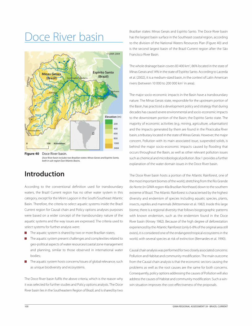
Doce River basin
Introduction
According to the conventional definition used for transboundary
waters, the Brazil Current region has no other water system in this
category, except for the Mirim Lagoon in the South/Southeast Atlantic
Basin. Therefore, the criteria to select aquatic systems inside the Brazil
Current region for Causal chain and Policy options analyses purposes
were based on a wider concept of the transboundary nature of the
aquatic systems and the way issues are expressed. The criteria used to
select systems for further analysis were:
The aquatic system is shared by two or more Brazilian states;
The aquatic system present challenges and complexities related to
geo-political aspects of water resources/coastal zone management
and planning, similar to those observed in international water
bodies;
The aquatic system hosts concerns/issues of global relevance, such
as unique biodiversity and ecosystems.
The Doce River basin fulfils the above criteria, which is the reason why
it was selected for further studies and Policy options analysis. The Doce
River basin lies in the Southeastern Region of Brazil, and is shared by two
Brazilian states: Minas Gerais and Espírito Santo. The Doce River basin
has the largest basin surface in the Southeast coastal region, according
to the division of the National Waters Resources Plan (Figure 40) and
is the second largest basin of the Brazil Current region after the São
Francisco River Basin.
The whole drainage basin covers 83 400 km2, 86% located in the state of
Minas Gerais and 14% in the state of Espírito Santo. According to Lacerda
et al. (2002), it is a medium-sized basin, in the context of Latin American
rivers (between 10 000 to 200 000 km2 in area).
The major socio-economic impacts in the Basin have a transboundary
nature. The Minas Gerais state, responsible for the upstream portion of
the Basin, has practiced a development policy and strategy that during
decades has caused severe environmental and socio-economic impacts
to the downstream portion of the Basin; the Espírito Santo state. The
majority of economic activities (e.g. mining, agriculture, urbanisation)
and the impacts generated by them are found in the Piracicaba River
basin, a tributary located in the state of Minas Gerais. However, the major
concern, Pollution with its main associated issue, suspended solids, is
behind the major socio-economic impacts caused by flooding that
occurs throughout the Basin, as well as other relevant pollution issues
such as chemical and microbiological pollution. Box 1 provides a further
explanation of the water domain issues in the Doce River basin.
The Doce River basin hosts a portion of the Atlantic Rainforest, one of
the most important biomes of the world, stretching from the Rio Grande
do Norte (in GIWA region 40a Brazilian Northeast) down to the southern
extreme of Brazil. The Atlantic Rainforest is characterised by the highest
diversity and endemism of species including aquatic species, plants,
insects, reptiles and mammals (Mittermeier et al. 1982). Inside this large
biome, there is a regional diversity that follows biogeographic patterns
with known endemism, such as the endemism found in the Doce
River basin (Kinsey 1982). Because of the high degree of deforestation
experienced by the Atlantic Rainforest (only 6-8% of the original area still
exists), it is considered one of the endangered tropical ecosystems in the
world, with several species at risk of extinction (Bernardes et al. 1990).
Causal chain analysis was performed for two closely associated concerns:
Pollution and Habitat and community modification. The main outcome
from the Causal chain analysis is that the economic sectors causing the
problems as well as the root causes are the same for both concerns.
Consequently, policy options addressing the causes of Pollution will also
address the causes of Habitat and community modification. Such a win-
win situation improves the cost-effectiveness of the proposals.
Minas Gerais(Brazil)
Espirito Santo(Brazil)
Mantiq
ueira
Espi
nhaç
o
Manhuaçu
Suaçui Grande
Santo Antonio
Piracicaba
Casca
Matipó
Manart
Gua
ndu
São José
Piranga
Pancas
Sant
a Jú
lia
Colatina
Ipatinga
Governador Valadares
Linhares
Ressaquinha
0 100 Kilometres
Elevation (m)
© GIWA 2004
2404
1000
800
600
200
400
Figure 40 Doce River basin. Doce River basin includes two Brazilian states: Minas Gerais and Espírito Santo, both in sub-region East Atlantic Basins.

100 GIWA REGIONAL ASSESSMENT 39 BRAZIL CURRENT CAUSAL CHAIN ANALYSIS 101
System description
Geographic and demographic settings The Doce River, the main watercourse in the Basin, has its source in
the municipality of Ressaquinha, at an altitude of over 1 000 m, in the
mountain ranges of the Espinhaço and Mantiqueira complex, state of
Minas Gerais, under the name of Piranga River. It runs 853 km to its
mouth at the Atlantic Ocean, close to the district of Regência, in the
municipality of Linhares, state of Espírito Santo. Over 230 municipalities,
with almost 500 districts, are fully or partially contained in the Doce
River basin. The population of these municipalities is 2.26 million in the
urban areas and close to 1 million in the rural areas, and an urbanisation
rate of approximately 70% (IBGE 2000). Urban growth in the Basin is
lower than the average values found in the states of Minas Gerais and
Espírito Santo. There is a general exodus from rural areas. The analysis
of demographic data shows that the region in the Basin called “Vale do
Aço” meaning “Steel Valley”, in the River Piracicaba sub-basin located
in the state of Minas Gerais, has the highest population density, with
migration to one of its largest cities: Ipatinga. Consequently, there
is a trend towards a diminishing population in municipalities with
up to 20 000 inhabitants, representing approximately 93% of the
municipalities in the Doce River basin. In year 2000, about 69.2% of the
Basin population was served by public water supply systems, 57.6% by
public sanitary sewerage systems, only 4.7% of the latter being treated
(IBGE 2000). The population with water supply and the percentage of
collected sewage treated is below the Brazilian average, equal to 81.5%
and 17.8% respectively. However the population covered by a public
sanitary sewerage network is above the Brazilian average of 47.2%.
Climatic and hydrologic characteristicsFigure 41 identifies the boundaries of the climatic regions in Doce River
basin. Four types of climate are found in the basin, according to the
Köppen classification:
On the slopes of the Mantiqueira and Espinhaço mountains and
in the southern area of the Basin, a high altitude tropical climate
predominates with summer rainfalls and mild summers;
At the sources of the Doce River tributaries, the climate is high
altitude tropical, with wet and warm summers;
In the middle and lower reaches of the tributaries and in the Doce
River itself, a warm climate with summer rainfalls predominates;
In a small region to the southeast, the climate is sub-tropical with
distributed rainfall and hot summers.
The highest rainfall rates are found on the slopes of the Mantiqueira
and Espinhaço mountains, and in the southern part of the basin, in
the order of 1 500 mm per year. The rainfall rates diminish gradually as
far as the town of Aimorés, and then begin to rise again towards the
coast. According to the Water Resources National Plan (PNRH 2003), the
mean annual precipitation in the basin is 1 238 mm and annual mean
A characteristic of the Brazilian Water Resources System is that the water, from a constitutional viewpoint, may be in the domain of the individual states or of the federal government. Waters in the state domain are the groundwater located under its territory and the surface waters of the water bodies (lakes and rivers) that are entirely located within the territory of that state. Waters in the federal government domain are the surface waters of water bodies that are transboundary, either because they are in more than one state, or in a neighbouring country. In the case of the Doce River basin, the waters flowing in the Doce River are in the federal government domain. However the waters flowing in most of its tributaries, such as those of Piracicaba River, are in the domain of the state where this tributary has its source and mouth. This establishes a triple domain for the waters to be the object of the concession of rights of use. Those of the Doce River are to be granted by the National Agency of Water (ANA), a federal entity. Those of the tributaries belonging to the state of Minas Gerais, such as Piracicaba River, by the Minas Gerais Institute of Water Management (IGAM) (Instituto Mineiro de Gestão das Águas). Those of the tributaries belonging to the state of Espírito Santo, by the State Secretariat for Environmental Issues of Espírito Santo (SEAMA) (Secretaria de Estado para Assuntos de Meio Ambiente). Licensing potentially polluting activities in Brazil is part of the National System of the Environment. In this case the following coexist: a national agency, the Brazilian Institute of the Environment and Renewable Natural Resources (IBAMA), and state agencies: State Foundation for the Environment of Minas Gerais (FEAM) (the Fundação Estadual do Meio Ambiente de Minas Gerais) and the aforementioned SEAMA, in the state of Espírito Santo. The National Council of the Environment establishes the competencies for licensing potentially polluting activities. In brief, in one and the same basin, five organisations coexist, with legal attributions that may affect the use, protection and management of waters belonging to three jurisdictions, two of them at state-level and one of them federal. Three of them have attributions to grant water use rights: ANA, IGAM and SEMA; three of them have attributions related to environmental licensing: IBAMA, FEAM and SEAMA. This institutional arrangement presents great risks of inefficiency and ineffectiveness in the sustainable management of water and environmental resources, due to the lack of communication and cooperation, and the mechanisms to provide these. A river basin plan is the most logical alternative to integrate the actions of these entities harmoniously.
Box 1 Water domain issues in the Doce River basin waters.
Minas Gerais
Espírito Santo
Manhuaçu
Suaçui Grande
Santo Antonio
Piracicaba
Casca
MatipóManart
Guandu
São José
Piranga
Pancas
Santa Júlia
© GIWA 2004
Aw
Cfa
Cwa
Cwb
Figure 41 Doce River basin climate types. Doce River Basin climate types, according to Köppen’s classification. “Aw “- tropical hot and wet summer; “Cwa” - tropical of altitude (sub-tropical) wet and hot summer; “Cwb”- tropical of altitude (sub-tropical) wet and mild summer; “Cfa” - sub-tropical well-distributed rainfall and hot summer.
(Source: Gerenciamento Integrado da Bacia do Rio Doce 2003)
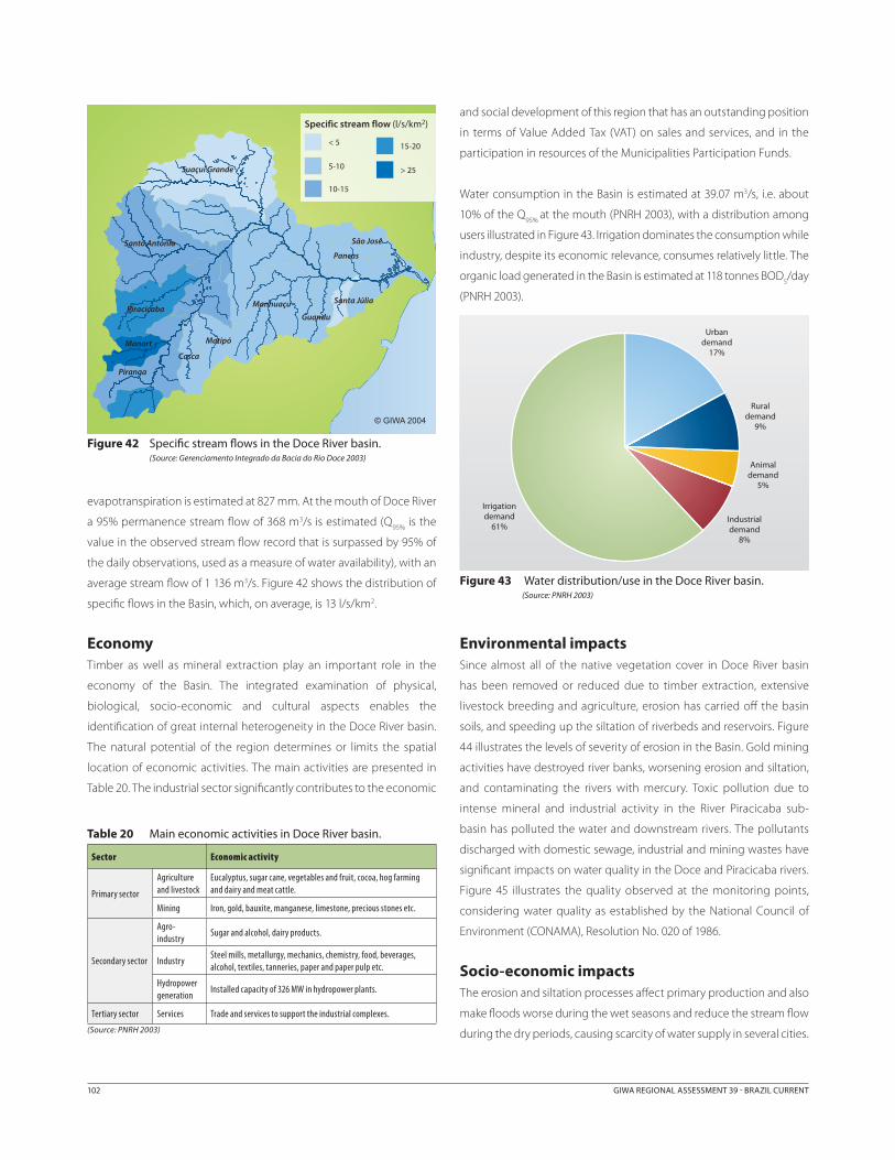
102 GIWA REGIONAL ASSESSMENT 39 BRAZIL CURRENT CAUSAL CHAIN ANALYSIS 103
evapotranspiration is estimated at 827 mm. At the mouth of Doce River
a 95% permanence stream flow of 368 m3/s is estimated (Q95%
is the
value in the observed stream flow record that is surpassed by 95% of
the daily observations, used as a measure of water availability), with an
average stream flow of 1 136 m3/s. Figure 42 shows the distribution of
specific flows in the Basin, which, on average, is 13 l/s/km2.
EconomyTimber as well as mineral extraction play an important role in the
economy of the Basin. The integrated examination of physical,
biological, socio-economic and cultural aspects enables the
identification of great internal heterogeneity in the Doce River basin.
The natural potential of the region determines or limits the spatial
location of economic activities. The main activities are presented in
Table 20. The industrial sector significantly contributes to the economic
and social development of this region that has an outstanding position
in terms of Value Added Tax (VAT) on sales and services, and in the
participation in resources of the Municipalities Participation Funds.
Water consumption in the Basin is estimated at 39.07 m3/s, i.e. about
10% of the Q95%
at the mouth (PNRH 2003), with a distribution among
users illustrated in Figure 43. Irrigation dominates the consumption while
industry, despite its economic relevance, consumes relatively little. The
organic load generated in the Basin is estimated at 118 tonnes BOD5/day
(PNRH 2003).
Environmental impactsSince almost all of the native vegetation cover in Doce River basin
has been removed or reduced due to timber extraction, extensive
livestock breeding and agriculture, erosion has carried off the basin
soils, and speeding up the siltation of riverbeds and reservoirs. Figure
44 illustrates the levels of severity of erosion in the Basin. Gold mining
activities have destroyed river banks, worsening erosion and siltation,
and contaminating the rivers with mercury. Toxic pollution due to
intense mineral and industrial activity in the River Piracicaba sub-
basin has polluted the water and downstream rivers. The pollutants
discharged with domestic sewage, industrial and mining wastes have
significant impacts on water quality in the Doce and Piracicaba rivers.
Figure 45 illustrates the quality observed at the monitoring points,
considering water quality as established by the National Council of
Environment (CONAMA), Resolution No. 020 of 1986.
Socio-economic impactsThe erosion and siltation processes affect primary production and also
make floods worse during the wet seasons and reduce the stream flow
during the dry periods, causing scarcity of water supply in several cities.
Manhuaçu
Suaçui Grande
Santo Antonio
Piracicaba
Casca
MatipóManart
Guandu
São José
Piranga
Pancas
Santa Júlia
© GIWA 2004
Specific stream flow (l/s/km2)
< 5
5-10
10-15
15-20
> 25
Figure 42 Specific stream flows in the Doce River basin. (Source: Gerenciamento Integrado da Bacia do Rio Doce 2003)
Urban demand
17%
Rural demand
9%
Animal demand
5%
Industrial demand
8%
Irrigation demand
61%
Figure 43 Water distribution/use in the Doce River basin.(Source: PNRH 2003)
Table 20 Main economic activities in Doce River basin.
Sector Economic activity
Primary sector
Agriculture and livestock
Eucalyptus, sugar cane, vegetables and fruit, cocoa, hog farming and dairy and meat cattle.
Mining Iron, gold, bauxite, manganese, limestone, precious stones etc.
Secondary sector
Agro-industry
Sugar and alcohol, dairy products.
IndustrySteel mills, metallurgy, mechanics, chemistry, food, beverages, alcohol, textiles, tanneries, paper and paper pulp etc.
Hydropower generation
Installed capacity of 326 MW in hydropower plants.
Tertiary sector Services Trade and services to support the industrial complexes.
(Source: PNRH 2003)

102 GIWA REGIONAL ASSESSMENT 39 BRAZIL CURRENT CAUSAL CHAIN ANALYSIS 103
Although most of the large industries have invested in environmental
control systems, industrial pollution by small and medium-sized
industries is still a problem in the Basin. Basic sanitation is critical: many
towns have problems with the quality of water supply, there is a lack
of investment in sewerage networks, there is practically no sewage
treatment, and solid wastes are deposited mainly along river banks.
In brief, the main environmental impacts that lead to socio-economic
problems in the Basin arise from the following factors (Gerenciamento
Integrado da Bacia do Rio Doce 2003):
Generalised deforestation and mismanagement of agricultural soils
that led to loss of fertility and high erosion rates, and consequently
to loss of agricultural productivity, increased rural poverty and
migration to the outskirts of large cities;
Siltation of riverbeds caused by erosion, leading to reduced stream
flow during the dry period and increased problems during floods,
with effects on urban supply, irrigated agriculture and public
safety;
Floods, resulting from natural conditions but worsened by the
human occupation of the flood plain, deforestation, soil erosion
and siltation;
Vulnerability of reaches where the intake of domestic supply are
located, considering previous accidental toxic pollution events, at
several points in the Basin (the cities of Ponte Nova, Governador
Valadares, in Minas Gerais, and Colatina in Espírito Santo, cities in
the Vale do Aço (Steel Valley) in Minas Gerais, among others), with
potential risks to public health;
The precarious state of basic sanitation (networks, sewage
treatment, disposal of solid wastes) and the lack of drinking water
supply in several urban agglomerations and rural communities,
reflecting on public health and on the economy.
A schematic illustration of the most degraded areas is found in
Figure 46.
Manhuaçu
Suaçui Grande
Santo Antonio
Piracicaba
CascaMatipóManart
Guandu
São José
Piranga
Pancas
Santa Júlia
Erosion
Very high
Medium
Low
Very Low
© GIWA 2004
Figure 44 Degree of erosion in the Doce River basin.(Source: Gerenciamento Integrado da Bacia do Rio Doce 2003)
Manhuaçu
Suaçui Grande
Santo Antonio
Piracicaba
CascaMatipóManart
Guandu
São José
Piranga
Pancas
Santa Júlia
© GIWA 2004
Water quality classes
Class 3
Class 4
Figure 45 Water quality in the Doce River basin.In 59 sections of the Doce River basin, water quality monitoring indicated Class 3 or 4 (based on CONAMA, Resolution No. 020/1986), despite the fact that guidelines indicate that water quality should be at least Class 2 based on assigned uses (see Annex III, Note 3).
(Source: Gerenciamento Integrado da Bacia do Rio Doce 2003)
Minas Gerais
Espírito Santo
Ponte Nova
Vale do Aço
Piracicaba Colatina
Linhares
GovernadorValadares
Ipatinga
© GIWA 2004
Dams
Flood prone areas
Pollution from the steel industry, mining and silting
Eroded soils (silting and floods)
Figure 46 Doce River basin and its main environmental problems.(Source: PNRH 2003)
104 GIWA REGIONAL ASSESSMENT 39 BRAZIL CURRENT CAUSAL CHAIN ANALYSIS 105
Methodology
The methodology adopted to prepare the Causal chain analysis was
to invert the course of the causal chain. In other words, based on the
main socio-economic impacts identified in the Doce River basin, the
environmental impacts that cause them were sought. The immediate
causes of the latter and the economic sectors activities that generate
them, due to the non-sustainable management of land and water
resources, were identified.
Considering the activities in the economic sectors and their un-
sustainable management, the root causes that enabled or encouraged
this unsustainable scenario were sought. For this purpose, several
technical reports on studies and plans concerning the Basin were
analysed, and specialists from the Brazilian National Agency of
Water (ANA) who work with activities in the Doce River basin were
interviewed. These activities include mobilising society to create the
management committee for the Doce River basin, and the preparation
of an action agenda for the committee. Since the GIWA concerns
Pollution, and Habitat and community modification were identified
as priority concerns in the Assessment , the causal chains pertinent to
them were identified. It was decided that the problems do not result
only from the environmental vulnerability of the basin, but rather from
the institutional framework and management framework of the basin.
The situation of the basin, with respect to these two frameworks, was
considered in detail, cross matching information from the reports
consulted with the current stage of implementation of the National
Water Resources Management System, and with the ANA specialists’
perception of the problems. Based on this analysis, the root causes
were identified and the causal chains for the Pollution and Habitat and
community modification were constructed. The causal chains related
to the selected GIWA concerns Pollution and Habitat and community
modification are presented below.
Causal chain analysis for Pollution – Doce River basinThe concerns chosen for causal chain analysis in Doce River basin were
Pollution and Habitat and community modification. The historical
occupation of Doce River basin was associated with mining and
exploitation of iron and precious metals, together with agricultural
practices that did not consider proper management of soil and water,
followed by the intensive use of wood as fuel. These economic activities
destroyed the major portion of the Basin’s native vegetation, created soil
erosion, which in turn, generated two parallel sequences of impacts. On
one hand, accelerated erosion and siltation aggravated the problems of
flooding and caused considerable risks to the population living in the
upstream portion of the Basin. On the other hand, the soil degradation
increasingly reduced the agriculture productivity, resulting in the
migration of the people from the countryside to the outskirts of the cities.
An excessive concentration of low-income and unemployed people in
the cities, without adequate infrastructure (e.g. sewage collection and
treatment) caused pollution due to the organic load, in addition to the
suspended solids. The industrialisation process in the Basin, especially in
the Piracicaba River Valley, stimulated by the iron mining and processing,
caused chemical pollution. Suspended solids, increasing organic load,
microbiological and chemical pollution increased the risk of health
problems due to consumption of low quality water. Six root causes
have been identified for the causal chain of Pollution. Two of them are
related to aspects of governance as discussed below.
Root causesGovernance 1: Lack of basin-wide management plan
Due to the lack of a master plan in the Basin, several managerial
problems are identified, contributing to the worsening of pollution
problems. A basin plan could establish an inter-institutional structure
for communication and cooperation, and harmonise the water use
demands, especially those related to its consumption and use as a
receiving body for wastes. Above all, the integrated management
should take into account the upstream uses in the Basin, especially
waste discharges and quality demands of downstream domestic
and agricultural users. The state and federal water resources and
environmental entities, for instance, should have a common agenda
for water protection actions (granting rights of use, licensing potentially
polluting activities), which would be negotiated in the plan.
Box 1 provides a further explanation of this issue, which arises from
the characteristics of water domain, established by the Brazilian
constitution. Equally, an integrated plan including different economic
sectors should be established, especially among the industry, mining,
agriculture and urbanisation sectors, the first three being the main
agents of degradation (urban supply from polluted sources and
worsening of floods). The urban sector also causes degradation
(untreated sewage discharged into watercourses, inadequate land
occupation causing erosion and obstructing the free flow of the waters).
The current lack of integration, resulting from this multiplicity of entities
and sectors acting in the Basin, renders the balancing of the interests
of the different stakeholders difficult. A river basin plan would lead to
the negotiations needed to promote the balance and harmonisation
of interests. One of the relevant aspects of the absence of a river basin
104 GIWA REGIONAL ASSESSMENT 39 BRAZIL CURRENT CAUSAL CHAIN ANALYSIS 105
plan is the lack of “city statutes” (called “urban master maps” in Brazil,
which guide the occupation of land, limiting inadequate uses) which,
when they do exist, do not take water-related demands into account.
This has led to: (i) the occupation of hill slopes, worsening the problem
of erosion and later siltation of bodies of water; and (ii) building in the
river flooding zones, which has the effect of containing the waters and
greatly worsening flooding problems upstream. The built up areas
themselves may suffer flooding and during large floods the obstacles
that have been artificially created may be destroyed, and flood waves
may be generated, with catastrophic effects downstream.
Governance 2: Lack of legitimacy in negotiations commanding
decisions regarding investments
Manoeuvring by powerful stakeholders and their influence over the
government creates a risk that the government may make decisions
of doubtful legitimacy value, which will privilege certain powerful
groups, without taking the public interest into account. An aspect
that contributes to this lack of legitimacy is that there is not enough
public involvement in decision-making. The Management Committee
of the Doce River basin is currently being set up, but it will take some
time until its action becomes effective to solve this problem. A lack of
instruments for public participation is also observed, i.e. instruments
that will encourage, guide and promote the mobilisation of society
with a view to taking on the role that the National Water Resources
Policy expects it to perform in the decision process that is part of
water management. According to the National Water Resources Policy
(in accordance to the Agenda 21, UNCED 1992), among other principles
it is established that the water resources in Brazil shall be managed in
an integrated approach with participation of different stakeholders. It
can be observed that, due to the lack of this participation and social
control, the public institutions lack accountability, which makes it
easier to exempt them from being held responsible for basin pollution
problems: the causes of problems are always “the others” (Montada
2001), and there is no clear definition of responsibilities regarding the
failure of water quality management.
Finally, contributing to this problem, the Brazilian judicial system takes too
long to execute legal procedures, which helps create a lack of definition
of guilty parties, and, what is equally bad, leads to the late identification
of responsibilities when very little or nothing can be done, in terms of
mitigating measures. The other root causes are related to economics
(economic distortions are not correct), lack of knowledge (insufficient
training regarding best land use practices), socio-economic (poverty
among the population living in the Basin) and demographic (population
growth and migration to cities followed by illegal land occupation -
shanty towns). Some of their characteristics are discussed below.
Economics: Economic distortions are not correct
Although foreseen by the National Water Resources Policy, economic
instruments to promote more sustainable use of natural resources,
such as charging for water use, have not yet been implemented in the
Basin. This results in inefficient use of water, and the non-correction of
negative externalities, the clearest example of which is water pollution
(Mendes & Motta 1997).
Knowledge: Insufficient training regarding best land use practices
The problems of inadequate land occupation are exemplified by
the agricultural management adopted in the Basin, which caused
generalised deforestation, the removal of gallery forests, land
erosion and loss of its productive potential. It is also observed in the
inappropriate location of structures on the steep hillsides and in the
river flood zone. It is assumed that these practices are mostly the result
of insufficient training regarding best land use practices.
Socio-economics: Poverty among the population living in the
Doce River basin
This root cause is almost always present in any causal chain analysis
performed in Brazil, since it is not possible to ignore the impacts
of poverty on the environmental concerns and issues addressed
by the GIWA assessment. Poverty, together with the demand to
immediately overcome adverse living conditions, makes it difficult to
use economic instruments in environmental management, challenges
the implementation of the rules and legal standards, and prevents the
transfer of basic knowledge regarding the relations between man-
society-environment. The reason for this is that the economic logic
which makes it possible to adopt economic instruments is based on
a relationship of exchanges, or the market. In a situation of poverty,
there is no such exchange relationship, strictly speaking, since the poor
have comparatively little to offer and a lot to demand. Poverty leads
to social exclusion, which in turn, induces (or encourages) those who
suffer it, to behave outside the legal rules or norms that govern society.
It is not, directly, the cause of ignorance, but since it monopolises all
the individual’s resources to overcome the problems it causes, poverty
prevents planning for the medium or long-term, and, thus, from setting
aside some time to learn.
Demographic: Population growth & migration to cities followed
by illegal land occupation - shanty towns
This root cause is generated by the impoverishment of the rural
population, caused by population growth together with loss of soil
productivity. The causes of high urbanisation rate are those already
indicated (Demographic root cause of pollution in the Patos-Mirim
Lagoon system). The Doce River basin exhibits this phenomenon,

106 GIWA REGIONAL ASSESSMENT 39 BRAZIL CURRENT CAUSAL CHAIN ANALYSIS 107
one of the consequences of which is the “swelling” of the cities. This
root cause is partly a consequence of the previous root cause: poverty.
However, its causes may go beyond this. Population growth, together
with loss of productivity in the rural area (which in turn may be caused
by erosion) generates a search for work opportunities in the cities, in
the secondary and tertiary sectors of the economy. As the city becomes
crowded, increasing demand for housing leads to higher prices. As a
result, a significant portion of the migrants settle in urban areas
where housing is lower, particularly in regions farther away from the
downtown area. For the interests of this causal chain analysis, the most
important issue is the illegal occupation of land with significant risks of
flooding or other natural disasters.
Selected root causesFigure 47 (Causal chain diagram for Pollution) shows that some root
causes have a greater number of causal relations with the sector
activities. The number of connections cannot, a priori, be considered
a good criterion to rank the root causes according to their relevance.
In this case, however the most important root causes in the process of
pollution of the Doce River basin waters are precisely those that are
grouped under the class of Governance, Economics and Knowledge,
and that have closest connections to the sector activities. This is
confirmed by the severity of degradation problems that are perceived
in the Basin, related to microbiological and chemical pollution,
eutrophication and suspended solids.
The inappropriate occupation of the riverbeds, one of the immediate
causes that generate increased suspended solids and siltation,
aggravated by the inappropriate use of land, also worsens the floods
with risk of damage to life and property. This socio-economic impact
was listed in the pollution causal chain due to the relevance of the
problem in the Basin, and the fact that its consequences are analogous
to pollution, although the GIWA methodology does not list this
problem as a socio-economic impact. In other words, like pollution, the
worsening of floods is an undesirable side effect of human activities.
The socio-economic and demographic root causes are probably less
relevant in accounting for the Basin pollution process in this case. The
proposal of policy options to mitigate the latter root causes is also
less credible over the short and medium-term. Figure 47 presents a
comprehensive version of the causal chain analysis for the concern
Pollution in Doce River basin. Figure 48 summarises the most relevant
causal chain links for Pollution. Figure 49 shows the causal links selected
for further consideration and policy option analysis.
Socio-economic impacts
GIWA concern
Environmental impacts
GIWA issues
Immediate causes
Sectors/ Activities Root causes
Governance 2 Lack of legitimacy on
negotiations commanding decisions regarding investments
Governance 1Lack of a basin-wide management plan
EconomicEconomic distortions
not corrected
Knowledge Insufficient training on best land use practices
UrbanisationLand
occupation without
infrastructure
Agriculture Deforestation
Agricultureuse of pesticide
and other chemicals
Agriculturewith improper
land use techniques
Untreated urban
wastewater discharge
Solid waste disposed in
open dumps, uncontrolled
landfills
Increasing remobilisation
and leaching
Pollutant transported
through storm water run-off
Microbiological pollution
Suspended solids
Loss of property value
Loss of tourism and recreational
values
Litigation costs
Loss of water supplies
Increased risk for interstate conflicts
Pollution
Redox changes
Aquatic organisms
infection and diseases
Increased algal blooms
Changes in community
structure
Increased erosion of coast and river banks/
channels
Habitat change/loss
Increased risk for human health
Increased sediments deposition
DemographicPopulation growth &
migration to cities followed by illegal land
occupation - shanty towns
Mining(hematite, sand, gold
mining)
Industry with insufficient
effluent treatment
Soil erosion, sediments
remobilisation and leaching
Modification of stream flow
Eutrophication
Chemical pollution
Increasing risk of floods and related damage to human
lives and properties
Point source discharge of
chemical pollutants
Socio-economic Poverty among the population living in
the Basin
Loss in the fisheries sector
Figure 47 Causal chain diagram for the main concern Pollution and its issues in Doce River basin: Comprehensive version.

106 GIWA REGIONAL ASSESSMENT 39 BRAZIL CURRENT CAUSAL CHAIN ANALYSIS 107
Socio-economic impacts
GIWA concern
Environmental impacts
GIWA issues
Immediate causes
Sectors/ Activities Root causes
Governance 2Lack of legitimacy
on negotiations commanding
decisions regarding
investments
Governance 1Lack of a basin-
wide management plan
EconomicEconomic
distortions not corrected
Knowledge Insufficient
training on best land use practices
UrbanisationLand occupation
without infrastructure
Agriculture Deforestation
Agricultureuse of pesticide
and other chemicals
Agriculturewith no proper
land use techniques
Discharge of untreated urban
wastewater
Solid waste disposed in
open dumps, uncontrolled
landfills
Increasing remobilisation and leaching
Pollutant transported
through storm water run-off
Microbiological pollution
Suspended solids
Litigation costs
Loss of water supplies
Increased risk for interstate
conflicts
POLLUTION
Redox changes
Aquatic organisms
infection and diseases
Algal blooms
Changes in community
structure
Increasingerosion of coast and river banks/
channels
Habitat change/loss
Increased risk for human health
Increasingsediments deposition
Soil erosion, sediments
remobilisation and leaching
Modification of stream flow
Eutrophication
Chemical pollution
Increased risk of floods and
related damage to human lives and properties
Figure 48 Causal chain diagram for the main concern Pollution and its issues in Doce River basin: Version focused on the main sectors and root causes.
Socio-economic impacts
GIWA concern
Environmental impacts
GIWA issues
Immediate causes
Sectors/ Activities Root causes
Governance 2Lack of legitimacy on
negotiations commanding
decisions regarding investments
Governance 1Lack of a basin-wide management plan
EconomicEconomic distortions
not corrected
Knowledge Insufficient training
on best land use practices
UrbanizationLand occupation
without infrastructure
Agriculture Deforestation
Agriculturewith no proper land
use techniques
Increasing remobilisation
and leaching
Suspended solids
Pollution
Increasing erosion of coast and river banks/
channelsIncreased risk for human health
Increasing sediments deposition
Soil erosion, sediments
remobilisation and leaching
Modification of stream flow
Increased risk of floods and related damage to human
lives and properties
Figure 49 Causal chain diagram for the main concern Pollution and its issues in Doce River basin: Selected root causes for policy options analysis.

108 GIWA REGIONAL ASSESSMENT 39 BRAZIL CURRENT
Causal chain analysis for Habitat and community modification – Doce River basin
The causal chain analysis presents common root causes for Habitat and
community modification and Pollution, except for the Demographic
(Figure 50). In this case, the analyses and characterisations performed
for the concern pollution are valid to a large extent. Therefore, it
can be assumed that some root causes generate two sequences of
effects related to pollution and habitat and community modification,
respectively. Policy options selected to minimise/solve one of these
concerns probably will have a similar effect on the other concern.
Socio-economic impacts
GIWA concern
Environmental impacts
GIWA issues
Immediate causes
Sectors/ Activities Root causes
Increase vulnerability for
opportunistic invaders
Governance 1 Lack of a basin
management plan not implemented
yet
Governance 2Lack of
legitimacy on negotiations commanding
decisions regarding
investments
EconomicEconomic
distortions not corrected
Knowledge Insufficient training on
land use best practices
AgricultureIntroduction of
agriculture species and
pasture
Agriculture Inappropriate
land use techniques and unsustainable
harvesting practices
AgricultureUse of pesticide,
and other chemicals
Mining(hematite, sand,
gold)
Deforestation
Erosion and loss of soil fertility
Increased suspended
solids, turbidity and silting of the
rivers
Water pollution with pesticides and increased discharge of
nutrients
Loss of ecosystem or
ecotones
Modification of ecosystem or
ecotones
Reduced capacity to meet
human needs (food, fuel)
Costs of restoration of
damaged ecosystems
Costs of responding to risks of flood
Economic losses due to floods
Loss of aesthetic value and recreation
Habitat and Community Modification
Loss of natural productivity
Loss of biodiversity
Loss of natural protection from
erosion
Loss of migratory species and altered migratory patterns
Changes in ecosystem stability
Changes in animal and plant
community structure
Changes in migratory paterns
Health losses due to flood (water-borne diseases)
Socio-economic Poverty among the population
living in the BasinIntergenerational inequity
Conclusions
The causal chain analyses for Pollution and for Habitat and community
modifications have their main root causes as outlined in Table 21.
The policy options selected will contribute to mitigating these root
causes and thus to the mitigation of the problems of Pollution and
Habitat and community modification.
Figure 50 Causal chain diagram for the main concern Habitat and community modification in Doce River basin.
Table 21 Summary of root causes for Pollution and Habitat and community modification in Doce River basin.
Root cause Pollution and Habitat and community modification
GovernanceBasin-wide management plan not implemented yet. Lack of legitimacy in negotiations commanding decision regarding investments.
Economic Economic distortions are not correct.
Knowledge Insufficient training regarding best land use practices.