categorization of swc technologies and approaches — a ... · these sets is subdivided into...
TRANSCRIPT

12th ISCO Conference Beijing 2002
Categorization of SWC Technologies and Approaches — A Global Need?
H.P. Liniger1, Dennis Cahill 2, Will Critchley3, Donald Thomas4, G.W.J. van Lynden5 and Gudrun Schwilch6
1 Centre for Development and Environment, University of Berne, Hallerstrasse 12, 3012 Bern,
Switzerland (E-mail: [email protected]) 2 P.O. Box 14893, Nairobi, Kenya (E-mail: [email protected])
3 International Cooperation Centre, Vrije Universiteit Amsterdam, De Boelelaan 1105, 1081 HV Amsterdam, The Netherlands (E-mail: [email protected])
4 2 Madang Avenue, Box Hill North, Victoria 3129, Australia (E-mail: [email protected])
5 International Soil Reference and Information Centre, P.O. Box 353 - 6700 AJ Wageningen-The Netherlands (E-mail: [email protected])
6 Centre for Development and Environment, University of Berne, Hallerstrasse 12, 3012 Bern, Switzerland (E-mail: [email protected])
Abstract: Within the World Overview of Conservation Approaches and Technologies (WOCAT) program, local achievements in improved soil and water management are documented and exchanged in order to make better use of existing knowledge. To facilitate the sharing of knowledge, common “tools” and a common “language” are required. Consistent terms for soil and water conservation (SWC) technologies and approaches are not used. In fact, no globally approved or endorsed system exists for categorization or terminology. A common categorizing system would help to group SWC technologies and approaches. Given the fact that on one hand there are so many different terms for similar SWC technologies and approaches, yet on the other hand similar names can conceal important differences. There is an urgent need to come up with a commonly accepted system that can be used in different environments, but one that still has some flexibility to be adapted to specific needs and conditions in the different regions of the world. Keywords: WOCAT, categorization, conservation technologies, SWC For SWC technologies, which are differentiated here as management, agronomic, vegetative and
structural measures that control soil degradation and enhance productivity in the field, WOCAT proposes a hierarchical system. This combines 3 basic sets of information: first, on the land use where the technology is applied, secondly on the degradation type addressed and thirdly on the conservation measure. Each of these sets is subdivided into additional hierarchical levels. The SWC technology categorization system proposed in this paper is still in a preliminary stage and improvements are needed. The aim of this paper is to present the results so far and initiate a reaction by the international SWC community in order to improve the system such that the system is practicable and useful for the exchange of experience and for better implementation of SWC world-wide.
1 Need for a categorization
Within the World Overview of Conservation Approaches and Technologies (WOCAT) program,
local achievements in improved soil and water management are documented and exchanged in order to make better use of existing knowledge (see Liniger et al., 2002).
Terms for soil and water conservation (SWC) technologies and approaches are not consistently used and mean different things to different people – and even to the same people at different times. In fact, no globally approved or endorsed system exists. Some given names refer to the appearance such as terraces, bunds ditches, some combine the appearance with the materials used e.g. stone walls, earth bunds, grass strips, some add the slope or drainage e.g. graded ditches or infiltration ditches, others refer to the management e.g. enclosure, others to the way of construction e.g. fanya juu (= ‘throw soil uphill’ in

7
Kiswahili) or to the function and impact e.g. cut-off drain, etc. Critchley (2000) showed that even amongst terraces there is a huge variety of names and much confusion about what ‘terraces’ actually are: Names include, for example, bench terrace and step terrace (metaphorical derived), forward / outward sloping terraces (describing the inclination of the bed), fanyu juu terraces (an assimilated Swahili term describing the way soil is ‘thrown upwards’ to build the bund), Puerto Rico terraces (site-derived) and Zingg terraces (named after a person). This makes a common understanding and sharing of knowledge rather difficult (Critchley, 2000).
There are systems for classification that cover only part of the whole spectrum of SWC technologies and approaches and they have been reviewed by the authors and partly integrated into the proposal of this categorization system (Critchley, 2000, Morgan, 1986, Sheng, 1989, Hudson, 1992, Thomas, 1997, Shaxson, 1999).
2 A first attempt at a globally acceptable categorization system for SWC technologies
For SWC technologies, defined as management, agronomic, vegetative and structural measures that
control soil degradation and enhance productivity in the field, a hierarchical system is proposed. The hierarchical system combines 3 basic sets of information: first, on the land use where the technology is applied, secondly on the degradation type addressed and thirdly on the conservation measure. Each of these sets is subdivided into additional hierarchical levels. If needed further subtypes could be introduced later on. Each item on each hierarchical level has a predefined abbreviation. The combination of these letters makes up the code that fully describes a SWC technology, e.g. CaWtS1 for bench terraces.
2.1 Land use
Five major land use types are distinguished: cropland, grazing land, forestland, mixed land and
others, each of them being subdivided into secondary types. For definitions see WOCAT technology questionnaire: WOCAT 2002a (page ET4):
C: Cropland: Ca: annual cropping, Cp: perennial cropping Ct: tree and shrub cropping G: Grazing land: Ge: extensive grazing, Gi: intensive grazing F: Forest/woodland: Fn: natural, Fp: plantations, afforestation, Fo: other (e.g. selective cutting of
natural forests and incorporating planted species) M: Mixed land: Mf: Agroforestry (cropland and forest), Mp: agropastoralism (cropland and grazing
land), Ma: agrosilvopastoralism (cropland, grazing land and forest), Ms: silvopastoralism (forest and grazing land), Mo: other
O: Other land: Oi: mines and extractive industries, Os: settlements, roads, infrastructure network, Oo: others (wastelands, deserts, glaciers)
2.2 Degradation type addressed
Main degradation types are water erosion, wind erosion, chemical deterioration and physical
deterioration. Each of these main categories is further subdivided based on a joint ISRIC and WOCAT methodology. For definitions see WOCAT map questionnaire: WOCAT 2002c:
W: Water erosion: Wt: loss of topsoil (surface erosion), Wg: gullying (gully erosion), Wm: mass movements, Wr: riverbank erosion, Wc: coastal erosion, Wo: offsite degradation (deposition of sediments, downstream flooding, siltation of reservoirs and waterways, and pollution of water bodies with eroded sediments).
E: Wind erosion: Et: loss of topsoil (surface erosion), Ed: deflation and deposition, Eo: offsite effects (Covering of the terrain with windborne sand particles from distant sources (“overblowing”)).
C: Chemical deterioration: Cn: fertility decline and reduced organic matter content (not caused by erosion, e.g. leaching, fertility mining), Ca: acidification (lowering of the soil pH), Cp: soil pollution (contamination of the soil with toxic materials), Cs: salinization/alkalinization (a net increase of the salt content of the (top)soil leading to a productivity decline).

8
P: Physical deterioration: Pc: compaction (deterioration of soil structure by trampling or the weight and/or frequent use of machinery), Pk: sealing and crusting (clogging of pores with fine soil material and development of a thin impervious layer at the soil surface obstructing the infiltration of rainwater), Pw: waterlogging (effects of human induced hydromorphism), Ps: subsidence of organic soils, settling of soil, Pu: loss of bio-productive function due to other activities (e.g. construction, mining), Pa: aridification (decrease of average soil moisture content).
The degradation type that is chiefly addressed by the SWC measure must be indicated under this system. In the case of several degradation types being more or less equally addressed by the same technology, this should be indicated as a combination of (two or more) categories e.g.: CaWtV1+CaCnV1, which means that the Vegetative measure V1 (trees and shrubs cover) addresses both sheet erosion (Wt) and fertility decline (Cn). If subcategories are not specified, a “-“ should be added instead of a letter.
2.3 Conservation measure
It is proposed that the main conservation measures are subdivided as management, agronomic,
vegetative and structural. Combinations are possible. Each of these conservation categories is split up into subcategories. The main criteria are the appearance, the materials and the management involved in the technology. For definitions see WOCAT technology questionnaire: WOCAT 2002a (page ET6). The proposed system works mainly on the principle of the appearance, the materials and the management involved in the technology. The function e.g. how they manage the water (control splash, control dispersed and concentrated runoff, improve infiltration or improve the fertility, their impact on the outputs etc.) should be assessed for each of the technologies separately (as suggested in Liniger et al., 1998. ).
M: Overall Management: Management measures (such as land use change, area closure, rotational grazing, etc.) involve a fundamental change in land use; involve no agronomic and structural measures; often result in improved vegetative cover; and often reduce the intensity of use.
M1: Change of land use type: e.g. enclosure, resting, protection, change from crop to grazing land, from forest to agroforestry, from grazing land to cropland, etc. (Fig. 1)
Fig.1 Area closure (M1): left uncontrolled grazing , right area closure excluding grazing in
the first few years and afterwards controlled grazing. Niger. (Photo: H.P. Liniger)
M2: Change of management / intensity level: e.g. from mono-cropping to rotational cropping, from continuous cropping to managed fallow, from laissez-faire to managed, from random (open access) to controlled access (grazing land forest land e.g. access to firewood), from herding to fencing, adjusting stocking rates, etc.
M3: Layout according to natural and human environment: exclusion of natural waterways and hazardous areas, separation of grazing types, distribution of water points, salt-licks, livestock pens, dips (grazing land)

9
M4: Major change in timing of activities: land preparation, planting, cutting of vegetation M5: Control / change of species composition: reduce invasive species, selective clearing, encourage
desired species, controlled burning / residue burning A: Agronomic / soil management: Agronomic measures (such as mixed cropping, contour
cultivation, mulching) are usually associated with annual crops; are repeated routinely each season or in a rotational sequence; are of short duration and not permanent; do not lead to changes in slope profile; are normally not zoned; and are normally independent of slope.
A1: Vegetation / soil cover: better soil cover by vegetation, early planting, relay cropping, mixed cropping / intercropping, contour planting / strip cropping, cover cropping, retaining more vegetation cover, mulching, temporary trash lines, others (Fig. 2)
Fig.2 Mulching with banana leaves (A1) (Photo Will Critchley)
A2: Organic matter / soil fertility: legume inter-planting, green manure, applying manure / compost / residues (organic fertilizers), applying mineral fertilizers (inorganic fertilizers), applying soil conditioners (e.g. use of lime or gypsum), rotations / fallows (associated with M), others
A3: Soil surface treatment: conservation tillage (zero tillage, minimum tillage and other tillage with reduced disturbance of the top soil), contour tillage, contour ridging (crop and grazing land), done annually or in rotational sequence, breaking compacted top soil (ripping, hoeing, ploughing, harrowing), pits, redone annually or in rotational sequence, others
A4: Subsurface treatment: breaking compacted subsoil (hard pans): deep ripping, “subsoiling”, deep tillage / double digging, others
V: Vegetative: Vegetative measures (such as grass strips, hedge barriers, windbreaks, etc.) involve the use of perennial grasses, shrubs or trees; are of long duration; often lead to a change in slope profile; are often zoned on the contour or at right angles to wind direction and are often spaced according to slope:
V1: Tree and shrub cover: dispersed (in annual crops or grazing land), aligned (in annual crops or grazing land): e.g. live fences, hedges, barrier hedgerows, alley cropping), in blocks (e.g. woodlots)
V2: Grasses and perennial herbaceous plants: dispersed, aligned (grass strips) (Fig. 3) S: Structural measures: Structural measures (such as terraces, banks, bunds, constructions,
palisades, etc.) often lead to a change in slope profile; are of long duration or permanent; are carried out primarily to control runoff, wind velocity and erosion; often require substantial inputs of labour or money when first installed; are often zoned on the contour / against wind direction; are often spaced according to slope; and involve major earth movements and / or construction with wood, stone, concrete, etc.:
S1: bench terraces (<6%) (if combined with S3, S4 and S5 indicate the combination): level (incl. rice paddies), forward sloping /outward sloping, backward sloping / back-sloping / reverse (Fig. 4)
S2: forward sloping terraces (>6%): (if combined with S3, S4 and S5 indicate the combination) S3: bunds / banks (if combined with terrace, combination is indicated): level (tied, non-tied), graded
(tied, non-tied), semi-circular, v-shaped, trapezoidal, others. (Fig. 5)

10
Fig.3 Grass strips (V2): Vetiver and Napier grass aligned along contour. After some years
the grass strips develop into forward sloping terraces (S2) or even into bench terraces (S1). Tanzania. (Photo: H.P. Liniger)
Fig.4 Stone forward sloping bench terraces (S1), Morocco. (Photo H.P. Liniger)
Fig.5 Graded bunds / banks (S3), graded ditches and waterways (S4) to drain excess water.
Ethiopia. (Photo H. Hurni)
11
S4: graded ditches, waterways (to drain and convey water): cut-off drains, waterways S5: level ditches, pits: infiltration, retention, sediment / sand traps S6: dams / pans: store excessive water S7: reshaping surface (reducing slope, …) / top soil retention (e.g. in mining storing top soil and
respreading S8: walls, barriers, palisades (constructed from wood, stone concrete, others, not combined with
earth) S9: others
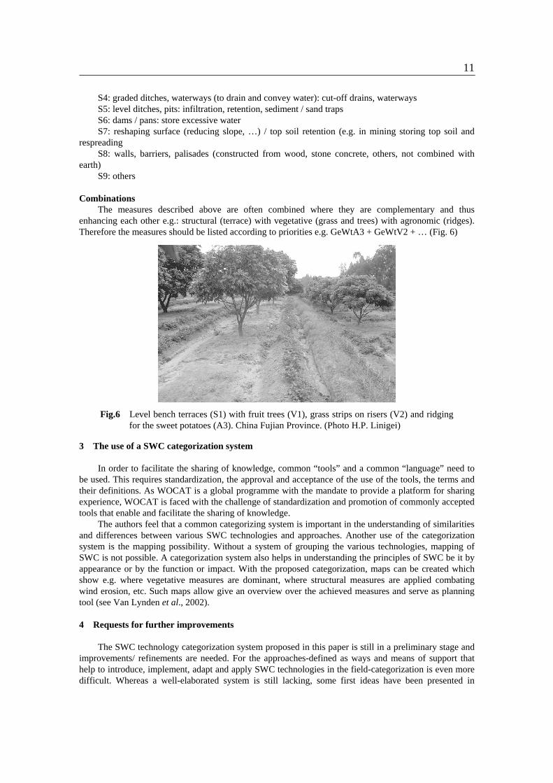
Combinations The measures described above are often combined where they are complementary and thus
enhancing each other e.g.: structural (terrace) with vegetative (grass and trees) with agronomic (ridges). Therefore the measures should be listed according to priorities e.g. GeWtA3 + GeWtV2 + … (Fig. 6)
Fig.6 Level bench terraces (S1) with fruit trees (V1), grass strips on risers (V2) and ridging
for the sweet potatoes (A3). China Fujian Province. (Photo H.P. Linigei)
3 The use of a SWC categorization system In order to facilitate the sharing of knowledge, common “tools” and a common “language” need to
be used. This requires standardization, the approval and acceptance of the use of the tools, the terms and their definitions. As WOCAT is a global programme with the mandate to provide a platform for sharing experience, WOCAT is faced with the challenge of standardization and promotion of commonly accepted tools that enable and facilitate the sharing of knowledge.
The authors feel that a common categorizing system is important in the understanding of similarities and differences between various SWC technologies and approaches. Another use of the categorization system is the mapping possibility. Without a system of grouping the various technologies, mapping of SWC is not possible. A categorization system also helps in understanding the principles of SWC be it by appearance or by the function or impact. With the proposed categorization, maps can be created which show e.g. where vegetative measures are dominant, where structural measures are applied combating wind erosion, etc. Such maps allow give an overview over the achieved measures and serve as planning tool (see Van Lynden et al., 2002).
4 Requests for further improvements
The SWC technology categorization system proposed in this paper is still in a preliminary stage and
improvements/ refinements are needed. For the approaches-defined as ways and means of support that help to introduce, implement, adapt and apply SWC technologies in the field-categorization is even more difficult. Whereas a well-elaborated system is still lacking, some first ideas have been presented in

12
Liniger et al. 1998. In a preliminary attempt to classify SWC approaches, it was realized that each approach is unique and that there is no simple categorization like: food for work, catchment approach, training and visit, participative etc. As a result WOCAT proposes that the following aspects have to be described in order to give a short characterization of an approach: objective, focus, scale, duration, process, purpose and the method of implementation. However, much more thinking has to go into the establishment of an approach categorization system.
The aim of this paper is to present the results so far with respect to technologies and initiate a reaction by the international SWC community in order to improve the system. Therefore, readers are asked to contact us and give their suggestions for improvements and collaborate with WOCAT such that the system is practicable and useful for the exchange of experience and for better implementation of SWC world-wide.
Please visit the WOCAT Website at www.wocat.net or E-mail us through [email protected]. WOCAT Secretariat, Hallerstrasse 12, 3012 Bern, Switzerland, Fax: +41 31 6318822.
References
Critchley, W.R.S., 2000. “Groundtruthing: New perspectives on soil erosion and conservation in the tropics” PhD Thesis, Vrije Universiteit, Amsterdam.
Hudson, N.W. (1992). Land Husbandry. London: Batsford. Morgan, R.P.C. (1986, 1995). Soil Erosion and Conservation. Harlow: Longman. Shaxson, T.F. (1999). New Concepts and Approaches to Land Management in the Tropics with Emphasis
on Steeplands. Soils Bulletin 75. Rome: Food and Agriculture Organisation. Sheng, T.C. (1989). Soil Conservation for Small Farmers in the Humid Tropics. Soils Bulletin No. 60.
Rome: Food and Agriculture Organisation. Thomas D.B. (ed) 1997. Soil and water conservation. Soil and Water Conservation Branch, Ministry of
Agriculture, Livestock Development and Marketing, English Press Ltd., Nairobi, Kenya. WOCAT 2002a: Questionnaire on SWC Technologies. A Framework for the Evaluation of Soil and
Water Conservation (revised). Centre for Development and Environment, Institute of Geography, University of Berne, Berne, 63pp.
WOCAT 2002b: Questionnaire on SWC Approaches. A Framework for the Evaluation of Soil and Water Conservation (revised). Centre for Development and Environment, Institute of Geography, University of Berne, Berne, 40pp.
WOCAT 2002c: Questionnaire on the SWC Map. A Framework for the Evaluation of Soil and Water Conservation. Centre for Development and Environment, Institute of Geography, University of Berne, Berne, 14pp.
Liniger H.P., van Lynden G. and Schwilch G. 2002a: Documenting field knowledge for better land management decisions-Experiences with WOCAT tools in local, national and global programs. Proceedings of ISCO Conference 2002, Beijing.
Liniger H.P., van Lynden G. and Schwilch G. 2002a: Documenting field knowledge for better land management decisions-Experiences with WOCAT tools in local, national and global programs. Proceedings of ISCO Conference 2002, Beijing.
Liniger, H.P., Thomas, D.B., and Hurni, H., 1998. WOCAT — World Overview of Conservation Approaches and Technologies — Preliminary results from eastern and southern Africa. In: Towards sustainable land use, Vol. II. Advances in Geoecology 31, Catena Verlag, Germany, p. 1037-1046.
Van Lynden G.W.J., Liniger H.P and Schwilch G. 2002: The WOCAT map methodology, a standardized tool for mapping degradation and conservation. Proceedings of ISCO Conference 2002, Beijing.