catchy catchments: estimating outflow of the iponan watershed
TRANSCRIPT
Catchy catchments: estimating outflow of the Iponan
watershed using Anylogic
Julius Sempioa, Leorey Marquez
b, Jerimae Acosta
c, Joana Decillos
c and Tricia Lunasd
a Department of Geodetic Engineering, University of the Philippines, Quezon City, Philippines
b CSIRO Digital Productivity, Clayton, Victoria, Australia
c Training Center for Applied Geodesy and Photogrammetry, Quezon City, Philippines
d SRDP Consulting Inc, Quezon City, Philippines
Email: [email protected]
Abstract: The increasing frequency and intensity of storms that hit the Philippines and the destructive floods
that follow has made the prediction of outflow behaviour for catchment basins during high precipitation
events essential in preparing riverside communities to manage disaster scenarios. This paper reports on the
development of an agent-based simulation tool for modeling runoff within the Iponan watershed using a
Java-based simulation software called AnyLogic. This tool provides a structured, transparent and interactive
approach to helping communities understand the relationship between rainfall, flooding and disaster
management. The model, called the Iponan Watershed Simulation System or IWSS, will use agents to
encapsulate the properties and interactions of the watershed components, starting with the major subbasins,
junctions and reaches, then followed by potential flood-affected areas and the populations and infrastructure
within. IWSS uses forecast data from defined rainfall scenarios to simulate extreme storm conditions for
which outflow values from the different components of the watershed will be calculated for specified points
in time. The tool is envisaged to consist of three interacting modules that will model the behaviour of the
watershed through the stages of precipitation and runoff, flooding and intervention, and population impact.
The three modules contain components, such as rivers, vegetation, populated areas, and infrastructure that
will interact with water and with each other to produce emergency conditions and represent policy
implementation scenarios. To facilitate this interaction between components, an agent-based modeling and
simulation (ABMS) approach was applied to construct the modules using the Anylogic simulation
platform. For each module, agents were created to represent the major physical and social components
operating within the watershed. The agents were assigned attributes and behaviour that approximated the
behaviour of the physical counterpart under defined precipitation scenarios. To achieve this, each module
needs to: (1) replicate a validated model of the natural system while (2) simultaneously allowing its agents
to interact with agents from other modules. This paper details the attributes and actions of the agents in the
rainfall-runoff module, first module to be completed. The rainfall-runoff module applies three
hydrometeorological techniques for runoff computations namely, Soil Conservation Service - Curve Number
(SCS-CN) for rainfall excess, Clark Unit Hydrograph (Clark UH) for direct runoff and Muskingum-Cunge
for channel routing. The model outputs are compared with results from the widely-used HEC-HMS model
for validation and accuracy assessment purposes. Further work has commenced on the development of the
agents for the flood and intervention module.
Keywords: Simulation modeling, watershed modeling, disaster management
21st International Congress on Modelling and Simulation, Gold Coast, Australia, 29 Nov to 4 Dec 2015 www.mssanz.org.au/modsim2015
1794

Sempio et al., Catchy catchments: estimating outflow of the Iponan watershed using Anylogic
1. INTRODUCTION
The Philippines continues to suffer from the adverse effects of climate change in the form of storms that are
increasing in frequency, duration and intensity. The nation’s difficulties again captured international attention
in 2014 when Typhoon Haiyan (“Yolanda”), the most destructive of recent storms, destroyed 90 percent of
the city of Tacloban, as it swept ashore with seven-metre high storm surges “wiping out practically
everything in its path” (Al Jazeera, 2014).
Much of the devastation brought about by the abovementioned storms were due to severe flooding in
communities located along rivers and other bodies of water. In particular, floods resulted from remarkably
high precipitation values pouring into watersheds, estimated to average around 50 mm per hour. The excess
rainfall brought huge volumes of water into receiving rivers which then overflowed into low-lying
communities (Olan, 2014; Malig, 2011; Panela, 2012). These conditions again showed the need for reliable
and localized tools to forecast watershed outflow due to extreme precipitation levels in order to help assess
the vulnerability of individual Philippine settlements located along river systems (Ali et al., 2011). In
addition, these tools can assist local government in the evaluation of adaptation strategies to be implemented
before and during a high precipitation event.
1.1. Iponan study area
The Iponan watershed is located in Northern Mindanao, straddling the cities of Cagayan de Oro and Iligan,
two cities severely affected by Tropical Storm Washi in 2011. Cagayan de Oro is the capital of Misamis
Oriental province with a 2010 population of 602,000 while Iligan City is an independently administered city
with a 2010 population of 322,000 inhabitants. The main tributary, the Iponan River, runs 60 km. from its
head water in Iligan City before draining into Macajalar Bay, close to the Cagayan de Oro River Basin. The
Iponan River Basin consists of 26 subbasins, 25 reaches and 26 junctions and has a drainage area of 407 sq.
km. It includes smaller tributaries such as the Domalokdok and Talakag creeks.
1.2. Study objectives
This paper reports on the design and development of an interactive simulation model of the Iponan
Watershed in Mindanao Island that will estimate water outflow for specified precipitation events. The
model, called the Iponan Watershed Simulation System or IWSS, will use agents to encapsulate the
properties and interactions of the watershed components, starting with the major subbasins, junctions and
reaches, then followed by potential flood-affected areas and the populations and infrastructure within. The
development of these agents are facilitated by the object-oriented and visually-interactive nature of the
Anylogic modeling environment. IWSS uses forecast data from defined rainfall scenarios to simulate
extreme storm conditions for which outflow values from the different components of the watershed will be
calculated for specified points in time. To assess the model’s validity and accuracy, the performance of IWSS
for observed rainfall conditions will be compared to officially published outflow values from accepted
watershed models such as HEC-HMS.
The success of this modeling study will present a new framework and library of generic watershed modeling
agents and classes specific to Philippine conditions. These generic elements can then be reused to represent
other Philippine watersheds and their corresponding rainfall scenarios provided formula normalization can
be achieved and the new watersheds to be modelled possess the minimum data requirements. This will help
local communities develop their knowledge and understanding of the dynamics of watershed behavior in
their area of influence.
1.3. Simulation in hydrologic models
Various studies have used simulation in modeling the complex hydrologic processes of watersheds especially
during rainfall events. Fan & Shibata (2015) reported on the Soil and Water Assessment Tool (SWAT)
which was used for the Teshio River basin in Northern Hokkaido to simulate the dynamics between water,
nitrogen, phosphorus, and sediment under multiple land-use and climate change scenarios. HEC-HMS, or the
Hydrologic Engineering Center - Hydrologic Modeling Software, is a well-known and widely-applied tool
from the US Army Corps of Engineers for simulating rainfall-runoff processes in river basins (USACE-
HEC, 2000). HEC-HMS was used to evaluate the impacts of potential land use change on the storm-runoff
generation in the Lai Nullah Basin in Islamabad, Pakistan (Ali et al., 2011). HEC-HMS was also used to
simulate runoff values for the Yuvacik Basin in the Marmara Region of Turkey, for flood control and flood
damage estimation studies (Yener et al., 2012). Project Climate Twin Phoenix (UP TCAGP, 2013) also used
1795
Sempio et al., Catchy catchments: estimating outflow of the Iponan watershed using Anylogic
HEC-HMS in modeling runoff for four watersheds in Mindanao Island including the Iponan watershed. The
Phoenix simulation results will be used to guide and assess the development of the rainfall-runoff model in
IWSS.
2. IWSS COMPONENTS
The Iponan Watershed Simulation System (IWSS) aims to provide communities, local government and
disaster management authorities with an integrated tool for analysing and predicting the impact of
precipitation events on the populations within the Iponan watershed. The tool is envisaged to consist of
three interacting modules that will model the behaviour of the watershed through the stages of precipitation
and runoff, flooding and intervention, and population impact. The three modules contain components, such
as rivers, vegetation, populated areas, and infrastructure that will interact with water and with each other to
produce emergency conditions and represent policy implementation scenarios. To facilitate this interaction
between components, an agent-based modeling and simulation (ABMS) approach was applied to construct
the modules using the Anylogic simulation platform. For each module, agents were created to represent the
major physical and social components operating within the watershed. The agents were assigned attributes
and behaviour that approximated the behaviour of the physical counterpart under defined precipitation
scenarios. The three modules and their principal agents are described as follows:
1. Rainfall-runoff module - This module will estimate the volume of runoff, speed of flow and channel
routing at specified points in the watershed resulting from forecasted rainfall levels. A prototype of this
module has been completed in Phase One of the IWSS development process. The agents in this
module will represent the subbasins, junctions and reaches in the watershed. In this model, the
subbasin is the area from where surface water is collected, and the junction refers to the point where
water converges for collection. A reach refers to the portion of a river or stream between two
junctions. These agents will be used to estimate the volume of water produced by a precipitation event
and where that volume goes.
2. Flood and intervention module – This module will estimate flood levels and duration at different areas
of the watershed from the forecasted runoff levels using digital terrain and elevation data, soil data,
and land cover. This module will be developed in the second phase of the IWSS development process.
In this module, the watershed area will be broken down into 100mX100m grid cells, and each cell will
be represented by an agent which will calculate the floodwater level in the grid at any time period
given the grid’s characteristics (elevation, soil, cover, etc), and the water volume produced by the
rainfall-runoff module. These agents perform the actions, such as the opening of dams or rerouting of
streams, that represent defined flood management strategies, which in turn, feedback on the agents in
the rainfall-runoff module. 3. Population impact module – This module will overlay demographic and infrastructure data over the
flood modelling layer to identify the size, attributes and locations of populations impacted by the
precipitation events. This module will provide local government with science-based analyses that can
be used in the formulation of disaster risk reduction strategies. This module will be developed in the
third phase of the IWSS development process. The agents in this module will represent the individual
households in the Iponan area, with various attributes such as location, demographics, dwelling, etc.
and with estimated behaviour in response to the water volume affecting them, as well as the disaster
management policies being implemented.
The IWSS modules are expected to produce system behaviour that parallels those from the natural system.
To achieve this, each module needs to: (1) replicate a validated model of the natural system while (2)
simultaneously allowing its agents to interact with agents from other modules. For example, the rainfall-
runoff module implements standard hydrologic processes in its subbasin agents, junction agents and reach
agents similar to those used in the HEC-HMS model. In addition, the rainfall-runoff agents are also
required to interact with grid agents, outside of the runoff module, who may be performing actions
affecting water volume and flow. HEC-HMS does provide this capability and so cannot serve as the agent-
based framework that will also support the intervention and population impact modules. The following
sections discuss the development of the rainfall-runoff agents.
2.1. Rainfall-runoff elements
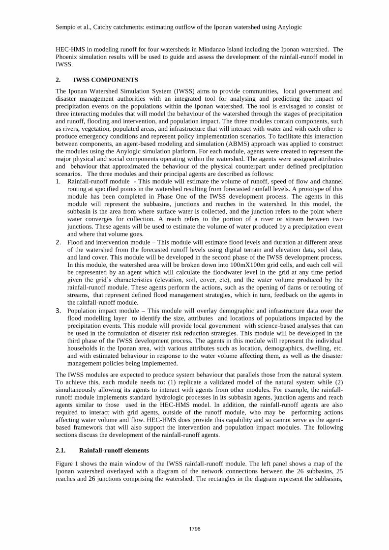
Figure 1 shows the main window of the IWSS rainfall-runoff module. The left panel shows a map of the
Iponan watershed overlayed with a diagram of the network connections between the 26 subbasins, 25
reaches and 26 junctions comprising the watershed. The rectangles in the diagram represent the subbasins,
1796

Sempio et al., Catchy catchments: estimating outflow of the Iponan watershed using Anylogic
the circles represent the junctions, and the solid line segments represent the reaches. The color shading of
the component indicates the volume of water calculated for the component for the given simulation period.
Figure 1. Main window of IWSS rainfall-runoff module
The panel on the right displays the legend for the water volumes calculated for the components and
displayed in the map. Red is used to indicate water volumes at the top limit of the range while green is used
for the bottom end. The right panel also displays four charts summarising water volumes in the watershed
during each simulation period. The top chart displays the total rainfall per simulation period, while the
other three display the total water volumes per simulation period in the subbasins, junctions and reaches.
The next version of IWSS will provide the same water volume chart for each individual subbasin, reach
and junction.
The SubBasin agent contains three elements for estimating the total runoff from precipitation coming from
the subbasins. The Infiltration Loss element calculates the amount of rainfall that falls on the watershed,
determining how much of it penetrates the surface and how much of the water runs off as excess. The
Transformation element simulates the transformation of excess precipitation into direct runoff. Baseflow
element simulates the slow subsurface drainage of water from the system into channels. (USACE, 2000).
The Reach agent contains the Channel Routing element that applies continuity and momentum equations to
simulate open channel flow. The Junction agent simply aggregates inflows from all sources and immediately
sets these as a single outflow (USACE, 2000).
2.2. Estimating rainfall losses and excess
The Infiltration Loss element implements the Soil Conservation Services - Curve Number (SCS-CN) method
to estimate rainfall losses, the volume of water that is intercepted, infiltrated, stored, evaporated and
transpired. Infiltration loss is found for each simulation period and is subtracted from the water depth to
obtain the precipitation excess (USACE, 2000).
The SCS-CN method estimates precipitation excess as a function of cumulative precipitation, soil cover,
land use, and antecedent moisture. The actual retention of the land cover, watershed storage, actual direct
runoff, total rainfall and initial abstraction are taken into consideration.
The precipitation excess Pe, is obtained from the runoff volume equation (USACE, 2000):
Pe = ( P - IA )2 / (P – IA + S ) (1)
Where P = accumulated rainfall depth at time t; Ia = the initial abstraction (initial loss); and S = potential
maximum retention, a measure of the ability of a watershed to abstract and retain storm precipitation. Until
1797

Sempio et al., Catchy catchments: estimating outflow of the Iponan watershed using Anylogic
the accumulated rainfall exceeds the initial abstraction, the precipitation excess, and hence the runoff, will be
zero.
The maximum retention S and the watershed characteristics are related through an intermediate parameter CN
(curve number) from the following equation (USACE, 2000):
S = (1000 - 10*CN) / CN (foot-pound system) or (2)
S = (25400 -254*CN) / CN (SI systems) (3)
2.3. Estimating direct runoff
Given the precipitation excess for the simulation period, the Transformation element implements Clark’s
Unit Hydrograph (Clark UH) method to derive the direct runoff for the subbasin. Clark derives a watershed
Unit Hydrograph by explicitly representing two critical processes (translation and attenuation) in the
transformation of excess precipitation to runoff (USACE, 2000).
Short-term storage of water throughout a watershed – in the soil, on the surface, and in the channels- plays an
important role in the transformation. The direct runoff equation is given by (USACE, 2000):
Ot = CA* It + CB* It-1 (4)
Where, Ot = outflow from storage at time t; IT = average inflow to storage at time t; and CA, CB = routing
coefficients.
The coefficients CA and CB are calculated from (USACE, 2000).:
CA = ( t / (R + 0.5 t) ; CB = 1 - CA (5)
Where R = subbasin storage coefficient . The storage coefficient R is an index of the temporary storage of precipitation excess in the watershed as it drains to the outlet point (USACE, 2000).
2.4. Estimating baseflow
To obtain the total outflow from the subbasin, we need add the baseflow to the direct runoff. Baseflow refers
to the sustained or ‘fair-weather’ runoff of previous rainfall that was temporarily stored in the watershed, plus
the delayed subsurface runoff from the current rainfall (USACE, 2000).
The Baseflow element calculates the baseflow using the Exponential Recession method. In this method, Qt,
the baseflow at any time t, is given by (USACE, 2000):
Qt = Q0 * kt (6)
Where Q0 = is the initial baseflow (at time zero); and k = exponential decay coefficient (USACE, 2000).
The starting baseflow value is an initial condition in the model and may be specified as a flow rate (m3/s or
cfs) or as a flow per unit area (m3/s/m
2 or cfs/sq.mile). The total flow from the subbasin is the sum of the
baseflow and the direct runoff.
2.5. Calculating for channel routing
The Channel Routing element implements the Muskingum-Cunge method to solve the continuity and
momentum equations for open channel flow. Using finite difference approximations of partial derivatives,
the solution to the open channel equations give (USACE, 2000):
Ot = C1 It-1 + C2 It + C3 Ot-1 + C4 (qL Δx) (7)
Where Ot, Ot-1 = outflow discharges at time t and t-1, respectively; It, It-1 = inflow hydrograph ordinates
at time t and t-1, respectively; qL, = lateral inflow; Δx = distance step size and C1, C2, C3, C4, =
dimensionless coefficients.
The coefficients are given by (USACE, 2000):
C1 = ( t / K ) + 2 X) / C0; (8)
C2 = ( t / K ) – 2 X) / C0; (9)
C3 = ( 2 ( 1 – X ) - t / K ) / C0; (10)
C4 =( 2 ( t / K ) / C0 ; (11)
C0 = t / K + 2 ( 1 – X ). (12)
1798

Sempio et al., Catchy catchments: estimating outflow of the Iponan watershed using Anylogic
An approximation for K is the travel time through the reach (length of reach divided by the average flow
velocity). The value of X is between 0.0 and 0.5. A value of 0.0 gives maximum attenuation from the
procedure and 0.5 provides the minimum attenuation. Linsley et al., (1982) describe a procedure to
determine K and X from hydrographs.
3. PRELIMINARY RESULTS
Test runs of IWSS were performed
using rainfall data for a 100-year event
with land cover for 2013. (UP
TCAGP, 2014). The data provides
rainfall volumes in the Iponan
watershed at 10-minute intervals for
December 1, 2013. IWSS was used to
obtain estimates for precipitation
excess, direct flow, baseflow and total
flow for each subbasin for 144
simulation periods. Estimates of total
outflow were also obtained for
junctions and reaches for the
simulation period. The results were
then compared with output obtained
from HEC-HMS for the same rainfall
data as part of Project Climate Twin
Phoenix.
Figure 2 provides charts comparing
the IWSS outputs with the results from
HEC-HMS for a) total precipitation
excess in subbasins, b) total outflow
from subbasins and c) total outflow
from reaches. The charts show that the
plots of overall results from IWSS
overlay very closely with those from
HEC-HMS. Comparisons were also
made for results from individual
components such as subbasin B83.
The results from IWSS again matched
those from HEC-HMS. This means
that IWSS provides the same estimates
as HEC-HMS for the calculation
methods ( exponential recession, SCS-
CN, Clark UH, Muskingum-Cunge)
that have been implemented. The
results of comparisons with HEC-
HMS validate the implementation of
the rainfall-runoff model of IWSS.
4. FURTHER WORK
This paper presented on the
development of the rainfall-runoff
module of IWSS. This module is the
first of three modules that will provide an integrated modeling and disaster management tool for the Iponan
watershed. Results from IWSS for outflow estimates for a 100-year rainfall event matched closely those from
HEC-HMS, validating the implementation of the calculation methods selected. More calculation methods
will be included in IWSS providing the user with flexibility in modeling different watersheds. With the
success of the rainfall-runoff module, the development of the flood module of IWSS can commence soon.
a) Comparing excess precipitation
b) Comparing total outflow from subbasins
c) Comparing total outflow from reaches
Figure 2. Charts comparing IWSS outputs (red) with HEC-HMS results (blue) for 100-year rainfall event under Iponan 2013 land cover.
1799
Sempio et al., Catchy catchments: estimating outflow of the Iponan watershed using Anylogic
REFERENCES
Al Jazeera. (2014) Philippines marks Typhoon Haiyan anniversary. Retrieved February 21, 2015, from Al
Jazeera International: November 8 2014, http://www.aljazeera.com/news/asia-pacific/2014/11/philippines-
marks-typhoon-haiyan-anniversary-201411835744828320.html.
Ali, M., Khan, S. J., Alsam, I., & Khan, Z. (2011). Simulation of the impacts of land-use change on surface
runoff of Lai Nullah Basin in Islamabad, Pakistan. Landscape and Urban Planning , 102, 271-279.
Fan, M., & Shibata, H. (2015). Simulation of watershed hydrology and stream water quality under land use
and climate change scenarios in Teshio River watershed, northern Japan. Ecological Indicators , 50, 79-89.
Linsley, R.K., M.A. Kohler, and J.L.H. Paulhus, (1982). Hydrology for Engineers, McGraw Hill, 508 pp
Malig, J. (2011). 'Sendong' world's deadliest storm for 2011. Retrieved February 26, 2015, from ABS-CBN
News Online, December 20 20122, http://www.abs-cbnnews.com/nation/12/19/11/sendong-worlds-deadliest-
storm-2011
NRCS. (1986). Technical Release 55 – Urban Hydrology for Small Watersheds. . National Resources
Conservation Service, United States Department of Agriculture.
Olan, S. J. (2014). Looking back: the records of Ondoy. Retrieved February 26, 2015, from Rappler,
September 26 2014, http://www.rappler.com/move-ph/issues/disasters/70240-ondoy-records
Panela, S. (2012). NASA: Pablo's rainfall rate similar to Sendong, Ondoy. Retrieved February 26, 2015, from
GMA News Online, December 5, 2012, http://www.gmanetwork.com/news/story/285109/news/nation/nasa-
pablo-s-rainfall-rate-similar-to-sendong-ondoy
UP TCAGP (2013). Profile and cross-section surveys, inflow measurements and flood modeling of the
Cagayan de Oro, Iponan, Mandulog and Iligan rivers, for flood hazard assessment purposes. Quezon City:
University of the Philippines Training Center for Applied Geodesy and Photogrammetry.
UP TCAGP (2014). River Basin and Flood Modeling and Flood Hazard Assessment of Rivers in the Cities of
Cagayan De Oro and Iligan. Quezon City: University of the Philippines Training Center for Applied Geodesy
and Photogrammetry. June 2014. Published by the Climate Change Commission under the CCC-UNDP-
Australian Government Project - Project Climate Twin Phoenix
USACE (2000). Hydrologic Modeling System HEC-¬HMS Technical Reference Manual. Davis, California:
United States Army Corps of Engineers- Hydrologic Engineering Center.
Yener, M. K., Sorman, A. U., Sorman, A. A., Sensoy, A. and Gezgin, T. (2012), Modeling Studies
with HEC-HMS And Runoff Scenarios in Yuvacik Basin, Turkiye, International Congress on River Basin
Management, pp 621-634.
1800