carolina bay volunteer research program
TRANSCRIPT

University of South CarolinaScholar Commons
Faculty & Staff Publications Archaeology and Anthropology, South CarolinaInstitute of
2-2010
Carolina Bay Volunteer Research ProgramChristopher R. MooreUniversity of South Carolina - Columbia, [email protected]
Mark J. BrooksUniversity of South Carolina - Columbia, [email protected]
Andrew H. Ivester
Terry Ferguson
Follow this and additional works at: https://scholarcommons.sc.edu/sciaa_staffpub
Part of the Anthropology Commons
This Article is brought to you by the Archaeology and Anthropology, South Carolina Institute of at Scholar Commons. It has been accepted forinclusion in Faculty & Staff Publications by an authorized administrator of Scholar Commons. For more information, please [email protected].
Publication InfoPublished in Legacy, Volume 14, Issue 1, 2010, pages 4-9.http://www.cas.sc.edu/sciaa/© 2010 by The South Carolina Institute of Archaeology and Anthropology

4 Legacy, Vol. 14, No. 1, February 2010
Savannah River ResearchCarolina Bay Volunteer Research ProgramBy Christopher R. Moore, Savannah River Archaeological Research Program; Mark J. Brooks, Savannah River Archaeological Research Program; Andrew H. Ivester, Department of Geosciences, University of West Georgia; and Terry A. Ferguson, Department of Environmental Studies, Wofford College
Over the last year, the integration of archaeological research and public outreach has been achieved at the Savannah River Site (SRS) through the establishment of the Carolina Bay Volunteer Research Program. This research involves utilizing dedicated avocational archaeologists, collectors, and the interested public in an ongoing and systematic study of Carolina bays. Both specific site-level research at Flamingo Bay (on the SRS) and more general regional-level studies of Carolina bays in surrounding counties will provide high resolution archaeological and geological data from a single bay and a comparative database for regional bay variability.
Carolina bays are shallow, oriented (NW-SE in the Carolinas), and elliptically-shaped ponds that occur in large numbers throughout the Coastal Plain portion of the South Atlantic Slope (Fig. 1). Several hundred thousand bays are thought to exist between Maryland and northern Florida, with the greatest concentration
occurring in the Carolinas and Georgia (Walker and Coleman 1987). Carolina bays often have elevated sand rims composed of fine sand to gravel-sized sediments deposited by high-energy, lacustrine (lake) processes involving shoreface (water-lain) and eolian (wind-blown) sedimentation (Brooks et al. 1996). If eolian and shoreface sedimentation occurred over the course of the Holocene under varying climatic conditions, then the potential exists for prehistoric occupations to have been buried and preserved. Thus, these geologic deposits represent a “time-capsule” for understanding the
archaeological record of the Coastal Plain and serve as a proxy for understanding climate change and cultural adaptation.
The most recent cosmic impact hypothesis for the origin of Carolina bays has been advanced by Firestone et al. (2007). These authors further hypothesize the impact as a mechanism for explaining the Younger Dryas (YD) cold period (ca. 12,900-11,500 calendar years BP), megafauna extinctions, and the demise of Clovis culture at the end of the last ice age. Our data, however, demonstrate that Carolina bays were formed by high-energy lacustrine processes over lengths of time far greater than the onset of the YD and that bay evolution is a long-term process rather than a synchronous event (e.g., Brooks et al. 2001; Ivester et al. 2002).
In addition to meeting our objectives for engaging the public, this long-term Carolina bay study by the Savannah River Archaeological Research Program (SRARP) addresses four basic research objectives: 1) determining the age, origin, and evolution of Carolina bays; 2) delineating prehistoric cultural activities and site formation processes on Carolina
Fig. 1: LiDAR digital elevation map of Carolina bays in Southeastern North Carolina. (Figure produced in ArcGIS by Christopher Moore)
Fig. 2: LiDAR digital elevation map of Flamingo Bay (38AK469). (Figure produced in ArcGIS by Christopher Moore)

5Legacy, Vol. 14, No. 1, February 2010
bay sand rims; 3) determining the role of Carolina bays in prehistoric settlement systems; and 4) exploring linkages at Carolina bays between climate change, depositional processes, and prehistoric adaptations. In addition to the ongoing baseline investigations at Flamingo Bay on the SRS (e.g., Brooks et al. 1996; Brooks and Taylor 2003), a body of comparative data was obtained this year from fairly intensive investigations at Frierson Bay near Blackville, South Carolina, and Johns Bay near Allendale, South Carolina.Below, we describe preliminary results of geoarchaeological research on Carolina bays in Aiken, Allendale, and Barnwell counties, South Carolina.
Flamingo Bay (Aiken County)At Flamingo Bay, investigations
continued this year at site 38AK469, situated on the bay’s east-central sand rim (Fig. 2). Volunteers for this excavation included DOE intern Jennifer Stevenson, SRS employee Dennis Hendrix, and long-time SRARP volunteer Jill Nazarete. Several Early Archaic activity areas, or possibly discrete, small-scale occupations were identified earlier through systematic close-interval testing (Brooks and Taylor 2003). The major site-level goal is to derive a better understanding of site activities and how these small-scale Early
Archaic hunter-gatherer societies were organized—in this case with respect to the use of Carolina bays. However, because most behavioral interpretations are based on artifact patterning, it is necessary to first differentiate between the natural and cultural processes that collectively formed the archaeological record. This
is particularly critical when dealing with shallow, sandy, multicomponent Coastal Plain sites with no visually observable depositional stratigraphy. While many sites in the Coastal Plain appear to be bioturbated with mixed or conflated artifact assemblages, it is apparent from
previous work on Carolina bay sand rims in South Carolina (e.g., Brooks et al. 1996) and relict source-bordering dune deposits in North Carolina (e.g., Daniel et al. 2008; Moore 2009; Seramur and Cowan 2002; Seramur 2003) that sandy sites like these may contain stratified cultural deposits with valuable cultural and paleoenvironmental information.
Previous shovel testing and test unit excavations at Flamingo Bay (Brooks and Taylor 2003) have established the presence of stratified occupations (Fig. 3). With the help of volunteers, recent excavations of a 4 X 4-meter block have revealed evidence for a relatively pure Early Archaic occupation between 50 and 70 centimeters below surface (cmbs) with numerous worked and broken cobbles, hammerstones, unifacial tools, and whole and broken corner-notched points. Although the Early Archaic horizon is shallower than at other bay sites (see Frierson Bay and Johns Bay below), this is explained by the fact that historic land use had effectively deflated the upper ~20-30 centimeters of sand along the sand rim at Flamingo Bay by the middle 20th century
(Brooks et al. 1996). Above the Early Archaic horizon we have evidence for likely ephemeral Middle and Late Archaic occupations along with trace amounts of Woodland and Mississippian pottery near the surface.
In an attempt to understand site
Fig. 3: Artifact backplot of piece-plotted artifacts from Flamingo Bay (PROV. 25) along with grain size data for interpreting site formation processes. (Figure produced by Christopher Moore)
Fig. 4: Andrew Ivester (Department of Geosciences, University of West Georgia) collecting sediment samples for micromorphology. (Photo by Christopher Moore)

6 Legacy, Vol. 14, No. 1, February 2010
formation processes, all pebbles and stone concretions found during our excavations were collected for analysis. Within the assemblage of pebbles and concretions, we recovered numerous pebble-sized polished stone gastroliths (i.e., gizzard stones)—also in association with the Early Archaic occupation of the site. Notably, we have also recovered charred hickory nut, charred persimmon seed, and wood charcoal in association with Early Archaic occupations. Together, these findings offer a surprising glimpse into the food procurement strategies of early Holocene hunter-gatherers beyond that typically associated with formal projectile points and scrapers. Dr. Robert Yohe (Department of Sociology and Anthropology, California State University) has agreed to examine the gastroliths for protein residue (i.e., immunological analysis) in hopes of identifying specific bird species. This technique has been used successfully to identify blood protein residue preserved within the fractured surfaces of stone tools (e.g., Newman 1994) but to our knowledge has never been attempted on bird gastroliths.
With the present interest in delineating buried occupation surfaces and depositional processes, stratigraphic (vertical) data were emphasized. Grain-size analyses in combination with a consideration of the vertical distribution
of artifacts have proven successful in delineating buried occupation surfaces (e.g., Brooks and Sassaman 1990; Brooks et al. 1996). Accordingly, artifacts larger than 2.5 centimeters were point-plotted (larger artifacts are less likely to be displaced vertically due to post-occupational processes, a proposition that will be evaluated by refitting broken artifacts) and a continuous sediment column was collected at 2.5-centimeter increments to the depth
of excavation. In the past, ~5-centimeter increments were used, but it is likely that multiple, thin burial events were crosscut. Other sediment data of possible relevance to identifying buried surfaces, for which samples were also collected at finer increments, included soil chemistry, soluble silica, magnetic susceptibility, bulk density, field water content, and optically stimulated luminescence (OSL) dating. In addition, several samples were taken for micromorphology analysis at Flamingo Bay (Fig. 4). With specific reference to OSL dating, refinements were made by reducing the sample collection tube size from 5 centimeter (or larger) to 1.5-2 centimeters, and by shifting from the single aliquot to the single grain technique. This was done in order to test our hypothesis that depositional events along
bay sand rims since the late Pleistocene were centimeter-scale events and that use of larger sampling tubes would likely intersect multiple depositional events (e.g., Feathers et al. 2006). A shift to single-grain OSL dating also reflects our increased understanding of site formation processes of shallowly buried eolian and water-lain deposits of lacustrine and fluvial origin within the Coastal Plain (e.g., bay rims, source-bordering dunes, and sand sheets) (Brooks and Taylor 2003; Moore 2009).
Frierson Bay (Barnwell County)Frierson Bay is a large (~1.2
kilometers along its long axis and 0.6 kilometers at its widest point), forested bay that contained permanent water until drained in the early 1960s (Fig. 5). Its prominent eastern sand rim, which was the focus of our geoarchaeological attention, has prograded into the western edges of two other Carolina bays immediately to the east. Frierson Bay is located on the property of Dr. John Frierson. We are greatly indebted to John (long-time contributor to the Archaeological Research Trust [ART]) for allowing access to his farm near Blackville, South Carolina. Volunteers for this project were numerous and included Aiken residents Rooney Floyd and Tom Cofer with previous experience at the Topper site. Also included were Aiken resident
Fig. 6: Volunteers Rooney Floyd, Tom Cofer, and Kevin Eberhard excavating at Frierson Bay. (Photo by Christopher Moore)
Fig. 5: Color-infrared aerial image of Frierson Bay in Barnwell County showing excavation areas and a prominent eastern bay sand rim burying the western edge of a smaller Carolina bay. (Figure produced in ArcGIS by Christopher Moore)
7Legacy, Vol. 14, No. 1, February 2010
and long-time SRARP volunteer Kevin Eberhard, along with Danny Robinson (former SRARP employee), and recent graduate Warren Rich (now part of the SRARP field crew) (Fig. 6).
Archaeological survey consisted of shovel testing along the spine of the eastern sand rim—the preferred location of prehistoric settlement at most Carolina bays. East-west shovel test transects were placed across the sand rim at key locations. Virtually all
shovel tests contained archaeological material—primarily Coastal Plain chert debitage in the 40-80 centimeters below surface depth range. All Archaic and Woodland period components were represented; however, like most bays, the Early Archaic seemed dominant. Unlike Flamingo Bay, no particular area appeared to contain noticeably higher densities of material, but this may be due to the larger testing interval at Frierson Bay. Thus, the placement of two adjacent 2 X 2
meter units and one isolated 1 X 2 meter unit was largely arbitrary. One of the 2 X 2 meter units produced an exhausted, Early Archaic quartz Taylor biface at 77 centimeters below datum (Fig. 7), and the 1 X 2 meter unit produced a cache (n = 12) of Coastal Plain chert, biface performs, and one quartzite biface between 66 and 69.5 centimeters below surface (Fig. 8). Based on depth range, technology, degree of patination, and presence of thermal alteration, a Middle Archaic affiliation is likely for the cache, although an Early Archaic affiliation cannot be ruled out. Dates from OSL samples collected from this unit should resolve the question.Continuous sediment columns sampled at 2.5 centimeter intervals were taken from one of the 2 X 2-meter units and from the 1 X 2 meter unit. These samples were subsampled for magnetic susceptibility analysis. In total, eight OSL samples were collected from the walls of the same two units at key depths indicated by the archaeological record. At Frierson Bay, 1.5-centimeter diameter OSL sampling tubes were used to reduce the likelihood of sampling across “invisible” depositional boundaries. Soil chemistry, bulk phytolith, bulk density, and field water content analyses will be conducted at Frierson and Johns Bays in the future if the pilot study for these analyses at Flamingo Bay proves fruitful.
Johns Bay (Allendale County)Johns Bay is also large (~0.7
kilometer along its long axis and 0.5 kilometer at its widest point) with a prominent eastern sand rim merging laterally into a markedly elevated (~3 meter), broad, parabolic dune-shaped landform on the southeastern bay margin (Fig. 9). The bay basin is open, characterized by low, herbaceous vegetation and an open-water pool (~0.5 hectares) at the south end.
We wish to express appreciation to the landowner, Mrs. Mary Johns, for allowing our field crew and volunteers access to her property for archaeological testing of this prominent bay sand rim. Mrs. Johns, whose house is located on
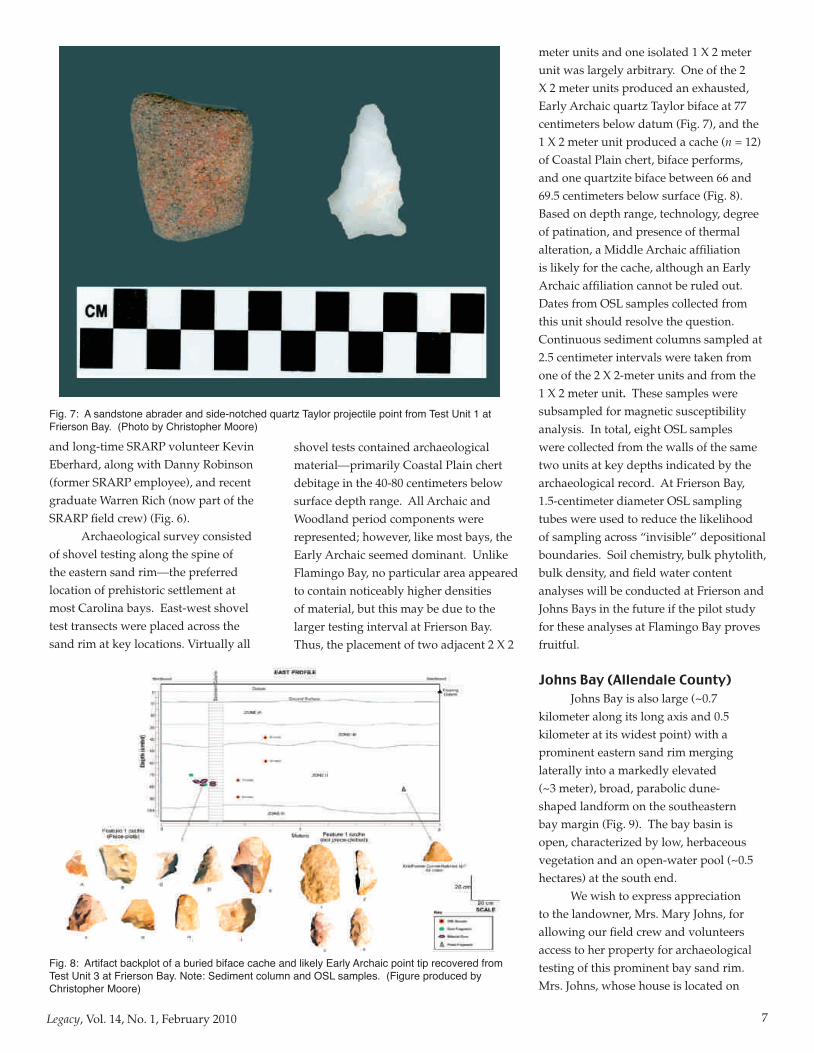
Fig. 7: A sandstone abrader and side-notched quartz Taylor projectile point from Test Unit 1 at Frierson Bay. (Photo by Christopher Moore)
Fig. 8: Artifact backplot of a buried biface cache and likely Early Archaic point tip recovered from Test Unit 3 at Frierson Bay. Note: Sediment column and OSL samples. (Figure produced by Christopher Moore)

8 Legacy, Vol. 14, No. 1, February 2010
the northeast portion of the rim, noted that the entire basin was open water until at least 1955 when she remembers people waterskiing. Ms. Johns also noted that the bay was most recently completely inundated in 2003 when the water level was up to her yard. An interesting manifestation of the most recent inundation was the formation of a “clean” white sandy beach along the bays southeast margin. This beach was produced by high-energy wave action reworking the toe of the sand rim, representing former shoreline deposits consisting of both water-lain and eolian components. This is significant because most bays transitioned from high-energy, open-water ponds to low-energy, vegetated wetlands during the mid-Holocene (Brooks et al. 1996), such that sediments became vegetation bound. Under this circumstance, it is hard to explain how Mid- to Late Holocene archaeological materials could be buried on the sand rim if the sediment supply was shut down. As demonstrated by Johns Bay, this can be explained by the episodic, small-scale reworking of existing source-bordering (sand rim) deposits; in this case, the beach sands would be exposed for eolian transport up on to the sand rim
by winds out of the west-northwest once the water level receded and the sediments dried.
Recent work on stratified source-bordering dunes and eolian/fluvial sand sheets along the Tar River in North Carolina suggest burial events at those sites may be associated with periods of rapid climate change and ecosystem instability (Moore 2009). Our work on Carolina bays will address whether or not similar site formation processes are responsible for site burial at the regional level.
At Johns Bay, the parabolic dune-shaped deposits of the southeastern rim were targeted for geoarchaeological investigations. Two areas were selected for archaeological survey, with every shovel test producing cultural material to a depth of one meter below surface. One of these areas contained a fairly dense spatial cluster (~30 X 30 meters), more similar to the archaeological patterning at Flamingo Bay than of that at Frierson Bay. All temporal components appeared to be present, dominated by
Archaic period material with the Early Archaic likely most prevalent.
In the area of highest density of archaeological material, two 2 X 2-meter units were excavated with the help of volunteers including Bob Van Buren of Aiken and Larry Strong from Allendale (Fig. 10). Woodland and Late Archaic materials were recovered immediately below the plowzone, and a small Early Archaic Kirk/Palmer biface of Coastal Plain chert was point-plotted at 80 centimeters below surface in one of the units (Fig. 11). Coastal Plain chert dominated the assemblage; however small amounts of non-local material were present in the Archaic horizons. Possibly relating to proximity to the Allendale chert quarries, the chert debitage from Johns and Flamingo Bays represent the complete range of post-quarry reduction activities, whereas the small chert debitage from Frierson Bay indicates primarily late stage tool reduction and maintenance.
Grain-size, magnetic susceptibility, and OSL samples were collected from one of the 2 X 2-meter units in the manner employed at Flamingo and Frierson Bay. Through coring, basal bay rim OSL samples were also collected from Johns Bay at 165-195 and 255-285 centimeters below surface, just above the Tertiary-aged boundary, to obtain a minimum age for the bay and to document rates of net sedimentation in the vicinity of the excavation units. Although these samples have yet to be dated, previous age
Fig. 10: Johns Bay volunteers Dr. Larry Strong of Allendale and Bob Van Buren of Aiken. (Photo by Christopher Moore)
Fig. 9: Color-infrared aerial image of Johns Bay in Allendale County showing excavation areas, ponded water, and a large parabolic dune. (Figure produced in ArcGIS by Christopher Moore)

9Legacy, Vol. 14, No. 1, February 2010
determinations by Brooks et al. (2003) and Ivester et al. (2007) have demonstrated that at least some Carolina bays are in excess of 100,000 years old.
Analyses of artifacts along with sedimentology are currently underway with the help of lab volunteers John Whatley from Evans, Georgia (Fig. 12) and Bob Van Buren from Aiken, SC (Fig. 13). These data along with the results of other specialized geoarchaeological analyses (e.g., soil chemistry, magnetic susceptibility, bulk phytolith, micromorphology, immunological analysis of gastroliths, ethnobotanical analysis, artifact refitting and back-plotting, ground-penetrating radar, and OSL dating) will be presented in future symposia and publications. Cumulatively, these
Fig. 11: Artifact backplot of piece-plotted artifacts from Johns Bay (TU 1) along with magnetic susceptibility and grain size data for interpreting site formation processes. Note: Sediment column and OSL samples. (Figure produced by Christopher Moore)
analyses will allow us to begin to address substantive issues beyond site formation processes and relate cultural occupation of Carolina bays to broader anthropological questions concerning the social organization, complexity, and adaptative strategies of early hunter-gatherers to changing environmental conditions.
Finally, we would like to end by saying that this work would not be possible without the hard work and dedication of our volunteers. Over the next year, the SRARP hopes to expand the Carolina Bay Volunteer Research Program to include more volunteers, both in the
field and in the lab. We also wish to thank board members and trustees of the Archaeological Research Trust (ART) for providing a grant for OSL dating at Flamingo Bay. Additional excavations are planned for the spring and preliminary results
of this work will be presented at regional conferences including the upcoming Archaeological Society of South Carolina (ASSC) Conference and the Southeastern Geological Society of America (GSA) meetings in Baltimore, Maryland.
For more information on the Carolina Bay Volunteer Research Program, please contact Dr. Christopher R. Moore, [email protected], office: 803-725-5227 or Dr. Mark J. Brooks, [email protected], office: 803-725-5221. Donations for this research are accepted through the USC Educational Foundation. If you wish to donate to this foundation, please contact Nena Powell Rice, [email protected], office: (803) 576-6573 or cell: (803) 331-3431.
For a list of references cited in this article, please contact the authors.
Fig.13: Volunteer Bob Van Buren of Aiken, SC, holding a small Palmer point found at Johns Bay. (Photo Christopher Moore)
Fig. 12: Lab volunteer John Whatley of Evans, GA, assisting in artifact analysis. (Photo by Christopher Moore)