capsizing after grounding and death of 18 crew members of ...3 vessel particulars 3.1 photo of...
TRANSCRIPT

Department of Marine Services and Merchant ShippingAntigua and Barbuda W.I.
Investigation Report
Very serious marine casualty:
Capsizing after grounding and death of 18 crewmembers of
MV ROCKNESon 19 January 2004
in Vatlestraumen/sea area south of Bergen,South Norway
Joint investigation report in accordance withIMO Res. A849(20)
by the flag State Antigua and Barbudaand the State with substantial interest,
Federal Republic of Germany
Bundesstelle für SeeunfalluntersuchungFederal Bureau of Maritime Casualty Investigation
Bundesoberbehörde im Geschäftsbereich des Bundesministeriums für Verkehr, Bau- und Wohnungswesen
Department of Marine Services and Merchant ShippingAntigua and Barbuda W.I.
_____________________________________________________________________________________________________
Bundesstelle für Seeunfalluntersuchung
Federal Bureau of Maritime Casualty Investigation
BSUSeite 2 von 46
Extract fromThe Merchant Shipping
(Accident Reporting and Investigation)Regulations 1999 – Regulation 4:
"The purpose of investigating an accident under the Mer-chant Shipping (Accident Reporting and Investigation)Regulations 1999 is to determine its circumstances and thecauses with the aim of improving safety of life at sea andthe avoidance of accidents in the future. It is not the pur-pose to apportion liability, nor, except so far as necessaryto achieve the fundamental purpose, to apportion blame."
Note
The report is not written with liability in mind and is not in-tended to be used in court for the purpose of litigation. Itendeavours to identify and analyse the relevant safety is-sues pertaining to the specific accident, and to make rec-ommendations aimed at preventing similar accidents in thefuture.
Prior to finalizing the investigation report draft copies have been dis-tributed to parties having substantial interest in the findings and out-come of the investigation. Technical comments and contributions re-ceived in return have been respected as deemed appropriate. TheRoyal Norwegian Ministry of Fisheries and Coastal Affairs Authoritiesrequested (reference 200400093- /BV) that following remark shouldbe inserted into the introduction of the report:
Quote:
" Due to the fact that there is a litigation brought against the Norwe-gian government represented by our Ministry following the accidentof MV "Rocknes", the Ministry of Fisheries and Coastal Affairs do notfind it appropriate to comment on the report."
Unquote.
Department of Marine Services and Merchant ShippingAntigua and Barbuda W.I.
_____________________________________________________________________________________________________
Bundesstelle für Seeunfalluntersuchung
Federal Bureau of Maritime Casualty Investigation
BSUSeite 3 von 46
Table of Contents
1 SUMMARY OF THE MARINE CASUALTY........................................................ 52 SCENE OF THE ACCIDENT ............................................................................. 63 VESSEL PARTICULARS ................................................................................... 7
3.1 Photo of vessel................................................................................... 73.2 Vessel particulars ............................................................................... 7
4 COURSE OF THE ACCIDENT .......................................................................... 84.1 Conversion KVITNES to ROCKNES ................................................... 84.2 Weather conditions............................................................................ 124.3 Voyage planning................................................................................ 134.3.1 Local pilot .......................................................................................... 134.3.2 Vessel command............................................................................... 144.3.3 Electronic sea charts ......................................................................... 154.4 Loading in Eikefet.............................................................................. 204.5 Passage from Eikefet to Skålevik...................................................... 214.6 Bunkering in Skålevik ........................................................................ 224.7 Onward passage from Skålevik......................................................... 234.8 Vatlestraumen passage..................................................................... 274.9 Bridge Management .......................................................................... 33
5 INVESTIGATION ............................................................................................. 356 STABILITY AND FOLLOW- UP ACTIONS ...................................................... 38
6.1 Stability....................................................................................................... 386.2 Related IMO submissions .......................................................................... 38
7 SAFE PASSAGE THROUGH VATLESTRAUMEN .......................................... 387.1 Environment ...................................................................................... 417.2 Visibility from the navigation bridge ................................................... 41
8 ACTION TAKEN............................................................................................... 438.1 Modifications during repair of ROCKNES.......................................... 43
9. SOURCES ....................................................................................................... 44ADDRESSES AND CONTACTS...................................................................... 45

Department of Marine Services and Merchant ShippingAntigua and Barbuda W.I.
_____________________________________________________________________________________________________
Bundesstelle für Seeunfalluntersuchung
Federal Bureau of Maritime Casualty Investigation
BSUSeite 4 von 46
List of Figures
Figure 1: Scene of the accident ................................................................................. 6
Figure 2: ROCKNES................................................................................................... 7
Figure 3: Approved line of sight plan KVITNES.......................................................... 8
Figure 4: Side view of ROCKNES with new deck superstructure ............................... 9
Figure 5: Cross-sectional drawing MV ROCKNES ................................................... 11
Figure 6: Line of sight plan ROCKNES..................................................................... 12
Figure 7: Excerpt from the Norwegian ENC.............................................................. 17
Figure 8: Excerpt from ARCS (up to April 2004)....................................................... 18
Figure 9: Excerpt from C-Map (up to January 2004) ................................................ 19
Figure 10: Vessel route ROCKNES from Eikefet to Skålevik.................................... 22
Figure 11: Voyage route ROCKNES after leaving Skålevik...................................... 26
Figure 12: Depth data shown in Sea Chart 21 old .................................................... 27
Figure 13: Depth data shown in Sea Chart 21 new .................................................. 28
Figure 14: Original size Sea Chart 21, Statens Kartverk Sjø.................................... 30
Figure 15: Comparison between Sea Chart 21 old (top) and new (bottom).............. 31
Figure 16: Cover sheet to Admiralty NtM No 1819, April 2004 ................................. 33
Figure 17: Bottom damage to the capsized ROCKNES ........................................... 35
Table 1: Loading diagram for MV ROCKNES........................................................... 20

Department of Marine Services and Merchant ShippingAntigua and Barbuda W.I.
_____________________________________________________________________________________________________
Bundesstelle für Seeunfalluntersuchung
Federal Bureau of Maritime Casualty Investigation
BSUSeite 5 von 46
1 Summary of the marine casualty
On the weekend of 17 and 18 January 2004 the Bulk Carrier ROCKNES loaded acargo of gravel in the South Norwegian port of Eikefet, north of Bergen. After theloading works had been completed on Sunday evening, the vessel left Eikefet shortlybefore 09:00 h1 on Monday, 19 January 2004, with a pilot on board and proceeded tobunker in Skålevik near Bergen, where she moored at 11:40 h. Four hours later, atabout 15:40 h, MV ROCKNES continued its voyage, still with the pilot on board,heading for the intended port of discharge in Emden, Germany.
At about 16:23 h MV ROCKNES changed course to port in order to enter Vatles-traumen. At about 16:27 h the vessel touched ground with her starboard side in thenarrow passage; immediately she developed list to starboard that could not bestopped. Within a few minutes MV ROCKNES capsized completely.
Twelve of the thirty persons on board could be recovered alive as a result of the res-cue measures initiated immediately. Three of them were freed from the hull of thevessel floating keel upwards after several hours.
Escaping fuel polluted Vatlestraumen and the adjacent coastline. The NorwegianCoastal Authority collected a total of 1.291 tons of emulsified sea water which hasbeen determined to be equivalent to 227,5 tons of IFO 380.
After the rescue attempts were discontinued, the vessel was towed into a bay onÅgotnes. The hull of the vessel was examined and it was decided to upright MVROCKNES again. From 17 March 2004 onwards work proceeded on turning the ves-sel; on 29 March 2004 it was lying upright again. On 5 April 2004 MV ROCKNES wastowed to the Bergen Mekaniske Yard at Laksevag near Bergen. The vessel was in-spected and a decision was taken to reinstate it. To this end MV ROCKNES wastowed to Poland for repairs and modifications. It was initially estimated that the nec-essary repair works would take more than one-and-a-half years.
In the course of this refurbishment a large amount of conversion work was carried out(see Section 7.1 of this report). Here in particular the findings of the technical com-mission of the affected coastal State, Norway, were taken into account; the commis-sion had dealt with questions of stability (see Section 6.1 of this report).At the end of June 2005 the vessel, now renamed “NORDNES”, was put back intooperation again.
1 All times stated in this report are local time Central European Time (CET) = UTC + 1 h
Department of Marine Services and Merchant ShippingAntigua and Barbuda W.I.
_____________________________________________________________________________________________________
Bundesstelle für Seeunfalluntersuchung
Federal Bureau of Maritime Casualty Investigation
BSUSeite 6 von 46
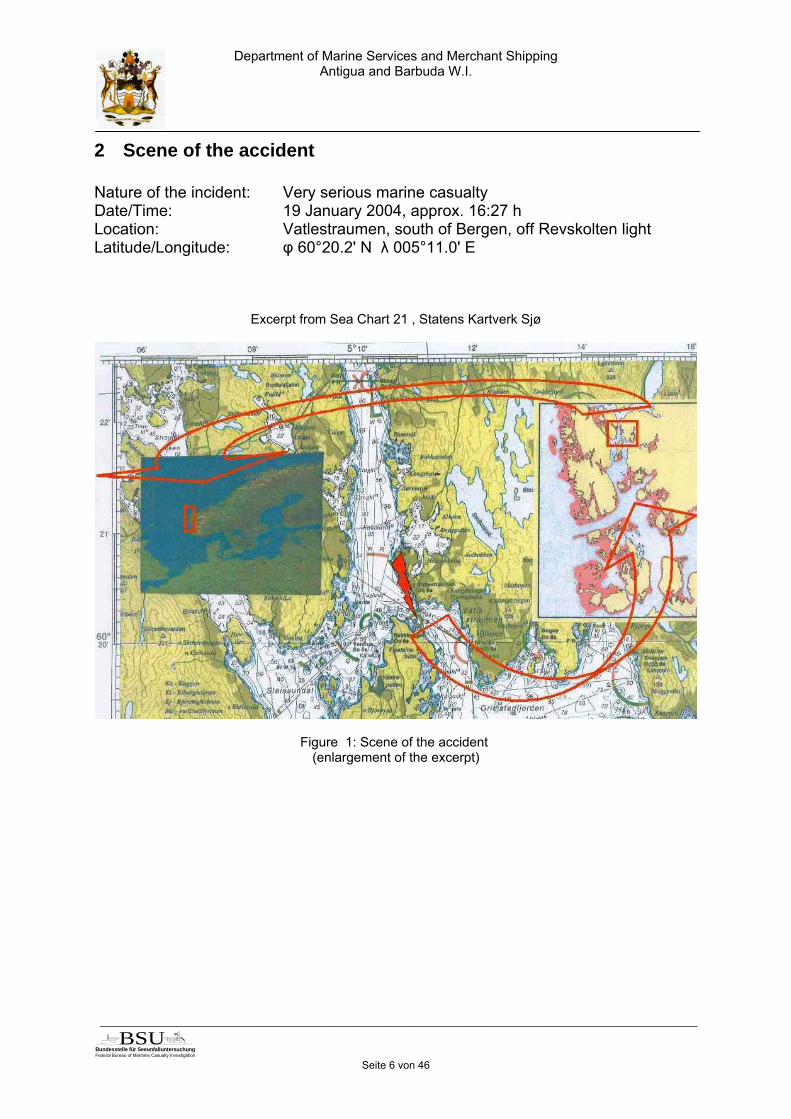
2 Scene of the accident
Nature of the incident: Very serious marine casualtyDate/Time: 19 January 2004, approx. 16:27 hLocation: Vatlestraumen, south of Bergen, off Revskolten lightLatitude/Longitude: φ 60°20.2' N λ 005°11.0' E
Excerpt from Sea Chart 21 , Statens Kartverk Sjø
Figure 1: Scene of the accident (enlargement of the excerpt)

Department of Marine Services and Merchant ShippingAntigua and Barbuda W.I.
_____________________________________________________________________________________________________
Bundesstelle für Seeunfalluntersuchung
Federal Bureau of Maritime Casualty Investigation
BSUSeite 7 von 46
3 Vessel particulars3.1 PHOTO OF VESSEL
Figure 2: ROCKNES3.2 VESSEL PARTICULARSName of vessel ROCKNES (ex. KVITNES)Type of vessel Bulk Carrier, Supply (Free Fall Pipe [FFP]) Vessel,
Self UnloadingNationality/Flag Antigua and Barbuda W.I.Port of Registry CuxhavenIMO Number 9229910Call signal V2OG8Vessel operator AJ Shipmanagement GmbH, LeerYear built 2001Building yard/building num-ber
J.J. Sietas KG Schiffswerft GmbH & Co. / 1177
Classification society Germanischer LloydDamage Stability SOLAS Amendments 90/91, Chap. II-1, Reg. 25-1Required Survival Probability 53 %Length over all 166.70 mBreadth over all 24.50 mGross tonnage 17765 gtDeadweight 25065 tMax. draft 10.49 mEngine rating 7300 kWMain engine MaK, Diesel Engine 8 M 43Persons on board 30 (23 crew + 6 FFP Specialists +1 pilot)Speed 14 kn

Department of Marine Services and Merchant ShippingAntigua and Barbuda W.I.
_____________________________________________________________________________________________________
Bundesstelle für Seeunfalluntersuchung
Federal Bureau of Maritime Casualty Investigation
BSUSeite 8 von 46
4 Course of the accident
4.1 CONVERSION KVITNES TO ROCKNES
The vessel was laid up at the Sietas yard in Hamburg as new building 1177 on 4 May2000 and was delivered under the name KVITNES in August 2001. It was a self-unloading bulk carrier made of steel; the classification society was GermanischerLloyd. An approx. 80 m long, swivel-type boom fitted forward amidships served todischarge the cargo. The associated deck superstructure was located on the foreship from frame 204 to frame 219. Due to its height of about 20 m above the maindeck and a width of about 8 m, visibility from the bridge covering the area ahead ofthe vessel was restricted, both from the two conning positions and from the centre ofthe bridge. The technical solution to this problem of the dead sector was to mount theS-band radar on the fore ship superstructure in conjunction with deflector panels toreduce interference echo.As regards to the optical visibility, the principles to be observed are set down in SO-LAS, Chapter V, Regulation 22, "Navigation bridge visibility ". Section 1.1 states:“The view of the sea surface from the conning position shall not be obscured by morethan two ship lengths, or 500 m, whichever is the less, forward of the bow to 10° oneither side under all conditions of draught, trim and deck cargo”. According to Section1.2 no blind sector caused by cargo, cargo gear or other obstructions outside of thewheelhouse forward of the beam which obstructs the view of the sea surface as seenfrom the conning position, shall exceed 10°. The total arc of blind sectors shall notexceed 20°. The clear sectors between blind sectors shall be at least 5°. However, inthe view described in paragraph (a)(i), each individual blind sector shall not exceed5°. Observance of these specifications is determined by a line of sight test.
Figure 3: Approved line of sight plan KVITNES

Department of Marine Services and Merchant ShippingAntigua and Barbuda W.I.
_____________________________________________________________________________________________________
Bundesstelle für Seeunfalluntersuchung
Federal Bureau of Maritime Casualty Investigation
BSUSeite 9 von 46
The original building KVITNES bore the classification symbol NAV-O in accordancewith the regulations of Germanischer Lloyd for "Bridge Design on Seagoing Ships,One-Man Control Console”, according to which the SOLAS horizontal field of visionhad to be satisfied directly by the two navigating and monitoring workstations. Thedead angle caused by the fore ship superstructure of KVITNES was 2.8 degreesfrom the navigation workplaces; the visibility concealment on the sea surface aheadof the bow was 134.94m.On the grounds of an agreement between the operators and owners it was decidedto convert KVITNES for use in the offshore oil and gas industry. The conversion workbegan in November 2002 at the Kèppel Verolme yard in Rotterdam and was com-pleted in March 2003 with return delivery of the vessel now renamed ROCKNES. Theconversion was planned by the engineering firm Bureau voor Scheepsbouw, Ir. P. H.de Groot b.v. in Bloemendaal; Germanischer Lloyd remained the competent classifi-cation society. The key area of the conversion work lay in installing a flexible fall pipesystem2 that enabled the vessel to deposit its cargo of stones selectively on the seabottom in a controlled process via the fall pipe3. In addition to a whole series ofsmaller conversion measures, the former cargo hold 5 in particular was redesignedfor this purpose. A moonpool open downwards was installed on the starboard sidethrough which the fall pipe system could be lowered and brought back up onto deckagain; in addition the necessary hydraulic and electrical systems were housed there.The accommodation capacity of the deck house was extended from formerly 25 per-sons to now 50, so that the specialist staff additionally required could be taken onboard for offshore assignments.
Figure 4: Side view of ROCKNES with new deck superstructure
2 Flexible fall pipe systems – abbreviated to FFP3 This operation takes place for instance when under-water pipelines or sea cables are laid in order toprotect them in this way with a layer of stones.

Department of Marine Services and Merchant ShippingAntigua and Barbuda W.I.
_____________________________________________________________________________________________________
Bundesstelle für Seeunfalluntersuchung
Federal Bureau of Maritime Casualty Investigation
BSUSeite 10 von 46
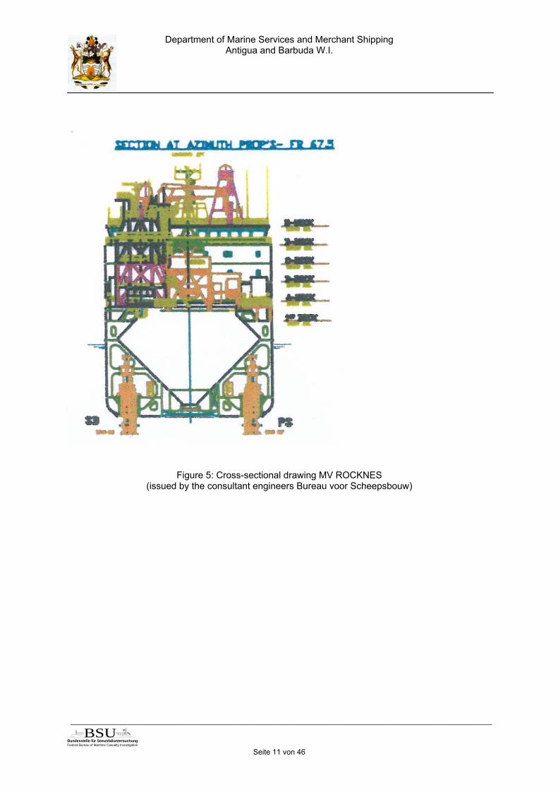
As a result of cargo hold 5 no longer being available, the cargo hold volume of MVROCKNES was reduced from 20131.87 m³ to 17994.75 m³, corresponding to a cargoof about 3000 t. A further deck superstructure was installed to handle the flexible fallpipe, located on the starboard side from frame 88 to frame 109. The height of thisstone chute was about 15 m above the main deck, and with the crane mounted ontop the facility reached a height of about 20 m at a width of about 7 m. The vessel’slightweight was increased from 7307 t to 8960 t, with a vertical shift in the height ofthe centre of gravity from 9.66 m to 10.91 m. No fixed ballast was installed as com-pensation. As a function of the cargo centre of gravity and distribution, it was neces-sary to take on ballast water for compensation purposes. In the fully loaded andequipped condition altogether 1461 t ballast water were required; the individual stan-dard loading cases were summarised in the Stability Booklet. In Volume 1, Point 2.4of the Stability Booklet6 it was recommended that the asymmetrical weight distribu-tion resulting from the conversion be compensated by flooding tanks 49 and 52 onthe port side and tank 50 on the starboard side. There was no binding specification.After completion of the conversion work under the supervision of the surveyor of theclassification society responsible on site, the new ship's lightweight and the newheight of the centre of gravity were determined and a heeling test was conducted.The intact and damage stabilities were calculated anew, the Stability Booklet andDamage Stability Plan drawn up anew, and all documents were checked and ap-proved by Germanischer Lloyd. MV ROCKNES had a loading computer available todetermine the intact stability from case to case; the stability program used was alsotested and approved by Germanischer Lloyd. The necessary data for the stabilitycalculation such as cargo and equipment quantities and distribution, and ballast wa-ter volumes and distribution, had to be entered manually. At the same time the pro-gram checked whether the resulting limit curve of the initial stability was also still inthe admissible area for the damage stability. If this was not the case, this was sig-nalled to the operator by lighting up of the warning sign "Critical".The deck superstructure of the stone chute on the starboard side for handling theflexible fall pipe consisted of a lattice structure. The overall height was about 15 mabove the main deck; with the crane mounted, the height was about 20 m and thewidth about 7 m. This new structure, as a lattice structure, was not considered to bea cohesive visibility obstruction. The classification symbol NAV-O of the Germanis-cher Lloyd regulations was deleted as a result from the conversion of MV ROCKNES.The SOLAS horizontal field of vision no longer had to be satisfied directly from thetwo navigating and monitoring workstations, but instead from the conning position4.This position is not defined further in SOLAS and could be freely selected on theROCKNES navigation bridge. If this position is selected close to the starboard wing,the stone chute and crane column are in a line and in the opinion of GermanischerLloyd do not represent any inadmissible blind sector. The classification society didnot require any updated line of sight plan from the yard for approval.
6 „Operation of the ship“
Department of Marine Services and Merchant ShippingAntigua and Barbuda W.I.
_____________________________________________________________________________________________________
Bundesstelle für Seeunfalluntersuchung
Federal Bureau of Maritime Casualty Investigation
BSUSeite 11 von 46
Figure 5: Cross-sectional drawing MV ROCKNES(issued by the consultant engineers Bureau voor Scheepsbouw)

Department of Marine Services and Merchant ShippingAntigua and Barbuda W.I.
_____________________________________________________________________________________________________
Bundesstelle für Seeunfalluntersuchung
Federal Bureau of Maritime Casualty Investigation
BSUSeite 12 von 46
Figure 6: Line of sight plan ROCKNES(issued by the consultant engineers Bureau voor Scheepsbouw)
4.2 WEATHER CONDITIONS

Department of Marine Services and Merchant ShippingAntigua and Barbuda W.I.
_____________________________________________________________________________________________________
Bundesstelle für Seeunfalluntersuchung
Federal Bureau of Maritime Casualty Investigation
BSUSeite 13 von 46
In the course of 19 January 2004 an area of low pressure with a centre over SouthNorway proceeded on a south-easterly course over South Sweden to the South-EastBaltic Sea. Between 16:00 h and 17:00 h a weak south-east to south-south-east windwith an average force 1 Bft to 2 Bft was blowing in Vatlestraumen passage in thearea of the southern navigation channel from Bergen. There was no precipitation andvisibility was 25 km. The air temperature was about –1°C to –2°C and was dropping,the water temperature was about 7°C to 8°C. The sky was initially covered 4/8 withclouds, but these quickly broke up. The sun went down at 16:17 h, the civil twilight5lasted until 17:09 h. According to corroborated statements the light beacons con-trolled via photoelectric cells were still unlit at the time of the occurrence. With theprevailing wind the sea state could only develop within the range of just a few centi-metres to 1 decimetre at most. The approx. 1.5 m to 2 m high swell running on theopen coastal sea from the north-west could not run into the area under review. Tosummarise, low-wind, clear and precipitation-free frosty weather was prevailing inVatlestraumen.On 19 January 2004 the first high tide in Bergen was at 08:28 h, and the second hightide at 21:00 h. In Vatlestraumen the flood current starts to run north about 6 hoursafter high tide in Bergen and the ebb current starts to run southwards about 10 min-utes before high tide in Bergen. Consequently on the day of the accident the floodcurrent began to run northwards starting at about 14:28 h, while the ebb current be-gan to run southwards starting at about 20:50 h. The pilot on board ROCKNES esti-mated the current setting northwards to be about 2 kn, and the captain of the SeaRescue Boat “ODD FELLOW II” that had overtaken MV ROCKNES shortly before theentrance into Vatlestraumen estimated it at about 3 to 3.5 kn.
VOYAGE PLANNING
4.3.1 Local pilot
The pilot responsible on board ROCKNES on the day of the accident began his pilottraining in February 1998. The training with the competent maritime administration6
took three years with various intermediate certifications. The training was carried outselectively for a local sea area for which the trainee was provided with all the neces-sary nautical documents. Paper charts that were corrected via the Norwegian Noticeto Mariners7 or alternatively electronic sea charts were available for selection. On thebasis of an agreement between C-Map and the authority responsible for the Norwe-gian pilots for testing electronic sea charts, the pilots had been able to use a C-Mapsystem as an alternative to the paper sea charts since December 1999. In additionthey were then still provided with the Norwegian Notice to Mariners, although these
5 Civil twilight is the period of increasing darkness after sunset during which it is still light enough toread something outdoors; it is the time that the centre of the sun needs after sunset to reach 6 de-grees below the true horizon.6 Norwegian National Coastal Administration (NNCA)7 Etterretninger for sjøfarende (Efs)

Department of Marine Services and Merchant ShippingAntigua and Barbuda W.I.
_____________________________________________________________________________________________________
Bundesstelle für Seeunfalluntersuchung
Federal Bureau of Maritime Casualty Investigation
BSUSeite 14 von 46
did not contain any correction service for the electronic charts drawn up by C-Mapitself. The pilot of MV ROCKNES on the day of the accident had made use of thisoption and was using the C-Map chart, of which he had a version on his home com-puter. Accordingly a parallel paper sea chart that the pilot still had must have been anold edition of Chart 21.According to the internal specifications of the waterways and shipping authority re-sponsible for the pilots and their training, the pilots were obliged to have all relevantinformation about their local sea region at their disposal in order to be able to pilotvessels of all types and all sizes through the relevant estuary. Already during theirtraining candidates were expected to draw up their own route book with all the rele-vant information about their estuary. They should thus have been enabled to conductpilot work from their head and to reproduce the sea areas and associated charts fromtheir memory. A final examination after the three year training period then certifiedthe pilot as being qualified to pilot vessels of all types and all sizes through the rele-vant local sea area.The pilot had carried with him in his papers his voyage planning based on this train-ing, his experience and his knowledge of the waters. No individual planning had beencarried out for the voyage of MV ROCKNES; an alternative route deviating from thepassage through Vatlestraumen had not been considered. There had been no meet-ing with the vessel command prior to the start of the voyage to discuss and agreeupon this and to properly pre-plan the forthcoming pilotage and to familiarize with thevessel. Only information about the vessel draft had been requested on leaving theloading station. Further information had been provided to the pilot in advance by hiscompetent pilot station8 from an internal Norwegian used database. Furthermore, ithad been known in pilot circles that course changes with MV ROCKNES had to bestarted at an early stage and applying small rudder angles, since otherwise the ab-sorption of the turning movement could lead to difficulties. During the first section ofthe voyage, after leaving the loading station, there had been a brief discussion withthe Master about the planned course of the voyage. This discussion had referredamong other factors to the current in Vatlestraumen, but had not dealt exhaustivelywith details. Nor had it been customary to carry out any detailed discussion andagreement with the command of vessels.
4.3.2 Vessel command
According to the specifications of the safety management system of the responsiblecompany (ISM 1.1.2)9, the vessel manager or charterer were to provide the Masterwith written voyage instructions. These were to include instructions regarding loadingand discharge ports, cargo volumes, travel speed and fuel supply. After receiving theinstructions the Master was to check whether the water depths in the loading anddischarge ports and along the planned voyage route allowed him to implement thevoyage instructions. In addition, the Chief Mate had to draw up his own loading plan,especially as regards the stowing of the cargo. Voyage instructions drawn up by the
8 Kvitsøy Pilot Station9 here: CARGO VESSEL DECK and CARGO OPERATIONS MANUAL, Points 2.2 + 2.3 + 2.19 + 2.20
Department of Marine Services and Merchant ShippingAntigua and Barbuda W.I.
_____________________________________________________________________________________________________
Bundesstelle für Seeunfalluntersuchung
Federal Bureau of Maritime Casualty Investigation
BSUSeite 15 von 46
shore side had not been provided for the forthcoming voyage; however, the loadingplan required on the ship's side had been produced.According to the STCW Code10 the Master of MV ROCKNES was obligated to en-sure before starting a voyage that a voyage plan had been drawn up comprising pre-cise, complete and updated information regarding the dangers for shipping that weresignificant for safe command of the vessel. There had been a voyage plan drawn upby the vessel command. The ship-side navigational voyage planning had consistedprimarily in preparing the electronic sea chart with the planned courses and a print-out of the voyage plan. The passage through Vatlestraumen was evidently not ac-corded any special significance on the grounds of increased danger here. Further-more, the navigation officer had prepared a pilot information card with all the impor-tant details of the vessel that had been displayed next to the chart table and could bemade available to the pilot in response to his request.
4.3.3 Electronic sea charts
The expression "electronic sea chart" comprises a large number of systems with theaid of which sea chart information is displayed on a computer screen on the bridge. Adistinction is made between three basic types, ECDIS11, ECS12 and RCDS13. In addi-tion to the main purpose for use of an electronic sea chart, to contributing to safecommand of a vessel, substitution for the paper chart is a further concern for naviga-tion. This is basically only admissible when the system used on board complies withthe requirements as ECDIS14 and when sufficient back-up facilities15 are provided inthe event that a system fails. The performance standards for electronic sea chart dis-play and information systems (ECDIS) are regulated in the IMO ResolutionA.817(19). Under Section 4.1 there it is stated that the cartographic data to be usedshould originate from the latest edition of an information medium that has beendrawn up by a state-authorised hydrographic service and that it should correspond tothe relevant IHO16-Standards. A cartographic database standardised in this way istermed an Electronic Navigational Chart (ENC). National hydrographic services arecalled upon to draw up ENC and provide the associated correction service for thesea area for which they are responsible. For the transitional period in which world-wide coverage with ENC is not achieved, and for sea areas in which there is no ENC,Annex 7 to Resolution A.817(19)17 permits the use of a sea chart display and infor-mation system (ECDIS) in RCDS mode using official raster charts (RNC)18. Rastercharts are produced by scanning the appropriate paper sea charts observing therelevant IHO Standards for this purpose. In Europe, official raster charts are drawn
10 STCW Code, Section A-VIII/2, Part 2 Voyage Planning, No 5 Planning prior to each voyage11 Electronic Chart Display and Information System12 Electronic Chart System13 Raster Chart Display System14 SOLAS V/19, 2.1.4: "...; an electronic chart display and information system (ECDIS) may be ac-cepted as meeting the chart carriage requirements of this subparagraph"15 Resolution MSC.64(67) as supplement to Resolution A.817(19), new Annex 616 International Hydrographic Organization17 Resolution MSC.86(70) as a supplement to Resolution A.817(19), new Annex 718 Raster Navigational Chart

Department of Marine Services and Merchant ShippingAntigua and Barbuda W.I.
_____________________________________________________________________________________________________
Bundesstelle für Seeunfalluntersuchung
Federal Bureau of Maritime Casualty Investigation
BSUSeite 16 von 46
up by the hydrographic service of the United Kingdom19 as the Admiralty RasterChart Service (ARCS). RNC are a digital reproduction of the current paper sea chartof a sea area as regards both scale and content.Evidence that performance standards for electronic sea chart display and informationsystems are satisfied is furnished by type approval. Systems that are not type-approved are basically not counted as ECDIS, but instead as ECS. Some admini-strations specify a type test20 for ECS too if such a system is to be used on board avessel under their flag. However, even type-approved ECDIS that are used on board,not with existing ENC but instead with "non-official" cartographic data material orsolely in the RCDS mode, are considered as ECS. ECS in contrast to ECDIS is not acomplete substitute for the paper sea chart, however, but instead should be consid-ered as a navigation aid and supplement to the paper chart.SOLAS Chapter V lists ECDIS as a navigational equipment and system on board; asyet there is no obligation to install this, however. Accordingly it is a matter for the ad-ministration of the relevant flag State to decide whether and to what extent a systeminstalled on board can replace paper sea charts, or what sufficient back-up facilitiesare necessary for this. It is also the task of the flag State to document this in the ves-sel papers, for example in the Record of Equipment for the Cargo Ship SafetyEquipment Certificate (Form E).MV ROCKNES had two electronic sea chart systems on board that were type-approved as ECS. One system runs using charts provided by the private supplier C-Map, and the second used ARCS charts. According to the Record of Equipment forthe Cargo Ship Safety Equipment Certificate, only paper sea charts were noted un-der the section on navigation systems and equipment. The electronic sea chart wasECS type-approved, and thus did not satisfy the requirements of an ECDIS and wasin so far not authorised as a primary navigation system. The ECS was to be consid-ered as a navigation support; parallel use of an approved paper sea chart was nec-essary.
About one week before publication of the new Norwegian paper Sea Chart 21 in Feb-ruary - March 2003, the official electronic sea chart for the Vatlestraumen area hadbeen issued. This ENC displayed the 10 m contour in the area of the Revskolten lightbeacon in agreement with the new paper sea chart (see also 4.8).
19 United Kingdom Hydrographic Office (UKHO)20 an electronic sea chart can be both ECDIS and ECS type-approved, the relevant certificate mustcontain information about the relevant admission
Department of Marine Services and Merchant ShippingAntigua and Barbuda W.I.
_____________________________________________________________________________________________________
Bundesstelle für Seeunfalluntersuchung
Federal Bureau of Maritime Casualty Investigation
BSUSeite 17 von 46
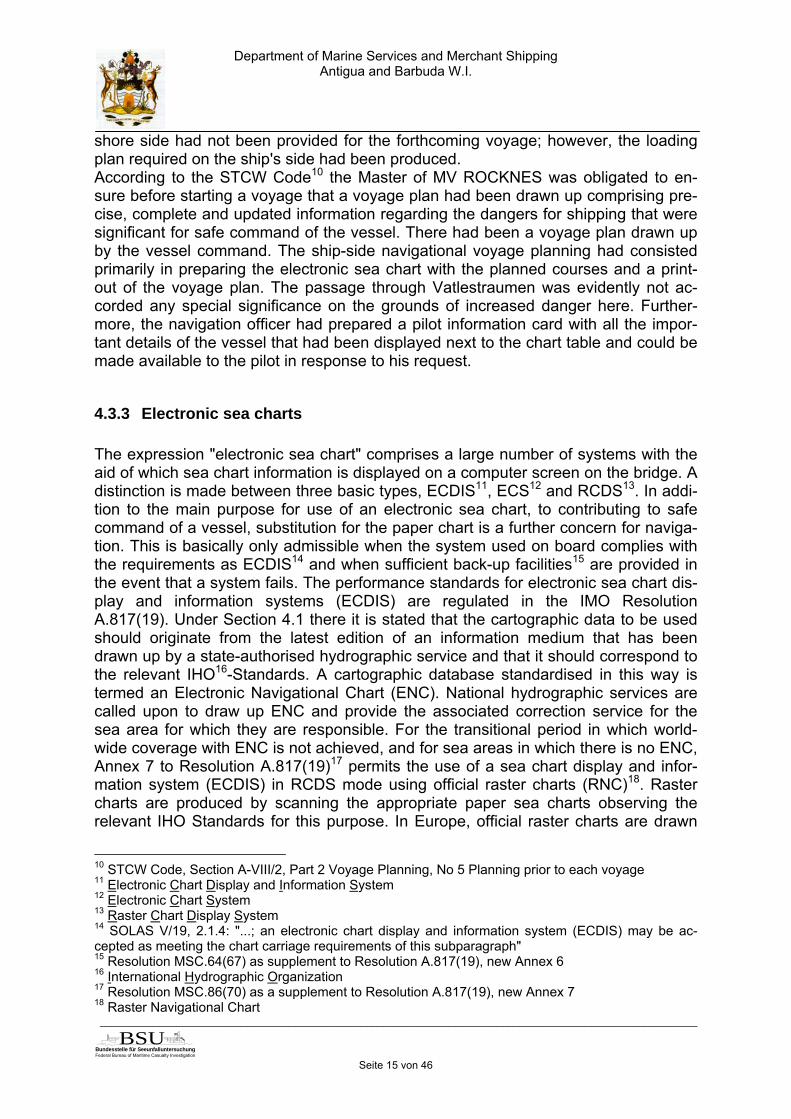
Figure 7: Excerpt from the Norwegian ENC
The C-Map available on board MV ROCKNES at the time of the accident and theARCS chart, on the other hand, were still based on the presentation of the older edi-tion of paper Sea Chart 21 and accordingly showed the 6 m shallow water dangerline running close round the Revskolten light beacon together with the depth informa-tion 29 m north-east of the light beacon.

Department of Marine Services and Merchant ShippingAntigua and Barbuda W.I.
_____________________________________________________________________________________________________
Bundesstelle für Seeunfalluntersuchung
Federal Bureau of Maritime Casualty Investigation
BSUSeite 18 von 46
Figure 8: Excerpt from ARCS (up to April 2004)
The correction of the British ARCS showing the altered depth line was only carriedout parallel with the correction of the BA 3009 with NtM21 1819/2004 in April 2004. Inaddition, the southern edge of the white sector of the Hilleren light beacon wasshown close to the 6 m shallow water danger line in the older ARCS edition.C-Map had issued an update of the chart in January 2004. In addition to its ownelectronic sea charts, C-Map as authorised enterprise also markets ENC of varioushydrographic services, including those from Norway. ENC newly prepared by a hy-drographic service are incorporated into the overall ENC database of C-Map everyweek and are then available to customers. The C-Map system on board MV ROCK-NES had been installed for test purposes in the year 2001. The vessel operator hadthen decided not to use this system further, however. No correction by C-Map hadbeen procured and so the chart material must in so far have been obsolete.
21 Notice to Mariners
Department of Marine Services and Merchant ShippingAntigua and Barbuda W.I.
_____________________________________________________________________________________________________
Bundesstelle für Seeunfalluntersuchung
Federal Bureau of Maritime Casualty Investigation
BSUSeite 19 von 46
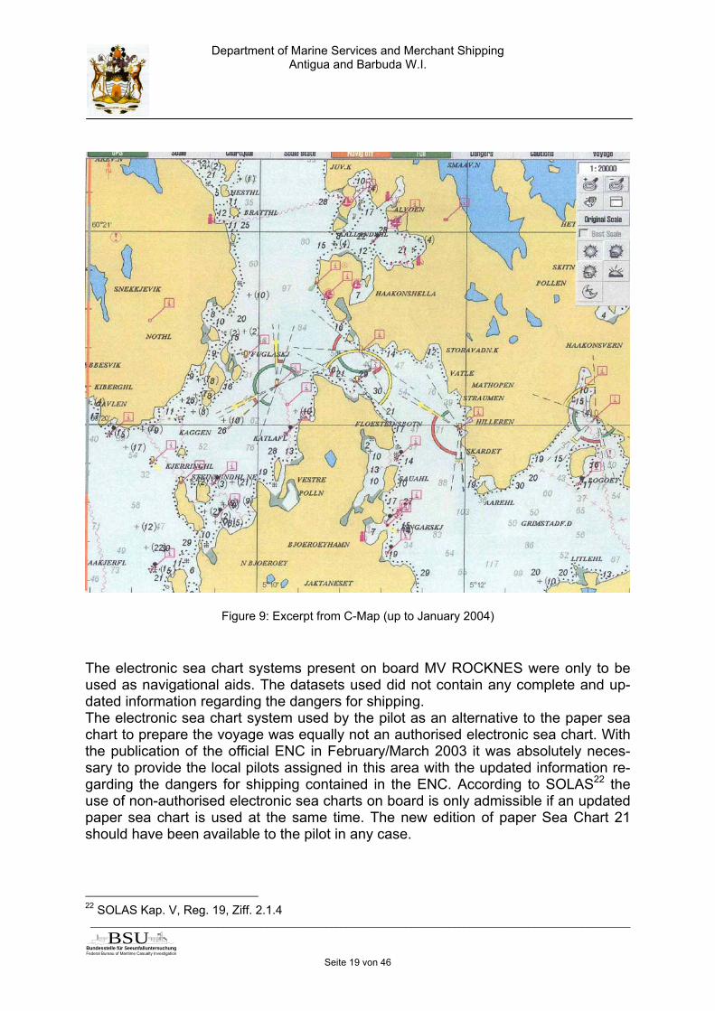
Figure 9: Excerpt from C-Map (up to January 2004)
The electronic sea chart systems present on board MV ROCKNES were only to beused as navigational aids. The datasets used did not contain any complete and up-dated information regarding the dangers for shipping.The electronic sea chart system used by the pilot as an alternative to the paper seachart to prepare the voyage was equally not an authorised electronic sea chart. Withthe publication of the official ENC in February/March 2003 it was absolutely neces-sary to provide the local pilots assigned in this area with the updated information re-garding the dangers for shipping contained in the ENC. According to SOLAS22 theuse of non-authorised electronic sea charts on board is only admissible if an updatedpaper sea chart is used at the same time. The new edition of paper Sea Chart 21should have been available to the pilot in any case.
22 SOLAS Kap. V, Reg. 19, Ziff. 2.1.4
Department of Marine Services and Merchant ShippingAntigua and Barbuda W.I.
_____________________________________________________________________________________________________
Bundesstelle für Seeunfalluntersuchung
Federal Bureau of Maritime Casualty Investigation
BSUSeite 20 von 46
4.4 LOADING IN EIKEFET
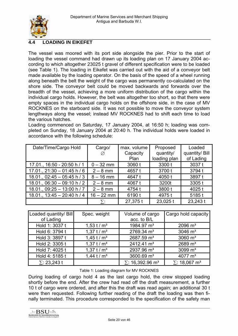
The vessel was moored with its port side alongside the pier. Prior to the start ofloading the vessel command had drawn up its loading plan on 17 January 2004 ac-cording to which altogether 23025 t gravel of different specification were to be loaded(see Table 1). The loading in Eikefet was carried out with the aid of a conveyor beltmade available by the loading operator. On the basis of the speed of a wheel runningalong beneath the belt the weight of the cargo was permanently co-calculated on theshore side. The conveyor belt could be moved backwards and forwards over thebreadth of the vessel, achieving a more uniform distribution of the cargo within theindividual cargo holds. However, the belt was altogether too short, so that there wereempty spaces in the individual cargo holds on the offshore side, in the case of MVROCKNES on the starboard side. It was not possible to move the conveyor systemlengthways along the vessel; instead MV ROCKNES had to shift each time to loadthe various hatches.Loading commenced on Saturday, 17 January 2004, at 16:50 h; loading was com-pleted on Sunday, 18 January 2004 at 20:40 h. The individual holds were loaded inaccordance with the following schedule:
Date/Time/Cargo Hold Cargo/∅
max. volumeCapacity
Plan
Proposedquantity/
loading plan
Loadedquantity/ Bill
of Lading17.01., 16:50 - 20:50 h / 1 0 – 32 mm 3060 t 3300 t 3037 t17.01., 21:30 – 01:45 h / 6 2 – 8 mm 4657 t 3700 t 3794 t18.01., 02:45 – 05:45 h / 3 8 – 16 mm 4647 t 4050 t 3897 t18.01., 06:30 – 09:10 h / 2 2 – 8 mm 4067 t 3200t 3305 t18.01., 09:25 – 13:00 h / 7 2 – 8 mm 4754 t 3800 t 4025 t18.01., 13:45 – 20:40 h / 4 16 – 22 mm 6190 t 4975 t 5185 t
∑: 27,375 t 23,025 t 23,243 t
Loaded quantity/ Billof Lading
Spec. weight Volume of cargoacc. to B/L
Cargo hold capacity
Hold 1: 3037 t 1,53 t / m³ 1984.97 m³ 2096 m³Hold 6: 3794 t 1,37 t / m³ 2769.34 m³ 3046 m³Hold 3: 3897 t 1,45 t / m³ 2687.59 m³ 3060 m³Hold 2: 3305 t 1,37 t / m³ 2412.41 m³ 2689 m³Hold 7: 4025 t 1,37 t / m³ 2937.96 m³ 3099 m³Hold 4: 5185 t 1,44 t / m³ 3600.69 m³ 4077 m³∑: 23,243 t ∑: 16,392.96 m³ ∑: 18,067 m³
Table 1: Loading diagram for MV ROCKNESDuring loading of cargo hold 4 as the last cargo hold, the crew stopped loadingshortly before the end. After the crew had read off the draft measurement, a further10 t of cargo were ordered, and after this the draft was read again; an additional 30 twere then requested. Following further reading of the draft the loading was then fi-nally terminated. This procedure corresponded to the specification of the safety man

Department of Marine Services and Merchant ShippingAntigua and Barbuda W.I.
_____________________________________________________________________________________________________
Bundesstelle für Seeunfalluntersuchung
Federal Bureau of Maritime Casualty Investigation
BSUSeite 21 von 46
agement system of the vessel operator, according to which the Master had to ensurethat the vessel took on a maximum of cargo23.Contrary to the 23025 t gravel to be loaded in accordance with the loading plan, only21548 t were loaded according to the shore calculations. However, the draft readingsby the vessel revealed loading with altogether 23243 t. In order to verify the differ-ence of over 7%, the draft was checked again; after this the vessel command agreedwith those responsible on shore on the quantity actually delivered of 23243 t. Thedifference of 218 t compared to the quantities planned in accordance with the loadingplan was divided between the individual lots according to the Bill of Lading. MVROCKNES was completely loaded at 20:40 h on Sunday, 18 January 2004. Therewas no final trimming of the cargo in the cargo holds.
4.5 PASSAGE FROM EIKEFET TO SKÅLEVIK
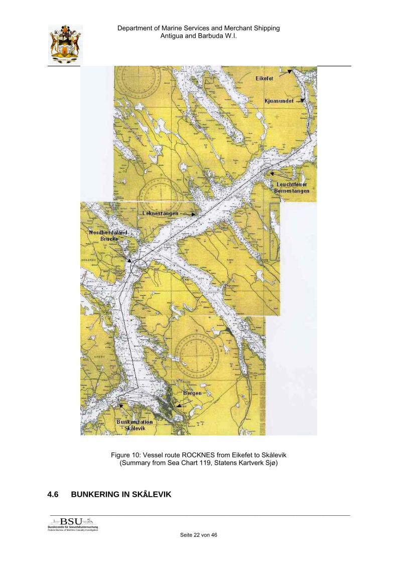
On Monday, 19 January 2004 at about 08:50 h, the pilot came on board; he reachedthe bridge at about 08:55 h. The Master, officer of the watch (OoW) and a helmsmanwere on the bridge, the vessel was ready to depart. The navigational equipment in-cluded two radar sets and two electronic sea chart systems; the paper sea chart ofthe area was lying on the chart table parallel with this. The Norwegian Master of MVROCKNES cast off from Eikefet, and at about 09:10 h the pilot then took over. Sincehe had not checked the draft of the vessel himself on coming on board, the pilotasked the Master what the present draft was. The Master had said 10.4 m, the pilothad then made a mental note that MV ROCKNES had a draft above 10 m. The ves-sel was running at half speed ahead of approx. 8 kn until it left the Kjuasundet atabout 09:40 h, after speed was increased to full ahead of approx. 13 kn. Aboutquarter of an hour later MV ROCKNES passed the Bernestangen light beacon on theport side. In order to pass a known shallow there in safe distance, the pilot had or-dered the rudder to port 5. This change in course corresponded to this type of vesselin the experience of other pilots too, whereby course changes were to be carried outearly and with small rudder angles, since with larger rudder angles there was a dan-ger that the turn in the vessel could not be stopped again in time. The pilot hadchecked the change in course with the aid of the electronic sea chart, and when thelandmark Leknestangen was well ahead on starboard as next way point, the changein course had been terminated with the order to the helmsman “Steady”. During thechange in course MV ROCKNES had shown a slight list to starboard, which the pilotconsidered to be certainly normal with a port rudder angle. However, it had been un-usual that after terminating the course change the vessel did not return to even Keelon its own. However, since on the other hand the list did not appear to be threaten-ing, the pilot turned his attention to his pilot tasks again, while the question of stabilityhad been left to the Master and the relieve Master who was also on the bridge forfamiliarisation. The further passage to Skålevik had proceeded without incident. Atabout 11:40 h the Master had taken over MV ROCKNES and berthed the vessel withits port side alongside the bunker station.
23 here: CARGO VESSEL DECK and CARGO OPERATIONS MANUAL, Point. 2.7
Department of Marine Services and Merchant ShippingAntigua and Barbuda W.I.
_____________________________________________________________________________________________________
Bundesstelle für Seeunfalluntersuchung
Federal Bureau of Maritime Casualty Investigation
BSUSeite 22 von 46
Figure 10: Vessel route ROCKNES from Eikefet to Skålevik(Summary from Sea Chart 119, Statens Kartverk Sjø)
4.6 BUNKERING IN SKÅLEVIK

Department of Marine Services and Merchant ShippingAntigua and Barbuda W.I.
_____________________________________________________________________________________________________
Bundesstelle für Seeunfalluntersuchung
Federal Bureau of Maritime Casualty Investigation
BSUSeite 23 von 46
On arrival in Skålevik MV ROCKNES had only about 50 t heavy fuel oil in its serviceand settling tank and about 20 t diesel fuel in the service tank as remaining bunkeron board.Altogether 400 t heavy fuel oil were taken on board, bunkered half each in storagetank 1 on the port side and tank 2 on the starboard side. With a specific weight ofabout 0.95 t / m³ the 400 t correspond to approx. 420 m³ uniformly divided betweenthe two storage tanks 1 and 2, with about 210 m³ per tank. With a tank volume of491.2 m³ and tanks almost empty at the start of bunkering, the storage tanks weresubsequently just under half full.50 t diesel oil were taken over and bunkered in storage tank 11 on the starboardside. With a specific weight of about 0.85 t / m³, 50 t here correspond to about 59 m³.Tank 11 with a capacity of 87.8 m³ total volume and also almost empty at the start ofbunkering was subsequently 2/3 full.After taking over the first 40 t heavy fuel oil, the bunker station had noticed an un-usual list to port for a vessel of this size but this had dissipated again in the course offurther bunkering.Parallel with taking on the fuel, the vessel discharged sludge and waste oil on shorein Skålevik. MV ROCKNES had a sludge tank, tank 55 on the starboard side with avolume of 34 m³, two waste oil tanks, tanks 56 and 68 on the starboard side with avolume of 21 m³ and 32.8 m³, and a bilge water holding tank, tank 59 midships with avolume of 14.8 m³. It was no longer possible to reconstruct what quantities weregiven off by which of these tanks; according to the records of the collection stationthe total quantity discharged was 25 m³.Nor was it possible to reconstruct whether and if appropriate to what extent ballastwater was pumped out at the bunker station Skålevik parallel to bunkering.The activities in Skålevik were terminated at about 15:30 h. At this time the main en-gine of MV ROCKNES had already been started again and the engine control hadbeen switched to the bridge.
4.7 ONWARD PASSAGE FROM SKÅLEVIK
The pilot, who had gone ashore briefly during bunkering in Skålevik, had been backon board since about 14:30 h. He did not ask about the quantities bunkered or anychange in the draft after bunkering; the pilot had continued to work with his mentalnote that MV ROCKNES had a draft greater than 10 m.Still as bridge team present were the Master, the OoW and a helmsman; the naviga-tional equipment was still in operation. The relieve Master on board for familiarisationwas also on the bridge, but according to the findings available did not intervene in thefollowing sequence of events. At about 15:40 h MV ROCKNES cast off fromSkålevik, with the Master carrying out the casting-off manoeuvre and the pilot takingover subsequently. With a course of about 250° the vessel steered towards theAskøy Bridge and the Hjelteskjer light beacon had been slightly starboard ahead.Halfway between Askøy Bridge and Hjelteskjer light beacon ROCKNES had calledBALTIC TRADER proceeding about 1 mile ahead of it on VHF. Since the two vesselswere proceeding along the same route southwards, the distance between them wasnot to be reduced any further and MV ROCKNES reduced speed to about 10 kn. Thedistance had been monitored with the aid of a variable range marked on the radar.
Department of Marine Services and Merchant ShippingAntigua and Barbuda W.I.
_____________________________________________________________________________________________________
Bundesstelle für Seeunfalluntersuchung
Federal Bureau of Maritime Casualty Investigation
BSUSeite 24 von 46
About five minutes before passing the Sotra Bridge, MV ROCKNES had issued a callon VHF Channel 16 to inform other traffic of its further passage. No other vesselsanswered this call. Below the Sotra Bridge there had been a slight change of courseto port at about 16:05 h in order to take the Håkonshella light beacon dead ahead.Since the deck superstructure did not allow any direct visibility dead ahead, however,the pilot had been forced to change his position on the bridge constantly betweenport and starboard wing. At this time the Master of BALTIC TRADER travelling aheadobserved MV ROCKNES, and while course and speed appeared to be in order, MVROCKNES had given him the impression of "weak" stability24. During this change incourse, on the other hand, no exceptional listing had been noted on board MVROCKNES. Shortly after passing the Sotra Bridge, MV ROCKNES had issued a fur-ther call on VHF Channel 16 off Valen. At the same time the pilot had agreed withBALTIC TRADER that the latter would take the Kobbeleia Passage west of Bjorøynaand thus allow the larger vessel, MV ROCKNES, unimpeded passage through Vat-lestraumen. With a small course correction to starboard, the Vonflua light beacon offBjorøyna had been kept slightly to port, a position slightly to the right of the middle ofthe navigation channel had been steered and the turn into the Vatlestraumen pas-sage had been prepared. At about 16:23 h the Håkonshella light beacon had beenapproximately abeam to port at a distance of a few cables and the pilot had initiatedthe turn towards Vatlestraumen with his order rudder port 5. With further ruddercommands the pilot had corrected the turn in the direction of Vatlestraumen. He hadintended to reach the middle of the passage best approach point.The command and the pilot were called upon in accordance with the STCW Code25
to keep each other informed of planned manoeuvres, local conditions, and the char-acteristics of the vessel. Against the background that he had already piloted MVROCKNES prior to its conversion or a sister vessel and was supplied with the infor-mation from the database of the pilot station and the results of discussions betweenpilots about the manoeuvring characteristics of the vessel, the pilot felt sufficientlyfamiliar with the characteristics of the vessel. The exchange of information with thevessel's command had been restricted to a brief discussion of the current in Vatles-traumen and the question as to the draft, whereby this question had not been re-peated after bunkering. The passage through Vatlestraumen was quite evidently notconsidered to be a special danger. The necessary change of course for steering intothe Vatlestraumen passage was about 55°, and the necessary new course in thewhite sector of the Hilleren light beacon was 123°. At this time MV ROCKNES wasproceeding at a speed of about 11 kn, after having reduced speed previously so asnot to run up against BALTIC TRADER running ahead. The change in course wasinitiated with angle position port 5, by analogous with the change in course at theBernestangen shallow. The change in course to be carried out at the start of the voy-age there was 20°, the speed 13 kn. Even if a much larger change in course at re-duced speed was necessary to steer for Vatlestraumen, this manoeuvre was initiatedwith the same small rudder angle. The experience of the second regular captain of
24 Excerpt from the English translation of the record of the official Norwegian hearing from 26 to 31January 2004: "ROCKNES listed from side to side and seemed strange. The ship in the witness’sterminology was „weak“, i.e. had poor stability.... What he noticed was that ROCKNES listed so muchit seemed abnormal. When asked he suggests that the list might have been 5-10 degrees,..."25 STCW Code, Section A-VIII/2, Part 3 Watchkeeping at Sea, No 49 Navigation with pilot on board

Department of Marine Services and Merchant ShippingAntigua and Barbuda W.I.
_____________________________________________________________________________________________________
Bundesstelle für Seeunfalluntersuchung
Federal Bureau of Maritime Casualty Investigation
BSUSeite 25 von 46
MV ROCKNES had been to initiate such a change in course with a larger rudder an-gle, however, and then ease to a smaller rudder angle. In his experience the vesselhad a tendency to heel to starboard during changes of course to port.As per the pilot’s statement the change in course at the day of the casualty was ter-minated with the order “Steady” but without checking the course heading. The pilothad assessed the position of the vessel as slightly right of the middle of Vatlestrau-men. This had not been in line with his original intention of taking MV ROCKNES intothe middle of the passage. The Hilleren light beacon, still unlit at this time of day,ahead of ROCKNESS had been slightly to port. In the opinion of the pilot MVROCKNES had been still in its white sector. In order to be able to better monitor thefurther passage and distance from the Revskolten light beacon, the pilot had left hisposition on the left of the centre of the bridge and moved over to starboard wing. Hehad considered the distance from the Revskolten light beacon on the starboard sideto be sufficient. The Master had also come to starboard and both had talked brieflyabout a colleague of the pilot. When the Revskolten light beacon was approximatelystarboard abeam, MV ROCKNES had sustained two slight vibrations on its starboardside followed by heavier scraping. The Master and pilot had assumed ground con-tact, especially since the vessel was building up a list to starboard.The reconstructed data from the electronic sea chart show that the change in coursewas started at about 16:23 h. Towards the minute 26 MV ROCKNES was in the whitesector of the Hilleren light beacon. Its course at this time was 142° and thus almost20° further south than the course of 123° necessary in order to proceed to Hilleren inthe white sector. Already towards minute 27 the vessel had left the white sectorsouthwards. At this time its course of 137° was still approximately 15° more southerlythan the necessary 123°. Less than one minute later MV ROCKNES then touchedbottom on its starboard side.According to the STCW Code26 the presence of the pilot does not relieve either theMaster or the navigating officer on duty from their duties and obligations regardingthe safety of the vessel. It could not be determined to what extent the vessel com-mand intervened in the change of course before ground contact was made.Immediately after ground contact the Master had set off the general alarm and or-dered the closing of the water-tight doors. MV ROCKNES had issued an emergencycall. The pilot had initially ordered "hard a starboard", a command that the helmsmanhad followed. As the vessel heeled further and more strongly to starboard, the pilothad then ordered "hard a port". The already enormous list had stopped briefly, buthad then continued at increasing speed. MV ROCKNES had capsized within a veryshort space of time.
26 STCW Code, Section A-VIII/2, Part 3 Watchkeeping at Sea, No 49 Navigation with pilot on board

Department of Marine Services and Merchant ShippingAntigua and Barbuda W.I.
_____________________________________________________________________________________________________
Bundesstelle für Seeunfalluntersuchung
Federal Bureau of Maritime Casualty Investigation
BSUSeite 26 von 46
Figure 11: Voyage route ROCKNES after leaving Skålevik(Excerpt from Sea Chart 21 , Statens Kartverk Sjø)

Department of Marine Services and Merchant ShippingAntigua and Barbuda W.I.
_____________________________________________________________________________________________________
Bundesstelle für Seeunfalluntersuchung
Federal Bureau of Maritime Casualty Investigation
BSUSeite 27 von 46
4.8 VATLESTRAUMEN PASSAGE
The passage through Vatlestraumen is one of the most important passages from andto Bergen and is used by large deep going vessels. The relevant sea area at thescene of the accident is shown in Norwegian Sea Chart No. 21 on a scale 1:50,000.In the older edition of this chart a shallows danger line27 was drawn around the Rev-skolten light beacon indicating that a water depth of less than 6 m could be expectedwithin the area contained by the line. This line runs 33 m in front of the light beacon,corresponding to 0.66 mm on the chart. No 10 m contour had been drawn in thisolder edition, but there was a 29 m depth entered at a distance of 102 m, corre-sponding to 2.02 mm on the chart, off the light beacon Revskolten. It could be as-sumed that there was a uniform increase in depth from the 6 m line to this 29 mdepth. Accordingly a water depth of 10 m could be expected from about 12 m of the 6m line at a distance from the light beacon of then 45 m, corresponding to 0.9 mm onthe chart. The boundary between the red and white sector of the Hilleren light beaconwas at a distance of 90 m from the Revskolten light beacon, corresponding to 1.8mm on the chart. Both the 6 m shallows danger line and the 10 m line to be assumedwere thus in the red sector of the Hilleren light beacon.
Figure 12: Depth data shown in Sea Chart 21 oldEnlargement of excerpt from Sea Chart 21, Statens Kartverk Sjø
27 shallows danger line = slaggrunnslinje
Department of Marine Services and Merchant ShippingAntigua and Barbuda W.I.
_____________________________________________________________________________________________________
Bundesstelle für Seeunfalluntersuchung
Federal Bureau of Maritime Casualty Investigation
BSUSeite 28 von 46
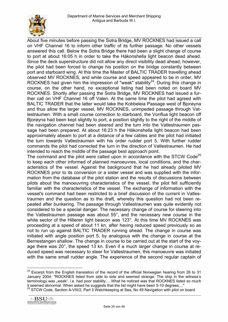
In the years 1988 to 2001 the region of the Norwegian Sea Chart 21 was resurveyedby the Norwegian Hydrographic Service (NHS), and Vatlestraumen was soundedagain in the year 1995. The horizontal accuracy of this sounding was 10 m. In Febru-ary - March 2003 a new edition of the Norwegian Sea Chart 21, scale 1:50,000, wasissued; the older issue became invalid. In the edition the shallow water area aroundthe Revskolten light beacon is now marked with a 10 m contour line underlaid in blue,within which no water depth greater than 10 m can be expected. This 10 m shallowwater area runs at its widest point for 55 m corresponding to 1.1 mm on the chart,north east of Revskolten light beacon, whereby the boundary between the red andwhite sector of the Hilleren light beacon continued to run at a distance of 90 m beforethe Revskolten light beacon28. The distance from the 10 m contour to the sector limitof the Hilleren light beacon was accordingly 35 m, corresponding to 0.7 mm on thechart. Accordingly this distance had been reduced by about 10 m compared to theold edition of the sea chart. However, the 10 m line still lay in the red sector of theHilleren light beacon.
Figure 13: Depth data shown in Sea Chart 21 newEnlargement of excerpt from Sea Chart 21, Statens Kartverk Sjø
28 After capsizing of MV ROCKNES the sector limit was enlarged from 90 m to 110 m, but on the dateof the accident the boundary was still at 90 m.

Department of Marine Services and Merchant ShippingAntigua and Barbuda W.I.
_____________________________________________________________________________________________________
Bundesstelle für Seeunfalluntersuchung
Federal Bureau of Maritime Casualty Investigation
BSUSeite 29 von 46
Even though the more recent examinations of the bottom topography of this area inthe year 1995 did not produce any fundamental changes compared to the older ex-aminations, there were now far more data available. Building on this larger data vol-ume, a fundamentally changed presentation was selected for the new edition of pa-per Sea Chart 21. Instead of showing a 6 m shallows danger line as earlier, a pres-entation with a 10 m contour was now selected. In this respect the old and new edi-tion of the chart can no longer be compared, especially as regards accuracy of thecoastal contour and the bottom topography. This estimation that the new sea chartpresented a completely different situation of the bottom topography in Vatlestraumenis plausible. The 29 m depth information in the old edition suggested that there wasstill sufficient water depth outside the white sector of the Hilleren light beacon andthat accordingly it was unproblematic for vessels with large drafts to approach theRevskolten light beacon. However, the more precise 10 m contour in the new editionhighlights the danger deep going vessels in this tight passage clear. To the north-east the 10 m contour still extends 55 m beyond the position of the light beacon.There was no additional sea marker to mark this endangered position. For vesselssuch as MV ROCKNES with drafts of more than 10 m, the distance from thered/white sector boundary of Hilleren light beacon up to reaching an insufficient waterdepth was less than 35 m. On leaving the white sector of the Hilleren light beaconabeam of Revskolten light beacon, MV ROCKNES had a safety distance of aboutone ship's breadth to starboard before reaching insufficient water depth. Accordingly,for a safe passage MV ROCKNES definitely had to remain in the white sector of Hil-leren light beacon. This requirement was made more difficult in turn by the fact thatthe lighting of the beacon was controlled by a photoelectric cell. At the time of theaccident the light beacon was not yet lit, so that it was more difficult to check visuallywhether MV ROCKNES was still moving in the right sector. Furthermore, the newSea Chart 21 was still issued completely to scale 1:50,000. No separate plan with alarger scale to highlight the special hazards for the safety of navigation in Vatles-traumen had been inserted. In the original scale of the chart, the 10 m contour pro-jected 1.1 mm beyond Revskolten light beacon position. The distance from there tothe sector limit was 0.7 mm, and at this point the white sector itself was 1.5 mm wide.All relevant details for recognising the danger are present in the sea chart. However,they are of the order of magnitude of millimetres and are thus not evident at firstglance to navigators using the sea chart.

Department of Marine Services and Merchant ShippingAntigua and Barbuda W.I.
_____________________________________________________________________________________________________
Bundesstelle für Seeunfalluntersuchung
Federal Bureau of Maritime Casualty Investigation
BSUSeite 30 von 46
Figure 14: Original size Sea Chart 21, Statens Kartverk Sjø(Excerpt)
The Norwegian Hydrographic Service29 responsible for drawing up and issuing thechart also shared this opinion that the old and new edition of Sea Chart 21 were nolonger comparable with one another. Despite this, the analysis by NHS came to theconclusion that there was no new information but instead an altered presentation ofpreviously known information. In the year 1995 there had been 121 reported newshallows in the area of Norwegian Chart 21. These had been classified as dangers toshipping and published in the Norwegian Notice to Mariners. The shallow water areaaround the Revskolten light beacon had not belonged to these, since this was not anisolated newly discovered shallow, but instead an area close to the shore that wassurrounded by a 10 m contour. Since the whole area had been located within the redsector of the Hilleren light beacon, this had not been published separately in the No-tice to Mariners, nor had any additional buoys been considered necessary. Only ageneral notice to mariners on the new publication of Sea Chart 21 had been issued.
29 NHS

Department of Marine Services and Merchant ShippingAntigua and Barbuda W.I.
_____________________________________________________________________________________________________
Bundesstelle für Seeunfalluntersuchung
Federal Bureau of Maritime Casualty Investigation
BSUSeite 31 von 46
Figure 15: Comparison between Sea Chart 21 old (top) and new (bottom)Enlargement of excerpt from Sea Chart 21 , Statens Kartverk Sjø

Department of Marine Services and Merchant ShippingAntigua and Barbuda W.I.
_____________________________________________________________________________________________________
Bundesstelle für Seeunfalluntersuchung
Federal Bureau of Maritime Casualty Investigation
BSUSeite 32 von 46
The differing assessment of the situation here between the Hydrographic Service andthe coastal administration30 was shown in the further shifting of the red/white sectorlimit of the Hilleren light beacon by the administration following capsizing of MVROCKNES. The NCAW shifted the distance of the red/white sector boundary fromRevskolten light beacon from 73 m to 90 m already in the course of retrofitting andconverting the Hilleren light beacon in April 2002, thus after completion of thesoundings by NHS in Vatlestraumen, but still before publication of the new edition ofChart 21. The distance of 73 m existing since 1919 had at this time not been consid-ered up to date any more due to changes in ship dimensions. Directly after the acci-dent of MV ROCKNES, still in January 2004, the distance was again increased tonow 110 m. In the assessment of the NCAW, many mariners at this time had still as-sumed that it was uncritical to pass close by the Revskolten light beacon and only therenewed change in the sector boundary had ensured a sufficient horizontal safetyreserve.The coastal administration is also the body responsible for training pilots. Only afterthe ROCKNES accident NCAW was informed in detail of the findings of the Hydro-graphic Service. Accordingly, the local pilots were only able to familiarise themselveswith these new findings after the accident. The marking of the exposed position of the10 m contour north-east of the Revskolten light beacon by an additional sea markerwas only carried out by the coastal authority responsible for this, after MV ROCKNEShad capsized, on the basis of the thorough analysis then conducted of the soundingcharts of NHS. This measure too documented the different assessments of the risk.In addition to the Norwegian Sea Chart 21 this sea area is also displayed in the Brit-ish chart BA 3009 on the same scale 1:50,000. Contrary to the Norwegian chart, nonew edition of the BA chart was issued at the beginning of 2003, but the edition ofFebruary 1994 continued to remain valid. The changes contained in the new editionof the Norwegian chart, especially the changed presentation of the depth lines inVatlestraumen around the Revskolten light beacon, were only published in April 2004in the British Notices for Mariners in the form of a cover sheet to be inserted31. Thiscover sheet then showed the new red navigation channel buoy installed after the ac-cident.
30 Norwegian National Coastal Administration NNCA / Norwegian Coastal Authority West NCAW31 Admiralty NtM No 1819/2004

Department of Marine Services and Merchant ShippingAntigua and Barbuda W.I.
_____________________________________________________________________________________________________
Bundesstelle für Seeunfalluntersuchung
Federal Bureau of Maritime Casualty Investigation
BSUSeite 33 von 46
Figure 16: Cover sheet to Admiralty NtM No 1819, April 2004(Excerpt)
The decision based on the safety analysis by the NHS of not drawing attention ex-pressly to the changed presentation of the bottom topography in the new edition ofSea Chart 21 and the danger for passage of vessels with large drafts evident fromthis in the Vatlestraumen sea area in the form of a notice to mariners, especially inview of the scale of 1:50,000 of this chart, contributed to it being possible to misesti-mate the danger potential of this part of the passage. As a consequence neither thevessel command nor the local pilot appeared to be aware of the closeness to thehazard to shipping. The fact that the correction was only published in the British No-tice to Mariners after the ROCKNES accident promoted the general unawareness ofthe danger potential in shipping circles.
4.9 BRIDGE MANAGEMENT
The principles of bridge management are contained in the STCW Code32. Thesestate among other factors that tasks are to be allocated clearly and distinctly, allbridge facilities must function properly, and all essential information should be com-piled, processed and interpreted. In addition to the pilot, at the time of the accidentthe Master, an Officer of the watch (OoW) and a helmsman of MV ROCKNES wereon the bridge. Also the relieve Master travelling for familiarisation was on the bridge.Paper and electronic sea chart, one X-Band Radar and S-Band Radar and an echosounder were available. The distance from BALTIC TRADER travelling ahead hadbeen monitored with the aid of a variable range marker However, there are no indi
32 STCW Code, Section B-VIII/2, Part 3 Watchkeeping at Sea, No 5 Bridge Resource Management
Department of Marine Services and Merchant ShippingAntigua and Barbuda W.I.
_____________________________________________________________________________________________________
Bundesstelle für Seeunfalluntersuchung
Federal Bureau of Maritime Casualty Investigation
BSUSeite 34 von 46
cations as to whether a safety distance from the Revskolten light beacon that mustnot be, had to be kept as minimum distance primarily and that was to be checkedcontinuously by radar during the Vatlestraumen passage had been set out in thevoyage plans of the vessel command or the pilot. Instead it was repeatedly empha-sized that the passage had been a visual passage. The radar had only been runningalong with this. Not only the checking as to whether the vessel was still in the whitesector of the Hilleren light beacon, but also the assessment of the distance of trackfrom the Revskolten light beacon had been conducted visually and the results wereconsidered to be sufficient. It appears that there had been no clear and distinct allo-cation of tasks within the bridge team, for example to the navigating officer, to con-tinuously monitor the distance of track from Revskolten light beacon uninterruptedlyon the radar. The course steered on passing the light beacon could not be remem-bered. The echo sounder was apparently not included actively in the decision-makingprocesses on the bridge as a source of information for the water depth below thekeel.A further disadvantage was the sight obstruction by the deck superstructures. Whileat the start of the course change the Hilleren light beacon could still be observed wellas the next steering point on the port side of the bridge, it then disappeared in thedead sector of the midships superstructure. Nor could the light beacon be visuallymonitored from navigation and monitoring workstations on the starboard side of thebridge where the radar screens were located. The pilot had instead felt that he had tochange his position on the bridge constantly, which must have made it more difficultto assess whether ROCKNES was still proceeding in the white sector of the Hillerenlight beacon that was not yet lit at this time of the day. Here too there appears tohave been no further allocation of tasks or agreement with the other persons on thebridge.

Department of Marine Services and Merchant ShippingAntigua and Barbuda W.I.
_____________________________________________________________________________________________________
Bundesstelle für Seeunfalluntersuchung
Federal Bureau of Maritime Casualty Investigation
BSUSeite 35 von 46
5 Investigation
On Monday, 19 January 2004 at about 15:40 h the fully loaded MV ROCKNES con-tinued its voyage, after completing an intermediate stop for bunkering, under the pi-lotage of a local pilot in the direction of the planned German port of unloading, Em-den.At about 16:23 h she changed course to port in order to enter the narrow Vatlestrau-men passage. At about 16:26 h the vessel was in the narrow, white sector of the Hil-leren light beacon, and at about 16:27 h had left this on its starboard side. Less thanone minute later MV ROCKNES with a draft of more than 10 m had sustained groundcontact, the ship's bottom was damaged. The list to starboard resulting immediatelyafter this due to water ingress could no longer be stopped and MV ROCKNES hadcapsized completely within a few minutes.
Figure 17: Bottom damage to the capsized ROCKNES
As a result of the ground contact with subsequent capsizing 18 of the 30 persons onboard met their death.Spilling fuel polluted Vatlestraumen and the coast. The Norwegian Coastal Authoritycollected a total of 1.291 tons of emulsified sea water which has been determined tobe equivalent to 227,5 tons IFO 380. The exact quantities of other oils and lubricantsspilled are not known, nor is the amount of loss and damage resulting from this.
Department of Marine Services and Merchant ShippingAntigua and Barbuda W.I.
_____________________________________________________________________________________________________
Bundesstelle für Seeunfalluntersuchung
Federal Bureau of Maritime Casualty Investigation
BSUSeite 36 von 46
As a result of the capsizing the hatch covers and the boom arranged amidships forself-discharge of the vessel were ripped off, the entire cargo of gravel went down.This did not cause any additional environmental damage.

Department of Marine Services and Merchant ShippingAntigua and Barbuda W.I.
_____________________________________________________________________________________________________
Bundesstelle für Seeunfalluntersuchung
Federal Bureau of Maritime Casualty Investigation
BSUSeite 37 von 46
After the rescue measures had been ceased, the vessel was towed to a bay in Ågot-nes. The vessel hull was examined and it was decided to upright MV ROCKNESagain. From 17 March 2004 onwards the vessel was turned, and on 29 March 2004 itwas lying upright again. On 5 April 2004 MV ROCKNES was towed to the BergenMekaniske Yard in Laksevaag near Bergen. The vessel was inspected and it wasdecided to reinstate it. For this purpose MV ROCKNES was towed to Poland. Thenecessary repair works were initially estimated at more than one-and-a-half years. In the course of this reinstatement work a large number of conversions were carriedout (see Section 7.1 below in the present report). In particular the findings of thetechnical commission of the affected coastal state, Norway, that had looked intoquestions of stability (see Section 6.1 below of the present report) were taken intoaccount.At the end of June 2005 the vessel, now renamed MV NORDNES, was recommis-sioned. The spectrum of assignment of the vessel in the offshore area too is un-changed.
Department of Marine Services and Merchant ShippingAntigua and Barbuda W.I.
_____________________________________________________________________________________________________
Bundesstelle für Seeunfalluntersuchung
Federal Bureau of Maritime Casualty Investigation
BSUSeite 38 von 46
6 Stability and Follow- Up Actions
6.1 STABILITY
Two central safety aspects result from the course of the accident described underSection 4 of this report. MV ROCKNES, loaded to maximum draft, proceeded too farto the south in Vatlestraumen and as a result sustained ground contact on its star-board side. The damage to the ship's bottom caused as a result of the ground con-tact led to water ingress, which led MV ROCKNES to capsize within a very short pe-riod.The assessment of the stability issue was the main concern of a working group setup by the coastal State Norway to examine the capsizing. In its final report the work-ing group comes to four conclusions.
1. ROCKNES was not loaded in accordance with the ship’s approved stabilitycalculations in respect of the quantity of cargo and ballast, which gave theship too high centre of gravity.
2. The cargo was not trimmed as described in Chapter VI, Part B, Regulation7 of the International Convention for the Safety of Life at Sea (SOLAS).
3. If ROCKNES had been loaded in accordance with approved stability cal-culations and the cargo had been trimmed, it would probably have cap-sized from the damage the ship suffered from running aground, but not asquickly.
4. The elapsed time under c) would have given the crew more time to under-take an evacuation, and lives might have been saved.
6.2 RELATED IMO SUBMISSIONS
The findings of the Norwegian Maritime Directorate (separate report issued) causedto Norway contains proposals submitted to IMO's 48th SLF sub-committee on subdi-vision, calculation of attained survivability index and the use of cargo computer. Thecomplete report can be read under:www.sjofartsdir.no/upload_attachment/Rocknes_report_NMD_working_group.doc
As this aspect is already dealt with, this report here does not consider the safety as-pect of the stability and capsizing in further detail. The safety aspect of safe passagethrough Vatlestraumen is considered below.
7 Safe passage through Vatlestraumen
Already since his training that began in 1998, it was expected of the pilot that heshould be able to reproduce all details of this local sea area relevant for safe pas-sage in his head (Section 4.3.1).
The pilot's voyage plan was based on the C-Map Electronic Sea Chart System(Section 4.3.1).

Department of Marine Services and Merchant ShippingAntigua and Barbuda W.I.
_____________________________________________________________________________________________________
Bundesstelle für Seeunfalluntersuchung
Federal Bureau of Maritime Casualty Investigation
BSUSeite 39 von 46
The official ENC had appeared in Spring 2003 (Section 4.3.3). ENC and the new issue of the paper sea chart contained the same representation
of the bottom topography (Section 4.3.3). The pilot did not use the ENC (Section 4.3.3). A new issue of the paper chart was not available to the pilot for his voyage plan-
ning (Section 4.3.1). The voyage plan was not issued individually for the passage with MV ROCKNES
(Section 4.3.1). Information on the vessel particulars were provided in advance from a database
(Section 4.3.1). Information on the manoeuvring characteristics of the vessel were based on ear-
lier experience and exchange of experience with other pilots (Section 4.3.1). There was no detailed discussion and agreement with the vessel command on
the conduct of the pilotage (Sections 4.3.1 + 4.7). The only vessel detail checked on board was the draft, and the information that
this was greater than 10 m was considered to be sufficient (Sections 4.3.1 + 4.5). The vessel was fully loaded in Eikefet (Section 4.4). With the 10.4 m stated, the vessel had already approximately reached its maxi-
mum draft (Sections 3.2 + 4.4). Possible changes resulting from bunkering were not queried (Section 4.7). The manoeuvring characteristics of the vessel were not queried on board (Section
4.3.1). The vessel's voyage plan was produced on the electronic C-Map sea chart. (Sec-
tion 4.3.2). Vatlestraumen was apparently not considered to be an area requiring special
consideration in the voyage plan (Section 4.3.2). The Cargo Ship Safety Equipment Certificate only provided for paper charts for
navigation (Section 4.3.2). The electronic sea chart was type-approved as ECS (Section 4.3.2). The electronic sea chart on board was not admitted as primary navigation system
(Section 4.3.3). The radar was used actively in order to monitor the distance from BALTIC
TRADER travelling ahead (Section 4.7). The radar was apparently not used actively to monitor the distance from the Rev-
skolten light beacon (Section 4.7) The turn into Vatlestraumen was initiated with rudder angle port 5 (Section 4.7). Experience of the second captain advised a different initiation of the turn (Section
4.7).

Department of Marine Services and Merchant ShippingAntigua and Barbuda W.I.
_____________________________________________________________________________________________________
Bundesstelle für Seeunfalluntersuchung
Federal Bureau of Maritime Casualty Investigation
BSUSeite 40 von 46
The middle of Vatlestraumen should have been steered for safe passage (Section4.7).
The turn in was ended by the pilot with the order "Steady", but he did not remem-ber the exact course steered (Section 4.7).
The course on termination of the turn was more southerly than the course re-quired to steer in the white sector of Hilleren (Section 4.7).
MV ROCKNES was already slightly to the right of the middle of Vatlestraumen(Section 4.7).
MV ROCKNES left the white sector to the south (Section 4.7). The distance from the Revskolten light beacon on starboard was estimated visu-
ally and considered to be sufficient (Section 4.7). On passing the light beacon MV ROCKNES sustained ground contact on the
starboard side (Section 4.7). The sea area Vatlestraumen is shown on the paper sea chart in scale 1:50,000
(Section 4.8). The size of the chart details necessary for safe passage are in the millimetre
range (Section 4.8). The findings gained since 1995 on the bottom topography of the area were not
published separately (Section 4.8). A different presentation was selected for the new edition of the sea chart in Spring
2003 (Section 4.8). The scale was retained (Section 4.8). There was no separate notification about the changed presentation and supple-
mentary information to be taken from this (Section 4.8). The horizontal safety reserve for MV ROCKNES with a draft greater than 10 m on
leaving the white sector of Hilleren light beacon abeam of Revskolten Light wasless than one ship's breadth (Section 4.8).
The evaluation of the information sources available for making a decision onpassing through Vatlestraumen was incomplete (Section 4.9).
The assignment of the bridge team for monitoring the safe passage was insuffi-cient (Section 4.9).

Department of Marine Services and Merchant ShippingAntigua and Barbuda W.I.
_____________________________________________________________________________________________________
Bundesstelle für Seeunfalluntersuchung
Federal Bureau of Maritime Casualty Investigation
BSUSeite 41 von 46
7.1 Environment
A central point in pilot training was memorising and recalling precise knowledge ofthe estuary area (Section 4.2.1).
At the time of the accident the light beacons controlled via photoelectric cells werenot yet lit (Sections 4.2 + 4.8).
The tidal current was setting in to the north and was observed at 2 to 3.5 kn (Sec-tion 4.2).
Vatlestraumen was sounded again by NHS in 1995 (Section 4.8). The soundings provided more precise knowledge of the bottom topography (Sec-
tion 4.8). The 10 m contour line around the Revskolten light beacon was projecting 55 m in
north easterly direction beyond the light beacon position (Section 4.8) The administration responsible for training pilots only learned of the new findings
concerning bottom topography in Vatlestraumen available with the HydrographicService since 1995 as a result of the ROCKNES accident (Section 4.8).
After the accident the administration saw itself occasioned to shift the sector limitsof the Hilleren light beacon as a result of its new knowledge and to lay out a buoyadditionally (Section 4.8).
7.2 Visibility from the navigation bridge
After conversion, the visibility requirements for NOV-O could no longer be fulfilledfrom the workstations for navigating and monitoring. The class notation NOV-Owas consequently cancelled. (Section 4.1).
On conversion of the vessel a further deck superstructure was built on the star-board side (Section 4.1).
The new deck superstructure consisted of the lattice structure (Section 4.1). The new deck superstructure and that already present in the original structure did
not represent inadmissible visibility restrictions from the point of view of the clas-sification society (Section 4.1).
No new line of sight plan was drawn up (Section 4.1). The superstructures on deck forced the pilot to change his location on the bridge
constantly in order to have visibility ahead (Section 4.7).
Department of Marine Services and Merchant ShippingAntigua and Barbuda W.I.
_____________________________________________________________________________________________________
Bundesstelle für Seeunfalluntersuchung
Federal Bureau of Maritime Casualty Investigation
BSUSeite 42 von 46
1540h D
eparture Skålevik
Voyage plans of vessel and pilot w
ere not based on
official sea charts
Paper sea
chart and ENC
display hazards
Scale 1:50,000 m
ade it more
difficult to recognise hazards
No separate
plan inserted for
Vatlestraumen
Sounding Vatlestraum
en in 1995, new
issued chart 21 and first issued
ENC
2003
New
edition announced in
NtM
, no separate
reference to m
odified presentation
Deviating
assessment by
NH
S and
NC
AW
No EC
DIS
on board, only EC
S, pilot w
orked with C
-M
ap
No danger
awareness, no special consideration of Vatlestraum
en
No
arrangements
for pilotage, especially in
Vatlestraumen,
no allocation of tasks
Ship dim
ensions and
manoeuvring
characteristics not discussed
Draft asked
for, D>10m
useed as
mental note
1623h Turn into
Vatlestraumen
with port 5°
1626h R
ocknes in w
hite sector of H
illeren light
1627h Left w
hite sector to south
1628h G
round contact
Rocknes
Capsizing of R
ocknes
Course
steered 142°, course
required 123°
Passage in the m
iddle of Vatle-
straumen
intended
No safety
distance to R
evskolten light
specified
Vessel
comm
and did not
intervene in pilotage
Course
steered 137°, course
required 123°
Position to
right of mid-
Vatlestraumen reached
No radar
verification, distance
estimated
visually, echo sounder not
observed
Turn ended w
ith „Steady“, course steered
not checked
10m line
projects 55m
beyond light position
Details on
sea chart in m
m
size
Distance from
w
hite sector to 10m
line=35m,
less than a ship’s breadth
Pilot must
be able to reproduce details in his head
Visual assessm
ent m
ade difficult by photoelectric cell control of lights
and deck superstructure of
Rocknes
Class sym
bol N
AV-O
deleted upon conversion of
Rocknes
Marking by buoy and shifting of
sector limits only
after Rocknes
capsize

Department of Marine Services and Merchant ShippingAntigua and Barbuda W.I.
_____________________________________________________________________________________________________
Bundesstelle für Seeunfalluntersuchung
Federal Bureau of Maritime Casualty Investigation
BSUSeite 43 von 46
8 Action taken
8.1 MODIFICATIONS DURING REPAIR OF ROCKNES
During reconstruction of MV ROCKNES, subsequently renamed MV NORDNES, alarge number of modifications compared to the original design and the findings of thetechnical group of the Norwegian Maritime Directorate were implemented in consul-tation with all parties involved.Mainly the following modifications were carried out:
Two wing tank (Sponsons) each 750 mm wide were installed on the hullon the outside to improve the stability.
The wing ballast tanks Nos. 1 and 2 were divided horizontally into bot-tom and top tanks to improve the damage stability.
The bridge wings and bridge were widened on each side by 750 mm toimprove bridge visibility.
Two fire emergency exits from the accommodations to the lifeboat sta-tion were installed on each deck.
A further emergency exit from the mess room was installed. A skeg was fitted to improve the rudder effect. The rudder angle and propeller pitch indicators were installed in the
bridge wing control stations. Manual sounding pipes were installed in all tanks. Four additional 25-person life rafts were placed at the forward edge of
the accommodation. Approved electronic sea charts were installed.

Department of Marine Services and Merchant ShippingAntigua and Barbuda W.I.
_____________________________________________________________________________________________________
Bundesstelle für Seeunfalluntersuchung
Federal Bureau of Maritime Casualty Investigation
BSUSeite 44 von 46
9. Sources
Documents of the Norwegian Investigation Commission: Report from the maritime inquiry Witness statements Report from the working group charged with considering the ship-technical as-pects of the capsizing of Rocknes
(http://www.sjofartsdir.no/upload_attachment/Rocknes_report_NMD_working_group.doc)
Investigations by the Norwegian Maritime Directorate:
Evaluations of the electronic sea chart ROCKNES Fig.2: ROCKNES at the bunker station Skålevik on the date of
the accident Fig.17: Bottom damage to the capsized ROCKNES
Conversion plans of NORDNES to reinstate and recommission the vessel
Comments by the owner and operator on the conversion measures performed.
Investigations by the Flag State Administration Antigua and Barbuda W.I.: On-Scene Investigation by the Chief Casualty Investigator and
one Sworn Shipping Expert. Statements taken from survivors (human evidence), Analysis of fact findings
BSU: New building file KVITNES Drawings ROCKNES Excerpts from the safety management system of the operator of
MV ROCKNES Sea charts

Department of Marine Services and Merchant ShippingAntigua and Barbuda W.I.
_____________________________________________________________________________________________________
Bundesstelle für Seeunfalluntersuchung
Federal Bureau of Maritime Casualty Investigation
BSUSeite 45 von 46
ATTACHMENTS
Human Evidence – Protocols of Principal Witnesses (translated)Human Evidence – Protocols of Eyewitnesses (translated)Norwegian Maritime Directorate - Report from the Working Group Rocknes Modification Team – Comments by the Owner and OperatorRocknes Documents – Checklist of Certificates, Surveys & Validity
ADDRESSES AND CONTACTS
Antigua & Barbuda W.I. Flag State AdministrationDepartment of Marine Services and Merchant Shipping Antigua & Barbuda W.I.Inspection and Investigation DivisionChief Casualty InvestigatorCapt. Siegfried OttingerSteubenstraße 7 B27568 Bremerhaven, GermanyPhone: +49 (0)471-14267-0, Fax.: +49(0)471-1426722, Mobile: +49 172 5487100e-mail: [email protected]
Sachverständigenbüro/Expert BurauCapt. H.J.Möller & Partner Attn. Capt. H.J. MöllerAlter Fährweg 827568 Bremerhaven / GermanyPhone: +49 (0)471 946090, Fax.: +49 (0)471 9460999e-mail: [email protected]
BSU – Bundesstelle für SeeunfalluntersuchungenContact: Mr. Joerg KaufmannBernhard-Nocht-Straße 820359 Hamburg, GermanyPhone: +49 (0)40 31908300, Fax.: +49 (0)40 31908340e-mail: [email protected]

Department of Marine Services and Merchant ShippingAntigua and Barbuda W.I.
_____________________________________________________________________________________________________
Bundesstelle für Seeunfalluntersuchung
Federal Bureau of Maritime Casualty Investigation
BSUSeite 46 von 46
SjöfartsdirektoratetNorwegian Maritime DirectorateStensberggt. 27N-0170 Oslo, NorwayAttn. Rune Teisrud ( c/o Bodil Rafner)Director General of Shipping and NavigationPhone: +47 22 45 45 00, Fax.: +47 22 45 45 01e-mail [email protected]
KystverketThe Norwegian Coastal AdministrationServiceboks 2, NO-6025 Alesund, NorwayPhone: +47 70 23 10 00, Fax.: +47 0 23 10 08e-mail: [email protected]
Vessel OwnerReederei Hans-Jürgen Hartmann MS "Kvitnes" GmbH & Co. KG.Gewerbestraße 321781 Cadenberge / Germany
Vessel Management (ISM 1.1.2)AJ Ship Management GmbHHafenstraße 626789 Leer / GermanyPhone: +49 (0)491 960 740, Fax.: +49 (0)491 960 7414e-mail: [email protected]