cape coral marketplace pdp (pdp 14-0003) cape coral marketplace pdp (pdp 14-0003) final project...
TRANSCRIPT

PURPOSE
Cape Coral Marketplace PDP (PDP 14-0003)
Final Project Staff Report January 22, 2015
Prepared by Chad Boyko, AICP, Planner II
Reviewed by Mike Struve, AICP Planning Team Coordinator
Approved by Derek C.S. Burr, AICP Planning Manager
The purpose of this document is to provide a single, consolidated review from the Planning Division concerning the "Cape Coral Marketplace" Planned Development Project (PDP). Within this report the following topics are addressed:
• Description of the subject property; • Description, analysis, and staff recommendation associated with each applicant request; and, • Analysis of the project in terms of consistency with the City's Comprehensive Plan.
PROJECT REQUESTS AND SUMMARY
The applicant, MDT of Cape Coral, LLC requests approval of a PDP entitled "Cape Coral Marketplace". Within this project, the applicant requests approval of a commercial subdivision that will create five development tracts, specifically three outparcels and two water management tracts. Along the five development tracts, the PDP will include a 41,353 sq. ft.± "Wai-Mart Neighborhood Market" retail establishment. The proposed commercial subdivision will have a build-out of 10 years from the adoption ofthe PDP.
Within this requested PDP, the applicant also requests the following:
• A deviation to allow building to develop with a zero side-yard setback. • A deviation to allow the issuance of building permits prior the recording of a subdivision plat. • The approval of five special exceptions. • Development Plan approval.
DESCRIPTION OF SUBJECT PROPERTY
The proposed Cape Coral Marketplace PDP is located on nine un-platted, vacant parcels totaling 14.85 acres property that are located at the southeast intersection of Pine Island Road and Hibiscus Drive1
.
1 A state and county road, respectively.

PDP14-0003 January 22, 2015
Page 2
Proposed access to the project will be available from both Pine Island Road and Hibiscus Drive. The Future Land Use of the subject properties is Pine Island Road District (PIRD) and the zoning is Corridor (CORR).
The surrounding area consists of single-family homes and an office building to the west, and a mix of developed and vacant commercial property to the north, south and east. The commercial subdivisionL East Cape Commerce Park, is directly adjacent to the south and east. All surrounding properties have a Future Land Use of PIRD and a zoning of CORR.
The proposed development abuts a small parcel to the east, south and west that is developed with a City-owned lift station.
SUMMARY OF APPLICANT REQUESTS
Table 1. below provides information on entitlements requested by the applicant associated with the "Cape Coral Marketplace" PDP along with the accompanying staff recommendation. A thorough analysis of each applicant request is provided later within a separate section of this report.
Table 1. Summary of applicant requests and accompanying staff recommendations.
Category Request Staff Recommendation
Subdivision Subdivide the property into five (5) development Approve with tracts - including three (3) outparcels - and two (2) conditions water management tracts.
Deviation A deviation from LUDR, Section 2.7.13.E (Table 2) to Approve allow buildings to develop with a zero side-yard setback.
Deviation A deviation from LUDR, Section 4.2.5.H.2 that Denial requires the a development to have a recorded subdivision plat in order to allow the issuance of building permits, in order to allow the issuance of building permits without a recorded subdivision plat.
Special Exception The approval of the following five special exceptions: Approve with 1) Automotive Repair and Service, Group 1 condition 2)Automotive Service Station, Limited, with Convenience Store 3) Business Office, Group Ill 4) Self-Service Fuel Pump Station 5) Swimming Pool Supply Store with Liquid Chemical Tanks
Development Plan Approval Approval of the conceptual plan for the PDP. Approve with conditions

REQUESTS: ANALYSIS AND STAFF RECOMMENDATIONS
Subdivision
Findings of Fact
PDP14-0003 January 22, 2015
Page 3
The applicant proposes to subdivide the 14.85 acre subject property into the following tracts:
Tract #1- 5.27 acres Tract #2 - 1.68 acres Tract #3- 2.20 acres Tract #4- 1.00 acre Tract #5 -1.10 acres Tract #6- 3.13 acres Tract #7- 0.47 acres
The proposed subdivision will have access from two streets- Pine Island Road and Hibiscus Drive. The applicant will make improvements to Hibiscus Drive in order to accommodate the entrance into the development. The improvements will include re-aligning a segment of the roadway and will require the developer to extend driveways for properties that currently have access from Hibiscus Drive.
A 41,353± sq. ft. Wai-Mart Neighborhood Market retail establishment is proposed for Tract 1, however, the future development of the Tracts 2 through 5 is not known. The development will have internal circulation via an east-west drive aisle. Tracts 4 and 5, which are outparcels along Pine Island Road, will also be required to provide cross-access between each outparcel per LUDR, Section 2.7.13.F.5. The development will also provide an ingress/egress easement along the eastern portion of the property that will allow cross-access with the eastern, adjacent property.
A City-owned parcel that is developed with a lift station will be located near the subdivision. Currently, the parcel and the lift station are accessed through a 25-foot Public Utility and Drainage Easement (PUE) that parallels Pine Island Road. The re-alignment of Hibiscus Drive and the presence of some power lines could restrict the access currently used by the City. In order to ensure that access to the lift station is still available, the City is requesting a condition that requires cooperation with the developer in allowing future access to the lift station. This cooperation could result in the developer granting an additional access easement to the City if necessary.
The applicant intends to construct all infrastructure prior to the final plat recording. However, the applicant has requested a deviation to allow for the issuance of building permits prior to the subdivision plat being recorded. This deviation request is discussed later in this report.
Planning Staff Analysis
Planning staff has reviewed the applicant's proposed subdivision plan per LUDR, Section 4.1 and 4.2 and finds that the applicant has complied with all regulations for subdivisions and POPs. The proposed subdivision has appropriate access and has provided stormwater retention and internal utilities. Planning staff recommends approval of the proposed subdivision with the following conditions.
1) The developer shall provide vehicular and pedestrian cross-access between Tracts 1 through 5.

PDP14-0003 January 22, 2015
Page 4
2) The Developer shall provide the City has appropriate access to the existing sanitary sewer lift station located on proposed Outparcel 3/Tract 3. The Developer shall grant an access easement to the City at the time of development of Outparcei_-3/Tract_-3, if required by the City.
3) The Developer shall provide a cross-access easement to the property which is adjacent to the west of the development as shown on the Overall Conceptual Development Plan.
4) The Developer shall be responsible for the extension of any driveway west of Hibiscus Drive that is altered due to the re-alignment of Hibiscus Drive.
Transportation Analysis
The transportation impacts for the Cape Coral Marketplace PDP were analyzed based upon a traffic impact assessment (TIA). The TIA included anticipated impacts of 58,000 sq. ft. of shopping center uses, 5,000 sq. ft. of bank uses, 5,000 sq. ft. of convenience market with gas pump uses, and 3,000 sq. ft. of fast food with drive-thru uses. Transportation staff concluded the traffic impacts of the development will degrade the City's Level of Service (LOS) standards that are included in the City's Comprehensive Plan. Based upon the result of the TIA, City staff determined the following roadway improvements shall be required for the Cape Coral Marketplace PDP to maintain roadway LOS standards. These improvements shall be the responsibility of the developer and shall be completed prior to any building receiving a Certificate of Occupancy (CO) from the City.
1) Constructing an eastbound right turn lane at Pine Island Road and Hibiscus Drive. 2) Lengthening a westbound left-turn lane at Pine Island Road and Hibiscus Drive. 3) Re-aligning Hibiscus Drive and constructing a southbound left turn lane and a northbound
left and right-turn lane. 4) Constructing a south-bound left-turn lane for the new access drive on Hibiscus Drive. 5) Constructing an east-bound right-turn lane of the new access drive on Hibiscus Drive.
The City's Transportation staff requires the developer to make monetary contributions for the signalizations of proposed traffic lights. The cost of the traffic lights will be determined by a professional engineer licensed in the state of Florida, and the developer will be required to make the following contributions:
1) Twenty percent of signalization costs for the traffic light at Pine Island Road and Hibiscus Drive.
2) Seven percent of the signalization and intersection modification costs for the traffic light at Pine Island Road and NE 24th Avenue.
Additionally, City staff reserves the right to request a signal warrant analyses and Annual Traffic Monitoring Reports in order to ensure that the project is not exceeding the impacts within the original TIA. If impacts greater than the original TIA are reported, the City has the ability to request to additional traffic mitigation measures to ensure that LOS standards are maintained.

Deviation from LUDR, Section 2.7.13.E.Table 2
PDP14-0003 January 22, 2015
Page 5
The applicant requests a deviation to allow buildings within the development to develop with a zero sideyard setback.
Findings of Fact
The CORR district requires all non-residential buildings located on properties with areas 45,000 sq. ft. or greater to develop with a side-yard setback of 15 feet. The applicant has requested a deviation to allow buildings to develop with a zero foot side-yard setback. The applicant has requested the deviation in order to allow for greater flexibility. The applicant states the deviation would allow for uniform commercial development as well as separate ownership of the various tracts within the PDP. The applicant also states the deviation will only apply to internal side yards between buildings as opposed to side yards that border a right-of-way (ROW} or the water management tracts.
Analysis:
Deviations requested within a PDP are reviewed according to the standards set forth in LUDR, Section 4.2.4.K., which state the following:
"To provide design flexibility in developing land through the PDP process, deviations from the City of Cape Coral Land Use and Development Regulations which relate to standards of the zoning district of the site in question, including, but not limited to, area, dimensional, and other standards, may be approved in a PDP development order by the City Council provided that the PDP demonstrates unique and innovative design which would be enhanced by the approval of such deviation(s} and that the intent of such regulations to protect the health, safety, and welfare of the public would be served by the approval of the deviation."
Planning staff finds the requested deviation allows the project to implement an innovative design by a style of development that is uncommon within the City. The requested deviation allows for commercial development that is unified, and not separated by parking lots, landscaping and setbacks. Frequently, commercial subdivisions consist of large-retail anchor stores2 with adjoining walls and no separation between adjacent stores; however, this style of development is only possible3 if a common land owner leases the property to the retail establishments. The unified development allows commercial businesses to share parking, rather than being required to provide their own individual parking lot. Such sharing can reduce the over-supply of parking spaces that occasionally occurs with commercial developments.
Planning staff also finds that the requested deviation would not contribute to a reduction in the health, safety and welfare of the public. Unlike the majority of properties in the City that are platted with a sixfoot perimeter PUE, the Cape Coral Marketplace will dedicate easements around the perimeter of the entire development, instead of the individual tracts. Consequently, staff does find that the requested deviation will not result in buildings constructed within the project's PUEs.
2 Stores that utilize 50-70% of the gross floor leasable area. 3 Without the use of the deviation process.

Recommendation
PDP14-0003 January 22, 2015
Page 6
Planning staff finds that the requested deviation is consistent with all standards found in LUDR, Section 4.2.4.K., and is consistent with the City's Comprehensive Plan. Therefore, Planning staff recommends approval of the proposed deviation.
Deviation from LUDR, Section 4.2.5.H.2
The applicant has requested a deviation that would allow for the issuance of building permits prior the final platting of the project.
Findings of Fact
The applicant has indicated their "Letter of Intent" that the deviation is necessary for the timing and the financing of the project. The applicant also states that the deviation will allow for a more accurate plat that reflects the actual improvements that are constructed. The applicant proposes that a plat would need to be recorded prior to the issuance of any Certificates of Occupancy (CO) by the City.
Analysis
Similar to the deviation regarding side-yard setback relief, deviations within PDPs are reviewed under the standards set forth in LUDR, Section 4.2.4.K. These standards indicate that the deviation must not affect the public health, safety or welfare, and must demonstrate "unique and innovative design". Staff finds that the requested deviation does not meet either of these standards. The requirement for a recorded plat prior to the issuance of building permits is a measure of protection for the City. The recording of a plat means that the infrastructure improvements (roads and utilities for this specific PDP) have been constructed or financially secured through a bond. If building permits are issued without a recorded plat, the potential exists for a developer to not finish building construction and leave the City with one or more half-built buildings on a development --this could result in the City having to bear the expense of demolishing any unfinished buildings. This situation would be the expense incurred by the taxpayers of the City. More importantly, the granting of this deviation would effectively transfer some of the financial risks typically taken on by the private sector in developing a commercial project and transpose a portion of those risks upon the City. Staff also finds this deviation is not related to design aspect of the PDP, and the deviation request does not meet the "unique and innovative design" standard.
Recommendation
Planning staff finds that the requested deviation is not consistent with the standards found in LUDR, Section 4.2.4.K. Therefore, Planning staff recommends denial of the proposed deviation.
Special Exception
The applicant requests the five following special exception uses within the CORR district:
1) Automotive Repair and Service, Group 1

2) Automotive Service Station, Limited, with Convenience Store 3) Business Office, Group Ill 4) Self-Service Fuel Pump Station 5) Swimming Pool Supply Store with Liquid Chemical Tanks
Findings of Fact
Each of the requested special exception uses is described below.
Automotive Repair and Service, Group 1
PDP14-0003 January 22, 2015
Page 7
Group I uses allow for a wide variety of motor vehicle repairs and services including towing, brake and carburetor repairs, inspection services, transmission repairs, wheel alignment, and oil changes. Repairs that involve major body work that include engine repairs, axle straightening, frame and front end work, painting, and rust proofing are not allowed within this Group I category, but are instead classified as automotive repair and service, Group II uses.
Automotive Service Station Limited with Convenience Store The City defines this use as "An establishment primarily engaged in the retail sale of motor fuel and lubricants, but which may also include facilities for washing, waxing, detailing, polishing, greasing, tire repair (no recapping or vulcanizing) and other minor incidental repairs."
Business Office, Group Ill Business services that store equipment and vehicles usually require facilities in addition to standard office space. Examples of Group Ill establishments include armored car services, automobile repossessing services, pest control, swimming pool maintenance and cleaning, and water softening services.
Self-Service Pump Station The City defines this use as "An establishment which is primarily for the purpose of retail selling of motor vehicle fuels and in which no other vehicle service is provided. Ancillary sales may include some convenience commodities such as tobacco or dairy products."
Swimming Pool Supply Store with Liquid Chemical Tanks The City defines this use as "An establishment engaged in the retail sale of swimming pool supplies, such as pumps, motors, cleaning and maintenance supplies, and pool accessories such as spas and hot tubs". The use would require a special exception due to the presence of the liquid chemical tanks. A Swimming Pool Supply Store could be established without a special exception if liquid chemical tanks were not installed or utilized.
The applicant has not determined where the proposed special exception uses would be located, however, the development plan shows four parcels where the special exceptions could be established4
.
While analyzing special exceptions without a definite location is challenging, staff has analyzed these requests collectively in the following analysis. Based on anticipated project attributes that could cause conflicts with surrounding land uses, staff has developed conditions that in some instances apply to single special exception uses and in other cases multiple special exception uses.
4 Four tracts separate from the proposed Wal-Mart Neighborhood Market.

Analysis
PDP14-0003 January 22, 2015
Page 8
The Planning Division has reviewed this application based on the City's LUDR, Section 2.7.1, the CORR district, and the five (5) standards outlined within LUDR, Section 8.8.5a-e which covers special exceptions, and offers the following analysis for consideration:
1) Generally:
The Corridor zoning of this parcel is compatible with the Pine Island Road District future land use classification of the subject property. With the exception of the Automotive Repair and Service, Group I use the remaining four uses all have a minimum land area requirement of 45,000 sq. ft. All proposed tracts exceed 45,000 sq. ft. except for Tract 4 which is approximately one acre in size. In order for the remaining special exception uses to locate on Tract 4, the tract would need to be slightly increased in area at the time of platting.
2) Compatibility:
Pine Island Road represents one of the City's major commercial corridors. The subdivision has frontage along both Pine Island Road and Hibiscus Drive. Existing development within 500 of the proposed development consists of commercial shopping centers to the west and north, a sparsely developed commercial subdivision to the south and vacant property to the west. Special exception uses in general can be detrimental5 to residential uses, however, residential uses are absent within 500 feet of the Cape Coral Marketplace PDP. Planning staff also finds that 3 out of the 4 requested special exceptions uses are automobile-oriented and these uses are common along Pine Island Road due to the high traffic levels experienced along the roadway. Planning staff finds that the proposed special exception uses will be compatible in conjunction with two recommended conditions. The first condition would limit the number of uses located within the development. Staff recommends only allowing one of each of the Automotive Repair and Service, Group 1, Automotive Service Station, Limited, with Convenience Store, and the Self-Service Fuel Pump. This condition would limit the proliferation of these uses that are similar, thus reducing the compounding effects on noise and lighting. Staff also recommends that any storage of materials associated with a Business Office, Group Ill shall be enclosed within a fence or wall constructed of concrete block stucco, brick, textured concrete or other similar materials.
3) Minimum Lot Frontage; Access:
The subject property has approximately 970 feet of frontage along SW Pine Island Road. Access to the development will be from Pine Island Road and Hibiscus Drive. The CORR district does not have a minimum lot frontage requirement.
4) Building Location; Setbacks:
5 Through a combination of traffic, noise, lighting or site aesthetics.

PDP14-0003 January 22, 2015
Page 9
Exact locations of the special exception uses have not been determined, however, any new development will have to comply with the CORR district's dimensional regulations. Staff also notes that the applicant has requested a deviation granting relief from the side-yard setback regulations.
5} Screening and Buffering:
The applicant has submitted a Master Landscape Plan for the Cape Coral Marketplace PDP. The plan includes landscaping around the perimeter of the project that will screen and buffer the special exceptions uses. Staff finds that this plan, coupled with the condition regarding enclosed storage, should serve as sufficient screening and buffering.
Additional Conditions that May be Imposed on the Development
The Board of Zoning Adjustment and Appeals (BZA) and the Cape Coral City Council may approve this project with staff conditions, may modify staff conditions, or eliminate one or more conditions in their entirety. In addition, the BZA or the City Council has the option of recommending or imposing additional conditions on this proposed project. Additional conditions that could be prescribed by the BZA or the City Council for a project of this nature are listed below. Please note that this list is not meant to be an inclusive list, but it is intended to provide guidance to BZA members and Council of other options that are available for consideration as a condition of approval. Such conditions for approval could include:
• Requiring modifications to the landscaping plan. • Limiting the location of any of the buildings or structures. • Placing conditions on lighting. • Placing limitations on hours of operations.
Recommendation
The City defines a "special exception" use as "a use which is essential to, or would promote the public health, safety or welfare in one or more districts, but which might impair the integrity and character of the district in which it is located, or in adjoining districts, such that restrictions or conditions on location, size, extent and character of performance may be imposed in addition to those already imposed in this ordinance." Planning staff finds that the proposed uses will not have a negative impact on the surrounding uses nor will the proposed use impair the CORR district. Therefore, the Planning Division recommends approval of the requested special exception uses with the following conditions:
1. No more than one (1) of each of the following special exception uses shall be conducted within the Cape Coral Marketplace PDP at any given time: Automotive Repair and Service- Group I; Automotive Service Station Limited with convenience store; Self Service Fuel Pump Station. Should one of the aforementioned uses become established, no such additional use shall be allowed within the Cape Coral Marketplace PDP unless the previously established use is discontinued.
2. 2. Any storage of vehicles, goods or products in association with a Business Office, Group Ill that is not located within a building shall be enclosed by a fence or wall that is a minimum of six

PDP14-0003 January 22, 2015
Page 10
feet in height, constructed of one of the following materials: concrete block coated with stucco, texture concrete block, stone, brick, or formed, decorative, or precast concrete.
Master Development Plan Approval
The applicant seeks master development plan approval for this project.
Planning staff finds that the proposed master development plan is consistent with LUDR, Section 4.2 and 4.3, and recommends approval of the plan pursuant to the approval of the special exception and rezoning requests. The applicant proposes to construct a Wai-Mart Neighborhood Marketplace retail establishment and the master development plan proposes adequate parking spaces and landscaping to accommodate the requested use. The development plan also proposes adequate access to the proposed development and an internal circulation plan providing vehicular throughout the project. Planning staff notes that the project will require a "Site Plan" for the construction of the infrastructure, site improvements and the proposed commercial building(s) associated with the PDP.
CONSISTENCY WITH THE COMPREHENSIVE PLAN
The Cape Coral Marketplace PDP is consistent with the following Comprehensive Plan Policies:
Policy 1.1: "The subdivision of land within the City of Cape Coral shall be granted only within Developments of Regional impact (ORis) or in Planned Development Projects (POPs), except for instances of approving small-scale subdivisions of fewer than 10 lots involving fewer than 10 acres."
Policy 1.8: "The City will maintain regulations ensuring safe and convenient on-site traffic flow and vehicle parking needs for all developed lands."
Policy 1.15.m: "Under this land use designation at least two distinctive zoning categories will be allowed: Village and Corridor zoning. The Village zone is intended to promote maximum pedestrian friendliness and minimal automobile traffic between residential areas, shopping destinations, a variety of entertainment establishments, and employment opportunities. The Corridor zone designation will be placed on the land located between the Villages and will include larger scale, less pedestrian-oriented uses ... "
Policy 8.3: "Commercial developments shall be designed to minimize negative impacts on surrounding residential uses and the land development regulations shall provide for adequate buffering between commercial and residential uses. The design should ensure adequate screening of unsightly views of commercial developments (such as loading docks, rooftop equipment, service entrances, trash containers, parking area and exterior storage) through the extensive use of landscaping, berms, fencing, concealment, architectural features, open space setbacks, and/or building orientation ... "
PROJECT RECOMMENDATION
Staff finds that this PDP described within this report, as submitted by the applicant, is consistent with the City's Land Use and Development Regulations and the Comprehensive Plan. With the exception of

PDP14-0003 January 22, 2015
Page 11
the deviation request for building permits prior to platting, Planning staff recommends approval of this PDP, subject to the conditions outlined with the Development Order.


NOTICE OF 1035 PUBLIC HEARING
NOTICE OF PUBLIC HEARING
YOU ARE HEREBY NOTIFIED that the City of Cape Coral, Florida, pro-
poses to adopt ORDINANCE 5-15 AN ORDINANCE APPROVING A
PLANNED DEVELOPMENT PROJECT IN THE CITY OF CAPE CORAL, FLOR-
IDA ENTITLED "CAPE CORAL MAR-KETPLACE" FOR CERTAIN PROPERTY
DESCRIBED AS PARCELS OF LAND LOCATED IN SECTION 05, TOWN-
SHIP 44, RANGE 24 EAST, CAPE CORAL, LEE COUNTY, FLORIDA, AS
MORE PARTICULARLY DESCRIBED HEREIN; PROPERTY LOCATED AT
PINE ISLAND ROAD AND HIBISCUS DRIVE; GRANTING SUBDIVISION,
DEVIATION, AND SPECIAL EXCEP-TIONS; GRANTING DEVELOPMENT
PLAN APPROVAL PURSUANT TO SECTION 4.2 OF THE CITY OF CAPE
CORAL LAND USE AND DEVELOP-MENT REGULATIONS; PROVIDING
FOR FINDINGS OF FACT AND CON-CLUSIONS OF LAW; PROVIDING
FOR ACTION ON REQUEST AND CONDITIONS OF APPROVAL;
PROVIDING FOR LEGAL EFFECT
AND LIMITATIONS OF THIS PDP DEVELOPMENT ORDER AND ADMIN-
ISTRATIVE REQUIREMENTS; PROVID-ING SEVERABILITY AND AN EFFEC-
TIVE DATE. FURTHER that an application has
been received from MDT of Cape Coral, LLC.
FURTHER that said request will be reviewed by the Cape Coral Planning
and Zoning Commission/Local Planning Agency on February 4th, 2015 at 9:00
A.M. in the Council Chambers at City Hall.
FURTHER that said request will be reviewed by the Cape Coral City
Council on February 9th, 2015 at 4:30 P.M. in the Council Chambers at City
Hall. FURTHER any person may appear
at the public hearings and be heard, subject to proper rules of conduct.
Written comments filed with the Direc-tor will be entered into the record. The
hearings may be continued from time to time as necessary.
FURTHER any person deciding to appeal any decision made at these
hearings may need to insure that a
verbatim record includes the testimony and evidence upon which the appeal is
to be based. FURTHER in accordance with the
Americans with Disabilities Act, persons needing special accommoda-
tions to participate in this proceeding should contact the City Clerk’s office
which is located at Cape Coral City Hall, 1015 Cultural Park Boulevard,
Cape Coral, Florida; telephone 1-239-574-0411 for assistance; if
hearing impaired, telephone the Florida Relay Service Numbers, 1-
800-955-8771 (TDD) or 1-800-955-8770 (v) for assistance.
FURTHER You are allowed sufficient time to write or appear at the public
hearing to voice your objections or approval. Please reference the case
number below within your correspond-ence and mail to: Department of
Community Development, Planning Division, P. O. Box 150027, Cape
Coral, FL 33915-0027; or email [email protected]. For further
information, please call Chad Boyko @ 239-573-3162 or email at
by order of
Rebecca van Deutekom, MMC City Clerk
REF # PDP14-0003 January 25th, 2015

PDP 14-0003
ORDINANCE 5-15
AN ORDINANCE APPROVING A PLANNED DEVELOPMENT PROJECT IN THE CITYOF CAPE CORAL, FLORIDA ENTITLED "CAPE CORAL MARKETPLACE" FORCERTAIN PROPERTY DESCRIBED AS PARCELS OF LAND LOCATED IN SECTION 05,TOWNSHIP 44, RANGE 24 EAST, CAPE CORAL, LEE COUNTY, FLORIDA, AS MOREPARTICULARLY DESCRIBED HEREIN; PROPERTY LOCATED AT PINE ISLAND ROADAND HIBISCUS DRIVE; GRANTING SUBDIVISION, DEVIATION, AND SPECIALEXCEPTIONS; GRANTING DEVELOPMENT PLAN APPROVAL PURSUANT TOSECTION 4.2 OF THE CITY OF CAPE CORAL LAND USE AND DEVELOPMENTREGULATIONS; PROVIDING FOR FINDINGS OF FACT AND CONCLUSIONS OF LAW;PROVIDING FOR ACTION ON REQUEST AND CONDITIONS OF APPROVAL;PROVIDING FOR LEGAL EFFECT AND LIMITATIONS OF THIS PDP DEVELOPMENTORDER AND ADMINISTRATIVE REQUIREMENTS; PROVIDING SEVERABILITY ANDAN EFFECTIVE DATE.
WHEREAS, an application from MDT of Cape Coral, LLC, has been received requesting approvalof a Planned Development Project (PDP) for "Cape Coral Marketplace"; requesting subdivision,deviation, special exceptions, and development planapproval; and
WHEREAS, the request has been reviewed by the Cape Coral Planning and ZoningCommission/Local Planning Agency; and
WHEREAS, the City Council has considered the recommendations of the Planning and ZoningCommission/Local Planning Agency.
NOW, THEREFORE, THE CITY OF CAPE CORAL, FLORIDA, HEREBY ORDAINSPURSUANT TO THE LAWS OF FLORIDA, AND OTHER APPLICABLE LAWS, THISORDINANCE:
SECTION I. PDP APPROVAL, SUBDIVISION, DEVIATION, SPECIALEXCEPTION.
Having reviewed the application requesting approval of a Planned Development Project for "CapeCoral Marketplace" PDP, requesting subdivision; requesting the following five special exceptions:Automotive Repair and Service - Group I; Automotive Service Station Limited with ConvenienceStore; Business Office —Group III; Self Service Fuel Pump Station; and Swimming Pool SupplyStore with Liquid Chemical Tanks to be allowed in the Corridor District; requesting a deviationfrom the City'sLand Use and Development Regulations, Section2.7.13.E, Dimensional Regulations,that requires a 15-foot side yard setback, in order to allow buildings to develop with no side yardsetback; and having considered the recommendations of the Planning and Zoning Commission andthe Local Planning Agency, the City Council of the City of Cape Coral, Florida, does hereby grantthe aforesaid PDP approval, and approves development plan including site plan, in accordance withplan set, Sheets C-l, C-3, C-4 and L-l, dated June 2, 2014, and, prepared by CPH, Inc., and Sheets1-5, dated April 11, 2014, bearing a revision date of June 9, 2014, and prepared by AAL LandSurveying Services, Inc., for purposes of development plan approval pursuant to Section 4.2 of theCity of Cape Coral Land Use and Development Regulations. Approval of the PDP shall be subjectto the terms and conditions set forth below.
SECTION II. FINDING OF FACT/CONCLUSION OF LAW
A. The "Cape Coral Marketplace" development is a Commercial Planned DevelopmentProject(PDP). This development consists of 14.85 acres of land located along NE Pine IslandRoad, east of Hibiscus Drive. The proposed development will include the development of a42,000± sq. ft. Walmart Neighborhood Market along with an additional 16,500± sq. ft. ofretailuses. The development will also include3 additional outparcels along Pine Island Roadthat support commercial uses. The development willhave a buildout period of ten years.
B. The name of the legal and equitable owner is MDT of Cape Coral,LLC.
C. The legal description of the property is as follows:
See Exhibit "A"

D. The "Cape Coral Marketplace" PDP subject parcel has 14.85 acres zoned Corridor (CORR)pursuant to the authority of Chapter 166, Florida Statutes, and the Land Use andDevelopment Regulations, Cape Coral, Florida, as same may hereafter be amended. Thesubject property has approximately 14.85 acres with a Future Land Use designation of PineIsland Road District (PIRD).
E. All future structures and uses, population density, building intensity, and building heightandany other dimensional regulations shall conform to the provisions of the respective zoningdistrict of the Land Use and Development Regulations, Cape Coral, Florida, as same mayhereafter be amended. In addition, the development shall obtain all local developmentpermits from the City of Cape Coral, Florida, and other governmental jurisdictions. Failureof this agreement to address a particular permit, condition, term, restriction, or zoningregulation shall not relieve the Developer of the necessity of complying with the lawgoverning said permitting requirements, conditions, terms, restrictions, or zoningregulations.
F. The proposed development does not unreasonably interfere with the achievement of theobjectives of the adopted State Land Development Plan applicable to the area.
G. The proposed development, as noted, is consistent with the adopted City of Cape CoralComprehensive Plan, and the City of Cape Coral Land Use and Development Regulations.
H. The term Developer for purposes of this development order shall mean and refer to MDTof Cape Coral, LLC, its successors in interest, and/or assigns.
SECTION III. ACTION ON REQUEST AND CONDITIONS OF APPROVAL
NOW, THEREFORE, be it ordained by the City Council of Cape Coral, Florida, in public meetingduly advertised, constituted and assembled, that the Planned Development Project application forDevelopment Approval submitted by MDT of Cape Coral, LLC, is hereby ordained approved,subject to the following conditions, restrictions, and limitations deemed necessary for the publichealth, safety, and welfare.
A. DRAINAGE/WATER QUALITY
1. Prior to the commencement of construction of any subdivision infrastructure, aSouth Florida Water Management District (SFWMD) construction permit for theproposed improvements shall be obtained and a copy provided to the City forreview.
2. With each individual site development submitted, the Developer shall be required toprovide on-site stormwater runoff provisions, with either a letter of compliance,modification, or exemption, as applicable, from South Florida Water ManagementDistrict.
3. At completion of construction of the required site improvements, the Developershall provide certification by the Engineer of Record that all required surface watermanagement infrastructure improvements have been constructed in accordancewiththe design approved by SFWMD and the City of Cape Coral. The certification shallinclude the wording "Construction Compliance Certification.
4. Prior to any final plat approval, site plans for the subdivision infrastructure must besubmitted and approved in accordance with section 4.4 of the LUDR for the areaincluded in the final plat and any other area which is needed to support theinfrastructure included in that final plat area.
B. WETLANDS, VEGETATION, AND WILDLIFE
1. Ongoing control and removal of nuisance exotic plants onsite is required, includingbut not limited to, Casuarina sp. (Australian Pine), Melaleuca quinquenervia(melaleuca), and schinus terebinthifolius (Brazilian Pepper), and all Category Iinvasive exotic plants listed by the Florida Exotic Pest Plant Council.

All landscaping and screening required in the subject development by either thisDevelopment Order or the City Code of Ordinances or the City Land Use andDevelopment Regulations shall be maintained in good condition throughout the lifeof this development.
The Developer shall comply with the State of Florida regulations pertaining to theprotection of gopher tortoise burrows located on the site and a protective barriercomposed of stakes, silt fence, and rope or other suitable materials shall be placedaround all existing gopher tortoise burrows, including any that are discovered duringthe life of the project. This requirement shall be waived if the Developer providesthe City with evidence of a funded incidental take/mandatory relocation permitpriorto the issuance of a City of Cape Coral permit for the excavation, grading, clearing,or any similar disturbance of the ground. Entombment of tortoises is stricdyprohibited at all times, regardless of the type of permit procured by the applicant.
When gopher tortoise burrows are located on the site, the Developer shall seek agopher tortoise relocation permit from the State of Florida for some or all of thegopher tortoises that must be relocated on-site or removed from the site, andprovide a copy to the City prior to issuance of a permit. In the event gopher tortoiserelocation is off-site, then the Developer shall provide the City of Cape Coral with asigned letter(s) of acceptance from the owner(s) of the property upon which thegopher tortoises will be relocated. The letter must state the number of gophertortoises each property owner is willing to accept in accordance with the State ofFlorida regulations in effect at the time of relocation.
In the event all or a portion of the subject property is located within an Eagle NestManagement Zone, the developer shall comply with all City laws, regulations, andguidelines that are currently in effect or that may be hereafter adopted by the Cityconcerning the protection and management of bald eagle nests including, but notlimited to Chapter 23 of the City Code of Ordinances. No development shall occuron any portion of the subject property that is within an Eagle Nest ManagementZone except in accordance with a Bald Eagle Management Plan that has beenapproved by the City. Once an Eagle Management Plan has been approved by theCity for all or a portion of the property, the Developer's ability to develop inaccordance with such Plan shall not be affected by any amendment to the City'sregulations concerning eagle nests, so long as no additional or "new" eagle nest needto be accommodated. In the event, however, that one or more eagle nests arehereafter established or determined to be active in locations that result in all or a
portion of the subject property being located in a new or expanded Eagle NestManagement Zone, then no development shall occur in such new zone except inaccordance with an Eagle Management Plan that has been approved by the City forsuch zone.
C. FIRE PROTECTION
1. Fire impact fees shall be paid as specified by City Ordinance.
2. The Developer shall review site development plans with the Cape Coral FireDepartment to incorporate fire protection design recommendations into the project.
D. WATER CONSERVATION
1. The Developer shall incorporate the use of water conserving devices as required bystate law (Section 553.14, Florida Statutes).
2. For the purpose of non-potable water conservation, the development should require,through the use of deed restriction, the utilization of Florida Yards andNeighborhoods (FYN) and other xeriscape principals, where feasible, in the designand installation of the project's landscaping. FYN materials and assistance areavailable through the Planning Division and the Environmental Resources Division.
3. Irrigation will be accomplished in accordance with City Ordinance(s) or SouthFlorida Water Management District mandate as applicable.
E. SOLID WASTE
1. The Developer and tenants of the project should investigate methods of reducingsolid waste volume at the project.
2. The Developer and tenants of the project shall identify to the City, the presence ofand the proper on-site handling and temporary storage procedures for hazardouswaste that may be generated on-site, in accordance with local, regional, and statehazardous waste programs.
3. The Developer will require that an EPA/DEP approved holding storage tank beprovided on-site along with the proper monitoring devices if a prospective user hasthe potential for producing toxic or industrial waste. These wastes shall be disposedof off-site by a companylicensed to disposeof such wastes.
4. The Developer shall inform the waste hauler and disposer of the nature of anyhazardous waste on the site, to determine if, and the extent of, any specialprecautions that may be necessary.
5. No solid waste disposal facilities shall be located on site.
6. The Developer willparticipate in recycling programs.
7. Solid waste disposal shall be provided through Lee County, Florida pursuant toSpecial Act, Chapter 85-447. Current and planned facilities have sufficient capacityto meet the demands of this development.
F. WASTEWATER MANAGEMENT
1. Wastewater (sewer) serviceis available to the site.
2. The Developershall design, construct and install allimprovements required by the Cityto connect to the City's wastewater system. Said design, construction, and installationshall be accomplished in accordance with prevailing City design criteria and shall besubject to Cityinspection and approvalprior to acceptance.
3. Wastewater containing hazardous materials shall be segregated and handled inaccordance with Florida Department of Environmental Protection (DEP) criteria.Wastewater entering the City system shall meet quality limitations as specified by CityOrdinance(s).
4. Sewer impact fees, betterment fees, and/or all other applicable fees shall be paid asspecifiedby City Ordinance(s).
5. The Developer shall connect to City wastewater facilities as specified by CityOrdinance.
6. The Developer shall grant appropriate easements to City for utility service prior toissuance of a building permit. Prior to connection of this development to City utilityfacilities, the Developer shall convey to the City the component parts of the Wastewatersystem that were constructed by Developer by bill of sale in a form satisfactory to theCity Attorney, togetherwith suchother evidence as maybe required by the City that theutility system proposed to be transferred to the City is free of all liens andencumbrances.
G. WATER SERVICE
1. Water service is available to the site.
2. The Developer shall design, construct and install all improvements required by the Cityto connect to the City's water system. Said design, construction, and installation shallbe accomplished in accordance with prevailing City design criteria and shall be subjectto City inspectionand approval prior to acceptance.

3. Water impact fees, betterment fees, and/or all other applicable fees shall be paid asspecified by City Ordinances(s).
4. The Developer shall grant appropriate easements to City for utility service prior toissuance of a building permit. Prior to connection of this development to City utilityfacilities, the Developer shall convey to the City the component parts of the watersystem that were constructed by Developer by bill of sale in a form satisfactory to theCity Attorney, together with such otherevidence as may be required bythe City that theutility system proposed to be transferred to the City is free of all liens andencumbrances.
H. IRRIGATION SERVICE
1. Irrigation service is available to the site. When service becomes available, Developershallconnect to the City's irrigation systemas prescribedby Ordinance.
2. Developer shallconnect to the City's irrigation systemas prescribed by City Ordinance.The Developer shall design, construct, and install allimprovements required by the Cityto connect to the City's irrigation system in accordance with prevailing City designcriteria and shallbe subject to City inspectionand approval prior to acceptance.
3. Irrigation betterment fees and/or all other applicable fees shall be paid as specifiedby City Ordinance(s).
4. The Developer shall grant appropriate easements to the City for utility service priorto issuance of a building permit. Prior to connection of this development to Cityutility facilities, the Developer shall convey to the City the component parts of theirrigation system that were constructed by Developer by Bill of Sale in a formsatisfactory to the City Attorney, together with such other evidence as may berequired by the City that the utility system proposed to be transferred to the City isfree of all liens and encumbrances.
I. AIR QUALITY
1. If any of the individual tract owners/developers create a complexsource of pollutionas defined by DEP rules, they shall apply directly to DEP for permitting.
2. Each individual tract development will be required to comply with all federal, stateand local laws and codes governing air quality and emissions.
J. HISTORICAL/ARCHAEOLOGICAL
During the life of the project, if any historical or archaeological sites are uncovered, work inthe vicinity shall cease until the proper authorities can be contacted and an evaluation of thesite carried out.
K. TRANSPORTATION
1. The traffic impact assessment upon which this Development Order is based on aproject build-out in the year 2019. The traffic impact assessment included theexpected impacts of 58,000 square feet of Shopping Center, 5,000 square feet of Bankwith Drive-Thru, 5,000 square feet of Convenience Market with Gas Pumps, and 3,000square feet of Fast Food with Drive-Thru.
2. The traffic impacts of this development do not degrade roadway and intersectionlevel of service (LOS) below LOS standards adopted in the City of Cape CoralComprehensive Plan.
3. Based on existing and projected volumes and conditions, the Developershall completeand dedicate to the public the following roadway and turn lane improvements prior toreceiving a Certificate of Occupancy for the first building. All turn lanes shallmeet theCity's Engineering and Design Standards, FDOT requirements and the Lee CountyTurn Lane Policy as applicable.

Table 1
Location Movement
Pine Island Rd. at
Hibiscus Dr.Eastbound Right Turn Lane
Pine Island Rd. at
Hibiscus Dr.Lengthen Westbound Left turn Lane
Pine Island Rd. and
Hibiscus Dr.
Realign Hibiscus Dr. ProvidingSouthbound, Northbound Left and
Northbound Straight/Right Turn LanesAccess Drive on
Hibiscus Dr.Southbound Left Turn Lane
Access Drive on
Pine Island Rd.Eastbound Right Turn Lane
The Developer shall make a monetary contribution toward the improvementlisted inTable 2. Such monetary contribution shall be based on a cost estimate acceptable tothe City. The cost estimate shall include design, permitting, installation, and roadwaygeometries associated with the improvement. The design and cost estimate shall beprovided by a professional engineer licensed in the State of Florida. The design shallinclude 30%, 60%, and 100% review by the Public Works Department of the City ofCape Coral. The Developer shall make such monetary contribution no later than 90days after the later of the date of the City's Certificate of Completion of the requiredsite improvements or the date the subdivision plat is recorded.
Table 2
SubstantiallyImpacted
Intersections
ImprovementsRequired
Percentage ofImprovements
to be
Contributed
by DeveloperPine Island Rd.
Hibiscus Dr.
Signalization 20%
Pine Island
Rd./ NE 24thAve.
Signalization andintersection
modifications
7%
4. The Developer shall dedicate the northeast corner of Hibiscus Drive right-of-way toLee County in order to accommodate the realignment of Hibiscus Drive. Thededication will be shown on the recorded subdivision plat.
5. The Developer shall dedicate to the Florida Department of Transportation (FDOT)the frontage required along Pine Island Road in order to accommodate the sidewalksrequested by FDOT. The dedication willbe shown on the recorded subdivision plat.
6. The Developer shall provide the City of Cape Coral all appropriate Road Impact Feesat the time of application for each buildingpermit.
7. The Developer shall convey to the City the component parts of the transportationinfrastructure constructed by the Developer and being transferred to the City on a formacceptable to the City Attorney, together with such other evidence as may be requiredby the City that the transportationinfrastructure is free of all liensand encumbrances.
8. Should the cumulative trip generation exceed the approved levels, the City of CapeCoral reserves the right to request signal warrant analyses and Annual TrafficMonitoring Report(s) before the development reaches build-out which may include atraffic signal warrant analysis at the intersection of Pine Island Road and HibiscusDrive. The Developer shall pay the costs associated with the reports and signalwarrant analyses. Preparation of the reports shall not begin until the Developerprovides the City of Cape Coral with an acceptable methodology for preparing thereports. If this report shows impacts greater than those estimated at the time oforiginal approval and/or determines that the LOS is degraded below adopted LOSstandards, the Developer shall provide mitigation actions to assure that all roadways and

intersections shall be improved so as to maintain the adopted peak hour LOS standard.The Developer shall be credited for mitigation already provided.
L. SUBDIVISION
1. The Developer shall meet all requirements of Section 4.2.11., Minimum DesignStandards, Cityof CapeCoral Land Use and DevelopmentRegulations.
2. Prior to submittal of the final subdivision plat for review the applicant shall apply forapproval of site plans for the subdivision infrastructure in accordance with Section4.4, Site Plan Review Procedure, City of Cape Coral Land Use and DevelopmentRegulations.
3. Prior to any final Subdivision Plat approval, either the Developer shall satisfactorilycomplete all of the required site improvements, or the Developer shall provide asurety bond, letter of credit, or certified check in an amount equal to 110% of theestimated cost to complete all required siteimprovements, as determined by the City.Such surety bond, letter of credit, or certified check shall be returned to theDeveloper after the Director has determined that all required improvements havebeen satisfactorily completed.
4. The final Subdivision Plat shall be substantially consistent with the approvedSubdivision Plan with regard to external boundary and access point on Pine IslandRoad and Hibiscus Drive. The internal configuration may be modified to the extentthat any modifications comply with the zoning district regulations, the EngineeringDesign Standards, any conditions contained within this PDP development order andare approved by the Director.
5. The Director shall submit the Subdivision Plat for the Mayor's signature after allrequired site improvements have been satisfactorily completed or the City hasreceived a surety bond, letter of credit, or certified check in an amount equal to110% of the estimated cost to complete of all required site improvements. The Cityshall submit such Plat for recording by the Lee County Clerk pursuant to Chapter177, Florida Statutes. The Developer shall pay all fees associated with recording theplat and providing a copy of the recorded plat for the City.
M. GENERAL CONSIDERATIONS
1. Future development on tracts located within the project area may proceedthrough the City's siteplan review process unless the developmentcontainsa requestor condition that must be specifically approved by an amendment to thedevelopment order.
2. The Developer shall provide vehicular and pedestrian cross-access between Tracts 1through 5.
3. The Developer shall cooperate with the City to assure appropriate access ismaintained to the existing sanitary sewer lift station located on proposed Out Parcel1. The Developer shall grant an access easement to the City at the time ofdevelopment of Out Parcel 1, if required by the City.
4. No more than one (1) of each of the following special exception uses shall beconducted within the Cape Coral Marketplace PDP at any given time:Automotive Repair and Service - Group I; Automotive Service Station Limitedwith Convenience Store; Self Service Fuel Pump Station. Should theaforementioned uses become established, that same use shall not be allowed withinthe Cape Coral Marketplace PDP unless the previously established use isdiscontinued.
5. Any storage of vehicles, goods or products in association with a Business Office,Group III use that is not located within a building shall be enclosed by a fence orwall that is a minimum of six feet in height, constructed of one of the followingmaterials: concrete block coated with stucco, texture concrete block, stone, brick, orformed, decorative, or precast concrete.

The Developer shall provide a cross-access easement to the property which isadjacent to the west of the development as shown on the Conceptual SubdivisionPlan.
The Developer shall be responsible for the extension of any driveway west ofHibiscus Drive that is altered due to the re-alignment of Hibiscus Drive.
SECTION IV. LEGAL EFFECT AND LIMITATIONS OF THISDEVELOPMENT ORDER, AND ADMINISTRATIVEREQUIREMENTS
A. This Development Order shall constitute an ordinance of the City of Cape Coral, adoptedby this Council in response to the Planned Development Project application filed for the"Cape Coral Marketplace" PDP.
B. Sections III.K.3, III.K.4, III.M.6 and III.M.7 of this Development Order which clearly applyonly to the Developer shall be binding on the Developer and shall not be construed to bebinding upon future owners of the project lots. All other section of the Development Ordershall be binding upon any owner(s), jointly and severally, who acquire(s) any tract of landwithin the PDP.
C. The terms and conditions set out in this document constitute a basis upon which theDeveloper and City may rely in future actions necessary to implement fully the finaldevelopment contemplated by this Development Order.
D. All conditions, restrictions, stipulations, and safeguards contained in this DevelopmentOrder may be enforced by either party hereto by action at law or equity, and all costs of suchproceedings, includingreasonable attorney's fees, shallbe paid by the defaulting party.
E. Any references herein to any governmental agency shallbe construed to mean to include anyfuture instrumentality which may be created and designated as successor in interest to orwhich otherwise possesses any of the powers and duties of any referenced governmentalagencyin existence on the effective date of this Development Order.
F. The approval granted by this Development Order is limited. Such approval shall not beconstrued to obviate the duty of the Developer to comply with all applicable local or statereview and permitting procedures, except where otherwise specifically provided. Suchapproval shall also not obviate the duty of the Developer to comply with any City Ordinanceor other regulations adopted after the effective date of this Development Order.
G. Subsequent requests for local development permits shall not require further review, unless itis found by the City Council, after due notice and hearing, that one or more substantialdeviation(s), or other changes to the approved development plans which create a reasonablelikelihood of adverse impacts which were not evaluated in the review by the City haveoccurred. Substantial deviations include but are not limited to:
1. Any change which requires a variance to code and above those specificallyincorporated herein.
2. An increase of more than five (5) percent in density, parking requirements,trip generation rates, water or sewer usage, or building square footage.
3. An expiration of the period of effectiveness of this Development Order asherein provided.
4. If development order conditions and applicant commitments incorporatedwithin the Development Order to mitigate impacts are not carried out as indicated tothe extent or in accordance with the Development Order, then this shall bepresumed to be a substantial deviation from the Development Order.
Upon a finding that any of the above is present, the City Council may order a termination ofall development activity until such time as a new PDP Application for Development

Approval has been submitted, reviewed and approved and all local approvals have beenobtained.
H. The physical development authorized under this Development Order shall terminate in tenyears from the date of adoption of this Development Order, unless an extension is approvedby this Council. The Council may grant an extension if the project has been developingsubstantially in conformance with the original plans and approved conditions, and if nosubstantial adverse impacts not known to Cape Coral at the time of their review andapproval, or arising due to the extension, have been identified. Forpurposes of determiningwhen the buildout date has been exceeded, the time shall be tolled during the pendency ofadministrative and judicial proceedings relating to development permits. All conditionsimposed on the subject development shall remain in full force and effect throughout the lifeof thedevelopment unless rescinded or amended bythe City and shall not be affected byanytermination of the authorization for physical development.
I. The Director of the Cape Coral Department of Community Development or his/herdesignee, shall be the local official responsible for assuring compliance with thisDevelopment Order. Upon reasonable notice by the City and at all reasonable times, theDeveloper shall allow the City of Cape Coral, its agents, employees, and/or representatives,access to the project site for the purpose of assuring compliance with this DevelopmentOrder.
J. With each subsequent application for siteplanapproval or PDP modification the Developer,or its successors in title to the undeveloped portion of the subject property, includingindividual parcels, shall provide an updated summary describing the state of developmentand compliance with Section III. The summary shall also identify cumulative data for thepeak hour trips generated by existing and proposed development on each individual parcel,as compared to the overall peak hour trip generation approved for the entire subdivisionproject.
K. Within thirty (30) days of adoption of this Ordinance, this Development Order shall berecorded in the Office of the Clerkof the Circuit Court by the City.
SECTION V. SEVERABILITY.
In the event that any portion or section of this Ordinance is determined to be invalid, illegal, orunconstitutional by a court of competent jurisdiction, such decision shall in no manner affect theremaining portions or sections of this Ordinance which shall remain in full force and effect.
SECTION VI. EFFECTIVE DATE.
This ordinance shall take effect immediately upon its adoption by the Cape Coral City Council.Permits issued prior to or after the effective date of this Ordinance are obtained solely at the risk ofthe Developer.
ADOPTED BY THE COUNCIL OF THE CITY OF CAPE CORAL AT ITS REGULAR
SESSION THIS DAY OF , 2015.
MARNI L. SAWICKI, MAYOR
VOTE OF MAYOR AND COUNCILMEMBERS:
SAWICKIBURCHCARIOSCIANESTALEONERBRICKWILLIAMSDONNELL

ATTESTED TO AND FILED IN MY OFFICE THIS2015.
DAY OF
APPROVED AS TO FORM:
BRIANTCBARTOS
ASSISTANT CITY ATTORNEYORD/pdpl4-0003 Cape Coral Marketplace1/02/15
REBECCA VAN DEUTEKOM
CITY CLERK
10

EXHIBIT A
DESCRIPTION: AS PROVIDED IN FIRST AMERICAN TITLE INSURANCE FILE NO. 5011612 - 2037-3156848
DATED APRIL 11, 2014
PARCEL 1-A:
LOTS 58 AND 59, SOUTH FLORIDA FARMS, AN UNRECORDED SUBDIVISION, MORE PARTICULARLY
DESCRIBED AS FOLLOWS:
A PARCEL OF LAND SITUATED IN THE STATE OF FLORIDA, COUNTY OF LEE, BEING A PART OF SECTION 5,
TOWNSHIP 44 SOUTH, RANGE 24 EAST, AND FURTHER BOUNDED AND DESCRIBED AS FOLLOWS:
STARTING AT THE SOUTHEAST CORNER OF SECTION 5, SAID CORNER BEING ON THE CENTERLINE OF
PONDELLA ROAD; THENCE N 89o17'00" W ALONG SAID CENTERLINE FOR 1440,00 FEET; THENCE N
00o43*00" E PERPENDICULAR TO SAID CENTERLINE FOR 1350.20 FEET TO THE SOUTHEAST CORNER OF A
PARCEL RECORDED IN OFFICIAL RECORDS BOOK 1348, PAGE 1627 OF THE PUBLIC RECORDS OF LEE
COUNTY; THENCE N 89°17,00" W PARALLEL WITH THE CENTERLINE OF SAID PONDELLA ROAD AND
ALONG THE SOUTH LINE OF SAID PARCEL FOR 263.43 FEET TO THE POINT OF BEGINNING OF THE HEREIN
DESCRIBED PARCEL; THENCE CONTINUE N 89°17'00" W ALONG SAID PARALLEL LINE AND SAID SOUTH
LINE OF PARCEL FOR 456.57 FEET TO THE SOUTHWEST CORNER OF SAID PARCEL; THENCE N 00o43'00" E
PERPENDICULAR TO SAID CENTERLINE OF PONDELLA ROAD AND ALONG THE WEST LINE OF SAID PARCEL
FOR 589.69 FEET TO THE SOUTHEASTERLY RIGHT-OF-WAY LINE OF PINE ISLAND ROAD (STATE ROAD NO.
78); THENCE N 62°07'57" EALONG SAID SOUTHEASTERLY RIGHT-OF-WAY LINE FOR 519.94 FEET; THENCES 00°43'00MW PERPENDICULAR TO SAID CENTERLINE OF PONDELLA ROAD FOR 838.46 FEET TO THE
POINT OF BEGINNING.
LESS RIGHT-OF-WAY PARCEL AS DESCRIBED IN 0. R. BOOK 2342, PAGE 1474, PUBLIC RECORDS OF LEE
COUNTY, FLORIDA; AND
LESS LIFT STATION PARCELAS DESCRIBED IN 0. R. BOOK 3477, PAGE 3086, PUBLIC RECORDS OF LEE
COUNTY, FLORIDA.
AND PARCEL 1-B
A PARCELOF LAND SITUATED IN THE STATE OF FLORIDA, COUNTY OF LEE, BEING A PART OF SECTION 5,
TOWNSHIP 44 SOUTH, RANGE 24 EAST, AND FURTHER BOUNDED AND DESCRIBED AS FOLLOWS:STARTING ATTHE SOUTHEAST CORNER OF SECTION 5, SAID CORNER BEING ON THE CENTERLINE OF
PONDELLA ROAD; THENCE N 89°17'00" W ALONG SAID CENTERLINE FOR 1440.00 FEET; THENCE N
00°43'00" E PERPENDICULAR TO SAID CENTERLINE FOR 1350.20 FEET TO THE SOUTHEAST CORNER OF A
PARCEL RECORDED IN OFFICIAL RECORDS BOOK 1348, PAGE 1627 OF THE PUBLIC RECORDS OF LEE
COUNTY AND TO THE POINT OF BEGINNING OF THE HEREIN DESCRIBED PARCEL; THENCE N 89°17'00" W
PARALLEL WITH THE CENTERLINE OF SAID PONDELLA ROAD AND ALONG THE SOUTH LINE OF SAID
PARCEL FOR 263.43 FEET; THENCE N 00°43'00" E PERPENDICULAR TO SAID CENTERLINE FOR 838.46 FEETTO THE SOUTHEASTERLY RIGHT-OF-WAY LINE OF PINE ISLAND ROAD (STATE ROAD NO. 78); THENCE N62°07'57" E ALONG SAID SOUTHEASTERLY RIGHT-OF-WAY LINE FOR 300.00 FEET TO THE NORTHEAST
CORNER OF THE AFORESAID PARCEL; THENCE S 00°43'00" W ALONG THE EAST LINEOF SAID PARCEL
AND PERPENDICULAR TO THE CENTERLINE OF PONDELLA ROAD FOR 981.99 FEET TO THE POINT OF
BEGINNING.

LESS RIGHT-OF -WAY PARCEL AS DESCRIBED IN 0. R. BOOK 2342, PAGE 1405, PUBLIC RECORDS OF LEE
COUNTY, FLORIDA.
PARCEL 2:
LOT 20, BLOCK A, DEL PINE MANOR, AN UNRECORDED SUBDIVISION, MORE PARTICULARLY DESCRIBED
AS FOLLOWS:
FROM THE SE CORNER OF SECTION 5, TOWNSHIP 44 SOUTH, RANGE 24 EAST, RUN NORTHERLY ALONG
THE EAST LINE OF SAID SECTION 5 FOR 33 FEET TO THE NORTH LINE OF THE COUNTY ROAD KNOWN AS
PONDELLA ROAD; THENCE RUN WESTERLY ALONG THE NORTH LINE PARALLEL TO AND 33 FEET FROM
THE CENTERLINE OF SAID ROAD FOR 2160 FEET; THENCE NORTHERLY ON A LINE PERPENDICULAR TO
SAID ROAD 1513 FEET TO THE POINT OF BEGINNING OF THE PLOT HEREIN DESCRIBED; THENCE WEST
150 FEET; THENCE NORTH 100 FEET; THENCE EAST 150 FEET; THENCE SOUTH 100 FEET TO THE POINT OF
BEGINNING, BEING LOT 20, BLOCKA, DEL PINE MANOR, AN UNRECORDED PLAT.
PARCEL 3:
LOTS 21 AND 22, BLOCK A, DEL PINE MANOR, AN UNRECORDED SUBDIVISION, MORE PARTICULARLY
DESCRIBED AS FOLLOWS:
FROM THE SOUTHEAST CORNER OF SECTION 5, TOWNSHIP 44 SOUTH, RANGE 24 EAST RUN NORTHERLY
ALONG THE EAST LINE OF SAID SECTION 5 FOR 40 FEET TO THE NORTH LINE OF THE COUNTY ROAD
KNOWN AS PONDELLA ROAD; THENCE RUNWESTERLY ALONG SAID NORTH LINE (40 FEET FROM THECENTERLINE) FOR 2310 FEET; THENCE RUN NORTH ALONG A PERPENDICULAR TO SAID ROAD FOR 1606FEET TO THE POINT OF BEGINNING OF THE LANDS HEREIN DESCRIBED. FROM SAID POINT OF
BEGINNING CONTINUE NORTH ON THE SAME COURSE FOR 100 FEET; THENCE RUN EAST PARALLEL TO
SAID ROAD FOR 150 FEET; THENCE RUN SOUTH PERPENDICULAR TO SAID ROAD FOR 100 FEET; THENCERUN WEST PARALLEL TO SAID ROAD FOR 150 FEETTO THE POINT OF BEGINNING. BEING LOT 21, BLOCK
A, UNRECORDED PLAT OF DEL PINE MANOR.
AND
FROM THE SOUTHEAST CORNER OF SECTION 5, TOWNSHIP 44 SOUTH, RANGE 24 EAST RUN NORTHERLY
ALONG THE EAST LINE OF SAID SECTION 5 FOR 40 FEET TO THE NORTH LINE OF THE COUNTY ROAD
KNOWN AS PONDELLA ROAD;THENCE RUNWESTERLY ALONG SAID NORTH LINE (40 FEET FROM THECENTERLINE) FOR 2310 FEET; THENCE RUN NORTH ALONG A PERPENDICULAR TO SAID ROAD FOR 1706FEET TO THE POINT OF BEGINNING OF THE LANDS HEREIN DESCRIBED. FROM SAID POINT OF
BEGINNING CONTINUE NORTH ON THE SAME COURSE FOR 111.83 FEET TO INTERSECTION WITH THE
SOUTHERLY LINE OFSTATE ROAD NO. 78 (PINE ISLAND ROAD); THENCE RUN NORTHEASTERLY ALONGSAIDSOUTHERLY LINE (33 FEET FROM THE CENTERLINE) FOR 170.89 FEET; THENCE RUN SOUTHERLYPERPENDICULAR TO SAID PONDELLA ROAD FOR 193.7 FEET; THENCE RUN WESTERLY PARALLEL TO SAID
PONDELLA ROAD FOR 150 FEETTO THE POINT OF BEGINNING. BEING LOT 22, BLOCK A, UNRECORDED
PLAT OF DEL PINE MANOR.
LESS THAT CERTAIN PARCEL CONVEYED TO THE STATE OF FLORIDA DEPARTMENT OF TRANSPORTATION
RECORDED IN 0. R. BOOK 2335, PAGE 147, PUBLIC RECORDS, LEE COUNTY, FLORIDA.
SAID LANDS BEING MORE PARTICULARLY DESCRIED AS FOLLOWS:
LOTS 58 AND 59, SOUTH FLORIDA FARMS, AN UNRECORDED SUBDIVISION, LOTS 20-22, BLOCKA, DEL
PINE MANOR, AN UNRECORDED SUBDIVISION, BEING MORE PARTICULARLY DESCRIBED AS FOLLOWS:
COMMENCE AT THE NORTHWEST CORNER OF TRACT A, EAST CAPE CORAL COMMERCE CENTER,
ACCORDING TO THE PLAT THEREOF AS RECORDED IN INSTRUMENT NUMBER 2007000375280, OF THE
PUBLIC RECORDS OF LEE COUNTY, FLORIDA, SAID POINT BEING THE POINT OF BEGINNING OF THE
HEREIN DESCRIBED PARCEL; THENCE NORTH 00o35'25" EAST ALONG THE NORTHERLY EXTENSION OF
SAID TRACT A, A DISTANCE OF 195.76 FEET; THENCE NORTH 89°24' 37" WEST ALONG THE NORTH LINE
OF LOT 19, BLOCK A, OF SAID DEL PINE MANOR, A DISTANCE OF 150.00 FEET TO A POINT ON THE EAST
RIGHT OF WAY LINE OF HIBISCUS DRIVE;THENCE NORTH 00°35'25" EAST ALONG SAID EAST RIGHT OF
WAY LINE, A DISTANCE OF 308.66 FEETTO A POINT ON THE SOUTH RIGHT OF WAY LINE OF PINE ISLAND
ROAD (PER FLORIDA DEPARTMENT OFTRANSPORTATION MAP SECTION 12060-2519) SAID POINT BEINGA POINT OF CURVATURE CIRCULAR, CURVE CONCAVE TO THE SOUTHEAST, WHOSE CHORD IS NORTH
65°39'02" EAST, HAVING A DISTANCE OF 959.59 FEET, THE RADIUS POINT OF WHICH BEARS SOUTH26044'29" EAST, FOR A DISTANCE OF 11,497.00 FEET; THENCE NORTHERLY ALONG SAID CURVE,
THROUGH A CENTRAL ANGLE OF 04°47'01" FOR AN ARC DISTANCE OF 959.87 FEET TO THE NORTHWEST
CORNER OF TRACT 1, EAST CAPE CORAL COMMERCE CENTER UNIT ONE, ACCORDING TO THE PLAT
THEREOF AS RECORDED IN INSTRUMENT NUMBER 2011000026124, OF THE PUBLIC RECORDS OF LEE
COUNTY, FLORIDA; THENCE SOUTH 00°35'23 WEST ALONG THE WEST LINE OF SAID TRACT 1 OF SAIDEAST CAPE COMMERCE CENTER UNIT ONE AND THE WEST LINE OF TRACT D OF SAID EAST CAPE
COMMERCE CENTER UNIT ONE, A DISTANCE OF 909.04 FEET TO A POINT ON THE NORTH LINE OF SAID
TRACT A; THENCE NORTH 89°24,37" WEST ALONG SAID NORTH LINE OF TRACT A, A DISTANCE OF 720.12
FEET TO THE POINT OF BEGINNING.
LESS AND EXCEPT LIFTSTATION PARCEL AS DESCRIBED IN OFFICIAL RECORDS BOOK 3477, PAGE 3086,
OF THE PUBLIC RECORDS OF LEE COUNTY, FLORIDA, BEING MORE PARTICULARLY DESCRIBED AS
FOLLOWS:
COMMENCE AT THE NORTHWEST CORNER OF TRACT A, EAST CAPE CORAL COMMERCE CENTER,
ACCORDING TO THE PLAT THEREOF AS RECORDED IN INSTRUMENT NUMBER 2007000375280, OF THE
PUBLIC RECORDSOF LEE COUNTY, FLORIDA; THENCE RUN NORTH 00°35'25" EAST ALONG THE
NORTHERLY EXTENSION OF SAID TRACT A, A DISTANCE OF 522.62 FEETTO THE POINT OF BEGINNING OF
THE HEREIN DESCRIBED PARCEL; THENCE CONTINUE NORTH 00o35'25" EAST, A DISTANCE OF 30.00 FEET
TO A POINT ON A CURVE CONCAVE TO THE SOUTHEAST, WHOSE CHORD IS NORTH 64°07'06" EAST,HAVING A DISTANCE OF 33.51 FEET, THE RADIUS POINT OFWHICH BEARS SOUTH 25°57'55" EAST, FOR A
DISTANCE OF 11,472.00 FEET; THENCE NORTHEASTERLY ALONG SAID CURVE, THROUGH A CENTRAL
ANGLE OF OtriOW FOR AN ARC DISTANCE OF 33.51 FEET; THENCE SOUTH 00o35'25" WEST, A
DISTANCE OF 44.94 FEET; THENCE NORTH 89°24'35" WEST, A DISTANCE OF 30.00 FEET TO THE POINT OFBEGINNING.
CONTAINING 13.56 ACRES MORE OR LESS.
DESCRIPTION: OVERALL PARCELS 1-4
LOTS 58 AND 59, SOUTH FLORIDA FARMS, AN UNRECORDED SUBDIVISION, LOTS 15-22, BLOCK A, DEL
PINE MANOR, AN UNRECORDED SUBDIVISION, BEING MORE PARTICULARLY DESCRIBED AS FOLLOWS:
COMMENCE AT THE NORTHWEST CORNER OF TRACT A, EAST CAPE CORAL COMMERCE CENTER,
ACCORDING TO THE PLAT THEREOF AS RECORDED IN INSTRUMENT NUMBER 2007000375280, OF THE
PUBLIC RECORDS OF LEE COUNTY, FLORIDA, SAID POINT BEING THE POINT OF BEGINNING OF THE
HEREIN DESCRIBED PARCEL; THENCE RUN SOUTH 00°35'25M WEST, ALONG THE WEST LINE OF SAID
TRACT A, A DISTANCE OF 179.24 FEET; THENCE NORTH 89°24,37" WEST ALONG THE NORTH LINE OF LOT
14, BLOCK A, OF SAID DEL PINE MANOR, A DISTANCE OF 150.00 FEETTO A POINT ON THE EAST RIGHT

OF WAY LINE OF HIBISCUS DRIVE; THENCE NORTH 00°35'25" EASTALONG SAID EAST RIGHT OF WAY
LINE, A DISTANCE OF 683.66 FEET; TO A POINT ON THE SOUTH RIGHT OF WAY LINE OF PINE ISLAND
ROAD (PER FLORIDA DEPARTMENT OF TRANSPORTATION MAPSECTION 12060-2519) SAID POINT BEINGA POINT OF CURVATURE CIRCULAR CURVE CONCAVE TO THE SOUTHEAST, WHOSE CHORD IS NORTH
65o39'02" EAST, HAVING A DISTANCE OF 959.59 FEET, THE RADIUS POINT OF WHICH BEARS SOUTH26°44'29M EAST, FOR A DISTANCE OF 11,497.00 FEET; THENCE NORTHERLY ALONG SAID CURVE,
THROUGH A CENTRAL ANGLE OF 04°47'01" FOR AN ARC DISTANCE OF 959.87 FEET TO THE NORTHWEST
CORNER OF TRACT 1, EAST CAPE CORAL COMMERCE CENTER UNIT ONE, ACCORDING TO THE PLAT
THEREOF AS RECORDED IN INSTRUMENT NUMBER 2011000026124, OF THE PUBLIC RECORDS OF LEE
COUNTY, FLORIDA; THENCE SOUTH 00°35'23 WEST ALONG THE WEST LINE OF SAIDTRACT1 OF SAID
EAST CAPE COMMERCE CENTER UNIT ONE AND THE WEST LINE OF TRACT D OF SAID EAST CAPE
COMMERCE CENTER, A DISTANCE OF 909.04 FEETTO A POINT ON THE NORTH LINE OF SAID TRACT A;
THENCE NORTH 89°24,37" WEST ALONG SAID NORTH LINE OF TRACTA, A DISTANCE OF 720.12 FEET TO
THE POINT OF BEGINNING.
LESS AND EXCEPT LIFT STATION PARCELAS DESCRIBED IN OFFICIAL RECORDS BOOK 3477, PAGE 3086,
OF THE PUBLIC RECORDS OF LEE COUNTY, FLORIDA, BEING MORE PARTICULARLY DESCRIBED AS
FOLLOWS:
COMMENCE AT THE NORTHWEST CORNER OF TRACT A, EAST CAPE CORALCOMMERCE CENTER,
ACCORDING TO THE PLATTHEREOF AS RECORDED IN INSTRUMENT NUMBER 2007000375280, OF THE
PUBLIC RECORDS OF LEE COUNTY, FLORIDA; THENCE RUN NORTH OO^^S" EAST ALONG THENORTHERLY EXTENSION OF SAID TRACTA, A DISTANCE OF 522.62 FEETTO THE POINT OF BEGINNING OF
THE HEREIN DESCRIBED PARCEL; THENCE CONTINUE NORTH 00°35'25" EAST, A DISTANCE OF 30.00 FEETTO A POINTON A CURVE CONCAVE TO THESOUTHEAST, WHOSE CHORD IS NORTH 64°07'06M EAST,HAVING A DISTANCE OF 33.51 FEET, THE RADIUS POINT OF WHICH BEARS SOUTH 25057'55M EAST, FOR ADISTANCE OF 11,472.00 FEET; THENCE NORTHEASTERLY ALONG SAID CURVE, THROUGH A CENTRALANGLE OF OOnOW FOR AN ARC DISTANCE OF 33.51 FEET; THENCE SOUTH 00°35'25" WEST, ADISTANCE OF 44.94 FEET; THENCE NORTH 89°24'35M WEST, A DISTANCE OF 30.00 FEET TO THE POINTOF
BEGINNING.
CONTAINING 14.85 ACRES MORE OR LESS.
DESCRIPTION: AS PROVIDED IN FIRST AMERICAN TITLE INSURANCE FILE NO. 5011612 - 2037-3156848
DATED APRIL 11, 2014
PARCEL 4:
LOT 15
FROM THE SOUTHEAST CORNER OF SECTION 5, IN TOWNSHIP 44 SOUTH, OF RANGE 24 EAST, LEE
COUNTY, FLORIDA RUN NORTHERLY ALONGTHE EAST LINE OF SAID SECTION 5 FOR 33 FEETTO THE
NORTH LINE OF THE COUNTY ROAD KNOWN AS PONDELLA ROAD; THENCE RUN WESTERLYALONG THE
NORTH LINE, PARALLEL TO AND 33 FEET FROM THE CENTERLINE OF SAID ROAD FOR 2,160 FEET; THENCENORTHERLY ON A LINE PERPENDICULAR TO SAID ROAD FOR 1138 FEET TO THE POINT OF BEGINNING OF
THE TRACT HEREIN DESCRIBED; THENCE RUN WESTERLY PARALLEL TO SAID ROAD 150 FEET; THENCE
RUN NORTHERLY ALONG A PERPENDICULAR TO SAID ROAD FOR 75 FEET; THENCE RUN EASTERLY
PARALLELTO SAID ROAD FOR 150 FEET; THENCE RUN SOUTHERLY ALONG A PERPENDICULAR 75 FEET TO
THE POINT OF BEGINNING. BEING LOT 15 IN BLOCK A OF DEL PINE MANOR, AN UNRECORDED PLAT.
LOT 16

FROM THE SOUTHEAST CORNER OF SECTION 5, TOWNSHIP 44 SOUTH, RANGE 24 EAST, RUN
NORTHERLY ALONG THE EAST LINE OF SAID SECTION 5 FOR 33 FEET TO THE NORTH LINE OF COUNTY
ROAD KNOWN AS PONDELLA ROAD; THENCE RUN WESTERLY ALONG THE NORTH LINE, PARALLEL TO
AND 33 FEET FROM THE CENTERLINE OF SAID ROAD 2160 FEET; THENCE NORTHERLY ON A LINE
PERPENDICULAR TO SAID ROAD FOR 1213 FEET TO THE POINT OF BEGINNING OF THE LANDS HEREIN
DESCRIBED; THENCE WEST 150 FEET; THENCE NORTH 75 FEET; THENCE EAST 150 FEET; THENCE SOUTH
75 FEETTO THE POINT OF BEGINNING; SAME BEING LOT 16 OF BLOCK A, OF THAT CERTAIN
UNRECORDED SUBDIVISION KNOWN AS DEL PINE MANOR, LEE COUNTY, FLORIDA.
LOT 17
FROM THE SOUTHEAST CORNER OF SECTION 5, TOWNSHIP 44 SOUTH, RANGE 24 EAST, RUN
NORTHERLY ALONG THE EAST LINE OF SAID SECTION 5 FOR 33 FEET TO THE NORTH LINE OF COUNTY
ROAD KNOWN AS PONDELLA ROAD; THENCE RUN WESTERLY ALONG THE NORTH LINE, PARALLELTO
AND 33 FEET FROM THE CENTERLINE OF SAID ROAD 2160 FEET; THENCE NORTHERLY ON A LINE
PERPENDICULAR TO SAID ROAD FOR 1288 FEET TO THE POINT OF BEGINNING OF THE LANDS HEREIN
DESCRIBED; THENCE WEST 150 FEET; THENCE NORTH 75 FEET; THENCE EAST 150 FEET; THENCE SOUTH
75 FEET TO THE POINT OF BEGINNING; SAME BEING LOT 17 OF BLOCK A, OF THAT CERTAIN
UNRECORDED SUBDIVISION KNOWN AS DEL PINE MANOR, LEE COUNTY, FLORIDA.
LOT 18
FROM THE SOUTHEAST CORNER OF SECTION 5, TOWNSHIP 44 SOUTH, RANGE 24 EAST, RUN
NORTHERLY ALONG THE EAST LINE OF SAID SECTION 5 FOR 33 FEET TO THE NORTH LINE OF COUNTY
ROAD KNOWN AS PONDELLA ROAD; THENCE RUN WESTERLY ALONG THE NORTH LINE, PARALLELTO
AND 33 FEET FROM THE CENTERLINE OF SAID ROAD 2160 FEET; THENCE NORTHERLY ON A LINE
PERPENDICULAR TO SAID ROAD FOR 1363 FEET TO THE POINT OF BEGINNING OF THE LANDS HEREIN
DESCRIBED; THENCE WEST 150 FEET; THENCE NORTH 75 FEET; THENCE EAST 150 FEET; THENCE SOUTH75 FEET TO THE POINT OF BEGINNING; SAME BEING LOT 18 OF BLOCKA, OF THAT CERTAIN
UNRECORDED SUBDIVISION KNOWN AS DEL PINE MANOR, LEE COUNTY, FLORIDA.
LOT 19
FROM THE SOUTHEAST CORNER OF SECTION 5, TOWNSHIP 44 SOUTH, RANGE 24 EAST, RUN
NORTHERLY ALONG THE EAST LINE OF SAID SECTION 5 FOR 33 FEET TO THE NORTH LINE OF COUNTY
ROAD KNOWN AS PONDELLA ROAD; THENCE RUN WESTERLY ALONG THE NORTH LINE, PARALLEL TO
AND 33 FEET FROM THE CENTERLINE OF SAID ROAD 2160 FEET; THENCE NORTHERLY ON A LINE
PERPENDICULAR TO SAID ROAD FOR 1438 FEET TO THE POINT OF BEGINNING OF THE LANDS HEREIN
DESCRIBED; THENCE WEST 150 FEET; THENCE NORTH 75 FEET; THENCE EAST 150 FEET; THENCE SOUTH
75 FEETTO THE POINT OF BEGINNING; SAME BEING LOT 19 OF BLOCK A, OF THAT CERTAIN
UNRECORDED SUBDIVISION KNOWN AS DEL PINE MANOR, LEE COUNTY, FLORIDA.
SAID LANDS BEING MORE PARTICULARLY DESCRIED AS FOLLOWS:
LOTS 15-19, BLOCK A, DEL PINE MANOR, AN UNRECORDED SUBDIVISION, BEING MORE PARTICULARLY
DESCRIBED AS FOLLOWS:

COMMENCE AT THE NORTHWEST CORNER OF TRACT A, EAST CAPE CORAL COMMERCE CENTER,
ACCORDING TO THE PLATTHEREOF AS RECORDED IN INSTRUMENT NUMBER 2007000375280, OF THE
PUBLIC RECORDS OF LEE COUNTY, FLORIDA, SAID POINT BEING THE POINT OF BEGINNING OF THEHEREIN DESCRIBED PARCEL; THENCE RUN SOUTH 00o35'25" WEST, ALONG THE WEST LINE OF SAIDTRACT A, A DISTANCE OF 179.24 FEET; THENCE NORTH 89°24'37" WESTALONG THE NORTH LINE OF LOT14, BLOCK A, OF SAID DEL PINE MANOR, A DISTANCE OF 150.00 FEET TO A POINT ON THE EAST RIGHTOF WAY LINE OF HIBISCUS DRIVE; THENCE NORTH 00o35'25" EAST ALONG SAID EAST RIGHT OF WAYLINE, A DISTANCE OF375.00 FEET; THENCE LEAVING SAID RIGHT OFWAY LINE RUN SOUTH 89024'37MEAST, ALONG THESOUTH LINE OF LOT 20, BLOCK A OF SAID DEL PINE MANOR, A DISTANCE OF 150.00FEET; THENCE SOUTH 00o35'25" WESTALONG THE NORTHERLY EXTENSION OF SAID TRACT A, ADISTANCE OF 195.76 FEET TO THE POINT OF BEGINNING.
CONTAINING 1.29 ACRES MORE OR LESS.

Department of Community Development Post Office Box 150027 Cape Coral, Florida 33915-0027
1015 Cultural Park Blvd. Cape Coral, Florida 33990 Email: [email protected]
City of Cape Coral
Department of Community Development January 9, 2015 RE: PDP14-0003
Dear Property Owner: This notice is sent to you, as required by the City of Cape Coral Land Use and Development Regulations, to notify all property owners within 500 feet of a request for approval of a Planned Development Project entitled “CAPE CORAL MARKETPLACE”.
The applicant is requesting approval of: Ordinance 5-15; An Ordinance approving a Planned Development Project in The City of Cape Coral, Florida Entitled “CAPE CORAL MARKETPLACE” for certain property described as parcels of land located in Section 05, Township 44, Range 24 East, Cape Coral, Lee County, Florida, as more particularly described herein; Property located at Pine Island Road and Hibiscus Drive; granting Subdivision, Deviation, and Special Exceptions; granting Development Plan approval pursuant to Section 4.2 of The City of Cape Coral Land Use and Development Regulations; providing for findings of fact and conclusions of law, providing for action on request and conditions of approval; providing for legal effect and limitations of this PDP Development Order and administrative requirements; providing severability and an effective date.
The request will be reviewed by the Cape Coral Planning and Zoning Commission / Local Planning Agency on February 4th, 2015 at 9:00 A.M. in the Council Chambers at City Hall, 1015 Cultural Park Boulevard, Cape Coral, Florida.
The request will be reviewed by the Cape Coral City Council on February 9th, 2015, at 4:30 P.M. in the Council Chambers at City Hall, 1015 Cultural Park Boulevard, Cape Coral, Florida.
Colored maps for this application are available at the City of Cape Coral website, www.capecoral.net/publichearing. The reference number above will access the specific map for this application. For further information, please call Chad Boyko at (239) 573-3162 or [email protected].
Any person may appear at the public hearing and be heard, subject to proper rules of conduct. You are allowed sufficient time to write or appear at the public hearing to voice you objections or approval. Written comments filed with the Director will be entered into the record. Please reference the case number below within your correspondence and mail to the Department of Community Development, Planning Division, P. O. Box 150027, Cape Coral, FL 33915-0027. The hearings may be continued from time to time as necessary.
Be advised that any person deciding to appeal any decision made at the public hearings may need to insure that a verbatim record includes the testimony and evidence upon which the appeal is to be based.
In accordance with the Americans With Disabilities Act, persons needing a special accommodation to participate in this proceeding should contact the Human Resources Department whose office is located at Cape Coral City Hall, 1015 Cultural Park Boulevard, Cape Coral, Florida; telephone 1-239-574-0530 for assistance; if hearing impaired, telephone the Florida Relay Service Numbers, 1-800-955-8771 (TDD) or 1-800-955-8770 (v) for assistance.
Sincerely, Derek C.S. Burr, AICP, MS, MPA Planning Manager

Department of Community Development Post Office Box 150027 Cape Coral, Florida 33915-0027
1015 Cultural Park Blvd. Cape Coral, Florida 33990 Email: [email protected]
City of Cape Coral
Department of Community Development
What is a Planned Development Project (PDP)?
The Planned Development Project (PDP) process is a local development approval process that culminates in a development order (resolution or ordinance) that is granted directly by the governing body at a public hearing. The PDP process ensures that development applications are reviewed in a comprehensive manner and uphold the integrity of the community. PDPs may depart from conformance with regulations that would otherwise apply, if the intent and purpose of the regulations is served. The PDP is not a zoning district and may contain more than one zoning district. A PDP application may include requests for subdivision, rezonings, site plan approval, special exceptions, variances, vacations of plat and deviations that can be considered simultaneously within the PDP application.

00006
0000A
0090A
0090B
0090C
0354603548
03550 0355124
2526 27 28 29 30 31 32 33
TR
TR
TR
18
6007
9
12
13
1718
19
14
15
16
17
18
19
30
31
32
339
10
11
12
13
14
15
16
17
6008
HIBIS
CUS D
RNE PINE ISLAND RD
NE 10TH TER
DELP
INE
S T
0 100 200 300 400FeetThis map is not a survey and should not be used in place of a survey.
While every effort is made to accurately depict the mapped area, errorsand omissions may occur. Therefore, the City of Cape Coral cannot beheld liable for incidents that may result due to the improper use of theinformation presented on this map. This map is not intended for con-struction, navigation or engineering calculations. Please contact the
Department of Community Developmentwith any questions regarding this map product.
January 21st, 2015
Subject Parcels
500' Proximity Boundary
Case No. PDP14-0003Lots: 6007
LegendSubject parcels500' BufferCORRCPOCanals/Lakes
ZONING MAP500 Proximity Boundary
CITY OF CAPE CORALDepartment of
Community DevelopmentPlanning Division
KRKA
µ
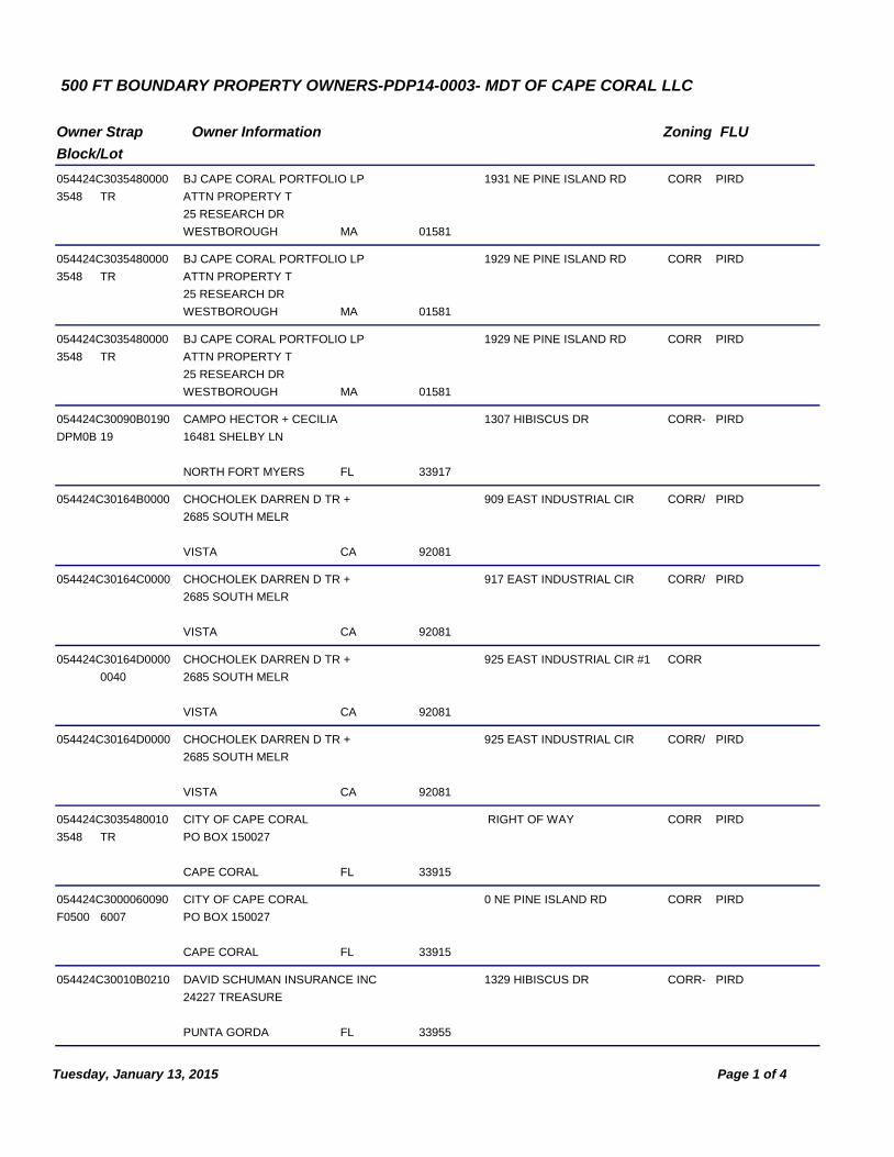
500 FT BOUNDARY PROPERTY OWNERS-PDP14-0003- MDT OF CAPE CORAL LLC
Owner Strap
Block/Lot
Owner Information Zoning FLU
054424C3035480000
3548
1931 NE PINE ISLAND RD CORR PIRDBJ CAPE CORAL PORTFOLIO LP
ATTN PROPERTY T
01581
25 RESEARCH DR
MAWESTBOROUGH
TR
054424C3035480000
3548
1929 NE PINE ISLAND RD CORR PIRDBJ CAPE CORAL PORTFOLIO LP
ATTN PROPERTY T
01581
25 RESEARCH DR
MAWESTBOROUGH
TR
054424C3035480000
3548
1929 NE PINE ISLAND RD CORR PIRDBJ CAPE CORAL PORTFOLIO LP
ATTN PROPERTY T
01581
25 RESEARCH DR
MAWESTBOROUGH
TR
054424C30090B0190
DPM0B
1307 HIBISCUS DR CORR- PIRDCAMPO HECTOR + CECILIA
16481 SHELBY LN
33917FLNORTH FORT MYERS
19
054424C30164B0000 909 EAST INDUSTRIAL CIR CORR/ PIRDCHOCHOLEK DARREN D TR +
2685 SOUTH MELR
92081CAVISTA
054424C30164C0000 917 EAST INDUSTRIAL CIR CORR/ PIRDCHOCHOLEK DARREN D TR +
2685 SOUTH MELR
92081CAVISTA
054424C30164D0000 925 EAST INDUSTRIAL CIR #1 CORRCHOCHOLEK DARREN D TR +
2685 SOUTH MELR
92081CAVISTA
0040
054424C30164D0000 925 EAST INDUSTRIAL CIR CORR/ PIRDCHOCHOLEK DARREN D TR +
2685 SOUTH MELR
92081CAVISTA
054424C3035480010
3548
RIGHT OF WAY CORR PIRDCITY OF CAPE CORAL
PO BOX 150027
33915FLCAPE CORAL
TR
054424C3000060090
F0500
0 NE PINE ISLAND RD CORR PIRDCITY OF CAPE CORAL
PO BOX 150027
33915FLCAPE CORAL
6007
054424C30010B0210 1329 HIBISCUS DR CORR- PIRDDAVID SCHUMAN INSURANCE INC
24227 TREASURE
33955FLPUNTA GORDA
Page 1 of 4Tuesday, January 13, 2015

Owner Strap
Block/Lot
Owner Information Zoning FLU
054424C30010B0020 1229 HIBISCUS DR CORR- PIRDDEL PINE MANOR LLC
1130 PONDELLA R
33909FLCAPE CORAL
054424C30010B0260 1342 DEL PINE DR CORR- PIRDDEL PINE MANOR LLC
1130 PONDELLA R
33909FLCAPE CORAL
054424C30010B0270 1330 DEL PINE DR CORR- PIRDDEL PINE MANOR LLC
1130 PONDELLA R
33909FLCAPE CORAL
054424C30090B0140
DPM0B
1279 HIBISCUS DR CORR- PIRDDEL PINE MANOR LLC
1130 PONDELLA R
33909FLCAPE CORAL
14
054424C30090B0150
DPM0B
1293 HIBISCUS DR CORR- PIRDDEL PINE MANOR LLC
1130 PONDELLA R
33909FLCAPE CORAL
15
054424C30090B0160
DPM0B
1295 HIBISCUS DR CORR- PIRDDEL PINE MANOR LLC
1130 PONDELLA R
33909FLCAPE CORAL
16
054424C30140A00CE
F0500
LAKE PVRD PVRDEAST CAPE COMMERCE CENTER
12424 BRANTLEY C
33907FLFORT MYERS
12
054424C30140D00CE
F0500
RESERVED PVRD PVRDEAST CAPE COMMERCE CENTER
12424 BRANTLEY C
33907FLFORT MYERS
6007
054424C3014C100CE
F0500
RIGHT OF WAY PVRD PVRDEAST CAPE COMMERCE CENTER
12424 BRANTLEY C
33907FLFORT MYERS
7000
054424C2035500010
3548
2025 NE PINE ISLAND RDEASTPOINT STIMULI LLC
UNIT 2001
34134
4875 PELICAN COLONY BLV
FLBONITA SPRINGS
TR
054424C3035480020
3548
2015 NE PINE ISLAND RD CORR PIRDEASTPOINT STIMULI LLC
UNIT 2001
34135
4875 PELICAN COLONY BLV
FLBONITA SPRINGS
TR
054424C2035510010
3551
2101 NE PINE ISLAND RD CORR PIRDEASTPOINT STIMULI LLC
UNIT 2001
34135
4875 PELICAN COLONY BLV
FLBONITA SPRINGS
TR
Page 2 of 4Tuesday, January 13, 2015

Owner Strap
Block/Lot
Owner Information Zoning FLU
054424C30090B0300
DPM0B
1302 DEL PINE DR CORR- PIRDHIGGINS ERIC H
1248 HIBISCUS DR
33909FLCAPE CORAL
30
054424C30090A0120
DPM0A
1302 HIBISCUS DR CORR- PIRDHONC CHERYL S
804 CAPE VIEW DR
33919FLFORT MYERS
12
054424C30090B0170
DPM0B
1303 HIBISCUS DR CORR- PIRDLYNCH ROBERT L + KIMBERLY S
1303 HIBISCUS DR
33909FLCAPE CORAL
17
054424C30090B0180
DPM0B
1305 HIBISCUS DR CORR- PIRDLYNCH ROBERT L + KIMBERLY S
1303 HIBISCUS DR
33909FLCAPE CORAL
18
054424C30090A0130
DPM0A
1306 HIBISCUS DR CORR- PIRDMCGEE KIRPATRICK
204 NW 4TH TER
33993FLCAPE CORAL
13
054424C30010A0150 1340 HIBISCUS DR CORR- PIRDMDT OF CAPE CORAL LLC
200 OCEAN AVE ST
32951FLMELBOURNE BEACH
054424C30010A0160 1352 HIBISCUS DR CORR- PIRDMDT OF CAPE CORAL LLC
200 OCEAN AVE ST
32951FLMELBOURNE BEACH
054424C30010A0180 1370 HIBISCUS DR CORR- PIRDMDT OF CAPE CORAL LLC
200 OCEAN AVE ST
32951FLMELBOURNE BEACH
054424C30010A0200 1384 HIBISCUS DR CORR- PIRDMDT OF CAPE CORAL LLC
200 OCEAN AVE ST
32951FLMELBOURNE BEACH
054424C30010A0210 1390 HIBISCUS DR CORR- PIRDMDT OF CAPE CORAL LLC
200 OCEAN AVE ST
32951FLMELBOURNE BEACH
054424C30010A0220 1394 HIBISCUS DR CORR- PIRDMDT OF CAPE CORAL LLC
200 OCEAN AVE ST
32951FLMELBOURNE BEACH
054424C30000A0170
DPM0A
1366 HIBISCUS DR CORR- PIRDMDT OF CAPE CORAL LLC
200 OCEAN AVE ST
32951FLMELBOURNE BEACH
17
Page 3 of 4Tuesday, January 13, 2015

Owner Strap
Block/Lot
Owner Information Zoning FLU
054424C30000A0190
DPM0A
1376 HIBISCUS DR CORR- PIRDMDT OF CAPE CORAL LLC
200 OCEAN AVE ST
32951FLMELBOURNE BEACH
19
054424C3000060070
F0500
2020 NE PINE ISLAND RD CORR- PIRDMDT OF CAPE CORAL LLC
200 OCEAN AVE ST
32951FLMELBOURNE BEACH
6007
054424C300006007A
F0500
2030 NE PINE ISLAND RD CORR- PIRDMDT OF CAPE CORAL LLC
200 OCEAN AVE ST
32951FLMELBOURNE BEACH
6007
054424C2035510000
3551
2201 NE PINE ISLAND RD CORR PIRDPINE I R LLC
1715 RIDGE RD
48383MIWHITE LAKE
TR
054424C3016010000 2200 NE PINE ISLAND RD CORR/ PIRDTERRACAP PI PARTNERS L.P.
100 SHEPPARD AV
M2N 6N5ONTORONTO
TR 1
Page 4 of 4Tuesday, January 13, 2015