canterbury settlement hierarchy study (cha 2011-10)
TRANSCRIPT

7/28/2019 Canterbury Settlement Hierarchy Study (CHA 2011-10)
http://slidepdf.com/reader/full/canterbury-settlement-hierarchy-study-cha-2011-10 1/76
A RURAL SETTLEMENT HIERARCHY STUDY OF
CANTERBURY DISTRICT
OCTOBER 2011

7/28/2019 Canterbury Settlement Hierarchy Study (CHA 2011-10)
http://slidepdf.com/reader/full/canterbury-settlement-hierarchy-study-cha-2011-10 2/76

7/28/2019 Canterbury Settlement Hierarchy Study (CHA 2011-10)
http://slidepdf.com/reader/full/canterbury-settlement-hierarchy-study-cha-2011-10 3/76
1 CONTENTS
1. INTRODUCTION
Aim of this Study 2
Canterbury District’s Existing Settlement Pattern 5
2. PLANNING POLICY CONTEXT
National Planning Policy 7
Regional Planning Context 10
Canterbury District Local Plan 10
Canterbury District Local Development Framework 11
Community Planning 12
3. SURVEY METHODOLOGY 14
4. SETTLEMENT HIERARCHY 27
5. RECOMMENDATIONS 32
6. PARISH PROFILES 36
ACKNOWLEDGEMENTS 74
F I G U R E S A N D T A B L E S
Table 1: Population figures by Urban Area (2009) and by Parish (2007) 6
Table 2: Settlement Facilities 17
Table 3: Rural Settlement Rankings 29
Figure 1: Settlements of Canterbury District 3
Figure 2: Parishes of Canterbury District 4
Figure 3: Extract from Canterbury District Core Strategy Options Report 11
Figure 4: Settlement Hierarchy 34

7/28/2019 Canterbury Settlement Hierarchy Study (CHA 2011-10)
http://slidepdf.com/reader/full/canterbury-settlement-hierarchy-study-cha-2011-10 4/76
21. INTRODUCTION
A im of th is Study
1.1 Canterbury District contains a wealth and diversity of settlements, from the cathedral
city of Canterbury and the Victorian and Edwardian seaside resorts of Herne Bay and
Whitstable to the many thriving villages and tiny hamlets of the Kent Downs and the
North Kent plain. In response, the City Council’s planning strategies have traditionally
allowed for different approaches to development in different settlements, to ensure
that the character of the district’s rich and varied landscape and its towns and villages
is maintained and enhanced. Maps of the district showing the location of its
settlements and parishes follow on pages 3 and 4 of this Study.
1.2 One of the key objectives of the Canterbury District Local Development Framework
(LDF), currently in preparation, is to set out policies for the location and management
of new development in the rural areas of the district. Such policies must be developed
in accordance with national planning guidance which promotes the principles of
sustainable development and requires local planning authorities to ensure that new
development is located in the most sustainable locations and that local development
needs are met.
1.3 The strategy for the rural areas of the district as set out in the Canterbury District LDF
will be rooted in part, but not exclusively, on the identification of a hierarchy of settlements, in which villages and towns are classified according to the services and
facilities they currently offer and the extent to which they act as local service centres
for adjoining rural areas and settlements. This Study presents such a hierarchy based
on an analysis of a range of services in each rural settlement deemed to act as
indicators of the sustainability of a settlement. These include shops, education, health,
employment facilities and access to public transport. Specifically this Study
describes in brief the character of the settlement pattern of Canterbury District
provides a brief overview of the national planning policy context including the
Draft National Planning Policy Framework published as this Study was being
finalised, the Canterbury Local Development Framework, current Local Plan
policies and community-produced supplementary planning documents such as
Parish Plans and Village Design Statements
describes the broad methodology used to develop the Hierarchy
identifies the types and role of settlements in the district based on village survey
work carried out between April and June 2011
identifies a hierarchy of settlements and explains the classification of each of the
district’s settlements included in the Hierarchy
proposes recommendations based on the evidence arising from this Study

7/28/2019 Canterbury Settlement Hierarchy Study (CHA 2011-10)
http://slidepdf.com/reader/full/canterbury-settlement-hierarchy-study-cha-2011-10 5/76
3
FIGURE 1: Settlements of Canterbury District

7/28/2019 Canterbury Settlement Hierarchy Study (CHA 2011-10)
http://slidepdf.com/reader/full/canterbury-settlement-hierarchy-study-cha-2011-10 6/76
4
FIGURE 2: Parishes of Canterbury District

7/28/2019 Canterbury Settlement Hierarchy Study (CHA 2011-10)
http://slidepdf.com/reader/full/canterbury-settlement-hierarchy-study-cha-2011-10 7/76
5
The nature of Canterbury District’s Settlement Pattern
1.4 Canterbury has the largest population of all the Kent Districts with a population in
2010 of 153,2001. Population is concentrated in the three principal urban areas of
Canterbury and the coastal towns of Herne Bay and Whitstable. A number of parishes
on the edges of these three settlements, namely Herne and Broomfield, Sturry,
Chartham, Blean, Chestfield, Thanington Without and Harbledown are amongst the
highest ranked non-urban areas in population terms.
1.5 The distribution of the population across Canterbury District exhibits a markedly
different pattern than that of other parts of the county. With an unusually large
number of small hamlets which have their origins in the area’s historic character of
scattered farmsteads, the district is home to fewer market towns and large villages
serving its rural areas than is the case with settlement patterns in other parts of Kent.
An examination of all districts in Kent reveals that Canterbury has the highest
proportion (62%) of its parished population living in the smallest parishes - those of
less than 1,000 people. In contrast, the profile in the neighbouring boroughs of Swale,
Ashford and Thanet is markedly different, with larger proportions of the populations of
these districts living in larger settlements. Such a pattern results in challenges in
addressing the location of new housing in Canterbury District based, as national policy
guidance requires, on sustainability issues.
1.6 The most recent population figures for which data is available for the 26 parishes andthree urban areas of which the district is comprised are set out in Table 1 overleaf.
Littlebourne village Ickham village
1 Kent County Council 2010, Mid Year Estimates

7/28/2019 Canterbury Settlement Hierarchy Study (CHA 2011-10)
http://slidepdf.com/reader/full/canterbury-settlement-hierarchy-study-cha-2011-10 8/76
6
URBAN AREAS POPULATION (2009)2
Canterbury 49,040
Herne Bay 38,040
Whitstable 32,430
PARISHES POPULATION (2007)3
Herne and Broomfield including Herne Common * 8,030
Sturry including Broad Oak and Hersden 6,730
Chartham including Shalmsford Street, St Augustines and
Chartham Hatch
4,040
Blean 3,860
Chestfield ** 3,040
Thanington Without *** 2,710
Harbledown and Rough Common including Upper Harbledown 2,160Littlebourne 1,510
Bridge 1,480
Barham including Out Elmstead and Derringstone 1,270
Bekesbourne with Patrixbourne 990
Chislet including Marshside, Highstead, Upstreet and Grove Ferry 890
Petham including Garlinge Green 800
Adisham 680
Lower Hardres 620
Hackington including Tyler Hill 560
Hoath including Maypole 530
Kingston 490
Wickhambreaux including Stodmarsh 450
Ickham and Well including Bramling 440
Waltham including Anvil Green 420
Westbere 400
Fordwich 390
Upper Hardres including Bossingham 330
Womenswold including Woolage Green and Woolage Village 250
Bishopsbourne 220
* for the purposes of this Rural Settlement Hierarchy Study only this parish is considered to fall within
the Herne Bay Urban Area
** for the purposes of this Rural Settlement Hierarchy Study only this parish is considered to fall within
the Whitstable Urban Area
*** for the purposes of this Rural Settlement Hierarchy Study only this parish is considered to fall within
the Canterbury City urban area
2 KCC, ward level population estimates 2009, the most recent available at time of writing3
KCC, parish population estimates 2007, the most recent available at time of writing

7/28/2019 Canterbury Settlement Hierarchy Study (CHA 2011-10)
http://slidepdf.com/reader/full/canterbury-settlement-hierarchy-study-cha-2011-10 9/76
7 2. PLANNING POLICY
National planning policy
2.1 Policies in the Canterbury Local Development Framework must be developed in
accordance with national planning policy. National planning guidance is currently set
out in a series of Planning Policy Statements (PPSs), with PPS1: Delivering Sustainable
Development , PPS3: Housing, PPS7: Sustainable Development in Rural Areas and
PPS13: Transport being of particular relevance to this Study. PPS12: Local Spatial
Planning sets down how Local Development Documents, into which this Study will
feed, should be prepared.
2.2 On the issue of locating new development such guidance at national level advocates
Most new development should be directed to existing towns and cities to help
maximize accessibility to employment and services by walking, cycling and public
transport
Within rural areas most new development should be focused in or near to local service
centres
There is a need to provide housing in villages in order to enhance or maintain their
sustainability Any new development in the open countryside, away from existing settlements or
outside areas allocated for development, should be strictly controlled in line with the
government’s overall aim to protect the countryside for its own sake and for the sake
of its landscape character, heritage, wildlife and recreational opportunities
2.3 The clear message from such national guidance therefore is that new development
should occur in the most sustainable locations. New development should be
“located where everyone can access services or facilities on foot, bicycle or public
transport rather than having to rely on access by car, while recognising that this
may be more difficult in rural areas”.4
2.4 With specific regard to housing, national policy requires that the planning system
should deliver housing developments in suitable locations, which offer a good range of
community facilities and with good access to jobs, key services and infrastructure5.
Although national policy does acknowledge that some housing development should
take place in more rural areas to prevent stagnation or decline in the rural economy
4 Planning Policy Statement 1, Delivering Sustainable Development, paragraph 275 Planning Policy Statement 3, Housing, paragraph 36

7/28/2019 Canterbury Settlement Hierarchy Study (CHA 2011-10)
http://slidepdf.com/reader/full/canterbury-settlement-hierarchy-study-cha-2011-10 10/76
8
and its social infrastructure, the imperative of ensuring that additional development
takes place in the most sustainable locations remains
“away from larger urban areas, planning authorities should focus most new
development in or near to local service centres where employment, housing
(including affordable housing), services and other facilities can be provided close
together ”6
and such centres
“should be identified in the development plan as the preferred location for such
development ”7.
2.5 At the same time national policy also requires that account should be taken of the
need to provide housing in rural areas, not only in market towns and local service
centres but also in villages in order to enhance or maintain their sustainability. Suchwork should include, particularly in the case of small rural settlements, consideration
of the relationship between settlements so as to ensure that growth is distributed in a
way that supports existing informal social support networks, assists people to live near
their work and to benefit from key services, minimise environmental impact and
where possible, encourage environmental benefits.8
2.6 PPS12 states that it is essential that a Local Development Framework makes clear
spatial choices about where development should go in broad terms. It also requires
such work to be founded on a robust and credible evidence base. The use of
Settlement Hierarchies to guide such spatial choices has been previously employed by
the City Council, by Kent County Council in the formation of Structure Plan policies and
by many local planning authorities across the country and has been supported at the
Examination stages of plan preparation as an important evidence base from which to
determine the location of new development. However caution has also been
expressed over undue reliance being placed on the application of such an approach in
defining ‘sustainable’ locations for new development, and this is reflected in the
recommendations of this Study set out in section 5. Such caution stems from concern
that the underlying premise of such an approach can be that new housing in villages is
too often considered negatively; to be, in essence, a burden. At a time when increasing
numbers of people who work in the countryside are unable to be able to live there,
and those that live there increasingly do not work there, this is at best an unhelpful
place to start. The Taylor Review9
for example highlights the threats to the national
goals of sustainable development and of creating mixed communities in all areas, both
urban and rural, and the problems that result from an approach that prevents new
housing (whether affordable or otherwise) in rural settlements on the sole basis that
they do not possess a specific combination of services at present.
6 Planning Policy Statement 7, Sustainable Development in Rural Areas, paragraph 3 7 Planning Policy Statement 7, Sustainable Development in Rural Areas, paragraph 3
8 Planning Policy Statement 3, Housing, paragraph 389 Living Working Countryside (2008), Matthew Taylor, DCLG

7/28/2019 Canterbury Settlement Hierarchy Study (CHA 2011-10)
http://slidepdf.com/reader/full/canterbury-settlement-hierarchy-study-cha-2011-10 11/76
9
2.7 Furthermore, while it is important to focus policy on sustainable development and
behaviour change, linked to tackling and mitigating the effects of climate change, it
should be borne in mind that if decision making in rural areas is determined primarily
or solely by reference to limiting car-based travel then there is little or no opportunity
for a settlement at a lower level to migrate up a settlement hierarchy. This results in
what the Taylor Review terms a ‘sustainability trap’10
where in essence, otherwise
beneficial development can only be approved if the settlement is considered
sustainable in the first place.
2.8 At the time of writing, proposed changes to the national planning framework have
been released for public consultation and the Localism Bill is going through its final
parliamentary stages. The Localism Bill reflects a new approach to land use planning,
known in short as Localism, and aims to ensure that amongst other things
communities have improved opportunities to shape the future of their own
communities. It proposes the replacement of the current portfolio of documents that
make up Local Development Frameworks, with one statutory Local Plan, which will
perform a strategic planning role, and new Neighbourhood Plans which will have to
conform to such Local Plans and will be produced by a designated ‘Neighbourhood
Forum’. Such Neighbourhood Plans will also be required to conform to a proposed
presumption in favour of sustainable development, European directives, national and
international designations and neighbouring Neighbourhood Plans. Subject to passing
an independent examination a Neighbourhood Plan will, uniquely in the field of
planning policy documents, under the Bill as currently drafted, have to be approved by
more than 50% of the ‘local’ population in a referendum.
2.9 The Draft National Planning Policy Framework, out for public consultation at the time
of writing, also signals a new approach to planning policy at national level. It sets out
to bring together Planning Policy Statements, Planning Policy Guidance notes and
some circulars into a single consolidated document to provide a framework within
which local people and their accountable councils can produce their own distinctive
local and neighbourhood plans which reflect the needs and priorities of their
communities. The presumption in favour of sustainable development is central to the
policy approach in the Framework. The brownfield target is proposed to be removed,
with councils instead being required to allocate sites considered most suitable for
housing development taking account of environmental quality while actively managing
patterns of growth to make the fullest use of public transport. The Draft Framework is
clear that rural housing that is distant from local services should not be permitted.11
10 Living Working Countryside (2008) Matthew Taylor, DCLG, paragraph 77 11 Draft National Planning Policy Framework (2011), DCLG, paragraph 112

7/28/2019 Canterbury Settlement Hierarchy Study (CHA 2011-10)
http://slidepdf.com/reader/full/canterbury-settlement-hierarchy-study-cha-2011-10 12/76
10
Regional planning context
2.10 At the time of writing, although the Secretary of State has announced an intention to
abolish Regional Spatial Strategies once the Localism Bill has received Royal Assent,
advice currently states that for so long as the regional strategies continue to exist, anydevelopment plan documents must be in general conformity with the relevant
regional strategy; in the case of Canterbury, the South East Plan (2009).
2.11 Policies of the South East Plan conform to national guidance in also requiring new
housing to be provided in sustainable locations. Policy SP2 advocates the majority of
new housing in Canterbury District to be focused on Canterbury itself, an approach
also set down in Policy SP3 which states that development should be concentrated
within or adjoining urban areas. Policy H2 vi requires local planning authorities to
provide a sufficient quantity and mix of housing, including affordable housing, in rural
areas to ensure the long term sustainability of rural communities. Of particularrelevance to this Study is the direction that limited small scale development can help
meet the specific local housing, business and service needs of individual rural
settlements, preferably informed by community-led planning initiatives and
documents such as parish plans and village design statements.
Canterbury District Local Plan
2.12 In addressing the location and scale of new housing development in Canterbury
District for the adopted Canterbury Local Plan, housing capacity work revealed that the
District had capacity within its existing urban areas to achieve the strategic housing
requirements up to and beyond the local plan period of 2011.
2.13 Allocations for new residential development in the adopted Local Plan are therefore
concentrated on previously developed land within the three main urban areas of the
district, namely Canterbury, Herne Bay and Whitstable. New residential development
in all villages is restricted to minor development only, unless brownfield land becomes
available and a full impact assessment of its redevelopment for housing can
demonstrate that no adverse impact on the existing social and physical infrastructure
of the village would result, that any development has had regard to the character,appearance and historic environment of the village and does not conflict with other
Local Plan designation or environmental objectives and that a Development Brief is
prepared as part of a planning application to ensure the proper planning of the area.
2.14 The majority of Local Plan housing policies have been saved and, as the latest Housing
Information Audit12
confirms, Canterbury District continues to enjoy a surplus supply
of housing land (allocated sites and those with existing planning permissions for
housing development which remain unimplemented or fully implemented) in excess of
the 5 year statutory requirement.
12 Canterbury Housing Information Audit, Kent County Council 2010

7/28/2019 Canterbury Settlement Hierarchy Study (CHA 2011-10)
http://slidepdf.com/reader/full/canterbury-settlement-hierarchy-study-cha-2011-10 13/76
11
Canterbury District Local Development Framework
2.15 In January 2010 the Canterbury District Local Development Framework Core Strategy
Options Report was published for consultation. This Options report and in particularthe District Settlement Strategy and the Strategic Development Options therein, is
based to a large degree on the outcomes of the extensive Canterbury Futures Study, a
study commissioned from consultants Experian in 2006 to establish and examine
potential scenarios for the growth and future character of the district over the next 20
years. This Futures work concluded13
that a Knowledge based economy approach to
the District was most supported and identified a need for new development to be
focused on Canterbury to support the development of such a ‘Knowledge Economy’
and the ‘Canterbury Experience’.
2.16 Locations for new development in the District continued to be informed by a
sequential approach in the Core Strategy Options Report. Seven Options were set out,
with a preferred Option identified. A Settlement Hierarchy was also included (as set
out below) for consultation as part of the District Settlement Strategic Options.
City of Canterbury Identified as Regional Hub in South East Plan;
commercial, tourism and retail centre for the sub-
region
Whitstable, Herne Bay Main urban centres at the coast
Larger, well-served villages
around Canterbury
Barham; Blean; Bridge; Chartham; Sturry; Littlebourne
Other villages Adisham; Bekesbourne; Bishopsbourne; Bossingham;
Broad Oak; Chartham Hatch; Derringstone; Fordwich;
Harbledown; Hersden; Hoath; Ickham; Kingston;
Lower Hardres; Patrixbourne; Petham; Rough
Common; Shalmsford Street; Stodmarsh; Tyler Hill;
Upper Harbledown; Upstreet; Waltham; Westbere;
Wickhambreaux; Womenswold; Woolage Green;
Woolage Village; Yorkletts
FIGURE 3: Canterbury District Core Strategy Options Report, Table 3
13 At a Crossroads: Canterbury Futures Study (2006) Experian for Canterbury City Council

7/28/2019 Canterbury Settlement Hierarchy Study (CHA 2011-10)
http://slidepdf.com/reader/full/canterbury-settlement-hierarchy-study-cha-2011-10 14/76
12
2.17 This Hierarchy received 51 representations, 15 in support and 36 objections. Of the
objections half related to the rankings of individual settlements, just under a third to
the classification of the settlement of Hersden, while a third were promoting individual
sites and not therefore of direct relevance to principles and composition of the
Settlement Hierarchy.
2.18 The City Council is currently working to take forward the results of this public
consultation and to assemble both the robust evidence base for and the policy content
of a Canterbury District Local Development Framework to replace the Canterbury
District Local Plan in providing strategic policies for the planning of development in the
district. As part of this work it was considered appropriate to review and update the
village survey work previously undertaken by the City Council in 2007 alongside a
review of changes in planning policy at regional and national level where applicable,
and to make such alterations to the draft Settlement Hierarchy as set out in the
Options Report as may be required as a result of such work.
Community Planning
2.19 In addition to national and local requirements the distribution of housing allocations
across the district will take account of the needs and aspirations of the District’s rural
communities, building on consultation already undertaken as part of the Core
Strategy. The district has enjoyed a high level of proactive involvement in the planning
process by its rural parishes (Canterbury City Council’s approach to working with
parish councils in preparing Parish Plans and Village Design Statements has beenhighlighted by Natural England
14as an example of best practice) with more than a
third of all parishes in Canterbury District having produced Community Appraisals or
full Parish Plans15
. Two further parishes (Chartham and Littlebourne) and part of the
parish of Thanington Without have produced Village Design Statements and the
District Council continues to work in partnership with parish councils to encourage
community involvement in the planning process. All Parish Plans, Village Design
Statements and responses to the Core Strategy Options Report by parish councils and
community groups have been reviewed as part of the preparation of this Report.
14 England’s statutory landscape designations: a practical guide to your duty of regard (2010) Natural
England
15 Barham (2005) Blean (2009) Chestfield (2006) Hackington (2007) Herne & Broomfield (2004) Hoath
(2007) Ickham and Well (2010) Petham (2009) Sturry (2009) Thanington (Parish Appraisal) (2006)
Upper Hardres (2005) Westbere (2011)

7/28/2019 Canterbury Settlement Hierarchy Study (CHA 2011-10)
http://slidepdf.com/reader/full/canterbury-settlement-hierarchy-study-cha-2011-10 15/76
13
Chartham Parish Design Statement (2005) Sturry Parish Plan (2009)
Littlebourne Village Design Statement (2005) Barham Parish Plan (2005)

7/28/2019 Canterbury Settlement Hierarchy Study (CHA 2011-10)
http://slidepdf.com/reader/full/canterbury-settlement-hierarchy-study-cha-2011-10 16/76
143. SURVEY METHODOLOGY
3.1 As part of the preparation of this Study (which reviews and updates the village survey
work previously undertaken by the City Council in 2007) all rural settlements16
were
visited and surveyed between April and June 2011 to identify the services and
amenities present that provide residents with access to basic needs including shops
and social facilities, education, healthcare, leisure and employment as well as public
transport links. A profile of each of these settlements, grouped by Parish, can be found
in Section 6 of this Study. Parish Profiles were circulated to parish councils for fact-
checking during October 2011.
3.2 Due to their geographical proximity and character the parishes and settlements of
Herne and Broomfield and of Chestfield have been considered for the purposes of this
Study only to fall within the urban areas of Herne Bay and Whitstable respectively,
while part of the parish of Thanington Without, despite its name, falls within the urban
area boundary of Canterbury and is therefore classified as part of the city for the
purposes of this report. Yorkletts although a small settlement is not located in a rural
parish, and thus is deemed to fall within the Whitstable Urban Area for the purposes
of this Study.
3.3 It should be noted that discrepancies between historical parish boundaries and
modern day settlement patterns throw up a number of anomalies when seeking to
assess the sustainability of villages and settlements in this district on the basis of the
facilities they currently enjoy. The large parish of Sturry, for example, includes the
settlements of Sturry, Broad Oak and the residential areas of Hersden. The village of
Sturry is however contiguous with the small historic town, and parish, of Fordwich
whose sustainability is therefore enhanced by the facilities of its larger neighbour.
Similarly, the village of Bossingham, in Upper Hardres parish, immediately abuts the
village of Stelling Minnis (in Shepway District) and is served by Stelling Minnis School
which sits on the boundary between both parishes and which serves, for the purposes
of assessing the facilities which contribute to sustainability, both Bossingham andStelling Minnis equally, despite being actually located in the latter.
3.4 With regard to assessing the existing employment facilities of settlements, two of the
district’s principal industrial estates are located along the A28 east of Sturry in the
village of Hersden on land largely previously occupied by buildings of the Chislet
colliery which operated from the 1920s until its closure in 1969. However as these
employment sites lie south of the A28 they are therefore geographically, but not
functionally, in the rural parish of Westbere whose boundary historically has run along
16 For the purposes of this work the word settlement covers all towns, villages and hamlets where thereare existing services or facilities.

7/28/2019 Canterbury Settlement Hierarchy Study (CHA 2011-10)
http://slidepdf.com/reader/full/canterbury-settlement-hierarchy-study-cha-2011-10 17/76
15
the centre of what is now the A28 but whose settlement, the small village of
Westbere, and the Stodmarsh National Nature Reserve which covers roughly half the
area of Westbere parish, has an entirely separate and distinctive character and range
of facilities for the purposes of this Study. The rural hamlet of Chislet similarly gives its
name to a large rural parish stretching north east from the Great Stour river, which
forms its southern boundary, to the A299 Thanet Way but which contains for example
a number of employment sites which are far removed from, and therefore cannot be
deemed to be part of or contribute to the character and sustainability of, the small
settlement of Chislet.
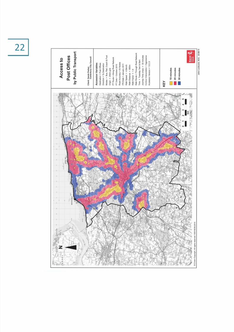
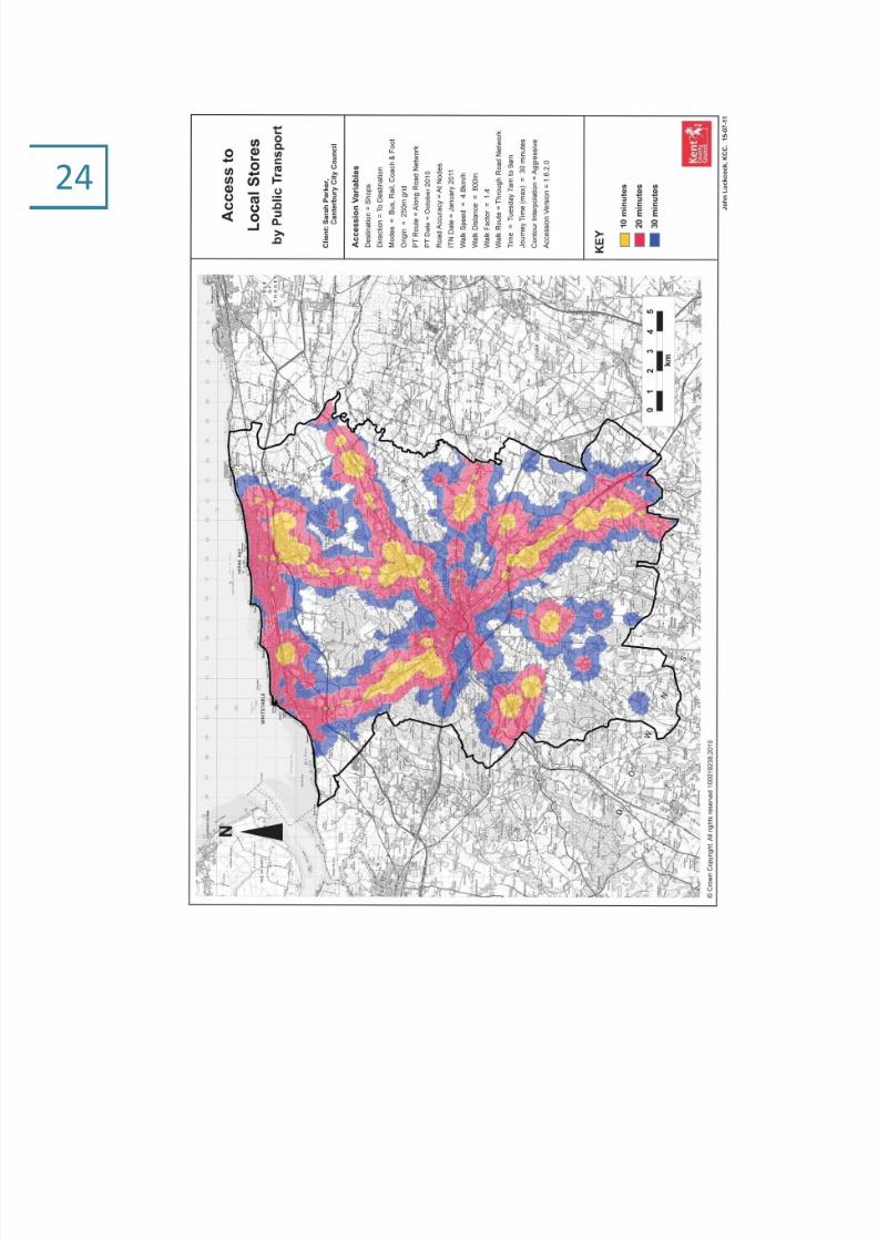
3.5 Alongside the main survey work set out below, accessibility studies were undertaken
by Kent County Council’s Planning and Environment directorate using specialist
‘Accession’ software recommended by the Department of Transport as an effective
tool for measuring accessibility to identified public amenities and for graphically
representing how accessible a specific destination is using the existing public transportnetwork. The studies included analysis of 30 minute accessibility, by public transport,
to key services within Canterbury district. The key services examined were primary
schools, post offices, local stores and GP surgeries and the results, shown at the end of
this Chapter, reflect the historical growth of development in the district along the main
transport routes into the city of Canterbury.
3.6 For this Rural Settlement Hierarchy Study of Canterbury District a range of services and
facilities were considered to contribute to the sustainability of settlements based on
work by the Commission for Rural Communities in their State of the Countryside
reports. In addition facilities which formed the basis for previous surveys by the City
Council were referred to, to allow for an element of consistency and comparison with
such previous survey work.
3.7 Such services and facilities were drawn from six broad categories
public transport : hourly bus service; train station
shops : post office; local store/s; public house ; other
shops
community facilities: village hall; play area/field; playgroup
education: primary school
health services: GP surgery
employment: business premises
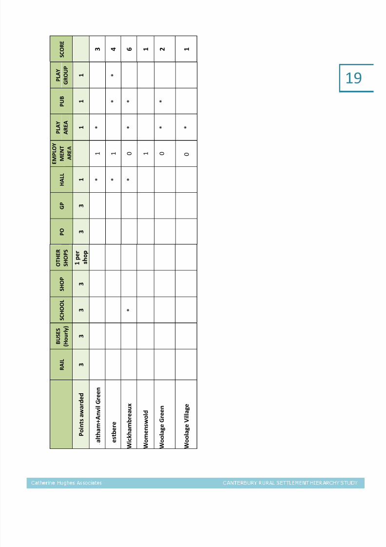
3.8 Scores were then assigned to determine a settlement’s position in the hierarchy, as set
out in Table 2 below, with weighting employed to reflect the view, and an approach
prevalent amongst many such rural settlement hierarchy studies, that some services
are deemed as making a more important contribution towards the sustainability of a
settlement than others. These ‘key’ services were defined as
regular hourly bus services

7/28/2019 Canterbury Settlement Hierarchy Study (CHA 2011-10)
http://slidepdf.com/reader/full/canterbury-settlement-hierarchy-study-cha-2011-10 18/76
16
a train station
primary school
post office
local supermarket or store
GP surgery
For a settlement to score points, the service or amenity must be located within the
built up area of a settlement, or within 800m (reasonable walking distance) of the
centre of that settlement.
3.9 Local employment opportunities are also considered vital to the vibrancy of rural
settlements. The district’s rural communities can only prosper and survive if a living
and working countryside is promoted and supported by planning policies. It is
however difficult to establish a consistent and accurate evidence base which measures
local employment, particularly as the nature of rural employment often results in jobs
being located across rural areas, rather than being located in rural settlements. The
employment indicator used in this Study is based on the number of businesses in a
parish paying business rates (with figures extracted by address to cross relate as far as
was possible to each settlement) Such a score excludes registered charities, those
working from home and is indicative only, reflecting as it does the numbers of
businesses present in each parish and not the numbers of jobs.
3.10 As noted in 3.3 above, discrepancies between historical parish boundaries and modern
day settlement patterns throw up a number of anomalies. In assessing the
employment facilities of settlements such anomalies are particularly evident in theeastern part of the district, with the industrial estates of Lakesview International
Business Park and Canterbury Business Park being located largely on land which
previously formed part of Chislet Colliery and thus in what is the modern day
settlement of Hersden but which falls within the historic boundary of the parish of the
small rural hamlet of Westbere. Similarly the employment site of Chislet Business Park
functions within the settlement of Hersden, despite being located in the adjoining
large rural parish of Chislet. Acknowledgement has been made for such boundary
anomalies in the hierarchy tables where they occur.
Village stores at Littlebourne (left) and at Blean (right)

7/28/2019 Canterbury Settlement Hierarchy Study (CHA 2011-10)
http://slidepdf.com/reader/full/canterbury-settlement-hierarchy-study-cha-2011-10 19/76
17
17A settlement scores one point irrespective of the number of pubs located there 18
Less than 25 business premises: 1pt; 26-50: 2pts; 51-100: 3pts; 100+ business premises: 4pts19 Excludes car sales and garages; includes farm shops 20School located within boundary of Stelling Minnis parish but serves Bossingham21Hersden scores an extra point here as it has a secondary school, Spires Academy. Secondary schools serve a wide catchment
area and thus are not considered to be an indicator of a settlement’s sustainability in the same way as a primary school.
S C O R E
9 2 1
1 3 4 2
4 9 2 7 9 2
7 5 5 4 5 2 6 6
P L A Y
G R O U P
1 *
*
*
*
*
*
*
*
P U B 1 7
1 *
*
*
*
*
*
*
*
*
*
*
*
P L A Y
A R E A
1 *
*
*
*
*
*
*
*
*
*
*
*
E M P L O Y
M E N T 1 8
1
3
2
1
3
1
2
2
3
1
2
1
1
4
1
H A L L 1 *
*
*
*
*
*
*
*
*
*
*
*
*
*
G P 3
*
*
*
*
P O 3
*
*
*
*
*
O T H E R
S H O P S
1 9
1 p e r
s h o
2
5
2
1
6
1
2
1
3
1
L O C A L
S H O P
3 *
*
*
*
*
*
S C H
O O L
3 *
*
*
* 2 0
*
*
*
* 2 1
*
B U S E S
( H o u r l y )
3 *
*
*
*
*
*
R A I L 3 *
*
*
P o i n t s a w a r d e d
A d i s h a m
B a r h a m
B e k e s b o u r n e
B i s h o p s b o u r n
e
B l e a n
B o s s i n g h a m
B r i d g e
B r o a d O a k
C h a r t h a m ( i n c
S h a l m s f o r d S t r e e t )
C h a r t h a m H a t c h
C h i s l e t + M a r s h s i d e
F o r d w i c h
H a r b l e d o w n
H e r s d e n
H o a t h +
a y p o l e

7/28/2019 Canterbury Settlement Hierarchy Study (CHA 2011-10)
http://slidepdf.com/reader/full/canterbury-settlement-hierarchy-study-cha-2011-10 20/76
18 S C O R E
4 8 2 2 5 1 9 1
1 1 4 1 7 3 1
2
P
L A Y
G R O U P
1 *
*
*
*
*
*
P U B
1 *
*
*
*
*
*
*
*
*
*
*
P L A Y
A R E A
1
*
*
*
*
*
*
*
*
*
*
E M P L O Y
M E N T
1
1
2
1
1
1
0
3
1
1
1
H A L L 1 *
*
*
*
*
*
*
*
G P 3
*
*
P O 3
*
*
*
*
O T
H E R
S H O P S
1 p e r
1
1
1
1
6
S H O P
3
*
*
*
*
S C H O O L
3
*
*
*
B U S E S
( H o u r l y )
3
*
*
*
*
*
R A I L
3
*
P o i n t s a w a r d e d
I c k h a m + B r a m l i n g
K i n g s t o n
L i t t l e b o u r n e
L o
w e r H a r d r e s
P a t r i x b o u r n e
P e t h a m +
G a r l i n g e G r e e n
R o u g h C o m m o n
S t
o d m a r s h
S t
u r r y
T y
l e r H i l l
U p p e r H a r b l e d o w n
U p s t r e e t + G r o v e F e r r y
7/28/2019 Canterbury Settlement Hierarchy Study (CHA 2011-10)
http://slidepdf.com/reader/full/canterbury-settlement-hierarchy-study-cha-2011-10 21/76
19
S C O R E
3 4 6 1 2 1
P L A Y
G R O U P
1 *
P U B
1 *
*
*
P L A Y
A R E A
1 *
*
*
*
E M P L O Y
M E N T
1
1
0
1
0
0
H A
L L
1 *
*
*
G P 3
P O 3
O T H E R
S H O P S
1 p e r
S H O P
3
S C H O O L
3 *
B U S E S
( H o u r l y )
3
R A I L 3
P o i n t s a w a r d e d
a l t h a m + A n v i l G r e e n
e s t b e r e
W i c k h a m b r e a u x
W o m e n s w o l d
W o o l a g e G r e e n
W o o l a g e V i l l a g e

7/28/2019 Canterbury Settlement Hierarchy Study (CHA 2011-10)
http://slidepdf.com/reader/full/canterbury-settlement-hierarchy-study-cha-2011-10 22/76
20

7/28/2019 Canterbury Settlement Hierarchy Study (CHA 2011-10)
http://slidepdf.com/reader/full/canterbury-settlement-hierarchy-study-cha-2011-10 23/76
21
7/28/2019 Canterbury Settlement Hierarchy Study (CHA 2011-10)
http://slidepdf.com/reader/full/canterbury-settlement-hierarchy-study-cha-2011-10 24/76
22

7/28/2019 Canterbury Settlement Hierarchy Study (CHA 2011-10)
http://slidepdf.com/reader/full/canterbury-settlement-hierarchy-study-cha-2011-10 25/76
23
7/28/2019 Canterbury Settlement Hierarchy Study (CHA 2011-10)
http://slidepdf.com/reader/full/canterbury-settlement-hierarchy-study-cha-2011-10 26/76
24

7/28/2019 Canterbury Settlement Hierarchy Study (CHA 2011-10)
http://slidepdf.com/reader/full/canterbury-settlement-hierarchy-study-cha-2011-10 27/76
25

7/28/2019 Canterbury Settlement Hierarchy Study (CHA 2011-10)
http://slidepdf.com/reader/full/canterbury-settlement-hierarchy-study-cha-2011-10 28/76
26

7/28/2019 Canterbury Settlement Hierarchy Study (CHA 2011-10)
http://slidepdf.com/reader/full/canterbury-settlement-hierarchy-study-cha-2011-10 29/76
27

7/28/2019 Canterbury Settlement Hierarchy Study (CHA 2011-10)
http://slidepdf.com/reader/full/canterbury-settlement-hierarchy-study-cha-2011-10 30/76
28 4. SETTLEMENT HIERARCHY
4.1 This Study has focused on the rural areas of the District but the settlement pattern and
hierarchy also encompasses the three urban areas of Canterbury, Herne Bay and
Whitstable.
4.2 It should be noted that in drawing up the hierarchy account has not been taken of
environmental issues, including flood risk and landscape designations, as they do not
influence a settlement’s sustainability, though the Parish Profiles which follow in
section 6 note such matters and constraints with regard to each settlement.
4.3 Finally, the ranking of each settlement, and thus its potential suitability to
accommodate further development, should not be taken to mean that there is suitable
land for development in such a village. As the recommendations at the close of this
Study make clear, the Settlement Hierarchy is only one of a range of background
studies which should and will feed into the site allocation process.
4.4 Table 3 overleaf sets out the rural settlement rankings resulting from the assessment
of the sustainability of each as reflected by the range of facilities offered in each
village. The Hierarchy is directly drawn from such rankings.
4.5 As noted in 3.10 above a number of anomalies arose in assigning parish based
employment scores to settlements during this survey work. In the case of Chartham,
Chislet, Harbledown and Sturry parishes individual addresses of all businesses paying
business rates were examined in order to distribute the employment score as
accurately as possible between the settlements in each of these parishes.

7/28/2019 Canterbury Settlement Hierarchy Study (CHA 2011-10)
http://slidepdf.com/reader/full/canterbury-settlement-hierarchy-study-cha-2011-10 31/76
29
TABLE 3: Rural Settlement Rankings
RURAL SETTLEMENT RANKING SCORE
Sturry 41Bridge 27
Chartham 27
Hersden 26
Blean 24
Littlebourne 22
Barham 21
Bekesbourne 13
Upstreet 12
Rough Common 11
Adisham 9Bossingham 9
Petham 9
Broad Oak 9
Kingston 8
Tyler Hill 7
Hoath 6
Wickhambreaux 6
Chislet 5
Harbledown 5
Chartham Hatch 5Lower Hardres 5
Bishopsbourne 4
Fordwich 4
Westbere 4
Ickham 4
Waltham 3
Upper Harbledown 3
Woolage Green 2
Stodmarsh 1
Woolage Village 1
Patrixbourne 1
Womenswold 1

7/28/2019 Canterbury Settlement Hierarchy Study (CHA 2011-10)
http://slidepdf.com/reader/full/canterbury-settlement-hierarchy-study-cha-2011-10 32/76
30Regional Centre
4.6 Canterbury City is classified as a Primary Regional Centre in the South East Plan (2009)
(which as noted in paragraph 2.9 above at the time of writing remains part of the
development plan) being the principal centre of importance in the East Kent sub
region. It is home to 30% of the District’s population, and provides the widest range of
services and facilities. Canterbury City enjoys a world-wide reputation as a tourist
destination centred on the World Heritage Site status. It is also the District’s principle
transport hub with excellent high speed train connections and plentiful bus services.
District Centres
4.7 The District’s two remaining urban areas are located on the coast at Herne Bay and
Whitstable. Such towns play an important role in the profile of the District and are a
focus for shopping and other services for settlements to the north of Canterbury in
particular, as well as performing an important role in the economy and vibrancy of the
District by attracting visitors to their distinctive seaside offer.
Rural Settlements
4.8 As stated previously the rural settlement character of Canterbury District is dominated
by a large number of small village settlements and it is these that have been the focus
of this work.
Rural service centre
4.9 A number of settlements emerged from this Study as providing a service role for other
surrounding smaller villages. Principal of these is Sturry. With a parish population of
6,730 the parish of Sturry is the only22 rural parish in the District which falls within the
size categorised as urban by the Office of National Statistics. It has a good and
markedly larger range of services and facilities compared with the next ranked village
which serve the dispersed settlements of the eastern area of the district (including ‘the
smallest town in England’, Fordwich, which immediately adjoins Sturry to the south),together with excellent public transport links. The parish of Sturry encompasses the
settlements of Broad Oak and Hersden, the latter possessing a good range of services
and facilities in its own right, including primary and secondary schools. Given this and
in order to accurately position Hersden within the hierarchy of settlements the
population of Sturry Parish was examined at Super Output Level revealing Hersden to
be, in population size, on a scale commensurate with that of the village of Bridge.
There are however significant transport issues that need to be addressed in assessing
the suitability of Sturry for additional housing as part of the Local Development
22 With the exception of Herne and Broomfield which for the purposes of this study only is considered to fall within
the Herne Bay urban Area

7/28/2019 Canterbury Settlement Hierarchy Study (CHA 2011-10)
http://slidepdf.com/reader/full/canterbury-settlement-hierarchy-study-cha-2011-10 33/76
31
Framework given ongoing congestion problems with the A28 through Sturry and
between Sturry and Canterbury.
Local centres
4.10 A number of other larger villages Chartham (including Shalmsford Street) Bridge,
Hersden, Blean, Littlebourne, and Barham and have also emerged, from both the
survey work and from the results of the Accession based analysis undertaken by Kent
County Council and illustrated in maps at the end of Chapter 3 of this Study, as
providing a range of services for the rural areas surrounding them. Such local service
centres are smaller in scale and do not have such a wide range of retail services as
Sturry, but they do offer a significant range of services and facilities, including
employment opportunities, which cater for the daily needs of the local communities
and surrounding small settlements. These larger villages all have all the key
sustainability services, namely a primary school, hourly bus services and or a train
station, a post office, village store and (with the exception of Barham) a GP surgery.
Villages
4.11 The villages of Adisham, Bekesbourne, Bossingham, Broad Oak, Hoath, Kingston,
Petham, Rough Common, Tyler Hill, Upstreet, and Wickhambreaux generally have
smaller populations and significantly smaller ranges of services and facilities and are
reliant on adjacent larger villages for key services. Each village in this tier does
however have one or more of the key sustainability services.
Hamlets
4.12 Canterbury District has a large number of small settlements with modest populations
(termed hamlets for the purposes of this Hierarchy Study only) which provide very
limited services, namely Chartham Hatch, Chislet, Bishopsbourne, Fordwich,
Harbledown, Ickham, Lower Hardres, Patrixbourne, Stodmarsh, Upper Harbledown,
Upper Hardres, Waltham, Westbere, Womenswold, Woolage Green, and Woolage
Village. With the exception of Chislet primary school there are no key sustainability
services in these settlements.

7/28/2019 Canterbury Settlement Hierarchy Study (CHA 2011-10)
http://slidepdf.com/reader/full/canterbury-settlement-hierarchy-study-cha-2011-10 34/76
32
5. RECOMMENDATIONS
5.1 In preparing the Canterbury District Local Development Framework, the new strategic
planning policy document to shape the development of the district over the next 15
years, the City Council remains committed to a sequential approach to the location of
new development. Such an approach is in line with national planning guidance and
with the results of the Canterbury Futures work23
which identified the need for
development to be focused on the city of Canterbury to best support the economic
development and prosperity of the district.
5.2 The outcomes of this Rural Settlement Hierarchy Study, which has examined the
sustainability (as defined by the range of services and employment opportunitiesprovided) of the rich diversity of rural settlements in the district, serve as a significant
element of the evidence base required to identify appropriate locations for new
development in Canterbury District. The production of a Settlement Hierarchy to guide
the selection of sites is also in line with emerging national policy as set out in the Draft
National Planning Policy Framework which has at its heart the promotion of and
support for sustainable development and thus of sustainable locations for new
development .
5.3 The revised Settlement Hierarchy as set out below updates the Hierarchy included in
the Core Strategy Options Report produced by the City Council in January 2010. It is
based on the outcomes of village survey work undertaken during the spring and early
summer of 2011 and an analysis of employment opportunities offered in each
settlement. Such survey work is clearly, it should be emphasised, a snap shot of the
facilities enjoyed by each settlement at the time of survey and will change over time.
5.4 The settlement of Sturry to the east of Canterbury emerges from the hierarchy work as
having a stronger retail profile than the settlements of Barham, Blean, Bridge,
Chartham, Hersden and Littlebourne which, despite offering a sustainable range of
facilities, with the exception of Bridge have a very limited range of retail premises atthe present time and thus still retain the character of medium-sized villages. Sturry is
therefore considered to play a wider service centre role than the tier below it (a
situation reflected in the scoring differential) and may be appropriate for additional
housing in excess of minor development. However, there are a number of other policy
matters that will need to be satisfactorily addressed, particularly the significant
transport issues associated with the A28 and the level crossing, together with
landscape character, in any proposals at Sturry.
23 At a Crossroads: Canterbury Futures Study (2006) Experian for Canterbury City Council

7/28/2019 Canterbury Settlement Hierarchy Study (CHA 2011-10)
http://slidepdf.com/reader/full/canterbury-settlement-hierarchy-study-cha-2011-10 35/76
33
5.5 Barham, Blean, Bridge, Chartham, Hersden and Littlebourne each serve as local
centres with a good or reasonable sustainable range of facilities and posessing all of
the key services (with the exception of Barham which does not have a GP surgery).
These villages are thus rural settlements where small scale additional housing
development may be appropriate commensurate with their size and village character
and subject to environmental and other factors. The smaller villages and hamlets (as
categorised for the purposes this Study only) are considered to be suitable for minor
or infill development only, again in accordance with their scale, character and local
environmental factors.
5.6 It is recommended that the Council should set out a clear Policy for the Location of
New Development across the District in the Local Development Framework (currently
being prepared to replace the adopted Local Plan). Such a policy should continue to
have as its principal focus the urban areas of Canterbury, Herne Bay and Whitstable.
Modest additional new development in excess of minor development may also beappropriate at the rural service centre of Sturry, provided that this can be delivered in
a way that respects and enhances the character and design of the village and subject
to satisfactorily addressing environmental, flooding and transportation impact issues.
Small scale provision of new housing that is of a design, scale, character and location
appropriate to the character and built form of the service centres of Barham, Blean,
Bridge, Chartham, Hersden and Littlebourne may also be appropriate provided that
such proposals are not in conflict with other Development Plan transport,
environmental, flood zone protection and design policies, including those of the Kent
Downs AONB Management Plan where applicable. In all other settlements policy
should make clear that priority will be given to protecting the rural character of the
District and development will be restricted to minor development or infill or that
which is needed to meet the needs of agriculture or forestry or an identified local need
for affordable housing only.

7/28/2019 Canterbury Settlement Hierarchy Study (CHA 2011-10)
http://slidepdf.com/reader/full/canterbury-settlement-hierarchy-study-cha-2011-10 36/76
34
FIGURE 4: Settlement Hierarchy for Canterbury District
5.6 It should also be emphasised that this Settlement Hierarchy Study, though significant,
is only one of a number of factors in the selection of appropriate locations for new
development. Traditionally it has been the case that the scale and distribution of
housing sites directly follows from the settlement hierarchy. However, as has been
acknowledged previously in this Study there are many other factors to be taken into
account when allocating land in the rural areas of the district such as transport,
landscape or flooding issues and housing needs particular to individual communities.
5.7 Canterbury District enjoys large areas of highly attractive and protected landscapes
including three internationally protected SPA and Ramsar sites, three National Nature
Reserves and 15 nationally designated SSSIs, while the Kent Downs AONB covers
almost a third of the district. Designation as an AONB confers the highest level of
protection and one which the council has a statutory duty to conserve and enhance.
Development proposals that fall within or which affect the setting of the AONB will
therefore need to have regard to the policies of the Kent Downs AONB Management
Plan. Canterbury District also has an enviable range of heritage assets including the
World Heritage Site of Canterbury together with over 100 Conservation Areas and
nearly 3,000 Listed Buildings. The Great Stour and the Nailbourne rivers run through
the centre of many of the rural villages of the district affecting the flood riskdesignations of many settlements.
Regional Centre Canterbury
District Centre Herne Bay, Whitstable
Rural Service Centre Sturry
Local Centre Barham, Blean, Bridge, Chartham, Hersden, Littlebourne
Villages Adisham, Bekesbourne, Bossingham, Broad Oak, Hoath,
Kingston, Petham, Rough Common, Tyler Hill, Upstreet,
Wickhambreaux
Hamlets Chartham Hatch, Chislet, Bishopsbourne, Fordwich,
Harbledown, Ickham, Lower Hardres, Patrixbourne,
Stodmarsh, Upper Harbledown, Upper Hardres, Waltham,
Woolage Green, Westbere, Woolage Village and
Womenswold

7/28/2019 Canterbury Settlement Hierarchy Study (CHA 2011-10)
http://slidepdf.com/reader/full/canterbury-settlement-hierarchy-study-cha-2011-10 37/76
35
5.8 It is also important to ensure that the views of those living and working in rural
settlements are taken into account in the assessment of new development locations
wherever possible. Canterbury District has a large number of community produced
planning documents including Parish Plans and Village Design Statements which
provide a rich source for identifying the views and concerns of individual rural
communities, and which have been reviewed as part of this Study. The current
Localism Bill promotes the increased involvement of communities in the planning
process. Research undertaken by this practice for the Countryside Agency24
in 2005
highlighted the effectiveness of community involvement upstream in the planning
system and Canterbury City Council has a good track record in this regard.
5.9 It is therefore recommended that this settlement hierarchy work be taken forward by
the Council through a series of community workshops in each of the Local Centres and
the Rural Service Centre identified in the Hierarchy to discuss the potential foradditional housing development in each of these villages. Given the financial and time
resources that are necessary to produce Parish Plans and Village Design Statements
and that will inevitably be required to produce Neighbourhood Plans, such a proactive
approach by the City Council will ensure an equality of opportunity for involvement for
each of these villages at the appropriate stage of the Local Development Framework
preparation. In addition it is recommended that a forum is established to work with
the smaller villages to address the housing needs of and the potential supply of land in
these small settlements and to identify potential small scale infill housing sites
throughout the Plan period.
5.10 Finally, it has not been within the remit of this Study to assign quantums of
development appropriate for each tier of the hierarchy, particularly in advance of the
determination of the overall housing requirement for the district. However the
continued support for a sequential approach to the allocation of land for development
means that housing numbers should be concentrated in the urban centres of the
District, with new development in the rural settlements limited, and commensurate
with their scale and position in the hierarchy. As this Study has established, Canterbury
District does not possess a large number of larger villages, but rather many
settlements that are small in scale. It is important and appropriate that the distribution
of new housing sites in rural settlements reflects such a settlement pattern, and that
rural allocations made as part of the emerging Canterbury District Local Development
Framework be predominantly small in scale. Historically rural settlements have grown
gradually over time and this Study has concluded that such a pattern of organic small-
scale growth remains appropriate for the majority of the rural settlements of
Canterbury District.
24 Assessing the impact of the Parish Plans Grant scheme in South East England (2005) Catherine
Hughes Associates and Danny Chesterman for the Countryside Agency,

7/28/2019 Canterbury Settlement Hierarchy Study (CHA 2011-10)
http://slidepdf.com/reader/full/canterbury-settlement-hierarchy-study-cha-2011-10 38/76
366. PARISH PROFILES
Parish Adisham
Population 680
Parish Plan No
Description
Adisham is a rural parish located six
miles south east of the City of
Canterbury on the B2046 between
Bridge to the north west, Littlebourne to
the north and Barham to the south
west. The main settlement in the parish
is the village of Adisham centred around
a village green and church. There are no
local retail services and the only pub
The Bulls Head has now closed.
The village has a primary school, village hall and sports area which provides
local facilities and a sense of community. There are few employment sites
located in the parish. The village has good easy access to the A2 and is one of
only a few villages in the district to have a train station providing links to the
rest of Kent and London.
Facilities/amenities
Retail Services The Moors Head Hotel – now closed
Community
Facilities
Primary School
2 Churches
Village Hall
Sports Court and Children’s Play Equipment behind Village Hall
Employment
Sites
Hydroquip
Workwear Centre
Spinner Finance
TransportTrain Station – providing good links to Kent and London
No Bus Services
Environment
AONB/SSSI/NNRPitt Wood to the South East of the village is designated as a SSSI
Much of the parish is classed as ancient woodland
Designated
Areas
Adisham Conservation Area (24.83 ha) designated 1995
Bossington Conservation Area (13.97 ha) designated 1995
Cooting Conservation Area (3.28 ha) designated 1995
Woodlands Park Conservation Area (26.48 ha) designated 1995
Flooding
Key Community Concerns/Wishes

7/28/2019 Canterbury Settlement Hierarchy Study (CHA 2011-10)
http://slidepdf.com/reader/full/canterbury-settlement-hierarchy-study-cha-2011-10 39/76
37
ParishBarham including Derringstone and Out
Elmstead
Population 1,2070
Parish Plan Yes
Description
The Parish of Barham is located in the
Elham Valley to the west of the A2, 7
miles south-east of Canterbury and 10
miles north of Folkestone. The Barham
of today was created from two separate
old villages, Barham and Derringstone.
These were joined by a 1960s property
development. Barham is the principal
settlement in the parish; Out Elmstead
is a small hamlet in the north of the parish. There are few local services provided in Barham with only one small
community store & post office located in the village hall car park and a garden
centre (A further retail premises, the former shop and post office, is currently
for sale) This lack of local facilities is highlighted by residents responses to the
parish survey.
Barham is well located in terms of access as it lies just off the A2 and enjoys
good public transport links with regular buses running throughout the day to
and from Canterbury and Folkestone. The built up areas of both Barham and
Out Elmstead are designated as conservation areas, there is a medium riskfloodplain running through the centre of Barham. The parish plan highlights
the fact that the majority of the residents in the parish do not wish to see
further housing development in the parish, however, they would like to see
more retail and community facilities provided.
Facilities/amenities
Retail Services
Barham
Community store and Post Office
Vineyard
Absolute Chimneys (Stoves &
Fireplaces) now for sale
Cafe
Garden Centre
Pub/Restaurant (Duke of
Cumberland)
3 B&B/hotels
Community
Facilities
Barham
Barham Primary School
2 tennis courts, football pitches
2 play areas
Bowls green
Golf course (Broome Park)
Church
Employment
Sites
Barham
Jali Home Design
Barham crematorium
Stablegate Antiques
Broome Park Estate & Golf course
Barham Business Park – 24 units
Barham Court Farm- light industrial
units
Out Elmstead
Showan Hydraulics
Realli Ski – Ski / Snowboard simulator
Birse Civils

7/28/2019 Canterbury Settlement Hierarchy Study (CHA 2011-10)
http://slidepdf.com/reader/full/canterbury-settlement-hierarchy-study-cha-2011-10 40/76
38
TransportBarham – Folkestone = 26 buses per day
Barham – Canterbury = 24 buses per day
Environment
AONB/SSSI/NNRThe parish lies within the boundaries of the Kent Downs Area of Outstanding
Beauty
Designated
Areas
Barham Conservation Area (83.11 ha) designated 1992Broome Park Conservation Area (272.07 ha) designated 1987
Out Elmstead Conservation Area (13.86 ha) designated 1991
Derringstone Conservation Area (11.29 ha) designated 1991
Elham Valley Railway Conservation Area (4.62 ha) designated 1992
Flooding Nailbourne river floodplain runs through the centre of Barham
Key Community Concerns/Wishes
Key concerns and wishes raised in the Parish survey/questionnaire undertaken as part of the
parish plan in 2004 include:
The lack retail facilities and play facilities for younger residents
63% of respondents considered there to be no need for more housing
Priorities outlined by the results of the survey are:
Better communications – broadband
Better sports facilities/playing fields
Better shopping facilities
Better access to doctors
Improved flood risk prevention

7/28/2019 Canterbury Settlement Hierarchy Study (CHA 2011-10)
http://slidepdf.com/reader/full/canterbury-settlement-hierarchy-study-cha-2011-10 41/76
39
BEKESBOURN
E
Parish Bekesbourne with Patrixbourne
Population 990
Parish Plan No
Description
Bekesbourne-with-Patrixbourne is a
rural parish situated 4 miles to the
south east of Canterbury located
between Littlebourne to the north east
and Bridge to the south west. The parish
consist of the villages of Bekesbourne
and Patrixbourne. The main housing
settlement is located on Aerodrome
Road (which as its name implies was a
former World War One aerodrome).
The services in the parish appear to be mainly aimed at passing trade who are
visiting Howletts zoo, the nearest local services are at Littlebourne to the
north east or Bridge to the south west. The nearest school and community
facilities are in Bridge. A train stop connects the villages to London Victoria
and other parts of Kent. The Nailbourne River floodplain flows through the
centre of Bekesbourne.
Facilities/amenities
Retail Services
At Chalkpit Farm:
All Nine – maternity clothes
Essentially Hops
Dinnerservice – catering
MamaFeel goods – food/coffee shop
The Bourne Gallery
Farm Shop – Howletts
Pub/ Restaurant (The Unicorn Public
House)
Cafe (Chalkpit farm)
Community
Facilities
Bekesbourne
Vets
No School – children attend Bridge
school
St Peters Church
Recreation ground + pavilion
Patrixbourne
St Mary’s Church
Playing field +area
Employment
Sites
Howletts Wild Animal Park
WU Gung Academy
East Kent Packers, at Bekesbourne Farm
Offices adjacent to station – currently vacant
Chalkpit Farm
Transport Train StationEnvironment
AONB/SSSI/NNRThe southern part of the parish, including Patrixbourne, lies within the
boundaries of the Kent Downs Area of Outstanding Natural Beauty
Designated
Areas
Bekesbourne Conservation Area (39.44 ha) designated 1994
Bekesbourne Hill and Woolton Farm (25.62 ha) designated 1994
Bifrons Park Conservation Area (123.90 ha) designated 1995
Highland Court Conservation Area (59.84 ha) designated 1995
Patrixbourne Conservation Area (15.31 ha) designated 1994
Flooding Nailbourne river
Key Community Concerns/Wishes

7/28/2019 Canterbury Settlement Hierarchy Study (CHA 2011-10)
http://slidepdf.com/reader/full/canterbury-settlement-hierarchy-study-cha-2011-10 42/76
40
BISHOPSBOU
RNE
Parish Bishopsbourne
Population 220
Parish Plan No
Description
Bishopsbourne is located just to the
south of the A2 and sits in the Elham
valley about 4 miles from Canterbury;
Bridge is to the north and Kingston and
Barham to the south. It is a rural parish
with one main settlement; the small
village of Bishopsbourne. There is a pub,
hotel, church and village hall but no
retail services.
The nearest services are at Bridge just the north of the village along the A2.
There are no buses provided for the village but there is good road access to
the nearby A2.The parish is rural in nature with Gorsley woods in the west of
the parish and Bourne Park, a 2000 acre estate, which is designated as a
conservation area, in the north. The Nailbourne river runs through the village.
Facilities/amenities
Retail Services
No Shops
Pub (The Mermaid Inn)
B&B/Hotel (Beechborough)
Community
Facilities
St Marys Church
Village HallNeame Meadow playing field
Employment
Sites
Elham Joinery
Transport No Bus Services
Environment
AONB/SSSI/NNRThe parish lies within the boundaries of the Kent Downs Area of Outstanding
Beauty
Designated
Areas
Bishopsbourne Conservation Area (13.79 ha) designated 1994
Bourne Park Conservation Area (272.32 ha) designated 1994 – covers Bourne
Park a 2000 acre estate of the Manor of Bourne in the north of parish.
Flooding Nailbourne river running through the village
Key Community Concerns/Wishes

7/28/2019 Canterbury Settlement Hierarchy Study (CHA 2011-10)
http://slidepdf.com/reader/full/canterbury-settlement-hierarchy-study-cha-2011-10 43/76
41
BLEAN
Parish Blean
Population 3,680
Parish Plan Yes
Description
Blean is located to the north of Rough
Common and to the west of Tyler Hill 3
miles from the centre of Canterbury.
The only major settlement in the parish
is the village of Blean, a linear
development built along the main road
running north from Canterbury to
Whitstable on the coast. The local retail
services include a village store and post
office and farm shop. Due to its
close proximity and good connections, in the form of road links and regularbuses to Canterbury, the nearest services are in the City of Canterbury.
Beyond the village the rest of the parish is rural and much of it is a designated
as a Nature Reserve and SSSI. Residents when surveyed were conclusive in not
wanting anymore private housing built in the village; however, just under half
of residents acknowledged the potential benefits of providing more affordable
housing.
Facilities/amenities
Retail Services
Blean Village convenience store +
Post Office
Blean Angling shop
Farm Shop and plant nursery&gardenshop
2 Pubs - Hare & Hounds, Royal Oak
Livery stables
Community
Facilities
Blean Primary School
Blean Church
Blean Village Hall + large playing field
Blean Surgery
Employment
Sites
Hart Lee Engineering Ltd – car
mechanics
Alba Motors – taxis
TG Kelk Ltd
Taxi workshopDog Boarding Kennels
Broadlands Industrial Park
Small employment site – Kent Fruit
Hammonds Builders
Office complex Pean Hill& Blean
CommonCabinet maker
Transport
Buses:
Blean – Canterbury = 74 buses per day
Blean – Whitstable = 79 buses per day
Environment
AONB/SSSI/NNR Nature Reserve, SSSI
Designated
Areas
Blean Conservation Area (43.86 ha) designated 1994
Hothe Court Conservation Area (11.99 ha) designated 1994
Flooding Bad record with surface water
Key Community Concerns/Wishes
The Blean Village Survey and Action Plan 2009-14

7/28/2019 Canterbury Settlement Hierarchy Study (CHA 2011-10)
http://slidepdf.com/reader/full/canterbury-settlement-hierarchy-study-cha-2011-10 44/76
42
BLEAN
52% of residents who replied to the parish survey expressed a desire for more low-cost affordable
housing to be built in Blean. 80% of residents who replied to the survey were against more private
housing being built in the village
Other concerns raised by residents included:
Better opportunities for social interaction: ‘meeting place for villagers to collect for a coffee’,
‘more village events’, ‘more whole community events’
The acceptability of the existing Village Hall is also a concern of residents; those who know
and use the facility appear to want it demolished and rebuilt, or extensively enlarged and
modernized.

7/28/2019 Canterbury Settlement Hierarchy Study (CHA 2011-10)
http://slidepdf.com/reader/full/canterbury-settlement-hierarchy-study-cha-2011-10 45/76
43
BRIDGE
Parish Bridge
Population 1,480
Parish Plan No
Description
Bridge is located just off the A2 3.5
miles to the south east of Canterbury
city centre. Bridge is the only settlement
in the parish. Its high street contains a
mix of local amenities including a post
office, pharmacy, butchers, estate
agents, hairdressers, a Londis store and
a village hall.
Bridge is the local amenities centre for the surrounding villages of
Patrixbourne, Bekesbourne, Bishopsbourne, Kingston and Barham. Bridge has
good road links into Canterbury and to Dover and Folkestone, as well as
regular buses into the city. Bourne Park a 2000 acre estate lies to the south
east of Bridge. The Nailbourne river runs through the centre of the village.
Facilities/amenities
Retail Services
Londis
Post Office/Pharmacy
Woodlands Hair & Beauty
Bakery (now closed)
Laurie Wakeham ButchersColebrook Sturrock Estate Agent
Alfie and Trish Photograph
Nicolas James Salon
3 Pubs - White Horse Inn, Plough &
Harrow, Red Lion
2 B&B’s Bridge Country Club B&B/Hotel
Community
Facilities
Bridge & Patrixbourne Primary School
St Peters church and cemetery
Football pitches, tennis courts and
play equipment
Bridge Health Centre
Pharmacy
Village Hall
Employment
Sites
Highland Court
Transport
Buses:
Bridge – Canterbury = 13 buses per day
Bridge – Folkestone = 15 buses per day
Environment
AONB/SSSI/NNRThe parish lies within the boundaries of the Kent Downs Area of OutstandingNatural Beauty
Designated
Areas
Bridge Conservation Area (42.02 ha) designated 1995
Bourne Park Conservation Area (272.32 ha) designated 1994
Flooding Nailbourne river runs through the village
Key Community Concerns/Wishes
Representations to the Core Strategy Options Consultation include:
There should be less emphasis on housing development and more on infrastructure and
job creation
The parish council accepts that the village may be able to absorb 20 more houses over the
plan period but should be staggered at a rate of one or two a year so that houses can be
absorbed into the community gradually

7/28/2019 Canterbury Settlement Hierarchy Study (CHA 2011-10)
http://slidepdf.com/reader/full/canterbury-settlement-hierarchy-study-cha-2011-10 46/76
44
BRIDGE
A 2005 Housing Needs Survey indicated that 75% of residents would not object to housing
development to meet the needs of the community. The survey also highlighted that there was
some, small, need for housing, particularly the elderly
Concerns were expressed about
Pressure on existing services and facilities
Expansion of the village and growth towards Canterbury
Loss of rural feel and possible change to village character

7/28/2019 Canterbury Settlement Hierarchy Study (CHA 2011-10)
http://slidepdf.com/reader/full/canterbury-settlement-hierarchy-study-cha-2011-10 47/76
45
CHARTHAM
ParishChartham including Shalmsford Street,
St Augustine’s and Chartham Hatch
Population 4,040
Parish Plan Village Design Statement
Description
The parish of Chartham is situated 3miles from Canterbury and 11 miles
from Ashford. The parish is split either
side of the Great Stour river. The parish
borders Harbledown to the north and
Petham to the south. Chartham is a
large Parish covering 25 square
kilometres, of which only about 5
square kilometres is developed, the
remainder being farmland and
Woodland. The parish is made up of five main settlements: The village of Chartham near the river; Shalmsford Street on the western edge of the parish
which is the original settlement; Mystole, near the boundary of Chilham;
Chartham Hatch which is one mile north of the centre of Chartham and
separated by the busy A28 Ashford Road; and St Augustine’s the newest and
largest development consisting of 500 homes built on the site of the former St.
Augustine’s hospital.
The services in Chartham include a Spar shop, local garages, a pub, cafe and
hotel as well as a primary school, secondary school and a new village hall.
Chartham provides local amenities and services to the surrounding villages of Garlinge Green, Petham, Lower Hardres, and Waltham. There are numerous
employment sites in the parish including Arjo Wiggins paper mill in the centre
of the village of Chartham. The parish has good road links with the A28
running through the parish, a regular bus service to Canterbury and Ashford
and also has a train station providing links to the rest of Kent and London.
There is a new cycle path/footpath which connects Chartham to Canterbury
along the Stour river. There are two conservation areas. The Great Stour river
runs through Chartham and is used for gravel extraction for local flint. Facilities/amenities
Retail Services
Chartham
Spar Shop
Pace Petrol station and Tobin garage
Nationwide Crash Repair Centre
Pub (The Artichoke)
Cafe
B&B/Hotel
Post Office
St. Augustine’s
Pub – The Local
Shalmsford Street
Premier Shop + Post Office
The News Centre
Pub (The George)
Playing Field
Chartham Hatch
Beans Farm Shop
Pub - The Chapter Arms
Hotel – Howfield Manor

7/28/2019 Canterbury Settlement Hierarchy Study (CHA 2011-10)
http://slidepdf.com/reader/full/canterbury-settlement-hierarchy-study-cha-2011-10 48/76
46
CHARTHAM
Community
Facilities
Primary School
Canterbury Steiner School – Private
St Mary’s Church
Village Hall
2 doctors surgeries
Employment
Sites
Chartham
Lipscomb Volvo
East Kent Audi
Brett & Sons Limited
Wyevale Garden Centre
Kent Sectional Buildings (display
offices)
Knights Day Nursery
Kids Kingdom
Choose Leisure Ltd
Kent Sectional Buildings
Arjo Wiggins Paper Mill
Blackbird CaterersRichard Rose Furniture and Kitchens
Inca Geometric
Newmafruits Farms Ltd
Stour Valley Business Park
17 business and industrial units
St Augustine’s
Campbell’s Fishing
E. Kent Timber
Howfield Manor
Tivoli Enterprise
MIR Ltd
Howfield Lane Caravan Site
Kidz Paradise
Volvo
Whitman Blinds
Caravan & Camper salesroom
Caravan Club Site – Parish Hill
Kent Sectional Buildings (StationRoad)
KSB Swimming Pools (Station Road)
Transport
Chartham rail station
Bus Services from Chartham to Canterbury, & Ashford
Return buses from Chartham to Chartham Hatch, St Augustine’s and
Shalmsford street
Environment
AONB/SSSI/NNR Woodland to the west of Chartham Hatch designated as SSSI
Designated
Areas
Chartham Conservation Area (123.67 ha) designated 1991
Mystole Park Conservation Area (132.82 ha) designated 1996
Flooding The Great Stour floodplain runs through the centre of the village of Chartham
Key Community Concerns/Wishes
Representations to the Core Strategy Consultation include:
Concerns over the necessity for a park and ride at Harbledown as it would cause
destruction of the countryside; the enlargement of Wincheap Park and Ride is considered
sufficient
Village Design Statement:
To facilitate new dwellings provided they are in such locations, numbers and design as not to
detract from the rural character of the parish.
To assist new employment creating development provided that this does not result in ribbon
development (particularly along the A28) and that the development is appropriately designed
and screened
To encourage opportunities for leisure and tourism
Residential development would be acceptable where:
Use is made of suitable Brownfield sites or existing buildings within the built-up areas
It is the provision of new dwellings for key-workers or agricultural workers –
The design of the housing is in keeping with the form, materials and construction methods of
existing dwellings, especially those in close proximity
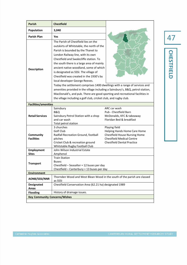
7/28/2019 Canterbury Settlement Hierarchy Study (CHA 2011-10)
http://slidepdf.com/reader/full/canterbury-settlement-hierarchy-study-cha-2011-10 49/76
47
CHESTFIELD
Parish Chestfield
Population 3,040
Parish Plan Yes
Description
The Parish of Chestfield lies on the
outskirts of Whitstable, the north of the
Parish is bounded by the Thanet to
London Railway line, with its own
Chestfield and Swalecliffe station. To
the south there is a large area of mainly
ancient native woodland, some of which
is designated as SSSI. The village of
Chestfield was created in the 1930’s by
local developer George Reeves.
Today the settlement comprises 1400 dwellings with a range of services and
amenities provided in the village including a Sainsbury’s, B&Q, petrol station,
MacDonald’s, and pub. There are good sporting and recreational facilities in
the village including a golf club, cricket club, and rugby club.
Facilities/amenities
Retail Services
Sainsbury
B&Q
Sainsbury Petrol Station with a shop
and car wash
Total petrol station
ARC car wash
Pub - Chestfield Barn
McDonalds, KFC & takeaway
Floridan Bed & breakfast
Community
Facilities
3 churches
Golf ClubRadfall Recreation Ground, football
pitches
Cricket Club & recreation ground
Whitstable Rugby Football Club
Playing field
Helping Hands Home Care HomeChestfield House Nursing Home
Chestfield Medical Centre
Chestfield Dental Practice
Employment
Sites
John Wilson Industrial Estate
Amphenol
Transport
Train Station
Buses:
Chestfield – Seasalter = 12 buses per day
Chestfield – Canterbury = 13 buses per day
Environment
AONB/SSSI/NNRThornden Wood and West Blean Wood in the south of the parish are classed
as SSSI
Designated
Areas
Chestfield Conservation Area (62.21 ha) designated 1989
Flooding History of drainage issues.
Key Community Concerns/Wishes

7/28/2019 Canterbury Settlement Hierarchy Study (CHA 2011-10)
http://slidepdf.com/reader/full/canterbury-settlement-hierarchy-study-cha-2011-10 50/76
48
CHISLET
ParishChislet including Marshside, Upstreet
and Grove Ferry
Population 890
Parish Plan No
Description
The parish of Chislet is 8 miles northeast of the City of Canterbury and south
east of Herne Bay and includes the small
settlements of Chislet, Marshside,
Upstreet and Highstead. Upstreet is the
newest and largest village in the parish
located on the A28 into Canterbury,
while further north are the smaller
villages of Chislet and Marshside which
are rural in nature.
Upstreet has a small local shop. More substantial services are located in eitherSturry or Herne Bay. There are a school, 2 churches and a village cricket pitch
in the parish. Public transport connections run from Upstreet with regular
buses to and from Canterbury, Broadstairs, Minnis Bay and Westwood Cross.
Upstreet also has good road links as it is developed around the A28 into
Canterbury. Development is restricted to the east of the parish by the Chislet
marshes; the southern part of the parish is designated SSSI and a country park
abutting the Stodmarsh National Nature Reserve.
Facilities/amenities
Retail ServicesUpstreet Village Store with PO
2 x car sales
Clark Car sales and Motor Tech
2 pubs, one at Grove Ferry
Community
Facilities
Chislet & Marshside
Chislet Primary School
2 churches
Cricket field
Upstreet
3 care homes
Grove Ferry picnic site
Employment
Sites
Chislet & Marshside
Chislet Court Farm Converted
agricultural building – Acorn Furniture
Chislet Mushroom Farm – Hersden
Mansfield’s, Northstream
Highstead Riding Centre
Industrial units at Port Farm
Industrial units at Wall End Farm
Transport
In addition to regular buses from Upstreet as noted above, one bus a week
(Wednesday) travels from Canterbury to Herne Bay and back again stopping at
Upstreet, Chislet and Marshside.
Environment AONB/SSSI/NNR
Designated
Areas
Boyden Gate Conservation Area (29.52 ha) designated 1981
Chislet and Chitty Conservation Area (12.09 ha) designated 1993
Chislet Forstal Conservation Area (N/A)
Highstead Conservation Area (8.73 ha) designated 1993
Marshside Conservation Area (29.66 ha) designated 1997
Under The Wood Conservation Area (17.91 ha) designated 1993
Upstreet Conservation Area (14.16 ha) designated 1987
FloodingMuch of the parish is located in the Chislet Marshes
Grove Ferry and Upstreet abut the Stodmarsh National Nature reserve
Key Community Concerns/Wishes

7/28/2019 Canterbury Settlement Hierarchy Study (CHA 2011-10)
http://slidepdf.com/reader/full/canterbury-settlement-hierarchy-study-cha-2011-10 51/76
49
FORDWICH
Parish Fordwich
Population 390
Parish Plan No
Description
Fordwich is situated immediately to the
south of Sturry and 3 miles from the
centre of Canterbury. This historic town,
with its own Town Hall and Town
Council contains many listed buildings
densely built around winding streets. It
has no retail services of its own, except
two pubs and a retail fencing outlet. All
other local services and amenities
provided in
adjacent Sturry and also Canterbury. A conservation area covers the main
centre of the town. Much of the rest of the parish is woodland/farmland.
Facilities/amenities
Retail Services
No Shops – nearest in Sturry
2 pubs – George & Dragon and Fordwich Arms
Boating and fishing
Community
Facilities
St Mary’s Church (redundant)
Town Hall
Community Centre. Play area.
Nearest Doctor/Dentist - Sturry
Employment
Sites
1st Choice Fencing
Finn’s Estate Agency
TransportNo Buses – nearest bus services available in Littlebourne Road
Nearest services in Sturry – train and buses
Environment
AONB/SSSI/NNRTo the north and east of Fordwich is Westbere marshes part of the Stodmarsh
Nature reserve (SSSI, NNR, Ramsar, SPA, SAC)
Designated
Areas
Fordwich conservation area (60.65 ha) designated 1993
Flooding The river Stour floodplain runs through the town
Key Community Concerns/Wishes
Transport management and river access

7/28/2019 Canterbury Settlement Hierarchy Study (CHA 2011-10)
http://slidepdf.com/reader/full/canterbury-settlement-hierarchy-study-cha-2011-10 52/76
50
HACKINGTON
Parish Hackington including Tyler Hill
Population 560
Parish Plan Yes
Description
The Parish is located immediately to the
north of the City of Canterbury and
bounded by the line of the former Crab
& Winkle railway to the West and Broad
Oak to the East. There are few local
services provided with the nearest
school and local services located in
nearby Blean and in the city of
Canterbury. There are good transport
links via road and bus
to Canterbury. Development is restricted by the designation of a SSSI to the
west of the village of Tyler Hill and two Kent Wildlife trust sites to the north
west and south of the village.
Facilities/amenities
Retail Services None
Community
Facilities
Pub – Ivy House
Nearest Primary school – Blean
Baptist Church
St Francis Mission Church
Village Hall
Playing field
EmploymentSites
Fishery
Transport
Buses:
Tyler Hill – Canterbury = 14 buses per day
Tyler – Seasalter = 10 buses per day
Environment
AONB/SSSI/NNR
Much of the parish has been designated as a Site of Special Scientific Interest
There are two Kent Wildlife Trust sites to the North West and south of the
village.
Tyler Hill Meadow Local Nature Reserve
Designated
Areas
Tyler Hill Conservation Area (299.87 ha) designated 1995
Flooding
Key Community Concerns/Wishes
Representations to the Core Strategy Consultation include:
Proposals for additional development will exacerbate the existing transport problems
Further numerical expansion of the university will swamp the city with more students who
at present cannot be adequately housed without detriment to adjacent communities
Objectives on the provision of affordable housing are supported
Student accommodation should not count towards housing requirements
Conversion of family houses to student accommodation threatens the community
Main issues/wishes from the Parish Plan 2007 include:
Any development within the village envelope must demonstrate a sympathetic regard to our
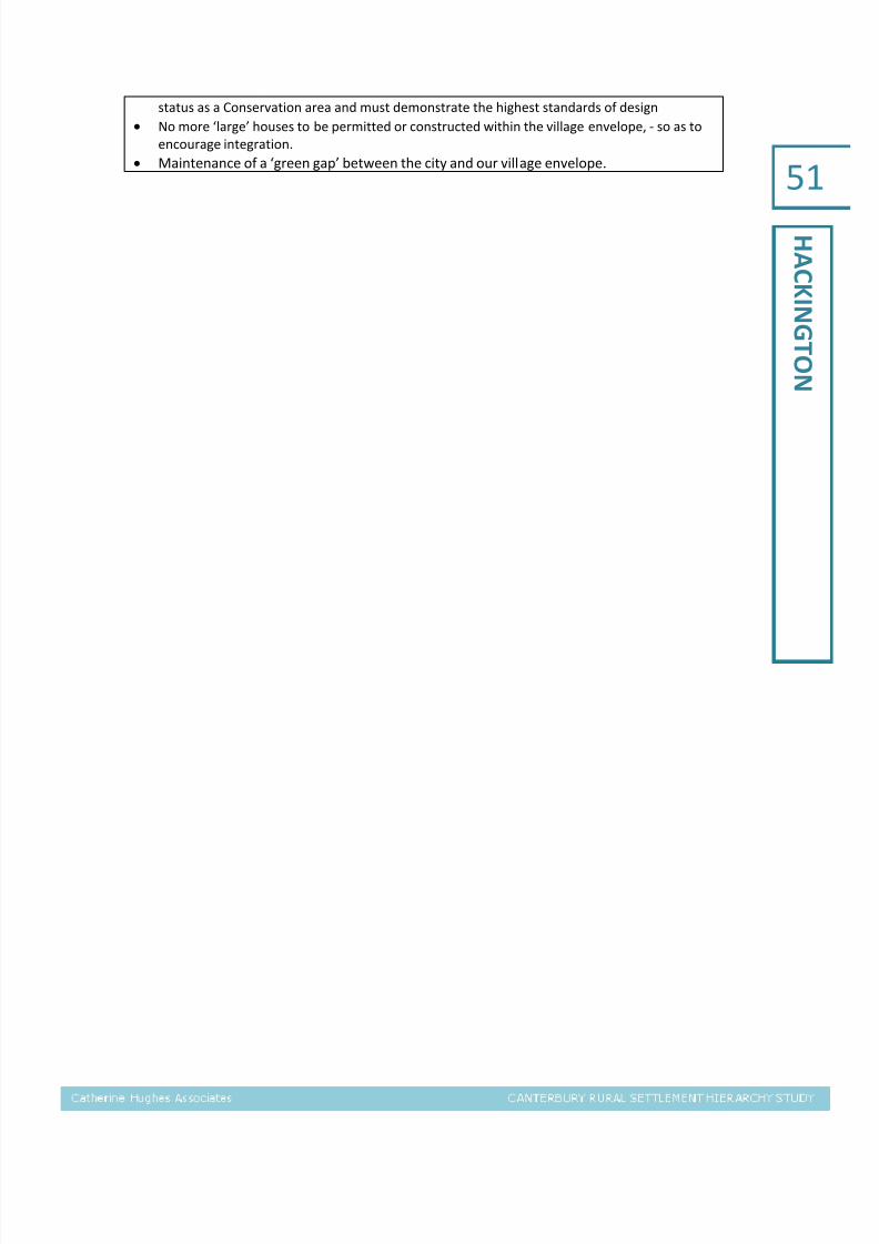
7/28/2019 Canterbury Settlement Hierarchy Study (CHA 2011-10)
http://slidepdf.com/reader/full/canterbury-settlement-hierarchy-study-cha-2011-10 53/76
51
HACKINGTON
status as a Conservation area and must demonstrate the highest standards of design
No more ‘large’ houses to be permitted or constructed within the village envelope, - so as to
encourage integration.
Maintenance of a ‘green gap’ between the city and our village envelope.

7/28/2019 Canterbury Settlement Hierarchy Study (CHA 2011-10)
http://slidepdf.com/reader/full/canterbury-settlement-hierarchy-study-cha-2011-10 54/76
52
HARBLEDOW
N
ParishHarbledown including Rough Common
and Upper Harbledown
Population 2,160
Parish Plan No
Description
The parish of Harbledown is locatedeither side of the A2050 which links the
Canterbury to the A2 and West Kent.
There are three main settlements:
Harbledown village is located to the
south of the A2050, whilst Upper
Harbledown and Rough Common are
located to the north. Rough Common is
a newer development adjoining the City
of Canterbury incorporating a local shop and good community facilities and
provides local amenities for the surrounding villages of Harbledown, Blean,
and Upper Harbledown. Upper Harbledown has a former employment area
(Wyevale garden centre) which has permission for office accommodation.
Much of the parish is woodland and designated as the Rough Common Nature
Reserve Church Woods.
Facilities/amenities
Retail ServicesRough Common
Small convenience store & post Office
Community
Facilities
Harbledown
Vernon Holme Junior School (Private)
St Michaels ChurchPub – Old Coach & Horses
Rough Common
Pub – The Dog
Village Hall
Football & cricket pitches
Upper Harbledown
Pub – The PloughPine Meadow play area
Care home
Nearest Schools – Blean (primary),
Canterbury/Whitstable (secondary)
Employment
Sites
Harbledown
Christchurch Business School
Upper Harbledown
Lockhart’s, timber merchant
Transport
Buses:
Rough Common to Canterbury and Faversham 1 per day
Harbledown to Canterbury = 19 buses per day
Harbledown to Canterbury = 19 buses per day
Environment
AONB/SSSI/NNRThe west of the parish is woodland and designated as Rough Common Nature
Reserve
Designated
Areas
Harbledown Conservation Area (69.41 ha) designated 1994
Upper Harbledown Conservation Area (49.36 ha) designated 1994
Flooding
Key Community Concerns/Wishes
Representations to the Core Strategy Consultation include:
Housing development should be directed towards lower grades of agricultural land

7/28/2019 Canterbury Settlement Hierarchy Study (CHA 2011-10)
http://slidepdf.com/reader/full/canterbury-settlement-hierarchy-study-cha-2011-10 55/76
53
HARBLEDOW
N
Objection to Park and Ride provision at Harbledown as it is believed to be unjustified and
would increase travel demand and to the provision of additional A2 slip roads at
Harbledown
Aims of parish council informed by residents survey:
Maintain the green gap between Rough Common and the City
Support only small scale infill development in the three villages to maintain the integrity of the existing HRCPC area built-envelope
Support government policy on Brownfield sites
Maintain vigilance over the two Conservation Areas to ensure that their character is preserved and
/or enhanced

7/28/2019 Canterbury Settlement Hierarchy Study (CHA 2011-10)
http://slidepdf.com/reader/full/canterbury-settlement-hierarchy-study-cha-2011-10 56/76
54
HERNEANDB
ROOMFIELD
ParishHerne and Broomfield including Herne
Common
Population 8,030
Parish Plan Yes
Description
Herne and Broomfield is located justsouth of the coastal town of Herne Bay.
Herne and Broomfield is the largest
parish in the district with 4,400 homes.
The parish is made up of Herne and
Broomfield and Herne Common a small
village to the south east of the main
settlement. The original village of Herne
is centred upon the Parish Church of St
Martin; the village contains a wide
variety of buildings dating from 14th
Century to the present day and includes31 listed buildings which give the village a distinctive feel. There has been
considerable housing development since the 1950’s resulting in the merging of
Herne and Broomfield. There are adequate retail services and community
facilities for the size of the settlement, and good transport links to nearby
Herne Bay which is the main service centre for the settlement. To the south of
the parish lies the Ramsar and SSSI designated East Blean Woods.
Facilities/amenities
Retail Services
Herne
Village Stores incl. Post Office
3 pubs (The Smugglers Inn, Upper Red
Lion(closed) and First & Last)
Butchers Arms Beer (Micro-pub)
Herne Common
Canterbury Garden Centre
Broomfield
Store & Post Office
Nursery
Supermarket
Chinese Takeaway and Fish & Chip
Shop
Hair & Beauty Salon
2 pubs (Huntsman and Horn and The
Plough Inn)
Community
Facilities
Herne
Herne C of E Infants School, Herne C
of E Junior School
4 churches
Herne Village Hall
3 sports/playing fields (CherryOrchard Playing Field, Ruskin’s View,
Apple Tree Dentists
State of the art BMX track
Curtis Wood Park)
Strode Park Care Home
Broomfield
Broomfield Church
Herne & Broomfield Surgery
Herne Common
Small children’s play area
Employment
Sites
Herne
LMS Ltd, Commercial and Residential
Property Maintenance
Flexicon, Flexible Screw manufacture
R Jackson Motor Repairs
Firwood Court livery
Transport
Train:
Nearest = Herne Bay
Buses:
Herne – Canterbury = 74 buses per day
Herne – Herne Bay = 79 buses per day

7/28/2019 Canterbury Settlement Hierarchy Study (CHA 2011-10)
http://slidepdf.com/reader/full/canterbury-settlement-hierarchy-study-cha-2011-10 57/76
55
HERNEANDB
ROOMFIELD
Broomfield – Canterbury = 29 buses per day
Broomfield – Herne Bay = 30 buses per day
Environment
AONB/SSSI/NNR
East Blean Wood - SSSI, NNR and Ramsar site. Over 300 acres owned and
managed by the Kent Wildlife Trust. National Nature Reserve status. It is the
most important site in the UK for the Heath Fritillary Butterfly
Childs Forstal. 6.07 hectare (15 acre) woodland at the western end of East
Blean.
West Blean Wood – SSSI Part of this piece of "The Blean" falls within the Parish
boundary.
Curtis Wood – Local Nature Reserve & Curtis Wood Park. 11 acres of open
space
Broomfield Pond.
Broomfield Woodland Park
Designated
Areas
Herne Conservation Area 114.62ha. Designated 1990
Herne Windmill Conservation Area 0.43ha
Hawe Farm Conservation Area 7.11ha
Broomfield Conservation Area 8.31 haEddington Conservation Area
Flooding
Key Community Concerns/Wishes
Representations to the Core Strategy Consultation include:
The promotion of green energy in all new builds and the active promotion of solar panels,
wind turbines, heat source pumps etc.
The parish council supports any residents who wish to install green technologies on their
existing properties
The parish council would like to the provision of a new secondary school in the Canterbury
area
Consider that Herne and Broomfield should be included in list of large well-served villages Any development in larger villages should comply with a housing needs survey
All new builds should excel in environmental performance
A scheme for Open space and play areas should be provided to meet the needs of housing
development
Due to the numbers of properties being constructed it is considered that Canterbury
should have a fully functioning A&E department
Parish Council conducted a Parish Plan Questionnaire in 2002 and a Planning for Real consultation
in 2002/03. Key concerns raised from this include:
Residents did not wish to see any more development in the Parish which they felt would result
in a loss of community and uniqueness that the village has Due to development the amount of
traffic travelling through the village was causing congestion and the general feeling was that a
by-pass was needed
Concern over a lack of facilities to withstand further development

7/28/2019 Canterbury Settlement Hierarchy Study (CHA 2011-10)
http://slidepdf.com/reader/full/canterbury-settlement-hierarchy-study-cha-2011-10 58/76
56
HOATH
Parish Hoath including Maypole
Population 530
Parish Plan Yes
Description
Hoath and Maypole are dispersed
settlements, rural in nature surrounded
by farmland and isolated from major
settlements and service centres. The
villages have a local school but few local
services; the nearest service centres are
Sturry to the south and Herne &
Broomfield and Herne Bay to the north
and west.
Facilities/amenities
Retail ServicesFarm Shop
Pub – Prince of Wales
Community
Facilities
Hoath Primary School
Church – Holy Cross
Village Hall
Small play area
Employment
Sites
None
TransportHoath to Canterbury – 5 buses a day
Hoath to Herne Bay – 6 buses a day
Environment
AONB/SSSI/NNREast Blean National Nature Reserve and SSSI Ramsar site in the west of the
parish.
Designated
Areas
Hoath, Rushbourne and Tile Lodge conservation area (91.94 ha) designated
1995
Ford, Maypole and Old Tree Conservation Areas (214.16 ha) designated 1995
Flooding The north east of the parish is in the Chislet Marshes
Key Community Concerns/Wishes
Parish survey/questionnaire conducted in 2007. Main concerns/wishes are:
64.9% did not want more housing in Hoath
22.3% did want more housing
95.4% agreed the parish should prevent inappropriate housing development and avoid
creeping urbanisation
A third of residents considered there to be enough community facilities within 3 miles, a third
disagreed and the other third didn’t know.
Wishes of residents:
o Village shop
o Village green
o More facilities for teens

7/28/2019 Canterbury Settlement Hierarchy Study (CHA 2011-10)
http://slidepdf.com/reader/full/canterbury-settlement-hierarchy-study-cha-2011-10 59/76
57
ICKHAMAND
WELL
Parish Ickham and Well including Bramling
Population 420
Parish Plan Yes
Description
The Parish of Ickham and Well is
situated approximately five miles east of
Canterbury city centre. It borders the
parish of Littlebourne to the west and
Wickhambreaux to the north. The main
settlement of Ickham is centred around
a single road, The Street. There are very
limited services provided in Ickham,
local services and amenities being
located in nearby Littlebourne.
Ickham has good road connections as it is located near the A257.
Facilities/amenities
Retail Services2 Pubs – Duke William, The Haywain
B&B/Hotel – Duke William
Community
Facilities
St John’s Church
Village Hall
Employment
Sites
Tor Spa Retreat (health spa)
Transport2 buses a day to Canterbury
2 buses a day to Margate
Environment
AONB/SSSI/NNR
Designated
Areas
Lee Priory and Garrington Conservation Area (137.45 ha) designated 1994
Bramling Conservation Area (41.23 ha) designated 1996
Ickham, Wickhambreaux, Seaton Conservation Area (96.10 ha) designated
1989
Flooding The Little Stour river floodplain runs along the northern edge of the parish
Key Community Concerns/Wishes
Parish Survey/Questionnaire conducted 2010; key concerns/ community wishes include:
Residents stated that they would accept the following types of development:
Conversion of redundant buildings (86% strongly in favour or in favour);
Affordable housing for local needs (65%); and
Single dwellings (56%)
60% of residents were against or strongly against small groups of less than 10 houses, while 89%
were against or strongly against larger groups of houses.
Most residents (76%) were in favour of no development at all. Residents also commented that any
development should be in keeping with the village layout, building density and character
Generally less than 15% of residents feel there is a strong need for any type of additional housing,
although 16% feel there is a strong need for subsidised rental homes for local people.
The general consensus was that it is very difficult to see if or where any further development could
be accommodated without detriment to the village.

7/28/2019 Canterbury Settlement Hierarchy Study (CHA 2011-10)
http://slidepdf.com/reader/full/canterbury-settlement-hierarchy-study-cha-2011-10 60/76
58
KINGSTON
Parish Kingston
Population 490
Parish Plan No
Description
Kingston parish lies just to the south of
the A2 with Bridge to the north and
Barham directly to the south. The parish
runs east to west either side of the A2.
Kingston is a small village with a pub,
church, village hall and playing field.
There are no retail services in the village
with the nearest local service centres
located at Barham to the south and
Bridge to the north.
The surrounding area of Kingston is rural with woodland dominating much of
the parish including Ileden Wood which is designated as a conservation area.
The village has good transport connections with regular bus services to and
from Canterbury and Folkestone.
Facilities/amenities
Retail Services Pub – Black Robin
Community
Facilities
St Giles Church
Village Hall
King Georges Playing Field
Kingston House Care Home
Employment
Sites
Kingston Driving School
Goddard RoofingJohn Morgan Lets
TransportKingston – Canterbury = 13 buses per day
Kingston – Folkestone = 14 buses per day
Environment
AONB/SSSI/NNRThe parish lies within the boundaries of the Kent Downs Area of Outstanding
Beauty
Designated
Areas
Ileden Park Conservation Area (48.96 ha) designated 1996
Kingston Conservation Area (62.66 ha) designated 1995
Flooding Nailbourne river floodplain runs along the northern edge of the village
Key Community Concerns/Wishes

7/28/2019 Canterbury Settlement Hierarchy Study (CHA 2011-10)
http://slidepdf.com/reader/full/canterbury-settlement-hierarchy-study-cha-2011-10 61/76
59
LITTLEBOURN
E
Parish Littlebourne
Population 1,510
Parish Plan Village Design Statement
Description
Littlebourne parish is 4 miles east of City
of Canterbury, bordered by the villages
of Ickham, Wickhambreaux, and
Bekesbourne and lies on the main road
from the east of Kent into Canterbury.
The village of Littlebourne has a high
street which provides a large local shop
as well as a hairdressers, two pubs a
B&B and a recently completed care
home. The village provides local
amenities for
the surrounding villages of Ickham, Wickhambreaux, Stodmarsh, Bramling,
Adisham and Bekesbourne. There are also good community facilities with a
local primary school, a doctor’s surgery, a village hall and large playing fields
with children’s play equipment. There are good transport connections to
Canterbury with the A257 the main road east out of the city and regular bus
services to and from Canterbury and Walmer.
Facilities/amenities
Retail Services
Littlebourne Shop and Post Office
Hair Design
2 Pubs – The Evenhill, The Anchor
2 B&B/Hotels – The Pilgrims Rest,
The Evenhill
Community
Facilities
Littlebourne Church of England
Primary School
St. Vincent’s Church of England
Littlebourne Chapel
Littlebourne Chapel used as a hall
Village Hall
Littlebourne Barn
Large playing field and sports pitch
Children’s play equipment
Littlebourne House – Residential
Home and King William IV Day Centre
Doctors surgery (with permission
granted for a new surgery at Court
Hill)
EmploymentSites
Hayward Design + Paint
K & T GlassBNI – Business Referral Organisation
Nailbourne Forge
Littlebourne Woodcraft Joinery
Just SoCanterbury Bears
Aviva Stone – Slate, Marble, Granite
TransportLittlebourne – Walmer = 29 buses per day
Littlebourne – Canterbury = 29 buses per day
Environment
AONB/SSSI/NNR
Designated
Areas
Littlebourne Conservation Area (27.69 ha) designated 1994
Elbridge House Conservation Area (87.28 ha) designated 1992
Flooding Little Stour river floodplain runs through the village
Key Community Concerns/Wishes
Village Design Statement:

7/28/2019 Canterbury Settlement Hierarchy Study (CHA 2011-10)
http://slidepdf.com/reader/full/canterbury-settlement-hierarchy-study-cha-2011-10 62/76
60
LITTLEBOURN
E
Preservation of the local environment is of primary concern to residents and this is
reflected in the policies of the village design statement
A number of character areas have been identified in the design statement and
consideration to these character areas must be adhered to when make changes to
residencies of proposing development
The policies of the design statement provide details as to the types of materials to be used, the
design of changes to housing or proposed development and the layout of new developments to
preserve the defined character areas that are outlined in the document.

7/28/2019 Canterbury Settlement Hierarchy Study (CHA 2011-10)
http://slidepdf.com/reader/full/canterbury-settlement-hierarchy-study-cha-2011-10 63/76
61
LOWERHARD
RES
Parish Lower Hardres
Population 620
Parish Plan No
Description
Lower Hardres is located 4 miles south
of Canterbury city centre; to the east is
Bridge, Bossingham is to the south and
Shalmsford Street to the west. Lower
Hardres is the main settlement in the
parish with a farm shop and pub, church
and village hall. A greater range of
services are located in nearby Bridge or
in the City of Canterbury itself accessed
by easy road access and
regular buses. Much of the parish is rural and made up of ancient woodland.
The built up areas are largely covered by conservation areas.
Facilities/amenities
Retail ServicesFarm Shop
Pub – The Granville
Community
Facilities
Church
Village Hall. Play area.
Employment
Sites
Lower Hardres Fruit Farm
Canterbury Joinery Ltd
Transport
Lower Hardres – Canterbury = 10 buses per day
Lower Hardres – Ashford = 1 bus per day
Lower Hardres – Hythe = 5 buses per day
Environment
AONB/SSSI/NNRThe southern part of the parish lies within the boundaries of the Kent Downs
Area of Outstanding Natural Beauty
Designated
Areas
Nackington Conservation Area (12.76 ha) designated 1995
Lower Hardres and Street End Conservation Area (75.65 ha) designated 1995
Flooding
Key Community Concerns/Wishes
Representations to the Core Strategy Consultation include:
Provision of improved infrastructure should be of primary importance
There should be a reduction in the number of houses built; development should be spread
around the 23 villages which could make each village economically viable in terms of shop,
pub, schools
Concerned that both land at Nackington and New House Lane are included as a preferred
option. Both areas are high grade farm land and land at Nackington is probably the finest
Grade 1 brick earth in the UK and therefore should be protected
Concern over risks to the country lanes from increased development and traffic, and
particularly in areas without any sustainable public transport.
The buffer between City and the villages is lost

7/28/2019 Canterbury Settlement Hierarchy Study (CHA 2011-10)
http://slidepdf.com/reader/full/canterbury-settlement-hierarchy-study-cha-2011-10 64/76
62
PETHAM
Parish Petham including Garlinge Green
Population 800
Parish Plan Yes
Description
Petham is located 5 miles south of the
city of Canterbury with Chartham to the
north west and Bridge to the north east.
Within the parish there is the main
settlement of Petham and the small
hamlet of Garlinge Green. Petham has a
local farm shop, a pub, a café and a
B&B.
According to the parish survey most residents do their main grocery shopping
in one of the major supermarkets in Canterbury, with a very few using other
towns and local village shops, but when it comes to top-up shopping local
residents use Lower Hardres Farm Shop and the shops at Stelling Minnis
(outside Canterbury district) and Bridge. There are good road links to
Canterbury but there are limited public transport links with only 4 buses a day
to and from Canterbury.
Facilities/amenities
Retail Services
Farm Shop
Pub – Chequers
Cafe – Butterflies Garden Centre
B&B/Hotel – Upper Ansdore Guest
House
Community
Facilities
Petham Primary School
All Saints Church
Village Hall
Kenfield Cricket Club
Employment
Sites
Halsion Industrial area (Stone Street)
Caravan supplies Shop (Stone Street)
Buckholt Park
Transport 4 buses to Canterbury a day
Environment
AONB/SSSI/NNR The parish lies within the Kent Downs Area of Outstanding Natural Beauty
Designated
Areas
Dane Chantry Conservation Area (8.14 ha) designated 1997Kenfield Conservation Area (N/A) designated 1994
Petham Conservation Area (84.42 ha) designated 1994
Flooding
Key Community Concerns/Wishes
Representations to the Core Strategy Consultation include:
The provision of a variety of sizes of dwellings available for private purchase for singles,
couples or small young families to maintain a diversity of age and social mix within villages
Concerns over the ability of road infrastructure to withstand development, particularly
proposed urban extensions and the impact this will have on the road infrastructure of
outlying villages. Agree with Perham’s classification as a village in the existing settlement hierarchy.

7/28/2019 Canterbury Settlement Hierarchy Study (CHA 2011-10)
http://slidepdf.com/reader/full/canterbury-settlement-hierarchy-study-cha-2011-10 65/76
63
PETHAM
Parish Plan 2010:
When asked about development residents showed a preference, but not an overwhelming desire
for conversions of redundant buildings and a range of smaller and more affordable homes. There is
concern about whether Petham and its facilities can support much if any new housing, as well as
some disquiet over recent developments.

7/28/2019 Canterbury Settlement Hierarchy Study (CHA 2011-10)
http://slidepdf.com/reader/full/canterbury-settlement-hierarchy-study-cha-2011-10 66/76
64
STURRY
Parish Sturry including Broad Oak and Hersden
Population 6,730
Parish Plan Yes
Description
Sturry is the principal settlement in the
parish bordering the city of Canterbury
and located on the A28 which links
Canterbury and Margate. The village of
Hersden lies on the eastern boundary of
the parish along and to the north of the
A28. Broad Oak is to the north of Sturry.
Sturry is the main service centre for the
parish providing good retail and
community facilities, whilst Hersden and
Broad Oak are largely rural settlements serviced by Sturry. Sturry is split into
two character areas, the larger post war housing estates and the old village.
Sturry provides local services and amenities, including a Co-op, Cost-cutters,
chemist, hairdressers, pubs, and restaurants, for the surrounding villages
including Fordwich, Westbere, Broad Oak, Hersden, Hoath and Maypole and
Upstreet. There are good road links to Canterbury and Herne Bay and to
Canterbury and other areas in Kent and London through the train station in
Sturry. There has been recent housing development in Hersden at Chislet
Gardens on the western edge of the village. Surrounding Hersden are 3
industrial/business parks. Broad Oak is a smaller more rural village with a local
village shop, church and 2 pubs. There is one conservation area that covers
the older parts of Sturry which surround the train station.
Facilities/amenities
Retail Services
Sturry
Chemist
Post Office
Library and mobile library
Co-op local store
Costcutter
Jolly Chef (take away)
Kathton (restaurant)Salon Chique (hairdresser)
Sturry News (newsagent)
Cracking Glass (glazing company)
Chinese (Sunflower)
Fish and Chip shop (Sturry Fish Bar)
Home care services (Highmead)
Insurance brokers (Bonsai)
Hairdressers (Dial a Style)
Greenfields Shooting Range
Benjy’s Motorcycle tyre repair and
sales
Vikings car sales
3 pubs – Swan, Welsh Harp, Punch
Tavern
Perry’s Car Sales
Spicemaster Indian restaurant
Stockbridge Carpets and Curtains
Broad OakVillage Store
Farm Shop
2 pubs – Royal Oak, Golden Lion
Hersden
Mace Food store
Post office
Chopsticks chinese restaurant

7/28/2019 Canterbury Settlement Hierarchy Study (CHA 2011-10)
http://slidepdf.com/reader/full/canterbury-settlement-hierarchy-study-cha-2011-10 67/76
65
STURRY
Community
Facilities
Sturry
Junior King’s School (ages 3-13) –
private school
Sturry C of E Primary School
1 church
Village Hall
Sturry social centre
Parkview Play Area
4 care homes
Doctors – Sturry Surgery
2 dentists
Vets
Wildwood Discovery Park
Longshaw Farm Coarse Fishery
Canterbury & District Angling
Association HQ
Sturry cemetery
Broad Oak
Broad Oak Chapel
Broad Oak Village Hall
Hersden
Hersden Community Primary School
Spires Academy secondary school
Doctors surgery
Catholic church
Bowling Green
Childrens play area &recreation
ground
Sports Hall
Chislet Colliery CLub
Employment
Sites
SturryBretts - Sturry Quarry
Wealden Forest Industrial Site
Kemberland re-cycling
J.H Worrell& Sons Nursery
Broad Oak
Goose Farm
HersdenLakesview International Business Park
Chislet Business Park
Canterbury Industrial Park
Transport
Train Station in Sturry
Buses:
Sturry to Canterbury – 74 buses a day
Sturry to Herne Bay – 79 buses a day
Broad oak to Canterbury – 7 buses a day
Broad Oak to Herne Bay – 7 buses a day
Hersden to Canterbury – 38 buses a day
Hersden to Westwood – 42 buses s day
Hersden to Minnis Bay – 12 buses a day
Environment
AONB/SSSI/NNR
Designated
Areas
Sturry Conservation area (48.62 ha) designated in 1997 – covers the old
village.
The Centenary Woodland, Sturry SSSI
Flooding River Stour floodplain runs through the south of the parish.
Key Community Concerns/Wishes
Representations to the Core Strategy Consultation include:
Growth at Sturry will put pressure on the A28
Development at Broad Oak farm must include a road west of this development
Ensure affordable housing targets are met
Transport is a key issue, any development should ensure there is consideration for the
increase in traffic and the potential for congestion
Key community concerns/wishes and action points resulting from parish survey include:
Desire for more community facilities particularly sporting facilities
Promotion of local shops
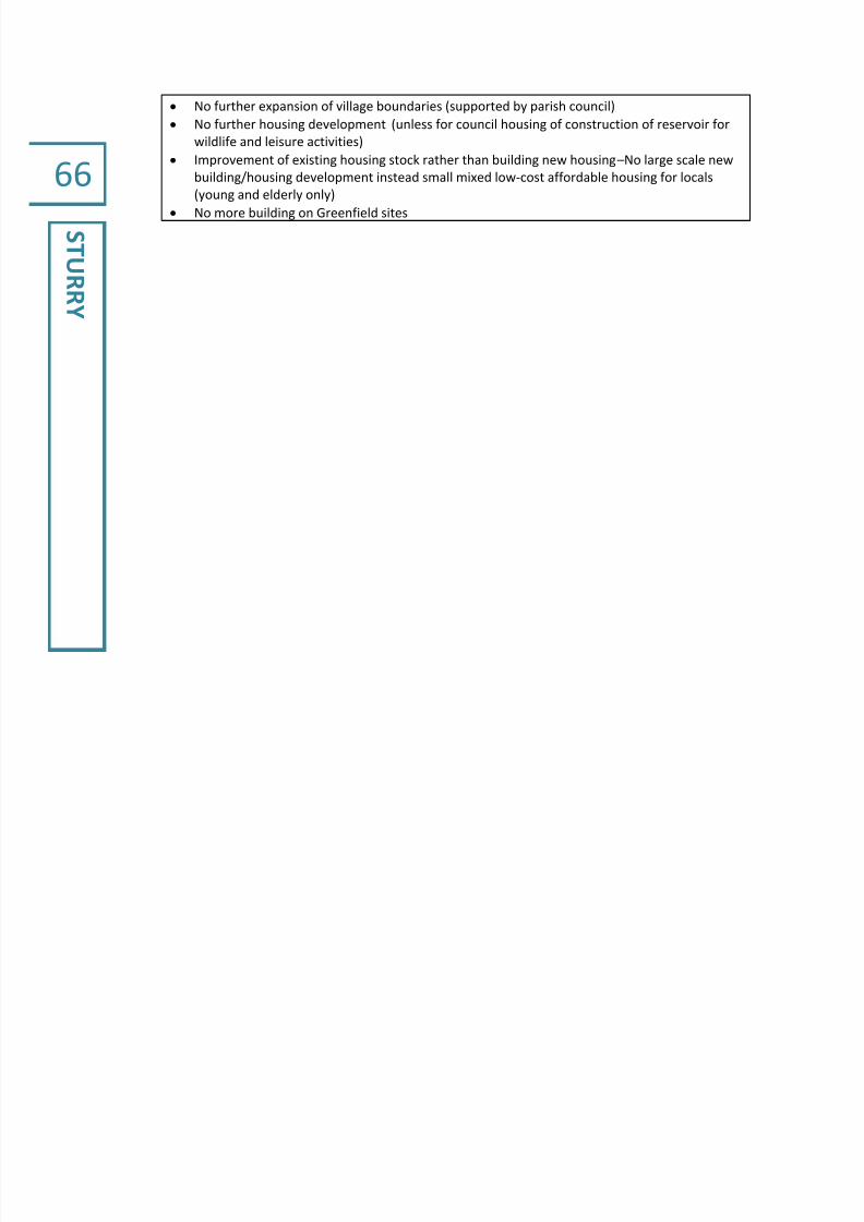
7/28/2019 Canterbury Settlement Hierarchy Study (CHA 2011-10)
http://slidepdf.com/reader/full/canterbury-settlement-hierarchy-study-cha-2011-10 68/76
66
STURRY
No further expansion of village boundaries (supported by parish council)
No further housing development (unless for council housing of construction of reservoir for
wildlife and leisure activities)
Improvement of existing housing stock rather than building new housing –No large scale new
building/housing development instead small mixed low-cost affordable housing for locals
(young and elderly only) No more building on Greenfield sites

7/28/2019 Canterbury Settlement Hierarchy Study (CHA 2011-10)
http://slidepdf.com/reader/full/canterbury-settlement-hierarchy-study-cha-2011-10 69/76
67
THANINGTON
WITHOUT
Parish Thanington Without
Population 2,710
Parish PlanVillage Design Statement (for part of
parish only) and Parish Appraisal
Description
Thanington is a largely residential areabordering the western edge of the City
of Canterbury and the Wincheap
Industrial estate. There are no services
provided in the parish with local
amenities provided in Wincheap.
Facilities/amenities
Retail Services None – Wincheap close by
Community
Facilities
2 churches
2 community centres
Nursery school
Employment
Sites
Transport14 buses a day to Canterbury
13 buses a day to Ashford
Environment
AONB/SSSI/NNR
Designated
Areas
Flooding River Stour floodplain runs along the northern edge of the settlement
Key Community Concerns/Wishes
Representations to the Core Strategy Consultation include:
CCC should commission an independent study from sociologists with a track record of
work on the social impact of very large scale development
CCC should also commission an independent study on the road traffic pollution
predictions of the combined impact of at least 5,000 additional new cars per day on the
roads in South Canterbury
The Parish Council urge the City Council to reject the option of giant, single site
development, at least until more high quality information is available on health, social
cohesion and road traffic impacts of very large single site development
A more thoughtful, more sustainable and less socially damaging solution is a combination
of infill, Brownfield development and a ring of much smaller new development around the
city
It is an unavoidable fact that Canterbury's roads cannot cope with the current demand
Village Design Statement for ‘Hilltop Community’ only:
Existing unrestricted views across the surrounding rolling countryside should be preserved
and protected in all directions
Infill development or lateral extensions to existing buildings should not interfere with
important views

7/28/2019 Canterbury Settlement Hierarchy Study (CHA 2011-10)
http://slidepdf.com/reader/full/canterbury-settlement-hierarchy-study-cha-2011-10 70/76
68
THANINGTON
WITHOUT
New development applications should include adequate parking areas
Any new developments (including infill or extensions) should conserve open space and
where possible enhance these elements
It is the opinion of residents that any additional traffic through the community will have a
detrimental effect on its character. Every effort should be made to minimise this effect.
It is felt that efforts should be made in new building, extensions and refurbishments toecho some of the features of the existing built environment wherever this is appropriate
Future development must always reflect the rural setting within which it must blend.
Estates of standard housing design are not appropriate in the Hilltop Community.
Linear development further extending the settlement into the countryside, regular house
layout and regimented design should be avoided.
Encouragement should be made wherever possible for the re-use or replacement of
existing buildings where feasible

7/28/2019 Canterbury Settlement Hierarchy Study (CHA 2011-10)
http://slidepdf.com/reader/full/canterbury-settlement-hierarchy-study-cha-2011-10 71/76
69
UPPERHARD
RES
Parish Upper Hardres including Bossingham
Population 250
Parish Plan Village Appraisal 2005
Description
The parish of Upper Hardres lies 7 miles
south of the city of Canterbury. To the
north is Lower Hardres and to the West
Petham. Upper Hardres is a rural parish,
largely farmland and woodland.
Bossingham is the main village in the
parish. There is no local retail service in
the village. The main service centre is
Stelling Minnis adjacent but which is
outside Canterbury District. The nearest school is also in Stelling Minnis.
Community facilities include a church, village hall, cricket club and pre-school.
Facilities/amenities
Retail ServicesGarden Centre
Pub – The Hop Pocket
Community
Facilities
Nearest School – Stelling Minnis
Church
Village Hall
Cricket Club
Pre-school
Employment
Sites
Transport
Buses:
Bossingham – Canterbury 5 buses a day
Bossingham – Ashford 1 bus a day
Bossingham – Hythe 5 buses a day
Environment
AONB/SSSI/NNRThe parish lies within the boundaries of the Kent Downs Area of Outstanding
Natural Beauty
Designated
Areas
Upper Hardres Court (62.07 ha) designated 1995
Flooding
Key Community Concerns/Wishes
The Parish Plan identifies the type of future development residents would like to see:
Preference was towards smaller more affordable property developments and a clear objection to
large detached or executive style properties. Given the indication in favour of starter homes there
is an absence of desire for flats or single bedroom properties. There is reasonable support for light
industrial units to be allowed. There was a significant proportion of responses (60-75% of those
households who responded) who were against any form of developments being allowed.

7/28/2019 Canterbury Settlement Hierarchy Study (CHA 2011-10)
http://slidepdf.com/reader/full/canterbury-settlement-hierarchy-study-cha-2011-10 72/76
70
WALTHAM
Parish Waltham including Anvil Green
Population 420
Parish Plan No
Description
Waltham is located 8 miles south west
of the city of Canterbury. To the north is
Petham and further north are Chartham
and Shalmsford Street and to the east is
Bossingham. Waltham is a rural parish
with two main settlements: Waltham
and Anvil Green, both small settlements
characterised by large detached
housing. The villages are isolated from
main services and have limited public
transport links. The nearest local services and amenities are located in
Chartham just to the north of the parish. The parish lies within the boundaries
of the Kent Downs Area of Outstanding Natural Beauty; Yockletts Bank to the
east of Waltham village is designated a Site of Special Scientific Interest.
Facilities/amenities
Retail Services Waltham Court Hotel
Community
Facilities
St. Bartholomew’s Church
Waltham Village Hall
Waltham Park
Employment
Sites
Chaucer Riding and Livery Stables (W)
Local farmsBuckholt Park
Transport Circular route to Canterbury – 4 buses a day
Environment
AONB/SSSI/NNR
The parish lies within the boundaries of the Kent Downs Area of Outstanding
Natural Beauty
Yockletts Bank nature reserve to the east of Waltham village is a Site of Special
Scientific Interest
Designated
Areas
Waltham Conservation Area (9.61 ha) designated 1995
Anvil Green Conservation area (14.74 ha) designated 1995
Flooding
Key Community Concerns/Wishes

7/28/2019 Canterbury Settlement Hierarchy Study (CHA 2011-10)
http://slidepdf.com/reader/full/canterbury-settlement-hierarchy-study-cha-2011-10 73/76
71
WESTBERE
Parish Westbere
Population400
(Westbere local census 2005 :318)
Parish Plan Yes
Description
The parish of Westbere is locatedapproximately 3½ miles north-east of
Canterbury, and runs along the
southern side of the A28 from the
boundary with Sturry parish as far as
Lakesview Business Park. The village of
Westbere is a conservation area and a
small settlement of 140 houses set
some distance from the A28. The
nearest local services
are in Sturry. To the south lie the Westbere marshes, which are part of theStodmarsh National Nature Reserve, and the river Stour.
Facilities/amenities
Retail Services
Garage – Perry’s
Pub – Old Yew Tree Inn
Restaurant – Old Yew Tree Inn, Spice
Master
County Mowers,
Canterbury Caravan Sales,
Café and car wash (all 3 included in
scoring for Hersden)
Community
Facilities
Garage – Perry’s All Saints Church
Village Hall
Employment
Sites
Lakesview and Canterbury Business
Parks fall within Westbere parish
(included in scoring for Hersden)
TransportRegular buses throughout the day to Canterbury and Westwood Cross (no bus
into the village - bus stop on the A28)
Environment
AONB/SSSI/NNRWestbere marshes part of Stodmarsh NNR which is designated as a SSSI,
Ramsar, SPA and a SAC
Designated
Areas
Two designated conservation areas Westbere No.1 and Westbere No.2
allocated in 1973 and 1984 respectively.
Flooding Westbere marshes and river Stour in the south of the parish
Key Community Concerns/Wishes
The Westbere Parish Plan published in 2011 aims to improve the quality and sustainability of
life in the parish. Produced in a different, attractive and expensive format, it enjoyed a high
response rate of 84% of households to its consultation questionnaire. Its key
recommendations include preserving the rural character of the parish and the village,
initiating green environmental proposals, a full desktop assessment of the archaeological and
historical background of the parish, a further ecological survey and working to provide more
strategic car parking spaces in the parish.

7/28/2019 Canterbury Settlement Hierarchy Study (CHA 2011-10)
http://slidepdf.com/reader/full/canterbury-settlement-hierarchy-study-cha-2011-10 74/76
72
WICKHAMBR
EAUX
Parish Wickhambreaux including Stodmarsh
Population 450
Parish Plan No
Description
The Parish of Wickhambreaux is
situated approximately five miles east of
Canterbury city centre. It borders the
parish of Littlebourne to the west and
Ickham to the south. Wickhambreaux
village is closely related to Ickham in its
location and architecture.
Wickhambreaux has a school, village hall and playing field with local retail
services and amenities provided at nearby Littlebourne. Outside of
Wickhambreaux the parish is rural, mainly farmland, in character. Stodmarsh
National Nature Reserve and Westbere Marshes lie in the north of the parish.
Facilities/amenities
Retail ServicesWickhambreaux
Pub – The Rose Inn
Stodmarsh
Pub – Red Lion
Community
Facilities
Wickhambreaux
Primary SchoolSt Andrews Church
Village Hall
Playing Field
Stodmarsh
St Mary’s Church
Employment
Sites
Transport 2 buses a day to Canterbury; 3 buses on Monday and Wednesday
Environment
AONB/SSSI/NNR
Designated
Areas
Ickham, Wickhambreaux, Seaton Conservation Area (96.10 ha) designated
1989
Stodmarsh Conservation Area (12.58 ha) designated 1992Lampen Stream Conservation Area (41.23 ha) designated 1992
Flooding
Located on the Little Stour floodplain
Stodmarsh National Nature Reserve and Westbere Marshes in the north of the
parish.
Key Community Concerns/Wishes

7/28/2019 Canterbury Settlement Hierarchy Study (CHA 2011-10)
http://slidepdf.com/reader/full/canterbury-settlement-hierarchy-study-cha-2011-10 75/76
73
ParishWomenswold including Woolage Green
and Woolage Village
Population 250
Parish Plan No
Description
Womenswold is located just off the A2to the east of Barham. The parish is
made up of three small settlements
Womenswold, Woolage Village and
Woolage Green. Womenswold is a small
rural hamlet with a church; Woolage
Village consists of some 60 dwellings
and has a large playing field with a
children’s playground;
Woolage green consists of around 36
dwellings and the only pub in the parish. There are no local services in theparish; local services and amenities are provided in Aylesham (outside
Canterbury district).
Facilities/amenities
Retail Services
Woolage Green
Pub – The Two Sawyers
Restaurant - Meals in Pub
Community
Facilities
Womenswold
Learning Opportunities Centre for
children with special needs
St Margaret of Antioch Church
Woolage Village
Recreation Ground
Woolage Green
Recreation ground
Employment
Sites
Womenswold
Denne Hill Business Centre
Nethersole Farm
Camping and Caravan Club site
Transport No bus service
Environment
AONB/SSSI/NNRThe western half of the parish lies within the boundaries of the Kent Downs
Area of Outstanding Natural Beauty
Designated
Areas
Womenswold Conservation Area (20.81 ha) designated 1995
Woolage Green Conservation Area (15.40 ha) designated 1995
Denne Hill Conservation Area (105.22 ha) designated 1996
Flooding
Key Community Concerns/Wishes

7/28/2019 Canterbury Settlement Hierarchy Study (CHA 2011-10)
http://slidepdf.com/reader/full/canterbury-settlement-hierarchy-study-cha-2011-10 76/76
ACKNOWLEDGEMENTS
We are grateful for the advice and support of Adrian Verrall, Sarah Parker, Jillian Barr and Lee
Parker of the Planning Policy Unit of Canterbury City Council, Sam Westley of EK Services, John
Luckcock of Kent County Council’s Planning and Environment Directorate and Anne Brierley of
Kent County Council’s Research and Evaluation Team.
Thanks are also due to Andy Mills for undertaking the village survey work.
A RURAL SETTLEMENT HIERARCHY STUDY OF CANTERBURY DISTRICT WAS PRODUCED FOR
CANTERBURY CITY COUNCIL BY CATHERINE HUGHES ASSOCIATES