cambridge city council annual monitoring report 2017 · in particular, the reports can highlight...
TRANSCRIPT

Cambridge City Council Annual Monitoring Report 2017
December 2017


i
List of Abbreviations
Definition
AAP Area Action Plan AMR Annual Monitoring Report ASHE Annual Survey of Hours and Earnings BfL Building for Life BfL12 Building for Life 12 BREEAM Building Research Establishment Environmental Assessment Method CATS Cambridge Area Transport Strategy CCC Cambridge City Council CHP Combined Heat & Power CIL Community Infrastructure Levy CiWs City Wildlife Site CLG Department for Communities and Local Government CPERC Cambridgeshire and Peterborough Environmental Records Centre CSR Cambridge Sub-Region DPD Development Plan Document dph Dwellings Per Hectare DPSSC Development Plan Sub Scrutiny Committee DWP Department of Work and Pensions EEDA East of England Development Agency EERA East of England Regional Assembly ELR Employment Land Review EU European Union GC3 Greater Cambridge Cycle City Project GCP Greater Cambridge Partnership GO-EAST The Government Office for the East of England Grade I Listed Buildings of exceptional interest, sometimes considered to be
internationally important.
Grade II Listing Buildings that are nationally important and are of special
interest. Grade II* Listed Buildings that are particularly important and of more than
special interest. ha Hectares HESA Higher Education Statistics Agency HMO Housing in Multiple Occupation HRA Habitats Regulation Assessment HSSA Housing Strategy Statistical Appendix IMD Index of Multiple Deprivation IPPG Informal Planning Policy Guidance JDCC Joint Development Control Committee JSGIC Joint Strategic Growth Implementation Committee JTF Joint Transport Forum LDF Local Development Framework

ii
Definition
LDS Local Development Scheme LEP Local Enterprise Partnership LNR Local Nature Reserve Local Plan Review The process of the creation of the Local Plan 2014, which will replace
the Cambridge Local Plan 2006, once adopted. LTB Local Transport Bodies MW Megawatt NHB New Homes Bonus NHS National Health Service NIAB National Institute of Agricultural Botany NPPF National Planning Policy Framework ODPM Office of the Deputy Prime Minister (succeeded by the CLG) ONS Office for National Statistics PDCS Preliminary Draft Charging Schedule PDL Previously Developed Land PPS Planning Policy Statement R&D Research and Development RDA Regional Development Agency RGF Regional Growth Fund RSS Regional Spatial Strategy (also known as the East of England Plan) S106 Section 106 S29 Section 29 Committee SA Sustainability Appraisal SCDC South Cambridgeshire District Council SFRA Strategic Flood Risk Assessment SHLAA Strategic Housing Land Availability Assessment SHMA Strategic Housing Market Assessment SPD Supplementary Planning Document SSSI Site of Special Scientific Interest SuDs Sustainable Drainage Systems TIF Transport Innovation Fund TSCSC Transport Strategy for Cambridge and South Cambridgeshire

iii
Contents List of Abbreviations .......................................................................................................... i
1. Introduction ................................................................................................................. 1
2. Cambridge Today .......................................................................................................... 5
3. Designing Cambridge .................................................................................................. 11
4. Conserving Cambridge ................................................................................................ 14
5. Living in Cambridge..................................................................................................... 20
6. Enjoying Cambridge .................................................................................................... 43
7. Working and Studying in Cambridge ........................................................................... 47
8. Connecting and Servicing Cambridge ........................................................................... 51
9. Areas of Major Change ............................................................................................... 56
10. Implementation ........................................................................................................ 75
11. Local Development Scheme ...................................................................................... 78
12. Development Monitoring Framework ....................................................................... 91
Appendix A – Contextual Indicators ................................................................................ 94
Appendix B – Local Indicators ....................................................................................... 103
Appendix B – Local Indicators ....................................................................................... 104
Appendix C – Local Plan Policy Usage ............................................................................ 109
Appendix D – Housing Trajectory .................................................................................. 112
Cambridge Housing Trajectory ...................................................................................... 115
Summary of Sites.......................................................................................................... 121
Greater Cambridge Housing Trajectory ......................................................................... 156
Appendix E – Cambridge East Indicators (Taken from Cambridge East Area Action Plan) 158
Appendix F – North West Cambridge Indicators (Taken From North West Cambridge Area Action Plan) .................................................................................................................. 159
Appendix G – Use Classes Order ................................................................................... 162
Appendix H – Advice Note – Deleted Local Plan Policies ................................................ 164
Appendix I - Housing Supply in Cambridge .................................................................... 168
Appendix J – Hotel Development .................................................................................. 169
Appendix K – Greater Cambridge Rolling Five-Year Supply ............................................ 171
Bibliography ................................................................................................................. 174

iv

Chapter 1 - Introduction
Page | 1
1. Introduction 1.1 Comprehensive monitoring is essential in order to establish whether the council is
succeeding in promoting and managing the future development of Cambridge. The Localism Act 2011 and Section 34 of the Town and Country Planning Act (Local Planning) (England) Regulations 2012 establish the statutory need for monitoring reports.
1.2 Local planning authorities must publish information at least annually that shows progress with Local Plan preparation, reports any activity relating to the duty to cooperate and shows how the implementation of policies in the Local Plan is progressing and are encouraged to report as frequently as possible on planning matters to communities. This is important to enable communities and interested parties to be aware of progress. Local planning authorities can also use the Authority Monitoring Report to provide up-to-date information on the implementation of any neighbourhood plans that have been brought into force, and to determine whether there is a need to undertake a partial of full review of the Local Plan.
1.3 This information should be made available publicly. Regulation 34 of the Town and Country Planning (Local Planning) (England) Regulations 2012 sets out what information the reports must contain, although there is other useful information that can be set out. In particular, the reports can highlight the contributions made by development, including section 106 planning obligations, Community Infrastructure Levy and New Homes Bonus payments, and how these have been used.
1.4 Guidance issued by the Department for Communities and Local Government (CLG) in
March 2005 and updated in October 2005 and July 2008 (ODPM, 2005a & CLG 2008) was revoked in a letter from Bob Neill (Parliamentary Under Secretary of State) dated 30th March 2011 (CLG, [online], 2011). This means that there is no longer a requirement to produce a set of Core Indicators as in previous years’ AMRs. There is merit in continuing to monitor these local indicators, therefore they can be found in Appendix B of this year’s AMR.
1.5 To be a robust and useful document, an Annual Monitoring Report should:
cover a period which is no longer than 12 months and cover a period which begins with the end of the period covered by the previous report;
contain the titles of and a review of the progress for each of the documents in the council’s Local Development Scheme (LDS – the project plan for plan and programme-making in each council), noting reasons for any delays;
identify any policies from Development Plan Documents (DPDs) or any previous local plan policies that are still in place but are not being implemented and any measures that are being made to remedy this;
report on the net annual housing completions for the relevant monitoring period and the net annual completions since the adoption of a housing requirement policy;

Chapter 1 - Introduction
Page | 2
include information on Neighbourhood Development Orders or Plans adopted by the authority, reasons for their creation or reasons for the revocation of such orders;
report information on the Community Infrastructure Levy specified in regulation 62(4) of the Community Infrastructure Levy Regulations 2010 (as amended);
detail cooperation between the local authority and other duty to co-operate bodies which have been undertaken during the monitoring period and what action they have taken during the period covered by the report
make the AMR available on the council’s website as soon as possible following completion.
This AMR meets the requirements as set out above and many of the additional elements as set out in the now revoked guidance.
Policy Context 1.6 The Cambridge Local Plan was adopted on 20 July 2006. The Secretary of State issued
a formal Direction on 2 July 2009 saving the majority of policies in the Cambridge Local Plan 2006. Only those policies listed in the Direction are now formally part of the Cambridge Local Plan 2006 (See Appendix H for a list of deleted policies).
1.7 The Cambridge Local Plan 2006, two existing Area Action Plans and six Supplementary
Planning Documents were reviewed to establish the extent to which they are compliant with the National Planning Policy Framework (NPPF). The analysis showed that there is significant overall compliance with the NPPF. This analysis was reported to the council’s Environment Scrutiny Committee on 26 June 2012.
1.8 Between July and September 2013 the council produced and consulted upon the Local
Plan 2014: Proposed Submission (which will replace the Local Plan 2006). The Plan and associated documentation was submitted to the Secretary of State on 28 March 2014.
1.9 Hearing sessions for the Local Plan examination concluded in July 2017. The Councils are currently corresponding1 with the Inspectors in relation to the final modifications to be proposed for the Local Plan. Once the inspectors are content that they have a complete final list of the modifications that they consider may be necessary to make the plan ‘sound’, they will write to the Council and formally ask us to undertake a consultation on their behalf.
1.10 The process of Local Plan examination by the Planning Inspectors is referenced throughout this document as the local plan review. Further information on the progress and preparation of the Cambridge Local Plan 2014 can be found in Chapter 11.
1 https://www.cambridge.gov.uk/post-submission-correspondence-with-the-inspector

Chapter 1 - Introduction
Page | 3
Topic Chapters
1.11 The topic chapters of the AMR are structured in the same way as the Local Plan 2006. This makes it easier to select and review an area of interest. In addition, contextual and local indicators can also be found in Appendices A and B respectively to enable quick access to these results.
1.12 Most chapters have been split into 5 or 6 sections. These sections are explained in more detail in the paragraphs below:
Introduction;
Use of Policies;
Issues to Consider;
Target Based Policies and/or Other Indicators;
Conclusion & Actions.
1.12.1 The Introduction establishes the key issues and information for the city.
1.12.2 Use of Policies involves the straightforward recording of the key policies (from the 2006 Local Plan) used in planning decision-making. Previous AMRs have investigated reasons for policy usage when necessary. In many cases, under-usage of policies has occurred because there had not been any relevant applications or because policies have been used only in pre-application discussions by Development Management. As the Local Plan 2014 is currently being examined by the Planning Inspectorate, the commentary with regard to policy usage has been reduced. All comments on policy usage from previous AMRs have been used to assist in the development of the Local Plan 2014 policies. To view the Local Plan 2014: Proposed Submission visit https://www.cambridge.gov.uk/local-plan-review-reference-documents-library. Appendix C of this report lists all Local Plan policies and their associated usage over 2016/17 year. This year’s policy usage figures are higher than the previous year by 9%. This is not an indication of the number of applications that have been processed, but merely a reflection of the types of planning applications submitted within the monitoring year. A full breakdown of policy usage can also be found in Appendix C.
1.12.3 Issues to Consider - Information such as the emergence of new policy documents, background evidence or schemes are included in this section.
1.12.4 Target Based Policies and/or Other Indicators - A number of policies in the Local Plan 2006 are based on thresholds and/or targets, which trigger provision of some kind. The provision of affordable housing through Policy 5/5 is one such example. For this AMR, a limited number of policies have been selected for monitoring in this way. Analysis of this work will show how successful the

Chapter 1 - Introduction
Page | 4
council is at implementing these policies or whether there are any issues that need to be addressed.
1.12.5 Conclusion & Actions – This section identifies any actions that will be taken during the coming year and pulls together key issues and concluding comments for the chapter.
1.12.6 Some chapters such as the Local Development Scheme, Areas of Major Change and Living in Cambridge have been laid out differently as more detailed content is required. A change in format helps to ensure ease of reading.
The Housing Trajectory
1.13 The council’s housing trajectory (Appendix D) has been monitored using existing site allocations from the 2006 Local Plan; non-allocated sites with planning permission (windfall); and allocations identified in the Local Plan 2014: Proposed Submission. The council’s objectively assessed housing need is identified through the Local Plan review as 14,000 (between 2011 and 2031). This year’s housing trajectory is assessed against the council’s objectively assessed housing need of 14,000. Additional information has been provided showing the joint housing trajectory position of Cambridge City Council and South Cambridgeshire District Council (The Greater Cambridge Housing Trajectory 2011-2031) including joint five-year land supply calculations. Further information on housing and the council’s five-year land supply can be found in Chapter 5.

Chapter 2 – Cambridge Today
Page | 5
2. Cambridge Today 2.1 Cambridge has an area of approximately 4,070 hectares and is located around 60
miles north-east of London. It is best known as the home of the University of Cambridge (which is made up of 31 colleges).
2.2 Results from the 2011 census show a ‘usually resident’ population in Cambridge of
123,900. This indicates that the population of Cambridge has grown by 13.8% since the last Census figures in 20012 (ONS, [online], 2011). Census population density calculations show Cambridge as having 30.4 persons per hectare, significantly higher than that of the rest of the county which reveals an average density of 2 persons per hectare.
2.3 The 2011 Census shows that from a population of 123,900, 16,500 people live in
communal establishments. The average household size is 2.3 persons per household. 2.4 The 2011 Census also notes that Cambridge has 3,300 short-term non-UK residents.
The total figure for the whole of Cambridgeshire is 4,100. 2.5 The latest population estimates put the population of the city at 132,700
(Cambridgeshire Insight, [online], 2016a) for 2015. Cambridge is the main settlement within a rapidly growing sub-region.
2.6 The figures in Appendix A illustrate the student numbers (full-time, part-time and distance learning) for the University of Cambridge and Anglia Ruskin University. In the 2016/17 year, 19,529 people studied at the University of Cambridge in comparison to 19,320 in 2015/16. Anglia Ruskin University has also seen an increase in its student population, with just over 10,000 students in 2015/16 to more than 11,397 in 2016/17.
2.7 Usual resident population by age group shows that Cambridge has a high percentage
of residents in their twenties (26%), whilst 22% of the population is 19 years old or under.
2
http://cambridgeshireinsight.org.uk/populationanddemographics

Chapter 2 – Cambridge Today
Page | 6
Table 1: Population by age
Age Range Cambridge Cambridge % of Total Population
All Ages 132,700 100.0%
0-4 7,300 5.5%
5-9 6,500 4.9%
10-14 5,200 3.9%
15-19 9,800 7.4%
20-24 20,800 15.7%
25-29 13,400 10.1%
30-34 11,200 8.4%
35-39 9,500 7.2%
40-44 7,800 5.9%
45-49 7,400 5.6%
50-54 6,900 5.2%
55-59 5,800 4.4%
60-64 5,000 3.8%
65-69 4,600 3.5%
70-74 3,400 2.6%
75-79 2,800 2.1%
80-84 2,300 1.7%
85-89 1,700 1.3%
90+ 1,100 0.8%
(Cambridgeshire Insight, [online], 2017a: 2015 Base Population Estimates) 2.8 The 2011 Census demonstrates that ethnic minorities constituted around 17.5% of
the total population. People of Asian ethnicity were the largest group in the city (7.4%) next to those of white ethnicity, followed by Chinese (3.6%), those of mixed ethnicity (3.2%) and those of black ethnicity (1.7%). 19.1% of students were from ethnic minorities (ONS, [online], 2011).
2.9 Cambridge is an internationally celebrated historic city attracting over 5.3 million
visitors a year, bringing around £583 million to the Cambridge economy and accounting for around 17% of local employment (Visit Cambridge and Beyond, 20163). Statistics from Visit Britain show the number of tourists coming into the city for ‘staying visits’ rose from 418,000 in 2014 to 498,000 in 2015. The data, based on an International Passenger Survey, Office for National Statistics, ranked Cambridge 9th in the top 20 towns for inbound visitors to Britain in 2016.4
2.10 The city has a renowned landscape setting protected by a Green Belt with historic and cultural associated areas, such as The Backs, Grantchester Meadows and
3 https://www.cambridgenetwork.co.uk/news/visit-cambridge-and-beyond-launches-to-boost-
cambridge-tourism/ 4 https://www.visitbritain.org/town-data
Chapter 2 – Cambridge Today
Page | 7
Stourbridge Common. Cambridge has 825 entries on the National Heritage List for England. 67 are listed as Grade I, 49 are Grade II* and 709 are Grade II. This is an increase of one Grade II* and one Grade II on the previous year’s figures. For the size of the city, Cambridge has a greater than average number of higher grade buildings. Some of the entries, such as those for Colleges or terraced houses include more than one building or property; therefore overall numbers may be considerably higher.
2.11 The city has 6 Scheduled Monuments and 12 Historic Parks and Gardens. There are 12 Conservation Areas designated in the city totalling 964.95 hectares. This represents 23.71% of the city’s area.
2.12 453 buildings are designated as being of Local Interest; this is an increase of 1 on the
previous year’s figures. The new addition is Rock Road Library. This figure of 453 buildings, like the number of entries on the National Heritage List for England, uses a single entry to cover more than one building.
2.13 The city is an acknowledged world leader in higher education, research and
knowledge based industries. It has a prosperous and dynamic economic base in high technology, research and development and related service sector industries. The success of the high technology industry in the area, termed the “Cambridge Phenomenon”, has generated considerable interest and debate in recent years. Biotechnology, health services and other specialist services also play a major role within the local economy. In early 2006, the city had 16,518 jobs within 461 high technology firms. By early 2008, employment levels had remained roughly the same at 16,577 but the numbers of firms had reduced slightly to 410. Biotech employment within this amounted to 5,543 jobs in 2008. High tech employment overall reduced from 18% of all employment in 2006 to 17% in 2008 (Cambridgeshire Insight, [online], 2006).
2.14 Unemployment levels in Cambridge are low as demonstrated by the Jobseekers Allowance Claimant Count. In April 2017, Cambridge had a claimant count rate of 0.80%, this was below the regional and national averages of 1.4% and 2.0% respectively (ONS: Claimant Count cited in Nomis, [online], 2017). The Jobseekers Allowance Claimant Count rate is the proportion of the resident population aged between 16 to 64 who claim Jobseekers Allowance. Jobseekers Allowance is payable to people under pensionable age who are available for, and actively seeking, work of at least 40 hours a week.
2.15 The Department of Work and Pensions’ (DWP) statistical dataset shows that in
November 2016 6.1% (5,830 individuals) of the working age population in Cambridge claim benefits. The total count is broken down by statistical groups. These categorise each person according to the main reason why they are claiming benefit. Each client is classified to a single group. The 6.1% is distributed across the following statistical categories: Jobseekers (0.6%); Employment Support Allowance and Incapacity Benefits (3.7%); Lone Parents (0.6%); Carers (0.6%); Others on Income Related Benefits (0.1%); Disabled (0.5%) and Bereaved (0.1%) (DWP Benefit Claimants –

Chapter 2 – Cambridge Today
Page | 8
working age client group, cited in Nomis, [online], 2017). This figure of 6.1% in November 2016 follows a distinct trend as it is lower than the figures of 6.3% in November 2015. 6.5% in November 2014, 7.1% on November 2013 and 7.5% in 2012. In comparison to the 6.1% (5,830 individuals) of the working age population in Cambridge who claim benefits, higher proportions of 9.0% of the Eastern Region working age population claim these benefits and 11.0% across Great Britain.
2.16 4,730 residents are receiving out of work benefits, cited in Nomis [online], 2017. This figure includes the following benefits: Job Seekers Allowance, Employment Support Allowance, Incapacity Benefit, Lone Parent Benefit and other Income Related Benefits. Universal Credit is not yet included in this figure.
2.17 Cambridge and the surrounding rural district of South Cambridgeshire provide over
179,500 employee jobs (ONS: business register and employment survey 2016 cited in Nomis, [online], 2017), approximately 101,000 of which are based within the city boundary and distributed as 67,900 full-time and 33,100 part-time jobs. Employee jobs exclude self-employed, Government-supported trainees and HM Forces.
2.18 Cambridge’s labour demand is higher than its available workforce, with a jobs-to-
working age population ratio of 1.20 (ONS: Jobs Density 2015 cited in Nomis, [online], 2017), this is an increase from 1.19 in 2014. In contrast, the jobs density in the Eastern Region is 0.81 and 0.83 across Great Britain.
2.19 Cambridge is well served in terms of strategic communication. Cambridge has direct
infrastructure links to the A14 and M11 providing easy access to London and the Eastern port of Felixstowe. A short drive along the A14 also leads to the A1, one of the major road networks linking the north and south of the country. Access to London by rail is quick and easy, taking approximately 50 minutes from Cambridge. Cambridge now has two railway stations as the Cambridge North station opened in 2017. The Cambridge North station is on the Fen Line, which runs from Cambridge to King's Lynn. It connects to the Cambridgeshire Guided Busway, and provides an interchange with Park & Ride and local bus services. The Cambridge North Station has three platforms: platform 1 on the eastern side of the station serves southbound fast services to Cambridge and London King's Cross; platform 2 serves northbound services to Ely and Norwich; platform 3 is a south-facing bay serving semi-fast services to London Liverpool Street via Cambridge and Bishop's Stortford, and stopping services to London King's Cross via Cambridge and Stevenage.
2.20 Cambridge is also within an hour drive of the international airports of Stansted and Luton and less than two hours from Gatwick, East Midlands and Birmingham Airports. Cambridge International Airport is a privately owned airport based in Cambridge. The airport provides the flexibility of a local airport and benefits from direct access to London, the East of England and beyond5. The nearest major ports to Cambridge are Felixstowe (which is directly linked to Cambridge via the A14 road
5 http://www.cambridgeairport.com/

Chapter 2 – Cambridge Today
Page | 9
network), Great Yarmouth, Lowestoft, Ipswich and Harwich in Essex. Smaller ports such as Wisbech and King’s Lynn are only 40 miles away.
2.21 As a small city, Cambridge does however suffer from a number of serious local
transport problems, particularly in relation to traffic congestion on radial routes and in respect of public transport capacity in the city centre. The 2008 Place Survey showed that 50% of resident respondents ranked the level of traffic congestion as the issue that needed the most improvement in Cambridge. The 2011 Citizens Survey highlighted that residents ranked the reduction of traffic congestion and pollution as the second most important priority for the council (CCC, [online], 2011).
2.22 In November 2016, the Council published the results of its Resident’s Survey (CCC, [online], 2016). The survey was conducted amongst 1,124 residents in Cambridge, via a self-completion postal and an online survey during late August and September 2016. The last two Cambridge City Council surveys conducted to track residents’ views were undertaken in 2011 and 2008/09. To ensure that the results of the 2016 survey were comparable, many of the questions in the Residents Survey were the same as those included either in the previous City Council surveys or in national surveys. The survey demonstrated that almost nine in ten (89%) Cambridge residents are satisfied with their local area as a place to live. This figure compares closely to the results of the 2008 Place Survey when 87% of residents were satisfied with their local area as a place to live. Compared to the Local Government Association (LGA) 2015/16 benchmarking results, Cambridge City Council’s result of 89% residents satisfied with their local area as a place to live is above both the median quartile result of 85% and the top quartile result of 87%. In the 2016 Resident’s survey, almost two-thirds (63%) of Cambridge residents also indicated that they ‘feel strongly’ that they belong to their local area. This compares to the 2008 Place Survey finding of 48% and shows a considerable improvement.
2.23 Affordability of housing is an important issue for many groups, but particularly for
key workers and those on lower incomes. Salaries within the Cambridge area are somewhat skewed by the presence of so many high technology companies, as salaries tend to be higher in this industry. Around 17% of the city’s jobs were associated with these firms in 2008.
2.24 Annual median pay (Gross) for full time workers in Cambridge was recorded as
£31,935 in 20176. Annual median pay for all workers in Cambridge was recorded as £27,404. Lower quartile median annual pay was £23,773 for full time workers and £18,661 for all workers7.
6 ONS Annual Survey of Hours & Earnings (ASHE) 2017
7 These figures are based on Cambridge’s workplace population and not resident population.

Chapter 2 – Cambridge Today
Page | 10
2.25 With regards to Cambridge’s resident population the annual median pay (Gross) for full time workers was recorded as £32,214 in 20178. Annual median pay for all workers in Cambridge was recorded as £28,819. Lower quartile median annual pay was £23,807 for full time workers and £17,800 for all workers9.
2.26 Figures related to house prices and wage levels produced by Hometrack suggest that the ratio, or multiplier, of median wages to median house prices in the city, was 11.6 in March 201710 which represents a slight dip from the figure of 12.8 in March 2016. The ratio of lower quartile house price to lower quartile earnings was 16.4 in March 2017 which also represents a small dip from the figure of 18.8 in March 2016.
2.27 Average (mean) house prices are now around £503,763 (March 2017 – all properties), a decrease of 1% from March 2016 (£505,334), this equates to £1,571 in monetary terms. However the trend over the last 3 years has been an increase in average (mean) house prices, for example the figure in March 2014 was £387,321. Lower quartile house prices have fallen from £320,000 in March 2016 to £310,000 in March 2017, a decrease of 3% (CCC, [online], 2017).
2.28 The number of households presented as homeless and the number accepted as homeless and in priority need, was recorded as 393 and 130 respectively between April 2016 and March 2017 (CCC, [online], 2017). This information can also be found in Appendix A - Contextual Indicators.
2.29 Between April 2016 and March 2017, there were 1,243 recorded instances of rough sleeping in Cambridge.
2.30 More information on housing figures including figures on overcrowding, tenure,
house prices, rent, the needs register and rough sleeping can be found by accessing the council’s Strategic Housing Key Facts June 2017 (CCC, [online], 2017).
8 ONS Annual Survey of Hours & Earnings (ASHE) 2017
9 These figures are based on Cambridge’s workplace population and not resident population.
10 Cambridgeshire Insight Housing market bulletin July 2017 (March 2017
data)https://cambridgeshireinsight.org.uk/Housingmarketbulletin

Chapter 3 – Designing Cambridge
Page | 11
3. Designing Cambridge 3.1 Promoting sustainable development and design quality is a key overarching theme
running throughout council policy. Policies in this chapter are frequently cited in decisions on planning applications, as they relate to matters of building and site design. The built and natural environment has always been an important consideration in the development of the city. New development is expected to promote high standards of built form and urban and landscape design. The quality of the city’s environment plays an important role in the local economy, attracting tourists, employees and residents, who all contribute to the continued success of Cambridge.
Use of Policies 3.2 Policies of particular relevance in decision-making include Policy 3/4 Responding to
Context, which was used 1,235 times. Policy 3/7 Creating Successful Places was used 1,086 times and Policy 3/14 Extending Buildings, 764 times. These policies are essential to ensuring that new development is of a high quality of design and has a positive impact on its setting. Policy 3/1 Sustainable Development was also used on 902 occasions. In respect of major development, the policy requires the submission of a sustainable development checklist to ensure proposals have regard to the breadth of sustainability measures that may be appropriate to incorporate depending on the scheme being developed.
3.3 Policy 3/7 plays an important role in place-making and the development of the city and its urban extensions. It is important in managing areas where the street scene may be affected through development. Considerable work is undertaken on planning applications for the major growth sites and much of the work associated with these sites relates to the processing of outline and reserved matters planning applications, negotiating planning obligations, facilitating pre-application discussion, and preparing design codes. Further information about the major growth sites can be found in Chapter 9.
3.4 Policy 3/12 The Design of New Buildings has increased in usage from 280 to 329 (17.5%) in the past year. This is reflective of the trend towards an increase in new building construction on large development sites and house extensions and on small parcels of land. More information on the progress of housing development can be found in Chapters five, nine and Appendix D.
3.5 Some policies were used on only a few occasions, Policy 3/2 Setting of the City (18
times), 3/9 Watercourses and other Bodies of Water (10) and 3/13 Tall Buildings and the Skyline (19). Whilst usage of these policies is low, they are particularly important in managing proposals that have the potential to significantly impact sensitive locations and existing city vistas. The use of these policies is very dependent upon the type and location of applications that have been submitted during the monitoring year.

Chapter 3 – Designing Cambridge
Page | 12
Issues to Consider 3.6 The Local Plan 2014: Proposed Submission has taken account of analysis from previous
AMRs to inform the development of new policies. More information on the progress of the Local Plan 2014 can be found in Chapter 11.
3.7 The council will be reviewing its Sustainable Design and Construction Supplementary Planning Document (adopted in 2007). The SPD will be used to support certain policies in the Local Plan 2014 (see below), and will include any changes or feedback received through the Local Plan examination on these policies, which is still ongoing. Preparation of the SPD is currently underway. The SPD will be subject to public consultation. The SPD will be adopted following the adoption of the Local Plan 2014 and provides detailed guidance on the application of the following policies:
Policy 27: Carbon reduction, community energy networks, sustainable design and construction, and water use;
Policy 30: Energy-efficiency improvements in existing dwellings;
Policy 33: Contaminated land;
Policy 34: Light pollution;
Policy 35: Protection of human health and quality of life from noise and vibration;
Policy 36: Air quality, odour and dust; and
Policy 63: Works to a heritage asset to address climate change.
3.8 With regards to policies related to flood risk and sustainable drainage, further guidance on the implementation of these policies has been provided within the Cambridgeshire Flood and Water SPD. This document, which has been produced by Cambridgeshire County Council in conjunction with the Cambridgeshire local planning authorities, has already been subject to consultation between 4 September and 16 October 2015 and was approved for use as a material consideration in the planning process at a meeting of DPSSC on 6 December 2016. The guidance will be adopted as an SPD following the adoption of the Local Plan 2014.
Target Based Monitoring of Policies 3.9 No policies in this chapter were identified for target based monitoring. 3.10 664 completed dwellings (gross) on sites consisting of nine or above dwellings, were
monitored in the 2016/17 year. The average density of these sites was 53.57 dph and 36% of these sites had a density of 50 dph or more. In the previous year, 2015/16, the average density of these sites was 58.68 dph (Cambridgeshire County Council, [online], 2017a). This indicates that Cambridge continues to make the best use of land for development.
Conclusion and Actions 3.11 The council is currently reviewing its Sustainable Design and Construction
Supplementary Planning Document. It will be used to support a number of policies in
Chapter 3 – Designing Cambridge
Page | 13
the Local Plan 2014. The SPD will be adopted following the adoption of the Local Plan 2014.
3.12 The Cambridgeshire Flood and Water SPD has been produced by Cambridgeshire County Council in conjunction with the Cambridgeshire local planning authorities. It was subject to consultation between 4 September and 16 October 2015 and was approved for use as a material consideration in the planning process at a meeting of DPSSC on 6 December 2016. The guidance will be adopted as an SPD following the adoption of the Local Plan 2014.

Chapter 4 – Conserving Cambridge
Page | 14
4. Conserving Cambridge 4.1 A major part in the success and attraction of Cambridge is its high quality natural and
built environment. Cambridge is a compact city with a thriving historic centre and a framework of attractive and historic green spaces, trees and other landscape features.
4.2 The city has a renowned landscape setting protected by a Green Belt with historic and cultural associated areas, such as The Backs, Grantchester Meadows and Stourbridge Common. Cambridge has 825 entries on the National Heritage List for England, an increase of two on the previous year’s figures. 67 are listed as Grade I, 49 are Grade II* and 709 are Grade II. For the size of the city, Cambridge has a greater than average number of higher grade buildings. Some of the entries, such as those for Colleges or terraced houses include more than one building or property; therefore overall numbers may be considerably higher. The city has 6 Scheduled Monuments and 12 Historic Parks and Gardens. There are 12 Conservation Areas designated in the city totalling 964.95 hectares. This represents 23.71% of the city’s area.
Use of Policies 4.3 There are 13 policies in this chapter of the Local Plan 2006. Through monitoring the
use of these policies, it was established that the most frequently used policies were: Policy 4/11 Conservation Areas which was used 650 times; Policy 4/13 Pollution and Amenity was used on 567 occasions; Policy 4/10 Listed Buildings was used on 253 occasions and Policy 4/4 Trees which was used 201 times.
4.4 Policy 4/8 Local Biodiversity Action Plans was used nine times. The use of the
policies in this chapter is highly dependent upon the nature and location of applications submitted within the monitoring year. As such, these policies remain a significantly important part of the planning policy framework of the city.
4.5 There has been an increase in the use of Policy 4/12 Buildings of Local Interest in comparison to the previous monitoring year from 76 (2015/16) to 84 (2016/17). Similar increases in usage have also occurred with Policy 4/14 Air Quality Management Areas (11 to 37) and 4/15 Lighting, which shows an increase from 29 applications of the policy in planning decisions to 41. Use of Policy 4/13 Pollution and Amenity has significantly increased from 245 applications to 567. The increase in the application of these policies to inform planning decisions demonstrates the Councils commitment to the conservation of the City, its historic assets and the overarching Council vision11 to tackle the local and global threat of climate change.
Issues to Consider 4.6 Conservation Area Appraisals contain guidance to protect the best features of an
area. The special character of Conservation Areas means that the development is controlled more strictly than in other areas.
11
https://www.cambridge.gov.uk/vision-statement

Chapter 4 – Conserving Cambridge
Page | 15
4.7 The Historic Core of the Central Conservation Area appraisal has been reviewed. It
was the subject of a 6-week public consultation from February to March 2016. This 2015 Cambridge Historic Core Conservation Area Appraisal incorporated some amendments following the consultation and was approved at the council’s Environment Scrutiny Committee in June 201712. The Historic Core Conservation Area Appraisal seeks to assess the character of the historic centre of Cambridge. The appraisal provides street by street analysis and considers the issues affecting this character and how we can work together to minimise any threat to the key features and enhance weaker areas. It is used as a material consideration in the determination of planning applications.
4.8 The Storey’s Way Conservation Area appraisal (2008) has been reviewed and proposed amendments have been made13. The appraisal was the subject of a public consultation from 19 May 2017 to 18 June 2017. Responses have been received from local residents and the draft appraisal is expected to be going to the council’s Environment Scrutiny Committee in January 2018. The Conservation Area includes Storey’s Way, All Souls Lane, and the Ascension Parish Burial Ground, a designated City Wildlife Site. The major arterial routes of Huntingdon Road, Madingley Road, the A14, and the M11 surround the area. It is almost completely encircled by University buildings and Colleges, and grounds. Beyond these spaces to the north, is the wide arc of the A14 dual carriageway.
4.9 453 buildings are designated as being of Local Interest; this is an increase of 1 on the previous year’s figures. The new addition is Rock Road Library. This figure, like the number of entries on the National Heritage List for England, uses a single entry to cover more than one building.
Public Open Spaces 4.10 As part of the urban growth sites, a number of new areas of public open space have
been delivered in particular at North West Cambridge as part of the new Eddington quarter. New areas of open space now available to the general public include a new cricket pitch, tennis courts and open land for dog walking at Storey’s Field.
4.11 Both Cambridge City Council and South Cambridgeshire District Council have worked together with Sport England and the respective National Governing Bodies for sport to develop two sports strategies: a Playing Pitch Strategy 2015-2031 for grass and all weather pitches covering both areas; and an Indoor Sports Facility Strategy 2015-203114 to guide future provision of indoor sports halls, swimming pools and outdoor cycling facilities to serve existing and new communities in Greater Cambridge. In line with the National Planning Policy Framework, the strategies assess the quantity and quality of supply versus current and future demand for pitches and facilities to 2031.
12
Historic core conservation appraisal https://www.cambridge.gov.uk/historic-core-appraisal 13
https://www.cambridge.gov.uk/conservation-areas 14
Both documents were endorsed by Cambridge City Council’s Development Plan Scrutiny Sub Committee on 2 June 2016 and South Cambridgeshire District Council’s Planning Portfolio Holder Meeting on 7 June 2016.

Chapter 4 – Conserving Cambridge
Page | 16
4.12 These documents identify where there is a shortfall of sporting facilities for different
sports and provide options for meeting this provision. The strategies include an action list of where new provision should be provided on-site and how off-site contributions should be used to support new and improved provision. In June 2016, these strategies were approved by both Councils and are now used to support their respective Local Plans and the development management decision making process, where applicable.
Target Based Policies 4.13 No policies have been identified for target based monitoring at present.
4.14 Contextual indicator E1 (also found in Appendix B) highlights the number of planning
permissions that have been granted in the Cambridge local authority area against the advice of the Environment Agency. Table 2: Planning Permissions Granted Contrary to Environment Agency Advice
E1 Number of planning permissions granted contrary to Environment Agency advice on (i) flooding and (ii) water quality grounds 2016/17
i 0
ii 0
(Source: Environment Agency, [online] 2017)
4.15 No planning applications were objected to by the Environment Agency on the grounds of water quality.
4.16 There were two instances where the Environment Agency did object to an application within the monitoring year. Both objections were resolved as follows;
4.17 Application 16/0617/FUL15 was objected to by the Environment Agency due to the absence of an acceptable Flood Risk Assessment that does not comply with the requirements set out in paragraph 9 of the Technical Guide to the National Planning Policy Framework. Their initial objection related to the surface water drainage and flood risk mitigation measures. The Environment Agency was re-consulted on the updated Flood Risk Assessment (June 2016) and conditions for a detailed surface water drainage scheme were applied to the consent to mitigate the development.
4.18 Planning application 16/0769/FUL was objected to by the Environment Agency due to the absence of an acceptable Flood Risk Assessment. The application was withdrawn.
15
For the erection of 14 flats and associated bin and cycle stores at Hayling House, Fen Road.

Chapter 4 – Conserving Cambridge
Page | 17
4.19 Contextual Indicator E2 (found in Appendix B) shows the change in areas of biodiversity importance from information supplied by the Cambridgeshire and Peterborough Records Centre.
Table 3: Change in Areas of Biodiversity Importance
E2 Change in areas of biodiversity importance 2016/17
Cambridge has 2 sites designated as Sites of Special Scientific Interest (SSSI): Cherry Hinton Pit and Traveller’s Rest Pit, totalling 15.03 hectares. There has been no change in the status of these SSSIs from the previous year (2015/16).
36.1% of SSSI land area in the city remains in favourable condition, 57.4% of SSSI land is classed as Unfavourable Recovering and 6.5% as Unfavourable No Change. This has remained unchanged from the previous year’s results in 2015/16.
Cambridge has 12 Local Nature Reserves (LNR) totalling 77.06 hectares; this figure has also remained unchanged from the previous year.
LNR Name Total area (ha)
Area in authority (ha)
Barnwell East 3.26 3.26
Barnwell West 4.02 4.02
Bramblefields 2.06 2.06
Byron’s Pool 4.36 2.82
Coldham’s Common 10.37 10.37
East Pit 8.11 8.11
Limekiln Close 2.86 2.86
Logan’s Meadow 2.13 2.13
Paradise 2.17 2.17
Sheep’s Green and Coe Fen 16.85 16.85
Stourbridge Common 19.38 19.38
West Pit 3.03 3.03
Cambridge has 0.58 hectares of Local Nature Reserve per 1,000 people as of 2016/17. This is a decrease of 0.01 from 2015/6 which is due to the increase in population; there has been no change in the area of land designated as a LNR.
The addition of Adams Road Sanctuary as a new County Wildlife Sites (CWS) in Cambridge has increased the number of sites in Cambridge from 15 in 2015/16 to 16. The new site is 1.6 ha and means that Cambridge now has 96.91 hectares of CWS. County Wildlife Sites are sites selected by the CWS Group (a group of partnership organisations and individuals affiliated to the Cambridgeshire and Peterborough Biodiversity Partnership).
City Wildlife Sites (CiWS) are similar to County Wildlife Sites but are only found within Cambridge and have different selection criteria. The number of CiWS has reduced from 50 in 2015/16 to 49 in 2016/17 with the removal of

Chapter 4 – Conserving Cambridge
Page | 18
E2 Change in areas of biodiversity importance 2016/17
Adams Road Sanctuary from the CiWS list to become a CWS. The 49 sites total 163.14 hectares of land, which are all within the Cambridge local authority boundary.
The proportion of local sites where positive conservation management has been or is being implemented during the last five years shows that 42 out of 67 sites (62.7%) demonstrate positive conservation management. This represents a 5.5% decrease on last year’s figures. The decrease in positive conservation management has been attributed to the lack of management of privately owned sites, previously deemed well managed and not directly related to development impacts. The number of Local Geological Sites in Cambridge has increased from one to two this year (2016/17). The new addition, Nine Wells Local Geological Site is 1.18ha. The landscape at Nine Wells is marked by a change of slope between the chalkland to the south and the flat (chalk marl and clay) land to the north. The rocks there are the source of spring waters that rise from fissures in a hard band of Totternhoe Stone, known locally as the Burwell Rock. This famous layer in the chalk lies at the base of the Zig Zag Chalk, and overlies the West Melbury Chalk Marl. East Pit (8.08 ha) a chalk quarry in Cherry Hinton was designated as a Local Geological Site in 2015/16. Both sites were designated at the County Wildlife Sites Panel meeting in line with the procedures for County Wildlife Sites and considered worthy of protection.
Source: CPERC 2017
4.20 Contextual indicator E2 found in Table 3 (and Appendix B) shows that the standard
of SSSI land has not worsened and that positive conservation management techniques are being successfully implemented across the Authority.
Conclusion and Actions 4.21 The Historic Core of the Central Conservation Area has been reviewed and was the
subject of a public consultation. The draft 2015 Appraisal, agreed at the council’s Environment Scrutiny Committee in January 2016.
4.22 The Storey’s Way Conservation Area appraisal (2008) has been reviewed and proposed amendments have been made. This went out to public consultation from 19 May 2017 to 18 June 2017. Responses have been received from local residents and the draft appraisal will be going to the council’s Environment Scrutiny Committee in January 2018.
4.23 Both Cambridge City Council and South Cambridgeshire District Council have worked together with Sport England and the respective National Governing Bodies for sport to develop two sports strategies: a Playing Pitch Strategy 2015-2031 and an Indoor Sports Facility Strategy 2015. In June 2016, these strategies were approved by both

Chapter 4 – Conserving Cambridge
Page | 19
Councils and are now used to support their respective Local Plans and the development management decision making process, where applicable.

Chapter 5 – Living in Cambridge
Page | 20
5. Living in Cambridge 5.1 Cambridge is a key employment destination and an attractive place to live. This is
reflected in the development of key housing sites within and around the City such as, Trumpington Meadows, Clay Farm, Glebe Farm, Bell School, North West Cambridge and the Station Area. As a result, 14,000 dwellings are to be provided between April 2011 and the end of March 2031. This target is based on the objectively assessed housing need calculated in the Cambridgeshire Strategic Housing Market Assessment (SHMA) and further evidenced through the Cambridge and South Cambridgeshire Objectively Assessed Housing Need: Further Evidence in November 201516.
5.2 The high cost of housing in Cambridge is recognised as a major issue. As prices rise, it makes it more and more difficult for first time buyers and those on lower incomes to buy or rent in the city. This also has a knock-on effect as employees have to look further afield for housing and then commute in, which in turn has implications for sustainability issues and congestion on the city’s roads.
5.3 Policies such as Policy 5/5 Meeting Housing Needs in the Local Plan 2006 looks to
secure new affordable housing to meet local needs in housing developments. This local plan chapter also includes policies about community facilities (Policies 5/11 to 5/14), which are considered key to the development of more sustainable communities.
5.4 This chapter also provides information relating to the five-year land supply, housing
trajectory/supply for Cambridge, dwelling mix and housing completions and commitments.
Use of Policies 5.5 The most used policy was 5/1 Housing Provision, used 146 times.
5.6 Policy 5/8 Travellers was not used this year, and had in fact not been used since
the 2007/08 monitoring year. However, this policy is required in order to deal with any planning applications for temporary stopping places that may arise. The Local Plan 2014 has reviewed this policy and has produced proposed Policy 49: Provision for Gypsies and Travellers. This proposed new policy states the need for regular assessment in partnership with neighbouring Local Authorities to understand the need for and provision of pitches for Gypsies and Travellers and plots for Travelling Showpeople.
Issues to Consider
5.7 The current Local Plan Policy 5/5 Meeting Housing Needs requires that sites of 0.5 hectares or more, or 15 or more dwellings will only be permitted if they provide 40% or more affordable housing on site. Policy 45: Affordable housing and dwelling mix
16
The council’s housing target and evidence has been a matter of discussion at the Local Plan examination hearings sessions.

Chapter 5 – Living in Cambridge
Page | 21
will succeed this policy in the Local Plan 2014 and be supported by an affordable housing Affordable Housing Supplementary Planning Document.
5.8 The Affordable Housing Supplementary Planning Document was revised in 2014 and
included as part of the evidence base for the Local Plan 2014: Proposed Submission to the Secretary of State for examination. The council will formally adopt the Affordable Housing SPD after the adoption of Cambridge Local Plan 2014.
5.9 The Council recognises that the draft Affordable Housing SPD may need to be updated prior to adoption to reflect the changing national picture and any changes made to Policy 45 as a result of the Local Plan Examination.

Chapter 5 – Living in Cambridge
Page | 22
Housing Supply
Table 4: Housing Supply Indicators
H1 Plan period and housing targets
Local Plan 2014: Proposed Submission 2011 to 2031: 14,000 dwellings.
Local Plan 2006 Target 1999 to 2016: 12,500.
See Appendix D for an explanation of the approach in this year’s trajectory.
H2 (a) Net additional dwellings in previous years
See Appendix I and D (Table C1)
H2 (b) Net additional dwellings 2016-2017
1,178 dwellings
H2(c) Net additional dwellings in future years
See Appendix D
H2 (d) Managed delivery target
See Appendix D (Table C1)
H3 New and converted dwellings – on previously developed land (Gross) 2016-2017
467
H4 Net additional pitches (Gypsy and Travellers) 2016-2017
0
H5 (a) Gross affordable housing completions 2016-2017
474 (out of 1,239 gross housing completions).
H5 (b) Net affordable housing completions 2016-2017
458 (Cambridgeshire County Council, [online], 2017a)
5.10 Figure 1 illustrates the housing completions and projected completions from 1 April
2011 to 31 March 2031 and progress towards the Local Plan 2014 housing target of 14,000 dwellings.
5.11 Figure 2 (used to monitor Policy 5/1 Housing Provision) shows the actual dwelling
completion figures for the years 2011/12 to 2016/17. To date, 4,932 dwellings (net) have been completed between 2011/12 and 2016/17. 1,178 dwellings (net) were completed in the last monitoring year (2016/17). This is above the Local Plan annual requirement of 700 dwellings per annum.

Chapter 5 – Living in Cambridge
Page | 23
Figure 1: Housing Completions and Projected Completions 1 April 2011 to 31 March 2031.
(Cambridgeshire County Council [online] 2017a & Appendix D)

Chapter 5 – Living in Cambridge
Page | 24
Figure 2: Dwelling Completions 2011/12 to 2016/17
(Cambridgeshire County Council [online] 2017b & Appendix D)

Chapter 5 – Living in Cambridge
Page | 25
5.12 Figure 1, shows that there is an adequate housing supply in relation to the proposed
Local Plan 2014 housing target for the period to 2030/3117. Of note, is delivery in 2017/18; this increase in delivery has been influenced by completions at the Cambridge major growth areas at the University’s North West Cambridge site, Clay Farm and Bell School and the smaller urban allocations at Cambridge City Football Ground and 9-15 Harvest Way.
5.13 A large number of housing completions are expected in the 2017/18 monitoring year at North West Cambridge. Given the specific circumstances at North West Cambridge, this is not considered unreasonable on the basis that a number of large flatted developments have planning permission and are currently under construction. This site is not comparable to other housing sites in the City.
5.14 After returning to a delivery rate slightly below the Council’s annual requirement of 700 (due to the conclusion of many phases of delivery on Clay Farm, Trumpington Meadows and Bell School), housing completions are expected to fluctuate between 900 to 1,000 between 2020/21 and 2023/24. The majority of this delivery is expected to originate from further phases of North West Cambridge, NIAB (allocation R43) and Cambridge East – Land North of Cherry Hinton (R47). After this, new allocations from the Local Plan 2014 will provide a steady supply of housing to meet need thereafter. Many of these sites are subject to the approval of planning permissions, section 106 agreements and market and economic factors, which may fluctuate year on year.
5.15 A more detailed breakdown (site by site) of the housing trajectory can be found in Appendix D.
5.16 Projected figures (featured in this chapter and Appendix D) are based on the council’s housing trajectory. This is intended to track the housing supply provision over the lifespan of the local plan and any subsequent development plan documents, as well as identifying housing land likely to come forward in the first five years as required in Section 6 of the National Planning Policy Framework. The trajectory must cover at least 15 years after the adoption of a local plan or the end of the plan period whichever is longer. The trajectory has been produced in consultation with landowners, developers or their agents and South Cambridgeshire District Council and also from discussions with Development Management officers where owners have not provided a response.
5.17 Preparation of the housing trajectory is not an exact science and relies upon data concerning predicted build rates from developers, their agents or house builders.
5.18 The capacity and availability of some allocated sites has also been raised by landowners. As a result, the following allocations have been reviewed as part of the preparation of the Local Plan 2014: Proposed Submission and through the SHLAA.
17
Figures taken from the Council’s housing trajectory (see Appendix D).

Chapter 5 – Living in Cambridge
Page | 26
These sites are considered unlikely to provide further significant residential development in the future. These sites are not included in the Local Plan 2014: Proposed Submission housing allocations:
The Territorial Army Centre on Cherry Hinton Road (site 5.08);
Caravan Park – Fen Road (site 5.11);
Milton Infant and Junior School (site 5.13);
Coldham’s Lane/Newmarket Road (Site 7.03);
Mitcham's Corner (Site 7.04);
West Cambridge, Madingley Road (site 7.06)18;
Leckhampton House Grounds (Site 7.07);
Grange Farm off Wilberforce Road (Site 7.09)19;
Land Around 16 Mill Lane (7.10)20;
66-64 Peverel Road (Site 9.14).
Mount Pleasant House21
5.19 The housing trajectory identifies non-allocated sites with planning permission (windfall); Local Plan 2006 allocated sites and urban extensions and allocations identified in the Local Plan 2014: Proposed Submission to demonstrate how the council will meet the objectively assessed housing need of 14,000 dwellings between 2011/12 to 2030/31 (as identified in the Local Plan 2014). This is consistent with the development strategy in the emerging Local Plan.
5.20 14,000 dwellings are to be provided between April 2011 and the end of March 2031, therefore the annualised projected requirement for Cambridge is 700 dwellings per annum. Current completions22 to date of 352 in 2011/12, 472 in 2012/13; 1,325 in 2013/14; 713 in 2014/15; 892 in 2015/16 and 1,178 in 2016/17 (totalling 4,932 dwellings) demonstrate that Cambridge is currently meeting its housing requirement and demonstrates a surplus of 732 dwellings. Over the next five years (2017/18 to 2021/22) 3,500 dwellings will be required. Projected completions for Cambridge over the next 5 years are 4,201.
5.21 Current dwelling commitments with planning permission (Table 5) are based around the city’s growth areas and focused on the University’s North West Cambridge site, NIAB (R43), Clay Farm (R42a) and Trumpington Meadows (R42b). Future allocations will see development in the East of the City through Land North of Cherry Hinton (R47).
18
This site is carried forward in the Local Plan 2014: Proposed Submission as site M13 for University and research uses. 19
This site is carried forward in the Local Plan 2014: Proposed Submission as site U3 for student accommodation. 20
This site is carried forward in the Local Plan 2014: Proposed Submission as site U1 for student accommodation. 21
This site was originally proposed in the Local Plan 2014: Proposed Submission as site R17 for housing. After further consultation with the landowner, the site has now been proposed for student accommodation. 22
Completion figures for 2012/13 and 2013/14 have been revised due to new information received.

Chapter 5 – Living in Cambridge
Page | 27
5.22 Currently, monitoring data from Cambridgeshire County Council for the 2016/17 monitoring year shows that Cambridge has dwelling commitments of 9,16523 residential units. Of these 9,165 units, 1,515 are currently under construction and 5,402 have outline, full, or reserved matters planning permission (Cambridgeshire County Council, [online], 2017a and Table 5). These figures are a snapshot in time taken from 1 April 2017, as part of Cambridgeshire County Council’s housing monitoring surveys. For a full breakdown of estimated housing commitments to 2030/31 please see Appendix D.
23
This includes Local Plan housing allocations.

Chapter 5 – Living in Cambridge
Page | 28
Table 5: Dwelling Commitments in Cambridge by Ward by Number of Residential Units
Number of Units with
Outline Planning
Permission
Number of Units
Under Constructi
on
Number of Units with
Planning Permission
that have not
started.
Total Number of Units with
Planning Permission
Number of Units that
are Allocated,
with No Planning
Permission
Number of Units
Allocated in the 2014
Local Plan
Total Outstandin
g Commitme
nts by Number of
Units
Abbey 0 6 34 40 780 110 930
Arbury 450 25 46 521 41 0 562
Castle 1,925 613 477 3,015 0 550 3,565
Cherry Hinton 0 20 65 85 0 780 865
Coleridge 0 1 28 29 123 33 185
East Chesterton 0 29 49 78 0 0 78
King's Hedges 0 2 16 18 95 0 113
Market 0 22 22 44 80 0 124
Newnham 0 4 4 8 0 0 8
Petersfield 0 13 74 87 0 167 254
Queen Edith's 2 76 72 150 0 430 580
Romsey 0 45 26 71 28 335 434
Trumpington 3 645 533 1,181 55 108 1,344
West Chesterton 0 14 61 75 48 0 123
Total 2,380 1,515 1,507 5,402 1,250 2,513 9,165
(Cambridgeshire County Council [online] 2017b & Appendix D)

Chapter 5 – Living in Cambridge
Page | 29
Cambridge Five-Year Land Supply
5.23 The National Planning Policy Framework (Paragraph 47) requires Local Planning Authorities to: “identify and update annually a supply of specific deliverable sites sufficient to provide five years’ worth of housing against their housing requirements with an additional buffer of 5% to ensure choice and competition in the market for land. Where there has been a record of persistent under delivery of housing, local planning authorities should increase the buffer to 20% to provide a realistic prospect of achieving the planned supply and to ensure choice and competition in the market for land;”
5.24 Currently, there are two methods that local authorities are using to calculate their
five-year land supply: the Liverpool Method and the Sedgefield Method. The Liverpool Method requires that, after completions are deducted from the overall supply total (14,000), any under or over supply is then added or subtracted from remaining total and averaged out over the remaining years of the plan period. In contrast, the Sedgefield Method requires that this under or over supply be added or subtracted from the five-year supply total (3,500).
5.25 In addition to the chosen method of calculation, a 5% or 20% buffer must be added to the five-year land supply requirement in line with Paragraph 47 of the NPPF.
5.26 Table 6 illustrates the council’s position with regard to all methods of calculation,
demonstrating that current and predicted housing allocations identified within the plan period adequately meet the council’s required five-year land supply.

Chapter 5 – Living in Cambridge
Page | 30
Table 6: Five Year Land Supply Summary Table
Financial Year
17/18 18/19 19/20 20/21 21/22 Total
Housing trajectory – predicted completions 1,335 434 535 906 991 4,201
Local Plan 2014: Proposed Submission annual housing target 700 700 700 700 700 3,500
Under/over supply in relation to Local Plan 2014 701
Five Year Supply Calculation Methods: including taking into account a surplus of 732 dwellings completed between 2011/12 and 2016/17
Five-year supply as a percentage
Five-year supply represented in years
Liverpool Method with 5% buffer 124% 6.18 years
Liverpool Method with 20% buffer 109% 5.40 years
Sedgefield method with 5% buffer 145% 7.23 years
Sedgefield method with 20% buffer 126% 6.32 years
Greater Cambridge Housing Trajectory 2011-2031 5.27 In response to a number of changes in circumstance since the Local Plan 2014 was
submitted in March 2014, the council agreed (on 9 September 2014 at the Council’s Development Plan Scrutiny Sub Committee and the Joint Strategic Spatial Planning Group) to a Memorandum of Understanding on the Greater Cambridge Joint Housing Trajectory with South Cambridgeshire District Council. This memorandum confirms the agreement between the two councils under the duty to co-operate that the housing trajectories for the two areas should be considered together for the purposes of phasing housing delivery, and calculating 5-year housing land supply for plan-making and decision-taking. The councils set out proposed modifications to the Local Plan to give effect to the Memorandum in their written statement for the Local Plans examinations hearing for Matter 1: Legal Requirements. The merits of the Memorandum of Understanding were considered at the Local Plans Examination in November 2014. This joint trajectory can be found at the end of Appendix D.
5.28 In view of the various ways that five year supply could be calculated, and pending the outcome of consideration at the Local Plans examinations, the five year land supply from 2017/18 to 2021/22 and 2018/19 to 2022/23 for the Greater Cambridge area has been summarised in Table 7 and Table 8. These calculations use the housing requirement based on the objectively assessed needs identified in the SHMA. The calculations reflect that Cambridge City Council is demonstrably

Chapter 5 – Living in Cambridge
Page | 31
delivering housing within the urban areas and urban fringe sites in the early and middle parts of the plan period. South Cambridgeshire District Council is committed to delivery of housing in the urban fringe sites and at new settlements, with an emphasis on the middle and latter parts of the plan period, but with an element of village housing allocations to provide some early delivery.
5.29 The phasing of development outlined in the submitted plans follows the development sequence and carries forward the strategy from the adopted plans. As expected, development is coming forward within the urban area of Cambridge and on the edge of Cambridge early in the plan period with new settlements following later in the plan period as they have a longer lead-in time before the start of delivery. In particular, the fringe sites that were released from the Green Belt in the last round of plan-making are now well underway and delivering new homes, jobs and associated infrastructure on the ground. These cross-boundary sites are logically building out from the edge of the existing built-up area with more homes being built in Cambridge in the early part of the plan period and then moving into South Cambridgeshire later on. This is a logical and appropriate way of delivering sites to meet the combined objectively assessed housing need across the Greater Cambridge area, consistent with the development strategy contained in both submitted Local Plans.
Table 7: Greater Cambridge Five Year Housing Land Supply (expressed as percentages).
2017/18 to 2021/22 Liverpool Method Sedgefield Method
Joint five year supply (with 5% buffer). Represented in years.
124% 114%
Joint five year supply (with 20% buffer). Represented in years.
108% 100%
2018/19 to 2022/23 Liverpool Method Sedgefield Method
Joint five year supply (with 5% buffer). Represented in years.
132% 125%
Joint five year supply (with 20% buffer). Represented in years.
116% 109%
Table 8: Greater Cambridge Five Year Housing Land Supply (expressed as years) for the period2017/18 to 2021/22.
‘Liverpool’ Methodology Cambridge South Cambs Greater Cambridge
(City & South Cambs)
Five year supply (with 5%)
6.18 6.21 6.20
Five year supply (with 20%)
5.40 5.44 5.42

Chapter 5 – Living in Cambridge
Page | 32
‘Sedgefield’ Methodology
Cambridge South Cambs Greater Cambridge
(City & South Cambs)
Five year supply (with 5%)
7.23 5.10 5.72
Five year supply (with 20%)
6.32 4.46 5.0
5.30 For the five year period 2017-2022, the Councils (Greater Cambridge) can currently demonstrate a five year supply under the most stringent method of calculating supply (Sedgefield methodology with 20% buffer). It is important to note that there is nothing in policy that prevents faster delivery than anticipated in the trajectory and if the development industry is capable of delivering sites faster, there would be an increase in housing supply. In addition, it is important to note that the Councils have taken a cautious approach to the estimated number of completions as part of reviewing and verifying information provided by developers. The Councils consider that these robust, realistic and somewhat cautious expectations are appropriate.
5.31 This position on the five year supply for Greater Cambridge is anticipated to be a very short term issue for a number of reasons:
the Edge of Cambridge sites will be delivering larger numbers in the coming years as more sites begin to deliver, including in South Cambridgeshire;
delivery of housing at Northstowe is underway and development rates are increasing ;
sites consented due to the lack of five year supply in South Cambridgeshire will be delivering increasing numbers of completions; and
new settlements at Waterbeach, Bourn Airfield and Cambourne West are expected to begin to add to the five year supply.
5.32 It is anticipated that the Councils will be able to demonstrate an ongoing five year land supply for the remainder of the plan period, both individually and jointly, based on the housing requirement included in the current Local Plans, use of the Liverpool methodology and 20% buffers. The table below shows the rolling five year land supply for each subsequent five year period and will be published in the December 2017 Annual Monitoring Reports. The rolling supply for the rest of the plan period is shown in Appendix K.

Chapter 5 – Living in Cambridge
Page | 33
Table 9: Five Year Supply based on Sedgefield with 20% buffer
2017-
2022
2018-
2023
2019-
2024
2020-
2025
2021-
2026
Cambridge 5.4 5.4 6.0 6.2 6.2
South Cambs 5.4 6.0 6.3 6.3 6.4
Greater Cambridge (Cambridge & South Cambridgeshire)
5.4 5.8 6.2 6.3 6.3
Housing Density
Table 10: Density of new development on sites greater than 9 dwellings in 2016/17
Density Percentage
<30 DPH 0%
30 – 50 DPH 64.0%
>50 DPH 36.0%
(Cambridgeshire County Council, [online], 2017a)
5.33 664 completed dwellings (gross) on sites consisting of nine or above dwellings, were monitored in the 2016/17 year. The average density of these sites was 53.57 dph, 36% of these sites had a density of 50 dph or more and 64% were between 30 and 50 dph (Cambridgeshire County Council, [online], 2017a). This indicates that Cambridge continues to make the best use of land for development.

Chapter 5 – Living in Cambridge
Page | 34
Target Based Policies
5.34 Policy 5/5 Meeting Housing Needs - The housing needs policy requires that sites of 0.5 hectares or more or 15 or more dwellings will
only be permitted if they provide 40% or more affordable housing. Fourteen planning applications were submitted relating to Policy 5/5 this year, of these four applications were withdrawn and two refused, these applications have therefore not been assessed. The remaining sites and their assessments are tabled below. In the cases where no monitoring was required or the policy was not applicable, it is most likely that the policy was used by Development Management officers to discuss or illustrate a related issue. Table 11: Policy 5/5 Meeting Housing Needs
Site Application Assessment
15/2321/FUL Eastfield Chesterton
Erection of 50 new affordable houses, following demolition of 26 existing dwellings (Nos 46-60 and 66-75 Eastfield), and associated highway works, landscaping and public open space provision.
The development accords with the Development Plan. The scheme increases the density of development and provides 24 additional houses to meet housing need. The design and layout of the development responds positively to the site context. The development is 100% affordable housing.
16/0477/FUL 225 Coldhams Lane
Construction of 2x 1 bed chalets in rear garden (follow demolition of existing garage)
Not applicable – site in excess of 0.5ha but inappropriate for further development due to the protection of garden land
15/2322/FUL Eastfield Chesterton
Demolition of 8 existing dwellings [Nos 79-86 (consec) Eastfield], and erection of 12no 2 and 3 bed affordable houses.
Not applicable – the net gain is only 4 units and therefore below the policy threshold for seeking affordable housing.
16/1299/FUL Erection of 13 flats (following the demolition of existing Not applicable. At 13 net units on a site

Chapter 5 – Living in Cambridge
Page | 35
Site Application Assessment
1-4 Water Lane buildings 1-4 Water Lane), together with the provision of one disabled space, cycle parking, landscaping and associated infrastructure.
area of 0.07 ha, the proposal did not meet either threshold triggering the requirement for affordable housing provision.
15/1369/FUL 149B Histon Road
Demolition of industrial building and erection of 23 residential units (use class C3) to be arranged in two blocks comprising a mix of studio and 1 & 2 bed flats including 40% affordable housing, two car parking spaces, cycle parking and associated hard and soft landscaping.
Granted permission. It is proposed that 9 of the 23 residential units are affordable. This equates to 40% and as such meets the requirements for affordable housing provision as set out in the Local Plan (policy 5/5).
16/1371/FUL 77 And 77A Shelford Road
Proposed Demolition of Existing Dwelling and Workshops and Erection of 9 Dwellings
Not applicable. Only 9 dwellings and the site area is only 0.25 hectares
15/0519/OUT 295 - 301 Histon Road
Outline application with all matters reserved except for access for the demolition of all structures on site and development of 27 dwellings.
Yes. The scheme will provide 10 affordable homes as part of a Section 106 agreement, this equates to 37% affordable housing.
16/1389/FUL Mount Pleasant House, Mount Pleasant.
Demolition of the existing office building and removal of the 145 associated car parking spaces (use class B1a) and construction of College accommodation (comprising 243 en-suite rooms and 34 studios), landscaping and access arrangements.
Not applicable, as the application is for student accommodation.
16/1432/FUL 1 Sunnyside
Conversion of 3 bed dwellinghouse to 4 1 bed apartments following a single and two storey extension.
Not applicable, the policy was used by Development Management officers to discuss and illustrate a related issue.
5.35 These results show that the policy is working in relation to meeting housing needs, with relevant applications providing 40%
affordable housing.

Chapter 5 – Living in Cambridge
Page | 36
5.36 The usage of this policy seems relatively low in comparison to previous years. For example, in 2014/15 the policy was used 30 times.
This reduction is a result of the types of applications that have been processed in the monitoring year. The submission of applications for large growth sites such as, Clay Farm, Trumpington Meadows, Glebe Farm and the Station Area are reducing, as construction is now underway and delivering significant housing. Finally, most planning applications for new developments have not met the criteria of the policy as they were under 0.5 hectares and 15 units.
5.37 Policy 5/10 Dwelling Mix - This policy sets out that sites of 0.5 ha or more or 15 dwellings or more will be expected to provide a mix of dwelling sizes based on the number of bedrooms. The policy does not set any proportions for mix; however, Annex 2 to the Affordable Housing SPD (2008) includes key findings from the SHMA, which sets out a guide for new affordable housing provision. It goes on to note that the guidance “…will also be a material consideration in the determination of planning applications for the market housing element…” (Cambridge City Council, 2008, p5).
5.38 The guidance sets out the following mix: 50% 1 and 2 bedroom dwellings, but with no more than 10% 1 bed dwellings, 50% 3 bedroom or larger dwellings, but with no less than 20% 3 bed dwellings on sites of 0.5 hectares or more, or developments of 15 or more dwellings. Annex 2 of the SPD is caveated by reference to the site size, location and previous decisions.
5.39 There were nine sites that related to Policy 5/10: The sites that have been assessed are listed below:
Table 12: Policy 5/10 Dwelling Mix
Site Application Assessment
16/0970/S73 Field At Corner Of Coldhams Lane And Hatherdene Close
Section 73 application to vary condition 38 of permission 14/0028/OUT proposing alternative vehicular access.
Not applicable. The dwelling mix was previously assessed through application 14/0028/OUT.
15/1670/REM Darwin Green One
Reserved matters for 114 residential units and local centre including library, community rooms, health centre and retail units pursuant to outline consent
Cambridge City Council’s Housing Services Team assessed the application in terms of bedroom split and commented as follows: Both the Local Centre and this application have high numbers

Chapter 5 – Living in Cambridge
Page | 37
Site Application Assessment
07/0003/OUT. of one and two bed units. This is dictated by the need to keep within character of other factors in the location including the Primary Street North, the Supermarket frontage and School Square. This requires four storey apartment block design to keep the urban character and the associated facilities and services needed. Future reserved matters applications will need to re-address the imbalance in the current proposed mix of dwelling bed spaces to achieve requirements site wide and demonstrate deliverability. These re-assurances are being provided by the applicant and their Registered Provider for affordable homes across Darwin Green 1. The application is therefore considered compliant with the policy as the dwelling mix will be addressed through the site as a whole.
15/2321/FUL Eastfield, Chesterton
Erection of 50 new affordable houses, following demolition of 26 existing dwellings (Nos 46-60 and 66-75 Eastfield), and associated highway works, landscaping and public open space provision.
The bed space mix does not meet the Affordable Housing SPD requirements; The proposal provides 16% 1-bed, and 76% 1 & 2-bed units. The proposal provides 24% 3-bed properties. The SPD seeks to achieve 50% 3 bed or larger but with no less than 20% 3-bed. Whilst the application does not meet the criteria of the policy the application was approved. The officer determining the application assessed the particular nature of the site and concluded that:

Chapter 5 – Living in Cambridge
Page | 38
Site Application Assessment
“Whilst I appreciate the concerns raised in the above comments, consideration should be given to the fact that the scheme is providing 100% affordable housing which far exceeds the policy requirements for 40% provision. In my opinion, the standards can only reasonably be applied to 40% of the scheme rather than to the entire development. In addition, the Housing Association has made it clear that the housing mix proposed within the application has been designed to enable the existing residents (within 11 of the properties) to relocate to the new development, thereby ensuring that those that wish to do so, have the opportunity to stay within the local community. The mix also takes account of the changing needs of existing residents and is designed to enable elderly residents to downsize, and families to relocate into similarly sized properties. The remaining houses would be available for others on the list with a Housing Need and shared owners.
15/2322/FUL Eastfield Chesterton
Demolition of 8 existing dwellings [Nos 79-86 (consec) Eastfield], and erection of 12no 2 and 3 bed affordable houses.
This application was assessed in tandem with application 15/2321/FUL (above). The same conclusion was drawn.
16/0965/S73 Former 9 - 15 Harvest Way
Section 73 application to vary condition 1 (approved plans) of permission 15/1804/NMA, relating to permission 11/0219/FUL, to enable minor material amendments to the approved design comprising the inclusion of boiler flue at roof level; two car park extract vents enclosed in timber-clad turrets, located
Not applicable, the dwelling mix for the site was previously assessed through application 11/0219/FUL which was considered to be in accordance with policy 5/10.

Chapter 5 – Living in Cambridge
Page | 39
Site Application Assessment
in the courtyard;
15/1369/FUL 149B Histon Road
Demolition of industrial building and erection of 23 residential units (use class C3) to be arranged in two blocks comprising a mix of studio and 1 & 2 bed flats including 40% affordable housing, two car parking spaces, cycle parking and associated hard and soft landscaping.
Not applicable. This application proposes 5no. studio flats, 17no. 1-bedroom flats and 1no. 2-bedroom flat. Although the site area for this application is only 0.14ha, being below the stated threshold, the policy is intended to apply to the wider site allocation as a whole.
16/0847/FUL Land Adjacent To 52 Victoria Road Erection of six bedsits Not applicable, under 15 dwellings.
15/0519/OUT 295 - 301 Histon Road
Outline application with all matters reserved except for access for the demolition of all structures on site and development of 27 dwellings.
Approved outline application The accompanying design and access statement indicates the following mix of dwellings may be appropriate: 9 x 4-bed houses 3 x 3-bed houses 5 x 2-bed houses 1 x 2-bed bungalow 6 x 2-bed flats 3 x 1-bed flats The mix of dwellings was deemed to be appropriate within the context of the site.
15/1855/FUL 1 Fitzwilliam Road
Demolition of existing building and construction of six new dwellings and associated access and landscaping Not applicable, under 15 dwellings.
5.40 These results show that the policy is working in relation to providing for a range of sizes of residential accommodation. In cases where
no monitoring was required or the policy was not applicable, it is most likely that the policy was used by Development Management

Chapter 5 – Living in Cambridge
Page | 40
officers to discuss or illustrate a related issue. Some applications are part of a larger development whereby dwelling mix and typologies need to be considered holistically across the whole area instead of on a piecemeal basis.
5.41 The usage of this policy seems relatively low in comparison to previous years. For example, in 2014/15 the policy was used 17 times.
This reduction is a result of the types of applications that have been processed in the monitoring year. The 2016/17 monitoring year saw a large number of applications for house extensions. In addition, the submission of applications for large growth sites such as, Clay Farm, Trumpington Meadows, Glebe Farm and the Station Area are reducing as construction is now underway and delivering significant housing.

Chapter 5 – Living in Cambridge
Page | 41
5.42 Figure 3 shows the dwelling mix of completed new dwellings in 2016/17. The total figure used is 1,239 and represents the gross number of new dwelling completions in the 2016/17 financial year as opposed to the net number of housing completions for this year (1,178), which has been used in Appendix D for the Housing Trajectory.
Figure 3: Dwelling Size Mix 2016/17
(Cambridgeshire County Council [online], 2017a)
Public Houses 5.43 The number of safeguarded public house sites has risen from 102 to 105. In the past
year however the number of vacant sites has increased since last year from six to seven. The Jenny Wren closed in January 2017 and has recently been granted planning permission (Ref. 17/0927/FUL) retaining a public house use on the ground floor with residential units above. The Five Bells on Newmarket Road has also been granted planning permission as part of a larger scheme for a video gaming business which will see it return as a gaming themed public house.
5.44 In early 2016, the Hopbine on Fair Street and the Castle Inn on Castle Street were
unsuccessful with their nomination as an asset of community value. The Panel considered both pubs furthered the social well-being or social interests of the local community; however, this was ancillary to the main use. There was insufficient evidence provided of use by the community to demonstrate otherwise.
Conclusion 5.45 A total of 1,178 dwellings (net) have been completed in the last monitoring year
(2016/17).
21%
53%
15%
11% 0%
Dwelling Mix 2016/17
1 Bed
2 Bed
3 Bed
4+ Bed
Unknown

Chapter 5 – Living in Cambridge
Page | 42
5.46 There is an adequate housing supply in relation to the proposed Local Plan 2014
housing target for the period to 2030/3124. Of note, is delivery in 2017/18; This increase in delivery has been influenced by completions at the Cambridge major growth areas at the University’s North West Cambridge site, Clay Farm and Bell School and the smaller urban allocations at Cambridge City Football Ground and 9-15 Harvest Way.
5.47 A large number of housing completions are expected in the 2017/18 monitoring year
at North West Cambridge. Given the specific circumstances at North West Cambridge, this is not considered unreasonable on the basis that a number of large flatted developments have planning permission and are currently under construction. This site is not comparable to other housing sites in the City.
5.48 After returning to a delivery rate slightly below the Council’s annual requirement of
700 (due to the conclusion of many phases of delivery on Clay Farm, Trumpington Meadows and Bell School), housing completions are expected to fluctuate between 900 to 1,000 between 2020/21 and 2023/24. The majority of this delivery is expected to originate from further phases of North West Cambridge, NIAB (allocation R43) and Cambridge East – Land North of Cherry Hinton (R47). After this, new allocations from the Local Plan 2014 will provide a steady supply of housing to meet need thereafter. Many of these sites are subject to the approval of planning permissions, section 106 agreements and market and economic factors, which may fluctuate year on year.
5.49 Currently, monitoring data for the 2016/17 monitoring year shows that Cambridge has dwelling commitments of 9,16525 residential units. Of these 9,165 units, 1,515 are currently under construction and 5,402 have outline, full, or reserved matters planning permission (Cambridgeshire County Council, [online], 2017a and Table 6). These figures are a snapshot in time taken from 1 April 2017, as part of Cambridgeshire County Councils housing monitoring surveys. For a full breakdown of estimated housing commitments to 2030/31 please see Appendix D.
5.50 Current and predicted housing allocations identified within the plan period (and through the housing trajectory in Appendix D) show that the Council can adequately meet the required five-year land supply.
24
Figures taken from the Council’s housing trajectory (see Appendix D). 25
This includes Local Plan housing allocations.

Chapter 6 – Enjoying Cambridge
Page | 43
6. Enjoying Cambridge 6.1 Shopping, leisure and tourist attractions all have an important part to play in serving
those who live, work and study in Cambridge and those visiting the world renowned city.
6.2 Main sub-regional shopping facilities are located in two distinct areas of the City
Centre: the historic centre and Fitzroy/Burleigh Street (which contains The Grafton). The historic centre has undergone considerable redevelopment in the last decade with the construction and opening of Christ’s Lane and the Grand Arcade.
6.3 The city is a key sub-regional location for indoor and outdoor cultural and
entertainment venues, such as concert venues and theatres. Outdoor events such as the Cambridge Folk Festival and Summer in the City are hosted on the open spaces throughout the city.
Use of Policies 6.4 Policy 6/10 Food and Drink Outlets, was the most used policy (20 times). This policy
ensures that new developments for food and drink uses do not cause unacceptable environmental problems or nuisance. Policy 6/6 Change of Use in the City Centre was the second most used policy – it was used 14 times.
Issues to Consider 6.5 The Local Plan 2014 Proposed Submission has included new policies on the City
Centre and areas of major change and opportunity areas. These are designed to protect and enhance specific retail areas in Cambridge. Hearing sessions on these policies took place in July 201626 and draft SPDs to support these policies are progressing. A brief summary of the policies is listed below:
Policy 6: Hierarchy of centres and retail capacity – This policy directs retail and other town centre uses to the retail centres based on a predetermined hierarchy. Any retail development proposed outside the retail centres must be subject to a retail impact assessment.
Policy 9: The City Centre – This policy guides development in the City Centre. The creation of an evidence base to inform the creation of a Spaces and Movement SPD (formerly referred to as the Public Realm Strategy SPD) is currently underway.
Policy 10: Development in the City Centre Primary Shopping Area - In the primary shopping area (in the City Centre) proposals for new retail use (A1) will be supported. Proposals for other centre uses (as defined through a table in this policy) will be supported according to definitions provided within the policy.
Policy 11: Fitzroy/Burleigh Street/Grafton Area of Major Change - the primary focus for providing additional comparison retail in the City Centre, along with other mixed uses. Draft masterplan and guidance SPD for the
26
For more information on the progress of the Local Plan 2014 see Chapter 11.

Chapter 6 – Enjoying Cambridge
Page | 44
Grafton Area was approved for consultation by Cambridge City Council’s DPSSC on 12 September 2017. Public consultation ran from 25 September to 6 November 2017.
Policy 21: Mitcham’s Corner Opportunity Area - Development proposals within the Mitcham’s Corner opportunity area will be supported if they promote and coordinate the use of sustainable transport modes, contribute to the creation of a sense of place, and deliver local shops and services. Consultation on the draft SPD to support this policy ran from 5 September to 17 October 2016. The draft document was approved by Development Plan Scrutiny Sub Committee (DPSSC) on 25 January 2017.
Policy 23: Mill Road Opportunity Area - Development proposals within the Eastern Gate Opportunity Area will be supported if they enhance the character of the area, improve connectivity and increase activity. Consultation on the draft SPD to support this policy ran from 3 June to 22 July 2016. The draft document was approved by DPSSC on 22 March 2017. The document will be carried forward for adoption as an SPD at the same time as the Local Plan.
6.6 Other policies in the Local Plan 2014, which include elements of retail development
and guidance are:
Policies 14 to 20 which address the areas of major change such as the Southern Fringe and NIAB 1;
Policy 22: Eastern Gate Opportunity Area;
Policy 24: Cambridge Railway Station, Hills Road Corridor to the City Centre Opportunity Area;
Policy 25: Old Press/Mill Lane Opportunity Area.
These policies have also been dealt with through the Local Plan Examination process between April 2015 and July 2016 with the exception of Policy 25, where the Planning Inspectors requested no further information.
Hotels 6.7 The Local Plan 2006, Policy 6/3 Tourist Accommodation supports development which
maintains a range of short-stay accommodation. In 2012, the Council commissioned Hotel Solutions to produce ‘Cambridge Hotel Futures: Headline Findings Issues & Options’ to help guide development management decisions and support the proposed policies in the Local Plan 2014.
6.8 In recent years, many of the proposed hotel developments have been in areas where
significant mixed use urban development has been expected. In March 2017, the Tamburlaine opened providing 155 rooms. 204 hotel rooms are currently under construction and are expected to be completed by the end of 2018, a further 329 rooms have planning consent and there is a prospect of an additional 75 rooms at Mill Lane and 130 at North West Cambridge. The proposed Crowne Plaza at Cambridge Biomedical Campus and Addenbrooke’s hospital has yet to start construction.

Chapter 6 – Enjoying Cambridge
Page | 45
6.9 Close by in South Cambridgeshire, the Radisson Blue at the Cambridge Science Park
and an aparthotel at Orchard Park are planned for development and comprise 378 hotel rooms.
6.10 Of the 571 rooms currently under construction in Cambridge, 133 apart-hotel units are
to be provided on the site of the former Milton Road County Primary School. This development (application 14/0052/FUL) was refused planning permission but allowed on appeal. The Cambridge Hotel Futures Study anticipated a small growth in serviced apartments with a new generation of serviced accommodation that combines different elements of self-catering with a range of hotel-style services.
6.11 Further details regarding hotel development can be found in Appendix J.
Other Indicators
Table 13: Contextual Indicator BD4 Amount of completed floorspace (sqm) 2016/17 in Cambridge
BD4 Amount of completed floorspace (sqm) 2016/17 in Cambridge
A1 A2 B1 (a) D2
Town Centre Gains 496 0 17 75
Losses -452 -436 -196 0
Net 44 -436 -179 75
Local Authority Area Gains 4,135 103 15,490 2,865
Losses -794 -617 -724 0
Net 3,341 -514 14,767 2,865
(Cambridgeshire County Council [online], 2017b) 6.12 A1 figures are for net tradable floorspace (sales space). Floorspace for the rest of the
use classes is gross. The table shows losses of floorspace in A1 uses in the Town Centre (See Appendix G for a Use Classes Order summary).
6.13 Total retail space in the City Centre (defined as the Historic Core, Fitzroy and Burleigh Street and The Grafton) is identified in the Cambridge Retail and Leisure Update 2013 as having 216,916 sqm (gross) floorspace and is split as follows:
Table 14: Cambridge City Centre Composition
Type Number of Units Floorspace in sqm
Convenience 43 5,844
Comparison 353 134,887
Retail Service 82 7,739
Leisure Service 187 43,623
Financial Service 62 9,978
Vacant 67 14,846
Total 794 216,916
(GVA [online] 2013)

Chapter 6 – Enjoying Cambridge
Page | 46
Conclusion and Actions 6.14 New policies in the Local Plan 2014 Proposed Submission on the City Centre and
areas of major change and opportunity areas have been examined as part of the Local Plan hearing sessions. Many SPDs to support the implementation of the policies have now been completed.
6.15 Of the 571 hotel rooms currently under construction in Cambridge, 133 apart-hotel units are to be provided on the site of the former Milton Road County Primary School. This development (application 14/0052/FUL) was refused planning permission but allowed on appeal. The Cambridge Hotel Futures Study anticipated a small growth in serviced apartments with a new generation of serviced accommodation that combines different elements of self-catering with a range of hotel-style services.

Chapter 7 – Working and Studying in Cambridge
Page | 47
7. Working and Studying in Cambridge 7.1 The Working & Studying chapter of the Local Plan relates to the key areas of the
city’s economy. The policies in this chapter allow the city to develop and be shaped in a way that will provide a sustainable economy.
7.2 The city is home to the University of Cambridge, Anglia Ruskin University and hosts a branch of the Open University. In the 2016/17 year, 19,529 people studied at the University of Cambridge in comparison to 19,320 in 2015/16. Anglia Ruskin University has also seen an increase in its student population, with just over 10,000 students in 2015/16 to more than 11,397 in 2016/17 (see also Appendix A).
7.3 Language schools also make an important contribution to the city’s economy. There are 22 accredited schools in the Cambridge area employing over 300 staff. Fees and accommodation generate around £50 million per annum and spend in the local area is thought to exceed £78 million per annum (SQW, 2011).
Use of Policies 7.4 There are 11 policies in this chapter of the Local Plan 2006. Policy 7/2 Selective
Management of the Economy was used 21 times, Policy 7/5 Faculty Development in the Central Area, University of Cambridge was used 7 times and Policy 7/7 College and University of Cambridge Staff and Student Housing was used on 10 occasions; Policy 7/1 Employment Protection was used 17 times.
7.5 The use of these policies is very dependent upon the type and location of applications that have been submitted during the monitoring year. This year all policies within the chapter have been used.
Issues to Consider 7.6 The Cambridge Local Plan 2014: Proposed Submission document has sought to
make changes to the way business uses are dealt with. In particular, the Local Plan 2014 looks at protecting all business employment space through Policy 41: Protection of Business Space. Evidence suggests that as employment land is under pressure from redevelopment to other uses e.g. residential use, there is a need to protect employment land.
7.7 In addition, the council has moved away from its current selective management of the economy policy (Policy 7/2 in the Local Plan 2006) by introducing Policy 40: Development and expansion of business space. Policy 7/2 was used to protect land for the expansion of the research and development sectors (R&D), evidence now suggests that there is now an adequate supply of R&D land and therefore, the scope of this policy has been changed to deal with a wider variety of business uses.

Chapter 7 – Working and Studying in Cambridge
Page | 48
7.8 Policies 40 and 41 were examined at the Local Plan Examination hearing sessions in September 2016.
7.9 In relation to the provision of student accommodation, Cambridge has seen significant provision of new student accommodation since 1 April 2011. 1,065 student units were completed in the 2016/17 monitoring year. At 1 April 2017, there were a further 753 student units with planning permission but not yet built and 339 student units under construction. Developments under construction as at 1 April 2017 included: land at 315-349 Mill Road, 59 St. Barnabas Road and 3 Barton Road. Between 1 April 2011 and 31 March 2017, 3,531 student units were completed.
7.10 Significant developments in 2016/17 include:
1 to 8 St Clements Gardens, Thompsons Lane: 72 units;
Former Hilltop Day Centre Primrose Street: 30 units;
1 Milton Road: 211 units;
University Health Centre, Gresham Road: 85 units;
Land Between Huntingdon Road, Madingley Road and M11, North West Cambridge: 325 units; and
Castle Court, Castle Park, Castle Street: 342 units.
7.11 The council recognises that the NPPG states “All student accommodation,
whether it consists of communal halls of residence or self-contained dwellings, and whether or not it is on campus, can be included towards the housing requirement, based on the amount of accommodation it releases in the housing market.” The council has begun to gather data on how to meet this requirement of the NPPG, but has not yet concluded on this work. This matter was the subject of examinations hearing sessions in April 2017.
7.12 The Council commissioned an Assessment of Student Housing Demand and Supply (Cambridge Centre for Housing and Planning Research, [online], 2017) to inform any amendments to Policy 46: Development of student housing of the Local Plan. As a result of this assessment, a number of modifications were proposed to the emerging Local Plan to address a range of issues with student accommodation. The assessment, its findings and modifications to the policy as a result were reported to Development Plan Scrutiny Sub Committee in January 2017 and Full Council on 23 February 2017. The full council approved a modification to Policy 46 which was to be strengthened to ensure that housing allocations are maintained alongside modifications to Policy 3: Spatial strategy for the location of residential development. Policy 46 was be amended to confirm that schemes are tied to particular institutions, which have specific need for accommodation. The type of accommodation will need to be suitable for the institution in terms of type and layout, affordability and maintenance regime. This policy was examined by the Inspectors in April 2017.

Chapter 7 – Working and Studying in Cambridge
Page | 49
7.13 No policies have been identified for target based monitoring at present. The Local Plan 2014: Proposed Submission forecasts a growth of 22,100 net additional jobs in Cambridge to 2031, including a net gain of some 8,800 jobs in the B use classes (offices and industry). The B-use elements of this job growth (8,800 jobs) would generate a net demand for around 70,200 sqm of additional floorspace or 7.4 hectares of land (net).
Other Indicators
Table 15: Business Completions 2016/17
Business Completions 2016/17
Gains Losses
BD1 Land (ha)
Floorspace (sqm)
Land (ha) BD2
% on PDL
B1 (unspecified) 0 0 0 0 0 0%
B1a 15,490 0.76 -724 -0.17 15,490.3 100%
B1b 603 0 0 0 603 100%
B1c 1 0.1 -470 -0.04 1 100%
B2 2,343 0.66 -288 0.03 2,343 100%
B8 0 0.00 -1,856 -1.01 0 0%
Total 18,437 1.52 -3,338 -1.25 18,437 100%
Employment land lost to residential B1-B8 (ha) 0.06
Land lost in Employment/Regeneration areas B1-B8 (ha) 0
Definitions
Gains = developments that involve the creation of new business use land/floorspace, on land that was not previously in business use.
Losses = developments that involve the loss of business floorspace, to allow the land to be used for a non-business use.
BD1 = Total amount of additional employment floorspace (Sqm)
BD2 = Additional employment floorspace on PDL (sqm)
Data spans 01/04/2016 to 31/03/2017 (Cambridgeshire County Council [online], 2017b)
7.14 Overall there have been gains in employment floorspace of 18,437 sqm this year (2016/17) and losses of 3,338 sqm. Most development has taken place on previously developed land.
7.15 The most significant gains in business floorspace have occurred in the in the B1a use class. This is largely as a result of work undertaken on Land to the North of

Chapter 7 – Working and Studying in Cambridge
Page | 50
Station Road and the West of the Railway Line (Station Road), which involved the demolition of existing buildings (City Roomz Hotel and former railway offices) and construction of a new office building comprising: 14,326 sqm office floorspace (Class B1a) and 1,205 sqm of retail/cafe and restaurant floor space (Class A1/A3/A4/A5).
7.16 Investigation into the future provision of employment floorspace identifies that 190,504 sqm of B1 to B8 employment land is under construction. -4,649 sqm of B1 to B8 employment land has full or reserved matters planning applications, where construction has not commenced and 107,764 sqm of B1 to B8 development has outline planning permission, which is currently not under construction. These figures are all net.
Conclusion and Actions 7.17 The Cambridge Local Plan 2014: Proposed Submission document has sought to
make changes to the way business uses are dealt with. In particular, the Local Plan 2014 looks at protecting all business employment space through Policy 41: Protection of Business Space. In addition, the council has moved away from its current selective management of the economy policy (Policy 7/2 in the Local Plan 2006) by introducing Policy 40: Development and expansion of business space. Policies 40 and 41 were examined at the Local Plan Examination hearing sessions in September 2016.
7.18 The most significant gains in business floorspace have occurred in the in the B1a use class. This is largely as a result of work undertaken on Land to the North of Station Road and the West of the Railway Line (Station Road), which involved the demolition of existing buildings (City Roomz Hotel and former railway offices) and construction of a new office building comprising: 14,326 sqm office floorspace (Class B1a) and 1,205 sqm of retail/cafe and restaurant floor space (Class A1/A3/A4/A5).
7.19 Very little employment floorspace was lost to residential development.

Chapter 8 – Connecting and Servicing Cambridge
Page | 51
8. Connecting and Servicing Cambridge 8.1 This section encompasses a number of topic areas including: transport;
telecommunications; energy resources; water; sewerage; drainage infrastructure and waste. These issues are essential in making development in the city more sustainable.
Use of Policies 8.2 Three policies are identified by Development Management as being key policies:
Policy 8/2 Transport Impact (400 uses), Policy 8/6 Cycle Parking (292 uses) and Policy 8/10 Off Street Parking (382 uses). Development Management have identified policies in this chapter as being especially important in pre-application discussions.
8.3 Policy 8/2 Transport Impact has seen increased usage from 298 in 2015/16 to 400 in 2016/17. The increase in the application of these policies to inform planning decisions demonstrates the Councils commitment to tackling the local and global threat of climate and the overarching Council vision to minimise environmental impact by cutting carbon, waste and pollution.
8.4 Policy 8/15 Mullard Radio Astronomy Observatory was not used this year. The policy
addresses the potential effect of new development proposals on the Mullard Radio Astronomy Observatory. The Observatory is susceptible to many forms of interference; specifically electrical interference, microwave interference from telecommunications masts and equipment, light pollution and mechanical vibration from domestic, industrial plant and other sources such as the movement of vehicles, including aircraft. No development applications have come forward that could potentially affect the Observatory and therefore the policy has not been used.
8.5 Policy 8/12 Cambridge Airport and Policy 8/13 Cambridge Airport Public Safety Zone were both used only twice. The use of these policies are highly dependent upon the nature and location of applications submitted within the monitoring year. This policy remains a useful part of the planning policy framework. Policy 8/13 is mostly used at pre-application stage and therefore is still a valuable policy.
Issues to Consider 8.6 The Government has committed up to £1.5 billion investment to improve the A14
between Cambridge and Huntingdon. This upgrade will relieve congestion, unlock growth and help to connect communities. Proposals include a major new bypass to the south of Huntingdon, widening part of the existing A14 between Swavesey and Girton, widening part of the A14 Cambridge Northern Bypass, widening a section of the A1 between Brampton and Alconbury and demolition of the A14 viaduct at Huntingdon. The Development Consent Order application was party to an examination period, between 13 May 2015 and 13 November 2015. The

Chapter 8 – Connecting and Servicing Cambridge
Page | 52
Development Consent Order was approved by the Secretary of State on 11 May 2016.
8.7 The scheme started in March 2017 and the first side road bridge opened in September 2017, ahead of schedule. The bridge (near Wood Green Animal Shelter in Godmanchester) will eventually carry the A1198 over the new A14 bypass. Other work currently underway includes:
The building of construction compounds and haul roads.
Work to build new bridges, including the 750m River Great Ouse viaduct.
The excavation of project borrow pits, which will provide some of the 10million m³ of material needed to build the road.
The creation of 271 hectares of new wildlife habitat.
Work will continue over the winter of 2017/18 and include:
Archaeological excavations;
Bridges construction;
Installation of new drainage and replacing existing drainage where necessary.
8.8 Highways England are working to deliver the new scheme by 2020, although some finishing works will still carry through into 2020 once the road is open, for example removal of the Huntington A14 viaduct.
8.9 Further information on the progress of this scheme can be found at:
http://www.highways.gov.uk/roads/road-projects/a14-cambridge-to-huntingdon-improvement-scheme/.
8.10 Cambridge North railway station opened in May 2017. The station is a new railway
station in the north of Cambridge, providing links to transport routes for cyclists, pedestrians and bus users. The Cambridge North station is managed by train operator Greater Anglia, with Great Northern trains also stopping at the station, providing key connections to London’s King’s Cross and Liverpool Street stations, and Ely, Norwich and Cambridge. Funded by the Department for Transport and developed by Network Rail in partnership with Cambridgeshire County Council, the station serves Cambridge Science and Business Parks, and the suburb of Chesterton. The new station’s easily accessible location, next to the A14 and A10, combined with its three platforms, parking for 450 vehicles and 1,000 cycles, will help to alleviate congestion on the roads and platforms of Cambridge City station.
8.11 Construction of a new segregated on-carriageway cycle lane on the east side of Huntingdon Road is planned to commence in September 2017. The new facilities will be between Richmond Road and the Histon Road junction. Work is planned for completion by end of November 2017. In phase three, the outbound cycle lane will be widened and resurfaced.

Chapter 8 – Connecting and Servicing Cambridge
Page | 53
8.12 Improvements in Arbury and King’s Hedges around St Laurence Catholic Primary School have been progressed through the award of monies from the Greater Cambridge City Deal Cross City Cycling Scheme. Following public consultation in early 2016, the City Deal Board approved construction of the Arbury Road scheme in June 201627. Arbury Road connects residential areas in Northern Cambridge, some of which contain new housing developments that have created a growth in the local population. The 1st phase of the scheme between St Catharine’s Road and St Albans Road was completed by Cambridgeshire County Council in September 2016. The aim of this project is to extend this high quality cycling infrastructure along the majority of Arbury road. In order to do this some hedges have been removed and new ones planted further away from the road, to make space for new cycle lanes. Work on phase two of the Arbury Road cycleway began in October 2017. Once complete, the cycleway will enable people to cycle along Arbury Road from St Catharine’s Road to the North Cambridge Academy. Other Greater Cambridge City Deal Cross City Cycling projects include Ditton Lane and links to East Cambridge; Fulbourn /Cherry Hinton eastern access; Hills Road and Addenbrooke’s; and links to Cambridge North Rail Station and the Science Park. Further information on the progress of these projects can be found at: https://www.greatercambridge.org.uk/transport/transport-projects/cross-city-cycling/
8.13 The Greater Cambridge City Deal was signed by Central Government, Council leaders, businesses and the University of Cambridge and aims to secure hundreds of millions of pounds for Cambridge and South Cambridgeshire. The Greater Cambridge City Deal aims to ensure that the success of the area continues by investing in transport infrastructure, housing and skills needed to provide future economic growth. The first £100m of funding was made available for transport improvements in the five years from April 2015. The transport projects include:
Cambourne to Cambridge - better bus journeys;
The Chisholm Trail;
Cross City Cycling;
Milton Road Bus Priority Scheme;
Histon Road Bus Priority Scheme;
Cambridge Access Study;
Western Orbital;
A1307, Three Campuses to Cambridge;
A10 Royston to Cambridge foot & cycleway
Greenways
Rural Travel Hubs
27
https://www.greatercambridge.org.uk/arbury-road/

Chapter 8 – Connecting and Servicing Cambridge
Page | 54
Target Based Policies 8.14 Policy 8/16 Renewable Energy in New Developments sets out that major
development proposals will be required to provide at least 10% of the development’s total predicted energy requirements on site from renewable energy sources, measured in terms of reduction in carbon emissions. The policy was used 29 times over the past year in determining planning applications. There is evidence that provision of 10% renewables in line with policy is being secured through conditions to planning permissions. However, there are difficulties in monitoring the actual performance of installed renewable energy technologies post completion of sites. As a result, it is unclear whether schemes being implemented are generating the levels of renewable energy that were modelled at the planning application stage, and there can be a considerable difference between predicted generation and installed generation.
8.15 The Local Plan 2014: Proposed Submission has not carried forward the percentage
renewable approach as in the 2006 Local Plan, favouring instead a carbon reduction method. This method allows for a hierarchical approach to reducing carbon emissions, and is contained in Policy 27: Carbon reduction, community energy networks, sustainable design and construction and water use. However, recent changes to national policy in light of the Housing Standards Review have removed the ability of local planning authorities to set requirements related to energy efficiency as part of their local plans. A proposed modification to the policy has been put forward to the Inspector, which seeks to retain the carbon reduction approach for new housing until such time as the changes to regulation required to implement the outcomes of the Housing Standards Review have taken place.
Other Indicators
Table 16: Renewable Energy Generation
Environmental Quality
E3 Renewable energy generation28
Installed Capacity (MW) 2016/17
Potential Sites - Installed capacity (MW) at 31/03/2017
Wind 0 0
Biomass 0 0
Landfill gas 0 0
Sewage gas 0 0
Photovoltaic 0.0840 0.006
Hydro-power 0 0 (Source: Cambridgeshire County Council, [online], 2017)
28 The figures for installed capacity for photovoltaics are a combination of Cambridgeshire County Council
Research and Monitoring Team data and Feed in Tariff data from OFGEM. The figures are based on standalone
renewable energy generation applications and not where renewable energy is part of a larger scheme, such as
major housing developments.

Chapter 8 – Connecting and Servicing Cambridge
Page | 55
8.16 The table above provides monitoring information related to the installation of renewable energy technologies in Cambridge provided by Cambridgeshire County Council. This monitoring information looks at non domestic installations.
Conclusion and Actions
8.10 Cambridge North railway station opened in May 2017. The station is a new railway station in the north of Cambridge, providing links to transport routes for cyclists, pedestrians and bus users. The Cambridge North station is managed by train operator Greater Anglia, with Great Northern trains also stopping at the station, providing key connections to London’s King’s Cross and Liverpool Street stations, and Ely, Norwich and Cambridge.
8.17 The Government has committed up to £1.5 billion investment to improve the A14
between Cambridge and Huntingdon. This upgrade will relieve congestion, unlock growth and help to connect communities. The scheme started in March 2017 and the first side road bridge opened in September 2017, ahead of schedule.
8.18 Policy 8/2 Transport Impact has seen increased usage from 298 in 2015/16 to 400 in 2016/17. The increase in the application of these policies to inform planning decisions demonstrates the Councils commitment to tackling the local and global threat of climate and the overarching Council vision to minimise environmental impact by cutting carbon, waste and pollution.

Chapter 9 – Areas of Major Change
Page | 56
9. Areas of Major Change 9.1 A number of urban extensions have been allocated around Cambridge and sites such
as the Station Area have been earmarked for redevelopment. These areas will be the focus of substantial development over the next 10–20 years. As well as providing residential accommodation, the development of these communities will need to provide a mix of uses appropriate to their scale to ensure the most sustainable development possible.
9.2 The vision for the urban extensions is to provide high quality, sustainable design,
housing people can afford, thriving local neighbourhoods with good local facilities, green open spaces and the priority of travel by non-car modes.
9.3 There are six areas of major change in the Cambridge Local Plan 2006:
Cambridge East;
Southern Fringe;
Northern Fringe East;
Madingley Road/Huntingdon Road;
Huntingdon Road/Histon Road;
Station Area. Updates on the progress of these areas can be seen below. Two of these areas,
Cambridge East and North West Cambridge are currently addressed by Joint Area Action Plans produced by Cambridge City Council and South Cambridgeshire District Council.
9.4 The majority of these sites straddle the Cambridge/South Cambridgeshire local authority boundaries. This chapter deals with the parts of development which are in the Cambridge City Council local authority area. Development in South Cambridgeshire is monitored through their Annual Monitoring Report. The cross-boundary nature of these urban extensions has given rise to a significant level of ongoing joint working between Cambridge City Council and South Cambridgeshire District Council. Once built out, the urban extensions will remain split between the two local authority areas.
Cambridge East 9.5 The 2008 Cambridge East Area Action Plan (AAP) identified this site as a new urban
quarter of approximately 10,000 to 12,000 dwellings and associated infrastructure. Most of this site will not now come forward for development before 2031. The Local Plan 2014: Proposed Submission safeguarded this land for development after 2031 through Policy 12: Cambridge East. South Cambridgeshire District Council has a similar policy in its submitted plan (Policy SS/3). It should be noted that these two policies in the respective draft local plans only replace two policies in the Cambridge East Area Action Plan (CE/3 and CE/35). The remainder of the policies in the Cambridge East Area Action Plan would remain extant following the adoption of the new local plans.

Chapter 9 – Areas of Major Change
Page | 57
9.6 The delivery of the approximately 10,000 to 12,000 dwellings was based on the relocation of Cambridge airport. Marshall has signalled its intention not to move the airport in the foreseeable future. Therefore, a smaller site was put forward for development.
Wing
9.7 In December 2013, Marshall submitted an outline planning permission for their Wing development (land north of Newmarket Road, S/2682/13), which consists of up to 1,300 homes, a primary school, a food store, community facilities, open spaces, landscaping and associated infrastructure in the district of South Cambridgeshire. The landowner has indicated that, subject to securing outline planning permission, construction is anticipated to start on site in 2018, with the first housing completions in 2019. It is anticipated that the development will be completed in 2029. The outline application (S/2682/13) was approved, subject to conditions, in November 2016.
Land at Coldham’s Lane (R41) 9.8 Land at Coldham’s Lane has been allocated in the Local Plan 2014: Proposed
Submission with a potential capacity of 57 dwellings. On 19 November 2014, an outline planning application for 57 residential units was approved at Joint Development Control Committee subject to the signing of a section 106 agreement. The section 106 agreement was completed on 2 April 2015. The Reserved matters application 16/0746/REM granted permission in February 2017 was for the erection of 57 dwellings including 10 one-bed and 19 two-bed apartments, together with 20 three-bed and 8 four-bed dwellings. . The site is currently being marketed by Weston Homes as the Eastfields development. This site is identified as Cambridge East – Land at Coldham’s Lane and can be found in Table C4 of the housing trajectory (Appendix D). Development has recently started on site.
Land north of Coldham’s Lane of Cherry Hinton (R47) 9.9 The Inspectors wrote to the councils on 20 May 2015 in relation to three main issues
and invited them to undertake additional work to address those issues before the examinations progress further. The councils agreed to undertake additional work and the examinations were formally suspended on 28 July 2015 until March 2016.
9.10 An updated paper on Housing Needs and Development Strategy was also prepared. This included an update on the situation in relation to Land North of Cherry Hinton (Cambridge East) where discussions with the two promoters of the site demonstrated that a larger part of the land allocated in the adopted Cambridge East Area Action Plan could come forward for development with the Airport remaining. Land North of Cherry Hinton
9.11 The Local Plans submitted in 2014 included a provision across both districts for 460 Homes at Cambridge East (up to 2031). New evidence demonstrated that 1,200 homes could be safely provided, with 780 in Cambridge and 420 in South Cambridgeshire, together with provision of a primary school, a local centre and a spine road between Cherry Hinton Road and Coldham’s Lane. Land north of Cherry Hinton is allocated for development in the Cambridge East Area Action Plan, and is

Chapter 9 – Areas of Major Change
Page | 58
also proposed to be allocated for residential development in modifications to policy 12 and policy SS/3 in the emerging Local Plans for Cambridge and South Cambridgeshire.
9.12 Residential development on land north of Coldham’s Lane, Church End and Teversham Drift (R47) should not come forward before there is an agreed approach to the delivery of sufficient secondary school capacity in the area. This site is identified as Cambridge East – Land North of Cherry Hinton and can be found in Table C4 of the housing trajectory (Appendix D). In developing a draft Supplementary Planning Document (SPD) the Councils worked with landowners and other stakeholders, and held a series of workshops to discuss the options for development here. These workshops informed the development of the SPD. A North of Cherry Hinton SPD workshop event record for these workshops was also produced: https://www.cambridge.gov.uk/sites/default/files/noch_spd_workshop_event_reco
rd.pdf
9.13 The draft SPD was approved at Cambridge’s Development Plan Scrutiny Sub-Committee on 27 July 2017 and South Cambridgeshire District Council’s Planning Portfolio Holder’s meeting on 26 July, before going out to consultation. Consultation ran for eight weeks between 7 August and 2 October 2017. Representations to the consultation will be considered and a final version of the document is expected to be taken to Development Plan Scrutiny Sub Committee in 2018 for approval
9.14 Appendix E shows indicators that will be monitored once development is underway.
Southern Fringe 9.15 The Southern Fringe is split into the following areas and illustrated in Figure 5:
Cambridge Biomedical Campus (including Addenbrooke’s Hospital): Clinical and biomedical /research and development set to create 12,000 jobs (adopted Local Plan figure);
Clay Farm: Up to 2,300 dwellings with 40% affordable, new secondary and primary schools, community sport and recreation facilities, local shops, public open space including country park, allotments roads, footpaths, cycleways and crossings of Hobson’s Brook (application 07/0620/OUT);
Trumpington Meadows Approximately 1,200 dwellings, with 40% affordable housing, a primary school with community facilities, local shops, children’s play areas and multi-use games area, allotments, footpaths and cycleways and a 60 ha country park (split between Cambridge and South Cambridgeshire District Council)(Cambridge City Council application 08/0048/OUT and South Cambs District Council Application S/0054/08/O);
Bell School: 270 dwellings, with 40% affordable and 100 bed student accommodation, public open space, allotments footpaths and cycleways; (application 13/1118/S73) and
Glebe Farm: 286 dwellings including 40% affordable housing, open space, allotment provision and landscaping (application 09/1140/FUL).

Chapter 9 – Areas of Major Change
Page | 59
9.16 In summary, progress on the Southern Fringe is well underway with the majority of
residential planning applications approved and under construction.
9.17 The Cambridge Local Plan 2014: Proposed Submission includes a policy on the Southern Fringe to support and guide development – Policy 17: Southern Fringe Areas of Major Change.
Cambridge Biomedical Campus 9.18 Cambridge Biomedical Campus is an international centre of excellence for patient
care, biomedical research and healthcare education. It plays a local, regional and national role in providing medical facilities, research and employment opportunities. Significant development is planned at this location and is supported by Policy 16: Cambridge Biomedical Campus (including Addenbrooke’s Hospital) Area of Major Change, in the Local Plan 2014. Its main features will be 60,000m2 of clinical research and treatment (D1); 130,000m2 of biomedical and biotech research and development (B1(b); and 25,000m2 of either clinical research and treatment (D1) or higher education or sui generis medical research institute uses.
9.19 On 4 February 2015 a reserved matters application (14/1633/REM) was approved at Planning Committee on behalf of AstraZeneca. The application will provide, a total of 59,821 sqm of biotech and biomedical research and development floorspace, and includes: a research and development centre and corporate headquarters, a research and development enabling building, support building and energy centre, associated parking, hard and soft landscaping, internal roads, supporting facilities and ancillary infrastructure.
9.20 A Reserved Matters application for the relocation of Papworth Hospital was approved at Planning Committee on 3 December 2014 under 14/1411/REM.
9.21 Progress on planning applications at Cambridge Biomedical Campus is as follows:
Cambridge Biomedical Campus (06/0796/OUT);
Multi-storey Car Park (11/0780/REM): Completed June 2014;
The Forum development – private hospital, hotel, conference centre, learning centre, retail (14/0120/FUL); not implemented as yet.
LMB Building (07/0651/FUL): Completed and occupied;
Helipad (10/0094/FUL): Implemented for a temporary period. To be relocated to Emergency Centre in the Long-term;
Southern Spine Road (12/1304/REM): completed;
Energy Innovation centre (C/05009/12/CW): approved but not constructed ;
Papworth Hospital (14/1411/REM): Under construction; in 2018, Papworth Hospital will move to the new site on the Cambridge Biomedical Campus.
Astra Zeneca (14/1633/REM): In April 2017, AstraZeneca carried out the ‘topping out’ of its new R&D centre and global corporate headquarters at the

Chapter 9 – Areas of Major Change
Page | 60
Cambridge Biomedical Campus. Occupation of the site will begin in stages in 2018.
Plot 8 (16/0653/REM) 9,033 sqm Biotech and Biomedical Research and Development Building: Approved August 2016;under construction
Plot 9 (16/1078/OUT) 14,193 sqm Biotech and Biomedical Research and Development Building. This was approved in February 2017; not implemented as yet. Site is being marketed by the University.
ABCAM (16/0165/FUL): Application for the erection of a building for biotech and biomedical research and development and production together with associated supporting headquarters and logistics function along with associated infrastructure. This was approved in November2016; under construction.
Cambridge Biomedical Campus Phase 2 (16/0176/OUT): Development of up to 75,000 sqm floor space of research and development, clinical, sui-generis and higher education uses. Up to two multi-storey car parks, open space and landscape. Approved in August 2016 subject to agreement of a Section 106. The Section 106 agreement was signed in September 2017
Project Atria: new Heart and Lung Research Institute (16/1523/REM). Approved in November 2016. Waiting funding.

Chapter 9 – Areas of Major Change
Page | 61
Figure 4: Cambridge Biomedical Campus
29
29
Source: https://www.cambridge.gov.uk/where-cambridge-is-growing. Please note that this is an indicative map and progress on these sites may have occurred since its last publication.

Chapter 9 – Areas of Major Change
Page | 62
Clay Farm 9.22 Clay Farm will also include a park, a secondary school (Trumpington Community
College), a primary school (Trumpington Park Primary School) and a local centre with a square, shops and a community centre (Clay Farm Centre). All applications for residential accommodation at Clay Farm have now been approved. 2,169 residential units will be built on the site and 1,300 have already been completed. First occupations at Clay Farm were in May 2013. More information can be found in table C4 of the housing trajectory and the summary of sites in Appendix D.
9.23 The Clay Farm Centre (14/0093/REM) is due to open in Autumn 2017. The building
will include community facilities, a library and a café on the ground and first floors; a medical centre on the second floor and residential properties above.
Trumpington Meadows 9.24 Approximately 1,200 homes will be built, split between the Cambridge and South
Cambridgeshire boundary (40% affordable housing) featuring a mix of one, two, three, four and five bedroom homes. 452 residential units have been completed at Trumpington Meadows, with 107 remaining to be built in the Cambridge Local Authority Area. First occupations of residential units at Trumpington Meadows were in August 2012, further progress on the number of completed residential units can be found in the housing trajectory in Appendix D (table C4). All applications for residential accommodation at Trumpington Meadows have now been approved.
9.25 Trumpington Meadows Primary School (County Council application S/00506/CC)
opened in September 2013. The secondary school, Trumpington Community College, on the Clay Farm site opened in September 2016. An extension for Fawcett Primary School adjacent to Clay Farm (County Council application C/05/0005/13/CC) was also completed in 2015. A new primary school is also under construction at Clay Farm.
Bell School 9.26 Application 13/1786/REM was approved on 16 April 2014 for 270 dwellings and 100
bed student accommodation at the Bell School site. Construction is currently underway and 143 units were completed as of 1 April 2017.
Glebe Farm 9.27 Construction of 286 homes at Glebe Farm and 30 units at the site known as Glebe 3 is
now complete (see table C5 of the Cambridge Housing Trajectory in Appendix D).

Chapter 9 – Areas of Major Change
Page | 63
Figure 5: Cambridge Southern Fringe
30
30
Source: https://www.cambridge.gov.uk/where-cambridge-is-growing. Please note that this is an indicative map and progress on these sites may have occurred since its last publication.

Chapter 9 – Areas of Major Change
Page | 64
Northern Fringe East 9.28 The Local Plan 2014: Proposed Submission has allocated the site for mainly
employment-led development through Policy 14: Northern Fringe East and land surrounding the proposed Cambridge Science Park Station Area of Major Change. An Area Action Plan is being developed jointly with South Cambridgeshire District Council. More information on the progress towards the development of the AAP can be found in Chapter 11.
North West Cambridge Site (University development between Madingley Road and Huntingdon Road) 9.29 The North West Cambridge Area Action Plan (adopted in 2009) identifies land to be
released from the Cambridge Green Belt to contribute towards meeting the development needs of the University of Cambridge. It establishes an overall vision and objectives to achieve this. It also sets out policies and proposals to guide the development as a whole.
9.30 The outline application (11/1114/OUT) (and sister application for the area in South
Cambridgeshire: S/1886/11) was approved by the Joint Development Control Committee in August 2012, subject to the completion of a Section 106 agreement which was signed in February 2013. Strategic conditions have been discharged. The applications include 1,500 private market homes, 1,500 key worker homes, 2,000 student bedspaces, 100,000 sqm of employment floorspace, 5,300 sqm gross retail floorspace, 6,500 sqm for a residential institution e.g. a care home; a community centre, police office, primary health care; primary school, nurseries, indoor sports provision and open space and a 130 room hotel. All the 3,000 homes will be built to the Code for Sustainable Homes Level 5.
9.31 Phase 1 of the North West development, which will be known as Eddington is substantially completed. Recently completed construction work this year includes the completion, in October 2017, of Swirles Court (application 13/1400/REM) – the post-graduate student complex which will be leased to Girton College; Sainsbury’s supermarket store has been built and opened in September 2017; the first residents moved into the University affordable homes at the end of June 2017; the road and the Ridgeway cycle and pedestrian path opened in September 2017; and for the market housing, Hill have started construction works on the first market homes, marketed as “Athena” (application 17/0285/REM), located on the north side of the site near the new junction and Huntingdon Road.
9.32 Anticipated delivery of residential units at North West Cambridge shows an unusually large estimated completions figure in 2017/18 (see Appendix D, Table C4). This is not considered unreasonable on the basis that a number of large flatted developments have planning permission and are currently under construction. The University has
Chapter 9 – Areas of Major Change
Page | 65
confirmed the completion of over 600 residential units in the 2017/18 monitoring year. This site is not comparable to other housing sites in the City.
9.33 Appendix F shows indicators that will be monitored once development is underway.

Chapter 9 – Areas of Major Change
Page | 66
Figure 6: Composite Plan of the University’s North West Cambridge Development and NIAB
31
31
Source: https://www.cambridge.gov.uk/where-cambridge-is-growing. Please note that this is an indicative map and progress on these sites may have occurred since its last publication.

Chapter 9 – Areas of Major Change
Page | 67
NIAB (Land Between Huntingdon Road and Histon Road) 9.34 The Cambridge Local Plan 2014: Proposed Submission includes a policy on this site to
support and guide development – Policy 19: Land between Huntingdon Road and Histon Road Area of Major Change.
9.35 The outline application for Land between Huntingdon Road & Histon Road (NIAB 1, also known as Darwin Green) for 1,593 homes was approved by the Joint Development Control Committee (JDCC) in July 2010, subject to the signing of a Section 106 agreement, which was signed on 18 December 2013.
9.36 The first reserved matters application (14/0086/REM) was approved in June 2014. The work proposed under the planning application includes site infrastructure, access roads, pedestrian and cycle paths, services across the site, allotment and public open spaces. A reserved matters application (14/1410/REM) for the public square within the proposed local centre was also approved in December 2014.
9.37 An application by the County Council for a 420-place primary school and 52-place pre-school (C/5000/15/CC) was approved in February 2016 but has not yet been implemented. A reserved matters application (15/1670/REM) was granted in May 2016for the local centre, including 114 residential units. An application for the first phase of residential development (BDW1) for 173 dwellings, including amenity & public open space was granted in May 2016. Work has recently started on site on the site wide infrastructure delivery including drainage, roads and open spaces.
9.38 A reserved matters application was approved for the site known as NIAB Frontage by
the Joint Development Control Committee in May 2008 for 187 dwellings. Construction on the frontage site commenced in 2010 and 153 homes have been completed and are now occupied, 30 homes remain to be built, see Appendix D (Table C4) of the housing trajectory for completion figures.
West Cambridge 9.39 The West Cambridge site lies just outside the City Council boundary. Under policy 18
in the submitted Local Plan, the site is allocated for uses related to the University of Cambridge. Development has begun in accordance with an approved planning permission and is supported by an agreed masterplan and development guidelines. The overall site (allocation reference M13), which covers 66.5 hectares, was the subject of an outline planning approval in 1999 that set out the density of development permitted. A masterplan was subsequently agreed with the University of Cambridge for the development of approximately 250,000 sqm of space, which creates a strategic framework to guide future development of the site.
9.40 The University is undertaking further masterplanning to support an outline planning
application which was submitted in June 2016. Application 16/1134/OUT is an as yet undetermined outline application for a new masterplan.

Chapter 9 – Areas of Major Change
Page | 68
9.41 At West Cambridge, there was an application for 4,376sqm of D1 (Academic) floorspace for the Civil Engineering Building (16/1811/FUL) at land to the rear Of Cape Building on J J Thomson Avenue, which was approved in October 2016. There is also a new application for the new Cavendish and Shared Facilities Hub (17/1799/FUL) which was submitted in October 2017. This application is for 37,160 sqm of D1 academic floor space to accommodate the relocation of the Cavendish Laboratory.
9.42 The Table below demonstrates the proposed and existing floorspace as proposed through application 16/1134/OUT.

Chapter 9 – Areas of Major Change
Page | 69
Table 17: West Cambridge Floorspace
Land use (GFA)
Existing m232
-1999 Consent not implemented33
Demolish (m2)
Refurbished (m2)
Proposed (m2)
Total (m2)34
Academic research (m2)
102,25935 27,576 -44,350 0 200,000 257,909
Commercial research and research Institute (m2)
40,386 52,086 0 0 170,000 210,386
Nursery (m2) 650 0 0 0 2,500 3,150
Shop, café, restaurant, pub A1-A5 (m2)
0 0 0 0 1,000 1,000
Assembly and leisure
6,060 4,060 0 0 4,100 10,160
Residential (m2)
10,680 0 -680 0 0 10,000
Ancillary infrastructure (data centre, energy centre)
4,515 0 -2,540 0 5,700 7,675
Total (m2) 164,550 83,722 -47,570 0 383,300 500,280
32
This includes pre-1999 development plus 1999 consent implemented floorspace (as of September 2015). 33
Existing development column plus the 1999 consent not implemented, column equates to the do minimum scenario (i.e. total floorspace on site 248,272 sqm) 34
Floorspace totals are the sum of existing (column 2). Demolished (column 4) and Proposed (column 6). 35
The academic research total of 102,259 sqm includes shared facilities areas.

Chapter 9 – Areas of Major Change
Page | 70
Station Area 9.43 The major redevelopment of Cambridge’s station area, reported to be worth £850
million, received outline approval in April 2010 (application 08/0266/OUT). 9.44 In August 2010, a reserved matters application (10/0810/REM) was submitted. This
application sought to agree the appearance, landscaping, layout and scale of buildings and spaces to provide 511 student units in four blocks, two facing the bus interchange, two close to Hills Road and two shops fronting Hills Road and the bus only link road. In association with the submission, applications were also made to seek non-material amendments to the parameter plans approved under the outline planning permission. These related to the use of the upper floors of 125 Hills Road and the basements and footprints of the buildings. This was approved at Planning Committee in October 2010 and is now completed.
9.45 A reserved matters submission for the erection of an office building at the junction of
Station Road with Tenison Road was submitted in August 2010. Application 10/0797/REM sought to agree the appearance, landscaping, layout and scale of buildings and spaces to provide an office building (9,808 sqm), a pocket park and a garden. The office building (The Microsoft Building) is now occupied.
9.46 A reserved matters application (11/0633/REM) was also approved for four blocks.
Blocks L1 to L4 are on a north/south alignment and will be located between Station Road and Hills Road opposite the Warren Close development. The application included commercial space at ground floor level in Block L1 and Fosters Mill and a community room in Block L4. A mixture of private and affordable housing units were proposed, including 169 flats of which 63 will be affordable homes, these are now occupied. The application also included part of the local park, which is to be laid out for use as an informal open space for public use. This was agreed at Planning Committee on 21 September 2011. Both the Fosters Mill conversion and Blocks L1 to L4 are now occupied.
9.47 The cycle park with capacity for 3,000 cycles and 231 bed Ibis hotel (application 12/1622/FUL), and the new office facing the railway station (One The Square) (12/1608/FUL) are completed and occupied. Phase One of the new Station Square has also been completed in accordance with the approval of reserved matters (13/0806/REM).
9.48 The second phase of residential development has been completed (13/1034/FUL) which included provision of a new access to the Station Square and car/cycle park (Great Northern Road). 137 residential units were completed. . An application for blocks I1 and K1 proposing 89 residential units has been approved but planning permission has not been issued pending completion of a legal agreement.
9.49 The new offices at Twenty Two Station Road are now occupied by engineers Mott MacDonald, law firm Birketts and other Cambridge based companies. This will facilitate the redevelopment of the Murdoch House site (Block I1) and allow the delivery of the second/final phase of Station Square. Work has commenced on a new office building, 50/60 Station Road, and is expected to be completed next year.
Chapter 9 – Areas of Major Change
Page | 71
9.50 More information regarding progress on this site can be found at:
http://www.cb1cambridge.eu/ 9.51 The Cambridge Local Plan 2014: Proposed Submission includes a policy on this site to
support and guide development – Policy 20: Station Areas West and Clifton Road Area of Major Change.

Chapter 9 – Areas of Major Change
Page | 72
Figure 7: Station Area Composite Plan
36
36
Source: https://www.cambridge.gov.uk/where-cambridge-is-growing. Please note that this is an indicative map and progress on these sites may have occurred since its last publication.
Chapter 9 – Areas of Major Change
Page | 73
Use of Policies 9.52 Use of the policies in this chapter are determined by the progress of development
within specific growth areas as they are used in deciding applications for the urban extensions. This year, Policy 9/5 Southern Fringe was used 10 times, this reflects progress made in this area.
9.53 As part of the work on Areas of Major Change, the Cambridge East and North West
Cambridge AAPs were developed and adopted, superseding Policies 9/4 East Cambridge and 9/7 Land between Madingley Road and Huntingdon Road respectively. Not all policies however, have been developed into AAPs. In the case of the Southern Fringe and Station Area, Area Development Frameworks support the policies for these areas. These frameworks are material considerations.
New Areas of Major Change – Identified in the Local Plan 2014: Proposed Submission 9.54 Policy 11: Fitzroy/Burleigh Street/Grafton Area of Major Change. This policy supports
the redevelopment and/or expansion of the area, for retail and leisure use, alongside residential and student accommodation. Preparation of a Supplementary Planning Document to support the Policy began in 2017. Cambridge City Council as the Local Planning Authority has produced the draft Grafton Area of Major Change - Masterplan and Guidance SPD in partnership with local stakeholders. The draft masterplan and guidance SPD was approved for consultation by Cambridge’s Development Plan Scrutiny Sub-Committee on 12 September 2017. A consultation ran for six weeks between 25 September to 6 November 2017. Representations to the consultation will be considered and a final version of the document is expected to be taken to Development Plan Scrutiny Sub Committee for approval in the new year.
9.55 Policy 15: South of Coldham’s Lane, identified in the Local Plan 2014: Proposed Submission seeks the wider regeneration of the area with appropriate redevelopment and the creation of an urban country park to serve the east of the city. A masterplan and transport assessment will need to be developed and submitted before any planning application is submitted.
9.56 Policy 20: Station Areas West and Clifton Road Area of Major Change supports the regeneration of this area including the development of a multi-modal transport interchange, residential and employment uses and the inclusion of open space, community facilities and hotel uses.
9.57 Policy 26: Site Specific development opportunities in the Cambridge Local Plan 2014:
Proposed Submission seeks to release the following land for development:
sites GB1 and GB2 (Land North and South of Worts’ Causeway), are to be released from the Cambridge Green Belt for residential development of up to 430 dwellings;
sites GB3 and GB4 (Fulbourn Road West 1 and 2), to support the development of employment uses.

Chapter 9 – Areas of Major Change
Page | 74
Policy 26 was the subject of hearing sessions as part of the Cambridge Local Plan 2014 examination in July 2017 for the Inspectors’ Matter M11 relating to Joint Omission Sites.
9.58 All of these policies have been the subject of hearing sessions as part of the
Cambridge Local Plan 2014 examination. Further information on this and the progress of the Local Development Scheme can be found in Chapter 11.
Conclusion and Actions 9.59 A considerable amount of work has been carried out and is continuing in order to
ensure that the areas of major change are as sustainable as possible in providing successful new communities in Cambridge.
9.60 Construction is well advanced at Trumpington Meadows and Clay Farm. Residential
development at Glebe Farm is now completed. The North West development is well advanced on site and Phase 1 is largely complete. A significant amount of development is likely to come forward on the Cambridge Biomedical Campus in 2017/18
9.61 Anticipated delivery of residential units at North West Cambridge shows an unusually large estimated completions figure in 2017/18 (see Appendix D, Table C4). This increase in delivery is due to anticipated completions on the University’s North West Cambridge site. Given the specific circumstances at North West Cambridge, this is not considered unreasonable on the basis that a number of large flatted developments have planning permission and are currently under construction. This site is not comparable to other housing sites in the City.
9.62 The Local Plan 2014: Proposed Submission has allocated the Northern Fringe East for mainly employment-led development. Policy 14: Northern Fringe East and land surrounding the proposed Cambridge Science Park Station Area of Major Change requires an Area Action Plan to be developed jointly with South Cambridgeshire District Council to support this policy. See Chapter 11 for more information.
Chapter 10 - Implementation
Page | 75
10. Implementation 10.1 This local plan chapter sets out how the proposals and policies of the local plan will
be implemented in order to fulfil the objectives of the Plan. It highlights how these proposals and policies will enable development to occur in a way which will benefit residents, businesses, students and tourists, thus supporting the city’s role in the sub-region.
10.2 The local plan sets out a vision for the continued growth and development of
Cambridge until 2016, by creating the opportunities and framework for development to take place. Delivery of the vision relies on partnership working and consultation between the council and a variety of other stakeholders including other local authorities, agencies, landowners, developers and residents.
10.3 This chapter provides an update of the progress on the Community Infrastructure
Levy (CIL).
Use of Policies 10.4 Policy usage research (see Appendix C for full listing) found that Policy 10/1
Infrastructure Improvements was used 70 times in deciding planning applications. Development Management Officers have, through discussions, noted that it is essential throughout the progress of a development proposal from pre-application to permission.
Target Based Policies 10.5 There are no specific target based policies associated with this topic.
Community Infrastructure Levy (CIL) 10.6 The 2008 Planning Act established powers to create a Community Infrastructure Levy
(CIL) in England and Wales. This came into force on 6 April 2010 through the Community Infrastructure Levy Regulations 2010 (now amended by the Community Infrastructure Levy (Amendment) Regulations 2011, 2012, 2013, 2014, 2015). Essentially, it allows local authorities to levy a charge on new development in their area. The money can be used to fund a wide range of infrastructure that is needed as a result of the development. This includes new or safer road schemes, flood defences, schools, hospitals and other health facilities, park improvements, green spaces, etc.
10.7 It was agreed at Development Plan Scrutiny Sub Committee on 22 March 2011, that
the council’s CIL approach would be prepared and taken forward in parallel with the local plan review.
10.8 The first formal round of consultation, the Preliminary Draft Charging Schedule
(PDCS), took place between 18 March and 29 April 2013. A total of 73 representations were received from 23 respondents. A complete list of respondents, the full consultation responses and a detailed assessment of the responses can be
Chapter 10 - Implementation
Page | 76
found in the background documents in the CIL pages of the council’s website: https://www.cambridge.gov.uk/community-infrastructure-levy. These representations provided the basis for the development of the council’s Draft Charging Schedule, which was subject to a second formal round of consultation between 28 October and 9 December 2013.
10.9 Draft CIL Charging Schedule was submitted for independent examination by a Planning Inspector on 28 March 2014, alongside the Cambridge Local Plan 2014 - Proposed Submission. The Planning Inspectorate appointed the same Inspector to examine firstly the Local Plan and then, following the conclusion of the Local Plan examination, the draft Charging Schedule.
10.10 Because of the time that elapsed since submission and the changes in circumstances during that time, on 3 October 2017 the City Council took the decision, in accordance with Regulation 18 of the Community Infrastructure Levy Regulations 2010 (amended), to withdraw the draft Charging Schedule from Examination. The Council will review the situation once the Inspector’s Report on the Local Plan is received, taking account of matters including:
The government’s proposed review of the CIL regulations;
The emergence of the Cambridge and Peterborough Combined Authority; and
The consequence of modifications to the Local Plan made by the Inspector.
10.11 Government regulation requires that the council report certain monitoring
information on the Community Infrastructure Levy as specified in regulation 62(4) of the Community Infrastructure Levy Regulations 2010 (as amended). This monitoring is to commence once the Community Infrastructure Levy has been adopted by the council.
Planning Obligations Strategy SPD
10.12 The council has consulted upon a new Planning Obligations Strategy Supplementary Planning Document (SPD). The draft SPD was approved for consultation at Development Plan Scrutiny Sub-Committee on 25 March 2014. The document was submitted to the Planning Inspectorate in support of the Council’s Draft Community Infrastructure Charging Schedule on 28 March 2014 in order to explain the relationship between the use of the Community Infrastructure Levy, planning obligations and conditions. It will be used to support Policy 85: Infrastructure delivery, planning obligations and the Community Infrastructure Levy in the Local Plan 2014. Following adoption of the 2014 Local Plan, anticipated in early 2018, the Council will undertake to review the SPDs to ensure it remains relevant and contain the correct references to the new policies in the Local Plan and progress on CIL.
10.13 Planning Obligations are not a tariff-based system like the Community Infrastructure
Levy. Planning obligations are legally binding agreements entered into between a

Chapter 10 - Implementation
Page | 77
Local Authority and a developer under section 106 of the Town and Country Planning Act 1990. They are private agreements negotiated between planning authorities and persons with an interest in a piece of land. They are intended to make development acceptable that would otherwise be unacceptable. They provide the mechanism by which measures are secured to mitigate the impact of development on facilities and infrastructure that are geographically or functionally related to it.
10.14 Planning obligations do this through:
Prescribing the nature of a development e.g. by requiring affordable housing;
Securing a contribution from a developer to compensate or re-provide for loss or damage created by a development e.g. through the transfer of land, requiring of a commuted payment to be made, requiring new habitats to be created etc.; and
Mitigating a development’s impact on the locality e.g. through the securing of environmental improvements and the provision of both on and off-site infrastructure and facilities to serve the development such as new roads and junction improvements which, without the proposed development taking place would not be required.
Conclusion and Actions 10.15 Because of the time that elapsed since submission and the changes in circumstances
during that time, on 3 October 2017 the City Council took the decision, in accordance with Regulation 18 of the Community Infrastructure Levy Regulations 2010 (amended), to withdraw the draft Charging Schedule from Examination. The Council will review the situation once the Inspector’s Report on the Local Plan is received.
10.16 The council has drafted and consulted upon an updated version of its Planning Obligations Supplementary Planning Document (adopted in 2010). The draft SPD was approved for consultation at Development Plan Scrutiny Sub-Committee on 25 March 2014. Following adoption of the 2014 Local Plan, anticipated in early 2018, the Council will undertake to review the SPDs to ensure it remains relevant and contain the correct references to the new policies in the Local Plan and progress on CIL.

Chapter 11 – Local Development Scheme
Page | 78
11. Local Development Scheme
11.1 The main documents in the current Development Plan for Cambridge are:
Cambridgeshire County Council’s Cambridgeshire and Peterborough Minerals and Waste Core Strategy (July 2011) and the Site Specific Proposals Plan (February 2012) Development Plan Documents;
the Cambridge Local Plan 2006; the Cambridge East Area Action Plan (2008); and the North West Cambridge Action Area Plan (October 2009).
11.2 The above Development Plan Documents are currently being used by applicants
and Development Management to inform and make decisions on planning applications in the Cambridge area. In particular, the North West Cambridge Area Action Plan is used to inform development on the North West Cambridge area of Major Change (see Chapter 9, North West Cambridge Site). The Cambridge East Area Action Plan is currently being utilised to inform the development of the Wing site, which is predominantly in South Cambridgeshire; Land North of Coldham’s Lane and Land North of Cherry Hinton (see Chapter 9, Cambridge East).
11.3 This chapter is split into nine parts and predominantly focuses on the progress of the Local Plan (development of the Cambridge Local Plan 2014), and other development plan documents and supplementary planning documents. This chapter elaborates on the following topic areas:
Devolution
Local Development Scheme
Local Plan Review
Evidence Base;
Reference Documents Library;
Examination;
Planning Policy Documents;
Neighbourhood Development Orders and Neighbourhood Plans;
Saved Local Plan Policies in the 2006 Local Plan.
Devolution 11.4 James Palmer was elected Mayor for the Cambridgeshire and Peterborough
Combined Authority on 4 May 2017. The Combined Authority is made representatives from eight organisations: Cambridge City Council, Cambridgeshire County Council, East Cambridgeshire District Council, Fenland District Council, Huntingdonshire District Council, Peterborough City Council, South Cambridgeshire District Council and the Greater Cambridge, Greater Peterborough Local Enterprise Partnership (GCGP LEP). The Council will be working with the Combined Authority to pursue the objectives of the organisation.

Chapter 11 – Local Development Scheme
Page | 79
11.5 By having a Combined Authority and a Mayor in place, Cambridgeshire and Peterborough will receive £170 million to deliver new homes over a five-year period in Cambridgeshire and Peterborough which includes affordable, rented and shared ownership housing and £20 million a year funding over 30 years to boost growth in the region. The Combined Authority will also be responsible for chairing a review of 16+ skills provision in the area.
11.6 The Combined Authority could also exercise powers and functions devolved from
Central Government including: responsibility for a multi-year devolved transport budget; responsibility for an identified key route network of local authority roads; powers over strategic planning and the responsibility to create a non-statutory spatial framework for Cambridgeshire and Peterborough.
11.7 More information on the Cambridgeshire and Peterborough Combined Authority can be found here: http://cambridgeshirepeterborough-ca.gov.uk/
Local Development Scheme 11.8 It is a statutory requirement on the council to prepare and maintain a Local
Development Scheme (LDS), which sets out a planning work programme over a three-year period detailing the timetable required to produce the Development Plan documents. The most recent LDS was adopted in November 2015 and covers the period to 2018. The Council is planning an update of the LDS in 2018 after the adoption of the Local Plan. This will include a revised timetable for the Cambridge Northern Fringe East AAP as well as the indicative timeframe for preparing a new Local Plan for the Greater Cambridge area.
11.9 On completion of the review of the current local plan, the development plan for
Cambridge will comprise the following documents:
The Cambridge Local Plan 2014 and policies map;
Cambridgeshire County Council’s Cambridgeshire and Peterborough Minerals and Waste Core Strategy (July 2011) and the Site Specific Proposals Plan (February 2012) Development Plan Documents
The North West Cambridge Area Action Plan (2009);
The Cambridge East Area Action Plan (2008); and
Cambridge Northern Fringe East Area Action Plan (once adopted).
Local Plan Review 11.10 The Council agreed to prepare a new Local Plan in 2011. The preparation of a local
plan involves a number of stages including public consultation. This is to ensure that it is robust and comprehensive. Key stages in the process are:
Preparation of Evidence Base: preparation and completion of various studies which will be used to inform issues and options and policy development;

Chapter 11 – Local Development Scheme
Page | 80
Consultation on Issues and Options: identification of relevant issues and options for the future development and protection of the city. Consultation with relevant stakeholder groups and with the wider public;
Consultation on Site Options (Issues and Options 2): consultation on joint sites with South Cambridgeshire District Council for housing and employment development, sites within the city’s urban area for a ranges of uses, residential space standards, car and cycle parking standards, and designation of land for protection of particular uses, e.g. Protected Open Space;
Proposed Submission Consultation: consultation on the draft Plan;
Submission: submission of the Local Plan to the Secretary of State;
Examination: an independent Government Inspector considers the ‘soundness’ of the document in a public examination and produces a report; and;
Adoption: formal adoption of the Local Plan by the council. 11.11 The main schedule for these stages are as follows:
Table 18: Local Development Scheme Timetable
Stage Timescales
Preparation & Completion of Evidence Base
Spring 2011 – June 2012
Issues & Options Consultation 15 June – 27 July 2012
Sites Options Consultation 7 January – 18 February 2013
Draft Submission Plan Consultation 19 July – 30 September 2013
Submission 28 March 2014
Examination Hearing sessions commenced on 4 November 2014 and concluded in July 2017.
Adoption 201837
11.12 The Issues and Options stage has been completed and a consultation on the Issues
and Options Report ran for six weeks between 15 June and 27 July 2012. The Issues and Options Report set out a series of issues and options relating to the future planning and development of the city over the 20 years and asked for the public’s views including from local residents and other key stakeholders. All documents were available on the council’s website and at local libraries for people to view. A series of exhibitions were also held across the city and over 11,000 comments were received from 858 respondents.
11.13 The next stage was the Issues and Options 2 consultation (site options) which ran
from 7 January to 18 February 2013. The document was split into two parts. Part 1 of this second stage of Issues and Options consultation was a joint consultation
37
The estimated adoption date is dependent on the Inspectors’ reports and consultation on Main Modifications. .

Chapter 11 – Local Development Scheme
Page | 81
(with South Cambridgeshire District Council) on options for the development strategy for the wider Cambridge area and for site options for housing or employment development on the edge of Cambridge on land currently in the Green Belt. It also included options on sub-regional sporting, cultural and community facilities and site options for a community stadium. It built on the Issues and Options consultation that took place in summer 2012 and provided background information on the housing and employment needs of the area as a whole, as well as outlining what that means for the future development strategy. In Part 2, the City Council consulted on site options for the urban area of Cambridge, including a range of uses for possible site allocations, and picked up more detailed matters such as consultation on residential space standards and car and cycle parking standards. The document also included designations of land for a range of purposes e.g. protected open space. This stage of consultation received over 6,400 representations.
11.14 The Cambridge Local Plan 2014: Proposed Submission was then drafted taking into
account representations from both of the previous consultations. A public consultation was held between 19 July and 30 September 2013. The consultation ran parallel to the South Cambridgeshire Local Plan: Proposed Submission consultation and the Cambridgeshire County Council Transport Strategy for Cambridge and South Cambridgeshire. Approximately 3,000 representations were received.
11.15 In total, nearly 21,000 representations were received for all three stages of public
and stakeholder consultation, with 2,634 individuals submitting these representations.
Evidence Base 11.16 The council began to prepare the evidence base that underpins each component of
the Cambridge Local Plan 2014 in spring 2011. The evidence base consists of information on existing social, environmental and economic conditions within the city and draws upon existing and new survey data. It was used to identify issues and options for future development and led to the creation of spatial objectives and a vision for the future development of the city. Feedback from public consultations and findings from the sustainability appraisals also fed into continued development of the evidence base.
11.17 To view the evidence base, visit: https://www.cambridge.gov.uk/background-
documents
Reference Documents Library 11.18 The reference documents library is a list of all the documents that have been used
to inform the preparation of the Cambridge Local Plan 2014, this list includes evidence base documents. The difference between the evidence base and core documents is that the evidence base documents were specifically commissioned or created to inform the local plan. The reference documents library includes a wider range of documents, including national guidance and legislation, documents

Chapter 11 – Local Development Scheme
Page | 82
created by other authorities and organisations, existing Plan documents etc. It can be found at: https://www.cambridge.gov.uk/local-plan-review-reference-documents-library.
11.19 The library includes up to date Sustainability Appraisals and Habitats Regulations
Assessments. These reports have been prepared in support of the Local Plan 2014. 11.20 Further additions to the reference documents library will occur as part of the Local
Plans examinations process and an updated version of the library will be posted online as and when required.
Examination 11.21 The Local Plan 2014 was agreed at Full Council in early 2014 before it was
submitted to the Secretary of State. 11.22 Following the analysis of all the representations made to the Local Plan 2014:
Proposed Submission, a number of minor modifications to the Plan were approved as part of the final draft Local Plan 2014. These modifications can be found in the councils’ reference document library38 in document RD/Sub/C/050 - Addendum to the Cambridge Local Plan 2014: Proposed Submission document (July 2013) Schedule of Proposed Changes following Proposed Submission Consultation. The document was submitted to the Secretary of State for examination on 28 March 2014.
11.23 The Secretary of State appointed Laura Graham BSc MA MRTPI as the Inspector
from the Planning Inspectorate to carry out an independent examination of the Cambridge Local Plan. Her task is to establish whether the Local Plan is ‘sound’, taking into consideration representations made during public consultation on the Proposed Submission Local Plan between July and September 2013. She will report on her findings, including advising if changes are needed to make the Local Plan sound. The Inspector is being assisted by an Assistant Inspector – Alan Wood MSc FRICS.
11.24 The Inspectors hold a series of hearing sessions on issues they consider require
further investigation. People who have requested to appear at examination, may then be invited to attend the relevant hearing session to provide further information.
11.25 As part of the local plan examination, written statements can be submitted by the
councils and objectors in response to the Inspector's Matters and Issues and may include Statements of Common Ground; these can be found on the council’s Written Statements webpage: https://www.cambridge.gov.uk/local-plan-review-written-statements.
38
https://www.cambridge.gov.uk/local-plan-review-reference-documents-library

Chapter 11 – Local Development Scheme
Page | 83
11.26 The examination of the Cambridge and South Cambridgeshire Local Plans commenced at the point of submission of the Local Plans on 28 March 2014. Block One of the hearing sessions commenced on 4 November 2014 and included joint matters common to Cambridge and South Cambridgeshire such as legal process and requirements, overall spatial vision, housing need, employment and retail, and infrastructure, monitoring and viability.
11.27 Block Two of the hearing sessions commenced on 10 February 2015 and covered
Green Belt and transport. This was followed by Block Three, which commenced on 17 March 2015 and dealt with housing land supply and delivery, infrastructure, monitoring and viability. The fourth block of hearing sessions commenced on 28 April 2015 and addressed areas of major change and major development areas on the edge of Cambridge.
11.28 The Inspectors wrote to the councils on 20 May 2015 in relation to three main issues and invited them to undertake additional work to address those issues before the examinations progress further. The councils agreed to undertake additional work and the examinations were formally suspended on 28 July 2015 until March 2016. Further work was undertaken on the following subject areas: objectively assessed need for housing, the inner green belt, transport, infrastructure delivery, viability and an update to the councils’ Sustainability Appraisals. Council meetings were scheduled in November 201539 to consider the outcome of further work and any proposed modifications. Following this, public consultation was held between 2 December 2015 to 25 January 2016: https://www.cambridge.gov.uk/proposed-modifications-consultation.
11.29 The Councils considered the results of the public consultation, these were
approved by their respective committees in March 2016:
Joint Strategic Transport and Spatial Planning Group meetings: 14 March 2016 9.30am;
Cambridge City Council Development Plan Scrutiny Sub Committee: 14 March 2016, 5.30pm;
South Cambridgeshire District Council Planning Portfolio Holder’s Meeting: 14 March 2016 2 pm;
Cambridge City Council: Full Council Extraordinary Meeting: 23 March 2016, 6pm;
39 16 November: Joint Strategic Transport & Spatial Planning Group (2pm), 17 November: South
Cambridgeshire District Council Planning Portfolio Holder Meeting (2pm), 17 November: Cambridge City
Council Development Plan Scrutiny Sub-Committee (5.30pm), 30 November: South Cambridgeshire
District Council Full Council Meeting (6pm), 30 November: Cambridge City Council Full Council Meeting
(6pm)

Chapter 11 – Local Development Scheme
Page | 84
South Cambridgeshire District Council: Full Council Local Plan Meeting: 23 March 2016, 2pm.
11.30 On 31 March 2016 the Councils submitted the consultation responses, evidence
base documents and associated proposed modifications to the Inspectors for consideration. Main changes to the Cambridge Local Plan were as follows:
Additional text relating to the Development Strategy and the further work undertaken;
A new modification to include Newbury Farm (0.9ha) within the GB2 (Land South of Worts’ Causeway) allocation. This extended the line of the eastern boundary down to Babraham Road and is consistent with the findings of the Cambridge Inner Green Belt boundary study (2015);
A correction to the housing number relating to the total housing provision in the Cambridge urban area to read 6,828 not 6,282;
Additional text relating to listed buildings and the application of Policy 27 (Sustainable Design and Construction) in order to ensure no harm to heritage assets;
Additional text relating to vehicular access and masterplanning of land North of Cherry Hinton.
11.31 Hearing sessions resumed in June 2016 (Block Five) covering the joint proposed
modifications issues of: housing, objectively assessed housing need, five year housing land supply and proposed joint housing trajectory and Green Belt.
11.32 The Inspectors followed the joint hearing sessions on proposed modifications with
Cambridge only matters and issues between 14 June 2016 and 7 September 2016. The following topics were discussed in Blocks Six and Seven:
Heritage policies protecting and enhancing the character of Cambridge;
City centre and areas of major change;
Climate change;
Supporting the Cambridge economy;
Services and local facilities.
11.33 Hearing sessions for South Cambridgeshire District Council only matters commenced on 1 November 2016 and ran until April 2017. These sessions included, for Block Eight, the topics of Climate Change and Promoting Successful Communities. In Block Nine, the topic of Delivering High Quality homes was discussed. In Block Ten, the topic of Delivering High Quality Places and Protecting and Enhancing the Natural Environment was discussed. In Block Eleven, the topic of Building a strong and competitive economy was discussed. In Block Twelve, the topic of Strategic Sites was discussed.
11.34 Following this, examination sessions focused on the Cambridge only matters
concerning Maintaining a balanced supply of housing and Omission Sites, in Block Thirteen, in April 2017. The Inspectors followed this with a South Cambridgeshire District Council only matters session concerning the strategy for the Rural Area, in Block Fourteen in June 2017. Joint hearing sessions resumed in Block Fifteen in July

Chapter 11 – Local Development Scheme
Page | 85
2017 to discuss remaining joint issues of Transport, Gypsies and Travellers, Joint omission sites and also the South Cambridgeshire District Council only matter concerning omission sites. Block Fifteen completed on the 13th of July 2017.
11.35 Block Fifteen of the hearing sessions was the last block and the Examination hearings closed on 20 July 2017. No further comments or submissions will be accepted unless they have been expressly invited by the Inspectors.
11.36 The Councils are currently corresponding40 with the Inspectors in relation to the final modifications to be proposed for the Local Plan. Once the inspectors are content that they have a complete final list of the modifications that they consider may be necessary to make the plan ‘sound’, they will write to the Council and formally ask us to undertake a consultation on their behalf.
11.37 The consultation provides the opportunity for stakeholders and the public to
comment on the specific detailed changes put forward but does not reopen the debate on other matters (these other matters include the modifications which were consulted on from December 2015 to January 201641).
11.38 Following consultation, the Council will provide the Inspectors with a report detailing all representations made for consideration. It is not currently known whether further hearing sessions on the representations will be required, as this will be at the discretion of the Inspectors.
11.39 Subsequently, a report will be made available on the Inspectors’ findings regarding the Local Plan. No information is currently available regarding the date that the Inspectors’ reports will be available. Following any further work, the Council will start the process of adoption of the Local Plan, which is currently expected in 2018.
Planning Policy Documents 11.40 As part of the Local Plan review process, updates and reviews of certain SPDs and
DPDs will be required. For example, as illustrated below, an Area Action Plan will be created jointly with South Cambridgeshire District Council to support Policy 14: Northern Fringe East and land surrounding the proposed Cambridge Science Park Station Area of Major Change in the Cambridge Local Plan 2014. A list of proposed documents and timescales (if available) are also listed in the table below.
40
https://www.cambridge.gov.uk/post-submission-correspondence-with-the-inspector 41
https://www.cambridge.gov.uk/proposed-modifications-consultation

Chapter 11 – Local Development Scheme
Page | 86
Table 23: Planning Policy Documents Completed Development Plan Documents Document Title Adoption Date Local Plan 2006 July 2006 Cambridge East Area Action Plan February 2008 North West Cambridge Area Action Plan October 2009 Completed Supplementary Planning Documents Sustainable Design and Construction SPD June 2007 Affordable Housing SPD January 2008 Old Press/Mill Lane Site SPD January 2010 Public Art SPD January 2010 Planning Obligations Strategy SPD March 2010 Eastern Gate Development Framework SPD October 2011 Completed Guidance Documents Informal Planning Policy Guidance (IPPG) on Foodstore Provision in North West Cambridge
March 2011
Guidance for the application of Policy 3/13 [Tall Buildings and the Skyline] of the Cambridge Local Plan [2006]
March 2012
Interim Planning Policy Guidance (IPPG) on the Protection of Public Houses in the City of Cambridge
October 2012
New Development Plan Documents Cambridge Northern Fringe East Area Action Plan To be reviewed
through the production of a revised LDS in 2018

Chapter 11 – Local Development Scheme
Page | 87
Table 23: Planning Policy Documents cont. New Supplementary Planning Documents The emerging Local Plan is still being examined. The Council is unable to adopt these SPDs until the Local Plan has been found sound and adopted. In the interim period, prior to adoption of the SPDs, these documents provide context and guidance as material consideration in the planning process. Below is the stage at which the documents have reached. Document Title Current Stage Affordable Housing SPD (see chapter 5) Consultation on draft SPDs ran from 2
June 2014 to 14 July 2014. These documents will require further work prior to taking forward a final version for adoption.
Planning Obligations SPD (see chapter 10)
New Museums Site Development Framework SPD
Consultation on draft SPD ran from 13 July 2015 to 7 September 2015. The final document was approved at DPSSC on 14 March 2016 to be carried forward for adoption as a Supplementary Planning Document at the same time as the Local Plan.
Ridgeons Site, Cromwell Road: Planning and Development Brief SPD
Consultation on draft SPD ran from 18 January to 7 March 2016. The final document was approved at DPSSC on 21 July 2016 to be carried forward for adoption as a Supplementary Planning Document at the same time as the Local Plan.
Cambridgeshire Flooding and Water SPD Public consultation ran from 4 September to 16 October 2015. The document was approved by DPSSC on 6 December 2016 to be carried forward for adoption as an SPD at the same time as the Local Plan.
Mill Road Depot: Planning and Development Brief SPD
Consultation on draft document ran from 3 June to 22 July 2016. The draft document was approved by DPSSC on 22 March 2017 to be carried forward for adoption as an SPD at the same time as the Local Plan.
Mitcham’s Corner Development Framework SPD
Consultation on the draft document ran from 5 September to 17 October 2016. The draft document was approved by DPSSC on 25 January 2017 to be carried forward for adoption as an SPD at the same time as the Local Plan.
Land North of Cherry Hinton SPD Draft Development Framework was agreed for consultation at DPSSC on 27 July 2017 and South Cambridgeshire

Chapter 11 – Local Development Scheme
Page | 88
New Supplementary Planning Documents The emerging Local Plan is still being examined. The Council is unable to adopt these SPDs until the Local Plan has been found sound and adopted. In the interim period, prior to adoption of the SPDs, these documents provide context and guidance as material consideration in the planning process. Below is the stage at which the documents have reached. Document Title Current Stage
District Council’s Planning Portfolio Holder’s meeting on 26 July 2017. Public consultation ran from 7 August and 2 October 2017. Representations to the consultation will be considered and a final version of the document is expected to be taken to Development Plan Scrutiny Sub Committee for approval. Date to be confirmed.
Grafton Area SPD Draft masterplan and guidance SPD was approved for consultation by Cambridge’s DPSSC on 12 September 2017. Public consultation ran from 25 September to 6 November 2017. Representations to the consultation will be considered and a final version of the document is expected to be taken to Development Plan Scrutiny Sub Committee for approval. Date to be confirmed.
Sustainable Design and Construction SPD Preparation of evidence base underway.
Spaces and Movement SPD (former working title City Centre Public Realm Strategy)
Preparation of evidence base underway.
11.41 Following adoption of the 2014 Local Plan, anticipated in early 2018, the Council
will undertake to review all of the above SPDs to ensure they remain relevant and contain the correct references to the new policies in the Local Plan. The Local Plan also commits the council to the preparation of an SPD for the Clifton Road area. Timing and resources for this document is to be scoped out.
11.42 The council has also produced a Statement of Community Involvement that was
adopted in December 2013.
Joint Area Action Plan for Cambridge Northern Fringe East 11.43 The Cambridge Northern Fringe East Area Action Plan will set out a vision and
planning framework for Cambridge Northern Fringe East to ensure the coordinated development of the area. Consultation on the Issues and Options for Cambridge Northern Fringe East ran from 8 December 2014 to 2 February 2015. The comments received from this consultation have now been assessed and were presented alongside recommendations for further detailed work at the end of
Chapter 11 – Local Development Scheme
Page | 89
2015. The next step is the creation of Proposed Submission AAP Document followed by further consultation. The catalyst for the regeneration is the new Cambridge North railway station, which opened in May 2017. As of August 2017, the timetable for the preparation of the Cambridge Northern Fringe East Area Action Plan is under review and will be reported in the revised LDS to be considered by the Council in 2018.
Neighbourhood Development Orders and Neighbourhood Plans 11.44 The introduction of neighbourhood planning through the 2011 Localism Act has, to
date, resulted in one community group in the City coming forward to prepare a neighbourhood plan. The South Newnham Neighbourhood Area and the Neighbourhood Forum were designated on 22 March 2017. A draft Neighbourhood Plan for South Newnham has not yet been submitted to the Council. More information can be found on the Council’s Neighbourhood Planning pages: https://www.cambridge.gov.uk/neighbourhood-planning.
11.45 In accordance with Schedule 4B of the 1990 Town and Country Planning Act, the City Council is working closely with South Cambridgeshire District Council to unify the range of support, including guidance notes, that can be provided to any community groups formed with the purpose of preparing a neighbourhood plan. A webpage for neighbourhood planning has been established and the preparation of a service level agreement that neighbourhood forums will be invited to sign up to will follow.
Saving Local Plan Policies in the 2006 Local Plan 11.46 The Secretary of State issued a formal direction on 2 July 2009 saving the majority
of policies in the Local Plan 2006. Eight policies were deleted from the plan. Further details can be found in Appendix H.
11.47 These policies will remain in place until superseded by the adoption of the
Cambridge Local Plan 2014. 11.48 The Cambridge Local Plan 2006 is still the current Local Plan for Cambridge.
However, the Local Plan 2014 and its policies will gain more weight in the determination of planning applications as it progress through to adoption.
Conclusion and Actions 11.49 The Cambridge Local Plan 2014 was submitted for examination on 28 March 2014.
Hearing Sessions concluded in July 2017
11.50 The Councils are currently corresponding42 with the Inspectors in relation to the final modifications to be proposed for the Local Plan. Once the inspectors are content that they have a complete final list of the modifications that they consider
42
https://www.cambridge.gov.uk/post-submission-correspondence-with-the-inspector

Chapter 11 – Local Development Scheme
Page | 90
may be necessary to make the plan ‘sound’, they will write to the Council and formally ask us to undertake a consultation.
11.51 Following consultation, the Council will provide the Inspectors with a report
detailing all representations made for consideration. It is not currently known whether further hearing sessions on the representations will be required, as this will be at the discretion of the Inspectors.
11.52 Subsequently, a report will be made available on the Inspectors’ findings regarding the Local Plan. No information is currently available regarding the date that the Inspectors’ reports will be available. Following any further work, the Council will start the process of adoption of the Local Plan, which is currently expected in 2018.
11.53 The Cambridge Northern Fringe East Area Action Plan will set out a vision and planning framework for Cambridge Northern Fringe East to ensure the coordinated development of the area. As of August 2017, the timetable for the preparation of the Cambridge Northern Fringe East Area Action Plan is under review and will be reported in the revised LDS to be considered by the Council in 2018.
11.54 Work is underway to produce various SPDs that will support policies in the Local Plan
2014: Proposed Submission. These SPDs will be adopted following the adoption of the Local Plan. In the interim period, prior to adoption of the SPDs, these documents provide context and guidance as material consideration in the planning process. Following adoption of the 2014 Local Plan, anticipated in early 2018, the Council will undertake to review all of the SPDs to ensure they remain relevant and contain the correct references to the new policies in the Local Plan.
Chapter 12 – Development Monitoring Framework
Page | 91
12. Development Monitoring Framework 12.1 This chapter explains the process associated with monitoring and evidence
gathering, which is used to inform the development of the local plan and monitor its effectiveness.
12.2 The role and importance of monitoring has long been recognised by the council as a vital part of the plan-making and review process. It enables feedback on the performance of policies and the physical effects they have on the city.
12.3 Monitoring will be crucial to the successful delivery and implementation of the Cambridge Local Plan 2014, enabling the development of a comprehensive evidence base, which will in turn inform the preparation of policy documents. Monitoring will also provide a feedback loop mechanism, giving information about policy performance and highlighting policies that need to be replaced/amended.
12.4 Monitoring is a key feature of the planning system and as such is central to the plan-making process. There are five stages that contribute towards the creation of monitoring information, these are:
Evidence Base; Sustainability Appraisal; Habitats Regulations Assessment; Policy Usage; Policy Monitoring.
12.5 Local planning authorities must publish information at least annually that shows
progress with Local Plan preparation, reports any activity relating to the duty to cooperate and shows how the implementation of policies in the Local Plan is progressing and are encouraged to report as frequently as possible on planning matters to communities. This is important to enable communities and interested parties to be aware of progress. Local planning authorities can also use the Authority Monitoring Report to provide up-to-date information on the implementation of any neighbourhood plans that have been brought into force, and to determine whether there is a need to undertake a partial of full review of the Local Plan.
12.6 This information should be made available publicly. Regulation 34 of the Town and
Country Planning (Local Planning) (England) Regulations 2012 sets out what information the reports must contain, although there is other useful information that can be set out. In particular, the reports can highlight the contributions made by development, including section 106 planning obligations, Community Infrastructure Levy and New Homes Bonus payments, and how these have been used.

Chapter 12 – Development Monitoring Framework
Page | 92
Policy Usage 12.7 The use of policies by Development Management is monitored each year through
the Annual Monitoring Report. All information gathered over the years has helped to inform the creation of new policies in the Cambridge Local Plan 2014: Proposed Submission. Information on Policy usage can be found in Appendix C.
12.8 Policy usage monitoring for the Cambridge Local Plan 2014: Proposed Submission will also be monitored to analyse the effectiveness of the new policies once the document is adopted.
Policy Monitoring 12.9 Policy targets linked to output indicators, delivery mechanisms and partnership
working have been identified in Appendix M of the Cambridge Local Plan 2014: Proposed Submission. These targets reflect developments that can be directly influenced by the development plan, for example housing completions and provision of open space.
12.10 At the joint examination hearing session for Matter 5: Infrastructure / Monitoring / Viability in November 2014, the Inspectors had asked Cambridge City Council and South Cambridgeshire District Councils to review the monitoring framework and requirements set out in their respective Local Plans to ensure that the monitoring indicators were SMART (specific, measurable, achievable, relevant, and time-bound). All 85 policies were specifically identified within the submitted Cambridge Local Plan Appendix M: Monitoring & Implementation as requiring assessment. The Indicators were reviewed and approved at Development Plan Scrutiny Sub Committee on 27 July 2017 before being submitted to the Planning Inspectors for consideration43.
12.11 At present, all policies within the Cambridge Local Plan 2006 are monitored by counting how many times officers have used specific policies to inform planning application decisions. After data is gathered, annual meetings are held with Development Management to discuss if the usage of these policies appears reasonable and correct. Policies solely requiring monitoring via the above methodology are not considered SMART due to the lack of specific policy targets and triggers (to action a review of the policy due to under-performance) and were therefore removed from Appendix M. The Councils worked together to review their monitoring requirements and indicators, and where appropriate have made their requirements and indicators consistent. Modifications were proposed in order to make the plan sound.
12.12 Once the Local Plan 2014 is adopted, these targets will be reported back through the council’s AMR.
43
43
The document is referenced as RD/Strat/530 in the Councils’ Reference Documents Library: https://www.cambridge.gov.uk/local-plan-core-documents-library
Chapter 12 – Development Monitoring Framework
Page | 93
Final Stage 12.13 The final stage in integrating the monitoring and review process with the
development of the Cambridge Local Plan 2014 arises as a result of the examination and publication of the Inspector’s Report. The examination looks at the soundness of the document, and this includes an assessment of the evidence base and the appropriateness of the monitoring framework. Modifications may need to be made to the proposed monitoring strategy in light of the Inspector’s Report; this may include changes to the output, significant effects and indicators. Once agreed, the monitoring strategy; policy targets; output and contextual indicators; sustainability appraisal targets and significant effects indicators will need to be reported in the AMR.
Linkages with other Authorities 12.14 The council continues to work with South Cambridgeshire District Council when
dealing with policy development for urban extensions, and evidence based work which spans the boundary between the two districts, for example the Employment Land Review and work on both districts’ Strategic Housing Land Availability Assessments. The two councils produce separate AMRs which deal with their own districts.
12.15 In addition to the need to monitor individual districts, it will be important to monitor developments that span the administrative boundary. To this end, indicators have been developed for the joint AAPs for Cambridge East (Appendix E) and North West Cambridge (Appendix F), drawing together the monitoring of the developments across both districts. This will allow for the monitoring of housing completions against the policy requirements for the development as a whole. A number of specific local indicators have also been developed to enable the monitoring of policies that set specific requirements for development, for example, housing density and access to public transport (see Appendices A and B).
Conclusion and Actions 12.16 New indicators have been developed to monitor the effectiveness of planning
policies in the Local Plan 2014, and once the plan is adopted, these indicators will be reported in subsequent AMRs.
12.17 The council is working in partnership with the neighbouring authority of South Cambridgeshire District Council on a number of urban extensions. Work has been and will continue to be carried out to identify and monitor appropriate indicators in both districts.

Appendix A – Contextual Indicators
Page | 94
Appendix A – Contextual Indicators
Indicator Output Unit Time Frame Source
Population Characteristics
Population
Total Population 132,700 Count Mid -2015 (Cambridgeshire Insight [online] 2016a). Annual Change +2,100 Count 2014-2015
Total Population (rounded) 123,800 Count 2011 Census 2011 (ONS [online], 2011). Average Change Since 2001 13.8% Count 2001-2011
Students University of Cambridge 19,529 (18,474 Full Time and
1,055 Part Time)
Count 2016/17 University of Cambridge.
Anglia Ruskin University 11,39744 (86% full time, 11% part time and
3% other) at November 2016
Count 2016/17 Anglia Ruskin University.
Ethnicity White 82.5 %
2011
Census 2011 (ONS [online], 2011).
Mixed 3.2 %
Asian or Asian British 7.4 %
Black or Black British 1.7 %
Chinese 3.6 %
Other Ethnic Group 1.7 %
Based on a total population of 123,867 Count
44
Full Time, Part-time and Distance Learning

Appendix A – Contextual Indicators
Page | 95
Indicator Output Unit Time Frame Source
Household Characteristics
Total Households 46,700 Count
2011 Census 2011 (ONS [online], 2011).
Average Household Size 2.3 Count
Communal Establishment Residents 16,500 Count
Short-term Non-UK Residents 3,300 Count
Working Age Population 92,700 (74.8%) Count (% of Total
Population
Single Adult Households Non Pensioner 22.8 %
2011 Census 2001 (ONS [online], 2011).
Single Adult Households Pensioner 11.2 %
Couple Households No Children 17.5 %
Couple Households With Dependent Children
17.4 %
Lone Parents With Dependent Children 4.2 %
Other Households 26.9 %
Dwelling Stock
Local Authority – Social Housing (general housing, sheltered housing, supported housing, temporary housing, miscellaneous leases)
7,040 Count
1 April 2016
Key Statistics June 2015 – Strategic Housing (CCC [online], 2016).
Local Authority - Social Housing (Shared ownership housing)
78 Count 1 April 2016 Key Statistics June 2015 – Strategic Housing (CCC [online], 2016).

Appendix A – Contextual Indicators
Page | 96
Indicator Output Unit Time Frame Source
Local Authority - Social Housing (Leasehold)
1,144 Count 1 April 2016 Key Statistics June 2015 – Strategic Housing (CCC [online], 2016).
Total Dwellings in Cambridge 51,240 Count 2015 (Cambridgeshire Insight [online] 2015).
Tenure Owner Occupied and Private Sector Rented
39,360 Count
2015
Department for Communities and Local Government 2015.
Local Authority Rented 6,910 Count
Housing Association/RSL Rented 4,740 Count
Other 100 Count
Average House Price 1 bed flat 248,924 Price £
March 2017
Source: Hometrack Automated Valuation Model. From sales and valuations. Reported in Cambridge sub-regional Housing Market bulletins: https://cambridges
2 bed flat 325,882 Price £
2 bed house 391,457 Price £
3 bed house 476,337 Price £
4 bed 761,250 Price £
Average45 503,763 Price £
Lower quartile46 310,000 Price £
45 Data shows average and lower quartile house prices for Cambridge City as a snapshot for the month stated only. 46 Data shows average and lower quartile house prices for Cambridge City as a snapshot for the month stated only.
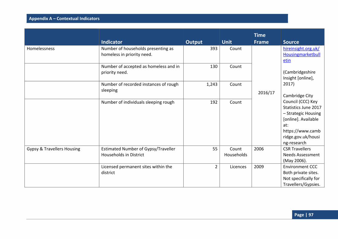
Appendix A – Contextual Indicators
Page | 97
Indicator Output Unit Time Frame Source
Homelessness
Number of households presenting as homeless in priority need.
393 Count
2016/17
hireinsight.org.uk/Housingmarketbulletin (Cambridgeshire Insight [online], 2017) Cambridge City Council (CCC) Key Statistics June 2017 – Strategic Housing [online]. Available at: https://www.cambridge.gov.uk/housing-research
Number of accepted as homeless and in priority need.
130 Count
Number of recorded instances of rough sleeping
1,243 Count
Number of individuals sleeping rough 192 Count
Gypsy & Travellers Housing Estimated Number of Gypsy/Traveller Households in District
55 Count Households
2006 CSR Travellers Needs Assessment (May 2006).
Licensed permanent sites within the district
2 Licences 2009 Environment CCC Both private sites. Not specifically for Travellers/Gypsies.

Appendix A – Contextual Indicators
Page | 98
Indicator Output Unit Time Frame Source
Gypsy and Traveller Accommodation Needs Assessment (2011)
Number of Transit Sites 047 Count
2011 (Cambridgeshire County Council [online], 2011).
Estimated Need for Travellers’ pitches 1 Pitch 2021-2026 Need identified for one pitch between 2021 and 2026. (Cambridgeshire County Council, [online], 2011).
No of permanent licensed pitches in District
5 Count Licences
July 2011 An estimated 5 pitches on the 2 licensed caravan sites (not specifically designated as G&T sites) are occupied by Gypsies and Travellers Cambridgeshire County Council [online] (2011)
47
“The evidence from recorded short-term unauthorised encampments and other sources, whilst patchy, demonstrates some demand for transit or emergency stopping places. However, it is not
possible to determine a precise amount of demand in any one local authority area. This is because of travel routes through the Cambridge area, where the same caravans may stop in different local authority areas at different times. Therefore, a well-placed transit site within one local authority may serve the needs of two or more local authorities. Travellers Liaison Officers advise that current thinking is towards providing more emergency stopping places rather than transit pitches.” - Cambridge Sub-Regional Gypsy and Traveller Accommodation Needs Assessment 2011.
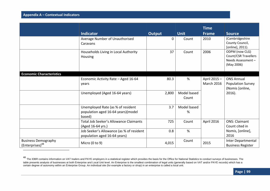
Appendix A – Contextual Indicators
Page | 99
Indicator Output Unit Time Frame Source
Average Number of Unauthorised Caravans
0 Count 2010 (Cambridgeshire County Council, [online], 2011).
Households Living in Local Authority Housing
37 Count 2006 ODPM (now CLG) Count/CSR Travellers Needs Assessment –(May 2006)
Economic Characteristics
Economic Activity Rate – Aged 16-64 years
80.3 % April 2015 – March 2016
ONS Annual Population Survey (Nomis [online, 2016).
Unemployed (Aged 16-64 years) 2,800 Model based Count
Unemployed Rate (as % of resident population aged 16-64 years)(model based)
3.7 Model based %
Total Job Seeker’s Allowance Claimants (Aged 16-64 yrs.)
725 Count April 2016 ONS: Claimant Count cited in Nomis, [online], 2016
Job Seeker’s Allowance (as % of resident population aged 16-64 years)
0.8 %
Business Demography (Enterprises)48
Micro (0 to 9) 4,015 Count
2015 Inter Departmental Business Register
48 The IDBR contains information on VAT traders and PAYE employers in a statistical register which provides the basis for the Office for National Statistics to conduct surveys of businesses. The
table presents analysis of businesses at both Enterprise and Local Unit level. An Enterprise is the smallest combination of legal units (generally based on VAT and/or PAYE records) which has a certain degree of autonomy within an Enterprise Group. An individual site (for example a factory or shop) in an enterprise is called a local unit.

Appendix A – Contextual Indicators
Page | 100
Indicator Output Unit Time Frame Source
Small (10 to 49) 495 Count (ONS) 2014. (Nomis [online, 2016). Medium (50 to 249) 120 Count
Large (250+) 35 Count
Business Demography (Local Units) Micro (0 to 9) 4,925 Count
Small (10 to 49) 1,105 Count
Medium (50 to 249) 325 Count
Large (250+) 45 Count
Earnings Annual Gross Median Pay (Full time Workers)
31,007 £ 2012 Key Statistics June 2016 – Strategic Housing (Cambridge City Council)
Deprivation49 Local Authority Average Score50 13.75 Rank
2015
The English Indices of Deprivation 2015 – (CLG [online], 2015).
Local Authority Rank Of Average Score51 227 Rank
Super Output Areas in 20% Most Deprived in England
2 Count
Commuting Characteristics
Total Workforce Population 78,667 Count 2011
Census (ONS [online], Employed Residents 2011 94,190 Count
49 The Indices of Deprivation 2015 provide a set of relative measures of deprivation for small areas (Lower-layer Super Output Areas) across England, based
on seven domains of deprivation. The domains were combined using the following weights to produce the overall Index of Multiple Deprivation: Income Deprivation (22.5%); Employment Deprivation (22.5%); Education, Skills and Training Deprivation (13.5%); Health Deprivation and Disability (13.5%); Crime (9.3%); Barriers to Housing and Services (9.3%); Living Environment Deprivation (9.3%); 50 Where 41.99 is the worst and 5.009 the best. 51
Where 326 is the best and 1 is the worst.

Appendix A – Contextual Indicators
Page | 101
Indicator Output Unit Time Frame Source
Live and Work in Cambridge 2001 59,437 Count 2011)
Mode of Travel to work Car/Van 20.8 %
Bus 3.9 %
Train 3.0 %
Cycle 18.1 %
Foot 9.6 %
Environmental Characteristics
Annual Average Concentration Nitrogen Dioxide (NO2)
Regent Street (exceedences hourly average)
32 (0)
ug/m3 2016 Cambridge City Council & Ricardo AEA
Montague Road (exceedences hourly average)
27(0)
Gonville Place (exceedences hourly average)
36 (2)
Parker Street (exceedences hourly average)
41 (0)
Newmarket Road (exceedences hourly average)
24 (0)
Annual Average Fine Particles (PM10)
Montague Road (exceedences daily average)
22 (2)
Gonville Place (exceedences daily average)
20 (1)
Parker Street (exceedences daily average)
22 (4)
Annual Average Fine Particles (PM2.5)
Newmarket Road 11
Gonville Place 15

Appendix A – Contextual Indicators
Page | 102
Indicator Output Unit Time Frame Source
Total Area of Cambridge Local Authority
Total Area of Cambridge Local Authority 4070 ha
Cambridge City Council
Open Space Area of Protected Open Space per 1,000 Population (748.57/126.5)
5.9 ha
2012/13
Open Space & Recreation Strategy 2011 data including new sites included in the Local Plan 2014 (4.98 ha in total)
Area of total Protected Open Space Accessible to the Public per 1,000 population (350.83/126.5)
2.77 ha
Area of Semi-Natural Green Spaces Accessible to The Public
88.89 ha
Area of Local Nature Reserve per 1,000 Population (77.1/126.5)
0.60 ha 2014/15 Recalculated using data from CPERC (CPERC, 2015).

Appendix B – Local Indicators
Page | 103
Appendix B – Local Indicators
Business Development and Town Centres
BD1 Total amount of additional employment floorspace - by type (sqm)
BD2 Total amount of employment floorspace on previously developed land - by type (sqm)
BD3 Employment land available - by type (ha)
BD4 Total amount of floorspace for 'town centre uses' (sqm)
Housing
H1 Plan period and housing targets
H2 (a) Net additional dwellings – in previous years
H2 (b) Net additional dwellings 2015-16
H2 (c) Net additional dwellings – in future years
H2 (d) Managed delivery target
H3 New and converted dwellings – on previously developed land (Gross)
H4 Net additional pitches (Gypsy and Travellers)
H5 Gross and Net affordable housing completions
Environmental Quality
E1 Number of planning permissions granted contrary to Environment Agency advice on (i) flooding and (ii) water quality grounds
E2 Change in areas of biodiversity importance
E3 Renewable energy generation (MW)
Other Indicators
Density
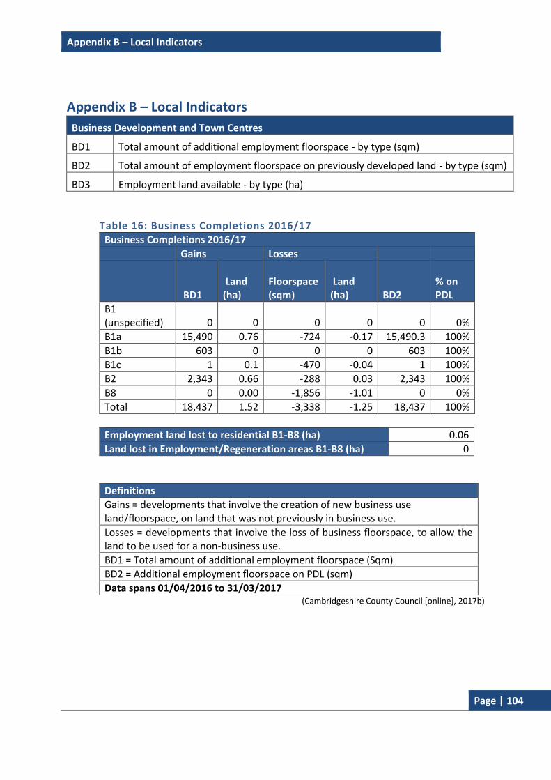
Appendix B – Local Indicators
Page | 104
Appendix B – Local Indicators
Business Development and Town Centres
BD1 Total amount of additional employment floorspace - by type (sqm)
BD2 Total amount of employment floorspace on previously developed land - by type (sqm)
BD3 Employment land available - by type (ha)
Table 16: Business Completions 2016/17
Business Completions 2016/17
Gains Losses
BD1 Land (ha)
Floorspace (sqm)
Land (ha) BD2
% on PDL
B1 (unspecified) 0 0 0 0 0 0%
B1a 15,490 0.76 -724 -0.17 15,490.3 100%
B1b 603 0 0 0 603 100%
B1c 1 0.1 -470 -0.04 1 100%
B2 2,343 0.66 -288 0.03 2,343 100%
B8 0 0.00 -1,856 -1.01 0 0%
Total 18,437 1.52 -3,338 -1.25 18,437 100%
Employment land lost to residential B1-B8 (ha) 0.06
Land lost in Employment/Regeneration areas B1-B8 (ha) 0
Definitions
Gains = developments that involve the creation of new business use land/floorspace, on land that was not previously in business use.
Losses = developments that involve the loss of business floorspace, to allow the land to be used for a non-business use.
BD1 = Total amount of additional employment floorspace (Sqm)
BD2 = Additional employment floorspace on PDL (sqm)
Data spans 01/04/2016 to 31/03/2017 (Cambridgeshire County Council [online], 2017b)

Appendix B – Local Indicators
Page | 105
BD4 Amount of completed floorspace (sqm) 2016/17 in Cambridge
A1 A2 B1 (a) D2
Town Centre Gains 496 0 17 75
Losses -452 -436 -196 0
Net 44 -436 -179 75
Local Authority Area Gains 4,135 103 15,490 2,865
Losses -794 -617 -724 0
Net 3,341 -514 14,767 2,865
(Cambridgeshire County Council [online], 2017b)
H1 Plan period and housing targets
Local Plan 2014: Proposed Submission 2011 to 2031: 14,000 dwellings.
Local Plan 2006 Target 1999 to 2016: 12,500.
See Appendix D for an explanation of the approach in this year’s trajectory.
H2 (a) Net additional dwellings in previous years
See Appendix I and D (Table C1)
H2 (b) Net additional dwellings 2016-2017
1,178 dwellings
H2(c) Net additional dwellings in future years
See Appendix D
H2 (d) Managed delivery target
See Appendix D (Table C1)
H3 New and converted dwellings – on previously developed land (Gross) 2016-2017
467
H4 Net additional pitches (Gypsy and Travellers) 2016-2017
0
H5 (a) Gross affordable housing completions 2016-2017
474 (out of 1,239 gross housing completions).
H5 (b) Net affordable housing completions 2016-2017
458 (Cambridgeshire County Council, [online], 2017a)

Appendix B – Local Indicators
Page | 106
Environmental Quality
E1 Number of planning permissions granted contrary to Environment Agency advice on (i) flooding and (ii) water quality grounds 2016/17
i 0
ii 0
(Source: Environment Agency, [online] 2017)
*In the instance of planning applications granted contrary to Environment Agency advice on the grounds of flood risk, the Environment Agency did object to some applications within the monitoring year. However these issues were resolved through the submission of further evidence or subsequently withdrawn. For more information on these applications see Chapter 4.
E2 Change in areas of biodiversity importance 2016/17
Cambridge has 2 sites designated as Sites of Special Scientific Interest (SSSI): Cherry Hinton Pit and Traveller’s Rest Pit, totalling 15.03 hectares. There has been no change in the status of these SSSIs from the previous year (2015/16).
36.1% of SSSI land area in the city remains in favourable condition, 57.4% of SSSI land is classed as Unfavourable Recovering and 6.5% as Unfavourable No Change. This has remained unchanged from the previous year’s results in 2015/16.
Cambridge has 12 Local Nature Reserves (LNR) totalling 77.06 hectares; this figure has also remained unchanged from the previous year.
LNR Name Total area (ha)
Area in authority (ha)
Barnwell East 3.26 3.26
Barnwell West 4.02 4.02
Bramblefields 2.06 2.06
Byron’s Pool 4.36 2.82
Coldham’s Common 10.37 10.37
East Pit 8.11 8.11
Limekiln Close 2.86 2.86
Logan’s Meadow 2.13 2.13
Paradise 2.17 2.17
Sheep’s Green and Coe Fen 16.85 16.85
Stourbridge Common 19.38 19.38
West Pit 3.03 3.03

Appendix B – Local Indicators
Page | 107
E2 Change in areas of biodiversity importance 2016/17
Cambridge has 0.58 hectares of Local Nature Reserve per 1,000 people as of 2016/17. This is a decrease of 0.01 from 2015/6 which is due to the increase in population; there has been no change in the area of land designated as a LNR.
The addition of Adams Road Sanctuary as a new County Wildlife Sites (CWS) in Cambridge has increased the number of sites in Cambridge from 15 in 2015/16 to 16. The new site is 1.6 ha and means that Cambridge now has 96.91 hectares of CWS. County Wildlife Sites are sites selected by the CWS Group (a group of partnership organisations and individuals affiliated to the Cambridgeshire and Peterborough Biodiversity Partnership).
City Wildlife Sites (CiWS) are similar to County Wildlife Sites but are only found within Cambridge and have different selection criteria. The number of CiWS has reduced from 50 in 2015/16 to 49 in 2016/17 with the removal of Adams Road Sanctuary from the CiWS list to become a CWS. The 49 sites total 163.14 hectares of land, which are all within the Cambridge local authority boundary.
The proportion of local sites where positive conservation management has been or is being implemented during the last five years shows that 42 out of 67 sites (62.7%) demonstrate positive conservation management. This represents a 5.5% decrease on last year’s figures. The decrease in positive conservation management has been attributed to the lack of management of privately owned sites, previously deemed well managed and not directly related to development impacts. The number of Local Geological Sites in Cambridge has increased from one to two this year (2016/17). The new addition, Nine Wells Local Geological Site is 1.18ha. The landscape at Nine Wells is marked by a change of slope between the chalkland to the south and the flat (chalk marl and clay) land to the north. The rocks there are the source of spring waters that rise from fissures in a hard band of Totternhoe Stone, known locally as the Burwell Rock. This famous layer in the chalk lies at the base of the Zig Zag Chalk, and overlies the West Melbury Chalk Marl. East Pit (8.08 ha) a chalk quarry in Cherry Hinton was designated as a Local Geological Site in 2015/16. Both sites were designated at the County Wildlife Sites Panel meeting in line with the procedures for County Wildlife Sites and considered worthy of protection.
Source: CPERC 2017

Appendix B – Local Indicators
Page | 108
Environmental Quality
E3 Renewable energy generation52
Installed Capacity (MW) 2016/17
Potential Sites - Installed capacity (MW) at 31/03/2017
Wind 0 0
Biomass 0 0
Landfill gas 0 0
Sewage gas 0 0
Photovoltaic 0.0840 0.006
Hydro-power 0 0 (Source: Cambridgeshire County Council, [online], 2017
*The figures for installed capacity for photovoltaics are a combination of Cambridgeshire County Council Research and Monitoring Team data and Feed in Tariff data from OFGEM. The figures are based on standalone renewable energy generation applications and not where renewable energy is part of a larger scheme, such as major housing developments.
Other Indicators
Density range of completed dwellings on sites greater than nine dwellings 2016/17
Density Percentage
<30 DPH 0%
30 – 50 DPH 64.0%
>50 DPH 36.0%
(Cambridgeshire County Council, [online], 2017a)
52 The figures for installed capacity for photovoltaics are a combination of Cambridgeshire County Council
Research and Monitoring Team data and Feed in Tariff data from OFGEM. The figures are based on standalone
renewable energy generation applications and not where renewable energy is part of a larger scheme, such as
major housing developments.
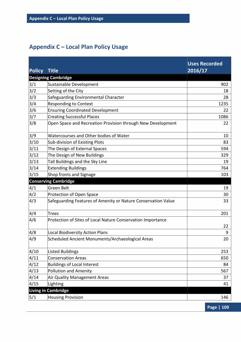
Appendix C – Local Plan Policy Usage
Page | 109
Appendix C – Local Plan Policy Usage
Policy Title Uses Recorded 2016/17
Designing Cambridge
3/1 Sustainable Development 902
3/2 Setting of the City 18
3/3 Safeguarding Environmental Character 28
3/4 Responding to Context 1235
3/6 Ensuring Coordinated Development 22
3/7 Creating Successful Places 1086
3/8 Open Space and Recreation Provision through New Development 22
3/9 Watercourses and Other bodies of Water 10
3/10 Sub-division of Existing Plots 83
3/11 The Design of External Spaces 594
3/12 The Design of New Buildings 329
3/13 Tall Buildings and the Sky Line 19
3/14 Extending Buildings 764
3/15 Shop fronts and Signage 103
Conserving Cambridge
4/1 Green Belt 19
4/2 Protection of Open Space 30
4/3 Safeguarding Features of Amenity or Nature Conservation Value 33
4/4 Trees 201
4/6 Protection of Sites of Local Nature Conservation Importance
22
4/8 Local Biodiversity Action Plans 9
4/9 Scheduled Ancient Monuments/Archaeological Areas 20
4/10 Listed Buildings 253
4/11 Conservation Areas 650
4/12 Buildings of Local Interest 84
4/13 Pollution and Amenity 567
4/14 Air Quality Management Areas 37
4/15 Lighting 41
Living in Cambridge
5/1 Housing Provision 146

Appendix C – Local Plan Policy Usage
Page | 110
Policy Title Uses Recorded 2016/17
5/2 Conversion of Large Properties 31
5/3 Housing Lost to Other Uses 4
5/4 Loss of Housing 9
5/5 Meeting Housing Needs 14
5/7 Supported Housing/Housing in Multiple Occupation 18
5/8 Travellers 0
5/9 Housing for People with Disabilities 6
5/10 Dwelling Mix 9
5/11 Protection of Existing Facilities 11
5/12 New Community Facilities 20
5/13 Community Facilities in the Areas of Major Change 2
5/14 Provision of Community Facilities through New Development 11
5/15 Addenbrooke’s 5
Enjoying Cambridge
6/1 Protection of leisure Facilities 9
6/2 New Leisure Facilities 9
6/3 Tourist Accommodation 10
6/4 Visitor Attractions 4
6/6 Change of Use in the City Centre 14
6/7 Shopping Development and Change of Use in District and Local Centres
13
6/8 Convenience Shopping 10
6/9 Retail Warehouses 4
6/10 Food and Drink Outlets 20
Working and Studying in Cambridge
7/1 Employment Provision 17
7/2 Selective Management of the Economy 21
7/3 Protection of Industrial and Storage Space 25
7/4 Promotion of Cluster Development 10
7/5 Faculty development in the Central Area, University of Cambridge 7
7/6 West Cambridge, South of Madingley Road 3
7/7 College and University of Cambridge Staff and Student Housing 10
7/8 Anglia Ruskin University East Road Campus 4
7/9 Student Hostels for Anglia Ruskin University 4
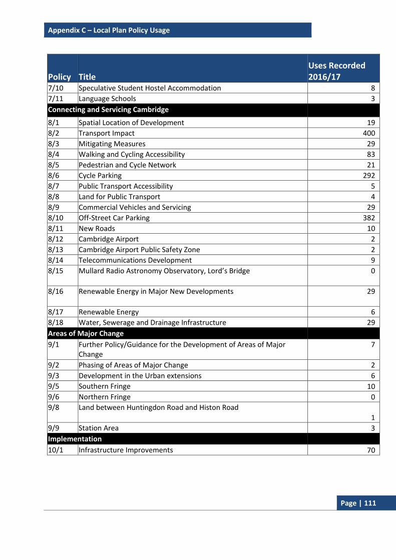
Appendix C – Local Plan Policy Usage
Page | 111
Policy Title Uses Recorded 2016/17
7/10 Speculative Student Hostel Accommodation 8
7/11 Language Schools 3
Connecting and Servicing Cambridge
8/1 Spatial Location of Development 19
8/2 Transport Impact 400
8/3 Mitigating Measures 29
8/4 Walking and Cycling Accessibility 83
8/5 Pedestrian and Cycle Network 21
8/6 Cycle Parking 292
8/7 Public Transport Accessibility 5
8/8 Land for Public Transport 4
8/9 Commercial Vehicles and Servicing 29
8/10 Off-Street Car Parking 382
8/11 New Roads 10
8/12 Cambridge Airport 2
8/13 Cambridge Airport Public Safety Zone 2
8/14 Telecommunications Development 9
8/15 Mullard Radio Astronomy Observatory, Lord’s Bridge 0
8/16 Renewable Energy in Major New Developments 29
8/17 Renewable Energy 6
8/18 Water, Sewerage and Drainage Infrastructure 29
Areas of Major Change
9/1 Further Policy/Guidance for the Development of Areas of Major Change
7
9/2 Phasing of Areas of Major Change 2
9/3 Development in the Urban extensions 6
9/5 Southern Fringe 10
9/6 Northern Fringe 0
9/8 Land between Huntingdon Road and Histon Road
1
9/9 Station Area 3
Implementation
10/1 Infrastructure Improvements 70

Appendix D – Housing Trajectory: Cambridge Housing Trajectory
Page | 112
Appendix D – Housing Trajectory
What is a Housing Trajectory? The housing trajectory shows actual residential completions from 2011/12 to 2016/7 and predicted residential completions for the years 2017/18 to 2030/31. The housing trajectory includes a written summary of sites, highlighting the progress and/or council’s position on new housing allocations. In addition, a summary table and charts showing the council’s position in terms of joint housing supply with South Cambridgeshire District Council (The Greater Cambridge Housing Trajectory) is also provided and details the potential five-year land supply under different methods of calculation.
What does it contain? The Cambridge City Council housing trajectory is split into the following tables:
Table C1: Housing Trajectory for Cambridge City Council – Actual and Predicted Completions (summary table), which includes:
A summary of the housing trajectory, including the five-year land supply total (a more detailed account can be found in Chapter 5);
Previous years’ completions and predicted totals table. This tracks the council's progress against the Local Plan 2014: Proposed Submission’s objectively assessed housing need target for the years 2011/12 to 2030/31 (see Chapter 5 for more detailed information).
Table C2: Cambridge Urban Area, Existing Allocations;
Table C3: Cambridge Urban Area, New Allocations;
Table C4: Cambridge Fringe Sites, Existing Allocations;
Table C5: Cambridge Fringe Sites, New Allocations;
Table C6: Cambridge Windfall;
Summary of sites – A written account highlighting the progress and/or council’s position on all sites in the housing trajectory.
The Greater Cambridge Housing Trajectory, which includes:
A summary table and charts showing the council’s position in terms of joint housing supply with South Cambridgeshire District Council potential five-year land supply under different methods of calculation. For more information on the five year supply, see Chapter 5.
Appendix D – Housing Trajectory: Cambridge Housing Trajectory
Page | 113
Charts visualising the Greater Cambridge Housing Trajectory and its predicted progress towards the joint housing target of 33,500 (between 2011/12 and 2030/31).
Method The Five Year Land Supply Totals and the Housing Trajectory take into account all approved planning applications and also housing allocations set out in the council’s Local Plan 2006 and Cambridge Local Plan 2014: Proposed Submission and Area Action Plans such as Cambridge East and North West Cambridge. The information is gathered by the following means:
questionnaires to developers, landowners and agents, which includes a survey and a ‘best estimate’ table of completions;
talking to the council’s Development Management and Building Control teams to identify progress on sites and completions;
referencing applications against the county council’s completions data;
talking to the City Council’s New Neighbourhoods Team concerning major sites;
in cases where no information was returned, estimates were made though information obtained from the Development Management and New Neighbourhoods teams;
through information from the SHLAA;
from research used to compile the council’s land allocations for the Local Plan 2014: Proposed Submission Document
Statements of Common Ground agreed as part of the Local Plan Examination process.
In some cases, a site may indicate no development across the whole of the trajectory period. This denotes that the site is no longer available for development, but is still allocated for housing in the Cambridge Local Plan 2006 (the council’s current local plan).
Definitions
Availability – Identifies the site as being available for development and indicates that there are no legal or ownership constraints to development, that the site is not used for an existing use that is likely to continue or that there is current planning permission granted;
Suitability – Indicates the site is in a suitable location for housing development and is free of known planning constraints (for example is it protected open space, close to services and facilities or are there listed building or landscape constraints);
Achievability – Indicates that development on the site is viable, and there are no cost, market or delivery factors that may prevent the site coming forward within the plan period;
Appendix D – Housing Trajectory: Cambridge Housing Trajectory
Page | 114
Deliverable and developable – Deliverable indicates that the site is available, suitable and achievable within five years. Developable demonstrates that the site is available, suitable and achievable within the plan period.
Market and Affordable housing – In some cases, a site has been split into two entries with the initials M, A after the site name. This indicates whether the figures are referring to market or affordable housing provision. U/K denotes that the type of housing (market or affordable) is currently unknown;
Built to date column – identifies how many houses have been built on that site by 31/03/16;
Small Print The Five Year Land Supply Total and the Housing Trajectory are based on replies from developers, agents and planning professionals. This information is, however, influenced by market conditions, economic circumstances and the time it takes to agree planning obligations and associated agreements, therefore it is likely that the figures in the trajectory may change over time. The target dwellings for some sites in the trajectory have been changed to reflect those in the Local Plan 2014: Proposed Submission allocations.
The Future of the Housing Trajectory As the Local Plan 2014 progresses, sites allocated by the Cambridge Local Plan 2006 will be removed and replaced with sites allocated in the Local Plan 2014.

2011/2012
2012/2013
2013/2014
2014/2015
2015/2016
2016/2017
2017/2018
2018/2019
2019/2020
2020/2021
2021/2022
2022/2023
2023/2024
2024/2025
2025/2026
2026/2027
2027/2028
2028/2029
2029/2030
2030/ 2031
Plan Period:2011-2031
Five Year Supply:2017-2022
Completions352 472 1,325 713 892 1,178 0 0 0 0 0 0 0 0 0 0 0 0 0 0 4,932 0
Urban Area 0 00 0 80 277 128 238 212 179 160 161 90 100 256 261 2142 485
Fringe Sites 0 00 0 0 84 180 250 250 250 250 250 79 0 0 0 1593 2640 0 0 0 34 0 0 0 0 0 0 0 0 0 34 34
613 118 145 245 245 210 160 40 0 0 0 0 0 0 1776 1366613 118 145 329 459 460 410 290 250 250 79 0 0 0 3403 16640 0 0 0 60 132 132 132 132 132 60 0 0 0 780 600 57 0 0 0 0 0 0 0 0 0 0 0 0 57 570 57 0 0 60 132 132 132 132 132 60 0 0 0 837 117
494 106 122 74 73 0 0 0 0 0 0 0 0 0 869 86942 0 0 0 65 0 0 0 0 0 0 0 0 0 107 1070 0 0 0 0 0 0 0 0 0 0 0 0 0 0 038 56 33 0 0 0 0 0 0 0 0 0 0 0 127 127574 162 155 74 138 0 0 0 0 0 0 0 0 0 1103 11030 0 60 80 60 0 0 0 0 0 0 0 0 0 200 2000 0 0 50 50 50 50 30 0 0 0 0 0 0 230 1000 0 60 130 110 50 50 30 0 0 0 0 0 0 430 300
Windfall 0 0148 83 16 10 5 0 0 0 0 0 0 0 0 0 262 2620 14 18 24 30 5 0 0 0 0 0 0 0 0 91 860 0 61 62 61 123 123 123 123 123 123 124 124 124 1294 184
148 97 95 96 96 128 123 123 123 123 123 124 124 124 1647 532Total 352 472 1,325 713 892 1,178 1,335 434 535 906 991 1,008 927 754 665 666 352 224 380 385 14,494 4,201
Five Year SupplyLiverpool Method 20%
2011/2012
2012/2013
2013/2014
2014/2015
2015/2016
2016/2017
2017/2018
2018/2019
2019/2020
2020/2021
2021/2022
2022/2023
2023/2024
2024/2025
2025/2026
2026/2027
2027/2028
2028/2029
2029/2030
2030/2031 Totals
Actual Completions 352 472 1,325 713 892 1,178 4,932Predicted Completions 1,335 434 535 906 991 1,008 927 754 665 666 352 224 380 385 9,562Cumulative Completions Local Plan 2014 352 824 2,149 2,862 3,754 4,932 6,267 6,701 7,236 8,142 9,133 10,141 11,068 11,822 12,487 13,153 13,505 13,729 14,109 14,494 14,494Annualised Housing Target over Plan PeriodLocal Plan 2014 700 700 700 700 700 700 700 700 700 700 700 700 700 700 700 700 700 700 700 700 14,000Cumulative Housing Target over Plan PeriodLocal Plan 2014 700 1,400 2,100 2,800 3,500 4,200 4,900 5,600 6,300 7,000 7,700 8,400 9,100 9,800 10,500 11,200 11,900 12,600 13,300 14,000Annualised Housing Target taking Account of Actual / Predicted CompletionsLocal Plan 2014 718 732 697 696 683 648 595 608 615 586 541 482 419 363 303 212 165 136 -109 -494Comparison of Actual / Predicted Completions against Annualised Housing TargetLocal Plan 2014 -348 -228 625 13 192 478 635 -266 -165 206 291 308 227 54 -35 -34 -348 -476 -320 -315Cumulative Under/Oversupply against Actual / Predicted Completions Local Plan 2014 -348 -576 49 62 254 732 1,367 1,101 936 1,142 1,433 1,741 1,968 2,022 1,987 1,953 1,605 1,129 809 494
4,201
Table C1: Housing Trajectory for Cambridge City Council - Actual and Predicted Completions
NIAB - MainNIAB - FrontageNW - Cambridge UniversityTotal - North West CambridgeCambridge East Land North of Cherry HintonCambridge East - Land at Coldham's LaneTotal - Cambridge East
Completions
Land north of Wort's CausewayLand south of Wort's CausewayTotal - South East
Urban Area
Clay FarmTrumpington MeadowsGlebe FarmBell School SiteTotal - Southern Fringe
Predicted Completions in Cambridge by Type (2017/18 to 2030/31)
Actual Completions
5.4 108% 5.4 109%Supply in Years % of Supply Supply in Years % of Supply
Unallocated Sites with Planning PermissionUnallocated Sites with Resolution to Grant Planning PermissionWindfall Allowance
2017-2022 2018-2023
Total Windfall

0
200
400
600
800
1,000
1,200
1,400
1,600
2011/2012
2012/2013
2013/2014
2014/2015
2015/2016
2016/2017
2017/2018
2018/2019
2019/2020
2020/2021
2021/2022
2022/2023
2023/2024
2024/2025
2025/2026
2026/2027
2027/2028
2028/2029
2029/2030
2030/2031
Cambridge Housing Trajectory 2011-2031 Actual Completions
Predicted Completions
PLAN: Annualised Housing Target
MANAGE: Annual Requirement takingaccount of Completions

Site No. 2006 Local Plan
Site No. 2014 Proposed
Submission Plan
Application Number Site Name and Address Size (ha) Market or
Affordable
Target Number of
Dwellings on Site (net)
Number of Dwellings Built
(net) (at 31.03.17)
Outstanding Dwellings (net)
2017/2018
2018/2019
2019/2020
2020/2021
2021/2022
2022/2023
2023/2024
2024/2025
2025/2026
2026/2027
2027/2028
2028/2029
2029/2030
2030/2031
Post 2031
Total Estimated Completions
(2017/18 - 2030/31)
Five Year Supply: 2017/18
- 2021/22
Ava
ilabi
lity
Suita
bilit
y
Ach
ieva
bilit
y
Comments
M 287 287 0 0 0 0 0 0 0 0 0 0 0 0 0 0 0 0 0 0
N/A A 122 122 0 0 0 0 0 0 0 0 0 0 0 0 0 0 0 0 0 0
Total - CUP Site, Clarendon Rd Total 409 409 0 0 0 0 0 0 0 0 0 0 0 0 0 0 0 0 0 0
M 74 0 74 0 0 0 0 0 37 37 0 0 0 0 0 0 0 74 0
A 49 0 49 0 0 0 0 0 0 24 25 0 0 0 0 0 0 0 49 0
Total - The Paddocks Total 123 0 123 0 0 0 0 0 0 61 62 0 0 0 0 0 0 0 123 0
M 82 82 0 0 0 0 0 0 0 0 0 0 0 0 0 0 0 0 0 0
A 54 54 0 0 0 0 0 0 0 0 0 0 0 0 0 0 0 0 0 0
Total 136 136 0 0 0 0 0 0 0 0 0 0 0 0 0 0 0 0 0 0
5.04 M1 379-381 Milton Road 2.40 U/K 95 0 95 0 0 0 0 0 0 0 0 40 55 0 0 0 0 0 95 0 Y Y Y Site is developable.
M 62 62 0 0 0 0 0 0 0 0 0 0 0 0 0 0 0 0 0 0
5.05 R3 14/0790/FUL Cambridge City Football Ground, Milton Road 1.60 A 44 44 0 0 0 0 0 0 0 0 0 0 0 0 0 0 0 0 0 0 Completed 2016/17
Total - Cambridge City Football Ground Total 106 106 0 0 0 0 0 0 0 0 0 0 0 0 0 0 0 0 0 0
5.06 Part of R14 British Telecom, Long Road 1.70 U/K 55 0 55 0 0 0 0 0 0 0 0 0 0 0 0 46 9 55 0 Y Y Y
Part of Site R14 in the Cambridge Local Plan 2014: Proposed Submission. See Table C3 for the remainder of the site. A Statement of Common Ground was agreed on this site (RD-SCG-281). Site is developable.
5.07 R2
14/1254/FUL15/1286/S7315/1369/FUL17/0412/S73 Willowcroft, Histon Road 1.40 U/K 78 0 78 0 0 21 14 0 0 21 22 0 0 0 0 0 0 0 78 35 Y Y Y Site is developable.
5.08 N/A Territorial Army, Cherry Hinton Road 1.26 U/K 0 0 0 0 0 0 0 0 0 0 0 0 0 0 0 0 0 0 0 0 N Y N The landowners have no intention of developing the site.
5.09 R911/1294/FUL16/1947/S73 Travis Perkins, Devonshire Road 1.20 U/K 43 0 43 0 0 0 43 0 0 0 0 0 0 0 0 0 0 0 43 43 Y Y Y Site is deliverable.
5.11 N/A Caravan Park, Fen Road 0.80 U/K 0 0 0 0 0 0 0 0 0 0 0 0 0 0 0 0 0 0 0 0 N Y N The landowners have no intention of developing the site.
5.12 M4 Police Station, Parkside 0.50 U/K 50 0 50 0 0 0 0 0 50 0 0 0 0 0 0 0 0 0 50 0 Y Y YA Statement of Common Ground was agreed on this site (RD-SCG-120). Site is developable.
60 60 0 0 0 0 0 0 0 0 0 0 0 0 0 0 0 0 0 0
5.12 39 39 0 0 0 0 0 0 0 0 0 0 0 0 0 0 0 0 0 0
Total - Fire Station, Parkside Total 99 99 0 0 0 0 0 0 0 0 0 0 0 0 0 0 0 0 0 0
5.13 N/A 14/0052/FUL Milton Infant & Junior School, Milton Road 0.40 U/K 5 0 5 0 0 5 0 0 0 0 0 0 0 0 0 0 0 0 5 5 Y Y Y Site is deliverable.
5.14 Part of R12 Ridgeons, Cavendish Road 3.27 U/K 28 0 28 0 0 0 28 0 0 0 0 0 0 0 0 0 0 0 28 28 Y Y Y
Part of site R12 in the Local Plan 2014: Proposed Submission. See Table C3 for the remainder of the site. A Statement of Common Ground was agreed on this site (RD-SCG-200) and a site specific SPD has been approved. Site is deliverable
5.15 R4 Henry Giles House, Chesterton Road 0.80 U/K 48 0 48 0 0 0 0 0 48 0 0 0 0 0 0 0 0 0 48 0 Y Y YA Statement of Common Ground was agreed on this site (RD-SCG-270). Site is developable.
M 93 93 0 0 0 0 0 0 0 0 0 0 0 0 0 0 0 0 0 0
5.16 N/A Junction of Cherry Hinton & Hills Road A 40 40 0 0 0 0 0 0 0 0 0 0 0 0 0 0 0 0 0 0
Total - Junction of Cherry Hinton Total 133 133 0 0 0 0 0 0 0 0 0 0 0 0 0 0 0 0 0 0
5.17 R1 15/0519/OUT 295 Histon Road 0.70 U/K 26 0 26 0 0 0 26 0 0 0 0 0 0 0 0 0 0 0 26 26 Y Y YThis includes the demolition of one residential unit and the construction of 27 leaving a net total of 26 units.
5.18 N/A
03/0406/FUL, 03/1241/FUL, 06/1305/FUL, 06/0544/FUL, 09/1024/EXP Sandy Lane 0.60 U/K 23 0 23 0 0 0 0 0 0 0 0 23 0 0 0 0 0 23 0 Y Y Y Multiple applications live on the site. Site is developable.
7.01 N/A 10/1067/FUL 23-29 Occupation Road 0.46 U/K 14 14 0 0 0 0 0 0 0 0 0 0 0 0 0 0 0 0 0 0 N/A N/A N/A Completed 2012/13.
7.01 N/A 12/0628/FUL 30-31 Occupation Road See Above M 13 13 0 0 0 0 0 0 0 0 0 0 0 0 0 0 0 0 0 0 N/A N/A N/A Completed 2014/15.
7.01 N/A 09/0743/FUL 20 Occupation Road See Above U/K 5 5 0 0 0 0 0 0 0 0 0 0 0 0 0 0 0 0 0 0 N/A N/A N/A Completed 2012/13.
7.01 N/A 14/1407/FUL 71-73 New Street See Above U/K 14 14 0 0 0 0 0 0 0 0 0 0 0 0 0 0 0 0 0 0 N/A N/A N/A Completed 2015/16
M 30 30 0 0 0 0 0 0 0 0 0 0 0 0 0 0 0 0 0 0
N/A A 45 45 0 0 0 0 0 0 0 0 0 0 0 0 0 0 0 0 0 0
Total - 9-15 Harvest Way Total 75 75 0 0 0 0 0 0 0 0 0 0 0 0 0 0 0 0 0 0
Total - Site 7.01 121 121 0 0 0 0 0 0 0 0 0 0 0 0 0 0 0 0 0 0
06/0552/FUL, M 93 0 93 0 0 0 0 0 0 0 0 0 0 0 0 30 63 0 93 0
7.02 M44 09/1177/EXP Betjeman House, Hills Road 0.7 A 63 0 63 0 0 0 0 0 0 0 0 0 0 0 0 20 43 0 63 0
Total 156 0 156 0 0 0 0 0 0 0 0 0 0 0 0 50 106 0 156 0
7.03 N/A Coldham's Lane/Newmarket Road 0.47 U/K 0 0 0 0 0 0 0 0 0 0 0 0 0 0 0 0 0 0 0 0 N N N Site developed as a hotel.
7.04 N/A14/0506/FUL14/0543/FUL Mitcham's Corner (remainder of site) 0.70 U/K 0 0 0 0 0 0 0 0 0 0 0 0 0 0 0 0 0 0 0 0 N N N
Site developed for student accommodation and retail uses.
7.06 M13 West Cambridge Site, Madingley Road 66.90 U/K 0 0 0 0 0 0 0 0 0 0 0 0 0 0 0 0 0 0 0 0 N Y N
Previous housing trajectory returns from the landowner indicate that the site will not be developed for residential use. This site is allocated for agricultural, University and research uses in the Cambridge Local Plan 2014: Proposed Submission (Site M13).
7.07 N/A Leckhampton House Grounds 2.94 U/K 0 0 0 0 0 0 0 0 0 0 0 0 0 0 0 0 0 0 0 0 N Y N
Previous housing trajectory returns from the landowner indicate that the site will not be developed for residential use. This site is not allocated in the Cambridge Local Plan 2014: Proposed Submission.
7.09 U3 Grange Farm off Wilberforce Road 0.20 U/K 0 0 0 0 0 0 0 0 0 0 0 0 0 0 0 0 0 0 0 0 N Y N
Previous housing trajectory returns from the landowner indicate that the site will not be developed for residential use. The site is allocated in the Cambridge Local Plan 2014: Proposed Submission for student accommodation (site U3).
7.10 U1 Land Around 16 Mill Lane 0.80 A 0 0 0 0 0 0 0 0 0 0 0 0 0 0 0 0 0 0 0 0 N Y N
Housing trajectory return from the landowner indicate that the site will not be developed for residential use. The site is allocated in the Cambridge Local Plan 2014: Proposed Submission for student accommodation (site U1).
7.11 N/A
09/0181/FUL, 09/0179/FUL & 11/0327/REM Brunswick Site 0.80 U/K 205 205 0 0 0 0 0 0 0 0 0 0 0 0 0 0 0 0 0 0 N/A N/A N/A Completed 2014/15.
7.12 Part of R21 Magnet Warehouse, Mill Road 0.60 U/K 0 0 0 0 0 0 0 0 0 0 0 0 0 0 0 0 0 0 0 0 N N N
Site no longer available for residential development. Site has approval for a Mosque (11/1348/FUL) and student accommodation (14/1496/FUL, under construction).
9.14 N/A 13/1594/FUL 64-66 Peverel Road 1.40 M 0 0 0 0 0 0 0 0 0 0 0 0 0 0 0 0 0 0 0 0 N Y N
Planning application 13/1594/FUL was approved for B1 use, therefore no residential will come forward on this site.
M 106 106 0 0 0 0 0 0 0 0 0 0 0 0 0 0 0 0 0 0
M14 A 63 63 0 0 0 0 0 0 0 0 0 0 0 0 0 0 0 0 0 0
Total - Station Area (Blue Phase) Total 169 169 0 0 0 0 0 0 0 0 0 0 0 0 0 0 0 0 0 0
M 132 79 53 0 0 0 53 0 0 0 0 0 0 0 0 0 0 0 53 53
9.10 + 9.15 M1413/1034/REM 15/1759/FUL Station Area - Pink Phase (Station Road West) A 94 58 36 0 0 0 36 0 0 0 0 0 0 0 0 0 0 0 36 36
Total - Station Area (Pink Phase) Total 226 137 89 0 0 0 89 0 0 0 0 0 0 0 0 0 0 0 89 89
Total - Station Area 395 306 89 0 0 0 89 0 0 0 0 0 0 0 0 0 0 0 89 89
2334 1515 819 0 0 26 200 0 98 82 84 40 78 0 0 96 115 0 819 226
226M = Market Housing, A = Affordable Housing, U/K = Unknown
Five Year Supply Total
Table C2: Cambridge Urban Area, Existing Allocations
R7
N/A
7.30
0.30
08/0266/OUT, 11/0633/REM9.10 + 9.15 Station Area - Blue Phase (Station Road West)
N/A0.90
Completed 2012/13.Fire Station , Parkside
N/AN/AN/A
N/A
N/A
Completed 2013/14.
Completed 2016/17
Site is deliverable.
N/A
N/A
08/0500/OUT, 11/0902/REM, 12/1337/FUL.5.03
N/A
2.70
Total - British Telecom, Cromwell Road
3.00CUP Site, Clarendon Road06/0584/REM & 13/0741/FUL5.01
Y
N/A N/A
1.20
5.02
Completed 2014/15.
Total - Sites Allocated in the Local Plan
9-15 Harvest Way11/0219/FUL7.01
Y
British Telecom, Cromwell Road
See Above
N/A
YThe Paddocks Trading Estate, Cherry Hinton Road
Total - Betjeman House, Hills Road
A Statement of Common Ground was agreed on this site (RD-SCG-140). Site is developable.
Completed 2014/15.
08/0505
N/A
Y Y
YYY
N/AN/AN/A
N/A N/A
N/A
Y
Completed 2015/16
Additional capacity for residential units being discussed, which has increased the total number of residential units on-site. Application 13/1034/REM is completed. Site is deliverable.
10/0523/FULN/A 0.40 U/K N/A N/A

Site No. 2006 Local Plan
Site No. 2014 Proposed
Submission Plan
Application Number Site Name and Address Size (ha) Market or
Affordable
Target Number of
Dwellings on Site (net)
Number of Dwellings Built
(net) (at 31.03.17)
Outstanding Dwellings (net)
2017/2018
2018/2019
2019/2020
2020/2021
2021/2022
2022/2023
2023/2024
2024/2025
2025/2026
2026/2027
2027/2028
2028/2029
2029/2030
2030/2031
Post 2031
Total Estimated Completions
(2017/18 - 2030/31)
Five Year Supply: 2017/18
- 2021/22
Ava
ilabi
lity
Suita
bilit
y
Ach
ieva
bilit
y
Comments
N/A R5Camfields Resource Centre and Oil Depot 137-139 Ditton Walk 0.86 U/K 35 0 35 0 0 0 0 0 15 20 0 0 0 0 0 0 0 0 35 0 Y Y Y Site is developable.
N/A R8149 Cherry Hinton Road and Telephone Exchange, Coleridge Road 0.76 U/K 33 0 33 0 0 0 0 0 0 0 0 0 0 0 0 33 0 0 33 0 Y Y Y
A Statement of Common Ground was agreed on this site (RD-SCG-240 & RD-SCG-251). Site is developable. Site is developable.
83 0 83 0 0 27 27 29 0 0 0 0 0 0 0 0 0 0 83 83
N/A R10 2.70 U/K 84 0 84 0 0 27 28 29 0 0 0 0 0 0 0 0 0 0 84 84
167 0 167 0 0 54 55 58 0 0 0 0 0 0 0 0 0 0 167 167
N/A R11 Horizon Resource Centre, 285 Coldham's Lane 0.82 U/K 40 0 40 0 0 0 0 0 0 0 0 0 0 0 0 20 20 0 40 0 Y Y Y Site is developable.
N/A R14BT Telephone Exchange and car park, Long Road U/K 21 0 21 0 0 0 0 0 0 0 0 0 0 0 0 0 21 0 21 0 Y Y Y
Additional capacity: see site 5.06 in table C2 for the remainder of the site. A Statement of Common Ground was agreed on this site (RD-SCG-281). Site is developable.
N/A R16Cambridge Professional Development Centre, Foster Road 1.49 U/K 67 0 67 0 0 0 0 0 0 0 0 0 0 15 20 17 15 0 67 0 Y Y Y Site is developable.
N/A R17 Mount Pleasant House, Mount Pleasant 0.57 U/K 0 0 0 0 0 0 0 0 0 0 0 0 0 0 0 0 0 0 0 0 N/A N/A N/A
Site has been removed from proposed allocations and allocated for student accomodation as part of the examination of the Cambridge Local Plan 2014
N/A M2 Clifton Road Area 9.43 U/K 550 0 550 0 0 0 0 0 50 60 70 70 60 60 60 60 60 0 550 0 Y Y YA Statement of Common Ground was agreed on this site (RD-SCG-160). Site is developable.
M 58 58 0 0 0 0 0 0 0 0 0 0 0 0 0 0 0 0 0 0
1.30 A 37 37 0 0 0 0 0 0 0 0 0 0 0 0 0 0 0 0 0 0
95 95 0 0 0 0 0 0 0 0 0 0 0 0 0 0 0 0 0 0
N/A M5 82-88 Hills Road and 57-63 Bateman Street 0.58 U/K 20 0 20 0 0 0 0 0 0 0 0 0 0 0 0 10 10 0 20 0 Y Y Y Site is developable.
N/A R6
636-656 Newmarket Road, Holy Cross Church Hall, East Barnwell Community Centre and Meadowlands, Newmarket Road 1.01 U/K 75 0 75 0 0 0 0 0 0 0 0 0 0 15 20 20 20 0 75 0 Y Y Y Site is developable.
N/A R12 16/1904/OUT Ridgeons, Cromwell Road 3.27 U/K 217 0 217 0 0 0 22 70 75 50 0 0 0 0 0 0 0 0 217 92 Y Y Y
Part of site R12 in the Local Plan 2014: Proposed Submission. See Table C3 for the remainder of the site. A Statement of Common Ground was agreed on this site (RD-SCG-200) and a site specific SPD has been approved. Site is developable.
N/A R21 315-349 Mill Road and Brookfields 2.18 U/K 98 0 98 0 0 0 0 0 0 0 25 50 23 0 0 0 0 0 98 0 Y Y YA Statement of Common Ground was agreed on this site (RD-SCG-230). Site is developable.
1418 95 1323 0 0 54 77 128 140 130 95 120 83 90 100 160 146 0 1323 259
259M = Market Housing, A = Affordable Housing, U/K = Unknown
Total - Michael Young Centre, Purbeck Road
Five Year Supply Total
N/A
Total
M313/1250/OUT14/1648/REM Michael Young Centre, Purbeck Road
Table C3: Cambridge Urban Area, New Allocations
Completed 2015/16N/A N/A N/A
Mill Road Depot and adjoining properties, Mill Road Y Y Y
A Statement of Common Ground was agreed on this site (RD-SCG-150) and consultation on a draft Planning and Development Framework has been completed. Site is deliverable.

Site No. 2006 Local
Plan
Site No. 2014 Proposed
Submission Plan
Application Number Site Name and Address Size (ha) Market or
Affordable
Target Number of Dwellings on
Site (net)
Number of Dwellings Built
(net) (at 31.03.17)
Outstanding Dwellings (net)
2017/2018
2018/2019
2019/2020
2020/2021
2021/2022
2022/2023
2023/2024
2024/2025
2025/2026
2026/2027
2027/2028
2028/2029
2029/2030
2030/2031
Post 2031
Total Estimated Completions (2017/18 -
2030/31)
Five Year Supply: 2017/18 - 2021/22 A
vaila
bilit
y
Suita
bilit
y
Ach
ieva
bilit
y
Comments
M 467 0 467 0 0 0 0 36 79 79 79 79 79 36 0 0 0 0 467 36
A 313 0 313 0 0 0 0 24 53 53 53 53 53 24 0 0 0 0 313 24
Total 780 0 780 0 0 0 0 60 132 132 132 132 132 60 0 0 0 0 780 60
33 0 33 0 33 0 0 0 0 0 0 0 0 0 0 0 0 0 33 33
CE AAP R4114/0028/OUT16/1181/FUL
Cambridge East - Land at Coldham's Lane 1.30 U/K 24 0 24 0 24 0 0 0 0 0 0 0 0 0 0 0 0 0 24 24
57 0 57 0 57 0 0 0 0 0 0 0 0 0 0 0 0 0 57 57
Total - Cambridge East 837 0 837 0 57 0 0 60 132 132 132 132 132 60 0 0 0 0 837 117
M 955 0 955 0 0 0 50 108 150 150 150 150 150 47 0 0 0 0 955 158
R43 A 638 0 638 0 0 0 34 72 100 100 100 100 100 32 0 0 0 0 638 106
Total 1593 0 1593 0 0 0 84 180 250 250 250 250 250 79 0 0 0 0 1593 264
M 131 107 24 0 0 0 0 24 0 0 0 0 0 0 0 0 0 0 24 24
A 56 46 10 0 0 0 0 10 0 0 0 0 0 0 0 0 0 0 10 10
Total 187 153 34 0 0 0 0 34 0 0 0 0 0 0 0 0 0 0 34 34
Total - NIAB 1780 153 1627 0 0 0 84 214 250 250 250 250 250 79 0 0 0 0 1627 298
M 654 390 264 36 55 80 47 46 0 0 0 0 0 0 0 0 0 0 264 264
R42a A 439 274 165 50 30 31 27 27 0 0 0 0 0 0 0 0 0 0 165 165
Total 1093 664 429 86 85 111 74 73 0 0 0 0 0 0 0 0 0 0 429 429
M 77 77 0 0 0 0 0 0 0 0 0 0 0 0 0 0 0 0 0 0
R42a A 51 51 0 0 0 0 0 0 0 0 0 0 0 0 0 0 0 0 0 0
Total 128 128 0 0 0 0 0 0 0 0 0 0 0 0 0 0 0 0 0 0
M 238 177 61 61 0 0 0 0 0 0 0 0 0 0 0 0 0 0 61 61
R42a A 159 142 17 17 0 0 0 0 0 0 0 0 0 0 0 0 0 0 17 17
Total 397 319 78 78 0 0 0 0 0 0 0 0 0 0 0 0 0 0 78 78
M 29 8 21 21 0 0 0 0 0 0 0 0 0 0 0 0 0 0 21 21
A 20 8 12 12 0 0 0 0 0 0 0 0 0 0 0 0 0 0 12 12
Total 49 16 33 33 0 0 0 0 0 0 0 0 0 0 0 0 0 0 33 33
M 104 0 104 104 0 0 0 0 0 0 0 0 0 0 0 0 0 0 104 104
R42a A 124 0 124 124 0 0 0 0 0 0 0 0 0 0 0 0 0 0 124 124
Total 228 0 228 228 0 0 0 0 0 0 0 0 0 0 0 0 0 0 228 228
M 163 117 46 31 13 2 0 0 0 0 0 0 0 0 0 0 0 0 46 46
R42a A 111 56 55 38 8 9 0 0 0 0 0 0 0 0 0 0 0 0 55 55
Total 274 173 101 69 21 11 0 0 0 0 0 0 0 0 0 0 0 0 101 101
Total - Clay Farm 2169 1300 869 494 106 122 74 73 0 0 0 0 0 0 0 0 0 0 869 869
Previously 9.07/9.11 of the Local Plan. Now NWC AAP NWC AAP
11/1114/OUT13/1748/REM13/1827/REM14/0109/REM14/1722/REM NW - Cambridge University 67.86 M 1849 73 1776 613 118 145 245 245 210 160 40 0 0 0 0 0 0 0 1776 1366 Y Y Y
Under construction. Part of the North West Cambridge Area Action Plan. Key Worker and Market Housing (split 50/50). Site is deliverable.
Total 1849 73 1776 613 118 145 245 245 210 160 40 0 0 0 0 0 0 0 1776 1366
M 358 277 81 42 0 0 0 39 0 0 0 0 0 0 0 0 0 0 81 81
R42b A 201 175 26 0 0 0 0 26 0 0 0 0 0 0 0 0 0 0 26 26
Total 559 452 107 42 0 0 0 65 0 0 0 0 0 0 0 0 0 0 107 107
M 173 173 0 0 0 0 0 0 0 0 0 0 0 0 0 0 0 0 0 0
R42c A 114 114 0 0 0 0 0 0 0 0 0 0 0 0 0 0 0 0 0 0
Total - Glebe Farm Total 287 287 0 0 0 0 0 0 0 0 0 0 0 0 0 0 0 0 0 0
M 162 57 105 38 34 33 0 0 0 0 0 0 0 0 0 0 0 0 105 105
R42d A 108 86 22 0 22 0 0 0 0 0 0 0 0 0 0 0 0 0 22 22
Total - Bell School 270 143 127 38 56 33 0 0 0 0 0 0 0 0 0 0 0 0 127 127
Total - Urban Extensions 7751 2408 5343 1187 337 300 403 657 592 542 422 382 382 139 0 0 0 0 5343 2884
Five Year Supply Total 2884
Site No. 2006 Local
Plan
Site No. 2014 Proposed
Submission Plan
Application Number Site Name and Address Size (ha) Market or
Affordable
Target Number of Dwellings on
Site (net)
Number of Dwellings Built
(net) (at 31.03.17)
Outstanding Dwellings (net)
2017/2018
2018/2019
2019/2020
2020/2021
2021/2022
2022/2023
2023/2024
2024/2025
2025/2026
2026/2027
2027/2028
2028/2029
2029/2030
2030/2031
Post 2031
Total Estimated Completions (2017/18 -
2030/31)
Five Year Supply: 2017/18 - 2021/22 A
vaila
bilit
y
Suita
bilit
y
Ach
ieva
bilit
y
Comments
GB1 Land north of Worts' Causeway 7.84 U/K 200 0 200 0 0 60 80 60 0 0 0 0 0 0 0 0 0 0 200 200 Y Y Y
A Statement of Common Ground was agreed on this site (RD-SCG-090). Site is deliverable.
GB2 Land south of Worts' Causeway 6.80 U/K 230 0 230 0 0 0 50 50 50 50 30 0 0 0 0 0 0 0 230 100 Y Y Y
A Statement of Common Ground was agreed on this site (RD-SCG-090). Site is deliverable.
M 18 18 0 0 0 0 0 0 0 0 0 0 0 0 0 0 0 0 0 0A 12 12 0 0 0 0 0 0 0 0 0 0 0 0 0 0 0 0 0 0
Total - Glebe Farm 2 30 30 0 0 0 0 0 0 0 0 0 0 0 0 0 0 0 0 0 0
Total 460 30 430 0 0 60 130 110 50 50 30 0 0 0 0 0 0 0 430 300Five Year Supply Total 300
Site Name and AddressTarget Number of Dwellings on
Site (net)
Number of Dwellings Built
(net) (at 31.03.17)
Outstanding Dwellings (net)
2017/2018
2018/2019
2019/2020
2020/2021
2021/2022
2022/2023
2023/2024
2024/2025
2025/2026
2026/2027
2027/2028
2028/2029
2029/2030
2030/2031
Post 2031
Total Estimated Completions (2017/18 -
2030/31)
Five Year Supply: 2017/18 - 2021/22
1593 0 1593 0 0 0 84 180 250 250 250 250 250 79 0 0 0 0 1593187 153 34 0 0 0 0 34 0 0 0 0 0 0 0 0 0 0 34
1849 73 1776 613 118 145 245 245 210 160 40 0 0 0 0 0 0 0 17763629 226 3403 613 118 145 329 459 460 410 290 250 250 79 0 0 0 0 3403
780 0 780 0 0 0 0 60 132 132 132 132 132 60 0 0 0 0 78057 0 57 0 57 0 0 0 0 0 0 0 0 0 0 0 0 0 57
837 0 837 0 57 0 0 60 132 132 132 132 132 60 0 0 0 0 8372169 1300 869 494 106 122 74 73 0 0 0 0 0 0 0 0 0 0 869
559 452 107 42 0 0 0 65 0 0 0 0 0 0 0 0 0 0 107317 317 0 0 0 0 0 0 0 0 0 0 0 0 0 0 0 0 0270 143 127 38 56 33 0 0 0 0 0 0 0 0 0 0 0 0 127
3315 2212 1103 574 162 155 74 138 0 0 0 0 0 0 0 0 0 0 1103200 0 200 0 0 60 80 60 0 0 0 0 0 0 0 0 0 0 200230 0 230 0 0 0 50 50 50 50 30 0 0 0 0 0 0 0 230430 0 430 0 0 60 130 110 50 50 30 0 0 0 0 0 0 0 430
8211 2438 5773 1187 337 360 533 767 642 592 452 382 382 139 0 0 0 0 5773Five Year Supply Total 3184
M = Market Housing, A = Affordable Housing, U/K = Unknown
Completed 2016/17Y Y Y
Table C5: Cambridge Fringe Sites, New Allocations
R42c 14/1792/FUL
Y
07/0620/OUT, 14/0093/FUL, 14/1201/REM 9.06 & 9.05
Completed 2015/16.
Site is under construction.Y
Under construction. Site is deliverable.
9.79
15.50Trumpington Meadows
Glebe Farm
9.05
07/0620/OUT, 12/0754/REM, 13/0751/REM
See Above
06/0795/OUT, 13/1786/REM, 13/1118/S73
Clay Farm/Showground (City Council)
Under construction. Site is deliverable.
N/A
Y
Y
Total - Fringe Sites
Total - Cambridge EastClay FarmTrumpington Meadows
NIAB - FrontageNW - Cambridge UniversityTotal - North West CambridgeCambridge East Land North of Cherry Hinton
Glebe FarmBell School Site
Cambridge East - Land at Coldham's Lane
Land north of Wort's CausewayLand south of Wort's CausewayTotal - South East
Total - Southern Fringe
8.38
See Above
NIAB Main (Darwin Green)
60.69 (including sites below)
Total NW - Cambridge University
NIAB - Main
9.03 07/1124/REM
9.03 07/0003
R42a
See Above
Summary - Cambridge Fringe Sites by Locality
Total - Trumpington Meadows
7.78
Glebe Farm 2 0.83
Cambridge East Land North of Cherry HintonR47
Y Y
Under construction. Sites are deliverable.
Under construction. Site is deliverable.
Clay Farm/Showground (Crest Nicholson) See Above Y Y Y
Y Y
Y
Y
Y Y
Y Y
Y Y
Clay Farm/Showground (Bovis)
NIAB Frontage
52.87
07/0620/OUT, 12/0867/REM
9.06 & 9.05
9.05
Bell School Site
9.13
08/0361 & 08/0363 & 09/1140/FUL
9.08
11/0073/REM and 11/0075/REM, 14/0348/REM, 14/0624/REM, 14/2103/REM, 14/0348/REM, 14/2109/REM, 16/1769/REM,
Under construction. Site is deliverable.
Completed 2014/15.
Under construction. Site is deliverable.Y Y
N/A
Y
9.12
9.06 & 9.05
07/0620/OUT, 11/0698/REM
07/0620/OUT, 10/1296/REM, 12/0794/REM, 13/0705/REM, 14/0520/REM, 14/1736/REM, 15/0844/REM15/2397/REM
N/A
Y
N/A
Y
Y Y
Clay Farm/Showground (Countryside Properties)
Clay Farm/Showground (Skanska)
9.06 & 9.05
Y Site is deliverable.
Site is deliverable. Site will be guided by Land North of Cherry Hinton SPD.Y Y Y
Table C4: Cambridge Fringe Sites, Existing Allocations
CE AAP
N/A N/A
Y Y
07/0620/OUT, 15/1002/REM
Clay Farm/Showground (Cala Homes) See Above Y
A Statement of Common Ground was agreed on this site (RD-SCG-300). Site is deliverable.
Site is developable.

Site No Application Number Site Name and Address Net Site Area
(ha)Market or Affordable
Target Number of Dwellings on
Site (net)
Number of Dwellings Built
(net) (at 31.03.17)
Outstanding Dwellings (net)
2017/2018
2018/2019
2019/2020
2020/2021
2021/2022
2022/2023
2023/2024
2024/2025
2025/2026
2026/2027
2027/2028
2028/2029
2029/2030
2030/2031
Post 2031
Total Estimated Completions
(2017/18 - 2030/31)
Five Year Supply: 2017/18 - 2021/22
Ava
ilabi
lity
Suita
bilit
y
Ach
ieva
bilit
y
Comments
M 135 135 0 0 0 0 0 0 0 0 0 0 0 0 0 0 0 0 0 0
A 8 8 0 0 0 0 0 0 0 0 0 0 0 0 0 0 0 0 0 0
Total - Cambridge Water Company, Rustat Road 143 143 0 0 0 0 0 0 0 0 0 0 0 0 0 0 0 0 0 0
12/0730/FUL 115-119 Perne Road 0.11 M 12 12 0 0 0 0 0 0 0 0 0 0 0 0 0 0 0 0 0 0 N/A N/A N/A Completed 2016/17
15/0120/FUL 186-188 Histon Road 0.07 M 13 0 13 13 0 0 0 0 0 0 0 0 0 0 0 0 0 0 13 13 Y Y Y
The application consists of two demolitions and the construction of 13 residential units. Two demolitions were recorded in the 2016/17 monitoring year. Under construction. Site is deliverable.
14/0195/FUL 394-398, Mill Road and 8 Montreal Road 0.10 M 17 0 17 0 17 0 0 0 0 0 0 0 0 0 0 0 0 0 17 17 Y Y Y
The application consists of four demolitions and the construction of 17 residential units. 4 demolitions were recorded in the 2016/17 monitoring year. Under construction. Site is deliverable.
13/1139/FUL 132-136 Newmarket Road 0.04 M 13 13 0 0 0 0 0 0 0 0 0 0 0 0 0 0 0 0 N/A N/A N/A Completed 2016/17
12/1368/FUL 55-57 Regent Street 0.23 13 0 13 0 13 0 0 0 0 0 0 0 0 0 0 0 0 0 13 13 Y Y Y Under construction. Site is deliverable.
M 15 15 0 0 0 0 0 0 0 0 0 0 0 0 0 0 0 0 0 0
13/1405/FUL 0.76 A 20 20 0 0 0 0 0 0 0 0 0 0 0 0 0 0 0 0 0 0
35 35 0 0 0 0 0 0 0 0 0 0 0 0 0 0 0 0 0 0
14/1995/FULLand And Buildings To Rear Of 1 - 5 Napier Street and Adjacent To 1A Napier Street (Tredgold Lane). 0.06 M 14 14 0 0 0 0 0 0 0 0 0 0 0 0 0 0 0 0 0 0 N/A N/A N/A Completed 2016/17
14/1878/FUL Land Between 60 - 68 Victoria Road 0.03 M 10 0 10 10 0 0 0 0 0 0 0 0 0 0 0 0 0 0 10 10 N/A N/A N/A Completed 2017/18
15/0363/FUL Land At 21 To 23 Milton Road 0.10 M 10 10 0 0 0 0 0 0 0 0 0 0 0 0 0 0 0 0 0 0 N/A N/A N/A Completed 2016/17
14/0159/FUL Anstey Hall Farm Barns, Grantchester Road 1.89 M 12 12 0 0 0 0 0 0 0 0 0 0 0 0 0 0 0 0 0 0 N/A N/A N/A Completed 2016/17
15/2321/FUL Eastfield, Chesterton U/K A 34 0 34 34 0 0 0 0 0 0 0 0 0 0 0 0 0 0 34 34 Y Y Y
The application is for the demolition of 26 units and the erection of 50 units. As at 2016/17 16 units had been demolished and 0 built. The net total of minus 16 units has been recorded in the completions for 2016/17. This leaves a net total of 34 units to be delivered. Site is under construction.
15/2350/FUL Crossway Gardens, Anstey Way U/K M 10 10 0 0 0 0 0 0 0 0 0 0 0 0 0 0 0 0 0 0 N/A N/A N/A Completed 2016/17
16/0641/FUL 68-80 Perne Road 0.28 M 13 0 13 0 13 0 0 0 0 0 0 0 0 0 0 0 0 0 13 13 Y Y Y Site is deliverable.
Total: Identified Windfall - Small Sites (10 to 49 dwellings) 206 106 100 57 43 0 0 0 0 0 0 0 0 0 0 0 0 0 100 100
With planning permission and under construction 114 0 114 86 28 0 0 0 0 0 0 0 0 0 0 0 0 0 114 114 Y Y Y Deliverable sites.With planning permission - not under construction (minus 10%) 48 0 48 5 12 16 10 5 0 0 0 0 0 0 0 0 0 0 48 48 Y Y Y Deliverable sites.
Total: Identified Windfall - Very Small Sites (0 to 9 dwellings) with planning permission 162 0 162 91 40 16 10 5 0 0 0 0 0 0 0 0 0 0 162 162
Planning permissions granted between 1 April 2017 and 30 October 2017
17/0111/FUL 503 Coldham's Lane 0.16 M 14 0 14 0 14 0 0 0 0 0 0 0 0 0 0 0 0 0 14 14 Y Y Y
Approved at planning committee 31 August 2016. Site under construction. Site is deliverable.
16/0617/FUL Hayling House, Fen Road 0.41 M 13 0 13 0 0 13 0 0 0 0 0 0 0 0 0 0 0 0 13 13 Y Y Y
one unit and construction of 14 creating a net of 13 units.
17/0172/FUL 34-36 Madingley Road 0.35 M 14 0 14 0 0 0 14 0 0 0 0 0 0 0 0 0 0 0 14 14 Y Y YApproved at planning committee 5 October 2016. Site is deliverable.
Planning applications for 9 or less dwellings (minus 10%) 50 0 50 0 0 5 10 30 5 0 0 0 0 0 0 0 0 0 50 45 Y Y Y Deliverable sites.
Total: Planning permission granted between 1 April 2017 and 30 October 2017 91 0 91 0 14 18 24 30 5 0 0 0 0 0 0 0 0 0 91 86
Windfall - North Cambridge 278 0 278 0 0 0 0 0 31 31 30 31 31 31 31 31 31 0 278 0 Y Y Y
Windfall - East Cambridge 308 0 308 0 0 31 0 0 31 30 31 30 31 31 31 31 31 0 308 31 Y Y Y
Windfall - South Cambridge 339 0 339 0 0 0 31 31 30 31 31 31 30 31 31 31 31 0 339 62 Y Y Y
Windfall - West Cambridge 369 0 369 0 0 30 31 30 31 31 31 31 31 30 31 31 31 0 369 91 Y Y Y
Total - Unidentified Windfa Total - Small Sites 10-49 dwellings 1294 0 1294 0 0 61 62 61 123 123 123 123 123 123 124 124 124 0 1294 184
1896 249 1647 148 97 95 96 96 128 123 123 123 123 123 124 124 124 0 1647 532
Five Year Supply Total 532
M = Market Housing, A = Affordable Housing, U/K = Unknown
Identified Windfall - Small Sites (10 to 49 dwellings)
Completed 2016/17. Demolitions recorded in 2014/15.Aylesborough Close N/A N/A N/A
07/1223/REM & 05/1336/OUT & 13/6001/S106BA Cambridge Water Company, Rustat Road 1.20
Identified Windfall - Very Small Sites (0 to 9 dwellings) with planning permission
Total Windfall
Windfall Allowance
Total - Aylesborough Close
Identified Windfall - Large Sites Over 50 dwellings
Table C6: Cambridge Windfall
N/A N/A N/A Completed 2016/17

Appendix D – Housing Trajectory
Page | 121
Summary of Sites Cambridge City Council aims to ensure that the housing trajectory is as robust and realistic as possible. Letters and questionnaires are sent to agents, developers or landowners of sites (as part of the Council’s Annual Monitoring Report) asking them to provide details on whether their site is deliverable, available, achievable and viable (as set out in the National Planning Policy Framework (NPPF)53), and their expected delivery timetable, based on the latest understanding of any constraints, including market conditions. A joint questionnaire is sent by Cambridge City Council and South Cambridgeshire District Council to sites on the edge of Cambridge that span the two local authorities.
For the small number of sites where the Council does not receive a completed questionnaire, annual completions are estimated based on survey data collected by Cambridgeshire County Council’s Research and Monitoring Team; information included within the planning application; representations to the relevant section of the Local Plan; or information known by the case officer. Where questionnaires are returned, but they are considered unrealistic and unreliable, the Council takes a cautious approach and discusses these sites with case officers.
Below is a summary of each site contained within the housing trajectory tables. The site summaries are shown in housing trajectory order and outline any new developments on the sites and general comments.
References within this document which begin with the prefix ‘RD/’ can be found in the Councils’ joint Reference Document Library, located on Cambridge City Council’s website at https://www.cambridge.gov.uk/local-plan-review-reference-documents-library54.
Additionally, there are also references to the document M8/CCC&SCDC. This is the Councils’ joint hearing statement, produced for the hearing sessions concerning Matter 8: Housing Land Supply and Delivery as part of the examination of the Local Plans. This document and supporting appendices and supplements can be found at: https://www.cambridge.gov.uk/matter-8-housing-land-supply-and-delivery.
53
Paragraph 47 of the National Planning Policy Framework. 54
The reference document library comprises the evidence base and supporting documents that were
used in the production of the Cambridge Local Plan 2014: Proposed Submission and the South
Cambridgeshire Submission Local Plan (July 2013). The reference document library will be updated
throughout the examination process and additional sections will be added.

Appendix D – Housing Trajectory
Page | 122
Cambridge Urban Area, Existing Allocations (see table C2)
CUP site Clarendon Road
This parcel of land is allocated as site 5.01 in the 2006 Local Plan. All 409 residential units on the site were completed as of the 2014/15 monitoring year. The site is not allocated in the Cambridge Local Plan 2014: Proposed Submission.
The Paddocks Trading Estate, Cherry Hinton Road
This parcel of land is allocated as site 5.02 in the 2006 Local Plan and as site R7 in the Cambridge Local Plan 2014: Proposed Submission. The allocation of this site is supported by LaSalle Investment Management (Representation 25384 to the Cambridge Local Plan 2014: Proposed Submission consultation). The Council has agreed a statement of common ground with LaSalle Investment Management (RD/SCG/140) with regard to this site. It is agreed that the most likely current time-frame for development is 2023 to 2025 due to the multiple leases on-site and the relocation needs of existing users. There is scope for vacant possession and/or break clauses in leases to allow for development to take place. It is agreed that the existing lease arrangements and relocation of existing uses from the site would not preclude the site’s developability within the plan period. Alternative locations are currently being explored and all current occupiers are aware of the development intentions. There is scope within existing employment sites in the city, including land in Cambridge City Council ownership, for the relocation of uses through redevelopment and densification. The site is phased later in the plan period to allow for relocation of uses.
In accordance with footnote 12 to paragraph 47 of the NPPF this site is considered developable for the following reasons:
Available - The site will be available by 2023 and it is anticipated that development could be completed by 2025 (M8/CCC&SCDC, Appendix 9, page 116 - 117). The site is phased later in the plan period to allow for relocation of uses.
Suitable - The site is at the first stage in the development sequence within the urban area of Cambridge. The site was assessed in the Council’s Strategic Housing Land Availability Assessments 2012 and 2013 (page 52 of RD/Strat/130 and page 52 of RD/Strat/140) as site 5.02. The site was considered developable after 2016. Pages 125-140 of the Technical Background Document (RD/LP/260) also provide an assessment of the site and show that the site has an overall rating of green. This indicates that the site has development potential and few or minor constraints or adverse impacts (the highest development potential rating).
Achievable and Viable - The site is viable and achievable, according to preliminary viability assessment (page 61 of RD/Strat/150) and confirmed as developable outside the first five

Appendix D – Housing Trajectory
Page | 123
years of the plan period by the landowner in a statement of common ground (RD/SCG/140).
British Telecom, Cromwell Road
This parcel of land is allocated as site 5.03 in the 2006 Local Plan. All 136 residential units on the site were completed as of the 2014/15 monitoring year. The site is not allocated in the Cambridge Local Plan 2014: Proposed Submission.
379-381 Milton Road
This parcel of land is allocated as site 5.04 in the 2006 Local Plan and as site M1 in the Cambridge Local Plan 2014: Proposed Submission. WFM Motors (Representation 26624 to the Cambridge Local Plan 2014: Proposed Submission consultation) expressed their intentions in 2013 to develop the site as 100% housing within the plan period and confirmed that the lease for the current tenant expires on 24 December 2019 and can be broken on 25 December 2015. The site is occupied by EMG Motor Group.
In accordance with footnote 12 to paragraph 47 of the NPPF this site is considered developable for the following reasons:
Available - The site is phased later in the plan period to allow for relocation of uses. The housing trajectory currently indicates that that development could be undertaken between 2025 and 2027.
Suitable - The site is at the first stage in the development sequence within the urban area of Cambridge. The site was assessed in the Council’s Strategic Housing Land Availability Assessments 2012 and 2013 (page 52 of RD/Strat/130 and page 52 of RD/Strat/140) as site 5.04. The site was considered developable. Pages 433–449 of the Technical Background Document (RD/LP/260) also provide an assessment of the site and show that the site has an overall rating of green. This indicates that the site has development potential and few or minor constraints or adverse impacts (the highest development potential rating).
Achievable and Viable - The site is viable and achievable, according to preliminary viability assessment (page 64 of RD/Strat/150) and confirmed as developable outside a five year timeframe by the landowner through their representation 26624 (Cambridge Local Plan 2014: Proposed Submission consultation). The site is in close proximity to the forthcoming station at Cambridge Northern Fringe East and dependant on the relocation of the existing use

Appendix D – Housing Trajectory
Page | 124
Cambridge City Football Ground, Milton Road
This parcel of land is allocated as site 5.05 in the Cambridge Local Plan 2006 and as site R3 in the Cambridge Local Plan 2014: Proposed Submission. The development was completed in the 2016/17 monitoring year.
British Telecom, Long Road
This parcel of land is allocated as site 5.06 in the 2006 Local Plan and as site R14 in the Cambridge Local Plan 2014: Proposed Submission with the addition of a car park to the allocation. The current parcel of land known as site 5.06 can be found in table C2 of the housing trajectory, whilst the additional parcel of land allocated through the Cambridge Local Plan 2014: Proposed Submission can be found in table C3 of the housing trajectory as site R14 (Cambridge Urban Area, New Allocations).
The Council has agreed a statement of common ground with Telereal Trillium on behalf of British Telecom (RD/SCG/280), which confirms that the site can be developed within the plan period. It has been confirmed that underground cabling is not an uncommon occurrence on such sites and can be addressed as part of development. Any local issues with surface water management can also be addressed through the development management process and through use of sustainable urban drainage systems. The site is phased later in the plan period to allow for relocation of uses.
In accordance with footnote 12 to paragraph 47 of the NPPF this site is considered developable for the following reasons:
Available - In a response to the housing trajectory questionnaire, Telereal Trillium have confirmed that the site will be available for development towards the end of the Plan Period. It is anticipated that development on the site could be completed by 2030/31.
Suitable - The site is at the first stage in the development sequence. The site was assessed in the Council’s Strategic Housing Land Availability Assessments 2012 and 2013 (page 53 of RD/Strat/130 and page 52 of RD/Strat/140) as site 5.06 and CC583 (the car park). The site was considered developable. Pages 242-257 of the Technical Background Document (RD/LP/260) also provide an assessment of the site and show that the site has an overall rating of green. This indicates that the site has development potential and few or minor constraints or adverse impacts (the highest development potential rating).
Achievable and Viable - The site is viable and achievable, according to preliminary viability assessment (page 53 of RD/Strat/150) and confirmed as developable outside a five year timeframe by the landowner through their statement of common ground (RD/SCG/280) and last year’s response to the housing trajectory.
Appendix D – Housing Trajectory
Page | 125
Willowcroft, Histon Road
This parcel of land is allocated as site 5.07 in the 2006 Local Plan and as site R2 in the Cambridge Local Plan 2014: Proposed Submission with the inclusion of an additional parcel of land. Site 5.07 was assessed and allocated for 67 residential units net. The remainder of the site (CC 312 – SHLAA 2013) was assessed as being capable of providing 11 additional net units. This information can be found in table 5 of the SHLAA 2013 (RD/STRAT/140, page 52). In combination, these sites were allocated as site R2 in the Cambridge Local Plan 2014: Proposed Submission and are capable of providing a total of 78 residential units (net). The site is owned by ATS Euromaster, Skymond Ltd and Murketts.
Multiple ownership of the site has meant that the site is coming forward in small parcels. Planning permission was granted at Cambridge City Council’s (14/1254/FUL amended through 15/1286/FUL) planning committee for 15 flats (14 net). A further application was approved for 21 units (15/1369/FUL amended through application 17/0412/S73) adjacent to this site. This site will be developed by BPHA as 17 shared ownership units and 4 affordable rent units. In addition, ATS Euromaster has replied to the housing trajectory survey noting that a further portion of the site will become available for development within the next 12 months.
Murketts Ltd stated in their response to the Cambridge Local Plan 2014: Proposed Submission consultation (representation 27853) that they currently have no plans to bring the car dealership site forward for redevelopment. However, with the change in trading conditions (such as dealers holding less stock) and the changing maintenance requirements (vehicles have longer service intervals); they are finding that the existing site is no longer being utilised to its full potential. They therefore envisage that in the future, the business could downsize to a smaller site, enabling the existing site to come forward for redevelopment. This would occur before 2031.
The Council’s assessment of the overall allocation site identifies the net capacity as 78. This assessment includes the demolition of any residential units currently on site
In accordance with footnote 12 to paragraph 47 of the NPPF, this site is considered developable for the following reasons:
Available - In a response to the housing trajectory questionnaire, ATS Euromaster have confirmed that a large portion of the site will be available within 12 months and it is anticipated that development on this portion of the site could be completed by 2024/25 The council has taken a cautious approach to this information to allow for the approval of planning applications, construction for current approved applications to be completed and the relocation of any existing businesses.. The parcels of land with planning permission are considered deliverable within five years in accordance with footnote 11 to paragraph 47 of the NPPF.

Appendix D – Housing Trajectory
Page | 126
Suitable - The site is at the first stage in the development sequence within the urban area of Cambridge. The site was assessed in the Council’s Strategic Housing Land Availability Assessments 2012 and 2013 (page 53 of RD/Strat/130 and page 52 of RD/Strat/140) as site 5.07. The site was considered developable subject to landowners’ intentions. Pages 42-57 of the Technical Background Document (RD/LP/260) also provide an assessment of the site and show that the site has an overall rating of green. This indicates that the site has development potential and few or minor constraints or adverse impacts (the highest development potential rating), this is also evidenced by the submission and approval of planning applications on part of the site.
Achievable and Viable - The site is viable and achievable, according to preliminary viability assessment (page 59 of RD/Strat/150). Part of the site with planning permission is considered deliverable within the five year period and evidenced through this year’s response to the housing trajectory.
Territorial Army, Cherry Hinton Road
This parcel of land is allocated as site 5.08 in the Cambridge Local Plan 2006. The landowners have informed the Council that they have no intention to develop the site in the plan period. The site is not allocated in the Cambridge Local Plan 2014: Proposed Submission.
Travis Perkins, Devonshire Road
This site is allocated as site 5.09 in the Cambridge Local Plan 2006 and site R9 in the Cambridge Local Plan 2014: Proposed Submission. The site is currently home to a builders’ merchants. Application 11/1294/FUL was granted permission for 43 units in April 2014. More recently application 16/1947/S73 was approved in April 2016 to vary some conditions associated with the application. Delivery of the site is expected within five years.
In accordance with footnote 11 to paragraph 47 of the NPPF this site is considered deliverable for the following reasons:
Available - The landowners have a current planning application on the site for the development of residential units and are currently actively investigating relocation options for their business.
Suitable - The site is at the first stage in the development sequence. The site was assessed in the Council’s Strategic Housing Land Availability Assessment 2013 (page 46 of RD/Strat/140) as site 5.09. The site was considered deliverable. Pages 157-172 of the Technical Background Document (RD/LP/260) also provide an assessment of the site and show that the site has an overall rating of green. This indicates that the site has development potential and few or minor constraints or adverse impacts (the highest development potential rating).

Appendix D – Housing Trajectory
Page | 127
Achievable and Viable – Viability was addressed as part of the approved planning applications 11/1294/FUL & 16/1947/S73.
Caravan Park, Fen Road
This parcel of land is allocated as site 5.11 in the 2006 Local Plan. The landowners have informed the Council that they have no intention to develop the site in the plan period. The site is not allocated in the Cambridge Local Plan 2014: Proposed Submission.
Police Station, Parkside
This parcel of land was allocated as site 12.2 in the 1996 Local Plan and is currently allocated as site 5.12 in the 2006 Local Plan. These allocations also included the fire station, which has now been developed. The police station is allocated as site M4 in the Cambridge Local Plan 2014: Proposed Submission. The Council agreed a statement of common ground with Cambridgeshire Constabulary Estates (RD/SCG/120) with regard to this site, which confirms that the redevelopment of the site is achievable within the plan period.
The police station is likely to be vacated by the Police Service for a number of reasons:
The nature of policing has significantly changed since the building was first occupied and as a result the building and its internal layout no longer provide the level and standard of accommodation required to meet the needs and expectations of the occupying departments. The lifespan of the existing buildings on the site is also limited, due to the nature of the building’s construction and the significant likely cost of remedial works to bring the building up to modern standards.
The population served by this division is anticipated to increase by some 25% over the next decade with the creation of Northstowe and the Cambridge fringe developments; this will have a significant impact on the operational needs of the Southern Division of Cambridgeshire Police. Furthermore, the site’s location in the city centre makes it increasingly difficult to respond to calls within all areas of the Southern Division within an appropriate response time.
In accordance with footnote 12 to paragraph 47 of the NPPF this site is considered developable for the following reasons:
Available - In a response to the housing trajectory questionnaire, Cambridgeshire Constabulary Estates confirmed that the site will be available for development in 2020. The Council expects with first completions in 2022/23 to take into account the time needed to find a new site, submit and approve planning applications and construction and relocation.
Appendix D – Housing Trajectory
Page | 128
Suitable - The site is at the first stage in the development sequence within the urban area of Cambridge. The site was assessed in the Council’s Strategic Housing Land Availability Assessments 2012 and 2013 (page 53 of RD/Strat/130 and page 53 of RD/Strat/140) as site 5.12. The site was considered developable. Pages 486–503 of the Technical Background Document (RD/LP/260) also provide an assessment of the site and shows that the site has an overall rating of green. This indicates that the site has development potential and few or minor constraints or adverse impacts (the highest development potential rating).
Achievable and Viable - The site is viable and achievable, according to preliminary viability assessment (page 66 of RD/Strat/150) and confirmed as developable outside a five year timeframe by the landowner as evidenced through this year’s response to the housing trajectory and the statement of common ground (RD/SCG/120).
Fire Station, Parkside
This parcel of land is allocated as part of site 5.12 in the Cambridge Local Plan 2006. 99 residential units were completed on the site in 2012/13.
Milton Infant & Junior School, Milton Road
This site is allocated as site 5.13 in the 2006 Local Plan. The original approved application (07/0328/FUL) for the site was for an 88 bed care home and 67 flats with community facility. Part of the application has been built out (the care home). An application for a 133 unit aparthotel and 5 residential townhouses under application 14/0052/FUL was allowed at appeal on 23 June 2015. A further application (16/1966/S73) was approved in April 2017 to replace the approved drawings with new drawings
The site was assessed in the Council’s Strategic Housing Land Availability Assessments 2012 and 2013 (page 53 of RD/Strat/130 and page 53 of RD/Strat/140) as site 5.13. The site is considered deliverable under the definition of footnote 11 to paragraph 47 of the NPPF. The site was not allocated in the Cambridge Local Plan 2014: Proposed Submission as it was under the threshold for allocation. Delivery of the 5 townhouses is expected in 2020.
Ridgeons, Cavendish Road/Cromwell Road
This parcel of land is allocated as site 5.14 in the 2006 Local Plan and as site R12 in the Cambridge Local Plan 2014: Proposed Submission with the inclusion of an additional parcel of land. The current parcel of land known as site 5.14 can be found in table C2 of the housing trajectory, whilst the additional parcel of land allocated through the Cambridge Local Plan 2014: Proposed Submission, can be found in table C3 of the housing trajectory (Cambridge Urban Area, New Allocations).
Appendix D – Housing Trajectory
Page | 129
Site R12 Ridgeons (75 Cromwell Road) houses a builders’ merchant. Cambridge City Council and Ridgeons Ltd signed a statement of common ground with regard to this site (RD/SCG/200). This years’ housing trajectory response from Ridgeons confirms that a replacement site has been secured and that the site will be available for development earlier than anticipated. The development will be carried out by a housebuilder, following the sale of the site.
Consultation on the Ridgeons site, Cromwell Road draft Planning and Development Brief (SPD) was held between 18 January 2016 and 7 March 2016. The final draft version of the SPD was approved at Development Plan Scrutiny Sub Committee on 21 July 2015. The Council Plans to adopt the document as an SPD once the Local Plan 2014 has been adopted. In the interim, the Planning and Development Brief can be used as guidance to inform the submission of planning applications on the site.
An outline planning application (16/1904/OUT) has been submitted for the erection of up 245 dwellings, including affordable housing, a nursery and/or community facility, open space, car parking, cycle parking & associated works and is currently pending consideration.
In accordance with footnote 12 to paragraph 47 of the NPPF this site is considered developable for the following reasons:
Available – In a response to the housing trajectory questionnaire, Ridgeons confirmed that a replacement site has been secured and that the site will be available for development. Completions are expected to commence within five years. The development will be carried out by a housebuilder, following the sale of the site. An outline planning application (16/1904/OUT) is currently pending consideration.
Suitable - The site is at the first stage in the development sequence within the urban area of Cambridge. The site was assessed in the Council’s Strategic Housing Land Availability Assessments 2012 and 2013 (page 54 of RD/Strat/130 and page 53 of RD/Strat/140) as site 5.14 and site 5.14 and CC922 respectively. The site was considered developable. Pages 208-224 and 29–48 of the Technical Background Documents (RD/LP/260 and RD/LP/310) also provide an assessment of the site and show that the site has an overall rating of green in both RD/LP/260 and RD/LP/310. This indicates that the site has development potential and few or minor constraints or adverse impacts (the highest development potential rating).
Achievable and Viable - The site is viable and achievable, according to preliminary viability assessment (page 47 of RD/Strat/150) and confirmed as developable through the statement of common ground (RD/SCG/200), delivery of the site is expected to commence within a five year timeframe, as confirmed by the landowner and in response to this year’s housing trajectory.

Appendix D – Housing Trajectory
Page | 130
Henry Giles House, Chesterton Road
This parcel of land is allocated as site 5.15 in the 2006 Local Plan and as R4 in the Cambridge Local Plan 2014: Proposed Submission. The Council has agreed a statement of common ground with Telereal Trillium (RD/SCG/270) with regard to the majority of this site, which confirms that the redevelopment of the Henry Giles House element of the site is achievable within the plan period. Employment uses on site can be relocated to other employment sites in Cambridge, including those subject to redevelopment and densification. There is scope for vacant possession and break clauses to allow development to come forward.
Consultation on the draft Mitcham’s Corner Development Framework (SPD) was held between 5 September and 17 October 2016. The final draft version of the SPD was approved at Development Plan Scrutiny Sub Committee on 25 January 2017. The Council Plans to adopt the document as an SPD once the Local Plan 2014 has been adopted. In the interim, the Planning and Development Brief can be used as guidance to inform the submission of planning applications on site R4: Henry Giles House.
In accordance with footnote 11 to paragraph 47 of the NPPF this site is considered developable for the following reasons:
Available - Telereal Trillium have contributed to the Mitcham’s Corner Development Framework (SPD) concerning general development principles for the area and through this continue to support the allocation at Henry Giles House. The Council has taken a cautious approach to delivery on this site and anticipates that development on the site could be completed by 2022/23 outside the 5 year period.
Suitable - The site is at the first stage in the development sequence within the urban area of Cambridge. The site was assessed in the Council’s Strategic Housing Land Availability Assessments 2012 and 2013 (page 54 of RD/Strat/130 and page 53 of RD/Strat/140) as site 5.15. The site was considered developable. Pages 75-90 of the Technical Background Document (RD/LP/260) also provide an assessment of the site and show that the site has an overall rating of amber. This indicates that the site has development potential and some constraints and adverse impacts, this is due to surface water flooding and location within Air Quality Management Area. These issues are considered to be capable of mitigation as part of the development management process.
Achievable and Viable - The site is viable and achievable, according to preliminary viability assessment (page 60 of RD/Strat/150). Telereal Trillium has contributed towards the development principles included in the Mitcham’s Corner Development Framework (SPD), which supports the improvement and enhancement of the area.
Appendix D – Housing Trajectory
Page | 131
Junction of Cherry Hinton Road and Hills Road (The Marque)
This parcel of land is allocated as site 5.16 in the 2006 Local Plan. 133 residential units were completed on this site in the 2013/14 monitoring year. This site is not allocated in the Cambridge Local Plan 2014: Proposed Submission.
295 Histon Road
This parcel of land is allocated as site 5.17 in the 2006 Local Plan and as site R1 in the Cambridge Local Plan 2014: Proposed Submission for 32 residential units (net). An outline planning application (15/0519/OUT) was approved on 29 September 2016 and includes the demolition of all structures on site (1 residential unit) and the development of 27 dwellings. The net number of residential units on-site is 26.
In accordance with footnote 11 to paragraph 47 of the NPPF, this site is considered deliverable as it has planning permission, and aims to complete development within five years.
Sandy Lane
This parcel of land is allocated as site 5.18 in the 2006 Local Plan. It is not allocated in the Cambridge Local Plan 2014: Proposed Submission. There are a number of live planning applications on the Sandy Lane site. Some of applications on this site overlap each other so the final figure is unknown:
o 03/0406/FUL: Erection of 18 No. 4 and 5 bedroom dwellings following demolition of existing workshops;
o 03/1241/FUL: Erection of five dwelling houses following demolition of existing industrial buildings;
o 06/1305/FUL: Erection of seven one-bedroomed flats with associated parking (adjacent to 3 and to the rear of 5, 7, 9 and 11 Montague Road);
o 06/0544/FUL: Erection of one 5-bedroom house; o 09/1024/EXP: still pending determination (06/0544/FUL).
From analysing the various applications, it is reasonable to assume that 23 units could come forward on the site. This would comprise application 03/0406/FUL (18 units) and 03/1241/FUL (5 units). These applications do not overlap site boundaries.
In accordance with footnote 12 to paragraph 47 of the NPPF, this site is considered developable. The site is suitable for housing, has planning permission and a visit to the site in July 2015 showed that hoardings have now been erected around the periphery of the site. The Council has sought legal advice on this site, which confirmed that commencement/implementation had taken place in 2009. The site was assessed in the Council’s Strategic Housing Land Availability Assessments 2012 and 2013 (page 54 of RD/Strat/130 and page 54 of RD/Strat/140) as site 5.18.

Appendix D – Housing Trajectory
Page | 132
Site 7.01: New Street/Newmarket Road
This parcel of land is allocated as site 7.01 in the Cambridge Local Plan 2006; the allocation comprises multiple applications, which total 121 residential units. All sites were completed as of the 2016/17 monitoring year.
Betjeman House, Hills Road
This parcel of land is allocated as site 7.02 in the Cambridge Local Plan 2006 and as site R44 (modified to M44) in the Cambridge Local Plan 2014: Proposed Submission. Currently in use as offices, the site is 1.17 hectares and capable of providing 156 residential units.
Betjeman House, Broadcasting House, Botanic House and the Flying Pig Public House are already the subject of a partially implemented planning permission. The consent (06/00552/FUL) is for redevelopment to provide mixed use scheme comprising 156 residential units (including 40% affordable housing), B1 office use; retail / food and drink (Classes A1; A3 and A4 uses, including retention of 'Flying Pig' Public House), and new community use, together with associated basement car parking and servicing; amenity space (external and internal) with associated hard and soft landscaping; including re-location of the war memorial and provision of public art respectively. The application site did not include Francis House or its rear car park, which was acquired by the current landowner in September 2010.
A subsequent Section 73 planning permission (08/1058/S73) was granted on 23 October 2008 to vary various planning conditions to allow the office element of the approved scheme to be constructed as the first phase of the development (i.e. the now completed New Botanic House). These planning permissions have been implemented by virtue of the clearance of all relevant pre-commencement conditions and the construction of phase 1 of the development.
In terms of what is currently on the site, the Francis House building has recently been comprehensively refurbished and is now occupied by Siemens Plc, with their lease running until 2023. This part of the overall site will therefore not be available for redevelopment for some time. The Francis House part of the site, whilst currently in office use, is regarded by the landowners as being the most suitable for potential future residential use, subject to viability and prevailing market conditions.
Betjeman House is occupied less intensively on a short term lease basis by various companies. This building and its surrounding land, including Ortona House and The Flying Pig Public House, has been subject to very early draft proposals, which have already been the subject of initial discussions with the Council’s Development Management Officers.

Appendix D – Housing Trajectory
Page | 133
In a response to the housing trajectory questionnaire, agents acting on behalf of the landowners have confirmed that the site will be developed in three phases with housing completions on the residential section of the site expected in 2029/30 and 2030/31.
In accordance with footnote 12 to paragraph 47 of the NPPF this site is considered developable for the following reasons:
Available – In a response to the housing trajectory questionnaire, agents acting on behalf of the landowners have confirmed that the site is available for development. The site will be developed in three phases with housing completions on the residential section of the site expected in 2029/30 and 2030/31. The landowner is working with the Council to produce a Supplementary Planning Document for the development area.
Suitable - The site is at the first stage in the development sequence within the urban area of Cambridge. The site was assessed as site 7.02 in the Council’s Strategic Housing Land Availability Assessments 2012 and 2013 (page 54 of RD/Strat/130 and page 55 of RD/Strat/140). The site was considered developable.
Achievable and Viable - The site is viable and achievable, and was confirmed as developable by the landowner through this year’s housing trajectory return.
Coldham’s Lane/Newmarket Road
This parcel of land is allocated as site 7.03 in the Cambridge Local Plan 2006. This site was redeveloped as a hotel and is therefore no longer available for residential development. This site is not allocated in the Cambridge Local Plan 2014: Proposed Submission.
Mitcham’s Corner
This parcel of land is allocated as site 7.04 in the Cambridge Local Plan 2006. Planning applications 14/0506/FUL (approved on 9 July 2014) for retail development, provision of medical practitioner facility and car parking and 14/0543/FUL (approved on 14 October 2014) for student accommodation, A1 food retail and bicycle and car parking, have now been completed. This allocation is no longer available for residential development. This site is not allocated in the Cambridge Local Plan 2014: Proposed Submission.
West Cambridge, Madingley Road
This parcel of land is allocated as site 7.06 in the Cambridge Local Plan 2006. The site has been allocated in the Local Plan 2014: Proposed Submission as site M13 for University and research uses. No further residential accommodation is expected on this site.

Appendix D – Housing Trajectory
Page | 134
Leckhampton House Grounds
This parcel of land is allocated as site 7.07 in the Cambridge Local Plan 2006. The landowners have informed the Council that they have no intention to develop the site for residential use. The site is not allocated in the Cambridge Local Plan 2014: Proposed Submission.
Grange Farm off Wilberforce Road
This parcel of land is allocated as site 7.09 in the Cambridge Local Plan 2006. This site has been allocated in the Local Plan 2014: Proposed Submission as site U3 for student accommodation. No further residential accommodation is expected on this site.
Land Around 16 Mill Lane
Allocated as site 7.10 in the Cambridge Local Plan 2006. Following proposed modifications to the Local Plan 2014, this site has been allocated as site U3 for student accommodation. No further residential accommodation is expected on this site.
Brunswick Site
This parcel of land is allocated as site 7.11 in the Cambridge Local Plan 2006. The 205 residential units on site were fully completed in the 2014/15 monitoring year. The site is not allocated in the Cambridge Local Plan 2014: Proposed Submission.
Magnet Warehouse, Mill Road
This parcel of land is allocated as site 7.12 in the 2006 Local Plan. A larger parcel of land has been allocated as R21 in the Cambridge Local Plan 2014: Proposed Submission, which encompasses some of site 7.12.
Table C2 of the housing trajectory updates progress on the original allocation (7.12). The remaining parcel of land at site R21 (315-349 Mill Road) is owned by Cambridgeshire Community Services NHS Trust (the Trust); progress on this portion of the site can be found under site reference R21 in table C3 of the housing trajectory.
Approximately half of the original allocation for site 7.12 (Table C2 of the housing trajectory) has planning permission for a mosque (planning permission 11/1348/FUL for 309 – 313 Mill Road), which is now being built. The McLaren Group has an option on the remaining portion of land owned by The Cooperative Group. This land at 315 - 349 Mill Road now also has planning permission (14/1496/FUL) for student housing development consisting of 270 student rooms, communal areas, bicycle parking, refuse store, plant room, office, new substation, infrastructure and access. The planning application was approved at appeal in January 2016 and is now being built. Therefore this portion of the site is no longer available for residential development.
Appendix D – Housing Trajectory
Page | 135
64-66 Peverel Road
This parcel of land is allocated as site 9.14 in the Cambridge Local Plan 2006. Planning application 13/1594/FUL was approved and a Section 106 agreement signed on 3 October 2014 for B1 building use for Marshall Aerospace and Defence Group. The site is not available for residential development; as a result, this allocation was not taken forward into the Local Plan 2014: Proposed Submission.
Station Area – Blue Phase
This site is allocated as site 9.10 and 9.15 in the Cambridge Local Plan 2006 and site M14 in the Local Plan 2014: Proposed Submission. The 169 residential units were completed in the 2015/16 monitoring year.
Station Area – Pink Phase
This site is allocated as site 9.10 and 9.15 in the Cambridge Local Plan 2006 and site M14 in the Local Plan 2014: Proposed Submission.
Planning application 13/1034/REM was approved on 10 January 2014 for part of the Pink Phase of the CB1 development. The application comprised 137 residential units and was completed in 2016.
An application for blocks I1 and K1 proposing 89 residential units (15/1759/FUL) is currently pending consideration.
In accordance with footnote 11 to paragraph 47 of the NPPF, this site is considered deliverable as it has planning permission. Development is likely to be completed within five years.
Cambridge Urban Area, New Allocations (see table C3)
Camfields Resource Centre and Oil Depot 137-139 Ditton Walk
This parcel of land is a new allocation (R5) in the Cambridge Local Plan 2014: Proposed Submission. This site is considered to be capable of providing 35 residential units. The site has two owners, one of which is Cambridgeshire County Council. The delivery of the site is expected outside the council’s five year supply.
In accordance with footnote 12 to paragraph 47 of the NPPF, this site is considered developable for the following reasons:
Available - The Council understands that the landowners have been in discussions to enable comprehensive development of the whole allocation. In a response to the housing trajectory questionnaire, agents acting on behalf of the oil depot have confirmed that the
Appendix D – Housing Trajectory
Page | 136
site will be available for development. The oil depot was recently removed from the hazardous installations list by the Health and Safety Executive.
Suitable - The site is at the first stage in the development sequence within the urban area of Cambridge. The site was assessed in the Council’s Strategic Housing Land Availability Assessments 2012 and 2013 (page 69 of RD/Strat/130 and page 65 of RD/Strat/140) as site 906. The site was considered developable. Pages 91–107 of the Technical Background Document (RD/LP/260) also provide an assessment of the site and shows that the site has an overall rating of amber. This indicates that the site has development potential and some constraints and adverse impacts, this is due to surface water flooding, contamination and impact on green space. These issues are considered to be capable of mitigation as part of the development management process.
Achievable and Viable - The site is viable and achievable, according to preliminary viability assessment (page 52 of RD/Strat/150) and confirmed as developable outside a five year timeframe as detailed in a response to the housing trajectory survey.
149 Cherry Hinton Road and Telephone Exchange, Coleridge Road
This parcel of land is a new allocation (R8) in the Cambridge Local Plan 2014: Proposed Submission. The site is jointly owned by Swiss Laundry and British Telecom. This site is considered to be capable of providing 33 residential units.
The Council has agreed a statement of common ground (RD/SCG/240) with Swiss Laundry Ltd. Swiss Laundry Ltd made representation 26840 (Cambridge Local Plan 2014: Proposed Submission consultation) with regard to site R8. They confirmed that the site could be made available for redevelopment during the plan period to 2031 if Swiss Laundry could find a suitable alternative site, for either all or part of its existing operation, and would relocate provided such a move is viable. It is agreed that the existing uses on the site do not preclude the site’s developability within the plan period.
The Council has also agreed a statement of common ground with Telereal Trillium on behalf of British Telecom (RD/SCG/250) confirming that the most likely current time-frame for development is 2029 to 2031, although it is possible that development will come forward earlier.
In accordance with footnote 12 to paragraph 47 of the NPPF, this site is considered developable for the following reasons:
Available - Swiss Laundry have confirmed that the site will be available for development, and it is anticipated that development could be completed by 2030. The site is phased later in the plan period to allow for relocation of uses however, the Council understands that the site could come forward earlier.

Appendix D – Housing Trajectory
Page | 137
Suitable - The site is at the first stage in the development sequence. The site was assessed in the Council’s Strategic Housing Land Availability Assessments 2012 and 2013 (page 37 of RD/Strat/130 and page 36-37 of RD/Strat/140) as sites 081 and 087. The sites were considered developable. Pages 141–107 of the Technical Background Documents (RD/LP/260) also provide an assessment of the site known as 149 Cherry Hinton Road and shows that it has an overall rating of green. Pages 9–28 of the Technical Background Document Supplement (RD/LP/310) assess an expanded version of the site, which includes the telephone exchange and also produces an overall site rating of green. This indicates that the site has development potential and few or minor constraints or adverse impacts (the highest development potential rating).
Achievable and Viable - The site is viable and achievable, according to preliminary viability assessment (page 35 of RD/Strat/150) and confirmed as developable outside a five year timeframe by the landowners through the statements of common ground (RD/SCG/240 and 250).
Mill Road Depot and Adjoining Properties, Mill Road
This parcel of land was previously allocated in the 1996 Local Plan (Site 6.24), but was not allocated in the Cambridge Local Plan 2006. A change in circumstances led to a new allocation (R10) in the Cambridge Local Plan 2014: Proposed Submission for 167 residential units.
The Council’s Planning Services agreed a statement of common ground (RD/SCG/150) with the Council’s Property Services. Since the submission of the representations to the Proposed Submission consultation, further work has been undertaken by the Council on the relocation of the depot. The Council and South Cambridgeshire District Council agreed a single shared waste service which is now located the Waterbeach Depot. These operations took up a significant part of the site R10, and relocating them was an important step towards moving operations from the site. Work regarding the relocation of the other uses on site is currently underway.
Public consultation on the Mill Road Depot Draft Planning and Development Brief (SPD) was undertaken between 3 June and 22 July 2016. The final Mill Road Depot Planning and Development Brief was approved at Development Plan Scrutiny Sub Committee on 22 March 2017, in anticipation of the adoption of the Local Plan, and it was agreed that it should be carried forward for adoption as a Supplementary Planning Document (SPD) at the same time as the Local Plan.
In accordance with footnote 11 to paragraph 47 of the NPPF, this site is considered deliverable for the following reasons:
Available - In a response to the housing trajectory questionnaire, Cambridge Investments Partnership have confirmed that the site will be subject to transfer into a 50/50

Appendix D – Housing Trajectory
Page | 138
partnership between Cambridge City Council and Hill Investment Partnership to enable delivery.
Established in January 2017, Cambridge Investments Partnership is a joint venture between Cambridge City Council and Hill Investment Partnerships, a subsidiary of the house building company Hill Holdings Limited. CIP has been formed to develop sites to meet the need for housing, and in particular affordable housing in Cambridge.
Council services have relocated already in anticipation of redevelopment meaning that development can commence on a large portion of the site from 2017 onwards. It is anticipated that development could be completed by 2021/22.
Suitable - The site is at the first stage in the development sequence within the urban area of Cambridge. The site was assessed in the Council’s Strategic Housing Land Availability Assessments 2012 and 2013 (page 45 of RD/Strat/130 and page 43 of RD/Strat/140) as site 102. The site was considered developable. Pages 173–190 of the Technical Background Document (RD/LP/260) also provide an assessment of the site and shows that the site has an overall rating of amber. This indicates that the site has development potential and some constraints and adverse impacts, this is due to setting of listed building, multiple ownership, access, contamination and cycling provision. These issues are considered to be capable of mitigation as part of the development management process.
Achievable and Viable - The site is viable and achievable, according to preliminary viability assessment (page 44 of RD/Strat/150). The housing trajectory return confirms that housing completions are expected within five years. A Statement of Common Ground was also agreed by the landowner and confirmed that the site was achievable and viable (RD/SCG/150).
Horizon Resource Centre, 285 Coldham ’s Lane
This parcel of land is a new allocation (R11) in the Cambridge Local Plan 2014: Proposed Submission. The site is currently in use as a day centre with car parking facilities. The site is owned by Cambridgeshire County Council and is considered to be capable of providing 40 residential units.
In accordance with footnote 12 to paragraph 47 of the NPPF, this site is considered developable for the following reasons:
Available - Cambridgeshire County Council has indicated that the site could be delivered at the end of the plan period. Further investigation needs to be carried out to ensure that the current services on the site are incorporated into the development or relocated to a suitable location, but these are not considered to prevent development from coming forward.
Appendix D – Housing Trajectory
Page | 139
Suitable - The site is at the first stage in the development sequence within the urban area of Cambridge. The site was assessed in the Council’s Strategic Housing Land Availability Assessments 2012 and 2013 (page 47 of RD/Strat/130 and page 45 of RD/Strat/140) as site 629. The site was considered developable. Pages 191-206 of the Technical Background Document (RD/LP/260) also provide an assessment of the site and shows that the site has an overall rating of amber. This indicates that the site has development potential and some constraints and adverse impacts, this is due to access. These issues are considered to be capable of mitigation as part of the development management process.
Achievable and Viable - The site is viable and achievable, according to preliminary viability assessment (page 49 of RD/Strat/150) and is considered developable outside a five year timeframe.
British Telecom, Long Road
This parcel of land is allocated as site 5.06 in the 2006 Local Plan and has been allocated as R14 in the Cambridge Local Plan 2014: Proposed Submission with the addition of a car park to the allocation. The current parcel of land known as site 5.06 can be found in table C2 of the housing trajectory. The additional parcel of land allocated through the Cambridge Local Plan 2014: Proposed Submission can be found in table C3 of the housing trajectory (Cambridge Urban Area, New Allocations). The site is capable of providing 76 residential units. In accordance with footnote 12 to paragraph 47 of the NPPF this site is considered developable. Further information on this site can be found on page 123 of this document.
Cambridge Professional Development Centre, Foster Road
This parcel of land is a new allocation (R16) in the Cambridge Local Plan 2014: Proposed Submission. This site is considered to be capable of providing 40 residential units on land which excludes the playing fields. In accordance with footnote 12 to paragraph 47 of the NPPF, this site is considered developable for the following reasons:
Available - A reply to the housing trajectory survey from Cambridgeshire County Council indicates that the site could be delivered between 2027/28 and 2030/31.
Suitable - The site is at the first stage in the development sequence within the urban area of Cambridge. The site was assessed in the Council’s Strategic Housing Land Availability Assessments 2012 and 2013 (page 50 of RD/Strat/130 and page 50 of RD/Strat/140) as site 905. The site was considered developable. Pages 276-292 of the Technical Background Document (RD/LP/260) also provide an assessment of the site and shows that the site has an overall rating of green. This indicates that the site has development potential and few or minor constraints or adverse impacts (the highest development potential rating). These issues are considered to be capable of mitigation as part of the development management process.
Appendix D – Housing Trajectory
Page | 140
Achievable and Viable - The site is viable and achievable, according to preliminary viability assessment (page 51 of RD/Strat/150) and confirmed as developable outside a five year timeframe.
Mount Pleasant House, Mount Pleasant
This site is a new allocation (R17) in the Cambridge Local Plan 2014: Proposed Submission. Following proposed modifications to the Local Plan 2014, this site has been allocated for student accommodation. No further residential accommodation is expected on this site.
Clifton Road Area
This parcel of land is a new allocation (M2) in the Cambridge Local Plan 2014: Proposed Submission. Site M2 Clifton Road Area houses industrial, office and leisure uses. It is allocated for residential redevelopment to include 550 dwellings at a range of densities and 2 hectares of employment floorspace. The Council agreed a statement of common ground (RD/SCG/160) with USS Limited. The statement of common ground explains the collaborative process that has been entered into between Cambridge City Council and Universities Superannuation Scheme Limited and the work streams that Universities Superannuation Scheme Limited has commissioned to demonstrate the deliverability of the proposed site allocation M2 and Policy 20: Station Area West and Clifton Road Areas of Major Change.
Cambridge City Council is the major freeholder. There are however other landowners with freehold interests on the site. These include Royal Mail Group and Network Rail. The existing Clifton Road Industrial Estate, of which Universities Superannuation Scheme Limited is the long leaseholder, accommodates 46 businesses across 56 units. All of these leases will expire during the early part of the plan period with the last unit expiring in 2025. This means that existing lease arrangements are not an overriding constraint to the deliverability of the site.
The site allocation proposes a mix of employment uses on circa two hectares, leisure-related uses and residential uses with a maximum capacity of 550 dwellings. Universities Superannuation Scheme Limited has carried out high-level masterplan work which provides assurance over the capacity of the site to accommodate both the quantum and diversity of uses envisaged in the site allocation, whilst avoiding negative impacts on its immediate neighbours and the wider area. In accordance with footnote 12 to paragraph 47 of the NPPF, this site is considered developable for the following reasons:
Available - In a response to the housing trajectory questionnaire, USS have confirmed that first completions are expected in 2022/23, and it is anticipated that development could be completed by 2030/2031.

Appendix D – Housing Trajectory
Page | 141
Suitable - The site is at the first stage in the development sequence. The site was assessed in the Council’s Strategic Housing Land Availability Assessments 2012 and 2013 (page 70 of RD/Strat/130 and page 37 of RD/Strat/140) as site 913 and site M2. The site was considered developable. Pages 450–467 and pages 83-102 of the Technical Background Documents (RD/LP/260 and RD/LP/310 respectively) also provide an assessment of the site and shows that the site has an overall rating of amber. This indicates that the site has development potential and some constraints and adverse impacts, this is due to access, contamination and noise. These issues are considered to be capable of mitigation as part of the development management process.
Achievable and Viable - The site is viable and achievable, according to preliminary viability assessment (page 54 of RD/Strat/150) and confirmed as developable outside a five year timeframe by the landowner through the statement of common ground (RD/SCG/160) and response to the housing trajectory questionnaire.
Michael Young Centre, Purbeck Road
This site is a new allocation (M3) included in the Cambridge Local Plan 2014: Proposed Submission. The Local Plan 2014: Proposed Submission allocated the site for 50 residential dwellings and over 0.5 hectares of employment. A planning application (13/1250/OUT) was approved in February 2014 which included the addition of a further 45 residential units, bringing the total number of dwellings on the site to 95. A reserved matters application for the site (14/1648/REM) was approved on 5 February 2015 and the site was completed in the 2015/16 monitoring year.
82-88 Hills Road and 57-63 Bateman Street
This parcel of land is a new allocation (M5) in the Cambridge Local Plan 2014: Proposed Submission. A representation was submitted to the Cambridge Local Plan 2014: Proposed Submission consultation by the landowner, Trinity Hall (Representation 26612). At the time the landowner believed that an extra 30 dwellings could be developed on the site and the site size could be increased by 0.08ha.
A recent reply to the housing trajectory from the Trinity Hall noted that the College will retain the commercial use in the short to medium term. Therefore the completions are phased towards the end of the plan period. In accordance with footnote 12 to paragraph 47 of the NPPF this site is considered developable for the following reasons:
Available - The development is phased later in the plan period to allow the allocation to be retained as commercial use in the short to medium term.
Suitable - The site is at the first stage in the development sequence within the urban area of Cambridge. The site was assessed in the Council’s Strategic Housing Land Availability Assessments 2012 and 2013 (page 47 of RD/Strat/130 and page 45 of RD/Strat/140) as site 872. The site was considered developable. Pages 504- 19 of the Technical

Appendix D – Housing Trajectory
Page | 142
Background Document (RD/LP/260) also provide an assessment of the site and shows that the site has an overall rating of amber. This indicates that the site has development potential and some constraints and adverse impacts, this is due to the location of the site within an Air Quality Management Area, its proximity to an historic park and garden, conservation area, and access to the site. These issues are considered to be capable of mitigation as part of the development management process.
Achievable and Viable - The site is viable and achievable, according to preliminary viability assessment (page 50 of RD/Strat/150) and confirmed as developable outside a five year timeframe by the landowner through previous trajectory returns.
636-656 Newmarket Road, Holy Cross Church Hall, East Barnwell Community Centre and Meadowlands, Newmarket Road
This parcel of land is a new allocation (R6) in the Cambridge Local Plan 2014: Proposed Submission. Cambridge City Council and Cambridgeshire County Council, as landowners, acknowledge that the site is currently occupied. The SHLAA 2013 (RD/Strat/140, page 33) notes that community facilities would need to be incorporated as part of the development. This was included in the constrained capacity calculation.
Cambridge City Council is currently looking to redevelop the community centre on this site, which should not impact on the redevelopment of the wider site and should maintain operational requirements. Whilst the land is in multiple ownership, this is not considered to be an issue with the majority of developable land owned by Cambridge City Council and Cambridgeshire County Council. Discussions are underway to discuss joint development options. The County Council have indicated that their portion of the site is available immediately for development and they are currently looking at the provision of a flatted development situated above a community hub.
In accordance with footnote 12 to paragraph 47 of the NPPF, this site is considered developable for the following reasons:
Available – The parcel of land owned by Cambridgeshire County Council is available for development. In order to allow for time for joint development options to be investigated and implemented on-site (the Council’s preferred development option), the Council has decided to take a cautious approach and placed the delivery of this site towards the end of the plan period.
Suitable - The site is at the first stage in the development sequence within the urban area of Cambridge. The site was assessed in the Council’s Strategic Housing Land Availability Assessments 2012 and 2013 (page 32 of RD/Strat/130 and page 33 of RD/Strat/140) as site 443. The site was considered developable. Pages 108-124 of the Technical Background Document (RD/LP/260) also provide an assessment of the site and shows that the site has an overall rating of green. This indicates that the site has development

Appendix D – Housing Trajectory
Page | 143
potential and few or minor constraints or adverse impacts (the highest development potential rating).
Achievable and Viable - The site is viable and achievable, according to preliminary viability assessment (page 26 of RD/Strat/150) and confirmed as developable outside a five year timeframe.
Ridgeons, Cromwell Road/Cavendish Road
This parcel of land is allocated as site 5.14 in the 2006 Local Plan and as site R12 in the Cambridge Local Plan 2014: Proposed Submission with the inclusion of an additional parcel of land. The current parcel of land known as site 5.14 can be found in table C2 of the housing trajectory, whilst the additional parcel of land allocated through the Cambridge Local Plan 2014: Proposed Submission, can be found in table C3 of the housing trajectory (Cambridge Urban Area, New Allocations). An outline planning application (16/1904/OUT) has been submitted for the erection of up 245 dwellings, including affordable housing, a nursery and/or community facility, open space, car parking, cycle parking & associated works and is currently pending consideration.
In accordance with footnote 12 to paragraph 47 of the NPPF this site is considered developable. Further information on this site can be found on page 127 of this document.
315-349 Mill Road and Brookfields
This parcel of land is allocated as site 7.12 in the 2006 Local Plan. A larger parcel of land has been allocated as R21 in the Cambridge Local Plan 2014: Proposed Submission, which encompasses some of site 7.12. Table C2 of the housing trajectory updates progress on the original allocation (7.12). The remaining parcel of land at site R21 (315-349 Mill Road) is owned by Cambridgeshire Community Services NHS Trust (the Trust). Progress on this portion of the site can be found under site reference R21 in table C3 of the housing trajectory. Further information on this site can be found on page 133 of this document.
The additional parcel of land allocated through the Cambridge Local Plan 2014: Proposed submission, can be found in table C3 of the housing trajectory (Cambridge Urban Area, New Allocations). This site is capable of providing 98 residential units. In accordance with footnote 12 to paragraph 47 of the NPPF this site is considered developable.
Available – The Trust confirmed that the site will be available towards the middle to end of the Plan period. Existing and future healthcare provision on the site will be factored into the development.
Suitable - The site is at the first stage in the development sequence within the urban area of Cambridge. The site was assessed in the Council’s Strategic Housing Land Availability Assessments 2012 and 2013 (page 58 of RD/Strat/130 and page 57 of RD/Strat/140) as
Appendix D – Housing Trajectory
Page | 144
site 7.12 and site 7.12 and site 934 respectively. The site was considered developable. Pages 360–377 and 103-121 of the Technical Background Documents (RD/LP/260 and RD/LP/310 respectively) also provide an assessment of the site and show that the site has an overall rating of amber in RD/LP/260 and RD/LP/310. This indicates that the site has development potential and some constraints and adverse impacts. RD/LP/260 notes that this is due to the site being in an Air Quality Management Area, contamination and proximity to Buildings of Local Interest. This assessment is mirrored in RD/LP/310 with the addition of concerns about loss of community facilities. These issues are considered to be capable of mitigation as part of the development management process
Achievable and Viable - The site is viable and achievable, according to preliminary viability assessment (page 63 of RD/Strat/150) and the majority of the site is confirmed as developable outside the first five years of the plan period by the main landowner through the statement of common ground (RD/SCG/230).
Cambridge Fringe Sites, Existing Allocations (see table C4)
Cambridge East, Land North of Cherry Hinton
While the airport remains on site, there is also potential for residential development North of Cherry Hinton on land within both Cambridge and South Cambridgeshire, as provided for in the Cambridge East Area Action Plan (RD/AD/280). This site was proposed for allocation in both Councils’ submitted Local Plans as R40 and SS/3 and is expected to deliver a total of approximately 460 dwellings of which approximately 350 would be delivered in Cambridge. The site is owned by two landowners, both of whom are in pre-application discussions with the Councils. In 2015, the Councils explored the potential for an extension to the allocation, which would mean carrying forward a larger part of the allocation in the adopted Cambridge East Area Action Plan, rather than changing it to safeguarded land that could only come forward through a plan review. Recent discussions with the landowners (Marshall and the White family) and further technical work has been undertaken and resulted in the reallocation of a wider site area, which will provide at least 1,200 residential units within Cambridge and South Cambridgeshire. Allocation R40 in the Cambridge City Council Housing Trajectory has therefore been expanded and reallocated as site R47 for 780 residential units. The Councils have previously agreed statements of common ground with Marshall (RD/SCG/210) and the Whites (RD/SCG/220). The Councils are currently working towards the production of an SPD for the site with the landowners and relevant stakeholders.
Housing trajectory questionnaires from two landowners state that the site is available and that completions could commence in 2021/22. The projected completion dates have changed since last year due to further work being undertaken in the form of a Supplementary Planning Document that has been produced in cooperation with the landowners to guide development on the site. Consultation on the draft Land North of Cherry Hinton SPD was held between 7 August and 2 October 2017. The final draft version of the SPD will be taken to Development Plan Scrutiny Sub Committee in the new
Appendix D – Housing Trajectory
Page | 145
year for approval by Councillors. The Council Plans to adopt the document as an SPD once the Local Plan 2014 has been adopted. In the interim, the Planning and Development Brief can be used as guidance to inform the submission of planning applications on the site.
Part of the site is considered by all parties to be deliverable within a five-year time period and is available for development. In accordance with footnote 12 to paragraph 47 of the NPPF, this site is considered developable for the following reasons:
Available – A reply to the housing trajectory survey indicates that the site is available and it is anticipated that housing completions could start on site in 2021/22. Pre-application discussions are underway with both landowners.
Suitable - The site was allocated for development in the adopted Cambridge East Area Action Plan (RD/AD/280), having been released from the Cambridge Green Belt. It is at the second stage in the development sequence. Pages 49–65 of Technical Assessment Document (RD/LP/310) provide an assessment of the site and shows that the site has an overall rating of green. This indicates that the site has development potential and few or minor constraints or adverse impacts (the highest development potential rating). The site was also assessed in the Council’s Strategic Housing Land Availability Assessments 2012 and 2013 (page 59 of RD/Strat/130 and page 57 of RD/Strat/140) as a larger site 9.01. A further site assessment on the new allocation (site R47) was also recently carried out as part of the Council’s proposed modifications consultation and illustrates that the site’s development potential remains green (RD/MC/050, Appendix 1 and 2).
Achievable and Viable - The site is viable and achievable, with confirmation provided by landowners that the site is achievable.
Cambridge East – Land at Coldham’s Lane
The site (R41 in the emerging Cambridge Local Plan) was allocated for development in the adopted Cambridge East Area Action Plan (RD/AD/280), having been released from the Cambridge Green Belt. It is at the second stage in the development sequence. The site was assessed in the Council’s Strategic Housing Land Availability Assessments 2012 and 2013 (page 59 of RD/Strat/130 and page 57 of RD/Strat/140) as a larger site 9.01. The land North of Cherry Hinton was considered deliverable from 2017/18. Pages 66–82 of Technical Assessment Document (RD/LP/310) also provide an assessment of the site and shows that the site has an overall rating of amber. This indicates that the site has development potential and some constraints and adverse impacts, this is due to the location of the site within air safeguarding zones and noise issues. These issues are considered to be capable of mitigation as part of the development management process.
Application 14/0028/OUT for land North of Coldham’s Lane for 57 units was approved at Joint Development Control Committee on 19 November 2014 subject to the signing of a section 106 agreement. The section 106 agreement was completed on 2 April 2015.
Appendix D – Housing Trajectory
Page | 146
Application 16/0746/REM was approved in February 2017 for 57 residential units. The site is currently being marketed by Weston Homes as the Eastfields development.
In accordance with footnote 11 to paragraph 47 of the NPPF, this site is considered deliverable as it has planning permission and completions are expected within five years.
NIAB Main
Allocated as site 9.03 in the Cambridge Local Plan 2006 and as site R43 in the Cambridge Local Plan 2014: Proposed Submission, the site is located off Huntingdon Road and Histon Road and has outline planning permission for a mixed use development comprising 1,593 residential units. A housing trajectory return from the agents indicated that the first completions are expected in 2018/19 and that the development will be completed in 2026. Cambridge City Council has taken a cautious approach to delivery of this site and assumed that the first completions on Darwin Green 1 will be delivered two years later than anticipated by the agent to allow time for the approval of the reserved matters application.
In accordance with footnote 11 to paragraph 47 of the NPPF, this site is considered deliverable as it has planning permission and completions are expected within five years.
NIAB Frontage
Allocated as site 9.03 in the Cambridge Local Plan 2006. The site is located off Huntingdon Road. Application 07/1124/REM was approved for 187 dwellings, 153 of which have been completed. The remaining 34 units are expected to come forward as part of the NIAB Main development. This is due to the phasing plan of the site.
Clay Farm
This parcel of land is allocated as site 9.05 and 9.06 in the 2006 Local Plan and has been allocated as part of R42a in the Cambridge Local Plan 2014: Proposed Submission. The site was assessed in the Council’s Strategic Housing Land Availability Assessments 2012 and 2013 (page 60 of RD/Strat/130 and page 58 of RD/Strat/140) as sites 9.05 and 9.06. The site was considered developable and deliverable from 2011–2022. There are multiple approved planning applications relating to the site (see housing trajectory spreadsheets).
The site currently has six developers involved in the site: Countryside Properties, Skanska, Bovis, Cambridge City Council, Crest Nicholson and Cala Homes. Currently 1,300 of the 2,169 units have been built. The whole of Clay Farm now has planning permission. Parcels 19 and 20 were developed by Skanska and completed in the 2014/15 monitoring year.
In accordance with footnote 11 to paragraph 47 of the NPPF, this site is considered deliverable as it has planning permission and is under construction.

Appendix D – Housing Trajectory
Page | 147
North West – Cambridge University
The site known as the North West Cambridge Development (also referred to as Land between Madingley Road and Huntingdon Road, Cambridge) and identified in the North West Cambridge Area Action Plan (RD/AD/290) is capable of delivery during both Cambridge City Council and South Cambridgeshire District Council plan periods (2011-2031), and has been secured through an outline planning permission in 2013 (Reference 11/1114/OUT and S/1886/11). The site was assessed in the Council’s Strategic Housing Land Availability Assessments 2012 and 2013 (page 61 of RD/Strat/130 and page 59 of RD/Strat/140) as site 9.07. The site was considered developable.
The University of Cambridge Primary School opened on 7 September 2015 with access provided off Huntingdon Road and construction of the Storey’s Field Community Centre is underway. Numerous planning applications for residential units have been approved on site including 13/1748/REM (for 117 residential units), 13/1827/REM (232 units), 14/0109/REM (73 units) and 14/1722/REM (264 units) and 15/1663/REM (121 units).
The delivery rate across the North West Cambridge Development reflects the nature of the development, which includes 50% key worker housing for the University of Cambridge and 50% market housing and the existing pace of construction.
The site at North West Cambridge will include a range of dwelling types, from apartments through to detached houses. The first phase of development, which the University is currently implementing, is focused on the local centre and is predominantly flats. Flatted schemes are capable of delivering large number of units relatively quickly. Development has commenced and there are multiple contractors on site at the moment working on different residential lots, in addition, a contractor is delivering site-wide infrastructure. Latest information from the University indicates that there are currently 807 units with planning permission. 613 residential units have been confirmed as completed since April 2017.
In accordance with footnote 11 to paragraph 47 of the NPPF, this site is considered deliverable as it has planning permission and is under construction.
Trumpington Meadows
Allocated as site 9.08 (Monsanto) in the Cambridge Local Plan 2006 and as site R42b in the Cambridge Local Plan 2014: Proposed Submission. It is addressed by the Southern Fringe Area of Major Change Policy (Policy 17) in the Cambridge Local Plan 2014: Proposed Submission. All planning applications for the site within the Cambridge Local Authority Boundary have now been approved Current applications for the site include: 11/0073/REM and 11/0075/REM, 14/0348/REM, 14/0624/REM, 14/2103/REM, 14/0348/REM, 14/2109/REM, 16/1769/REM and 16/1488/REM. The site is currently under construction and 452 dwellings have been built to date.

Appendix D – Housing Trajectory
Page | 148
The developer has advised that the development will be completed in 2021, and has provided a breakdown of predicted completions by lots. The developer anticipates that lot 9, the Riverside, and the Local Centre will all be completed by March 2018, and that lots 10 & 11 will be delivered between 2017-2018 and 2021-2022 across Cambridge and South Cambridgeshire. The Councils have based their housing trajectories on continued development of this site along the spine road from north to south, and around the Park and Ride, with the final completions being within Cambridge along the frontage with Hauxton Road. The Councils have anticipated that lot 9, the Local Centre and the part of Riverside within Cambridge will be completed in 2017-2018 as these dwellings are under construction. The Councils have anticipated that the part of Riverside with South Cambridgeshire will be delivered in the following year (2018-2019), and that lots 10 & 11 will be delivered between 2018-2019 and 2021-2022 as suggested by the developer but with all the dwellings in Cambridge in the final year, rather than across all four years.
In accordance with footnote 11 to paragraph 47 of the NPPF, this site is considered deliverable as it has planning permission and is under construction.
Glebe Farm (Glebe Farm 1)
This parcel of land is currently allocated as site 9.13 in the 2006 Local Plan and has been allocated as part of R42c in the Cambridge Local Plan 2014: Proposed Submission. Applications 08/0361, 08/0363 and 09/1140/FUL were previously approved on this site. Application 13/0706/FUL amended the number of dwellings on site from 286 to 287 through the erection of four dwellings in lieu of plots 240, 241 and 242. The site was completed in 2015/16 monitoring year.
Bell School
Allocated as site 9.12 in the Cambridge Local Plan 2006 and as site R42d in the Cambridge Local Plan 2014: Proposed Submission. A reserved matters application (13/1786/REM) was approved for 270 dwellings in April 2014. The site is under construction.
In accordance with footnote 11 to paragraph 47 of the NPPF, this site is considered deliverable as it has planning permission and is under construction.
Cambridge Fringe Sites, New Allocations (see table C5)
Land North of Worts’ Causeway
This site is a new allocation included in the Cambridge Local Plan 2014: Proposed Submission. The current site reference for the site is GB1. This site is situated on Green Belt land and is believed to be capable of providing 200 residential units. The promoters of the site indicated in their response to the housing trajectory that the site could be delivered earlier than indicated in the previous year’s trajectory. The Council has noted

Appendix D – Housing Trajectory
Page | 149
this response, but has taken a cautious approach. The site will be developed in tandem with housing allocation GB2.
In accordance with footnotes 11 and 12 to paragraph 47 of the NPPF, this site is considered deliverable and developable for the following reasons:
Available - A housing trajectory return from the agents indicated that the first completions are expected in 2019/20. The site is available immediately and it is anticipated that development could be completed by 2021/22.
Suitable - The site was allocated for development in the Cambridge Local Plan 2014: Proposed Submission. It is at the second stage in the development sequence. The site was assessed in the Council’s Strategic Housing Land Availability Assessment 2013 (page 133 and 167 of RD/Strat/140) as site GB1. The site was considered developable.
Achievable and Viable - The site is viable and achievable, according to preliminary viability assessment (page 55 of RD/Strat/150).
Land South of Worts’ Causeway
This site is a new allocation included in the Cambridge Local Plan 2014: Proposed Submission. The current site reference for the site is GB2. This site is situated on Green Belt land and is believed to be capable of providing 230 residential units. The site will be developed in tandem with housing allocation GB2.
In accordance with footnotes 11 and 12 to paragraph 47 of the NPPF, this site is considered deliverable and developable for the following reasons:
Available - A housing trajectory return from the agents indicated that the first completions are expected in 2019/20. The Council has taken a cautious approach to this information and moved the estimated completions back to 2020/21 allow for the adoption of the Cambridge Local Plan 2014. The site will be available for development within the Council’s five year supply.
Suitable - The site was allocated for development in the Cambridge Local Plan 2014: Proposed Submission. It is at the second stage in the development sequence. The site was assessed in the Council’s Strategic Housing Land Availability Assessment 2013 (page 133 and 166 of RD/Strat/140) as site GB1. The site was considered developable. The landowners do not anticipate any legal constraints on the site.
Achievable and Viable - The site is viable and achievable, according to preliminary viability assessment (page 56 of RD/Strat/150) and the landowner’s response to the housing trajectory.

Appendix D – Housing Trajectory
Page | 150
Glebe Farm 2
The figure for site R42c Glebe Farm was reduced to 30 units in the housing trajectory from 35 units in 2013 Annual Monitoring Report (RD/AD/350) and remained at 30 units in the 2014 Annual Monitoring Report (RD/AD/360). Application 14/1792/FUL was approved for 30 residential units in February 2016. The site was completed in the 2016/17 monitoring year.
Cambridge Windfall: Identified Windfall – Large Sites Over 50 Dwellings (see table C6)
Cambridge Water Company, Rustat Road
This site is not allocated in the Cambridge Local Plan 2006 or the Cambridge Local Plan 2014: Proposed Submission. This site is included in the housing trajectory as it has planning permission (07/1223/REM) for 143 residential units. A subsequent application (13/6001/S106BA) was approved on 9 December 2013, which changed the market/affordable housing split from that of 60%/40% to 94%/6%. The development was completed in the 2016/17 monitoring year.
Cambridge Windfall: Identified Windfall – Small Sites (10 to 49 dwellings) (see table C6)
115-119 Perne Road
This site is not allocated in the Cambridge Local Plan 2006 or the Cambridge Local Plan 2014: Proposed Submission. This site is included in the housing trajectory as it has planning permission (12/0730/FUL) for 12 residential units. The site was completed in the 2016/17 monitoring year.
186-189 Histon Road
This site is not allocated in the Cambridge Local Plan 2006 or the Cambridge Local Plan 2014: Proposed Submission. This site is included in the housing trajectory as it has planning permission (13/0231/FUL) for 13 residential units (application 15/0120/FUL, which supersedes previous application 13/0231/FUL). The application is for the demolition of 2 houses and the erection of 13 flats, which equates to a net of 11 residential units. The developer confirmed that the estimated year of completion is 2017/18.

Appendix D – Housing Trajectory
Page | 151
394-398 Mill Road and 8 Montreal Road
This site is not allocated in the Cambridge Local Plan 2006 or the Cambridge Local Plan 2014: Proposed Submission. This site is included in the housing trajectory as it has planning permission (14/0195/FUL) for 17 residential units. The application consists of four demolitions and the construction of 17 residential units. four demolitions were recorded in the 2016/17 monitoring year. The site is under construction. An agent on behalf of the landowner confirmed that the development is estimated to be completed in 2018/19.
132-136 Newmarket Road
This site is not allocated in the Cambridge Local Plan 2006 or the Cambridge Local Plan 2014: Proposed Submission. This site is included in the housing trajectory as it has planning permission (13/1139/FUL) for 13 residential units. The development was completed in the 2016/17 monitoring year.
55-57 Regent Street
This site is not allocated in the Cambridge Local Plan 2006 or the Cambridge Local Plan 2014: Proposed Submission. This site is included in the housing trajectory as it has planning permission (12/1368/FUL) for 13 residential units. An agent on behalf of the landowner confirmed that the development is estimated to be completed in 2018/19.
Aylesborough Close
This site is not allocated in the Cambridge Local Plan 2006 or the Cambridge Local Plan 2014: Proposed Submission. This site is included in the housing trajectory as it has planning permission (13/1405/FUL) for 35 residential units. The development was completed in the 2016/17 monitoring year.
Land And Buildings To Rear Of 1 - 5 Napier Street and Adjacent To 1A Napier Street (Tredgold Lane)
This site is not allocated in the Cambridge Local Plan 2006 or the Cambridge Local Plan 2014: Proposed Submission. This site is included in the housing trajectory as it has planning permission (14/1995/FUL) for 14 residential units. The development was completed in the 2016/17 monitoring year.
Land between 60-68 Victoria Road
This site is not allocated in the Cambridge Local Plan 2006 or the Cambridge Local Plan 2014: Proposed Submission. This site is included in the housing trajectory as it has planning permission (14/1878/FUL) for 10 residential units. The housing trajectory return confirms that the development was completed in the 2017/18 monitoring year.

Appendix D – Housing Trajectory
Page | 152
Land at 21-23 Milton Road
This site is not allocated in the Cambridge Local Plan 2006 or the Cambridge Local Plan 2014: Proposed Submission. This site is included in the housing trajectory as it has planning permission (15/0363/FUL) for 10 residential units. The development was completed in the 2016/17 monitoring year.
Anstey Hall Farm Barns
This site is not allocated in the Cambridge Local Plan 2006 or the Cambridge Local Plan 2014: Proposed Submission. This site is included in the housing trajectory as it has planning permission (14/0159/FUL) for 12 residential units. The development was completed in the 2016/17 monitoring year.
Eastfield, Chesterton
This site is not allocated in the Cambridge Local Plan 2006 or the Cambridge Local Plan 2014: Proposed Submission. This site is included in the housing trajectory as it has planning permission (15/2321/FUL). The application is for the demolition of 26 units and the erection of 50 units. As at 2016/17 16 units had been demolished and 0 built. The net total of minus 16 units has been recorded in the completions for 2016/17. This leaves a net total of 34 units to be delivered. Site is under construction. Completions are expected in the 2017/18 monitoring year.
Crossway Gardens, Anstey Way
This site is not allocated in the Cambridge Local Plan 2006 or the Cambridge Local Plan 2014: Proposed Submission. This site is included in the housing trajectory as it has planning permission (15/2350/FUL) for 10 residential units. The development was completed in the 2017/18 monitoring year.
68-80 Perne Road
This site is not allocated in the Cambridge Local Plan 2006 or the Cambridge Local Plan 2014: Proposed Submission. This site is included in the housing trajectory as it has planning permission (16/0641/FUL) for 13 residential units (net). The developer confirms construction is to commence this year and completion of the site is expected in 2018/19.
Cambridge Windfall: Identified Windfall – Very Small Sites (9 dwellings or less) (see table C6)
At 31 March 2017, 114 dwellings (net) had planning permission and were under construction on small sites within Cambridge. It has not been practical to explore the delivery of each of these sites with the landowner, developer or agent. However, as these small sites are under

Appendix D – Housing Trajectory
Page | 153
construction, it is considered reasonable to count all of these dwellings. All of these dwellings are anticipated to be completed within two years.
At 31 March 2017, there were 53 (net) dwellings with planning permission on small sites within Cambridge that are not currently under construction. It has not been practical to explore the delivery of each of these sites with the landowner, developer or agent. As development has yet to start on these sites, it is considered necessary to assume that a proportion of these sites may not come forward for development. As such, approximately 10% of the total number of units has been deducted to account for the potential non-implementation of some planning applications. On this basis, 48 dwellings are anticipated to be completed within five years.
Cambridge Windfall: Planning permissions granted between 1 April 2016 and 30 October 2016 (see table C6)
503 Coldham’s Lane
This site is not allocated in the Cambridge Local Plan 2006 or the Cambridge Local Plan
2014: Proposed Submission. This site is included in the housing trajectory as it has
planning permission (17/0111/FUL) for 14 residential units (net). The application was
approved at Planning Committee in August 2017. The agent has confirmed that
development has commenced on site and it is expected to be completed in the 2018/19
monitoring year.
Hayling House, Fen Road
This site is not allocated in the Cambridge Local Plan 2006 or the Cambridge Local Plan 2014: Proposed Submission. This site is included in the housing trajectory as it has planning permission (16/0617/FUL) for 13 residential units (net). The agent anticipates completion of the development in the 2019/20 monitoring year.
34-36 Madingley Road This site is not allocated in the Cambridge Local Plan 2006 or the Cambridge Local Plan 2014: Proposed Submission. This site is included in the housing trajectory as it has planning permission (17/0172/FUL) for 14 residential units (net). The agent anticipates completion of the development in the 2020/21 monitoring year.
Planning applications for 9 or less dwellings (minus 10%)
Between 1 April 2017 and 30 October 2017, 56 (net) dwellings were approved at committee or issued with a decision notice for approval of planning permission on small sites within Cambridge. None of these sites are under construction. It has not been practical to explore

Appendix D – Housing Trajectory
Page | 154
the delivery of each of these sites with the landowner, developer or agent. As development has yet to start on these sites, it is considered necessary to assume that a proportion of sites may not come forward for development. As such, 10% of the total number of units has been deducted. On this basis, 50 dwellings are anticipated to be completed within five years, between 2019/20 and 2022/23.
Cambridge Windfall: Windfall Allowance (see table C6)
Paragraph 48 of the National Planning Policy Framework (NPPF) says that an allowance may be made for windfall sites if local planning authorities have compelling evidence that such sites have consistently become available in the local area and will continue to provide a reliable source of supply.
Cambridge City Council has taken a measured and robust approach to windfall calculations. Any allowance should have regard to the SHLAA (Strategic Housing Land Availability Assessment), historic windfall delivery rates and expected future trends, and should not include residential gardens. In line with paragraph 48 of the NPPF, the approach taken by the Council excluded garden land, allocated land and any development on sites over 0.5 hectares from the windfall calculations. Based on the Planning Advisory Service’s advice, the SHLAA 2012 identified small sites (9 dwellings or less and 0.25 hectares or under in broad locations). These broad locations were identified in lieu of windfall and included in Annex 2 of the 2012 SHLAA (RD/Strat/130). Following the publication of the NPPF, reflecting the requirements of paragraph 48, the Council produced the SHLAA 2013 (RD/Strat/140) which focussed on strategic sites of 0.5ha or more and undertook detailed research on small windfall sites (up to 0.5 hectares).
The methodology for calculating a realistic windfall allowance is set out in the Council’s Housing Land Supply Topic Paper (RD/Top/070). In summary, the Council identified past windfall completions from 2002 to 2012 omitting the two highest and lowest years of delivery and calculated an annualised average on the remaining years of data. This resulted in an annualised windfall figure of 123.3 residential units per annum. This figure is reflected in the Council’s Windfall Allowance figures.
The Council performed a ‘health check’ on these calculations in 2014 as part of the Local Plan Examination Hearing Sessions for Matter 8: Housing Land Supply and Delivery55. As per the SHLAA methodology, the two highest and lowest years of data were removed to allow for any potential anomalies. The final annualised windfall allowance resulted in a figure of 122.44 residential units per annum. This very small variation is 0.86 units less than the original calculation (123.3). This highlights that the trend for windfall calculations is still consistently available in line with paragraph 48 of the NPPF.
Due to the highly built up nature of the city, the strength of the housing market and the continuing demand for housing, and scope for intensification of sites, the Council considers
55
https://www.cambridge.gov.uk/matter-8-housing-land-supply-and-delivery
Appendix D – Housing Trajectory
Page | 155
that windfall sites remain a significant and continuing component of housing supply. In line with paragraph 48 of the NPPF, this provides compelling evidence that such sites become consistently available.
As more identified windfall comes through within the five year housing trajectory period (2017/18 to 20121/22) the windfall allowance is reduced to ensure that windfall completions do not exceed 123 dwellings a year if a windfall allowance is included in that year. It is anticipated that unidentified windfall sites will currently deliver 1,294 dwellings by 2031.

For more detail, see:
2011/2012
2012/2013
2013/2014
2014/2015
2015/2016
2016/2017
2017/2018
2018/2019
2019/2020
2020/2021
2021/2022
2022/2023
2023/2024
2024/2025
2025/2026
2026/2027
2027/2028
2028/2029
2029/2030
2030/2031
Post 2031 Totals
Five Year Supply:
2017-2021
Cambridge Table C1 352 472 1,325 713 892 1,178 4,932South Cambridgeshire Table SC1a 694 556 631 867 679 543 3,970
Cambridge - existing allocations Table C2 0 0 26 200 0 98 82 84 40 78 0 0 96 115 0 819 226Cambridge - new allocations Table C3 0 0 54 77 128 140 130 95 120 83 90 100 160 146 0 1,323 259South Cambridgeshire - existing allocations Table SC2 0 42 0 0 105 0 0 0 0 0 0 0 0 0 0 147 147South Cambridgeshire - new allocations Table SC2 0 0 0 0 0 0 0 0 0 0 0 0 0 0 0 0 0
Cambridge - existing allocations Table C4 1,187 337 300 403 657 592 542 422 382 382 139 0 0 0 0 5,343 2,884Cambridge - new allocations Table C5 0 0 60 130 110 50 50 30 0 0 0 0 0 0 0 430 300South Cambridgeshire - existing allocations Table SC3 123 179 248 344 407 408 408 333 323 208 335 340 295 200 250 4,151 1,301South Cambridgeshire - new allocations Table SC3 0 0 0 0 0 0 0 0 0 0 0 0 0 0 0 0 0
South Cambridgeshire - existing allocations Table SC4 117 186 200 200 250 250 250 250 250 250 250 250 250 250 6,784 3,203 953South Cambridgeshire - new allocations Table SC4 0 0 0 0 160 300 400 400 400 400 400 400 400 400 8,840 3,660 160
South Cambridgeshire - existing allocations Table SC5 118 260 86 58 50 50 0 0 0 0 53 0 0 0 0 675 572South Cambridgeshire - new allocations Table SC5 28 56 239 351 310 275 250 200 150 150 150 150 150 150 935 2,609 984
Cambridge Table C6 148 97 34 34 35 5 0 0 0 0 0 0 0 0 0 353 348South Cambridgeshire Table SC6 273 451 1,057 827 360 138 75 40 0 0 0 0 0 0 0 3,221 2,968
Cambridge Table C6 0 0 61 62 61 123 123 123 123 123 123 124 124 124 0 1,294 184South Cambridgeshire Table SC6 0 0 0 50 100 200 200 200 200 200 200 200 200 200 0 1,950 150
1,046 1,028 1,956 1,580 1,571 1,721 1,994 1,608 2,365 2,736 2,733 2,629 2,510 2,177 1,988 1,874 1,740 1,564 1,675 1,585 16,809 38,080 11,43610,424
Sedgefield Method 20% 100%
Supply in Years6.25.45.7
Five Year SupplyLiverpool Method 5% 124%Liverpool Method 20%Sedgefield Method 5%
5.0
% of Supply
108%114%
11,436
Windfalls
Completions
Totals
Unallocated Sites with Planning Permission or Resolution to Grant Planning Permission
Windfall Allowance
New Settlements
Rural Area
Greater Cambridge Housing Trajectory 2011-2031
Actual Completions
Cambridge Urban Area
Cambridge Fringe Sites
Allocations

0
500
1,000
1,500
2,000
2,500
3,000
2011/2012
2012/2013
2013/2014
2014/2015
2015/2016
2016/2017
2017/2018
2018/2019
2019/2020
2020/2021
2021/2022
2022/2023
2023/2024
2024/2025
2025/2026
2026/2027
2027/2028
2028/2029
2029/2030
2030/2031
Joint Housing Trajectory for Cambridge and South Cambridgeshire 2011-2031 Actual Completions
Predicted Completions
PLAN: Annualised Housing Target
MANAGE: Annual Requirement taking account ofCompletions

Appendix E – Cambridge East Indicators
Page | 158
Appendix E – Cambridge East Indicators (Taken from Cambridge East Area Action Plan) Objective B/a: To create a new and distinctive sustainable community on the eastern edge of Cambridge which will enhance the special character of the City and its setting and is connected to the rest of the City by high quality public transport and non-motorised modes of transport.
Indicator Number Indicator
Type of Indicator
Related Chapter Objectives
Related Policies Targets
CE01 Total Housing Completions / Annual Rate
Core D3/a CE/7 To provide an adequate and continuous supply of land for housing development for (1) approximately 10,000-12,000 dwellings at the Cambridge East site as a whole before 2016, and (2) approximately 1,500-2,000 dwellings by 2016. The total housing completions and annual rate of completions for Cambridge East will be monitored through the Cambridge East housing trajectory.
CE02 Housing Density Core D3/b CE/7 At least 50 dwellings per hectare
CE03 Housing Mix Core D3/c CE/7 No specific target - Cambridge East should provide a mix of housing sizes that address the level of need for smaller 1 and 2 bedroom homes in the Cambridge area whilst at the same time creating a balanced community for the long term.
CE04 Employment Land Supply by type Core D4/a, D4/b CE/8 Equivalent of 20-25 hectares of employment land.
CE05 Distance to Public Transport Local D6/d, D7/I CE/11 All development within 600m of a stop on dedicated local busway or 400m of other local bus stops. The Total housing completions and annual rate of completions for Cambridge East will be monitored through the Cambridge East housing trajectory.
CE06 Distance to public Open Space Local D10/b CE/20 Formal sports pitches within15 minutes walk; No home more than one minute’s walk (i.e. 100m actual walk distance) from a LAP; no home more than five minutes walk (i.e. 400m actual walk distance) from a LEAP; no home more than 15 minutes walk (i.e. 1,000m actual walk distance) from a NEAP or SIP.
CE07 Renewable energy installed by type Core D13/e CE/24 Renewable energy to provide at least 10% of predicted energy requirements
CE08 Investment secured for infrastructure and community facilities through developer contributions.
Core E2/a, D5/c CE/35, CE/9 Targets to be detailed through s.106 agreement or planning obligations.

Appendix F – North West Cambridge Indicators
Page | 159
Appendix F – North West Cambridge Indicators (Taken From North West Cambridge Area Action Plan)
Development at North West Cambridge is now underway. Further detail will be provided as the development progresses.
Indicator Number Indicator
Type of Indicator
Related Preferred Policy Options Targets
NWC01 Total no. of: (1) Units of student accommodation
completed (2) Housing Completions / Annual Rate
(1) 325 (2) 73
Core NW5 To provide an adequate supply of land for housing for development (1) for 2,000 university students, and (2) for 3,000 open market and affordable dwellings. The total housing completions and annual rate of completions for North West Cambridge will be monitored against the North West Cambridge AAP housing trajectory in each council’s Annual Monitoring Report.
NWC02 Housing Density tbc Core NW5 At least 50 dwellings per hectare average net density.
NWC03 Percentage of Housing which is Affordable
tbc Core NW6 At least 50% affordable housing must be provided to meet the needs of Cambridge University and College key workers.
NWC04 Employment Land Supply by type tbc Core NW8, NW10 (1) 100,000m² of employment and academic development; (2) Approximately 60,000m2 of higher education uses, including academic faculty development and a University Conference Centre, within Use Class D1.
NWC05 Employment Uses in the Local Centre tbc Core NW9 100% of completed development for B1 uses in the local centre in units not exceeding 300m
2.
NWC06 Distance to Public Transport tbc Local NW16 Majority of development within 400m of a bus stop.

Appendix F – North West Cambridge Indicators
Page | 160
Indicator Number Indicator
Type of Indicator
Related Preferred Policy Options Targets
NWC07 Amount (and percentage) of completed non-residential development complying with car parking standards
tbc Core NW19 Car parking standards are set out in Appendices 1 and 2 of the North West Cambridge AAP.
NWC08 Public Open Space and Recreation Facilities
tbc Local NW23 Standards for provision of public open space and recreation facilities are set out in Appendix 3 of the North West Cambridge AAP Protection of Traveller’s Rest Pit SSSI and surrounding geodiversity.
NWC09 Sustainable Development tbc Local NW24 Amount of Residential development designed in line with the Code for Sustainable Homes: (1) Percentage approved on or before 31 March 2013 designed to
meet Code level 4 or higher, up to a maximum of 50 dwellings; (2) Percentage approved after 1 April 2013, designed to Code
level 5 or higher. Amount of Non-residential development designed in line with BREEAM: (1) Percentage approved designed to “Excellent” standards.
NWC10 Renewable energy installed by type tbc Core NW24 (1) Percentage of the non-residential development and student accommodation energy requirements provided by renewable energy (at least 20% required if renewable CHP is not viable);
(2) Percentage of the development served by a Combined Heat and Power (CHP) plant or a District Heating Scheme fuelled by renewable energy sources.

Appendix F – North West Cambridge Indicators
Page | 161
Indicator Number Indicator
Type of Indicator
Related Preferred Policy Options Targets
NWC11 Water Conservation Local NW24 (1) Percentage of residential development approved pm before 31 March 2013 which reduces water consumption by 30%, based on 2006 per capita levels; and
(2) Percentage of residential development approved after 1 April 2013, which reduces water consumption by 47% based on 2006 per capita levels.
NWC12 Investment secured for infrastructure and community facilities through developer contributions.
Core NW31 Targets points set out in S106 agreements or planning obligations.

Appendix G – Use Classes Order
Page | 162
Appendix G – Use Classes Order The Town and Country Planning (Use Classes) (Amendment) (England) Order 2010 came into force on 6th April 2010 and puts uses of land and buildings into various categories known as 'Use Classes'.
Use Class Description
A1 Shops Shops, retail warehouses, hairdressers, undertakers, travel and ticket agencies, post offices (but not sorting offices), pet shops, sandwich bars, showrooms, domestic hire shops, dry cleaners, funeral directors and internet cafes.
A2 Financial and professional services
Financial services such as banks and building societies, professional services (other than health and medical services) including estate and employment agencies and betting offices.
A3 Restaurants and cafés For the sale of food and drink for consumption on the premises - restaurants, snack bars and cafes.
A4 Drinking establishments
Public houses, wine bars or other drinking establishments (but not night clubs).
A5 Hot food takeaways For the sale of hot food for consumption off the premises.
B1 Business Offices (other than those that fall within A2), research and development of products and processes, light industry appropriate in a residential area.
B2 General Industrial Use for industrial process other than one falling within class B1 (excluding incineration purposes, chemical treatment or landfill or hazardous waste).
B8 Storage or distribution
This class includes open air storage.
C1 Hotels Hotels, boarding and guest houses where no significant element of care is provided (excludes hostels).
C2 Residential institutions
Residential care homes, hospitals, nursing homes, boarding schools, residential colleges and training centres.
C2A Secure residential institution
Use for a provision of secure residential accommodation, including use as a prison, young offenders institution, detention centre, secure training centre, custody centre, short term holding centre, secure hospital, secure local authority accommodation or use as a military barracks.
C3 Dwellinghouses This class is formed of 3 parts:
C3 (a) covers use by a single person or a family (a couple whether married or not, a person related to one another with members of the family of one of the couple to be treated as members of the family of the other), an employer and certain domestic employees (such as an au pair, nanny, nurse, governess, servant, chauffeur, gardener, secretary and personal assistant), a carer and the person receiving the care and

Appendix G – Use Classes Order
Page | 163
Use Class Description
a foster parent and foster child.
C3 (b) up to six people living together as a single household and receiving care e.g. supported housing schemes such as those for people with learning disabilities or mental health problems.
C3(c) allows for groups of people (up to six) living together as a single household. This allows for those groupings that do not fall within the C4 HMO definition, but which fell within the previous C3 use class, to be provided for i.e. a small religious community may fall into this section as could a homeowner who is living with a lodger.
C4 Houses in multiple occupation
small shared dwelling houses occupied by between three and six unrelated individuals, as their only or main residence, who share basic amenities such as a kitchen or bathroom.
D1 Non-residential institutions
Clinics, health centres, crèches, day nurseries, day centres, schools, art galleries (other than for sale or hire), museums, libraries, halls, places of worship, church halls, law court. Non residential education and training centres.
D2 Assembly and leisure Cinemas, music and concert halls, bingo and dance halls (but not night clubs), swimming baths, skating rinks, gymnasiums or area for indoor or outdoor sports and recreations (except for motor sports, or where firearms are used).
Sui Generis Certain uses do not fall within any use class and are considered 'sui generis'. Such uses include: theatres, houses in multiple occupation, hostels providing no significant element of care, scrap yards. Petrol filling stations and shops selling and/or displaying motor vehicles. Retail warehouse clubs, nightclubs, launderettes, taxi businesses, amusement centres and casinos.

Appendix H – Advice Note – Deleted Local Plan Policies
Page | 164
Appendix H – Advice Note – Deleted Local Plan Policies Whilst we are preparing Cambridge’s Local Development Framework, which will incrementally replace the Cambridge Local Plan 2006 in due course, the Planning and Compulsory Purchase Act 2004 makes provision for councils to retain their local plan policies by application to the Secretary of State. In the light of this, the City Council made an application to the Secretary of State in January 2009. We have received the Secretary of State’s direction, which confirms that the vast majority of the Cambridge Local Plan’s policies will remain in force from 20th July 2009. However, eight policies will expire on 20th July 2009. The table below sets outs the reason for their deletion and policy alternatives, where relevant. Please note that the Local Plan Appendices and Proposals Map (February 2008) remain unchanged.
Deleted Policy (Reference Number & Name Reason for Deletion & Alternative Policy Support
3/5 Mixed Use Development
This policy expected mixed-use development to be sustainable via the inclusion of appropriate community and retail facilities within residential schemes and elements of residential development within larger non-residential sites. This policy was deleted as it simply repeated national and regional policy. It was redundant given the references to the mix of development that supports the creation of sustainable and accessible communities in Planning Policy Statement 1 Delivering Sustainable Development (paragraph 27).
4/5 Protection of Sites of National Nature Conservation Importance
This policy stated that development will not be allowed which has a detrimental effect on a Site of Special Scientific Interest. (SSSI) This policy was deleted as it simply repeated national and regional policy. SSSIs are protected by Planning Policy Statement 9: Biodiversity and Geological Conservation (paragraphs 7 and 8) and are defined and designated by Natural England in accordance with the Wildlife and Countryside Act 1981 (as amended).
4/7 Species Protection This policy precluded development affecting protected species unless the need for the development outweighs nature conservation importance. This policy was deleted as it simply repeated national and regional policy contained in Policy ENV3 of the RSS for the East of England, paragraphs 1, 15 and 16 of Planning Policy Statement 9: Biodiversity

Appendix H – Advice Note – Deleted Local Plan Policies
Page | 165
Deleted Policy (Reference Number & Name Reason for Deletion & Alternative Policy Support
and Geological Conservation, Department for Communities and Local Government Circular 06/2005, the Wildlife and Countryside Act 1981 (as amended) and the Natural Environment and Rural Communities Act 2006.
4/16 Development and Flooding
This policy prevented development from taking place in areas with an unacceptable risk of flooding. It also prevents development, which would increase the risk of flooding elsewhere or have a detrimental effect on flood management including flood defences. The supporting text to the policy refers to the City Council’s support of sustainable drainage systems. This policy was deleted because it was covered by existing national and regional policy. Policy WAT4 in the RSS for the East of England directs development away from areas at high risk of flooding and areas where development would increase the risk of flooding elsewhere and Planning Policy Statement 25: Development and Flood Risk (December 2006) also covers the policy. In relation to Criterion (a) of Policy 4/16, paragraph 9 of Planning Policy Statement 25 sets out the risk based approach that should be adopted. Paragraphs 16 and 17 deal with the sequential test, directing development to the zones of least risk from flooding (Zone 1 low probability, Zone 2 medium probability, Zone 3a high probability and Zone 3b the functional floodplain). Paragraphs 18-20 set out the exception test. In relation to Criterion (b) of Policy 4/16, the first bullet point of paragraph 9 of Planning Policy Statement 25 deals with minimising run-off from new development onto adjacent and other downstream property, and into the river systems. In relation to criterion (c) of Policy 4/16, the first bullet point of paragraph 6 (Planning Policy Statement 25) deals with safeguarding land from development that is required for current and future flood management e.g. conveyance and storage of flood water, and flood defences. The policy’s supporting text sets out support for Sustainable Drainage Systems (SuDS). This is covered by the second and third bullet points of paragraph 6 and second bullet point of paragraph 9

Appendix H – Advice Note – Deleted Local Plan Policies
Page | 166
Deleted Policy (Reference Number & Name Reason for Deletion & Alternative Policy Support
(Planning Policy Statement 25).
5/6 Meeting Housing Needs From Employment Development
This policy set out the requirement for proposals for employment development, which impact on the demand for affordable housing, to provide affordable housing on-site; contributions towards of-site housing or by means of key worker housing provision. This policy was deleted because it was recognised at the Examination in Public for the RSS for the East of England that there was an absence of convincing evidence that specific local circumstances existed to justify the imposition of the requirement as referred to in the council’s Affordable Housing Supplementary Planning Document (SPD). The Affordable Housing SPD does not provide any further detail in taking this policy forward. The RSS for the East of England does not make specific reference to the need for employment development to provide for affordable housing and Policy P9/1 of the Cambridgeshire and Peterborough Structure Plan 2003 was not saved.
6/5 Shopping Development in the City Centre
This policy stated that retail proposals in the City Centre would only be permitted where they maintained and enhanced the vitality and viability of the City Centre and which were of an appropriate nature and scale. This policy was deleted because it reiterated national guidance in paragraphs 3.13 – 3.19 of Planning Policy Statement 6: Planning for Town Centres that require the application of sequential testing and proof that the development is of appropriate nature and scale. Additionally, paragraphs 3.20 - 3.23 of Planning Policy Statement 6 cover the need to consider the impact of the proposal on the vitality and viability of existing centres within the catchment area of the proposed development, including the likely cumulative effect of recent permissions, developments under construction and completed developments. It clarifies that the identification of need does not necessarily indicate that there will be no negative impact.
9/4 East Cambridge This policy set out the criteria for development at East Cambridge. This policy was deleted because it has been superseded by the Cambridge East, which was adopted by both Cambridge City Council and South Cambridgeshire District Council in February 2008.
10/2 Monitoring and This policy set out the monitoring process for the local plan and
Appendix H – Advice Note – Deleted Local Plan Policies
Page | 167
Deleted Policy (Reference Number & Name Reason for Deletion & Alternative Policy Support
Review identified review work and actions, which would be brought into play in the event that the local plan policies and development plan allocations were not being met. This policy was deleted because Section 35 of the Planning and Compulsory Purchase Act 2004 covers the need to monitor policies by making an annual report to the Secretary of State, which covers the implementation of the Local Development Scheme and the extent to which the policies set out in the local development documents are being achieved. Section 48 of the Town and Country Planning (Local Development) (England) Regulations 2004 covers the mechanisms that will be triggered if policies and allocations are not being met.
The North West Cambridge AAP was adopted in October 2009. As a result, the following local plan Policy and allocations were superseded:
Policy 9/7 – Land between Madingley Road and Huntingdon Road
Proposal Site 9.07 – Madingley Road/Huntingdon Road
Proposal Site 9.11 – 19 Acre Field and land at Gravel Hill Farm

Appendix I – Housing Supply in Cambridge
Page | 168
Appendix I - Housing Supply in Cambridge The below table shows completions against the targets set out in the Local Plan 2006 and the draft Local Plan 2014.
99
/00
00
/01
01
/02
02
/03
03
/04
04
/05
05
/06
06
/07
*
07
/08
08
/09
09
/10
10
/11
11
/12
12
/13
13
/14
*
14
/15
*
15
/16
*
16
/17
Completions 325 159 287 505 601 731 638 521 588 287 390 352 472 1,325 713 892 1,178
Local Plan 2006 targets 735 735 735 735 735 735 735 735 735 735 735 735 736 736 736
736
736
N/A
Local Plan 2014 targets N/A N/A N/A N/A N/A N/A N/A N/A N/A N/A N/A N/A 700 700 700
700
700
700
*The number of dwellings completed in previous years have been slightly revised from data previously published; this is a result of the ongoing assessment of data by the Research & Monitoring Team at Cambridgeshire County Council to remove any inaccuracies.
Appendix J – Hotel Development
Page | 169
Appendix J – Hotel Development
Table J1 – Hotels: Built
Location / Site
Planned Hotel/s
Type No. Rooms (net)
Status
Tamburlaine Hotel Station Road
O'Callaghan Hotel
4 star 155 The hotel opened in March 2017.
Total Hotel Rooms Built (net) 155
Table J2 – Hotels: Under construction
Location / Site
Planned Hotel/s
Type No. Rooms (net)
Status
Regent Street
University Arms
5 star 71 A major redevelopment and expansion of this hotel is currently underway to deliver a landmark (possible 5 star) hotel with an additional 71 bedrooms, a new destination restaurant, conference facilities and a gym.
Milton Road
Proposed hotel
Aparthotel
133 Plans for this aparthotel were approved at appeal in June 2015.
Total Hotel Rooms Under Construction (net)
204
Table J3 – Hotels: Unimplemented
Location / Site
Planned Hotel/s
Type No. Rooms (net)
Status
With Planning Permission
The Forum Addenbrooke's
Crowne Plaza
4 star 212 Planning permission granted in 2014 as part of The Forum development at Addenbrooke’s and the new Cambridge Biomedical Campus. Other elements of the scheme include a private hospital, 800-seat

Appendix J – Hotel Development
Page | 170
conference centre and postgraduate medical education centre
Gonville Place
Gonville Hotel
4 star 31 Planning permission granted for extensions to provide an additional 31 bedrooms and a gym and spa facility Not started
Coldham's Business Park
Holiday Inn Express
Upper-Tier Budget 3+star
67 (49+18) Proposed hotel extension. Not started
Chesterton Road
Ashley Hotel
Boutique
19 Planning permission granted for an additional 19 bedrooms and underground car parking. It is understood that the owners are planning to progress the extension as part of a scheme to reposition the entire hotel as 35-bedroom boutique hotel Not started
Total Hotel Rooms with Planning Consent but not Under Construction
329
Without Planning Permission
Mill Lane 75 Old Press/Mill Lane SPD, p38
NW Cambridge 130 NW Cambridge AAP
Total New Hotel Rooms without Planning Consent
205
Table J4 – Planned hotels in South Cambridgeshire, close to Cambridge
Location / Site No. Rooms (net)
Status
Radisson Blu Cambridge Science Park
296 Site has been cleared but no further progress
Total New Hotel Rooms 378

Appendix K – Greater Cambridge Rolling Five-Year Supply
Page | 171
Appendix K – Greater Cambridge Rolling Five-Year Supply The below table shows the rolling five-year supply for Greater Cambridge based on the Liverpool and Sedgefield methodologies and a 5% or 20% buffer. This is based on the number of years of housing supply that the Councils’ have according to their estimated completions from their housing trajectory.
Cambridge City Council
Liverpool - adding undersupply across trajectory 2017-2022
2018-2023
2019-2024
2020-2025
2021-2026
2022-2027
2023-2028
2024-2029
2025-2030
5% in % 124% 124% 137% 142% 141% 142% 133% 121% 120%
5% in years 6.18 6.20 6.84 7.10 7.06 7.08 6.64 6.05 6.00
20% in % 108% 109% 120% 124% 124% 124% 116% 106% 105%
20% in years 5.40 5.43 5.98 6.22 6.18 6.19 5.81 5.29 5.25
Sedgefield - adding undersupply to five year supply
2017-2022
2018-2023
2019-2024
2020-2025
2021-2026
2022-2027
2023-2028
2024-2029
2025-2030
5% in % 145% 173% 173% 170% 175% 185% 182% 165% 147%
5% in years 7.23 8.65 8.67 8.52 8.77 9.26 9.11 8.27 7.37
20% in % 126% 151% 152% 149% 154% 162% 159% 145% 129%
20% in years 6.32 7.57 7.58 7.45 7.68 8.10 7.97 7.24 6.45
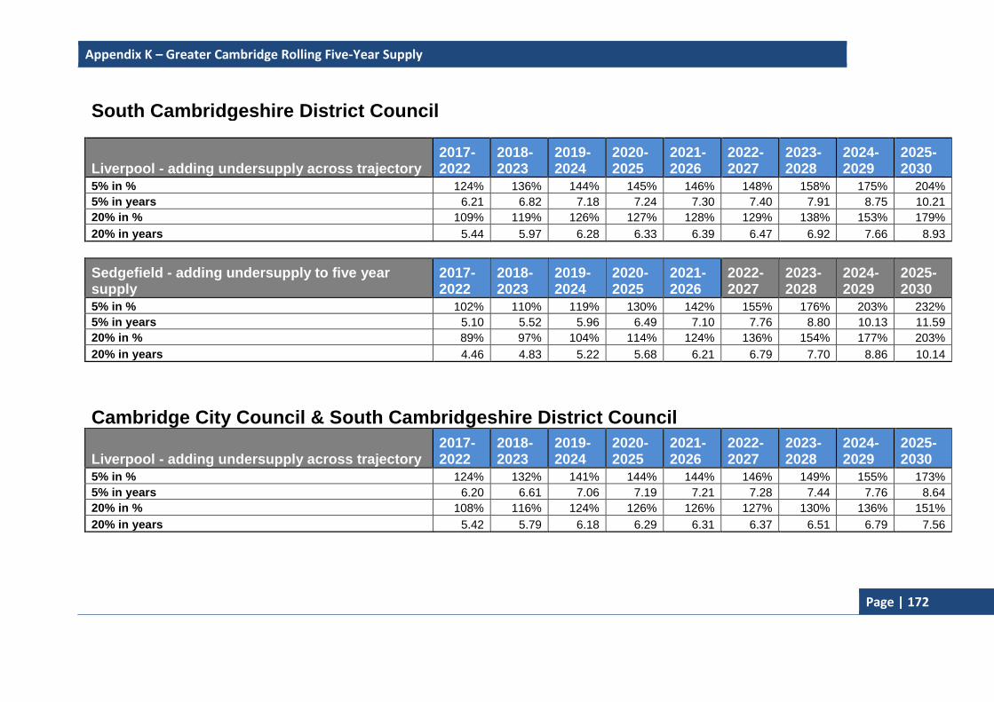
Appendix K – Greater Cambridge Rolling Five-Year Supply
Page | 172
South Cambridgeshire District Council
Liverpool - adding undersupply across trajectory 2017-2022
2018-2023
2019-2024
2020-2025
2021-2026
2022-2027
2023-2028
2024-2029
2025-2030
5% in % 124% 136% 144% 145% 146% 148% 158% 175% 204%
5% in years 6.21 6.82 7.18 7.24 7.30 7.40 7.91 8.75 10.21
20% in % 109% 119% 126% 127% 128% 129% 138% 153% 179%
20% in years 5.44 5.97 6.28 6.33 6.39 6.47 6.92 7.66 8.93
Sedgefield - adding undersupply to five year supply
2017-2022
2018-2023
2019-2024
2020-2025
2021-2026
2022-2027
2023-2028
2024-2029
2025-2030
5% in % 102% 110% 119% 130% 142% 155% 176% 203% 232%
5% in years 5.10 5.52 5.96 6.49 7.10 7.76 8.80 10.13 11.59
20% in % 89% 97% 104% 114% 124% 136% 154% 177% 203%
20% in years 4.46 4.83 5.22 5.68 6.21 6.79 7.70 8.86 10.14
Cambridge City Council & South Cambridgeshire District Council
Liverpool - adding undersupply across trajectory 2017-2022
2018-2023
2019-2024
2020-2025
2021-2026
2022-2027
2023-2028
2024-2029
2025-2030
5% in % 124% 132% 141% 144% 144% 146% 149% 155% 173%
5% in years 6.20 6.61 7.06 7.19 7.21 7.28 7.44 7.76 8.64
20% in % 108% 116% 124% 126% 126% 127% 130% 136% 151%
20% in years 5.42 5.79 6.18 6.29 6.31 6.37 6.51 6.79 7.56

Appendix K – Greater Cambridge Rolling Five-Year Supply
Page | 173
Sedgefield - adding undersupply to five year supply
2017-2022
2018-2023
2019-2024
2020-2025
2021-2026
2022-2027
2023-2028
2024-2029
2025-2030
5% in % 114% 125% 133% 142% 152% 165% 178% 190% 202%
5% in years 5.72 6.25 6.66 7.09 7.62 8.24 8.90 9.52 10.09
20% in % 100% 109% 117% 124% 133% 144% 156% 167% 177%
20% in years 5.00 5.46 5.83 6.21 6.67 7.21 7.78 8.33 8.83

Bibliography
Page | 174
Bibliography This bibliography includes:
Publications
Acts of Parliament, Statutory Instruments, White Papers, Guidance and Circulars
Online Articles and Data
Publications CAMBRIDGE CENTRE FOR HOUSING & PLANNING RESEARCH (2017) Assessment of
Student Housing Demand and Supply for Cambridge City Council. Cambridge: Cambridge Centre for Housing & Planning Research.
CAMBRIDGE CITY COUNCIL (CCC) (2006) Cambridge Local Plan – July 2006. Cambridge: Cambridge City Council
CAMBRIDGE CITY COUNCIL (CCC) (2007) Sustainable Design & Construction: Supplementary Planning Document – June 2007. Cambridge: Cambridge City Council
CAMBRIDGE CITY COUNCIL (CCC) (2008) Affordable Housing Supplementary Planning Document – January 2008. Cambridge: Cambridge City Council
CAMBRIDGE CITY COUNCIL (CCC) (2008a) Cambridge City Council Place Survey 2008. Cambridge: Cambridge City Council
CAMBRIDGE CITY COUNCIL (CCC) (2010a) Old Press/Mill Lane Supplementary Planning Document – January 2010. Cambridge: Cambridge City Council
CAMBRIDGE CITY COUNCIL (CCC) (2010b) Planning Obligations Strategy Supplementary Planning Document – March 2010. Cambridge: Cambridge City Council
CAMBRIDGE CITY COUNCIL (CCC) (2010c) Public Art: Supplementary Planning Document – January 2010. Cambridge: Cambridge City Council
CAMBRIDGE CITY COUNCIL (CCC) (2011a) Open Space and Recreation Strategy – October 2011. Cambridge: Cambridge City Council
CAMBRIDGE CITY COUNCIL (CCC) (2011b) Eastern Gate Development Framework Supplementary Planning document – October 2011. Cambridge: Cambridge City Council
CAMBRIDGE CITY COUNCIL (CCC) (2011c) Informal Planning Policy Guidance on Foodstore Provision in North West Cambridge - 2011. Cambridge: Cambridge City Council
CAMBRIDGE CITY COUNCIL (CCC) (2012a) Interim Planning Policy Guidance on the Protection of Public Houses in the City of Cambridge 2012. Cambridge: Cambridge City Council
CAMBRIDGE CITY COUNCIL (CCC) (2012b) Guidance for the application of Policy 3/13 (Tall Buildings and the Skyline) of the Cambridge Local Plan (2006): Cambridge City Council
CAMBRIDGE CITY COUNCIL (CCC) (2012c) Issues and Options Report – June 2012. Cambridge: Cambridge City Council

Bibliography
Page | 175
CAMBRIDGE CITY COUNCIL (CCC) (2013) Statement of Community Involvement – December 2013. Cambridge: Cambridge City Council
CAMBRIDGE CITY COUNCIL (CCC) (2013a) Cambridge Local Plan – Towards 2031: Issues & Options 2, Part 2 - Site Options Within Cambridge – January 2013. Cambridge: Cambridge City Council
CAMBRIDGE CITY COUNCIL (CCC) (2013b) Cambridge Local Plan 2014: Proposed Submission – July 2013. Cambridge: Cambridge City Council
CAMBRIDGE CITY COUNCIL AND SOUTH CAMBRIDGESHIRE DISTRICT COUNCIL (2008) Local Development Framework: Cambridge East Area Action Plan, Development Plan Document – Adopted February 2008. Cambourne: South Cambridgeshire District Council & Cambridge City Council
CAMBRIDGE CITY COUNCIL & SOUTH CAMBRIDGESHIRE DISTRICT COUNCIL (2009) North West Cambridge Area Action Plan: Local Development Plan Framework Development Plan Document – Adopted October 2009. Cambridge: Cambridge City Council
CAMBRIDGE CITY COUNCIL & SOUTH CAMBRIDGESHIRE DISTRICT COUNCIL (2013) Cambridge Local Plan – Towards 2031: Issues & Options 2, Part 1 – Joint Consultation on Development Strategy & Site Options on the Edge of Cambridge – January 2013.
CAMBRIDGESHIRE & PETERBOROUGH ENVIRONMENTAL RECORDS Centre (CPERC) (2015). Cambridgeshire & Peterborough Environmental Records Centre (CPREC) Annual Monitoring Report supporting information for Cambridge City Council – Reporting Year 2014/15. Cambridge: CPERC
CAMBRIDGESHIRE COUNTY COUNCIL AND PETERBOROUGH CITY COUNCIL (2003) Cambridgeshire & Peterborough Structure Plan 2003 – Planning for Success. Cambridgeshire: Cambridgeshire County Council and Peterborough City Council
CAMBRIDGESHIRE HORIZONS (2009) Strategic Housing Market Assessment. Cambridge: Cambridge Horizons
EAST OF ENGLAND Tourism (2008) Economic Impact of Tourism: Cambridge – 2007. Bury St Edmunds: East of England Tourism.
GOVERNMENT OFFICE FOR THE EAST OF ENGLAND (2008) East of England Plan: The Revision to the Regional Spatial Strategy for the East of England. London: TSO
SQW (2011). Cambridge Cluster at 50: Final Report to EEDA and Partners – March 2011. Cambridgeshire: SQW
SQW (2012) Cambridge and South Cambridgeshire Employment Land Review Update 2012. Cambridge: SQW.
PETER BRETT ASSOCIATES (PBA) (2015) Cambridge and South Cambridgeshire Objectively Assessed Housing Need: Further Evidence (November 2015). London: PBA.
Acts of Parliament, Statutory Instruments, White Papers, Guidance and Circulars
COMMUNITIES & LOCAL GOVERNMENT (CLG) (2008) Local Development Framework: Core Output Indicators – Update2/2008. London: TSO

Bibliography
Page | 176
COMMUNITIES & LOCAL GOVERNMENT (CLG) (2011b) Letter from Bob Neill MP – Preparation and Monitoring of Local Plans [online]. London: Communities and Local Government. Available at: http://www.communities.gov.uk/documents/planningandbuilding/pdf/1876440.pdf [Accessed November 2011]
COMMUNITIES & LOCAL GOVERNMENT (CLG) (2012) National Planning Policy Framework. London CLG
OFFICE OF THE DEPUTY PRIME MINISTER (2005a) Local Development Framework Monitoring: A Good Practice Guide. London: ODPM
GREAT BRITAIN (2004a) Planning & Compulsory Purchase Act 2004 (c.5)
GREAT BRITAIN (2004b) The Town and Country Planning (Local Development) (England) Regulations 2004. No.2204
GREAT BRITAIN (2008) Planning Act 2008. (c.29)
GREAT BRITAIN (2010) Community Infrastructure Levy Regulations 2010 No.948
GREAT BRITAIN (2010) The Town and Country Planning (Use Classes) (Amendment) (England) Order 2010, No. 653
GREAT BRITAIN (2011) Community Infrastructure Levy (Amendment) Regulations 2011, No.987
GREAT BRITAIN (2011) Localism Act 2011 (c.20)
GREAT BRITAIN (2012) Community Infrastructure Levy (Amendment) Regulations 2012, No.2975
GREAT BRITAIN (2012a) The Regional Strategy for the East of England (Revocation) Order 2012, No. 3046
GREAT BRITAIN (2013) Community Infrastructure Levy (Amendment) Regulations 2013, No.982
GREAT BRITAIN (2014) Community Infrastructure Levy (Amendment) Regulations 2014, No.385
Online Articles and Data ANGLIA RUSKIN UNIVERSITY (2017) Student Snapshots 2016 [online]. Available at:
https://www.anglia.ac.uk/about-us/equality-diversity-and-inclusion/aru-student-snapshots [Accessed November 2017]
BIDWELLS (2014) Bidwells Databook – Spring 2014 [online]. Available at: http://www.bidwells.co.uk/research [Accessed November 2014]
CAMBRIDGE CITY COUNCIL (CCC) (2011) Citizens’ Survey [online]. Available at: https://www.cambridge.gov.uk/citizens-survey [Accessed November 2015]
CAMBRIDGE CITY COUNCIL (CCC) (2016) Residents’ Survey [online]. Available at: https://www.cambridge.gov.uk/sites/default/files/residents-survey-2016-report.pdf [Accessed September 2017]
CAMBRIDGE CITY COUNCIL (CCC) (2016) Key Statistics June 2017 – Strategic Housing [online]. Available at: https://www.cambridge.gov.uk/housing-research [Accessed September 2017]

Bibliography
Page | 177
CAMBRIDGE CITY COUNCIL (CCC) (2014a) Conservation Area Appraisals [online]. Available at: https://www.cambridge.gov.uk/conservation-areas [Accessed November 2013]
CAMBRIDGE CITY COUNCIL (CCC) (2014b) Draft Affordable Housing SPD [online]. Available at: https://www.cambridge.gov.uk/affordable-housing-spd [Accessed November 2014]
CAMBRIDGE CITY COUNCIL (CCC) (2016) Historic core conservation appraisal https://www.cambridge.gov.uk/historic-core-appraisal [accessed November 2017]
CAMBRIDGE CITY COUNCIL (CCC) (2017) Storey's Way conservation area appraisal review consultation https://www.cambridge.gov.uk/consultations/storeys-way-conservation-area-appraisal-review-consultation [accessed November 2017]
CAMBRIDGE NETWORK [2016] Visit Cambridge and Beyond launches to boost Cambridge tourism https://www.cambridgenetwork.co.uk/news/visit-cambridge-and-beyond-launches-to-boost-cambridge-tourism/ [accessed November 2017]
CAMBRIDGE CITY COUNCIL (CCC) (2014c) Draft Planning Obligations Strategy SPD [online]. Available at: https://www.cambridge.gov.uk/planning-obligations-strategy-spd [Accessed November 2014]
CAMBRIDGE CITY COUNCIL (CCC) (2014c) Cambridge Northern Fringe East Area Action Plan [online]. Available at: https://www.cambridge.gov.uk/cambridge-northern-fringe-east-area-action-plan [Accessed November 2014]
CAMBRIDGESHIRE COMMUNITY SAFETY PARTNERSHIP (2014) Strategic Partnership [online]. Available: https://www.cambridge.gov.uk/cambridge-community-safety-partnership [Accessed: November 2014]
CAMBRIDGESHIRE COUNTY COUNCIL (2011) Gypsy and Traveller Accommodation Needs Assessment [online] Cambridge: Cambridgeshire County Council. Available at: http://www.cambridgeshireinsight.org.uk/housing/gypsy-and-traveller-accommodation-needs-assessment [Accessed: November 2015]
CAMBRIDGESHIRE COUNTY COUNCIL (2017a) Monitoring housing, business and renewable energy development [online] Cambridge: Cambridgeshire County Council Research Group. Available at: https://www.cambridgeshire.gov.uk/business/planning-and-development/planning-applications/monitoring-housing-business-and-renewable-energy-development/ [Accessed August 2017].
CAMBRIDGESHIRE COUNTY COUNCIL (2016b) Business Development [online] Cambridge: Cambridgeshire County Council Research Group. Available at: http://www.cambridgeshire.gov.uk/info/20099/planning_and_development/234/planning/9 [Accessed November 2016].
CAMBRIDGESHIRE COUNTY COUNCIL (2013c) Cambridgeshire and Peterborough Minerals and Waste Local Development Framework [online].Available at: http://www.cambridgeshire.gov.uk/environment/planning/mineralswasteframework/ [Accessed December 2013]
CAMBRIDGESHIRE COUNTY COUNCIL (2014) Transport Strategy for Cambridge and South Cambridgeshire [online].Available at:

Bibliography
Page | 178
http://www.cambridgeshire.gov.uk/info/20006/travel_roads_and_parking/66/transport_plans_and_policies/2 [Accessed November 2014]
CAMBRIDGESHIRE COUNTY COUNCIL (2017) Renewable Commitments and Completions [online] Cambridge: Cambridgeshire County Council Research Group. Available at: https://www.cambridgeshire.gov.uk/business/planning-and-development/planning-applications/monitoring-housing-business-and-renewable-energy-development/ [Accessed August 2017].
CAMBRIDGESHIRE COUNTY COUNCIL (2015a) Housing Development [online] Cambridge: Cambridgeshire County Council Research Group. Available at: http://www.cambridgeshire.gov.uk/info/20099/planning_and_development/234/planning/8 [Accessed November 2015].
CAMBRIDGESHIRE INSIGHT (2006) Employment in the High-Tech “Community” Cambridgeshire & Peterborough 2006 [online] Cambridge: Cambridgeshire County Council. Available at: http://www.cambridgeshireinsight.org.uk/economy/employment [Accessed November 2015]
CAMBRIDGESHIRE INSIGHT (2016) Housing Market Bulletin [online] Cambridge: Cambridgeshire County Council Research Group. Available at: http://cambridgeshireinsight.org.uk/Housingmarketbulletin July 2017 [Accessed November 2017].
CAMBRIDGESHIRE INSIGHT (2017a) Mid-2015 Population Estimates [online] Cambridge: Cambridgeshire County Council Research Group. Available at: http://www.cambridgeshireinsight.org.uk/ [Accessed August 2017].
COMMUNITIES AND LOCAL GOVERNMENT (CLG) (2015) English Indices of Deprivation 2015 [online]. Available at: https://www.gov.uk/government/statistics/english-indices-of-deprivation-2015. [Accessed October 2015]
ENVIRONMENT AGENCY (2017) Environment Agency Objections on Flood Risk and Water Quality grounds for 2016/17 [online]. Available at: https://www.gov.uk/government/publications/environment-agency-objections-to-planning-on-the-basis-of-flood-risk [Accessed November 2017].
GOV.UK (2013) Housing Standards Review Consultation [online]. Available at: https://www.gov.uk/government/consultations/housing-standards-review-consultation [Accessed December 2013)
GVA (2013) Cambridge Retail and Leisure Update 2013 – May 2013 [online]. Available at: https://www.cambridge.gov.uk/sites/www.cambridge.gov.uk/files/documents/Cambridge%20Retail%20and%20Leisure%20Update%202013%20with%20Apps.pdf [Accessed September 2017]
MARSHALL (2013) Cambridge International Airport [online] http://www.marshallairportcambridge.co.uk/ [Accessed November 2010]
NOMIS (2017) Nomis official labour market statistics [online] https://www.nomisweb.co.uk/ [Accessed August 2017]

Bibliography
Page | 179
NOMIS (2017) Business Register and Employment Survey 2016 [online] https://www.ons.gov.uk/employmentandlabourmarket/peopleinwork/employmentandemployeetypes/datasets/localauthoritydistrictbusinessregisterandemploymentsurveybrestable6 [Accessed November 2017]
OFFICE FOR NATIONAL STATISTICS (ONS) (2011) Census Data (2001 & 2011) [online] London: Office for National Statistics. Available at: http://www.statistics.gov.uk/census2001/census2001.asp [Accessed November 2013].
SOUTH CAMBRIDGESHIRE DISTRICT COUNCIL (2013) South Cambridgeshire Local Plan: Proposed Submission – July 2013 [online]. Available at: https://www.scambs.gov.uk/localplan [Accessed November 2013)
UNIVERSITY OF CAMBRIDGE (2017) Total matriculated student population [online] https://www.prao.admin.cam.ac.uk/data-analysis-planning/student-numbers/time-series [Accessed November 2017]
VISIT BRITAIN [2017] Top towns for 'staying visits' by inbound visitors https://www.visitbritain.org/town-data [Accessed November 2017]
VISIT CAMBRIDGE & BEYOND [2017]

Bibliography
Page | 180