camber car park to dengemarsh gully, dungeness · coastal access camber to folkestone natural...
TRANSCRIPT
Coastal Access | Camber to Folkestone | Natural England’s Proposals | Chapter 1: Camber car park to Dengemarsh Gully, Dungeness
www.naturalengland.org.uk
Chapter 1:
Camber car park to Dengemarsh Gully, DungenessCoastal Access: Camber to Folkestone - Natural England’s Proposals
Part 1.1: Introduction
Start Point: Camber car park (grid reference: TQ9646 1855)
End Point: End of Dengemarsh Gully, Dungeness (grid reference: TR0650 1672)
Relevant Maps: 1a to 1i
Understanding the proposals and accompanying maps:
The Trail:
1.1.1 Generally follows existing walked routes, including public rights of way and promoted routes, along most of this length.
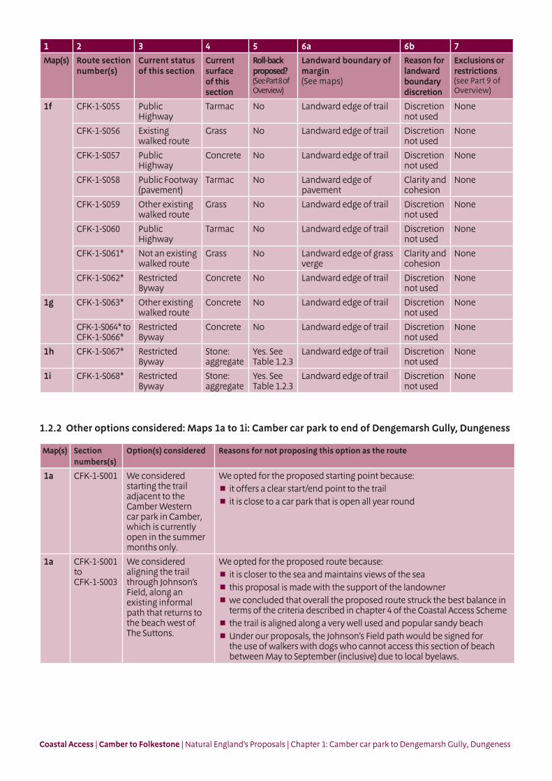
1.1.2 In East Sussex, is aligned on the beach between Camber car park and the Broomhill Sands sea defence wall. The trail runs above the Mean High Water Mark where at all possible and to the seaward side of the dunes, beach houses and businesses.
1.1.3 Follows the coastline closely between Camber and Jury’s Gap, maintaining good views of the sea.
1.1.4 Is incorporated into the design for a new Environment Agency Broomhill Sands sea defence scheme between Camber and Jury’s Gap, that is due to be completed during 2015.
1.1.5 Includes a significant inland route between Jury’s Gap and the end of Dengemarsh Gully, Dungeness. This diversion via Lydd town is necessary to bypass the Lydd Military Ranges, which are automatically excepted from coastal access rights due to their military byelaws (see Overview Part 5a). Along some of this inland route, there are distant sea views, and the coastal nature of the area is still evident at a significant distance from the shoreline, due to the unique landscape of vegetated shingle. (See Future Change, below and Part 8 of the Overview).
1.1.6 Follows part of the existing Sustrans National Cycle Network (Route 2) between Jury’s Gap and Lydd town.
1.1.7 This part of the coast includes the following sites, designated for nature conservation or heritage preservation (See map C of the Overview):
Dungeness Special Area of Conservation (SAC)
Dungeness, Romney Marsh and Rye Bay potential Special Protection Area (pSPA)
Dungeness, Romney Marsh and Rye Bay proposed Ramsar site (pRamsar)
Dungeness, Romney Marsh and Rye Site of Special Scientific Interest (SSSI) for its geological /wildlife interest
Coastal Access | Camber to Folkestone | Natural England’s Proposals | Chapter 1: Camber car park to Dengemarsh Gully, Dungeness
We have assessed the potential impacts of access along the proposed route (and over the associated spreading room described below) on the features for which the affected land is designated and on any which are protected in their own right.
1.1.8 After advice from specialists we have concluded that our proposals would not be likely to have any significant impact on these features. In reaching this conclusion we have identified that it would be necessary to provide signage at points along Dengemarsh Gully to emphasise the trail route and deter trampling of the adjacent, sensitive vegetated shingle. This proposal is explained further in parts 5b & 9 of the Overview.
1.1.9 The patterns of public access along this length of coast would be unlikely to change significantly as a result of our proposals and we have therefore concluded that our proposals would not be likely to have any significant impact on these features.
In relation to those nature conservation sites listed above, refer to our published Access and Sensitive Features Appraisal for more information.
See part 5b of the Overview - ‘Natural environment’ - for more information.
Accessibility:
1.1.10 Generally, there are few artificial barriers to accessibility on the proposed route, which makes use of existing surfaced paths wherever these meet the criteria in the Coastal Access Scheme. However, there are places where it may not be entirely suitable for people with reduced mobility because:
The trail would follow a stretch of sandy beach near the start of the trail at Camber Sands, along sections CFK-1-S001 to CFK-1-S003.
At the eastern edge of Camber, the trail sections CFK-1-S004 to CFK-1-S028, would follow the top of a new, wide shingle beach (part of the proposed Environment Agency’s Broomhill Sands sea defence scheme) for approximately 400m before joining the hard sea defences along the coast to Jury’s Gap. See Table 1.2.2 for the options considered here.
1.1.11 Route sections CFK-1-S001 to CFK-1-S003 cross Camber Sands beach, where Rother District Council excludes dogs between May and September (inclusive). As a consequence, we are minded to sign another route to take dog walkers around this beach. This will follow an existing walked track and path through Johnson’s Field, between Camber car park and the public footpath to the beach west of The Suttons, as shown on map 1a. Signs within the car park and by The Suttons will alert walkers to this route.
1.1.12 At Jury’s Gap, the existing informal path between the sea defence and the road crossing will be improved with a ramp, to make it easier to use. We envisage this happening as part of the Environment Agency’s Broomhill Sands sea defence scheme.
See part 5a of the Overview - ‘Recreational issues’ - for more information.
Where we have proposed exercising our discretion:
The discretions referred to below are explained in more detail in the Overview.
1.1.13 Landward boundary of the coastal margin: We have used our discretion on some sections of the route to map the landward extent of the coastal margin to an adjacent physical boundary such as a fence line, pavement or track to make the extent of the new access rights clearer. See Table 1.2.1 below.
1.1.14 In one place (Camber), we have used our discretion to propose the inclusion of an additional, more extensive landward area within the coastal margin, to secure or enhance public enjoyment of this part of the coast. The owners of this land are content for us to propose this.
See also part 3 of the Overview - ‘Understanding the proposals and accompanying maps’, for an explanation of the default extent of the coastal margin and how we may use our discretion to adjust the margin, either to add land or to provide clarity. See also Annex C of the Overview - ‘Excepted land categories’.
Coastal Access | Camber to Folkestone | Natural England’s Proposals | Chapter 1: Camber car park to Dengemarsh Gully, Dungeness
1.1.15 Restrictions and/or exclusions: Access rights to the spreading room would be subject to the national restrictions on coastal access rights listed in Annex D of the Overview. These restrictions would not apply to public rights of way.
1.1.16 Development of the Broomhill Sands sea defence scheme near Camber is due to be completed in 2015. These works are expected to be completed before the trail is opened. If works are still ongoing, we would work with the Environment Agency and East Sussex County Council to utilise informal techniques or temporary restrictions between sections CFK-1-S004 to CFK-1-S032 to provide a continuous route and avoid disrupting construction work.
See part 9 of the Overview - ‘Restrictions and exclusions’ - for details.
1.1.17 Other factors affecting access: From time to time along the beach at Camber, public access may be interrupted for short periods to allow the Environment Agency to carry out maintenance works. This arrangement would continue without any local restrictions on the new access rights to give effect to it formally.
1.1.18 Establishment: Some physical establishment of the trail would be necessary, in accordance with the general approach described in part 6 the Overview. This includes clear signage and distance markers to ensure walkers are aware of the inland route of the trail around Lydd Military Ranges and the provision of signage at Camber car park to highlight the route for dog walkers.
1.1.19 Significant works are being carried out by the Environment Agency during 2014 and 2015 along Broomhill Sands Sea defence scheme near Camber. These will benefit walkers and provide a clearer and easier line to follow along the coast. The Environment Agency plan to improve access between the sea defence wall and the main road, at Jury’s Gap, as part of this scheme.
1.1.20 Ongoing management and maintenance would be necessary in accordance with the general approach described in part 7 of the Overview.
See parts 6 - ‘Physical establishment of the trail’ and 7 - ‘Maintenance of the trail’ of the Overview for more information.
Future Change:
1.1.21 Parts of the route of the trail on this length of coast would be able to change without further approval from the Secretary of State in response to coastal erosion or other geomorphological processes, or encroachment by the sea. This would happen in accordance with the criteria and procedures for ‘roll back’ set out in part 8 of the Overview. See Table 1.2.1 below for details of the sections likely to be affected in the foreseeable future.
1.1.22 There are also places on the length of coast described in this chapter where it might be necessary or desirable in the future for us to propose variations to these access provisions (subject to approval from the Secretary of State) should either of these specific situations arise:
if changes were ever announced regarding the use of the military ranges at Lydd that would allow improved access along the coast or nearer to the coast between Dungeness and Jury’s Gap; or
if any changes were made to the status of land over which the trail passes as a consequence of any future review of military byelaws.
These are summarised at part 8 of the Overview.
See parts 5e - ‘Coastal processes’ and 8 - ‘Future changes’ of the Overview for more information.
Coastal Access | Camber to Folkestone | Natural England’s Proposals | Chapter 1: Camber car park to Dengemarsh Gully, Dungeness
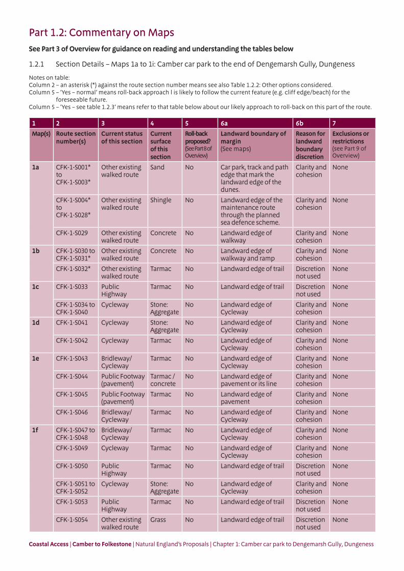
Part 1.2: Commentary on MapsSee Part 3 of Overview for guidance on reading and understanding the tables below
1.2.1 Section Details – Maps 1a to 1i: Camber car park to the end of Dengemarsh Gully, Dungeness
Notes on table:Column 2 – an asterisk (*) against the route section number means see also Table 1.2.2: Other options considered.Column 5 – ‘Yes – normal’ means roll-back approach l is likely to follow the current feature (e.g. cliff edge/beach) for the
foreseeable future.Column 5 – ‘Yes – see table 1.2.3’ means refer to that table below about our likely approach to roll-back on this part of the route.
1 2 3 4 5 6a 6b 7
Map(s) Route section number(s)
Current status of this section
Current surface of this section
Roll-back proposed?(See Part 8 of Overview)
Landward boundary of margin (See maps)
Reason for landward boundary discretion
Exclusions or restrictions(see Part 9 of Overview)
1a CFK-1-S001* to CFK-1-S003*
Other existing walked route
Sand No Car park, track and path edge that mark the landward edge of the dunes.
Clarity and cohesion
None
CFK-1-S004* to CFK-1-S028*
Other existing walked route
Shingle No Landward edge of the maintenance route through the planned sea defence scheme.
Clarity and cohesion
None
CFK-1-S029 Other existing walked route
Concrete No Landward edge of walkway
Clarity and cohesion
None
1b CFK-1-S030 to CFK-1-S031*
Other existing walked route
Concrete No Landward edge of walkway and ramp
Clarity and cohesion
None
CFK-1-S032* Other existing walked route
Tarmac No Landward edge of trail Discretion not used
None
1c CFK-1-S033 Public Highway
Tarmac No Landward edge of trail Discretion not used
None
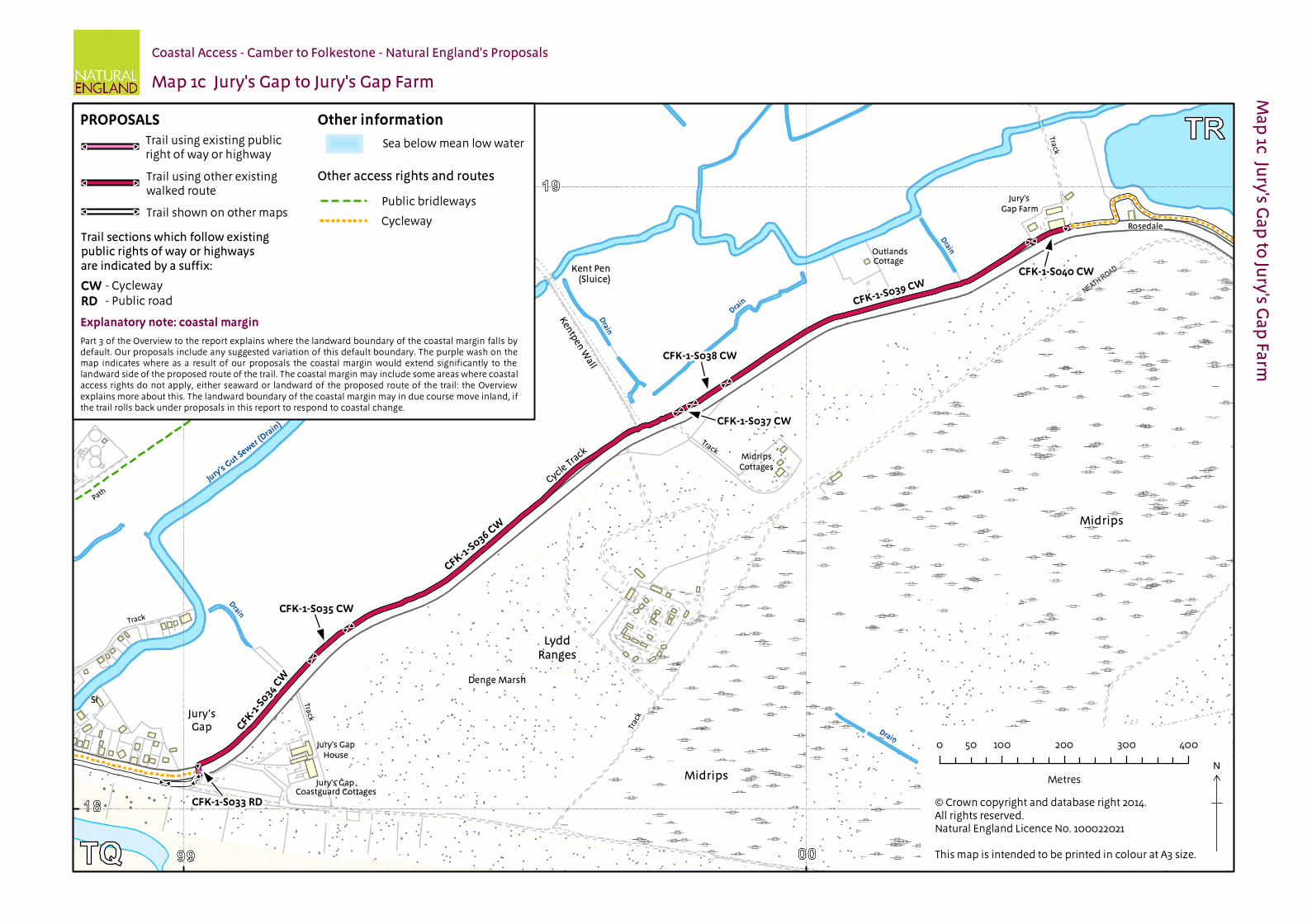
CFK-1-S034 to CFK-1-S040
Cycleway Stone: Aggregate
No Landward edge of Cycleway
Clarity and cohesion
None
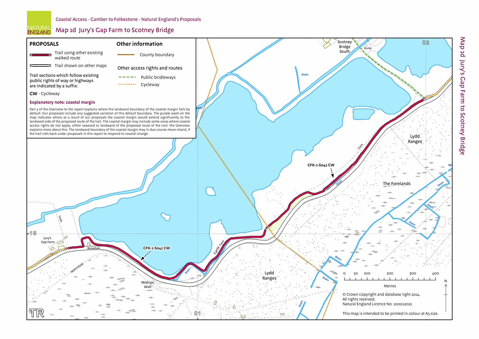
1d CFK-1-S041 Cycleway Stone: Aggregate
No Landward edge of Cycleway
Clarity and cohesion
None
CFK-1-S042 Cycleway Tarmac No Landward edge of Cycleway
Clarity and cohesion
None
1e CFK-1-S043 Bridleway/Cycleway
Tarmac No Landward edge of Cycleway
Clarity and cohesion
None
CFK-1-S044 Public Footway (pavement)
Tarmac / concrete
No Landward edge of pavement or its line
Clarity and cohesion
None
CFK-1-S045 Public Footway (pavement)
Tarmac No Landward edge of pavement
Clarity and cohesion
None
CFK-1-S046 Bridleway/Cycleway
Tarmac No Landward edge of Cycleway
Clarity and cohesion
None
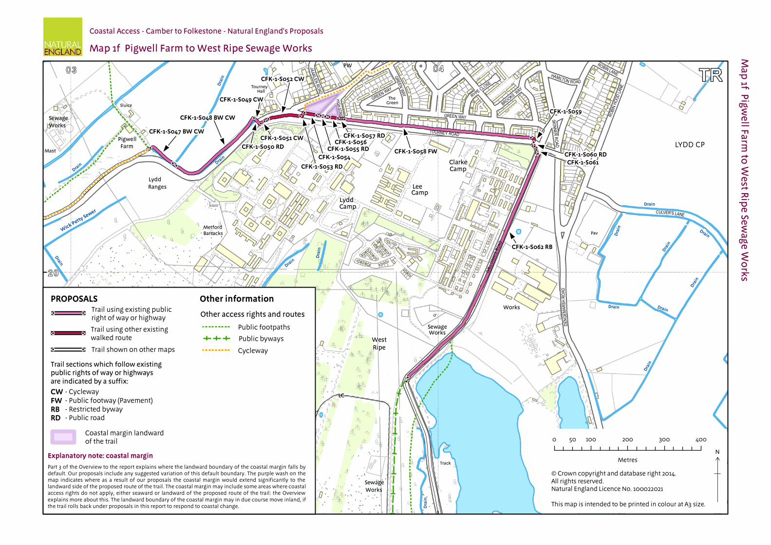
1f CFK-1-S047 to CFK-1-S048
Bridleway/Cycleway
Tarmac No Landward edge of Cycleway
Clarity and cohesion
None
CFK-1-S049 Cycleway Tarmac No Landward edge of Cycleway
Clarity and cohesion
None
CFK-1-S050 Public Highway
Tarmac No Landward edge of trail Discretion not used
None
CFK-1-S051 to CFK-1-S052
Cycleway Stone: Aggregate
No Landward edge of Cycleway
Clarity and cohesion
None
CFK-1-S053 Public Highway
Tarmac No Landward edge of trail Discretion not used
None
CFK-1-S054 Other existing walked route
Grass No Landward edge of trail Discretion not used
None
Coastal Access | Camber to Folkestone | Natural England’s Proposals | Chapter 1: Camber car park to Dengemarsh Gully, Dungeness
1 2 3 4 5 6a 6b 7
Map(s) Route section number(s)
Current status of this section
Current surface of this section
Roll-back proposed?(See Part 8 of Overview)
Landward boundary of margin (See maps)
Reason for landward boundary discretion
Exclusions or restrictions(see Part 9 of Overview)
1f CFK-1-S055 Public Highway
Tarmac No Landward edge of trail Discretion not used
None
CFK-1-S056 Existing walked route
Grass No Landward edge of trail Discretion not used
None
CFK-1-S057 Public Highway
Concrete No Landward edge of trail Discretion not used
None
CFK-1-S058 Public Footway (pavement)
Tarmac No Landward edge of pavement
Clarity and cohesion
None
CFK-1-S059 Other existing walked route
Grass No Landward edge of trail Discretion not used
None
CFK-1-S060 Public Highway
Tarmac No Landward edge of trail Discretion not used
None
CFK-1-S061* Not an existing walked route
Grass No Landward edge of grass verge
Clarity and cohesion
None
CFK-1-S062* Restricted Byway
Concrete No Landward edge of trail Discretion not used
None
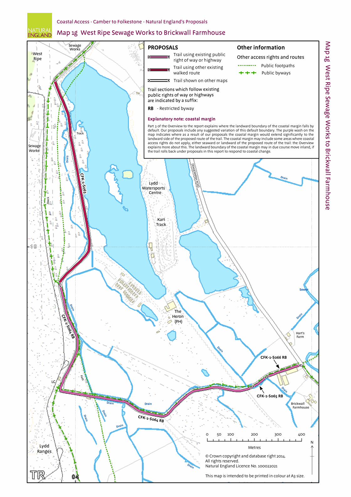
1g CFK-1-S063* Other existing walked route
Concrete No Landward edge of trail Discretion not used
None
CFK-1-S064* to CFK-1-S066*
Restricted Byway
Concrete No Landward edge of trail Discretion not used
None
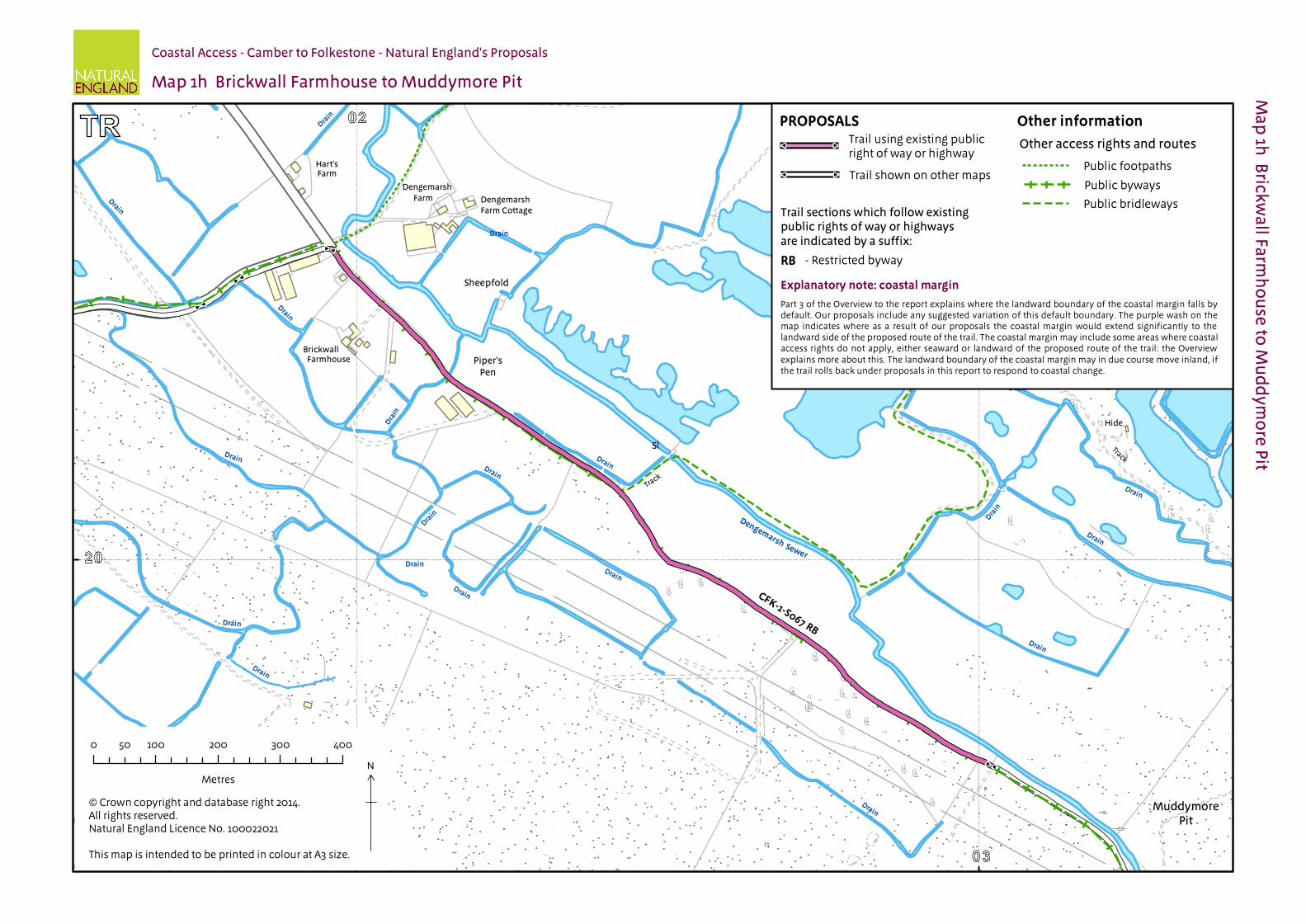
1h CFK-1-S067* Restricted Byway
Stone: aggregate
Yes. See Table 1.2.3
Landward edge of trail Discretion not used
None
1i CFK-1-S068* Restricted Byway
Stone: aggregate
Yes. See Table 1.2.3
Landward edge of trail Discretion not used
None
1.2.2 Other options considered: Maps 1a to 1i: Camber car park to end of Dengemarsh Gully, Dungeness
Map(s) Section numbers(s)
Option(s) considered Reasons for not proposing this option as the route
1a CFK-1-S001 We considered starting the trail adjacent to the Camber Western car park in Camber, which is currently open in the summer months only.
We opted for the proposed starting point because: it offers a clear start/end point to the trail it is close to a car park that is open all year round
1a CFK-1-S001 to CFK-1-S003
We considered aligning the trail through Johnson’s Field, along an existing informal path that returns to the beach west of The Suttons.
We opted for the proposed route because: it is closer to the sea and maintains views of the sea this proposal is made with the support of the landowner we concluded that overall the proposed route struck the best balance in
terms of the criteria described in chapter 4 of the Coastal Access Scheme the trail is aligned along a very well used and popular sandy beach Under our proposals, the Johnson’s Field path would be signed for
the use of walkers with dogs who cannot access this section of beach between May to September (inclusive) due to local byelaws.
Coastal Access | Camber to Folkestone | Natural England’s Proposals | Chapter 1: Camber car park to Dengemarsh Gully, Dungeness
Map(s) Section numbers(s)
Option(s) considered Reasons for not proposing this option as the route
1a CFK-1-S004 to CFK-1-S028
We considered aligning the trail:
Along the private street, behind The Suttons houses;
Through Johnson’s Field and along Lydd Road
We opted for the proposed route because: it is closer to the sea and maintains views of the sea; it is aligned along an existing walked route on a very well used beach; changes being planned as part of the Environment Agency’s new
Broomhill Sands sea defence scheme will incorporate and clearly define the trail. An existing walked line along the top of the current, eroded shingle beach runs close to The Suttons beach gardens. The planned sea defence scheme will create a much wider beach crest than currently exists, taking the trail further from the houses than the current path;
the trail is aligned to a 5m wide ‘maintenance gap’ in the planned groynes structure of the new sea defences, designed to be at a reasonable distance from the edge of private gardens;
the new sea defences have removed initial concerns regarding the safety of the eroded beach during high tides and storms;
we concluded that overall the proposed route struck the best balance in terms of the criteria described in chapter 4 of the Coastal Access Scheme;
any of the inland route options would in any case create coastal access rights along the beach and the proposed alignment.
1b CFK-1-S031 to CFK-1-S032
We considered aligning the trail further east along the Broomhill Sands sea defence wall towards Jury’s Gap, with the trail utilising the existing ramp near to the Jury’s Gap cottages to leave the sea wall.
We opted for the proposed route because: this follows a direct and informal path between the sea wall and the road
crossing point; it is aligned away from the private access track of the Jury’s Gap cottages; we concluded that overall the proposed route struck the best balance in
terms of the criteria described in chapter 4 of the Coastal Access Scheme.
1f to 1g
CFK-1-S061 to CFK-1-S066
We considered aligning the trail along Tourney Road and south along Dengemarsh Road, in Lydd.
We opted for the proposed route because: this follows a quiet, private track rather than the busier Dengemarsh Road; it is aligned, in large part, to rights of way; it has existing use by walkers; we concluded that overall the proposed route struck the best balance in
terms of the criteria described in chapter 4 of the Coastal Access Scheme
1h, 1i, 2a and 2b
CFK-1-S067 to CFK-2-S007 (see map 2b)
We considered aligning the trail across the Dungeness shingle from Dengemarsh Road towards Dungeness point, landward of the power stations.
We opted for the proposed route because: it is closer to the sea and maintains views of the sea; it follows existing rights of way that have current use; walking across the shingle for such a distance would be more difficult
than the proposed route; a new, promoted route along this line would have an unacceptable
impact on the vegetated shingle vegetation of this European designated site;
we concluded that overall the proposed route struck the best balance in terms of the criteria described in chapter 4 of the Coastal Access Scheme.
1.2.3 Roll-back implementation – more complex situations: Maps 1h to 1i: Dengemarsh Gully, Dungeness
Map(s) Section numbers(s)
Feature or site potentially affected
How we will manage roll-back in relation to this feature or site
1h, 1i, 2a and 2b
CFK-1-S067 to CFK-1-S068
Dungeness National Nature Reserve
If it is no longer possible to find a viable route in front of the nuclear power stations at Dungeness point (see chapter 2 for details), we will choose a new route to pass somewhere to the landward side. Detailed discussions with all relevant interests would take place in finding an appropriate route and we would take full regard of the need to seek a fair balance between the interests of potentially affected owners and occupiers and those of the public, and to consider impacts on the sensitivities of European designated sites in the area.
Coastal Access | Camber to Folkestone | Natural England’s Proposals | Chapter 1: Camber car park to Dengemarsh Gully, Dungeness
Part 1.3: Chapter 1 - Formal Proposals Below are our formal proposals to the Secretary of State for the length of coast shown on maps 1a to 1i.
They should be read in conjunction with the relevant maps.
The commentary above explains the practical effect of these proposals.
Formal Proposals – Camber car park to Dengemarsh Gully, Dungeness
Proposed route of the trail
1.3.1 In relation to route sections CFK-1-S001 to CFK-1-S066, the route is to be at the centre of the line shown on maps 1a to 1g as the proposed route of the trail.
1.3.2 In relation to route sections CFK-1-S067 to CFK-1-S068, the initial proposed route, as determined at the time the report was prepared, is to be at the centre of the line shown on map 1h and 1i as the proposed route of the trail.
1.3.3 If at any time any part of the route described in the previous paragraph needs to change in order to remain viable, as a result of coastal erosion or other geomorphological processes or encroachment by the sea, the new route will be determined by Natural England in accordance with the criteria and procedures described under the title ‘Roll-back’ in part 8 of the Overview and section 4.10 of the Scheme. If this happens, the new route will become the approved route for that section for the purposes of the Order which determines where coastal access rights apply.
Landward boundary of coastal margin
1.3.4 Adjacent to route sections CFK-1-S001 to CFK-1-S003, the landward boundary of the coastal margin is to coincide with a combination of the seaward edges of Camber car park and track and paths across Johnson’s Field, as indicated by the coastal margin landward of the trail on map 1a.
1.3.5 Adjacent to route sections CFK-1-S004 to CFK-1-S028, the landward boundary of the coastal margin is to coincide with the landward edge of a new maintenance route through beach groynes along the top of the shingle beach, marked by wooden posts, shown as the trail on map 1a.
1.3.6 Adjacent to route sections CFK-1-S029 to CFK-1-S031, the landward boundary of the coastal margin is to coincide with landward edge of the concrete walkway shown as the trail on maps 1b and 1c.
1.3.7 Adjacent to route sections CFK-1-S034 to CFK-1-S049 and CFK-1-S051 to CFK-1-S052, the landward boundary of the coastal margin is to coincide with landward edge of the Cycleway track shown as the trail on maps 1c to 1f.
1.3.8 Adjacent to route section CFK-1-S058, the landward boundary of the coastal margin is to coincide with landward edge of the pavement shown as the trail on map 1f.
1.3.9 Adjacent to route section CFK-1-S061, the landward boundary of the coastal margin is to coincide with landward edge of the verge shown as the trail on map 1f.
1.3.10 Adjacent to route sections CFK-1-S062 to CFK-1-S068, the landward boundary of the coastal margin is to coincide with landward edge of the track shown as the trail on maps 1f to 1i.
Local restrictions and exclusions
1.3.11 At the time of writing this report, there are no proposals for local restrictions or exclusions in relation to this length of coast.
#
#
#
#
#
#
#
#
#
#
#
#
#
#
#
#
#
#
#
#
#
#
#
#
#
#
#
#
#
#
#
#
#
#
#
#
#
#
#
#
#
#
#
#
#
#
#
#
#
#
#
#
#
#
#
#
#
#
#
#
#
#
#
#
#
#
#
#
#
#
#
#
#
#
#
#
#
#
#
#
#
#
#
#
#
#
#
#
#
#
#
#
#
#
P. J. C.
DENHAM WAY
YATES CLOS E
LYDD ROAD
DN . W.
SEA ROADOLD
DUNES
AVENUE
S AUND ER S WAY
DANIEL WAY
SECOND AVENUE
MARCH ANTS
DRIVE
THE SUTTONS
PELWOOD ROAD
LYDD ROAD
PH
ExTel
Marine
FB
Car
Mast
Sand
Park
Park
Path
Park
Pa
th
Path
PathPa
th
Pa
th
Trac
k
Dunes
Dunes
Holiday
Caravan
Groynes
Car Park
CampSite
Cottages
Cottages
Broomhill Farm
Broomhill Farm
PO
Drain
Drain
Drain
Drain
Drain
Drain
Drain
Guldeford
Sewer (Drain)
Mean Low Water
Map 1a Camber car park to Broomhill Farm
Ma
p 1a
Cam
be
r car p
ark
to B
roo
mh
ill Farm
Coastal Access - Camber to Folkestone - Natural England's Proposals
N
×
CFK-1-S001
CFK-1-S002
CFK-1-S003
CFK-1-S003
CFK-1-S029
#
#
# #
# #
# #
#
#
# #
#
#
# #
#
#
#
#
# #
# #
#
#
# #
#
#
#
#
#
#
# #
# #
#
## #
# #
#
#
# #
#
#
#
#
# #
#
#
# #
#
#
# #
#
## #
# #
# #
#
#
#
#
#
#
#
#
# #
# #
# #
#
#
#
#
#
#
# #
# #
#
#
# #
# #
#
#
#
#
CFK
-1-S00
4
CFK
-1-S00
5C
FK-1-S0
06
CFK
-1-S00
7
CFK
-1-S00
8C
FK-1-S0
09
CFK
-1-S010
CFK
-1-S011
CFK
-1-S012
CFK
-1-S013
CFK
-1-S014
CFK
-1-S015
CFK
-1-S016
CFK
-1-S017
CFK
-1-S018
CFK
-1-S019
CFK
-1-S020
CFK
-1-S021
CFK
-1-S022
CFK
-1-S023
CFK
-1-S024
CFK
-1-S025
CFK
-1-S026
CFK
-1-S027
CFK
-1-S028
#
#
THE SUTTONS
Camber
Johnson'sField
Explanatory note: coastal margin
PROPOSALS
#
#
#
#
Other information
Other access rights and routes
Mean High Water
Broomhill Sands

#
#
#
#
#
#
# #
##
#
#
#
#
#
#
# #
##
LYDD ROAD
Sl
Mast
Path
Path
Park
Track
Track
Track
Track
WorksSewage
Sluice
Holiday
Caravan
Groynes
Car Park
Cottages
Jury's Gap
Broomhill Farm
Broomhill Farm
Jury's GapHouse
Coastguard Cottages
Jury'sGut
Jury'sGap
Broomhill Sands
Drain
Drain
Drain
Drain
Drain
Drain
Drain
Drain
Drain
Drain
Sewer (Drain)
Mean Low Water
Jury
's Gut S
ewer (Dra
in)
Map 1b Broomhill Farm to Jury's Gap
Ma
p 1b
Bro
om
hill Fa
rm to
Jury
's Ga
pCoastal Access - Camber to Folkestone - Natural England's Proposals
Other informationPROPOSALS
#
#
#
#
Explanatory note: coastal margin
N
×
CFK-1-S031
CFK-1-S030
CFK-1-S032
Other access rights and routes
Mean Low Water Mark
Mean High Water
#
#
#
#
#
#
# #
##
#
# #
# #
#
#
#
#
#
#
# #
# #
# #
# #
#
#
#
#
#
#
#
NEATH ROAD
Drain
Drain
Drain
Drain
Drain
Drain
Drain
Drain
Jury
's Gut S
ewer (Dra
in)
Other informationPROPOSALS
#
#
N
×
CFK-1-S
034 CW
CFK-1-S035 CW
CFK-1-S036 C
W
CFK-1-S038 CW
CFK-1-S037 CW
CFK-1-S039 CWCFK-1-S040 CW
CFK-1-S033 RD
Explanatory note: coastal margin
CWRD
#
#
#
#
#
#
#
##
#
#
#
#
# #
#
#
#
FERGUSON ROAD
NEATH ROAD
Gut
Sewer
Drain
Drain
Drain
Drain
Drain
Drain
Dra
in
Drain
Drain
Dra
in
Drain
Drain
Drain
Jury's
Pig's Creek
Petty Sewer
Widney Fleet
Wick Petty Sewer
Scotney Petty Sewer
CFK-1-S042 CW
N
×
CFK-1-S041 CW
Other informationPROPOSALS
Explanatory note: coastal margin
CW
#
#
#
#
#
#
#
#
#
#
#
##
#
#
#
#
#
#
#
#
#
#
#
#
#
JURY'S GAP ROAD
Pen
Drain
Drain
Drain
Dra
in
Drain
Drain
Drain
Drain
Drain
Drain
Drain
Drain
Drain
Drain
Burnthouse
Wick Petty Sewer
Other information
!!
PROPOSALS
!U
#
#
!!
FW
#
#
#
#
#
#
N
×
CFK-1-S043 BW CW
CFK-1-S045 FW
CFK-1-S046 BW CW
CFK-1-S044 FW
Other informationPROPOSALS
#
#
#
#
Explanatory note: coastal margin
CW
BW
#
#
###
#
#
# ##
#
#
#
# #
#
##
#
#
#
#
#
#
#
#
#
#
###
#
##
#
#
#
# #
#
##
#
#
#
#
#
#
SKINNER ROAD
TOURNEY ROAD
MANO
R ROAD
GALLO
WAYS
ROAD
TRN. RD.
RYPE CLOSE
GREEN WAY
HIGH STREET SKINNER ROAD
BROOKS WAY
ROBIN LANEHAMILTON ROAD
CULVER'S LANE
THE DERINGS
GREEN WAY
DENGEMARSH ROAD
ROBIN
HOOD
LANE
JA ARLEN ROAD
GREEN WAY
Drain D
rain
Dra
in
Drain
Drain
Dra
in
Drain
Drain
Dra
in
Dra
in
Drain
Drain
Dra
in
Drain
Drain
Drain
Drain
Drain
Drain
Dra
in
Wick Petty Sewer
CFK-1-S048 BW CW
Explanatory note: coastal margin
CFK-1-S047 BW CW
CFK-1-S049 CW
CFK-1-S050 RD
CFK-1-S051 CW
CFK-1-S052 CW
CFK-1-S053 RD
CFK-1-S055 RD
CFK-1-S057 RD
CFK-1-S054
CFK-1-S056
CFK-1-S062 RB
CFK-1-S060 RD
CFK-1-S059
CFK-1-S061
CFK-1-S058 FW
CWFWRBRD
Other informationPROPOSALS
#
#
#
#
#
#
DENG
EMAR
SH RO
AD
N
×
#
#
#
#
#
#
#
#
#
#
#
#
#
#
#
#
#
#
#
#
DENGEMARSH ROA D
Sewer
Dra
in
Drain
DrainDrain
Drain
Drain
Drain
Drain
Drain
Drain
Drain
Drain
Drain
Drain
Drain
Drain
Drain
Drain
Drain
Dra
in
Drain
Drain
Dra
in
N
×
CFK-1-S065 RB
Explanatory note: coastal margin
Other informationPROPOSALS
#
#
#
#
#
#
RB
CFK-1-S066 RB
CFK-1-S064 RB
CFK
-1-S064 R
B
CF
K-1-S
06
3
#
#
#
#
#
#
#
##
#
#
#
Drain
Drain
Drain
Drain
Drain
Drain
Drain
Drain
Sewer
Drain
Dra
in
Drain
Drain
Drain
Drain
Drain
Drain
Drain
Dra
in
Drain
Drain
Drain
Drain
Drain
Dengemarsh
N
×
CFK-1-S067 RB
Explanatory note: coastal margin
PROPOSALS
#
#
#
#
RB
Other information

#
#
#
#
#
#
#
#
#
#
Dra
in
Drain
Drain
Drain
Drain
Drain
RSPB Reserve
Mean Low Water
N
×C
FK-1-S0
68 RB
Explanatory note: coastal margin
PROPOSALS
#
#
#
#
RB
Other information
Mean High Water