caltongate masterplan - the city of edinburgh … 242 8181 m ... 12 caltongate masterplan the...
TRANSCRIPT

Caltongate Masterplan 1
Caltongate Masterplan5 October 2006
Ref. ITS/06104 - The Caltongate Draft Consultation Masterplan. Urdu
� ������� ���������� �� �����������������
��������������
�������������������������������������������������
���������������
���� 0131 242 8181�(ITS) ��������������������������������� ����������������
�������
������� 06104 ���������
������������������������������
�������������������
���������������
�������������������������������� �����
���� 0131 242 8181� (ITS) �����������
�������
������� 06104 ���������
ITS 060104 Caltongate Draft Consultation Masterplan Arabic
�������������� ����������� ������������� ������������� �������� �������
��������� ������ �������� ��������� ����� ������� ��� ���� .����� ��� ����������� ������ ������ ��� ��� ������� ������ ���������� ������� ������� ���� ����� ����
������ ���81812420131��� ������ ����06104
������������� �������� ������������������� ����������� �������������
�������� ��������� ����� ������� ��� �������������� ������ .������������� ����� ���
������ ������� ������� ������ ���� ��� ����������� ��� ������������ �������� ��������� �����
��������81812420131���� ������ �����06104
Ref: 06104/ The Caltongate Draft Consultation Masterplan/ Bengali
���L�������-���������������M����M�����������
���L������� ������� ���� ����� PS����� �� ������T ����� ���� ������� � �� ������T� �N�������� ������� ������ ������ ���� �����P���� ��� ��������� ������� (��.���.��.)-���0131 242 8181 �M��� ����� ���� �������� �M�� 06104 ��� ��R� �
���L������� ������� ���� ����� PS����� ��������T ����� ���� ������� � �� ������T��N��� ����� ������� ������ ������ ���������P���� ��� ��������� ������� (��.���.��.)-��� 0131 242 8181 �M��� ����� ���� ���������M�� 06104 ��� ��R� �

2 Caltongate Masterplan

Caltongate Masterplan 3
1.0 Contents
2.0 Introduction
3.0 Site and Context
4.0 Vision
5.0 Development Objectives
6.0 Site Specific Development Principles
7.0 Transport and Parking
8.0 Infrastructure
9.0 Developer Contributions
10.0 Implementation and Phasing
Appendices:
Appendix 1: SEA Process

4 Caltongate Masterplan
Figure 1: Aerial photograph of the site

Caltongate Masterplan 5
2.0 Introduction
The Caltongate Masterplan has been prepared by the Council to guide the redevelopment of a series of sites within the Waverley Valley; collectively known as ʻCaltongateʼ for the purpose of the Masterplan. It includes land at East Market Street, New Street, Calton Road and Canongate.
Its preparation follows an extended period of public consultation on a draft version of the Masterplan, which was produced by Mountgrange Caltongate Ltd, as the majority landowner, in association with the Council. The consultation exercise was led by the Council and included the publication of a consultation leaflet, public exhibitions, stakeholder workshops and a community planning day. The draft Masterplan was amended substantially, following consultation and the Committee decision on 15 June 2006, to form this final version.
The purpose of the Masterplan is to set out the Councilʼs vision for the area and establish the planning and design objectives, including the preferred land uses and development principles. Detailed proposals will be decided in accordance with the Development Plan. The Masterplan will also be a material planning consideration in the determination of future planning applications for planning permission, listed building consent and conservation area consent and sits alongside other relevant planning guidance. Applications will be assessed against the principles and guidance contained within the Masterplan.
While the Masterplan addresses land principally in the ownership of the Council and Mountgrange; the development principles it sets out will be relevant to other sites in the Waverley Valley.
The Masterplan has been subject to the process of strategic environmental assessment (SEA). Appendix 1 outlines the SEA process. The Environmental Report together with the comments received during the SEA process have been taken into account in the production of this finalised Masterplan and this will be detailed in the subsequent SEA Statement, which will be published by the Council.
The Masterplan is accompanied by a Sustainability Statement and this forms a separate document.
The Masterplan is structured as follows:
- Site & Context- Vision- Development Objectives- Site Specific Development Principles - Transport & Parking- Infrastructure- Developer Contributions- Implementation and Phasing - Appendices

Caltongate Masterplan 11
A Redevelopment Strategy for the Waverley Valley (2000)/ Waverley Valley Co-ordinating Framework Document (2001)
These documents set out detailed supplementary planning guidance for the wider Waverley Valley area. For the purposes of this Masterplan, these are collectively known as the Waverley Valley Redevelopment Strategy. It highlights a requirement for a mix of uses in permeable townscape which is physically integrated with the surrounding area. In particular, it emphasises the importance of protecting the Waverley Valley and the associated views. The transport guidance seeks to minimise the impact of vehicles and promote easy movement by foot and bicycle throughout including the creation of a new strategic route – Parliament Way – from Waverley Station to the Canongate through the former bus depot site. The Strategy highlights the opportunity for major public space on the former New Street bus depot site.
The Waverley Valley Redevelopment Strategy provides detailed guidance on land use; conservation and heritage; landform and topography; urban design principles; access and transport; and includes some site specific guidance. The guidance outlines scope for demolition of listed buildings where it improves the permeability or ambience of the area. It recognises that the New Street/Market Street/ Calton Road area should not be treated as separate unrelated developments but as a composite with a brief or masterplan.
The Old Town Conservation Area Character Appraisal
Caltongate is within the Old Town Conservation Area, which is designated an outstanding conservation area. The Character Appraisal sets out the key elements that contribute to the special historic and architectural character of the area that should be taken into consideration when assessing new development. It describes the Old Townʼs spatial structure, townscape, architectural character, natural heritage and mix of land uses. For new development, it encourages good contemporary design that is sympathetic to the Old Town context.
The Old and New Towns of Edinburgh World Heritage Site Management Plan (July 2005)
Caltongate sits within Edinburghʼs World Heritage Site, which reinforces the sensitive heritage location of the site. The World Heritage Site is a key consideration when assessing the impact of any new development. The World Heritage Site Management Plan was prepared by Edinburgh World Heritage on behalf of all the stakeholders including the Council and Scottish Ministers. The Plan sets out what is of significance in the Site as a basis for understanding its important qualities, in order to protect and manage it. It explains its ʻOutstanding Universal Valuesʼ which include:- Landscape Setting: Topography of hills and valleys and juxtaposition of the Old and New Towns;- Urban Form and Landscape: Contrasting character, townscape and historic buildings;- History and Heritage: Historic City and Capital of Scotland, communities and Edinburgh – Festival City.

12 Caltongate Masterplan
The Management Plan identifies one of the defining factors of the Old Townʼs character as the ʻspine and ribsʼ pattern of the High Street with its closes and wynds, though this is less discernable in the Canongate. It also states that equally important is the overlaying of the Old Town in the late eighteenth and early nineteenth century with wide streets as a result of the City Improvement Acts and commercial ventures. The Plan recognises the importance of the topography in shaping the townscape and key views both out and into the World Heritage Site.
The Management Plan acknowledges that change is necessary in a dynamic urban centre and achieving a satisfactory balance between preservation and change lies at the heart of successful conservation management. New developments, provided that they complement the character of the Site and enhance its special qualities, play an important role.
Memorandum of Guidance (1998)
The Memorandum of Guidance on listed buildings and conservation areas sets out Historic Scotlandʼs policy in respect of alterations and demolition of listed buildings and unlisted buildings in conservation areas as well as development that affects the setting of listed buildings.
Existing Planning Permission: ʻGensler Schemeʼ
In December 2003, full planning permission was granted for the redevelopment of the former New Street bus depot for a mix of uses. This consent remains valid and development could still go ahead within the defined statutory five year period to commence works. Conservation area consent for the demolition of the bus depot was also granted. Key elements of the extant permission are as follows:
- Office space: approx. 26,000 m2 split between two buildings forming narrow blocks running south to north linked by a glazed atrium- Arts and media centre: 3,000 m2
- Residential: 55 units- Health & fitness centre: approx. 3,200 m2
- Telehotel: 4,100 m2
- Hard landscaped open space- Development height of three to seven storeys - Modern, innovative design of buildings, using a mix of materials.

Caltongate Masterplan 13
4.0 Vision
Caltongate occupies a location of strategic importance as Figure 11 demonstrates. It has the potential to link regeneration opportunities/proposals in Canongate - the Council HQ, Scottish Parliament, Holyrood North and the Moray House campus - with public transport links (rail, bus and airport), the retail and business cores of the city centre; and the emerging development opportunities opening-up in the New Town such as the St James Centre.
Figure 11: Emerging contexts
OLD TOWN CONSERVATION AREA
WAVERLEY STATION
CALTON HILL
WATERLOO PLACE
PRINCES STREET
NEW
STR
EET
REGENT ROAD
NO
RTH BR
IDG
E
HIGH STREET
SCOTTISH PARLIAMENT
PALACE OF HOLYROOD
CANONGATE
CALTON ROAD
EAST MARKET STREET
CEC
HOLYROOD NORTH
MORAY HOUSE
CAMPUS
ROYAL HIGH
SCHOOL
DYNAMIC EARTHOFFICES
Whilst it clearly sits within the Canongate community offering the opportunity to strengthen the residential population and to address the needs of the local community, Caltongate also has the potential to make a positive contribution to Edinburghʼs city centre by bringing a variety of a new mix of uses and activities to the area. Such an approach will help to support the city centre function and the wider economic development objectives
The vision, therefore, is to bring increased population, related local services and a mix of uses to the area, and to create new streets and spaces that establish new urban connections through the Valley that will encourage ease of movement and generate activity within the Old Town by increasing frontage and unlocking the potential of development sites. The creation of a major new public square - fitting in with a growing family of public spaces off the Royal Mile - offers the means to regenerate Canongate and bring an additional focus and destination.
The vision is for buildings and spaces to be of the highest architectural and urban design quality that conserve and reinforce the existing historic and landscape context.
NEW TOWN CONSERVATION AREA
Boundary of World Heritage Site
Old Town Conservation Area

14 Caltongate Masterplan
5.0 Development Objectives
This section sets out the development objectives which provide a general development framework for the Caltongate area as a whole and form the basis for the site specific guidance provided in Section 6.0 of the Masterplan. Proposals should seek to incorporate these objectives to ensure that individual developments contribute to the overall vision of the Masterplan and that together they form a high quality coherent place that respects the historic context. Figures 12 & 13 outline the concept development framework for the masterplan area.
Figure 12: Masterplan concept diagram
Waverley Station
Hunter Square
Parliament Square
Calton Road Regent Road
HOUSING
OFFICES
North Bridge
Canongate
Jeffrey St.
High Street
Calton Hill
Monuments
HOTEL
MIXED USE
PublicSpace
PublicSpace
New
St.
St. John StreetSt. Maryʼs Street
CEC Offices
H igh S t r ee t
Waverley Station
Je f f r ey S t r ee t
Canonga t e
Ca l t on Road
Regen t Road
E .Mar ke t S t r ee t
Figure 13: Outline development framework
New
Street

Caltongate Masterplan 15
Principle 1: Sustainability
The Masterplan seeks to deliver exemplar development in terms of sustainability. The Masterplan is accompanied by a Sustainability Statement which sets out detailed information on sustainability objectives and how these objectives will be delivered.
The design process is at an early stage so it is expected that as development proposals are further developed through the detailed design stages, additional sustainability work will be carried out. Supplementary information on specific deliverables appropriate to the stage of design will be required. This will require the development of specific measurable and rigorous targets, identification of Key Performance Indicators (KPIs) within the targets, and the monitoring, reporting and auditing requirements necessary to ensure the objectives are achieved.
To help deliver an exemplar sustainable development, commitment will be required from the developer through all stages of the development process: design, procurement, construction and building management as well as from the end-users.
The Sustainability Statement includes the following objectives:
- Aspiration to achieve a low carbon development in terms of procurement, construction and use.
- Aspiration to achieve an ʻExcellentʼ BREEAM/ Eco Homes rating, and as a minimum achieve ʻVery Goodʼ.
- Sustainable procurement of materials including 30% of materials by mass to be sourced within a 45 mile radius.
- Reducing reliance on conventional non-renewable energy through the incorporation of ground source heat pumping technology – the objective is to reduce carbon emissions by 30%.
- Achieving a high level of energy efficiency through the orientation and form of individual components and through design specifications aimed at high energy efficiency.
- Construction Waste Minimisation Plan with a target to divert 80% or more of waste away from ultimate disposal by landfill through promoting the reduction, re-use and recycling of waste.

16 Caltongate Masterplan
Principle 2: Mixed Uses
The Old Town is a varied and vigorous community supporting a wide-ranging mix of uses and activities, but this is not generally reflected in the masterplan area as it currently exists. The purpose of the Masterplan is to reinforce this mix of uses to achieve a sustainable and integrated quarter in relation to the Old Town and the city centre.
Development proposals for the area as a whole could include a wide range of uses including residential, office, business, retail, leisure, community and tourist/visitor facilities. The following schedule outlines the current mix of uses being proposed:
1. Small business units to include offices, studio and workshop premises. Location and type to be determined at planning application stages.2. Definition of 5* hotel - Accommodation providing all en-suite bedrooms of minimum size of 30 sqm rising to presidential suites of 120 sqm, with restaurants, services such as porter services, 24 hour room service, laundry and dry cleaning, hotel conference and function room facilities (with capacity for up to 875 delegates) and hotel health and fitness leisure club and shops within the ground floor levels of the building.3. Small supermarket would be at least 500 sq m gross floor area 4. Community facilities: Includes replacement community day centre for Ark facility (circa 170 sqm) and potential for other multi-purpose community space location and type to be agreed at the plan-ning application stages. 5. Management space includes support function for use of public open space for events.6. Car parking numbers will be in keeping with the Councilʼs Parking Standards including the provi-sion of adequate visitor and cycle parking. The level of parking required will be determined by the final uses within the scheme.
��������� �� ����� ����
CALTONGATE MASTERPLANSchedule of Masterplan Uses
Gross Floor Area GFA(sqm)
No of UnitsSchedule of MasterplanUses
Min Max Min Max
Residential units (openmarket)
17,000 23,000 160 250
Affordable residential units 2,500 - 40 63
Serviced apartments - 6,000 0 85
Offices 17,000 30,000 - -
Small business units (note 1) 850 1,500 (note 1) (note 1)
5* Hotel (note 2) 15,800 23,000200
bedrooms220
bedrooms
Shops (including smallsupermarket) (note 3)
3,000 4,500 - -
Food and Drink premises(Class 3) and bars
2,000 3,200 - -
Community Facilities (note 4) 300 600 - -
Management space (note 5) 100 200 - -
Leisure and fitness - 500 - -
TOTAL GFA (excl carparking areas)
58,550 92,500
Public Open Space (PublicSquare)
1,500 sqm
1. Small business units to include offices, studio and workshop premises. Location and type to be determined atplanning application stages.
2. Definition of 5* hotel - Accommodation providing all en-suite bedrooms of minimum size of 30 sqm rising topresidential suites of 120 sqm, with restaurants, services such as porter services, 24 hour room service, laundryand dry cleaning, hotel conference and function room facilities (with capacity for up to 875 delegates) and hotelhealth and fitness leisure club and shops within the ground floor levels of the building.3. Small supermarket would be at least 500 sq m gross floor area4. Community facilities: Includes replacement community day centre for Ark facility (circa 170 sqm) andpotential for other multi-purpose community space location and type to be agreed at the planning applicationstages.
5. Management space includes support function for use of public open space for events.6. Car Parking numbers will be in keeping with the Council’s Parking Standards including the provision ofadequate visitor and cycle parking. The level of parking required will be determined by the final uses within thescheme.

Caltongate Masterplan 17
This schedule is not a rigid land use allocation but sets out the broad land uses, which are considered acceptable in principle. Figure 14 outlines the general disposition of these uses. However, the final mix and location of uses and the associated scale and mass will be determined at the planning application stage.
Care will be taken to avoid the juxtaposition of incompatible uses. In order to create a vibrant living and working environment, large areas of mono-use should be avoided.
It is important that there is sufficient flexibility within the buildings to accommodate any future change to the range of uses without undermining the overall objectives.
In assessing planning applications, the Council will take account of the following:
a Open Market HousingTo create a balanced community, a range of housing types which will appeal to all sectors of the housing market including families should be provided. This will include a mix of one, two and three bedroom properties of an appropriate floorspace as well as a mix of property types as appropriate for a city centre location.
Figure 14: Distribution of uses
C A L T O N R O A D
E A S T M A R K E T S T R E E T
JEFFREY STREET BUILDING
POTENTIAL USES: - OFFICES - RETAIL (CLASS 1) - CAFE (CLASS 3) - RESTAURANT
COURTYARD BUILDING
POTENTIAL USES: - RESIDENTIAL FLATS - RETAIL (CLASS 1) - CAFE (CLASS 3) - UNDERGROUND CAR PARK
LINK BUILDING
POTENTIAL USES: - RESIDENTIAL FLATS - RETAIL (CLASS 1)
SERVICED APARTMENTS / RESIDENTIAL / OFFICES
POTENTIAL USES:- SERVICED APARTMENTS- RETAIL (CLASS 1)- OFFICES- RESIDENTIAL FLATS- AFFORDABLE HOUSING
CRANSTON STREETBUILDING POTENTIAL USES: - OFFICES - RETAIL - CAFE (CLASS 3)
JEFFREY STREET ARCHES
POTENTIAL USES: - CAFE (CLASS 3) - LEISURE - WORKSHOPS & BUSINESS UNITS - RETAIL (CLASS 1)
RESIDENTIAL BUILDING NORTH
BUILDING FUNCTIONS: - RESIDENTIAL FLATS - UNDERGROUND CAR PARK
CALTON ROAD SOUTH
POTENTIAL USES: - OFFICE - COMMUNITY FACILITY - RESIDENTIAL FLATS (AFFORDABLE)
CALTON ROAD NORTH
POTENTIAL USES:- RESIDENTIAL FLATS (AFFORDABLE)- THE ARK TRUST
ATRIUM OFFICE
POTENTIAL USES: - OFFICES - SMALL BUSINESS UNITS - RESTAURANT, CAFES (CLASS 3), RETAIL (CLASS 1), LEISURE (CLASS11) - UNDERGROUND CAR PARK
HOTEL
POTENTIAL USES: - HOTEL - RESTAURANT (CLASS 3) - BARS, CAFES (CLASS 3), RETAIL (CLASS 1) - LEISURE / HEALTH & FITNESS (CLASS 11), CONFERENCE FACILITY - UNDERGROUND CARPARK (HOTEL)

18 Caltongate Masterplan
b Affordable Housing The affordable housing requirement will be based on 25% as outlined in the Development Quality Handbook guideline on ʻAffordable Housingʼ (June 2006). The replacement of Council owned properties lost through the redevelopment proposals will be in addition to this requirement. The required number of affordable units will be based on the development of the whole site.
An appropriate mix of dwelling size and type of tenure will be required. The size of the affordable units must be comparable to the market housing. It is recognised that a social housing provider will determine the final mix and tenure of the affordable housing content according to identifiable needs.
Two sites on Calton Road have been identified for a proportion of the affordable housing. To achieve integration with the market housing, other affordable housing provision, where required, must be located elsewhere within site, preferably closer to the Canongate.
c Community Facilities Any existing community facilities; for example The Ark Trust, should be retained within the local area. The location and the timing for the provision of any such new facilities should be agreed by the service provider.
The potential for new flexible community space within the local area has been identified through the consultation process and developers will be required to make appropriate provision to address this requirement. Discussions with the relevant community organisations and the Council will be required to establish the potential appropriate size and requirements of any such community space.
d OfficesThe design of the office space should allow flexibility in terms of unit size and access to adapt to the market needs. Where possible, consideration should be given to providing small business premises (less than 200 sq m.) within the area – such uses can be important to provide interest and vitality especially at ground floor levels.
e Affordable Business Units Any loss of permanent affordable business space currently located within the site must be replaced within the local area. A commitment from the developer would be required to make provision for these units to be affordable; for example to be provided at a rental discounted from market price.
f RetailTo strengthen the retail offer of the Canongate and to add vitality at ground floor level, proposals must include new retail floorspace, in the following locations: East Market Street, Parliament Way, public square and the Canongate. The expectation will be the provision of new convenience shopping facilities such as small scale retail units aimed at comparison/ specialist retailers and a small supermarket, to help meet the needs of the local community.

Caltongate Masterplan 19
g Food and Drink (Class 3/ Bars)
The final gross floor area of Class 3 uses/ bars will be balanced against the scale of other uses, such as retail, to avoid a large concentration of Class 3 uses/ bars within the area. It is important that care is taken to minimise the impact of late night activity on the amenity of existing and new residents within the area. Proposals for separate independent large-scale Class 3 uses/ bars will not be acceptable.
h Hotel
At present, hotel occupancy and yield is very strong in Edinburgh. It is widely recognised that additional hotel stock is required if the City is to capitalise on efforts to grow revenue from tourism and conferences. In particular, there is a shortage of hotels of four or five star status, compared to other European cities, and these would expect to find a location in the city centre.
Planning policy supports in principle the provision of a hotel within the masterplan area. This site is considered a suitable location for a hotel given its proximity to public transport connections and visitor related facilities in the Old Town and beyond. It is also recognised that a hotel can contribute to the vitality of an area both in the daytime and evening.
20 Caltongate Masterplan
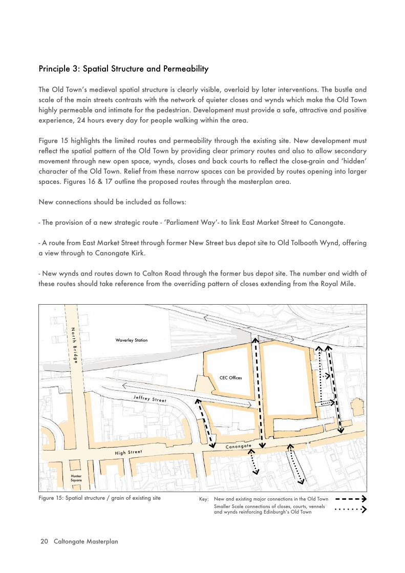
Figure 15: Spatial structure / grain of existing site
Principle 3: Spatial Structure and Permeability
The Old Townʼs medieval spatial structure is clearly visible, overlaid by later interventions. The bustle and scale of the main streets contrasts with the network of quieter closes and wynds which make the Old Town highly permeable and intimate for the pedestrian. Development must provide a safe, attractive and positive experience, 24 hours every day for people walking within the area.
Figure 15 highlights the limited routes and permeability through the existing site. New development must reflect the spatial pattern of the Old Town by providing clear primary routes and also to allow secondary movement through new open space, wynds, closes and back courts to reflect the close-grain and ʻhiddenʼ character of the Old Town. Relief from these narrow spaces can be provided by routes opening into larger spaces. Figures 16 & 17 outline the proposed routes through the masterplan area.
New connections should be included as follows:
- The provision of a new strategic route - ʻParliament Wayʼ- to link East Market Street to Canongate.
- A route from East Market Street through former New Street bus depot site to Old Tolbooth Wynd, offering a view through to Canongate Kirk.
- New wynds and routes down to Calton Road through the former bus depot site. The number and width of these routes should take reference from the overriding pattern of closes extending from the Royal Mile.
CEC Offices
J e f f r ey S t r ee t
H igh S t r ee t
No
r t h B
r i dg
e
Waverley Station
Canonga t e
HunterSquare
New and existing major connections in the Old TownSmaller Scale connections of closes, courts, vennels and wynds reinforcing Edinburghʼs Old Town
Key:

Caltongate Masterplan 21
- The provision of public steps between Jeffrey Street and East Market Street.
- To set-aside land to allow for a new, more direct stepped route from Calton Road to Regent Road/ Calton Hill.
- Public permeability to backlands and backcourts as is characteristic of the Old Town.
Consideration should be given to the provision of a series of public, semi-private and private open space of varying sizes. Open space in any new housing should be provided in sufficient amounts to satisfy the needs of residents. The DQ Handbook Guideline on ʻOpen Space and Ancillary Facilities for New Housing Developmentsʼ provides appropriate advice.
Figure 17: Proposed Spatial Structure / grain
Figure 16: City connectivity
St James Centre
Royal High School Holyrood
Palace
Scottish Parliament
Moray House
Station
Castle
Princes Street
R O Y A L M I L E
Calton Hill
CEC HQCanongate Kirk
Key: = Caltongate masterplan area
New and existing major connections in the Old TownSmaller scale connections of closes, courts, vennels and wynds reinforcing Edinburghʼs Old Townbuilding permeability
Key:
CEC Offices
J e f f r ey S t r ee t
H igh S t r ee t
No
r t h B
r i dg
e
Waverley Station
Canonga t e
HunterSquare
Omni Centre
22 Caltongate Masterplan
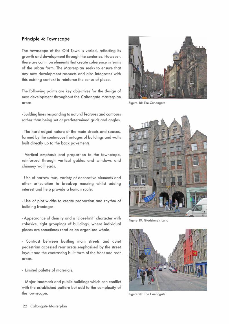
Principle 4: Townscape
The townscape of the Old Town is varied, reflecting its growth and development through the centuries. However, there are common elements that create coherence in terms of the urban form. The Masterplan seeks to ensure that any new development respects and also integrates with this existing context to reinforce the sense of place.
The following points are key objectives for the design of new development throughout the Caltongate masterplan area:
- Building lines responding to natural features and contours rather than being set at predetermined grids and angles.
- The hard edged nature of the main streets and spaces, formed by the continuous frontages of buildings and walls built directly up to the back pavements.
- Vertical emphasis and proportion to the townscape, reinforced through vertical gables and windows and chimney wallheads.
- Use of narrow feus, variety of decorative elements and other articulation to break-up massing whilst adding interest and help provide a human scale.
- Use of plot widths to create proportion and rhythm of building frontages.
- Appearance of density and a ʻclose-knitʼ character with cohesive, tight groupings of buildings, where individual pieces are sometimes read as an organised whole.
- Contrast between bustling main streets and quiet pedestrian accessed rear areas emphasised by the street layout and the contrasting built form of the front and rear areas.
- Limited palette of materials.
- Major landmark and public buildings which can conflict with the established pattern but add to the complexity of the townscape.
Figure 18: The Canongate
Figure 19: Gladstoneʼs Land
Figure 20: The Canongate

Caltongate Masterplan 23
Principle 5: Architectural Expression
In the detailed design process required for the planning application stages, high architectural and urban design quality will be expected. Design proposals must respect and respond to the unique local context and differing characteristics of each part of the Masterplan. Anonymous international-style corporate architec-ture which makes no reference to its location will not be acceptable.
To create variety and interest – reflecting the character of the Old Town – a number of architectural practic-es must be used for the detailed design stages. The regeneration of Holyrood North provides an exemplar for such an approach.
24 Caltongate Masterplan
Platts step up from Calton Road to Old Town Ridge
Wall of Buildings along Jeffrey Street
O L D T O W N R I D G E
Spine Rises East to West
Fingers rise up
Tolbooth Wynd
CEC HQ
Figure 21: Concept strategy for heights
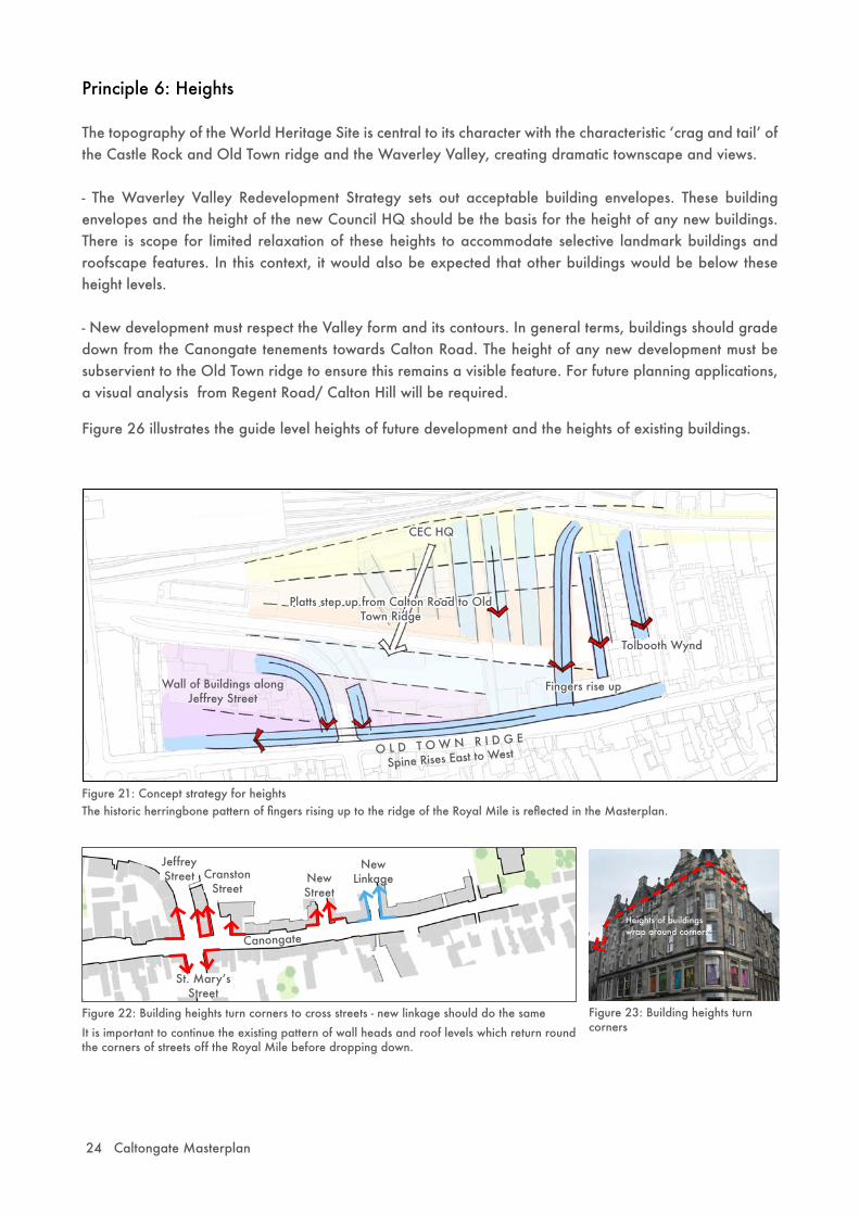
Principle 6: Heights
The topography of the World Heritage Site is central to its character with the characteristic ʻcrag and tailʼ of the Castle Rock and Old Town ridge and the Waverley Valley, creating dramatic townscape and views.
- The Waverley Valley Redevelopment Strategy sets out acceptable building envelopes. These building envelopes and the height of the new Council HQ should be the basis for the height of any new buildings. There is scope for limited relaxation of these heights to accommodate selective landmark buildings and roofscape features. In this context, it would also be expected that other buildings would be below these height levels.
- New development must respect the Valley form and its contours. In general terms, buildings should grade down from the Canongate tenements towards Calton Road. The height of any new development must be subservient to the Old Town ridge to ensure this remains a visible feature. For future planning applications, a visual analysis from Regent Road/ Calton Hill will be required.
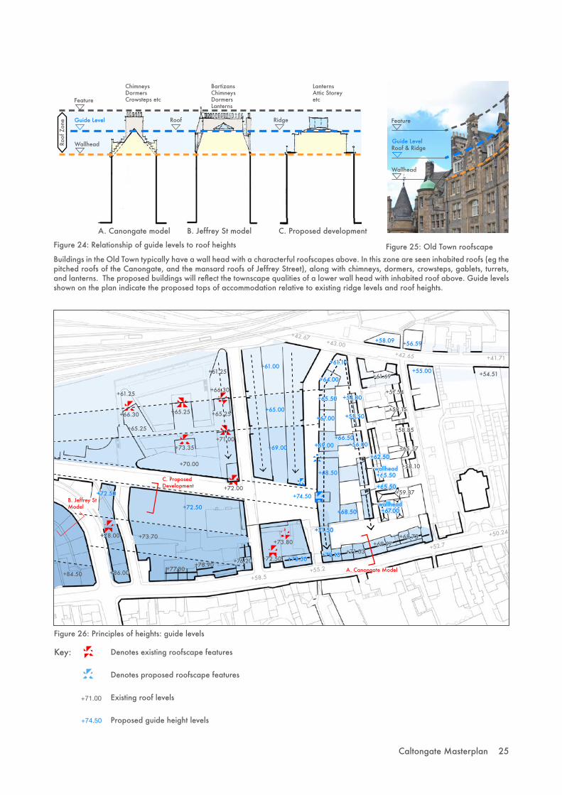
Figure 26 illustrates the guide level heights of future development and the heights of existing buildings.
St. Maryʼs Street
New Street
Cranston Street
Jeffrey Street
Canongate
Figure 22: Building heights turn corners to cross streets - new linkage should do the same Figure 23: Building heights turn corners
New Linkage
Heights of buildings wrap around corners
It is important to continue the existing pattern of wall heads and roof levels which return round the corners of streets off the Royal Mile before dropping down.
The historic herringbone pattern of fingers rising up to the ridge of the Royal Mile is reflected in the Masterplan.
Caltongate Masterplan 25
+42.67+43.00
+42.65 +41.71
+54.51
+61.25
+61.00+61.25
+61.10
+64.00
+65.50
+67.00
+69.00
+65.00
+61.69
+66.50
+68.50
+69.00
+65.25
+66.30
+66.30
+65.25 +65.25
+73.35
+70.00
+71.00
+58.5+55.2
+71.50
wallhead+67.00
+59.37
+52.7
+50.24
+58.10
+65.37
+58.85
+59.15
+57.54
+73.80
+72.50+72.10 +71.03
+68.73+69.97
+76.20
+84.50 +86.00
+78.00
+72.50
+78.90
+73.70
+72.00
+72.50
+77.30
+72.50
+74.50
+68.50
Figure 26: Principles of heights: guide levels
Key:
+58.09 +56.59
+55.00
+54.00
wallhead+65.50
+55.50
+56.00
A. Canongate Model
B. Jeffrey St Model
C. Proposed Development
Figure 24: Relationship of guide levels to roof heights
Ridge
A. Canongate model B. Jeffrey St model C. Proposed development
ChimneysDormersCrowsteps etc
Bartizans ChimneysDormersLanterns
LanternsAttic Storeyetc
Guide Level
Roof
Zon
e Roof
+62.50
+65.50
Figure 25: Old Town roofscape
Feature
Buildings in the Old Town typically have a wall head with a characterful roofscapes above. In this zone are seen inhabited roofs (eg the pitched roofs of the Canongate, and the mansard roofs of Jeffrey Street), along with chimneys, dormers, crowsteps, gablets, turrets, and lanterns. The proposed buildings will reflect the townscape qualities of a lower wall head with inhabited roof above. Guide levels shown on the plan indicate the proposed tops of accommodation relative to existing ridge levels and roof heights.
Denotes existing roofscape features
Denotes proposed roofscape features
Existing roof levels
Proposed guide height levels+74.50
+71.00
Wallhead
Feature
Guide Level
Wallhead
Roof & Ridge
26 Caltongate Masterplan
Principle 7: Roofscape
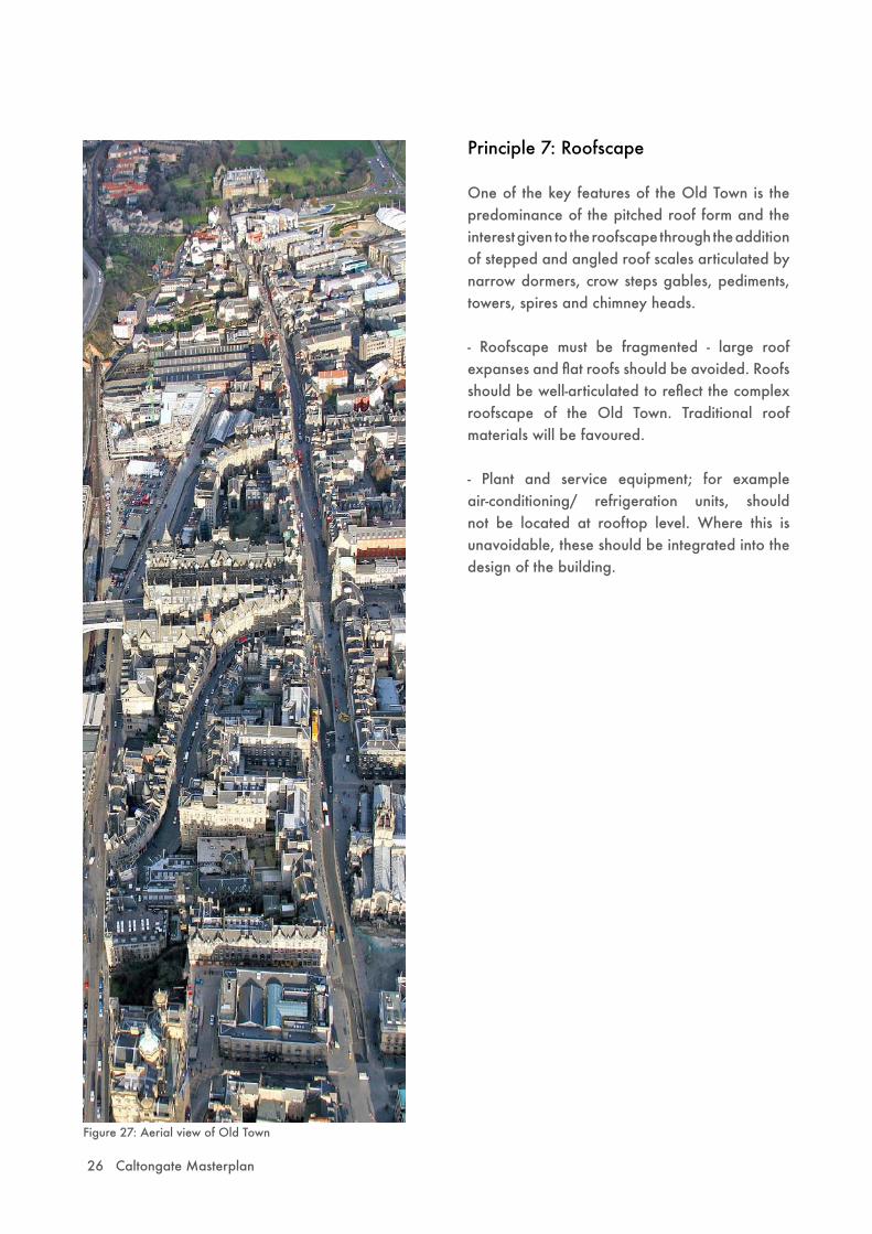
One of the key features of the Old Town is the predominance of the pitched roof form and the interest given to the roofscape through the addition of stepped and angled roof scales articulated by narrow dormers, crow steps gables, pediments, towers, spires and chimney heads.
- Roofscape must be fragmented - large roof expanses and flat roofs should be avoided. Roofs should be well-articulated to reflect the complex roofscape of the Old Town. Traditional roof materials will be favoured.
- Plant and service equipment; for example air-conditioning/ refrigeration units, should not be located at rooftop level. Where this is unavoidable, these should be integrated into the design of the building.
Figure 27: Aerial view of Old Town

Caltongate Masterplan 27
Figure 28: The Masterplan promotes new vistas and reinforces existing vistas as part of Edinburghʼs characterful townscape
- Where new development impacts on existing views and vistas, the significance of this impact will be considered and where appropriate balanced against the creation of new views and vistas and whether the quality and sensitivity of the new building adds to the layers of townscape.
- Views to Canongate Kirk and Calton Hill through the New Street bus depot site will be encouraged.
CEC Offices
J e f f r ey S t r ee t
H igh S t r ee t
HunterSquare
No
r t h B
r i dg
e
Waverley Station
Principle 8: Vistas and Views
The townscape of the Old Town is varied and many people ʻorienateʼ themselves in the city through urban markers such as clearly defined streets, towers, spires and domes. Collectively all these elements convey a strong sense of place.
It is important that the Masterplan protects these existing views, vistas and glimpses, and looks at creating new focal points to help create that sense of place and to draw people through the Old Town. Figure 28 shows the proposed new vistas and existing vistas within the masterplan area.
Glimpses of Canongate Kirk
28 Caltongate Masterplan
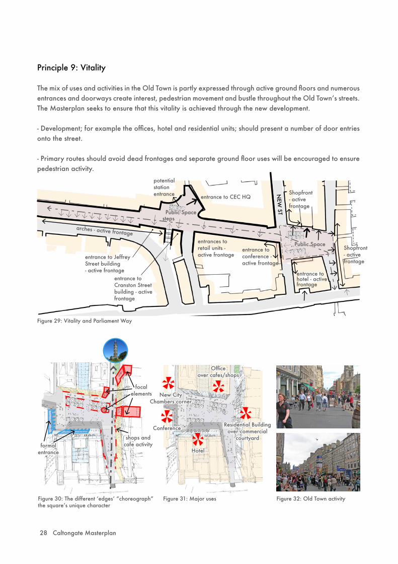
Principle 9: Vitality
The mix of uses and activities in the Old Town is partly expressed through active ground floors and numerous entrances and doorways create interest, pedestrian movement and bustle throughout the Old Townʼs streets. The Masterplan seeks to ensure that this vitality is achieved through the new development.
- Development; for example the offices, hotel and residential units; should present a number of door entries onto the street.
- Primary routes should avoid dead frontages and separate ground floor uses will be encouraged to ensure pedestrian activity.
entrance to CEC HQ
arches - active frontageentrances to retail units - active frontageentrance to Jeffrey
Street building - active frontage
entrance to Cranston Street building - active frontage
steps
potential station entrance
entrance to conference - active frontage
entrance to hotel - active frontage
NEW
ST
Shopfront - active frontage
Shopfront - active frontage
Public Space
Public Space
Figure 29: Vitality and Parliament Way
Figure 30: The different ʻedgesʼ “choreograph” the squareʼs unique character
formal entrance
focal elements
shops andcafe activity
Figure 31: Major uses
New City Chambers corner
Officeover cafes/shops
Residential Buildingover commercial
courtyard
Hotel
Conference
Figure 32: Old Town activity

Caltongate Masterplan 29
Principle 10: Community Safety
Designing for community safety is central to achieving high quality sustainable places for people. Secure by Design is a police initiative to encourage crime prevention measures in the design of developments to assist in reducing the opportunity for crime and the fear of crime, creating a safer and more secure environment for all forms of development. The Masterplan objectives of a mix of uses, increasing vitality throughout the area and creating permeability will increase safety. The detailed design stage must take further cognisance of the need to introduce design features that facilitate natural surveillance and create a sense of ownership and responsibility for the development. Liaison with the community safety/ architectural liaison team within Lothian and Borders Police is encouraged.
Principle 11: Materials
The choice and quality of materials in the new development is critical to reinforce the sense of place and the local identity.
- Natural stone is the basic building block of the Old Town in its predominant form of silver grey ashlar. This should be the first consideration in terms of building materials.
- Harled walls can be in keeping with the surrounding character but only in areas where visual reference can be made to other materials.
- The re-use of existing building materials from the site will be encouraged.
- Roof coverings make an important contribution to the architectural character of the Old Town. Traditional dark grey slates should be the predominant roofing material. Other roofing materials may be considered depending upon the quality and agreed style of the building.
- For the public realm, the palette of Caithness stone and whinstone cobbles as established in the Royal Mile should be utilised for the public area with flexibility in the more private areas; for example the back courts.
- High quality materials for shopfronts including modest signage will be expected with the design appropriate to the overall building design.
Figure 33: A range of materials in the Old Town
30 Caltongate Masterplan
Figure 34: Canongate Venture building
Figure 35: Old Sailorʼs Ark
Figure 36: The Arches
Principle 12: Heritage
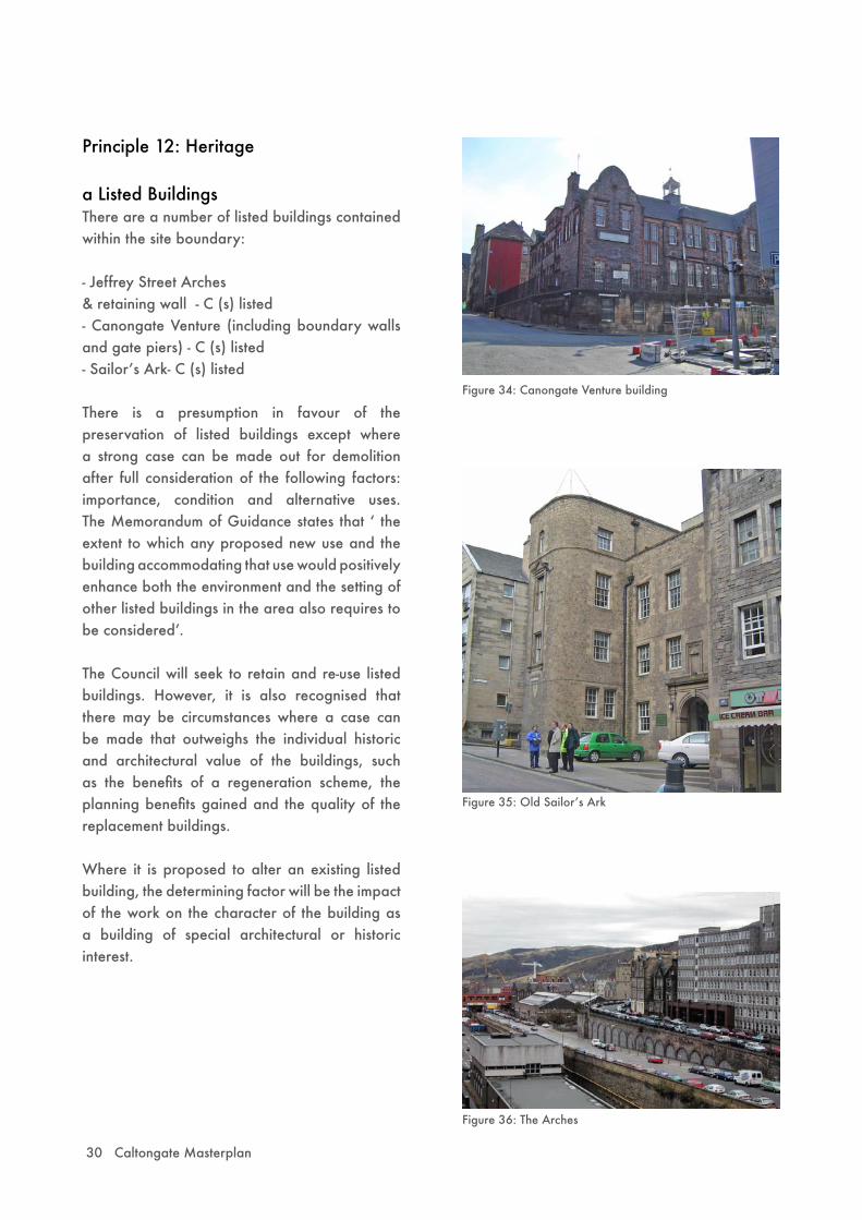
a Listed BuildingsThere are a number of listed buildings contained within the site boundary:
- Jeffrey Street Arches & retaining wall - C (s) listed - Canongate Venture (including boundary walls and gate piers) - C (s) listed- Sailorʼs Ark- C (s) listed
There is a presumption in favour of the preservation of listed buildings except where a strong case can be made out for demolition after full consideration of the following factors: importance, condition and alternative uses. The Memorandum of Guidance states that ʻ the extent to which any proposed new use and the building accommodating that use would positively enhance both the environment and the setting of other listed buildings in the area also requires to be consideredʼ.
The Council will seek to retain and re-use listed buildings. However, it is also recognised that there may be circumstances where a case can be made that outweighs the individual historic and architectural value of the buildings, such as the benefits of a regeneration scheme, the planning benefits gained and the quality of the replacement buildings.
Where it is proposed to alter an existing listed building, the determining factor will be the impact of the work on the character of the building as a building of special architectural or historic interest.
Caltongate Masterplan 31
no. 221-229 unlisted
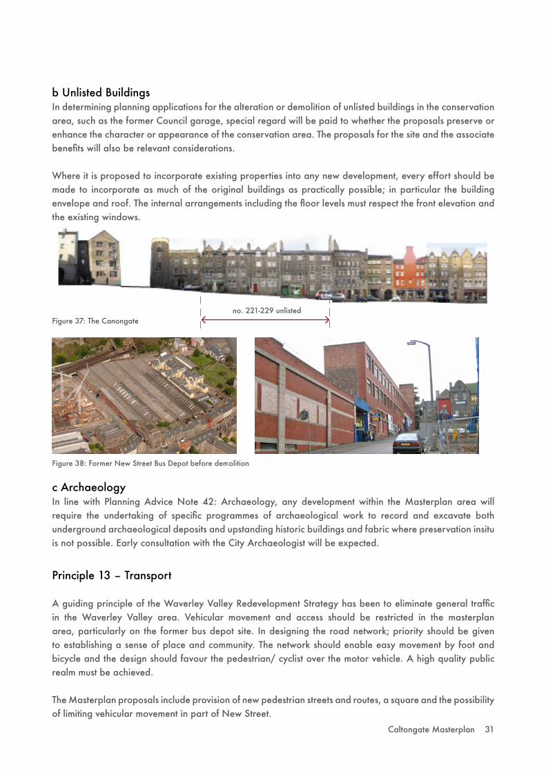
b Unlisted BuildingsIn determining planning applications for the alteration or demolition of unlisted buildings in the conservation area, such as the former Council garage, special regard will be paid to whether the proposals preserve or enhance the character or appearance of the conservation area. The proposals for the site and the associate benefits will also be relevant considerations.
Where it is proposed to incorporate existing properties into any new development, every effort should be made to incorporate as much of the original buildings as practically possible; in particular the building envelope and roof. The internal arrangements including the floor levels must respect the front elevation and the existing windows.
Figure 38: Former New Street Bus Depot before demolition
Figure 37: The Canongate
c ArchaeologyIn line with Planning Advice Note 42: Archaeology, any development within the Masterplan area will require the undertaking of specific programmes of archaeological work to record and excavate both underground archaeological deposits and upstanding historic buildings and fabric where preservation insitu is not possible. Early consultation with the City Archaeologist will be expected.
Principle 13 – Transport
A guiding principle of the Waverley Valley Redevelopment Strategy has been to eliminate general traffic in the Waverley Valley area. Vehicular movement and access should be restricted in the masterplan area, particularly on the former bus depot site. In designing the road network; priority should be given to establishing a sense of place and community. The network should enable easy movement by foot and bicycle and the design should favour the pedestrian/ cyclist over the motor vehicle. A high quality public realm must be achieved.
The Masterplan proposals include provision of new pedestrian streets and routes, a square and the possibility of limiting vehicular movement in part of New Street.

32 Caltongate Masterplan
Figure 39: Photos along East Market Street
Figure 40: Improvement of East Market Street
CEC Offices
J e f f re y S t re e t
H i g h S t re e t
C a n o n g a t e
HunterSquare
No
r t h B
r i dg
e
Waverley Station
R e g e n t R o a d
P a r l i a m e n t Wa y
In order to assist with the interpretation and implementation of the Masterplan, the site has been separated into areas/ sites. Site specific development principles are outlined; but must be read in conjunction with the Development Objectives outlined in Section 5.0.
6.1 East Market Street/Jeffrey Street
At present, East Market Street is uninviting; there is little activity along it to encourage pedestrian movement and the former bus depot creates a full stop rather than offering a continuing route to draw pedestrians down.
- Proposals to introduce new public space, improve the streetscape and widen the pavement to encourage pedestrian and street activity, such as markets, will be required. Any such scheme should be developed in consultation with the Council.
6.0 Site Specific Development Principles
Caltongate Masterplan 33
Waverley Station
- Redevelopment of the land currently owned by Network Rail along East Market Street should be considered in the context of any future development of the station and its land.
- Developing new public space and creating a new station entrance adjacent to the Council HQ would be desirable in longer term plans for the wider area. The Masterplan should take cognisance of these objectives.
Jeffrey Street Arches
- The necessary repair and conversion of the Arches into active uses will be strongly encouraged as this is a significant element in the regeneration and connectivity of the masterplan area. The details of any conversion will be considered at the application stage.
Jeffrey Street Site
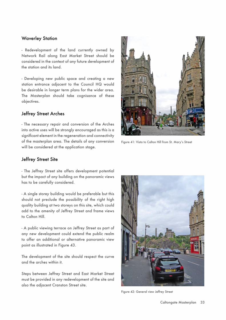
- The Jeffrey Street site offers development potential but the impact of any building on the panoramic views has to be carefully considered.
- A single storey building would be preferable but this should not preclude the possibility of the right high quality building at two storeys on this site, which could add to the amenity of Jeffrey Street and frame views to Calton Hill.
- A public viewing terrace on Jeffrey Street as part of any new development could extend the public realm to offer an additional or alternative panoramic view point as illustrated in Figure 43.
The development of the site should respect the curve and the arches within it.
Steps between Jeffrey Street and East Market Street must be provided in any redevelopment of the site and also the adjacent Cranston Street site.
Figure 42: General view Jeffrey Street
Figure 41: Vista to Calton Hill from St. Maryʼs Street

34 Caltongate Masterplan
Figure 43: Option for Cranston Street and Jeffrey Street
Pedestrianlink
Option forpotential development
aboveJeffrey Street steps
Potential landmarkbuilding stepsdown to gable
Pedestrianlink
Cranston Street
- The realignment of Cranston Street is supported as it offers the opportunity to enhance the vista to Calton Hill. The existing setts should be re-used for any road re-alignment. Figure 43 shows the development site.
- Residential amenity of the properties in the gable of the east side of Jeffrey Street, the Waverley Valley form and the impact on existing views will be determining factors for the scale of development on the Cranston Street site.
- A landmark building could be acceptable on the East Market Street section but any building should be reduced in scale towards the rear of the site.
Potential for panoramic
view
View ofCalton Hill
Canongate Venture
- The Canongate Venture is a category C(s) listed and of local historic interest. The demolition of the Canongate Venture site will only be considered where the replacement building is part of a proposal which seeks to regenerate the wider area. Isolated proposals for demolition and redevelopment of the listed building will not be acceptable.
The Council is minded to accept the demolition of the listed building but only on the basis that the replacement building fully addresses the development objectives of the Masterplan and the associated economic, cultural and urban design benefits. However, the case for demolition cannot be fully made or supported without proposals for the detailed design of the replacement building on the site. Support for demolition will therefore depend on the detailed design stage as any replacement building must be of the highest quality.
6.2 New Street
- Separate ground floor uses; for example small business premises; should be located along New Street to provide activity at ground floor level.
- Where required as part of a development proposal, a link over New Street between development sites will be considered, subject to an adequate case being made for its need. Support for such a link will depend on the final design stage. It should be single-storey to minimise impact on views, especially the view of the skyline of Calton Hill and street environment, and of a high design standard to create a positive addition to the townscape.
- A subterranean link under New Street to connect buildings would be possible.
Caltongate Masterplan 35
Potential landmarkbuilding stepsdown to gable
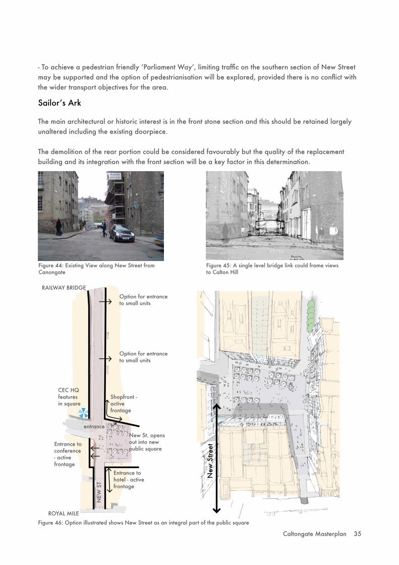
- To achieve a pedestrian friendly ʻParliament Wayʼ, limiting traffic on the southern section of New Street may be supported and the option of pedestrianisation will be explored, provided there is no conflict with the wider transport objectives for the area.
Sailorʼs Ark
The main architectural or historic interest is in the front stone section and this should be retained largely unaltered including the existing doorpiece.
The demolition of the rear portion could be considered favourably but the quality of the replacement building and its integration with the front section will be a key factor in this determination.
RAILWAY BRIDGEOption for entranceto small units
Option for entranceto small units
CEC HQ featuresin square
Entrance to conference - activefrontage
Shopfront -activefrontage
Entrance to hotel - activefrontage
ROYAL MILE
New St. opens out into new public square
entrance
NEW
ST
New
Stre
et
Figure 44: Existing View along New Street from Canongate
Figure 45: A single level bridge link could frame views to Calton Hill
Figure 46: Option illustrated shows New Street as an integral part of the public square

36 Caltongate Masterplan
6.3 Former Bus Depot
Parliament Way
- Proposals for the former bus depot must include a strategic link through the site to meet the Councilʼs objective of ʻParliament Wayʼ.
- The design of ʻParliament Wayʼ should provide a clear route through the site whilst respecting the traditional urban grain of the Old Town. Figures 49 & 50 outline the proposed route.
- The route should be as at grade as possible for use by pedestrians and cyclists.
- The route - from New Street to Canongate - should be vehicle-free, except for emergency vehicles and limited servicing.
- A connection on the Canongate will be required. The preferred option is through 221-225 Canongate with a full height breakthrough as illustrated in Figure 47. A narrower width that will only allow the safe passage and turning of emergency vehicles and the safe movement of pedestrians and cycles is preferred, whilst taking into account the need for a legible route and sunlight to the square beyond. Normal vehicle access must not be possible and the pavement on Canongate should remain continuous.
- The use of ʻParliament Wayʼ in the Masterplan does not denote the final name of the street; the final name would be determined by the Council.
Figure 47: Full height connection
Figure 48: The containment of the Canongate remains the predominant character
Figure 49: Main pedestrian routes
Primary Route
approx.+53 m
approx.+55 m
Gentle level changeGood wayfinding
Secondary routeapprox.+58.5 m
Figure 50: Parliament Way concept sketch

Caltongate Masterplan 37
Exchange square Parliament square
Hunter squareProposed Caltongate square
Figure 52: Spatial comparisons to the same scale
Figure 51: The square responds to an established Edinburgh typology of a public building within a square
CEC Offices
Waverley Station
R e g e n t R o a d
High Court Tron Kirk
Caltongate
Public Square
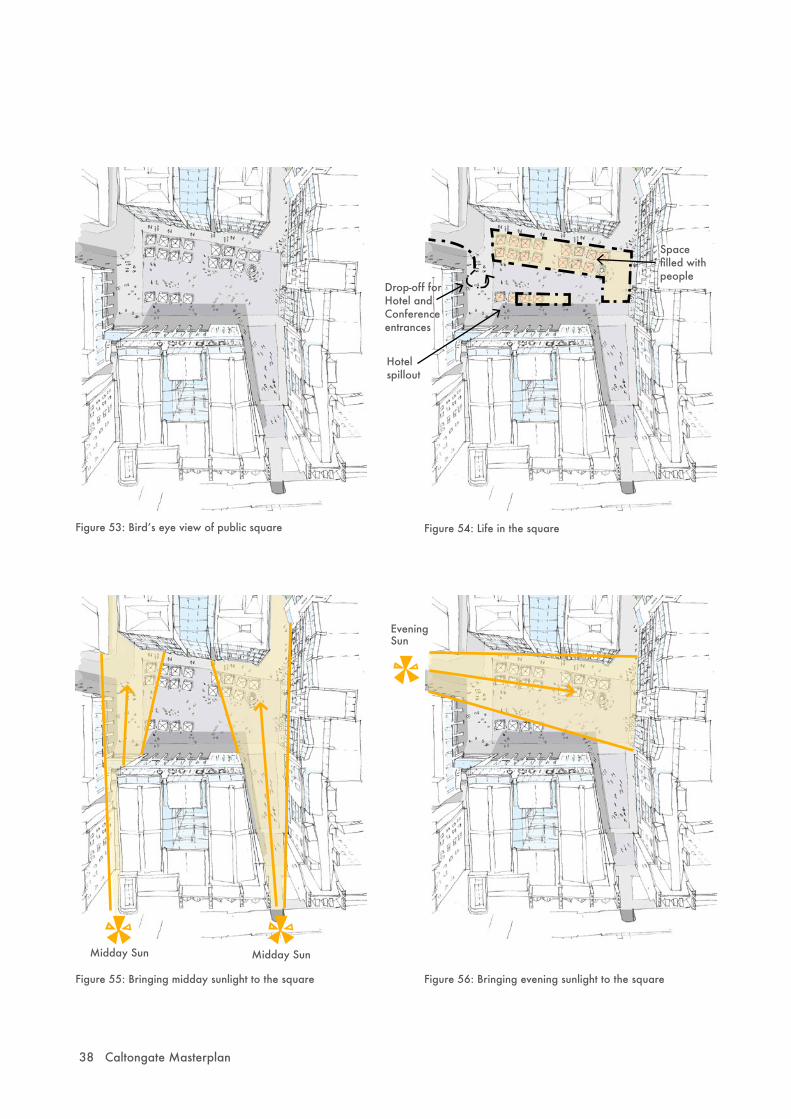
- The creation of major new public space is a requirement. It should be large enough and relatively flat to accommodate a range of formal and informal activities.
- The design should create a sense of place and destination in its own right. Figure 53 outlines a possible design for the Square.
- A good level of sunlight must reach the public space to encourage daytime and evening outdoor activity as illustrated in Figures 55 & 56.
- The recording and display of the existing site, layout and historical content must be displayed on or near the new public square. This should be developed in consultation with the local community.
26 by 30m
27 by 50m
38 by 41m
21 by 64m
25 by 48m
approx.
38 by 60m
38 Caltongate Masterplan
Figure 53: Birdʼs eye view of public square Figure 54: Life in the square
Hotel spillout
Spacefilled withpeople
Drop-off for Hotel and Conference entrances
Figure 56: Bringing evening sunlight to the square
Evening Sun
Midday Sun Midday Sun
Figure 55: Bringing midday sunlight to the square
Caltongate Masterplan 39
6.4 Calton Road
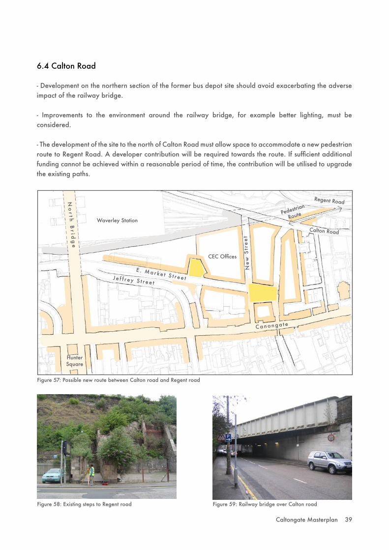
- Development on the northern section of the former bus depot site should avoid exacerbating the adverse impact of the railway bridge.
- Improvements to the environment around the railway bridge, for example better lighting, must be considered.
- The development of the site to the north of Calton Road must allow space to accommodate a new pedestrian route to Regent Road. A developer contribution will be required towards the route. If sufficient additional funding cannot be achieved within a reasonable period of time, the contribution will be utilised to upgrade the existing paths.
CEC Offices
J e f f r ey S t r ee t
Canonga t e
HunterSquare
No
r t h B
r i dg
e
Waverley StationPedestrian
Route
Calton Road
Regent Road
Ne
w S
tre
et
E . Ma r ke t S t r ee t
Figure 57: Possible new route between Calton road and Regent road
Figure 58: Existing steps to Regent road Figure 59: Railway bridge over Calton road
40 Caltongate Masterplan
7.0 Transport And Parking
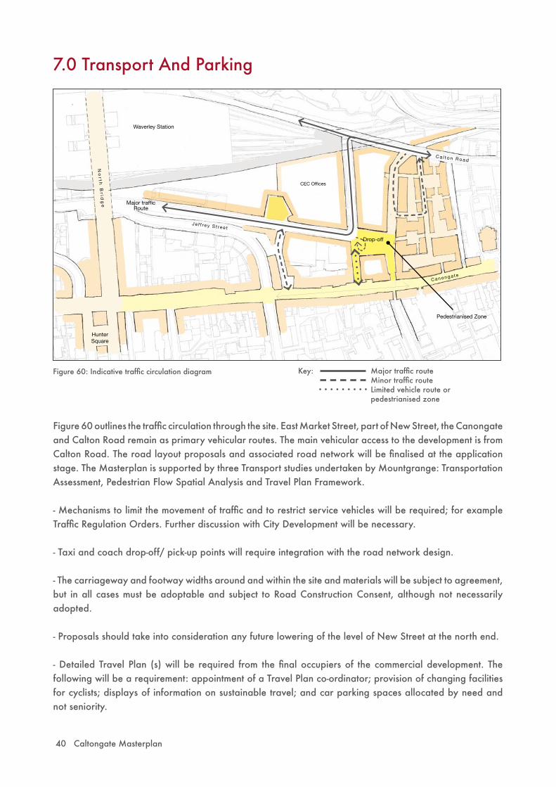
Figure 60 outlines the traffic circulation through the site. East Market Street, part of New Street, the Canongate and Calton Road remain as primary vehicular routes. The main vehicular access to the development is from Calton Road. The road layout proposals and associated road network will be finalised at the application stage. The Masterplan is supported by three Transport studies undertaken by Mountgrange: Transportation Assessment, Pedestrian Flow Spatial Analysis and Travel Plan Framework.
- Mechanisms to limit the movement of traffic and to restrict service vehicles will be required; for example Traffic Regulation Orders. Further discussion with City Development will be necessary.
- Taxi and coach drop-off/ pick-up points will require integration with the road network design.
- The carriageway and footway widths around and within the site and materials will be subject to agreement, but in all cases must be adoptable and subject to Road Construction Consent, although not necessarily adopted.
- Proposals should take into consideration any future lowering of the level of New Street at the north end.
- Detailed Travel Plan (s) will be required from the final occupiers of the commercial development. The following will be a requirement: appointment of a Travel Plan co-ordinator; provision of changing facilities for cyclists; displays of information on sustainable travel; and car parking spaces allocated by need and not seniority.
Figure 60: Indicative traffic circulation diagram
CEC Offices
J e f f re y S t re e t
C a n o n g a t e
HunterSquare
No
r t h B
r i dg
e
Waverley Station
C a l t o n R o a d
Drop-off
Major traffic Route
Pedestrianised Zone
Major traffic routeMinor traffic routeLimited vehicle route or pedestrianised zone
Key:

Caltongate Masterplan 41
- The site is within the boundary for a tram contribution and when the final areas are agreed, a figure will be calculated on the basis of the approved Council policy.
- A contribution will be required to the City Car Club – access to the City Car Club should be for local office staff and residents to improve viability.
- The scheme must comply with the Councilʼs Parking Standards including the provision of adequate visitor and cycle parking. The level of parking allowed will be determined by the final uses within the scheme.
- The majority of parking should be provided at below surface level. A limited level of public on-street parking will be required including 5 City Car Club spaces.
- On the southern section of New Street, limiting traffic and giving priority to pedestrians/ cyclists may be possible with the option of pedestrianisation to be explored. Any proposal must take into consideration the traffic management proposals for Canongate.

42 Caltongate Masterplan
8.0 Infrastructure
Waste & Recycling
- The Councilʼs requirements for recycling/ residual waste storage and means of access for servicing/ collection must be taken into consideration at the detailed design stage. This may impact on both internal and external design of buildings and spaces. Innovative methods of waste/recycling storage, for example underground system, will be encouraged.
- Internal storage facilities must be provided for trade waste.
- Local recycling facilities should be provided within the scheme according to Council requirements.
- Early discussion with relevant Council function will be encouraged.
Contaminated Land
There are a number of potentially contaminative uses within the Masterplan area. Remediation strategies have been agreed with the Council for sites that have already been through the development control system. If as a result of the Masterplan, changes are made to end uses or site layout then there will be a requirement to review and if necessary amend these plans.
The preliminary site investigations have revealed there is ground and groundwater contamination at part of the site. A risk assessment of ground contamination will be required.
Noise
The implementation of the Masterplan will see the introduction of a mix of uses to the area. As with all mixed use development, care must be taken to avoid the juxtaposition of incompatible uses. Careful consideration of noise issues will be required at the detailed planning stage.
Water and Drainage
Proposals should include sustainable urban drainage systems (SUDS) for the attenuation and treatment of surface water, subject to the constraints of a built-up city centre. The potential scope of SUDS should be discussed further with SEPA prior to the detailed planning application stage.
Air Quality
Air quality issues must be given full consideration when detailed applications are made. In order to assess the potential impact of the development on local air quality and possible need for mitigation measures, an air quality assessment will be required at application stage. This should include the traffic flow rates and the types of buildings which would be attracted to the area.

Caltongate Masterplan 43
9.0 Developer Contributions
Given the location and scale of the Masterplan area, developers will be expected to enter into legal agreements to secure appropriate contributions to meet identified requirements. Reference should be made to the following Council guidelines in terms of contributions to education and transport infrastructure and services:- Developer Contributions for the Investment in Schools- Movement and Development- Tram Project: Developer Contributions- Affordable Housing
In order to meet the overall objectives of the Masterplan, the Council is seeking to improve the public realm, achieve better connectivity, provide community facilities and increase vitality within the area. Specific proposals are:
- Improvements to the public realm along East Market Street- Improvement to the environment under the railway bridge on Calton Road/ New Street- Conversion of the Jeffrey Street Arches- New public route between Calton Road and Regent Road or the upgrading of existing routes- Provision of community facilities- City Car Club - Public art and the recording and display of the existing site, layout and historical content
The developer(s) will be expected to enter into agreement to provide a range of physical works and/or financial contributions towards identified requirements. These will be secured through the use of planning conditions or legal agreements associated with individual applications, as appropriate. The level of contributions is to be determined at the planning application stages, but the Council will endeavour to establish, at an early stage, the detailed requirements for developer contributions.

44 Caltongate Masterplan
10.0 Implementation and Phasing
This section sets out the implementation strategy for the Caltongate Masterplan to ensure that the Masterplan is delivered on the site and the potential benefits of redevelopment are realised. It outlines how the redevelopment of Caltongate will take place in order to meet the various stated Masterplan principles and amongst other matters, this involves consideration of the delivery, timing and phasing, as well as establishing the Masterplan.
10.1 Delivery
In order to achieve the redevelopment of Caltongate, in accordance with the Masterplan, there has to be a co-operative and joined-up approach from the various parties involved in the project.
City of Edinburgh Council
The Council has a variety of roles before, during and after the development of Caltongate. The Councilʼs role as local planning authority, which begins with the preparation and adoption of this Masterplan, will continue through the consideration of applications for planning approval.
The Council has powers to serve Compulsory Purchase Notices, and, subject to further consideration by the Council, these shall be exercised if required. At the meeting of the City of Edinburgh Council in November 2005, it was also authorised in principle to use Compulsory Purchase Order powers should they be required to secure development. Other procedural mechanisms may also be required, such as Traffic Regulation Orders.
The Councilʼs various departments also have an on-going role in servicing the completed development including waste management, education, and maintenance of Council adopted areas within and surrounding the masterplan area.
Landowners
Mountgrange Capital plc, a privately owned property investment and development company, purchased the former New Street bus depot site in 2004. It subsequently added to its holdings by acquiring property in Calton Road, part of the Old Sailorʼs Ark (231 Canongate) and flats on Canongate through its subsidiary Mountgrange Caltongate Ltd. In addition, the Council has conditionally resolved to dispose of properties in East Market Street and Cranston Street to Mountgrange. Mountgrange is therefore the most significant landowner within the masterplan area.
Other existing landowners affected by the Masterplan include private owners of properties in Canongate and the Sailorʼs Ark Trust, who own and operate the community day centre which occupies part of 231 Canongate.
Mountgrange intends to be the main developer for Caltongate. It is in discussions with many parties to assist in the delivery of the Masterplan. As well as the Council, these parties include owners of the private properties on Canongate and the Sailors Ark Community Centre (Sailors Ark Trust). Such properties may be acquired by Mountgrange in agreement with existing landowners and discussion has taken place. For

Caltongate Masterplan 45
instance, Mountgrange has been working with the Sailorʼs Ark Trust in relation to the provision of alternative accommodation for the community day centre facility in new premises at Calton Road.
Places for People
Places for People Group are a property management and regeneration organisation. Within the Places for People Group, there are a number of Registered Social Landlords who own and manage affordable social rented housing.
Mountgrange has been working with Places for People in relation to the provision of affordable housing units on the two areas of land in Calton Road. These discussions have also involved the relocation of the Sailors Ark Community Centre to Calton Road. Under current arrangements, Places for People will have a key role if Caltongate is to successfully deliver a significant amount of affordable housing on site.
10.2 Establishing the Masterplan
The main method of achieving the delivery of the regeneration and development of Caltongate will be through the granting of planning permissions for acceptable developments with associated section 75 planning agreements. There would also be the need for listed building consent for any demolition and alteration of listed buildings and conservation area consent for any demolition of unlisted buildings in the conservation area. Conditions and/or legal obligations associated with such approvals will also control the development.
Subsequent planning applications will be screened by the Council as planning authority, in accordance with the Environmental Impact Assessment (Scotland) Regulations 1999 and Circular 15/1999, in order to determine whether an Environmental Impact Assessment (EIA) is required. The basic test of the need for an EIA in a particular case is the likelihood of significant effects on the environment.
Prior to the submission of the formal applications for major development on Caltongate, it is intended to agree a processing agreement(s) with the Council informed by statutory consultees and other key agencies. The processing agreement will comprise an agreement of principles of joint working for the formal planning application process including how applications will be submitted. It will include key milestones and timescales for delivering the major development and clarify the process for community engagement.
The Processing Agreement would be prepared in the context of proposals set out in the Scottish Executive White Paper, “Modernising the Planning System” (2005). The proposals in the White Paper are yet to be realised in Legislation and/or Regulations. The Caltongate Processing Agreements would therefore be a pilot project aimed at evaluating and promoting the use of processing agreements to assist in the efficient and effective determination of applications for major development. The Scottish Executive is supportive of this approach.
For the planning application stages, design statements will be prepared in support of the planning applications to explain how the component parts of the development are consistent with the Masterplan, the character and appearance of the Old Town Conservation Area and the World Heritage Site.
46 Caltongate Masterplan
10.3 Timetable and Phasing
The comprehensive development of Caltongate would be phased. An optimum phasing programme has been carried out by Mountgrange which indicates that development could be completed over the next 5 years, subject, for instance, to the necessary consents and approvals being granted.
In order to bring about the regeneration of Caltongate, in its entirety and in as swift a timescale as possible, thereby minimising disruption to local amenity, it is important to achieve early delivery of significant ʻenabling worksʼ. Some of the work is already underway including the demolition of the former New Street Bus Garage, grouting of voids within the ground below that building, remediation of that site and the underpinning of the adjacent railway bridge abutment. Conservation area consent to demolish the former New Street bus depot has already been granted.
The Mountgrange team is working closely with the Council to ensure that archaeology including the remains of Edinburgh Gasworks is recorded.
Further enabling works will be procured by means of a separate building contract for the supporting plinth or ʻpodiumʼ in the Central area of the site. This may eventually contain the below surface level car parking for the scheme, with residential and office components above as well as the central residential street and the new urban square. There is no intention to utilise this structure for car parking prior to completion of the buildings that will be sited on top of the podium.
An important part of the podium construction is the creation of a utility hub and the drilling of the deep bore wells in order to provide ground source heating and cooling for the majority of the site. The current design intent is that greater than 60% of the buildingsʼ heating and cooling needs will be delivered from this renewable energy source.
Early phasing of “enabling works”, independent from the remainder of Caltongate, would also assist the viability of the whole development. Essentially, each stage of the works should commence as early as phased approvals following adoption of the Masterplan (planning permission, listed building consent, conservation area consent and building warrant, as well as statutory agreements) will permit.
Further contracts will be let with each contractor working separately to Mountgrangeʼs project managersʼ instructions, subject to the relevant consents. Subsequent phases of development may include the residential buildings and offices above the podium followed by the hotel and other buildings on East Market Street. Development on Calton Road is relatively independent of the infrastructure and base building works and can be separately programmed.
10.4 Management and Maintenance Strategy
Irrespective of whether or not the buildings are sold on through investment funding or to individual owners upon completion (as will certainly be the case with private residential apartments), a management protocol for the whole development should be carried forward with the main land titles. Management of the Caltongate development could be retained by the developer.
A separate management company could be established to deal with estate management issues. An on-site management suite would assist this service. Such a management company could also be responsible for the public realm at Caltongate (excluding the adopted areas).

Caltongate Masterplan 47
Appendix 1: SEA Process
The proposed masterplan was considered by the Council to be a qualifying plan under the Environmental Assessment (Scotland) Act 2005. In accordance with the Act, a Scoping Report was prepared to describe the approach to and scope of potential strategic environmental effects that the SEA would address, and issued to Historic Scotland, Scottish Environment Protection Agency and Scottish Natural Heritage as con-sultation authorities under the Act.
An Environmental Report was prepared which summarised the process and results of the SEA. The Environ-mental Report was published and consulted upon in accordance with the Act. The Environmental Report and comments on the Environmental Report from the three consultation authorities, community groups and members of the public have been taken into account in the production of the revised masterplan. This will be detailed in the SEA Statement which will be published and advertised following the approval by the Council of the revised Masterplan.

48 Caltongate Masterplan
Ref. ITS/06104 - The Caltongate Draft Consultation Masterplan. Urdu
� ������� ���������� �� �����������������
��������������
�������������������������������������������������
���������������
���� 0131 242 8181�(ITS) ��������������������������������� ����������������
�������
������� 06104 ���������
������������������������������
�������������������
���������������
�������������������������������� �����
���� 0131 242 8181� (ITS) �����������
�������
������� 06104 ���������
This document is available on request in Braille, tape, large print and various computer formats if you ask us. Please contact ITS on 0131 242 8181 and quote ref 060104. ITS can also give information on community language translations.
ITS 060104 Caltongate Draft Consultation Masterplan Arabic
�������������� ����������� ������������� ������������� �������� �������
��������� ������ �������� ��������� ����� ������� ��� ���� .����� ��� ����������� ������ ������ ��� ��� ������� ������ ���������� ������� ������� ���� ����� ����
������ ���81812420131��� ������ ����06104
������������� �������� ������������������� ����������� �������������
�������� ��������� ����� ������� ��� �������������� ������ .������������� ����� ���
������ ������� ������� ������ ���� ��� ����������� ��� ������������ �������� ��������� �����
��������81812420131���� ������ �����06104
Ref: 06104/ The Caltongate Draft Consultation Masterplan/ Bengali
���L�������-���������������M����M�����������
���L������� ������� ���� ����� PS����� �� ������T ����� ���� ������� � �� ������T� �N�������� ������� ������ ������ ���� �����P���� ��� ��������� ������� (��.���.��.)-���0131 242 8181 �M��� ����� ���� �������� �M�� 06104 ��� ��R� �
���L������� ������� ���� ����� PS����� ��������T ����� ���� ������� � �� ������T��N��� ����� ������� ������ ������ ���������P���� ��� ��������� ������� (��.���.��.)-��� 0131 242 8181 �M��� ����� ���� ���������M�� 06104 ��� ��R� �
Andrew M HolmesDirector of City DevelopmentThe City of Edinburgh Council1 Cockburn StreetEdinburghEH1 1ZJ
6 Caltongate Masterplan
3.0 Site & Context
3.1 The Site
Figure 2: Existing site plan
Former New Street Bus Depot
Calton Road South Site
Calton Road
New Street
Canongate
221-229 Canongate (1930s Tenements and Backlands)
Old Sailorʼs Ark
Canongate Venture
Former CEC Garage
New Street Solum
Cranston Street Solum
The Arches
East Market Street Calton Road North Site
Cranston Street
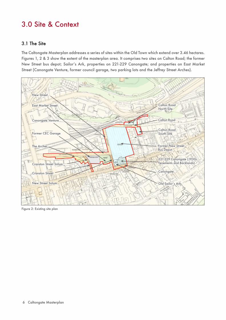
The Caltongate Masterplan addresses a series of sites within the Old Town which extend over 3.46 hectares. Figures 1, 2 & 3 show the extent of the masterplan area. It comprises two sites on Calton Road; the former New Street bus depot; Sailorʼs Ark, properties on 221-229 Canongate; and properties on East Market Street (Canongate Venture, former council garage, two parking lots and the Jeffrey Street Arches).
Caltongate Masterplan 7
C(S) Listed Building:Jeffrey Street Archesincl. retaining wall
C(S) Listed Building:Canongate Ventureincl. boundary wall and gatepiers
C(S) Listed Building:Old Sailorʼs Ark
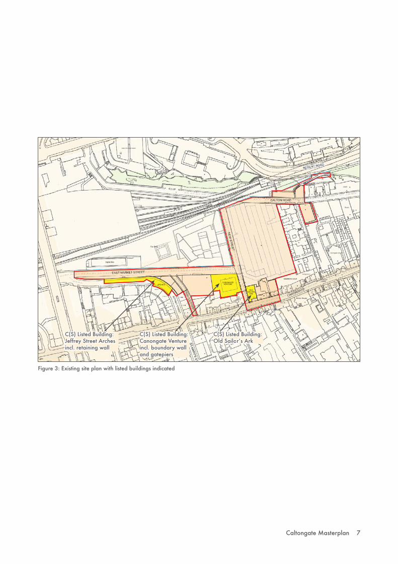
Figure 3: Existing site plan with listed buildings indicated

8 Caltongate Masterplan
- Over time, Edinburgh became more densely developed as the tofts were gradually built upon resulting in the ʻherring-boneʼ pattern of development with long narrow built-up areas reached by narrow closes and wynds.
- Within the burgh of Canongate, there was some development to the rear, but the tofts generally remained as formal gardens to the large houses which dominated Canongate due to the proximity of the Royal Court at Holyrood.
3.2 Historical Context
A study of the historical development of the Old Town helps to explain the Caltongate masterplan area as it is today, and suggests how to approach its redevelopment. Figures 5 to 10 show the historic development of the area.
- The Old Town contains two planned 12th century burghs: Edinburgh and Canongate. Land was divided up on the basis of tofts – long narrow strips of land - stretching down from the Royal Mile on the ridge into the valleys to the north and south.
Figure 5: James Gordon Plan of 1647. Reproduced by permission of National Library of Scotland
Figure 6 Left: William Edgar Plan of 1765. Reproduced by permission of National Library of Scotland
Figure 7 Right: A plan showing the site as Gas Works in 1893. Reproduced by permission of National Library of Scotland
- After the departure of the Scottish Parliament in 1707, the mansions of Canongate fell into decline. The unbuilt gardens of Canongate allowed large scale institutions and industry such as breweries to develop rapidly and on a large scale in the late 18th and early 19th centuries. New Street became the works for the Edinburgh Gas Light Company in 1818 before becoming the bus depot in 1906 and remaining in that use until recently.
- The Old Town experienced significant change in the 19th century. Motives of social improvement and concern for the capital city prompted a series of Improvement Acts where buildings were swept away with new streets; such as Cockburn Street and Jeffrey Street.
- In the early 1840s, three railway stations were established in the Valley which grew into an untidy and inefficient coalescence before being swept away to allow the construction of the current Waverley Station at the beginning of the 20th century, which retains much of its original layout and structure.

Caltongate Masterplan 9
S O U T H B A C K S
Castle Rock
Calton Hil l
Sal isbury Crags
N O R T H B A C K S
N E W T O W N E D G E
Figure 8: Historic edges of New and Old Towns
Figure 9: Changes to Waverley Valley
R a i l w a y s
Castle Rock
Calton Hil l
Sal isbury Crags
Castle Rock
Calton Hil l
V i e w a c r o s s G a r d e n s
W a l l
V i e w a c r o s s B u i l d i n g s
Figure 10: Todayʼs situation
Salisbury Crags
- Canongateʼs chequered history continued into the 20th century, when concerted efforts at improvements were carried out in the 1930s by the City Architect EJ MacRae and again in the 1950s, resulting in many of the later and rebuilt buildings which now enclose the Canongate.
- However, decline continued with the population reaching its lowest point at the time of the 1981 Census. The establishment of the Edinburgh Old Town Renewal Trust in 1985 began a process of restoration and rehabilitation which paved the way for major urban renewal in the 1990s. This was given further impetus by the location of the Scottish Parliament at the foot of Canongate and thereby re-establishing its significance within the wider city context.
Key: = Caltongate masterplan area

10 Caltongate Masterplan
3.3 Planning Context
The Masterplan has been prepared having regard to the development plan and other material planning considerations.
The Edinburgh and the Lothians Structure Plan 2015 (2004)
This gives priority to the re-use of urban brownfield land. Edinburgh city centre, including the Waverley Valley area, is identified as a core development area for strategic business and retail development as well as a location for higher density housing. The Structure Plan recognises the contribution of designated features such as the World Heritage Site, listed buildings and conservation areas.
Central Edinburgh Local Plan (1997 – reviewed 2000)
The Central Edinburgh Local Plan Proposals Map includes the masterplan area within a ʻMixed Activities Zoneʼ which seeks to further the well-established mix of residential, business, shopping, cultural and institutional uses. In particular, the Waverley Valley is identified as a Major Development Opportunity (MDO) in which the majority of the masterplan area lies.
The Local Plan identifies the city centre as a vital economic asset with significant potential for further growth and development. One aim is to encourage developments which will create jobs and wealth and further the role of the city centre as a major urban centre. It states that redevelopment in this area would afford a significant opportunity to improve a main ʼgatewayʼ to the city centre and offer scope for a mixed use development. A local plan objective for the Old Town is to achieve an increase in population and related local services. Tourism is also to be encouraged. The Local Plan also sets our broad objectives for conservation and quality of new development covering such matters as design, landscaping, accessibility, building heights and materials. Transport policies support the creation of an extensive, safe and attractive environment for pedestrians.
More detailed planning guidance is provided by the Councilʼs supplementary planning guidance including the Development Quality Handbook which contains a series of topic based guidance.
Edinburgh City Local Plan
The Council is currently preparing the Edinburgh City Local Plan. When adopted, this will replace the Central Edinburgh Local Plan. The relevance of the Edinburgh City Local Plan will increase as the process continues but it would be prudent to consider the implications of the policy guidance in the development of detailed planning applications. The Masterplan has taken into account the emerging plan.