calidus resources is an asx listed gold for personal use only
TRANSCRIPT
Page 1
ASX ANNOUNCEMENT
ASX : CAI
+61 8 6245 2050
Suite 12, 11 Ventnor Ave West Perth WA 6005 AUSTRALIA
ABOUT CALIDUS RESOURCES
Calidus Resources is an ASX listed gold exploration company which controls the Warrawoona Gold Project in the East Pilbara district of the Pilbara Goldfield in Western Australia.
DIRECTORS AND MANAGEMENT
Mr Keith Coughlan NON-EXECUTIVE CHAIRMAN
Mr David Reeves MANAGING DIRECTOR
Mr Adam Miethke NON-EXECUTIVE DIRECTOR
Mr Peter Hepburn Brown NON-EXECUTIVE DIRECTOR
Mr James Carter CFO AND COMPANY SECRETARY
calidus.com.au
23rd November 2017
Multiple New Gold Targets Identified Calidus Resources Limited (ASX:CAI) (‘Calidus’ or the ‘Company’) is pleased to announce that it has completed an initial review of its recently expanded land holdings and has generated numerous high priority gold targets.
HIGHLIGHTS
• ASTER imagery received, initial review shows main Klondyke gold bearing structure readily identified via alteration signature,
• CSIRO initial structural geology site visit highlighted that the Klondyke area has high potential to host deposits that extend at depths significantly greater than the current resource,
• Hyperspectral and XRF commenced on drill core and chips with CSIRO mineral vector work planned for 2018. Aimed at supporting rapid assessment of ground holdings using ASTER imaging signatures and portable XRF (pXRF) by Calidus staff,
• Initial review of Novo Resources area shows numerous targets including Klondyke East and recently worked mines such as Trump,
• Review of potential conglomerate-bearing horizons on Calidus ground confirms 41km of prospective outcrop, and
• Initial geological mapping and prospecting confirms presence of conglomerates and flat gold nuggets (up to 1cm in diameter) at one location with further work underway.
Appointment of Exploration Manager
• Experienced Exploration Manager – Mr Brenton Siggs appointed to accelerate review of extensive holdings and priority shear and conglomerate targets
Calidus Managing Director Dave Reeves commented, “I am very pleased to report on our on-going regional exploration activities. With a growing resource base at Klondyke, to have such a suite of exciting regional projects highlights the large potential of this goldfield. With the assistance of the CSIRO, we are getting a lot clearer picture of ore shoot control and methods that will allow us to rapidly and inexpensively explore the majority of our landholding. This, combined with extensive conglomerate outcrops, which are readily accessed from existing roads, provides Calidus with numerous high ranking targets for the year ahead. With such a large amount of opportunity, we have recently employed the highly experienced Brenton Siggs as Exploration Manager to accelerate regional greenfields exploration of our wider tenure whilst our current team continue to focus on resource increase around known deposits.”
For
per
sona
l use
onl
y
Page 2 calidus.com.au
ASX ANNOUNCEMENT
Further Geological Information
Shear Hosted Targets
Calidus recently took delivery of ASTER (Advanced Spaceborn Thermal Emission and Reflection Radiometer) imagery across the wider Klondyke area which is used to map lithology and hydrothermal alteration zones and identify signatures for gold exploration. This gives the means to highlight target hydrothermal alteration zones of potentially economic gold mineralisation to discriminate them from altered zones with lower potential.
The imagery consists of 14 data channels that cover ranges of visible, near infrared, shortwave infrared and thermal infrared regions of the electromagnetic spectrum. This method aims to discern the boundary between altered and unaltered rocks based on alteration minerals and mineral assemblages. This work is currently being undertaken in conjunction with geological and structural mapping to assist with the ranking of exploration targets.
Calidus commenced a CSIRO Kick-Start initiative research program on October 1st which will undertake research and report on conceptual models for gold mineralisation, ore-shoot controls and relative chronology of tectonic events to help target drilling and expedite resource definition. An initial 4-day field visit was completed by CSIRO during October with preliminary results indicating the use of a portable X-ray Fluorescence (pXRF) machine will be invaluable as a tool for regional objective mapping of the mineralised lithologies observed onsite.
TIMA (TESCAN Integrated Minerals Analyser) analysis will be the next phase in the research program. The TIMA is an automated method of providing mineralogical analyses of geological samples and will assist in understanding mineral concentrations, element distributions, and mineral texture properties such as grain-size, association, and liberation.
Working with CSIRO, our exploration team over the next 6 months aims to utilise these innovative tools to enhance our knowledge of the region, the structural development and the impact on controls on mineralisation deposition. Initial structural mapping around the immediate Klondyke resource area has concluded a preliminary model proposing three stages of gold mineralisation. The most commonly observed to date along the Warrawoona Shear package, Type One gold mineralisation, presents within the highly localised shears with very steep-dipping lineations. This can produce elongate pipe-like ore bodies with ore shoots parallel to the lineation within intensely deformed rocks.
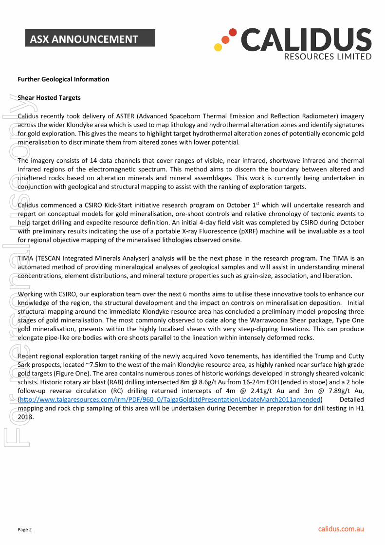
Recent regional exploration target ranking of the newly acquired Novo tenements, has identified the Trump and Cutty Sark prospects, located ~7.5km to the west of the main Klondyke resource area, as highly ranked near surface high grade gold targets (Figure One). The area contains numerous zones of historic workings developed in strongly sheared volcanic schists. Historic rotary air blast (RAB) drilling intersected 8m @ 8.6g/t Au from 16-24m EOH (ended in stope) and a 2 hole follow-up reverse circulation (RC) drilling returned intercepts of 4m @ 2.41g/t Au and 3m @ 7.89g/t Au, (http://www.talgaresources.com/irm/PDF/960_0/TalgaGoldLtdPresentationUpdateMarch2011amended) Detailed mapping and rock chip sampling of this area will be undertaken during December in preparation for drill testing in H1 2018.
For
per
sona
l use
onl
y
Page 3 calidus.com.au
ASX ANNOUNCEMENT
Figure One: Trump and Cutty Sark Prospects Location Plan
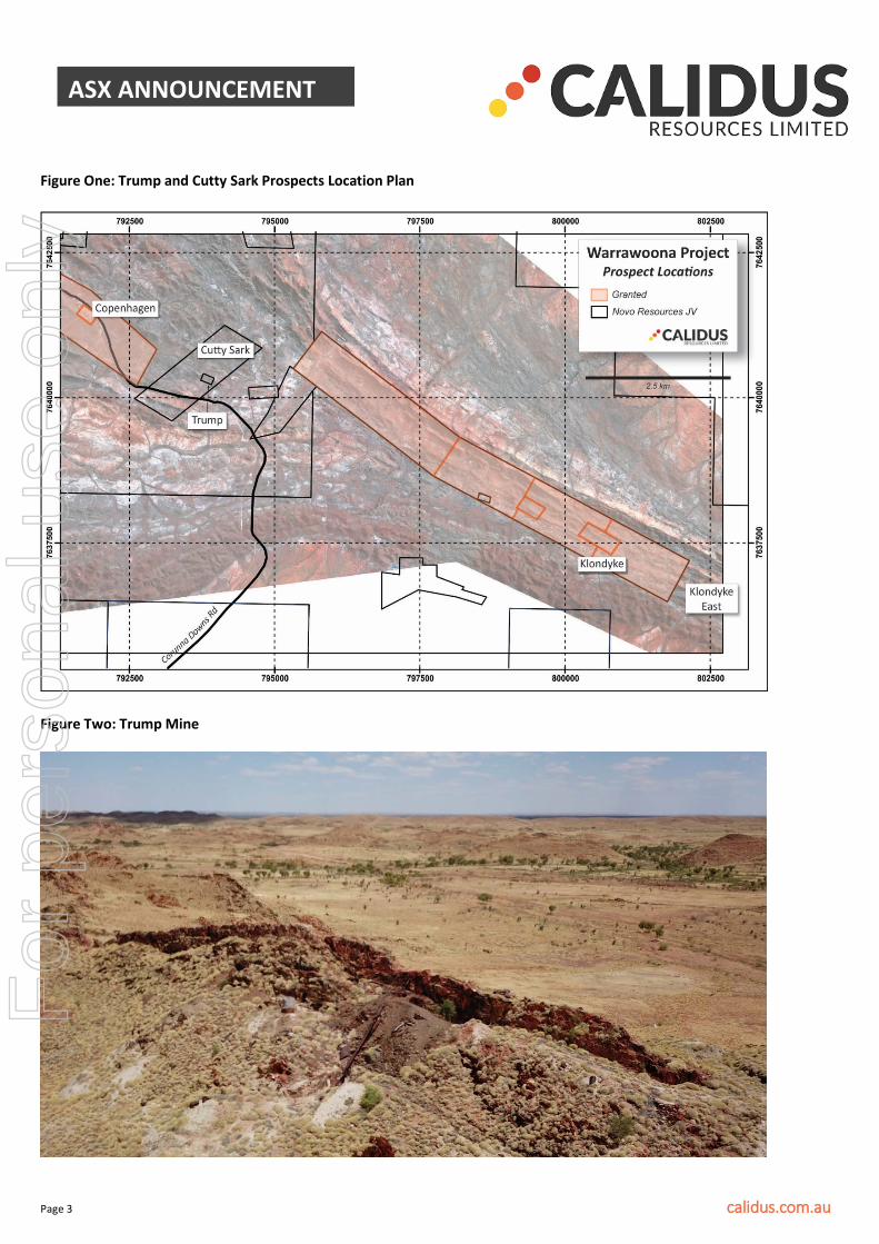
Figure Two: Trump Mine
For
per
sona
l use
onl
y
Page 4 calidus.com.au
ASX ANNOUNCEMENT
Recent first-pass high-grade Fieldings Gully results have provided encouragement to pursue the eastern strike extent of the satellite deposit with further RC drilling planned prior to Christmas. The structure hosting the significant intercept of 16m @ 3.52g/t Au (incl 1m @ 10.85g/t and 1m @ 22.0g/t) from 71m in hole 17FGRC005 (as released 14 November, 2017) on the most easterly section drilled by Calidus will be drill tested along strike to the east. Conglomerate Targets
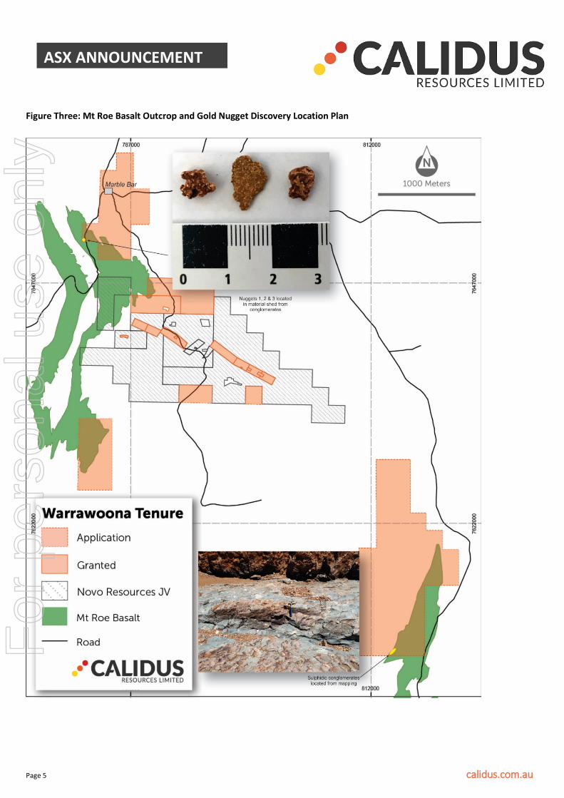
Calidus has recently completed a regional targeting exercise to confirm a number of potential gold-hosting conglomerate targets on the Companies granted tenements and applications. On an initial field trip that was aimed at locating the contact horizon and determine the extent of basal Mt Roe formations outcropping on tenement application ELA45/4556 close to Marble Bar, gold nuggets were confirmed as shown in Figure Three.
Initial overview mapping on tenement ELA45/4556 has revealed Fortescue Group conglomerates with the gold nuggets discovered at surface by gold detector in weathered material shedding from the adjacent outcropping conglomerate. The three nuggets are quite flat in nature, indicating they have not been transported far from their source.
Geological mapping focusing on conglomerate outcrop is also being undertaken on our 100% applications ELA45/4856 and ELA45/4857. ELA45/4856 is located about 27km south of the town of Marble Bar with the Mt Roe Basalt outcropping over the western and northwestern parts of the tenement. This comprises two main lenses, a northern lens, 500 m long and up to 150 m wide, and a southern lens up to 400m in wide and with 500 m strike length.
ELA45/4857 is located about 49 km southeast of the town of Marble Bar where a lens of polymictic boulder conglomerate near the base of the Mt Roe Basalt was confirmed. The conglomerate appears to transition laterally into pebbly sandstone and very coarse-grained sandstone. The conglomerate is very poorly sorted with clasts ranging from sub-angular to sub-rounded and underlain by very coarse-grained sandstone.
Bedding is not recognized in the conglomerate because of the lumpy nature of the outcrops and the lack of recognisable structures. Both of the lenses are irregular in outline. Clasts are poorly sorted from sandstone grains to cobbles. Granitic clasts are rounded and with low sphericity; other clasts, such as basalt, sandstone, siltstone, and quartz debris, are generally angular. The matrix is grey and very siliceous with angular quartz grains, and is silicified and recrystallised with very fine pyrite occasionally identified under hand lens. The lack of boulders might indicate a medium to low energy depositional environment. Calidus will continue systematic geological mapping and exploration of the potential gold-hosting conglomerate units identified in the targeting exercise during December and Q1 2018.
For
per
sona
l use
onl
y
Page 5 calidus.com.au
ASX ANNOUNCEMENT
Figure Three: Mt Roe Basalt Outcrop and Gold Nugget Discovery Location Plan
For
per
sona
l use
onl
y
Page 6 calidus.com.au
ASX ANNOUNCEMENT
Project History/ Historical Workings
The Warrawoona Project was first discovered and mined in 1897. There are over 200 known historic workings on the Company’s tenements. All of these workings are small scale workings targeting the high grade (plus 1oz/t) mineralisation that is prevalent through the area. Average mined grades for some of these workings include:
• Klondyke Queen 187g/t • Klondyke Boulder 40g/t • Golden Gauntlet 50g/t • Bow Bells 46g/t • Great Western 52g/t • St George 167g/t • Cuban 106g/t • Kopke’s Reward 90g/t • British Exploration of Australia 184g/t
Various companies have held portions of the main Klondyke zone in a “chequerboard” fashion over the years which has resulted in the current discontinuous resource at Klondyke. By consolidating the entire strike of the main zone of Klondyke, the Company is in the enviable position of being able to rapidly increase resources by in-fill drilling known mineralised areas that were previously not accessible to historic owners. In addition, it allows the Company to have a global view of the entire Warrawoona Greenstone which allows a superior geological model to be built to assist in better targeting the large number of prospects that lie on the Company’s tenements.
- END –
Notes Specific-ASX Announcements
The following announcements were lodged with the ASX and further details (including supporting JORC Reporting Tables) for each of the sections noted in this Announcement can be found in the following releases. Note that these announcements are not the only announcements released to the ASX but specific to exploration reporting on the Warrawoona Gold Project. The Company confirms that it is not aware of any new information or data that materially affects the information on the Project.
• Pharmanet to acquire the Warrawoona Gold Project in Western Australia: 22 March 2017 • Calidus Resources Limited-Prospectus: 8 May 2017
The information in this announcement that relates to exploration targets and exploration results is based on information compiled by Jane Allen a competent person who is a member of the AusIMM. Jane Allen is employed by Calidus Resources Limited. Jane has sufficient experience that is relevant to the style of mineralisation and type of deposits under consideration and to the activity being undertaken to qualify as a Competent Person as defined in the 2012 edition of the JORC Code. Jane Allen consents to the inclusion in this announcement of the matters based on her work in the form and context in which it appears.
The information in this report that relates to Exploration Results or Mineral Resources is based on information compiled or reviewed by Mr. Daniel Saunders, Principal of GeoServ Consulting Pty Ltd., who is a Member of the Australian Minerals Institute. Mr. Daniel Saunders is a full-time employee of GeoServ Consulting Pty Ltd. and has sufficient experience, which is relevant to the style of mineralisation and types of deposit under consideration and to the activities undertaken, to qualify as a Competent Person as defined in the 2012 Edition of the “Australasian Code of Reporting of Exploration Results, Mineral Resources and Ore Reserves”. Mr. Daniel Saunders consents to the inclusion of the report of the matters based on the information in the form and context in which it appears.
For
per
sona
l use
onl
y
Page 7 calidus.com.au
ASX ANNOUNCEMENT
For further information please contact:
Dave Reeves Managing Director
About Calidus Resources
Calidus Resources (ASX:CAI) is an ASX listed gold exploration company which controls the Warrawoona Gold Project in the East Pilbara district of the Pilbara Goldfield in Western Australia.
The Directors believe that the recent and on-going consolidation of this goldfield will transform the Company into a new Australian gold development company with significant potential to unlock further resources and new discoveries within the emerging gold belt of the Pilbara Goldfields district, which is a historically proven gold mining region. An aggressive drilling program is being pursued to rapidly and cost effectively add resource ounces in the near term as the first step towards development of a stand-alone gold operation.
For
per
sona
l use
onl
y

Page 8 calidus.com.au
ASX ANNOUNCEMENT
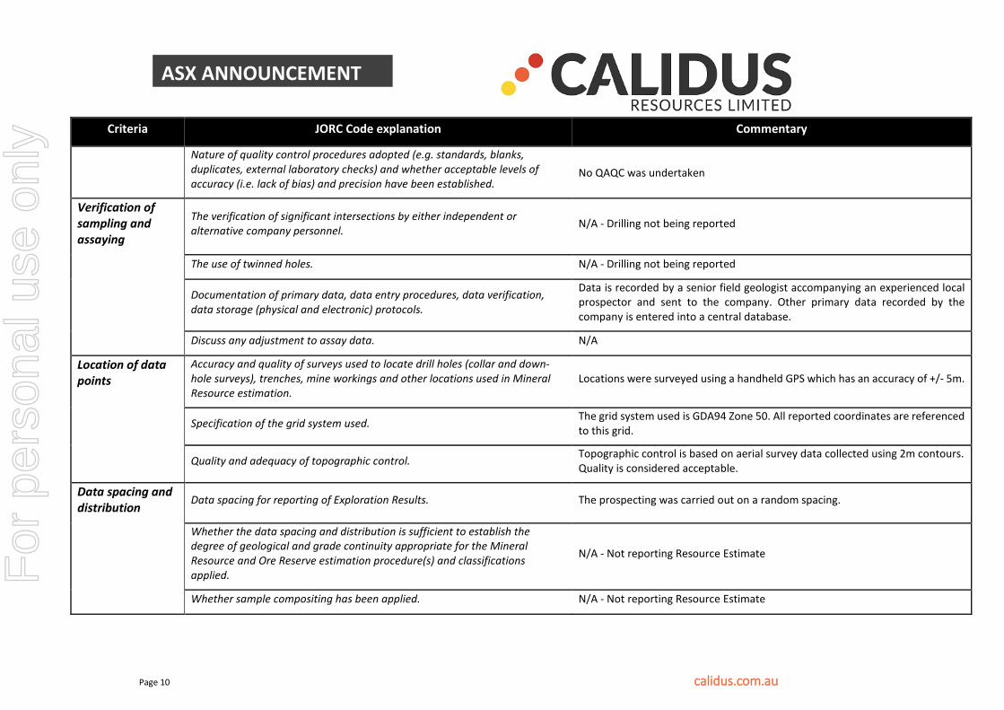
JORC TABLE 1 DISCLOSURES WARRAWOONA PROJECT JORC Code, 2012 Edition – Table 1 Section 1 Sampling Techniques and Data
Criteria JORC Code explanation Commentary
Sampling techniques
Nature and quality of sampling (e.g. cut channels, random chips, or specific specialised industry standard measurement tools appropriate to the minerals under investigation, such as down hole gamma sondes, or handheld XRF instruments, etc). These examples should not be taken as limiting the broad meaning of sampling.
3 gold nuggets weighing a total of 2.8 grams on a handheld digital scale have been located using a hand held metal detector whilst conducting reconnaissance exploration work over tenure prospective for conglomerate style gold mineralization.
Include reference to measures taken to ensure sample representivity and the appropriate calibration of any measurement tools or systems used. It is not possible to ensure sample representivity with metal detecting.
Aspects of the determination of mineralisation that are Material to the Public Report. N/A
Drilling techniques
Drill type (e.g. core, reverse circulation, open-hole hammer, rotary air blast, auger, Bangka, sonic, etc) and details (e.g. core diameter, triple or standard tube, depth of diamond tails, face-sampling bit or other type, whether core is oriented and if so, by what method, etc).
N/A - Drilling not being reported
Drill sample recovery
Method of recording and assessing core and chip sample recoveries and results assessed. N/A - Drilling not being reported
Measures taken to maximise sample recovery and ensure representative nature of the samples. N/A - Drilling not being reported
Whether a relationship exists between sample recovery and grade and whether sample bias may have occurred due to preferential loss/gain of fine/coarse material.
N/A - Drilling not being reported
For
per
sona
l use
onl
y
Page 9 calidus.com.au
ASX ANNOUNCEMENT
Criteria JORC Code explanation Commentary
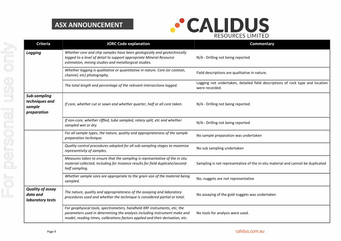
Logging Whether core and chip samples have been geologically and geotechnically logged to a level of detail to support appropriate Mineral Resource estimation, mining studies and metallurgical studies.
N/A - Drilling not being reported
Whether logging is qualitative or quantitative in nature. Core (or costean, channel, etc) photography. Field descriptions are qualitative in nature.
The total length and percentage of the relevant intersections logged. Logging not undertaken, detailed field descriptions of rock type and location were recorded.
Sub-sampling techniques and sample preparation
If core, whether cut or sawn and whether quarter, half or all core taken. N/A - Drilling not being reported
If non-core, whether riffled, tube sampled, rotary split, etc and whether sampled wet or dry. N/A - Drilling not being reported
For all sample types, the nature, quality and appropriateness of the sample preparation technique. No sample preparation was undertaken
Quality control procedures adopted for all sub-sampling stages to maximise representivity of samples. No sub sampling undertaken
Measures taken to ensure that the sampling is representative of the in situ material collected, including for instance results for field duplicate/second-half sampling.
Sampling is not representative of the in-situ material and cannot be duplicated
Whether sample sizes are appropriate to the grain size of the material being sampled. No, nuggets are not representative
Quality of assay data and laboratory tests
The nature, quality and appropriateness of the assaying and laboratory procedures used and whether the technique is considered partial or total. No assaying of the gold nuggets was undertaken
For geophysical tools, spectrometers, handheld XRF instruments, etc, the parameters used in determining the analysis including instrument make and model, reading times, calibrations factors applied and their derivation, etc.
No tools for analysis were used.
For
per
sona
l use
onl
y
Page 10 calidus.com.au
ASX ANNOUNCEMENT
Criteria JORC Code explanation Commentary
Nature of quality control procedures adopted (e.g. standards, blanks, duplicates, external laboratory checks) and whether acceptable levels of accuracy (i.e. lack of bias) and precision have been established.
No QAQC was undertaken
Verification of sampling and assaying
The verification of significant intersections by either independent or alternative company personnel. N/A - Drilling not being reported
The use of twinned holes. N/A - Drilling not being reported
Documentation of primary data, data entry procedures, data verification, data storage (physical and electronic) protocols.
Data is recorded by a senior field geologist accompanying an experienced local prospector and sent to the company. Other primary data recorded by the company is entered into a central database.
Discuss any adjustment to assay data. N/A
Location of data points
Accuracy and quality of surveys used to locate drill holes (collar and down-hole surveys), trenches, mine workings and other locations used in Mineral Resource estimation.
Locations were surveyed using a handheld GPS which has an accuracy of +/- 5m.
Specification of the grid system used. The grid system used is GDA94 Zone 50. All reported coordinates are referenced to this grid.
Quality and adequacy of topographic control. Topographic control is based on aerial survey data collected using 2m contours. Quality is considered acceptable.
Data spacing and distribution Data spacing for reporting of Exploration Results. The prospecting was carried out on a random spacing.
Whether the data spacing and distribution is sufficient to establish the degree of geological and grade continuity appropriate for the Mineral Resource and Ore Reserve estimation procedure(s) and classifications applied.
N/A - Not reporting Resource Estimate
Whether sample compositing has been applied. N/A - Not reporting Resource Estimate
For
per
sona
l use
onl
y
Page 11 calidus.com.au
ASX ANNOUNCEMENT
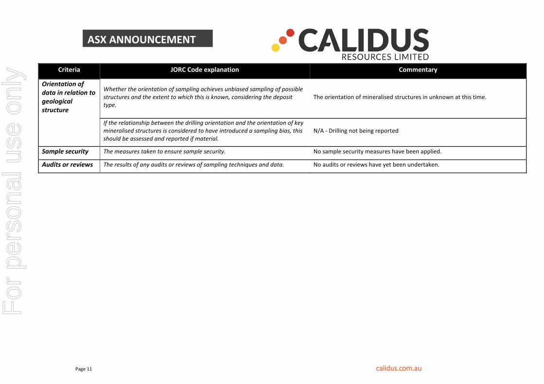
Criteria JORC Code explanation Commentary
Orientation of data in relation to geological structure
Whether the orientation of sampling achieves unbiased sampling of possible structures and the extent to which this is known, considering the deposit type.
The orientation of mineralised structures in unknown at this time.
If the relationship between the drilling orientation and the orientation of key mineralised structures is considered to have introduced a sampling bias, this should be assessed and reported if material.
N/A - Drilling not being reported
Sample security The measures taken to ensure sample security. No sample security measures have been applied.
Audits or reviews The results of any audits or reviews of sampling techniques and data. No audits or reviews have yet been undertaken.
For
per
sona
l use
onl
y

Page 12 calidus.com.au
ASX ANNOUNCEMENT
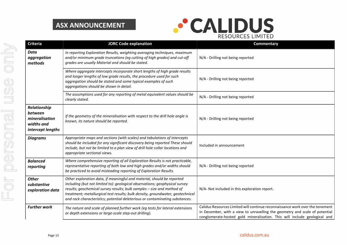
Section 2 Reporting of Exploration Results
Criteria JORC Code explanation Commentary
Mineral tenement and land tenure status
Type, reference name/number, location and ownership including agreements or material issues with third parties such as joint ventures, partnerships, overriding royalties, native title interests, historical sites, wilderness or national park and environmental settings.
The prospecting was undertaken in the East Pilbara District of the Pilbara Goldfield of Western Australia, approximately 150km SE of Port Hedland and approximately 25km SE of the town of Marble Bar. The tenement (E45/4556), is pending and Calidus has an option to acquire 100% from Epminex Resources as previously disclosed in the prospectus.
The security of the tenure held at the time of reporting along with any known impediments to obtaining a licence to operate in the area. The area is an application.
Exploration done by other parties
Acknowledgment and appraisal of exploration by other parties.
The Warrawoona Shear Zone is thought to have been discovered as a result of the gold rushes to the Pilbara in the late 1880s. Modern exploration has been undertaken by the Geological Survey of Western Australia (GSWA) followed by a number of explorers in the mid-1980s and then from 1993 to the present day. During this period Aztec Mining, CRA, Lynas and Jupiter all conducted exploration in the Klondyke area. Drilling information from these explorers has been reviewed and included as part of this Mineral Resource estimate, with the respective confidence in the quality considered in assignment of the Mineral Resource classification applied.
Geology Deposit type, geological setting and style of mineralisation.
The prospecting was undertaken across several outcropping conglomerates located in the area by traversing and geological mapping. Target mineralization are conglomerate-hosted gold deposits.
Drill hole Information
A summary of all information material to the understanding of the exploration results including a tabulation of the following information for all Material drill holes:easting and northing of the drill hole collar
elevation or RL (Reduced Level – elevation above sea level in metres) of the drill hole collar
dip and azimuth of the hole
down hole length and interception depth
hole length.
N/A - Drilling not being reported
Refer Figure Three in the announcement for location plan of gold nugget discovery.
For
per
sona
l use
onl
y
Page 13 calidus.com.au
ASX ANNOUNCEMENT
Criteria JORC Code explanation Commentary
Data aggregation methods
In reporting Exploration Results, weighting averaging techniques, maximum and/or minimum grade truncations (eg cutting of high grades) and cut-off grades are usually Material and should be stated.
N/A - Drilling not being reported
Where aggregate intercepts incorporate short lengths of high grade results and longer lengths of low grade results, the procedure used for such aggregation should be stated and some typical examples of such aggregations should be shown in detail.
N/A - Drilling not being reported
The assumptions used for any reporting of metal equivalent values should be clearly stated. N/A - Drilling not being reported
Relationship between mineralisation widths and intercept lengths
If the geometry of the mineralisation with respect to the drill hole angle is known, its nature should be reported. N/A - Drilling not being reported
Diagrams Appropriate maps and sections (with scales) and tabulations of intercepts should be included for any significant discovery being reported These should include, but not be limited to a plan view of drill hole collar locations and appropriate sectional views.
Included in announcement
Balanced reporting
Where comprehensive reporting of all Exploration Results is not practicable, representative reporting of both low and high grades and/or widths should be practiced to avoid misleading reporting of Exploration Results.
N/A - Drilling not being reported
Other substantive exploration data
Other exploration data, if meaningful and material, should be reported including (but not limited to): geological observations; geophysical survey results; geochemical survey results; bulk samples – size and method of treatment; metallurgical test results; bulk density, groundwater, geotechnical and rock characteristics; potential deleterious or contaminating substances.
N/A- Not included in this exploration report.
Further work The nature and scale of planned further work (eg tests for lateral extensions or depth extensions or large-scale step-out drilling).
Calidus Resources Limited will continue reconnaissance work over the tenement in December, with a view to unravelling the geometry and scale of potential conglomerate-hosted gold mineralization. This will include geological and
For
per
sona
l use
onl
y
Page 14 calidus.com.au
ASX ANNOUNCEMENT
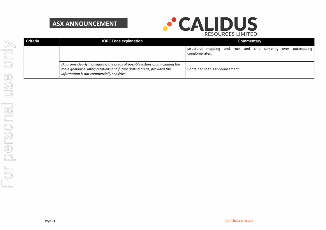
Criteria JORC Code explanation Commentary
structural mapping and rock and chip sampling over outcropping conglomerates.
Diagrams clearly highlighting the areas of possible extensions, including the main geological interpretations and future drilling areas, provided this information is not commercially sensitive.
Contained in this announcement
For
per
sona
l use
onl
y