caba gis data package user guide - catchment-based · pdf filecaba gis data package user guide...
TRANSCRIPT
CaBA GIS Data Package User Guide
Version 3, 2016
David Johnson, Michelle Walker & Lucy Butler, The Rivers Trust
Production of this guide was made possible thanks to the Environment Agency Catchment
Partnership Fund 2015-16 and EU LIFE Funding

3
CaBADataPackageGuidancev3.0.docx 2
CONTENTS 1.0 The way to use this guidance and licensing considerations ............................................................................. 4
1.1 Data licensing considerations ....................................................................................................................... 4
1.2 How to use this guide ................................................................................................................................... 4
1.3 What about wales?....................................................................................................................................... 6
1.4 How to grow this resource and tailor it to your catchments needs ............................................................. 6
1.4 CaBA open data, future data package releases and online mapping ........................................................... 6
2.0 Where are the opportunities for action within my catchment? ...................................................................... 7
Step 2a: Can drinking water quality be improved? ............................................................................................ 7
Step 2b: Is it possible to improved river water quality for the aquatic ecology? ............................................... 7
Step 2c: Where is the best place to improve the environment for wildlife? ..................................................... 8
Step 2d: Is there enough water for abstraction and the environment? ............................................................ 9
Step 2e: Can we reduce flooding risk? ............................................................................................................... 9
Step 2f: Is it possible to improved bathing water quality? ............................................................................... 10
Step 2g: Where are the best locations for contributing to the reduction in climate change? ........................ 11
Step 2h: Where are other organisations already working in the catchment? (Phase 2) ................................. 11
Step 2I: Climate change adaptation. Which river reaches will benefit most from tree planting? (Phase 3) ... 11
3.0 What are the well know issues in my catchment? ......................................................................................... 12
Step 3a: Where are the know problems in my catchment in surface water? .................................................. 12
Step 3b: Where are the main problems in my catchment in the groundwater? ............................................. 13
Step 3c. Where are the known problems in my catchment in lakes? .............................................................. 14
Step 3d: Where are the main problems in my catchment in the estuaries (transitional waters)? .................. 15
Step 3e: Where are the main problems in my catchment on the canals? ....................................................... 15
Step 3f: Where are the main problems in my catchment on the coast? ......................................................... 15
4.0 What are the key characteristics of my catchment? ..................................................................................... 17
Step 4a: What is the Weather and climate like in the catchment? .................................................................. 17
Step 4b: What is the Land cover, landuse and soils in the catchment? ........................................................... 17
Step 4c: What do we know about Surface Water in the catchment? .............................................................. 18
Step 4d: What do we know about Groundwater in the catchment? ............................................................... 19
Step 4e: What do we know about Canals, Lakes, Estuaries and coastal areas in the catchment? ................. 19
5.0 What are the suspected causes of problems in the catchment? ................................................................... 20
Step 5a: Where are the Point sources of pollution in the catchment and which sector is responsible? ......... 20
Step 5b: What are the Diffuse sources of pollution within the catchment? .................................................... 21
Step 5c: Are there any Barriers to fish migration in the river? ........................................................................ 22
Step 5d: What does the Environment Agency think the reasons for not achieving good status are in the
catchment?....................................................................................................................................................... 22
3
CaBADataPackageGuidancev3.0.docx 3
6.0 Base mapping ................................................................................................................................................. 24
Step 6a: Who is already active in the catchment? ........................................................................................... 24
Step 6B: Contextual information for the catchment? ...................................................................................... 24
7.0 What measures are most likely to have a positive impact? ........................................................................... 25
Annexes ................................................................................................................................................................ 26
Annex 1: Can drinking water quality be improved? ......................................................................................... 26
Annex 2: Is it possible to improved river water quality for the aquatic ecology? ............................................ 26
Annex 3: Where is the best place to improve the environment for wildlife .................................................... 26
Annex 4: Is there enough water for abstraction and the environment? ......................................................... 27
Annex 5: Can we reduce flooding risk? ............................................................................................................ 28
Annex 6: Is it possible to improved bathing water quality? ............................................................................. 28
Annex 7: Where are the best locations for contributing to the reduction in climate change ......................... 28
Annex 8: Where are the know problems in my catchment in surface water? ................................................. 28
Annex 9: Where are the know problems in my catchment in groundwater? .................................................. 28
Annex 10: Where are the know problems in my catchment in lakes? ............................................................. 28
Annex 11: Where are the main problems in my catchment in the estuaries? ................................................. 28
Annex 12: Where are the main problems in my catchment in the coastal waters or canals? ......................... 29
Annex 13: Weather and climate ....................................................................................................................... 29
Annex 14: Land cover and landuse. ................................................................................................................. 29
Annex 15: Surface Water ................................................................................................................................. 29
Annex 17: Point sources ................................................................................................................................... 30
Annex 18: Diffuse sources ................................................................................................................................ 31
Annex 19: Barriers to flow ................................................................................................................................ 31
Annex 20: Reasons for failure (Now Reasons for Not Achieving Good Status ................................................. 31
Annex 21: Who else is working in the catchment? .......................................................................................... 31
Annex 22: Keeping Rivers Cool ......................................................................................................................... 31
Annex 23: FCS2 Fisheries classification model ................................................................................................. 31
Annex 24: PSYCHIC phosphorus and sediment ................................................................................................ 31
Annex 25: NEAPN nitrate leaching ................................................................................................................... 31
This guide accompanies the CaBA GIS Data Package, which is a set of GIS layers suitable for supporting
integrated catchment management planning. The datasets are displayed, interpreted and grouped to help
partnerships identify issues and opportunities for collaborative action to improve their river catchments. Three
packages of data have been issued, each with an accompanying license, which is signed by the host
organisation in each partnership in order to obtain the data download link and share this in turn with the
partnership organisations.
All catchment host organisations are entitled to request the data package for their catchment(s) by contacting
3
CaBADataPackageGuidancev3.0.docx 4
1.0 THE WAY TO USE THIS GUIDANCE AND LICENSING CONSIDERATIONS
1.1 DATA LICENSING CONSIDERATIONS
The data contained in the three data packages comes from a variety of sources. This section summarises how
the data should be used to comply with the licenses and make sure that CaBA partnerships are recognised as
responsible and trusted users of environmental data and evidence. For each data layer the following information
is available.
Dataset description: This is the name of the data layer as it appears in the GIS package.
Data source. The source of each data layer is identified. It is critical to know the provenance of data, as this has
a direct bearing on the weight that should be placed upon it when making decisions.
Data release. The have been three data releases. There is guidance available on the CaBA website to show you
how to combine datasets from each release.
License. Most of the data contained in each release is licensed for the use of CaBA partnerships. For each dataset
we identify whether the data is:
OpenData. This means that there are no restrictions on the use of the data.
Open Government License. This means you can use the data for commercial and non-commercial
purposes but must acknowledge the supplier if the data is published. See section on acknowledgements
below. http://www.nationalarchives.gov.uk/doc/open-government-licence/version/3/
Standard Refer to the license document for terms and conditions
Non commercial. This means you can use the data for non-commercial purposes only.
Forestry Commission Terms of Use. As for non-commercial.
OS OpenData. As for Open Government license.
ESRI. This applies to the areal photography and limits the use to organisations with an ESRI license.
License 1, 2 or 3. This means that the data can be used under license. There is one license per
catchment, a signed copy of which is held by the Environment Agency and by the Rivers Trust. If you
have mislaid your copy please contact [email protected] and we will provide you
with a copy for your catchment.
Acknowledgements. Some of the datasets require formal acknowledgements if they are used in publications.
These acknowledgements are included in the ArcGIS Desktop layout view of each data release. It is part of the
license conditions to include these acknowledgments when publishing any of the data.
Can I pass on the data package to partners within my catchment? Yes. Each host organisation is in control of
passing on the data to partners within the catchment, in order to support the host organisation’s position as the
one point of coordination within each CaBA catchment and maximise the potential for collaboration. When the
data is passed on it should include a copy of the license, which the host organisation has signed. The best way
to pass on data is simply to copy the web link, which was used to send each partnership data in the first place.
1.2 HOW TO USE THIS GUIDE
This guidance is written with a headline style. The headline, in bold, summarises each section, the following
paragraph explains the headline in more detail and identifies the relevant Groups of data and 'data layers' which
have been provided in the GIS project. At the end of each section there are references for further detail; these
are usually in one of the Annexes of this guide. The report is structured like the GIS, with each section of the
report dealing with one of the four main questions in the GIS. The sub-sections of the report relate to the sub-
3
CaBADataPackageGuidancev3.0.docx 5
groups in the GIS. This guidance note is a living document and will be revised as new layers become available.
The supporting information in the Annexes will be refined and added to as the data is used by CaBA partners
and they provide feedback on the level of information required. This is the third version of the guide. Where
new data has been added this is identified as 'Release 3' data. Any additional information required to help
you interpret this data is included in 'Annex Release 3'. A guide explaining how to add this data into your
existing Data&GIS project is included with the Phase 3 data.
There are a few things to be aware of regarding the data package:
The datasets in this package will become out of date and need renewing. This is particularly true for datasets
such as ' The Reasons For Failure database' which has been reviewed and improved by the Environment Agency
(Now called 'Reasons For Not Achieving Good, RFNAG); However, it is also true for the other datasets. Data and
evidence is always being refined and revised; we are using the best available data at the moment, but need to
update this data as improvements are made. Where possible we have provided the link to the updated data as
well as including updates in each 'Phase' of the data released.
The Environment Agency is moving towards OpenData. This good news and means that new data is being made
available all the time. We will let you know when useful new data becomes available but it is always worth
checking https://data.gov.uk for the latest freely available data, and you can subscibe to update emails. Where
OpenData has been included in the data package this is indicated OpenData in the description of the layer.
CAMS status is based on the lowest downstream status, whilst WFD status relates to the water body itself.
There are basically two approaches to assessing risk in a river system, both equally valid. The first approach
identifies the status of a catchment based on the lowest status downstream. This is useful for highlighting where
there are issues downstream and areas of land where water resources or quality are 'vulnerable' to new
pressures (CAMS and NVZs). The WFD approach focuses on the catchment where the risk is observed and
highlight where mitigation should be focused if current problems are to be reduced.
The aerial photography layer will only plot when you are connected to the internet. This layer is in the
'Basemapping' section and is called 'WMS; World Imagery' This can be a nuisance but it avoids some difficult
licensing issues. #Note we made a mistake in the first data package and you need to change the projection of
this dataset if you want it to line up perfectly with the OS basemap.
Groundwater status can look a little odd in some catchments because the entire catchment may be at one
status. This is either because there is a very large aquifer in that catchment or because all the aquifers have the
same status. It is always worth opening the attribute table to see if there is more than one groundwater body in
the catchment.
Some layers will have nothing in them. All the layers have been included in all the CaBA catchments, however,
some, for example 'coastal', will not have anything in them because they do not occur within every CaBA
catchment. If this is the case for your catchment these layers can just be removed.
The attribute tables should be fine for most values except for the lengths and areas. This is because some of
the polygons will have been cut to only include the portion within your catchment, however, the area associated
with that polygon will be for the whole area not just the portion in your catchment. If you go on the GIS training
course they will show you how to re-calculate the areas.
The attribute tables can have many attributes which we cannot use. We have simplified many of the layers
however, some still have many attributes which are of no use because we do not know what they are! It is
possible that we will find out and in future versions of this guidance, explain what they are and how to use them.
3
CaBADataPackageGuidancev3.0.docx 6
If you have queries regarding any of the data, it is always a good idea to use your local catchment coordinator
to help you find out what the data means; how it was derived and whether it is appropriate for the way in which
you would like to use it.
1.3 WHAT ABOUT WALES?
The first data package is available for Wales as it was developed before NRW was formed. Subsequent data
packages have only partial coverage of Wales. Where possible data for cross border catchments have been
accessed from NRW and a separate license has been issued.
1.4 HOW TO GROW THIS RESOURCE AND TAILOR IT TO YOUR CATCHMENTS NEEDS
The data packages are just the start. The aim is that every catchment partnership will grow and modify their
data packages to suit the needs of the partnership. When we are undertaking projects around the country we
start with the data packages and then add in locally generated data and evidence from modelling, monitoring
and local knowledge. Which datasets we add depends on the questions we are asking.
1.4 CABA OPEN DATA, FUTURE DATA PACKAGE RELEASES AND ONLINE MAPPING
Where possible, we are also publishing datasets online as Open Data, so that they can be more easily kept up to
date, and can be used in ESRI desktop and online GIS aswell as other mapping software. Future data package
updates will primarily be released via this method, and we are attributing data with CaBA catchment and
partnership identifiers, so that you can filter or clip national datasets by your area of interest.
Visit http://theriverstrust.maps.arcgis.com/ to find the CaBA Open Data Portal, browse examples of ArcGIS
Online maps and apps, and online GIS training resources. If you’d like to know more, or to register your interest
in future ArcGIS Online training, please contact us ([email protected]) and ensure that you
don’t miss any updates by signing up to the CaBA mailing list: http://eepurl.com/KFOST and subscribing to the
CaBA Discussion Forum: http://www.catchmentbasedapproach.org/discussions.
3
CaBADataPackageGuidancev3.0.docx 7
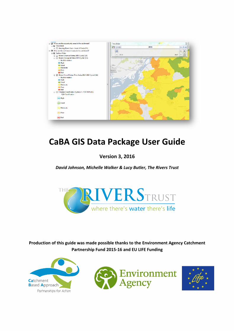
2.0 WHERE ARE THE OPPORTUNITIES FOR ACTION WITHIN MY CATCHMENT? The first group of data layers identify the locations in your catchment where different stakeholders could benefit
from measures being implemented. If a partner could benefit they may be able to access resources to help fund
improvements. All the data layers provided are suitable for the initial screening of a catchment and engaging
with stakeholders. The design and implementation of improvements will require more detailed local knowledge
and understanding to be added to this data so that you can be confident that the improvements are well
targeted and cost effective. More detail on each of the layers is included in annexes.
STEP 2A: CAN DRINKING WATER QUALITY BE IMPROVED? (Freshwater group): One of the most
valuable resources in any catchment is drinking water. Since privatisation 25 years ago the water industry has
spent over £100bn on improving the water supply and sewerage infrastructure. In reality catchments are a key
component of this infrastructure and can be improved to sustainably deliver better quality drinking water and
more effective disposal of sewage. Key datasets include:
Surface Water Safeguard Zones and Pressures (EA) (Release 2) (License 2). The 'Safe guard Zones'
(SgZ) data defines the whole upstream catchment of a drinking water abstraction from rivers, lakes and
reservoirs. Any activity within this zone has the potential to impact the quality of raw water abstracted
for drinking, however, the nearer the activity is to the abstraction the greater the likelihood of impact.
The dataset is displayed according to the water quality parameters which water companies are most
concerned about. This dataset is ideal for targeting catchment management options to deliver benefits
for water companies. This data will become OpenData in 2015.
Ground Water Safeguard Zones and Pressures (EA). (Release 2) (License 2). These are similar to the
Phase 1 Source Protection Zones (see below). SgZs are based on SPZs, usually the SPZ 2, and use
additional assessment to identify areas, which may or may not coincide with the SPZ, where additional
measures are required to ensure that abstraction waters meet Article 7.3 of the WFD. SgZs can be large
or small depending on the problem and may not cover the whole of a catchment or sub-catchment.
This data will become OpenData in 2015.
'Drinking Water Protected Area (EA) (Release 1) (License 1) This defines the area of land immediately
upstream of an abstraction for drinking water from a river. This dataset is significantly improved by the
Phase 2 SgZ datasets above.
'Source Protection Zones (EA) (Release 1) (License 1) (SPZ) identifies the area of land through which
water infiltrates into a groundwater borehole that is used for drinking water. Groundwater is an
exceptionally valuable resource because it is has the lowest carbon footprint of any of our sources of
drinking water. It is also very sensitive to poor water quality because there is often minimal treatment
of the water before it enters supply.
Changing land management within either of the areas identified above could have a beneficial impact on
drinking water. Potential partners, Water companies and the Environment Agency, are likely to be willing to
collaborate with improvement works inside these areas. However, it is important to understand that significant
resources are unlikely to be committed unless there is a specific water quality or quantity issue which could be
solved by changing land management. Key drinking water issues are pesticides in surface water and nitrates in
groundwater. Secondary issues are pesticides or faecal pollution of groundwater, where it is vulnerable to
pollution, and colour and sediment at surface water intakes. Further information in Annex 1.
STEP 2B: IS IT POSSIBLE TO IMPROVED RIVER WATER QUALITY FOR THE AQUATIC ECOLOGY?
(Fresh water group) Phosphorus and sediments have a profound impact on the quality of aquatic ecology. Partly
in recognition of this the amount of phosphorus that sewage treatment works can discharge to the environment
is likely to be reduced in the near future (UK TAG, 2013). However, the costs of improving treatment works are

3
CaBADataPackageGuidancev3.0.docx 8
significant. Changing land management may be a more cost effective solution in some catchments with small
rural sewage treatment works. This is particularly true where the bulk of the phosphorus is coming from
agriculture and the improvement in water quality required to meet the new standards is modest. Reducing
sediment loss in catchments will also have significant benefits for the ecology. The key datasets are:
'SA GIS Opportunity for Catchment Management of P' (EA) (Release 1) (License 1) identifies surface
water catchments where changing land management practice to reduce losses of phosphorus is most
likely to achieve the proposed water quality standards.
'Soil Erodibility' (EU soils) (Release 1) identifies soils which are vulnerable to erosion if high risk land
management activities are practiced. The darker the colour the higher the risk of soil erosion for any
given land management.
In these catchments water companies may be willing to work with partnerships to reduce phosphorus losses
from the catchment which will have other benefits, particularly for sediment, for the aquatic environment. It
should be recalled that reducing phosphorus concentrations will require a long term commitment because it will
take a significant amount of time for changes to phosphorus inputs and losses to feed through into improved
water quality. For further information Annex 2.
Most water companies will already have identified whether there is an opportunity to avoid additional P
stripping treatment costs by using catchment management approaches.
STEP 2C: WHERE IS THE BEST PLACE TO IMPROVE THE ENVIRONMENT FOR WILDLIFE? (Habitats
group) Improving the environment for wildlife provides significant benefits for the country as a whole as
described in UK National Ecosystem Assessment, 2011. Significant benefits can be achieved by improvements
around the edges of existing protected areas and by creating 'Habitats Networks' Natural England (2010) which
potentially link conservation area together allowing increased movement of species. The key datasets are:
'SPA' (NE), 'SAC' (NE) and 'SSSI' (NE) (Release 1) (OpenGov) All these sites are legally protected under
UK or EU law due to their scientific or conservation value.
'England Habitat Network' (NE) (Release 1) (OpenGov) Identifies where current habitats need to be
maintained or improved to promote habitat health. This data is useful both for identifying opportunities
for habitat creation as well as avoiding developing land which could significantly degrade the ecological
health of existing sites. The dataset provided identifies the preferred habitat in column 'Habitat_ty'.
Some areas of land will have a number of different preferred habitats, all of which will maintain or
enhance the ecological health of an area.
'Living Landscapes' (WT). (Release 1) (OpenData) Wildlife trusts have identified areas where The
Wildlife Trusts are targeting landscape-scale conservation efforts to halt the decline of wildlife and
restore the natural environment. More details of current work and catchment plans can be found at
Living landscape schemes however, it is worth noting that the layer in your project is more up to date
than the one on the website.
Catchment management in the areas identified are most likely to have beneficial impacts on local ecology.
However, Natural England warn against using the maps to 'join the dots' and suggest that greater benefit can
often be achieved by increasing the size of existing habitat patches rather than creating isolated new ones. In
many catchments there will be more detailed local 'Biodiversity Opportunity mapping' which will provide the
best available identification of where to create new habitat with the maximum potential for benefit. Potential
partners include Natural England, Environment Agency and local Conservation groups. Annex 3.
Natural England have done new NELMS targeting mapping. This has not been released yet (expected late 2015)
however, it is likely that when it is released it will provide good opportunity maps for habitat creation. The maps
are designed to enable applications for Countryside Stewardship grants and agreements to be assessed for their

3
CaBADataPackageGuidancev3.0.docx 9
strategic value to wildlife habitat. Until these maps are released the current areas for 'Countryside Stewardship
Scheme Agreements' and 'Countryside Stewardship Scheme Options' available from
http://environment.data.gov.uk/ds/catalogue give a reasonable guide to where habitat creation and
improvement could be targeted.
Woodland creation can provide valuable new habitat. The Forestry Commission have produced new opportunity
mapping which identifies where woodland creation can deliver wider benefits for the water environment in
terms of water quality and flood risk reduction. The new map has been published, however, it is not available as
a GIS layer because of IPR issues. It is worth asking your catchment co-ordinator if they are able to share the
maps with CaBA partners in their area.
STEP 2D: IS THERE ENOUGH WATER FOR ABSTRACTION AND THE ENVIRONMENT? (Water
regulation group) The quantity of water available from within the environment needs to be shared to meet both
human and ecological requirements. There are a number of initiatives which have focused on water resources
over the past decade including 'Returning to Sustainable Abstraction' and 'Catchment Abstraction Management
Plans' or CAMS, both from the Environment Agency. These initiatives focus on identifying the water
requirements for the aquatic ecology so that a sustainable level of abstraction can be identified. The assessment
is based on the availability of water resources in the most stressed catchment downstream. This is different from
the WFD assessments which are for the water body itself. Key layers:
'Resource Availability at Q50' (EA) (Release 2) (License 2). This gives a measure of the average
availability of water for abstraction throughout the year. Where it identifies that catchments are 'Over
abstracted' this implies that water needs to be put back into the catchment to enable the aquatic
ecology to thrive.
'Resource Availability at Q95' (EA) (Release 2) (License 2).This gives a measure of the availability of
water for abstraction in low flow months. Where it identifies that catchments are 'Over abstracted' this
implies that water needs to be put back into the catchment to enable the aquatic ecology to thrive.
'CAMS Water Reliability: % of time' (EA) (Release 1) (License 1). Shows the amount of time each year
when there are sufficient water resources within the catchment. The lower the percentage of time, the
more stretched the water resources are because too much water is being abstracted for drinking,
industry or agriculture.
Changing land management in the areas where water resources are stretched or installing Green Infrastructure
could improve the situation. However, it is unlikely that these improvements will make a significant difference
to the water available for abstraction. The Environment Agency has identified that water resource stressed
catchments represent a good opportunity for river improvement schemes because these enable the ecology to
be more resilient to low flows. The UKWIR/Atkins project on 'Effectiveness of Measures to Complement, or as
an Alternative to, Abstraction Reduction' (13/WR/25/5) provides guidance on how to target these
improvements. Ask your catchment coordinator if they can make this report, or the targeting maps, available
to you in your catchment. Potential partners for this work will include Water companies, especially where they
are involved in low flow studies, and the Environment Agency. Annex 4 and Annex Phase 2.
STEP 2E: CAN WE REDUCE FLOODING RISK? (Water regulation group) Catchment scale flooding is
difficult to influence by changing land management. It is a question of scale; the larger the catchment the more
significant the area of land management change that would be required to influence peak flows. This means that
smaller headwater catchments are likely to be the most suitable for mitigation measures targeted at reducing
flooding. Localised surface water flooding can also benefit significantly from modifications to the local hydrology
which increase the short term storage of water. Finally, large engineering schemes can represent significant
opportunities for habitat creation and improvement.

3
CaBADataPackageGuidancev3.0.docx 10
'FCRM Flood Risk Schemes' (EA) (Release 1) (License 1) are targeted at areas which have suffered from
flooding. Where there is insufficient funding (orange and red) there is the opportunity for partnership
working which could have wider benefits, particularly for habitat creation.
'Suitability for Infiltration SuDS' (BGS) (Release 1) (OpenData) Sustainable urban Drainage Schemes
(SuDS) slow down runoff and can allow greater storage of water within a catchment. The increased
storage of water can reduce peak flows, especially from intense summer storms. This can help reduce
localised surface water flooding, however, it is unlikely to be effective at reducing catchment scale
flooding due to the relative area of the scheme to the overall size of the catchment. Infiltration SuDS
direct water which would have runoff overland into the groundwater.
The Environment Agency project 'Communities @ Risk' will provide extremely valuable information about where
catchment management solutions to flood risk should be focused. When a data layer becomes available it will
be announced in the CaBA newsletter. The Environment Agency Flood Risk Management Plans for your
catchment also provide excellent information, by 'Operational catchment' about the projects which the
authorities with responsibility for flood risk plan to complete over the six years from 2015 to 2021. The tables of
projects, normally in section 10 of the reports, identify where catchment based initiatives are planned.
Woodland creation can significantly decrease localised surface runoff and associated flooding in small
catchments up to 100 km². There have been articles in the press that claim that woodland creation could reduce
flooding from large catchments; there is no evidence that this is the case. The Forestry Commission have revised
their Woodlands for Water – flood risk & water quality opportunity maps. However, these maps are not currently
available as GIS shapefiles due to IPR issues. Contact the Environment Agency 'National Customer Contact' team
for more information
There are two additional data layers which help to understand flood risk, these are included in section 4 'What
are the key characteristics of the catchment?'
Targeting measures which will store water or slow down the movement of water through the catchment may
benefit localised surface water flooding issues and smaller headwater catchments. Schemes to protect property
against catchment scale flooding may also provide opportunities for habitat creation. Working with Local
Authorities or the Environment Agency could well identify significant additional resources which could be
accessed to reduce the likelihood of flooding risk. Accessing Flood Risk Management money outside areas where
Local Authorities and the Environment Agency have identified a need will be difficult. Annex 5.
STEP 2F: IS IT POSSIBLE TO IMPROVED BATHING WATER QUALITY? ( Recreation & Culture group)
Bathing water quality on beaches and in lakes is determined by the bacteriological quality of the water from the
upstream catchment. The most significant sources of pollution come from agricultural livestock, sewage
treatment works and wildlife (particularly birds).
'Bathing Water Catchments: Zones of Influence' (EA) (Release 1) (License 1) identifies catchments that
drain to bathing beaches. This layer is the same as that used in the Bathing Water Explorer Bathing
water explorer
Reducing the loss of faecal matter into surface water through catchment management approaches will have
benefits for downstream surface water quality. However, it should be remembered that it takes very little faecal
contamination for bathing waters to fail the new revised bathing water standards which will come into force in
2015. Bathing water failures can be caused by small, localised sources of pollution which are well connected to
the bathing beach, e.g. grazing animals on nearby salt marshes or discharges from Combined Sewer Overflows
(CSOs). Bathing water failures are a sensitive issue and both the local Environment Agency (Area Office) and
Local Authorities (Tourism) may be able to access resources which will help to improve the water quality. Annex
6

3
CaBADataPackageGuidancev3.0.docx 11
STEP 2G: WHERE ARE THE BEST LOCATIONS FOR CONTRIBUTING TO THE REDUCTION IN CLIMATE
CHANGE? (Climate regulation group) All public bodies and most private commercial organisations have
aspirations or undertakings to reduce their impact on climate change. This represents a significant potential
resource which could be targeted within the catchment. One significant resource for the reduction of emissions
of GhG is the soil. Soils with an enhanced level of soil carbon are identified in the layers provided.
'Topsoil Organic Carbon Content' (EU Soils) (Release 1) Identifies soils with high organic carbon
content.
'Peatland' (EU Soils) (Release 1) identifies peat soils.
These maps are very much a starting point indicating areas with soils that have an enhanced value for the
reduction of GhG emissions. Annex 7.
STEP 2H: WHERE ARE OTHER ORGANISATIONS ALREADY WORKING IN THE CATCHMENT?
(PHASE 2)
It is important to know where there is existing activity within the catchment so that duplication of effort can be
avoided and opportunities for joint working can be identified. In general this information will come through local
engagement, which is why no attempt has been made to include it in the Data&GIS package (Phase 1). However,
Catchment Sensitive Farming have provided a data layer which shows where advice has been given.
Catchment Sensitive Farming (CSF) Visits (NE) (Release 2) (License 2). This dataset shows where CSF
advice had been given up to 2014.
STEP 2I: CLIMATE CHANGE ADAPTATION. WHICH RIVER REACHES WILL BENEFIT MOST FROM
TREE PLANTING? (PHASE 3)
River water temperature has a significant impact on the ecological health of a river. The Keeping Rivers Cool
(KRC) dataset identifies river reaches which would benefit from tree planting, which will create additional
riparian shade. The Environment Agency have produced a very useful guide which explains how this data can be
used and includes some case studies to show the practical issues involved when considering riparian planting,
Annex 22
Keeping Rivers Cool. (EA) (Release 3) (License 3)
3
CaBADataPackageGuidancev3.0.docx 12
3.0 WHAT ARE THE WELL KNOW ISSUES IN MY CATCHMENT? This section of the GIS is about building a common conceptual understanding of some of the main problems in
the catchment. The Release 3 dataset includes an update for Rivers, Lakes, Transitional and Coastal waters for
2015 based on the Cycle II waterbodies. Annual updates will be available at https://data.gov.uk/ and published
shortly afterwards on the CaBA Open Data Portal and ArcGIS Online: http://theriverstrust.maps.arcgis.com/
The Environment Agency has released an on-line tool called the Catchment Data Explorer
http://environment.data.gov.uk/catchment-planning/. This tool allows you to access, and download, water
body level data (i.e. not site level data) for any catchment in England for each of the water body types identified
below. The downloaded data needs to be linked to shapefiles of the catchments to enable it to be plotted in the
Data&GIS package. The site allows you to easily access water body level:
'Classification' data. This includes overall status, chemical status, ecological status, element and sub-
element. Currently (March 2015) the sub-element data does not appear to have been loaded. However,
this will be very useful when it is available as it will allow us to identify species level classification for
fish. We will let you know when this is available.
'Objectives' data. This shows Environment Agency ambition for each catchment. It is these objectives,
rather than status, the Environment Agency will modify based on local evidence.
Reasons for Not Achieving Good data – based on local area assessments of the multiple causes and
sectors attributable for waterbodies failing to reach Good Ecological Status.
'Actions' data. This shows what actions are planned for the catchment. As of march 2015 this appears
to be empty, however, it will be very useful once it is loaded. We will keep you informed.
STEP 3A: WHERE ARE THE KNOW PROBLEMS IN MY CATCHMENT IN SURFACE WATER? The maps
produced by the Environment Agency for the WFD represent a good first estimation of where the known issues
are in the rivers and streams of your catchment. These maps are based on a wealth of data, monitoring and local
knowledge. This information is combined to assess the 'status' of each catchment as follows:
'Fisheries Classification System 2 - FCS2' data up to 2015 (EA) (Release 3) (Standard). This provides
species level information at each site both from the FCS2 model and observation. The EQR is 'the
probability of observing the number of individuals which were actually observed, or less, if the site were
at reference conditions'. An EQR near 1 equates to little evidence of impact, an EQR near 0.5 equates
to no evidence either way and an EQR near 0 equates to strong evidence of impact. All the data is
retained in the attribute table. Annex 23.
'River overall status - timeseries' 2013 to 2015 (EA) (Release 3). (OpenData) This is an animation which
requires the user to use the 'Time-slider' functionality in ArcGIS to see how the overall status has
changed since 2013. It is important to understand that any change in status in the first three years is
more likely to be due to a change in the assessment methodology that the EA have used or even a
change in the catchment boundaries than any real change in water quality.
'River: Chemical Status 2015' Cycle 2 (EA). (Release 3) (OpenData) This is broken down into three
classes, 'Good', 'Fail' and 'No information'. The chemical status is determined by examining the water
quality of the river for a number of different water quality parameters. The chemical status is not
assessed for all catchments. Annex 8 provides more details on the water quality parameters that have
been examined and how they are combined to assess status. This assessment is based on the Cycle 2
waterbodies and tests.
'River: Chemical Status 2013 & 2014' Cycle 1 (EA). (Release 1 & 2) (OpenData) As above but based on
the Cycle 1 waterbodies and tests.

3
CaBADataPackageGuidancev3.0.docx 13
'River: Ecological Status 2015' (EA). (Release 3). (OpenData) This is broken down into 5 classes from
'High' to 'Bad'. The aim of the WFD catchment management plan is to achieve 'Good' ecological status
in each catchment by 2015 or at latest by 2027 where this is possible without incurring unreasonable
costs. The ecological status is assessed for all catchments, despite the fact that some catchments do
not have ecological monitoring, by looking at the health of a number of ecological indicator species.
Annex 8 provides more detail on the individual datasets that are used and how they are combined to
assess status. This assessment is based on the Cycle 2 waterbodies and tests.
'River: Ecological Status 2013 & 2014' (EA). (Release 1 & 2) (OpenData) As above but based on the
Cycle 1 waterbodies and tests.
'EA Monitoring Sites: Chemical, Fish, Invertebrates, Macrophytes, Physical Chemistry and
Phytobenthos' (EA). (Release 1) (License 1) Each biological and water quality monitoring point is
assessed to determine its status. This monitoring data is then used to determine the status of the
catchment in which it sits. If one element of biological or water quality fails then the whole catchment
fails. This data is critical for developing our understanding of the water body status. It is worth noting
that there are surface water bodies which have water quality monitoring but the status is 'No
Information'. This happens because the experts in the Environment Agency are not sufficiently
confident that the monitoring is representative. The monitoring data is for rivers, lakes, transitional
waters and coastal waters NOT groundwater. Annex 8 provides more detail on the monitoring data and
some of the common issues that can occur in the interpretation of it.
However, this output cannot capture all the complexities of each catchment. The first task is to identify where
you agree with the Environment Agency assessment. These are the river catchments where we can be most
confident that the common understanding is accurate.
Highlighting areas where local knowledge and expertise conflict with Environment Agency understanding is the
next stage. It is important to identify river reaches where you believe the local ecology is better than that
represented by the WFD status as well as river reaches where you know there to be issues which have not been
captured by the experts in the Environment Agency.
These areas of conflict are where a more forensic examination of the evidence is required so that a common
understanding can be gained. The key aspects to consider are:
Where is the nearest monitoring data on which the Environment Agency assessment is at least partly
based and does this explain why you disagree with their assessment?
What components of the water quality or ecology have the Environment Agency assessed and does this
more detailed understanding of how the Environment Agency have arrived at their status
determination explain why you disagree with them?
Do you have additional evidence which supports your view as opposed to the Environment Agency's,
and how much confidence do you have in that evidence?
Building consensus is all about weight of evidence. Comparing multiple lines of evidence, some elements of
which will be more compelling than others, to develop a coherent understanding of what is wrong, and where,
in your catchment.
STEP 3B: WHERE ARE THE MAIN PROBLEMS IN MY CATCHMENT IN THE GROUNDWATER? If there
is groundwater in you catchment, and it is likely that there is, it is important. In fact it is as important as the
rivers, it is just a little more difficult to visualise and understand what is happening. The WFD status for
groundwater has been determined by the Environment Agency using a significant amount of data (less than for
rivers) and a great deal of expert input from local hydrogeologists. This information is combined to determine
the status as follows:

3
CaBADataPackageGuidancev3.0.docx 14
'Groundwater: Chemical Status 2015' (EA) (Release 3). (OpenData) This is broken down into two
classes 'good' or 'poor'. There are 5 tests which the Environment Agency use to identify if the water
quality in the aquifers is good enough to sustain both abstraction and the ecology in the rivers and
wetlands. Additional information is provided in Annex 9.
'Groundwater: Chemical Status 2010' (EA). (Release 1) (OpenData) As above for 2010
'Groundwater: Quantative Status 2015' (EA) (Release 3). (OpenData) This is broken down into two
classes 'good' or 'poor'. There are 4 tests which the Environment Agency use to identify if there is
enough water in the aquifers to sustain both abstraction and the ecology in the rivers and wetlands.
Additional information is provided in Annex 9.
'Groundwater: Quantative Status 2010' (EA). (Release 1) (OpenData) As above for 2010
As with the river assessments, this output cannot capture all the complexities of each aquifer. The first task is to
identify where you agree with the Environment Agency assessment. These are the aquifers where we can be
most confident that the common understanding is accurate.
Highlighting areas where local knowledge and expertise conflict with Environment Agency understanding is the
next stage. It is important to identify aquifers where you believe the local wetlands and rivers are healthier than
that represented by the WFD status as well as aquifers where you know there to be issues which have not been
captured by the experts in the Environment Agency.
These areas of conflict are where a more forensic examination of the evidence is required so that a common
understanding can be gained. However, there is currently no site level classification data available for
groundwater. The Catchment Data Explorer http://environment.data.gov.uk/catchment-planning/. allows you
to access groundwater body level data for any aquifer in England. To access all the site level classification data
you will need to work with your catchment coordinator and follow a similar approach to that outline above for
rivers. The key aspects to consider are:
Where is the nearest monitoring data on which the Environment Agency assessment is at least partly
based and does this explain why you disagree with their assessment?
What components of the water quality or quantity have the Environment Agency assessed and does
this more detailed understanding of how the Environment Agency have arrived at their status
determination explain why you disagree with them?
Do you have additional evidence which supports your view as opposed to the Environment Agency's,
and how much confidence do you have in that evidence?
For groundwater it is all about how the hydrogeological system works often called 'the conceptual model'. The
Environment Agency will have a conceptual model of how the groundwater system is working. To challenge and
refine this you will need data and understanding from a number of sources. Local understanding is often key in
refining and improving the conceptual model.
STEP 3C. WHERE ARE THE KNOWN PROBLEMS IN MY CATCHMENT IN LAKES? (where appropriate)
If there are lakes in your catchment follow a similar approach as for rivers.
The methodology for determining the ecological and chemical status of a lake is complex. Refer to Annex 10 for
links to the appropriate documentation.
'Lakes: Chemical Status 2013, 2014 & 2015' (EA) (Release 1, 2 & 3) (OpenData)
'Lakes: Ecological Status 2013, 2014 & 2015' (EA) (Release 1, 2 & 3) (OpenData)
Key considerations for lakes are:
3
CaBADataPackageGuidancev3.0.docx 15
Many of the WFD lakes are used for the supply of drinking water.
Pollutant loads are as important for lakes as concentrations.
A significant number of lakes will have bespoke reports written by the Environment Agency on water
quality and ecological health.
STEP 3D: WHERE ARE THE MAIN PROBLEMS IN MY CATCHMENT IN THE ESTUARIES
(TRANSITIONAL WATERS)? (where appropriate) If there are estuaries in your catchment follow a similar
approach as for rivers. The methodology for determining the ecological and chemical status of an estuary is
complex. Refer to Annex 11 for links to the appropriate documentation.
'Transitional: Chemical Status 2013 & 2014' (EA) (Release 1, 2 & 3) (OpenData)
'Transitional: Ecological Status 2013 & 2014' (EA) (Release 1, 2 & 3) (OpenData)
Key considerations for estuaries are:
It is more complex to identify sources of pollution because the catchment changes according to the tide
and currents.
Loads are as important for estuaries as concentrations.
Many estuaries have bespoke reports on water quality and ecology written by the Environment Agency
for the Urban wastewater Treatment Directive.
STEP 3E: WHERE ARE THE MAIN PROBLEMS IN MY CATCHMENT ON THE CANALS? (where
appropriate) If there are canals in your catchment follow a similar approach as for rivers. The methodology for
determining the ecological and chemical status of a canal is complex. Refer to Annex 12 for links to the
appropriate documentation.
'Canal: Chemical Status 2013, 2014 & 2015' (EA) (Release 1, 2 & 3) (OpenData)
'Canal: Ecological Status 2013, 2014 & 2015' (EA) (Release 1, 2 & 3) (OpenData)
Key considerations for canals are:
It is more complex to identify sources of pollution because the catchment is determined by the source
of the water in the canal. Many canals have water pumped from nearby catchments. This means that
activities which are happening at significant distances from the canal can have a far greater influence
than nearby activities.
STEP 3F: WHERE ARE THE MAIN PROBLEMS IN MY CATCHMENT ON THE COAST? (where
appropriate) If there are coastal areas in your catchment follow a similar approach as for rivers. The Environment
Agency has already released a great online tool to help partners understand bathing water quality;
http://environment.data.gov.uk/bwq/explorer/index.html Refer to Annex 12 for links to the appropriate
documentation.
3
CaBADataPackageGuidancev3.0.docx 16
Coastal catchments draining to coastal waters Cycle2 (EA) (Phase 3). OpenData These are the 'missing'
surface water catchments which were removed from the surface water assessment and linked to the
transitional or coastal waters they drain to. The attribute table identifies the downstream coastal or
transitional water body so it is possible to infer the status of the catchment by linking it to the
downstream water body.
'Coastal: Chemical Status 2013 & 2014' (EA) (Release 1 & 2) (OpenData)
'Coastal: Ecological Status 2013 & 2014' (EA) (Release 1 & 2) (OpenData)
Key considerations for coastal areas are:
Coastal water bodies will change significantly from Cycle I to Cycle II of the WFD as a number of small
surface water catchments from Cycle I will be linked to coastal water bodies because there is no
significant surface water to protect.
It is a great deal more complex to identify sources of pollution because there is no defined catchment.

3
CaBADataPackageGuidancev3.0.docx 17
4.0 WHAT ARE THE KEY CHARACTERISTICS OF MY CATCHMENT? There is an enormous amount of data available for you to support or challenge your understanding of how the
catchment works. In this initial data pack we have brought together some of the most important and easily
available datasets, however, this can only give you part of the picture.
You should remember that you only need to understand the characteristics of your catchment which explain
why there is an issue at a specific location and, more importantly, the characteristics which determine what
measure will have the most cost effective impact on that issue.
The datasets which we have been able to provide you with have been grouped into five areas within the basic
data package; further information on each data layer provided is included in the annexes.
STEP 4A: WHAT IS THE WEATHER AND CLIMATE LIKE IN THE CATCHMENT?
'Rainfall (mm)' (Met Office) (Release 1) (OpenGov) 1961 to 1990 average annual rainfall per 5km
square.
This is a very basic dataset that allows you to get a feel for how much rainfall your catchment expects to receive
over a year and highlights areas where rainfall is higher. There are many commercial data products that can
provide additional information and understanding. Annex 13.
STEP 4B: WHAT IS THE LAND COVER, LANDUSE AND SOILS IN THE CATCHMENT?
'Land Cover Map 2000 (CEH) (Release 2) (License 2) This provides a detailed breakdown of land cover.
LCM2000 was classified using a hierarchical nomenclature corresponding to the Joint Nature
Conservation Committee (JNCC) Broad Habitats, which encompasses the entire range of UK habitats.
'Land Cover Map 2007 (CEH) (Release 2) (License 2) This dataset consists of a 25m resolution raster
version of the Land Cover Map 2007 for Great Britain. Each 25m pixel represents a 25m area of land
cover target class, broadly representing 'Broad Habitats' see above.
'Priority Habitats Inventory (NE) (Release 1) (OpenGov) This Single Habitats’ Layer was created in April
2012 and combines the existing individual BAP habitat inventories into one national layer.
'Agricultural Land Class (NE) (Release 1) (OpenGov) shows the grade of agricultural land based on
climate, site and the type of soil as well as the interaction between these factors. There are five grades
of land with Grade 1 land being the most valuable and having the maximum potential to grow crops.
The better the land grade the less likely it is that planning permission will be granted for a change of
use, although the actual planning decision depends on local considerations.
'National Forrest Inventory' (FC) (Release 1) (Forestry Commission terms of use) provides a record of
key information about our forests and woodlands. This information is useful to many people and
organisations involved in forestry and land management, as well as in the wider world of planning,
policy development and business. It provides a baseline against which change can be monitored.
'Land Cover' (Corine) (Release 1) provides basic land cover information in 34 classes.
These datasets give a feel for both the natural and manmade land cover. The Agricultural Land Class data
provides additional insight into the value of agricultural land. Although these are basic datasets they can be used
to develop an initial understanding of where the main risks are from agriculture and urban landuse. Annex 14
and Annex Phase 2
Soils data is critical for most catchment management work. Unfortunately to UK standard soil data is expensive
and available from NSRI . The only freely available data for the UK of which we are aware can be downloaded
from the UK Soils Observatory at http://www.ukso.org/

3
CaBADataPackageGuidancev3.0.docx 18
STEP 4C: WHAT DO WE KNOW ABOUT SURFACE WATER IN THE CATCHMENT?
'Risk of Surface Water Flooding (EA)' (Release 2) #(Planned to be OpenData summer 2016)# This is a
very useful new dataset. It identifies where surface water flooding is predicted to occur. This type of
flooding relates to localised issues and is more amenable to catchment management and Green
Infrastructure solutions. The predictions are based on detailed modelling work which has been
validated by local knowledge, in some locations. #Until it is OpenData please do not publish it on
WebGIS#
'Risk of Flooding from Rivers and Sea (EA)' (Release 2) (OpenData) These layers identify where flooding
from rivers and coast occur. Until 2015 this dataset was extremely expensive, however, the
Environment Agency is moving towards an OpenData policy and as a result this data has been made
available free of charge. The data helps to identify areas at risk of flooding which may represent a
number of opportunities for catchment managers in terms of habitat creation.
'River Waterbody Catchments: WFD Cycle I' (EA) (Release 1) (License 1) are the original catchments
used by the Environment Agency in the first assessment of chemical and ecological status. There are a
number of issues with these water bodies and the Environment Agency has recently published an
improved set of surface water catchments, see below. However, there is no chemical or ecological
status for the new Cycle II catchments.
'Change to WFD Surface Water Bodies: Cycle I to II' (EA) (Release 1) (License 1) This layer highlights
the catchments where there has been a significant change between the catchments in Cycle I and Cycle
II. This is important because we only have 'status' for Cycle I catchments. It is critical to check if a
catchment you are interested in will change in Cycle II because this may well indicate that the 'status'
determination is un-reliable.
'River Waterbody Catchments: WFD Cycle II' (EA) (Release 1) (OpenData) These are the improved
surface water catchments. The key improvements are:
o there are far fewer very small catchments, which are not meaningful areas for catchment
management.
o Coastal surface water catchments which drained straight to the coast are now linked to the
coastal water they impact.
o catchments in low lying areas of the country have been identified by local experts because it
is not possible to define catchments which are heavily drained using the elevation of the land.
This is particularly important in the areas managed by the internal drainage boards.
'DRN' (EA) (Release 1) (License 1) The Digital River Network is mapped at 10k scale and provides a
highly detailed description of each river reach with a wealth of useful supporting information.
'Dominant Slope Class (deg)' (OS) (Release 1) (OpenGov) This has been derived from the OS Land-
Form PANORAMA® which is a height dataset used for visualisation and modelling terrain across large
areas of Great Britain. The slope has been classified in four groups according to steepness. The
groupings identify 'Very High' to 'Low' risk from runoff.
'Soil Water Management' (EU Soils) (Release 1) indicates the likelihood that soils will be under drained
if arable agriculture is practiced. Although this is a basic dataset it is important. When combined with
the land cover map and the map of agricultural land grade it can be used to identify where land drainage
could be dominant. For many key pollutants including pesticides, phosphorus and fine sediment land
drains represent a significant risk. Most of the most common mitigation measure are significantly less
effective if there is land drainage.
'Soils (WMS requires internet connection)' (Cranfield University) (Release 3) (License #) The
'Soilscapes' WMS requires internet connection. It gives detailed information about the soil type.
There are more details on some of these datasets in Annex 15 and Annex Phase 2.
3
CaBADataPackageGuidancev3.0.docx 19
STEP 4D: WHAT DO WE KNOW ABOUT GROUNDWATER IN THE CATCHMENT?
'Groundwater Bodies: WFD Cycle I' (EA) (Release 1) (License 1) are just the aquifer management units.
Groundwater is a little more complex to visualise than surface water because groundwater catchments
can change through the year and change in response to new abstractions. There will be Cycle II
groundwater bodies however, these have changed little from the original ones and as a result have not
been included in this basic data package.
'Hydrogeology' (BGS) (Release 1) (License #) shows where the significant aquifers are and their key
characteristics. This is helpful because it can be used with the WFD map above to identify where
aquifers are protected by less permeable rocks.
The importance of groundwater in most catchments can scarcely be exaggerated. If the catchment is permeable
mitigation measures which target surface runoff, e.g. buffer strips are less likely to be cost effective. Many of
our most valuable habitats, including wetlands, rely on groundwater to support the ecology during the summer.
Annex 16 for more detailed information.
STEP 4E: WHAT DO WE KNOW ABOUT CANALS, LAKES, ESTUARIES AND COASTAL AREAS IN
THE CATCHMENT?
Lakes: WFD Cycle I (EA) (Release 1) (License 1)
Canals: WFD Cycle I (EA) (Release 1) (License 1)
Transitional Catchments: WFD Cycle I (EA) (Release 1) (License 1)
Coastal Catchments: WFD Cycle I (EA) (Release 1) (License 1)
All the above are simply the water bodies, however, there is a significant amount of information about each
water body including where appropriate 'typology' and 'hydromorphology', and in the additional information in
Annex 15.

3
CaBADataPackageGuidancev3.0.docx 20
5.0 WHAT ARE THE SUSPECTED CAUSES OF PROBLEMS IN THE CATCHMENT? The chances are: if there is an obvious cause of the problem, someone is already doing something about it! This
means that a more forensic approach is required to try to determine the relative importance of any possible
remaining problems. This requires us to look at as much evidence as we can and take a weight of evidence type
approach. The datasets which we have been able to provide you with have been grouped into four areas within
the basic data package; further information on each data layer is provided in the annexes:
STEP 5A: WHERE ARE THE POINT SOURCES OF POLLUTION IN THE CATCHMENT AND WHICH
SECTOR IS RESPONSIBLE?
NIRS Environmental Pollution Incidents (EA) (Release 2) (License 2) There are five layers in the new
data which include Category 3 (Minimal effect on water quality) and 4 (No impact) pollution incident
data. The data has been aggregated to water body scale to avoid issues related to personal data and is
available from 2001 to 2013. This data is invaluable for the identification of low level pollution, e.g.
from misconnections, which can be tackled by catchment partnerships and which will bring real benefits
to the local water environment. These are typically the 'low hanging fruit' of catchment management.
However, the point data is really what partnerships need for this work. Ask your catchment coordinator
to provide this to you and let them know that other catchments are using the point data. We will
continue to work with the Environment Agency to make the full dataset available. Annex 17.
Water Abstraction Licenses by Sector (EA) (Release 2) (License 2) This dataset shows where licenced
abstractions are located and the licensed quantity available for abstraction. This information is
valuable, however, care should be taken with this dataset! It is sensitive. The license conditions place
significant restrictions on how it can be published. We recommend that you use it for your internal
work but do not publish it externally.
Water Abstraction Licenses by Volume (EA). (Release 2) (License 2) . This data shows the size of
licensed abstractions, however, care should be taken in it's interpretation because some licenses cover
multiple abstraction points. This means that a group of licenses may have one license but on the map
it looks like each one can abstract the full license quantity. There is no way around this issue. Work with
your catchment coordinator to understand how the abstractions are managed so you can develop a
better understanding of how they are impacting the catchment. Again this is a sensitive dataset so do
not publish it externally, just use it for internal work within the partnership.
'Consented Discharges' (EA) (Effluent type) (Release 1) (License 1) These are the discharges to rivers
which the Environment Agency regulates. This layer highlights storm overflows which are a sub-set of
all the discharges. These discharges are designed to overflow during very wet periods when dilution in
the river will be significant enough to avoid ecological impacts. However, it is not un-common for these
type of discharge to malfunction due to blockages which means they can cause pollution during low
flow periods. There is a large amount of information about each discharge in the attribute table.
'Consented Discharges' (EA) (Outlet type) (Release 1) (License 1) This is the full dataset for all
regulated discharges colored up according to the sector from which it comes. Typically these discharges
will cause more of a problem at low flows due to reduced dilution. There is a large amount of
information about each discharge in the attribute table.
'NIRS Environmental Pollution Incidents' (EA) (Release 1) (License 1) highlights where the
Environment Agency has investigated the most serious spills (category 1 and 2) which have impacted
water quality over the last decade. Unfortunately this is only a small part of the available data. The
category 3 incidents have been found to be extremely helpful in tracking down catchment scale issues
in some of the Pilot Catchments. It is possible that you can get hold of this information by asking your
catchment coordinator.
Annex 17 and Annex Phase 2 for more details.

3
CaBADataPackageGuidancev3.0.docx 21
STEP 5B: WHAT ARE THE DIFFUSE SOURCES OF POLLUTION WITHIN THE CATCHMENT?
PSYCHIC Total Phosphate Load (ADAS) (Release 3) (License 3). Identifies the Total Phosphate load
(both annual and monthly) from agriculture. The model takes account of climate, landscape and land
management factors (including crop type, livestock numbers and subsurface drainage), and utilises
current knowledge of sediment and Phosphorus export processes. Annex 24.
PSYCHIC Total Sediment Loss (ADAS) (Release 3) (License 3). Identifies the sediment load as above.
Annex 24.
NEAP-N Total Nitrate Loss (ADAS) (Release 3) (License 3). Identifies the nitrate leaching from the base
of the soil layer both in terms of total load and concentration from agriculture. The attribute table also
includes the breakdown of the different components of the agricultural load so it is possible to see the
relative importance of livestock vs. crops etc. Annex 25.
'SAGIS Phosphorus Inputs' (EA) (Conc) (Release 1) (License 1). identifies the modelled phosphorus
concentration in each river water body and the percentage contribution from sewage treatment works,
septic tanks and diffuse pollution from urban and agricultural sources. It should be noted that the
contribution from agriculture is likely to be underestimated if you are interested in total annual loads
or peak concentrations rather than average annual concentrations. Unfortunately it is not possible to
provide the diffuse percentage split according to livestock, arable and urban. This will be available in
time. It is possible that you will be able to get this if you are working with the water company because
they have access to this data.
'SAGIS % improvement needed to meet current WQS for P' (EA) (Current PE) (Release 1) (License 1).
identifies the percentage improvement in phosphorus concentration required to meet current water
quality standards. It should be noted that reductions of greater than 10% will be very difficult to achieve
by changing land management at a catchment scale. It will be possible to get larger decreases at a more
local scale.
'SAGIS % improvement needed to meet proposed WQS for P' (EA) (Proposed PE) (Release 1) (License
1). identifies the percentage improvement in phosphorus concentration required to meet proposed
water quality standards. It should be noted that reductions of greater than 10% will be very difficult to
achieve by changing land management at a catchment scale. It will be possible to get larger decreases
at a more local scale.
'SAGIS model output accuracy' (EA) (Release 1) (License 1). highlights how well the model has
performed in each catchment. Where the dots are left grey the model has been able to reproduce the
concentration seen in the river. Where these dots are red or green the model has significantly over or
under predicted phosphorus concentrations. This dataset is very useful to help build confidence in the
modelling output or flag where it should be used with caution.

3
CaBADataPackageGuidancev3.0.docx 22
Figure 5.1. Plain English description of the fields in the SAGIS database.
A brief description of each of the fields in the database are included in Figure 5.1. A full description of the
modelling work is included in Annex 18.
STEP 5C: ARE THERE ANY BARRIERS TO FISH MIGRATION IN THE RIVER?
'Potential Barriers to Fish Migration' (EA) (Release 3) (OpenData). this dataset is an update on the
layer below. Data from the river obstacles app and additional local knowledge has been added to the
original dataset to 'fill in' the gaps and identify more barriers to fish passage.
'Potential Barriers to Fish Migration' (EA) (Release 1) (License 1). this dataset was derived to identify
the opportunity for hydro-power generation, however, it also provides a useful first estimate of where
there are potential barriers to fish migration. Catchment walkovers along some rivers have found that
there are significant numbers of barriers missing from this dataset.
Annex 19 for more details.
STEP 5D: WHAT DOES THE ENVIRONMENT AGENCY THINK THE REASONS FOR NOT ACHIEVING
GOOD STATUS ARE IN THE CATCHMENT?
This is a very important dataset. It represents a summary of a huge amount of experience and investigation by
the Environment Agency. However, there are issues with the version summarised in the GIS and provided in full
in the data package. The Environment Agency have done an extensive review of the data to sort out
inconsistencies and build confidence in their assessments. This dataset is being updated all the time, so ask your
catchment coordinator for the latest information, and you can use the Catchment Data Explorer to view and
interrogate the data.
The dataset is not easy to use. We have provided some summary layers in the GIS but it should be remembered
that reasons for not achieving good are given for each aspect of water quality or ecology that is deemed to fail.
Rivers which have multiple reasons may be more complex to improve because it will take time and effort to
identify the relative contribution of each potential reason to the overall failure.
Plain English
Environment
Agency WFD ID
River
concentration
mg/l
River
diffuse
concentration
mg/l Ignore
Reduction
ratio
current
standards
Reduction
ratio
proposed
standards
Calibrated
Diffuse
Load
Tonnes per
annum (tpa)
ESRI field
name EA_WB_ID Conc DiffuseCon P_diffuse_ RC RP All_diffus
Plain English
Percentage
removal
required for
current
standards
Percentage
removal
required for
proposed
standards
Load
removal
current
standards
(tpa)
Load
removal
proposed
standards
(tpa)
Current
standard
mg/l
Proposed
standard
ug/l
Septic
Tank
load
(tpa)
ESRI field
name Current_Pe Proposed_P Load_Remov Load_Rem_1 Current_St Proposed_S Septic_Loa
Plain English
Septic Source
proportion
(as % of
diffuse)
Percent
contribution of
septic tanks to
total
Percent
contribution of
sewage
treatment
works to total
Percent
contribution of
agricultural
AND urban to
total Ignore
Either 'likely
that catch man
will work' or
'unlikely'. If
'na' then P
already below
standard Ignore
ESRI field
name Septic_Per Septic tanks
Sewage
treatment
works
Agric and
Urban Shape_Area P_Oppor FID Shape_Leng

3
CaBADataPackageGuidancev3.0.docx 23
'Significant Water Management Issues (Tier 1)' (EA) (Release 1) (License 1). is a layer to get you eye
in. This shows the overall balance between the possible causes for a failure. Simple catchments will
tend to have a single cause, while complex catchments will tend to have multiple causes.
'Point Source' (EA) (Release 1) (License 1). shows the number of problems that have been put down to
point sources. If there are multiple entries this means that a number of ecological and water quality
parameters are failing and all these failures indicate point pollution as the likely cause. This gives an
increased weight of evidence that point sources are a significant component of the problem.
'Diffuse Source' (EA) (Release 1) (License 1). as above but for diffuse pollution.
'Flow' (EA) (Release 1) (License 1). as above but for low flow.
'Physical Modification' (EA) (Release 1) (License 1). as above but for physical modification.
'INNS' (EA) (Release 1) (License 1). as above but for Invasive Non Native Species.
It is particularly important to discuss the use of this dataset with your catchment coordinator because they will
be able to provide any recently updated information and help you interpret some of the comments in the full
dataset.
Annex 20 for more information including the full Reasons for failure database and user guide.

3
CaBADataPackageGuidancev3.0.docx 24
6.0 BASE MAPPING
STEP 6A: WHO IS ALREADY ACTIVE IN THE CATCHMENT?
'Local Authority Boundaries' (OS). (Release 1) (OpenGov). Local authorities have responsibilities for
surface water flooding, biodiversity and drainage. It is likely that there will be strategic plans or policy
documents for a number of their responsibilities which can help identify how active they are in any
given issue.
'Catchment Sensitive Farming Catchments' (EA). (Release 1) (OpenGov). identify catchments where
agricultural advise and financial help is being targeted. Unfortunately it is not possible at the moment
to access the database which shows what advice has been given and projects funded, however, the
Environment Agency does have this data and may be able to share it with you via the catchment co-
ordinator.
'CaBA Management Catchments' (EA). (Release 1) (OpenData). are the boundary of your partnership.
These are still in a state of change and may need to be updated in the future. It is worth noting that a
number of CaBA catchments do not line up with the more accurate Operational catchments from the
Environment Agency.
'EA Operational catchments' (EA). (Release 1) (OpenData). are the smallest catchment unit at which
the Environment Agency will report progress towards Water Framework Directive goals.
'WFD Management Catchments' (EA). (Release 1) (OpenData). are a collection of operational
catchments which the Environment Agency will use for internal reporting and possibly reporting to
Europe.
STEP 6B: CONTEXTUAL INFORMATION FOR THE CATCHMENT?
There are any number of background maps which can be used to provide a backdrop for the data. We have
included a small number of the most regularly used ones in the data package.
OS ###(Release 1) (License #).
OS ###(Release 1) (License #).
OS ###(Release 3) (License #).
'World_Imagery' (ESRI). Phase 1. (ESRI license) This is basic aerial photography that can be useful to
help engage with partners.
ArcGIS Desktop includes a number of Ordnance Survey and other open data basemaps, which can be loaded in
to ArcMap to provide context. Refer to the ESRI website for more details.
Annex 21 for more information.

3
CaBADataPackageGuidancev3.0.docx 25
7.0 WHAT MEASURES ARE MOST LIKELY TO HAVE A POSITIVE IMPACT? This is the most important question. Can we do anything about the problem? There are five key concepts we
need to consider.
What is the relative contribution of an individual source to the problem? If a source is contributing 50% of the
problem and we apply a measure to that source which reduces losses by 50% then the best we can expect is a
25% improvement in water quality. This is why source apportionment is so important.
Points sources of pollution and barriers can have very significant impacts on the ecological health of the whole
river . Removing these can have profound positive benefits over large areas both up and downstream; this is
because they can be the whole of the problem, unlike the more diffuse pressures.
Does the relative contribution of the sources vary over time? It can be the case that while one source
contributes the majority of the load over a year a lesser source contributes the majority of the load and
concentration during sensitive times of the year. This typically happens in streams with poor water quality during
low flows. The majority of the total annual load may be coming from diffuse pollution but the source that causes
water quality failure is a small point source which discharges during low flows. If we focus effort on the source
which contributes the greatest annual load we will fail to solve the problem.
What is the limiting factor for ecological health? There may be a number of factors which are preventing the
ecology from achieving good status. If only one of these causes is removed this may make little difference to the
ecology because its quality is still constrained by other factors. One example of this is in wetlands where the
ecological health is determined by the water level; the pH and the 'productivity' or nutrient availability.
Improving the water level in the wetland may make little difference if the pH or productivity are limiting the
ecology.
Cost effectiveness. This is just a measure of how much improvement is gained for each pound spent. The
Environment Agency have produced a cost benefit analysis for each catchment This assessment will form one
view of which measures would be most cost effective for the improvement of the ecological and chemical status
of the water body. However, your partnerships will develop their own understanding of their catchment and
what measures will deliver the maximum benefits based on their local understanding and priorities.
In short it is complex! The data in the basic package is really just a starting point which can be added to with
higher quality spatial data; more locally specific data and time variant data.

3
CaBADataPackageGuidancev3.0.docx 26
ANNEXES
ANNEX 1: CAN DRINKING WATER QUALITY BE IMPROVED? (Freshwater group)
Drinking water protected areas: Environment Agency safeguard zones
Drinking water Protected Zones: Environment Agency Drinking water protected areas
Source Protect Zones: Environment Agency Groundwater SPZ
ANNEX 2: IS IT POSSIBLE TO IMPROVED RIVER WATER QUALITY FOR THE AQUATIC ECOLOGY?
(Fresh water group)
SAGIS Opportunity for Catchment Management of P (EA): This dataset was derived from the Source
Apportionment GIS modelling commissioned by the Environment Agency and the UK Water Industry Research
Group. Each catchment identified as 'Catchment Management of P possible' had to satisfy the following tests:
Water quality (phosphorus) needs to be improved to meet proposed, river specific, water quality
standards.
The level of improvement required is less than 50%. It is unlikely that land management change can
deliver more than a 50% reduction in phosphorus concentrations. In these catchments the focus should
be on point sources.
The contribution to phosphorus concentration from agriculture should be higher than 50%. in
catchments where agriculture is a minor contributor it is unlikely that focusing on land management
change will deliver the required water quality improvement.
There is much more information available in the full model, but access is limited due to licensing restrictions.
There is a version of this model, called SEPARATE, which summarises the source apportionment for key nutrients
and pollutants at waterbody level, and we are working to get a license to release this nationally. Meanwhile, you
can try requesting this from your catchment coordinator.
Soil Erodibility: EU soils report
Report in folder Annex 2
ANNEX 3: WHERE IS THE BEST PLACE TO IMPROVE THE ENVIRONMENT FOR WILDLIFE (Habitats
group)
SSSI: Natural England SSSI
SAC: Natural England SAC
SPA: Natural England SPA
Habitats network: Natural England Habitat Network
Living Landscapes: Wildlife Trusts Living Landscapes

3
CaBADataPackageGuidancev3.0.docx 27
ANNEX 4: IS THERE ENOUGH WATER FOR ABSTRACTION AND THE ENVIRONMENT? (Water
regulation group)
CAMS: Environment Agency CAMS
3
CaBADataPackageGuidancev3.0.docx 28
ANNEX 5: CAN WE REDUCE FLOODING RISK? (Water regulation group)
FCRM Flood Risk Schemes: Environment Agency Flood Risk Management Schemes
Suitability for Infiltration SuDS: British Geological Survey SuDS
Environment Agency position statement on land management to reduce flooding: Environment Agency
Position statement on catchment management of flooding
Catchment Flood Management Plans: Environment Agency Catchment Flood Management Plans
Surface water flooding: Environment Agency Surface water flooding
Can forestry reduce flooding? : Forestry Commission Evidence for impact of forestry on flooding
ANNEX 6: IS IT POSSIBLE TO IMPROVED BATHING WATER QUALITY? (Water Recreation Group)
Bathing water standards: Environment Agency Bathing Water Standards
Bathing water explorer: Environment Agency Bathing Water Explorer
ANNEX 7: WHERE ARE THE BEST LOCATIONS FOR CONTRIBUTING TO THE REDUCTION IN
CLIMATE CHANGE (Climate change group)
European soils information: EU Soils Home page
Green House Gas research platform: Defra GhG research platform
ANNEX 8: WHERE ARE THE KNOW PROBLEMS IN MY CATCHMENT IN SURFACE WATER?
Surface water classification: Environment Agency WFD Surface Water Status
ANNEX 9: WHERE ARE THE KNOW PROBLEMS IN MY CATCHMENT IN GROUNDWATER?
Groundwater quantitative status: Environment Agency Groundwater Quantitative Status
Groundwater quality: Environment Agency Groundwater Quality Status
ANNEX 10: WHERE ARE THE KNOW PROBLEMS IN MY CATCHMENT IN LAKES?
Lake water quality and ecological quality: WFD UKTAG Lakes
ANNEX 11: WHERE ARE THE MAIN PROBLEMS IN MY CATCHMENT IN THE ESTUARIES?
Transitional waters: WFD UKTAG Estuaries
3
CaBADataPackageGuidancev3.0.docx 29
ANNEX 12: WHERE ARE THE MAIN PROBLEMS IN MY CATCHMENT IN THE COASTAL WATERS
OR CANALS?
Coastal WFD: WFD UKTAG Coastal
Canals and heavily modified water bodies: WFD UKTAG Canals and HMWB
ANNEX 13: WEATHER AND CLIMATE
Rainfall data: Met Office Rainfall
ANNEX 14: LAND COVER AND LANDUSE.
Priority habitats:
Report in folder Annex 14
Agricultural Land Classification: Natural England Agricultural Land Class
Report in folder Annex 14:
National Forest Inventory: Forestry Commission Forest inventory
Report in folder Annex 14
Land Cover (Corine): EEA Europe Corine
Landcover (CEH): CEH Landcover mapping
ANNEX 15: SURFACE WATER
Spreadsheets in folder Annex 15. These spreadsheets provide the raw data for surface water, lakes, transitional
and coastal waters, including status
DRN: Text from Environment Agency.
The Detailed River Network (DRN) is the only large-scale, accurate and fully attributed digital river centreline covering England and Wales. The DRN is captured from the water features theme of the OS MasterMap topographic layer and built into a network using automated rules. Other input datasets and extensive local Environment Agency staff knowledge has been used to augment the core geometry to incorporate critical spatial detail and attribution, such as flow direction and path, not available from the OS mapping and to verify the accuracy of the centreline itself. There are 3 geometric layers associated with this product:
1. The DRN itself comprises the connected river centreline geometries, as a polyline. 2. Nodes are the junction and pseudo node references as from and to nodes in the DRN. 3. Offline Drainage features are the sections of surface water (usually drains and ditches) which have no
or uncertain connectivity to the rest of the on line river network.

3
CaBADataPackageGuidancev3.0.docx 30
Dominant Slope Class (deg): Ordnance Survey Digital Terrain Model
Soil Water Management: EU Soils Home page
Catchment Flood Management Plans: Environment Agency Catchment Flood Management Plans
Surface water flooding: Environment Agency Surface water flooding
Can forestry reduce flooding? : Forestry Commission Evidence for impact of forestry on flooding
Annex 16: Groundwater
Spreadsheet with attributes explained in folder Annex 15 for groundwater status
ANNEX 17: POINT SOURCES
NIRS Environmental Pollution Incidents (EA) (Phase 2).
http://www.fwr.org/WQreg/Appendices/Common_incident_classification_system_04_01.pdf
Consented Discharges (EA) (Outlet type & Effluent type): Text from Environment Agency.
These data provide details of all permit details as required under the Environmental Permit Regulation. Information is held for all permit holders and covers all substances that are controlled. These data are a taken from the Environment Agency’s Public Register and contains three tiers of data for all active permits. Tier 1 – Site and General Information on the consent holder that has consent to discharge into controlled waters. Consent holder and the discharge address and type. The date of permit issue, effective and revocation. Information where the effluent enters the environment (such as sewage disposal works) for each holder that has been granted a permit. Data is also held on the effluent type e.g. Sewage effluent, Overflow. The location of the grid reference is supplied for the effluent and the outlet location in OS Nation Grid Reference format. Tier 2 – Effluent Further detail is provided on the amount that can be discharged and in which time period in months. This is stored as Dry Weather Flow, Maximum Daily, Mean, Maximum Rate. Further data about the permit type and treatment type from lookup lists are provided. Tier 3 – Determinand Limits Determinands are the substances and numerical limits that make up the effluent. This could include chemical, biological, and physical limits. Textual conditions are not included. The permitted limits are included for each determinand type. Data is provided for each effluent and may contain one or more determinands depending on the complexity of the discharge.
NIRS Environmental Pollution Incidents: Text from Environment Agency
Information held on NIRS may include sensitive information. There are, however, a number of fields that have been approved for access and only include substantiated and closed environmental protection incidents, where the environment impact level is either category 1 (major) or category 2 (significant) to at least 1 media (i.e. water, land or air).
3
CaBADataPackageGuidancev3.0.docx 31
ANNEX 18: DIFFUSE SOURCES
Report in folder Annex 18
ANNEX 19: BARRIERS TO FLOW
Potential Barriers to Fish Migration: Text from Environment Agency
The Potential Sites of Hydropower Opportunity [Filtered] shows the location of opportunities for hydropower and the basic environmental sensitivity associated with exploiting them in England and Wales.
A total of 25,935 'barriers' are identified and assessed in this project. The term 'barriers' is used to describe sites with sufficient drop to provide a hydropower opportunity. They are mostly weirs, but could also be other man-made structures or natural features, such as waterfalls. The average maximum power generation capacity on a barrier was 45Kw, with a total potential capacity of 1178Mw.
ANNEX 20: REASONS FOR FAILURE (NOW REASONS FOR NOT ACHIEVING GOOD STATUS
Report in folder Annex 20
Full spreadsheet in Annex 20
ANNEX 21: WHO ELSE IS WORKING IN THE CATCHMENT?
Management and operational catchments. Environment Agency Catchment Definitions
Catchment Sensitive Farming: Natural England Catchment Sensitive Farming
ANNEX 22: KEEPING RIVERS COOL
ANNEX 23: FCS2 FISHERIES CLASSIFICATION MODEL
ANNEX 24: PSYCHIC PHOSPHORUS AND SEDIMENT
ANNEX 25: NEAPN NITRATE LEACHING