c h a p t e rr 0001 - skyscrapers-civilians'...
TRANSCRIPT

P r i o d e e p C h o w d h u r y , L e c t u r e r , D e p t . o f C E E , U t t a r a U n i v e r s i t y . / / P r i o d e e p C h o w d h u r y , L e c t u r e r , D e p t . o f C E E , U t t a r a U n i v e r s i t y . / /
F l o o d M i t i g a t i o n & M a n a g e m e n t .F l o o d M i t i g a t i o n & M a n a g e m e n t .
NNN TTT RRR OOO DDD UUU CCC TTT III OOO NNN
C H A P T E C H A P T E C H A P T E RRR 000111
Bangladesh is one of the most flood prone countries in the world which is
situated in south Asian sub-continent. The country has about 130 million
populations with an area of approximately 147,000 sq km. It is one of the highly
dense populated countries and every year different flood types and magnitudes
occurs because of its unique topography and geographical location. At least eight
extreme flood events occurred affecting about 50-70% of land area during last fifty
years. Due to the floods economic loss was huge, e.g. in two consecutive floods of
1987 and 1988 flood damage was estimated at US$ 2.2 billion and in 1998 flood
damage was estimated at US$ 2.8 billion. Flood management in Bangladesh is,
therefore, perceived as an indispensable component of poverty reduction
initiatives.
At the present time the Ganges-Brahmaputra Delta and its 130 million
people living in Bangladesh are facing a serious challenge. While delta growth is
striving to keep pace with local relative sea-level rise, the people are repeatedly
confronted by natural and human-made catastrophes such as cyclones, tornadoes,
earthquakes, riverbank erosion, surface and groundwater pollution, air pollution,
droughts, wetland loss, coastal erosion, and floods. While some of these
environmental degradations are not directly related to human activities and land-
use practices (such as earthquakes, tornadoes, and cyclones), others are related to
human interactions with the nature. Flooding is one such water related
environmental problem magnitude of which is very much dependent on land-use
practices in the watershed of each rivers or streams.
HHyyddrroollooggyy of Bangladeshof Bangladesh
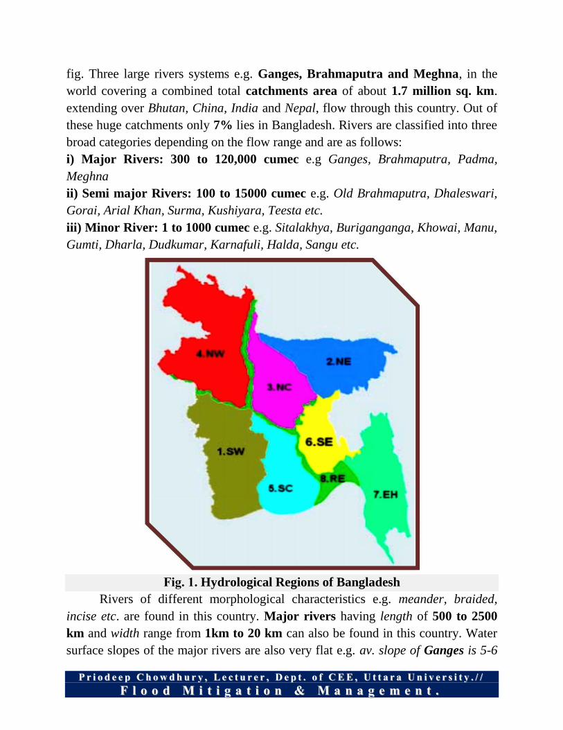
Bangladesh has unique hydrological regime. It has been divided into 7
hydrological zones. Hydrological zones are shown in fig. 1. It has 230 nos. rivers
of which 57 are trans-boundary Rivers. In all most all cases Bangladesh is a
lower riparian country. A picture of its river network is also given in the following
II
P r i o d e e p C h o w d h u r y , L e c t u r e r , D e p t . o f C E E , U t t a r a U n i v e r s i t y . / / P r i o d e e p C h o w d h u r y , L e c t u r e r , D e p t . o f C E E , U t t a r a U n i v e r s i t y . / /
F l o o d M i t i g a t i o n & M a n a g e m e n t .F l o o d M i t i g a t i o n & M a n a g e m e n t .
fig. Three large rivers systems e.g. Ganges, Brahmaputra and Meghna, in the
world covering a combined total catchments area of about 1.7 million sq. km.
extending over Bhutan, China, India and Nepal, flow through this country. Out of
these huge catchments only 7% lies in Bangladesh. Rivers are classified into three
broad categories depending on the flow range and are as follows:
i) Major Rivers: 300 to 120,000 cumec e.g Ganges, Brahmaputra, Padma,
Meghna
ii) Semi major Rivers: 100 to 15000 cumec e.g. Old Brahmaputra, Dhaleswari,
Gorai, Arial Khan, Surma, Kushiyara, Teesta etc.
iii) Minor River: 1 to 1000 cumec e.g. Sitalakhya, Buriganganga, Khowai, Manu,
Gumti, Dharla, Dudkumar, Karnafuli, Halda, Sangu etc.
Fig. 1. Hydrological Regions of Bangladesh
Rivers of different morphological characteristics e.g. meander, braided,
incise etc. are found in this country. Major rivers having length of 500 to 2500
km and width range from 1km to 20 km can also be found in this country. Water
surface slopes of the major rivers are also very flat e.g. av. slope of Ganges is 5-6

P r i o d e e p C h o w d h u r y , L e c t u r e r , D e p t . o f C E E , U t t a r a U n i v e r s i t y . / / P r i o d e e p C h o w d h u r y , L e c t u r e r , D e p t . o f C E E , U t t a r a U n i v e r s i t y . / /
F l o o d M i t i g a t i o n & M a n a g e m e n t .F l o o d M i t i g a t i o n & M a n a g e m e n t .
cm/km, av. slope of Brahamaputra is 8-9 cm/km and av. slope of Meghna is 4-3.5
cm/km. Annual flow volume of the rivers is to the tune of 1200 billion cum.
Rivers of Bangladesh carries huge sediment annual amount of which is between
1.8 to 2.0 billion tons.
CC hh aa nn gg ee ss II nn TT hh ee MM aa ii nn RR ii vv ee rr CC oo uu rr ss ee ss OO ff BB aa nn gg ll aa dd ee ss hh
11 77 66 77 -- 11 99 99 11
DDiissaasstteerr Disaster is a natural or human , caused phenomenon, which causes
serious disruption of the functioning of a community or a society causing
widespread human, material, economic and environmental losses which
elicited the ability of the affected community, society to cope using its
resources.
Floods are a common feature in the country that occur every year in many
parts including South Asia.
FFlloooodd An area goes under and remains under water for some times, it is inundation.

P r i o d e e p C h o w d h u r y , L e c t u r e r , D e p t . o f C E E , U t t a r a U n i v e r s i t y . / / P r i o d e e p C h o w d h u r y , L e c t u r e r , D e p t . o f C E E , U t t a r a U n i v e r s i t y . / /
F l o o d M i t i g a t i o n & M a n a g e m e n t .F l o o d M i t i g a t i o n & M a n a g e m e n t .
When inundation causes damage to property and crops, disrupts
communication and brings harmful effects to human beings as well as to flora
and fauna, we call it flood.
Inundation supports fish, navigation, soil fertility, ecosystems, ground water
recharge etc.
II NN UU NN DD AA TT II OO NN ++ DD AA MM AA GG EE == FF LL OO OO DD
Floods in major cities especially during rainy season are proving to disastrous
not only to the environment but also have serious implications for human life
and property.
A flood occurs when the Geomorphic Equilibrium in the river system is
disturbed because of intrinsic or extrinsic factors or when a system crosses the
geomorphic threshold.
(a) Flooding in a river due to aggradation of river bed (intrinsic threshold);
(b) Flooding in a river due to heavy rainfall (extrinsic threshold)
LLiiffee--TThhrreeaatteenniinngg CChhaarraacctteerriissttiiccss ooff FFllooooddss
Absence of warning of a flood (either ‘official’ warning or warning derived
from cues e.g. heavy rain).
High floodwater velocities (like in hilly or mountainous terrain or where
stream disgorge on to plains from upland areas; in river valleys with steep

P r i o d e e p C h o w d h u r y , L e c t u r e r , D e p t . o f C E E , U t t a r a U n i v e r s i t y . / / P r i o d e e p C h o w d h u r y , L e c t u r e r , D e p t . o f C E E , U t t a r a U n i v e r s i t y . / /
F l o o d M i t i g a t i o n & M a n a g e m e n t .F l o o d M i t i g a t i o n & M a n a g e m e n t .
gradients; in areas behind floods embankments or natural barriers which may
breach or overtop, below dams which may break).
Rapid speed of flood onset (like in areas when streams are ‘flashy’ i.e. rise
and fall rapidly; these are usually urban areas or arid rural areas where soil
surface becomes compacted and hard; or in areas where high floodwater
velocities are expected).
Deep floodwater: where floodwater is in excess of one meter depth (occurs in
or close to river channels; in depression which may not be easy to identify by
eye; behind overtopped flood embankments and in basements of buildings).
Long duration floods (like where land is flat, flooding is extensive; river
gradients are very low, channels are obstructed, and flood water become
trapped behind natural or artificial barriers).
Flood has more than one peak (not atypical on complex river systems where
tributaries contribute to river flows, or where flooding is tidal).
Debris load of floodwaters (usually greatest in high velocity floods;
floodwater may contain trees, building debris etc which may either provide
floating refuge, or threaten life).
Characteristics of accompanying weather (especially windy, unusually cold
or hot weather).
Flood may display combinations of characteristics!
FFlloooodd MMaannaaggeemmeenntt
Is it ‘Flood Control’ or ‘Flood Mitigation’ or ‘Flood Management?’
Flood Management measures are aimed at reduction of damage and harmful
effects, and creation of an environment for enhanced economic activity.
Urban flood vs. flood in rural areas need to be treated differently.
Total Flood Control is neither possible nor desirable.
FFlloooodd HHaazzaarrdd
Flood hazard can be defined as the risk to life and limb and damage caused
by a flood. The hazard caused by a flood varies both in time and place across the
floodplain. The Floodplain Development Manual (NSW Government, 2005)
describes various factors to be considered in determining the degree of hazard.
These factors are:

P r i o d e e p C h o w d h u r y , L e c t u r e r , D e p t . o f C E E , U t t a r a U n i v e r s i t y . / / P r i o d e e p C h o w d h u r y , L e c t u r e r , D e p t . o f C E E , U t t a r a U n i v e r s i t y . / /
F l o o d M i t i g a t i o n & M a n a g e m e n t .F l o o d M i t i g a t i o n & M a n a g e m e n t .
II.. Size of Flood;
IIII.. Effective Warning Time;
IIIIII.. Flood Readiness;
IIVV.. Rate of Rise of Floodwaters;
VV.. Depth and Velocity of
Floodwaters;
VVII.. Duration of Flooding;
VVIIII.. Evacuation problems;
VVIIIIII.. Effective Flood Access; and
IIXX.. Type of Development.
Hazard categorization based on all of the above factors is part of establishing
a Floodplain Risk Management Plan. Provisional flood hazard is flood hazard
categorized based on hydraulic principles only (depth and velocity). When
provisional flood hazard is considered in conjunction with the above listed factors
it provides a comprehensive assessment of the flood hazard, known as the “true
hazard”.
Not all of the above listed factors are applicable to all floodplains, in terms
of affecting hazard definition. Similarly, the application of these factors is rarely
consistent across all floodplains.
OObbsseerrvvaattiioonnss aabboouutt HHiissttoorriicc FFllooooddss
Documentation of floods in terms of flood depth, area affected, damage to
crops, damage to infrastructures, and number of people affected, and overall
monetary damage started in 1953. Other major recorded floods prior to 1953 took
place in 1787, 1917, and 1943. Based on the historic records, it is obvious that the
frequency, magnitude, and duration of floods have increased substantially during
the last few decades. For example, all major floods covering more than 30% of the
country (total area of Bangladesh is 144,000 km2) occurred after 1974 only. Four
floods of such great magnitude (1974, 1987, 1988, and 1998) took place during the
last 25 years, averaging one in every 6 years. According to Elahi, the floods of
both 1980 and 1984 covered an area more than 30%, making the number of such
floods to be 6 since 1974 (i.e. one in every 4 years). In addition, the total area
covered by major floods has been steadily increasing since 1974, with an exception
of 1984 floods. The data showing the total affected area varies widely from one
source to the others. The area affected by major floods has increased from 35% in
1974 to 68% in 1998. Variations in data pose a problem in analyzing the findings.
However, all sources of data seem to show a general trend of increased flooding
propensity.

P r i o d e e p C h o w d h u r y , L e c t u r e r , D e p t . o f C E E , U t t a r a U n i v e r s i t y . / / P r i o d e e p C h o w d h u r y , L e c t u r e r , D e p t . o f C E E , U t t a r a U n i v e r s i t y . / /
F l o o d M i t i g a t i o n & M a n a g e m e n t .F l o o d M i t i g a t i o n & M a n a g e m e n t .
Figure 2: Flood Prone Area.
P r i o d e e p C h o w d h u r y , L e c t u r e r , D e p t . o f C E E , U t t a r a U n i v e r s i t y . / / P r i o d e e p C h o w d h u r y , L e c t u r e r , D e p t . o f C E E , U t t a r a U n i v e r s i t y . / /
F l o o d M i t i g a t i o n & M a n a g e m e n t .F l o o d M i t i g a t i o n & M a n a g e m e n t .
Y P E S Y P E S Y P E S &&& CCC A U S E S O F A U S E S O F A U S E S O F FFF L O O DL O O DL O O D
C H A P T E C H A P T E C H A P T E RRR 000222
Types of Flood
Generally there are following types of arises in Bangladesh:
Rain-fed flood
Flash flood
Rivers’ flood
Flood due to cyclone
Flash Flood
Is a type of flood which can be described by observation of fall in water
levels and by rapid water rise. It occurs during mid-April before the on-set
of the south-westerly monsoon and when it occurs it can last between few
minutes to few hours.
Flash flood occurs mostly in the northern most area, north-central part,
northeastern part and southeastern part of Bangladesh. These Northern land
areas are lying mostly at foothills but most of the hilly catchments in India
and if it rains heavily in the Indian parts of the catchments the run-off
quickly accumulates and flow to Bangladesh causing severe flood.
Rain-Fed Flood
This type of flood generally happens in the Gangetic Deltas in the south-
western part of Bangladesh where most of natural drainage systems are
being deteriorated due to fall in up-land inflow from the main river Ganges
and are increasing in low-lying urban areas.
This kind of flood also occurs in the flood plains where natural drainage
systems have been disturbed either due to human interferences e.g.
construction of unplanned rural roads and encroachment of river courses etc.
or due to gradual decay of the natural drainage system.
TT

P r i o d e e p C h o w d h u r y , L e c t u r e r , D e p t . o f C E E , U t t a r a U n i v e r s i t y . / / P r i o d e e p C h o w d h u r y , L e c t u r e r , D e p t . o f C E E , U t t a r a U n i v e r s i t y . / /
F l o o d M i t i g a t i o n & M a n a g e m e n t .F l o o d M i t i g a t i o n & M a n a g e m e n t .
When intense rainfall takes place in those areas, the natural drainage system
cannot carry the run-off generated by the storm and causes temporary
inundation in many localities. 9 Upazilla of Satkhira, Jessore and Khulna district are facing rain-fed flood
and severe water logging from 2000. Major flood and water logging crisis occurred in 2000, 2004, and 2011. Dhaka and Chittagong city are regularly facing the urban flooding due to
rain-fed situation. In the year 2004, Dhaka urbanites faced a severe urban
flooding that lasted for a week. In June 2014, Chittagong city dwellers faced
flooding situation due to heavy rain. Rivers’ Flood
This type of flood is mostly common in Bangladesh and it occurs during
monsoon season along the river and covered 50% to 70% of the country’s
land area.
Climatologically, the discharge into Bangladesh, from upper catchments,
occurs at different time of the monsoon. In the Brahmaputra maximum
discharge occurs in early monsoon in June and July whereas in the Ganga
maximum discharge occurs in August and September. Synchronisation of
the peaks of these rivers results in devastating floods. Such incidents are not
uncommon in Bangladesh.
The rivers of Bangladesh drain about 1.76 million sq km area of which
93% lies outside its territory in India, Nepal, Bhutan and China. The annual
average runoff of the cross boundary rivers is around 1200 cubic kilometres
(WARPO, 2004). All the districts of GBM catchment area are prone to
normal flooding during the monsoon.
The country experienced many severe floods in the past 50 years and one of
the most flood affected year was in 1998 in terms of magnitudes and during.
Flood Due To Cyclone
In Bangladesh the coastal line of the northern part of the Bay of Bengal is
about 800 km and this type of flood occurs alongside the coastal area.
The entire coastal belt is flooded when cyclone hits strongly and the
approximate height of the surges is about 10 m to 15 m, which sometimes
cause great loss of lives. From June to September coastal areas are also
subjected to tidal flooding.

P r i o d e e p C h o w d h u r y , L e c t u r e r , D e p t . o f C E E , U t t a r a U n i v e r s i t y . / / P r i o d e e p C h o w d h u r y , L e c t u r e r , D e p t . o f C E E , U t t a r a U n i v e r s i t y . / /
F l o o d M i t i g a t i o n & M a n a g e m e n t .F l o o d M i t i g a t i o n & M a n a g e m e n t .
Continental shelves in this part of the Bay of Bengal are shallow and extend
to about 20-50 km.
Moreover, the coastline in the eastern portion is conical and funnel like in
shape. Because of these two factors, storm surges generated during any
cyclonic storm which is comparatively high compared to the same kind of
storm in other parts of the world. During super-cyclones (category 5)
maximum height of the surges were found to be 10-15 meter, which caused
severe flooding in the entire coastal belt. The worst kind of such flooding
occurred in last 45 years were on 12 Nov 1970, 29 April 1991, and 15
November 2007 which caused loss of 300,000 , 138,000 and 3,406 human
lives respectively (FFWC, 2011).
Coastal areas are also subjected to tidal flooding during the months from
June to September due to the southwest monsoon wind over Bay of
Bengal.
Flood Calendar of Bangladesh
According To Their Duration Flood Can Be Divided Into Different Categories
Slow-Onset Floods
Slow Onset Floods usually last for a relatively longer period, it may last for one or
more peeks, or even months.

P r i o d e e p C h o w d h u r y , L e c t u r e r , D e p t . o f C E E , U t t a r a U n i v e r s i t y . / / P r i o d e e p C h o w d h u r y , L e c t u r e r , D e p t . o f C E E , U t t a r a U n i v e r s i t y . / /
F l o o d M i t i g a t i o n & M a n a g e m e n t .F l o o d M i t i g a t i o n & M a n a g e m e n t .
Rapid-Onset Floods
Rapid- Onset Floods last for a relatively shorter period; they usually last for one or
two days only.
Flash Floods
Flash Floods may occur within minutes or a few hours after heavy rainfall, tropical
storm, failure of dams or levees or releases of ice dams. And it causes the greatest
damages to society.
Fig.: Principal causes and types of flooding

P r i o d e e p C h o w d h u r y , L e c t u r e r , D e p t . o f C E E , U t t a r a U n i v e r s i t y . / / P r i o d e e p C h o w d h u r y , L e c t u r e r , D e p t . o f C E E , U t t a r a U n i v e r s i t y . / /
F l o o d M i t i g a t i o n & M a n a g e m e n t .F l o o d M i t i g a t i o n & M a n a g e m e n t .
CC AA UU SS EE SS FF OO RR FF LL OO OO DD II NN GG There are several causes for flooding which are well demonstrated in the
following:
Figure: Major Reasons of Floods in Bangladesh.
Climatologically, the country has two distinct seasons, a dry season from
November to May and the wet (flood) season from June to September (or
October). Over 80% of the rainfall occurs during the monsoon or rainy season
when flooding normally occurs. Floods in Bangladesh occur for number of
reasons. The main causes are excessive precipitation, low topography and flat
slope of the country; but others include:
Monsoon downpour: An increased amount of precipitation can cause
flooding. An above normal monsoon downpour in the Ganges-Brahmaputra-

P r i o d e e p C h o w d h u r y , L e c t u r e r , D e p t . o f C E E , U t t a r a U n i v e r s i t y . / / P r i o d e e p C h o w d h u r y , L e c t u r e r , D e p t . o f C E E , U t t a r a U n i v e r s i t y . / /
F l o o d M i t i g a t i o n & M a n a g e m e n t .F l o o d M i t i g a t i o n & M a n a g e m e n t .
Meghna drainage system is thought to be the primary cause of the 1988 flood in
Bangladesh (GOB and UNDP, 1989; Brammer, 1990).
The geographic location and climatic pattern: Bangladesh is located at
the foot of the highest mountain range in the world, the Himalayas, which is also
among the highest precipitation zone in the world. This rainfall is caused by the
influence of the south-west monsoon. The confluence of three major rivers, the
Ganges, the Brahmaputra and the Meghna and the runoff from their vast
catchments (about 1.76 million km²) passes through a small area. Only 7% of
these catchments lie within Bangladesh. During the monsoon season the amount of
water entering Bangladesh from upstream is greater than the capacity of the rivers
to discharge in to the sea. Bangladesh is a land of rivers: there are about 230 major
and minor rivers in the country. Most of the rivers flow from north to south
direction while some of those flow from east to west to keep a natural balance of
water flow along the catchment areas. The total annual runoff of surface water
flowing through the rivers of Bangladesh is about 12,000 billion cubic meters.
Man-made environment: the construction of embankments in the upstream
catchments reduces the capacity of the flood plains to store water. The unplanned
and unregulated construction of roads and highways in the flood plain without
adequate opening creates obstructions to flow from north to south and east to west.
As a result, most of the east-west bound rivers died or dried out due to obstructed
natural flow. Damming of a river reduces the velocity of water flow downstream
from the dam. As a result of reduced velocity, the sediments carried by the river
start to settle down faster on the riverbed, causing riverbed aggradation and in turn
reducing the water carrying capacity of the river (Shalash, 1982).
The influence of tides and cyclones: the frequent development of low
pressure areas and storm surges in the Bay of Bengal can impede drainage. The
severity of flooding is greatest when the peak floods of the major rivers coincide
with these effects.
Long term environmental and climate changes: climate changes influence
the frequency and magnitude of flooding. A higher sea level will inhibit the
drainage from the rivers to the sea and increase the impact of tidal surges.
Deforestation in hilly catchments causes more rapid and higher runoff, and hence
more intense flooding. The Springtides of the Bay of Bengal retards the drainage
of floodwater into the sea and locally increases monsoon flooding. A rise of MSL
at times during the monsoon period due to effect of monsoon winds also adversely

P r i o d e e p C h o w d h u r y , L e c t u r e r , D e p t . o f C E E , U t t a r a U n i v e r s i t y . / / P r i o d e e p C h o w d h u r y , L e c t u r e r , D e p t . o f C E E , U t t a r a U n i v e r s i t y . / /
F l o o d M i t i g a t i o n & M a n a g e m e n t .F l o o d M i t i g a t i o n & M a n a g e m e n t .
affect the drainage and raise the flood level along the coastal belt. The rate of local
relative sea level rise is 7 mm/year around the coastal areas of Bangladesh (Emery
and Aubrey, 1990). The backwater effect caused by sea level rise can result in
more flooding of land from "piled up" river water inland (Warner, 1987). This
certainly seems to be one of the reasons for the increase in flood intensity in recent
years in Bangladesh.
Riverbed Aggradation: Riverbed aggradation is most pronounced for the
Ganges and its distributaries. From the border with India to the point where the
Ganges meets the Brahmaputra River, the riverbed has aggraded as much as 5 -7
meters in recent years (Alexander, 1989b). According to a study done by Kalam
and Jabbar (1991), the average width of the Ganges has decreased from 1.27 km in
1973 to 1.01 km in 1985. Riverbed aggradation is so pronounced in Bangladesh
that changes in riverbed level can be observed during one's lifetime. For example,
the Old Brahmaputra River was navigable for steamers only about 30 years ago,
and is presently an abandoned channel. This situation is true for many other
distributaries of the Ganges and Meghna Rivers, such as the Madhumati, Bhairab,
Chitra, Ghorautra Rivers, etc. Riverbed aggradation reduces the water carrying
capacity of rivers, causing bank overflow. This recent increase in riverbed levels
has undoubtedly contributed to the increased flooding propensity in Bangladesh.
Soil erosion: Ploughing makes the land surface more susceptible to soil
erosion. Surface run-off can easily wash away the topsoil from cultivated lands.
This surface erosion reduces land elevations, which in turn increase flood intensity
in an area. According to the Report of the Task Forces (RTF) on Bangladesh
Development Strategies for the 1990s (1991), soil erosion is a serious problem in
many parts of Bangladesh. Hilly areas in Sylhet, Chittagong, and Chittagong Hill
Tract districts are more susceptible to soil erosion. About 55% of Chittagong Hill
Tract area is highly susceptible to soil erosion (RTF, 1991). Heavy monsoon
showers remove the surface soil through runoff. Eroded sediments are deposited on
the riverbeds, reducing the water carrying capacity and increasing flooding
propensity in a watershed. Soil erosion also reduces land elevations and increases
elevations of riverbeds, contributing to increased flood depths. The land elevations
in other parts of Bangladesh must have been reduced over time due to soil erosion.
Aside from this, the tilling on the mountain slopes of the Himalayas is thought to
be responsible for massive soil erosion in Nepal (Dregne, 1987; Thapa and Weber,
1991; Sharma, 1991), which eventually causes rapid riverbed aggradation in

P r i o d e e p C h o w d h u r y , L e c t u r e r , D e p t . o f C E E , U t t a r a U n i v e r s i t y . / / P r i o d e e p C h o w d h u r y , L e c t u r e r , D e p t . o f C E E , U t t a r a U n i v e r s i t y . / /
F l o o d M i t i g a t i o n & M a n a g e m e n t .F l o o d M i t i g a t i o n & M a n a g e m e n t .
Bangladesh (Alexander, 1989a). Moreover, construction sites in cities can
contribute to soil erosion if silt fences or retention ponds are not employed
properly (Allen, 1999). In Bangladesh, no such measures are in practice at
construction sites.
Local Relative Sea Level Rise: The ultimate destination of all rivers is the
ocean. The land elevation is measured with respect to sea level in an area.
Therefore, any change in sea level causes land elevation to change. At the present
time sea level is rising globally (Pilkey et al., 1989). If sea level rises in an area at a
rate faster than the rate of land aggradation due to sedimentation, then land
elevation decreases. Any decrease in land elevation can cause increased inundation
by rivers overflowing at bank full stage.
Inadequate Sediment Accumulation: The only way for land to counter the
effects of a rising sea is for sediment to accumulate at a rate that is sufficient to
keep pace with the rate of sea level rise. Limited data show that the average
sediment accumulation rate for the last few hundred years in the coastal areas of
Bangladesh is 5-6 mm/year, which is not enough to keep pace with the rising sea
level (Khalequzzaman, 1989). As a result, net land elevations must have been
decreasing over time, resulting in more flood inundations.
Subsidence and Compaction of Sediments: Sediments on a delta plain are
rich in decomposed organic matter, and are subject to compaction due to
dewatering and the weight of the overburden. Most deltas subside due to the
weight of the thick sediment layer. Subsidence along with compaction reduces land elevation with respect to the rising sea level (Pilkey et al., 1989). Even though the
rate of subsidence and compaction are not yet well documented, based upon our
knowledge about processes active in other deltas it can be assumed that
Bangladesh's delta is also undergoing subsidence and compaction.
Deforestation in the Upstream Region: A rapid increase in population in
the Indian Subcontinent over the course of the present century has resulted in an
acceleration of deforestation in the hills of Nepal to meet the increasing demand
for food and fuel wood (Bajracharya, 1983; Ives, 1989; Sharma, 1991).
Deforestation of steep slopes is assumed to lead to accelerated soil erosion and
landslides during monsoon precipitations. This in turn is believed to contribute to
devastating floods in the downstream regions such as in Bangladesh (Hamilton,
1987; The NY Times, 1988; Alexander, 1989a).
Specific Physical/Natural Causes of Flooding In Bangladesh

P r i o d e e p C h o w d h u r y , L e c t u r e r , D e p t . o f C E E , U t t a r a U n i v e r s i t y . / / P r i o d e e p C h o w d h u r y , L e c t u r e r , D e p t . o f C E E , U t t a r a U n i v e r s i t y . / /
F l o o d M i t i g a t i o n & M a n a g e m e n t .F l o o d M i t i g a t i o n & M a n a g e m e n t .
Bangladesh is a very low lying country, with 70% of its land area being less than
1m above sea level and 80% of it being floodplain.
Bangladesh receives large amounts of water passing through it with two
major rivers (the Ganges and Brahmaputra) converging and forming a huge
delta (see figure 4) formed from silt deposited by the river as it enters the sea.
Both rivers have large volumes of water flowing through them to the sea as
they have large drainage basins which increasing the flood risk;
The main cause was the above average and long period of heavy rain which
caused all 3 rivers to have their peak flow at the same time.
Bangladesh has a monsoon climate and the annual torrential rains which
result often result in the rivers exceeding their capacity and flooding;
In the spring, melting snow from the Himalayas further increases the flood
risks as torrents of melt water enter the rivers at their source.
Most of the country consists of a huge flood plain and delta.
Two-thirds of the country is less than 5 meters above the sea level; and
susceptible to river and rain water flooding and in low lying coastal areas, to
tidal flooding during storm (MoWR, BCCSAP 2009)
10% of the land area is made up of Lakes and Rivers.
Tropical storms bring heavy rains and coastal flooding.
Specific Human Causes Of Flooding In Bangladesh:
Increasing population pressure in the foothills of the Himalayas where the
rain contributes to the source of the River Ganges and Brahmaputra has
resulted in intense deforestation. It is believed that this reduction in
interception has resulted in more water entering the rivers - indeed with 92%
of the area drained by the rivers being in countries other than Bangladesh.
Deforestation in the headwaters is also believed to be responsible for the
increased soil erosion which has led to large amount of silt being washed into
the rivers and subsequently being deposited on the river bed, reducing its
channel capacity and increasing the likelihood of flooding.
Increasing population pressure in Bangladesh itself has resulted in the sinking
of many new wells resulting in the lowering of the water table and the
subsequent subsidence of land making it even more prone to flooding
Urbanization and human habitation of the flood plain has increased magnitude
& frequency of floods.

P r i o d e e p C h o w d h u r y , L e c t u r e r , D e p t . o f C E E , U t t a r a U n i v e r s i t y . / / P r i o d e e p C h o w d h u r y , L e c t u r e r , D e p t . o f C E E , U t t a r a U n i v e r s i t y . / /
F l o o d M i t i g a t i o n & M a n a g e m e n t .F l o o d M i t i g a t i o n & M a n a g e m e n t .
Global warming is blamed for sea level rise, increased snow melt & increased
rainfall in the region.
The building of dams in trans-boundary Rivers of upper riparian countries has
increased the problem of sedimentation in Bangladesh.
Poorly maintained embankments (levees) leak & collapse in times of high
discharge.