bureau of mineral resources, geology and geophysics · 2015-12-02 · i bureau of mineral...
TRANSCRIPT

I BUREAU OF MINERAL RESOURCES, GEOLOGY AND GEOPHYSICS
RECORD
R E COR D 1985/27
EXCURSION GUIDE - ARUNTA BLOCK, N.T. CONFERENCE ON
TECTONICS AND GEOCHEMISTRY OF THE EARLY TO
MIDDLE PROTEROZOIC FOLD BELTS, DARWIN, AUGUST 1985
by
R.D. Shaw, R.G. Warren and A.Y. Glikson (BMR)
and
CLr UBRARY
P.R. James, R.W. Lawrence, R.L. Oliver, and J.D. Foden (Department of Geology & Geophysics, University of Ade~ide)
R E COR D 1985/27 .
EXCURSION GUIDE - ARUNTA BLOCK, N.T. CONFERENCE ON
TECTONICS AND GEOCHEMISTRY OF THE EARLY TO
MIDDLE PROTEROZOIC FOLD BELTS, DARWIN, AUGUST 1985
by
R.D. Shaw, R.G. Warren and A.Y. Glikson (BMR)
and
P.R. James, R.W. Lawrence, R.L. Oliver, and J.D. Foden (Department of Geology & Geophysics, University of Adelaide)
1111111111 ~ *R8502701*

CONTENTS
PART 1:INTRODUCTION (RDS,RGW) The Arunta Inlier:Stratigraphy and Tectonic Evolution 1
Geophysics 13 Tectonic Evolution 16 Igneous Rocks in the Arunta Inlier 21 Metamorphic Evolution 27 References 31
PART 2:THE GEOLOGICAL LOCALITIES
Proposed Itinerary 40
Mount Hay-Mt Chapple-Redbank Hill-Mt Ziel granulite gneiss belt(and the Redbank-Mt Ziel Thrust Zone) 41
Excursion Guide(AGY) 44
Laterites and Tertiary sediments(RGW) 48 Area surrounding the Mount Milton Sapphirine Yambah Retrograde Schist Zone(RGW) The Edwards Creek Cu-Pb-Zn Prospect(RGW) The Mud Tank Carbonatite Pegmatites in the Harts Ranges
Lens(RGW) 49 53 54 57 61
The Harts Range Area 62 Structural Development of the Harts Range,
central Australia(RWL,PRJ,RLO) 63 Excursion stops,Ruby Mine area(RWL,PRJ,RLO) 65
The Geology of the Entia Domal Structure, eastern Harts Ranges,N.T.(JDF) 72
Excursions stops(JDF) 75
FIGURES
1.1 The Arunta Inlier,showing tectonic provinces and the distribution of Divisions1,2,3. 3
1.2 Stratigraphic relations in the Napperby and Alcoota 1:250 000 Sheet area 4
1.3 Schematic cross-sections showing the relations between Divisions 1,2,3 in the southern tectonic province 4
1.4 Contoured Bouguer anomaly map of central Australia showing the Arunta Inlier,regional gravity features and NE and NW trending gravity features 12
1.5 a-d.Diagrammatic evolution of the Arunta Inlier 17

1.5 e-f.Diagrammatic evolution of the Arunta Inlier continued 19
2.1 Distribution of early gabbro-anorthosite complexes 22
2.2 Distribution of felsic igneous rocks of the Kalkadoon-Ewen-Leichhardt association 22
2.3 Harker variation diagrams showing the chemical 'fit' of the quartzofeldspathic gneisses(metavolcanics) of the Strangways Metamorphic Complex with trends for the Kalkadoon-Ewen-Leichhardt association in the Mount Isa Region 22
2.4 Distribution of late granites 25
2.5 Late mafic intrusions,alkaline intrusions,and granite 28
3.1 PTt path for the granulites in the northern Strangways Range 28
3.2 Geology of the Mt Hay-Mt Chapple-Redbank Hill-Mt Ziel region 47
4.2 Detailed geological map of the area surrounding the Mount Milton Sapphirine lens 52
4.3 Geological map
4.4 Geological map
5.1a Geology of the
5.1 b Fold relations
5.2 Geology of the
5.3 Geology of the
of the Edwards Creek Prospect
of the Mud Tank Carbonatite
Ruby Mine area
in the Ruby Mine area
Knoll ruby excavation
Trench Area, Ruby Mine
56
60
67
68
69
70
5.4 Folded early pegmatite in amphibolite-Entire Creek 71
TABLES
5.1 Analyses of representative lithologies from the Entia Domal Structure 79
/ )
1
PART 1:- INTRODUCTION
THE ARUNTA INLIER ~ Stratigraphy and tectonic evolution
(after Shaw and others, 1984 & Stewart and others, 1984)
The Aunta Inlier is the mass (200 000 km 2 , roughly the size of
Great Britain) of mainly Precambrian metamorphosed and deformed
igneous and sedimentary rocks in the southern part of the
Northern Terri tory of Australia (F ig. 1.1). It is surrounded on
most sides by Proterozoic and Phanerozoic sedimentary cover. To
the NW it merges with schist and gneiss of The Granites-Tanami
Province, and to the N it merges with similar rocks of lower
metamorphic grade in the Tennant Creek Inlier. Since the late
1960s the better exposed parts of the Inlier have been
systematically mapped and studied by the Bureau of Mineral
Resources, The Northern Territory Geological Survey (since 1979),
and staff members and students of the Australian National
University, Monash University, the University of Queensland and
the University of Adelaide.
The Arunta Inlier differs from other Proterozoic inliers in
northern Australia in the marked intensity and frequency of its
deformation, the high grade of much of its metamorphism, and its
abundance of granite. In these respects it resembles mobile
belts in southern Africa (Kroner, 1977, 1981; Hunter & Pretorius,
1981) and the Baltic Shield (Magnusson, 1960; Geijer, 1963).
The model of Precambrian tectonics developed by Kroner (1977,
1981) explains much of the geological history of the Arunta
Inlier, though further testing is required before the model can
be fully accepted.
In order to produce a synthesis of the data obtained in the
course of the regional studies, a stratigraphie model and the
concept of tectonic provinces have been developed:

2
The Stratigraphic model
In the Arunta Inlier primary age data such as fossils or times of
volcanic crystallization are absent, sedimentary facing is rare,
and so the order of superposition is generally unknown.
Stratigraphic sequences can be established locally, but because
of extensive faulting cannot be extended throughout the Inlier.
Consequently, it was necessary to establish a litho-stratigraphic
model - the Division concept (Shaw & Stewart, 1975) - based on
facies assemblages and lithological correlation.
The model uses three broad litho-stratigraphic groups called
Divisions 1, 2 and 3; Division 1 being the oldest and Division 3
the youngest (Shaw & Stewart, 1975; Figs 1.1,1.2,1.3).
Boundaries between the Divisions are commonly faulted, sheared,
metamorphosed, intruded by granite, or concealed by superficial
deposits, but in a few places unconformities between the
Divisions are preserved. Rock units and rock associations are
assigned to each Division primarily on lithological similarity,
in places across large areas of non-exposure, and so are only
tentatively regarded as chronological and stratigraphic
correIa t i ves. Each Division is essentially a group of rocks
which broadly represents a lithogenetic facies.
Division 1
Division 1 comprises mafic, felsic and semi-pelitic granulites
and lesser amounts of calc-silicate rock and marble, and crops
out principally in the Central Province (Fig. 1.1). It
represents a large volcanic facies which formed the first part of
the Arunta sequence. Mafic granulite is concentrated in the
lowest part of the Division, where it forms up to 70% of
exposures. Analysed samples from the Strangways Metamorphic
Complex, which forms much of the Stragways Range 70 km N of Alice
Springs (Fig.1.1), have an iron-rich tholeiitic composition
[total FeO ranges from 9.2 to 15.8%; (Shaw and others, 1979a,
Table A1; Shaw & Langworthy (1984)]. The mafic granulite forms
layers ranging from 3 to 10 m thick and up to several hundred
metres long, separated by felsic granulite (essentially a bimodal
assemblage). These have been multiply folded, suggesting that

I I
;
i
-3-
j
I
00
Figure 1.1 The Arunta Inlier, showing tectonic provinces and the distribution of Division 1, 2 & 3. 1:250 000 Sheet areas TG The Granites, MS Mount Solitaire, LR Lander River, HI Highland Rocks, MT Mount Theo, MP Mount Peake, BC Barrow Creek, ~r1 Webb, LH Lake Mackay, MD Mount Doreen, N Napperby, A Alcqota, HU Huckitta, T Tobermory, McD MacDonald, MR Mount Rennie, ML Mount Liebig, H Hermannsberg, AS Alice Springs IC Illogwa Creek, HR Hay River.
! .

4
NAPPERBY ALCOOTA r' -<:~I-g'~~~~ ~Olomlte Member '> on 7w:~d;or~'-~- .... r
- -- -- -.- - .... -- ._-_ .. __ .- .. --j
i ! -- ~er beds en CL Utopia Owutille
Pine HIli Formation -- 9 ~ ____ ow
------------=- I z ~ Mendlp Melamorphlcs ! Div.3
I
Div.2
Mount Thomas -==::=. > Z Quartzite -____ ~ ~
Creek
beds
lander Rock. beds
2" I
schlst.r-~ .• ,.------j - S--~~Ians!
-- - I Mou~ <:::::..... Dam , .~reellng -'< ~-J:.'.".tamorphlcsl
_____ ~chlst .~_ .. _.J
ChlrlJ,Jee
GnPI55 I'
I
metamorphlcs Aileron 'I' .'"
Div.l ! unit
I p'·Y "
leddll Schist
-l.o. ~D"lnlOrl' ,
~".2elr~Y Mct',tnlOrptllcs: -l.,,~'P.ISS 1
.~--" ----==-~ --~,'~ ! "< .~ ..... ;I' ' HClrl~ I
"-.. "(" I "? "")f',.r~" RdrHl(' ! Bleechmort'! ~ .... '-........ ' '', (HOUp I
') " , GranulltP \ Z~-.. .... ,~ ___ ..1
'-~- - -i
Mount
(lr.lIll1ht~
Weld"n" r --------l -'" TYson.creek metamorphlcs, L. '-
granulite i "" __ ~ __ • ___ . ___ ._. ________ .__ J:""
\
KiIl""cll"
~ ___ Div. 1 .. 2 boul1C!clry "\,,/'\,I"- Div. 2·3 boul)ctary 16. NT'JJ
Figure 1.2 Stratigraphic relationships in the Napperby and Alcoota 1:250 000 Sheet areas.
II --Celce,..oue end ehlminou. _t .. ediment.
F"i~ end mefi~ grenUlitN
~ •
CENTRAL ~ROV'NCE
Aluminou. end .iIi~ic mete.ediment.
Qflenzofeld."ethic _k.
~ $ili~~ """~e -v--v -v-v 1JIu;0000000iti .. ,..,fHIt
Figure 1.3 Schematic cross sect~ons showing the relationships between Divisions 1, 2 & 3 in the northern, central and southern tectonic provinces.

~-------------- ---~--------~--------------------------------------------~---.-
5
the mafic layers are primary tabular masses, and so are
interpreted as basalt flows, although no relict igneous textures
survive. The felsic granulite layers are mainly of granite to
granodiorite composition, but some large homogenous masses are of
intermediate composition, and may be intrusions (e.g., Utnalanama
granulite). Higher in the sequence in the Strangways Range,
semi-pelitic granulite is interlayered with the mafic and felsic
granulites, and contains abundant cordierite. Some mafic
granulite at this level forms thin, laterally persistent layers
5 cm thick, the origin of which is unknown. Small pods and
lenses of sapphirine-bearing silica-undersaturated rocks are
interlayered with cordierite-bearing granulites at a few
localities. The upper part of the Strangways Metamorphic Complex
is dominantly metasedimentary.
Windrim and McCulloch (1983) and Black and McCulloch (1984)
obtained Sn-Nd ages of 2015+120 Ma and 1980+190 Ma, respectively,
for the fractionation from the mantle of the primitive magmas
which later crystallised as the volcanics of Division 1.
The first detected metamorphism of Division 1 occurred at about
1800 Ma (Iyer and others, 1976; Black and others, 1983) in the
Central Province, and at about 1670 Ma in the Reynolds Range.
Division 2
Division 2 is the most extensive of the three Divisions, and
makes up nearly all of the Northern and Southern Provinces, and
the eastern third of the Central Province (Fig.1.1). In the
Northern Province, it represents the flysch-like facies of the
Arunta Inlier. In the Southern Province, the rocks appear to
have a significant felsic volcanic component.
In the Northern Province, Division 2 comprises abundant aluminous
and silicic metasediments, lesser calcareous rocks and a few
mafic flows or sills. The most extensive unit is the strongly
folded Lander Rock beds (Fig. 1.2), which crops out throughout
the Nand NW of the Arunta Inlier. In the Jervois region of
HUCKITTA, a gneissic granitoid complex is overlain by schist and
intercalated amphibolite and calc-silicate rock (the Bonya
Schist; Fig. 1.2). [The names of 1 :250 000 Sheet areas are

6
indicated as HUCKITTA and are shown in Fig. 1.1] These rocks are
intruded by granites metamorposed at 1800 Ma; consequently,
Division 2 in the Jervois region must be this age or older. The
rocks are separated from Division 1 to the S by granite, by areas
of non-exposure in the centre and W, and by a major fault zone
[the Delny-Mount, Sainthill Zone (Warren, 1978)] in the E (Fig.
1.1) •
In the eastern part of the Central Province (Fig. 1.1), Division
2 is mainly aluminous sediments and minor mafic igneous rocks
(the Harts Range Group) metamorphosed to amphibolite facies.
Abundant quartzofeldspathic gneiss at the base of the sequence is
a mylonitized granite (Shaw and others, 1985). In the Harts Range
itself, the Harts Range Group overlies Division 1 unconformably
(Fig. 1.2).
In the southern Province, E of Alice Springs, the bulk of
Division 2 crops out in the Wigley, Narbib and Ankala Blocks
where it is represented by compositionally layered, amphibolite
facies gneisses. Their stratigraphic position is unknown, but
they are provisionally placed in Division 2 because they are of
lower metamorphic grade than, and are overthrust from the N by,
Division 1 along the Redbank and Harry Creek Deformed Zones
(Marjoribanks & Black, 1974; Marjoribanks, 1975). The gneisses
could equally well be the upper part of Division 1, or even a
separate division between Divisions 1 and 2. The gneisses are
mainly of granite to granodiorite composition forming uniform
layers up to several tens of metres thick, which separate less
abundant amphibolite, sillimanite gneiss and calc-silicate rock.
Similar rocks (the Albarta Metamorphics) occur much farther E
(Fig. 1.1). The origin of the granitoid gneisses is unknown;
their uniformity of composition suggests they are metamorphosed
felsic volcanic flows or sills (Offe & Shaw, 1983).
To sum up, Division 2 consists of immature terrigenous
metasediments, calcareous metasediments, minor mafic igneous
rocks and, in the S, gneisses of granitoid composition as well.
The time of formation of the Division is not known; its first
metamorphism occurred before 1750 Ma.
7
Division 3
Division 3 (Figs 1.1, 1.2), the least extensive of the three
Divisions, is characterised by orthoquartzite, and represents the
platform facies of the Arunta Inlier. The Division is best known
in the Northern Province, where it is represented by the Reynolds
Range Group (Stewart and others, 1980). This is a weakly
metamorphosed shallow-marine quartzite-shale-carbonate sequence
about 1800 m thick, and occupies gently plunging synforms resting
with an angular unconformity on Division 2 (Lander Rock beds).
The unconformity is best exposed along the NE flank of the
Reynolds Range, though in the SE, the discordance is largely
obliterated by increasing metamorphic grade. The Reynolds Range
Group is intruded by, and is therefore older than, the Napperby
Gneiss, which has given an imprecise age of 1600-1500 Ma (Stewart
and others, 1980).
In the Central Province, Division 3 overlies Division 1, implying
an unconformable relationship. A regional unconformity is
evident in central ALCOOTA (Shaw & Warren 1975)], and in HOUNT
RENNIE, where magnetic interpretation (Mutton & Shaw 1979)
suggests Division 3 adjoins Division 1 (Fig. 1.1). In the
Southern Province near Alice Springs (Fig. 1.1), Division 3
comprises a sequence of silicic and aluminous metasediments and a
basal conglomerate nonconformably overlying orthogneiss of
Division 2. Metamorphism of these rocks is dated in the
adjoining HERHANNSBERG area at about 1600 Ma (Majoribanks & Black
1974). Between Alice Springs and Jay Creek, the metasediments
are intruded by orthogneisses which may represent granitic sills
(Offe & Shaw 1983).
In the small unmapp ed Arun ta Inl i er S of ILLOGWA CREEK (F ig.1 .1),
Leitch and others (1970) briefly described an unconformity between
rocks which are assigned to Divisions 2 and 3 on the basis of
their composition.
, ,
8
The Tectonic Provinces
The Arunta Inlier is divided into three tectonic provinces
(Fig.1.1). These are separated by major faults and shear zones
(inferred beneath areas of poor outcrop from geophysical
features), where relationships are exposed, the Central Province
is either faulted against the Northern Province or separated from
it by granite, and is brought up along a major high-angle reverse
fault against the Southern Province. The southern Province is
the smallest of the three in area. Despite its complex history,
the tectonic framework of the Arunta Inlier has remained
remarkably constant. Narrow fundamental zones of weakness or
faulting were established early, localized subsequent
deformation, and divided the Inlier into three tectonic
provinces. Each province has a fundamentally different
stratigraphic, structural and metamorphic history (Figs 1.3).
The tectonic provinces are cut by the NW-trending Weldon Tectonic
Zone and by several other oblique tectonic lineaments which are
apparent in the gravity map of the region (Fig. 1.4). Major
deformed zones and retrograde schist zones occur within and
between the tectonic provinces.
Northern Tectonic Province
The Northern Province is a region of aluminous and silicic Division
2 sediments that were metamorphosed to generally low grade during
the Strangways and Aileron Events. Volcanic and high-grade
metamorphic rocks are subordinate. Lithological layering trends
NW in the E of the Inlier, curving around to E and ENE trends in
the centre and W [Fig. 1 of Stewart and others (1984)]. To the
NW, the Province grades into low-grade metamorphosed greywacke,
siltstone and mafic volcanics of The Granites-Tanami Province
(Blake 1978).
Extensive granites intruding the Northern Province range from
older rapakivi types and orthogneisses emplaced between 1750 and
1500 Ma to younger, commonly porphyritic granites and sub-
9
volcanic porphyries emplaced at 1500-1400 Ma.
Major faults in the Northern Province are parallel to foliation
trends, and form an arc convex to the N. The S part of the
Province underwent mid-Palaeozoic moderate to high-angle faulting
accompanied by narrow zones of greenschist facies retrogression
near the N margin of the Ngalia Basin (Wells 1972; Well & Moss
1983). Faults up to 100 km long in MOUNT THEO, MOUNT PEAKE and
near Jervois (HUCKITTA) contain hydrothermal quartz \ fluorite,
and have undergone repeated brecciation and quartz-filling. The
faults cut late Proterozoic sediments in the Jervois area (Hill
1972).
Central Tectonic Province
Rocks in the Central Province (mainly assigned to Division 1)were
metamorphosed at deeper crustal levels (to 30km)than those of the
Northern Province during the Strangways Event at 1800-1750 Ma.
Mafic and felsic meta-igneous rocks are inter-layered with and
locally overlain by subordinate aluminous and calcareous
metasediments. Thin sequences of Division 2 metasediments are
locally overlain by quartzite and schist of Division 3. Multiple
folding with widely varying axial plane traces is typical of the
zone (Rickard & Shaw, 1972; Rickard, 1975; Shaw & Langworthy,
1984; Shaw and Rickard, 1985), resulting in complex
interference patterns of lithological layering, which contrast
with the more regular trends of the Northern Province. Small
bodies of anatectic granite formed at the peak of metamorphism in
the cores of last-formed folds. Metamorphism during the Aileron
Event at 1700-1600 Ma occurred locally, adjacent to the boundary
with the Southern Province. Retrograde schist zones containing
kyanite and staurolite are numerous in the Central Province, and
are localized along faults cutting Division 1 rocks. The schist
zones may be contemporaneous with the 1050-900 Ma migmatitic
Ormiston Event in the Southern Province (Shaw & Warren, 1975),
They are probably the same age as the Harry Creek Deformed Zone,
which locally separates the Central and Southern Provinces, and
which was cut at 990 Ma by the Gum Tree Granite (Allen & Black,
1979). K-Ar-mica and 40 Ar_39 Ar ages suggest reactivation of the
zones in the early Carboniferous.

10
Southern Tectonic Province
The Southern Province is characterized by quartzofeldspathic
gneiss, tentatively assigned to Division 2, nonconformably
overlain by silicic and aluminous metasediments assigned to
Division 3. Division 1 rocks are absent. Granites are abundant
and are commonly syntectonic or pre-tectonic (orthogneisses).
Deformation in the central-W of the zone was accompanied by
amphibolite facies metamorphism at about 1700-1600 Ma (Aileron
Event, Chewings phase). This metamorphism, accompanied by
syntectonic granite emplacement, probably extended to the E part
of the zone.
The Southern Province is characterized by abundant dolerite
dykes; the N-tending Stuart Dyke Swarm near Alice Springs has a
Rb-Sr age of 897Z9 Ma. Dykes with other trends occur in the W.
Small gabbro bodies in the Redbank Deformed Zone and NE of Alice
Springs may be of the same age.
The final episode of deformation in the Southern Province was
extensive thrust-faulting accompanied by greenschist facies
retrogressive metamorphism along the S margin of the Arunta
Inlier during the Alice Springs Orogeny at 400-300 Ma. Nappes
with cores of basement formed at Ormiston Gorge (Marjoribanks,
1975, 1976), Alice Springs (Stewart, 1967; Clark in Wells, 1976),
Arltunga (Forman, 1971; Stewart, 1971 aj Shaw and others, 1971;
Yar Khan, 1972), and farther E in the Oolera Fault Zone (Shaw and
others, 1982). Yar Khan (1972) demonstrated that the eastern
Arltunga nappes are thrust nappes. The faulting and metamorphism
also affected the lower part of the Amadeus Basin sequence.
Extensive gravity sliding took place in the Amadeus Basin as a
result of uplift of the Arunta Inlier (Wells and others, 1970).
Boundaries between tectonic zones
In several places the three tectonic provih~es are separated by
major faults or fault zones (Fig 1.1). The Redbank Deformed
Zone and its W extension together with the Harry Creek Deformed
Zone and its E extension mark most of the boundary between the

11
Southern and Central Provinces. Much of the poorly exposed NW
boundary between the Central and Northern Provinces places
granulite against granite. East of Aileron, the boundary between
the Central and Northern Provinces has a NE trend, and
interpretation of aeromagnetic data (Wyatt, 1974; Shaw & Warren,
1975) suggests that the boundary is a lithological transition
between Division 1 and 2 rocks. Farther to the E the boundary is
marked by the Delny-Mount Sainthill Fault Zone. In the far E the
boundary between the Central and Northern Provinces is not
exposed, but it corresponds to the NE margin of the Caroline
Gravity Ridge (Fig. 1.4).
An elongate E-W gravity high [Willowra Regional Gravity Ridge of
Fraser and others, (1977); Fig. 1.4], similar to that
corresponding to the Central Province, occurs within the N part of
the Northern Province, but where basement is concealed by
superficial cover. The NE margin of the ridge corresponds to the
Lander Fault between the Arunta Inlier and Wiso Basin. Gravity
modelling by Kennewell and others (1977) suggests that the Lander
Fault may extend to the mantle. The gravity ridge may be caused
by dense high-grade metamorphic rocks (Flavelle 1965; Whitworth
1970), possibly of Division 1.
Redbank and Harry Creek Deformed Zones
The Redbank Deformed Zone (Marjoribanks, 1975), which separates
the Central and Southern Provinces NW of Alice Springs (Fig.1.1),
is a narrow E-trending steeply N-dipping zone of complex plastic
deformation. It consists of greenschist facies phyllonitic and
mylonitic rocks, and finely foliated, highly strained amphibolite
facies gneisses containing quartz and feldspar augen and
porphyroblasts which are both discordant and concordant with the
foliation. The deformed zone can be traced E towards the
Arltunga Nappe Complex, where it is disrupted by granite
intrusion and transected by the Harry Creek Deformed Zone. From
correlation of fold styles and isotopic data, Marjoribanks and
Black (1974) suggested that deformation started at about 1600 Ma
and was overprinted by migmatization and granite emplacement at
1050 Ma. We consider that the zone is an overthrust, with the
main movement parallel to the down-dip lineation.

12
16/NT,76
Figure 1.4 Contoured Bouger anomaly map of central Australia, showing the Arunta Inlier (outlined), regional gravity features and NE and NW trending gravity lineaments: 1.
Willowra Regional Gravity Ridge; 2. Yuendumu Regional
Gravity Low; 3. Papunya Regional Gravity Ridge; 4. Angas
Regional Gravity High; 5. Caroline Gravity Ridge. Contour
interval 40 mgals. Shaded areas indicate anomalies greater
than -40 mgals.
13
Lithological and stratigraphic continuity across the Redbank
Deformed Zone 50 km NNE of Alice Springs, and across the Illogwa
Creek Schist Zone, which is the E-most portion of the Redbank
Deformed Zone indicate that the Redbank Zone is not a deeply
eroded cryptic collison zone in the sense of Burke and Dewey
(1973) or Gibb and Thomas (1976). Instead, it may represent the
reactivated S margin of the ensialic rift in which Division
volcanics accumulated.
Delny-Mount Sainthill Fault Zone
This 130 km long fault zone separates the Northern and Central
Provinc es in the NE Arun ta Inlier (F ig. 1.1). I t is vert ical to
steeply dipping with a down-dip lineation, and brings granulite
in the S against amphibolite facies to the N, indicating S-block
up displacement, i.e. normal faulting (Shaw & Warren, 1975). The
fault zone consists of discontinously exposed slices of deformed
rock, commonly 0.5 km wide, separated by high-strain zones
(Warren, 1978). In places the axis of the zone contain schistose
and granular rocks showing retrogression along narrow
discontinuous slivers, first to amphibolite facies and then to
greenschist facies. The zone also contain mylonitic quartzite.
GEOPHYSICS
Regional gravity features in central Australia are dominated by
three east-west trending highs and lows (Fig. 1.4) with extremely
large gradients. These are terminated to the east by the Weldon
Tectonic Zone (made up of two gravity lineaments, the Woolanga
and Ennugan features) and to the west by the Lake Mackay
Lineament. Forman and Shaw (1973) showed that regions of high
metamorphic grade in central Australia correspond to Bouguer
anomaly ridges, and suggested that major overthrust faults of
late Proterozoic age sliced through crust into the mantle. The
gravity anomalies to be expected on this model, which have been
computed by Mathur (1974, 1976), compare quite well with the
observed gravity though the computation takes into account
neither surface density contrast across major crustal faults, nor
the presence of dense granulite at the surface.

14
Anfiloff and Shaw (1973) explained the gravity features in
central Australia by compositional heterogeneities in the upper
crust alone although the density contrasts they used may be
slightly too high. They recognized that the Bouguer anomaly
gradients can be caused by juxta-position of dense mafic
granulite against metasediment and granite. Anfiloff and Shaw
(1973) and Mathur (1974, 1976) showed that this density contrast
extends to a depth of at least 20 km, because the gravity ridge
corresponding to the Central Tectonic Province (+45 mgals flanked
by - 100 mgal troughs) is too large to be caused by near-surface
rocks alone. Wellman (1978) showed that the density contrast
could extend to the mantle. Barlow (1979), on the basis of a
detailed gravity study of the Gosses Bluff area (Fig. 1.1),
agreed with Langron (1962) that either there was little density
contrast at the northern margin of the Amadeus Basin, or that the
Basin sediments in that area continue under basement which is
overthrust to the S. The Arunta Inlier is crossed by several
major gravity lineaments oblique to the latitudinal structures.
These are most apparent at the E and Wends of the Inlier (Fig.
1.4). The regional magnetic interpretation of the SW part of the
Inlier (Mutton and Shaw 1979) revealed numerous NW-trending
geophysical lineaments which may be major faults. Breaks in
gravity and magnetic trends suggest that similar features may be
more common than is shown in geological maps.
Woolanga Gravity Lineament
This lineament marks a decrease in Bouguer anomaly values at the
E end of the Papunya Regional Gravity Ridge (Anfiloff & Shaw
1973; Shaw & Warren 1975; Fig. 1.4). A corresponding magnetic
discontinuity is evident in the BMR ALICE SPRINGS total magnetic
intensity map. The gravity lineament cannot be precisely
located, but the magnetic discontinuity corresponds with two
parallel faults which extend NW for 50 km near Woolanga Bore and
SE for 150 km into HALE RIVER. The Woolanga Lineament roughly
corresponds with the E limit of Division 1 mafic grnaulite. It
is believed to be a deep crustal feature which acted as a conduit
for mantle-derived magmas such as the Mud Tank Carbonatite (Black

15
& Gulson, 1978) and the Mordor Igneous Complex (Langworthy &
Black, 1978). It also corresponds to a long narrow valley of
Tertiary age which is prominent on Landsat imagery.
Ennugan Gravity Lineament
A second lineament 50 km to the W parallels the Woolanga
Lineament, but differs from it in being a gravity gradient with a
30 mgal drop to the W. It marks the E end of the Yuendumum
Regional Gravity Low, and to the NW ends abruptly against the
Willowra Regional Gravity Ridge (Fig. 1.4). It persists to the SE
as a sharp drop in gravity values near the E end of the Papunya
Regional Gravity Ridge.
The gravity low E of the N part of the lineament corresponds to
granite batholiths flanked by schist. The S segment of the
lineament coincides with the E end of the belt of mafic, felsic
and intermediate granulites; to the E are mainly granitic
gneisses.

16
TECTONIC EVOLUTION (R.D. Shaw)
The most striking thing about the Arunta Inlier is that cycles of
extension and convergence, resembling embryonic Wilson Cycles,
appear to have occurred five times, at about 1800-1750, 1700-
1600, 1500-1400, 1050-900, and 400-300 Ma. The first phase of
extension produced a fundamental zone of weakness that nucleated
subsequent mega-faulting and mega-shearing. The repeated thermal
events suggests a long-lived and recurring thermal perturbation
in the mantle underlying the Arunta region.The following is a
model for the tectonic evolution of the Arunta region.
First cycle of extension and compression 1900-1780 Ma
The first episode of lithospheric extension-taphrogenesis
resulted in rifting (Fig. 1.5a), introduction of abundant
tholeiitic magma from the asthenosphere, and eventually basin
subsidence (Shaw, 1979). Underplating by insertion of a
subcrustal wedge of asthenosphere (Fig. 1.5b) caused extensive
metamorphism and granite production during the Strangways Event.
Limited subduction of mantle lithosphere below the asthenospheric
wedge (Ampferer or A-subduction of Kroner, 1979; Bally, 1981;
Weber, 1981) dragged Division 1 rocks down to about 30 km (Fig.
12b), and also formed the flanking troughs wherein Division 2
accumulated. Subduction was possible because of the deepseated
zone of weakness generated in the extensional phase, and resulted
from delamination and sinking of large blocks of subcrustal
lithosphere below the spreading wedge of partly molten and
therefore less dense asthenosphere (Kroner, 1981; Fig. 1.5b).
From this time on, the upper and lower parts of the crust
were detached from each other and behaved independently. The
upper crust underwent thrusting and folding, whereas the lower
crust below the Division 2 troughs thickened as a result of
shortening induced by the subduction. Heat from the mantle was
trapped in and below the thickening pile of sediments (cf.
Schruilling, 1972a, 1972b; West & Mareshal, 1979), and produced
granite masses and high-grade regional metamorphism peaking at
about 1800 Ma, after the folding (Fig. 1.5c).

A Taphrogene-sfs before 1800 Ma
Crust
11
South
Mantle I
lithosphere
-::;:.: /. \\ \\ 1/ ~~ \\ ij
Asthenosphere '/ = >' 1/ ,'" II '" II II II 11l-4~L.,..JJ.--''---'-l qlj ~ ~ ~ 4 I
B 8eginning of Strangways Event about 1800 Ma.
1/ '" 1/ "1' /I II = /.
A-subduction, underthrusting -----------::-=-=-=-=-~::..-.:..:...:::;.-__<~i;'. o( Division 1. deposition of Dlvrsion 2.
C Culmination of Strangways Event ca. 1750 Ma. A-subduction. folding. faulting. metamorphism. granite emplacement.
o Deposition of DivrSlon 3. possible mafic intrusIOn In nonhfsolid black)
North
--------------2-------------
Figure 1.5(a)-(d) Diagrammatic evolution of Arunta Inlier.
Numerals 1,2 & 3 refer to Divisions. RZ Redbank Deformed
Zone, DZ Delny-Mount Sainthill Fault Zone.

18
Second cycle of extension and compression 1700-1650 Ma
The second cycle of extension and compression began with uplift
and erosion of Divisions 1 and 2 as compression relaxed, and was
succeeded by deposition of Division 3 and possibly by
emplacement of mafic magma in the Northern Province (Fig. 1.5d).
Discordance between Divisions 1 and 3 indicates that uplift of
the Central Province indicates that uplift of the Central
Province was substantial. The ensuing compressional phase
(Fig. 1.5e) caused folding amd metamorphism during the Aileron Event at
about 1700-1600 Ma, and formed the NW-trending Weldon Zone. The
mafic rock in the Northern Province was metamorphosed to mafic
granulite at about 1655 Ma. Tectonism was of smaller magnitude than
that which accompanied the first cycle.
The zone of weakness produced by initial rifting (Fig.1.5a)
and subsequent convergences (Fig. 1.5b, 1.5c) along the Central
Tectonic Province was reactivated during the second cycle, and
the Southern Province was thrust below the Central Province
(Fig. 1.5e), resulting in the N-dipping schistosity characteristic of
the Chewings phase of deformation.
Subsequent cycles of extension and compression
By the end of the second tectonic cycle, the crust was strong
enough to resist penetration by the asthenosphere, and buoyant
enough to make subduction difficult. From this time on, mafic
magma rarely penetrated the crust, and granite production was
meagre. Although major tectonic events occurred at about 1500-
1400 (Fig. 1.5f) and 1050-900 Ma (Fig. 1.5g), only localised
vertical movements occurred, because Division 3 rocks are
preserved at widely scattered localities throughout the Arunta
Inlier. The tectonic events may have been caused by heat build
up and hence weakening of tectonically thickened crust, or by
continent-wide compression.
The overthrust faulting at 1050-900 Ma (Fig. 1.5g) may have
originated in a zone of decoupling or detachment between lower
ductile crust and upper brittle crust during a period of high
heat flow (Armstrong & Dick, 1974). This would account for the
lack of high-pressure granulites (greater than 10-12 kbar). It
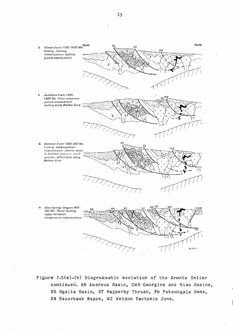
South E Aileron Event 1700-1600 Ma.
Folding, sheaflng. metamorphism. faultmg, granite emplacement
F Anmatlira Event 1500-1400 Ma. Felsic volcanism, granite emplacement, faultmg along Weldon Zone.
19
RZ
RZ G Ormiston Event 1050-900 Ma Folding. metamorphism. nllqmatlsatlOn. dolerrte dykes rn Southern province. 5{11811 .---,...,..,.,,,,,,,=-,~::c:0~::~ granItes, deforn1atJon along Weldon Zone
H Alice Springs Orogeny 400-300 Ma. Thrust-faultmg, nappe formation,
/ /'
/ // //
retrogressIve metamorphism. ~-'-'-'~~~;;"
North
I
/ /
16/NT/I.' ;
Figure 1.5(e)-(h) Diagrammatic evolution of the Arunta Inlier
continued. AB Amadeus Basin, GWB Georgina and Wiso Basins,
NB Ngalia BaSin, NT Napperby Thrust, Pb Patmungala Beds,
RN Razorback Nappe, WZ Weldon Tectonic Zone.

20
would also explain the magnitude of the Bouguer anomalies in the
Central Province, which, although large, are not large enough to
allow dense mafic granulite exposed at the surface to continue
below a depth of 20 km (Anfiloff & Shaw, 1973; Mathur, 1976). A
low-angle overthrust or decollement horizon at the base of the
upper crust could have as its counterpart a shortened and
thickened bulge in a lower crust, thereby causing a mass
deficiency there. This would explain the large negative gravity
anomalies in central Australia, and also reduce the extensive
departure from isostatic equilibrium and the large crustal
strengths implied by the models of Anfiloff and Shaw (1973) and
Mathur (1976).
Latest cycle of extension and compression: development of Amadeus
and Ngalia Basins
The evolution of the Amadeua and Ngalia Basins and their
subsequent deformation during the Alice Spring Orogeny (Fig. 1.5h)
made up the most recent cycle of extension and compression in
central Australia. In the Arunta and Musgrave Inliers, mafic
dyke intrusion preceded deposition, but the absence of a positve
gravity anomaly associated with the Amadaus or Ngalia Basins
negates the possibility of substantial extension, crustal
thinning and deep-seated mafic upwelling as the cause of
subsidence.
Deposition of the youngest sediments (Devonian) in the N
Amadeus Basin, and deformation of the Amadeus and Ngalia Basins,
were strongly controlled by the tectonic framework of the
underlying Arunta basement.The main controlling structures were
the latitudinal deformed zones (Redbank, Harry Creek, Oolera)
which gave rise to the nappe complexes, and the Weldon Zone with
its family of thrust faults splaying off to the W [one of which
became the overthrust N margin of the Ngalia Basin (Fig. 1.5h)].
The deformed zones steepen in the root zones of the nappe
complexes, but we suggest that at greater depth they may flatten
and merge with the zone of detachment between upper and lower
crust.
21
IGBEOUS ROCKS IB THE ARUHTA IBLIER
Rocks of igneous origin, both mafic and felsic but not
intermediate, make up a substantial proportion of the exposed
Arunta Inlier. Nearly all igneous rocks are metamorphosed; the
only exceptions being the young bodies, including the peralkaline
Mordor Complex (circa 1200 Ma, Langworthy & Black, 1978), the Gum
Tree Granite (1000 Ma, Allen & Black, 1979), the Stuart Dyke
Swarm (897 Ma Black & others, 1980) and the Mud Tank Carbonatite
(730 Ma, Black & Gulson, 1978). Age determinations on units older
than these record either metamorphism or deformation. Time
relationships (as summarised below) have been deduced from field
relationships. The felsic meta-volcanics and granites can also be
placed in a tentative time-framework using the limited amount of
geochemical data available and analogies with the better
controlled studies from the Mount Isa Inlier (Wyborn & Page,
1983, Wyborn, in preparation).
Geochemical studies (whole rock) from the Arunta Inlier fall into
two classes: broad brush surveys linked to regional mapping (BMR
NTGS) and detailed surveys in small areas (students from
Queensland, ANU and Adelaide). A BMR survey in progress (1984-5)
has been designed to improve the regional data and provide
more detail in the Jervois and Reynolds Range districts. Some of
the data from the regional surveys is available in reports (Shaw
& others, 1979; Stewart & others, 1980; Mutton & others, 1983;
Glikson, 1984).
The time-chemical framework developed in the Mount Isa Inlier can
be used in the Arunta. It reveals a complex igneous evolution
before metamorphism, but fits quite well with field observations.
The following summary of igneous activity (from the oldest to the
tyoungest) is based on available critera:-
1. Early gabbro-anorthosite complexes. There are three gabbro
anorthosite complexes in the Arunta Inlier (Fig. 2.1). These are

" ....
'-'~ ... ; ":'7" •. ~"~" -:: .. :::r-.._
22
',' .. :'~I.: :":. :',' .
............. . ........... :.'
200km
':~ .. " :p; ,/":0.:'
Figure 2.1 Distribution of early gabbro-anorthosite complexes 1. Mount Hay Complex, 2. Harry Anorthositic Gabbro, 3. Attuttra Metagabbro.
',' .. .' ,~ .. : : .. ;. :', ' .. : ... 200km
Figure 2.2 Distribution of felsic igneous rocks of the KalkadoonEwen-Leichhardt association in central Australia. Granites are indicated by fine cross hatchering, metavolcanics of the Strangways Metamorphic Complex (SHC) by brick pattern.

23
1·0
wt °10
-" ---......... ""...J!!.
2
wt °'0
MgO
60 65 70 75 80
"
+
,-, . \ \ ,.1
wt % Si02
Quartzofeld~pathic gneisses from the Strangwavs Metamorphic Complex
Analysis 7 in Table 4 from the Eronronga Metamorphics
Mean, quartzofeldspathic gneisses near Johannsen's Phlogopite Mine (Allen, 1979)
Individual ana1vses, field of valutls for the Kalkadoon-Ewens association
•
6 " ......... "
wt "to '" '\ ....... " ...
4 " " , " " 0 "', ,
CaO " " " , , '. , , x,, 2 ", x " ... -.., ;' ...... )( "', ,
" "', , " .........
'"
400 .0 • - .. . .+. I){ • •••• e.
Rb 200 _. -.- r I~ ... "'.A:- '" x •• -' .... ... ., ... )t'~ \ -.r.
" •
• •
60 65 70 75 80 wi % 5i02
Figure 2.3 Harker variation diagrams showing the chemical 'fit' of the quartzofeldspathic gneisses (metavolcanics) of the Strangways metamorphic Complex with trends for the KalkadonEwen-Leichhardt association in the Mount Isa Region (from Warren & Shaw, in preparation).
24
the Mount Hay complex (Glikson, 1983, this Record), The Harry
Anorthositic Gabbro (Allen, 1979a, Shaw & others, 1979), and the
Attutra metagabbro (Shaw & others, 1984b). Smaller and/or similar
bodies may occur in the northeastern Arunta. These early gabbro
anorthosite complexes are very similar to the McIntosh Gabbro
(Panton Sill) in the Halls Creek Province (Hamlyn, 1980).
The lower part of the Strangways metamorphic Complex is
predominantly mafic, though it may be extrusive.
2. Felsic to bimodal igneous activity of the Kalkadon-Ewen
Leichhardt Association. Felsic rosks with the chemical signature
of the Kalkadoon-Ewen-Leichhardt Association, first recognised in
the Mount Isa Inlier (Wyborn & Page, 1983) are widely distributed
in the Arunta Inlier (Fig. 2.2). In the northeast there are both
early, strongly deformed granites (Dneiper, Copia, Crooked Hole)
and later, metamorposed but relatively undeformed granites
(Jervois, Marshall, unnamed units). Both types have K/Rb ratios
in the range 150-200, low Nb, Y and Th. Preliminary data also
indicates that some of the granites in the northwest Arunta
belong to the association (Possum Creek, Boothby, part of the
Napperby). Indications are that some of the felsic gneiss
(strongly deformed granite or meta-volcanics) in the southern
zone near Alice Springs are also part of the Association. In the
central zone the felsic rocks in units of the Strangways
Metamorphic Complex have been interpreted as meta-volcanics of
the Association (Warren & Shaw, in preparation, see Fig. 2.3),
but the felsic rocks of the Erontonga Metamorphics are
demonstratably not part of the Association and may be older
basement.
Late granites (Fig. 2.4) Granites with low K/Rb ratios, enriched
in K2 0, Rb, Nb, Th and incompatible elements are widely
distributed across the northern Arunta. A convenient subdivision
is (a) large feldspar granites, (b) leucogranites, and (c)
'A' type granites. The large-felspar granites include the Mount
Swan (NE Arunta) and many of the granites in the NW Arunta. The
leucogranites are confined to the extreme eastern and
northeastern Arunta. Small 'A' type bodies occur in the Jervois
.. ....
. '.~ .... ; •. ..::"" .;;,,~ .. .,.; •• ;::r-. __
25
200km
:~: :p; . ·:fijf
Figure 2.4 Distribution of late granites: + leucogranites, A 'A'-type granites, R rapakivi granites.
....
. ':'~I.: :":. :',' .. :., . 200km
Figure 2.5 Late mafic intrusions, alkaline intrusions and granite: S metadolerite dykes in the Reynolds Range, A plugs of metanorite near Aileron, L Illappa metadolerite dykes, RR Riddock Amphibolite, C Mud Tank Carbonatite, M Mordor Complex, G Gumtree Granite.
26
district and larger bodies (Aloolya) in the NW Arunta where there
are small tin and tungsten deposits.
In the central zone the Queenie Flat, Bruna, Inkamulla and
Huckitta bodies, all intrusive into the Harts Range Group, belong
(on available chemistry) to the suite of late granites. In the
southern zone the only late granites so far recgnised are in the
extreme west, sampled by Mutton & others (1983).
4. Rapakivi granites Granites with rapakivi texture occur in the
northwest Arunta (Fig. 2.4) (Anmajira, Harverson, Yaningidjara,
Mount Airy). These contain rimmed feldspars, and the Haverson
also has blue quartz. Part of the Alice Springs Granite, east of
the Old Telegraph Station, is a rapakivi granite, with large pink
K feldspars rimmed by white plagioclase.
Late ma~ic intrusions (Fig. 2.5) Plugs of coarse grained
meta-norite intrude the northern Arunta. Larger bodies intrude
Division units in the Harts Range; the Riddock Amphibolite in the
Harts Range Group may inolude both intrusive and extrusive units.
There are two areas with pre-metamorphio dykes in the
northeastern and northwestern Arunta. The Illappa Dykes (NE
Arunta) are fine-grained low oalcium meta-dolerites.
6. Pegmatites The speotacular zoned pegmatites that are a major
feature of the Harts Range region were formerly mined for
musoovite (Joklik, 1955), and are still being prospected for
mineral speoimens. There is unoertainity about the age of these
pegmatites, which may be as young as mid Palaeozoic (Alice
Springs Orogeny). Pegmatites are also extensively developed in
the northern Arunta, and here they formed oiroa 1680 Ma (Blaok,
1980) at about the same time as the metamorphism in the northwest
Arunta.
27
METAMORPHIC EVOLUTION (R.G.Warren)
The metamorphic evolution of rocks from the Arunta Inlier follows
a well defined anticlockwise PTt path (Fig. 3.1), the major
features of which are summarised below. Such PPt paths have been
reported from other Precambrian terrains; notably Enderby Land
(Ellis, 1980; Sandiford, 1985), Broken Hill (Hobbs & others,
1984), and Namaqualand (Waters, 1984). They are in complete
contrast to the Alpine or collision zone PTt paths discussed by
England & Richardson (1977) and Thompson (1982); they require
high heat flow and rapid burial without consequent isostatic
imbalance.
Available age determinations indicate that metamorphism, reaching
granulite grade in the central zone and amphibolite grade in the
NE Arunta (Jervois district) occured circa 1800 Ma; granulite
metamorphism in the Reynolds Range has been dated at 1680 Ma
(Black & others, 1984). If these ages have been interpreted
correctly, then there were two separate influxes of heat into the
Arunta Inlier. Episodes of retrogression have been dated at 1680,
1450, 1000 and 400-300 Ma.
The earliest metamorphic stage throughout the Arunta Inlier is
everywhere of the high-T, low-P type, though it ranges from
incipient greenschist to granulite facies. The highest pressure
area (probably 9-10 kbars) is in the Oonagalabi inlier in the
Harts Range. The high grade metamorphism occured during or after
the waning of deformation. Granulite fabrics are isotropic; in
lower grade rocks a distinct preferred fabric may be present,
defined by mineral orientation.
Petrographic textures indicate downwarping of the rocks in
several parts of the Arunta took place at or near peak
temperatures. Evidence for this includes (a) Pseudomorphs of
sillimanite after andalusite in the assemblage Cd-Kf-AS-Q
(several localities in the Reynolds Range); (b) Garnet including
needles of sillimanite in meta-pelites (widespread); (c) coarse
orthopyroxene-sillimanite in cordierite (Mount Pfitzner area);

10
8
p kbars
6
28
1700 Ma 1450Ma 1000 Ma
I c.1820Ma I -t W
Bi dr w----.. ;.~ Cd-Ky-Ged
\ I L.Si/.W",·1
£? SiJ-Str
I £.-MDev.!
600 1000
Figure 3.1 PTt path for granulites in the northern Strangways Range: W western Strangways Range, E Edwards Creek Prospect. ??? Probable early downwarping at high temperatures, Gr granulite stage, Bi early, high temperature pervasive hydration, Ky-Ged late, localised hydration, Cd-Ky-Ged first uplift stage, Sil-Str second stage of isobaric cooling. Possible ages of the metamorphic stages are as indicated (after Warren, 1983).
29
and (d) symplectites of spinel-orthopyroxene in the presence of
cordierite (silica-undersaturated rocks with retrograde
sapphirine in the Strangways Range).
Granulite metamorphism was facilitated by partition of hydrous
fluids into partial melts, which generally remained in-situ, as
migmatites. With cooling, the partial melts froze out, releasing
the hydrous fluids into the erstwhile dry granulites so that
there is extensive overprinting of orthopyroxene-K feldspar
assemblages by biotite-bearing assemblages and late hornblende in
mafic granulites.
The indicators of the period of near-isobaric cooling that
followed the high-T stage are subtle. A widespread phenomenon is
the formation of thin crusts of garnet in clinopyroxene-bearing
calc-silicate rocks through the ex-solution of Ca Tschermak's
molecule and Ca ferri-Tschermak's molecule from the
clinopyroxene. In cordierite from the higher pressure areas,
alteration along grain boundaries to fine grained orthopyroxene
sillimanite is common (also symplectites of orthopyroxene
sillimanite at cordierite-sapphirine grain boundaries); in lower
pressure areas biotite-aluminosilicate has formed at cordierite
grain boundaries in the presence of K feldspar. Perthite and
anti-perthite occur in higher grade areas. Formation of late
garnet in two-pyroxene granulites could be interpreted as yet
another cooling feature, but as the localities where this occurs
are invariably close to major deformation zones, it may have
required deformation to nucleate the garnet.
Once cooling was complete (normal heat-flow conditions) most of
the rocks in the Arunta Inlier remained more-or-less the same;
but the Inlier is dissected by a network of major and minor shear
zones which show a clear history of hydration and re-activation.
In low grade areas, these are filled by quartz veins; in the high
grade areas, they are wide zones hydrous schistose rocks,
overprinted by mylonites. Petrographic studies show the earliest
hydrous assemblages formed at substantialy the same pressure as
adjacent un-retrogressed assemblages but much lower temperatures.
Thus in higher pressure areas the prograde assemblages contain
30
sillimanite, the retrogressive assemblages contain kyanite. In
the Reynolds Range, where rotation of blocks has exposed
continuous sections from higher to lower pressure, zones can be
delineated by (a) prograde sillimanite and retrograde kyanite, (b)
prograde and retrograde sillimanite, (c) prograde sillimanite and
retrograde andalusite, and (d) prograde and retrograde
andalusite. Study of the rocks in the retrograde zones also
provides a record of progressive uplift and unroofing in
stages with superimposed lower pressure assemblages, high level
mylonites and quartz veins (commonly subsequently deformed).

31
REFERENCES
Allen, A.R., 1979. The metamorphic evolution of the Arunta Block
in the Harry Creek area, southeastern Strangways Range,
Northern Terriory. PhD Thesis, Queensland.
Allen,A.R. & Black, L.P., 1979. The Harry Creek Deformed Zone, a
retrograde schist zone of Arunta Block, central Australia.
Geological SOCiety of Australia Journal 26, 17-28.
Anfiloff, W. & Shaw, R.D., 1973. The gravity effects of three
large uplifted granulite blocks in separate Australian
Shield areas. ~mposium on the Earth's gravitational Field
and secular Variation in Position, University of New South
Wales, Sydney, Proceedings, 273-289.
Armstrong, R.L. & Dick, H.J.B., 1974. A model for the development
of thin overthrust sheets of crystalline rock. Geology
2, 35-40.
Bally, A.W., 1981. Thoughts on the tectonics of folded belts. In
McClay, K.R. & Price, N.J. (editors) Thrust and nappe
tectonics. Geological SOCiety of London Special Publication
9, 13-32.
Barlow, B.C., 1979. Gravity investigations of the Gosses Bluff
impact structure, central Australia. BMR Journal of
Australian Geology and GeophysiCS, 4, 323-339.
Black, L.P., 1980. Rb-Sr geochronology of the Jervois Range area
in the eastern part of the Arunta Block, N.T. BMR Journal of
Australian Geology and Geophysics 5,265-270.
Black, L.P. & Gulson, B.L., 1978. The age of the Mud Tank
Carbonatite, Strangways Range, Northern Territory. BMR
Journal of Australian Geology and Geophysics, 3, 227-232.

32
Black, L.P. & McCulloch, M.T., 1984. Sm-Nd ages of the Arunta,
Tennant Creek, and Georgetown Inliers of northern Australia.
Australian Journal of Earth Sciences, 31,49-60.
Black, L.P., Shaw, R.D. & Offe, L.A., 1980. The age of the Stuart
Dyke Swarm and its bearing on the.onset of Late Precambrian
sedimentation in central Australia. Geological Society of
Australia Journal. 27, 151-155.
Black, L.P., Shaw, R.D. & Stewart, A.J., 1983. Rb-Sr
geochronology of Proterozoic events in the Arunta Inlier,
central Australia. BMR Journal of Australian Geology and
Geophysics. 8, 129-138.
Blake, D.H., 1981. The Proterozoic and Palaeozoic rocks of the
Granites-Tanami region, Western Australia and Northern
Territory, and interregional correlations. BMR Journal of
Australian Geology and Geophysics. 3, 35-42.
Burke, K. & Dewey, J.F., 1973. An outline of Precambrian plate
development. in Tarling, D.L. & Runcorn, S.K. (editors)
Implications of Continental Drift to the Earth Sciences,
pp. 1035-1045. Academic Press, London.
Ellis, D.J., 1980. Osumilite-sapphirine-quartz granulites from
Enderby Land, Antarctica: P-T conditions of metamorphism,
implications for garnet-cordierite equlibria and the
evolution of the deep crust. Contributions to Mineralogy and
Petrology 74, 201-210.
England, P.C. & Richardson, S.W., 1977. The influence of erosion
on the mineral facies of rocks from different metamorphic
environments. Journal of the geological Society of London
134, 201-213.
Flavelle, A.J., 1965. Helicopter survey by contract, NT and Qld
1965, Part 1. Bureau of Mineral Resources, Australia, Record
1965/212.
33
Forman, D.J., 1971. The Arl tunga Nappe Compl ex, MacDonnell
Ranges, Northern Territory, Australia. Geological Society of
Australia Journal, 18, 173-182.
Forman, D.J. & Shaw, R.D., 1973. Deformation of crust and mantle
in central Australia. Bureau of Mineral Resources, Bulletin
144.
Fraser, A.R., Darby, F. & Vale, K.R., 1977. The reconnaissance
gravity survey of Australia: a quanlitative analysis of
results. Bureau of Mineral Resources, Australia, Report 198.
Geijer, P., 1963. The Precambrian in Sweden. in Rankama, K.
(editor) The Precambrian Vol. 1, pp81-143. Interscience, New
York.
Gibb, R.A. & Thomas, D.M., Gravity signatures at fossil plate
boundaries in the Canadian shield. Nature, 262, 199-200.
Glikson, A.Y., 1984. Granulite-gneiss terrains of the
southwestern Arunta Block, central Australia: Glen Helen,
Narweitooma and Anburla 1:100 000 Sheet areas. Bureau of
Mineral Resources, Australia Record 1984/22.
Hill, J.H., 1972. Progress report on Authorities to Prospect 2283
and 3156 with special reference to fluorite potential. Jinka
Plain and Oorabra - Northern Territory. Central Pacific
Minerals, NL, Report NT34. Northern Territory Department of
Mines and Energy, Open file Report (unpublished).
Hobbs, B.E., Archibald, N.J., Etheridge, M.A. & Wall, V.J., 1984.
Tectonic history of the Broken Hill Block, Australia. in
Kroner, A. & Greilling, R. (editors) Precambrian Tectonics
Illustrated E Schweizerbarttsche Verlagsbuchhandlung,
Stuttgart 353-368.
34
Hunter, D.R. & Pretorius, D.A., 1981. Southern Africa. Structural
framework. in Hunter, D.R. (editor) Precambrian of the
southern hemisphere. Developments in Precambrian Geology,
Vol 2, PP397-422. Elsevier, Amsterdam.
Joklik, G.F., 1955. The geology and mica-fields of the Harts
Range, central Australia. Bureau of Mineral Resources,
Australia Bulletin 26.
Kenniwell, P.J, Mathur, S.P. & Wilkes, P.G., 1977. The Lander
Trough, south Wiso Basin, Northern Territory. BMR Journal of
Australian Geology and Geophysics, 2, 131-135.
Kroner, A. 1977. Precambrian mobile belts of southern Africa -
ancient sutures or sites of ensialic mobility? A case for
crustal evolution towards plate tectonics. Tectonophysics,
40, 101-135.
Kroner, A., 1981. Precambrian Plate Tectonics. in Kroner, A.
(editor) Precambrian Plate Tectonics, pp. 57-90. Elsevier,
Amsterdam.
Langron, W.J., 1962. Amadeus Basin reconnaissance gravity survey
using helicopters, NT, 1961. Bureau of Mineral Resources,
Australia Record 1962/24.
Langworthy, A.P. & Black, L.P., 1978. The Mordor Complex: a
highly differentiated potassic intrusion with kimberlitic
affinities in central Australia. Contributions 1Q Mineralogy
and Petrology, 67, 51-62.
Leitch, E.C., Fisher, D. & Mason, D.R., 1970. A suggested
orogenic break within the Arunta Complex, central Australia.
Search, 1, 159.
Magusson, N.H., 1960. The stratigraphy of the Precambrian of
Sweden outside the Caledonian Mountains. 21st International
Geological Congress Report 9, 133-140.
35
Marjoribanks, R.W., 1975. The structural and metamorphic geology
of the Ormiston area, central Australia. Bureau of Mineral
Resources, Australia Record 1975/13.
Marjoribanks, R.W. 1976. The relation between microfabric and
strain in a progressively deformed quartzite sequence from
central Australia. Tectonophysics, 32, 269-293.
Marjoribanks, R.W. & Black, L.P., 1974. Geology and geochronology
of the Arunta Complex, north of Ormiston Gorge, central
Australia. Geological Society of Australia Journal, 21, 291-
299.
Mathur, S.P., 1974. Crustal structure in southwestern Australia
from seismic and gravity data. Tectonophysics, 24, 151-182.
Mathur, S.P., 1976. Relationship of Bouguer anomalies to crustal
structure in southwestern and central Australia. ~MR Journal
of Australian Geology and Geophysics. 1, 177-186.
Mutton, A.J. & Shaw, R.D., 1979. Physical property measurements
as an aid to magnetic interpretation in basement terrains.
Australian SOCiety of Exploration Geophysicists Bulletin 10,
79-91.
Mutton, A.J., Shaw, R.D. & Wilkes, P., 1983. Analyses of
geological, geophysical and physical property data from the
southwest Arunta Block, NT. Bureau of Mineral Resources,
Australia Record 1983/1.
Offe, L.A. & Shaw, R.D., 1983. Alice Springs Region, Northern
Territory. Bureau of Mineral Resources. Australia 1;100 000
geological map Commentary.
Rickard, M.J., 1975. The struc ture of the Harts Ranges, NT.
Geological Society of Australia, 1st Australian Geological
Convention Abstracts p54.

Rickard, M.J. & Shaw, R.D., 1972. Preliminary interpretation of
the basement structures north of the Arltunga Nape Complex.
Geological Society of Australia Joint Specialists Meeting
Abstracts. 1a, 13-16.
Sandiford, M. 1985. The origin of retrograde shear zones in the
Napier Complex; implications for the tectonic evolution of
Enderby Land, Antarctica. Journal of Structural Geology.
Shaw, R.D. & Langworthy, A.P., 1984. Strangways Range region,
Northern Territory. Bureau of Mineral Resources, Australia
1;100 000 geological map Commentary.
Shaw, R.D. & St ew art, A.J., 1975. Toward s a st ra tigraph y of the
Arunta Block. Geological Society of Australia 1st Australian
Geological Convention Abstracts 35
Shaw, R.D. & Warren, R.G., 1975. Alcoota, Northern Territory.
1;250 000 Geological Series Bureau of Mineral Resources.
Australia explanatory Notes SF53/10.
Shaw, R.D., Stewart, A.J., Yar Khan, M. & Funk, J.L., 1971-
Progress report on detailled studies in the Arltunga Nappe
Complex, Northern Territory, 1971. Bureau of Mineral
Resources, Austral ia Record 1971/66.
Shaw, R.D., Langworthy, A.P., Offe, L.A., Allen, A.R., Senior,
B.R. & Clarke, D.B., 1979. Geological report on 1 :100 000
scale mapping of the southeastern Arunta Block, Northern
Territory. Bureau of Mineral Resources. Australia Record
1979/47.
Shaw, R.D., Freeman, M.J, Offe, L.A. & Senior, B.R., 1982.
Geology of the Illogwa Creek 1:250 000 Sheet area, central
Australia. Bureau of Mineral Resources. Australia Record
1982/23.

37
Shaw, R.D., Stewart, A.J. & Black, L.P. 1984a. The Arunta Inlier:
a complex ensialic mobile belt in central Australia. Part 2:
Tectonic history. Australian Journal of Earth Sciences 31
457-484.
Shaw, R.D., Warren, R.G., Offe, L.A., Freeman, M.J. & Horsfall,
C.L., 1984b. Geology of Arunta Block in the southern part of
the Huckitta 1:250 000 Sheet area, central Australia
preliminary data, 1980 survey. Bureau of Mineral Resources,
Australia Record 1984/3.
Shaw, R.D., Stewart, A.J. & Rickard, M.J., 1985. Arltunga-Harts
Range Region, Northern Territory. Bureau of Mineral
Resources, Australia 1:100 000 geological map Commentary.
Stewart, A.J., 1967. An interpretation of the structure of the
Blatherskite Nappe, Alice Springs, Northern Territory.
Geological Society of Australia Journal, 1_, 175-184.
Stewart, A.J. 1971. Structural evolution of the White Nappe
Complex, central Australia. PhD Thesis, Yale. University
Microfilms Inc., Ann Arbour, Michigan.
Stewart, A.J., Offe, L.A., Glikson, A.Y., Warren, R.G. & Black,
L.P., 1980. Geology of the northern Arunta Block, Northern
Territory. Bureau of Mineral Resources, Australia Record
1980/83.
Stewart, A.J., Shaw, R.D. & Black, L.P., 1984. The Arunta Inlier:
a complex mobile belt in central Australia Part 1:
Stratigraphy, correlations and origin. Australian Journal of
Earth Sciences 31, 445-456.
Thompson, A.B., 1981. The pressure-temperature (P-T) plane viewed
by geophysicists and petrologists. Terra cognita 1 11-20.
Warren, R.G., 1978. Delny-Mount Sainthill Fault System, eastern
Arunta Block, central Australia. BMR Journal of Australian
Geology and GeophysiCS, 3, 76-79.

38
Warren, R.G., 1983. Metamorphic and tectonic evolution of
granulites, Arunta Block, central Australia. Nature 305 300-
303.
Waters, D.J., 1984. Metamorphic zonation and thermal history of
pelitic gneisses from western Namaqualand. Conference on
Middle and Late Proterozoic Lithosphere Evolution. Abstracts
Precambrian Research Unit, University of Cape Town. 44.
Wellman, P., 1918. Gravity evidence for abrupt changes in mean
crustal density at the junction of Australian crustal
blocks. BMR Journal of Australian Geology and Geophysics, 3,
153-162.
Wells, A. T., 1972. Mount Doreen, Northern Territory-1 :250 000
geological Series. Bureau of Mineral Resources, Australia
explanatory Notes SF53/12.
Wells, A.T., 1916. Geology of Late Proterozoic-Palaeozoic Amadeus
Basin. 25th International Geological Congress Field Guide
48A
Wells, A.T. & Moss, J.F., 1983. The Ngalia Basin, Northern
Territory: stratigraphy and structure. Bureau of Mineral
Resources, Australia Bulletin 212.
Wells, A.T., Forman. D.J •• Ranford, L.C. & Cook, P.J., 1910.
Geology of the Amadeus Basin, central Australia. Bureau of
Mineral Resources, Australia Bulletin 100.
Whitworth, R., 1910. Reconnaissance gravity survey of parts of
Northern Territory and Western Australia, 1967. Bureau of
Mineral Resources, Australia Record 1970/15.
Windrum, D.P. & McCulloch, M.T., 1983. Nd and Sr chronology of
Strangways Range granulites: implications for crustal growth
and reworking in the Proterozoic of central Australia.
Geological Society of Australia, 6th Australian geological
Convention Abstracts 9, 192-193.
39
Wyatt, B.W., 1974. Preliminary report on airbourne magnetic and
radiometric survey of Alcoota 1:250 000 Sheet area, Northern
Territory, 1972. Bureau of Mineral Resources, Australia
Record 1974/33.
Wyborn, L.A.I. & Page, R.W., 1983. The Proterozoic Kalkadoon and
Ewen Batholiths, Mount Isa Inlier, Queensland: source,
chemistry, age, and metamorphism. BMR Journal of Australian
Geology and Geophysics, 8, 53-70.
Yar Khan, M., 1972. The structure and microfabric of a part of
the Arltunga Nappe Complex, central Australia. PhD thesis,
Australian National University, Canberra.
" , -. ....... --.... ""
40
PART 2 THE GEOLOGICAL LOCALITIES
Proposed itinerary:
August 14 Arrive Alice Springs 15-16 Mount Hay-Mount Chappel-Redbank 17-18 Northern Strangways Range 19-20 Harts Range
21 Return Alice Springs via Bitter Springs Gorge, inspect outcrops near Stuart Highway
41
The Mt Hay-Mt Chapple-Redbank Hill-Mt Zeil granulite gneiss belt and the Redbank-Mt Zeil trust zone, southwestern Arunta Block, central Australia.
A. Y. Glikson
(1) Excursion notes
The southwestern and western parts of the Arunta Block consist
of major northward tilted blocks separated by major thrust faults - the
Anmatjira, Napperby, Redbank-Mt Zeil and Mt Sonder-Mt Razorback faults,
which are associated with major Bouguer gravity anomalies. The Redbank
Mt Zeil thrust zone (RTZ) separates a granulite-facies suite to the north
from a paragneiss-migmatite-orthogneiss suite to the south. It is marked
by major morphological, radiometric and magnetic discontinuities, and
consists of cataclastic gneiss, mylonite and phyllonite, including relict
kernels of granulite, paragneiss and migmatite. The RTZ truncates all
other structures and postdates all juxtaposed units. Major dynamothermal
activity along the RTZ is thought to have taken place about 1.0-0.9 b.y.
ago, as reflected by possibly reset Rb-Sr ages in porphyroblastic gneisses
and migmatite to the north and south. Some Palaeozoic and younger move
ments are indicated by Devonian fan conglomerate (Brewer Conglomerate) and
by morphological features along the RTZ fault scarp. Two alternative
models for the RTZ are: (1) An antecedent of the RTZ existed between a
northern igneous-dominated granulite block and a younger southern
amphibolite facies paragneiss belt prior to about 1.6 b.y. ago;
(2) Contemporaneous granulites and paragneisses representing different
depth zones within a vertically zoned crust were juxtaposed by thrusting
about 1.0 b.y. ago and later. The discrimination between such possibilities
must await U-Pb and Sm-Nd isotopic studies.
The northern granulite block includes mafic granulites,
anorthosites and interme diate restite-bearing to eutectic felsic
derivatives. Mafic granulites include two pyroxene granulite (+/- amph,
biot, i1, mt) garnet-two pyroxene granulite, Gnt-Opx-Pl.g granul.i te &
(minor) cpx-amph-plg (+/-meionite, sphene, calcite) calc granulites.
The mafic granulites are extensively invaded by hosts of felsic to
intermediate stringers, bands, lenses and metre-scale stocks of
amphibolite to granulite facies orthogneiss. Large massifs of inter-

42
mediate to felsic granulite and granulite facies gneiss include abundant
enclaves of partly assimilated mafic granulite. Small bands and lenses
of garnet-sillimanite gneiss occur throughout the terrain. A plutonic
environment of emplacement of protoliths of the granulites is suggested
by (I) the association of mafic granulites with layered anorthosite;
(2) the occurrence of alkali element (K, Rb, Ba)-depleted, LIL-element
(P, Zr, Ti, Nb, Y, Ce, La)-depleted, and siderophile element (re, V, Cu,
Zn)-depleted high-Mg mafic granulites, and (3) the absence of clearly
demonstrable supracrustal rocks. The high-Mg granulites overlap the field
of mid-ocean ridge basalts (MORB) but have low strong field lithophile
element (Ti, Zr, P, Y) levels and high large ion lithophile (LIL) element
(Pb, Rb, Ba, Th) levels. The Qz-normative basic granulites have low Mg,
Ni, Cr, and Cu, and high LIL and REE element levels as compared to MORB.
As compared to chondritic compositions, light REE are relatively enriched
in the basic granulites, i.e. (Ce/Y)N = 1.5-3.0, (Ce/Nd)N = about 1.5,
(Nd/Y)N = 1.5-2.2. Ti/Zr ratios are clustered about or below chondritic.
Marked differences occur between the Mt Hay basic granulites and the
Mt Chapple basic and garnetiferous basic granulites. The latter are more
strongly Qz-normative, have low Mg number (35-40), low CaO and Sr/Ba, low
Ni and Cr, high total REE and (Ce/Y)N (2.5-5.0) and high V. These
characteristics are particularly well pronounced in the garnetiferous
granulites. The overall trend on the FAM ternary is tholeiitic. The wide
compositional range of the intermediate to felsic units, from plagioclase
dominated orthopyroxene and amphibole bearing dioritic-tonalitic types to
K-feldspar and quartz rich biotite and garnet bearing types corresponds to
increasing band size, in this order, thus reflecting progressive
differentiation. The intermediate units are rich in restite and thus show
generally high ferromagnesian element levels and low lithophile element
levels-when compared to average high-Ca and low-Ca granites. SI indices
are in the range of 0.9-1.1, conforming to I-type (igneous-derived) magmas.
The REE are moderately fractionated, i.e. (Ce/Y)N = over 5,
(Ce/Nd)N = 1-2, (Nd/Y)N = over 3. Good regressions on Harker diagrams,
i.e. C~O - Si02 (r = -0.85), and some trace-major element relations, i.e.
Ni - Mg (r = 0.89) support melt-residue reactions between the felsic magmas
and the basic granulites. A derivation of the felsic magmas by partial
fusion of basic granulites, leaving residue to High-Mg granulite, and
involving progressive magmatic fractionation upon upward migration, are
43
tentatively suggested. This model, if supported by further isotopic
studies, underlines the importance of deep crustal mafic layers as the
source of granitic magmas in the Arunta Block. The origin of the basic
protoliths may be interpreted in terms of infracrustal intrusion or
subcrustal underplating of mantle derived materials. No confident
criteria exist as yet to distinguish between these possibilities.
An indication of the minimum lateral and vertical dimensions
of the granulite block is provided by the Papunya Bouguer anomaly
(+50 mgl) which extends over an area in the order of 10 000 sq km and is
inferred by gravity modelling to represent dense (> 2.9 gr/cm3) materials
to a depth in the order of 20 km. Emplacement of the protoliths and
granulite facies metamorphism registered by Rb-Sr isochron ages of
ca 1.8 b.y. are interpreted as a continuous thermal phase during which
extensive crustal anatexis and production of tonalitic to adamelitic
magmas took place. The rise of these magmas to higher crustal levels
resulted in the development of a geochemically zoned crustal section.
Geothermometry and geobarometry conducted on selected microprobed mineral
assemblages suggest PT values in the ranges of 600-9000 C and 6.5-9.0 kb
for two pyroxene granulites (using cpx-opx and CaTs(cpx)-An pairs),
680-770oC and 7.3-8.1 kb for garnet-two pyroxene granulites (using gnt-cpx, o gnt-opx-plg-qz and gnt-cpx-plg-qz assemblages), 670 C and 5.9 kb for
intermediate gneiss bands injected into mafic granulites (using gen-opx
plg-qz and gnt-biot assemblages), and 6400 C and 6.4 kb for porphyroblastic
orthogneisses from Redbank Hill. The results suggest a secularly declining
geothermal regime, from 30-500 C/km during metamorphism of the mafic
granulites to 30-400 C/km during or following the intrusion of the or tho
gneisses. The near isobaric cooling can be interpreted in terms of a
convective heat regime genetically related to the emplacement of vast
volumes of basic magma represented by the Mt Hay mafic granulite-
anorthosite suite. Comparisons between the mafic granulite suite, felsic
intermediate granulite belts containing mafic enclaves, and high level
granite-migmatite-supracrustal paragneiss associations, allow a reconstruction
of a vertical early to middle proterozoic crustal section. It is possible
that the Mt Hay suite is derived from a subcrustal mafic layer formed by
extensi¥e basaltic underplating. The existence in places of such a layer
under the North Australia Precambrian Shield is suggested by seismic
refraction data. Such a layer may have constituted an important source
of the widespread anatectic I-type granites which invaded supracrustal
sequences throughout this domain during 2.0-1.6 b.y. ago.
44
(2) EKcursion Guide
For locality information refer to BMR Record 1984/22 and to the Glen Helen-Narwietooma-Anburla 1:100 000 Map available with the excursion guides.
August 15
The excursion leaves Alice Springs at 8 am, driving north along
the Stuart Hwy for about 20 km, then taking the Yuendumu-Tanami
road westward, Driving for about 10 km on the Burt Plain, the
road follows the Redbank-Mt Zeil fault scarp which limits the
paragneiss-orthogneiss-amphibolite terrain north of the Chewings
Range and then follows north of the Mt Hay basic granulite
ridge. About 70 km west of the Stuart Hwy, we take the track
which follows Anburla creek immediately west of the creek bed,
driving a couple of km until we reach the outcrops.
stop A (930-1030 am)(1330 12'E:230
27 t S): Mt Hay basic massive/banded
granulites, including Bi-Hb-Cp-Op-Plg assemblages, some QZ bearing,
some sphene-bearing Cp-Plg assemblages, including felsic to
intermediate neosome bands and lenses/tongues including Gnt-Bi-Kf
Plg-Qz assemblages. A distinct zone of anorthosites including
Hb and Op-bearing types straddles the basic granulites, and further
west interbanded granulite-anorthosite units are present. Rb-Sr
isochron ages for the granulites were measured at 1768+/-20 my
(Ri=0.7085) and 1728+/-65 my (Ri=0.706)(Black et al., 1983).
For further petrographic/geochemical information refer to Record
84/22 PP. 15-18.
From Anburla Creek we proceed on the Tanami road for 22 km WNW,
stopping at low hills crossed by the road.
stop B (1100-1130 am)(133°02'E:23°19'30"S): Mt Chapple bimodal
and basic-intermediate-felsic granulites including Mt Hay type
basic granulites (Bi-Hb-Op-Cp-Plg) forming bands and lenses
interspersed with Gnt-Bi-Kf-Plg-Qz neosome units ranging from
thin bands to discrete bodies of gneiss. Basic granulites of
45
the Mt Chapple range include Gnt-Op-Cp-Plg assemblages typically
of high Fe/Mg and Rb/Sr and low Ca. The overall ratio of felsic
to mafic granulites at Mt Chapple is higher than at Mt Hay, and
the ridge includes large terrains of Opx-bearing felsic-inter
mediate charnockites and thin bands of Gnt-Sillimanite gneiss.
For fUrther detail refer to Record 84/22 pp. 18-22, 68-69.
From locality B drive about 32 km WNW on the Yuendumu-Tanami
road reaching the intersection with the Papunya road. Take the
Papunya road and drive about 22 km WSW reaching the entrance
gate of the Narwietooma Hom~tead to the south, immediately north
of Mt Chapple peak. From the Homestead we drive about 6 km
along a fence WSW, reaching a station track which leads around
Mt Chapple S and then SE toward bore no. 6, about 30 km from the
intersection. From bore no. 6 we follow a fence for 3 km to the
NE, reaching Redbank Hill outcrops.
Stop C (300-600 pm)(1320 43'E:23025'S): Redbank Hill glomero
blastic and porphyroblastic augen gneiss and entrained enclaves
of basic to felsic granulites. The gneisses are in places
strongly deformed, constituting possible (1) blastomylonites, oval
and intruding a discrete/ body (1500X500 m) of Bi-Hb-Op-Cp-Plg
granuli tee The gneisses include Gnt-Hb-Bi-Plg-Kf-Qz assemblages
and relic bands/lenses of Opx-bearing grmlulites. A Rb-Sr whole
rock-K-feldspar isochron age of 893+/-97 my (Black et al., 1983)
may represent reactivation/thermal effects associated with the
Redbank-Mt Zeil thrust zone immediately to the south. For fUrther
information on Redbank Hill refer to Record 84/22 pp. 22-26, 70.
Overnight camping near bore no. 6.
August 16
Stop D (800-1200 am)(132040'E:23028'S): A section through the
Redbank-:t-1t Zeil thrust zone (RTZ), about 4 km SW from bore no. 6. The section starts with outcrops of granulites, showing increasing
cataclastic deformation southward, and is followed for about 2 km
along a creek where classic waterfall exposures of flaser gneiss,
.. 46
mylonites and phyllonites will be examined. Relic bodies o~
granulites occur within the de~ormed zone, including a prominent
dark hill immediately east of the creek. The hill consists o~
Bi-Hb-Op-Cp-Plg granulite enveloped by phyllonite and mylonite,
including epidote-biotite-hornblende schists derived by retro
gression of basic granulites. Proceeding south, orthogneisses
and migmatites o£ the southern block are reached. For fUrther
in£ormation on the HTZ at this locality re£er to Record 84/22
PP. 54-56.
Lunch at bore no. 6.
Proceed to the Strangeway Range via Narwietooma Homestead
and Papunya and Tanami roads.

" 47
GLIN HELIN NARWIIlOOMA ANBURLA
BURr PLAINS
~GOSSES ~8LUFf
s
D Mount Hay basic granulite
• Mount Hay anolthositB
('7;:~',l Mount Chapple granulite
D Mount Zell granulite
f.7J1 Redpank porphyroblast;c ~ gneIss
Figure 4.1
2.0-1.5 B V.
1'::'1 Chewlngs Range ('" Group
f'::'~~:J ChewlOgs Range >: ,.: ,. quanzite
f\t::1 Teapot grBnt'ltI
g----3 Oashwood ::: mlgmarite
D Derwent psragntJlSS
D Migmatlte
PLAIN
2.0-1.5 B.V.
B
3Hm L-______________ ~I
D Redbank-MountZeli ca. 1.0 B.Y. thrust zone o Heavllree quartZite}
ca. 0.8 B.V. p:::::::I:1 Bitter Sprmgs b::::d limestone
~ Macdonnell Range 0 B ~ Series . -0.3 B. V.
t· :" ~ ,: 1 Brewer conglomerate ca.O.3 B. Y.
48
LATERITES AND TERTIARY SEDIMENTS
Chemical weathering together with the deposition of thin fluviatile and laucastrine sediments from the late Mesozoic onwardshas played a major part in shaping the central Australian landscape north of the MacDonnell Ranges.
The Tertiary basins are probably fault controlled, but not necessarily fault bounded. The sediments infill a very irregular landsurface, similar to that in the present Strangways Range, reaching a maximum thickness close to 300 m in the south of the Burt Plain. The sedimentary basins are still evolving.
Several episodes of chemical deep weathering are shown in drill core from the sedimentary basins. However the most severe, which predates the sediments, probably began in the late Cretaceous and extended into the early Tertiary (dated as Maastrichtian-early Eocene by Idnurm & Senior, 1978). In this cycle up to 40 m of ferruginous laterite developed over crystalline rocks. This laterite has a tri-zonal form, with a lower bleached zone, an intermediate mottled zone and a ferruginous top. Exposures of the laterite are variable. In some areas the laterite forms mesas, with the ferruginous carapace as cap and the slopes in the mottled and bleached zones. Where the ferruginous zone has been eroded off, the less resistant lower zones form tiny hills a few metres high. Elsewhere the ferruginuos cap crops out as low rises within areas of Tertiary sediments where it is recognisable because of the dark red soil and iron pisolites that overlie it. Minor warping and erosion of the ferruginous profile predates Tertiary sedimentation.
A second period of deep weathering during the late Oligocene produced a siliceous weathering profile. Silcrete is not well developed in central Australia, but is important in western Queensland and northern South Australia. A still younger episode of silicification (probably still in progress in the north of the Arunta Inlier) has produced chalcedonic caps over laucastrine limestone in the Tertiary basins.
,
49
AREA SURROUNDING THE MOUNT MILTON SAPPHIRINE LENS
The Mount Milton sapphirine lens is about 1.5 km north of Mount
Mil ton and 5 km southeast of New Bullock Bore in the southern
rim of an amphitheatre of low hills. The lens is in the Yambah
Granulite, part of the Strangways Metamorphic Complex (Division
I). (Refer Figures 1.1, 4.1)
Most of the rocks in the area covered by Figure 4.1 are
quartzofeldspathic gneisses. Mafic granulite occurs wi thin the
gneisses as folded, distorted and boudinaged layers; there are
also areas of mainly mafic granulites. The outcrops include one
thick unit of cordierite quartzite (with minor calc silicate
rock and silica undersaturated rock) and a thin discontinuous
layer of marble, calc silicate rock, and silica undersaturated
rock. A small fault bounded block (labeled 3 on Figure 4.1)
contains a suite of thinly layered rocks, including finely
laminated mafic rock and a layer of cordierite quartzite about 1
metre thick.
The area is broken up by a network of faults and small shears.
Most shears are poorly exposed features, occuring in stream
valleys. No marker layers can be traced across the faults so
that estimation of displacement are not possible.
Quartzofeldspathic gneiss includes a range of textural
types, all consisting of quartz, orthoclase and plagioclase with
variable minor amounts of ferromagnesian minerals. Though
biotite is the common ferromagnesian mineral, garnet and
orthopyroxene are present in some outcrops. Migmatites are
extensively developed in the more massive outcropc (to 30
percent in some exposures). The gneissic fabric is defined by
concentration of the ferromagnesian minerals but biotite is not
strongly oriented.
Mafic granulite consists of plagioclase and two pyroxenes with
variable late hornblende and minor quartz and biotite. The more
,"--
50
massive mafic granulite in the northern outcrops tends to be
coarser grained and has a higher plagioclase content than the
thinly layered bodies.
Calc silicate rocks occur as small lenses within the
quartzofeldsathic gneisses and cordierite quartzite. These
rocks range texturally from finely layered (generally the
smallest bodies) to massive. Although there is considerable
variation in mineralogy, the minerals they contain indicate they
were originally dirty dolomites. The largest calc silicate unit
can be traced for nearly a kilometre but it is discontinuous in
outcrop. At the northern end it is conformable between
quartzofeldspathic gneiss and cordierite quartzite. These
outcrops have yielded assemblages of garnet-scapolite
wollastonite-calcite (high water activity). Massive marble
associated with silica undersaturated rocks which occurs across
a fault south of the cordierite quartzite body may be part of
the same layer.
Cordierite quartzite forms the prominent ridge which contains
the main saphirine lens. This ridge is divided into two by a
deeply incised gully. East of the gully the outcrops are
predominantly massive siliceous cordierite-bearing granofels.
West of the gully the unit is more diverse: it includes garnet
cordieri te quartz i te and encloses lenses of mafic rock, calc
silicate rock and several lenses of silica undersaturated rock.
Irregularly shaped bodies of silica undersaturated rock are
elongated parallel to the layering of the cordierite quartzite,
but their margins against country rock may be locally
discordant. These undersaturated rocks form tough, dark
outcrops, which tend to be less well exposed than the
surrounding quartzite. A feature of the undersaturated rocks is
the existence within the lenses of small, chemically distinct,
domains.
51
Assemblages within the silica undersaturated lenses are strongly
dependant on bulk composition, particularly bulk Mg/Fe. The
southern outcrops are highly magnesian, shown by the light
colours of the minerals, including sky-blue sapphirine. The main
sapphirine lens is less magnesian and sapphirine from these
outcrops is inky blue-black. Spinel in the same rocks is black
or green-black. There are also undersaturated rocks too iron
rich to stabilise sapphirine (spinel-cordierite-orthopyroxene
assemblage) and one outcrop of garnet-spinel-orthopyroxene rock.
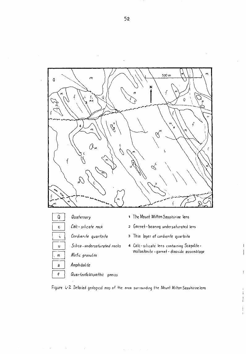
Q
m Quafernary
Q Ca/c- s'/Icafe rock
D Cordier/Ie quarfzde
~ Silica -undersafurafed rocks
~ Maile granulde
Q Amphlholtfe
~ Quarizofeldspafhic gneiss
52
1 The Mount Mi Iton Sapphirine lens
2 Ga rnet - bearing undersaturated lens
3 Thin layer of cordlertfe q,uadzite
4 Calc-silicate len!'> containing ScapoliteVYollastonite -garnet - diopside a!'>semblage
Fi 9 ure 4'? Detailed geological map of the area surrounding t he Mount Milton Sapphirine lens
53
YAMBAH RETROGRADE SCHIST ZONE
The Yambah Retrograde Schist Zone is made up of two "fault"
zones, intersecting at right angles in a wide valley south of
Mount Strangways. The schist zones are each about 1 km wide,
with diffuse margins grading into relately undeformed granulite
of the Strangways Metamorphic Complex (Yambah Granulite).
The maj or rock type in the schist zones is muscovi te-bioti te
quartz schist, in places containing garnet, kyanite and/or
stauroli te porpyroblasts. In composition these rocks ressemble
the adjacent quartzofeldspathic gneisses and are believed to
have been formed from them. Within the muscovite schists there
are pods of other rock types. These include mafic schists (cf
the mafic granulites in the Granulite), two pods of chlori te
garnet schist with associated calc silicate rock, and one pod of
gedrite-bearing schist.
Evidence for multiple deformation and polymetamorphism can be c
found in these outcrops. The s"histose fabric of the rocks is
in places complexly refolded. The aluminosilicate in the
Granuli te is sillimanite, rare bent needles of which may be
found in the schists; but the important aluminosilicate in the
schists is kyani te. The large blue blades of kyani te commonly
have faces corroded and etched by fine white muscovite, as do
the staurolite porpyroblasts.
Metamorphic segregation is an obvious feature of the schists,
especialy those with large zoned knots of kyanite, biotite and
quartz. Iyer (1974) reported that the "aluminous" schists have
lower Si0 2 and higher A1 20 3 than the quartzofeldspathic
gneisses presumed to be their protoliths. Mobility of K20, at
least in the final stages of the formation of the schists, seems
very probable, given the widespread growth of late muscovite.
Iyer and others (1976) reported a Rb/Sr age of 1820±60 Ma,
initial ratio .704 (corrected for revised decay constants) using
a whole rock isochron on undeformed granulites to the southwest
of the schist zone. The age of the Schist Zone itself is not
known.
54
THE EDWARDS CREEK Cu-Pb-Zn PROSPECT
The Edwards Creek Prospect is situated in low hills on the
northern edge of the Strangways Range, at 23 0 01 IS, 133 0
01 E. Outcrops containing copper, lead and zinc minerals are
erra: tically distributed along the west limb and northerf"l axial
zone of an upright south-plunging synform (probable syncline),
over a total strike length of nearly a kilometre (Fig 4.2).
The prospect and surrounding rocks are in a small fault block
about 4 km east-west by 1.5 km north-south. This block is
bounded on tt:e north by the Wallaby Knob Schist Zone, a wide
east-west st~king zone of multiply-deformed gneiss and schist;
on the south by a second wide schist zone; and on the east and
west by north-northwest trending faults. Minor shears and faults
subdivide the block internally. Several shears pass close to or
displace the wall rocks of the prospect itself. The rocks in
these minor shears, like those in the Wallaby Knob Schist Zone,
bear the imprint of several episodes of deformation, hydration,
and retrogression.
The well-exposed cordierite quartzite, which occurs adjacent to
the Cu-Pb-Zn bearing rocks, persists well beyond the prospect,
so that folds can be traced out over several square kilometres
using this layer as a marker.
Away from the prospect, individual quartzofeldspathic and mafic
units persist for considerable distances with little change in
thickness, but close to the prospect, units thicken and thin
markedly. Such variations in thickness are not related to the
folds and so are possibly primary features.
Several small bodies of orthogneiss disrupt the well layered
sequence and have margins which are localy discordant.
Mesoscopic features (foliation, granoblastic fabric, myrmekite)
show that the orthogneiss bodies predate the granulite stage and
shared the metamorphic history of the layered sequence.

55
Rocks carying ore minerals crop out adjacent to the cordierite
quartzite or form pods within it. Sulphides (galena, sphalerite
and pyrite) occur in some of the marbles; secondary copper
minerals occur in some of the gedri te rocks. The prominent
siliceous ironstone, stained by secondary copper minerals, may
be a true gossan or a ferruginous and siliceous cap over impure
marble. Analysed samples show a wide range of metal values and
ratios; from these data and field observations the Edwards Creek
Prospect is best regarded as a zinc prospect in which copper and
lead are partitioned into the gedrite rocks and marbles
respectively.
The wall rocks of the prospect provide excellent material for
the study of the superimposed retrogressions, but peak granulite
assemblages are poorly preserved. Orthopyroxene-K feldspar
assemblages occur in
assemblages developed
felsic rocks north of the prospect, and
in the early hydration (including rare
sapphirine) are present
rocks are common along
cordierite quartzite
in undeformed rocks. Gedrite-bearing
the shear zones, where retrogressed
contains gedrite-staurolite-kyanite-
-quartz±cordierite assemblages. Silica undersaturated rocks
include examples with corundum-stauroli te-chlori te assemblages
with staurolite of mg 40-42. Uplift following the gedrite
kyani te retrogression took the rocks back into the sillimanite
field, before a second episode of shearing in the quartz
chlorite field.
The marbles are derived from impure dolomites, they contain
calcite, dolomite, forsterite, humite, gahnite and sulphides.
Forsterite retrogresses to a phyllosilicate, possibly
antigori te. Coarse chlorite (to several centimetres) has been
collected from weathered calcareous rocks just north of the
ironstone, and nodules of chlorite to a centimetre are present
in some marbles.

s
[~~ SOII,all/muff}
~ Quartz scree
Q Schist
~ Deformed cordlerde ct"arrzile
G_J Marble) calc-silicate rOCK
~J Cordlerde fl"arrzde wdh undersa/<Jra/ed lenses
m FI nely layered rocks
W Orr.?ognerss
[IJ Quartzofeldspafhlc gnuss
If( op') I FelsIC granu/lfe
EJ Mafic 9ranville and amphlbolile
---Cj.
® 00
Figure 4.3 Geological map of the Edwards Creek Prospect
---- .-
Fault
Fault, Inferred
Fa uN , concealed
Snear zone
Quartz vein
Mlner'alo""rencc CU u,pper
Pi> Lead Zn Zmc
Partly cored, angled percussion Qnd Diamond drill hole
..
57
THE MUD TANK CARBONATITE
The Mud Tank Carbonatite, situated near the northern margin of
the Strangways Range has been described by Crohn & Gellatly
(1969), Gellatly, (1969) and Crohn & Moore (1984).
Three main outcrops of carbonatite are aligned in a northeastly
direction over a distance of about 2 km; a fourth outcrop lies a
furthur 2 km west-southwest (Fig. 4.2). Areomagnetic results
(Tipper, 1969) suggest the outcrops represent separate
lenticular to plug-like masses; Crohn & Moore (1984) interpreted
the results of auger drilling as showing plug-like bodies of
carbonate rock surrounded by poorly exposed phlogopite-carbonate
rock. The carbonatite intrudes garnetiferous semi-pelitc biotite
schist of the Arunta Inlier. Contacts are not exposed but have
been intersected in drill core where they are somewhat sheared.
There is no evidence of feni tiza tion. Basic rocks (probable
xenoliths) found as lenses within the carbonatite are amphibole
rich rocks that appear to show slight signs of metasomatism.
The only alkaline rocks associated with the carbonatite crop out
as small bodies of albite pegmatite, generally less than 3 m
long, within the carbonatite. Some contain traces of sodic
pyroxene and amphibole.
Exposures of the carbonatite are deeply weathered. Dipping
layering can be observed in some outcrops. Most of the material
on the surface is a residual carapace of apatite, magnetite, and
(now rare) zircon mixed with pisolites of ferruginous laterite.
In drill core the carbonati te is mainly coarsely crystalline
whi te carbonate rocks or biotite-carbonate rocks, with minor
amounts of magnetite, pale yellow-green apatite, dark green
chlorite, zircon, and zoned sodic amphibole. The carbonates are
calcite and dolomite in near equal proportions. Ilmenite,
pyrite, chalcopyrite, quartz, and pseudomorphs of possible
columbite after pyrochlore are also present •

58
That this is an igneous carbonatite rather than a meta
sedimentary carbonate-rock is supported by the following:
The assemblage apatite-magnetite-zircon is common in
carbonatites but rare in metamorphosed limestones.
The shape and distribution of calcite inclusions in dolomite
indicates exsolution from a single high temperature phase.
The zonal distribution of apatite and magnetite in the
marginal parts of the dolomite grains suggests magmatic
crystallization.
The si ze of magnetite crystals (up to 10 cm, or more) is
unknown in metamorphic limestones.
Some of the phlogopite shows reverse pleochroism with
maximum absorption normal to (001).
Trace elment concentrations are comparable with those from
other carbonatites especially those low in niobium:-
Nb 20-450 ppm
Ba 300-1000 ppm
Sr 800-1500 ppm
Ti
La y
200-10 000 ppm
100-7000 ppm
80-200 ppm
Black & Gulson (1978) obtained an age of 730 Ma using U-Pb
zircon and Rb/Sr total rock methods.
Black, L.P. & Gulson, B.L., 1978. The age of the Mud
Carbonatite, Strangways Range, Northern Territory.
Journal of Australian Geology and Geophysics 3 (3) ,
-232.
Tank
BMR
227 -
Crohn, P.W. & Gellatly, D.C., 1969. Probable carbonatites in the
Strangways Range area, central Australia. Australian Journal of Science 31, 335-336.
Crohn, P.W. & Moore, D.H., 1984. The Mud Tank Carbonatite,
Strangways Range, central Australia. BMR Journal of
Australian Geology and Geophysics 9(1), 13-18.
59
Gellatly, D.C., 1969. Probable carbonatites in the Strangways
Range area, Alice Springs 1:250 000 Sheet area, SF 53/14:
Petrography and Geochemistry. Bureau of Mineral Resources
Australia, Record 1969/77.
Tipper, D.B., 1969. Strangways Range detailed aeromagnetic
survey, Northern Teritory. Bureau of Mineral Resources,
Australia, Report 136.

QUATERNARY ~ Alluvium
Micaceous carbonate rock
LA.TE PROTEROZOIC .rrm Crystalline carbonate rock un. with apatite and magnetite
Feldspathic carbonate rock
EARLY PROTEROZOIC !~r.·~"'1 Leucocratic gneisses retrogressed granulite
Fault
t------; Cross section
Oal/Prw
60
ENTERPRISE 3 SECTION V_Vi
GEOPEKO V D.D.H. 'A' D.D.H. '2' D.D.H. '0' D.D.H. 'E'
i I
NWr-~~-,~~-.=-______ ~~~---.rr-__ ~~~TIr----'
X
I I
SCHIST I I
I I I
I
O.O.H. 'B'
NW ,--~~--",.
I SCHIST ANO I
AMPHIBOLITE / / I
CARBONATITE
ENTERPRISE 2 SECTION X-X'
0:~ \\\\\\~
"Micaceous "-FerrUginiSed Carbonate Rock Carbonate Rock
\w:r----___ ~ SE ........... Micaceous
Carbonate Rock peginatite
X'
A CARBONATITE
100m ~ ____ --"
500m
EJ Micaceous sand
Micaceous carbonate rock
• • ~ ~
~ P
A
o
Crystalline carbonate rock with apatite and magnetite
Feldspathic carbonate rock
Schist and gneiss, granulite
Amphibolite
Pegmatite
Amphibole-rich rock
Olivine-rich rock
16/F53/16
Figure 4.4 Geological map of the Mud Tank Carbonatite (after Crohn & Moore, 1984).

61
PEGMATITES IN THE HARTS RANGES
The pegmatites of the Harts Ranges were mined for muscovite from
1888 to 1960. During this period the pegmatites also yielded
fine mineral specimens; today the pegmatites and the abandoned
waste dumps are still being picked over for fine specimens of
beryl, feldspars and tourmaline.
The pegmatites
be as young
are younger than the peak metamorphism, and may
as mid-Palaeozoic has been suggested, though
pegmatites in the northeastern Arunta are circa 1700 Ma. The
majority of the pegmatites are fissure
faults, shears or steeply dipping joints, . ~
bodles, and some are contolled by more /I.
feature (Joklik, 1955).
. r.. velns, occurlng ln
~
others are pipe-like
than one structural
The economic pegmatites are coarse grained (>10 cm) zoned
bodies, with relatively fine grained
wall zone of quartz-muscovite, an
feldspar (perthitic microcline and
border zones, a coarse
intermediate zone of ~~~~~~~~~~
albi te) and accessory
minerals, and quartz-rich cores, in some pegmati tes containing
large microcline crystals.
Joklik, G. F., 1955. The geolgy and mica fields of the Harts
Range, central Australia. Bureau of Mineral Resources,
Australia. Bulletin 26.
62
HARTS RANGE AREA
by
P.R.James,R.W.Lawrence,R.L.Oliver and J.D.Foden
(Department of Geology & Geophysics, University of Adelaide)
t~ .. ~ -, ~,:' : .
.-,' ..
63
Structural development of the Harts Range, central Australia.
Hetamorphic rocks from part of the Harts Range Area. of the eastern Arunta Inlier, central Australia, have been divided into four main units; the Entia gneiss complex, the Bruna granitic gneiss, the Irindina supracrustal assemblage \ and the Brady supracrustal assemblage. Ding & James (1985) propos~d that the Entia gneiss complex was part of basement to the supracrustal cover. They also proposed that the basement and cover were· juxtaposed during the first Harts Range Remobilization thrusting event (HRT l ) and that the Bruna granitic gneiss was tectonically emplaced during HRT2 and HRT 3 •.
The Entia gneiss complex, along the western margin of the Entia Dome, is composed mainly of felsic gneisses. The complex has been. locally subdivided into three units with different abundances of inter layered mafic amphibolites and various metasediments. A major isoclinal fold of this sequence and the sequence itself are both sheared towards parallelism with the lower margin of the Bruna granitic gneiss, indicating that the
. overlying sequence has moved in a southeasterly direction. The complex is affected by the open folding responsible for the Entia Dome.
The Bruna granitic gneiss occurs as a layer at the base of the Irindina supracrustal assemblage. It consists of three varieties of differing deformation intensity. Large lense shaped bodies of almost un deformed granite occur within more typic3l granitic gneiss. Schistose mylonites with alkali feldspar megacrysts occur at the upper margin. The deformed rocks have strong lineations trending in northerly directions.
The Irindina supracrustal assemblage consists predominantly of biotite schists and mafic amphibolites, with lesser horizons of marble and calc-silicates. Three units of amphibolite have been distinguished throughout much of the area. Two of these units are separated by the Entia gneiss complex, which was used as a marker horizon during mapping. Five generations of folding have occurred in the Ruby Mine Area. A strong 8 1 foliation is ubiquitous, although majorF
l folds are rare. A major flexure in the trend of
the weak Lb mineral lineations occurs along the eastern margin of the Entia orne from 325 0 in the north, through 360 0
, to 015 0 in the south. Major F2 isoclinal folds have a very wide distribution and fold HRTI further to the west. F2 folds are tighter approaching the Bruna granitic gneiss. F3 folding is tight and restricted to the Ruby Mine Area. F2 and F3 folds are both coaxial with LI • Upright F4 folding trends E-W and is most strongly developed at the contact between the mylonites of the Bruna granitic gneiss and the Irindina supracrustals. FS folding is open and trends N-S.
The Brady supracrustal assemblage 'consists of a monotonous se q uence of biot it e gnei sses which have been divided in to two un its, the lower 0 f 'w h i c h t h ins a r 0 u n d the nor tho f the En t i a Dome. Tight and isoclinal folds occur and the assemblage is also
64
folded by FS.
The ruby deposits in the Entire anorthosite provide information on the timing of metamorphism in relation to. folding in the Irindina supracrustal assemblage. Extra silica was required in order to produce Sl hornblende in ultramafic.;;:;, which previously consisted of pyroxenes, olivine and spinel. Silica was supplied through metasomatic exchange between anorthosite and ultramafic. Loss of silica causer! a relative concentration of alumina in anorthosite resulting in ruby formation. Retrograde chlorite caused ultramafic to be less competent than anorthosite during F3 folding.

65
EXCURSION STOPS,RUBY MINE AREA.
A Bruna Gap
At the western end of Bruna Gap there is an exposure.of well layered and folded gneisses of the Entia gneiss complex. Within the Bruna Gap itself, strain variation within the Bruna granitic gneiss is well represented. At the upper (western) mal3in are schi~tose mylonites which were classified into the Irindina Gneiss by Shaw et al (1982). However, Ding and James (1935) have included them --;:;ithin their Bruna granitic gneiss because of the· obvious granitic protolith of these mylonites.
B Ruby excavation
Hetamorphic differentiation has occurred in anorthosite adjacent to ultramafic. Some small ruby corundum crystals, rimmed by sericite, occur in the layered and metasomatically altered anorthosite. This exposure demonstrates that metasomatism has occurred during Sl development and ruby has formed in altered anorthosite adjacent to ultramafic. The complex shape of the ultramafic is due to F3 folding, which can be examined at the next locality.
C The Knoll ruby excavation
The southern faces of the Knoll ruby excavation are the main exposures from which the origin of the ruby deposits has been deduced. The geology is represented in Fig. 2, although the Knoll has since been mined down to the ruby-bearing ultramafic layer. Layers of ruby bearing gneisses within ultramafic are continuous with and grade into anorthosite outside of the ultramafic. These layers are therefore considered to be isoclinal Fl folds as they are continuous with and parallel to the S foliation within the ultramafics defined by hornblende. The ru~y-bearing layers also have an S1 fabric and the rubies are considered to have grown during the Sl development.
The present mineralogy of the ultramafics is dominated by hornblende and chlorite. This chlorite has formed from a retrograde reaction between hornblende, olivine and spinel. The margins of the ultramafic are particularly rich in chlorite. The addition of chlorite would have caused ultramafic to be more ductile and the shapes of F3 folds indicates that this retrograde (although still amphibolite facies) reaction had commenced prior to F3 folding. -
Large scale F3 folds can be observed in the hills to the south of the Knoll. Non-cylindrical E-W open F 4 folds occur in mafic amphibolites north ~f the Knoll.

66
D Trenched Area
Much excavation has been carried out in the Trenched Area since earlier mapping (Fig. 3). In this area there are two distinct layers of ultramafic, the upper of which is ruby bearing. Thickness changes due to 'boudinage can be observed ~n the ex i s tin g ex p 0 sur e s , a s we 11 as 0 pen F 5 f old in g pI u.n gin gin a northerly direction. Of particular interest is a boudin of altered anorthosite with a thin rim of ultramafic ("e" on Fig. 3a). This ultramafic is considered to have been attenuated after the metasomatism that altered this boudin.
E Dating locality
Muscovite and zircon have been within folded mafic amphibolites. an S 3 fa b ric ( Fi g. 4)
F SE corner of Ruby Mine Area
analysed from acid pegmatites The pegmatites appear to have
Of particular interest is the more intense F4 upright folding in this area compared with near the Knoll. Steep dips are particularly obvious in the biotite gneisses immediately south of the large E-W pegmatite dyke. The mylonites at the upper margin of the Bruna granitic gneiss and the mylonitized "unit I" mafic amphibolite are more strongly folded than the underlying less deformed Bruna gneiss.
Another feature in this deformed and metamorphosed subophitic texture.
area is a during F1 ,
small boudin of norite but still retaining a
A prominant group of hills 15 km due south contains the same ~2 closure of the top of the "unit 2" amphibolite which is exposed ln the hill 400 m to the west of this locality.

IRINDINA SUPRACRUSTAL ASSEMBLAGE
,'~\~\~" pelitic gneiss
~ marble and quartzite
Harts Range Metaigneous Complex
_ ultramafic
p'.ji(/;;;~ Entire anorthosite
rs:s:sJ mafic amphibolites
1:-=-"] ~ SCALE, Meters
Unit 3
Unit 2
Unit 1
o 500 1000 ~I""--""·)==========~)
67
~ ARUNT~ : BLOC~ ,...-rHorts Range ~ area
: Alice , ~Springs - _L -
BRUNA GNEISS
l.-tv -vI mylonitized granite
E:=D granite and granitic gneiss
~pegmatite
.......... F Low angle fault
+F4 and F5 axial traces-antiform
--f-" " -synform
-fl- F3 axial trace
-A- F2 axial traces
16 Y layer parallel foliation
14 minor fold, vergence indicated
+
+
.j)?i.g. 5.1 a Geology of the Ruby Mine area

68
J l I
p ~I
1/ 'II
vI II /
/I(
g o
10
Fi~. 5
.1b
F
old
rela
tion
s
in
the
Ru
by
Min
e a
rea
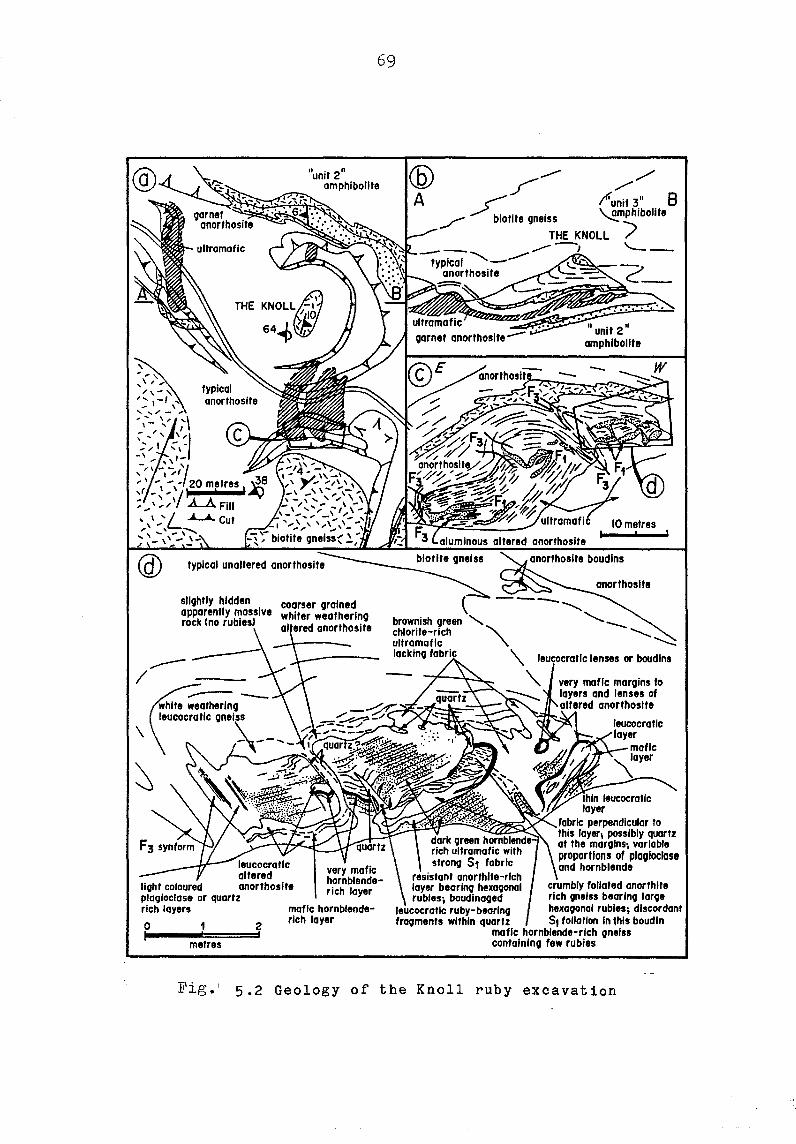
\
69
"unit 2" amphibolite
THE KNOLL(j-1 \ ;£'.0 641> \t;.
slightly hidden coarser grained apparently massive whiter weathering rock (no rubies) anorthosite
leucocratlc altered
light coloured anorthosite
very mafic hornblenderich layer
plaqloclase or quartz rich layers
o I
metres
2 I
mafic hornblenderich layer
f-- ,// /. I"unit 3" 8
/"" biotite gneiss ~mphjbollte THE KNOll ') -- ....--~ '--
typical -.......--anorthosite
10 metres ,
perpendicular to this layer; possibly quartz of the marglns\ variable proporflons of plagioclase and hornblende
crumbly foliated anorthite rich gneiss bearlno laroe hexagonal rubles; discordant
Fig.' 5.2 Geology of the Knoll ruby excavation
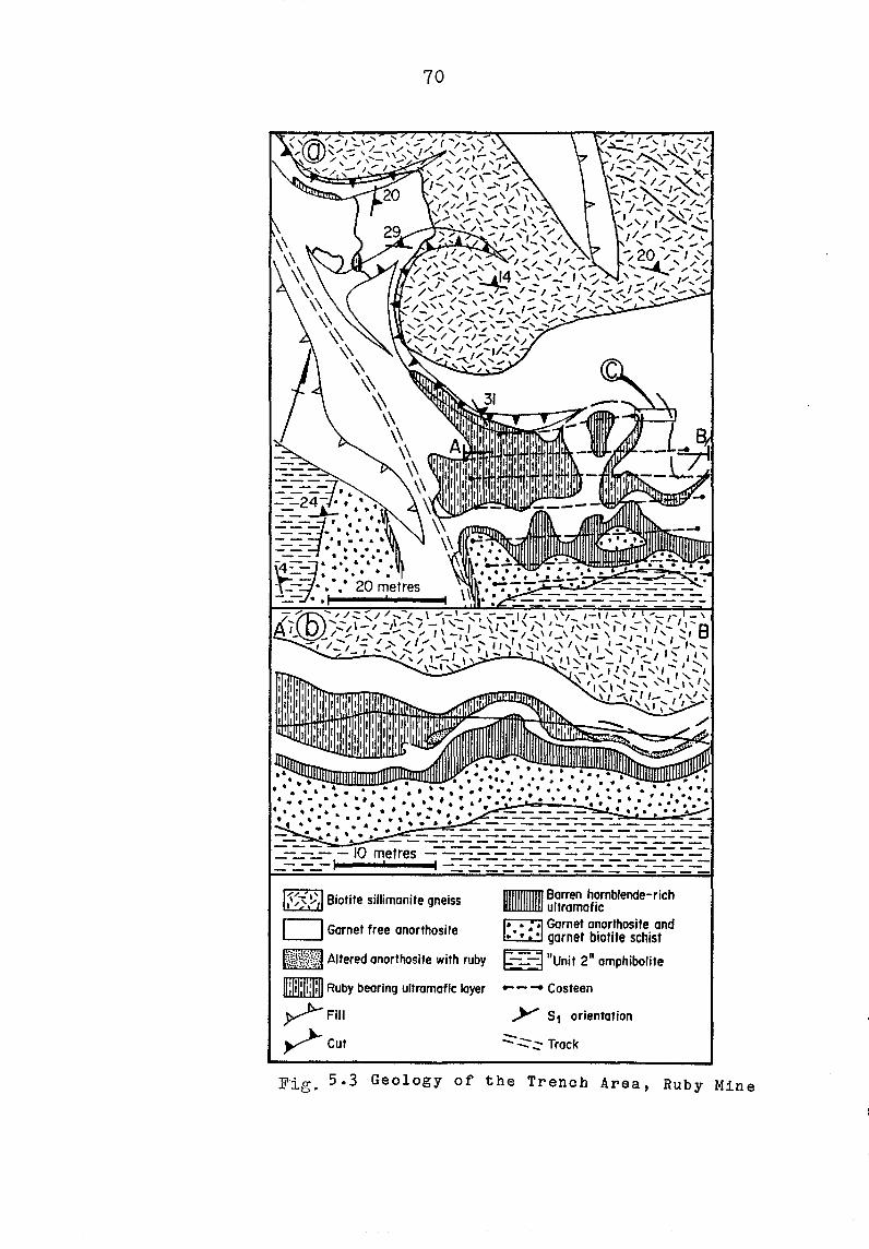
70
Biotite sillimanite gneiss
o Garnet free anorthosite
f~\~~~;Y}l Altered anorthosite with ruby
mlIillIJ Ruby bearing ultramafic layer
y>--Fill ~cut
_Barren hornblende-rich ultramafic
~ Garnet anorthosite and ~ garnet biotite schist
r=:::=::3 flU '2" h'b I't ~ nit amp' 0' e
--- Costeen
y S1 orientation
.:::-..:::- - Track -Fig. 5.3 Geology of the Trench Area, Ruby Mine

o I
71
FOLDED EARLY PEGMATITE IN AMPHIBOLITE - ENTIRE CREEK
........ ,~== " . .... ::t;..
0.5 ,
Meters
Fig.5.4
. ....
1.0 I
Coarse feldspar pellmatite
--
72
THE GEOLOGY OF THE ENTIA DOMAL STRUCTURE. EASTERN HARTS RANGES. N.T.
DF: J. D. FODEN
DEPARTMENT OF GEOLOGY AND GEOPHYSICS
UNIVERSITY OF ADELAIDE.
The Entia Domal Structure(EDS) is at the eastern end of the Harts Range in the eastern Arunta Block as defined by Plumb et al ~ (1981).Here rocks are regionally of amphibolite or gt-anuli.te facies and have yielded ma:dmum rCi.diometr-ic ages of about 1800 t'la. (Black et al ~ 1983). This is thought to represent the oldest metamorphism~refered to as the Strangways Event.
Subsequent to the work of Joklik (1955)~investigation of the regional geology of the Harts Range area has been carried out by the B.M.R. (Shaw and Stewart~1975~Shaw et al. 1979.1982).These investigations resulted in the establishment of a three-fold approximately chronological division of the rocks of the Arunta Block.This division (after Shaw et al. ,1982) is as follows:
Division 3 Division 2
Division
quartz-rich metasediments (youngest) basal quartzofeldspathic gneiss~overlain by pelitic gneisses and amphibolite units
1 :interlavered basic and acid granulites with minor amphibolite grade gneisses (oldest).
Shal41 et al. (1979~ 1982) considered that rocks of division 1 were overlain by those of division 2 at a faulted or discordant contact which may have been an original unconformity disrupted by thrust faulting. The rocks of the Harts Range Area are mainly assigned to division 2.Shaw et al. (1982) refer to these as the Harts Range Group.
The rocks of the Entia Domal Structure were referred to as the Entia Gneiss and were regarded as the basal unit of the group. The Entia Gneiss is overlain by the Bruna Gneiss~ the Irindina Gneiss and the Brady Gneiss.They considered that the Entia Gneiss overlay the division 1 rocks of the Strangways Metamorphic Complex.
More recently Ding and James (1984) have undertaken detailed structural studies in the Harts Range area and have suggested on the basis of structural style that the Entia Gneiss (refering to all the rocks of the Entia Domal Structure) be included in division 1.In recognition of the diversity of lithologies and ages of rocks previously defined as the Entia Gneiss~Ding and James (1985) rededefined this as the Entia gneiss complex. They regard the Brady and Irindina Gneisses (Shaw et al. 1982) as supracrustal ~cover associations which "Jere jLlxtaposed t;~ith .the division 1 "basement" (including the Entia gneiss complex) as a result of thrusting. Both·

73
cover thrust became
and basement were multiply deformed before they were together and the mylonite zone defining this thrust the site of intrusion of the Bruna Gneiss whilst this
event was in progress. The area of outcrop of the Entia gneiss compiex is
confined to the Entia Domal Structure. This is an area about 20-30 km. in diameter (figure 1) where the gneiss~s dip circumferentially outwards beneath the Bruna Gnei~s and the cover sequence rocks. This domal form of the Entia Gneiss is due to late stage upright open folding and is not due to diapirism of any of the granitic bodies presently exposed (ie the Huckitta or Inkamulla granite-gneisses).The doming of the Entia postdates the juxtaposition of cover and basement whereas the important granites are components of the gneiss complex and show complex deformation predating the doming events.
Rocks of the EDS can be subdivided into a supracrustal associ.tion whose most distinctive component is amphibolite and an intrusive component represented by sheet-like units of orthogneiss of mainly intermediate to acid composition. These rocks have been collectively referred to as the Entia gneiss complex by Ding and James (1985) and have suffered complex multiphase deformation. It can be shown that prior to the introduction of the major granite sheets at least two important isoclinal deformations of the suprac~ustal
association took place and that after intrusion there were two more large-scale tight to isoclinal recumbent events.
It is likly that the metamorphic thermal peak was reached in the EDS during the time of the first of these large-scale recumbent folding events and migmatite development is widespread as a result. Pegmatite intrusions took place over a very lengthy period of the geological history of the dome. Some pegmatites clearly predate the granite intrusions, some are coeval and some very prominant and widespread pegmatites clearly crosscut the latest dome-forming structures. •
Rock Types. The rocks of the Entia Domal Structure (EDS) can be
subdivided into two broad groups; 1. The supracrustal association and 2. The intrusive association.AII rock"types have experienced a lengthy and complex defor~ational and metamorphic history and mo~t rock types are now deformed and recrystallised gneisses.
Supracrustal Association. These are the oldest rocks of the EDS and comprise both
ortho- and para -amphibolite ,thin carbonate units and calcsilicate rocks together with thin meta pelite-psammite sequences .The pelitic components of the latter association have suffered extensive partial fusion yielding migmatite with restite/melanosome composed of biotite-phlogopite and often an aluminous phase ,either kyanite~garnet or cordierite. Rocks of this supracrustal association are seen at stops 1,2,3 and 5 and analyses of typical orthoamphibolites and a knotted phlogopite-kyanite schist are

74
given in table i.The amphibolites are the most distinctive lithology of the supracrustal association and their outcrop patterns provide the most easily mapped definition of the post-intrusive structures.
Least distinctive of the pre-intrusive litho~ogies i$ the finely layered Grey Biotite Gneiss.This unit is perhaps the major pre-intrusive component, but it forms highly weathered outcrops ~nd its origin is uncertai~.It may represent an earl y fel si c meta-·i ntl~usi ve a meta.-arkose or a meta-volcanic sequence •
Intrusive Orthogneisses. The EDS is dominated by metaigneous rocks of largely
intermediat~ to felsic ~omposition which have intruded the above supracrustal rocks as flat-lying ,conformable sheets (sills).Towards their margins these sheets are interleaved with the supracrustal rocks forming complex zones of xenoliths and thin sills.Thesp contact features are well illustrated at localities 4 and 5 where the contact of the Inkamulla Granite Gneiss is ~ell exposed.
Four main intrusive units are distinguished ;1. the Huckitta Granodiorite Gneiss,2.the Inkamulla Granite Gneiss~3.the Huckitta Tonalite Gneiss and 4. the Entia Leucogranite Gneiss.Typical analyses of these orthogneises are given in table I.The Huckitta granodiorite (Buick~1983)
is a mesocratic gneiss of granodioritic compostion composed of plagioclase~ quartz~hornblende ~nd biotite.It is a hetQrogeneous phase cut by thin dykes or sills of aplite~pegmatite and "spotty" hornblende-l:;learing leucogranodiorite.The Inkamulla granite is a leucocratic true granite composed of quartzrPotassium feldspar~ plagiocla,e and biotite.It outcrops as a distinctive massive~homogeneous, sill-like body.
The Huckitta tonalite gneiss is a much more mafic unit than the other orthogneisses and ranges from gabbro to granodiorite in composition. The largest exposed volumes are of tonalitic or dioritic compostion.It is a ~uartzpoor,plagioclase-hornblende-rich lithology and lik~ the Huel:: it ta Granodi m- i te contai ns numeroLls >:enol i ths of amphibolite or diorite composition.
The Entia Leucogranite gneiss is very widespread prthogneiss phase .It occurs throughout the Entia Dome as sheet-like intrusions usually conformably interleaved with components of the sLlpracrustal association.Locally however (eg stop 8) it cross-cuts this association. It is a pale orange coloured reck-type in outcrop forming pavemnents or slabby tors.Petrographically it is a quartz-plagioclasemicrocline granite gneiss, with minor biotite~ and is of fine-medium grainsize.
Throughout the EDS the pelitic gneiss and the grey biotite gneiss are pervasively migmatised and it is very possible that the Entia Leucogranite gneiss is a locally formed magma resulting from nearly in-situ partial melting. Pegmatite is also a very common component of the EDS and there are clearly many generations.~ome pegmatites pre-date
75
the intrusion of the orthogneisses while there several clearly younger generations. The latest are Palaeozoic and have E-W orientations.
Structure
are also probably
The structural development of the area can be subdivided into three phases: 1. Pre-intrusive structures .These afe indentified in the supracrustal association and can be placed as pre-intrusive by their occurence in ~enolithic
blocks within orthogneiss. There are at least three phases of folds which appear to be tight to isoclinal and at least in part recumbant.2. Early post-intrUSive folds. There are at least two early post -intrusive deformations which produc~d
recumbant, isoclinal folds eFI and F2).The first of these produced a pervasive regional schistosity (SI)in all the orthogneiss units described above. Folds attributable to this phase are difficult to recognise, but can be seen as closures in xenolith sheets in some granites (eg Inkamulla Granite~ stop 4).The second post-intrusive phase (F2) has pr6duced large scale meso to macro -folds in the EDS.These are also recumbant and tight .They refold SI and locally can be seen to develop a new axial planar schistosity (S2) (eg stop 6), though this weak by comparison with Sl.The risteep zone "in the centre of the EDS is the hinge of a very large F2 fold.
3. The late-stage folds .These are upright and open folds and are not clearly associated with fabric development or metamorphism (the metamorphic peak was probably syn-FlF2).There are probably three distinguishable phases of these (F3~F4 and F5).The domal character of the EDS is due to interference between F4 and F5.Late pegmatite intrusion and possible retrograde metamorphism (greenschist facies) ~ay
accompany these latest deformations.
Excursion Stops.
The Entia Domal Structure is approached from the Ruby Mine area to the west and its physiography is dominated by prominent strike-line ridges and resistant granite-gneiss units. The most prominent schistosity and the lithological layers are parallel and these dip outwards right a~ound the perimeter of the dome.Also prominent is a zone of steep to vertical dips running approximately north-south through the centre of the dome .This zone represents the hinge line of a very large-scale recumbent F2 fold with axial surfaces approximately hbrizontal.
Also quite distinctive are the outcrops of the Huckitta granodioritic gneiss in the east of the dome • These form striking bald, rounded hills which give the superficial appearance of diapiric intrusions though on closer examination they are in fact remnants of dipping gneissic sheets.
76
Stop 1. Between Spriggs Bore and Valley Bore:Knotted phlogopite-
kyanite schist.
This is typical of many such knotted kyanite schist' occurences throughout the EDS.It is part of the supracrustal association and occurs with migmatite An origin as a partial melting residue is suggested. The co-existance of granitic minimum melt and kyanite suggest minimum pressures of about 8kb. and temperatures of 700 C. Stop 2.
Near the Valley Bore intersection to the west of Inkamulla Bore .Amphibolite
This is a very mafic 'amphibolite composed of hornblende ~clinopyroxene and minor plagioclase. This is one of the orthoamphibolites of the supracrustal association. Stop 3.
On ·the eastern flank of the hill with prominent'cairn~ 300 meters to the south east of stop 2.
The para-amphibolite -quartzose the supracrustal suite.Here the banded with quartz-rich layers garnets. Stop 4.
metasediment sequence of amphibolites are finely and prominent flattened
At the base of the low ridge directly to the east of stop 3 (about 200 meters).Here the contact of the Inkamulla Granite Gneiss can be seen .It intrudes the older gneiss sequence~ including lithologies observed at stop 3.ln the hillside to the south some thin sills of the granite can be seen and in the western face of the low ridge projecting back towards the road~ a number of folded sheets of amphibolite are included in the granite as xenoliths.
The host Inkamulla granite has been folded together with these xenoliths in what appears to be two distinct generations. In the first of these ~ the xenolith clo~ures have the pervasive granitic schistosity (81) as an axial planar fabric .These closures are therefore equated with the Fl folds which must have produced the regional foliation in the orthogneisses. These Fl closures have horizontal axial planes and hinges striking E-W. Refolding this early set of folds together with the schistosity is a second gen.ration again with horizontal axial planes but with hinge lines striking NNW-SSE. This generation of folds (F2) has only developed a weak axial planar fabric which is best seen at stop 6.
Stop 5. The supracrustal meta-pelite association and
amphibolite in contact with the Inkamulla Granite Gneiss.This locality is situated about 400 meters due south from Inkamulla Bore (turn south and leave the road at the bore and drive parallel to the creek bed untill the first line of low hills and outcrops are reached).
77
At this locality the marginal apophyses of the Inkamulla granite can be seen intruded the older gneisses as thin sills.Towards the highest crest of the hill~ about 150 meters east of the creek bed a thin succesion of interbedded meta - pelite and quartzite of the supr~crustal association are exposed. Here the pelitic units are now composed of garnet-biotite-kyanite -feldspar gneiss; while ~he quartz-rich units are pale~ slabby quartzite •.
Stop 6 On the eastern flank of the prominent hill just to the
north of Inkamulla Bore.The prominent orange cliff on the south side of this hill ~f~cing the road is Inkamulla Granite Gneiss.This cliff exposes a broad open syncline with vertical axial plane (F3 or F4) .Stop 6 is located around the eastern side of this hill (procede eastwards about 1km along the Huckitta road past the next creek and turn north along a recent bulldozer scrape).
The eastern flank of the hill exposes Inkamulla granite and represents the core of a major F2 fold. Leaving the vehicals at the helicopter pad and crossing the fence-line into Riddock station~ the base of the cliffs about 100 meters to the NW expose well developed zones of M-vergence minor folds in the granite gneiss with hinges striking about 330 and plunging about 5 degrees. Locally well developed 52 schistosity is parallel to near-horizontal axial planes.
Stop 7 At stop 7 an outcrop of Huckitta Granodioritic Gneiss is
observed on the eastern side of the road about lkm after this road has swung to a more southerly average direction.~he
Huckitta granodiorite here is a complex gneiss with several components. These include an early mesocratic-melanocratic granodiorite which is cut by thin veins of later spottyleucocratic ~hornblende granodiorite.
Stop 8
This stop starts at the "Huckitta Camp" and involves a short walk to the west through the saddle in the low amphibolite ridge-top to the west. Here pavement outc~ops of the Entia Leucogranite Gneiss can be seen intruding the amphibolite.These intrusions are generally conformable~ but below the saddle ~ about 100 meters to the west~ amphibolite can be seen with cross-cutting leucogranite intrusion.
Continuing westwards beyond the first creek the last major orthogneiss unit is exposed. This is the Huckitta Tonalite Gneiss~ a meso-melanocratic ~plagioclase-hornblende rock which forms low ~brown tors. It may have several internal phases including cross-cutting networks of more leucocratic veins.
/
References.
Buick~I~S (1983) the Huckitta granitoids~Harts
Honours Thesis~
Adelaide.
78
The geology ~petrology and geochemis~ry of Granodioritic Gneiss and associated
Range, Central Australia. Unpublished Department of Geology, Univ~rsity of
Ding,P. and James,P~R (1985) Structural Evolution of the Harts Range area and its implication for the development of the Arunta Block. Central Australia. Precambrian Res. 27,251-276
Joklik,G.F. (1955).The Geology and mica fields of the Harts Range,Central Australia.BMR Bulletin 26
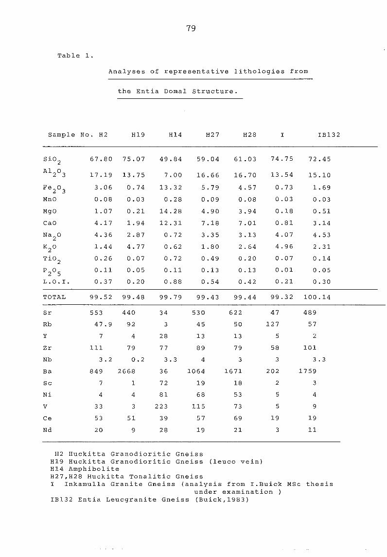
79
Table 1.
Analyses of representative lithologies from
the Entia Doma1 structure.
Sample No. H2 H19 H14 H27 H28 I IB132
MgO
CaO
Na2
0
K2
0
Ti02
P205
L.O.I.
TOTAL
Sr
Rb
Y
Zr
Nb
Ba
Sc
Ni
v Ce
Nd
67.80 75.07 49.84 59.04 61.03 74.75 72.45
17.19 13.75 7.00 16.66 16.70 13.54 15.10
3.06 0.74 13.32 5.79 4.57 0.73 1.69
0.08 0.03 0.28 0.09 0.08 0.03 0.03
1.07 0.21 14.28 4.90 3.94 0.18 0.51
4.17 1.94 12.31 7.18 7.01 0.81 3.14
4.36 2.87 0.72 3.35 3.13 4.07 4.53
1.44 4.77 0.62 1.80 2.64 4.96 2.31
0.26 0.07 0.72 0.49 0.20 0.07 0.14
0.11 0.05 0.11 0.13 0.13 0.01 0.05
0.37 0.20 0.88 0.54 0.42 0.21 0.30
99.52 99.48 99.79 99.43 99.44 99.32 100.14
553 440 34 530 622 47 489
47.9 92 3 45 50 127 57
7 4 28 13 13 5 2
111 79 77 89 79 58 101
3.2 0.2 3.3 4 3 3 3.3
849 2668 36 1064 1671 202 1759
7 1 72 19 18 2 3
4 4 81 68 53 5 4
33 3 223 115 73 5 9
53 51 39 57 69 19 19
20 9 28 19 21 3 11
H2 Huckitta Granodioritic Gneiss H19 Huckitta Granodioritic Gneiss (leuco vein) H14 Amphibolite H27,H28 Huckitta Tona1itic Gneiss I Inkamulla Granite Gneiss {analysis from I.Buick MSc thesis
under examination IB132 Entia Leucgranite Gneiss (Buick,1983)
- 80 -
ACKNOWLEDGEMENTS
This excursion would not have been possible without the great
help and co-operation of the Northern Territory Geological Survey,
Alice Springs.