building the twin cities interstate systeminterstate-35e construction, st. paul politics and...
TRANSCRIPT

Center for Urban and Regional Affairs
Cars in front of the St. Paul Cathedral, Summit and Dayton, St. Paul
Horses and wagons, bicycles, automobiles, and streetcars cause traffic congestion at Nicollet and Sixth, Minneapolis
View of downtown from Interstate 35, Minneapolis
Interstate-35E construction, St. Paul
Politics and Freeways:Building the Twin Cities Interstate System
by Patricia Cavanaugh
Interstate 35W with Minneapolis skyline in background
Used
with
per
mis
sion
of M
etro
polit
an D
esig
n Ce
nter
, © R
egen
ts o
f the
Uni
vers
ity o
f Min
neso
ta
Used
with
per
mis
sion
of H
enry
Ben
broo
ke H
all,
Min
neso
ta H
isto
rical
Soc
iety
Used
with
per
mis
sion
of
Min
neso
ta H
isto
rical
Soc
iety
Used
with
per
mis
sion
of N
orto
n &
Pee
l, M
inne
sota
His
toric
al S
ocie
ty
Used
with
per
mis
sion
of M
inne
sota
His
toric
al S
ocie
ty
Center for Urban and Regional Affairs
University of Minnesota200 Transportation and Safety Building 511 Washington Avenue SEMinneapolis, MN 55455Phone: 612-626-1077Fax: 612-625-6381E-mail: [email protected]: www.cts.umn.edu
University of Minnesota330 HHH Center
301—19th Avenue S.Minneapolis, MN 55455
Phone: 612-625-1551Fax: 612-626-0273
E-mail: [email protected]: www.cura.umn.edu
Cavanaugh Politics and Freeways
Center for U
rban
and
Region
al Affairs

Politics and Freeways: Building the Twin Cities Interstate System
Prepared by
Patricia Cavanaugh
University of Minnesota
for
Center for Urban and Regional Affairs (CURA)
and
Center for Transportation Studies (CTS)
at the
University of Minnesota
October 2006
Center for Urban and Regional Affairs

A joint publication of the Center for Urban and Regional Affairs (CURA), an all-University applied researchand technical assistance center at the University of Minnesota that connects faculty and students with com-munity organizations and public institutions working on significant public policy issues in Minnesota; andthe Center for Transportation Studies (CTS), a multidisciplinary center at the University of Minnesota thatserves as a catalyst for transportation innovation through research, education, and outreach. The content ofthis report is the responsibility of the author and is not necessarily endorsed by CURA, CTS, or theUniversity of Minnesota.
Publication No. CURA 06-01 (500 copies)
© 2006 by The Regents of the University of Minnesota. This publication may be reproduced in its entirety(except photographs or other materials reprinted here with permission from other sources) in print or elec-tronic form, for noncommercial educational and nonprofit use only, provided that two copies of the result-ing publication are sent to the CURA editor at the address below and that the following acknowledgment isincluded: “Reprinted with permission of the University of Minnesota’s Center for Urban and Regional Affairs(CURA).”
For information regarding commercial reprints or reproduction of portions of this publication, contact theCURA editor at the address below.
This publication is available in alternate formats upon request.
Printed with agribased inks on recycled paper with minimum 20% postconsumer waste.
Center for Urban and Regional Affairs (CURA)University of Minnesota330 HHH Center301—19th Avenue SouthMinneapolis, Minnesota 55455
Phone: (612) 625-1551Fax: (612) 626-0273E-mail: [email protected]: www.cura.umn.edu
The University of Minnesota is committed to the policy that all persons shall have equal access to its programs, facilities, and employment without regard to race, color, creed, religion, national origin, sex, age, marital status, disability,
public assistance status, veteran status, or sexual orientation.
Center for Transportation Studies (CTS)University of Minnesota200 Transportation and Safety Building511 Washington Avenue S.E.Minneapolis, Minnesota 55455
Phone: (612) 626-1077Fax: (612) 625-6381E-mail: [email protected]: www.cts.umn.edu

Table of Contents
List of Tables ........................................................................................................................ivList of Figures ......................................................................................................................ivForeword................................................................................................................................vAcknowledgements................................................................................................................viIntroduction ..........................................................................................................................11. Leading Up to the 1956 Federal-Aid Highway Act ............................................................5
Federal ....................................................................................................................5State and Local ......................................................................................................10
2. History of the Twin Cities Area Interstate: Mega-Projects (1956 to the Late 1960s) .......13Introduction ..........................................................................................................13Interstate 94 from St. Paul to Minneapolis ............................................................14Interstate 35W/Highway 62: Crosstown Commons ..............................................18Discussion ..............................................................................................................23
3. History of the Twin Cities Area Interstate: Expanding the Debate (1970 to the mid-1990s) ................................................................................................25
Introduction ..........................................................................................................25Interstate 335, the North Ring ..............................................................................29Interstate 35E ........................................................................................................34Interstate 394..........................................................................................................44Interstate 94 from Interstate 494/Interstate 694 to Trunk Highway 95 ..................54Discussion ..............................................................................................................60
4. History of the Twin Cities Area Interstate: Falling Behind (1990s) ..................................63Introduction ..........................................................................................................63Interstate 35W Expansion.......................................................................................65Discussion ..............................................................................................................87
5. Epilogue ..........................................................................................................................916. Discussion and Conclusions ............................................................................................97
Federal Government ..............................................................................................98State and Local Government ..................................................................................99Business Community ............................................................................................100Citizens.................................................................................................................101Professionals..........................................................................................................103The Role of Experts in a Representative Democratic Government........................105Leadership ............................................................................................................107Tensions and Mismatches ....................................................................................108Conclusions ........................................................................................................110
Appendices ........................................................................................................................113Appendix 1. Minnesota Governors, Highway/Transportation Commissioners,
and Metropolitan Council Chairs 1955–2005..................................................113Appendix 2. Municipal Consent Laws ................................................................115Appendix 3. Important Dates in Minnesota Highway History ............................119Appendix 4. Significant Federal Legislation Related to Highways ........................121Appendix 5. Development of the Metropolitan Council .....................................123Appendix 6. 1975 Moratorium Bill .....................................................................125
iii

LIST OF TABLES
Table 1. Construction of Freeways in the Seven-County Twin Cities Area ............3Table 2. Interviews by Type of Respondent ..........................................................4Table 3. 1975 Design Year Volumes for Interstate 35W ......................................66Table 4. Minnesota Driving Statistics Summary, 1965–2004 ..............................91
LIST OF FIGURES
Figure 1. Freeway Construction Completion by Era ............................................2Figure 2. Freeway Segments Selected for Study ....................................................4Figure 3. General Location of Proposed Freeway Routes, 1939 ............................7Figure 4. General Location of Proposed Freeway Routes, 1944 ............................8Figure 5. Interstate Highway System, 2002 ........................................................10Figure 6. Map of Proposed Super Belt Line ........................................................11Figure 7. Twin Cities Freeway Pattern, 1956 ......................................................12Figure 8. Proposed Route of Crosstown Highway, 1953 ....................................19Figure 9. Common Section of Interstate 35W and Highway 62 ........................22Figure 10. 1970 Metropolitan Freeway Completion Schedule ............................24Figure 11. Freeways Blocked by Moratorium Bill ...............................................29Figure 12. Proposed Northern Ring Route (Interstate 335) ................................30Figure 13. Proposed Interstate 35E Parkway........................................................39Figure 14. Proposed Route of Interstate 394 (Highway 12 Improvement) ..........45Figure 15. General Location of Twin Cities Freeways, 1955................................67Figure 16. Interstate 35W Project Location ........................................................70
iv

FOREWORD
Fifty years ago, the U.S. federal government began the most ambitious public works proj-ect in our nation’s history: the Interstate Highway System. As we look back on that land-mark event, it is worth briefly reflecting on how we arrived at that moment in history.
The internal combustion engine came onto the scene in the late 1800s. Within theshort span of 20 years, the automobiles and trucks it powered were becoming ubiq-uitous. The Great Depression and World War II slowed the spread of motor vehicles;most people today are too young remember that U.S. automobile manufacturersstopped producing cars for three years or so during the war, and converted their plantsto the production of military equipment and vehicles. Most people today are also tooyoung to appreciate the explosion of the manufacture and sale of cars and trucks fol-lowing the war in 1947 and 1948.
Following Eisenhower’s election in 1952, the country entered the era of “Peace,Prosperity, and Progress.” Americans had jobs and money, and were on the move.Most of those who had left farming communities and small towns during the warnever went back. Many Americans migrated to the South and West, and Americansin significant numbers moved from central city to suburb. No matter where and whenAmericans moved, they went by car.
Cars require roads, and by the mid-1950s, it was clear that America would need tobuild lots of roads—roads to move themselves and their goods, and roads that wouldmeet modern speed, safety, and design standards. Congress passed the Federal-AidHighway Act in 1956, with the federal government providing 90% of the cost of theinterstate system in each state. The boom in modern highway construction amongand within American’s urban centers began in earnest in 1958.
This report started with the idea that it would be useful to record the thoughts and mem-ories of some of the people who have played major roles in the development of the inter-state system in Minnesota, particularly in the Twin Cities. As the project evolved, many ofthose people were interviewed about their experiences, and their recollections were sup-plemented with documentary analysis to provide complete accounts of particular stagesand phases of the interstate’s development in the Twin Cities.
Several conclusions emerged as the project evolved. First, each person who wasinvolved in the development of the interstate system in Minnesota has a slightly dif-ferent perspective on what happened and why. The major job of the author, PatCavanaugh, and those who advised the project was to attempt to sort out these dif-ferent perspectives in a fair and meaningful way. Second, each phase of the develop-ment of the interstate system in the Twin Cities was extraordinarily complex, involvedmany issues and parties, and required careful planning, engineering, and construc-tion. At the same time, each phase of development took place in a changing social andpolitical environment, both nationally and in Minnesota. In many ways, this projectbecame a study of the evolution of a major public works project during five decadesof dramatic change in the United States.
There is much to learn from this report and, inevitably, there is much that is notreported. Nonetheless, those of us involved with this project believe that this study
v

allows us to look back on five decades of individual highway construction projectsand provide some perspective on the cumulative impact of what we’ve been doing andwhy we’ve done it that way.
Thomas M. ScottDirector, Center for Urban and Regional Affairs (CURA)University of MinnesotaOctober 2006
ACKNOWLEDGMENTS
This report is intended to be useful for the transportation planning and policy com-munity, citizens interested in transportation issues, and those with an interest in localhistory. The focus is the Twin Cities area. Its purposes are to provide an historical ref-erence for our current situation, offer analytical discussion on issues raised by thecases, and stimulate questions for further reflection and action. From inception, cre-ation of this report was guided by the expertise of a distinguished advisory commit-tee consisting of: Richard P. Braun, Peter Fausch, Jim Newland, Robert C. Johns,Thomas Scott, and Barbara Lukermann. This report was jointly funded by the Centerfor Transportation Studies and The Center for Urban and Regional Affairs (CURA).
The completeness and depth of the research was made possible by those who gavetheir time, delved into their memories, and shared their knowledge in conversation.This includes: Steve Alderson, Richard P. Braun, Ellen Brown, Steve Cramer, WilliamCrawford, Howard Dahlgren, Larry Dallam, John Diehl, James Denn, Natalio Diaz,Douglas Differt, Peter Fausch, Donald Fraser, John Hausladen, Leif Holter, John R.Jamieson, Ted Kolderie, Art Lee, Dee Long, Dan McElroy, S. Dore Mead, BobMorgan, Patrick Murphy, Jim Newland, Thomond O’Brien, John Ohrn, CraigRobinson, Marty Romano, Gertrude Ulrich, and Donn Wiski. Thanks also toGovernor Wendell Anderson for his assistance in locating relevant sources. AnnHopkins, SRF Consulting Group, contributed the description of the design processfor the I-35E parkway. Jeff Matson, CURA, made the maps. Charlene Zimmer, ZANAssociates, shared her insights on context sensitive design. Michael Turner, DakotaCounty Board, provided information on the I-35W Solutions Alliance. ConnieKozlak, Metropolitan Council, contributed a treasure trove of old files. Assistancewith secondary sources and archival materials was provided by Jerry Baldwin,MnDOT Library, Cheryl Olson, Metropolitan Council Library, and Eunice Johnson,Wilson Library, University of Minnesota. Barbara Lukermann’s knowledge, kindness,and wisdom were indispensable throughout the project. Finally, the integrity andintelligence of the final report were enhanced by the following readers who gracious-ly agreed to comment on the first complete version of the manuscript: StephenAlderson, Carol Flynn, Ted Kolderie, and S. Dore Mead.
vi

INTRODUCTION
This project grew out of informal conversations among the members of the advisorycommittee about the value of capturing, as far as it is possible, the memories and per-spectives of those who participated in the dramatic development of our highway andfreeway infrastructure in the Twin Cities during the last 50 years. In addition, thisresearch is an extension of the Transportation and Regional Growth Study conduct-ed by the Center for Transportation Studies. The concept of the research evolved intomore formal conversations and interviews, then added archival materials and second-ary sources. Along the way, it became apparent that the full array of changes thatoccurred in urban areas during the building of our highways is a rich area for research.To make it manageable, the scope of the research has been narrowed to include onlyinterstate freeways and then furthered narrowed to the selected cases discussed on thefollowing pages.
The research design was strongly influenced by, Mega-Projects: The Changing Politicsof Urban Public Investment, by Alan Altshuler and David Luberoff,1 in particular theirconceptualization of eras to describe changing politics and decision-making process-es in the 20th century. The eras were modified to reflect the local experience andinclude three periods: mega-projects (from 1956 to the late 1960s), the era of expand-ing the debate (from 1970 to 1990), and finally, the era of falling behind (1990s). Thebeginning and end dates of the eras suggest transitions rather than clear demarcations,although miles of actual highway construction strongly suggest these time periods, asshown in Figure 1. Cases were selected to provide insight into the local urban dynam-ics as they evolved after passage of the Federal Aid Highway Act of 1956 and through-out the subsequent eras. Many segments of the interstate were built without contro-versy. As shown in Table 1, 298 miles of freeway were built in the Twin Cities area,and most of this was welcomed by the surrounding communities. The beltline routeof I-494 and I-694 is an example of this. In 1961, James Marshall, commissioner ofhighways, noted that because of the lack of land development and the early stage ofhighway planning, the beltline could be built with minimal disturbance and functionas a factor in guiding growth of the area.2 The cases selected for research, however, areall urban routes that involved conflict (see Figure 2). This was done to learn as muchas possible about the way in which participants and institutions adapted to changingcircumstances and political pressures. Thus, for the period of mega-projects, from1956 to the late 1960s, the cases included:
• I-94 from downtown St. Paul to downtown Minneapolis• I-35W/Highway 62: Crosstown Commons
The four cases for the period of expanding the debate, from 1970 to the early 1990s,consist of three segments that shared a moratorium bill in the state legislature:
• I-335 (which was not built)• I-35E from the Mississippi River to downtown St. Paul• I-394 from downtown Minneapolis to I-494
Introduction 1
1. Alan Altshuler and David Luberoff, Mega-Projects: The Changing Politics of Urban Public Investment(Washington, D.C.: Brookings Institution Press, 2003).2. Notes for Remarks of Commissioner James C. Marshall, Minnesota Highway Users Conference,October 4, 1961.
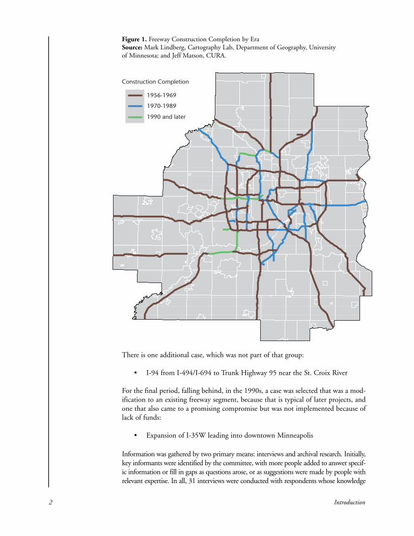
There is one additional case, which was not part of that group:
• I-94 from I-494/I-694 to Trunk Highway 95 near the St. Croix River
For the final period, falling behind, in the 1990s, a case was selected that was a mod-ification to an existing freeway segment, because that is typical of later projects, andone that also came to a promising compromise but was not implemented because oflack of funds:
• Expansion of I-35W leading into downtown Minneapolis
Information was gathered by two primary means: interviews and archival research. Initially,key informants were identified by the committee, with more people added to answer specif-ic information or fill in gaps as questions arose, or as suggestions were made by people withrelevant expertise. In all, 31 interviews were conducted with respondents whose knowledge
2 Introduction
Figure 1. Freeway Construction Completion by EraSource: Mark Lindberg, Cartography Lab, Department of Geography, Universityof Minnesota; and Jeff Matson, CURA.
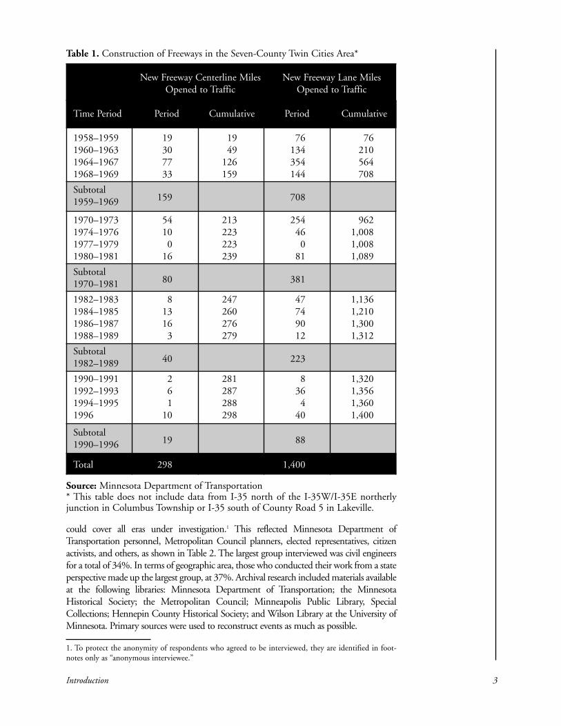
could cover all eras under investigation.1 This reflected Minnesota Department ofTransportation personnel, Metropolitan Council planners, elected representatives, citizenactivists, and others, as shown in Table 2. The largest group interviewed was civil engineersfor a total of 34%. In terms of geographic area, those who conducted their work from a stateperspective made up the largest group, at 37%. Archival research included materials availableat the following libraries: Minnesota Department of Transportation; the MinnesotaHistorical Society; the Metropolitan Council; Minneapolis Public Library, SpecialCollections; Hennepin County Historical Society; and Wilson Library at the University ofMinnesota. Primary sources were used to reconstruct events as much as possible.
Introduction 3
New Freeway Centerline Miles New Freeway Lane MilesOpened to Traffic Opened to Traffic
Time Period Period Cumulative Period Cumulative
1958–1959 19 19 76 761960–1963 30 49 134 2101964–1967 77 126 354 5641968–1969 33 159 144 708
Subtotal 1959–1969 159 708
1970–1973 54 213 254 9621974–1976 10 223 46 1,0081977–1979 0 223 0 1,0081980–1981 16 239 81 1,089
Subtotal 1970–1981 80 381
1982–1983 8 247 47 1,1361984–1985 13 260 74 1,2101986–1987 16 276 90 1,3001988–1989 3 279 12 1,312
Subtotal 1982–1989 40 223
1990–1991 2 281 8 1,3201992–1993 6 287 36 1,3561994–1995 1 288 4 1,3601996 10 298 40 1,400
Subtotal 1990–1996 19 88
Total 298 1,400
Table 1. Construction of Freeways in the Seven-County Twin Cities Area*
Source: Minnesota Department of Transportation* This table does not include data from I-35 north of the I-35W/I-35E northerlyjunction in Columbus Township or I-35 south of County Road 5 in Lakeville.
1. To protect the anonymity of respondents who agreed to be interviewed, they are identified in foot-notes only as “anonymous interviewee.”

4 Introduction
Figure 2. FreewaySegments Selectedfor StudySource: JeffMatson, CURA
Note: There were 31 total interviews completed. Totals are more than the number of respon-dents because some are counted in two categories due to their experience.
Engineers Other Elected Citizens Business TotalsProfessionals Officials
Federal 1 1 2 (6%)
State 9 3 1 13 (37%)
Regional 6 6 (17%)
County 1 1 (3%)
City 1 1 4 1 7 (20%)
Neighbor-hood 6 6 (17%)
Totals 12 (34%) 10 (29%) 6 (17%) 6 (17%) 1 (3%) 35 (100%)
Table 2. Interviews by Type of Respondent

Imagine the state of Connecticut knee deep in earth; that’s how much was moved for the inter-states. Or a wide sidewalk extending from the earth to a point in space five times the distanceto the moon; that’s how much concrete was poured for the interstates. Or a land mass the sizeof the state of Delaware; that’s how much property highway authorities acquired in order to siteinterstates. Or enough drainage culverts to handle all the needs of a city six times the size ofChicago; that’s how much was laid beneath the interstates. The Great Wall of China and theInterstate Highway System are among the only human creations that can be seen by astronautsfrom an orbiting spacecraft.
—Tom Lewis, Divided Highways1
Federal
The United States has an impressive histo-ry of great public works projects, from theprivately-financed turnpikes and canals inthe early 1800s, followed quickly by thefederally-subsidized railroad boom, to theimpressive locks and dams in the late1800s. Until the 20th century, however,roads in the United States were built andmaintained primarily by state and localgovernment. By the time Henry Fordhoned his system of mass-production,ushering in the age of the automobile,however, roads were beginning to beviewed as a public good that should beprovided by the federal government.2 At the 1939 World’s Fair in New York City, fivemillion people saw the Futurama exhibit constructed by General Motors. It held outa vision of a future with road systems designed specifically for fast travel by automo-biles. There were models of roads built through mountains, across wide rivers, andbypassing cities. At a time when travel by car was slow, dangerous and unpredictable,crowds thronged to the vision. It expressed the hope many felt. When the demandpent up from war restrictions was let loose in the mid 20th century, support for anational system of highways was virtually a consensus. In 1953, Americans mademore money per capita than at any previous time in history. With two world warsbehind them, they were ready to roll.3
Leading Up to the 1956 Federal-Aid Highway Act 5
—1—LEADING UP TO THE 1956 FEDERAL-AIDHIGHWAY ACT
1. Tom Lewis, Divided Highways (New York: Viking, 1997).2. Owen D. Gutfreund, Twentieth Century Sprawl: Highways and the Reshaping of the American Landscape(New York: Oxford University Press, 2004), 9. 3. Norman Bel Geddes, Magic Motorways (New York: Random House, 1940), 3–13; Lewis, DividedHighways, 72.
Horses and wagons,bicycles, automobiles,and streetcars cause traf-fic congestion at Nicolletand Sixth, Minneapolis,1905. (Courtesy of theMinnesota HistoricalSociety, location no.HE2.3 r29, negative no.975. Reprinted with permission.)
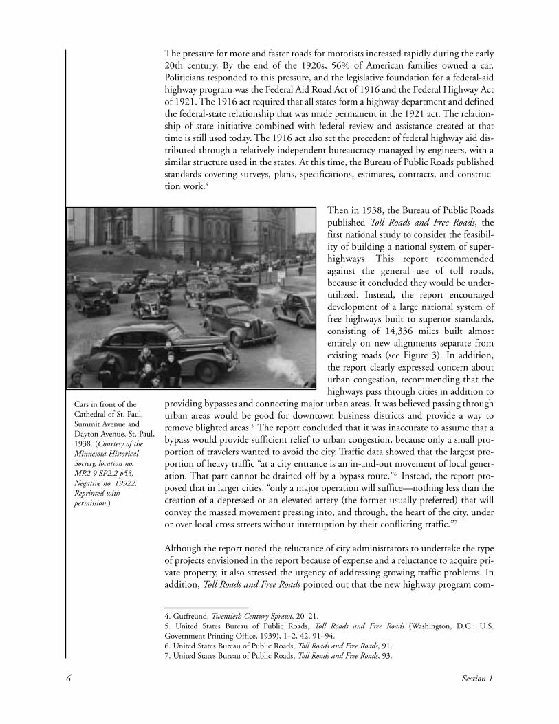
The pressure for more and faster roads for motorists increased rapidly during the early20th century. By the end of the 1920s, 56% of American families owned a car.Politicians responded to this pressure, and the legislative foundation for a federal-aidhighway program was the Federal Aid Road Act of 1916 and the Federal Highway Actof 1921. The 1916 act required that all states form a highway department and definedthe federal-state relationship that was made permanent in the 1921 act. The relation-ship of state initiative combined with federal review and assistance created at thattime is still used today. The 1916 act also set the precedent of federal highway aid dis-tributed through a relatively independent bureaucracy managed by engineers, with asimilar structure used in the states. At this time, the Bureau of Public Roads publishedstandards covering surveys, plans, specifications, estimates, contracts, and construc-tion work.4
Then in 1938, the Bureau of Public Roadspublished Toll Roads and Free Roads, thefirst national study to consider the feasibil-ity of building a national system of super-highways. This report recommendedagainst the general use of toll roads,because it concluded they would be under-utilized. Instead, the report encourageddevelopment of a large national system offree highways built to superior standards,consisting of 14,336 miles built almostentirely on new alignments separate fromexisting roads (see Figure 3). In addition,the report clearly expressed concern abouturban congestion, recommending that thehighways pass through cities in addition to
providing bypasses and connecting major urban areas. It was believed passing throughurban areas would be good for downtown business districts and provide a way toremove blighted areas.5 The report concluded that it was inaccurate to assume that abypass would provide sufficient relief to urban congestion, because only a small pro-portion of travelers wanted to avoid the city. Traffic data showed that the largest pro-portion of heavy traffic “at a city entrance is an in-and-out movement of local gener-ation. That part cannot be drained off by a bypass route.”6 Instead, the report pro-posed that in larger cities, “only a major operation will suffice—nothing less than thecreation of a depressed or an elevated artery (the former usually preferred) that willconvey the massed movement pressing into, and through, the heart of the city, underor over local cross streets without interruption by their conflicting traffic.”7
Although the report noted the reluctance of city administrators to undertake the typeof projects envisioned in the report because of expense and a reluctance to acquire pri-vate property, it also stressed the urgency of addressing growing traffic problems. Inaddition, Toll Roads and Free Roads pointed out that the new highway program com-
6 Section 1
Cars in front of theCathedral of St. Paul,Summit Avenue andDayton Avenue, St. Paul,1938. (Courtesy of theMinnesota HistoricalSociety, location no.MR2.9 SP2.2 p53,Negative no. 19922.Reprinted withpermission.)
4. Gutfreund, Twentieth Century Sprawl, 20–21.5. United States Bureau of Public Roads, Toll Roads and Free Roads (Washington, D.C.: U.S.Government Printing Office, 1939), 1–2, 42, 91–94.6. United States Bureau of Public Roads, Toll Roads and Free Roads, 91.7. United States Bureau of Public Roads, Toll Roads and Free Roads, 93.

plimented the slum-clearance projects underway by the federal government.8 The newhighway system was envisioned as a necessary part of the “radical revision of the cityplan. Such a revision will have to provide the greater space now needed for unfetteredcirculation of traffic” and “For such a revision of the city plan decision upon the loca-tion and character of the new highway facilities here described is a basic necessity.”9
The opening of the Pennsylvania Turnpike in the fall of 1940 seemed a marvel tomany, as a reporter wrote, “I never thought I could drive 75 miles an hour aroundmountain curves in heavy rain and live to tell about it,” and many people inWashington, D.C., were similarly impressed.10 Although legislation was passed byCongress in 1941 to fund a 78,780-mile network of highways, it was vetoed byPresident Franklin D. Roosevelt because of his expectation that the United Statessoon would be involved in World War II. Demonstrating his commitment to theproject, however, President Roosevelt appointed the National Interregional HighwayCommittee.11
Leading Up to the 1956 Federal-Aid Highway Act 7
Figure 3. General Location of Proposed Freeway Routes, 1939 Source: Reproduced from House Committee onPublic Roads, Toll Roads and Free Roads: Message from the President of the United States (Washington, D.C.: U.S. Government Printing Office, 27 April 1939), 19.
8. United States Bureau of Public Roads, Toll Roads and Free Roads, 94.9. United States Bureau of Public Roads, Toll Roads and Free Roads, 95.10. Lewis, Divided Highways, 66–67.11. U.S. Department of Transportation, Federal Highway Administration (U.S. DOT–FHA), The Storyof the Federal-Aid Highway Program: America on the Move (Washington, D.C.: U.S. Department ofTransportation, 1980), 9; Biennial Report of the Commissioner of Highways of Minnesota (St. Paul:Minnesota Department of Highways, 1942); District Nine Resource Section, Minnesota HighwayDepartment, “A History of the Interstate System at the National Level,” internal memorandum, August1975; Mark H. Rose, Interstate Express Highway Politics: 1939–1989, rev. ed. (Knoxville, TN: Universityof Tennessee Press, 1979), 2–3.

8 Section 1
This committee’s report, Interregional Highways: Report and Recommendations of theNational Interregional Highway Committee, was published in 1944. It recommended34,000 miles of interstates, with another 5,000 miles available for bypasses and otherurban routes, continuing the commitment to urban freeways stated in Toll Roads andFree Roads (see Figure 4). The report stressed planning the interstates so that theycomplement urban development: “Because of these two things—the permanency ofthe highways and the more or less planless form of the cities—the interregional routesmust be so located as to conform to the future shape of cities, insofar as this can beforeseen, as well as to the existing pattern of urban centers.”12 And further, “It is high-ly important that this force be so applied as to promote a desirable urban develop-ment.”13 The committee’s report also stressed the importance of local authorities indetermining detailed locations of the routes within federal guidelines. The majorpoint of departure from the 1938 report was the emphasis on building completelynew roads rather than upgrading existing roads when possible. In addition, the ideaof limited access was elaborated and insisted upon.14 The Federal-Aid Highway Actof 1944 followed this report quite closely, designating the interstate system of 40,000miles. It also appropriated funds for surveys and plans, stimulating coordination ofplanning efforts by federal, state, and local governments. The main components ofthe 37,700-mile system were formally adopted in 1947 with reserve miles for beltlinesand radial routes in urban areas. In the late 1940s, there was concern about the ade-quacy of the nation’s roads for defense purposes, adding another pressure to the need
Figure 4. General Location of Proposed Freeway Routes, 1944. Source: Reproduced from House National Interregional Highway Committee, Interregional Highways: Messagefrom the President of the United States, House Document No. 379, 78th Congress, 2d Session (Washington,D.C.: U.S. Government Printing Office, 12 January 1944), 7.
12. U.S. National Interregional Highway Committee, Interregional Highways: Report and Recommendations of theNational Interregional Highway Committee (Washington, D.C.: U.S. Government Printing Office, 1944), 53.13. U.S. National Interregional Highway Committee, Interregional Highways, 54.14. U.S. National Interregional Highway Committee, Interregional Highways, 78.

Leading Up to the 1956 Federal-Aid Highway Act 9
for roads. Based on the success of the Pennsylvania Turnpike, states developed plansof their own, with New York beginning construction of the Thruway in Syracuse in1946, and the New Jersey Turnpike getting underway in 1949.15 In 1954, PresidentEisenhower announced his intention to push for funding for a national freeway sys-tem. Although he did not yet have a financing plan, the idea was well received. Heappointed a federal Interagency Committee to study policy options and appointedGeneral Lucius Clay to head a presidential advisory committee, known informally asthe Clay Committee, to study finance plans. The Clay Committee’s report was sentto the president in January 1955. It recommended that the federal governmentassume a substantial portion of the cost of the interstate system. These additionalroutes were adopted in September 1955.16
After legislative roadblocks in the 1955 session regarding apportionment and financeformulas, the bill came to fruition as the Federal-Aid Highway Act of 1956. It com-mitted funding from the Highway Trust Fund, which was set up by the HighwayRevenue Act of 1956. This increased taxes on fuel, vehicles, and related purchases andprovided that revenue from these taxes go to the Highway Trust Fund. Federal fund-ing was provided at 90%, an astounding level of support. The 1956 act also requiredpublic hearings, changed the name of the highway system to the National System ofInterstate and Defense Highways, and stressed rapid completion of the system tomeet economic and defense needs of the country. The goals were to provide limitedaccess highways built to the safest and highest design standards available, to meet traf-fic needs for the next 20 years (projected to 1975), and connect a substantial numberof cities with a population of 50,000 or more by 197217 (see Figure 5). The benefitsof freeways were seen to be vast: safety, economic growth, national defense, improvedbusiness and employment, and the convenience and freedom of mobility for citizens.Freeways showed promise as being safer, faster, cheaper, and having greater capacityfor drivers.18
15. Lewis, Divided Highways, 68–69.16. Minnesota Department of Highways, A Study of Interstate Highway 94 (St. Paul: MinnesotaDepartment of Highways, September 1961); U.S. Department of Transportation, Federal HighwayAdministration, America’s Highways 1776–1976: A History of the Federal-Aid Program (Washington,D.C.: U.S. Department of Transportation, 1977), 165; District Nine Resource Section, MinnesotaHighway Department, “A History of the Interstate System at the National Level.”17. U.S. Department of Transportation, Federal Highway Administration, The Story of the Federal-AidHighway Program, 11, 22; District Nine Resource Section, Minnesota Highway Department, “A Historyof the Interstate System at the National Level”; George W. Barton and Associates, Freeways inMinneapolis: An Appraisal Prepared for the City of Minneapolis (Evanston, IL: Barton and Associates,January 1957), 33. 18. Barton and Associates, Freeways in Minneapolis, 5, 15; “43 Reasons Why America Needs BetterHighways Now!” brochure, (NP: NP, 196?).

Minnesota reflected the optimism and urgency felt across the nation, with congestion andtraffic hazards in the Twin Cities a growing a problem. Highway construction was plannedand underway, including early plans for and construction of a belt line around the metroarea, as shown in Figure 6. The idea of circumferential roads as a way to alleviate conges-tion appeared as early as the 1920s, with construction on Highway 100 beginning in thelate 1930s. The interstate program would provide a means to build a complete circumfer-ential system at a high standard.20 In 1961, Commissioner James Marshall described thisupgraded beltline as a means to ease congestion and spur development.21 On March 2,1956, even before the Federal Highway Act was passed, the Minneapolis Tribune
10 Section 1
History has determined that I be Governor of Minnesota just at this moment—in 1956 and 1957and 1958—and I feel especially privileged to be our state’s chief executive at the dawn of a greatlyexpanded Highway Era. I am convinced that this decade and the next will eventually be found tohave been the Era of Highway Development—just as there was an Era of Steam, and an Era ofElectricity, and the dawning of the Atomic Era. We are presently at the threshold of a time in whichanother new element has been completely recognized and will grow mightily from this point. Thatelement is the highway—and I am convinced that what we have seen since the passage of theInterstate Highway Act only sixteen months ago, is only a hint—a foretaste—of what is yet to come.In our office, we are Highway-conscious—because this is the way of the future.
—Governor Orville Freeman, 195719
19. Speech by Governor Orville Freeman, Minnesota Highway Users Conference, Curtis Hotel, 15October 1957.20. Ted Kolderie, “Memorandum to Persons Interested in Transportation and Transit Issues,” 12December 1987.21. Notes for Remarks of Commissioner James C. Marshall, Minnesota Highway Users Conference, 4October 1961.
State and Local
Figure 5. Interstate Highway System, 2002Source: Jeff Matson, CURA, based on ESRIdata and maps

announced the state plans for the Twin Cities freeways, declaring that thefirst segments could be open by 1958. Highway Commissioner M. J.Hoffman and L. P. Zimmerman, the chief engineer, presented plans to anenthusiastic group of local officials hosted by the Minneapolis Chamberof Commerce22 (see Figure 7). The new routes were viewed as a welcomeaddition to the existing system of highways. Then in May, J. E. P. Darrell,a traffic engineer with the Minnesota Highway Department (MHD), stat-ed that the highway program was “far along in the planning stage” andcould begin “very quickly” after the federal appropriation was passed. Anexpressway between downtown Minneapolis and St. Paul was noted as atop priority. A shortage of trained civil engineers was the only obstacleanticipated.23 Minnesota was viewed as having a head start over otherstates because of its established department with “a large corps of loyalemployees of long tenure.”24
Minnesota formed the State Highway Commission in 1905, which wasthen modified to comply with the federal requirements of the 1921 Act.The1920s, often called the Babcock era after Charles Babcock, the first highway commis-sioner, brought the development of Minnesota’s trunk highway system. The 16th amend-
Leading Up to the 1956 Federal-Aid Highway Act 11
Rush-hour traffic (loop-bound) at the junc-tion of Lyndale and Hennepin Avenues,Minneapolis, 1951. (Photo from theMinneapolis Star Journal Tribune, courtesy ofthe Minnesota Historical Society, location no.MH5.9 MP2.1 p617, negative no. 52338.Reprinted with permission.)
Figure 6. Map of Proposed Super Belt Line Source: Jeff Matson, CURA,based on a map from the Minneapolis Tribune,29 September 1955.
22. “First Expressways May Be Completed by 1958, City Told,” Minneapolis Tribune, 2 March 1956.23. “Official Sees Early Start on State Highway Program,” Minneapolis Tribune, 11 May 1956.24. “Freeway Offers New Travel Links,” Minneapolis Star, 5 January, 1958.

ment to Minnesota’s constitution was adopted in 1920 to create the state trunk highwaysystem, the goal of which was to connect all county seats and principal centers of popula-tion. In 1921, the Trunk Highway fund was established to finance the construction andmaintenance of the system. These laws moved the state squarely into the role of roadbuilding, something which had previously been the responsibility of towns and counties.25
On the 1944 federal map, three interstate system routes were planned for Minnesota: I-90along the southern border, I-35 from Iowa to Duluth, and I-94 traversing Minnesota fromHudson, Wisconsin, to Moorhead, Minnesota. From the beginning of the interstate devel-opment, there were plans to split I-35 into east and west sections because the state capitolwas in St. Paul and the business center was in Minneapolis. In Minneapolis, the first plansfor expressways were along diagonal radials running out from the central business district,such as a southeast diagonal highway on Hiawatha Avenue to connect to the MendotaBridge over the Minnesota River, built in the 1920s. The interstate alignment, however,called for freeways that formed an intersection as they crisscrossed the country, so ratherthan present a means for developing the diagonal routes, it led to the development of newtransportation corridors at the same that it offered a means to get the badly needed express-way between the two downtowns built quickly.26 St. Paul, which had plans for an express-way ready to go and worked closely with MHD, was ready to build I-94 when the 1956Act passed. The Minnesota Highway Department had a good reputation and was highlythought of in Washington, D.C. “It was known as a friendly and good state to work with.”The first section of interstate to open in Minnesota was an eight-mile stretch of I-35 nearOwatonna on August 21, 1958. 27
12 Section 1
Figure 7. TwinCities FreewayPattern, 1956 Source: Jeff Matson,CURA, based on amap from theMinneapolisMorning Tribune, 2March 1956.
25. Office of Public Information, Minnesota Department of Highways, 1921–1971: 50th Anniversary(St. Paul: Minnesota Department of Highways, 1971), 25.26. Kolderie, “Memorandum to Persons Interested in Transportation and Transit Issues.” 27. Anonymous interviewee, interview with author, May 2004.

—2—
HISTORY OF THE TWIN CITIES AREAINTERSTATE: MEGA-PROJECTS (1956 TO THELATE 1960S)
Introduction
Minnesota was prepared to act when the interstate program was funded in 1956. Thestate’s tradition of professionalism was already established because MHD enjoyed agood reputation in Washington, D.C. Construction moved quickly statewide, and by1967, Minnesota had about 360 miles of freeway open to traffic, almost 40% of thetotal planned.1 Public sentiment was strongly in favor of the freeway system. In 1959,72% of Minnesotans backed an increase in the gas tax to fund building roads.2 Therewere, however, some indications that there might be turbulence ahead. In 1958,Lewis Mumford published his well-known essay, “The Highway in the City,” inwhich he cautioned against the dangers of building interstates through urban areas,stressing the need to plan transportation systems that incorporate a balanced varietyof “speed and mode to fit a diversity of human purposes.”3 In 1963, racial issues wereviewed as the top problem in the nation.4 Overall, however, it was a time of great opti-mism and expectation of good financial times, with bringing new industry to the stateviewed as a top priority by most Minnesotans.5 “Freeways seemed like pure paths toprogress.”6
The confidence and forward looking atmosphere of the era is evident in the TwinCities Area Transportation Study (TCATS) conducted by the State of Minnesota, incooperation with the Bureau of Public Roads, beginning in 1958 and concluding inthe early 1960s. This state-of-the-art research was based on the predominant view atthe time, that “urban travel is an orderly phenomenon susceptible to rational analysisand prediction.”7 Rather than rely on origin and destination studies alone, as donepreviously, TCATS based its projections on land use patterns and found higher thanexpected traffic forecasts for 1980. The pent up pressure for new expressways wasgreat, public attitudes were favorable, and professionals believed they had the toolsnecessary for the task at hand. An important change in state municipal consent lawin 1959 also facilitated the interstate program. The previous law allowed municipali-ties complete veto power on highway projects, but Minnesota Statute §161.17, sub-division 2, allowed the commissioner to refer the plan to the Twin Cities
History of the Twin Cities Area Interstate: Mega-Projects (1956 to the late 1960s) 13
1. “35W Should Save 15 Minutes Driving Time,” Minneapolis Tribune, 28 November 1967.2. “7 of 10 Minnesotans Back Boost in Gasoline Tax for U.S. Roads,” Minneapolis Tribune, 8 November1959, Upper Midwest section, 4.3. Lewis Mumford, “Highway in the City,” in The Highway and the City (New York: Harcourt, Braceand World, 1963), 236.4. “Racial Crisis Seen as Biggest Problem,” Minneapolis Tribune, 11 August 1963, Upper Midwest section, 1.5. “Public: State’s Top Problem is New Industry,” Minneapolis Tribune, 30 December 1962, UpperMidwest section, 1.6. Curtis Johnson, “Market Choices and Fair Prices,” Transportation and Regional Growth Study Report#17 (Minneapolis: Center for Transportation Studies, University of Minnesota, January 2003), 6.7. Minnesota Department of Highways, Twin Cities Area Transportation Study (St. Paul: MinnesotaDepartment of Highways, 1962).

Metropolitan Area Planning commission for further review and recommendation (seeAppendix 2). Also in the mid-1960s came the formation of the Joint Program, a col-laborative planning effort that acknowledged the importance of multiple agenciescoordinating their efforts to develop comprehensive regional plans and policy (seeAppendix 5). The following two cases illustrate how the process for building freewaysworked in the beginning of the interstate program.
Interstate 94 from St. Paul to Minneapolis
Timeline
1947 St. Paul City Council approves Minnesota Highway Department plan1955 Rondo–St. Anthony Improvement Association formed1956 Prospect Park dispute1959 Merriam Park dispute1968 (Dec.) Freeway section opened
The need for an expressway between the central business districts of St. Paul andMinneapolis became clear immediately upon the growth of popularity and affordabil-ity of the automobile. Previously, there had been a connection between the two down-towns via the Milwaukee Road railroad, with a station in Merriam Park, a fashionableSt. Paul suburb in the late 1880s, which provided a 12-minute trip to each down-town. But by 1920, the St. Paul city engineer was drawing up plans for a radial high-way system with a western radial to Minneapolis along St. Anthony Avenue.8 Whenthe first interstate map was published by the federal government in 1938, an east-westroute connecting Chicago, Madison (Wisconsin), the Twin Cities, and Fargo (NorthDakota) was present along the route we now know as I-94. The need for a fast, con-venient connection along this route has never been in dispute.9
Two alignments for the intercity expressway received serious attention. The first wasalong St. Anthony Avenue, which paralleled University Avenue and extended all the wayfrom the central business district in St. Paul to Minneapolis and ran near both theUniversity of Minnesota and the Midway Industrial District. In the 1940s, when civicorganizations and MHD began making plans for expressways, MHD chose the gener-al alignment of this early plan with a river crossing at 26th Street in Minneapolis. Thecities of Minneapolis and St. Paul were in agreement on this general expressway plan.As it approached downtown St. Paul, St. Anthony Avenue ran through the Rondoneighborhood, where most of the African Americans in St. Paul lived. George Harrold,the St. Paul city engineer, was opposed to freeways going through cities because of hisconcern about land use and the dislocation of people and business, so he proposed a sec-ond alternative, which became known as the Northern Route. This ran adjacent to rail-road tracks north of St. Anthony Avenue. The Minnesota Highway Department wasopposed to this route because it was less direct and did not serve the Midway area aswell. In 1947, the St. Paul City Council approved MHD’s St. Anthony Avenue plan.10
14 Section 2
8. Brendan Henehan, “KTCA Reports: St. Paul’s Past.” (St. Paul: Twin Cities Public Television, 1991).9. U.S. Bureau of Public Roads, Toll Roads and Free Roads (Washington, D.C.: U.S. GovernmentPrinting Office, 1939).10. Alan Altshuler, “The Intercity Freeway,” in Donald Krueckeberg (ed.), Introduction to Planning in the UnitedStates (New Brunswick, NJ: Rutgers University Press, 1983), 199–206; Minneapolis Times, 30 October 1945.

Related to the alignment discussion was the push for federal urban renewal funding.This was obtained in 1949 because of the efforts of St. Paul Mayor Edward Delaney,who pushed for project approval, which required demonstration that there was a needfor the land once it was cleared. MHD officials assured him that funding for the free-way would be forthcoming, and local officials believed land adjacent to the freewaywould increase in value. Moving ahead with the urban renewal project west of thestate capitol solidified the freeway location. In addition, when the interstate programwas launched in 1956, states had only one year to get cost estimates to the Bureau ofPublic Roads, which left little time for arguing with local officials. If there was a dis-pute about a segment of the freeway, MHD officials made it clear they would simplybuild other segments first. Many interest groups strongly supported the freeway pro-gram, such as downtown businesses, truckers, and labor. Congestion was a growingproblem and downtown interests were concerned about postwar suburban flight. Themomentum for I-94 was in full force. 11
Leaders of the African American community became aware of the approval of the St.Anthony route in 1953, six years after it occurred. It came up because there was apush to rehabilitate a school in the affected area, and it was learned that the schoolwas in the path of the proposed freeway. The area residents used this information toget a new school built at another site, but there was little other activity regarding thefreeway until 1955 when it became apparent that federal funding for the massiveundertaking was about to pass. Reverend Floyd Massey, a community leader, learnedthat the St. Paul Planning Board, of which he was a member, would be asked toapprove the intercity freeway proposal. On Massey’s advice, residents formed theRondo–St. Anthony Improvement Association, the first of many organizations to beformed in response to freeway construction. Timothy Howard was president of thegroup and worked closely with Massey to decide how to proceed. Many neighbor-hood residents already had been displaced by the urban renewal project, so furtherdisplacement was a concern, but they also weighed the claims made by freeway pro-ponents that this project would stimulate development and bring economic opportu-nity to their neighborhood. There was evidence to support such claims and expecta-tions.12 In addition, it seemed possible that displacement might result in the integra-tion of some other neighborhoods as community leaders hoped for enactment of anordinance making discrimination in the rental and sale of homes illegal as part of theirnegotiations with political leaders. Furthermore, they were persuaded by the techni-cal evidence provided by MHD’s traffic data. Based on all of these things, Howardand Massey decided to focus on limiting the effects of the freeway and using the pub-licity to gain support for a new housing ordinance.13
Even though they coordinated their efforts with other African American groups, theymade no headway on the housing ordinance at the local level, so in the summer of1956, Howard and Massey went to Governor Orville Freeman and MHD officialsasking them to give authority to a state agency to make sure the relocation was donewithout discrimination. Governor Freeman referred the matter to the stateCommission on Human Rights, which had no legal power. The leaders attendedhearings in fall 1956, voicing their concerns about relocation, but at that time, therewas no specific government body charged with addressing their problems, and little
History of the Twin Cities Area Interstate: Mega-Projects (1956 to the late 1960s) 15
11. Altshuler, “The Intercity Freeway,” 207–214.12. Barton and Associates, Freeways in Minneapolis, 17–30. 13. Altshuler, “The Intercity Freeway,” 214–216.

action was taken. Howard appealed to officials to at least use appraisers from theneighborhood, who would be sympathetic to the homeowners; to a large part, thatrequest was met. The relocation went fairly smoothly, but the vision of a fair housingordinance was not realized. One in eight African Americans in St. Paul lost a hometo I-94. Many black-owned businesses, such as barbershops and movie theaters, werelost and never replaced. Of the homes demolished, 72% had been homes to AfricanAmericans. Research conducted after the relocation found that the density of non-white residents increased in all parts of the surrounding nonwhite area. What former-ly had been a vibrant mixed community became primarily black and economicallydepressed. 14
The one other objective Massey and Howard wanted to achieve was to have adepressed—that is, below-grade—freeway built. They viewed this as far superior toelevating the freeway at Lexington Parkway and Victoria, as planned. After securinga recommendation by the St. Paul Planning Board for a depressed freeway, Masseyand Howard went to the city council, which referred the planning board’s recommen-dation to committee for study. At a public hearing in December 1956, Massey andHoward argued for a depressed freeway design. Soon after that, George Shepard, the
city engineer, recommended a depresseddesign. Although MHD officials maintainedthat the Bureau of Public Roads was unlikelyto approve the additional cost of depression,when Shepard advised city officials that thiswas one design feature on which they shouldstand firm, they followed his advice, andMHD accepted their position. WithShepard’s help, the neighborhood leaders didachieve the goal of having a depressed free-way built.15
Another dispute arose in 1959 for MHDofficials working to meet the demands of thefederal interstate program in the MerriamPark neighborhood on the western edge ofSt. Paul. Like the leaders of the Rondo neigh-
borhood, the Merriam Park Residential Protective Association was not opposed to thefreeway or to its location, but they wanted to affect one aspect of the design and movean interchange. Specifically, they objected to an elevated section from Snelling Avenueto Cleveland Avenue, as well as the proposed interchange at Prior Avenue, which theythought should be at Cretin Avenue instead. Significantly, the Archdiocese of St. Paulwas also involved in this dispute because it owned property in the surrounding area,including a hospital for cancer patients, a parish school, and two Catholic colleges fora total capital investment of more than $40 million. In a letter to DeputyCommissioner Frank Marzitelli, dated August 12, 1960, Archbishop William Bradymade it clear to MHD that he was willing to make his concerns public and take themall the way to Washington, D.C., if need be to get the depressed design and inter-change moved from Prior to Cretin Avenue.
16 Section 2
Interstate 94 construc-tion, looking toward St.Anthony and St. Albans,1966. (Courtesy of theMinnesota HistoricalSociety, location no.HE3.81 r75. Reprintedwith permission.)
14. Altshuler, “The Intercity Freeway,” 216–218; Henehan, “KTCA Reports: St. Paul’s Past”; F. JamesDavis, Phylon 26,3 (1965): 209–215.15. Altshuler, “The Intercity Freeway,” 218–222.
The concern about the Prior Avenue interchange was based on its proximity to neigh-borhood schools, both public and parochial, and increased loss of land in the neigh-borhood park. Connie Kozlak, system planning and programming manager at theMetropolitan Council, recalls being an elementary school student at St. Mark’s schoolon Prior Avenue when the students were led outside to stand on Prior Avenue in aprotest of the interchange.16 When a series of local meetings and hearings resulted inno progress on the matter, the Merriam Park Association approached the Bureau ofPublic Roads and eventually met with Federal Highway Administrator BertramTallamy. To assess the situation, he asked MHD to prepare a report with backgroundmaterials and studies of the area. Despite the greater overall functionality of the PriorAvenue interchange because of improved flow from Highway 280 onto I-94, theneighborhood and Archdiocese were able to get the interchange moved and the ele-vated section depressed.17
Another dispute about I-94 arose in the Prospect Park neighborhood of Minneapolis.The Minnesota Highway Department’s original design for the freeway entrance intodowntown Minneapolis put the Mississippi River crossing near the railroad trestle,which entered Minneapolis near 26th Street, where the freeway would join HiawathaAvenue (planned at that time to be upgraded to a freeway) and progress into down-town. The area had a well-established neighborhood association, the Prospect Parkand East River Road Association, which had been aware of the freeway plans since1956 and was concerned about where it would be located, finding the original 26thStreet crossing layout compatible with the character of the neighborhood. However,the downtown Minneapolis business interests wanted a more direct entrance, and theUniversity of Minnesota wanted the freeway to come closer to campus to better serveits needs. The Minnesota Highway Department also preferred a more direct approachto downtown Minneapolis and proposed the existing alignment along the railroadtracks, which cuts through the Prospect Park neighborhood. Under the leadership ofJohn Jamieson, who later would become commissioner of MHD, the neighborhoodgroup attended hearings, wrote letters, and attempted to retain the original layout.18
In addition to the general freeway layout, some Prospect Park residents were con-cerned about the future of the Glendale housing project, a complex that consisted of28 buildings housing 182 families. In addition, nearby Luxton Park was heavily usedby neighborhood families. Norma Olson, an active neighborhood resident, wrote aletter to Governor Orville Freeman expressing these concerns that included signaturesfrom local residents who worked with children.19 The governor responded promptlyand referred the matter to MHD Commissioner Hoffman for review.20 In late August,the commissioner responded with a detailed letter in which the concerns about thehousing development and park were addressed through adjustments to the design.21
The design change was approved by the city and incorporated into the final plans.22
History of the Twin Cities Area Interstate: Mega-Projects (1956 to the late 1960s) 17
16. Anonymous interviewee, personal interview with author, October 2004. 17. Minnesota Department of Highways, A Study of Interstate Highway 94 (St. Paul: MinnesotaDepartment of Highways, 1961).18. Anonymous interviewee, personal interview with author, March 2004. 19. Diane Kepner, “Map Scares Neighborhood into Action,” Southeast: A Minneapolis Community Newspaper,July 1994, 1, 7; Magnus Olson and Norma Olson et al., Letter to Governor Orville Freeman, July 1956.20. Governor Orville Freeman, Letter to Mrs. Magnus Olson, 19 July 1956.21. M. J. Hoffman, Commissioner of Highways, Letter to Mrs. Raymond H. Shove, 27 August 1956. 22. Kepner, “Map Scares Neighborhood into Action,” 1, 7; Olson et al., Letter to Governor OrvilleFreeman.

As in the other disputes regarding this section of I-94, Prospect Park residents wereable to have an effect on the plans, albeit relatively minor ones. Through dealings withUniversity of Minnesota administrators in the course of the dispute, neighborhoodcitizens learned that they could be more effective if they formed coalitions with otherorganizations to coordinate information and activities. There were people involved inthe I-94 hearings who later became involved in opposing I-335, and they were moreknowledgeable about neighborhood organizing as a result.23
The freeway opened from the Lyndale-Hennepin interchange to downtown St. Paulin December 1968 at a cost of $80 million. It was possible to drive from the LowryHill Tunnel to the Marion Street exit in downtown St. Paul in 10 minutes. The join-ing of the two cities was marked by the Queen of the Snows and the MinneapolisAquatennial queen tying a large ribbon across the freeway in the presence ofCommissioner Waldor and city dignitaries.24
Interstate 35W/Highway 62: Crosstown Commons
Timeline
1956 Hennepin County Board of Commissioners approves plan for Highway 621957 Barton Report recommends common section with I-35W1958 Minneapolis city engineer recommends common section to Minnesota
Highway Department1959 Bureau of Public Roads grants location approval for the common section1966 Crosstown Commons opened
There were plans for an expressway across the southern edge of Minneapolis as earlyas 1940 in a report by the Minneapolis Planning Commission. This called for a high-way on 60th Street to alleviate traffic coming through downtown from Highway 12on its way to stockyards on the other side of the city:
The transportation of livestock by truck into the packing centers hasbecome an important highway industry in recent years. As the Cityof Minneapolis lies between these packing centers in South St. Pauland Newport and the livestock producing areas westerly of the city,a large volume of this traffic passes daily through local streets.25
The new highway would connect with Highway 100 and provide a bypass to the city.
In 1949, the Minneapolis City Planning Commission prepared another report, underthe guidance of Herman Olson, city planning engineer. This report proposed a southcrosstown highway on the city limits from Highway 100 to Highway 55 near Fort
18 Section 2
23. Anonymous interviewee, personal interview with author, March 2004. 24. Minneapolis Star, 8 December 1968; Anonymous interviewee, personal interview with author, March2004.25. Minneapolis City Planning Commission, A Report on a Survey of Traffic on Major Arterial Streets andTrunk Highways and Recommendations and Plans for Improvement of Traffic Facilities (Minneapolis:Minneapolis City Planning Commission, 1 May 1940), 64.

Snelling along the alignment where Highway 62 is today. This was to complement theplanned 28th Street expressway. The report stated that from the earliest days of cityhighway planning, the need for a south crosstown expressway had been recognized, withproposals at different times for 58th and 60th Streets. The 1949 proposal recommend-ed moving the planned expressway further south to 62nd Street because developmentfurther north made construction more difficult. The importance of this insight wouldbe borne out as many designs in the following decades got thrown out to preservehomes or businesses in developed areas. The south crosstown highway was viewed asproviding an important connection to the airport, as well as a way to get trucks to thestockyards. Citing expansion of the airport and growth of south Minneapolis, this 1949report urged earliest possible completion of the highway.26
In 1953, there was a request in the state legislature to build the Crosstown Highwayaligned as shown in Figure 8, following the same general plan proposed by Olson. By1956, the highway had been approved by the Hennepin County Board ofCommissioners, which then attempted to get it designated as a state-aid highway toget 50% of the cost paid for by federal funds. In December 1957, when the EdinaCity Council approved the plan, it was optimistically called clearing the “last realstumbling block” for the highway.27
The historical record of the development of the now infamous Highway 62/I-35Wcommons section is missing some pieces, but there are plausible explanations for whyit got built the way it did. The compromise layout for I-35W through southMinneapolis was a diagonal from 58th Street and Stevens Avenue in Minneapolis tothe intersection of 65th Street and Trunk Highway 65 in Richfield. This route wasselected over diagonal roads that went only through Minneapolis, or one that wasexclusively through Richfield, neither of which was politically acceptable. These diag-onal designs had a single interchange with Highway 62 and no common section.28 In
History of the Twin Cities Area Interstate: Mega-Projects (1956 to the late 1960s) 19
Figure 8. Proposed Route of Crosstown Highway, 1953 Source: Jeff Matson, CURA, based on a map from the Minneapolis Tribune, 27 February 1953.
26. Minneapolis City Planning Commission, Report on the South Crosstown Highway (Minneapolis:Minneapolis City Planning Commission, November 1949).27. Minneapolis Tribune, 27 February 1953; Crosstown Road Dream Takes Shape, Minneapolis Star, 27August 1956; “Edina Clears Way for Crosstown Highway,” Minneapolis Tribune, 19 December 1957.28. Anonymous interviewee, personal interview with author, March 2004.

1957, George Barton, a highly respected highway engineer, recommended buildingthe common section:
The Department of Highways has suggested two alternate treatmentsfor the freeway [I-35W] south of 58th Street. Under one alternative thefreeway would swing southwesterly to a junction with U.S. 65 west ofLyndale. Under the second, it would proceed straight south to 62ndStreet and share a right-of-way with the 62nd Street Crosstown to ajunction with U.S. 65 where an interchange would be provided. Thesecond alternative appears preferable for several reasons. First, it wouldallow the 62nd Street Crosstown to serve as a better collector, bringingtraffic from both the east and the west to use the South Freeway.Second, it would leave intact the area east of Nicollet and north of62nd [Street] which is zoned for light industry, is served by railroadtrackage and [is] already partly developed. Finally, it would avoid cre-ating a small triangular piece of property containing residential devel-opments bounded on two sides by freeway rights-of-way.29
In February 1958, Hugo Erickson, Minneapolis city engineer, wrote to MinnesotaHighway Department Commissioner L. P. Zimmerman and recommended the com-mon section over the diagonal alignment, most likely basing his recommendations onthe Barton Report. In July, MHD asked the Bureau of Public Roads for locationapproval for the common section, and approval was received in January 1959. Thecommon section was financially advantageous to Hennepin County because it meantthat portion of Highway 62 would have 90% of costs paid by the federal governmentthrough the interstate program.30
It is important to note that because the plans for the common section were preparedprior to 1963, they were bound by federal regulations to follow designs intended tohandle 1975 traffic projections. In addition, in the early 1960s, county roads were notseen as major expressways. “Nobody thought a county road would add much traf-fic.”31 In 1964, in a letter to County Highway Administrator Kent Youngdahl, ActingHighway Commissioner M. E. Hermenson stated there was no reason to believe atthat time that traffic volumes on Highway 62 would be a problem for the crosstownsection before 1980.32 In hindsight, it is easy to be critical, but given the knowledgeand constraints of the time, the plan did not look so far off given the state-of-the-artforecasting models used. The predicted traffic volume was a larger problem for theCrosstown Commons section than the physical design. Another factor that con-tributed to future difficulties was that the county’s overall design and purpose of theCrosstown Highway was “unlike an interstate freeway” because it was intended to“provide access and interchange points . . . at frequent intervals.”33 The different pur-poses of the two roads became part of the problem with arriving at an acceptabledesign. This tension was summed up by Professor Warren Ibele: “They’re being forced
20 Section 2
29. George W. Barton and Associates, Freeways in Minneapolis: An Appraisal Prepared for the City ofMinneapolis (Evanston, IL: Barton and Associates, January 1957), 57–58.30. D. T. Burns, Assistant Highway Operations Engineer, Memorandum to John H. Swanberg, DeputyCommissioner, 23 December 1966.31. Anonymous interviewee, personal interview with author, October 2004. 32. M. E. Hermanson, Acting Commissioner, Letter to Kent Youngdahl, 25 March 1964.33. Hennepin County Highway Department, Hennepin County Highways (Minneapolis: HennepinCounty Highway Department, 1964).

to do a job they were never meant to do. Freeways simply are not designed for urbantraffic use.” And this was particularly clear in the Crosstown Commons.34
Construction of the common section began in 1963.35 About this time, the HennepinCounty Highway Department made complaints about the design. According toMHD records, Hennepin County provided a report on their design concerns for thecommon section after construction was underway. There was speculation that theydid not want to come forward earlier because of potential loss of federal funds.36 Onedesign feature that was in dispute (and that has been repeatedly over the decades) wasthe ramp providing access to Lyndale Avenue. This was not in MHD’s original designbecause of safety and traffic flow considerations. However, this area of LyndaleAvenue was Richfield’s main commercial area. The Richfield Chamber of Commerce,a very active organization, brought the matter to MHD. They strongly supportedbuilding the common section but were adamant that access at Lyndale was necessaryfor the local business community. They garnered support from the Richfield citycouncil and succeeded in getting the design changed.37 The ramps did in fact proveto be an obstacle to safe, free flowing traffic, yet Richfield business interests contin-ued to object to eliminating the ramps based on access to the commercial area andlocal business and community needs.
In general, residents of Richfield supported the new expressway because the regionalshopping center, Southdale, was generating traffic on neighborhood streets. Otherthan the negotiations by Richfield business interests, the only other citizen protestwas regarding Wood Lake along I-35W as it approached the common section. As thefirst urban nature center, it was a source of pride for nearby residents. It was difficultfor them to generate concern in the wider community, however, because of limitedresources and inexperience with community organizing. This made it difficult to getmany people involved, and only those who lived near the lake were active. I-35Wchanged the drainage patterns, turning the lake into a marsh, yet efforts were madeby MHD to preserve the area, and it continued to be a thriving urban nature center.38
The common section opened in November 196639 (see Figure 9). Highway 62 wascarrying 20,000 vehicles a day at the time it opened, but by late 1967, the commonsection was carrying 45,000 cars a day. The Bureau of Public Roads admitted thattraffic projections had been low nationwide. The compromise design, which was thefourth choice of MHD, was met with almost immediate dissatisfaction. The chair-man of the Hennepin County Board of Commissioners made public statements that“the whole thing has been unbelievably botched,” blaming MHD. State troopersdubbed the common section, “Blood Alley.”40 All the agencies involved began blam-ing others. A member of the Hennepin County board was reported to have said thatHighway Commissioner Zimmerman designed the highway on a paper napkin, andcounty highway engineers made public statements that they had no authority over theplans, deflecting criticism to MHD and the cities of Richfield and Minneapolis.41
History of the Twin Cities Area Interstate: Mega-Projects (1956 to the late 1960s) 21
34. “A Terrifying Ride on Our Modern Freeway,” Monday Sun, 13 June 1968, section A, 11.35. “Crosstown Construction Proceeds in Sections,” Minneapolis Star, 14 September 1963, section A, 10.36. Burns, Memorandum to John H. Swanberg.37. Anonymous interviewee, personal interview with author, April 2004. 38. Anonymous interviewee, personal interview with author, April 2004. 39. “Crosstown Highway Open for 8 Miles,” newspaper article (no publication listed), November 1966, 23.40. Molly Ivins, “Crosstown Hwy. Called ‘Compromise, Blood Alley,’” Minneapolis Tribune, 3 September 1967.41. “Crosstown is Target Again,” The Richfield News, 9 February 1967.

This was disingenuous, as it would have been impossible for MHD to plan a com-mon section without county involvement. For their part, MHD staff accused thecounty of simply going after interstate funds. There were immediate calls to close theLyndale ramps, and options for complete separation of the two highways entered thediscussion right away.42 The cross purposes of a county road and an interstate freewaybecame apparent as the section was criticized for having too many closely spacedentrances and exits. Both Minneapolis and Richfield opposed any further taking ofhomes, which also limited design options. Highway Commissioner Waldor summedup the difficulties in arriving at a satisfactory solution: “The ultimate solution mayinvolve more money than anyone wants to spend,” he noted, and “There is also theproblem of where to take more property to redesign the crossing.”43
In February 1968, a meeting was held to discuss the problems with the common sec-tion. In attendance were Senator Bill Kirchner (IR–Richfield), Representative BobMcFarlin (St. Louis Park), and Bob Cook; Hennepin County Commissioner JackProvo; a representative from the governor’s office; members of the Richfield Chamberof Commerce; and Richard Braun, MHD assistant director of operations. Discussioncentered on the tension between local access and improved safety and flow. Braunstated MHD’s view that the Lyndale ramps must be closed, yet with the exception ofRepresentative McFarlin, everyone else opposed closing the ramps out of concern foraccess to the Richfield business district. Senator Kirchner asked for alternate rampdesigns, but Braun pointed out that Minneapolis would be unlikely to agree to the
22 Section 2
Figure 9. Common Section of Interstate 35W and Highway 62 Source: Jeff Matson, CURA
42. “County Skeptical of State Plans for Crosstown Hwy.,” Minneapolis Tribune, 16 December 1967;Anonymous interviewee, personal interview with author, October 2004. 43. “Highway Chief Concerned About Crosstown Highway,” Sun, 16 March 1968.

necessary loss of homes and businesses. Interestingly, the dis-cussion went back to the reasons for the decision to buildthe common section, and those present cited the BartonReport, as well as efforts to get approval from bothMinneapolis and Richfield. The only point of consensus atthe meeting was to move slowly with regard to making theimprovements. This impasse was typical of what would slowdown improvements on the Crosstown Commons fordecades.44
Discussion
The beginning of the interstate program in the Twin Citieswas characterized by a distribution of power generally limit-ed to federal and MHD staff, with city officials as the onlysource of meaningful dissent. Hennepin County was a sig-nificant actor in the development of the CrosstownCommons, but only because there was a common section,an unusual occurrence. Organized business interests had aneffect on the access provided on the Crosstown Commons,but support of the Richfield city council was crucial to their success. DowntownMinneapolis business interests combined with those of the University of Minnesotawere crucial to the alignment of I-94 crossing the Mississippi River and entering thecentral business district. At this time community groups could have a minor effect,but the lack of legal or institutional tools available to them combined with a lack ofknowledge about organizing limited their role. In the instances when citizen demandswere met successfully, there was an important ally lending support. In Merriam Park,it was the Archdiocese of St. Paul; George Shepard, the St. Paul city engineer, was cru-cial to getting I-94 depressed in the Rondo neighborhood. In general, officials in stateand federal highway agencies had reason to believe their projected completion sched-ule was realistic (see Figure 10).
It is clear that federal policy, and not only highway policy, defined the terrain onwhich local politics took place and strongly influenced positions taken by variousinterests. The availability of urban renewal funding was the main reason MayorDelaney pushed to get I-94 built through the Rondo neighborhood. The fact thatdesigns were restricted by federal regulations to 1975 traffic projections until 1963had a considerable effect on how quickly congestion built up on the CrosstownCommons and throughout the system. Although it was not the determining factor inwhy the common section was built given the considerable influence of the Bartonreport, the desire on the part of Hennepin County to benefit from the generous 90%funding of the federal interstate program clearly influenced the way they behaved andlikely made coordination between the county and state more difficult. In addition,the situation at the beginning of the interstate program was characterized by the factthat freeways were an extremely desirable scarce resource. In 1956, congestion wasgrowing, sentiments were strongly in favor of building freeways, cities wanted theconvenience and access they promised, and state highway engineers had the power to
History of the Twin Cities Area Interstate: Mega-Projects (1956 to the late 1960s) 23
View of downtownMinneapolis fromInterstate 35, 1968.(Photo by Norton & Peel,courtesy of the MinnesotaHistorical Society, locationno. Norton & Peel305742D, negative no.NP305742-D. Reprintedwith permission.)
44. R. P. Braun, Memorandum to C. E. Burrill, 1 March 1968; Stanley Olson, Mayor of Richfield,Letter to Commissioner Waldor, 27 July 1968.

determine who got what. The timeline for getting a design approved and funds allo-cated set by the Bureau of Public Roads was short. If there was a dispute in one area,MHD had the leverage that they could simply build someplace else first, where theplan was ready to go. The threat of being left behind quelled some of the disputes. Asthe system was completed, as would become clear in the 1970s, this dynamicchanged.
There were some interesting indications of things to come in these cases. The studyand report required by Federal Highway Administrator Bertram Tallamy to addressthe concerns of Merriam Park residents is similar to, albeit much smaller and lesscomprehensive than, an environmental impact statement. In the Prospect Park dis-pute, neighborhood organizations began forming coalitions, something that wouldbecome important to them in coming decades. One of the main things to note, how-ever, is that there has often been some controversy associated with urban freewayplanning and building since its inception. Further, tension between the intent ofbuilding a high-speed limited access freeway and the needs for local access in theneighborhoods through which it travels has resulted in compromise designs, inade-quate capacity, and disgruntlement all around.
24 Section 2
Figure 10. 1970 Metropolitan Freeway Completion ScheduleSource: Jeff Matson, CURA, based on a map from the Minneapolis Tribune, 16November 1970.

History of the Twin Cities Area Interstate: Expanding the Debate (1970 to the mid-1990s) 25
—3—
HISTORY OF THE TWIN CITIES AREAINTERSTATE: EXPANDING THE DEBATE (1970TO THE MID-1990s)
Introduction
By the late 1960s, it was clear that building freeways through urban areas was moredifficult than originally envisioned. Ted Kolderie, writing for the Minneapolis Tribunein 1964, observed:
This community—even its specialists—had little real conception ofall the changes that lay in store. The freeways took homes and busi-nesses. They reduced tax values in some cities and increased them inothers. They changed the pattern of buying and selling. They revo-lutionized state highway departments. They vastly stimulated cityplanning. They cut driving time, and thus opened up new locationsfor homes and shopping centers. They changed driving habits. Theyprovided jobs. They made major controversies for neighborhoods,important policy headaches for city councils and troublesome polit-ical problems for governors.1
Not surprisingly, these changes created tensions. Reflecting this, an advisory report tothe secretary of transportation stated:
On the one hand, personal mobility remains a cherished right in afree society and essential to the pursuit of each individual’s goals.Highway transportation is the basis for the unprecedented degree ofpersonal mobility we enjoy today, as well as for the scope anddependability of freight movement. . . . On the other hand, highwaytransportation cannot be allowed to function apart from or in con-flict with its environment. Inevitably, it directly affects the quality ofthe environment, for better or for worse. Inevitably, it interacts withother personal and community aspirations . . . and community well-being. And inevitably, the potential for conflict between the highwayand these other values is greatest in America’s densely populatedurban areas.2
1. Ted Kolderie, “Do Freeways Seem Like ‘the End’? They’re Only a Beginning,” Minneapolis Tribune,1964.2. Urban Advisors to the Federal Highway Administrator, The Freeway in the City: Principles of Planningand Design (Washington, D.C: Department of Transportation, 1968), 8.
Nationwide, the 1970s ushered in an era of change, turmoil, and disenchantment withgovernment institutions and officials. “Confrontation and reassessment became thenorm in America during the 1970s.”3 The growth of the environmental and women’smovements along with continuing action for civil rights brought widespread citizenactivism, often against government. Increasing disillusionment with the Vietnam War,followed by the Watergate scandal and economic problems, led to great skepticismtoward government. Minnesota reflected the rest of the nation in these views. In 1972,78% of Minnesotans, regardless of party affiliation, viewed ending the Vietnam Waras the top political issue. “The big issue is discontent in the nation,” an August 1972Minneapolis Tribune article noted.4 In 1976, 70% of Minnesotans reported that theyfelt distrust toward political institutions and the mass media.5 The federal interstateprogram was dramatically affected by these changes. For example, in 1974, the JusticeDepartment ruled that the Civil Rights Act forbids discrimination in any federallyfunded program. Officials at the U.S. Department of Transportation were told to with-hold funds for any project that displaces a “substantially disproportionate number ofminority residents without an adequate, nonracial justification.”6 If such a measure hadbeen in effect during the planning for I-94 between Minneapolis and St. Paul, theremay have been a different alignment or a more protracted dispute. “At the beginningof the interstate system, there was lots of money and expectations were high.”7 In the1970s, there was a need for more restrained planning.
The environmental movement gained force and influence in Washington, D.C. In1969, the National Environmental Protection Act (NEPA) was passed, requiringenvironmental impact statements (EIS) to be conducted on all federal constructionprojects. In 1973, there was an attempt to dedicate a portion of the national HighwayTrust Fund to mass transit, an effort that gained the support of the Nixon adminis-tration. Although it failed, it was alarming to highway interests and surely signaled achange in how transportation was viewed.8 In 1971, 56% of people living in the TwinCities thought some of the state gas tax revenue should be moved from improvinghighways and used to fund transit.9 This sentiment was again found in the 1972Metro Poll, when 59% of statewide and 63% of Twin Cities residents thought somestate gas tax money should be spent on transit instead of highways. Not surprisingly,at this time pollution was among the top three concerns of 72% of likely Minneapolisvoters, along with taxes and law and order.10
The energy crisis played a significant role in these changing dynamics. In his 1974State of the State address, Governor Wendell Anderson spent half the speech dis-cussing the energy shortage, which he called “the most frustrating single element” inthe crisis facing Americans. He noted that Minnesotans were wasteful because ofover-dependence on cars. He promoted mass transit, asking the legislature to developa transit plan by 1975.11 By this time, Representatives Don Fraser
26 Section 3
3. Lewis, Divided Highways, 214.4. “Vietnam War, Economy, Top 1972 Election Issues,” Minneapolis Tribune, 20 August 1972, section B, 6.5. “70% Distrust Our Political Institutions, Mass Media,” Minneapolis Tribune, 5 July 1976, section A, 1.6. St. Paul Dispatch, 8 November, 1974.7. Anonymous interviewee, personal interview with author, November 2004. 8. David Kuhn, “Road Interest Told ‘It’s Now or Never’ in Attempt to Stop Diversion of U.S. Funds toMass Transit,” Minneapolis Tribune, 4 March 1973, section A, 4; Betty Wilson, “Highway DepartmentLooking for New Role, Increased Gas Tax,” Minneapolis Tribune, 5 March 1973.9. “Mass Transit Use of Gas Tax Backed,” Minneapolis Star, 5 January 1971, section B, 2.10. “6 of 10 Metro-Area Residents Say, Use Gas Tax for Transit,” Minneapolis Star, 13 June 1972, section B, 1.11. Gary Dawson, “Wendy Seeks Energy Unit, Mass Transit,” St. Paul Dispatch, 16 January 1974, section A, 1.

(DFL–Minneapolis) and Bill Frenzel (R–Golden Valley) were advocating the use inMinnesota of the Federal-Aid Highway Act of 1973. This legislation allowed the con-version of interstate funds, taken from general funds rather than the Highway TrustFund, to be used for other transportation-related projects, such as noise walls. WhenPresident Gerald Ford signed an $11.8 billion transit bill in 1974, the St. Paul PioneerPress declared it was the end of the dominance of the highway lobby.12 By 1977, 58%of Minnesotans believed there was a serious energy shortage.13
Attitudes toward cars became less positive and more complicated. In 1966, 62% ofMinnesotans thought the country’s beauty was enhanced by automobiles, but in1971, that changed to a negative assessment, as 56% thought that automobiles madethe country less beautiful. Attachment to cars remained strong, however, as 87% saidthe automobile made life easier and 89% thought cars made the nation more pros-perous.14 In 1970, car ownership was 1.25 autos per household, daily trips per personincreased from 2.45 in 1958 to 2.72, and travel by auto increased while transit rider-ship decreased. People were using cars more and more even though their stated atti-tudes about them were changing.15 The growing distrust of government institutions,concern about the environment, worries about the energy crisis, and an atmosphereof growing citizen activism made MHD’s work more complicated and difficult thanit had ever been.
Although it was a minority view, it is noteworthy that in 1971, 44% of Minnesotansviewed MHD as “too independent” and that the legislature should have more controlover its activities. The same number believed it would be more effective if the legisla-ture had more control.16 Governor Wendell Anderson publicly referred to MHD asthe state’s “pentagon,” apparently implying a lack of responsiveness. An illustrativeexample is a private meeting between MHD officials and the Senate Metropolitanand Urban Affairs Committee. It was held, in violation of Senate rules, behind closeddoors at the Lexington Restaurant with the legislative planning manager for the FordMotor Company. Doug Kelm, with the Metropolitan Transit Commission (MTC),was rebuffed when he asked to be included, even though the topic of the meeting wasan expanded bus system. Senator Ralph Doty (DFL–Duluth) publicly used thisaction to support the belief that MHD makes all decisions privately and holds hear-ings only to make their decisions public. The meeting itself is perhaps not as remark-able as the public outcry, indicating that expectations about government opennesswere changing.17
In 1973, because of increased public criticism and actions by the legislature indicat-ing it would no longer allow MHD to operate as an independent entity, MHDacknowledged it had to change its ways. In addition, there were new federal require-ments regarding citizen involvement developed in response to the requirement in theFederal-Aid Highway Act of 1970 that guidelines were to be developed by the Federal
History of the Twin Cities Area Interstate: Expanding the Debate (1970 to the mid-1990s) 27
12. “Fraser Eyes Transit Funds,” St. Paul Pioneer Press, 10 February 1974; Gil Bailey, “Transit Bill EndsHighway Lobby Control,” St. Paul Pioneer Press, 1 December 1974.13. “More Convinced of Energy Shortage,” Minneapolis Tribune, 6 February 1977, section A, 1.14. “56 Percent Feel Cars Hinder Country’s Beauty,” Minneapolis Tribune, 19 July 1971, section B, 1.15. Metropolitan Council, Twin Cities Area Transportation Planning Program, “A Summary Report ofTravel in the Twin Cities Metropolitan Area” (St. Paul: Metropolitan Council, 1974). 16. “44% Call Highway Unit Too Independent,” Minneapolis Tribune, 2 May 1971, section B, 6.17. “Senate Panel, Ford Official Meet Privately,” Minneapolis Star, 21 February 1973, section A, 1.

28 Section 3
Highway Administration (FHWA) to assure full consideration of “possible econom-ic, social, and environmental effects,” which included consideration of the decision-making process.18 Thus, meetings were set up with citizens to design an action planto increase public participation in matters related to highways. The effort was metwith criticism by the Minnesota Public Interest Group (MPIRG) and a citizens’ advi-sory committee to the state Environmental Quality Council as only allowing partici-pation “after the fact.” In response, Highway Commissioner Ray Lappegaard revisedthe procedure to include frequent public meetings early in the process, liaison staff tocoordinate planning with local agencies, and a new Office of Environmental Policyand Programs. In addition, MHD took innovative action in 1974 when 28 engineersattended a week-long course on human behavior and citizen participation. The pur-pose of the course was to improve communication with the public.19 Although theseefforts indicate the beginning of change at MHD, they did not allay persistent con-cerns about “hidden decision making.” There was a growing view that because MHDclearly makes policy decisions and sets priorities, it is, and should be, political.Therefore, its decision-making process should be much more transparent. The histo-ry of the following cases show how this was hammered out via power strugglesbetween the legislature and MHD.
Freeway planning in this period also was affected by unexpected data from the statedemographer’s office. Population forecasts were reduced as birth rates declined. Thisled state and Metropolitan Council officials to move population forecasts for 2000down from 4 million to 3.2 million and then down again to 2.9 million. Data at thattime indicated that the population in the metro area was stabilizing. About this time,there also was a decline in traffic volume of 7% in the metro area, causing some toquestion how much new freeway construction was needed, particularly in regard tothe I-335, or the North Ring.20
This was a difficult time for highway engineers. They were working through thedynamics of a changing environment and figuring out how to adapt. The politicaldynamics were unfamiliar, and there was public doubt and skepticism where therehad previously been support and enthusiasm. It was an energizing time for citizenactivists who learned to use the new legal tools and often perceived themselves as partof a movement. This new element marked the beginning of a new era. The followingfour cases illustrate both these trends, as well as the increasing role of the state legis-lature.21 In 1975, the legislature passed a bill that would have been unthinkable in themega-project era: a construction moratorium on three interstate segments and oneinterchange (see Figure 11). Times had definitely changed.
18. U.S. Department of Transportation, Federal Highway Administration, Action Plan for Consideration ofSocial, Economic and Environmental Effects (Washington, D.C.: U.S. Federal Highway Administration, 1974);Wilson, “Highway Department Looking for New Role, Increased Gas Tax,” 5 March 1973, section A, 5;“Meetings Set on Citizen Help in Highway Planning,” Minneapolis Tribune, 20 March 1973, section B, 2.19. “Plan for Citizen Role in Road Decisions Weak, Group Charges,” Minneapolis Star, 24 September1973, section B, 14; Betty Wilson, “Road Unit Revises Plan, Will Give Public More Say,” MinneapolisStar, 30 May 1974; Betty Wilson, “Task Force Asks: Should Board Lead Roads Unit?” Minneapolis Star,6 June 1974; James George, “Highway Personnel Take Class to Understand Public Feeling,” St. PaulDispatch, 8 October 1974. 20. Dan Wascoe, “Metro Population Forecast Trimmed,” Minneapolis Tribune, 21 February 1974; BettyWilson, “Traffic Decreases Sharply in State,” Minneapolis Star, 16 April 1974; Aron Kahn, “7-CountyMetropolitan Area Has Slowest Growth,” St. Paul Dispatch, 21 June 1974.21. American Trucking Association, “The Cost of Not Building,” Transport Topics (29 July 1974): 12;Anonymous interviewee, personal interview with author, November 2004.

History of the Twin Cities Area Interstate: Expanding the Debate (1970 to the mid-1990s) 29
Interstate 335, the North Ring
Timeline
1964 (Oct.) I-335 added to the interstate system1970 Minneapolis City council approves plans1971 (Oct.) I-335 Concerned Citizens Committee formed1972 (June) Minneapolis City Council reverses its decision1972 (Oct.) Funds for I-335 halted by U.S. transportation secretary pending
further study1975 Legislative moratorium on freeway construction1977 Committee made up of Transportation Advisory Board and
Metropolitan Council members recommends withdrawal of I-335 from the interstate system
1978 (March) Governor Rudy Perpich formally requests withdrawal1978 (Aug.) U.S. Department of Transportation removes I-335 from the
interstate system
The idea of a ring route around the Minneapolis downtown business district was pro-posed as early as 1940. Although the early proposals planned for a smaller ring thanthe one formed by the proposed interstate alignment, the reasons for it did notchange.22 The addition of the 2.8 miles of the North Ring freeway was viewed as away to complete a loop around downtown Minneapolis that was already formed byI-94 and I-35W. Its original purpose was to move traffic in and out of the centralbusiness district, although, as traffic volumes increased, it came to be viewed as a way
22. Minneapolis City Planning Commission, A Report on a Survey of Traffic on Major Arterial Streets andTrunk Highways and Recommendations and Plans for Improvement of Traffic Facilities (Minneapolis: Cityof Minneapolis, 1940).
Figure 11. Freeways Blocked by Moratorium BillSource: Jeff Matson, CURA, based on a map from the Minneapolis Star, 9 May 1975.

30 Section 3
23. Barton-Aschman Associates, “Review of Freeway Planning at Downtown Minneapolis” (Evanston, IL:Barton-Aschman Associates, February 1963), 15.
to reduce volume in the I-94 Lowry Hill Tunnel. It was not discussed in the influen-tial 1957 Barton report, but by 1962, plans for the route had been developed to thepoint that the Minneapolis City Council requested the addition to the interstate sys-tem. In May 1963, MHD submitted this request to the federal government, andapproval of I-335 was granted in October 1964 (see Figure 12). In a report preparedfor the Minneapolis Chamber of Commerce and the Downtown Council in 1963,Barton-Aschman Associates stated the following:
Currently, no direct interchange is contemplated between the Northring route and the west leg [of I-94]. This connection was eliminat-ed to avoid unworkably heavy traffic loads on the west leg southwardthrough the Bottleneck. Consequently, this may induce some cross-town traffic to drift through the [central business district].23
Figure 12. Proposed Northern Ring Route (Interstate 335)Source: Jeff Matson, CURA, based on a map from the Minneapolis Star, 3 May 1963.
Deane Wenger, the preliminary design engineer for MHD, viewed the freeway as away to serve drivers going downtown and to reduce the need for a large number ofarterial routes. Leaving out an interchange between I-335 and I-94 was originallyintended to discourage drivers from the north destined to south Minneapolis or sub-urbs from using the route. The North Ring was strongly supported by theMinneapolis Downtown Council but only if it provided access to the central businessdistrict rather than serving through traffic. Business interests had long desired the ringroute to increase access to downtown, and the new idea of a limited access freewaydid not sit well with them.24 Residents from the affected neighborhood viewed theproject as supporting downtown business at the expense of their neighborhood.About 125 people attended a public hearing in December 1964, where they voicedtheir opposition, which was intense on the part of both residents and small neighbor-hood business owners. The cohesive northeast neighborhoods took exception to theproposed layout, because it took homes and left industrial land intact. It looked tothem like their homes were being targeted so that the industrial area would not bedisturbed. With many elderly residents in the area, citizens called upon officials tosave the homes of “widows and pensioners who had lived most of their lives in thearea.” One resident declared, “We’ve got big mouths and we’ll never keep them shut.”Nevertheless, in July 1970, the City Council approved preliminary plans for I-335and purchase of right-of-way began.25
Besides the curving route, another controversial design aspect was the elevated sectionplanned to run through the St. Anthony East neighborhood and over Central Avenue.Initially, this fueled much of the anger for the members of the I-335 ConcernedCitizens Committee. By the early 1970s, skepticism about freeways was growing, andthe northeast citizens toured other neighborhoods where freeways had been built andtalked to residents about the effects this had on their neighborhood. This led the com-mittee to call for a complete halt to the project and to initiate protest meetings. InDecember 1971, they held a meeting attended by about 350 people at which the pro-testers confronted MHD officials and local aldermen made their positions public.Aldermen Sam Sivanich, Lou DeMars, and Zollie Green opposed the freeway that adecade earlier had been sought vigorously by the city council. Alderman Green wasquoted as saying, “If we have to have freeways to save downtown Minneapolis, thento hell with downtown Minneapolis.”26 In March 1972, Governor Wendell Andersonordered the freeway design changed so that it would be depressed the entire length. Itwas hoped this would allow the project to move forward without further conflict.There was a neighborhood meeting on March 21, 1972, to discuss this design changewith Bill Crawford, assistant district engineer, in his usual role of explaining the revi-sions to the skeptical residents and attempting to get the project moving forward. Atthe meeting, the citizen’s committee issued a statement calling for a design at gradewith stoplights instead of ramps. In addition, these citizens asserted that MHD hadnot complied with the public hearing requirements of the U.S. Department of
History of the Twin Cities Area Interstate: Expanding the Debate (1970 to the mid-1990s) 31
24. Ted Kolderie, Memorandum to Bob Smith and George Peterson, 7 May 1963.25. Sam Newlund, “North Ring Freeway Proposals Protested,” Minneapolis Tribune, 22 December 1964;Bob Schrank, “North Ring’s Residents Rap Freeway Plan,” Minneapolis Star, 22 December 1964; KerryAshmore, “1970s Northeast Freeway Protesters Has Some Early Help Convincing Officials it Was a BadIdea,” Northeaster, 19 June 1995; MHD District Five and Barton-Aschman Associates, Status Report:Minneapolis Freeway System, Prepared for presentation to the Greater Minneapolis Chamber ofCommerce Highway Ad Hoc Committee, January 1972.26. Kerry Ashmore, “Early ‘70s Protest Laid the Foundation for a New Northeast Neighborhood,”Northeaster, 24 July 1995.

Transportation. They vowed they would turn to the city council and governor forredress.27 Alderman Sivanich read aloud a letter from the city attorney’s office, whichinterpreted the status of the city’s approval of I-335. The assistant city attorney deter-mined that Minnesota statutes required approval of both preliminary and final plans,making it possible for the city council to change its position without revoking its ear-lier approval.28 The new design did not placate the activists, who were now in com-plete opposition to the freeway. Additionally, on June 9, 1972, the Minneapolis CityCouncil reversed its position and voted to oppose I-335.29
The politics took a new turn in August 1972, when Senator Walter Mondale(D–Minnesota) and Representative Donald Fraser (D–Minneapolis) attended a meet-ing organized by the protesters. They had stated that their intention was to listen tothe residents and not take a stand. For the most part, residents presented their posi-tions calmly and expressed great pride in their neighborhood, and by the end of themeeting, both representatives had decided to do whatever they could in Washington,D.C., to stop I-335. A Minneapolis Tribune editorial a few days later was critical ofMondale and Fraser, arguing that the I-335 link was crucial to the functioning of thearea’s freeway system and should not be stopped because of neighborhood concerns,especially because property had been acquired and clearing had begun. Fraser wasquick to act, however, and announced on October 3, 1972, that U.S. TransportationSecretary John Volpe had halted all funds for I-335 pending review. At the state level,Representative Phyllis Kahn (DFL–Minneapolis) and Senator Allan Spear(DFL–Minneapolis) stated their opposition to the freeway and worked in support ofthe 1975 Moratorium Bill (see Appendix 6).30
At the same time that opposition to I-335 gathered strength, professionals working instate agencies and the Metropolitan Council were affected by changes in populationgrowth indicated by the 1970 census. In the 1960s, the common wisdom was “fourmillion by 2000,” but the 1970 census cast doubt on this. The best available infor-mation indicated that population growth had slowed, which affected traffic forecast-ing.31 The energy crisis was under way and support was low for freeways that did notserve a critical need that was clearly visible to the public. There was a desire in theU.S. Department of Transportation to reduce the total interstate miles and this pieceof the interstate had no strong suburban advocates with municipal authority whoneeded it for their residents to get access to downtown Minneapolis. When MHDannounced its six-year plan in 1973, it announced a halt on funding pending furtherstudy, perhaps indicating that it was already losing interest in completing the I-335project. The Federal-Aid Highway Act of 1973 allowed the conversion of funds forunbuilt sections of the interstate to transit and other transportation-related projects.32
The possibility of not building I-335, yet retaining the federal funds, made its com-pletion much less likely.
32 Section 3
27. Statement of 335 Concerned Citizens Committee, 21 March 1972; Highway Department DistrictFive Office, memorandum, 4 April 1972. 28. Jerome Fitzgerald, Assistant City Attorney, Letter to Alderman Sivanich, 21 March 1972.29. Kerry Ashmore, “Early ‘70s Protest Laid the Foundation for a New Northeast Neighborhood,”Northeaster, 24 July 1995.30. Kerry Ashmore, “Early ‘70s Protest Laid the Foundation for a New Northeast Neighborhood,”Northeaster, 24 July 1995.31 Anonymous interviewee, personal interview with author, March 2004. 32. “Frenzel: Transit and Hwy. 394,” Minneapolis Tribune, 11 April 1974; Betty Wilson, “StateAnnounces 6-Year, $684-Million Road Plan,” Minneapolis Star, 26 March 1973, section A, 1.

In a letter to Governor Wendell Anderson in the spring of 1974, CommissionerLappegaard stated his intention to build all remaining segments of the interstate sys-tem including I-335. However, the letter included the caveat that he might changehis mind at a later date, and it was widely believed that I-394 was the project with thehighest priority for MHD. There was speculation that commitment to I-335 hadwaned, though it was necessary to keep it in the plan to retain federal funds.33 WhenMinneapolis Mayor Albert Hofstede called for MHD to drop I-335 and apply forsubstitution funds in July 1975, a Minneapolis Star editorial commented that I-335’sfuture was already in doubt and that “there are reports that the MHD itself is readyto junk the plan.”34 Hofstede said that although his call for scrapping the freeway wasnot new, he waited to announce his decision until MHD had cleared the B. F. NelsonManufacturing Company, because the site was to be part of a renewal project alongthe Mississippi River. Ultimately MHD spent $5 million clearing the site.35 The citycouncil voted to support the mayor’s proposal several days later.36 Because $9 millionalready had been spent to acquire land for the freeway, and much of the land alreadyhad been cleared to begin construction, it was unclear how the details of the substi-tution funds would play out, and of utmost importance, whether the money alreadyspent would have to be repaid. This uncertainty about the financial implicationmakes it understandable that MHD would be reluctant to halt the project even if traf-fic projections became less compelling. It was an unfamiliar situation with unclearguidelines, as only two cities in the nation had applied for the substitution funds.
Highway Commissioner Marzitelli responded to Mayor Hofstede’s request by sayinghe would back him up “100 percent,” which is another hint that MHD had alreadydecided that I-335 was not a priority. The division engineer for the Federal HighwayAdministration, Dean Carlson, said the final decision was up to the governor.37
Governor Anderson announced that fall that he would ask the U.S. Department ofTransportation to withdraw I-335 from the interstate system. Because the law on sub-stitution projects was originally quite restrictive and it looked like the money couldnot be shifted to the proposed bus lanes and car pool projects, on the advice ofRepresentative Fraser, officials held off on asking for the funds until it was understoodexactly which kinds of projects would get funding.38 In November, the InterstateStudy Committee asked the city to reconsider its request for withdrawal.39 When inDecember 1975, Congress passed a bill relaxing the restriction on which substitutionfunds could be spent, allowing them to be spent on skyways, bus lanes, transit termi-nals, and other innovative transit projects, the request for withdrawal was assured,especially because the bill allowed for inflation, so the substitution funds would begreater than the $58 million originally earmarked for I-335. The bill also eliminatedthe requirement that the state repay the $9 million spent on acquisition of right-of-way, increasing the appeal of this option.40
History of the Twin Cities Area Interstate: Expanding the Debate (1970 to the mid-1990s) 33
33. Pat Marx, “State Tells Intent to Build I-394,” Minneapolis Star, 30 April 1974; “All Interstate PlansEndorsed,” St. Paul Pioneer Press, 1 May 1974; Anonymous interviewee, personal interview with author,January 2004. 34. “Instead of a Freeway,” Minneapolis Star, 28 July 1975.35. Eric Pianin, “Hofstede Seeks Highway Money for Mass Transit,” Minneapolis Star, 24 July 1975, sec-tion A, 1, 6.36. “Council Supports Opposition to I-335,” Minneapolis Star, 26 July 1975; Nick Coleman, “CityCouncil May Ask State to Drop I-335,” Minneapolis Tribune, 25 July 1975, section A, 1, 6.37. “Governor May Have Last Say on I-335 Plan,” Minneapolis Star, 29 July 1975.38. “Hwy. I-335 Funds Use for Transit Restricted,” Minneapolis Star, 21 October 1975.39. “Completing Freeways Supported,” Minneapolis Tribune, 7 November 1975.40. “Bill Would Allow Using I-335 Funds for Other Transit Work,” Minneapolis Star, 22 December 1975.

The demise of I-335 shifted rapidly to proposals for alternate uses of the land and money,but the process of removing the interstate from the interstate system was slow. City offi-cials and the governor waited until it was clear which proposals would be funded, withClayton Sorenson, the director of public works for Minneapolis, stating that the citywould wait to file a formal request until the new rules were published by the FederalHighway Administration. In addition to the use of money, the rules would clarify how theland acquired for right-of-way could be used.41 In late 1977, a committee with membersfrom the Transportation Advisory Board (TAB) and the Metropolitan Council wrote areport recommending the withdrawal of I-335 from the system. The formal request wasfinally made by Governor Rudy Perpich on March 1, 1978.42 The City of New Brightonand Carver County expressed some concern about the withdrawal, but at this late date,their objections had little effect. In August of 1978, the U.S. Department ofTransportation approved the removal of I-335 from the interstate system.43
Chaired by Patrick Murphy, the I-335 Interstate Task Force was created to advise theMetropolitan Council on possible projects. This task force recommended many projects forthe $76 million that was available in 1978. In a windfall for the area, the amount was adjust-ed up from the original $58.5 million allotment to the estimated cost of building the free-way in 1978. Although the increase in available funds was good news, it remained unclearwhether substitution projects would qualify for the federal/state, 90/10 matching programto fund the interstates, or whether local government would have to provide a larger share.Projects approved by the Metropolitan Council included local street improvements in thearea where I-335 was to have been built; a bridge over the Mississippi north of I-694; high-way improvements around the Twin Cities; a transit hub at the regional shopping center,Southdale; and a busway between the two University of Minnesota Twin Cities campuses.44
Interstate 35E
Timeline
1964 Construction begins1969 Residents in Protest 35E (RIP 35E) formed1972 Construction stopped by lawsuit regarding environmental impact study;
St. Paul City Council withdraws previous approval1974 St. Paul City Council grants approval1975 Two-year legislative moratorium begins1977 St. Paul City Council supports parkway design with no direct connection to I-941978 Legislation passed to build parkway design1981 St. Paul City Council supports parkway design with direct connection to I-94
Commissioner Braun selects parkway design with direct connection1982 Legislature passes bill for parkway design leaving decision about
connection to the commissioner1983 RIP 35E files lawsuit1984 RIP 35E loses lawsuit
34 Section 3
41. Betty Wilson, “New Law Permits I-335 Fund Shift,” Minneapolis Star, 20 May 1976, section B, 1;Peter Ackerberg, “Homes May Rise Again on Unbuilt I-335,” Minneapolis Star, 15 January 1976;42. Metropolitan Council, “Recommended Substitution Projects for Interstate-335” (St. Paul:Metropolitan Council, October 1978).43. “DOT Approves Dropping of I-335,” Minneapolis Tribune, 6 August 1978.44. Dan Wascoe, Jr., “I-335 Money May be a Windfall for Metro Area,” Minneapolis Tribune, 2 October1978, section B, 1, 5.

The development of Minneapolis and St. Paul as neigh-boring central cities created the pressure to build a splitinterstate route to serve both central business districtsand indeed, original plans made in the 1950s includedsuch a layout. In St. Paul, the Pleasant Avenue corridorwas designated for the route. In Minneapolis, the con-struction of I-35W south of downtown occurred early inthe interstate program and with relatively little controver-sy. Such was far from true in St. Paul. The conflict aroundthe completion of I-35E in St. Paul south of downtowneventually would become enshrined in the local lexiconas highway engineers, planners, and politicians adoptedthe phrase, “We don’t want another 35E.” In addition,the conflict would result in an innovative parkway designfor the link. Although the section north of downtown toForest Lake opened in 1970, the projected estimate thatthe 3.7-mile-long section from West 7th Street to thestate capitol area in downtown would be completed in1973 turned out to be off by nearly two decades.45
The process for building I-35E began in the usual manner in 1964, with most of theright-of-way acquisition completed by 1967, 9 of 15 planned bridges built, and grad-ing about three-quarters done by 1972. Approvals by the Metropolitan Council, theSt. Paul City Council, and the Minnesota State Planning Agency had been obtained.Approximately $23.5 million had been spent, and projected completion at that timewas 1977. But construction was halted in August 1972 by a compromise agreementformed under the pressure of a lawsuit. Although the City of St. Paul previously hadapproved several portions of the construction, in April 1972, the city council statedits intent to withdraw all previous approvals. In August, the City of St. Paul wasjoined by eight citizens and four neighborhood associations in a suit brought againstMHD and the U.S. Department of Transportation. The suit stated that constructionshould stop until an environmental impact statement (EIS) could be prepared incompliance with the National Environmental Policy Act of 1969. An agreement wasreached quickly between Commissioner Lappegaard and the plaintiffs. Lappegaarddemonstrated an awareness of the changing politics in his statement to GovernorAnderson: “We do recognize the impact of the freeway construction and operation onan immediate neighborhood and are sympathetic to the concerns of those residents inthe immediate area particularly.” Governor Anderson praised CommissionerLappegaard as “thoughtful, responsible, and responsive.” For their part, those insist-ing on an EIS praised the governor’s office for getting involved in facilitating an agree-ment and thanked members of the Minnesota Congressional delegation—Representative Joseph Karth (D–Minnesota), Representative John Blatnik(D–Minnesota), Senator Hubert Humphrey (D–Minnesota), and Senator WalterMondale—for working on the settlement.46
History of the Twin Cities Area Interstate: Expanding the Debate (1970 to the mid-1990s) 35
I-35E construction, St.Paul, 1971. (Photo byHenry Benbrooke Hall,courtesy of the MinnesotaHistorical Society, locationno. Collection III.44.109,negative no. 014266-8.Reprinted withpermission.)
45. “Two Sections of Freeway Open Today,” Minneapolis Tribune, 16 November 1970.46. Gary Dawson, “State to Order Halt to I-35E,” Minneapolis Tribune, 17 August 1972; Tuncay M.Aydinalp and Walter Butler Engineering Co., I-35E Report: Proposed West 7th Street to Capitol Approach(St. Paul, MN: The Walter Butler Engineering Co., 1975).

The citizen group that was central to these activities was Residents in Protest 35E, orRIP 35E, formed in late 1969. It was a group of neighbors who lived at the top of thebluff overlooking the planned route for I-35E. Shortly after the group formed, tworepresentatives of RIP 35E went to a meeting of anti-highway activists inWashington, D.C. Speakers addressed the effects of freeways on city neighborhoods,and workshops were offered on how to fight the state highway departments. Whilethey were in Washington, NEPA was passed, giving citizens new tools for fighting fortheir neighborhoods and the environment. This, along with a fair dose of anger, ener-gized the group.47
Although the expediency with which the various political forces came together toreach an agreement appeared to be a hopeful sign, while the EIS was underway, thecontroversy continued to heat up. The ability of citizen groups to successfully stopfreeway construction was certainly something new that resulted from the passage ofNEPA and its EIS requirement. Not surprisingly, this change was alarming to thosewhose interests were best served by the rapid completion of the freeway. Vitriol flowedfreely on both sides. John Klein, representing the joint highway committee, whichconsisted of representatives from the area chambers of commerce, began making pub-lic statements calling the freeway opponents “eco-freaks,” claiming that all over thecountry they “are just trying to stop everything for the sake of stopping something.”48
In 1974, Klein became director of the newly formed Urban Council on Mobility, anonprofit organization formed to promote the completion of I-35E as well as I-494and the Cedar Avenue Bridge.49 Residents of the area along West 7th Street andLexington Avenue collected signatures on petitions to call for the immediate comple-tion of the link to alleviate traffic on Lexington Avenue.50 Yet these calls for immedi-ate action were impossible to meet until the EIS and public hearing process was com-plete. These new procedures had not yet become familiar. In late 1974, the St. PaulCity Council once again changed its position on the I-35E link.51 This may have beenthe result of pressure from the St. Paul Chamber of Commerce, labor groups, andthose representing the south Lexington Avenue neighborhood. Frank Marzitelli, thecity administrator and soon-to-be highway commissioner, was a strong proponent ofcompleting the link.52 Nevertheless, the EIS and public hearing process had to becompleted.
Members of RIP 35E were persuaded that the need for access to downtown St. Paulwas important even though there was skepticism regarding what some called “me-too-ism” in the claims that St. Paul needed direct freeway access because Minneapolis hadit. No one was sure yet what the new regional shopping center, Southdale, wouldmean for the downtowns, and many members of RIP 35E were longtime, dedicatedcitizens of St. Paul. Pleasant Avenue had long been a major roadway in St. Paul, soalthough RIP 35E remained opposed to building a freeway in the corridor, inDecember 1974, they proposed as an alternative a four-lane boulevard along Pleasant
36 Section 3
47. Anonymous interviewee, personal interview with author, April 2004. 48. “Eco-Freaks Try to Stop Everything,” South St. Paul Sun, 3 July 1974.49. “Citizen Group Backs Freeway Completion,” St. Paul Dispatch, 27 August 1974.50. Paul Presbrey, “Residents Want Link of I-35E Completed,” Minneapolis Star, 16 November 1974.51. “Council Urges Work on I-35E,” St. Paul Pioneer Press, 16 November 1974.52. Don Ahern, “Marzitelli May Get I-35E Project Moving,” St. Paul Dispatch, 30 November 1974.

Avenue with completion of the freeway connection to the interstate system at a dif-ferent location, such as Shepard Road or the Lafayette Freeway. One key aspect of thisplan for RIP 35E was that there be no direct connection from the parkway to I-94 inthe State Capitol area. They offered the proposal in lieu of completing the EIS and toavoid the possibility of years of legal battles. Because they doubted that MHD couldever meet the noise pollution requirements, RIP 35E believed they would havegrounds for litigation. And they believed it was possible to get the federal governmentto pay for both projects. This proposal won the support of the St. Paul City Council.53
Shortly after this, in the spring of 1975, the report prepared by Walter ButlerEngineering Company, which was intended to fulfill the 1972 agreement, wasreleased. It was self described as “a locational and environmental analysis” of the pro-posed I-35E link in the Pleasant Avenue corridor and not strictly speaking an EIS,because the requirements for an official EIS were being developed during the time thestudy was conducted. The report’s purpose was to provide “impartial comparativeanalyses” that could be used for making decisions about the corridor and alternativealignments, including a do-nothing alternative. In preparation of the report, the con-sultants attended many public meetings in addition to using state, city, and countydata. Noise, air pollution, vibrations, and slope stability were identified as the primaryissues of concern, and connection of the central business district to the interstate sys-tem as the primary benefit of the link. Additional complications for the project werethe close proximity to historic districts, including two buildings listed in TheNational Register of Historic Places, and to United and Children’s hospitals, which wasconcerned about vibrations because the proposed alignment would run within 150feet of hospital operating rooms.54
The Butler report concluded there was a need for a connection between the interstatesystem and downtown to serve St. Paul, Dakota County, and the region, with thePleasant Avenue corridor the best alternative. It also noted that none of the align-ments were likely to meet the Minnesota Pollution Control Agency (MPCA) noisestandards, which were stricter than federal standards. The report did recommendsome changes to the original design, notably the depression of the freeway underGrand Avenue and Ramsey Street, rather than being elevated over them, to reducenoise and maintain the aesthetics of the area. The report also recommended preserv-ing the historic German Presbyterian Bethlehem Church designed by gothic-revival-ist architect Cass Gilbert. The report acknowledged that MHD had resolved thevibration problems regarding the hospital while the report was being written. In addi-tion, the report stressed that downtown Minneapolis was already connected to I-35;excluding St. Paul would put the city at a competitive disadvantage and have a nega-tive effect on downtown development.55 In compliance with the 1972 agreement,there was a public hearing to discuss the report on May 20, 1975. To the extent thatopponents of the project viewed building more freeways as “just relieving the symp-toms” of congestion “by giving automobiles more of our living space,” a thoughtcommonly held in the 1970s, they saw the recommendation to build as backward,
History of the Twin Cities Area Interstate: Expanding the Debate (1970 to the mid-1990s) 37
53. “35E Opponents to Give Compromise Plan on Wednesday,” St. Paul Pioneer Press, 7 December1974; Anonymous interviewee, personal interview with author, July 2004. 54. Aydinalp et al., I-35E Report.55. Aydinalp et al., I-35E Report; “St. Paul Need for I-35E Told,” Minneapolis Star, 28 November 1973,section D, 7.

rather than forward, thinking.56 On the other hand, to downtown St. Paul businessinterests and residents of Dakota County, the report was good news. To meet the newstandards for conducting an EIS, MHD still had some technical information to col-lect, analyze, and put into a report. This included future traffic analysis, noise and airpollution analysis, transit alternatives, and drainage system alternates to ensure waterquality compliance.57
About this time, the state legislature passed the “moratorium bill,” which stopped allbuilding on I-35E for two years (see Appendix 6). Representative Fred Norton(DFL–St. Paul), chair of the House Appropriations Committee, played a key role ingetting the moratorium passed, as did Senator Nick Coleman (DFL–St. Paul).Norton was also a resident of the affected neighborhood. In response to this newdevelopment, the St. Paul Chamber of Commerce explored “all legal avenues” to fol-low through on the Butler report and resume construction.58 The chamber filed a law-suit in July 1975. The suit asked the Ramsey County District Court to declare thelegislation unconstitutional, arguing that only the U.S. transportation secretary canhalt construction of the federal interstate. In addition to invalidating the moratoriumbill, the suit sought to direct Commissioner Marzitelli to take all necessary steps tocomplete the link.59 The RIP 35E Environmental Defense Fund sought and wasgranted permission to become a party in the litigation, arguing that completion of thelink would cause harm to the surrounding neighborhoods.60 Dakota County joinedthe St. Paul Chamber in the suit.61 In May 1976, Ramsey County District Judge JohnGraff upheld the legislation as constitutional. This ruling was significant beyond thiscase, because it gave the legislature clear power to make decisions about what MHDcould do.62
Opponents to I-35E had significant legal victories during this period. Previousavenues of power and authority were changing, federal technical requirements in theform of EIS reports were evolving, and the earlier widespread acceptance of freewaysbecame a much more complicated scene with a wide spectrum of attitudes about boththe environment and how to best meet transportation needs. The St. Paul Chamberof Commerce adapted to this new climate by changing its position and in August1976, coming out in favor of the four-lane parkway proposal (see Figure 13). Theyalso called for the legislative moratorium to be lifted. Representative Norton respond-ed with suspicion, saying that if the St. Paul Chamber supported a parkway, thenthere was no need to lift the moratorium. RIP 35E hailed the St. Paul Chamber’sstatement as a “major compromise.”63 Representative Norton’s skepticism may havebeen justified because the chamber appealed the previous court decision and argued
38 Section 3
56. Winston Kaehler, “The I-35E Report” [letter to the editor], St. Paul Pioneer Press, 23 May 1975.57 Minnesota Highway Department, “Minnesota Highway Department Response to Questions,” inter-nal memorandum, 28 August 1975. 58. “St. Paul Chamber Plan Legal Fight for I-35E,” Minneapolis Star, 26 May 1975.59. “St. Paul Chamber Lawsuit Pushes I-35E Completion,” St. Paul Pioneer Press, 15 July 1975.60. J. C. Wolfe, “Judge Allows RIP-35E to Enter Suit,” St. Paul Pioneer Press, 9 August 1975.61 Hilda Kuehl, “County Joins Effort to Speed I-35E Action,” Dakota County Tribune, 20 November1975.62. Dean Rubuffoni, “Judge Upholds Halt in Highways,” Minneapolis Tribune, 28 May 1976.63. Laird Hart, “St. Paul Chamber Alters Stand on I-35E Extension,” Minneapolis Tribune, 19 August1976.

the case before the Minnesota Supreme Court in April 1977.64 The Supreme Courtlet the legislation stand, stating that no one’s legal rights had been violated, that thelegislature has the authority to decide when freeway construction should stop, andthat although citizens may sue to prevent the illegal use of public funds, the sameprinciple does not apply to money that is not spent. Further, in a statement illustra-tive of the growing skepticism toward freeways that took hold in the 1970s, the courtsaid that although the freeway is a benefit to the area, “it is clear the system cannotbe expanded indefinitely, for environmental reasons, among others,” and that it wasup to the legislature to decide when freeway construction should be stopped.65
Meanwhile, Dakota County legislative representatives remained under pressure fromtheir constituents to do their utmost to provide freeway access through St. Paul fromthe southern suburbs. In early 1977, they pressed for lifting the moratorium andcompleting the link as originally planned.66 In contrast to the rest of Dakota County,the City of Mendota Heights passed a resolution in favor of the parkway design(although, in 1981, they changed their position to support a traditional freeway).67 Inthe legislature, the conflict was primarily between suburban and urban representa-tives. As long as Representative Fred Norton and Senator Nick Coleman continuedto hold prominent positions, the freeway opponents were likely to hold sway in thatpolitical arena. The Senate voted 30 to 18 to retain the moratorium.68 By this time,the parkway concept was gaining wide circulation, and both St. Paul legislatorspushed it as the best solution. The neighborhood conceded that access to St. Paul wasimportant, but going from Dallas to Duluth through St. Paul on an interstate was not
History of the Twin Cities Area Interstate: Expanding the Debate (1970 to the mid-1990s) 39
Figure 13. Proposed Interstate35E ParkwaySource: Jeff Matson, CURA,based on a map from theMinneapolis Star & Tribune, 20May 1983.
64. Gwenyth Jones, “Hwy. I-35E Link Project Illegally Halted, Justices Told,” Minneapolis Star, 6 April1977, section A, 9.65. “State’s High Court Refuses to Allow I-35E Construction,” Minneapolis Tribune, 10 September1977, section C, 12.66. Betty Wilson, “Halt to Freeway Ban Suggested,” Minneapolis Star, 28 February 1977, section B, 5;“Panel Backs Lifting Moratorium on I-35E,” Minneapolis Star, 5 April 1977, section C, 8.67. City of Mendota Heights, Resolution No. 77–82, 20 September 1977.68. “Senate Retains Moratorium on 35E,” Minneapolis Tribune, 24 April 1977, section A, 15.

important, thus the parkway plan was acceptable to them. A compromise bill callingfor the construction of a parkway in the Pleasant Avenue corridor made headway butdid not make it through the legislative process. The Minnesota Department ofTransportation (MnDOT—formerly the Minnesota Highway Department) contin-ued its studies for the link.69
The political dynamic changed when Governor Perpich made a surprise move inSeptember 1977. He announced that under the advice of MnDOT CommissionerJim Harrington, the decision of what should be built in the Pleasant Avenue corridorshould be left to the City of St. Paul. Perpich and Harrington understandably viewedthe situation as terribly “mired down,” and in an attempt to move toward resolution,they stated that they would abide by whatever St. Paul decided.70 Some viewed this asan attempt to rid themselves of a political “hot potato.” This may not be correct, asPerpich held the position that MnDOT should not press for highway construction inareas where residents were opposed. In any case, although this action can be under-stood politically, legally this was a questionable strategy, as the City of St. Paul stillwas bound by legislative action. Reflecting the new emerging reality, Harringtonpointed out that even if the City of St. Paul decided to go ahead with the freeway andget legislative approval, it would take three to five years to complete the EIS beforeconstruction could begin, and the likelihood of further legal action to stop the free-way was almost certain. Harrington also highlighted the uncertain status of federalfunds, because if the freeway was not built in the Pleasant Avenue Corridor, it waspossible the state would have to return the money already spent. He informed the St.Paul City Council that funds earmarked for the project could be used for anothertransportation project.71
The parkway concept continued to gain favor, and at the end of 1977, officials andneighborhood associations had reason to believe the situation was moving toward res-olution. The St. Paul City Council approved the parkway plan and voted to removethe link from the interstate system. Senator Coleman agreed to modify the moratori-um to allow some kind of indirect connection to I-94, although the details were notdiscussed. Following the example of I-335 in Minneapolis, the St. Paul City Councilexpected that federal funds could be transferred to other projects. MetropolitanCouncil Chair John Boland stated that a highway in the corridor is “unrealistic.” Hestressed that some kind of connection to I-94 was crucial for the parkway to be a partof the regional system.72 In March 1978, the legislature approved a bill to permit con-struction of a four-lane parkway with some connection to I-94.73 Responsibility forcompleting an EIS for the parkway was transferred from MnDOT to theMetropolitan Council, with a draft EIS to be completed cooperatively by September1, 1979.74
40 Section 3
69. “35E Compromise Gains in Senate,” Minneapolis Star, 13 May 1977, section A, 5; Anonymousinterviewee, personal interview with author, July 2004. 70. “Perpich Tosses I-35E to St. Paul,” Minneapolis Star, 7 September 1977, section A, 1.71. “St. Paul Considers Completing I-35E Section,” Minneapolis Star, 9 September 1977, section A, 9;“St. Paul Told 35E Needn’t Be Done,” Minneapolis Tribune, 9 September 1977, section A, 11.72. Robert Guenther, “St. Paul Shuns I-35 Freeway for Parkway Plan,” Minneapolis Star, 23 December1977, section A, 6.73. “I-35E Corridor Bill is Approved,” Minneapolis Star, 23 March 1978, section A, 1.74. Minnesota Department of Transportation, “MnDOT Legislative Mandate for I-35E in St. Paul,”memorandum, 1 July 1981.

As so often happens, the devil is in the details, and the optimism expressed by localofficials at the end of 1977 was lost in the controversy over the manner of connect-ing the new parkway to I-94 in the capitol approach area and in the doubts about thefeasibility of interstate substitution funds becoming available. Although the parkwaydesign—with landscaping, a 45-miles-per-hour speed limit, and a truck ban—hadwide approval, including that of MnDOT Commissioner Richard P. Braun, the lackof direct access to I-94 did not. One factor affecting this disapproval was that accord-ing to the FHWA, if there was not a direct connection, I-35E would have to eithercontinue on another route or be deleted as it was not possible to have dead ends orstop signs on the interstate system. It would be possible to consider I-35W the inter-state route through the Twin Cities, but approval would have to come fromWashington, D.C. If the state was to get 90/10 funding for the project, it had to keepthe interstate designation. Also, substitution funds were viewed as increasing unlike-ly because they were appropriated yearly and recent years had not been very success-ful. In view of how long the construction had been stopped, by the early 1980s, the1986 deadline for beginning all remaining interstate construction seemed ratherclose.75
The draft EIS prepared by the Metropolitan Council presented 12 alternatives, butonly two garnered much support: a parkway with a direct connection, and one with-out. The traditional freeway design had dropped out fairly quickly, with DakotaCounty interests being the remaining traditional freeway proponents. CommissionerBraun, the Metropolitan Council, and the St. Paul Planning Commission preferredthe parkway with direct connection alternative, which provided the same level of serv-ice as a freeway.76
Citizen activists in nearby neighborhoods, however, remained staunchly opposed to adirect connection. In addition to RIP 35E, activist groups included the Lexington-Hamline Community Council, the Summit Hill Association, the West Seventh StreetAssociation, and the Ramsey Hill Association. The Board of Directors of UnitedHospitals also supported the indirect connection. From the neighborhood perspec-tive, a parkway with a direct connection would be as detrimental as a freeway becauseof the likelihood that drivers would exceed the speed limit, resulting in the noise andair pollution they sought to prevent. There also was some suspicion that if there wasa direct connection, it would be upgraded to a full-fledged interstate at a later date,and existing documentation verifies that there were in fact freeway proponents whoat least hoped to use such a strategy. Understanding that the 90/10 funding was a cru-cial factor in the outcome of the dispute, the concerned citizens appealed to Secretaryof Transportation Drew Lewis to fund this non-traditional design. The citizensargued that the alternative with an indirect connection had the support of St. PaulMayor George Latimer, that studies had shown most of the traffic in the corridorwould be local, and that a six-block bypass in downtown could handle the traffic.Additionally, a direct connection would require a common section with I-94 as I-35Econtinues north of downtown and south around the capitol, an area that was alreadyfrequently congested. The letter to Secretary Lewis made it clear that they would take
History of the Twin Cities Area Interstate: Expanding the Debate (1970 to the mid-1990s) 41
75. Richard P. Braun, “I-35E in St. Paul,” MnDOT office memorandum, 31 July 1981.76. Metropolitan Council, U.S. Department of Transportation, and Minnesota Department ofTransportation, I-35E Final Environmental Impact Statement (St. Paul, MN: Minnesota Department ofTransportation, 1982).

legal action to try to stop any alternative that included a direct connection.77 Theresponse from Secretary Lewis’s staff simply stated that what qualifies for 90/10 inter-state funding is clearly defined by law and excludes, among other things, any road-way with at-grade intersections.78 Unfortunately, this point remained a matter ofdebate and confusion. William Lake, the FHWA division administrator, repeatedlystated that it was not clear an indirect connection would qualify and that this wouldrequire deliberation in Washington, D.C.79
On September 3, 1981, the St. Paul City Council once again changed its position,this time from its 1977 decision to support a parkway with no direct connection.They joined with the Metropolitan Council and MnDOT to support a four-laneparkway with a direct connection. In December 1981, Commissioner Braun formal-ly selected the direct connection using a design that preserved the two historic sitesadjacent to the alignment: the James J. Hill House and the German PresbyterianChurch. In 1982, bills came before both bodies of the legislature to allow a parkwaywith a direct connection to I-94 to be built. Notes from committee meetings make itclear that obtaining 90/10 funding for the project was of great concern. The measurepassed in March, leaving the determination of whether or not there should be a directlink with I-94 to the commissioner. Around this time, the Metropolitan Councilapproved the final EIS, followed quickly by approval from the FHWA. This clearedthe way for contracts to be let and construction to begin.80
As promised, RIP 35E, along with the West 7th/Fort Road Association and theSummit Hill Association, filed a suit in spring 1983.81 They contended that the finalEIS was inadequate and that the draft EIS also was inadequate and biased, because 10of the 11 designs focused heavily on Pleasant Avenue alternatives making it essential-ly preordained that Pleasant Avenue would be selected as the corridor. In addition,they charged that the draft EIS did not consider the effect of a direct versus indirectconnection on the likely observance of traffic speeds. This was important because theywere worried that the 45-miles-per-hour speed limit may have little effect in actualpractice. The reduced speed was crucial to reducing noise, without which they wouldconsider the parkway designation artificial. There also were criticisms of the air qual-ity and noise analyses. The activist groups sought second opinions from University ofMinnesota faculty and other experts. It was a new level of sophistication in citizenactivism and an indication this was a new era for highway development. Separatefrom their issues with the draft EIS was their belief that the earlier compromiseshould be honored.82 Almost simultaneously with the filing of the lawsuit, the St. PaulCity Council approved the final design. Local government officials stated that they
42 Section 3
77. Mark G. Mishek, Richard H. Zehring, David Thune, Michael Monahan, John E. Diehl, andGregory Filice, M.D., Letter to Secretary of Transportation Drew L. Lewis, 26 October 1981. 78. Ali F. Sevin, Chief, Environmental Programs Division, U.S Department of Transportation, FederalHighway Administration, writing on behalf of Secretary of Transportation Drew Lewis, Letter to Dr.Gregory Filice, 9 November 1981. 79. Gene Ofstead, Director, Government Relations, Minnesota Department of Transportation(MnDOT), “Ramsey County Delegation Hearing on I-35E on February 2,” Memorandum to RichardP. Braun, Commissioner, MnDOT, 9 February 1982; Chief, Environmental Programs Division,MnDOT, “Meeting in Congressman Tom Hagedorn’s Office on I-35E,” memorandum, 21 April 1982. 80. Del Gerdes, MnDOT, “I-35E House Appropriations Committee Meeting, March 3, 1982,” mem-orandum, 5 March 1982; Delbert W. Gerdes, MnDOT, “I-35E Senate Finance Committee,” memoran-dum, 8 March 1982; Metropolitan Council et al., I-35E Final Environmental Impact Statement. 81. “Hear I-35E Suit Soon,” St. Paul Dispatch, 23 March 1983, section A, 10.82. Metropolitan Council et al., I-35E Final Environmental Impact Statement.
would proceed unless stopped by an injunction. It was hoped contracts could be letby May 20, 1983.83
In February 1984, in U.S. District Court, Judge Paul Magnuson ruled against RIP35E. He found that the EIS process had been adequate; therefore, construction couldproceed. Citing previous litigation, Judge Magnuson noted that for an agency to beable to function, the number of alternatives considered must be kept to reasonablealternatives that accomplish the purpose of the action. The Lafayette alignment,which the neighborhood groups wanted considered, he ruled to be an alternative thatcould not meet project goals.84
In an effort to address design issues left unresolved by either the final EIS or the courtorder, MnDOT and the City of St. Paul made a decision to add a step in the finaldesign process. They referred to this extra step as the design concept process. Thisadded step focused on the segment of the I-35E Parkway between Grand Avenue andI-94, which required a customized design given the narrow right-of-way, the empha-sis on historic preservation, and the “gateway” nature of the corridor. The St. PaulPlanning Commission convened a meeting of the Lower Cathedral Hill Design TaskForce, comprised of neighborhood and business representatives from the area adja-cent to the project. Although many of the task force members were still recoveringfrom their defeat in district court, the climate within this group gradually becamemore constructive, and the group focused on developing the most sensitive designpossible.
The key issues that were addressed through a series of workshops with the task forceincluded landscaping and architectural details consistent with the historical andurban environment, connections to the local street system providing access to busi-nesses and institutions, and pedestrian/bicycle circulation. A nationally recognizedhighway design expert, Joseph Passonneau, of Washington, D.C., was brought in towork with the task force and develop design concept sketches to capture the aesthet-ic intent of the process. The follow up on each issue raised early in the process helpedto win support of the final design concept proposed at the end of the process.Although those who were against the project from the beginning would have pre-ferred a different outcome, most task force members seemed to be pleased and proudof the substantial enhancements that were developed as part of the newly addeddesign concept process.85
The ribbon-cutting ceremony for the opening of the I-35E link was held on October15, 1990, 12 years after the first action was taken to halt construction.86 If the meas-ure of a successful compromise is that no one is totally happy with the result, then theI-35E link was a success. Members of RIP 35E and other neighborhood freewayopponents were unhappy because there was a direct link with I-94. Dakota Countyresidents were unhappy because they wanted a high-speed freeway. Truckers wereunhappy because they could not use the route and the designated truck alternate on
History of the Twin Cities Area Interstate: Expanding the Debate (1970 to the mid-1990s) 43
83. Don Ahern, “Council Gives Final Blessing to I-35E Parkway Through City,” St. Paul Dispatch, 12April 1983, section A, 1.84. Residents in Protest-I-35E v. Dole, 583 F. Supp. 653 (D. Minn. 1984).85. Ann Hopkins, Senior Associate, SRF Consulting Group, personal e-mail correspondence to theauthor, May 2006. 86. Conrad deFiebre, “At Last Traffic to Roll on Final Link of I-35E,” Star Tribune, 14 October 1990,section B, 1.

Trunk Highway 3 (Robert Street) is less direct. Yet, the result was undeniably inno-vative, drawing interest from highway engineers from around the United States. Theunusual median and attractive landscaping was funded by federal mitigation funds,and this part of the regional and federal interstate systems was kept intact. In addi-tion, the court order provided secure protection for the nearby neighborhoods. Asrecently as 2004, the St. Paul City Attorney’s office interpreted the court order as akinto a legal contract to which the state is legally bound. Periodic legislative efforts toincrease the speed limit or allow trucks have failed, and if such action passed, it mostcertainly would be met with a credible legal challenge. In the world of politicalmaneuvering, the fact that this dispute was resolved in court resulted in an unusual-ly firm agreement.87
Interstate 394
Timeline
1968 I-394 added to the interstate system without transit provisions1971 Minnesota Highway Department forms the Citizens Advisory Committee1971 High-Occupancy-Vehicle lane approved1973 Draft environmental impact statement (EIS) completed1975 Legislative moratorium1978 Mayors form Task Force1982 Final EIS completed1986 South Bryn Mawr Highway Committee files lawsuit against the Minnesota
Department of Transportation (MnDOT)1991 Eastbound lanes opened1997 Added lanes opened
Although I-394 was not added to Minnesota’s interstate system until 1968, the cor-ridor has been an important passageway between communities west of the Twin Citiesand downtown Minneapolis for a long time. It was a concrete roadway before 1920and was designated U.S. Highway 12 in 1921, although it is more commonly knownas Wayzata Boulevard. In 1930, leaders from Hopkins, Excelsior, Deephaven, Edina,St. Louis Park, and Minnetonka Mills were coordinating their efforts to expandHighway 12.88 In 1939, the highway was widened to a four-lane expressway betweenSt. Louis Park and downtown Minneapolis. This was extended to Wayzata in 1952.89
Because this expansion was fairly recent at the time the Interstate Act was passed, andbecause Highways 7 and 55 also were available to motorists, it is understandable thatan interstate section in this area did not seem necessary in the initial planning stagesof the Twin Cities interstate system. Interstate 94 going west from downtownMinneapolis was planned to run north along the Mississippi River because of thepresence of Highway 12, although the Highway 12 corridor could have been used.
44 Section 3
87. “City Memo Outlines the Futility of Trying to Raise 35E Speed Limit,” The Villager, 12–25 May2004, 10.88. “Proponents of Diagonal Wins Month’s Stay,” Minneapolis Tribune, 13 October 1930.89. Minnesota Department of Transportation (MnDOT), Final Environmental Impact Statement andFinal Section 4[f ] Evaluation US-12/I-394 [hereafter cited as Final EIS] (St. Paul, MN: MinnesotaDepartment of Transportation, 1982), 56.

Development in the western part of the metropolitan area was rapid, however, andthe need to accommodate increasing number of commuters became evident duringthe 1960s. In 1961, Highway Commissioner Marshall noted that Highway 12 wasoverloaded and that the state hoped to get it upgraded to freeway standards.90 Bylate1968, I-394 was added to the Federal-Aid interstate system after a first attempt in1967 was denied because of unavailability of mileage on the interstate system (seeFigure 14). In 1970, MHD hired Howard, Needles, Tammen and Bergendoff(HNTB) to study the corridor; HNTB submitted comprehensive recommendationsfor the project followed by a location study. Because NEPA was passed just prior tothese efforts getting under way, there was uncertainty about how to proceed in a waythat satisfied the new requirements. The law required public involvement, but feder-al guidelines did not yet specify what to do. The Minnesota Highway Departmentcreated a technical advisory committee as well as an administrative committee, whichwere made up of representatives from various government agencies. In 1971, MHDformed the Citizens Advisory Committee (CAC), which included representativesfrom each of the affected cities (Minneapolis, St. Louis Park, Golden Valley, andMinnetonka). There was further reorganization in 1972, when the administrativesubcommittee of CAC was changed to the Project Management Board, which includ-ed representatives from CAC, as well as MHD, the Metropolitan Council, and theMetropolitan Transit Commission. At this time, a transit study of the corridor wasbeing conducted by consultants from Simpson and Curtin, and an attitude surveywas completed by Midwest Planning and Research as subconsultants to HNTB.During this time, MHD increased the amount of community contact from that ofprevious projects using public meetings, information booths, and a newsletter on I-394 that was distributed in St. Louis Park. In addition, MHD assigned a full-timeassistant district engineer to manage this effort, including the increased communityconnections.91 These efforts reflected the changes institutionalized by NEPA.
History of the Twin Cities Area Interstate: Expanding the Debate (1970 to the mid-1990s) 45
Figure 14. Proposed Route ofInterstate 394 (Highway 12Improvement)Source: Jeff Matson, CURA,based on a map from theMinneapolis Tribune, 6December 1978, sect. B, 1.
90. Notes for Remarks of Commissioner James C. Marshall, Minnesota Highway Users Conference, 4October 1961. 91. MnDOT, Final EIS, 56–57; Anonymous interviewee, personal interview with author, May 2004.
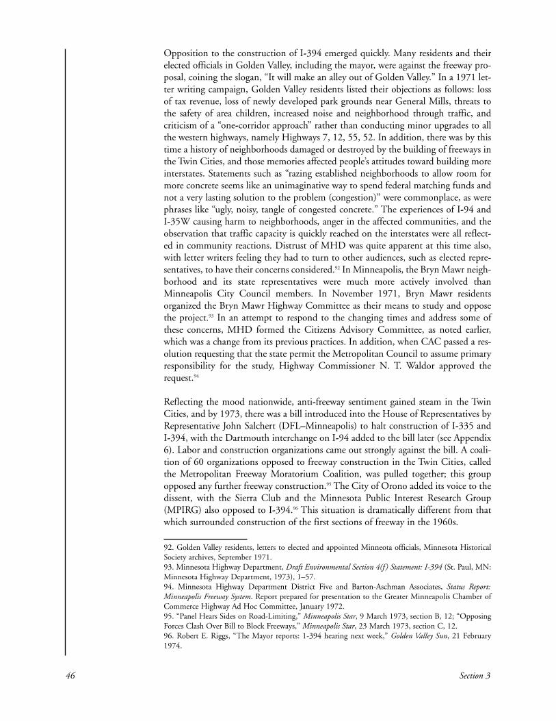
Opposition to the construction of I-394 emerged quickly. Many residents and theirelected officials in Golden Valley, including the mayor, were against the freeway pro-posal, coining the slogan, “It will make an alley out of Golden Valley.” In a 1971 let-ter writing campaign, Golden Valley residents listed their objections as follows: lossof tax revenue, loss of newly developed park grounds near General Mills, threats tothe safety of area children, increased noise and neighborhood through traffic, andcriticism of a “one-corridor approach” rather than conducting minor upgrades to allthe western highways, namely Highways 7, 12, 55, 52. In addition, there was by thistime a history of neighborhoods damaged or destroyed by the building of freeways inthe Twin Cities, and those memories affected people’s attitudes toward building moreinterstates. Statements such as “razing established neighborhoods to allow room formore concrete seems like an unimaginative way to spend federal matching funds andnot a very lasting solution to the problem (congestion)” were commonplace, as werephrases like “ugly, noisy, tangle of congested concrete.” The experiences of I-94 andI-35W causing harm to neighborhoods, anger in the affected communities, and theobservation that traffic capacity is quickly reached on the interstates were all reflect-ed in community reactions. Distrust of MHD was quite apparent at this time also,with letter writers feeling they had to turn to other audiences, such as elected repre-sentatives, to have their concerns considered.92 In Minneapolis, the Bryn Mawr neigh-borhood and its state representatives were much more actively involved thanMinneapolis City Council members. In November 1971, Bryn Mawr residentsorganized the Bryn Mawr Highway Committee as their means to study and opposethe project.93 In an attempt to respond to the changing times and address some ofthese concerns, MHD formed the Citizens Advisory Committee, as noted earlier,which was a change from its previous practices. In addition, when CAC passed a res-olution requesting that the state permit the Metropolitan Council to assume primaryresponsibility for the study, Highway Commissioner N. T. Waldor approved therequest.94
Reflecting the mood nationwide, anti-freeway sentiment gained steam in the TwinCities, and by 1973, there was a bill introduced into the House of Representatives byRepresentative John Salchert (DFL–Minneapolis) to halt construction of I-335 andI-394, with the Dartmouth interchange on I-94 added to the bill later (see Appendix6). Labor and construction organizations came out strongly against the bill. A coali-tion of 60 organizations opposed to freeway construction in the Twin Cities, calledthe Metropolitan Freeway Moratorium Coalition, was pulled together; this groupopposed any further freeway construction.95 The City of Orono added its voice to thedissent, with the Sierra Club and the Minnesota Public Interest Research Group(MPIRG) also opposed to I-394.96 This situation is dramatically different from thatwhich surrounded construction of the first sections of freeway in the 1960s.
46 Section 3
92. Golden Valley residents, letters to elected and appointed Minneota officials, Minnesota HistoricalSociety archives, September 1971. 93. Minnesota Highway Department, Draft Environmental Section 4(f ) Statement: I-394 (St. Paul, MN:Minnesota Highway Department, 1973), 1–57. 94. Minnesota Highway Department District Five and Barton-Aschman Associates, Status Report:Minneapolis Freeway System. Report prepared for presentation to the Greater Minneapolis Chamber ofCommerce Highway Ad Hoc Committee, January 1972.95. “Panel Hears Sides on Road-Limiting,” Minneapolis Star, 9 March 1973, section B, 12; “OpposingForces Clash Over Bill to Block Freeways,” Minneapolis Star, 23 March 1973, section C, 12.96. Robert E. Riggs, “The Mayor reports: 1-394 hearing next week,” Golden Valley Sun, 21 February1974.

The draft EIS was completed in December 1973. Originally, eight alternate routeswere considered, but four were eliminated during the first stage of the draft EISprocess because they were not considered the best solutions to traffic problems andwould have involved taking too many homes or encroached too seriously on parks.Two of these, alternates 6 and 7, began along U.S. Highway 12 but turned to runsouthwesterly between Cedar Lake and Lake of the Isles, then continue alongHighway 7. The four remaining alternates were as follows:
1. Alternate 1 followed U.S. Highway 12 to Penn Avenue, where there wouldbe an interchange and the lanes would split, with westbound lanes continu-ing on the Highway 12 alignment and eastbound lanes running south to par-allel railroad tracks just north of Cedar Lake until rejoining the Highway 12alignment at Winnetka Avenue.
2. Alternate 2 generally coincided with the existing Highway 12 alignment. 3. Alternate 3 was called the Highway 12 bypass because it would leave
Highway 12 as a roadway for local traffic, whereas I-394 would provide lim-ited access for drivers on regional or long-distance trips. This alternate wouldrun southwesterly along existing railroad tracks, along the northern edge ofCedar Lake, cross Highway 100 south of Highway 12, then swing back upto join the Highway 12 alignment at Colorado Avenue.
4. Alternate 4 was the no-build option.97
Following the new EIS guidelines, about 35 local, state, and federal agencies wereasked to comment on the report as it was developed. The draft EIS argued in favor ofthe project but cautioned that the project could meet projected traffic demands onlyif there was significant transit ridership.98
A public location hearing was held at the Wayzata High School on February 27,1974, at which MHD proposed three alternate routes plus the no-build option. Thehearing lasted four hours and was attended by nearly 800 people, including citizensfrom rural communities west of the Twin Cities who supported the project, as well asresidents from communities directly adjacent who were generally opposed.99 At thehearing, the Citizens Advisory Committee recommended that no decision be madeon the corridor until there was a plan for transit in the corridor. At this time, the BrynMawr Neighborhood Association also took the position that more information and aclear statement of tradeoffs between different proposals were needed before a decisioncould be made. After the hearing, the Minneapolis Tribune published an editorialopposing construction of I-394 and asking whether freeways were an appropriate wayto solve transportation problems, citing the energy shortage, the decline in popula-tion growth, and the need to prevent sprawl.100 In early 1974, the city of St. LouisPark announced its support for I-394.101 In addition, St. Louis Park supported con-current development of a major mass transit component along a southwest diagonalin the vicinity of Highway 7. The City of Golden Valley would not approve any of
History of the Twin Cities Area Interstate: Expanding the Debate (1970 to the mid-1990s) 47
97. Minnesota Highway Department, Draft Environmental Section 4(f ) Statement: I-394.98. Pat Marx, “EPA Gets Favorable Hwy. I-394 Statement,” Minneapolis Star, 10 January 1974.99. “I-394 Hearing,” Golden Valley Sun, 7 February 1974; Robert E. Riggs., “The Mayor Reports: I-394Hearing Next Week,” Golden Valley Sun, 21 February 1974; Dan Wascoe, Jr., “700 Attend I-394Hearing,” Minneapolis Tribune, 28 February 1974.100. “Another Metropolitan Freeway?” [editorial], Minneapolis Tribune, 7 March 1974, section A, 10;“Questions About Freeway” [letter to the editor], Minneapolis Tribune, 24 March 1974.101. “I-394 Route Along Hwy. 12 Endorsed by St. Louis Park,” Golden Valley Sun, 10 January 1974.

the designs in the draft EIS, stating that it did not believe the need for I-394 had beendemonstrated yet, and further, that it would wait for an overall transportation plan forthe western part of the metro area.102 After the public hearing, Commissioner Lappegaardselected Alternate 2, the U.S. Highway 12 alignment, as the preferred plan.103
In March 1974, the U.S. Environmental Protection Agency (EPA) recommendedthat plans to build I-394 be dropped for a mass transit system and upgrade of areahighways. Francis T. Mayo, EPA regional administrator, stated that the draft EIS wasnot comprehensive enough to be used as the basis for a complete environmentalassessment, and he specifically called for further investigation of mass transit options.The EPA report, which was advisory only, cited increased noise and air pollution andhighway runoff in nearby lakes as concerns and suggested the EIS consider a transit-only alternative. This was in addition to the Minnesota Pollution Control Agencyexpressing doubts about the project and opposition from U.S. Representative WilliamFrenzel (R–Minnesota), whose district included most of the affected area. Frenzelsupported the EPA recommendations. Commissioner Lappegaard took these con-cerns under consideration.104
Meanwhile, the Metropolitan Council’s Physical Development Committee approvedthe alternate selected by Commissioner Lappegaard and sent the decision to the fullcouncil, which already had approved the plan twice. At this time, the attorney repre-senting the City of Golden Valley pointed out a possible conflict of interest withregard to Larry Dallam, the Metropolitan Council’s director of transportation, whohad been the project manager for the HNTB corridor study. The attorney, CharlesDayton, asked that Dallam resign or that the proposal review be conducted by inde-pendent parties. Dallam acknowledged it was a difficult situation, but noted that theproposal review was only partially based on the HNTB report.105 However, theMinneapolis Tribune followed up on this situation with an editorial calling for anindependent review and criticizing the Physical Development Committee for not giv-ing fair consideration to viewpoints different from those of the MetropolitanCouncil’s staff.106 What in earlier times would have gone unnoticed became a publicissue because of skepticism about the transparency of procedures used for decisionmaking, no doubt a symptom of growing distrust for government institutions in gen-eral. The Metropolitan Council vote on April 11 was deadlocked in a 7-to-7 tie, withChairman John Boland rejecting the committee report because it did not considersuggestions made by the Citizens Advisory Committee. In addition, the MetropolitanCouncil discussed a letter received from Representative Frenzel promoting the use ofthe funds for transit, which was permissible under the Federal-Aid Highway Act of1973.107 Upon reconsideration, the Physical Development Committee recommendedthat the freeway be limited to six lanes with an additional lane for buses and carpools.In May, the full council approved the committee recommendations. These includedrecommendations that noise from the freeway “not exceed the average sound of bird
48 Section 3
102. MnDOT, Final EIS, 399, 407–433.103. MnDOT, Final EIS, 58.104. Randy Furst, “U.S. Agency Prefers Mass Transit to I-394 Plan,” Minneapolis Star, 27 March 1974,section A, 11; Dan Wascoe, Jr., “I-394 May Increase Pollution, EPA Says,” Minneapolis Tribune, 27March 1974.105. Dan Wascoe, Jr., “Metro Council Panel Approves Building I-394,” Minneapolis Tribune, 28 March1974, section C, 5.106. “Unanswered Freeway Questions” [editorial], Minneapolis Tribune, 1 April 1974.107. Pat Marx, “Metropolitan Council Deadlocked Over I-394,” Minneapolis Star, 12 April 1974.

calls” in the Eloise Butler Wildflower Garden and Bird Sanctuary, that designers makethe freeway visually appealing to both travelers and the adjacent communities, andthat measures be taken to preserve surrounding residential neighborhoods andaccommodate pedestrians and bicyclists. There was disagreement at the MetropolitanCouncil regarding whether or how strongly to make recommendations to MHD, asfreeway design had been exclusively MHD’s purview.108
While this process was going on in the Metropolitan Council, CommissionerLappegaard stated that MHD intended to build all remaining segments of the inter-state including I-394. He added the notable caveat that he could reverse his decisionbecause of the strong differences of opinion that remained. He pointed out that it waswidely acknowledged that Highway 12 needed improvement, and that if it wasupgraded to an interstate, federal highway funds would pay for 90% of the improve-ments.109 Although probably practical in intent, Lappegaard’s statement provokedsome outcry. Robert Riggs, the mayor of Golden Valley, several legislators, and oneMetropolitan Council member held a press conference stating they had hopedLappegaard would bring responsiveness to MHD, but they were disappointed that hedecided to ignore the needs of citizens and communities. It is worth looking at a por-tion of their statement in detail as it beckons to past experiences as justification fortheir position:
[The Highway Department is] unresponsive and insensitive to theneeds of many thousands of people who have been forced to movetheir homes and businesses as a result of freeways, and to the thou-sands of people who have had to live next to or in the vicinity of free-ways with their concomitant noise, dirt, and noxious odors.110
There is more than anger about I-394 at work here. Distrust of government, anti-free-way sentiment, and a we-won’t-take-it-anymore attitude grew out of the layers ofexperience related to building urban freeways and the different interpretations of thatexperience. In addition, Lappegaard’s statement reinforced the belief of some oppo-nents that MHD decisions were based on federal funding rather than careful consid-eration of area transportation needs. This suspicion of Lappegaard was more than abit ironic, as he was notably responsive to the new era and did his part to bring thedepartment in step with rapidly changing circumstances.
In June 1974, Commissioner Lappegaard met with representatives from a task forceof several citizens’ groups involved in the I-394 dispute. The citizens expressed doubtsabout the accuracy of some of the analyses in the EIS, but more importantly, theyexpressed bafflement and exasperation with the opacity of the decision-makingprocess regarding I-394. Lappegaard agreed to provide them with a flow chart of thedepartment’s process and said he would reply as soon as possible. About this sametime, the citizens’ groups also began mobilizing to gather resources to file a lawsuit
History of the Twin Cities Area Interstate: Expanding the Debate (1970 to the mid-1990s) 49
108. Robert Franklin, “Metro Council Panel Urges Six-Lane Limit on Freeway,” Minneapolis Tribune, 9 May1974; Dan Wascoe, Jr., “Metro Council Sets Standards for I-394,” Minneapolis Tribune, 24 May 1974.109. Pat Marx, “State Tells Intent to Build I-394,” Minneapolis Star, 30 April 1974; “All Interstate PlansEndorsed,” St. Paul Pioneer Press, 1 May 1974.110. “Officials Protest I-394 Decision,” Golden Valley Sun, 9 May 1974.

against MHD, believing it was their only remaining means of affecting the decision-making process.111
The political process also was in full swing, and in the 1975 legislative session, the“moratorium bill” was passed, stopping all studies and construction on I-394 (seeAppendix 6). Review of I-394 by the Interstate Study Committee resulted in recom-mendations to restrict this highway to six lanes; change the transit median to areversible traffic lane with preference given to carpools, buses, and commuter vans;and work with the neighboring communities to minimize impact.112 In 1976, the leg-islature lifted the moratorium on I-394 and approved construction of a six-lane free-way along the U.S. Highway 12 corridor to stay within the existing right-of-way asmuch as possible.113
In 1978, a new approach was taken to moving the project forward and achieving anacceptable design. Mayors from Minneapolis and the western suburbs adjacent to thecorridor had been involved in preliminary planning to facilitate communicationbetween MnDOT and neighborhood and business groups. The mayors created a taskforce for each of four segments between I-94 and I-494, made up of citizens and rep-resentatives from business, Hennepin County, and the Minneapolis Park andRecreation Board, who would be included in preliminary design discussion. MnDOTCommissioner Jim Harrington described this new organization as relieving hisdepartment of considerable pressure. In addition, more than a dozen public meetingswere held in the communities affected by the freeway. In 1979, a preliminary designwas circulated for discussion, followed by revised layout plans in 1980.114
Although this new structure may have helped move the process along and undoubted-ly improved communication between MnDOT and residents, it did not relieve dis-agreements between the cities. Minneapolis was concerned about the lack of accessbetween Penn Avenue and Highway 100 on the preliminary plan, but the City of St.Louis Park vehemently objected to the proposal to add access at France Avenue (knownas the France Flyover). In addition, St. Louis Park opposed the transit/high-occupan-cy-vehicle (HOV) lane, because in 1974, the city had approved the development oftransit improvements along a southwest railroad corridor. Consequently, althoughexpressing support for I-394 in general, St. Louis Park did not approve the designbeing circulated at this time. Golden Valley hired Barton-Aschman Associates to con-duct a study to determine, among other things, the effects of the proposed layout onlocal streets and neighborhoods. They opposed the transit/HOV lanes because theypreferred light rail as a transit solution. To continue to move the process forward, inDecember 1980, Commissioner Braun asked the Metropolitan Council to resolve thedisputes under its authority provided by Minnesota Statute §161.17, subdivision 2.115
50 Section 3
111. Paul Light, “Citizen groups continue challenge to I-394 plans,” Minneapolis Tribune, 25 June 1974, sec-tion B, 5; Duchess McBee, “Natz: consider lawsuit if I-394 enters village,” Golden Valley Sun, 13 June 1974. 112. Dan Wascoe, Jr., “Completing freeways supported,” Minneapolis Tribune, 7 November 1975, section A, 1. 113. MnDOT, Final EIS, 52, 58.114. Eric Pianin. “Mayors assume role in planning of I-394.” Minneapolis Tribune, 6 December 1978,section B, 1; MnDOT, Final EIS.115. St. Louis Park City Council, Resolution 6586, 1979; St. Louis Park., A Report on Highway andTransit Improvements and MnDOT’s Preliminary Layout, 3 June 1980); Barton-Aschman Associates, I-394 Impact Study of Golden Valley, October 1980; “I-394 dispute shifted to Metro Council,” MinneapolisTribune, 11 December 1980; Connie Kozlak and Larry Dallam, Memorandum to the MetropolitanCouncil Transportation Subcommittee, 26 February 1981.

In response to statements regarding ongoing municipal conflict, the cities of GoldenValley and St. Louis Park developed a joint position statement. They emphasized theirdesire for I-394 to be evaluated as part of an overall transportation plan for the west-ern suburbs, they opposed the France Avenue interchange as well as HOV lanes, andthey supported light-rail transit (LRT) along Highways 55 and 7 in view of the LRTstudy being conducted at the time. They proposed that interstate substitution fundsbe used to fund LRT when such funds became available through elimination of theHOV lane. Meanwhile, Minneapolis held firm to its position that there must beaccess between Penn Avenue and Highway 100. The City of Orono continued tooppose the project.116
Other voices joined the fray. Leaders of the Downtown Council of Minneapolis andthe Greater Minneapolis Chamber of Commerce instigated regular meetings withCommissioner Braun and Charles Weaver, Metropolitan Council chair, to do what-ever they could to facilitate the project. Their position was that although the projectwas vital to the health of downtown business, it ought to be designed in a way thathad minimal impact on the surrounding communities and was responsive to theirconcerns. General Mills voiced its support for I-394, but objected to the HOV lanes.The Bryn Mawr Neighborhood Association opposed the interstate because no accesswas planned between Penn Avenue and Highway 100.117
In May 1981, the Metropolitan Council held three public hearings, one each in BrynMawr, Plymouth, and St. Louis Park. Among items objected to in both Bryn Mawrand St. Louis Park was a Cedar Lake Road extension proposed to provide continuityfor local travel. Metropolitan Council staff reported that “the valid concerns so elo-quently expressed” were reason to drop the extension, especially because it was notintegral to I-394. Thus, they recommended dropping the Cedar Lake Road project.The issue of access between Penn Avenue and Highway 100 at either France Avenueor Wirth Parkway remained because of concerns about neighborhood access and cut-through traffic. The Bryn Mawr Neighborhood Association was opposed to the PennAvenue interchange. Metropolitan Council staff continued to recommend no access,and this recommendation was included in the final EIS in 1982.118 The design in thefinal EIS included six lanes from downtown Minneapolis to I-494, with two insidelanes designated as reversible diamond lanes for high occupancy vehicles and withphysical separation from Highway 100 to downtown Minneapolis. The HOV laneshad dedicated ramps in three locations. Park-and-ride sites were planned to increasethe use of carpools and buses. The project would require taking 63 homes and 37commercial buildings.119
An innovative aspect of the I-394 project became reality in 1982. The idea for a ThirdAvenue distributor to route traffic from the west into downtown Minneapolis
History of the Twin Cities Area Interstate: Expanding the Debate (1970 to the mid-1990s) 51
116. The City of St. Louis Park and the City of Golden Valley, Joint Statement Regarding DesignFeatures for Upgrading Highway 12, 13 February 1981; Parker Trostel, Letter to Charles Weaver, 27February 1981; Brad Van Nest, Mayor of Orono, Letter to Senator George Pillsbury, 17 March 1981. 117. Howard Barnhill and John McHugh, Letter to Charles Weaver, 5 March 1981; DowntownCouncil/Chamber of Commerce, Position Regarding the Metropolitan Council Staff Report on I-394,1981; John T. Schevenius, General Mills P.E., Letter to Ghaleb Abdul-Rahmen, 6 March 1981; BrynMawr Neighborhood Association, Resolution, 17 March 1981.118. Connie Kozlak and Larry Dallam, Memorandum to the Metropolitan Council TransportationCommittee, 15 June 1981.119. MnDOT, Final EIS, 14–17.

appeared in the 1957 Barton and Associates report, Freeways in Minneapolis, followedby a preliminary plan by the city presented to MHD in 1961. In 1970, after I-394’sinclusion in the interstate system, Minneapolis approved the preferred route from justwest of 13th Street to Washington Avenue, and the Metropolitan Council included itin its short-range highway improvement program. The final EIS for this portion ofthe I-394 project was approved in 1973.120 Closely related to this, a proposal to buildthree parking ramps downtown directly connected to the HOV lanes with a bus sta-tion and access to the skyway system located right in the ramps was seen as key toachieving the ridership goals for the HOV lanes. Because it was an integral part of theinterstate project, interstate funding was sought to fund the project. After beingrejected by federal highway officials, Senator Dave Durenburger (R–Minnesota)shepherded the proposal through Congress and got the project authorized in theinterstate bill for that year, acquiring $100 million in federal funding for the rampsand skyways. Construction began in 1986.121 This became a national model for mul-timodal design, which emphasized the movement of people rather than vehicles.
In 1986, residents of Bryn Mawr, organized as the South Bryn Mawr HighwayCommittee representing about 225 families, filed suit against MnDOT and theMPCA. Expressing frustration that “the transportation department seems to answerto no one” and seeing themselves as having no place else to turn, they resorted to alawsuit. At issue was the design of noise walls and the frontage road along the southside of I-394. The noise walls were being built to federal standards, but the neighbor-hood wanted them built to the stricter state standards. In addition, the residentsalleged that the design for the frontage road was changed without informing theneighborhood, in violation of state law. Early design plans showed the frontage roadending at the Prudential Insurance Company Building parking lot, but at the requestof Golden Valley, the department made the frontage road continuous to Highway100. The residents were concerned that this change would increase traffic, noise, andair pollution in their neighborhood. The lawsuit sought to block construction of thefrontage road and upgrade the noise walls to state standards. Commissioner Braunsaid that although he had no preference regarding the frontage road, Golden Valleywas firm in its desire to have the continuous road. In 1988, Representative GloriaSegal (DFL–St. Louis Park) got a bill through the state legislature that made the law-suit moot.122
In October 1991, the eastbound lanes of I-394 opened, with the unpleasant result ofthe morning rush-hour traffic backing up from downtown Minneapolis to LouisianaAvenue. Al Pint, corridor project manager, explained that although there would besome adjustments as drivers adapted to the new roadway, the one-lane junction withI-94 as traffic moves through the Lowry Hill Tunnel meant that congestion would bea permanent feature of the freeway. His advice was to carpool or take the bus to takeadvantage of the innovative HOV lanes; I-394 was the first freeway in Minnesotabuilt with exclusive bus and carpool lanes and seven park-and-ride lots. The optimism
52 Section 3
120. George W. Barton and Associates, Freeways in Minneapolis: An Appraisal Prepared for the City ofMinneapolis (Evanston, IL: Barton and Associates, January 1957); Minnesota Highway Department,Final Environmental Impact Statement for I-394 (St. Paul: Minnesota Highway Department, 1973). 121. “Plans for I-394 Don’t Stop at the Downtown Exits,” Minneapolis Star and Tribune, 11 December1986, section Y, 1.122. Laurie Blake, “I-394 foes may sue, citing flaws in frontage road, walls,” Minneapolis Star andTribune, 28 March 1986, section B, 4.; Dean Rebuffonie, Minneapolis Star and Tribune, 10 May 1986,section B, 1, 2.; Anonymous interviewee, personal interview with author, July 2004.

that this option would be a success, however, was muted by limited funding for theMetropolitan Transit Commission, which did not have enough money to provide thenumber of buses required to meet ridership goals. Because transit is funded separate-ly, the freeway project was able to move forward without secure funding for the nec-essary buses. As Pint pointed out, however, the transit investment was 1% of the totalcost of I-394, and if the daily carpool and bus riders were each to drive their ownvehicles, the cost to provide capacity for all of those individual drivers would be muchgreater than 1%.123
When the last segment of I-394 opened, there was well-deserved pride in the integra-tion of the elements designed to encourage carpooling and bus ridership, and indeed,12,000 people were using the HOV lanes daily during morning and afternoon rushhour. Nearly half the people on I-394 used carpools and buses during peak traveltimes. Perception of the HOV lanes as a success was a different matter, as their rela-tively empty appearance allowed people to conclude that they were wasted space, aphenomenon known as the empty lane syndrome. Public perceptions of a high rateof cheating, both in the lanes and in the reduced-rate parking for carpoolers, wasanother problem. The biggest problem that accompanied the opening of I-394, how-ever, was the immediate congestion. During construction, Pint maintained that thefreeway, although a tremendous improvement over Highway 12, would still becrowded because, “We are no longer designing facilities to accommodate the single-occupant vehicle at a good level of service in the peak hours. We can’t afford to—financially, environmentally, or politically.” Public expectations did not necessarilytake this broad perspective into account, however. Commuters, who were unlikely tobe aware of the complicated history and vast multi-lane freeway that would berequired to completely avoid congestion, tended to expect free-flowing traffic uponthe opening of the freeway and many labeled I-394 a waste of $420 million becauseof the congestion immediately present when the highway opened.124 Clearly, theopening of I-394 did not mean that the work was over.
In the face of public complaints, Pint continued to make statements encouraging theuse of carpools and buses and MnDOT conducted a telephone survey of residents inthe western suburbs to learn how to continue increasing bus ridership. Just a fewmonths after the official opening of I-394, the HOV lane was carrying 4,000 peoplea day during morning rush hour despite public perceptions that this lane was notworking. In addition, there was a public outcry about a change from three lanes totwo between Penn Avenue and Highway 100. This was a result of the six-lane restric-tion passed by the legislature as part of the moratorium bill, which applied starting atPenn Avenue, where the six lanes included two lanes in each direction plus tworeversible HOV lanes. Attempts to change the six-lane restriction were met withopposition in the legislature, with representatives from the western suburbs advocat-ing the lane addition and Minneapolis representatives opposing it. Opponents alsomaintained that it was unclear whether adding another lane would ease traffic or sim-ply attract more cars and thus result in congestion once again. Residents of Bryn
History of the Twin Cities Area Interstate: Expanding the Debate (1970 to the mid-1990s) 53
123. Laurie Blake, “New I-394 lanes open, but it’s no quick trip,” Star Tribune, 2 October 1991, sectionB, 1; Laurie Blake, “Funding in doubt for MTC to meet I-394 rider goals,” Star Tribune, 3 August 1992,section B, 1. 124. Anonymous interviewee, personal interview with author, March 2004; Laurie Blake, “A New Kindof Freeway Opens Officially,” Star Tribune, 19 October 1992, section A, 1; Laurie Blake, “A Not-So-Grand Opening: Premature I-394 hoopla leaves a long line of frustration,” Star Tribune, 23 November1992, section B, 1.

Mawr were concerned about the additional noise created by adding a lane becausenoise levels already exceeded state standards and approached federal limits.Representative Dee Long (DFL–Minneapolis), who represented Bryn Mawr, main-tained the importance of honoring commitments that were made to surroundingcommunities during the protracted design process. Bryn Mawr eventually agreed tothe additional lanes if the surface was asphalt rather than concrete to reduce noise,and if additional noise walls were built. The lanes opened in 1997.125
In 1993, ridership in the HOV lane met MnDOT goals for the year 2000, with traf-fic counts showing that during morning rush hour, half the people on I-394 were incarpools or on buses. On Highway 12, there were 350 carpools, and on I-394, therewere 1,400. Specifically on I-394, there were 1.4 people per vehicle compared with1.15 people per vehicle in the rest of the Twin Cities highway system. Despite thisclear success, public perception continued to be negative. Commuters in single-occu-pant vehicles were faced with traffic jams; they continued to call the HOV lane wast-ed space and the $420 million spent on the project wasteful government spending. Itproved to be extremely difficult to communicate that I-394 was not built to meet therush-hour demand of people in single-occupant vehicles. When the views of thosewho actually used the HOV lanes were added to the mix, it was a much more posi-tive picture, as carpoolers reported significantly reduced commute times. The park-and-ride lots also were popular with those who wanted to take advantage of the HOVlane.126
Interstate 94 from Interstate 494/Interstate 694 to Trunk Highway 95
Timeline
1958 Three alignments proposed1960 FHWA approves U.S. Highway 12 alignment1965 FHWA approves revised alignment, north of U.S. Highway 121973 (June) Bids received for construction1973 (July) Commissioner Lappegaard halts construction to conduct an EIS;
I-94 Management Committee formed by Highway Commissioner Lappegaard
1974 Citizen groups, Residents Against Pavement Pollution and I-94 Truth Association, formed
1975 (May) I-94 Management Committee selects northern alignment1976 Metropolitan Council selects U.S. Highway 12 alignment as
consistent with the Metropolitan Development Guide1976 (June) MnDOT Commissioner Marzitelli follows Metropolitan Council
recommendations and selects U.S. Highway12 alignment
54 Section 3
125. Laurie Blake, “The pain at Penn; Bottleneck blues still affect drivers on new I-394,” Star Tribune,22 December 1992, section B, 1; Laurie Blake, “Penn interchange clogs the works; But residents, com-muters collide over I-394 solution,” Star Tribune, 14 May 1993, section B, 2; Star Tribune, 17 July 1997,section B, 2. 126. Laurie Blake, “Experts say I-394 meeting its goals; But some angry drivers disagree,” Star Tribune,18 October 1993, section B, 1; Laurie Blake, “Park-and-ride lots are a transit success story; Conveniencelures many who might not use bus otherwise,” Star Tribune, 12 November 1995, section B, 1.
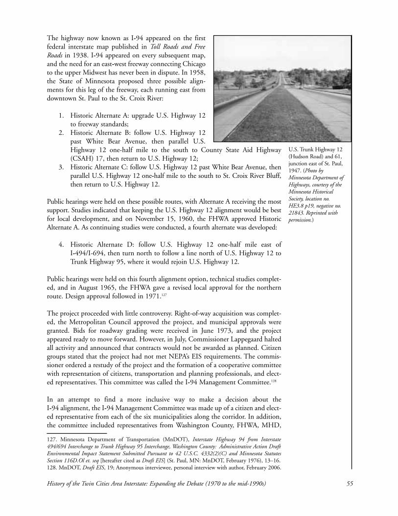
The highway now known as I-94 appeared on the firstfederal interstate map published in Toll Roads and FreeRoads in 1938. I-94 appeared on every subsequent map,and the need for an east-west freeway connecting Chicagoto the upper Midwest has never been in dispute. In 1958,the State of Minnesota proposed three possible align-ments for this leg of the freeway, each running east fromdowntown St. Paul to the St. Croix River:
1. Historic Alternate A: upgrade U.S. Highway 12to freeway standards;
2. Historic Alternate B: follow U.S. Highway 12past White Bear Avenue, then parallel U.S.Highway 12 one-half mile to the south to County State Aid Highway(CSAH) 17, then return to U.S. Highway 12;
3. Historic Alternate C: follow U.S. Highway 12 past White Bear Avenue, thenparallel U.S. Highway 12 one-half mile to the south to St. Croix River Bluff,then return to U.S. Highway 12.
Public hearings were held on these possible routes, with Alternate A receiving the mostsupport. Studies indicated that keeping the U.S. Highway 12 alignment would be bestfor local development, and on November 15, 1960, the FHWA approved HistoricAlternate A. As continuing studies were conducted, a fourth alternate was developed:
4. Historic Alternate D: follow U.S. Highway 12 one-half mile east of I-494/I-694, then turn north to follow a line north of U.S. Highway 12 toTrunk Highway 95, where it would rejoin U.S. Highway 12.
Public hearings were held on this fourth alignment option, technical studies complet-ed, and in August 1965, the FHWA gave a revised local approval for the northernroute. Design approval followed in 1971.127
The project proceeded with little controversy. Right-of-way acquisition was complet-ed, the Metropolitan Council approved the project, and municipal approvals weregranted. Bids for roadway grading were received in June 1973, and the projectappeared ready to move forward. However, in July, Commissioner Lappegaard haltedall activity and announced that contracts would not be awarded as planned. Citizengroups stated that the project had not met NEPA’s EIS requirements. The commis-sioner ordered a restudy of the project and the formation of a cooperative committeewith representation of citizens, transportation and planning professionals, and elect-ed representatives. This committee was called the I-94 Management Committee.128
In an attempt to find a more inclusive way to make a decision about the I-94 alignment, the I-94 Management Committee was made up of a citizen and elect-ed representative from each of the six municipalities along the corridor. In addition,the committee included representatives from Washington County, FHWA, MHD,
History of the Twin Cities Area Interstate: Expanding the Debate (1970 to the mid-1990s) 55
U.S. Trunk Highway 12(Hudson Road) and 61,junction east of St. Paul,1947. (Photo byMinnesota Department ofHighways, courtesy of theMinnesota HistoricalSociety, location no.HE3.8 p19, negative no.21843. Reprinted withpermission.)
127. Minnesota Department of Transportation (MnDOT), Interstate Highway 94 from Interstate494/694 Interchange to Trunk Highway 95 Interchange, Washington County: Administrative Action DraftEnvironmental Impact Statement Submitted Pursuant to 42 U.S.C. 4332(2)(C) and Minnesota StatutesSection 116D.Ol et. seq [hereafter cited as Draft EIS] (St. Paul, MN: MnDOT, February 1976), 13–16. 128. MnDOT, Draft EIS, 19; Anonymous interviewee, personal interview with author, February 2006.

the Metropolitan Council, and the Metropolitan Transit Commission. The group hadan open meeting policy and was given responsibility for determining the approach ofthe study, defining alternatives, reviewing technical data, and making recommenda-tions to the commissioner. A second group, called the Interdisciplinary Study Group,was formed to provide information and conduct studies of the areas in dispute. Thisgroup was made up of specialists from nine areas within MHD.129
Although the affected area was largely undeveloped, there were several major devel-opment projects in planning stages. Minnesota Mining and Manufacturing (3M)already had an office complex adjacent to U.S. Highway 12 that employed 8,500 peo-ple and that brought much traffic into the area. In addition, 3M had plans for anoffice expansion at I-694 and Trunk Highway 212 with expected employment of9,500 people by 1989. There were plans to build a regional shopping center calledEastown on Afton Road in Woodbury. The center would be anchored by two largedepartment stores and house about 100 other smaller stores. Eastown was expectedto generate 22,250 vehicle trips by 1990. Dayton-Hudson announced plans to builda “major diversified center” in Lake Elmo along Minnehaha Avenue. Construction onthis center was expected to start in 1976, with complimentary office space and a largehotel to follow. The Minnesota Highway Department estimated this developmentwould generate an average of 180,000 trips per day. Residential development wasplanned around Colby Lake in Woodbury with supporting developments nearby.This could generate another 75,000 trips per day. Washington Central Plaza, nearU.S. Highway 12 and CSAH 15, was in very early planning stages but also could bepresumed to generate more traffic. The U.S. Highway 12 alignment would benefitthe Colby Lake development, whereas the northern alignment would benefit theDayton-Hudson development.130
Public sentiment was in favor of completing this segment of I-94. The do-nothingalternate did not have a following, because it was clear this section of freeway was anecessary piece of the national interstate system. There was, however, intense dis-agreement regarding the two alignments. The southern route had dropped out of con-sideration, and the two proposed alternates consisted of the northern route (Alternate1), which ran a half mile north of U.S. Highway 12, and the reconstruction of U.S.Highway 12 to interstate standards (Alternate 2). A survey commissioned by MHDfound that views on the location depended on the respondent’s proximity to each ofthe proposed corridors. Predictably, those who lived close to one alignment wanted itbuilt in the other. Citizen groups formed to represent each of these positions. TheResidents Against Pavement Pollution (RAPP) I-94 formed to advocate for the U.S.Highway 12 upgrade and was the group that requested the EIS from CommissionerLappegaard. The I-94 Truth Association represented residents living near U.S.Highway 12 and advocated for the northern route.131
The state legislature became involved in the dispute during the 1974 legislative ses-sion. The House and Senate Transportation committees both heard testimony fromthe rival groups. Representative Walter Hanson (DFL–St. Paul) introduced a billdirecting MHD to build I-94 in the U.S. Highway 12 corridor. His position was that
56 Section 3
129. MnDOT, Draft EIS, 19, 219.130. MnDOT, Draft EIS, 50–55.131. Larry Adcock, “82% Favor Proposed I-94 Link,” St. Paul Dispatch, 4 January 1974; MnDOT,Draft EIS, 63, 219.

the northern alignment was undesirable, because it reduced open space. Jess Mottaz,a representative of RAPP I-94, also made arguments about preserving the environ-ment and argued that the rural character of the community should be preserved. LyleThorsten, from the I-94 Truth Association, maintained that the U.S. Highway 12alignment would take too many homes and businesses and cost too much, and that asecond major highway was needed to forestall future congestion. Stanley Olander ofthe I-94 Management Committee argued that the legislature should not take actionuntil the committee carried out its responsibilities to evaluate the alternatives. No fur-ther action was taken during the legislative session.132 Minnesota HighwayDepartment representatives expressed reservations about the hearing, stating that thelegislature had never taken responsibility for selecting a freeway corridor.133
The I-94 Management Committee held public hearings in the communities along theproposed corridors. Because the EIS process was relatively new, representatives fromMHD spent a good deal of their time explaining the EIS process to concerned citi-zens. The new, more comprehensive approach—which included social, economic,and more detailed environmental issues in addition to the traditional engineering fac-tors—was welcome to many but frustrating to those who wanted action taken asquickly as possible, especially supporters of the previously approved northern align-ment.134
In March 1975, the I-94 Management Committee was surprised when the newsmedia reported that staff at MHD had been conducting technical studies on a third,“north-south” route. It followed the alignment of the northern route from I-494/694to County Road 15, then turned south to join the U.S. Highway 12 alignment.When they learned of the technical report, committee members voted unanimouslyto form a subcommittee to study it. The news reports came as a “complete surprise,”according to Olander, the committee chair. An MHD spokesperson said that inform-ing the committee of the decision [to conduct the technical studies] would haveexceeded MHD’s role as technical advisors.135
Questions regarding cost estimates also came up in 1975. This was significant to thedispute; a major argument in favor of the northern route was that it would save mil-lions of dollars because the area was undeveloped, the right-of-way already had beenpurchased, and this route would be faster to build. Northern route opponents haddoubts about the estimates because of what appeared to them to be inconsistenciesbetween reports. One MHD report gave costs for demolishing homes and business-es, whereas another gave costs of sound barriers for some of the same homes and busi-nesses, raising the question of why both would be necessary. In addition, 390 feet ofright-of-way already had been acquired for the northern route, but for the U.S.Highway 12 alignment, it was stated 500 feet were needed. This raised further ques-tions. Finally, if the northern route was built, an interchange would be required whereit would cross U.S. Highway 12, and the Metropolitan Council’s estimates were thatit would cost $6 million to $9 million. Obviously, this interchange would not be
History of the Twin Cities Area Interstate: Expanding the Debate (1970 to the mid-1990s) 57
132. “Citizen Groups Give Freeway Stances,” St. Paul Pioneer Press, 10 May 1974; “Lawmakers HearTestimony on Location of I-94 in Washington County,” Inside the Interim, June 1974.133. “I-94 Proposal to Be Discussed At House Committee Hearing,” St. Paul Dispatch, 8 May 1974.134. Mollie Hedges, “I-94 Management Committee Discusses Resident Concerns,” Ramsey CountyReview, 20 November 1974.135. Jack Rhodes, “I-94 Study to Include 3rd Route,” St. Paul Dispatch, 1 March 1975.
required for the U.S. Highway 12 route.136 In the political climate of the 1970s, manypeople felt that building a second major expressway seemed wasteful.
In the 1975 legislative session, Representative Hanson once again introduced his billdirecting the freeway to be built in the U.S. Highway 12 corridor, this time withcoauthors Representatives Mike George (DFL–Mahtomedi) and Gary Laidig(R–Stillwater) of Washington County. The I-94 Management Committee passed aresolution that such legislation was contrary to the purposes of the committee ascharged by the highway commissioner. In this round of hearings, proponents andopponents made the same arguments they had during the previous session. This time,however, members of the transportation subcommittee questioned the neutrality ofthe I-94 Management Committee, noting that several members were from city coun-cils that previously had endorsed the northern route. In addition, Mr. Thorsten of theI-94 Truth Association came under fire for allegedly circulating incorrect informationregarding traffic safety and affected farmland. Although a bill was introduced, full leg-islative action was not taken that year.137
In May 1975, the I-94 Management Committee announced its selection of thenorthern route as the most desirable location for the freeway. The majority opinionin the report held that uncertainty in the community had negatively affected devel-opment, and the northern route would alleviate this uncertainty more quicklybecause it could be built more quickly. The majority opinion in the report stated thatbuilding the freeway on the northern route also would cause less disruption and pres-ent fewer safety concerns during the construction period. Separation of through traf-fic from local traffic could be achieved with the northern alignment, as local trafficcould continue using U.S. Highway 12, resulting in a safer design. Also, the estimat-ed cost of land acquisition was less for this option. Finally, the majority opinion wasthat future land use in Washington County would be affected more by sewers, zon-ing, and development plans than by the freeway location.138
In contrast, the minority opinion in the report stated that the U.S. Highway 12 align-ment was preferable. This group viewed the construction of a new freeway only a halfmile from an existing highway as unnecessary “proliferation” of highways.Development of rural land could be reduced with the U.S. Highway 12 route, whichalso would cause the least amount of environmental damage. The U.S. Highway 12option would cause less community disruption in Washington County and preservethe rural character of the area, which would be disturbed by the northern alignment,they argued. Sprawl could be better controlled with their preferred route. Only onemember voted for the north-south option that was added later in the process.139
In October 1975, when the report was formally delivered after 22 months of work,Commissioner Marzitelli said he would give it careful consideration.140 There was evident-ly speculation that he would select the U.S. Highway 12 alignment because whenRepresentative Hanson introduced his bill again, the bill was dropped even though it passed
58 Section 3
136. “Whither Interstate 94?” St. Paul Pioneer Press, 10 March 1975.137. Brian Sweeney, “I-94 Bill Advance to House Committee,” Washington County Bulletin, 27 March1975; I-94 Management Committee, Resolution, 23 January 1975.138. Carl Griffin, Jr., “Northern I-94 Plan is Favored,” Minneapolis Tribune, 23 May 1975; MnDOT,Draft EIS, 255–258.139. MnDOT, Draft EIS, 259–261.140. “Interstate Location Study to be Weighed,” St. Paul Pioneer Press, 22 December 1975.

the House by a large majority, was introduced in the senate by Senator Robert North(DFL–St. Paul), and moved easily to the floor for a vote. Commissioner Marzitelli hadmade it clear that he intended to select the U.S. Highway 12 alignment, and in June 1976,he announced his decision. The legislature considered it prudent to drop the legislationbecause there was concern that it might be contrary to federal regulations, which generallyassumed decisions about location to be the proper domain of state departments of trans-portation. Marzitelli said his decision relied heavily on a Metropolitan Council PhysicalDevelopment Committee report that selected this design option. The council’s develop-ment plan called for the eastern half of Washington County to remain relatively rural.141
The Metropolitan Council had approved the northern route, but at the beginning of therestudy process started by Commissioner Lappegaard in 1973, Metropolitan Council staffannounced that it would not be bound by its previous approval of the northern alignment.In December 1974, the council’s position was that either alternate would be consistentwith its transportation policies. After further review, in 1976, the council supported theU.S, Highway 12 alignment. Its position was that the U.S. Highway 12 alignment wouldhave less environmental impact and be more consistent with the MetropolitanDevelopment Guide. Building I-94 on the northern alignment would result in duplicat-ing the existing impact of U.S. Highway 12. In contrast to the I-94 ManagementCommittee report, the Metropolitan Council viewed freeway construction as likely tostimulate growth, and the northern route would do so in tension with other MetropolitanCouncil development priorities, such as sewer construction. In addition, the MetropolitanCouncil’s goal was to control sprawl, and it viewed using the U.S. Highway 12 alignmentas complementary to that goal. Finally, Metropolitan Council traffic analysis concludedthat U.S. Highway 12 was operating at only 53 to 65% of its capacity with a lower thanaverage accident rate.142 Commissioner Marzitelli apparently found their case persuasive.
Federal approval of the U.S. Highway 12 alignment was received in April 1977.Given the history of controversy about the alignment, however, it is not surprisingthat progress was slow. In January 1978, a lawsuit to stop construction of I-94 on theU.S. Highway 12 alignment was filed by Washington County and the towns ofWoodbury, Lake Elmo, and Afton. This group contended that because the locationalternates were duly studied by the I-94 Management Committee, and because thecommittee selected the northern route, the commissioner acted arbitrarily when heselected the U.S. Highway 12 alternate. It was hoped that filing the suit would getfederal officials to direct MnDOT to build on the northern route.143 Municipalapproval was slow in coming. Lake Elmo approved the plan, but also passed a resolu-tion stating that it reserved the right to challenge the plan in court. Woodbury object-ed to the frontage road layout, prompting MnDOT to ask the Metropolitan Councilto approve or disapprove of building I-94 through Woodbury under MinnesotaStatute §161.17. The council approved the design. The City of Afton let pass the 90-day deadline for approval, thus endorsing the design by default. The City of Lakelandapproved the plan. By January 1979, all approvals were obtained.144
History of the Twin Cities Area Interstate: Expanding the Debate (1970 to the mid-1990s) 59
141. “The Commissioner’s Choice,” The Minneapolis Star, 23 June 1976.142. Connie Kozlak and Ghaleb Abdul-Rahman, Memorandum to the Physical DevelopmentCommittee, 10 February 1977; Anonymous interviewee, personal interview with author, March 2004.143. “County, Towns File Suit Over I-94 Route,” Minneapolis Tribune, 17 January 1978.144. Harry Reed, Letter to John Boland, 22 November 1978; Connie Kozlak and Ghaleb Abdul-Rahman, Memorandum to the Physical Development Committee, 23 January 1979.

Discussion
This era was one of enormous change and adaptation, much of which was painful forthose involved. One of the biggest adjustments during this period was learning thetruth of a statement noted in an advisory report prepared for the secretary of trans-portation: “It is not possible to make vital decisions in highway location by totalingup and comparing formula answers. Subjective evaluations must always be applied.145
To arrive at and use these other, nontechnical evaluations, however, more participantshad to be allowed into the process, something for which previous public works proj-ects provided little experience. As stated by Barnes and Langworthy, before the mid-1960s, the primary means of transportation planning was “to use the ‘systemsapproach’ to estimate travel demand and to plan transportation systems that wouldadequately meet this demand. Increased levels of automobile use were widely seen asrepresenting desirable societal progress, and the issues of social and environmentalimpact resulting from the associated facilities were not of great concern.”146 No onewas prepared for the changes that occurred during the 1970s, and few, if any, of theparticipants in the mega-project era could predict the ramifications of building thefirst interstates through built-up urban areas. The cases show both the strain and theinnovation these changes prompted.
The crucial role of cities did not change, but the Mayor’s Task Force, created to coor-dinate the dissemination of information and decision making in the I-394 corridor,was a new kind of organization that proved to be quite useful in moving the projectforward. A separate problem between city councils and highway engineers was the dif-ference in the time frames in which these groups operated. As one transportationplanner pointed out, “MnDOT projects are lifetime events.”147 However, elected offi-cials respond to their constituents; thus, according to one MnDOT official, as con-stituents become more involved and concerned, it means “the politics change over thelife of a project.”148 In the cases of I-335 and I-35E, the changing positions of the citycouncil had an effect on the dynamic of the decision-making process.
The increased role of regional government is clear in this period. It is likely that theMetropolitan Council’s preference for the U.S. Highway 12 alignment was decisivein the final selection of that location over the northern alignment for I-94 east ofdowntown St. Paul. In addition, the Metropolitan Council recommended that I-335be withdrawn from the system, and it promoted the parkway design for I-35E. In theearly stages of planning for I-394, the Citizen’s Advisory Committee requested thatthe Metropolitan Council take the lead in the EIS process, a request that was grant-ed by Commissioner Waldor.
The relationship between the legislature and MnDOT changed dramatically duringthis period. Previously, the expertise of transportation professionals was consideredsufficient to manage the interstate program. On many issues nationwide, however,
60 Section 3
145. Urban Advisors to the Federal Highway Administrator, The Freeway in the City: Principles ofPlanning and Design. A Report to the Secretary, U.S. Department of Transportation (Washington, D.C.:U.S. Government Printing Office, 1968), 47.146. Gary Barnes and Peter Langworthy, “Increasing the Value of Public Involvement in TransportationProject Planning: Final Report” (St. Paul, MN: Minnesota Department of Transportation, ResearchServices Section, March 2004), 2.147. Anonymous interviewee, personal interview with author, March 2004.148. Anonymous interviewee, personal interview with author, April 2004.

the role of experts in a representative government was being questioned. In the 1970s,some members of the state legislature responded to their constituents’ concerns andinserted themselves more directly into the decision-making process. In 1974, the leg-islature was poised to make a decision regarding the location of I-94, and the mora-torium bill and six-lane restriction on I-394 was a level of intervention previouslyunknown. Legislative authority was affirmed when the St. Paul Chamber ofCommerce lost its lawsuit to declare the moratorium bill unconstitutional. Related tothis was an increasing inclination on the part of citizen activists to turn to their elect-ed officials because of their perception that MnDOT was not sufficiently responsive.As part of the changing expectations about government responsiveness and opennessgenerally, activists had expectations about how government should treat them, andoften those expectations were not met. As one activist noted, “Part of our dispute wasthat where we lived was seen as a ‘traffic corridor.’”149
In many areas of public life, citizen organizing was growing dramatically. Freewayopponents often “shared many aspects of the 1960’s countercultural and change-inducing anxiety. Typical of the time was rejection of top-down decision making, thenormal practice of the highway establishment in routing and building highways.”150
With the energy crisis and the growth of the environmental movement, previous waysof thinking were being challenged. “Auto domination was the way of thinking” untilthis time.151 During this period, there was a sense of social movement among manyactivists, a concern beyond what is too often characterized as the Not In My Backyard(NIMBY) syndrome. By the early 1970s, there was some national structure to anti-highway activity, with conferences and legal action workshops held in Washington,D.C.152 Citizens active in RIP 35E were energized by attendance at such a conference.Citizens learned from each other, as in the case of I-335, when protesters visitedneighborhoods where the freeway previously had been built. As one activist noted,“We were acutely aware what was happening in other disputes.”153
The single event most crucial to increasing the ways in which citizens could affect theprocess was the passage of the National Environmental Protection Act in 1969. Theenvironmental review process and the requirement that alternatives be studied andevaluated opened the possibilities for citizens to participate in the process more thanever before. This also created confusion as all parties figured out what the implica-tions of NEPA were. All four of the cases discussed in this report were under waywhen NEPA was passed. Huge, complex projects had to be adjusted mid-stream tothe unfamiliar requirements. Professionals in the highway planning community sud-denly were working under different expectations. It is not surprising that adapting tothe new procedures was challenging for everyone involved. A former commissionernotes that, “Based on years of conditioning, local people do not trust MnDOT.”154
When such a big change occurs in the midst of distrust, moving forward is even moredifficult. As one retired transportation professional observed, “The EIS moved theconversation from design issues [first] to policy first and then design issues.”155 The
History of the Twin Cities Area Interstate: Expanding the Debate (1970 to the mid-1990s) 61
149. Anonymous interviewee, personal interview with author, July 2004.150. Raymond A. Mohl, “Stop the Road: Freeway Revolts in American Cities,” Journal of Urban History30 (July 2004): 675.151. Anonymous interviewee, personal interview with author, March 2004.152. Mohl, “Stop the Road,” 696–697.153. Anonymous interviewee, personal interview with author, April 2004. 154. Anonymous interviewee, personal interview with author, April 2004. 155. Anonymous interviewee, personal interview with author, November 2004.

technical expertise of engineers was losing its primacy, and the time required to planand build a freeway increased dramatically. Consequently, so did the expense. In1980, more than one-third of the national system’s greater than $100 billion cost stillremained under contract.156
Another piece of legislation that had a large impact on the politics of urban freewayswas the Federal-Aid Highway Act of 1973, which allowed funds allocated to buildingfreeways to be converted to other projects. This played a key role in abandoning theplan to build I-335. Few government officials are ever going to take action that wouldresult in the loss of large amounts of federal money for their home districts, especial-ly when it is as substantial as the 90/10 funding provided in the interstate program.As one MnDOT official stated, “A priority is that you don’t lose federal funds.”157
Because substitution funds did not come from the Highway Trust Fund, they werenot completely reliable, but they definitely did add to the decision-making process anew dimension of alternatives other than building freeways. All in all, the new legisla-tive and legal environment “posed new hurdles for the highway advocates and high-way builders, created administrative confusion and delay at the local level, providednew access to information for citizen groups, and opened new opportunities for liti-gating the freeway revolt.”158
Business groups were involved in a deep, sustained manner during this period, espe-cially in disputes that directly affected central business districts. The St. PaulChamber of Commerce was informed and active throughout the entire I-35E dis-pute. Downtown Minneapolis business interests were crucial to the development ofthe proposal to build a ring route around the Minneapolis central business district.Although other factors prevailed that resulted in I-335 not being built, members ofthe business community were key actors in the process for decades.
This period of change also was a time of innovation, both politically and technically.I-35E’s innovative parkway design retained the basic location and design as deter-mined by engineering studies, but the operation was modified to restrict traffic speedsand prohibit heavy commercial vehicles. In addition, there was extensive and attrac-tive landscaping. The design of I-394 was built around the need to provide incentivesfor drivers to switch to carpooling or buses. This was done using HOV lanes withdedicated ramps, park-and-ride lots, and publicly owned parking garages connectedto the downtown skyway system. Both of these innovations gained national attentionfor their creative engineering solutions. New political structures, such as the CitizenAdvisory Committee on I-394 and the I-94 Management Committee, were devisedto include various perspectives in a systematic way. In the 1970s, American societydetermined that major public works projects ought to be part of public debate. Theconflict during this period was a part of figuring out how to accomplish this. Theprocesses and structures work out in this period sought to establish how to make thebest use of engineering and planning expertise within a representative governmentalsystem.
62 Section 3
156. U.S. DOT-–FHA, The Story of the Federal-Aid Highway Program: America on the Move, 12.157. Anonymous interviewee, personal interview with author, April 2004. 158. Mohl, “Stop the Road,” 697.

—4—
HISTORY OF THE TWIN CITIES AREAINTERSTATE: FALLING BEHIND (1990s)
Introduction
There was another change in atmosphere and citizen attitudes moving into the 1990s.In 1973, 62% of metro area residents reported that they liked the area in which theylived and if given the chance to move would prefer to stay. Of those who said theywould like to move, the weather was cited as the main reason. Clearly, overall satis-faction with the metro area was high. But by 1993, 61% of Minneapolis residents and57% of St. Paul residents said they thought life was better in the suburbs, with 54%and 50% respectively saying they were thinking about moving. The reason was fearof crime. In 1995, the Minnesota Poll concluded that “a pall hangs over the City ofLakes” with 60% of residents predicting that the quality of life would be worse in adecade. Again, Minneapolis residents stated crime was the biggest problem facing thecity. In St. Paul, 44% of residents said crime was the biggest problem in their city.Residents of both cities reported strong attachments to their neighborhoods, howev-er.1 This strong commitment to neighborhoods became a factor in the I-35W dispute.The mood nationwide was that “things have gotten pretty seriously off on the wrongtrack.” Governors had some of the lowest job performance ratings in years as federalfunding was cut and responsibility for many programs was transferred to states to fig-ure out at the same time they were suffering the effects of the recession.2 The famousMinnesota quality of life, which had been made rather than given, was starting toerode.3
Concurrently with this, the situation regarding freeways also had changed. Althoughthere was much conflict during the previous era, freeways continued to get built andsegments were completed. There was now a freeway system in place that people coulduse, and this system was widely viewed as a benefit to the region. Even with increas-ing congestion creating pressure for action, the dynamics are different when a systemneeds to be adjusted rather than created. The need to adjust the freeway system shift-ed projects from transportation-related construction the area had to have to construc-tion that would be nice to have.4 Although large total amounts of money continuedto be spent on highways and other travel-related items, investment in transportationinfrastructure began to fall behind. Highways that had been planned for years—suchas the Hiawatha Freeway, Cedar Avenue Freeway, 28th Street Crosstown, and anupgrade of Highway 55 to freeway standards—had been dropped years earlier andwere not likely to ever get built. For a complex array of reasons, including greatercompetition among scarce resources, anti-tax sentiments, and perhaps, a vague disil-
History of the Twin Cities Area Interstate: Falling Behind (1990s) 63
1. “The Folks Like It Here,” Minneapolis Star, 17 April 1973, section C, 7; “61% Wonder If the GoodLife Hasn’t Moved to the Suburbs,” Star Tribune, 3 September 1993.2. “Politicians May Face Voter Buzz Saw in 1992,” Star Tribune, 29 December 1991, section B, 1;“Carlson Not the Only Governor Losing Popularity Contests,” Star Tribune, 8 February 1992, sectionA, 1.3. Ted Kolderie, “Cold Sunbelt: Maintaining Minnesota’s Institutions of Public Policy,” MinnesotaJournal (January 2002).4. Anonymous interviewee, personal interview with author, November 2004.
lusionment with government, public support for investments waned even as the costsof urban transportation projects continued to increase dramatically. In addition, noclear, widely accepted vision emerged to follow the national mandate to build theinterstate system. Many transportation professionals and well-informed citizensbegan to believe that as a region, the state of Minnesota in general and the Twin Citiesmetro area in particular were falling behind in meeting transportation needs. In addi-tion, just what standards we should not fall behind was undetermined.
The political dynamics also continued to change. What had been a sharply differentway of operating in the 1970s was becoming familiar as the requirements establishedby NEPA were now codified and understood. Although it was less urgent than otherissues, by the early 1990s, Twin Cities residents were complaining about congestion,and although transit was most often cited as the best solution to congestion, few peo-ple were willing to carpool or use mass transit themselves.5 In 1992, 95% ofMinnesotans ranked the economy as a serious problem, with 75% calling it very seri-ous.6 At the same time money became tight, the cost of transportation projectsbecame more expensive. This was due to the high cost of acquiring right-of-way inbuilt up areas and the more complicated physical design needed to accommodateheavier traffic. As Natalio Diaz, director of metropolitan transportation services withthe Metropolitan Council put it, “The current era is the era of mega-projects thatdon’t get built.” He concluded, “It is impossible to put together a financial packagethat is politically acceptable.”7 Rapid growth outside the central cities led to conflict-ing needs between suburbs and city neighborhoods. Although elected officials workedto resolve these conflicts, with assistance from MnDOT staff and consultants, thefundamental differences were not overcome.8 The following case shows more sophis-ticated citizen activism making use of political tools that had become familiar by thistime and the adaptation by transportation professionals followed by the effect offalling behind on investments in our transportation infrastructure.9
64 Section 4
5. “Welcome to the Daily Traffic Jam,” Star Tribune, 24 November 1991, section B, 1.6. “Pocketbook, Social Issues Hit Home,” Star Tribune, 3 March 1992, section B, 1.7. Anonymous interviewee, personal interview with author, March 2004.8. Anonymous interviewee, personal interview with author, March 2004. 9. Anonymous interviewee, personal interview with author, March 2004.

Interstate 35W Expansion
Timeline
1971 I-35W Corridor Demonstration Project: ramp meters, express bus service, traffic surveillance
1978 (May) MnDOT request for Federal-Aid Interstate Funds (FAI) to add two lanes from 46th Street south to County Road 42 in Burnsville
1979 (April) FAI funds denied1984 EIS process under way1986 I-35W Community Task Force formed1987 Richfield Ad Hoc I-35W/494 Traffic Committee formed1987 Public meetings on Crosstown design concepts1988 Public meetings on concepts for scoping process1988 Neighborhood Transportation Network formed1988 (Oct.) Scoping Decision Document completed1989 I-35W Solutions Alliance formed1989 (July) Alternatives for study reduced to four1992 (March) Draft EIS completed1992 (May) Public hearing1993 (Jan.) Commissioner Denn announces selection of preferred alternative1994 (Nov.) Final EIS completed1995 (Oct.) Commissioner Denn announces funds not available
Interstate 35 was part of the federal interstate system from the earliest planningefforts, appearing on the 1938 map as an essential north-south route across the mid-dle of the country. Similarly, early planning maps show the freeway splitting into twoseparate routes—one through Minneapolis (the financial center) and the otherthrough St. Paul (the state capitol) as shown in Figure 15. Construction work on I-35W south of downtown Minneapolis began in 1959, and the route opened to thedowntown business district in 1967. The connecting link to I-94 was completed inDecember 1968. Increasing numbers of drivers quickly took advantage of the fasteraccess I-35W provided to the Minneapolis downtown center, the Minneapolis–St.Paul International Airport, and interchanges with other major routes. Before the free-way, it took a minimum of 30 minutes to drive from downtown Minneapolis to 98thStreet and Lyndale Avenue in Bloomington, and when I-35W opened, the time wasexpected to be reduced to fifteen.10 Suburbs grew quickly along I-35W south ofMinneapolis. In 1969, MHD officials announced the freeway had exceeded the pro-jected 1975 capacity of 5,900 vehicles an hour, reporting a traffic count of 6,078 from7 AM to 8 AM. This was double the traffic count for 1967, when I-35W opened twoyears earlier. Congestion on I-35W was partially addressed by the innovative rampmeter program developed by MHD in the early 1970s.11 Other innovative trafficmanagement elements incorporated into the corridor included a real-time surveil-lance system, express bus service, priority access to the freeway for buses, and park-and-ride facilities. These efforts were intended to increase the number of people
History of the Twin Cities Area Interstate: Falling Behind (1990s) 65
10. “35W Should Save 15 Minutes Driving Time,” Minneapolis Tribune, 28 November 1967.11. “Highway 35 Called Near ‘Breakdown’,” Minneapolis Star, 3 December 1969; Anonymous interviewee, personal interview with author, March 2004.

moved and improve the flow on an existing freeway, andalthough ultimately these measures could not keep up withincreasing demand, they did ease congestion.12
In 1978, MnDOT submitted a request for Federal-AidInterstate (FAI) funds to widen I-35W from 46th Street inMinneapolis south to County Road 42 in Burnsville. At thistime, I-35W consisted of four lanes north to the CrosstownCommons section, six lanes to 46th Street, and eight lanes northof 46th Street to downtown Minneapolis. MnDOT sought toadd two lanes from County Road 42 north to 46th Street, addan additional bridge over the Minnesota River to create a total ofsix lanes there, and provide six lanes for I-35W and four lanes forCounty Road 62 at the Crosstown Commons. The estimatedcost was $50 million. The proposal indicates that the 1965reconstruction plan for the I-494 bridge over the MinnesotaRiver shows two lanes added to I-35W. Planning for futureexpansion had been included quite early in the development onthis heavily used corridor. Even so, the rate of growth in thedemand for service in this corridor was not anticipated.
Burnsville was incorporated as a village in 1964, had a population of about 20,000 in1970, and a population of more than 30,000 only six years later. Valley Fair opened in1976, Burnsville Center opened in 1977, and the Minnesota Zoo opened in 1978.Likewise, the population of Bloomington increased from about 5,000 in 1950 to 82,000in 1970. In addition, highways planned for Cedar Avenue and Hiawatha Avenue in earlydesigns for the southern part of the metropolitan area were not built. These factors com-bined to make early traffic predictions fall short, as shown in Table 3.13
66 Section 4
12. Bather-Ringrose-Wolsfeld, Final Report for the I-35W Urban Corridor Demonstration Project (St. Paul,MN: Bather-Ringrose-Wolsfeld, 1975). 13. Minnesota Department of Transportation, “Interstate 35W: Proposed Lane Addition andReconstruction” (St. Paul, MN: MnDOT, 1978).
1958Prediction for
1975 ADT*
1965Prediction for
1975 ADT*ADT in 1975 ADT in 1977
Minnesota RiverCrossing
17,900 61,000 80,000
At 86th St. 21,000 72,800 88,000At 70th St. 25,000 72,100 85,000Curve south of
CrosstownCommon section
33,800 51,800 62,000
Crosstown Commonsection
59,000 95,700 115,000
Curve north fromCrosstownCommon section
42,600 75,000 88,000
At 50th St. 67,000 111,600 128,000
Minneapolis skyline fromI-35W and 39th Street,1991. (Photo © Regents ofthe University ofMinnesota. All rightsreserved. Reprinted withpermission of theMetropolitan DesignCenter.)
Table 3. 1975 Design Year Volumes for Interstate 35W
*Average Daily TrafficSource: Minnesota Department of Transportation, “Interstate 35W Proposed Lane Addition and Reconstruction” (St. Paul, MN: MnDOT, May 1978), 21.
1958 Prediction 1965 Prediction for 1975 ADT* for 1975 ADT* ADT in 1975 ADT in 1977
Minnesota River 17,900 61,000 80,000Crossing
At 86th St. 21,000 72,800 88,000
At 70th St. 25,000 72,100 85,000Curve south of Cross-town Common section 33,800 51,800 62,000
Crosstown Common section 59,000 95,700 115,000
Curve north from Cross-town Common section 42,600 75,000 88,000
At 50th St. 67,000 111,600 128,000
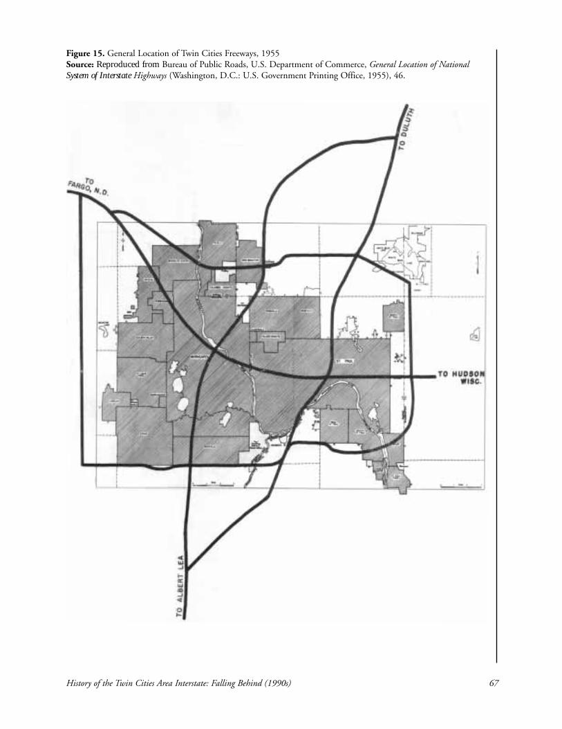
History of the Twin Cities Area Interstate: Falling Behind (1990s) 67
Figure 15. General Location of Twin Cities Freeways, 1955 Source: Reproduced from Bureau of Public Roads, U.S. Department of Commerce, General Location of National System of Interstate Highways (Washington, D.C.: U.S. Government Printing Office, 1955), 46.

68 Section 4
14. Donald E. Trull, Regional Administrator, Federal Highway Administration, Memorandum toDivision Administrators: Illinois, Indiana, Michigan, Minnesota, Ohio, and Wisconsin, 20 June 1978.15. Associate Administrator for Engineering and Traffic Operations, Federal Highway Administration,Memorandum to Regional Federal Highway Administrators, 7 June 1978.16. Minnesota Department of Transportation, “MnDOT Plan: A Transportation Plan for Minnesota”(St. Paul, MN: MnDOT, 1978). 17. Frederick A. Behrens, District Engineer for E. Dean Carlson, Division Administrator, FederalHighway Administration, Letter to Mr. Richard P. Braun, Commissioner, Minnesota Department ofTransportation, 4 April 1979.18. Richard T. Peterson, Office of Program Development, Minnesota Department of Transportation,Memorandum to Bruce L. Warzala, Director, Office of Program Development, 2 May 1979.
Despite the demonstration of need by MnDOT, the likelihood of acquiring federalfunds was less certain than in previous eras. The availability of federal funds for inter-state projects had shifted. In a memo to division administrators, Donald Trull,FHWA regional administrator, said the following:
It would appear that it will become increasingly difficult to justifyFAI funding of additional general use lanes, especially on sectionsthat are beyond their 20-year design life. Peak hour congestion isbecoming less a factor. The current emphasis is on moving peoplerather than vehicles and the capabilities of the total existing highwaysystem is to be considered when evaluating a request. Increasedemphasis is also being placed on a cost effective analysis.14
The FHWA viewed the interstate program as a one-time, initial construction-onlyprogram designed for a 20-year period. It stressed its view that the use of HOV lanesand bus service to improve the ability to transport people was of increased impor-tance.15 Indeed, financial pressure was being felt at MnDOT. The building boom wasfollowed by a shortage of funds to maintain or improve the built system. The 1978MnDOT Plan published under Commissioner Harrington noted:
Inflation in construction costs, difficulty in maintaining an agingsystem, and a decrease in the growth rate of revenues make it diffi-cult to slow the deterioration of the system. To provide an adequatesystem, which would meet the State’s needs for safety and mobility,may require a significant increase in the financial investment inhighways.16
The change in emphasis in the federal perspective became evident in a letter toCommissioner Braun from Frederick Behrens on behalf of the U.S. DOT DivisionAdministrator, Dean Carlson. The 1978 request for funds was denied due to theabsence of HOV lanes in the proposal. The letter stated the opinion that “no appre-ciable improvement in operations” would result from the proposed plan. However,FAI funds for further study of options for the corridor would be made available.17
Although this was viewed as encouragement to develop a project for the area thatincluded HOV lanes, MnDOT staff were acutely aware that the FAI cutoff dates wereclose (EIS approval was needed by September 30, 1983, and contracts were to beawarded by September 30, 1986) and that funding was not assured for this projectregardless of the alternative selected.18 Although the importance of this projectremained, the future upgrading of Cedar Avenue south of the Crosstown Commons
and Hiawatha Avenue south of downtown, as well as completion of the I-494Minnesota River bridge, were viewed as projects that could possibly reduce traffic vol-umes on I-35W.19 In 1982, a project to repair the I-35W bridge over the MinnesotaRiver received federal approval for three lanes as part of a redecking project. However,the third lane on the bridge could not be used until the approach was also widened.20
In 1983, MnDOT announced plans to begin the environmental impact study processfor the same section studied in the 1978 proposal, from 46th Street south to CountyRoad 42 in Burnsville. Funding was expected to come by way of shifting automobileexcise taxes from the State’s general fund to the highway construction fund, whichhad the support of Governor Perpich.21 In June 1984, Commissioner Braun formallyrequested the participation of the Metropolitan Council as a partner in the study anddevelopment of the I-35W corridor.22 The I-35W Background Executive Summaryfrom 1984 states that the major funding source for the project at that time wasexpected to come from the FHWA’s Interstate Rehabilitation Program funds.Commissioner Braun established a Project Advisory Board (PAB) consisting of repre-sentatives from the affected cities (Minneapolis, Richfield, Bloomington, andBurnsville), Hennepin and Dakota County, the Metropolitan Council, theMinnesota Valley Transit Authority, FHWA, and MnDOT. The purpose of thisgroup, which met monthly, was to recommend policy and direction for the study.Additionally, the group was designed to get coordination among the various govern-mental bodies from the very start of the project. Another group, the Project StaffTeam, was made up of representatives from MnDOT, the Metropolitan Council,FHWA, and a consulting firm. This group had responsibility for actually preparingthe studies and other required documents.23
Reflecting a change in perspective that shifted to planning for major transportationcorridors rather than freeways alone, all options receiving serious consideration (otherthan no-build) were multimodal, incorporating bus lanes, HOV lanes, or light rail.By 1986, MnDOT, FHWA, and the Metropolitan Council had initiated the environ-mental studies for expansion.24 The task at this stage was to prepare a scoping docu-ment, which would narrow the alternatives to only those that would be included inthe draft EIS. By this time, the freeway section under review had been expanded atthe north end to extend to Washington Avenue in Minneapolis (see Figure 16).
History of the Twin Cities Area Interstate: Falling Behind (1990s) 69
19. Jim Page, Transportation Planner, Minnesota Department of Transportation, Memorandum to JohnSem, Director, People and Goods Movement Section, Minnesota Department of Transportation, 22September 1981.20. Dennis Cassano, “Proposal to widen 35W pits Richfield’s ‘no’ vs. Burnsville’s ‘hurry!’,” MinneapolisStar Tribune, 28 February 1989, section A, 1,7.21. Laurie Blake, “State Eyes Wider I-35W South from 46th St.,” Minneapolis Star Tribune, 15December 1983, section B, 1.22. Richard P. Braun, Commissioner, Minnesota Department of Transportation, Letter to SandraGardebring, Chair, Metropolitan Council, 5 June 1984.23. Minnesota Department of Transportation, “I-35W Background Executive Summary” (St. Paul, MN:MnDOT, 1984). 24. Final EIS, 1-3–1-5.

70 Section 4
Figure 16. Interstate 35W Project LocationSource: Reproduced from Minnesota Department of Transportation (MnDOT), I-35W Final Environmental Impact Statement (St.Paul, MN: MnDOT, 1995).

Concern among citizens along the corridor in south Minneapolis was present as early asfall 1983, when elected officials consistently heard complaints from residents while doorknocking during the campaign. The memory of difficult experiences from the first roundof construction on I-35W was present in the community and viewed in retrospect asdamaging to the neighborhoods.25 It is not surprising, then, that the first formal citizengroup related to the I-35W expansion project was the I-35W Community Task Forcecreated by the Minneapolis City Council in 1986. This task force included citizen rep-resentatives from every ward affected by the proposed project, as well as some businessrepresentatives from the area. The group’s purpose was to study the alternatives and makerecommendations to the Minneapolis City Council.26 Beginning in April 1987, the taskforce held public meetings for comment on the scoping study. During these meetings,requests were made that transit be a major component of any proposed plan, concernswere voiced about the loss of homes necessary to complete the project, and complaintswere lodged about the possibility of increased noise and pollution. Additionally, LakeStreet business interests advocated for access at Lake Street.27
Minneapolis was not alone in hearing concerns from citizens. Burnsville residents lettheir elected officials know that relief for traffic congestion on I-35W was a priorityfor them.28 The long process for developing large projects like this was not well under-stood by citizens, and there was some impatience. In Richfield, people were con-cerned about traffic flowing onto their city streets and about the loss of access atLyndale Avenue, which they viewed as crucial to the vitality of their business district.The City of Richfield formed the Richfield Ad Hoc I-35W/I-494 Traffic Committee.The Minnesota Department of Transportation gave the Richfield group and the I-35W Community Task Force six design concepts to study for the CrosstownCommons as part of preparing the scoping document. Public meetings were held, onein each affected city, in fall 1987. This planning was for the freeway portion, withtransit design to be made available later after data were available.29
The following paragraphs describe the technical status of the project as of August1987. Because the transit ridership forecasts were not yet completed, designs pro-posed at this time did not yet incorporate public transit, although, MnDOT made itclear this component would be added. According to a MnDOT press release, “Otherdesign concepts, some including public transit, will be developed in the fall . . .Transit will play a pivotal role in the I-35W design . . . The transportation depart-ment is looking at transit options which included light rail transit (LRT) and highoccupancy vehicle lanes such as those now being built on I-394.”30 A project briefingmemo also noted that “Transit ridership forecasting for LRT and HOV lanes is stillunderway but near completion. Thus, transit components have not yet been incorpo-rated into design concepts.” The memo went on to stress, “This will be done as soonas ridership projections are available.”31 There were six design concepts for the
History of the Twin Cities Area Interstate: Falling Behind (1990s) 71
25. Anonymous interviewee, personal interview with author, February 2006. 26. Jim Daire, City of Minneapolis, Planning, Memorandum to John Doyle, Chair, I-35W CommunityTask Force, 25 September 1986.27. Katie Turnbull, Regional Transit Board, Memorandum to Elliot Perovich et al., Regional TransitBoard, 15 April 1987.28. Anonymous interviewee, personal interview with author, March 2006.29. Minnesota Department of Transportation, “I-35W Reconstruction Study Advances,” MnDOTNews, 12 August 1987.30. Minnesota Department of Transportation, “I-35W Reconstruction Study Advances.”31. Minnesota Department of Transportation, “I-35W Reconstruction Study Advances.”

Crosstown Commons, three for the I-94 common section, and four for the I-494interchange. The emphasis in the Crosstown Commons was to improve the curva-ture, eliminate left exits and entrances, separate the roadways, minimize right-of-wayacquisition, and avoid parks, lakes, cemeteries, and churches. The Lake Street inter-change area, the next section to be studied, was to continue south to Diamond LakeRoad.32
The political status of the project was beginning to heat up at this time. In Richfield,residents agreed that improvements to the freeway were necessary and expressed adesire to get it over with as quickly as possible so people who would have to leave theirhomes would be able to make plans.33 In Minneapolis, however, the loss of homes andbusinesses to additional lanes was a significant concern. In September 1987,Minneapolis City Council members Steve Cramer and Carol Johnson, who both rep-resented wards adjacent to the corridor, called for the city council to oppose any plansrequiring the taking of homes and businesses. Cramer and Johnson proposed thatmass transit options be used in lieu of adding lanes. The absence of data on transitoptions at that time, and the fact that no design concepts for other sections had yetbeen made public, made it difficult for MnDOT staff to respond. As the MnDOTspokesperson, corridor manager Craig Robinson replied that the commons section ofI-35W and Crosstown necessitated the taking of about 150 buildings to correct safe-ty problems, even if transit options were projected to reduce traffic congestion. Withregard to LRT options, one complication was that both state and federal law speci-fied that funds earmarked for highways must be spent on highways. Consequently,although bus and HOV lanes could be incorporated into plans that qualified for fed-eral monies, LRT options could not.34 In a letter to MnDOT Commissioner LeonardLevine, elected officials representing south Minneapolis stated a theme that would bepresent throughout the process: “Our neighborhoods have already absorbed morethan their share of the burdens associated with the state’s air and highway transporta-tion systems.” Although firmly stating their position (no doubt reflecting that of theirconstituents) that reconstruction must remain within the existing right-of-way, theyalso expressed their desire to work with elected officials from other cities to partici-pate in a constructive process.35 This would be their stance throughout the process. InBurnsville, officials were receptive to LRT as an option, but they wanted to keep itseparate from the diamond, carpool lane, or HOV options because they believedincluding LRT would slow down the project. They wanted expansion as quickly aspossible to serve their increasing population.36
In November 1987, the transit forecasts for various alternatives were made public.The alternatives included a no-build scenario; buses in mixed traffic; a diamond, car-pool lane; a separated, reversible HOV lane; LRT; and combinations of these.37 As
72 Section 4
32. Minnesota Department of Transportation, “Project Briefing: I-35W Informal Scoping—CrosstownCommon Section,” 12 August 1987.33. Laurie Blake, “300 Buildings Could be Razed Under I-35W Plan,” Minneapolis Star and Tribune, 18August 1987, section A, 1, 9.34. Laurie Blake, “Minneapolis May Try to Stop Plans for I-35W,” Star Tribune, 10 September 1987,section B, 1,8.35. Senator John Brandl, Representative Jean Wagenius, Council Member Steve Cramer, and CouncilMember Carol Johnson, Letter to MnDOT Commissioner Len Levine. 26 September 1987.36. Anonymous interviewee, personal interview with author, March 2006. 37. Metropolitan Council, “Summary of Key Findings: I-35W Transit Forecasts,” internal MetropolitanCouncil memorandum, 4 November 1987.

expected, simply including transit options in the design alternatives did not removethe need to demolish some homes and businesses in the Crosstown Commons, withestimates that at least 150 buildings would need to be removed. A corridor study con-ducted on behalf of MnDOT by Strgar-Roscoe-Fausch found that carpool lanes andLRT would be desirable, and that even if both were built, additional general purposelanes would be needed to accommodate projected traffic needs. Hennepin Countyhad state authority to build LRT, but funding sources for LRT remained question-able.38 To have time to incorporate the transit alternatives into the interstate designs,MnDOT delayed holding public meetings until early 1988.39 The purpose of thesemeetings would be “to provide the public an opportunity to discuss conceptual ideasbeing considered” for transit and access alternatives in the reconstruction.40
There were more than 200 people at the public meeting in Richfield. Loss of homeswas a sensitive issue because people remembered that many homes were removed forthe original construction of I-35W and Highway 62. The presence of I-35W, I-494,and Highway 62 along its borders gave Richfield residents a sense of having theircommunity whittled away by the need for expanded freeway capacity. One commonsentiment heard over and over at the hearing was that Richfield already had con-tributed its share to metro area freeways. Because many of the residents in the areawere approaching retirement age, uncertainty about the project and the timing ofpossible acquisition was crucial. If certain residents needed to move before MnDOTwas ready to purchase right-of-way, these residents could be left in a financially diffi-cult situation.41 In this respect, the long timetables for developing such a large projectwere themselves a problem for property owners adjacent to the corridor.
As the public meeting process got under way, David Fisher, the District Five repre-sentative on the Metropolitan Council observed:
When the relative pros and cons of each alternative are discussed,these people want to know up front the practical consequences. Ibelieve many are of the impression that some unknown andunreachable body of decision-makers has already concluded that thesystem will be changed, regardless of the consequences. I doubtmany disagree that perhaps a change of some sort is necessary, butthey must be reassured that the benefits of a system change will notbe outweighed by the costs, both in money and in social upheaval.42
This sense that residents felt there was some hidden part of the decision-makingprocess that they could not affect also was reported by elected officials fromMinneapolis. MnDOT and consultant staff worked hard to make themselves accessi-ble by attending many local meetings and personally responding to letters written byconcerned citizens. They strove to educate the public in the affected areas about the
History of the Twin Cities Area Interstate: Falling Behind (1990s) 73
38. Laurie Blake, “State: I-35W Light Rail Wouldn’t Spare Houses,” Star Tribune, 6 November 1987,section A, 1.39. Laurie Blake, “State Seeks Delay on I-35W Hearings,” Star Tribune, 25 November 1987, section B, 1.40. Minnesota Department of Transportation, “I-35W Transit, Access Options Offered,” MnDOT News,30 December 1987.41. Laurie Blake, “I-35W Plans Spark Plenty of Questions from Area Residents,” Star Tribune, 22 January 1988.42. David F. Fisher, Metropolitan Council, District 5, Memorandum to Connie Kozlak, MetropolitanCouncil, 29 January 1988.
proposed designs and traffic data.43 Residents along the corridor appreciated this highlevel of accessibility. Even though MnDOT and consultant staff made themselveswidely available for citizen questions and comments, they often were viewed as inflex-ible, both by many Minneapolis citizens who lived along the corridor and by theirelected representatives.44 This perception, combined with the sense of community his-tory regarding the original building of I-35W, fostered distrust of MnDOT on thepart of many residents in Minneapolis who lived near the freeway.45
In March 1988, the I-35W Community Task Force submitted its interim report toMinneapolis Mayor Don Fraser and the Minneapolis City Council. The task forcemet 21 times, held two public meetings, and studied materials given to them byMnDOT and consultant staff. Staff members from the City of Minneapolis assistedthe task force with these efforts. The report expressed a strong commitment to LRTin the I-35W right-of-way and selected three alternatives to move forward into theEIS phase, all of which were for smaller changes versus larger ones. One exception wasthe inclusion of the stacked alternative for the Crosstown Commons because thisalternative would reduce property acquisition. The task force stated its intent to con-sider an appropriate balance between the tradeoffs of increased local street traffic andthe taking of property, and in the end decided in favor of minimizing the loss of prop-erty. The group described its screening process as based on guiding principles devel-oped to reflect “community values rather than technical-transportation planning val-ues.”46 The report also conveyed the group’s belief that MnDOT had not fullyexplored all possible options for the corridor.47 MnDOT staff agreed to meet with thetask force members, but noted that they thought they had explored all possibilitiesduring the scoping process.48
In 1988, concerned citizens from the 14 neighborhood groups along the I-35W cor-ridor in south Minneapolis formed an organization called the NeighborhoodTransportation Network (NTN). Dore Mead, who was later elected to theMinneapolis City Council, provided leadership to the group. The group offeredstructure for local citizens who had been concerned about the I-35W plans for sever-al years and provided a way to share information and coordinate activities. The net-work was distinctive in that it was committed to not simply say “No!” to proposedchanges, but to come up with an alternative plan of its own. The NeighborhoodTransportation Network defined its purposes as “to investigate, analyze, and respondto MnDOT’s plans, to develop recommendations for alternate changes that couldimprove the efficiency and people-carrying capacity of I-35W, and to influence alter-ation decisions.” In an effort to do this, NTN created a 40-page document called,“Minimum Build/Maximum Management Alternative for Alterations to I-35W.”49
74 Section 4
43. Anonymous interviewee, personal interview with author, February 2006. 44. Anonymous interviewee, personal interview with author, February 2006. 45. Anonymous interviewee, personal interview with author, April 2004.46. I-35W Community Task Force, Interim Report on the I-35W Scoping Process to the Minneapolis CityCouncil and the Mayor (Minneapolis: City of Minneapolis, 1988), 3. 47. I-35W Community Task Force, Interim Report on the I-35W Scoping Process to the Minneapolis CityCouncil and the Mayor. 48. Steve Brandt, “Task Force Wants More Options for I-35W, Engineer: There May be None,” StarTribune, 12 April 1988, section B, 1, 5.49. Neighborhood Transportation Network (NTN), Minimum Build/Maximum Management Alternativefor Alterations to I-35W (Minneapolis: NTN, 1988), 1; Anonymous interviewee, personal interview withauthor, February 2006.

History of the Twin Cities Area Interstate: Falling Behind (1990s) 75
The report viewed plans for improving I-35W as a debate about the function of thefreeway and the focus of the problem, asserting that the debate should be about peo-ple rather than cars. Neighborhood Transportation Network’s assessment of the prob-lem was that congestion resulted from (1) the number of people who choose to trav-el on the segment during rush hour, (2) the high level of suburb-to-suburb trafficunrelated to the CBD, (3) low transit ridership, and (4) design defects in theCrosstown Commons as well as the I-94/I-35W interchange. Agreeing that the traf-fic forecasts were alarming, the report proposed taking an approach NTN viewed aschanging the direction of travel patterns rather than accommodating them. Thisapproach involved actions that would be out of the purview of MnDOT, such as cre-ating programs with corporations that encouraged employees to make travel decisionsthat reduced congestion, coordinating school schedules to reduce traffic, and makingimprovements to the bus system. The report, focusing only on the portion of freewaylocated in Minneapolis, requested that NTN’s minimum build/maximum manage-ment proposal be selected for evaluation in the EIS. There was concern that thiswould not happen because the 90% federal funding was available only if there weresubstantial alterations to the segment, which NTN’s proposal did not include.Further, at a March 10 public meeting, MnDOT officials pointed out that a no-buildor minimal-build alternative was not a realistic option because of the high trafficdemands in the corridor. The NTN report sought to lay out a reasonable argumentfor the neighborhoods’ vision of how the section should be altered. It included mapsand incorporated references to Metropolitan Council documents, technical reports,newspapers, and journals relating to the project. The report also emphasized thepoints of agreement between NTN and MnDOT, and where there was disagreement,the report detailed reasons incorporating available technical information. TheNeighborhood Transportation Network explicitly stated its disagreement with theguideline of obtaining 90/10 federal funding as a driving consideration in the designselection.50 Although clearly written by amateurs, when viewed in light of efforts byother citizen groups in previous disputes, the report represents a notably higher levelof sophistication than earlier efforts and a considerable expenditure of volunteer timeand effort.
The NTN recommendation that no lanes be added north of 61st Street received coolreception from highway planners. Connie Kozlak, a Metropolitan Council planner,pointed out that converting an existing lane to HOV use had not worked anywherein the country, mostly because drivers object to the loss of a lane and pressure politi-cians to keep the lane available for general use. Craig Robinson referred to a case inCalifornia where a lane converted from general use to HOV use lasted only six weeksdue to the level of public outcry and the ensuing response from the legislature.Converting an existing general-use lane to HOV use was not feasible politically.Meanwhile, Minneapolis City Council member Steve Cramer and RepresentativeJean Wagenius (DFL–Minneapolis) announced their determination to ensure seriousconsideration of the NTN proposal in the EIS process.51 There was widespread agree-ment among all involved that transit should be part of the design; the point of con-tention was whether additional general purpose lanes should be added. The MnDOTposition, as stated by metropolitan district engineer Bill Crawford at public meetings,was that transit alone could not handle the expected demand. The elected officials
50. NTN, Minimum Build/Maximum Management Alternative for Alterations to I-35W. 51. Steve Brandt, “Minneapolis Neighbors Propose Alternatives to I-35W Expansion,” Star Tribune, 15June 1988, section B, 1, 5.

76 Section 4
from Minneapolis held the position that a transit-only solution should be seriouslyconsidered, arguing that people need incentive to abandon single-occupancy vehicles.Both sides were able to marshal research to support their views.52
As opposition in Minneapolis continued to mobilize, it became evident that plans forfreeway expansion were bumping up against burgeoning neighborhood momentumfor revitalization. In the beginning of the interstate program, freeway constructioncomplemented the view that deteriorating areas should be razed and rebuilt. By themid-1980s, however, neighborhood revitalization through political mobilization andreinvestment was gaining a solid foothold. This was at odds with freeway expansionin south Minneapolis. Loss of low-income housing was now viewed as a problem,rather than a benefit as it was viewed in the late 1950s and early 1960s.53 Loss of hous-ing was a major area of distrust between Minneapolis neighborhood groups and theMetropolitan Council, because of problems associated with replacing housing lost tomake room for the Minneapolis Convention Center.54 It was difficult to ease the ten-sion between the need for housing and the need to quell the increasing trafficdemand.
In response to concerns about loss of homes in Minneapolis and Richfield, MnDOTannounced it was dropping from consideration those proposals for realignment of theCrosstown Commons that required the demolition of at least 300 houses, retainingtwo proposals that required taking about 200 houses. About 40 more houses actual-ly would be taken, according to plans to accommodate the realignment of I-35W andI-94. In November 1988, the scoping decision document described six alternatives forstudy in the EIS process, including the NTN proposal.55
Just as the scoping document was being completed, debate began regarding whetheror not the decisions about LRT’s inclusion and possible alignment should proceed aspart of the I-35W EIS process or whether this issue should be studied separately. Thisseemingly bureaucratic decision had political implications that were clear to electedofficials. Burnsville officials wanted to keep the LRT issue separate to make the I-35W process move more quickly, whereas Minneapolis officials wanted LRT includ-ed because they had great interest in LRT-only possibilities.56 The MetropolitanCouncil recommended that LRT be a part of the I-35W study. In conjunction withthis, they also recommended that Hennepin County participate in the EIS process asa cooperating agency.57 The Metropolitan Council’s “Long Range Transit AnalysisPlan” identified the I-35W corridor as one of two high-priority corridors for theregion.58 MnDOT accepted the Metropolitan Council recommendation and askedHennepin County, via the Hennepin County Regional Rail Authority, to participateas a cooperating agency and pay for the LRT portion of the EIS.59
52. Steve Brandt, “This 35W Thing is Going to be War,” Star Tribune, 14 June 1988, section B, 3.53. Anonymous interviewee, personal interview with author, February 2006; Connie Kozlak,Memorandum to Steve Keefe, 17 June 1988.54. Ana Moreno, Memorandum Steve Keefe, 17 June 1988.55. Steve Brandt, “State Revises Proposals for 35W Changes,” Star Tribune, 22 June 1988, section B, 1, 7.56. Anonymous interviewee, personal interview with author, March 2006. 57. Steve Keefe, Chair, Metropolitan Council, Letter to William Crawford, District Engineer, 12 August1988.58. David Fisher, Metropolitan Council, Memorandum to Sen. Carol Flynn, 19 September 1988.59. William Crawford, MnDOT District Engineer, Letter to Vern Genzlinger, Associate CountyAdministrator, Hennepin County, 6 September 1988.

History of the Twin Cities Area Interstate: Falling Behind (1990s) 77
The scoping decision document selected eight alternatives. In addition to the no-build option required by federal regulations, the included the following:
• Minimum Safe Operation: no additional through lanes, safety improvements• Diamond Lanes: additional highway lanes reserved for buses and other high-
occupancy vehicles• Hybrid Reversible HOV Lanes: reversible HOV lanes north of the
Crosstown and diamond lanes south of 60th Street• NTN Proposal: convert existing lane to diamond lane north of 60th Street,
diamond lanes added south of 60th Street• LRT combined with minimum safe operation• LRT and diamond lanes• LRT on the Soo Line railroad south of 60th
Street
This selection of alternatives for inclusion in the EISprocess meant all interests had their preferred alternativeincluded in the process. Cost estimates for these projectsranged from $270 million to nearly $1 billion.60
As the EIS process got under way, elected representa-tives from all affected areas began to mobilize. DakotaCounty commissioners and Burnsville officials weighedin on the importance of expanding I-35W south of theMinnesota River. Acknowledging that Richfield andMinneapolis had some thorny issues to resolve and stating their desire to not interfere,they called for expansion of I-35W south of I-494 to County Road 42, including theuse of the third lane on the bridge over the river. Recalling the delays in building I-35E,leaders sought to distance themselves from the disputes in which their northern neigh-bors were embroiled. Officials from Burnsville, Dakota County, Apple Valley, Eagan,Savage, and Lakeville formed a loose coalition that was the precursor to the I-35WSolutions Alliance. Their purpose was to communicate to legislators and GovernorPerpich the urgency residents along I-35W south of I-494 felt regarding the freewayexpansion.61 Sympathetic to the desire to open unused lanes that had been built toreroute traffic during bridge redecking, Governor Perpich directed CommissionerLevine to conduct the requisite soil study to open those lanes.62 Bloomington officialssupported the move to divide the project into two phases at I-494 so the improvementsthey advocated would move ahead. They also passed a resolution calling for the EIS tobe similarly divided to reflect the two distinct phases of the project.63 Richfield city offi-cials’ concern was that a delay in improvements to the Crosstown Commons wouldresult in more accidents and increased neighborhood traffic as drivers avoided this sec-tion of freeway. Although their position was that loss of homes should be kept to a min-imum, they also viewed the loss of homes as inevitable and wanted plans to be madequickly. During this time, elected representatives of Minneapolis took the offensive.
60. Minnesota Department of Transportation, “Scoping Decision Document: Interstate 35WReconstruction Project” (St. Paul, MN: MnDOT, 1988). 61. Dennis Cassano, “Proposal to Widen 35W Pits Richfield’s ‘No’ vs. Burnsville’s ‘Hurry’,” StarTribune, 28 February 1989, section A, 1.62. “Perpich Sets Study of Closed 35W Lanes,” Star Tribune, 17 March 1989, section B, 1.63. City Council of Bloomington, Resolution No. 89-44, 27 March 1989.
Nicollet Avenue fromBurnsville Parkway,Burnsville, 1979. (Photocourtesy of the MinnesotaHistorical Society, locationno. MD2.9 BV2 r1, nega-tive no. 38132. Reprintedwith permission.)

78 Section 4
Representative McLaughlin (DFL–Minneapolis), stating that when I-35W was builtit “was ripped out of the heart of the city,” wrote a bill proposing that no lanes couldbe added to the freeway segment until mass transit and traffic management optionswere exhausted to “soften further effects on the neighborhood.”64
In July 1989, Commissioner Levine announced that the number of alternatives in theEIS process had been reduced to four; two alternatives had carpool lanes and twocalled for LRT in the median. The other alternatives were eliminated because theyrequired taking up to 100 more homes than the remaining alternatives, especially inthe Phillips neighborhood in Minneapolis, a fragile area local citizens were workingto revitalize. The four remaining alternatives ranged from between 8 and 10 lanesnorth of Crosstown and 6 to 8 lanes south of that point. Some of the reduction in thenumber of homes lost was achieved by using double-decking on the common sectionwith I-94. Commissioner Levine and Governor Perpich had visited a two-tiered free-way in Austin, Texas.65 Commissioner Levine stated that eliminating the most disrup-tive designs should establish that MnDOT’s goal was to find a solution that met traf-fic demand needs with minimal disruption. Elected representatives of Minneapolispraised the move and urged the department to continue whittling away at the num-ber of homes and businesses required to be taken by the reconstruction.Representative Connie Morrison (R–Burnsville) noted with encouragement thatMinneapolis officials had a positive response to the announcement that the numberof alternatives had been reduced.66 The announcement also was met with some nega-tive reactions.
Because the scoping document had created the expectation that their plan would beincluded in the draft EIS, NTN members were angered by the announcement thattheir minimum build/maximum management alternative had been dropped. Therewere differing understandings regarding who would be responsible for making thetechnical drawings of the plan, as well as when various requirements had to be met.Minneapolis city staff provided substantial design and engineering work for NTN.67
In a letter dated July 20, the day after Commissioner Levine announced the reduc-tion of alternatives for study, Craig Robinson, the I-35W corridor manager, stated:“As I stated at [the June 29] meeting, our analysis of all alternatives is anticipated tobe concluded this fall. To maintain our project schedule, I need to have your final pro-posal, complete with conceptual drawings, by approximately the end of September,1989.”68 There was increasing tension regarding the NTN report for all involved.
Bob Morgan, the widely respected transportation planning engineer for the City ofMinneapolis and a key liaison and support person for the Minneapolis City Council,provided an account of the process for narrowing the alternatives in a memorandumto Mayor Fraser and the Minneapolis City Council dated July 26, 1989. He statedthat MnDOT and the Metropolitan Council were likely to have made their decision
64. Laurie Blake, “Minneapolis Getting Ready to Fight Pending Proposal to Upgrade I-35W,” StarTribune, 14 April 1989, section B, 1.65. Laurie Blake, “‘Double-Decking’ Considered for 35W,” Star Tribune, 17 March 1989, section B, 1,7.66. “4 Design Options are Finalists for I-35W Project,” Star Tribune, 20 July 1989, section B, 1.67. Dore Mead, President, Neighborhood Transportation Network, Letter to MnDOT CommissionerLen Levine, 25 July 1989.68. Craig Robinson, I-35W Corridor Manager, Letter to Dore Mead, President, NeighborhoodTransportation Network, 20 July 1989.

History of the Twin Cities Area Interstate: Falling Behind (1990s) 79
based on their concern about being able to provide the necessary documents to meetthe timetable set out for the project. In addition, the largest alternatives simplyrequired too much right-of-way to be viable. He describes Commissioner Levine’sannouncement:
Local elected officials south of Minneapolis were not invited to theCommissioner’s briefing and learned of the Commissioners decisionfrom their staff Wednesday afternoon, July 19, following the ProjectAdvisory Board (PAB) meeting. At the PAB meeting local govern-ment staff was advised that MnDOT and the Metropolitan]Council, working with the Project Management Team (MnDOT,Metropolitan Council, Regional Transit Board, Federal HighwayAdministration, and Strgar-Roscoe-Fausch), had developed thesemajor revisions. We were advised that the Commissioner hadannounced these decisions to a group of elected officials at a meet-ing that morning. We were further advised that the press had alreadybeen briefed. Several thousand of the I-35W Flyer newsletters hadalready been printed, boxed, and were available to us for distribu-tion. This was the first time that I or staff of the cities of Richfield,Bloomington, Burnsville, or Hennepin or Dakota County had heardof this decision. . . . MnDOT has managed in one day to ignore theMayors and local elected officials of Richfield, Bloomington, andBurnsville; to make major decisions in the EIS while excluding alllocal government staff; and to lose any developed credibility withactive citizen groups at least in Minneapolis. 69
Morgan’s memo reflects the important role local staff can play in the development ofcomplex projects, but only if they are well-informed and involved in the process by bothMnDOT and elected officials. Like many other transportation professionals workingduring these controversial projects, Morgan was caught in the tension between the tech-nical expertise of his profession and volatile political realities. All legislators representingthe affected areas in Minneapolis wrote to Commissioner Levine objecting to the processused to reduce alternatives and called for reinstatement of the NTN plan.70 Mayor Fraserand Minneapolis City Council members who represented wards along the corridor wroteto Commissioner Levine thanking him for his recognition that loss of housing is a con-cern to the City of Minneapolis, for including LRT for consideration, and for efforts tomitigate neighborhood impacts. They also expressed concern over the exclusivity of thedecision-making process that led to the reduced list of design alternatives to be studied.The letter stated that they “would like to see more interest and initiative from MnDOTto evaluate the NTN proposal at the same level of effort as the other EIS alternatives.”71
Also in 1989, Dan McElroy, mayor of Burnsville, led an effort to form the I-35WCouncil, a group that by late 1990 would be called the I-35W Solutions Alliance. The
69. Robert S. Morgan, Transportation Planning Engineer, Memorandum to Mayor Donald Fraser andMinneapolis City Council Members Brian Coyle, Barbara Carlson, Sharon Sayles-Belton, Joan Niemec,and Steve Cramer, 26 July 1989.70. Representatives Jean Wagenius, John Brandl, Ken Nelson, and Peter McLaughlin, Letter to MnDOTCommissioner Len Levine, 8 August 1989. 71. Mayor Donald Fraser and Minneapolis City Council Members Sharon Sayles-Belton, Brian Coyle,Joan Niemiec, Carol Johnson, Barbara Carlson, and Steve Cramer, Letter to MnDOT CommissionerLen Levine, 9 August 1989.

80 Section 4
72. “Purpose Statement for I-35W Council,” 16 March 1989; Anonymous interviewee, personal inter-view with author, March 2006. 73. Laurie Blake, “I-35W Design Study is Behind Schedule,” Star Tribune, 10 July 1990, section B, 3.74. “All Eyes on I-35W,” Star Tribune, 1 January 1991, section A, 1.75. Brian W. Clymer, U.S. DOT, Urban Mass Transportation Administration, Letter to MichaelEhrlichmann, Chairman, Regional Transit Board, 11 January 1991.76. Natalio Diaz, Metropolitan Council, Memorandum to Mary Anderson, Metropolitan Council, 25February 1991.
purpose of the organization was to develop solutions to improve traffic flow andcapacity on I-35W to meet the needs of future growth and development and to pro-vide a forum to discuss ways of alleviating congestion. Their immediate concern wasgetting use of the third lane on the bridge over the Minnesota River, whereas theirlong-term goal was to keep the corridor project on the established timetable andensure that funding for the project was in place. Elected officials from neighborhoodsalong the entire corridor were invited to join. Although the I-35W Solutions Alliancedid not have much immediate influence because of low attendance at early meetings,the group hired a lobbyist and played a significant role by the mid-1990s. Interactionsbetween representatives from Minneapolis and those of the southern suburbs werecordial, but they had different views on how the corridor should be developed, as didtheir constituents.72
Because of political pressure, MnDOT continued to work with NTN into summer1990. The EIS schedule was adjusted to accommodate development of the NTN pro-posal. Bob Morgan observed that although the inclusion of the citizen group’s pro-posal was slowing down the study process a little, it was adding a substantially differ-ent alternative, which included both light rail and carpool lanes.73 The process alsowas slowed by the eligibility requirements for federal mass transit subsidies, andbecause this was the first time light rail had been proposed as part of an interstateplan, MnDOT staff members were wading through unfamiliar procedures and paper-work. There was a sense in the transportation community that the decision aboutlight rail in the I-35W corridor was critical to the development of mass transit infuture designs throughout the metro area. Adding light rail after the constructionwould be prohibitively expensive, and many believed that if it was not built along theI-35W corridor in the current project, southern suburbs would never have LRT.Meanwhile, plans sought by those in the southern suburbs to open the third lane ofthe bridge over the Minnesota River moved ahead.74
The lack of familiarity with developing proposals for LRT was evident in a letter fromBrian Clymer, with the U.S. Department of Transportation’s Urban Mass TransportationTransit Board, to Michael Ehrlichman, chair of the Regional Transit Board. Preliminarycost-effectiveness data for the I-35W corridor, as well as the Hiawatha and Northeast cor-ridors, were described in the letter as “simplistic” and not based on an “acceptable travelforecast modeling process.” In addition, Clymer noted that information in different tech-nical memoranda was inconsistent and would need correcting before they would beacceptable. For the U.S. DOT to select the I-35W corridor for an alternate analysis, itwould have to be designated the region’s LRT priority.75 However, in 1991, the RegionalTransit Board recommended the central corridor between the two downtowns as the toppriority, and the Metropolitan Council concurred.76
In April 1991, MnDOT announced it was going to drop the NTN plan from thestudy. The State of Minnesota, the Metropolitan Council, and FHWA stated that the

History of the Twin Cities Area Interstate: Falling Behind (1990s) 81
NTN plan was unsafe and did not warrant further study. MnDOT CommissionerJohn Riley explained that the limited vehicle capacity proposed in the NTN planwould divert drivers to local streets, thereby causing an increase in accident rates.Commissioner Riley offered a new proposal that he viewed as incorporating the “sub-stance” of the citizens’ original proposal with changes to avoid the predicted increasein accidents. To achieve this, a lane was added in each direction between theCrosstown Commons and downtown Minneapolis. Because avoiding additional laneswas at the core of the NTN approach, it is not surprising that its supporters foundthis new alternative unacceptable. Elected representatives for the affected area inMinneapolis continued to call for inclusion of the NTN plan. Both the MinneapolisCity Council and the Hennepin County board passed resolutions to include theNTN plan in further study.77 Dakota County and the cities of Bloomington, Savage,Lakeville, and Burnsville passed resolutions to keep the NTN alternative out of theEIS and to move the project ahead as quickly as possible.78
The cities of Richfield, Burnsville, and Bloomington lined up in support of a designthat called for four additional lanes, one each direction for general use and one eachdirection for buses and carpools. Minneapolis was steadfast in its commitment toincluding LRT in the median. In an effort to arrive at a palatable, if unpopular, com-promise, the Metropolitan Council in early 1992 proposed a plan that would add twobus and carpool lanes and retain 45 feet in the median for light rail. The stakes werehigh because the 18 miles under consideration was the busiest stretch of freeway inthe state.79
In spring 1992, attention turned to the MnDOT public hearing, which was expect-ed to have unprecedented turnout. The hearing was preceded by informational meet-ings at various locations throughout the corridor. Opponents to expansion workedhard to get their supporters to the meeting. Neighborhood Transportation Networkdistributed 23,000 flyers alerting people to their position and the importance of thehearing. Former MnDOT Commissioner Richard Braun, highly respected by all par-ties, was asked to preside over the hearing; his experience was viewed as a valuableasset given the likelihood of a complex and heated event. The hearing was held atRichfield High School. This location was selected because of its central location alongthe corridor, ample parking, and large auditorium that could seat 1,000 people.80 Thislocation was seen by Minneapolis citizen activists, and some elected officials, as achoice that excluded many of those in areas likely to be affected by the project, asthere was no close bus access. In response, MnDOT provided shuttle buses throughthe Whittier and Phillips neighborhoods. In addition, NTN organized rides for thosewho needed them. Minnesota Department of Transportation staff also received criti-cism for holding only one hearing for four communities, but members of PAB replied
77. Laurie Blake, “State Calls I-35W Plan Unsafe, Quits Studying It,” Star Tribune, 24 April 1991, sec-tion B, 1; “MnDOT Rejects Group’s Plan,” Whittier Globe, April 1991, 1; Peter McLaughlin, HennepinCounty and Steve Cramer, Minneapolis City Council, Letter to MnDOT Commissioner John Riley, 3May 1991.78. City of Bloomington, Resolution No. 91-46, 1 April 1991; City of Savage, Resolution No. R-91-47,2 April 1991; City of Burnsville, Resolution No. 3656, 1 April 1991; City of Lakeville, Resolution No.91-47, 24 April 1991; Dakota County, Resolution No. 91-276, 9 April 1991.79. Laurie Blake, “Minneapolis, Suburbs Jockey for Inside Lane on I-35W’s Future,” Star Tribune, 13April 1992, section A, 1.80. James Denn, MnDOT Commissioner, and Mary E. Anderson, Chair, Metropolitan Council, Letterto Dore Mead, President, Neighborhood Transportation Network, 31 March 1991.
82 Section 4
that they thought it was important for everyone to hear everyone else in one forum.Preparations included court reporters in a separate room to take comments fromthose who did not wish to speak at the hearing; these individuals could fill out cardswith their comments to be included in the public record. Plans also were made tobroadcast the hearing via radio to a community center in the Phillips neighborhood.There was an air of paranoia among some Minneapolis neighborhood activists, someof whom carried pieces of paper in their pockets to hand off in case they were arrest-ed, and extra police were called in from Richfield and Edina.81
The hearing lived up to expectations. On May 14, 1992, an overflow crowd estimat-ed at 3,000 people attended. The hearing began at 7 PM, the crowd remained thickuntil 11 PM, and the hearing did not end until 2:45 AM. The cheers and boos fromthe crowd reflected the dominance of anti-expansion, pro-LRT attitudes among thosein attendance, with urban and suburban camps starkly divided. Distrust of MnDOTwas evident in many of the speakers’ comments, including elected officials fromMinneapolis as well as representatives of various interest groups. One theme of theevening was articulated in testimony sent by Archbishop John Robert Roach (as readby Bishop Joseph Leo Charron), in which the archbishop stressed that althoughextensive technical studies had been conducted, the social justice implications of theproposal had not been fully articulated even though it was clear that poor and minor-ity communities were going to be disproportionately harmed by the construction. Heargued that policy makers should examine the history of the effects freeway construc-tion had on Twin Cities neighborhoods and weigh that as part of the decision. Manyof the citizens were familiar with information in the draft EIS, prepared their com-ments in advance, and expressed heartfelt distress and genuine pain at the prospect offurther freeway expansion in their communities. Elected officials from Bloomingtonand Burnsville argued for the necessity of more lanes to serve their communities, stat-ing they were not the enemy of Minneapolis residents but simply needed relief fromcongestion for their growing communities. Spokespeople on each side of the debate(McLaughlin and Turner) criticized the 2010 design date82 as unrealistic. All told,there were more than 1,000 written and oral comments formally submitted. Of these,mass transit, environmental impact, and social and economic impacts were the threemost common concerns.83 All in all, it was a remarkable event and retains the distinc-tion of being the longest public hearing held in Minnesota.84
During the summer, the Urban Coalition came out against adding lanes inMinneapolis, arguing that the taking of homes would disproportionately affectminority, elderly, and poor residents. State Representative Myron Orfield(DFL–Minneapolis) made a statement that expanding the freeway would contributeto the fleeing of jobs from the city to the suburbs, making it difficult for low-incomeresidents to take advantage of employment opportunities. The Legal Aid Society ofMinnesota asserted that freeway expansion in south Minneapolis would violate fed-
81. Anonymous interviewee, personal interview with author, April 2004; “Grand Plans Made forHearing on New I-35W,” Star Tribune, 5 May 1992, section B, 1. 82. The term design date refers to the date engineers project forward to in order to create a design basedon the projected traffic volume for that year. 83. MnDOT, Final EIS, 1–27.84. Anonymous interviewee, personal interview with author, March 2004; “Light Rail Gets HeavyEmphasis at Hearing on I-35W,” Star Tribune, 15 May 1992, section A, 1; “Archbishop Roach: 35WWidening Plans Ask Low-Income People to Sacrifice the Most,” Catholic Bulletin, 21 May 1992, 3;MnDOT Public Hearing (videocassette), Richfield High School, Richfield, MN, 14 May 1992.
History of the Twin Cities Area Interstate: Falling Behind (1990s) 83
eral fair housing and civil rights laws. The Minneapolis Civil Rights Commissionconcluded that expansion of I-35W would violate federal civil rights laws and recom-mended that if MnDOT proceeded with a plan to widen the freeway in southMinneapolis, the city should sue. Minneapolis Mayor Don Fraser supported theirconclusions.85
Making a complex high-stakes situation more complex, in August 1992, 17Minneapolis officials presented their plan for improving the freeway. They developeda design that would add lanes only in the Crosstown Commons section and wouldbuild light rail in the median of the freeway, at a cost of $60,000 to HennepinCounty. Their proposal required the destruction of 30 houses compared to theapproximately 900 predicted to be lost in the state’s plan. Stating that the future ofthe city was at stake, the group argued against further loss of homes and increased pol-lution and asked MnDOT Commissioner Jim Denn to select their plan as the pre-ferred alternative. Denn approached the plan guardedly, stating that he had to con-sider the needs of the whole state in making his decision. Bloomington officials stat-ed that light rail would not accommodate existing suburb-to-suburb travel.86
In a report to the Minneapolis City Council, Richard Straub, Minneapolis city engi-neer, recommended LRT for the corridor. He noted that he had some disagreementwith the LRT patronage estimates in the draft EIS and suggested that alignment ofthe LRT along the west side of the freeway should be considered. He recommendedthat the city support a build alternative that included LRT, a stacked mainline designat the I-35W/I-94 common section, the addition of one lane in each direction southof 46th Street to the Crosstown Commons, and a rebuilding of the CrosstownCommons with I-35W in the middle.87 The Minneapolis City Council accepted someof these recommendations but remained firm in their position that LRT be built inadvance of highway reconstruction.88
On January 12, 1993, Commissioner Denn announced the long-awaited decision.He selected an unprecedented multimodal design that included (1) LRT on the free-way median from downtown Minneapolis to 95th Street with a feeder bus system; (2)an HOV lane achieved by building new dedicated lanes from County Road 42 to46th Street, and converting existing lanes from 46th Street to downtown; (3) addi-tion of one general purpose lane from County Road 42 to I-494; (4) separation of I-35W and Crosstown Highway 62 at the same level, side-by-side; and (5) rebuildingof the I-94/I-35W commons with stacking of the mainlines.89 The overall cost was $1billion, and right-of-way acquisition was expected to involve about 70 businesses and1,000 homes, with about 875 of those homes located in Minneapolis. In addition,MnDOT stated it would replace 75% of the housing acquired for the project.
85. “Minorities, Poor to be Hurt by Wider 35W, Panel Told,” Star Tribune, 6 August 1992, section B,1; “Panel Looks at a Road and Rights,” Star Tribune, 6 August 1992, section B, 7.86. Citizens and elected officials from the South Minneapolis community, “I-35W Change Plan:Economical Solution,” unpublished presentation to MnDOT Commissioner James Denn, 20 August1992; “Minneapolis Officials Offer Plan for Light Rail Along I-35W,” Star Tribune, 25 August 1992,section B, 1.87. Richard L. Straub, Report to the City Council on the I-35W Draft Environmental Impact Statement(Minneapolis, 19 May 1992).88. Minneapolis City Council, Detailed comments on the I-35W Draft EIS for incorporation in thePublic Hearing Record, 21 May 1992.89. MnDOT, Final EIS, 1-12–1-14.

84 Section 4
Construction was projected to begin in 1998 and take 10 to 15 years, depending onthe availability of funds.90 The commissioner’s choice was a compromise betweenMinneapolis officials’ desire for LRT and suburban officials’ preference for addedlanes, and was significant because it was the first time a MnDOT commissioner hadever selected a plan that included light rail. Denn also announced his intention tohave replacement housing built before demolition. The final EIS process was expect-ed to be completed in late 1993. To assist with obtaining federal funding, Denn askedthe legislature to form a financing study committee.91 Denn described the decision-making process as difficult, admitting that there were moments he “came very close,given the hard posturing that was taking place, and every indication that it was sin-cere, that no build was the best solution—just patch it up and let somebody else dealwith it.”92
Southern suburbs and the I-35W Solutions Alliance pressed for an interim HOVthird lane south of I-494, and Denn was persuaded both by their arguments and thepoor safety statistics for the area. In March 1993, the Minneapolis City Council voted10 to 1 to oppose plans for the interim lane, overriding Mayor Fraser’s veto. Their rea-soning was that if one part of the project moved ahead independently, other portions,especially LRT, would be jeopardized. Mayor McElroy responded to their action bysaying the project was so important to the area that officials would do whatever wasnecessary to get it done.93 In May, the Minneapolis City Council voted 10 to 1 to joina lawsuit NTN had filed against the state, because money had been guaranteed for aninterim lane on I-35W from 78th Street in Richfield to County Road 13 inBurnsville, but no money was committed to light rail. The council acknowledged thatthe lane was needed, but alleged that suburban legislators said they would supportfunding for light rail, yet made no effort in that direction.94 They maintained that theproject should remain an integrated, single project with one EIS. Only five days later,however, the council voted 9 to 3 to rescind its action to join the lawsuit. Two citycouncil members attributed this reversal to pressure from Governor Arne Carlson’sstaff. There were accusations that the governor’s staff had indicated that a residencyrequirement bill strongly desired by Minneapolis representatives would be vetoed ifMinneapolis moved forward with the suit. Pressure from south suburban legislatorswas also cited. Perhaps it was coincidence, but the governor signed the residency billhours after the city council rescinded its action to join the lawsuit. The governor’spress secretary made a statement denying a connection between the lawsuit and theresidency bill. Senator Bill Belanger (R–Bloomington), however, came forward andadmitted to brokering the deal.95
Neighborhood Transportation Network contended that the interim project was littlemore than freeway expansion before the completion of the EIS. Funding for the lanes
90. Minnesota Department of Transportation, “Summary of Recommendations for Reconstruction of I-35W” (St. Paul, MN: MnDOT, 12 January 1993).91. Minnesota Department of Transportation, News Release, 12 January 1993, 6.92. Laurie Blake, “Smooth Move: I -35W’s Design is an Old Sore; Fixing it Will be Painful,” Star Tribune,24 January 1993, section B, 1; Anonymous interviewee, personal interview with author, April 2004.93. Patricia Lopez Baden, “Minneapolis Council Votes to Block I-35W Lane,” Star Tribune, 20 March1993, section. B, 1.94. Patricia Lopez Baden, “Minneapolis Votes to Sue Over Extra Lane on I-35W,” Star Tribune, 15 May1993, section B, 1.95. Patricia Lopez Baden, “Vote Abruptly Reversed on I-35W Expansion,” Star Tribune, 20 May 1993,section A, 1.

History of the Twin Cities Area Interstate: Falling Behind (1990s) 85
was allocated from the existing MnDOT budget, prompting opponents to accuse thestate of slipping in a new construction project, while circumventing EIS procedures.In addition, the lanes were being built in the median, space supposedly proposed forlight rail. Commissioner Denn replied that the temporary HOV lanes had approvalfrom the Metropolitan Council and the Minnesota Pollution Control Agency, fol-lowed required legal procedures, and were necessary to improve safety and relieve con-gestion. In July, FHWA revoked funding for the lanes citing inadequate environmen-tal review, and NTN withdrew their lawsuit.96 By late August, the funding wasrestored, however, and the suit proceeded. Commissioner Denn and Bob McFarlin,MnDOT director of public affairs, both acknowledged that distrust of their organi-zation was very high in Minneapolis. That was reflected in statements by NTN andelected officials that the temporary project increased suspicions about the state’s com-mitment to light rail. The Minneapolis city council voted to join the lawsuit, butfailed to override a veto by Mayor Fraser.97
In November 1993, U.S. District Judge Richard Kyle dismissed the NTN suit, rul-ing that adding the interim lanes was a separate project from the proposed I-35Wreconstruction. Consequently, it was proper for it to move forward before the EIS wascompleted for the larger project. The ruling stated that the interim lanes had meritwithout regard to the larger project and did not foreclose any options.98
In summer 1994, a report by the Downtown Transportation ManagementOrganization, a private-public study group, urged Minneapolis city lawmakers toreconsider their opposition to additional highway lanes without LRT. The reportnoted the importance of the I-35W corridor and cautioned that delays in construc-tion could result in the loss of funds to other projects, such as the widening of I-494.The report also suggested paying for improvements to I-35W with gas tax funds. Thisposition was supported by the Minneapolis Downtown Council and the GreaterMinneapolis Building Owners and Management Association. Minneapolis CityCouncil member Jim Niland used procedural tactics to prevent a vote on the report,declaring, “I’m going to use any tactics I have available to stop the expansion of 35W,including laying in front of a bulldozer.” Minneapolis City Council member PatScott, who had introduced a motion to reconsider the council’s position on LRT,warned that they were likely to get neither LRT nor freeway improvements. Scott wasjoined by Minneapolis City Council member Steve Minn, Minneapolis MayorSayles-Belton, and public works staff.99 The timing of the introduction of the resolu-tion also was affected by the anticipation of the release of the final EIS, which wouldstart a series of meetings and decisions. Dore Mead, now a member of theMinneapolis City Council, along with Niland, conducted public meetings in southMinneapolis at which design plans were made available for review. The purpose of themeetings was to call for the city council to maintain its opposition to freeway expan-sion. Mead declared, “Widening roads to fight congestion is like loosening your beltto fight obesity.”100
96. Laurie Blake, “Funding for I-35W Expansion Delayed,” Star Tribune, 1 July 1993, section A, 1.97. Patricia Lopez Baden, “Council to Join Suit Again I-35W Project,” Star Tribune, 28 August 1993,section B, 1; “Fraser’s Veto Sustained in I-35W Project,” Star Tribune, 16 October 1993, section B, 1.98. Laurie Blake, “Judge OKs Third Lane for I-35W in 2 Suburbs,” Star Tribune, 19 November 1993,section A, 1.99. Kevin Diaz, “Report Says Widening I-35W Needed,” Star Tribune, 22 July 1994, section B, 1;100. “300 Fear City Weakening Resolve on I-35W,” Star Tribune, 20 October 1994, section B, 2.

86 Section 4
The final EIS was released in November 1994. The report stated that “it has beendetermined that it is not feasible to meet all the projected vehicle demand for travelon I-35W.” However, transit solutions alone were not viewed as sufficient to meet theplanned development in the Twin Cities. The preferred alternative incorporating LRTand additional lanes was described as the plan that could satisfy the most diverseneeds of the region, while minimizing right-of-way acquisition. The total number ofhousing units lost would be 854, plus the loss of 34 businesses. The MetropolitanCouncil supported this as consistent with the regional plan.101
It was not long before new situations developed. In January 1995, the MinneapolisPark Board announced its intent to sue MnDOT over the plans to upgrade the I-35W bridges over Minnehaha Creek. The park board had granted an easement to thestate when the freeway was originally built. It did not view the easement as permis-sion to expand the bridges. The immediate issue was that MnDOT proposed cover-ing the 30-foot gap between the two existing bridges, which would kill the plantsunderneath and create a dark section in the popular recreation area. The larger dis-pute, however, was again over the nature of the plan. The park board and StateSenator Jane Ranum (DFL–Minneapolis), who represented the area, viewed the planas a piecemeal way of constructing the I-35W project; MnDOT officials said it was atemporary effort and separate from the I-35W construction project. In addition tothis new development, conflict on the Minneapolis City Council intensified.Although the majority of council members continued to oppose the plan to add lanesin south Minneapolis, the transportation committee was dominated by members whothought the city would be better served by softening its position. Maneuvering byboth sides served to increase rancor.102
The city-level political situation was soon to be unimportant, however. The gas taxrevenue had become inadequate to pay for major road improvements, and GovernorCarlson and a majority of state legislators were unwilling to raise taxes. Natalio Diaz,the Metropolitan Council’s director of transportation planning, stated it was clearthey would not be able to move forward on any of the big projects that had beenplanned for years. Consequently, it was necessary to rewrite the regional plan. Thefunding panel formed at Commissioner Denn’s request to study funding options forfreeway projects declined to make any recommendations.103
101. MnDOT, Final EIS, 1-11–1-12, 1-18.102. Dean Rebuffoni, “Park Board Will Sue State to Block Work on I-35W Bridges,” Star Tribune, 13January 1995, section A, 1.103. Laurie Blake, “Lack of Money Stalls Major Projects on I-35W, 494,” Star Tribune, 10 April 1995,section A, 1.

History of the Twin Cities Area Interstate: Falling Behind (1990s) 87
In an October 1995 speech to the Minnesota Transportation Alliance, CommissionerDenn spelled out the situation in bleak terms:
For metro area transit, service will continue to be cut and faresincreased without additional financial support from the stateLegislature. For outstate transit, funding shortages will delay imple-mentation of service for all counties in the state and will limit, inmany cases, service currently being provided. For our highway sys-tem, under current funding levels, we can maintain and preserve theexisting system in approximately its existing condition for the nearfuture. . . . What we cannot do is address the major capital improve-ment needs facing the system today, and the capital needs that willgrow in the future.104
The politics of urban transportation projects had run into the new reality of chang-ing priorities, less commitment to investing in infrastructure, and unwillingness toraise taxes.
Discussion
The local politics of this case were intense, and they played out on terrain dictated toa large extent by federal policy regarding spending priorities and institutional require-ments. The stakes were high because of the critical role I-35W plays in the region,memories of previous events loomed large over the discussions, and every positionhad knowledgeable, capable leadership. Although there was business support forexpanding the freeway, organized business interests were no longer major players.Interstate 394 was a precursor to this case in that it also was not built with the expec-tation that it would meet needed capacity. With the expansion of I-35W, the regionhad a situation where no one even suggested it was realistic politically or financiallyto build to completely meet capacity. Similarly, no one felt that nothing should bedone and the corridor simply left alone. The points of contention were how to addresscongestion.
Opposition in Minneapolis often was focused on the loss of homes. This includedmore than simply the practical loss of dwelling units, and extended to encroachmenton neighborhoods, some of them fragile and at beginning stages of revitalizationefforts, and loss of community. Both Minneapolis citizen groups, the I-35W TaskForce and the Neighborhood Transportation Network, wanted to shift the debate toone of societal values. This was clear in their written documents, as well as in manyof the comments made at the May 1992 public hearing. Representative Karen Clark(DFL–Minneapolis), for example, argued that it was “an act of injustice” to ask fam-ilies to lose their homes and communities to suffer degradation simply to allow driv-ers to go five miles per hour faster.105 Regardless of the technical accuracy of this state-ment, it reflected a questioning of previous nationwide priorities regarding the impor-tance of meeting traffic demand. As one commentator noted, “Judging whether thatextra margin of speed justified displacing . . . poor families is not purely a technical
104. Charles C. Whiting, “As Traffic Increased, Revenue Failed to Keep Pace With Costs; Governor,Legislature Each Want the Other to Propose Solution,” Star Tribune, 19 December 1995.105. MnDOT Public Hearing (videocassette), Richfield High School, Richfield, MN, 14 May 1992.

88 Section 4
question. It is a question of values.”106 For some, there was a desire to deeply rethinkpolicy decisions that were made in 1956 with the passage of the interstate act. Thisresulted in tremendous frustration, and it is hard to see how it could have been oth-erwise given the institutional arrangements and processes in place. The MinnesotaDepartment of Transportation is not a policy-making body but serves the state via thegovernor and the legislature with its expertise about a wide range of transportationmatters. When faced with statements that the expansion of I-35W was a moral issue,MnDOT staff and consultants had no means to respond because they were not theappropriate body for this kind of a discussion. There was a mismatch between, on onehand, the debate about values and social morality those opposed to the expansionwanted to have, and on the other hand, the purpose of MnDOT, which was given thetask to implement, to the highest standard of their considerable technical expertise,policy already made by other institutions. In addition, the way the process is struc-tured puts MnDOT staff in the awkward position of “representing a particular posi-tion, typically that of the road or transit user,” while “they are also moderating thediscussion.”107
Concern about the environment and belief in transit as a good policy choice was inmany cases a sincere commitment among various interests. However, the separationof transit and highways, both institutionally and financially at state and federal levels,made coordination of transit and freeway construction difficult. In Minneapolis, apublic already disposed to distrust MnDOT was made more ill at ease by this situa-tion. In the southern suburbs, the concern was that the cumbersome nature of doingan intermodal project would slow a project they needed badly.
History loomed large, if behind the scenes. Officials in the southern suburbs wereacutely aware of the delay in construction caused by those opposed to the construc-tion of I-35E and framed their positions in a way they thought could tend to theneeds of their constituents without entering the dispute Minneapolis residents hadwith the plans. From their perspective, officials in Burnsville felt their city was madepossible by the original building of I-35W. To then deny accommodation of theresulting growth seemed unfair. Commissioner Denn was aware of the widespreaddistrust of MnDOT fostered by previous experience, and he did his best to balanceeveryone’s needs in a deeply contentious situation. His selection reflected not onlyconsiderable expertise on the part of his staff, but also his intent to include elementsthat would satisfy the needs of various interests. Residents in south Minneapolis andRichfield could remember the original freeway construction and spoke about thedamage to their neighborhoods. In the late 1960s, the Minneapolis Star ran a series ofarticles discussing the resentment and instability caused by I-35W in southMinneapolis neighborhoods, effects that lingered in the community memory and thatoccurred despite attempts made to protect the communities in the early investigationsconducted by George Barton.108 For their part, citizen activists had a wide array ofprevious disputes from which to learn. Indeed, by the time NTN was formed, citizenorganizing had reached new levels of sophistication. The National EnvironmentalPolicy Act was in place before the planning began for expanding I-35W, and peopleunderstood how the process worked. They not only understood the political power
106. Jonathan Gifford, “Toward the 21st Century,” Wilson Quarterly 17 (Winter 1993): 41.107. Barnes and Langworthy, “Increasing the Value of Public Involvement in Transportation ProjectPlanning,” 48.108. “Freeway View: Noise, Smog, Hippies, Ruins,” Minneapolis Star, 12 November 1968, section A, 1.

History of the Twin Cities Area Interstate: Falling Behind (1990s) 89
derived from forming coalitions, but also distinguished themselves by actually devel-oping a proposal of high enough quality that it made its way into the EIS process.The level to which a citizen group was able to affect the design process was new.
The Minnesota Department of Transportation had clearly changed its practices in sig-nificant ways since the beginning of the interstate program. At the very beginning ofthe I-35W project, Commissioner Braun established the Project Advisory Board tostructure dissemination of information and ongoing discussion among the agencies,cities, and counties. In addition, MnDOT staff generously made themselves availablefor meetings in all affected areas. A newsletter, the I-35W Flyer, was distributed reg-ularly and broadly. In many cases, citizen letters received individual responses fromMnDOT project staff. However, large institutions necessarily change more slowlythan free-forming citizen groups and elected officials. When proposals for such thingsas coordinating downtown work schedules or increasing the number of taxicabsbecame options discussed to ease congestion, it was difficult for the existing agenciesto respond. They did, however, adapt. As will be discussed in the next section, trans-portation professionals adapted, and continue to do so, via the development of con-text sensitive design and other innovative practices.
This case reflects on the planning process as institutionalized by NEPA and federalregulations. All groups involved were grasping for new ways to develop a major trans-portation corridor that met various needs. These dynamics did not have an opportu-nity to develop further, however, because inadequate funds made them moot. In1990, Dore Mead decried the failure of the region to invest adequately in transporta-tion.109 This also was the principal conclusion articulated so well in the speech byCommissioner Denn in 1995: We face a serious lack of resources to satisfy the capi-tal improvement needs. The precedent of the flow of federal money for the initialbuilding of the interstate system perhaps left the public and public officials unpre-pared for arriving at a means of paying for maintenance, let alone paying for thegrowing transportation needs of the region. As a retired transportation professionalsaid, “People do not have any idea of the cost of the roads they drive on. Culturalchange is required to get over the idea of abundant cheap highways without even hav-ing to think about it.”110 Yet, society faces multiple needs, all of which suffer fromscarce resources. Another transportation professional noted,
Right now, transportation is overshadowed by healthcare andschools. It is really small compared to those. There is a scarcity ofresources and to build a road, you have to take [the money] fromsomewhere else. We don’t have a national priority for transportation.People don’t vote on transportation. They might get frustrated driv-ing home, but they aren’t going to die and their kids aren’t going tobe stupid. They will just be frustrated.111
109. “More Mass Transit Needed, and Let’s Start with I-35W” (editorial), Star Tribune, 28 July 1990,section A, 15.110. Anonymous interviewee, personal interview with author, April 2004. 111. Anonymous interviewee, personal interview with author, May 2004.


—5—
EPILOGUE
In Minnesota, the freeway system has continued to develop, albeit in a less dramatic fash-ion than in previous eras. Statewide, the use of cars continues to grow, as shown in Table4. Vehicle miles traveled per year have more than tripled since 1965, and there are 1.1vehicles for every Minnesotan over the age of 16.1 The Minnesota Department ofTransportation has responded to these growing needs within financial and political con-straints. In 2003, the state legislature authorized the conversion of the HOV lanes on I-394 to high-occupancy toll (HOT) lanes. This new traffic management strategy, calledMnPASS, opened in May 2005. To maximize capacity, single-occupancy vehicles areallowed in the HOV lanes for a fee, which is charged to the user’s account via a transpon-der attached to the vehicle’s windshield. The fee is determined by the level of congestionand can range from $0.25 to $8, with an average of $1 to $4 during rush hour. Carpoolsand buses continue to have free access to the lanes.2 This varied fee structure, known ascongestion pricing, is a growing trend that attempts to relieve congestion by making moreefficient use of existing facilities. It also results in getting drivers to pay more of the truecost of each trip. Although it is true that car-related taxes often add up to more than gov-ernment spending on roads, many of these taxes are placed on the car itself, rather thanthe use of the facilities.3 When commuters driving alone during peak hours do not pay thetrue social costs of their trip, it results in an understatement of the cost of low-densityhousing development, in addition to increasing congestion.4 Essentially, MnPASS is a traf-fic management technique that shifts the costs of freeways closer to the user, resulting inmore efficient use of the corridor. Initial evaluations show that MnPASS has been success-ful in allowing more vehicles on the corridor, and that public opinion is favorable.5
Epilogue 91
1. Johnson, “Market Choices and Fair Prices,” 6.2. Minnesota Department of Transportation, “About MnPASS,” MnPASS website, www.mnpass.org,accessed April 2006.3. “Taming the Beast: A Survey of Living with the Car,” The Economist (22 June 1996): 12, 17.4. Anthony Downs, Still Stuck in Traffic: Coping With Peak-Hour Traffic Congestion (Washington, D.C.:Brookings Institution Press, 2004), 321.5. “Evaluation Finds Positive Views of MnPASS,” Center for Transportation Studies Report (May 2006): 3.
Table 4. Minnesota Driving Statistics Summary, 1965–2004
Source: Minnesota Department of Public Safety, Office of Traffic Safety, “Minnesota MotorVehicle Crash Facts 2004”
Year Licensed Drivers Motor Vehicles State Population Vehicle Miles(million) (MV million) (million) Traveled
(VMT billion)
1965 1.85 1.86 3.57 16.81970 2.05 2.24 3.80 22.41975 2.51 2.69 3.92 25.61980 2.77 3.01 4.08 28.51985 3.04 3.22 4.19 33.11990 3.18 3.52 4.38 38.81995 3.39 3.68 4.61 44.12000 3.65 4.20 4.92 52.4
2004 3.85 4.63 5.14 56.5

There was a noteworthy legal change in Minnesota when the municipal consent law waschanged in 2001, creating an appeals board process (see Appendix 2). If the local govern-ing body disapproves of a freeway or road layout, the MnDOT commissioner now has theoption to refer it to an appeals board. The board consists of one member appointed by thecommissioner, one member appointed by the local governing body, and a third memberagreed upon by both the commissioner and the governing body. If the parties cannot agreeon the third member, the chief justice of the Minnesota Supreme Court makes theappointment. If the appeals board disapproves of the layout, the commissioner can cancelthe project or “prepare final construction plans substantially similar to the final layoutreferred to the appeal board, notify the governing body and the appeal board, and proceedwith the project. Before proceeding with the project, the commissioner shall file a writtenreport with the governing body and the appeal board stating fully the reasons for doingso.”6 This change makes it much less likely that a municipality will be able to block aninterstate construction project.
Although not a part of the interstate system, Highway 212 in the southwest quadrantof the Twin Cities metro area is an important new thoroughfare intended to serve asa link to western Minnesota. Construction on this four-lane, 12-mile-long section offreeway will be completed in 2008. The beltline route of I-494 is currently beingexpanded to increase capacity and improve safety. An additional lane in each direc-tion is being added to create a six-lane freeway, feeder routes are being upgraded, andsound walls are planned for some areas. In addition, MnDOT is reconstructing a por-tion of I-694 where it runs as a common section with I-35E north of St. Paul. Majorbridge improvements and safety upgrades are also included in this project.7
The I-35W corridor has been developed and planning has continued even though theexpansion project was cancelled in 1995 due to lack of funds. The approach has beento build mini-projects instead of the mega-project to address some of the concerns inthe corridor in a time of financial constraints. In April 1996, MnDOT announced itsintention to rebuild the Crosstown Commons area and add an HOV lane in eachdirection from 42nd Street in Minneapolis to I-494 in Richfield to connect with theHOV lanes that run south from I-494 to Highway 13. The proposal was to build aside-by-side design with I-35W in the inside and Highway 62 on the outside lanes.8
The portion of the project that widened I-35W south of Highway 62 to I-494 pro-ceeded without serious dispute. When the plan for the Crosstown Commons becamemore widely known, there was concern about the extended highway closures duringconstruction and the lack of increased capacity. The state legislature passed a morato-rium on the project and required further study of these issues, as well as the level oftransit, Lyndale Avenue access, and right-of-way acquisition.9
The new plan presented by consultants provided two new through lanes on theCrosstown rather than one and presented an alternative to closing the interchangeduring construction. According to Laurie Blake, “although [MnDOT] disliked theidea of the legislature telling it how to design roads, the directive brought the inter-
92 Section 5
6. Minnesota Statute §161.165, Subd. 6.7. Minnesota Department of Transportation, “Construction Projects,” MnDOT website,www.dot.state.mn.us, accessed April 2006. 8. Minnesota Department of Transportation, Interstate I-35W: Addendum to the Final EnvironmentalImpact Statement (St. Paul, MN: MnDOT, December 1996).9. Parsons Brinkerhoff, “I-35W/Crosstown Concept Study,” submitted to the Minnesota Department ofTransportation, 28 January 2002, 3–4.

ests of those who use the interchange into design discussions along with those wholive nearby. The department has embraced the design and plans to build it.” Electedofficial representing south Minneapolis were concerned about the plan for transit inthe corridor.10 Funding for the project remained a problem. An advisory committeecontinued to develop the consultant’s plan and in November 2003, proposed a plandesigned to meet capacity for 20 years at a cost of $176 million. When the two free-ways are separated, there would be a total of 10 lanes, six for I-35W and four forHighway 62. This section will be completed long before a fifth lane for I-35W head-ing north out of the common section, which is planned for 2015. This means driverswill likely experience congestion at peak hours because of the lane drop.11 In March2004, MnDOT announced the finalized design at an updated cost of $201 million.12
In August, the City of Minneapolis announced it would withhold municipal consentunless MnDOT made a firm commitment to high-speed bus service in the corridor.13
In response, MnDOT sent the project to an appeals board as allowed under statelaw.14 The appeals board developed a plan that included the Minneapolis request fora bus rapid transit station on the 46th Street bridge along with a commitment toaccelerate funding for transit projects. This plan was accepted by MnDOT.15 Due tothe continuing shortage of funds for freeway upgrades, MnDOT is attempting to usean unorthodox means for financing the project: Officials want contractors to tem-porarily pay the costs of the project when the state does not have funds immediatelyavailable, then be reimbursed as the state receives federal funds.16 Construction wasdelayed in 2006 and is now scheduled to begin in summer 2007.
The federal government continued to adapt to changing national needs and attitudeswhen it enacted the Intermodal Surface Transportation Efficiency Act of 1991, orISTEA. It stated, “It is the policy of the United States to develop a NationalIntermodal Transportation System that is economically efficient and environmental-ly sound, provides the foundation for the Nation to compete in the global economy,and will move people and goods in an energy efficient manner.”17 The act providedfunds for construction and maintenance of highways as did previous highway aid acts,but it was innovative in that it created a new block grant program, the SurfaceTransportation Program (STP), which made funds available for a broad range oftransportation purposes, including not only transit, but also bicycle and pedestrianfacilities.18 This was followed in 1998 by the Transportation Equity Act for the 21stCentury (TEA-21), which continued funding for programs established by ISTEAwith an emphasis on safety and research in intelligent transportation systems. In2005, the Safe, Accountable, Flexible, Efficient Transportation Equity Act: A Legacyfor Users (SAFETEA-LU) was passed, continuing the broad approach to surface
Epilogue 93
10. Laurie Blake, “Crosstown Meddling Gets Some Raves Now; Legislators Credited with New Design;Minneapolis Would Like More Transit,” Star Tribune, 10 January 2002, section B, 1.11. Laurie Blake, “Overhaul for Busy Junction Revived; Work on 35W/Crosstown Would Start in2006,” Star Tribune, 7 November 2003, section A, 1.12. Laurie Blake, “So Long to One Scary Drive?; Crosstown-35W Redesign is Finished,” Star Tribune,22 March 2004, section B, 1.13. Rochelle Olson, “City Rejects Crosstown/I-35W Plans,” Star Tribune, 4 September 2004, section B, 1.14. Laurie Blake, “MnDOT Appealing City Decision on Crosstown.” Star Tribune, 1 October 2004, sec-tion B, 1.15. Scott Benson, City Council Ward 11, newsletter to constituents, March 2005. 16. Laurie Blake, “Crosstown Project to Rely on Contractors’ Money,” Star Tribune, 19 April 2006.17. Edward Weiner, Urban Transportation Planning in the United States: An Historical Overview, 5th ed.(Washington, D.C.: U.S. Department of Transportation, 1990), 140. 18. Weiner, Urban Transportation Planning in the United States, 140–152.

transportation established by ISTEA with a strong emphasis on flexibility, safety,regional planning, and environmental safeguards.19
Another initiative at the federal level was environmental justice. There are three fun-damental environmental justice principles: (1) to avoid, minimize, or mitigate dispro-portionate effects on minority populations; (2) to ensure full participation of allpotentially affected communities in the decision-making process; and (3) to preventthe denial of, reduction in, or significant delay in the receipt of benefits by minorityand low-income populations.20 In 1994, President Clinton signed the executive order,“Federal Actions to Address Environmental Justice in Minority Populations and Low-Income Populations.” Although the Civil Right Act of 1964 already prohibited dis-crimination, this executive order was intended to clarify goals, improve internal man-agement of the federal government, and ensure that all federal programs include accu-rate measures of the effect they have on low-income and minority communities.Specifically, the order required that the processes used under NEPA be used to studyenvironmental justice issues. To follow up on this, the U.S. DOT held a conferenceto develop the means to implement the executive order. Out of this conference camerecommendations to increase public involvement in decision making, improveresearch techniques, and support interagency cooperation. In 1997, the U.S. DOTissued its own order establishing procedures to meet these goals (DOT Order5610.2).21 The Minnesota Department of Transportation developed its own guide formeeting these goals and requirements by the August 1998 deadline.22
As part of the process of continuing to adapt while striving for excellence within thenew political environment, transportation professionals have developed context sen-sitive design. This approach has been institutionalized and is supported by FHWA inpartnership with the American Association of State Highway and TransportationOfficials (AASHTO). In 1998, they jointly sponsored a conference held in Marylandcalled “Thinking Beyond the Pavement.” After the conference, five states were select-ed to participate in incorporating context sensitive design into their highway plan-ning process; Minnesota was one of the states selected.23 At MnDOT, context sensi-tive design was incorporated into their design process in 2000, as follows:
94 Section 5
19. U.S. Department of Transportation, Federal Highway Administration (FHWA), “Federal HighwayAdministration,” FHWA website, www.fhwa.dot.gov, accessed April 2006.20. U.S. Department of Transportation, Federal Highway Administration (FHWA), “An Overview ofTransportation and Environmental Justice,” FHWA website, www.fhwa.dot.gov/environment/ej2000.htm,accessed May 2006. 21. Weiner, Urban Transportation Planning in the United States, 162.22. Minnesota Department of Transportation, “MnDOT Environmental Justice Draft Guidance” (St.Paul, MN: MnDOT, August 1998).23. U. S. Department of Transportation, Federal Highway Administration (FHWA), “The History ofContext Sensitive Design,” FHWA website, www.fhwa.dot.gov/csd/history.htm, April 2006.

Context Sensitive Design is the art of creating public works projectsthat are well accepted by both the users and the neighboring com-munities. It integrates projects into the context or setting in a sensi-tive manner through careful planning, consideration of differentperspectives and tailoring designs to particular project circum-stances. Context Sensitive Design uses a collaborative, interdiscipli-nary approach that includes early involvement of key stakeholders toensure that transportation projects are not only “MovingMinnesota” safely and efficiently, but are also in harmony with thenatural, social, economic and cultural environment. Early involve-ment of these stakeholders may help reduce rework later on and thuscontributes to more efficient program delivery.24
This entails early and continuous involvement of all parties likely to be affected byand concerned about the project. Specifically, all parties are involved in the scopingphase, during which the purpose of the project must be clearly stated and agreedupon. The project is supported from the beginning by an interdisciplinary team asdetermined by the needs of the project. Public involvement is also designed to meetthe needs of each project. A key facet is that the community and its viewpoints mustbe well understood before the engineering design process begins.25 There are signs thatthis new approach is developing further in research efforts by the Center forTransportation Studies at the University of Minnesota conducted for the AmericanInstitute of Architects. The research focuses on the benefits of well-designed trans-portation facilities to communities including economic, environmental, aesthetic,cultural, and public involvement perspectives.
Despite these hopeful signs, questions not only remain, they loom. The Twin Citiesregion lacks a sense of clear direction regarding transportation policy, as does thenation as a whole. Pondering the implications of a broad array of research in the TwinCities Regional Growth Study, led by the Center for Transportation Studies at theUniversity of Minnesota, Curtis Johnson stated:
The “limits” question is whether the region, because of past deci-sions on development and transportation patterns, now faces achoice among inherently unattractive options. By analogy, if theregion were a business, one might say there is a problem with theconvenience or attractiveness of the product. Shall we improve theproduct and raise prices to pay for the improvement, on the groundsthat our customers will appreciate and pay for the solution? Or dowe advertise that it isn’t perfect but it’s not very appealing.26
Epilogue 95
24. Patrick C. Hughes, Assistant Commissioner, MnDOT, “Technical Memorandum No. 00-24-TS-03,” 9 November 2000.25. Context Sensitive Solutions.org, www.contextsensitivesolutions.org, accessed April 2006. 26. Johnson, “Market Choices and Fair Prices,” 12.


—6—
DISCUSSION AND CONCLUSIONS
Discussion and Conclusions 97
1. Lewis, Divided Highways, xiv.2. Lewis Mumford, “The Freeway in the City,” in The Highway and the City (New York: Harcourt, Braceand World, 1968), 18.3. Anonymous interviewee, personal interview with author, July 2004.
In building the Interstate Highway System, we displayed ourselves in all our glory and ourmeanness; all our vision and our shortsightedness. We showed democracy’s virtues and not afew of its vices. The highways represent the height of American technological achievement; butno one, not the engineers, the planners, the builders, not even the naysayers— those whoopposed the highways—understood how the roads would ripple through the culture.”
—Tom Lewis, Divided Highways1
Building freeways is an inherently political enterprise. As Lewis Mumford said in1968, “Every freeway is a political statement.”2 Because transportation decisions aresome of the most public governmental decisions currently made, it is appropriate forthem to be part of the public political process. As such, these projects were and aresubject to the myriad factors that affect our political system as a whole. Politics andgovernance in the United States changed dramatically in the second half of the 20thcentury, and the interstate program was inevitably deeply affected by this. Due totheir enormity, these projects caught people’s attention. Elected officials responded towhat they heard from their districts, both for and against freeway construction. Asone elected official pulled into such a dispute noted, “This was always a battle for myconstituents.”3 Citizens learned how to use the legal and political tools available tothem. Transportation professionals not only developed technological solutions to traf-fic problems, but also learned to adapt to the changing environment in which theyworked. When disputes arose, they tended to be viewed as battles. Parties on all sideswere prone to view disputes in terms of who wins and who loses. The determinationof who won and who lost varies among past participants, but the disagreements havegenerally been seen in those terms.
Freeways are not only inherently political, but also inherently historical. The casesreviewed in this report clearly show that history had a powerful effect on the dynam-ics of the projects and policy debates that followed. The way in which issues wereframed in later disputes clearly reflected a sharp awareness of previous episodes. Thosewho wished to get freeway construction completed as quickly as possible summonedthe delays of I-35E, and the phrase “We don’t want another 35E” became a part ofthe local lexicon. Freeway opponents called upon the memories of displacement andsplitting of neighborhoods, often stating the view that “we have suffered enough.”This historical dynamic does not stop. Now, actions we do or do not take and wordswe do or do not speak also will work their way into how transportation problems areunderstood. As geographer John Borchert once noted, “[A highway] is both the prod-
uct of a given economic environment and a creative force shaping that environment.”4
Thus, it is useful to consider what history has to teach us so far.
Federal Government
It is difficult to overstate the importance of federal legislation and policy to localpolitical dynamics involving interstates. Given that, strictly speaking, only states andlocal governments actually build highways, this is an interesting dynamic. Federal pol-icy shapes expectations for all parties, which in turn affect the politics that affectfuture policy. Beginning with the national vision of urban renewal and a vast, mod-ern national interstate system, to the unprecedented 90/10 funding formula of theinterstate program, the expansion of participation and consideration of alternativescreated by NEPA, and the opportunity of substitution funds with the Federal-AidHighway Act of 1973, the federal government played a major role in shaping localpolitics by setting the terms in which it would take place.
The Federal-Aid Highway Act of 1956 launched a unique period in the developmentof urban infrastructure. The confluence of public support, economic growth, andrapid suburban development led to a remarkable pace of construction. In the 10 yearsfollowing the 1956 highway act, the Minnesota Highway Department built morethan 40% of the existing interstate miles in the Twin Cities.
The National Environmental Policy Act had an enormous effect on the developmentof freeways. It signalled a broadening of how freeway planning should proceed. It hadsignificant practical impact in the Twin Cities. In the case of I-94 east of St. Paul,Commissioner Lappegaard halted the project practically on the eve of beginning con-struction to conduct an environmental impact study requested by citizens. Thisresulted in the freeway location being moved from an alignment that had already beenpurchased by MHD to an existing highway corridor, something the interstate pro-gram discouraged in its earlier period. Members of RIP 35E used the environmentalreview process as a means to try to force consideration of other possible alignmentsfor I-35E. Having to consider alternate plans, however, brings with it complications.There are often different expectations between citizens and transportation profession-als about what are reasonable alternatives to include. Because of costs in both timeand money, it is not possible to conduct as comprehensive an evaluation of alterna-tives as everyone would like, so the list of alternatives to consider must be narrowed.This process itself is often a source of major conflict. The recent practice of increas-ing citizen participation in the scoping process is a way to reduce this area of tensionand potential misunderstanding.
The Federal-Aid Highway Act of 1973 was key to the decision that I-335 not be built,because it allowed state officials to drop a segment of the interstate and retain the sig-nificant federal allocation for transportation-related improvements in the area. Thecitizen mobilization was effective, but decision makers were clearly concerned aboutthe financial consequences of dropping I-335; the ability to retain funds was a signif-icant factor in the decision not to build.
98 Section 6
4. John Borchert, Donald D. Carroll, James Schwinden, Philip M. Raup, “The Economic Impact ofHighway Development Upon Land Use and Value,” Report submitted to the Bureau of Public Roadsand U.S. Department of Commerce, September 1958.
State and Local Government
During the mega-project era, elected officials viewed the expertise of those in thehighway department as appropriate to making most decisions about the interstateprogram. The state was fortunate to have a highway department that was held in highesteem nationally. As the political climate changed, due to both local experience withhighways and the more general attitude of increasing distrust for government nation-wide, the state legislature became involved at a new, more detailed level in the 1970s.Elected officials, some of whom were not previously involved in transportation issues,responded to their constituents. Citizens turned to their elected officials when theyperceived that interacting directly with MHD was not likely to result in significantchanges to proposed plans. Legislation that was introduced to place I-94 east of St.Paul on the existing U.S. Highway 12 alignment marked the first time a bill cameclose to determining where a freeway would be built. This bill was not enacted intolaw only because Commissioner Marzitelli selected the legislature’s preferred align-ment. In the case of I-394, the legislature limited the freeway to six lanes, and thenin 1975, the moratorium bill stopped all construction and study on three urban free-way segments. Given the legislature’s role in the Crosstown Commons reconstruc-tion, it appears it will remain involved in a significant way. This is not surprising con-sidering that Minnesota has a relatively strong and active legislature.5
Regional governance developed earlier in the Twin Cities than in other metropolitanareas. In 1957, the Minnesota State Legislature created the Twin Cities MetropolitanPlanning Commission to serve the five-county metropolitan area. In the mid 1960s,the Joint Program contributed to the development of collaborative regional planningin the Twin Cities. Then, in 1967, the legislature created the Metropolitan Council,even though federal law did not require a metropolitan planning organization until1973 (see Appendix 5 for a brief history of the council). In 1969, Harper’s Magazinecalled the council “an invention which will prove as significant to American cities asthe Wright brothers’ first plane was to aviation.”6 The Metropolitan Council playedan important role in the selection of the U.S. Highway 12 alignment for construct-ing I-94 east of St. Paul. The commissioner was persuaded that selecting a route thatsupported the council’s regional plan for the area was important. In the I-394 dispute,citizens requested that the EIS process be shifted to the Metropolitan Council’s con-trol; the commissioner granted the request. In this case, it seems the citizens preferredthe Metropolitan Council, because the council appeared to these citizens to be a moreneutral body. The Metropolitan Council was not as large of a player, with regard tobuilding the interstate, as some may have expected. This might have been because theinterstate program was well under way by the time the council was created andbecause of the multiple functions, other than transportation, it was designed to serve.
City governments have been and remain deeply involved in freeway planning. Theirformal role has changed via the development of municipal consent law (see Appendix2). Regardless of the legal structure, however, the ability of elected city officials toinfluence members of the legislature remains a powerful political tool. Conflict overfreeway construction often includes tension between central cities and suburbs and,perhaps increasingly, exurbs. These disputes focus on the questions of who bears the
Discussion and Conclusions 99
5. Daniel J. Elazar, Virginia Gray, and Wyman Spano, Minnesota Politics and Government (Lincoln, NE:University of Nebraska Press, 1999), 89–90.6. Elazar et al., Minnesota Politics and Government, 197.

costs and who benefits; how does society balance a diffuse, small benefit of manycommuters gaining several minutes in their travel time against the concentrated costsborne by some neighborhoods? This is a tradeoff that has become increasingly diffi-cult to make. At the beginning of the interstate program, the benefits were being allo-cated to everyone, because the need for improved highways was great and the costs tospecific neighborhoods was not yet well understood. In addition, the approach todealing with run-down neighborhoods at that time was slum clearance, so razing poorneighborhoods to build freeways was not viewed negatively, except, of course, bythose who lost their neighborhoods. In recent decades, neighborhood revitalizationand small-scale economic development initiatives have taken the place of slum clear-ance, which creates a conflict with freeway construction where previously there wasno conflict. As the freeway system and its political environment matured, the concen-trated costs were sharply felt and more clearly understood, whereas the benefits tend-ed to stay diffuse. As congestion worsens, this balance may shift again.
Business Community
One type of participant that became less engaged in the decision-making process overthe eras investigated in this report was the business community. Representatives fromboth downtown St. Paul and downtown Minneapolis were heavily involved in high-way planning before the interstate program, and they remained so for many years.Minneapolis business interests were involved in the layout for the entrance of I-94into the CBD and the proposal for I-335 as part of the ring route. The RichfieldChamber of Commerce was deeply involved in the Crosstown Commons planning.The St. Paul Chamber of Commerce was actively involved in the dispute about I-35Efor the entire duration of the dispute. By the time we get to the controversy about theI-35W expansion in the 1980s, however, organized business interests were notablymuted. This is especially noteworthy considering the section in dispute gave directaccess to downtown Minneapolis. This absence of a business voice is most likely areflection of the change in business structure and activity in the late 20th century.
Through the 1960s, many major firms were headquartered in the Twin Cities. In the1970s, businesses began looking increasingly to Washington, D.C., for decisions thatwere favorable to their interests. This, combined with the reduction of public affairsbudgets as companies increasingly focused on their line units, reduced the involve-ment of business in transportation planning. As firms grew larger, headquarters eithermoved from the area or their headquarter cities became less important to their over-all operations.7 Minnesota’s leading corporations have changed dramatically, and evenwhen these corporations remain technically locally owned, “they are managed by peo-ple who do not have earlier generations’ commitment to the state. This change isshowing up both in the level of corporate contributions, and even more important,in the amount of time corporate leaders devote to civic affairs.”8 In addition, as prob-lems became more complex, it became more difficult for business to stay involved. Inthe 1970s, Twin Cities business groups were deeply involved in interstate disputes asis shown in the I-35E and I-335 cases in particular. These were some of their lastmajor efforts in transportation.
100 Section 6
7. Kolderie, “Cold Sunbelt: Maintaining Minnesota’s Institutions of Public Policy.”8. Elazar et al., Minnesota Politics and Government, 13.
There are indications that businesses are developing a new, still emerging role in trans-portation issues. Local influential business leaders, organized as the Itasca Group,have worked to promote awareness of the need to invest in transportation in the TwinCities. The proposal for the Central Corridor LRT between the two downtowns hasthe strong backing of the St. Paul and Minneapolis Chambers of Commerce, as wellas many other business groups. Business leaders are an important part of the currenteffort to get a state constitutional amendment, which would dedicate all the revenuefrom the motor vehicle sales tax to transportation and transit. Although still less thanthe level of involvement in previous eras, these developments may be a sign of increas-ing interest on the part of business leaders.
Citizens
Although citizens expressed concern about projects from the beginning of the interstateprogram, their ability to influence projects increased dramatically over time. The lead-ers of the Rondo neighborhood were able to secure a depressed design along the lengthof the freeway, but only because they won the support of the St. Paul city engineer whothen argued on their behalf. The citizens of Merriam Park were able to persuade MHDto move the interchange from Prior to Cretin Avenue and get the depressed design, butwithout the support of the archdiocese, they may not have had as much success. It wasNEPA, along with a changing attitude about the relationship of citizens and their gov-ernment, that ushered in significant changes in citizen influence.
Research across urban areas nationally shows that citizen revolts against freeway con-struction that have resulted in a major effect on the outcome tend to have four char-acteristics: (1) neighborhood activists form coalitions, which in turn garner supportfrom local leaders, (2) strong support from at least some local officials, (3) a strongcity planning tradition, and (4) legal action.9 This is borne out in the cases in the TwinCities. Through their experiences, activists from Prospect Park learned the impor-tance of forming neighborhood coalitions. In the dispute concerning the I-35Wexpansion, the Neighborhood Transportation Network included all Minneapolisneighborhood organizations in the area affected by the proposed construction. InMinnesota, the political culture includes an expectation that elected representativeswill be responsive to their constituents. This clearly has been the case with the con-flicts around the urban portions of the interstate—whether it was the mayor ofBurnsville advocating for quick action, for example, or members of the MinneapolisCity Council calling for LRT. As already discussed, the Twin Cities has a well-estab-lished tradition of regional planning, and the lawsuit regarding I-35E was crucial tothe final design of that corridor.
The history of the interstates in the Twin Cities also illustrates the complexity ofdirect citizen participation in the policy process and the development of infrastruc-ture. It became apparent in the I-35W expansion case, for instance, that political par-ticipation is not simply collecting and measuring preferences and then attaching theseresults to projects. People wanted to be involved in the design process, and they wereallowed to do so. In our political culture, nationally and perhaps especially inMinnesota, the legitimacy of our political institutions depends on the ability of citi-zens to engage in meaningful participation and affect the course of events. Minnesota
Discussion and Conclusions 101
9. Mohl, “Stop the Road,” 676.

102 Section 6
10. Elazar et al., Minnesota Politics and Government, 46.11. Anonymous interviewee, personal interview with author, July 2004. 12. Anonymous interviewee, personal interview with author, July 2004. 13. Anonymous interviewee, personal interview with author, April 2004. 14. Stephen Macedo et al., Democracy at Risk: How Political Choices Undermine Citizen Participation andWhat We Can Do About It (Washington, D.C: Brookings Institution Press, 2005), 4.
stands out among other states not only for its effective state involvement in many pol-icy areas, but also because of its tradition of civic participation.10 Regardless of one’sposition concerning the construction of the interstate system, it cannot be denied thatcitizens involved in the disputes in these cases displayed unusual levels of civic engage-ment, and in some cases extraordinary commitment. Although this created stress inspecific situations, from the broad perspective of how our system of governance issupposed to work, such participation is desirable. This is not to say the process nec-essarily captured that effort in the most constructive way, but figuring out how to dothat has been one of the things everyone involved has been working out over thecourse of several decades. The lack of financial resources has removed the urgencybehind the development of the processes; nevertheless, it is ongoing.
In many instances, the experiences of citizens who disagreed with MnDOT resultedin frustration and a loss of a sense of legitimacy for the agency in some communities.The following statements reflect the perceptions of those who opposed MnDOTplans and experienced the conflict:
MnDOT behaved really badly. If they would just treat peopledecently and be honest it would help a lot.11
The thing that was so offensive was how government ignored us. Wehad prominent citizens who couldn’t even get to first base. It was ter-rible to see how government closed ranks to shut out citizens.12
What they were really saying to us was we aren’t interested in evenconsidering it. They did not consider adequate alternatives. Theyeliminated alternatives before the EIS.13
The leeriness that was experienced here could be found across the nation as the pres-sure of conflicting needs and expanding participants worked its way through ourpolitical system. Yet, this mistrust became a political factor in its own right and thusneeds to be acknowledged.
Context sensitive design offers an interesting opportunity to engage citizens in thedevelopment of transportation projects. It moves beyond citizens merely providinginput to decisions made by professionals. “When [citizens] possess sufficient informa-tion, resources, time and space for deliberation, and power to transform input intoaction, then the planning, the implementation, and the results can be more insight-ful, more legitimate, and more effective than anything that officials and plannerscould have devised on their own.”14 Although the end result might not be theabsolutely best engineering solution, viewed in the light of scarce resources and broadsocial values, the result may be innovative and more suitable to a given community.

This can be seen in the I-394 and I-35E cases. The designs were shaped by a moreconflictual process than context sensitive design proposes, but they illustrate the pointthat designs that undergo modification as a result of citizen views can become nation-al models. The I-35W plan selected by Commissioner Denn included LRT as a wayto respond to the voices of those who advocated a commitment to mass transit in thecorridor. If there had been resources to get it built, this also would have been an inno-vative system.
These cases indicate that debate has the potential to bring out relevant informationneeded to make the best decision within a given set of constraints. For citizen engage-ment to be legitimate and meaningful, there must be an ability to affect the agendarather than simply respond to choices offered by professionals. People accept policiesand laws when there is some plausible, albeit remote, connection to popular consent.There are problems with participation, however. Huge transportation projects may bedifficult for people to understand in detail. If citizens believe they are shut out of theprocess, they may take an adversarial approach. Public hearings have been contentiousand perhaps verging on uncivil at times. A tremendous amount of learning occurredin the decades under study, however. As Stephen Macedo observes in Democracy atRisk, “Democracy depends on citizens being willing to make an effort, no doubt, butthe nature and consequences of much popular political activity are deeply influencedby the context in which citizens must act.”15
Professionals
Since the beginning of federal roads programs in the early 20th century, both con-struction and policy have been guided primarily by what were formerly called high-way engineers.16 They were in the fortunate position of having revenue, authorization,plans, and users. As the cases show, there always has been controversy, but politicaland social changes have made it harder to build highways. The expansion of partici-pants in the 1970s caused a strain on the traditional arrangements and expectationsin the transportation professional establishment.
Now in the present era [1974] of concern for the social, economic,and environmental considerations, the professional engineer mustadapt to new challenges . . . Why is this? Perhaps because the engi-neer is trained to deal in exactitudes where only one “right” or “best”solution exists and can be proven. Logic and reason are his watch-words. Compromise and “second best” solutions are simply not inhis vocabulary.17
As explained by Professor Michael Meyer, in the 1960s and 1970s there was a modalbias toward highways. To fulfill goals of safety and efficiency in building the freewaysystem, engineers are trained in efficiency and a rational approach to problem solv-ing. Yet experiences in the 1970s and since have underscored the reality that under-
Discussion and Conclusions 103
15. Macedo et al., Democracy at Risk, 14.16. Bruce E. Seely, Building the American Highway System: Engineers as Policy Makers (Philadelphia:Temple University Press, 1987), 226.17. Jim Newland, Administrative Engineer, MnDOT, Office memorandum to MnDOT CommissionerRay Lappegaard, 8 October 1974.

standing politics is necessary to implement projects. Decision makers care about pub-lic acceptance and fairness, both in terms of benefits and sharing of burdens. Becauseof this, fairness and other social values must be considered up front. Distributionaleffects—that is, which group will have to pay the external costs of which design—must be figured out early on. Transportation problems are intertwined with manyother systems, and these relationships must be considered. Professor Meyer goes onto point out that since society pays for transportation, and since there are significantexternal costs, like pollution, noise, etc., compromise between the best possible engi-neering solution and other social and political considerations is crucial. And althoughdesign standards are absolutely crucial to safety, they are too often used as a crutch.Context is important, and the advent of context sensitive design is a good thing.18
The words of transportation professionals who were involved in some of the disputesdetailed here capture both the strain felt by those who lived through this transforma-tion of the profession and the new perspectives as they adapted. Reflecting upon howthe process changed throughout his career, a retired civil engineer admitted thingswere difficult at times but concluded, “There is a tension between a public worksproject and the environment through which it passes, and this is good because it getspeople involved, which is good. Obstacles in the planning stage make it better.”19 Or,consider this statement from a civil engineer offering a vision of how the processshould work: “We have to talk to the people who are affected and figure out what’sin it for them. We have to do more than build a road. We have to accompany it withsome development. We can’t look just fence to fence; we have to look beyond that.People are tuned in to the impact of these facilities.”20
Public safety depends on the civil engineers’ skill at creating designs for infrastructurethat will solve a particular problem or set of problems. The development processbecomes difficult when new participants enter and change the definition of the prob-lem after a solution has been articulated. For example, when citizens objected to airpollution they thought was likely to result from a proposed project, a MnDOT engi-neer stated, “You can’t take on air pollution with this project.” The civil engineer’sresponsibility is to design a structure that solves a problem and provides somethingthe area needs, and to do it at the highest standards that ensure the safety of the pub-lic. When transportation professionals have arrived at a design and then new voicesenter the discussion and object because the design does not address some other newlydefined problem, they are in an unworkable position. Citizen participation only latein the planning process not only makes poor use of citizens’ time and energy, but alsodoes not make the best use of engineers’ technical expertise. The changes thatoccurred in the second half of the 20th century moved in the direction of finding away to avoid this dynamic and make the best use of technical expertise.
The State of Minnesota has transportation professionals who are highly regardednationally, and this has been the case since early in the 20th century. ClaytonChristensen, in The Innovator’s Dilemma, raises the question of what is the best meansfor innovation. He notes that in business it often has been the case that in good, high-ly respected companies, reasonable and competent decisions by very good managers
104 Section 6
18. Michael Meyer, “Is Efficiency Fair? Why Transportation Solutions Are Often Rejected,” SehlinLecture, University of Minnesota, Department of Civil Engineering, 29 April 2005.19. Anonymous interviewee, personal interview with author, May 2004. 20. Anonymous interviewee, personal interview with author, April 2004.

have led to a failure to adapt to changing circumstances. Christensen asserts thatwhen an organization is faced with a technological change that does not perform aswell as previous technology, it has difficulty adapting. As applied to freeways, this maymean that inner-city freeways, which came with a much larger set of problems thanpreviously experienced, were more difficult technologies than the tremendously suc-cessful highways outside urban areas. Christensen found that in business success,adapting to more difficult situations is greatest when an organization’s leadership rec-ognizes that previous capabilities, practices, and cultures may not be the right fit forthe new situation despite the fact that they performed superbly previously.21 Althoughhis insights do not point to a specific solution or even direction, in our current peri-od of uncertainty regarding our regional transportation system, it does offer food forthought about what might be the best way to move forward. What kind of organiza-tional adaptation would best encourage transportation professionals to foster theircreativity and vision?
The Role of Experts in a Representative Democratic Government
It is difficult to think of a policy arena that more clearly illustrates the difficultiesinherent in figuring out the role of experts in a democratic system of governance thantransportation. As Bruce Seely noted in Building the American Highway System, “Atissue here is the place of experts in an American society that has faced the occasion-ally contradictory demands of democratic traditions and technological change.”22
Democracy was devised to avoid tyranny, not to find solutions to increasingly com-plex societal and technical problems. Yet, modern life requires that we find a way tomeet both our need for technical expertise and government responsiveness and repre-sentation. As society has become more complex and required more from government,it also has grown more skeptical. In The Politics of Bureacracy, Guy Peters observes that“The sheer size of government and the associated taxation, combined with the pub-licity given to its failures, have reduced the faith and possibly even the allegiance ofcitizens.”23 And as noted in Public Roads, a magazine published by FHWA, “Earningpublic trust and confidence is basic to any public agency’s purpose and existence.”24
Political systems must be able to allocate resources according to societal values and dothis in a manner that most members of society accept as binding.25 Legitimacy comesfrom the presence of multiple ways for citizens to participate and that actually lead toan effect on decisions, albeit indirect. At the same time, building safe, workable trans-portation systems depends on the expertise of engineers, planners, and other profes-sionals.
In the cases considered here, it often was not clear what the purpose of the citizen par-ticipation was, especially in the 1970s when NEPA was relatively new and its impli-cations were being clarified through practice. Participants differed on what the possi-ble results of participation might be and entered the process with widely varyingexpectations. What range and depth of participation is expected by professionals? Byelected officials? And what do citizens expect their participation to accomplish? When
Discussion and Conclusions 105
21. Clayton Christensen, The Innovator’s Dilemma: When New Technologies Cause Great Firms to Fail(Boston: Harvard Business School Press, 1997).22. Seely, Building the American Highway System, 4.23. B. Guy Peters, The Politics of Bureaucracy, 3rd ed (New York: Longman, 1989), 1.24. J. Richard Capka, “Megaprojects—They Are a Different Breed,” Public Roads (July/August 2004): 1, 9.25. David Easton, A Systems Analysis of Political Life (New York: Wiley, 1965), 21–24.

the scoping document included the NTN plan as one of the alternates to be studied forthe I-35W corridor, it created expectations on the part of activists and their elected rep-resentatives that it was considered a serious option, yet it is unclear that to professionalsit ever had that status. This difference in expectation added heat to the conflict.
There are means other than the EIS process for citizens to interact with professionals ingovernment. One of the great lessons of the civil rights movement is that going to courtcan be a powerful tool for citizens. This is one way for citizens to affect professionalsworking in government. How does the threat of a lawsuit change the dynamic in a par-ticular situation? There is a well-known story about Bill Crawford, MnDOT districtengineer, and “the legendary I-394 napkin.” As a vow of determination to keep lawsuitsfrom stopping the project, Crawford one day wrote on a lunchroom napkin: “I-394—NO LAWSUITS!”26 This is an example of the strong desire on the part of engineers tokeep projects moving. In addition, protesting is an acceptable form of political participa-tion in the traditions of the United States, yet few professionals working in the govern-ment welcome protests when it comes to the issues they work on. Public hearings, longthe mainstay of public works projects, did not serve particularly effective roles in any ofthe cases in this study. Different kinds of participation have different consequences. In allof them, the potential for frustration for all concerned is high. To the extent it is possi-ble, understanding these various possibilities may be helpful for figuring out ways tostructure public participation in a specific situation.
The current attitude of citizens toward government makes a complex task even moredifficult. Jonathan Gifford observes that “Americans today are far more skepticalabout the value of new roads, bridges, and sewage treatment plants—especially whenthey are located in their own backyard. Their faith that decisions about public workscan be safely left in the hands of public officials, engineers, and other technical expertsis gone.”27 The confidence prevalent in the mega-project era has waned, as is borneout in the cases. Gifford goes on to say, however, that the changes wrought by thistransformation can be viewed as beneficial to society because the awareness of thehuman, social, and environmental costs has been incorporated into the decision-mak-ing process.28 As the cases show, however, scarce funds since the 1990s have reducedthe opportunity for continuing the process of adaptation and learning.
Gifford suggests a shift in emphasis from using models of prediction to models of learn-ing.29 Public participation, even when not technically sophisticated, can bring attention todesign features that are highly desirable by some groups but have been overlooked, areunnecessary, or are unacceptable for a wide range of reasons that are not technical. It is anopportunity to learn about a community’s values and broad social priorities. Perhaps theshift from mega-projects to the more incremental changes we currently have will facilitatethe political process as it makes the plans easier to understand and reduces the number ofviewpoints included. Gifford concludes that it is a mistake to focus too much on gettingsociety to behave in a way that makes infrastructure work successfully. Rather, the focusshould be on making sure that the infrastructure supports an efficient society.30
106 Section 6
26. Laurie Blake, “His Life’s an Open Map; Top Freeway Engineer on the Road to Retirement,” StarTribune, 24 May 1993, section B, 3.27. Gifford, “Toward the 21st Century,” 40.28. Gifford, “Toward the 21st Century,” 40.29. Jonathan Gifford, “Increasing the Social Acceptability of Urban Transport Projects,” TransportationQuarterly (Fall 1999): 4, 59.30. Gifford, “Increasing the Social Acceptability of Urban Transport Projects,” 61.

Clearly, expertise on a wide range of matters is crucial to managing the functions ofmodern life, but it does not necessarily follow that citizen participation should be rel-egated simply to a late stamp of approval. By the mid-1980s, transportation profes-sionals in the case of the I-35W expansion chose to include a design offered by aneighborhood group. This created stress for all parties, but it moved the process ofcitizen participation toward a meaningful interaction with the design process.Context sensitive design further develops this into a way of doing business. Engaged,informed citizens do their part to promote the public good by holding expertsaccountable. The tension between technical expertise and a growing public policydebate as these changes were being played out in freeway disputes resulted in a loss ofconfidence in and distrust of MnDOT by some members of the public, but it wasalso a process of societal learning and adaptation. Policy making and implementationcan be viewed as an attempt to reconcile the potential of government with what itactually produces.31 In the case of transportation, there has been dramatic change notonly in what society has wanted government to produce, but also in the way it wantsgovernment to produce it.
Leadership
Leadership at the federal level has waned since the mega-project era. Commenting onthe 2005 surface transportation legislation, Neal Peirce observes that although trans-portation policy was “crystal clear” during the building of the interstate program, it has“lost its compass,” and although it has the positive effect of encouraging metropolitanplanning, it has “become an ordinary federal handout, devoid of clear purpose or strat-egy.” In 1981, there were fewer than 10 earmarks in the transportation bill, althoughrecent bills have had several thousand, according to a Heritage Foundation study.32
Often, these earmarks are not a part of an area’s plan and are a result of the growingpractice of passing agencies and going right to Congress to fund the desired project.
It is possible that there is a dynamic between vision and the flow of money; although,the direction of the causal relationship is unclear and perhaps circular. There was avision of the interstate program long before funds were allocated, but the availabilityof the money also stirred the vision. The 90/10 funding was a remarkable formulathat made interstate projects a priority. When interstate substitution funds becameavailable, the vision of the system was affected. Consider the following statements bythose who have worked in the transportation field for many years:
The vision has been lost. There is no big funding pot and that drove thevision in the first place.33
We have not thought beyond the era we are in.34
You can’t have first-class transportation without paying for it.35
Discussion and Conclusions 107
31. Lawrence Mead, “Public Policy: Vision, Potential, Limits,” Policy Currents: Newsletter of the PublicPolicy Section of the American Political Science Association (February 1995): 1–4.32. Neal Peirce, “New Federal Transportation Bill Bloated, Full of Earmarks, No National Strategy,”Washington Post, 12 June 2005.33. Anonymous interviewee, personal interview with author, March 2004.34. Anonymous interviewee, personal interview with author, April 2004. 35. Anonymous interviewee, personal interview with author, April 2004.

What are the ramifications of this for our current situation? If there was a big vision,would there be more impetus to provide money? Or is it the other way around? Jonathan Gifford claims that if the right kind of facility is supplied, the public will bewilling to pay for it.
The institutions that supply urban transportation infrastructurehave failed to deliver facilities that meet the test of public acceptabil-ity. . . . To be sure, the public is more than willing to use what sup-pliers have provided. What alternatives do they have? Staying home?The problem is a failure of infrastructure suppliers to conceptualizeand design facilities that command widespread support. The reme-dy must be to discover what kinds of facilities the public will sup-port.36
On the other hand, transportation now competes with rapidly rising healthcare costs,concern about school funding, and uncertainty about retirement benefits. In addi-tion, anti-tax sentiments remain strong.
If we agree with Gifford that the transportation policy arena is ripe for an infusion ofnew ideas and investment, where does that leave us as a society? New means of trans-porting people and goods are continuously being developed, so how do these newideas get onto the national or state agenda? At any given time, there are multiple solu-tions being circulated through any given policy community. A vision or idea takeshold when several factors come together, including public opinion, anticipation offuture needs, recognition of a condition as a problem, and technical innovation. Thisis the elusive moment when the policy community and politics fuse to provide a tak-ing-off point. When these factors coalesce, it creates a window of opportunity.Leadership is crucial to both creating the conditions that foster this coalescence andbeing ready to take advantage of the opportunity when it presents itself.37
The politics of transportation policy likely will remain difficult in the absence of anew consensus that coalesces around a new vision. The interstate program was abreakthrough policy change, which has 50 years later settled into the normal incre-mentalism of governance. Whether or not this incremental approach is adequate is yetto be determined. Perhaps circumstances will present a new challenge, such as perma-nently high gas prices, that focuses attention on transportation once again.
Tensions and Mismatches
There are three areas of tension or mismatches that are apparent in the cases studiedhere: time frame, geographic space, and problem definition. Major transportationinfrastructure projects take decades from conception to execution. An institution, likea department of transportation, can and must stay with a project for these extendedperiods of time. Citizens and the elected officials who represent them, on the otherhand, tend to operate on a much shorter time frame. As this relates to particular proj-ects, it often has been the case that residents of an area do not learn of a construction
108 Section 6
36. Gifford, “Increasing the Social Acceptability of Urban Transport Projects,” 51–52.37. John Kingdon, Agendas, Alternatives, and Public Policies, 2nd ed. (New York: Harper Collins, 1995).

project until it is fairly far along in its development. When are decisions and commit-ment to a design made by the agency? How far out should projections be made whenplanning a transportation system? How do citizens figure in given this timing? Theseare questions that have been and are currently undergoing examination, but the basicproblem of difference in time frame between departments of transportation andpoliticians and their constituents is to some a degree a continuing and unavoidabletension. In the broader perspective of transportation policy in general, by the time thepublic has transportation issues in their frame of reference, the possible solutions area decade or more off. As noted 40 years ago in a paper published by the JointProgram, the public does not develop a sense of urgency about congestion and invest-ment in transportation infrastructure until congestion is very heavy and travel timesget extremely long for some drivers.38 As John Adams points out, “The people whocame before us paid for what we now enjoy. The lack of investment in transportationinfrastructure is an issue of intergenerational justice.”39
Differences in geographic frame of reference are also apparent in the cases. TheMinnesota Department of Transportation is a statewide agency that must have abroad view of transportation needs. Cities and neighborhoods attend to the concernsin their local area. Both of these perspectives are appropriate, and it is unavoidablethat they will sometimes lead to conflict. The situation is especially complicated whencities do not agree among themselves, as happened in the case I-394, I-94 east of St.Paul, and the I-35W expansion. The Metropolitan Council ameliorates this some-what through its development of regional plans. As is clear in the case of I-94, thepresence of these plans undoubtedly makes a difference. Some argue that the region-al government should be strengthened to develop and enforce policy that is essential-ly regional, such as transportation and sewer lines. This may be a case in which it isbetter not to fix what is not really broken. The difference in geographic perspective isone of many fundamentally different perspectives that operate in American politics.It is built into our federalist system. Since the change in the municipal consent law in1959 (see Appendix 2), there has been a means to refer municipal decisions to aprocess that leads to resolution. It is true that in the I-35W expansion case, the dif-ference in opinion between the southern suburbs and Minneapolis could not be over-come despite the best efforts of elected officials and support staff. Such differencesoccur around many issues as a matter of course in American politics. When partiescannot agree, nothing gets done. When conflict between interests is intractable, it ishard to judge what should be done, so perhaps doing nothing is not such a badoption. In any case, it was a lack of funds that resulted in cancellation of a forward-looking plan for the I-35W corridor. In the I-394 corridor, lack of coordination infunding for roads, transit, and enforcement was a big problem in bringing all thepieces together. This reflects different levels of commitment to these different facetsof transportation via funding mechanisms determined by the legislative process.Although differences in the geographic frame of reference between different bodies inour existing political structure—combined with the scale of the projects—sometimesadds to conflict, it is not at all clear that focusing on this as what ails our transporta-tion system is the correct diagnosis.
38. The Joint Program, “Alternatives Paper 6,” April 1966, 1.39. John Adams, “The Transportation Choices Driving Minnesota,” Panel Discussion at the MinnesotaHistory Center, St. Paul, Minnesota, 11 May 2004.
Discussion and Conclusions 109
110 Section 6
Politics is especially difficult when there is not agreement on what the problem is.This can differ among experts in different professions as well as between experts andthe public, and again with elected officials. Among professionals, problems tend to bedefined in terms of their expertise. Citizens may define problems in terms of a broadsocial movement, such as the environmental movement, or narrower concernsfocused on their neighborhoods, or both. Elected officials tend to be subject to mul-tiple pressures and have resources they can use to gather information, so they are atleast in a position to have a broad perspective. When an issue becomes highly salientto their constituents, however, they respond to that. With so many perspectives, it isnot surprising that urban freeway disputes have been caught in the situation of dis-agreement over problem definition. In the I-35W expansion dispute, the citizensalong the corridor who were opposed to the freeway viewed the problem as one ofsocial justice or environmental protection, whereas transportation professionals, andmany others, viewed the problem as one of alleviating congestion. In our currentambiguous state of transportation policy, it is not necessarily clear when congestion isa condition of urban life and when it is a problem. The Center for TransportationStudies “Access to Destinations” research currently under way examines whethermeasures of accessibility are more meaningful than traditional measures of congestionbased on speed of travel.40 As Anthony Downs points out, congestion, which hedefines as “first-come, first-served access to limited road space,” is a global problemin large or growing cities.41 Maybe it is simply a characteristic of a successful urbanarea. Perhaps Yogi Berra best captured the tension inherent in congestion when hesaid, “Nobody goes there anymore. It’s too crowded.”42
Of the three tensions or mismatches that emerge from the cases, problem definitionis probably the one that can be alleviated most effectively by political or proceduraladaptation. This is, in fact, part of what occurred during the second half of the 20thcentury via the conflict and learning by those involved in building urban freeways.
Conclusions
The mega-projects era was unique in the development of urban areas. The multiplic-ity of factors poised to support this effort was impressive, including postwar subur-ban growth, a growing economy, business support for investment in transportation,urban renewal programs, and the widespread political appeal of high-speed highways.Federal legislation had already established the present federal–state relationship, sowhen the money was available, Minnesota went to work. During the era of expand-ing the debate, citizens had new tools provided by NEPA and had learned muchabout organizing as opposition to government grew across many issues. In addition,the legislature, which always had been involved, expanded its role dramatically whenit demonstrated its willingness to stop freeway construction or to legislate route selec-tion and number of lanes. The political process became more visible and complex,and this is how it will most certainly stay.
40. Center for Transportation Studies (CTS), University of Minnesota, “Access to Destinations Study,”CTS website, www.cts.umn.edu/access-study/index.html, accessed May 2006.41. Anthony Downs, Still Stuck in Traffic: Coping With Peak-Hour Traffic Congestion (Washington, D.C.:Brookings Institution Press, 2004), 323–329.42. Yogi Berra, The Yogi Book (New York: Workman Publishing, 1998), 16.

Discussion and Conclusions 111
Our current situation presents challenges and many questions. To the local commu-nity, the interstate program’s 90/10 funding formula made financing projects “appearcostless, or nearly so.”43 As this relatively painless way to fund freeways has ended andincreasingly expensive transportation systems have become the new standard, findingthe political will to make necessary investments is a tall order, especially in an anti-taxpolitical climate. Whether Minnesotans will find user fees acceptable on a widespreadbasis remains to be seen. In addition, the tensions in geographic and temporal framesof reference, as well as problem definition, play across agencies, whose actions may ormay not be coordinated. Are there ways to more directly link decision making forland-use and transportation investments? Similarly, multimodal projects such as I-394 require coordination between transit, enforcement, and freeways. Citizen partic-ipation is now a permanent part of transportation projects. Should some aspects ofcontext sensitive design or other innovations be institutionalized to ensure that citi-zen participation occurs from the time the problem is being defined and continues ina meaningful way? And, keeping the challenges of innovation in mind, we might askwhether some new place in our current organizational structure would invite creativ-ity and new vision.
One important contribution of citizen involvement in freeway decisions was theintroduction of new criteria for evaluating and assessing the consequences of highwayconstruction through built-up areas. Citizen activists argued that a broader, commu-nity-wide perspective was required and that traditional engineering criteria such assafety, speed, and cost-per-mile had to be weighed against the costs of neighborhooddisruption and destruction, increased travel time for local drivers having to cross free-ways, and the environmental costs of noise, air, and water pollution. They, and oth-ers, argued that freeways are only one part of an overall transportation system.44
Perhaps one of the reasons the era we are in is one of ambiguity is that we are stilldefining our current problem. What is congestion? What levels are tolerable, and howmuch are we willing to pay to provide relief? Minnesotans, like many Americans, arestrongly attached to their cars and expect unlimited mobility. Is that a reasonableexpectation? Despite our tradition of providing access to transportation as a publicgood, is the region better served by requiring people to pay for the use of certain facil-ities? Are there land-use patterns that have potential for reducing the need to drive?What factors would have a significant effect on decisions about location and trans-portation for business and households? What mix of transit and roads would fit ourregion? How do we balance transportation needs against other social goods, such aseducation and healthcare, when resources are scarce? If there is no money, will therebe innovation, or does the innovation have to come first? The interstate program wasan initiative that provided something, and the same thing, to every state. Maybe oneof the lessons we have learned is that transportation systems must be tailored to thegeography, land use, history, and political culture of a particular region.45
43. Altshuler and Luberoff, Mega-Projects: the Changing Politics of Urban Public Investment.44. My thanks to Barbara Lukermann and Tom Scott for their contributions to this discussion. 45. My thanks to Ken Buckeye, MnDOT, for this insight.

112 Section 6
Minnesota moves into the twenty-first century with a nationwidereputation as the exemplar of a state that has succeeded in providinga high “quality of life.” Its people are, on one hand, proud and con-fident of their future, principally because of their polity and its polit-ical system, and on the other hand, worried about a perceived dete-rioration in Minnesota’s quality of life.46
Through the difficult times of the 1970s and 1980s, the mix of various political pres-sures combined with changing financial resources to result in some innovativedesigns, such as I-35E and I-394. We do have a functional urban interstate system,and a tremendous amount of learning occurred for all involved. Minnesota’s qualityof life, or at least the transportation facet of it, appears to be in a period of uncertain-ty, with many possibilities circulating. This reflection on our history is an effort tomarshal our collective learning so that we may move toward the sustainability ofMinnesota’s quality of life with more surety and knowledge.
46. Elazar, Minnesota Politics and Government, 3.

Appendices 113
Appendices
APPENDIX 1:Minnesota Governors, Highway/Transportation Commissioners, and Metropolitan Council Chairs, 1955–2005
Governor Commissioner of Metropolitan Council Minnesota Highway Chair
Department (1917–1975) or
Minnesota Departmentof Transportation (1976–present)
1955 Orville Freeman (DFL) M.J. Hoffman19561957 L.P. Zimmerman1958195919601961 Elmer L. Anderson (R) James C. Marshall19621963 Karl Rolvaag (DFL)19641965 John R. Jamieson19661967 Harold LeVander (R) James Hetland (August)1968 N.T. Waldor196919701971 Wendell Anderson (DFL) Albert Hofstedt (April)1972 Ray Lappegaard1973 John Boland (August)19741975 Frank Marzitelli1976 Rudy Perpich (DFL) Jim Harrington19771978 Richard P. Braun1979 Al Quie (R) Charles Weaver (February)198019811982 Gerald Isaacs (January)1983 Rudy Perpich (DFL)1984 Sandra Gardebring (May)19851986 Steve Keefe (December)1987 Leonard Levine198819891990 John Riley1991 Arne Carlson (R) Jim Denn Mary Anderson (January)

Sources: Minnesota Legislative Reference Library, Metropolitan Council, MinnesotaDepartment of Transportation
114 Appendices
1992 Dottie Rietow (November)199319941995 Curtis Johnson (January)199619971998 Elwyn Tinklenberg1999 Jesse Ventura (Reform) Ted Mondale (February)2000200120022003 Tim Pawlenty (R) Carol Molnau Peter Bell200420052006

Appendices 115
APPENDIX 2: Municipal Consent Laws
At the time the Federal-Aid Highway Act of 1956 was passed, the municipal consentlaw regarding highways was Minnesota Statute, §160.702, Subd. 2.
MS 160.702 Subd. 2. No such highway shall be constructed or improvedwithin the corporate limits of any city, village or borough unless the planstherefore shall first be approved by the governing body of such city, village,or borough.
In 1959, an approval process specific to interstates was passed, as stated in MS§161.17 Subd. 2.
MS 161.17 Subd. 2. Interstate system. It is hereby declared that construc-tion of the interstate system of highways will vitally affect the future devel-opment of the cities, villages, and boroughs through which these routes passand such municipalities should have an important role in the developmentof this highway system; that on the other hand the future planning and pro-gramming of construction projects over a period of years is necessary to takemaximum advantage of federal aid and to build a unified and coordinatedinterstate system; that excessive delay in local approval of plans for construc-tion of one segment may seriously impede completion of the entire systemand adversely affect other municipalities along the interstate routes; that themutual exchange of information and close cooperation between the depart-ment and local governing bodies should be encouraged by improved admin-istrative processes for securing orderly review of plans and the resolution ofdifferences over interstate routes and projects; and that the provisions of sub-division 1 for local approval of trunk highway plans must be modified for theinterstate highway system in the light of these various considerations. Beforethe commissioner proceeds with the preparation of the final plans for theconstruction, reconstruction, or improvement of any route on the interstatesystem lying within any city, village, or borough, he shall submit to its gov-erning body preliminary plans covering the route location. The preliminaryplans shall be submitted as part of a report containing such supporting datathat the commissioner deems helpful to the governing body in appraising theplans submitted.
Any public hearing on location of an interstate route held in compliancewith federal requirements shall be held at least one month after submissionto the governing body of the report provided for in this subdivision. After thepublic hearing, when the commissioner has prepared final plans, he shall sub-mit the final plans to the governing body for approval. If the governing bodydoes not approve the final plans within three months after submitted, thecommissioner may refer the plans to (1) the Twin Cities Metropolitan AreaPlanning Commission, if the project is within the area of its jurisdiction, or(2) the municipal advisory committee on state-aid rules and regulationsestablished under Article III, Sec. 9, Subd. 2, if the project is elsewhere in thestate. If a member of the advisory committee is from the municipality con-cerned he shall be excused. If the plans are so referred, the commission orcommittee shall give the commissioner and the governing body ample

116 Appendices
opportunity to present the case for or against approval of the plans soreferred. Not later than three months after such hearings and independentstudy as it deems desirable, it shall approve or disapprove such plans, makingsuch additional recommendations consistent with state and federal require-ments as it deems appropriate, and it shall submit a written report contain-ing its findings and recommendations to the commissioner and the govern-ing body. The commissioner shall not proceed with the proposed construc-tion, reconstruction, or improvement except in accordance with plansapproved by the governing body or, if referred to the commission or commit-tee, until after the commission or committee has made its report, and thenonly after the governing body has had an additional 90 days within which toconsider the plans originally submitted or such modified plans as may besubmitted to it by the commissioner following the report of the commissionor committee. If within such 90 day period, the governing body does notapprove the plans submitted to it, and if the commissioner then wishes toproceed with the project according to plans differing substantially from theplans recommended by the commission or committee in its report, he shall,before proceeding with the project, file a written report with the commissionor committee and the governing body stating his reasons for doing so.Whenever plans are referred to the Twin Cities Metropolitan Area Planningcommission, the commission shall be reimbursed from the trunk highwayfund for actual and necessary expenses incurred by the commission in staffwork incident to consideration of plans and action thereon by the commis-sion. Whenever plans are referred to the advisory committee on rules andregulations, members of the committee shall be paid their necessary expens-es to the same extent and in the same manner as for its duties in consideringthe commissioner’s rules and regulations.
In 2001 the law was changed to create an appeals process.
MS 161.165 Commissioner action; interstate highways.
Subdivision 1. Applicability. This section applies to interstate highways.
Subd. 2. Action on approved final layout. (a) If the appeal board recom-mends approval of the final layout or does not submit its findings and rec-ommendations within 60 days of the hearing, in which case the final layoutis deemed approved, the commissioner may prepare substantially similarfinal construction plans and proceed with the project.
(b) If the final construction plans change access, traffic capacity, or acquisi-tion of permanent right-of-way from the final layout approved by the appealboard, the commissioner shall submit the portion of the final constructionplans that shows the changes, to the governing body for its approval or dis-approval under section 161.164, subdivision 2.
Subd. 3. Action on final layout approved with changes. (a) If, within 60days, the appeal board recommends approval of the final layout with modi-fications, the commissioner may:

Appendices 117
(1) prepare final construction plans with the recommended modifications,notify the governing body, and proceed with the project;
(2) decide not to proceed with the project; or
(3) prepare final construction plans substantially similar to the final layoutreferred to the appeal board, and proceed with the project. The commission-er shall, before proceeding with the project, file a written report with the gov-erning body and the appeal board stating fully the reasons for doing so.
(b) If the final construction plans contain changes in access or traffic capacity orrequire additional acquisition of permanent right-of-way from the final layoutreviewed by the appeal board or the governing body, the commissioner shall resub-mit the portion of the final construction plans that shows the changes, to the gov-erning body for its approval or disapproval under section 161.164, subdivision 2.
Subd. 4. Action on disapproved final layout. (a) If, within 60 days, theappeal board recommends disapproval of the final layout, the commissionermay either:
(1) decide not to proceed with the project; or
(2) prepare final construction plans substantially similar to the final layoutreferred to the appeal board, notify the governing body and the appeal board,and proceed with the project. Before proceeding with the project, the com-missioner shall file a written report with the governing body and the appealboard stating fully the reasons for doing so.
(b) If the final construction plans contain changes in access or traffic capac-ity or require additional acquisition of permanent right-of-way from the finallayout reviewed by the appeal board or the governing body, the commission-er shall resubmit the portion of the final construction plans that shows thechanges, to the governing body for its approval or disapproval under section161.164, subdivision 2.
Subd. 5. Final construction plans issued. The commissioner shall send acomplete set of final construction plans to the municipality at least 45 daysbefore the bid opening for informational purposes.
161.164 Subd. 2. Governing body action. (a) Within 15 days of receivinga final layout from the commissioner, the governing body shall schedule apublic hearing on the final layout. The governing body shall, within 60 daysof receiving a final layout from the commissioner, conduct a public hearingat which the Department of Transportation shall present the final layout forthe project. The governing body shall give at least 30 days’ notice of the pub-lic hearing.
(b) Within 90 days from the date of the public hearing, the governing bodyshall approve or disapprove the final layout in writing, as follows:

118 Appendices
(1) If the governing body approves the final layout or does not disapprove thefinal layout in writing within 90 days, in which case the final layout isdeemed to be approved, the commissioner may continue the project devel-opment.
(2) If the final construction plans contain changes in access, traffic capacity,or acquisition of permanent right-of-way from the final layout approved bythe governing body, the commissioner shall resubmit the portion of the finalconstruction plans where changes were made to the governing body. Thegoverning body must approve or disapprove the changes, in writing, within60 days from the date the commissioner submits them.
(3) If the governing body disapproves the final layout, the commissioner maymake modifications requested by the municipality, decide not to proceedwith the project, or refer the final layout to an appeal board. The appealboard shall consist of one member appointed by the commissioner, onemember appointed by the governing body, and a third member agreed uponby both the commissioner and the governing body. If the commissioner andthe governing body cannot agree upon the third member, the chief justice ofthe Supreme Court shall appoint a third member within 14 days of therequest of the commissioner to appoint the third member.

Appendices 119
APPENDIX 3: Important Dates in Minnesota Highway History
1898 Legislature authorizes creation of the State Highway Commission
1905 Legislature creates the State Highway Commission; first state aid road tax passed
1917 State Highway Commission abolished and office of Commissioner ofHighways created; Charles Babcock appointed commissioner
1920 Trunk highway plan as 16th Constitutional Amendment passes (Also known as the “Babcock Amendment”)
1924 Adoption of gas tax amendment
1929 County state-aid highway (CSAH) system established; state patrol established
1953 Legislature established the Minnesota Highway Study Committee toanalyze highway needs and problems
1956 Constitutional amendment establishes new aid formula (62% state, 29% county, 9% municipal)
1958 First stretch of interstate in Minnesota opens: I-35 near Owatonna;Twin Cities Area Transportation Study (TCATS) organized by Minnesota Highway Department and U.S. Bureau of Public Roads
1976 Minnesota Department of Transportation created and assumes responsibilities of the Highway Department, the Department of Aeronautics,and the transportation-related sections of the State Planning Agency and thePublic Service Department
Source: Office of Public Information, Minnesota Department of Highways, 1921–1971: 50thAnniversary (St. Paul, MN: MnDOT, April 1971). Available online at www.dot.state.mn.us/informa-tion/historydates.html.


Appendices 121
APPENDIX 4: Significant Federal Legislation Related to Highways
Federal-Aid Highway Act of 1934—created the cooperative relationship betweenthe Bureau of Public Roads and state highway departments.
Federal Aid Highway Act of 1944—authorized a “National System of InterstateHighways” of 40,000 miles.
Federal-Aid Highway Act of 1956—combined with the Highway Revenue Act, thisact provided for the construction of the national interstate system with a federalfinancial contribution of 90%.
Federal-Aid Highway Act of 1962—the first piece of federal legislation to mandateurban transportation planning as a condition for receiving federal funds in urbanizedareas, it called for regional planning and cooperation with local communities.
Urban Mass Transportation Act of 1964—authorized federal capital grants for upto two-thirds of the net mass transportation project cost of construction, reconstruc-tion, or acquisition of facilities and equipment.
Highway and Motor Vehicle Safety Acts of 1966—required the establishment ofminimum safety standards for motor vehicles and equipment, authorized researchand development, and expanded the National Driver Register of individuals whoselicenses had been denied, terminated, or withdrawn.
National Environmental Policy Act of 1969—stated it was the national policy to“encourage productive and enjoyable harmony between man and his environment.”NEPA required a comprehensive environmental impact statement (EIS) for all legislationand major federal actions that would affect the environment significantly. It required fed-eral agencies to seek comments on the action and its impacts from affected areas.
Federal-Aid Highway Act of 1973—increased the flexibility in the use of highwayfunds for urban mass transportation. Federal-aid Urban system funds could be usedfor capital expenditures on urban mass transportation projects, and funds for inter-state highway projects could be relinquished and replaced by an equivalent amountfrom the general fund and spent on mass transportation projects in a particular state.The relinquished funds reverted back to the Highway Trust Fund.
Federal-Aid Highway Act of 1976—broadened the use of funds from trade-ins ofnonessential interstate routes, increasing the flexibility of the 1973 act.
Surface Transportation Assistance Act of 1978—combined highway, public trans-portation, and highway safety authorizations in one piece of legislation.
Surface Transportation Assistance Act of 1982—addressed the problem of theaging interstate infrastructure by raising the federal gas tax by five cents a gallon effec-tive April 1, 1983. Other taxes were increased including a substantial increase in thetruck user fees.

122 Appendices
Intermodal Surface Transportation Efficiency Act of 1991 (ISTEA)—authorized$151 billion over six years for highways, mass transit, and safety programs. The actcreated a surface transportation program with flexible funding that opened the doorto new opportunities to address statewide and urban transportation problems.
Transportation Equity Act for the 21st Century (TEA-21)—enacted in 1998, thefederal surface transportation programs for highways, highway safety, and transit forthe six-year period, 1998 to 2003.
Safe, Accountable, Flexible, Efficient Transportation Equity Act: A Legacy forUsers (SAFETEA-LU)—enacted in 2005, it reauthorizes the provisions establishedin ISTEA and TEA-21.
Sources: Edward Weiner, Urban Transportation Planning in the United States: An Historical Overview, 5thed. (Washington, D.C.: U.S. Department of Transportation, 1997); U.S. Department of Transportationwebsite, www.dot.gov, accessed April 2006.

APPENDIX 5: Development of the Metropolitan Council
In 1957 the Legislature created the Twin Cities Metropolitan Planning Commissionto serve the five-county metropolitan area. The commission’s function was to researchand plan regional issues in an advisory capacity as a service to local governments.
In the mid-1960s, a collaborative planning effort called the Joint Program con-tributed to the development of regional planning in the Twin Cities. In addition tothe Metropolitan Planning Commission, the Joint Program included the MinnesotaHighway Department, the City of Minneapolis and City of St. Paul planning depart-ments, representatives from the highway departments of the seven metropolitancounties, and the federal Bureau of Public Roads, Housing, and Home FinanceAgency. In 1966, the Joint Program published a comprehensive metropolitan plan.
In 1967, the Minnesota Legislature created the Metropolitan Council “to coordinatethe planning and development of the metropolitan area” (Minnesota Session Laws1967, Section 1). Minnesota was unique in creating a metropolitan agency at thistime. Federal law did not require a metropolitan planning organization until 1973.The Metropolitan Council was established to deal with issues and create solutionsthat transcended the boundaries of local jurisdictions. Its 16 members and chair areappointed by the governor.
In 1974, the legislature passed the Metropolitan Reorganization Act, which strength-ened the Metropolitan Council’s policy role over regional commissions, such as theMetropolitan Transit Commission and the Metropolitan Sewer Board. This act estab-lished the requirement that before a controlled-access highway could be built or landacquired, the plan had to be submitted for approval of its consistency with the region-al plan and development guide. In 1974, the legislature also created theTransportation Advisory Board (TAB). The purpose of the TAB is to fulfill theresponsibilities designated by state and federal law and regulation with regard totransportation planning and programming for the Twin Cities metropolitan area. TheTAB, along with the Metropolitan Council and Technical Advisory Committee,serves as the certified metropolitan planning organization in compliance with federallaw and rules, and thereby qualifies the region for federal transportation planning,operating, and construction funds. Therefore, the TAB is a key participant in theregion’s transportation planning process.
In the Metropolitan Land Planning Act of 1976, “the legislature finds and declaresthat the local governmental units within the metropolitan area are interdependent . . .[and that the] problems of urbanization and development transcend local govern-mental boundaries” (MS §473.851). Under the act, local governments prepare com-prehensive plans and the Metropolitan Council reviews them for consistency withplans for regional systems. The act gave the council the authority to require modifi-cations to the plan if it would potentially have a substantial impact on or substantial-ly depart from metropolitan system plans.
The Metropolitan Reorganization Act of 1994 further strengthened the coordinationof regional policy with operational and capital decisions. The act merged the func-
Appendices 123

tions of three agencies (the Metropolitan Transit Commission, the Regional TransitBoard, and the Metropolitan Waste Control Commission) into one—theMetropolitan Council. The merger meant that the regional services and investmentsthat are key to the region’s growth and development—especially wastewater treatmentand regular-route transit—would now be carried out consistent with theMetropolitan Council’s overall policies and plans for the region.
Sources: “Twin Cities Metropolitan Planning Commission,” brochure, February 1958; MetropolitanCouncil website, www.metrocouncil.org/about/history.htm, accessed April 2006.
124 Appendices

APPENDIX 6: 1975 Moratorium Bill
The moratorium bill was first introduced in March 1973 by Representative JohnSalchert (DFL–Minneapolis). In May 1973, the bill passed in the House with a voteof 89 to 17 and was sent to the Senate but did not pass. In 1975, a bill was intro-duced in the Senate by Allan Spear (DFL–Minneapolis) and in the House by WesSkogland (DFL–Minneapolis). The moratorium passed and applied to all work on I-335, I-394, the Dartmouth Interchange, Hiawatha Avenue, and I-35E, includingpreliminary engineering and environmental studies (see Figure 11 for freewaysblocked by the Moratorium Bill). Metro-area legislators refused to approve a two-centgas tax increase unless the moratorium was included in the bill. The St. Paul Chamberof Commerce filed a lawsuit claiming the legislation was unconstitutional becauseonly the federal government could stop a federal project. The legislation was upheldby Ramsey County Judge John Graf, indicating the legislature has the power to pre-vent the highway department from building interstates. He noted that participationin the program does not deprive states of their traditional right to conduct their ownhighway programs and that the federal role is primarily financial.1
M.S. 161.123 1975Following the effective date of this act the department of highways shall notcause any construction on, nor shall any lands be acquired for, any of thetrunk highways designated as I-335, that portion of I-35E in Ramsey coun-ty described in section 19, clause (3), nor for the proposed I-394 between I-494 and the Hawthorne interchange, nor for any extension or connector ofthe Dartmouth interchange of the interstate route designated as I-94; norshall the department construct or improve Legislative Route No. 116,marked trunk highway route No. 55, within the city of Minneapolis, to free-way or expressway standards; provided, that nothing in this section shall beconstrued to prohibit the department from taking the following actions:
(1) Construction of a parkway facility of not more than four lanes of traf-fic in the corridor previously designated for I-335 in the city of Minneapolis.
(2) Construction of not more than six lanes of travel on Legislative RoutesNo. 10 and No. 107 marked TH12 between I-494 and the Hawthorne inter-change in the city of Minneapolis, provided that no additional lands shall beacquired for any such purpose except which is necessary for construction ofsix lanes on said highway.
(3) Construction of, on the route designated in section 19, clause (3), afour lane parkway facility with limited access, provided that such a parkwayshall not be physically connected with Legislative Route No. 392.
(4) Generally utilizing and widening present lanes of travel, increasing thenumber of lanes of travel up to but not exceeding six lanes, and upgradingLegislative Route No. 116 within the city of Minneapolis generally along itspresent traveled corridor.
Appendices 125
1. “Panel hears sides on road-limiting,” Minneapolis Star, 9 March 1973, sec. B, 12; “House votes to halt3 area freeways,” Minneapolis Star, 11 May 1973; Final EIS and Final Section 4[f ] Evaluation US-12/I-394, 1982; Dean Rebuffoni, “Judge upholds halt in highways,” Minneapolis Tribune, 28 May 1976; BobAnderson, “Area lawmakers ask freeway moratorium,” Minnesota Daily, 3 February 1975.

Any highway facility authorized by this section shall be compatible withthe immediate residential areas through which it passes. Upon the comple-tion of any highway facility authorized herein, any right of way previouslyacquired within the utilized corridor and not needed for the constructionand maintenance of such facility, shall be transferred to the city within whichsuch excess right of way is located, for public purposes, or sold for utilizationin a manner compatible with the immediate residential area through whichit passes, such excess right of way being determined by order of the commis-sioner. The transfer shall be evidenced by a quit claim deed, in such form asthe attorney general approves, executed by the governor in the name of thestate of Minnesota to such city.
The commissioner of highways shall consider a parkway or other alterna-tives for that portion of the trunk highway designated as I-35 or Route No.390 in the city of Duluth.
Sec. 16. The metropolitan council with the transportation advisory boardand the city councils of the affected cities shall review the uncompleted sec-tions of the interstate system in the seven county metropolitan area. Suchreview shall include an analysis of the financial and social impact as to alter-native interstate route designations or transit substitutes while maintainingthe integrity of the interstate system.
The metropolitan council shall report the findings of such study to the statelegislature not later than February 1, 1976.
Sec. 17. There is hereby appropriated to the metropolitan council from thegeneral fund the sum of $25,000 for the purpose of section 16.
126 Appendices

CREDITS:
Editor: Michael D. Greco, CURA Cover Design: Cadie Wright, CTSMap and Figure Design: Jeffrey Matson, CURAInterior Design and Layout: Jennifer Wreisner

Center for Urban and Regional Affairs
Cars in front of the St. Paul Cathedral, Summit and Dayton, St. Paul
Horses and wagons, bicycles, automobiles, and streetcars cause traffic congestion at Nicollet and Sixth, Minneapolis
View of downtown from Interstate 35, Minneapolis
Interstate-35E construction, St. Paul
Politics and Freeways:Building the Twin Cities Interstate System
by Patricia Cavanaugh
Interstate 35W with Minneapolis skyline in background
Used
with
per
mis
sion
of M
etro
polit
an D
esig
n Ce
nter
, © R
egen
ts o
f the
Uni
vers
ity o
f Min
neso
ta
Used
with
per
mis
sion
of H
enry
Ben
broo
ke H
all,
Min
neso
ta H
isto
rical
Soc
iety
Used
with
per
mis
sion
of
Min
neso
ta H
isto
rical
Soc
iety
Used
with
per
mis
sion
of N
orto
n &
Pee
l, M
inne
sota
His
toric
al S
ocie
ty
Used
with
per
mis
sion
of M
inne
sota
His
toric
al S
ocie
ty
Center for Urban and Regional Affairs
University of Minnesota200 Transportation and Safety Building 511 Washington Avenue SEMinneapolis, MN 55455Phone: 612-626-1077Fax: 612-625-6381E-mail: [email protected]: www.cts.umn.edu
University of Minnesota330 HHH Center
301—19th Avenue S.Minneapolis, MN 55455
Phone: 612-625-1551Fax: 612-626-0273
E-mail: [email protected]: www.cura.umn.edu
Cavanaugh Politics and Freeways
Center for U
rban
and
Region
al Affairs