building stock survey section01_fundamentals
DESCRIPTION
Fundamentals of Building Stock Survey.TRANSCRIPT
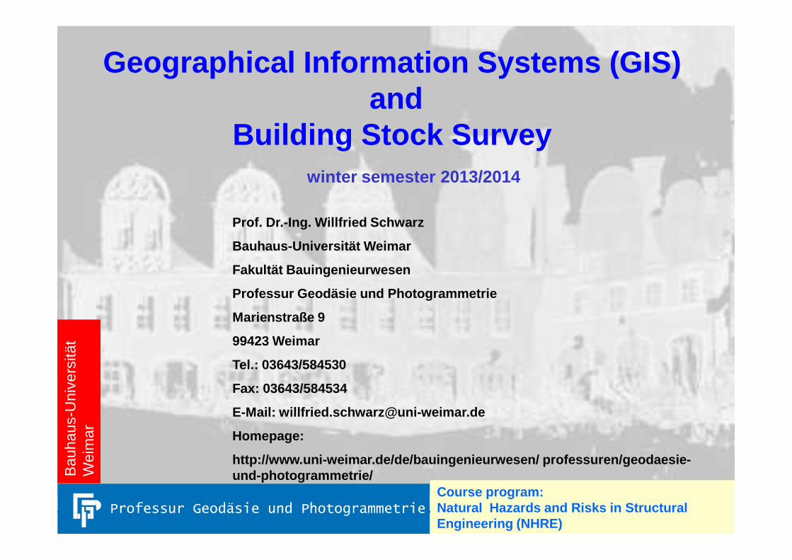
Geographical Information Systems (GIS)and
Building Stock Survey
Prof. Dr.-Ing. Willfried Schwarz
Bauhaus-Universität Weimar
Fakultät Bauingenieurwesen
winter semester 2013/2014
Building Stock Survey WS 2013/2014, Section 1: Fundamentals 1
Professur Geodäsie und Photogrammetrie
Marienstraße 9
99423 Weimar
Tel.: 03643/584530
Fax: 03643/584534
E-Mail: [email protected]
Homepage:
http://www.uni-weimar.de/de/bauingenieurwesen/ prof essuren/geodaesie-und-photogrammetrie/
Course program:Natural Hazards and Risks in Structural Engineering (NHRE)
Bau
haus
-Uni
vers
ität
Wei
mar
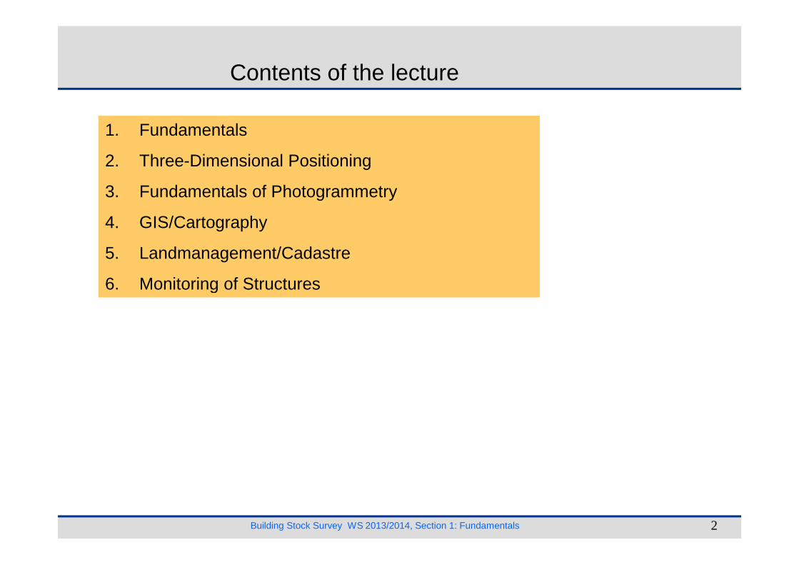
Contents of the lecture
1. Fundamentals
2. Three-Dimensional Positioning
3. Fundamentals of Photogrammetry
4. GIS/Cartography
5. Landmanagement/Cadastre
6. Monitoring of Structures
Building Stock Survey WS 2013/2014, Section 1: Fundamentals 2
6. Monitoring of Structures

Literature[Bauer, M. 2003 ] Vermessung und Ortung mit Satelliten. 5., neubearb. u. erw. Aufl., 62,00 EUR, Wichmann Verlag 2003, ISBN 3-87907-360-0..[Baumann, E. 1999 ] Vermessungskunde, Band 1: Einfache Lagemessung und Nivellement. 5., bearb. u. erw. Aufl., 22,40 EUR, Dümmler Verlag, Bonn 1999,
ISBN 3-427-790444 (nicht mehr lieferbar).[Baumann, E. 1998 ] Vermessungskunde, Band 2: Punktbestimmung nach Höhe und Lage. 6., bearb. u. erw. Aufl., 24,10 EUR, Dümmler Verlag, Bonn 1998,
ISBN 3-427-790568[Deumlich, F.; Staiger 2002 ] Instrumentenkunde der Vermessungstechnik. 9., neubearb. Aufl., 86,00 EUR, Wichmann Verlag 2002, ISBN 3-87907-305-8.[Fröhlich, H. 1995 ] Vermessungstechnische Handgriffe. 4., neubearb. Aufl., 11,20 EUR, Dümmler Verlag 1995 (nicht mehr lieferbar).[Gelhaus, R.; Kolouch, D. 1997 ] Vermessungskunde für Architekten und Bauingenieure. 2. Aufl., 21,00 EUR, Werner Verlag, Düsseldorf 1997, ISBN 3-804-17937-7,
(momentan nicht lieferbar, Verlag plant Nachdruck).[Hennecke, F.; Meckenstock, H.; Pollmer, G. 1993 ] Vermessung im Bauwesen – Grundlagen, Techniken, Beispiele. 11., überarb. u. erw. Aufl., 19,90 EUR,
Dümmler Verlag 1993.[Kahmen, H. 2006 ] Vermessungskunde. 20., neu bearb. Aufl., 49,95 EUR , Gruyter Verlag 2006, ISBN 3-11-018464.[Matthews, V. 2003 ] Vermessungskunde Teil 1. 29., neubearb. Aufl., 24,90 EUR, Teubner Verlag 2003, ISBN 3-519-25252-x.[Matthews, V. 1997 ] Vermessungskunde Teil 2. 17., neubearb. Aufl., 24,90 EUR, Teubner Verlag 1997, ISBN 3-519-15253-3.[NN 1996 ] DIN–Taschenbuch Nr. 111 Vermessungswesen. Neuaufl., Beuth–Verlag 1996, in Bibliothek.[Prasuhn, K.–B. 1995 ] Vermessungstechnik im Gartenbau und Landschaftsbau. 6., neubearb. Aufl., 44,95 EUR, Blackwell Wissenschafts–Verlag 1995,
(nicht mehr im Buchhandel).
Literature
Building Stock Survey WS 2013/2014, Section 1: Fundamentals 3
[Resnik, B.; Bill, R. 2003 ] Vermessungskunde für den Planungs–, Bau– und Umweltbereich. 29,80 EUR, 2. neubearb. u. erw. Aufl., Herbert Wichmann Verlag,Heidelberg 2003, ISBN 3-87907-399-6.
[Witte, B.; Schmidt, H. 2006 ] Vermessungskunde und Grundlagen der Statistik für das Bauwesen. 6., überarb. Aufl., 29,80 EUR, Konra d Wittwer Verlag,Stuttgart 2006, ISBN 3-87907-418-6.
[Konecny, G.; Lehmann, G. 1984 ] Photogrammetrie. 4., neubearb. Aufl., 42,95 EUR, Gruyter Verlag 1984 (nicht mehr im Buchhandel).[Luhmann, Th. 2003 ] Nahbereichsphotogrammetrie; Grundlagen, Methoden und Anwendungen. 88,00 EUR, Herbert Wichmann Verlag, Heidelberg 2003,
2. überarb. Aufl., ISBN 3-87907-398-8.[Regensburger, K. 1990 ] Photogrammetrie – Anwendungen in Wissenschaft und Technik. 1. Aufl. 1990, Wichmann Verlag 1990, in Bibliothek.[Rüger, W u.a. 1987 ] Verfahren und Geräte zur Kartenherstellung. 5., bearb. Aufl., Wichmann Verlag 1987, in Bibliothek.[Schwidefsky, K.; Ackermann, F. 1976 ] Photogrammetrie – Grundlagen, Verfahren. 7., neubearb. u. erw. Aufl., Teubner Verlag 1976, in Bibliothek.[Hake, G.; Grünreich, D. 2002 ] Kartographie. 8., neubearb. u. erw. Aufl., 42,95 EUR, Gruyter Verlag 2002, ISBN 3-11-016404-3.
[Kahmen, H.; Gaig, W. 1988] Surveying. Walter de Gr uyter 1988, ISBN 3-11-008303-5.[Bird, R. G. 1989] EDM TRAVERSES: Measurement, Com putation and Adjustment. Longman Scientific@Technic al, ISBN 0-582-02379-3.
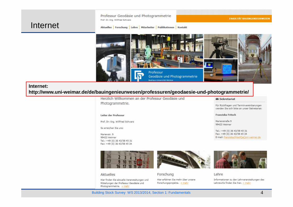
Internet:http://www.uni-weimar.de/de/bauingenieurwesen/profe ssuren/geodaesie-und-photogrammetrie/
Internet
Building Stock Survey WS 2013/2014, Section 1: Fundamentals 4
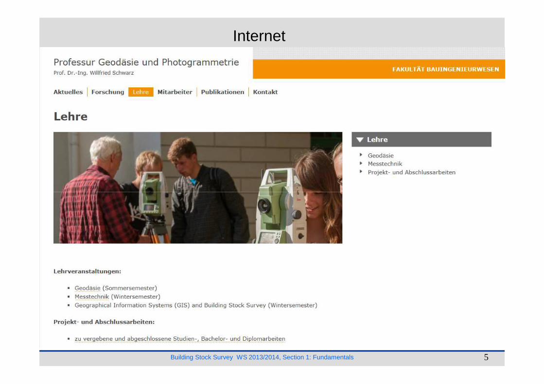
Internet
Building Stock Survey WS 2013/2014, Section 1: Fundamentals 5

Motivation
fallen buildings, e. g. in Haiti � earthquakes 12 of January 2010
Methods of surveying
• Polar Surveys
• Terrestrical Laserscanning
• Photogrammetry
Building Stock Survey WS 2013/2014, Section 1: Fundamentals 6
• Photogrammetry
• …
Ruined cathedral in Port-au-Prince
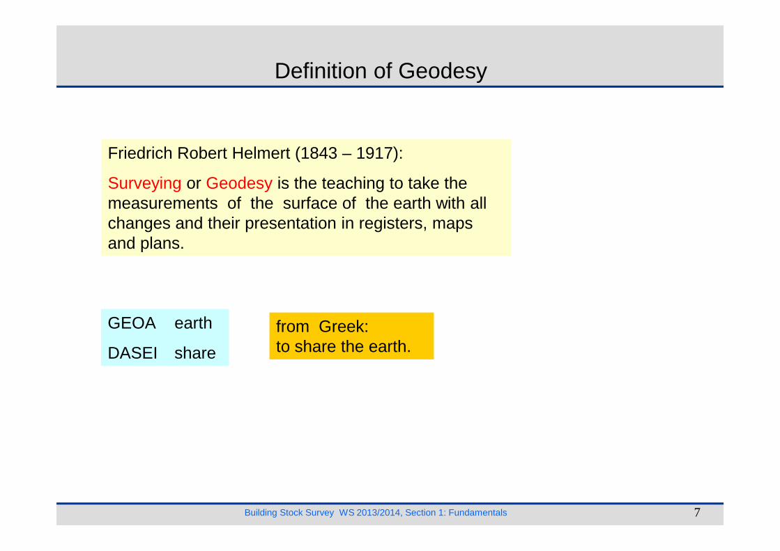
Definition of Geodesy
Friedrich Robert Helmert (1843 – 1917):
Surveying or Geodesy is the teaching to take themeasurements of the surface of the earth with allchanges and their presentation in registers, mapsand plans.
Building Stock Survey WS 2013/2014, Section 1: Fundamentals 7
GEOA earth
DASEI share
from Greek:to share the earth.

History of Surveying
Cheops pyramid near Gizeh, about 2500 before Christ (B. C.)
Babylonia and Egypt
Building Stock Survey WS 2013/2014, Section 1: Fundamentals 8
Quelle: Bachmann (1965)
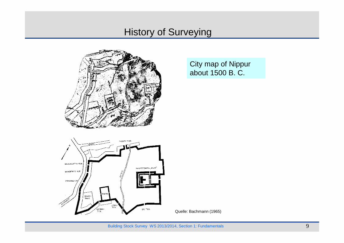
City map of Nippurabout 1500 B. C.
ll
History of Surveying
Building Stock Survey WS 2013/2014, Section 1: Fundamentals 9
Quelle: Bachmann (1965)
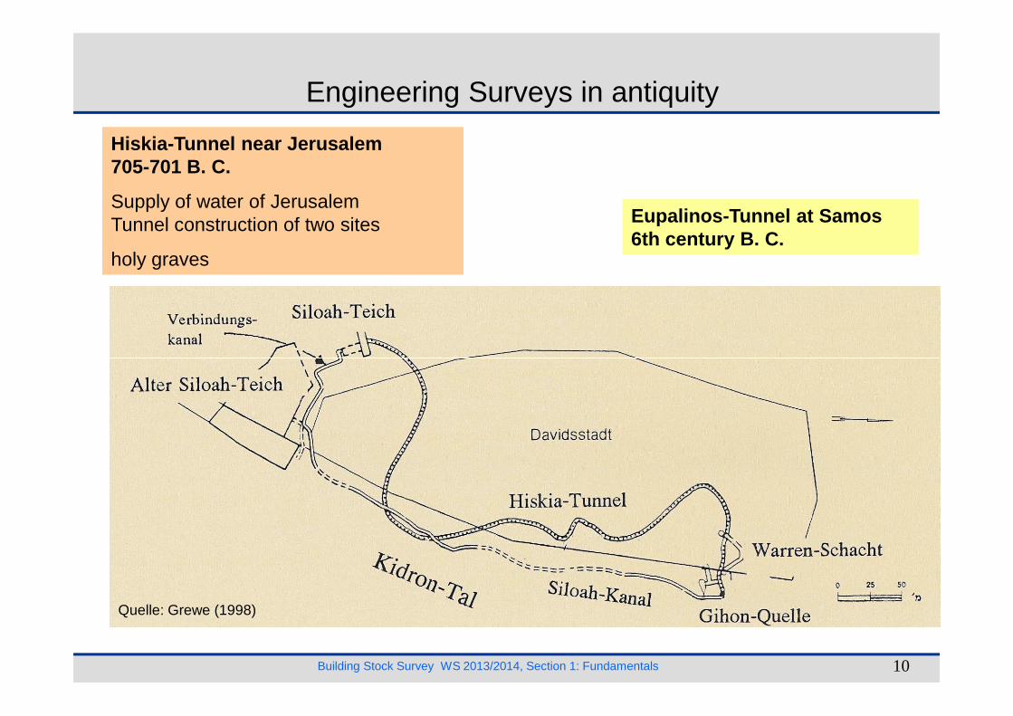
Engineering Surveys in antiquity
Hiskia-Tunnel near Jerusalem705-701 B. C.
Supply of water of JerusalemTunnel construction of two sites
holy graves
Eupalinos-Tunnel at Samos6th century B. C.
Building Stock Survey WS 2013/2014, Section 1: Fundamentals 10
Quelle: Grewe (1998)
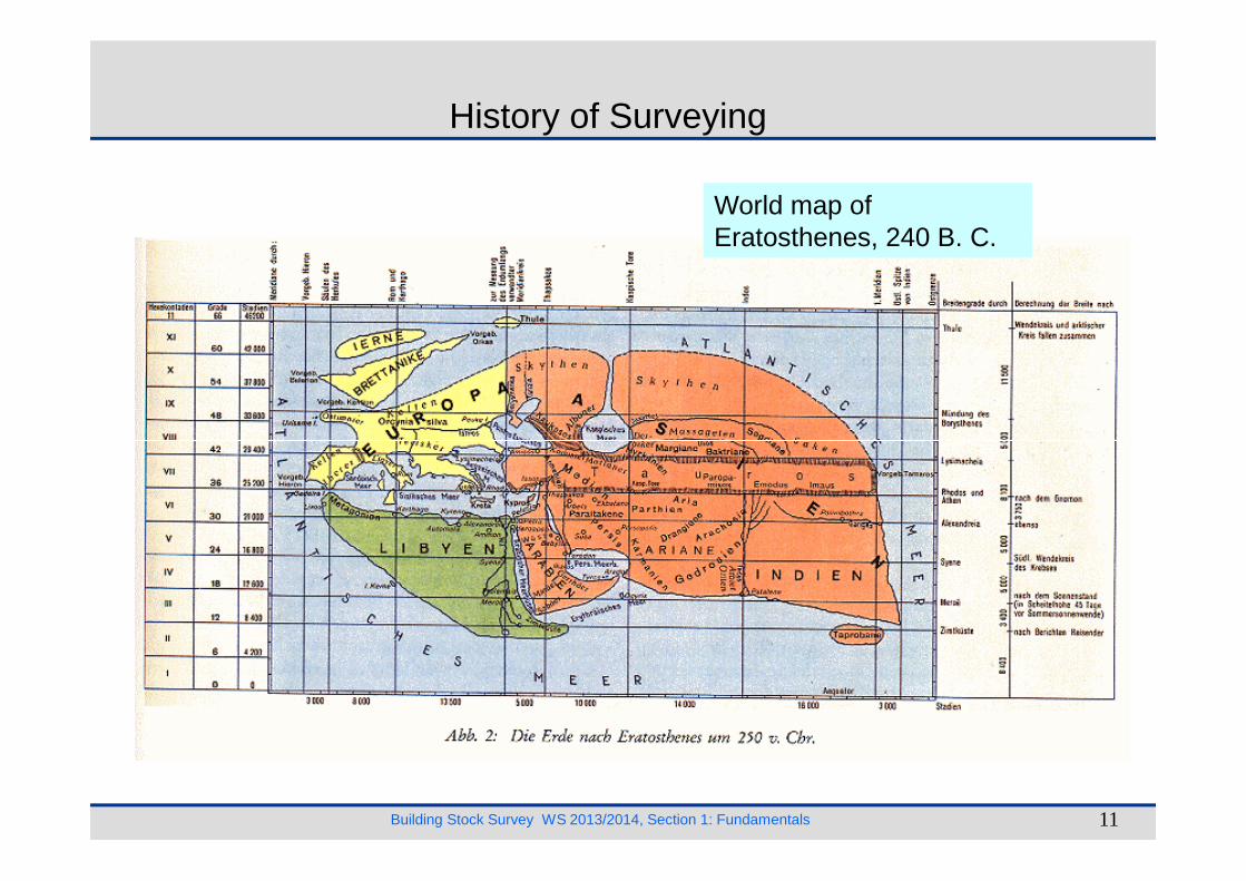
World map ofEratosthenes, 240 B. C.
History of Surveying
Building Stock Survey WS 2013/2014, Section 1: Fundamentals 11
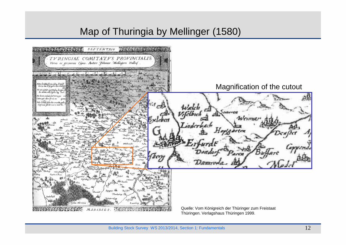
Map of Thuringia by Mellinger (1580)
Magnification of the cutout
Building Stock Survey WS 2013/2014, Section 1: Fundamentals 12
Quelle: Vom Königreich der Thüringer zum Freistaat Thüringen. Verlagshaus Thüringen 1999.

Surveying about 1800
Building Stock Survey WS 2013/2014, Section 1: Fundamentals 13
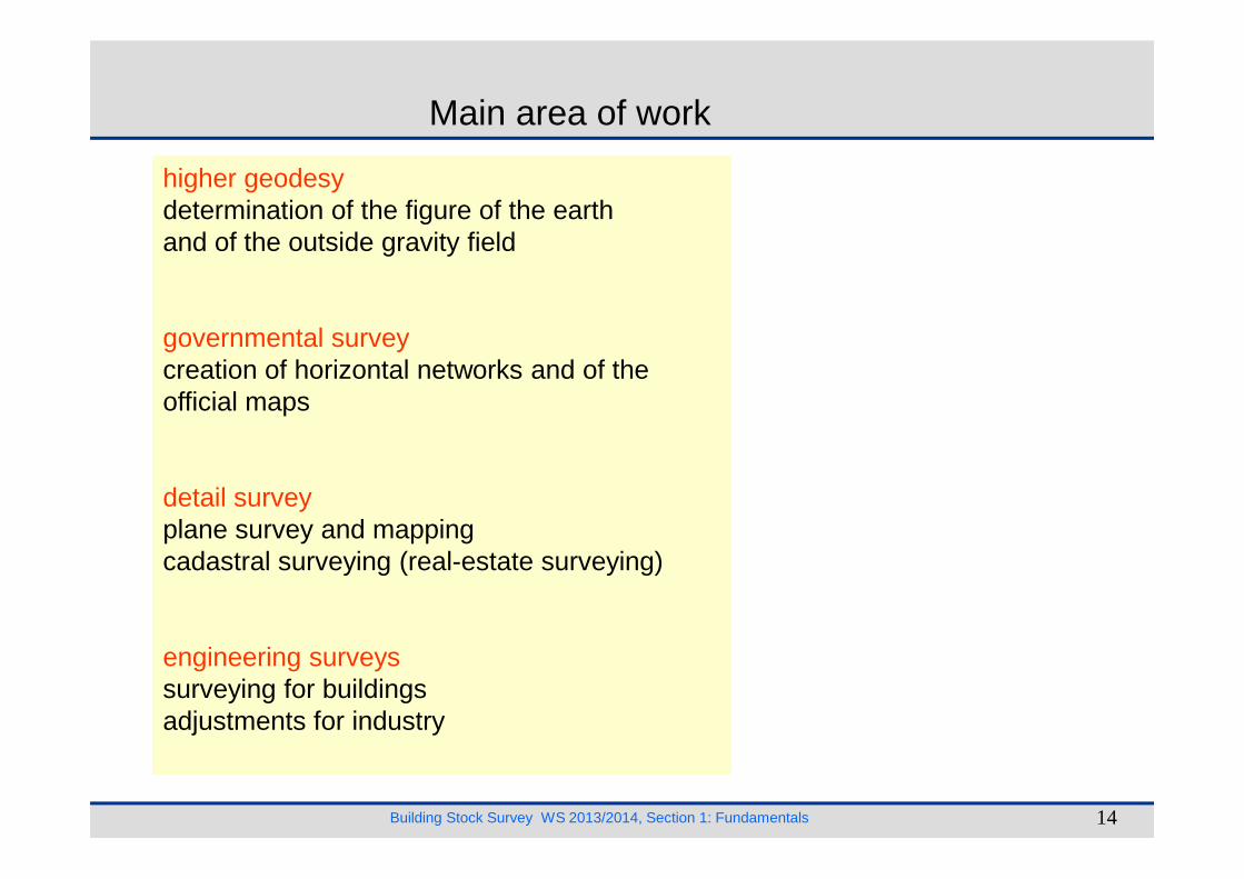
Main area of work
higher geodesydetermination of the figure of the earthand of the outside gravity field
governmental surveycreation of horizontal networks and of the official maps
Building Stock Survey WS 2013/2014, Section 1: Fundamentals 14
detail surveyplane survey and mappingcadastral surveying (real-estate surveying)
engineering surveyssurveying for buildingsadjustments for industry
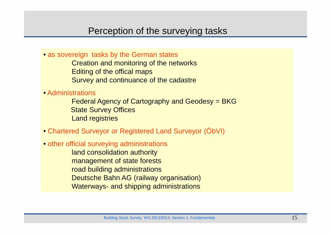
Perception of the surveying tasks
• as sovereign tasks by the German statesCreation and monitoring of the networksEditing of the offical mapsSurvey and continuance of the cadastre
• AdministrationsFederal Agency of Cartography and Geodesy = BKGState Survey OfficesLand registries
Building Stock Survey WS 2013/2014, Section 1: Fundamentals 15
Land registries
• Chartered Surveyor or Registered Land Surveyor (ÖbVI)
• other official surveying administrationsland consolidation authoritymanagement of state forestsroad building administrationsDeutsche Bahn AG (railway organisation)Waterways- and shipping administrations
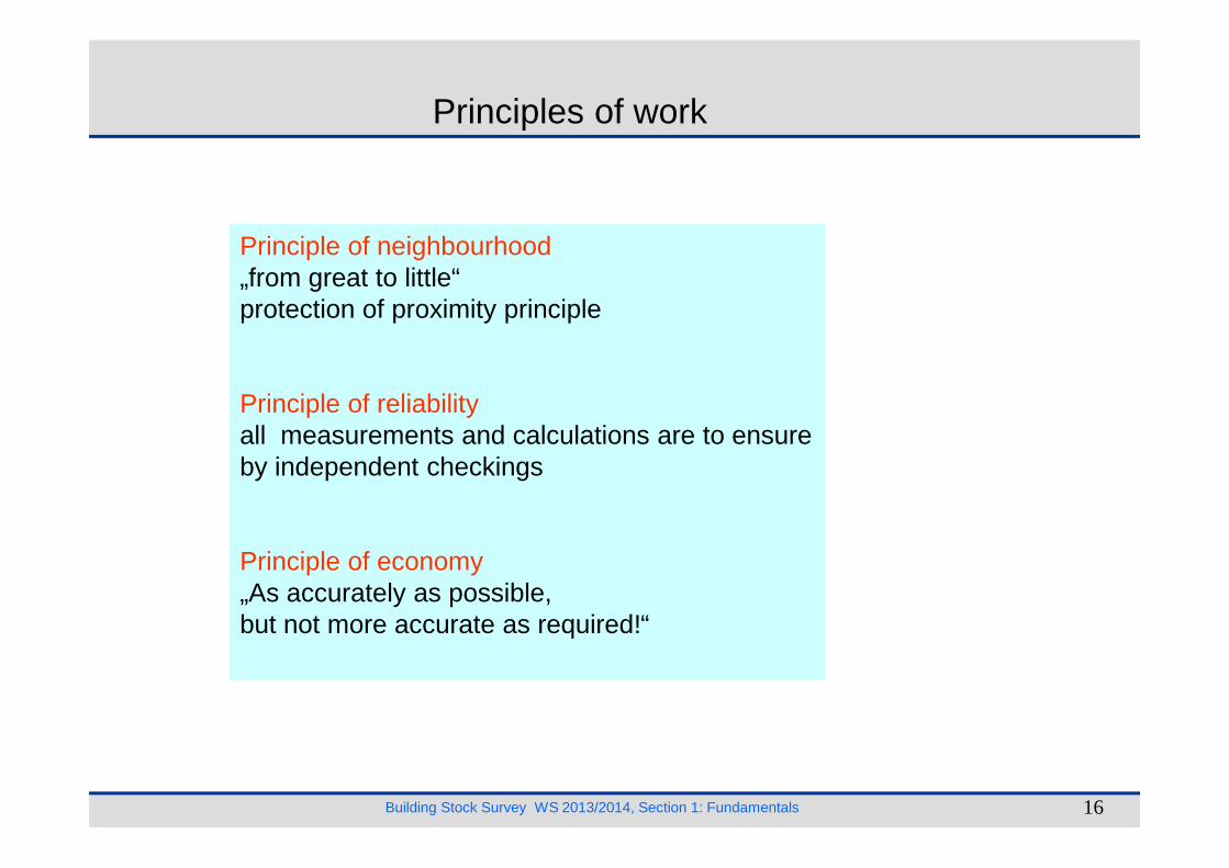
Principles of work
Principle of neighbourhood„from great to little“protection of proximity principle
Principle of reliabilityall measurements and calculations are to ensure
Building Stock Survey WS 2013/2014, Section 1: Fundamentals 16
all measurements and calculations are to ensure by independent checkings
Principle of economy„As accurately as possible,but not more accurate as required!“
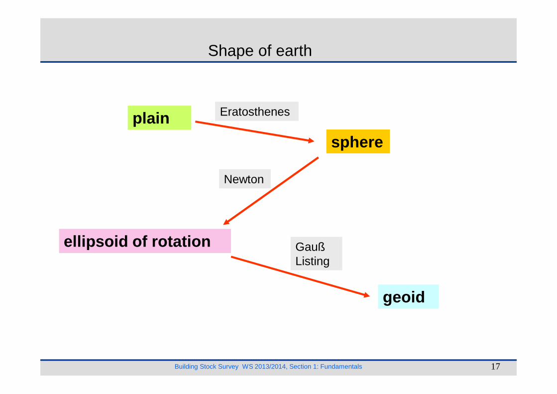
Shape of earth
plain
sphere
Newton
Eratosthenes
Building Stock Survey WS 2013/2014, Section 1: Fundamentals 17
ellipsoid of rotation
geoid
GaußListing
obelisk inAlexandria
well in Syene
bR
αααα
αααα
north pole
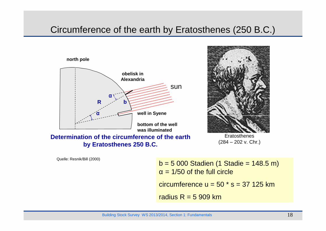
Circumference of the earth by Eratosthenes (250 B.C.)
sun
Building Stock Survey WS 2013/2014, Section 1: Fundamentals 18
Determination of the circumference of the earthby Eratosthenes 250 B.C.
well in Syene
bottom of the well was illuminated
αααα
b = 5 000 Stadien (1 Stadie = 148.5 m)α = 1/50 of the full circle
circumference u = 50 * s = 37 125 km
radius R = 5 909 km
Quelle: Resnik/Bill (2000)
Eratosthenes(284 – 202 v. Chr.)

Geoid
Geoid
The geoid is that equipotential surface which would coincide exactly with the mean ocean surface of the earth, if the oceans were in equilibrium, at rest, and extended through the continents (such as with very narrow canals).
Building Stock Survey WS 2013/2014, Section 1: Fundamentals 19
Quelle: www.google.deli
Quelle: GFZ Potsdam
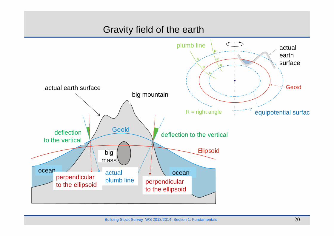
Topographie(Bergmassiv)
Niveaufläche
sichtbareErdober-Fläche
Geoid
Lotlinien
R
R
R
R
RR
R
R = Rechter Winkel
Gravity field of the earth
actual earth surfacebig mountain
plumb line
equipotential surface
actualearthsurface
R = right angle
Building Stock Survey WS 2013/2014, Section 1: Fundamentals 20
Meer Meer
Ellipsoid
GeoidLotabweichungLotabweichung
wahreLotrichtungEllipsoid-
normale Ellipsoid-normale
Stör-masse
ocean ocean
deflection to the verticaldeflectionto the vertical
actualplumb line perpendicular
to the ellipsoid
perpendicularto the ellipsoid
bigmass
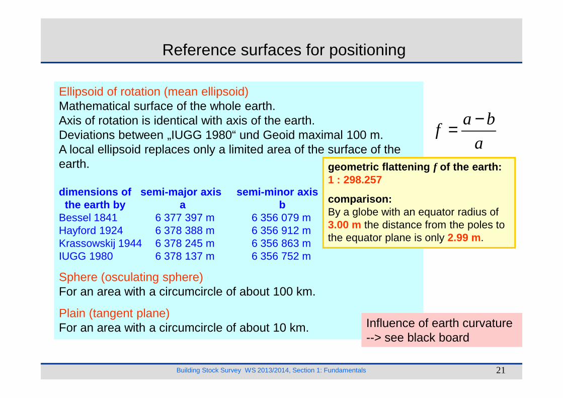
Reference surfaces for positioning
Ellipsoid of rotation (mean ellipsoid)Mathematical surface of the whole earth.Axis of rotation is identical with axis of the earth.Deviations between „IUGG 1980“ und Geoid maximal 100 m.A local ellipsoid replaces only a limited area of the surface of the earth.
dimensions of semi-major axis semi-minor axisthe earth by a b
geometric flattening f of the earth:1 : 298.257
comparison :
a bf
a
−=
Building Stock Survey WS 2013/2014, Section 1: Fundamentals 21
the earth by a bBessel 1841 6 377 397 m 6 356 079 mHayford 1924 6 378 388 m 6 356 912 mKrassowskij 1944 6 378 245 m 6 356 863 mIUGG 1980 6 378 137 m 6 356 752 m
Sphere (osculating sphere)For an area with a circumcircle of about 100 km.
Plain (tangent plane)For an area with a circumcircle of about 10 km.
comparison :By a globe with an equator radius of3.00 m the distance from the poles tothe equator plane is only 2.99 m.
Influence of earth curvature--> see black board

Shape of the earth
-120 m(maximal geoidundulation
plain
sphere
ellipsoid of rotation
geoid
sphere
ellipsoid of rotation
Building Stock Survey WS 2013/2014, Section 1: Fundamentals 22
drawing: without scale!
exercise:
circumference: 40 000 km
rope with a length of40 000 km + 1 m
undulationbest shape of earth:
ellipsoid of rotationwith a
geometric flattening of 1: 300
actualplumb line
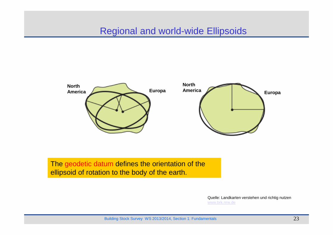
Regional and world-wide Ellipsoids
NorthAmerica
NorthAmericaEuropa Europa
Building Stock Survey WS 2013/2014, Section 1: Fundamentals 23
Quelle: Landkarten verstehen und richtig nutzen www.brk.nrw.de
The geodetic datum defines the orientation of the ellipsoid of rotation to the body of the earth.

Geodetical Reference System ITRSxx/ITRFxx
Global system with an accuracy of a few centimeter
Definition (ITRS.xx)
• 3D-coordinate axisgeocentricaxis
Realization (ITRF.xx)
• measurement methodsVLBI, SLR, GPS and other
• problem: registration
ITRS = International Terrestrial Reference SystemITRF = International Terrestrial Reference Frame
Building Stock Survey WS 2013/2014, Section 1: Fundamentals 24
axis
• Parametersemi-major axis ageometric flattening of the earthGMω
• Reduction of the observationsto the model earthpolar motionsdeformations
• problem: registrationof the changes
e. g. continental drift
One set of coordinates per year or frequently.
plate tectonics:2 cm to 10 cm per year
Quelle: Augath, W.: Beiträge des Vermessungs-wesens zur Ortung und Navigation im Wandel.
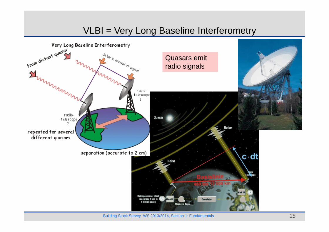
Quasars emit radio signals
VLBI = Very Long Baseline Interferometry
Building Stock Survey WS 2013/2014, Section 1: Fundamentals 25

The geodetic datum defines the orientation of the ellipsoid of rotation to the body of the earth.
Geodetic datum, ETRS89
Current reference system in Germany:
ETRS89 (= European TerrestrialReference-System 1989)
The ERTS89 is a geocentric reference system which is based on the
Building Stock Survey WS 2013/2014, Section 1: Fundamentals 26
The ERTS89 is a geocentric reference system which is based on the global International Terrestrial Reference System (= ITRS).
ellipsoid of rotation: GRS80 = IUGG 1980
fixing: fundamental stations of the global ITRF-Netin Europe, for example in Wettzell
projection: UTM
band size: 6°
Measuring methods: VLBI (= Very Long Baseline Interferometry),SLR (= Satellite-Laser-Ranging) undGPS (= Global Positioning System)
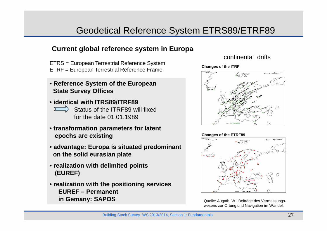
Current global reference system in Europa
• Reference System of the EuropeanState Survey Offices
• identical with ITRS89/ITRF89Status of the ITRF89 will fixedfor the date 01.01.1989
ETRS = European Terrestrial Reference SystemETRF = European Terrestrial Reference Frame
Changes of the ITRF
Geodetical Reference System ETRS89/ETRF89
continental drifts
Building Stock Survey WS 2013/2014, Section 1: Fundamentals 27
for the date 01.01.1989
• transformation parameters for latent epochs are existing
• advantage: Europa is situated predominanton the solid eurasian plate
• realization with delimited points(EUREF)
• realization with the positioning servicesEUREF – Permanentin Gemany: SAPOS Quelle: Augath, W.: Beiträge des Vermessungs-
wesens zur Ortung und Navigation im Wandel.
Changes of the ETRF89

Geodetical Reference System WGS84
Current global Reference System
• WGS84 as Reference System of the GPS-Satellitesand of the points on the earth
• determination of the WGS84-coordinates
a) coordinates of the Tracking-Stations
WGS = World Geodetic System 1984
Building Stock Survey WS 2013/2014, Section 1: Fundamentals 28
a) coordinates of the Tracking-Stations(12 fundamental stations distributed over the earth)
b) GPS-observations + algorithm(inclusive the global gravity field of the earth model)
c) coordinates of the GPS-Satellites
d) absolut positioning with GPS-observations
Quelle: Augath, W.: Beiträge des Vermessungs-wesens zur Ortung und Navigation im Wandel.
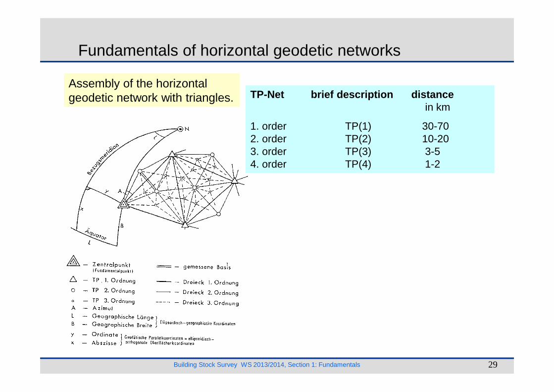
Fundamentals of horizontal geodetic networks
TP-Net brief description distancein km
1. order TP(1) 30-702. order TP(2) 10-203. order TP(3) 3-54. order TP(4) 1-2
Assembly of the horizontal geodetic network with triangles.
Building Stock Survey WS 2013/2014, Section 1: Fundamentals 29
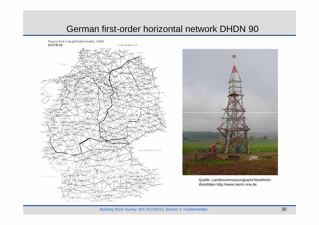
German first-order horizontal network DHDN 90
Building Stock Survey WS 2013/2014, Section 1: Fundamentals 30
Quelle: Landesvermessungsamt Nordrhein-Westfalen http://www.lverm.nrw.de
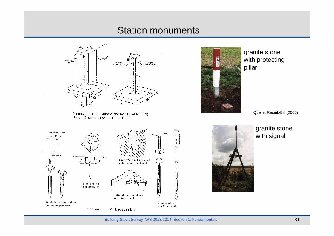
Station monuments
granite stone with protecting pillar
Quelle: Resnik/Bill (2000)
Building Stock Survey WS 2013/2014, Section 1: Fundamentals 31
granite stone with signal
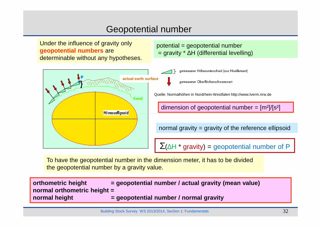
Under the influence of gravity only geopotential numbers are determinable without any hypotheses.
potential = geopotential number= gravity * ∆H (differential levelling)
dimension of geopotential number = [m²]/[s²]
Geopotential number
Quelle: Normalhöhen in Nordrhein-Westfalen http://www.lverm.nrw.de
actual earth surface
Building Stock Survey WS 2013/2014, Section 1: Fundamentals 32
To have the geopotential number in the dimension meter, it has to be divided the geopotential number by a gravity value.
orthometric height = geopotential numb er / actual gravity (mean value)normal orthometric height = normal height = geopotential n umber / normal gravity
normal gravity = gravity of the reference ellipsoid
Σ(∆Η * gravity) = geopotential number of P

Water gauge of Amsterdam and mean sea level (Normal Null)
• 1879: Levelling from the datum point of Amsterdam to Berlin (cue at observatory of Berlin = normal heights point )
• normal null point = 37.000 m under the normal heights point measured along the plumb line
• level surface in the normal null point is be termed as normal null (NN) .
Building Stock Survey WS 2013/2014, Section 1: Fundamentals 33
Quelle: Heyde, H. (1999): Die Höhennullpunkte der amtlichen Kartenwerke europäischer Staaten und ihre Lage zu Normal-Null. Schriftenreihe des Förder-kreises Vermessungstechnisches Museum e. V. Band 28, Dortmund 1999.
be termed as normal null (NN) .
Normal heights point(be lacking)
Reference system for heights
Old german statesBetween 1912 und 1956: German levelling base network 1912 (DHHN12) is because of inhomogeneous calculation methods and of network differences involved absolute insufficient.
1980-1985: renewal of the whole levelling base network first order (DHHN85)
base: normal orthometric height referring to Amsterdam water gauge. The reference system is termed as mean sea level (NN-heights ).
New german statesSince 1979 normal heights of the national levellings base network 1976 (SNN76) referring to the water gauge of Kronstadt near St. Petersburg). The reference system is termed as hight zero (HN-heights ).
Mean sea level of Kronstadt is about 15 cmhigher than the mean sea level of Amsterdam.
Building Stock Survey WS 2013/2014, Section 1: Fundamentals 34
termed as mean sea level (NN-heights ).
Federal Republic of Germany (after 1992)In October 1993 the AdV-plenum (AdV = Working Committee of the Surveying Authorities of the States of the Federal Republic of Germany) decided to establish a uniform reference system for heights for the whole area of the new Federal Republic of Germany. Levellings between the both levelling base networks were taken out. Description: Deutsches Haupthöhennetz 92 (DHHN92). Point of attachment: church Wallenhorst near Osnabrück. The new heights will be calculated as normal heights with measured gravity values . The reference system is termed as normal heights zero (NHN-heights ). Introduction of the NHN-heights in 2002.

Water gauges of the national reference systems in Europe
Reference systems in Europe
Water gauges and reference systems in Europe
Building Stock Survey WS 2013/2014, Section 1: Fundamentals 35
Quelle: Normalhöhen in Nordrhein-Westfalen; http://www.lverm.nrw.de

Example:city church in Weimar, side datum post,east side, 0.7 m above road pavement
217.339 m über NN (Old System)217.404 m über NN (New System/System 1912)217.387 m über NN (56)217.244 m über HN (56)217.238 m über HN (76)217.374 m über NHN (92)
Neighbouring countries:Averaged heights neighbouring countries in relation to NN-system
Water gauges
Building Stock Survey WS 2013/2014, Section 1: Fundamentals 36
217.374 m über NHN (92) relation to NN-system
Denmark -0.09 m (North Sea)Netherlands +0.02 m
Eastern neighbours +0.16 m (Baltic Sea)
France -0.25 m(Mediterranean Sea)
Austria -0.31 mSwitzerland -0.30 m
In the pipeline: United EuropeanLevelling Network (REU)
Bridge near Laufenburg

Classification of the levelling networks:
levelling brief diameternetwork description of the meshes
in km
1. order NivP(1) 30 - 50
2. order NivP(2) 15 - 20
3. order NivP(3) 2 - 10
German first-order levelling network (DHHN 92
Building Stock Survey WS 2013/2014, Section 1: Fundamentals 37
Renewal of the DHHN 2006 - 2011

Monument at the Herder church in Weimar
Touchdown point for the levelling rod:
the highest point of the bolt
Station monuments for geodetic points
Building Stock Survey WS 2013/2014, Section 1: Fundamentals 38
granite stone
bolt in a wall
(diameter:20 mm - 55 mm)
Quelle: Resnik/Bill (2000)
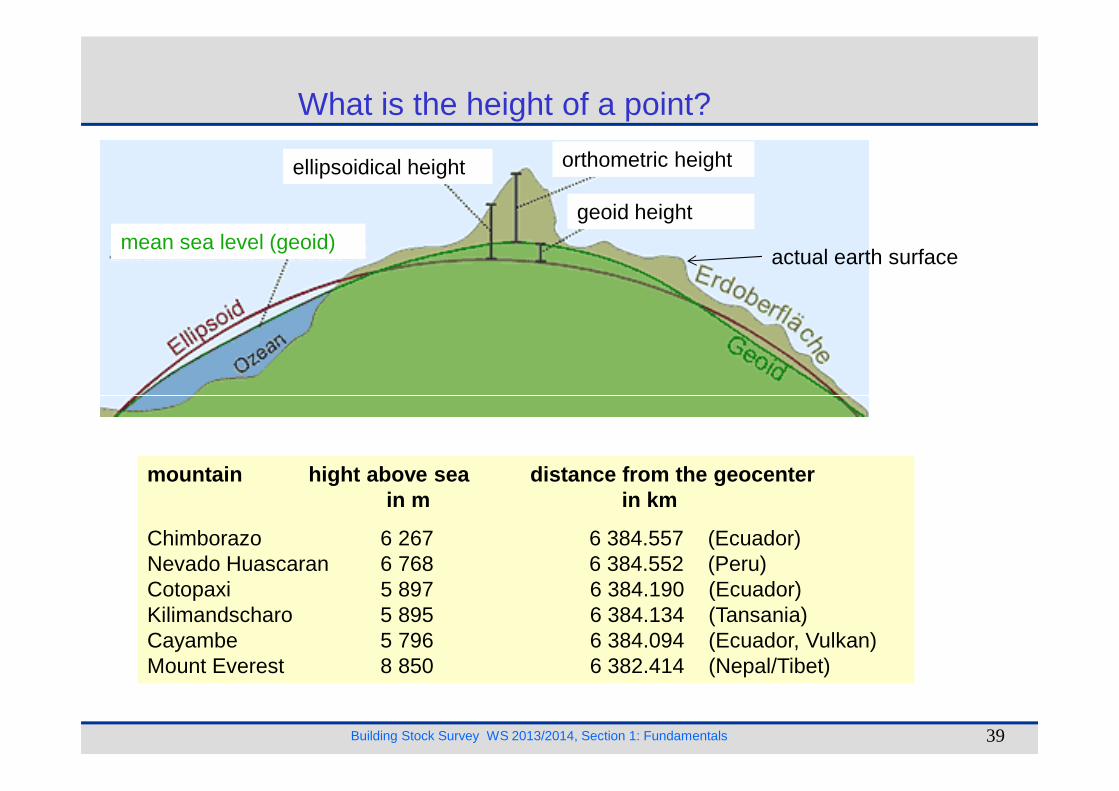
What is the height of a point?
mean sea level (geoid)
orthometric heightellipsoidical height
geoid height
actual earth surface
Building Stock Survey WS 2013/2014, Section 1: Fundamentals 39
mountain hight above sea distance from the geocenterin m in km
Chimborazo 6 267 6 384.557 (Ecuador)Nevado Huascaran 6 768 6 384.552 (Peru)Cotopaxi 5 897 6 384.190 (Ecuador)Kilimandscharo 5 895 6 384.134 (Tansania)Cayambe 5 796 6 384.094 (Ecuador, Vulkan)Mount Everest 8 850 6 382.414 (Nepal/Tibet)
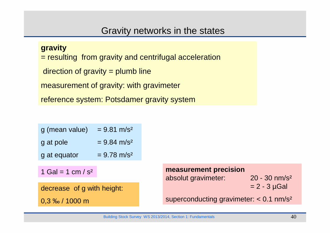
Gravity networks in the states
gravity= resulting from gravity and centrifugal acceleration
direction of gravity = plumb line
measurement of gravity: with gravimeter
reference system: Potsdamer gravity system
Building Stock Survey WS 2013/2014, Section 1: Fundamentals 40
measurement precisionabsolut gravimeter: 20 - 30 nm/s²
= 2 - 3 µGal
superconducting gravimeter: < 0.1 nm/s²
g (mean value) = 9.81 m/s²
g at pole = 9.84 m/s²
g at equator = 9.78 m/s²
1 Gal = 1 cm / s²
decrease of g with height:
0,3 ‰ / 1000 m
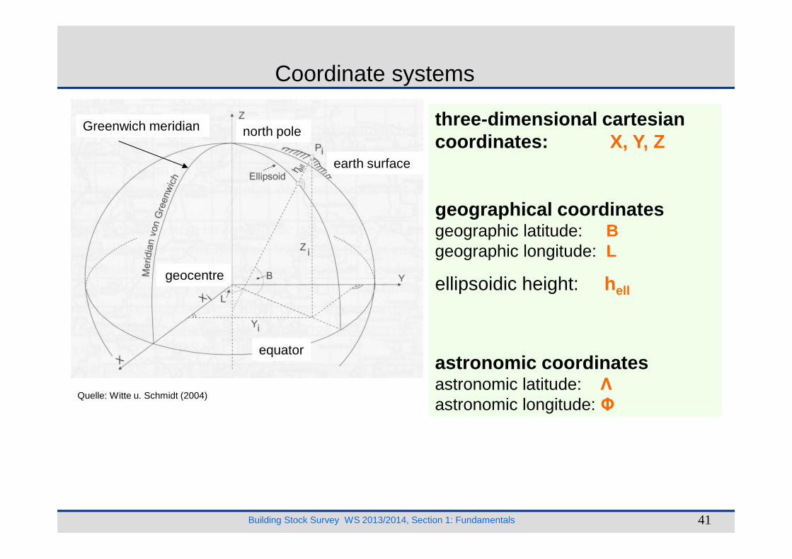
Coordinate systems
three-dimensional cartesian coordinates: X, Y, Z
geographical coordinatesgeographic latitude: Bgeographic longitude: L
ellipsoidic height: h
earth surface
north poleGreenwich meridian
geocentre
Building Stock Survey WS 2013/2014, Section 1: Fundamentals 41
Quelle: Witte u. Schmidt (2004)
ellipsoidic height: hell
astronomic coordinatesastronomic latitude: Λastronomic longitude: Φ
equator
geocentre
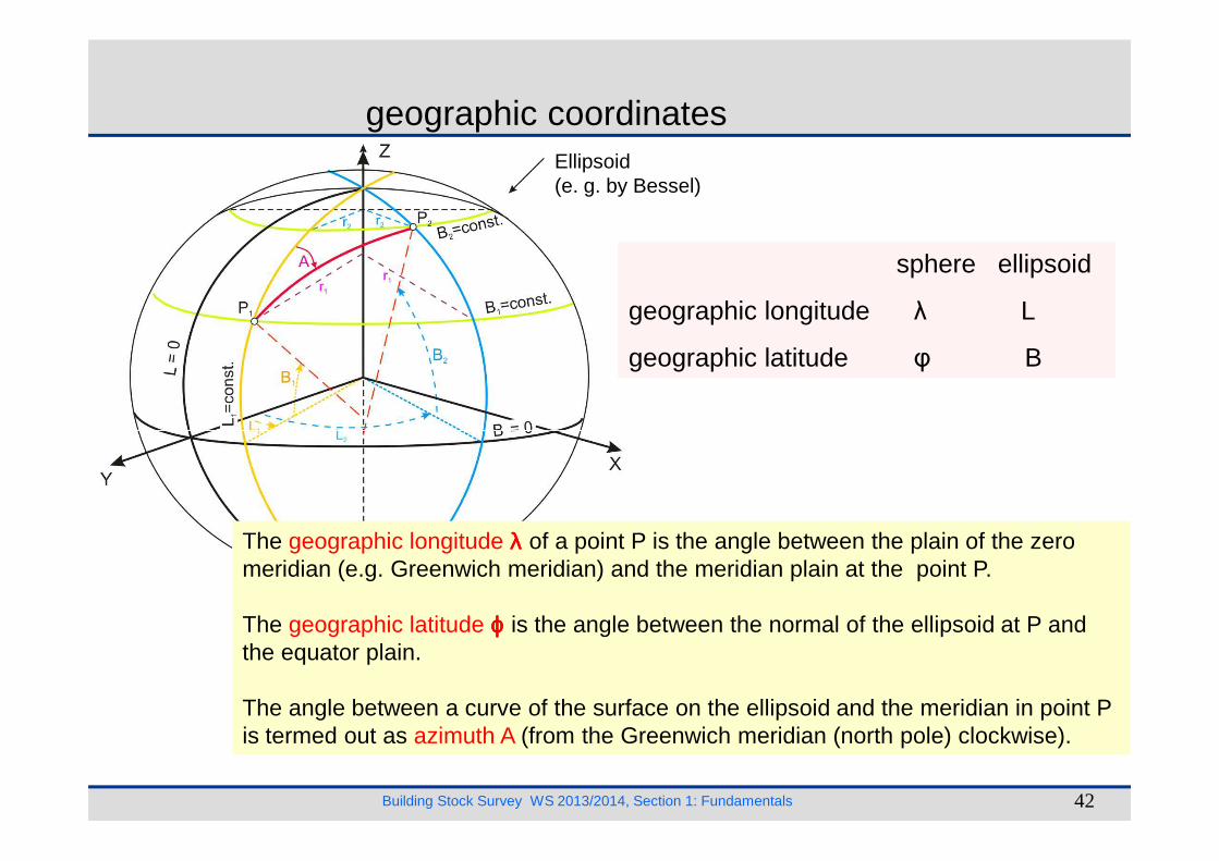
geographic coordinates
sphere ellipsoid
geographic longitude λ L
geographic latitude φ B
Ellipsoid(e. g. by Bessel)
Building Stock Survey WS 2013/2014, Section 1: Fundamentals 42
The geographic longitude λλλλ of a point P is the angle between the plain of the zero meridian (e.g. Greenwich meridian) and the meridian plain at the point P.
The geographic latitude ϕϕϕϕ is the angle between the normal of the ellipsoid at P and the equator plain.
The angle between a curve of the surface on the ellipsoid and the meridian in point P is termed out as azimuth A (from the Greenwich meridian (north pole) clockwise).
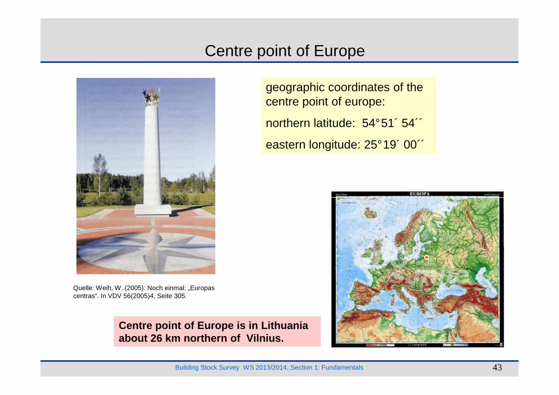
Centre point of Europe
geographic coordinates of the centre point of europe:
northern latitude: 54°51´ 54´´
eastern longitude: 25°19´ 00´´
Building Stock Survey WS 2013/2014, Section 1: Fundamentals 43
Quelle: Weih, W. (2005): Noch einmal: „Europas centras“. In VDV 56(2005)4, Seite 305.
Centre point of Europe is in Lithuania about 26 km northern of Vilnius.
x
P
0
s
x
x
0
y
y
P
polare coordinates (s, ϕϕϕϕ)cartesian coordinates (x, y)
Plain coordinate systemes
ϕϕϕϕ
Building Stock Survey WS 2013/2014, Section 1: Fundamentals 44
0y
x
y0
A
B
tAB
grid bearing (tAB)
∆y
∆x
quadrant I
quadrant IIquadrant III
quadrant IVTable of sign
∆y ∆x Quadrant+ + I+ - II- - III- + IV
tBA

cone projectionazimuthal projection cylinder projection
Projection of the surface of earth in the plainMathematical congruence cannot be obtained because the ellipsoid cannot be mapped onto a plane without distortions.
Building Stock Survey WS 2013/2014, Section 1: Fundamentals 45
cone projectionazimuthal projection cylinder projection
normal position transversal position inclined position
Quelle: Resnik/Bill (2000)
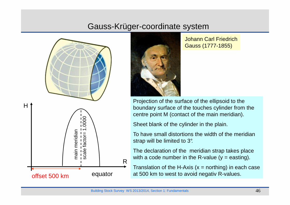
Gauss-Krüger-coordinate system
Projection of the surface of the ellipsoid to the H
Johann Carl Friedrich Gauss (1777-1855)
Building Stock Survey WS 2013/2014, Section 1: Fundamentals 46
Projection of the surface of the ellipsoid to the boundary surface of the touches cylinder from the centre point M (contact of the main meridian).
Sheet blank of the cylinder in the plain.
To have small distortions the width of the meridian strap will be limited to 3°.
The declaration of the meridian strap takes place with a code number in the R-value (y = easting).
Translation of the H-Axis (x = northing) in each case at 500 km to west to avoid negativ R-values.
H
R
equatoroffset 500 km
mai
n m
erid
ian
scal
e fa
ctor
= 1
.000
0
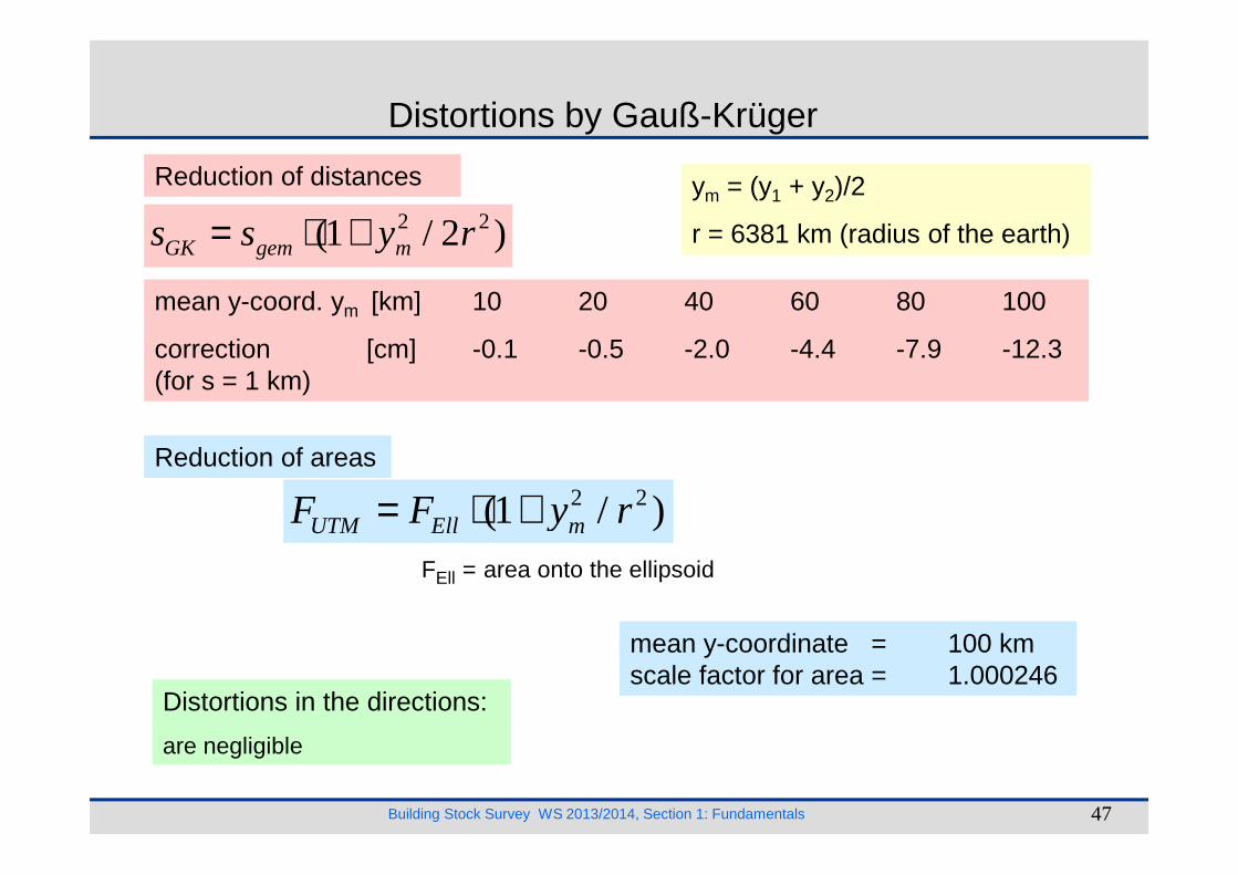
Distortions by Gauß-Krüger
2 2(1 / 2 )GK gem ms s y r= ⋅ +
mean y-coord. ym [km] 10 20 40 60 80 100
correction [cm] -0.1 -0.5 -2.0 -4.4 -7.9 -12.3(for s = 1 km)
ym = (y1 + y2)/2
r = 6381 km (radius of the earth)
Reduction of distances
Building Stock Survey WS 2013/2014, Section 1: Fundamentals 47
Reduction of areas
2 2(1 / )UTM Ell mF F y r= ⋅ +
Distortions in the directions:
are negligible
mean y-coordinate = 100 kmscale factor for area = 1.000246
FEll = area onto the ellipsoid
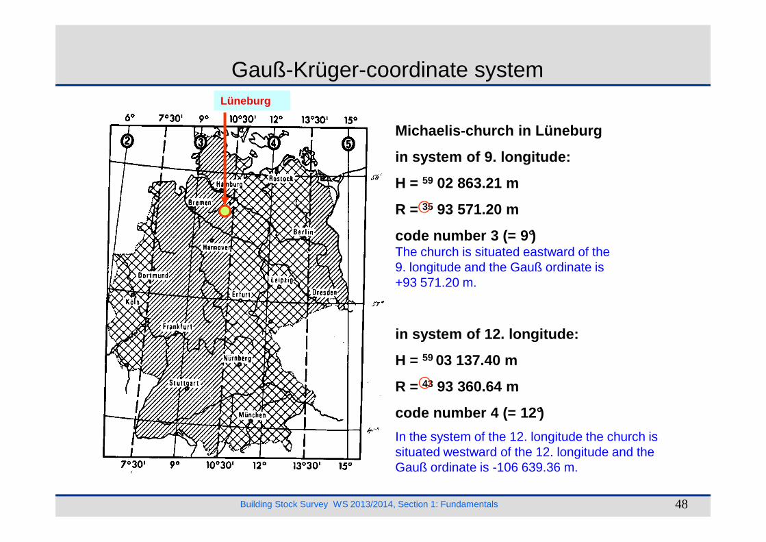
Lüneburg
Michaelis-church in Lüneburg
in system of 9. longitude:
H = 59 02 863.21 m
R = 35 93 571.20 m
code number 3 (= 9°)The church is situated eastward of the 9. longitude and the Gauß ordinate is
Gauß-Krüger-coordinate system
Building Stock Survey WS 2013/2014, Section 1: Fundamentals 48
9. longitude and the Gauß ordinate is +93 571.20 m.
in system of 12. longitude:
H = 59 03 137.40 m
R = 43 93 360.64 m
code number 4 (= 12°)
In the system of the 12. longitude the church is situated westward of the 12. longitude and the Gauß ordinate is -106 639.36 m.

Universal-Transversale-Merkator-system (UTM-system)
Projection of the surface of the ellipsoid to the boundary surface of the cylinder from the centre
N
Ecent
ral m
erid
ian
scal
e fa
ctor
= 0
,999
6
Gerhard Kremercalled:
Gerardus Mercator(1512-1594)
lines of true scale
Building Stock Survey WS 2013/2014, Section 1: Fundamentals 49
boundary surface of the cylinder from the centre point M (contact of the two intersection meridians).
Scale factor in the central meridian = 0.999 600.
Sheet blank of the cylinder into the plain.
The width of the meridian strap is be limited to 6°.
The declaration of the meridian strap takes place with the number of zone in the E-value (y).
Translation of the N-Axis (x) in each case at500 km to west to avoid negativ E-values (y).
E
equatoroffset 500 km
UTM-Zonenbildung

Distortions by UTM
2 20.9996 (1 / 2 )UTM gem ms s y r= ⋅ ⋅ +
mean y-ordinate ym [km] 10 40 80 120 160 200
correktion [cm] +39.9 +38.0 +32.1 +22.3 +8.6 -9.1(für s = 1 km)
ym = (y1 + y2)/2
r = 6381 km (earth radius)
UTM-StreckenreduktionUTM-Reduction of distances
Building Stock Survey WS 2013/2014, Section 1: Fundamentals 50
UTM-Reduction of areas2 2 20.9996 (1 / )UTM Ell mF F y r= ⋅ ⋅ +
Distortions in the directions:
are negligible
mean y-ordinate = 0 kmscale factor for areas = 0.999 200 160
FEll = area on the ellipsoid

Reductions of distances in GK- and UTM-Projection
Building Stock Survey WS 2013/2014, Section 1: Fundamentals 51
Quelle: Europäisches Terrestrisches Re-ferenzsystem 1989. Landesamt für Ver-messung und Geoinformation, Erfurt 2007.

GK-system UTM-systemwidth of zones 3° 6°
zones in Germany 2, 3, 4, 5 31, 32, 33
central meridian 6°, 9°, 12°, 15° 3°, 9°, 15°
cylinder touch cylinder intersection cylinder
scale factor 1,0000 0,9996
ellipsoid Bessel GRS80
Differences between GK- and UTM-system
Building Stock Survey WS 2013/2014, Section 1: Fundamentals 52
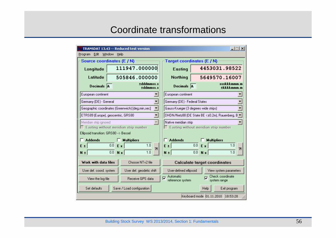
Coordinates of the well on the market place in Weim ar
coordinate system geod.Datum Long./R/East Lati./H/North
geograhical coordinates WGS84 11°19´ 47´´ 50°58´ 46´´GK-System Potsdam-Datum 44 53 032 m 56 4 9 570 mUTM-System ETRS89 32:663 539 m 56 50 123 m
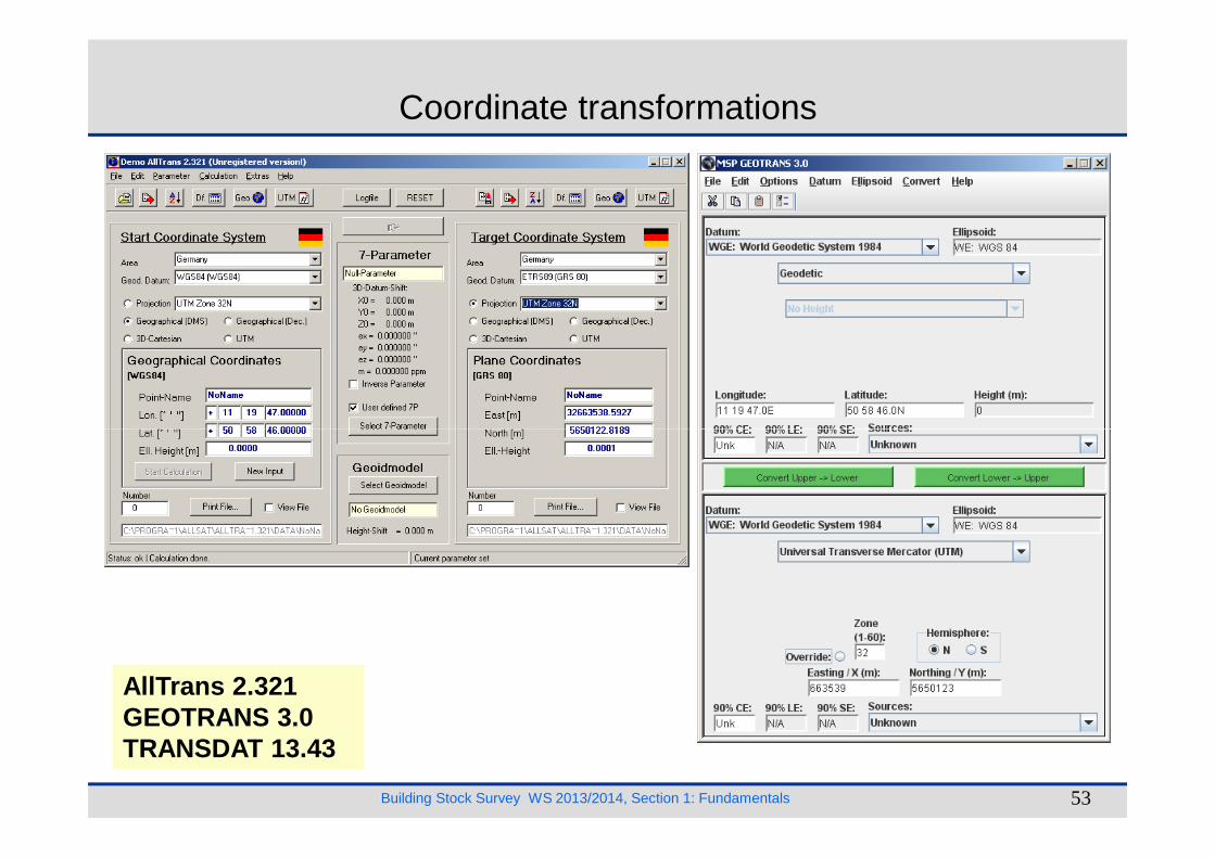
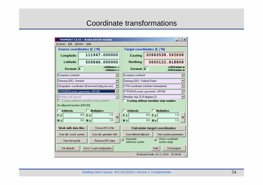
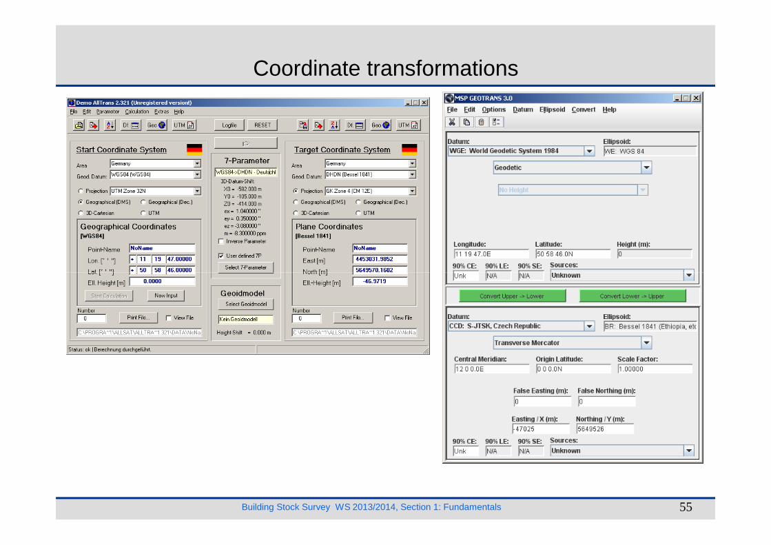
Coordinate transformations
Building Stock Survey WS 2013/2014, Section 1: Fundamentals 53
AllTrans 2.321GEOTRANS 3.0TRANSDAT 13.43
Coordinate transformations
Building Stock Survey WS 2013/2014, Section 1: Fundamentals 54
Coordinate transformations
Building Stock Survey WS 2013/2014, Section 1: Fundamentals 55
Coordinate transformations
Building Stock Survey WS 2013/2014, Section 1: Fundamentals 56
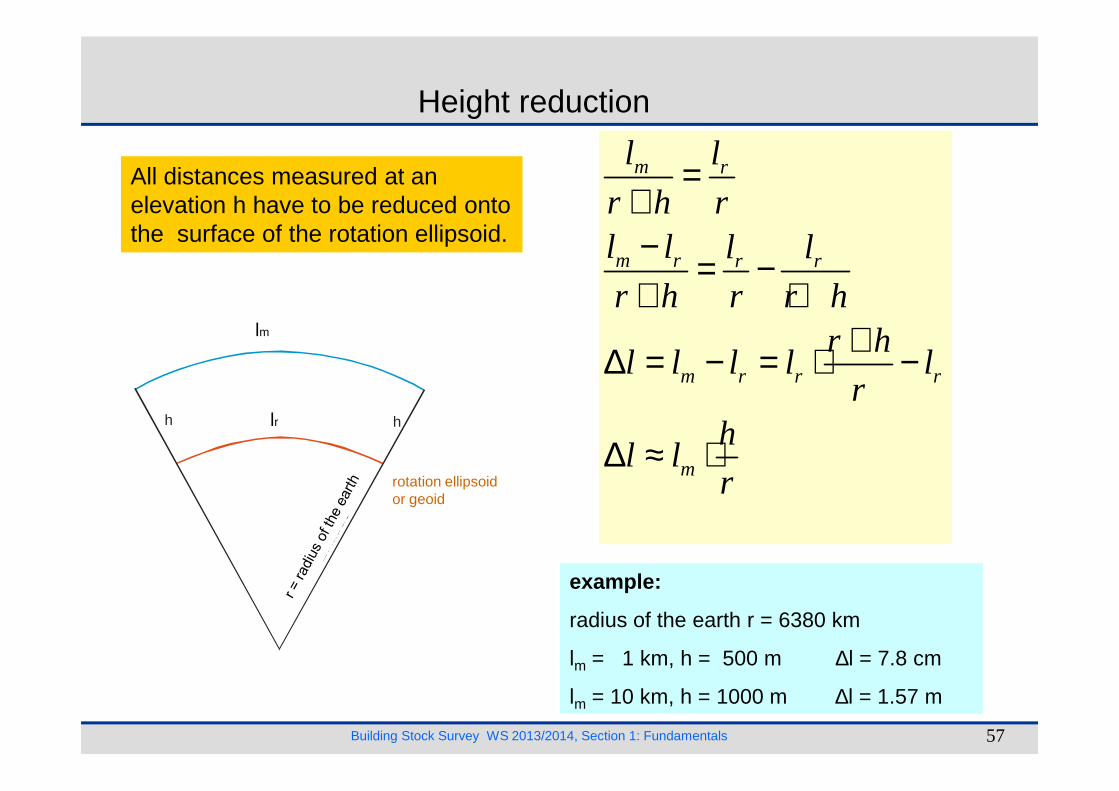
Height reduction
All distances measured at an elevation h have to be reduced onto the surface of the rotation ellipsoid.
lgem
m r
m r r r
m r r r
l l
r h rl l l l
r h r r hr h
l l l l lr
=+− = −+ +
+∆ = − = ⋅ −lm
Building Stock Survey WS 2013/2014, Section 1: Fundamentals 57
Rotationsellipsoidbzw. Geoid
r = E
rdra
diu
s
h hlred
example:
radius of the earth r = 6380 km
lm = 1 km, h = 500 m ∆l = 7.8 cm
lm = 10 km, h = 1000 m ∆l = 1.57 m
m
rh
l lr
∆ ≈ ⋅lr
rotation ellipsoid or geoid
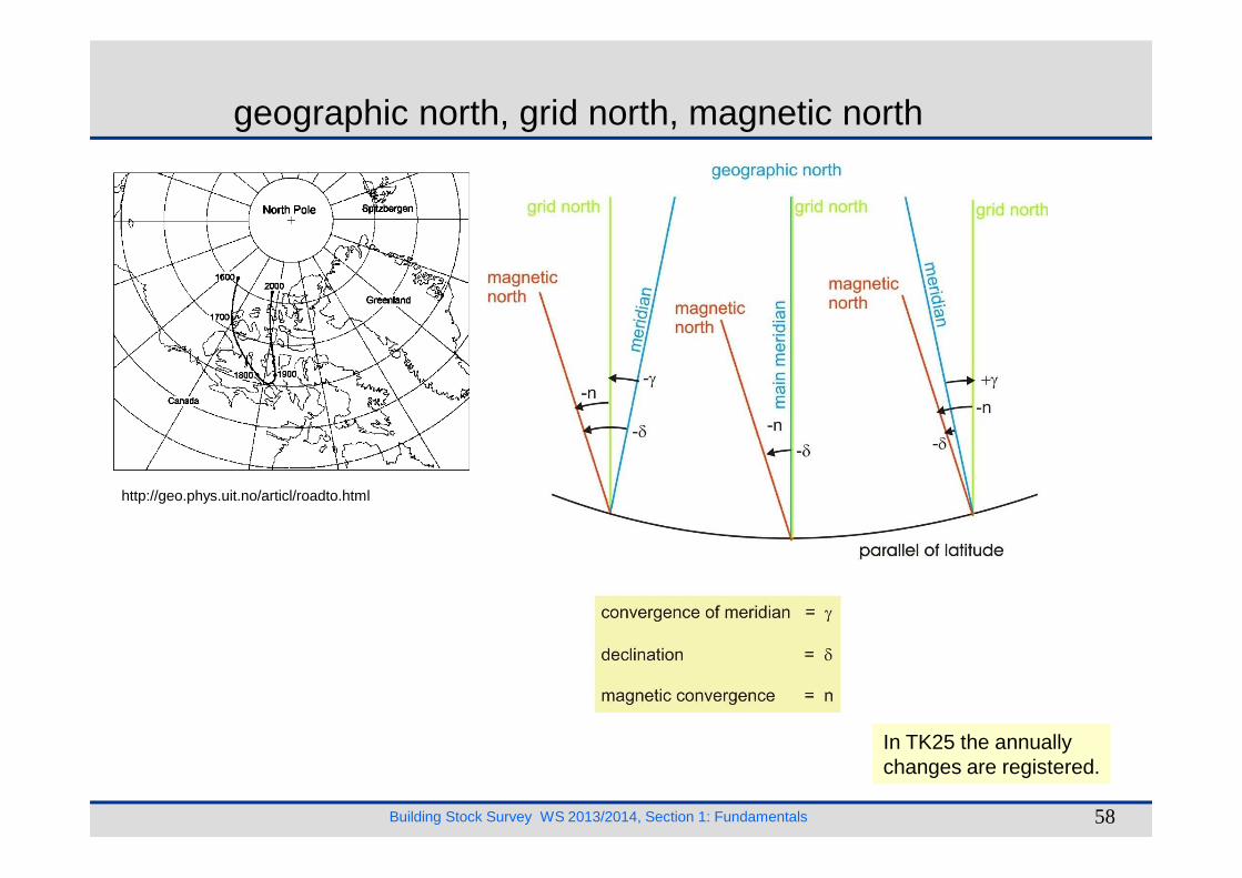
geographic north, grid north, magnetic north
Building Stock Survey WS 2013/2014, Section 1: Fundamentals 58
In TK25 the annually changes are registered.
http://geo.phys.uit.no/articl/roadto.html
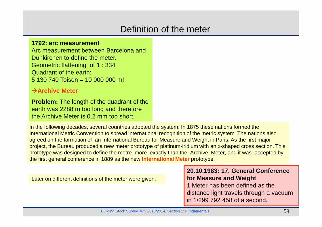
Definition of the meter1792: arc measurementArc measurement between Barcelona and Dünkirchen to define the meter.Geometric flattening of 1 : 334Quadrant of the earth:5 130 740 Toisen = 10 000 000 m!
�Archive Meter
Problem: The length of the quadrant of the earth was 2288 m too long and therefore the Archive Meter is 0.2 mm too short.
Building Stock Survey WS 2013/2014, Section 1: Fundamentals 59
the Archive Meter is 0.2 mm too short.
20.10.1983: 17. General Conference for Measure and Weight1 Meter has been defined as the distance light travels through a vacuum in 1/299 792 458 of a second.
In the following decades, several countries adopted the system. In 1875 these nations formed the International Metric Convention to spread international recognition of the metric system. The nations also agreed on the formation of an International Bureau for Measure and Weight in Paris. As the first major project, the Bureau produced a new meter prototype of platinum-iridium with an x-shaped cross section. This prototype was designed to define the metre more exactly than the Archive Meter, and it was accepted by the first general conference in 1889 as the new International Meter prototype.
Later on different definitions of the meter were given.
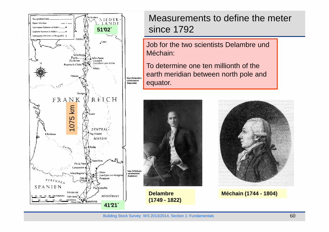
Measurements to define the metersince 1792
Job for the two scientists Delambre und Méchain:
To determine one ten millionth of the earth meridian between north pole and equator.
1075
km
51°02´
Building Stock Survey WS 2013/2014, Section 1: Fundamentals 60
Delambre(1749 - 1822)
Méchain (1744 - 1804)
1075
km
41°21´
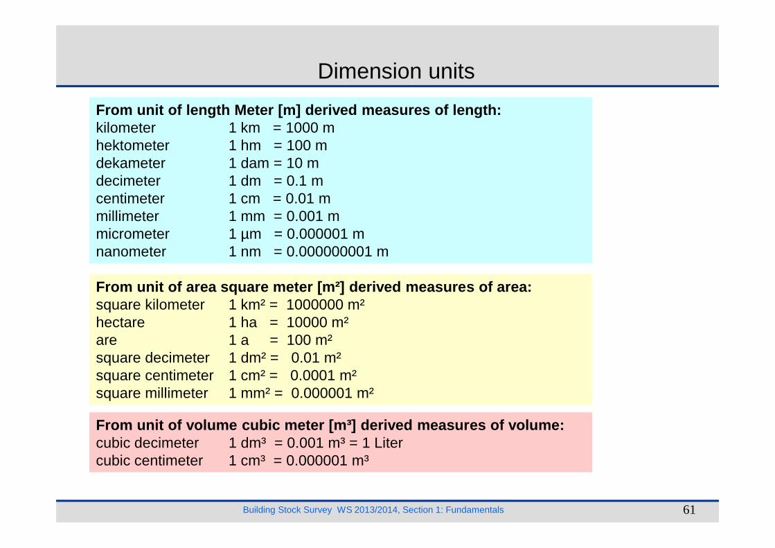
Dimension units
From unit of length Meter [m] derived measures of l ength:kilometer 1 km = 1000 mhektometer 1 hm = 100 mdekameter 1 dam = 10 mdecimeter 1 dm = 0.1 mcentimeter 1 cm = 0.01 mmillimeter 1 mm = 0.001 mmicrometer 1 µm = 0.000001 mnanometer 1 nm = 0.000000001 m
Building Stock Survey WS 2013/2014, Section 1: Fundamentals 61
From unit of area square meter [m²] derived measure s of area:square kilometer 1 km² = 1000000 m²hectare 1 ha = 10000 m²are 1 a = 100 m²square decimeter 1 dm² = 0.01 m²square centimeter 1 cm² = 0.0001 m²square millimeter 1 mm² = 0.000001 m²
From unit of volume cubic meter [m³] derived measur es of volume:cubic decimeter 1 dm³ = 0.001 m³ = 1 Litercubic centimeter 1 cm³ = 0.000001 m³
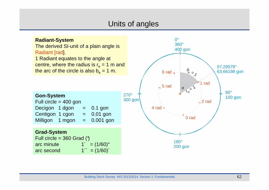
Units of angles
Radiant-SystemThe derived SI-unit of a plain angle is Radiant [rad].1 Radiant equates to the angle at centre, where the radius is re = 1 m and the arc of the circle is also be = 1 m.
Gon-System
0°360°400 gon
90°100 gon270°
1 rad5 rad
6 rad57,29578°63,66198 gon
αr = 1
e
b= 1e
Building Stock Survey WS 2013/2014, Section 1: Fundamentals 62
Gon-SystemFull circle = 400 gonDecigon 1 dgon = 0.1 gonCentigon 1 cgon = 0.01 gonMilligon 1 mgon = 0.001 gon
Grad-SystemFull circle = 360 Grad (°)arc minute 1´ = (1/60)°arc second 1´´ = (1/60)´
100 gon
180°200 gon
270°300 gon 2 rad
3 rad
4 rad

Conversion from Grad to gon
1 gon = 0.9°
Example:
36° 12´ 37´´ = ? gon
Building Stock Survey WS 2013/2014, Section 1: Fundamentals 63
36° 12´ 37´´ = ? gon
36°+ (12 + (37/60))/60
= 36.210278°
= 40.2336 gon
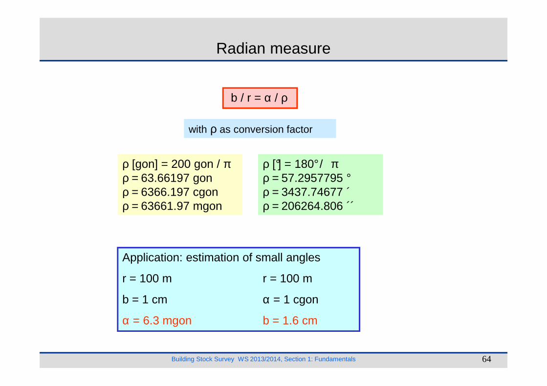
Radian measure
b / r = α / ρ
ρ [gon] = 200 gon / πρ = 63.66197 gonρ = 6366.197 cgon
ρ [°] = 180°/ πρ = 57.2957795 °ρ = 3437.74677 ´
with ρ as conversion factor
Building Stock Survey WS 2013/2014, Section 1: Fundamentals 64
ρ = 6366.197 cgonρ = 63661.97 mgon
ρ = 3437.74677 ´ρ = 206264.806 ´´
Application: estimation of small angles
r = 100 m r = 100 m
b = 1 cm α = 1 cgon
α = 6.3 mgon b = 1.6 cm
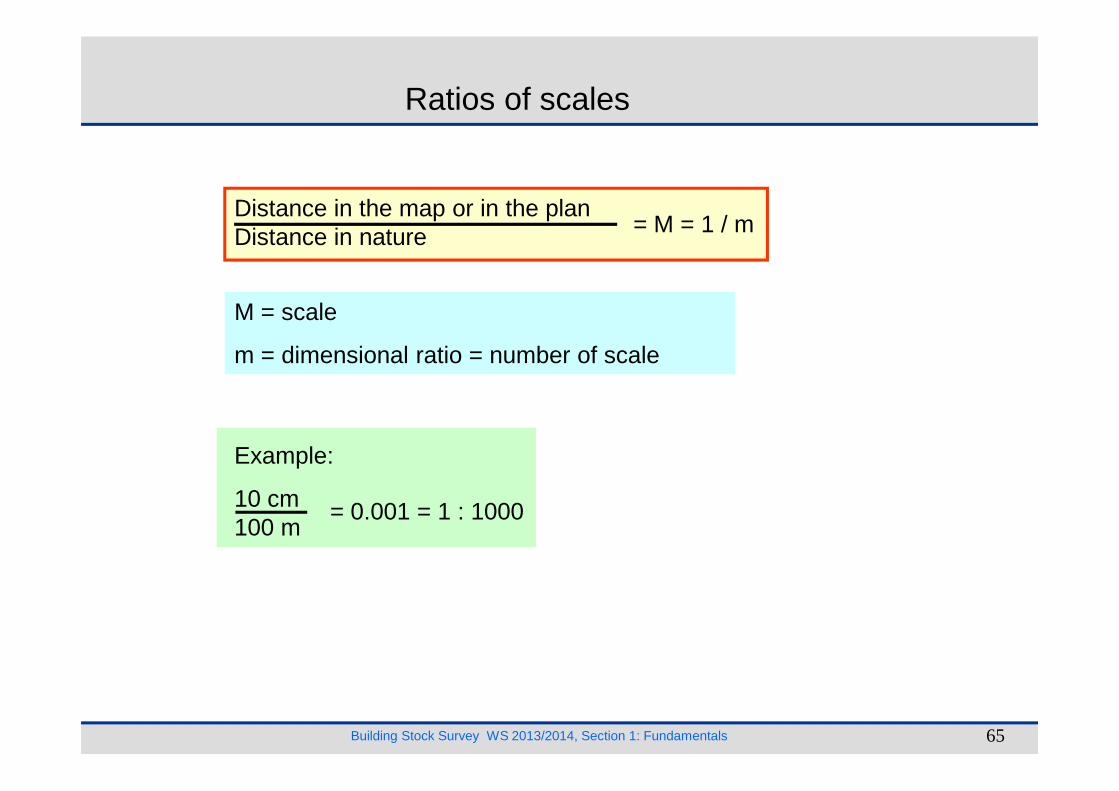
Ratios of scales
Distance in the map or in the plan Distance in nature = M = 1 / m
M = scale
m = dimensional ratio = number of scale
Building Stock Survey WS 2013/2014, Section 1: Fundamentals 65
Example:
10 cm100 m
= 0.001 = 1 : 1000
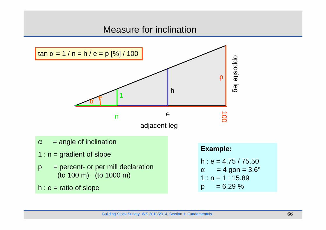
Measure for inclination
opposite leg
100
p
h
en
1αααα
tan α = 1 / n = h / e = p [%] / 100
Building Stock Survey WS 2013/2014, Section 1: Fundamentals 66
adjacent leg
100en
α = angle of inclination
1 : n = gradient of slope
p = percent- or per mill declaration(to 100 m) (to 1000 m)
h : e = ratio of slope
Example:
h : e = 4.75 / 75.50α = 4 gon = 3.6°1 : n = 1 : 15.89p = 6.29 %