building nation forest carbon monitoring capabilities
TRANSCRIPT

Global Observation of Forest and Land Cover Dynamics
Building nation forest carbon monitoring capabilities using the GOFC REDD sourcebook
GOFC-GOLD Land Cover Office, FSU Jena, Germanywww.gofc-gold.uni-jena.de
GLOBAL TERRESTRIAL OBSERVING SYSTEM

Pecora 17
Trajectory of Global Fossil Fuel Emissions
1990 1995 2000 2005 2010
2 (
y)
5
6
7
8
9
10Actual emissions: CDIACActual emissions: EIA450ppm stabilisation650ppm stabilisationA1FI A1B A1T A2 B1 B2
50-year constant growth rates to 2050
B1 1.1%,A1B 1.7%,A2 1.8% A1FI 2.4%
2006
Observed2000-2006 3.3%
Raupach et al. 2007, PNAS; Canadell et al 2007, PNAS
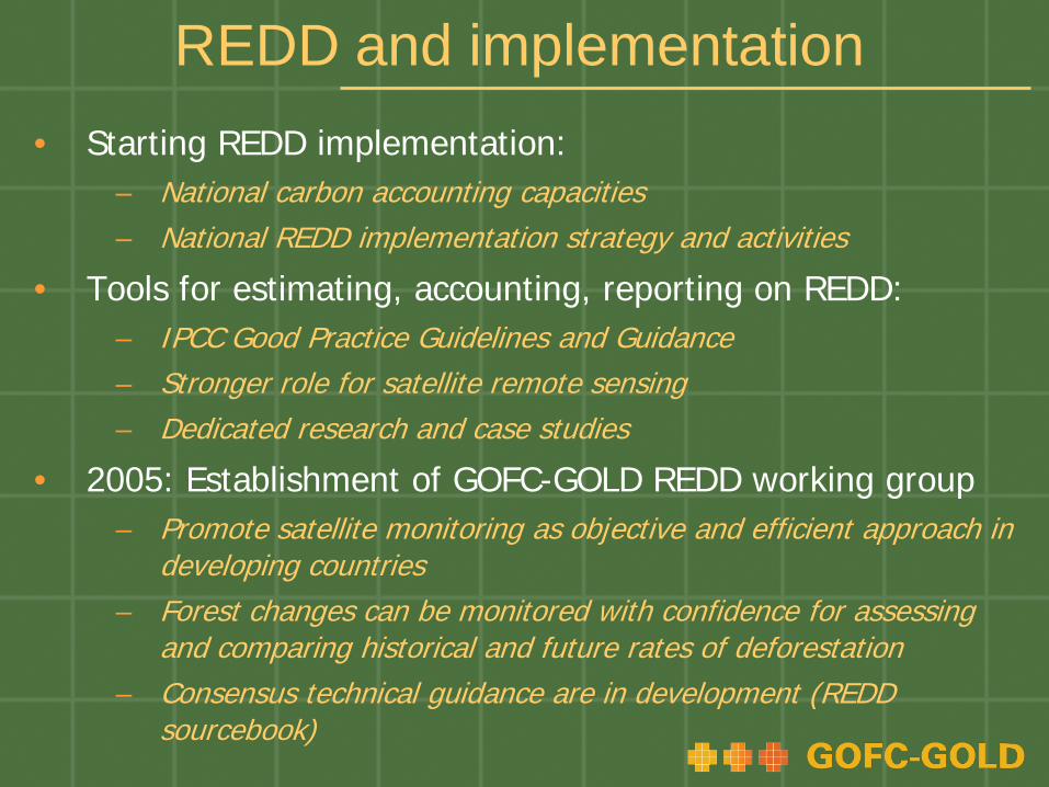
REDD and implementation • Starting REDD implementation:
– National carbon accounting capacities– National REDD implementation strategy and activities
• Tools for estimating, accounting, reporting on REDD:– IPCC Good Practice Guidelines and Guidance– Stronger role for satellite remote sensing– Dedicated research and case studies
• 2005: Establishment of GOFC-GOLD REDD working group – Promote satellite monitoring as objective and efficient approach in
developing countries– Forest changes can be monitored with confidence for assessing
and comparing historical and future rates of deforestation– Consensus technical guidance are in development (REDD
sourcebook)

Earth observation contribution to UNFCCC-REDD
2005
GOFC-GOLD working group est.
COP11Montreal
GTOSsubmission I
Subm. of view by parties I
1st GOFC-GOLD workshop
ED/GOFCSBSTA
side event
SBSTA 24
1st SBSTA workshop
GTOS/GOFCreport
COP12Nairobi
ESA/GOFCSide event +
booth
Subm. of view by parties II
2nd SBSTA workshop
SBSTA 26
2nd GOFC-GOLD workshop
ESA/GOFC-GOLD
side eventGTOS
submission II
COP13Bali
1.+ 2. REDD Sourcebook draft
WINROCK/GOFC-GOLDside event
2006 2007 2008 2009
Subm. of view by parties III + IV
GTOSsubmission III
SBSTA 28
GTOS/GOFC-GOLD
side event
3rd GOFC-GOLD workshop
COP14Poznan
3rd SBSTA workshop
SBSTA 30
PNG / GOFC-GOLDside event
Informal REDDworkshop

Sourcebook version COP13.2
http://www.gofc-gold.uni-jena.de/redd
Version COP13.2 includes: Edits from comments received through
international review process Updated sections, i.e. on fire monitoring, accuracy
assessment, national forest inventories …
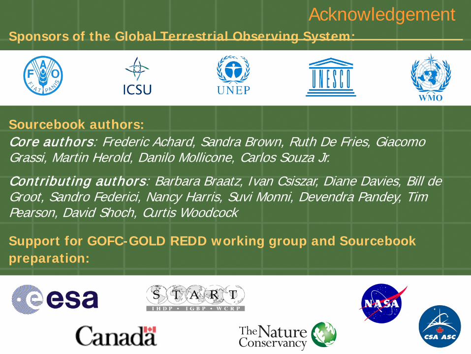
AcknowledgementSponsors of the Global Terrestrial Observing System:
Sourcebook authors: Core authors: Frederic Achard, Sandra Brown, Ruth De Fries, Giacomo Grassi, Martin Herold, Danilo Mollicone, Carlos Souza Jr.
Contributing authors: Barbara Braatz, Ivan Csiszar, Diane Davies, Bill de Groot, Sandro Federici, Nancy Harris, Suvi Monni, Devendra Pandey, Tim Pearson, David Shoch, Curtis Woodcock
Support for GOFC-GOLD REDD working group and Sourcebook preparation:

Sourcebook objectives1. to provide transparent methods that are designed to
produce estimates of changes in forest area and carbon stocks from deforestation and degradation
in a format that is user-friendly
2. to complement the IPCC GPG-LULUCF (2003) and IPCC Guidelines-AFOLU (2006) by providing additional explanation, clarification and enhanced methodologies for obtaining and analyzing key data
3. to support REDD early actions and readiness mechanisms on national level

Sourcebook initial format
Chapter 1 and 2: Introduction and definitions
Chapter 5Estimation of CO2 emissions
Estimation of area change
Estimation of carbon stocks
Chapter 3
Chapter 4
Chapter 6Guidance on reporting of CO2 emissions

Implementation remarks
1. Building a national forest carbon monitoring system is a process (that can start now):• Assessment of existing national capacities and
available data• Methods and guidance exist
2. Capacity building as key factor for “readiness phase”:• Technical monitoring capabilities• IPCC compliant estimation, accounting and reporting
3. Start conservative with motivation to improve monitoring system over time

Building national capabilitiesImportant components Practical considerations
FOREST AREA CHANGE Primary source: Landsat-type satellite data
Deforestation Starting point for historical assessment 1990-2005 (3 time steps minimum)
Build basic satellite data proc. capabilities
Monitoring of forest degradation Forest fire and burned area
Relevance and characteristics for human-induced carbon emissions
Definition of suitable monitoring system
Accuracy assessment Using best/transparent methods and efforts for continuous improvement
Prepare for statistically robust approach
CHANGE in CARBON STOCKS Primary source: ground/inventory data
Existing stratifications and forest carbon estimates
Inventory of available dataDecide on carbon pool/TIER level to report
Towards improved carbon stock change estimations
New inventory including other carbon poolsStratification in relevant areas/forest types
ACCOUNTING & REPORTING Provide conservative estimates

BREAK OUT GROUPS
At 3rd GOFC-GOLD symposium 13.10.08:
• Degradation/regrowth – Achard/DeFries
• Biomass burning – Justice
• Evolving technologies – Held
• Data collection at local/national level–Van Laake/Mayaux

Degradation More Difficult1. More severe degradation (area/intensity) results in more
distinct indicators for efficient monitoring2. Monitoring degradation requires understanding and
emission significance of human processes– Define on efficient, long term observation approach given relevant
processes
3. Assessment of degraded forest area and the carbon stocks changes per unit area:
– More reliance on ground data/pilot studies– Remote sensing data to assess the area affected– Ground measurements required for carbon stock change– Current data/knowledge uncertain on area/emission factors

Change in forest areas remaining as forest (degradation)
1. Inventory based approaches, field surveys, and forest statistics (i.e. logging concessions and harvest estimates)
2. Remote sensing to detect degraded area:Direct detection of degradation processes (canopy
damage):Landsat-type data with annual observationsVery high-resolution datasets (IKONOS type)Hot spot sampling approach maybe effective
Indirect approaches: Detecting required infrastructure and its changes (roads, log
landings) Concept of intact versus non-intact forests Suitable also for historical periods
3. Operational fire monitoring systems

Direct approaches to detect forest degradation
Highly Detectable Detection limited & increasing data/effort
Detection very limited
• Deforestation• Forest fragmentation• Recent slash-and-
burn agriculture• Major canopy fires• Major roads• Conversion to tree
monocultures• Hydroelectric dams
and other forms of flood disturbances
• Large-scale mining
• Selective logging• Forest surface fires• A range of edge-
effects• Old-slash-and-burn
agriculture• Small scale mining• Unpaved secondary
roads (6-20-m wide)• Selective thinning of
canopy trees
• Harvesting of most non-timber plants products
• Old-mechanized selective logging
• Narrow sub-canopy roads (<6-m wide)
• Understory thinning and clear cutting
• Invasion of exotic species
Peres et al., (2006) TREE
(using Landsat-type observations)
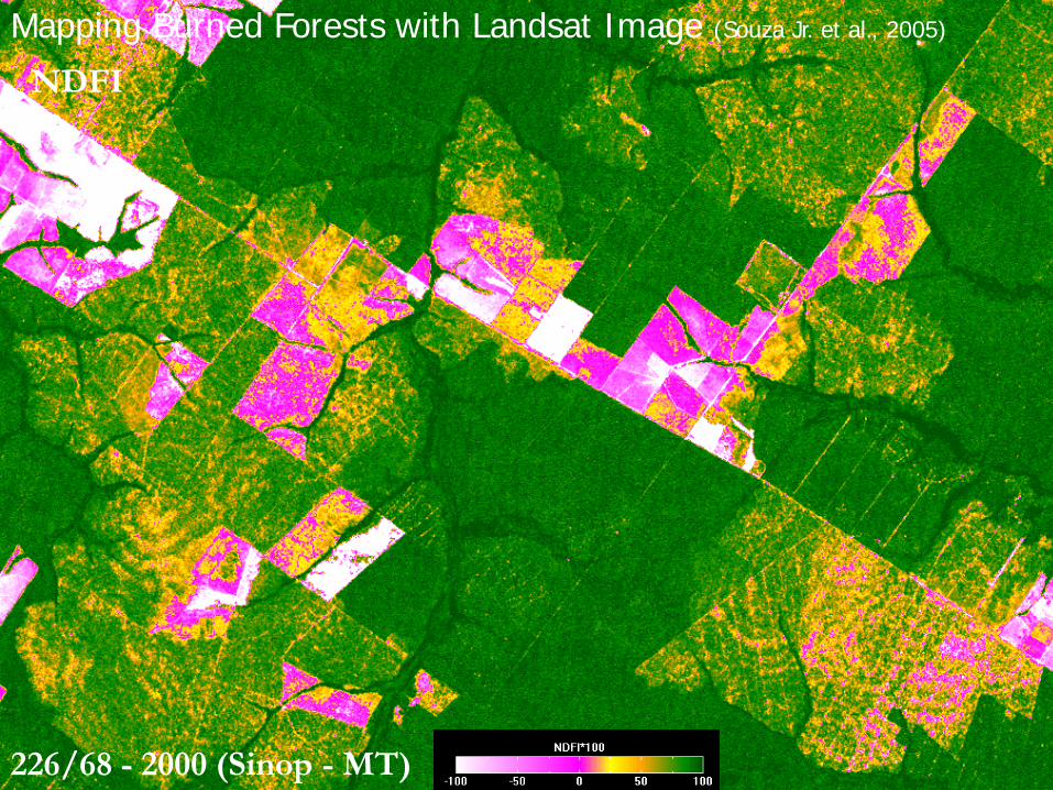
NDFI
226/68 - 2000 (Sinop - MT)
Mapping Burned Forests with Landsat Image (Souza Jr. et al., 2005)

226/68 - 2001 (Sinop - MT)
NDFIMapping Burned Forests with Landsat Image (Souza Jr. et al., 2005)

226/68 - 2003 (Sinop - MT)
NDFIMapping Burned Forests with Landsat Image (Souza Jr. et al., 2005)
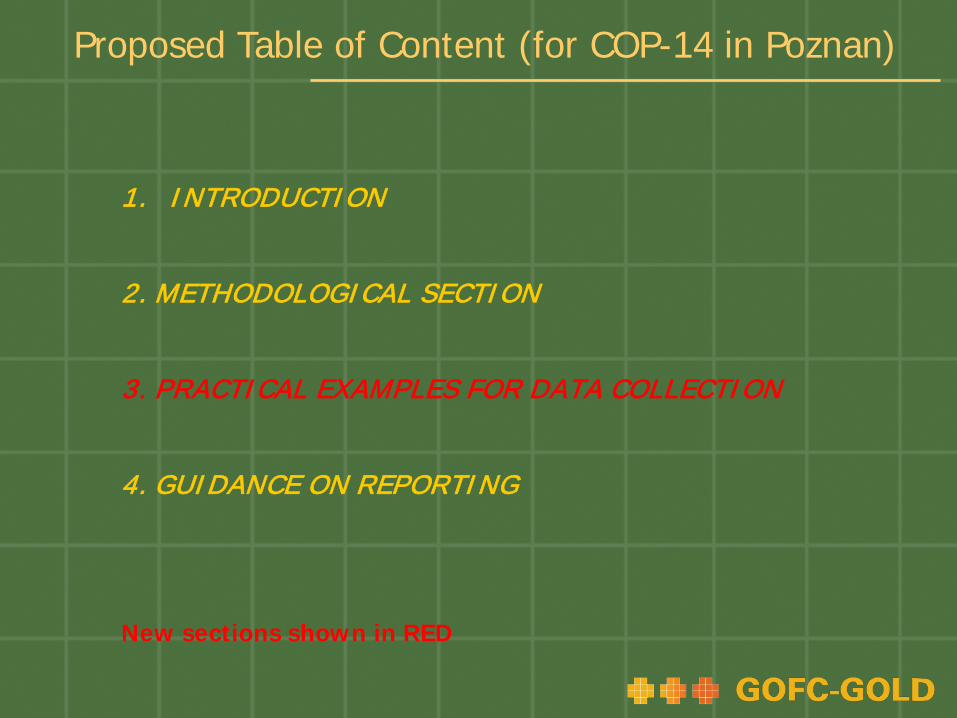
1. INTRODUCTION
2. METHODOLOGICAL SECTION
3. PRACTICAL EXAMPLES FOR DATA COLLECTION
4. GUIDANCE ON REPORTING
New sections shown in RED
Proposed Table of Content (for COP-14 in Poznan)

1. INTRODUCTION1.1 Purpose and Scope of the Sourcebook1.2 Issues and Challenges
2. METHODOLOGICAL SECTION2.1 Guidance on Monitoring of Changes in Forest Area
Monitoring of DeforestationMonitoring of Forest DegradationMonitoring of Forest regrowth
2.2 Estimation of Carbon Stocks2.3 Methods for estimating CO2 Emissions from Deforestation &
Degrad.2.4 Methods for estimating GHG’s emissions from biomass
burning2.5 Estimation of uncertainties2.6 Status of evolving technologies
Proposed Table of Content (for COP-14 in Poznan)
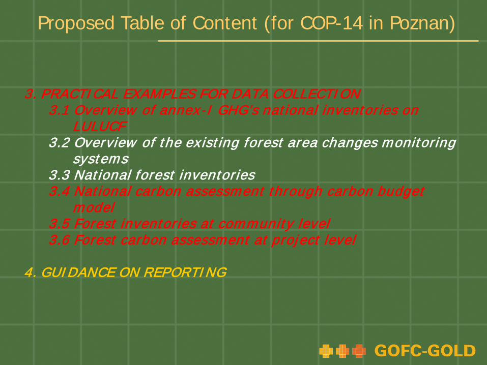
3. PRACTICAL EXAMPLES FOR DATA COLLECTION3.1 Overview of annex-I GHG’s national inventories on
LULUCF3.2 Overview of the ex isting forest area changes monitoring
systems3.3 National forest inventories3.4 National carbon assessment through carbon budget
model3.5 Forest inventories at community level3.6 Forest carbon assessment at project level
4. GUIDANCE ON REPORTING
Proposed Table of Content (for COP-14 in Poznan)

Forest fire observations• Forest fires occur annually in all vegetation zones
causing direct release of GHG to atmosphere• Under UNFCCC reporting provision, countries have
to report on GHG’s emissions from biomass burning– Observation and assessment in research phase
• Coarse resolution sensors provide near-real time, operational information
• Moderate resolution (30m) sensors provide more detailed information over limited areas
• Satellite fire observation objectives: – extent and intensity of ongoing fires – area, severity and impact of burns– support for fire early warning systems

Fire observations and their usefulness for national REDD implementation
Approach Information REDD objective SuitabilityPre-fire Early warning
systemProtect forest areas at risk and address leakage and permanence
Most suitable for countries with significant amount of wildland fires and known fire regimes
Active fire Hot spot satellite data
Fire relief and active emissions reductionSupport of in-situ actions
Most suitable for countries with large number of small-scale deforestation fires
Post-fire Burned area estimates
Support estimation of areas of deforestation and degradation
All countries with forest loss due to fire

Consideration of evolving technologies• Sourcebook describe readily available following IPCC good
practice guidance for: Derive activity/area change data Data on carbon stocks and carbon stock changes
• New technologies and approaches for monitoring changes in forest area, forest degradation and carbon stocks that: are potentially useful for REDD implementation have not been operationally for national level assessmentsmay provide additional data and certaintymay not be available for all developing countries implementation usually requires an additional resources further pilot cases and international coordination needed their utility may be enhanced in coming years depending on
data acquisition, access and scientific developments

Satellite observation system/program
Technical observation challenges
solved
Access to information on quality of archived data
worldwide
Continuous observation program for
global coverage
Pre-processed global image
datasets generated & accessible
Image data available in mapping
agencies for land change
analysis
Capacities to sustainably
produce/use map products in developing
countries
OPTICAL
LANDSAT TM/ETM
ASTER On demand
SPOT HRV (1-5) Commercially
CBERS 1-3 Regionally
IRS / Indian program Regionally
DMC program Probably Commercially
SAR
ALOS/PALSAR + JERS Regionally
ENVISAT ASAR, ERS 1/2 Regionally
TERRARSAR-X Commercially
IKONOS, GEOEye Probably Commercially
ICESAT/GLAS (LIDAR)
Current availability of fine-scale satellite data sources and capacities for global land cover change observations
(Note: dark gray=common or fully applicable, light gray=partially applicable/several examples, white=rare or no applications or examples)

Evolving technologies remarks• New sections on evolving technology to be added
to the GOFC-GOLD sourcebook:– Evolving technologies and data sources – potential of
methods not considered operational today– Usefulness for monitoring historical changes versus
future capabilities– Suitable approaches for communication status,
progress, and requirements to achieve progress for data collection procedures and interpretation methods
• Importance of synergy among different data sources
• Evolving approaches for collecting in-situ data

New Sections on evolving technologies SAR – Draft Section from Joseph Kellendorfer, Dirk
Hoeckman, Ake Rosenqvist LIDAR – Draft Section Mike Wulder - (concentrate on
airborne technologies at this point, carbon stocks, useful for sampling and site-based verification)
Fine resolution (purpose, eg for use in validation and accuracy assessment) (Caccetta & ?)
Hyperspectral (include short section on technology and potential future applications (Asner, Held?)
Thermal Imagery (forest fire radiative power estimation) (draft by Justice & Chuvieco)
Data integration tasks - Draft from Mike Wulder Recommendation section Table on outputs (measurements) vs technology options
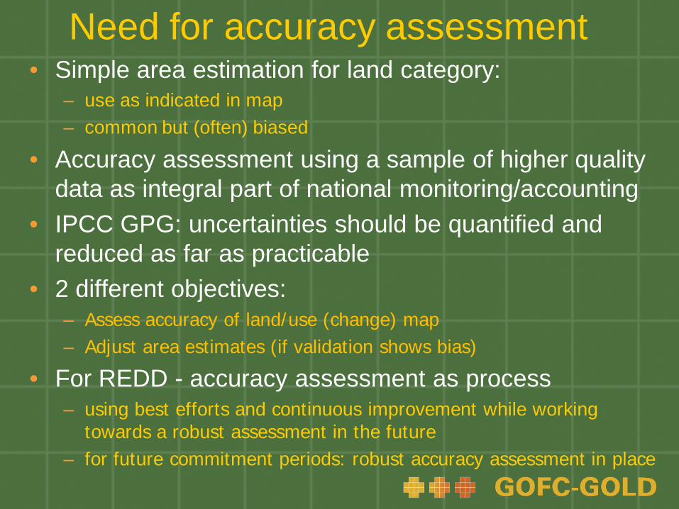
Need for accuracy assessment• Simple area estimation for land category:
– use as indicated in map – common but (often) biased
• Accuracy assessment using a sample of higher quality data as integral part of national monitoring/accounting
• IPCC GPG: uncertainties should be quantified and reduced as far as practicable
• 2 different objectives:– Assess accuracy of land/use (change) map– Adjust area estimates (if validation shows bias)
• For REDD - accuracy assessment as process – using best efforts and continuous improvement while working
towards a robust assessment in the future– for future commitment periods: robust accuracy assessment in place

Accuracy assessment proceduresConsensus methods exist for assessing the accuracy of remote sensing-derived (singe-date) land cover maps:http://nofc.cfs.nrcan.gc.ca/gofc-gold/Report%20Series/GOLD_25.pdf
• Implementation steps for robust approach:– Sample design: a probability sampling design is the preferred
approach for selecting reference locations– Response design: protocols to determine the reference or ground
condition label and comparison to map labels– Analysis design: includes estimation formulas and analysis
procedures for accuracy reporting, i.e. error matrix, accuracies and errors of omission and commission
• Often errors of omission and commission are not equal• Use accuracy information on bias in the map to adjust area
estimates and also to provide the confidence intervals
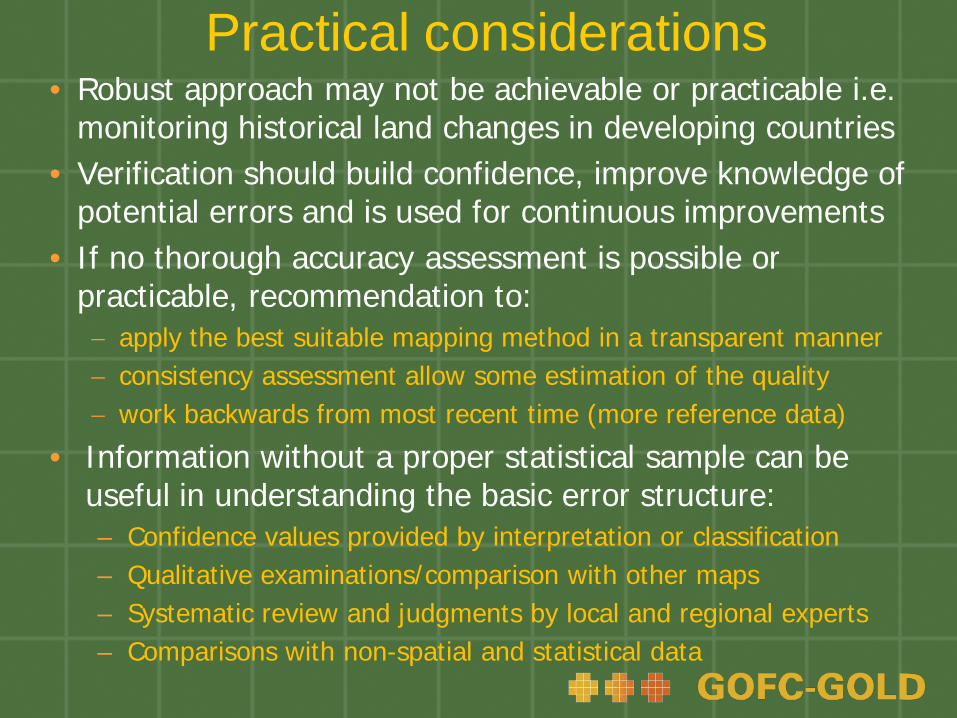
Practical considerations• Robust approach may not be achievable or practicable i.e.
monitoring historical land changes in developing countries• Verification should build confidence, improve knowledge of
potential errors and is used for continuous improvements• If no thorough accuracy assessment is possible or
practicable, recommendation to:− apply the best suitable mapping method in a transparent manner− consistency assessment allow some estimation of the quality− work backwards from most recent time (more reference data)
• Information without a proper statistical sample can be useful in understanding the basic error structure:– Confidence values provided by interpretation or classification– Qualitative examinations/comparison with other maps– Systematic review and judgments by local and regional experts– Comparisons with non-spatial and statistical data

Recent GOFC-GOLD REDD group Activities
1. 20/21. Oct. 08: attended informal REDD method. Meeting at UNFCCC Secretariat• Focus on monitoring forest degradation• http://unfccc.int/methods_science/redd/items/4579.php
2. 17-19. Nov. 08: Capacity development organized by Coalition for Rainforest Nations• GOFC-GOLD co-organizer, focus on area change• More than 30 countries present
3. 26-28. Nov. 08: Expert consultation on national forest monitoring and assessment at UN FAO• New requirements from REDD
4. 3. Dec.08: Sourcebook side event at UNFCCC COP 14 hosted by PNG

Web resources
• GOFC-GOLD REDD sourcebook:– http://www.gofc-gold.uni-jena.de/redd
• Global Terrestrial Observing System (GTOS):– http://www.fao.org/gtos/
• GOFC-GOLD:– http://www.fao.org/gtos/gofc-gold/
• GOFC-GOLD land cover project office:– http://www.gofc-gold.uni-jena.de/