building information modelling and heritage documentation · building information modelling and...
TRANSCRIPT
BUILDING INFORMATION MODELLING AND HERITAGE DOCUMENTATION
Stephen Fai1, Katie Graham1, Todd Duckworth1, Nevil Wood1, Ramtin Attar2 1Carleton Immersive Media Studio, Azrieli School of Architecture and Urbanism,
Carleton University, Ottawa, Canada, [email protected] 2Autodesk Research
210 King Street, Toronto, Canada, [email protected]
Keywords: BIM, heterogeneous datasets, heritage documentation, time based documentation
Abstract: Despite the widespread adoption of building information modelling (BIM) for the design and life-cycle management of new buildings, very little research has been undertaken to explore the value of BIM in the management of heritage buildings and cultural landscapes. To that end, we are investigating the construction of BIMs that incorporate both quantitative assets (intelligent objects, performance data) and qualitative assets (historic photographs, oral histories, music). Further, our models leverage the capabilities of BIM software to provide a navigable timeline that chronicles tangible and intangible changes in the past and projections into the future. In this paper, we discuss three projects undertaken by the authors that explore an expanded role for BIM in the documentation and conservation of architectural heritage. The projects range in scale and complexity and include: a cluster of three, 19th century heritage buildings in the urban core of Toronto, Canada; a 600 hectare village in rural, south-eastern Ontario with significant modern heritage value, and a proposed web-centered BIM database for materials and methods of construction specific to heritage conservation.
1. INTRODUCTION The 3D digital construction and documentation of existing heritage buildings is a complex undertaking that typically involves a hybrid approach to visualization of heterogeneous datasets such as survey data, CAD drawings, photographs, and 3D non-contact imaging data (laser scanning, photogrammetry) (El-Hakim et al. 2005; Remondino et al 2009). In the past decade, a growing number of research projects have provided a wide range of workflows, from the digital acquisition of extant buildings to the display of high-fidelity 3D models and animations. High visual fidelity, metric accuracy, and the integration of multiple media types have been the primary consideration in heritage documentation. In recent years, however, heritage documentation has taken a turn toward intelligent data as it pertains to the cultural analysis and maintenance of existing building stocks (Pauwels et al 2008; Attar et al. 2010). We argue that this new focus is due first, to the recognition of BIM as a technology that addresses the growing demand for a multi-disciplinary knowledge base, essential to the management of life-cycle processes such as operation, renewal and development of the growing inventory of heritage sites. Secondly, there is a growing recognition in the potential for BIM to contribute to the collation of the complex relationships between tangible and intangible heritage.
To address the existing challenges related to life-cycle management and heritage documentation, this paper explores the value of Building Information Modeling (BIM) through two case studies. In the first, we discuss an ongoing project that explores the capacity of BIM to document and monitor building performance parameters in urban cluster of 19th century heritage buildings. In the second, we outline a current project that involves a BIM for a 600-hectare village in rural south-eastern Ontario, Canada with significant modern heritage value. In this second case study, we demonstrate a methodology for creating a massive Information Model that contains both qualitative information and quantitative parametric and metric data. The past, present, and future are represented in relation to the construction assembly data found in smaller scale BIM projects, as well as on a larger scale with regard to town planning, terrain information, and services such as

roads, sewage and water. The "Batawa Model" serves to illustrate both the benefits of assembling multiple types of into a single model and the research challenges that remain. Finally, we will discuss our work on a proposed web-centered BIM database for the materials and methods of construction specific to heritage conservation.
2. BIM AND HERITAGE DOCUMENTATION Conceptually, BIM is an integrative tool for the design, representation, production, and long-term management of the built environment. BIM software combines multi-dimensional visualization with comprehensive, parametric databases to facilitate collaborative design and facility management among project partners (Russell; Elger 2008). Over the past five years, pundits, software vendors and (some) professionals have heralded BIM as the new design and management tool for the Architecture, Engineering, and Construction (AEC) industry. Proponents argue that the advent of BIM marks a radical transformation for the management of architectural information from conception through to building obsolescence (Eastman et al 2008). BIM is seen by some as a paradigm shift that will replace two-dimensional representation as the lingua franca for the design, assembly, and life cycle management of new buildings (Russel/Elger 2008). It has even been argued that BIM represents "… a political initiative to address low productivity in the construction sector (Mihindu/Arayici 2008).
We raise these points only to illustrate that BIM is still a novel technology and that now is an appropriate time to investigate BIM and its applicability to heritage documentation. Despite a trend to adopt BIM for the design and life-cycle management of new buildings, very little research has been undertaken to explore the value of BIM in the documentation and management of heritage buildings and cultural landscapes. For example, BIM is not discussed in Robin Letellier's Recording, Documentation, and Information Management for the Conservation of Heritage Places (2007), considered by many as the standard reference for heritage documentation. Nor is BIM mentioned in Metric Survey Specifications for Cultural Heritage (Bedford et al. 2009). Despite what appears to be a general disinterest, BIM-based documentation in the field of heritage conservation is not without precedents. Arayici (2008), for example, advocates the adoption of BIM for existing buildings in order to move beyond rote 3D visualization through the incorporation of multifunctional, intelligent and multi-representational data. This research focuses on adapting automated data processing and pattern recognition that leverages 3D point cloud data towards the generation of a simple building envelope. Given the lack of appropriate documentation for many existing buildings, automated BIM generation is a novel and important area of technical research. Research in this area, however, is still in its infancy and does not, in and of itself, fulfill the need for the data-rich documentation of existing heritage buildings. Penttila et al. (2007) provides a case study that evaluates the possibility of BIM for the retrofit of buildings of significant historical and cultural value. This report employs the concept of an “inventory model” as an essential base for a well-structured inventory of data that captures both the past and present condition of an existing building condition. The inventory model concept extends the definition of data to include that which is historic but the role of BIM as a data hub for documentation is not fully explored.
This paper follows our previous research into using BIM as a centralized data model to document a designated heritage building in downtown Toronto, Canada (http://www.210king.com/) (Attar et al. 2010). Created as a rich dataset to be shared by the building simulation community, we demonstrated a thoroughly documented and semantically-rich BIM model to support building performance analysis. We had an opportunity to learn invaluable lessons about the strengths and weaknesses of BIM while dealing with insufficient as-built drawings and the lack of a proper building survey, challenges often encountered with heritage buildings. Based on our experience with 210 King, this paper considers an expanded role for BIM to incorporate both quantitative assets (intelligent objects, performance data) and qualitative assets (historic photographs, oral histories, music). Further, our models leverage the capabilities of BIM to provide a navigable timeline that allows us to document the chronology of a site, including possible futures.
3. BATAWA PROJECT Batawa is located 175 km northeast of Toronto, Canada and is comprised of one hundred privately owned residences, two defunct factories, three commercial buildings, and two municipal facilities. It is currently home to approximately 300 people and it is a popular, albeit modest, skiing destination. Established in 1939 as the Canadian home of the world’s then-largest shoe manufacturer, Batawa is the expression of over two decades of research into modern town planning. With the extensive re-construction of Zlin, Czechoslovakia
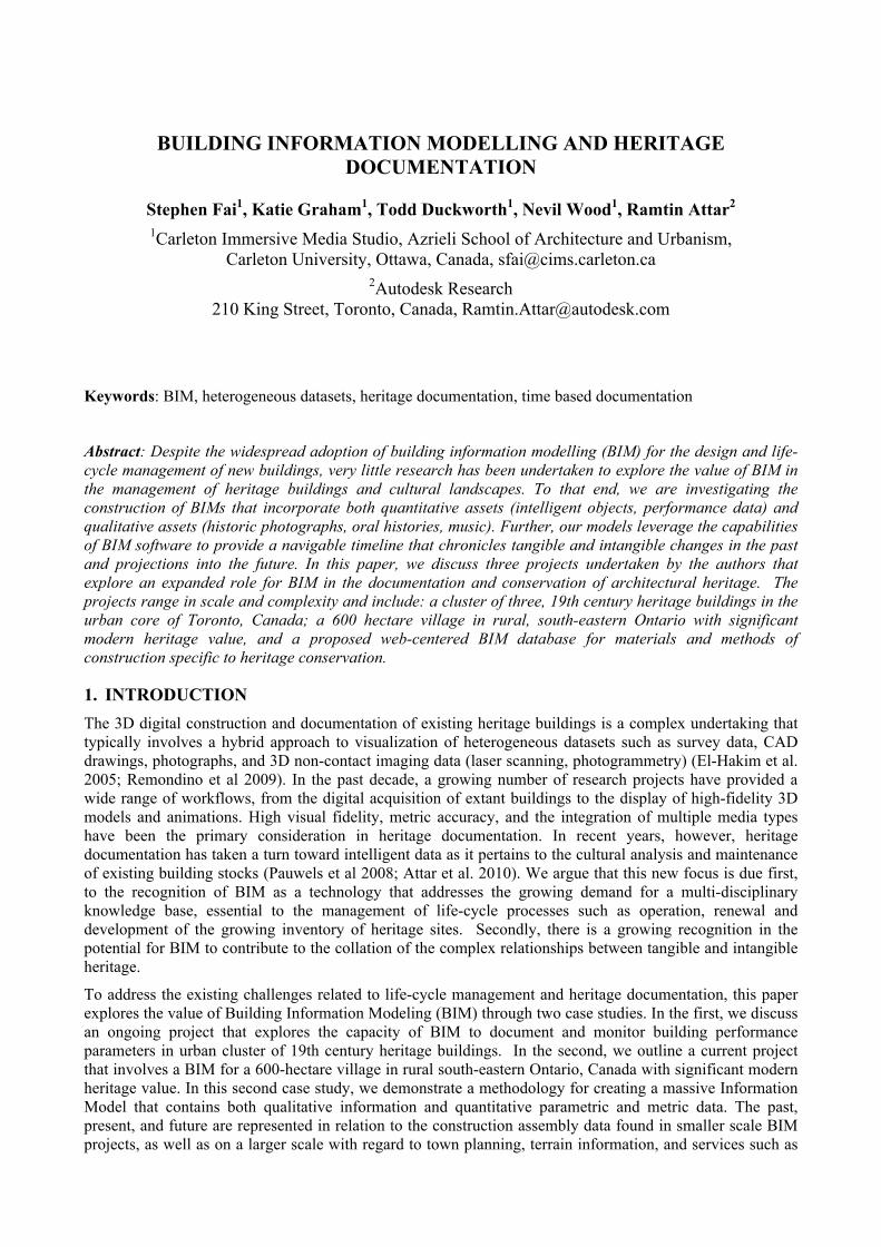
serving as a prototype, the pattern for development was well established before being brought to Canada. This included a core of efficient production buildings that adhere to elegant and efficient modern design principles; worker's accommodations that synthesized the principles of the Garden City with a pragmatic reworking of the local vernacular; and modern social amenities including cinemas, athletic facilities, and subsidized shopping. The careful management of architectural identity was integral to the remarkable success of "the shoemaker to the world" and academic, corporate, and anecdotal reports tell of vibrant, family oriented communities. While the original planning intentions for Batawa may not be evident to a casual observer, a careful study shows that the village is still informed by the structure of the original urban plan. This armature, along with the few remaining modernist buildings, represents a unique example of Canada's modern architectural heritage. Historian Shannon Ricketts has placed this within the discussion of international modernism and writes that Batawa "…represents a fascinating nexus in the generation and development of ideas which have been critical to the evolution of mass produced buildings and 20th century planning." (Ricketts 1992) The context of our research is a redevelopment proposal for approximately 600 hectares of land that includes this former factory town with its rich history of modern architecture and town planning (Figure 1). Specifically, the proposal includes the re-purposing of the factory buildings, renovation of existing and construction of new commercial venues, and the construction of 5000 new homes. This plan represents a significant physical and social transformation of the village as it stands today. Additionally, over half of the property is a government protected "Area of Natural and Scientific Interest" (ANSI). While having limited development potential, this protected area is home to a wide range of native flora and fauna. The developer is not only sensitive to both the heritage value of the site and the ANSI designation, but hopes to establish a benchmark for the inclusion of cultural and ecological considerations in real estate development.
Figure 1: (Left to right) Historical Aerial view of Batawa, 1982 Batawa Contour Map
Our goal in documenting the heritage assets of Batawa is to develop a BIM that will serve as a digital archive to help in conserving the extant heritage buildings and planning and to test future development proposals within the context of these historic buildings and plans. To achieve this, it is necessary to create a model from available, heterogeneous data that has the capacity for time-based representation—coordinating past, current, and possible futures of Batawa. In the following sections we discuss these two important aspects of our BIM-based documentation.
3.1 Multi-scale Heterogeneous Datasets The first stage of the project involved an extensive review of the village archive in order to assess the scope and format(s) of the available data. While the archive is orderly and well maintained, it has not been systematically catalogued. We were fortunate to have individuals familiar with the material to guide us. The archival material is both heterogeneous, comprised of architectural and planning documents (original drawings and paper copies of hand-drawn and computer generated blueprints and black line documents), paper and digitized photographs (some as early as 1939), and both digital and paper based texts. As a starting point, we approached our model in two separate scales:
• Topographic Scale: Terrain and Services Models
• Building Scale: Building Information Models
Topographic Scale -To create a model of the current terrain, we were able to obtain digital files for parts of the site that had been recently surveyed. From the archive, we have identified two extensive topographic
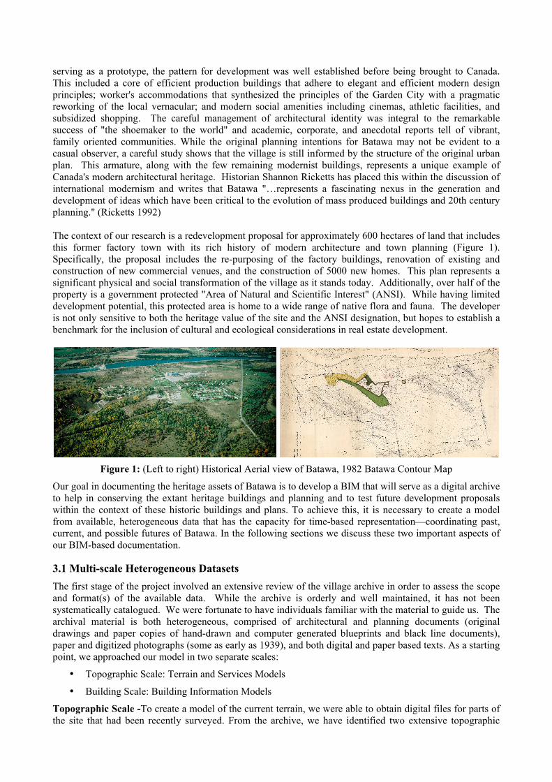
surveys of the entire site. These documents also provide a valuable timeline of development of the town plan. The first, from 1954, presented elevations at five-foot intervals. The second, from 1982, gave us elevations at two and one-half foot intervals. We also found fragments of the site documented in recent surveys (2000–2010). Our first step in the modeling process was to develop both historical and existing topographic surfaces from the survey documents. When we were not able to locate digital files, we had to trace the existing paper drawings, which were digitized at high resolution using a large-document scanner. Unfortunately, this resulted in an incomplete patchwork of the current conditions. We supplemented this information with a Digital Elevation Model (DEM) obtained from the local municipality and with our own terrestrial laser scanning (TLS) registered through a global positioning system (GPS). These various digital elements were assembled in AutoCAD Civil 3D. The process was a laborious and somewhat tedious, but it produced a very accurate topographical analysis from what had previously been a disconnected series of topographic data.
In order to verify the accuracy of the model, considering the diversity of datasets, we cut a series of transverse and longitudinal sections through the current and digitized historical topographies, and compared them. We discovered that the surfaces from 1954 and 1982 were consistent with the model we had constructed from recent surveys, DEM and our point cloud data. Each of the three topographic surveys (1954, 1982, 2010) are augmented in AutoCAD Civil 3D with data related to roads and services (electricity, water, natural gas, telephone) consistent with the period they represent in the development of the village. This process, again, required that we combine diverse data sets (drawings, text, photographs, interviews, on-site inspections) that have until now been physically disparate and lacking a cohesive historical narrative. This topographic study is now being used as the basis for a ground water management strategy for the village.
Figure 2: (Left to right) Comparison of the temporal terrain models in rendered 3D and graph form.
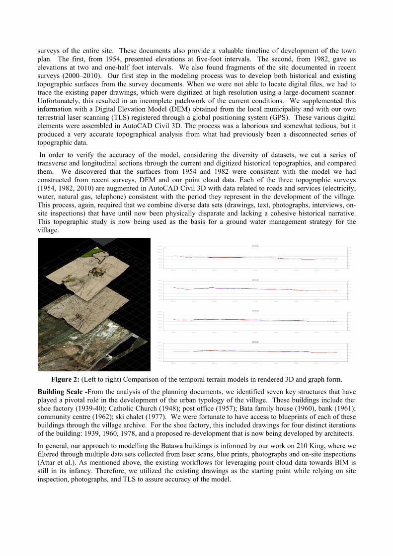
Building Scale -From the analysis of the planning documents, we identified seven key structures that have played a pivotal role in the development of the urban typology of the village. These buildings include the: shoe factory (1939-40); Catholic Church (1948); post office (1957); Bata family house (1960), bank (1961); community centre (1962); ski chalet (1977). We were fortunate to have access to blueprints of each of these buildings through the village archive. For the shoe factory, this included drawings for four distinct iterations of the building: 1939, 1960, 1978, and a proposed re-development that is now being developed by architects.
In general, our approach to modelling the Batawa buildings is informed by our work on 210 King, where we filtered through multiple data sets collected from laser scans, blue prints, photographs and on-site inspections (Attar et al.). As mentioned above, the existing workflows for leveraging point cloud data towards BIM is still in its infancy. Therefore, we utilized the existing drawings as the starting point while relying on site inspection, photographs, and TLS to assure accuracy of the model.
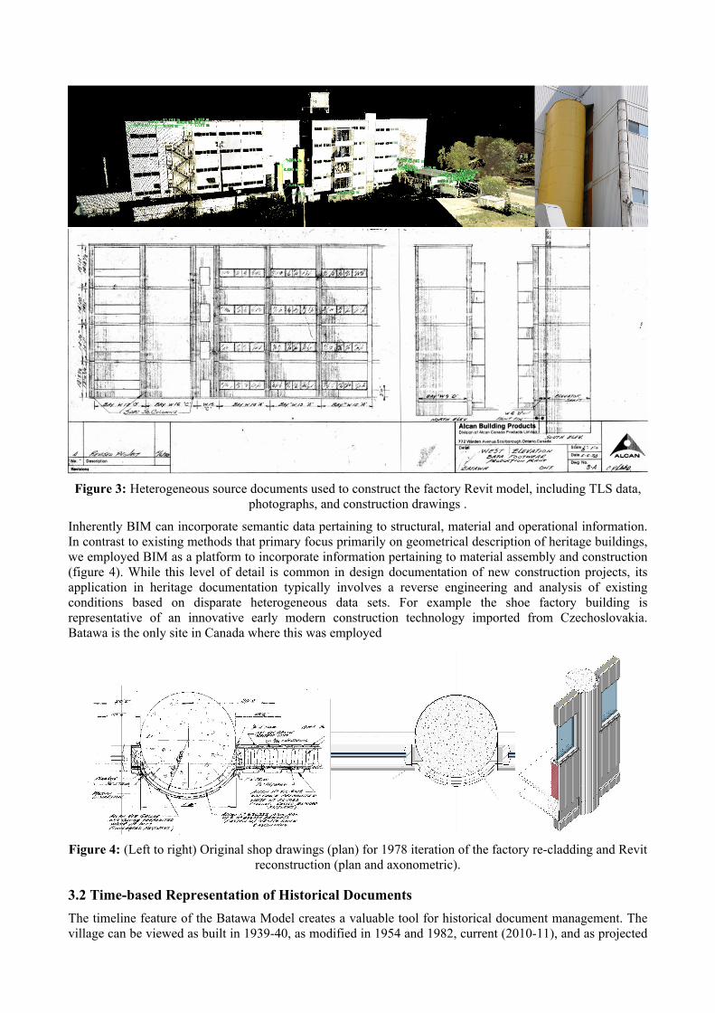
Figure 3: Heterogeneous source documents used to construct the factory Revit model, including TLS data,
photographs, and construction drawings .
Inherently BIM can incorporate semantic data pertaining to structural, material and operational information. In contrast to existing methods that primary focus primarily on geometrical description of heritage buildings, we employed BIM as a platform to incorporate information pertaining to material assembly and construction (figure 4). While this level of detail is common in design documentation of new construction projects, its application in heritage documentation typically involves a reverse engineering and analysis of existing conditions based on disparate heterogeneous data sets. For example the shoe factory building is representative of an innovative early modern construction technology imported from Czechoslovakia. Batawa is the only site in Canada where this was employed
Figure 4: (Left to right) Original shop drawings (plan) for 1978 iteration of the factory re-cladding and Revit
reconstruction (plan and axonometric).
3.2 Time-based Representation of Historical Documents The timeline feature of the Batawa Model creates a valuable tool for historical document management. The village can be viewed as built in 1939-40, as modified in 1954 and 1982, current (2010-11), and as projected
for 2020 in the "Homecoming Plan". The history, present, and future development of the village are represented as a single, seamless object. The Batawa Model serves to remind us of what is lost, to recognize what remains, and to foster a vital architectural future that is mindful of history.
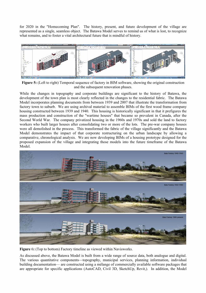
Figure 5: (Left to right) Temporal sequence of factory in BIM software, showing the original construction
and the subsequent renovation phases.
While the changes in topography and corporate buildings are significant to the history of Batawa, the development of the town plan is most clearly reflected in the changes to the residential fabric. The Batawa Model incorporates planning documents from between 1939 and 2007 that illustrate the transformation from factory town to suburb. We are using archival material to assemble BIMs of the first wood frame company housing constructed between 1939 and 1940. This housing is historically significant in that it prefigures the mass production and construction of the "wartime houses" that became so prevalent in Canada, after the Second World War. The company privatized housing in the 1960s and 1970s and sold the land to factory workers who built larger houses after consolidating two or more of the lots. The pre-war company houses were all demolished in the process. This transformed the fabric of the village significantly and the Batawa Model demonstrates the impact of that corporate restructuring on the urban landscape by allowing a comparative, chronological analysis. We are now developing BIMs of a housing prototype designed for the proposed expansion of the village and integrating those models into the future timeframe of the Batawa Model.
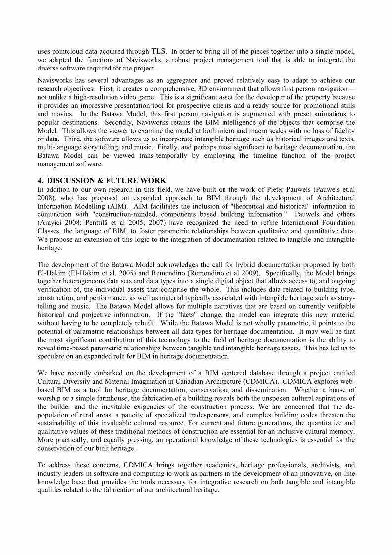
Figure 6: (Top to bottom) Factory timeline as viewed within Navisworks.
As discussed above, the Batawa Model is built from a wide range of source data, both analogue and digital. The various quantitative components—topography, municipal services, planning information, individual building documentation— are constructed using a mélange of commercially available software packages that are appropriate for specific applications (AutoCAD, Civil 3D, SketchUp, Revit,). In addition, the Model
uses pointcloud data acquired through TLS. In order to bring all of the pieces together into a single model, we adapted the functions of Navisworks, a robust project management tool that is able to integrate the diverse software required for the project.
Navisworks has several advantages as an aggregator and proved relatively easy to adapt to achieve our research objectives. First, it creates a comprehensive, 3D environment that allows first person navigation—not unlike a high-resolution video game. This is a significant asset for the developer of the property because it provides an impressive presentation tool for prospective clients and a ready source for promotional stills and movies. In the Batawa Model, this first person navigation is augmented with preset animations to popular destinations. Secondly, Naviworks retains the BIM intelligence of the objects that comprise the Model. This allows the viewer to examine the model at both micro and macro scales with no loss of fidelity or data. Third, the software allows us to incorporate intangible heritage such as historical images and texts, multi-language story telling, and music. Finally, and perhaps most significant to heritage documentation, the Batawa Model can be viewed trans-temporally by employing the timeline function of the project management software.
4. DISCUSSION & FUTURE WORK In addition to our own research in this field, we have built on the work of Pieter Pauwels (Pauwels et.al 2008), who has proposed an expanded approach to BIM through the development of Architectural Information Modelling (AIM). AIM facilitates the inclusion of "theoretical and historical" information in conjunction with "construction-minded, components based building information." Pauwels and others (Arayici 2008; Penttilä et al 2005; 2007) have recognized the need to refine International Foundation Classes, the language of BIM, to foster parametric relationships between qualitative and quantitative data. We propose an extension of this logic to the integration of documentation related to tangible and intangible heritage. The development of the Batawa Model acknowledges the call for hybrid documentation proposed by both El-Hakim (El-Hakim et al. 2005) and Remondino (Remondino et al 2009). Specifically, the Model brings together heterogeneous data sets and data types into a single digital object that allows access to, and ongoing verification of, the individual assets that comprise the whole. This includes data related to building type, construction, and performance, as well as material typically associated with intangible heritage such as story-telling and music. The Batawa Model allows for multiple narratives that are based on currently verifiable historical and projective information. If the "facts" change, the model can integrate this new material without having to be completely rebuilt. While the Batawa Model is not wholly parametric, it points to the potential of parametric relationships between all data types for heritage documentation. It may well be that the most significant contribution of this technology to the field of heritage documentation is the ability to reveal time-based parametric relationships between tangible and intangible heritage assets. This has led us to speculate on an expanded role for BIM in heritage documentation. We have recently embarked on the development of a BIM centered database through a project entitled Cultural Diversity and Material Imagination in Canadian Architecture (CDMICA). CDMICA explores web-based BIM as a tool for heritage documentation, conservation, and dissemination. Whether a house of worship or a simple farmhouse, the fabrication of a building reveals both the unspoken cultural aspirations of the builder and the inevitable exigencies of the construction process. We are concerned that the de-population of rural areas, a paucity of specialized tradespersons, and complex building codes threaten the sustainability of this invaluable cultural resource. For current and future generations, the quantitative and qualitative values of these traditional methods of construction are essential for an inclusive cultural memory. More practically, and equally pressing, an operational knowledge of these technologies is essential for the conservation of our built heritage. To address these concerns, CDMICA brings together academics, heritage professionals, archivists, and industry leaders in software and computing to work as partners in the development of an innovative, on-line knowledge base that provides the tools necessary for integrative research on both tangible and intangible qualities related to the fabrication of our architectural heritage.
Our project involves the development of a cross-platform, web-based application that will serve as a focal point for ongoing research among our team members and as a prototype for future national and international collaborations. The CDMICA Partnership will provide the opportunity to deepen and expand our ongoing research program toward a more comprehensive and dynamic integration of quantitative and qualitative data through BIM. To develop this expanded use of BIM, the CDMICA Partnership will explore five Research Themes (Documentation, Representation, BIM and Web-based Applications, Databases and Narrative Schema, Metrics) for the development of a web-based application that uses machine-to-machine interaction to deliver a continually updated resource library, allowing for “mash ups” of existing on-line resources and BIM. While this is an ambitious project, we have assembled a team with the technical, intellectual, and creative capacity to see it to fruition.
5. CONCLUSION In conclusion, our research has led us to the following observations on the possible future for BIM in the field of heritage documentation, and by extension, heritage conservation: 1. a simulation tool for the integration of cultural, economic and performance criteria in the conservation and management of heritage buildings. Heritage Conservation is a significant aspect of ecological stewardship and BIM is a proven tool in the management of life cycle processes. 2. functionality at multiple scales, in time, and integrating the documentation of both tangible and intangible heritage into a single parametric object. 3. a web based resource for IFC/BIM data related to materials and methods of construction specific to heritage documentation.
8. REFERENCES [1] El-Hakim, S.F., Beraldin, J. A., Gonzo, L., Whiting, E., Jemtrud, M., Valzano, V. : A Hierarchical 3D
Reconstruction Approach for Complex Heritage Sites, CIPA 2005 XX International Symposium, Torino, 2005. See also Remondino, F., El-Hakim, S., Girardi1, S., Rizzi, A., Benedetti, S., Gonzo, L.: 3D Virtual Reconstruction and Visualization of Complex Architectures – The "3D-Arch" Project, Proceedings of the 3rd ISPRS International Workshop, Trento, 2009.
[2] Pauwels, P., Verstaeten, R., De Meyer, R., Van Campenhout, J.: Architectural Information Modelling for Virtual Heritage Application, Digital Heritage – Proceedings of the 14th International Conference on Virtual Systems and Multimedia, 2008, 18-23.
[3] Attar, R., Prahbu, V. Glueck, M., Khan, A.: 210 King Street: A Dataset for Integrated Performance Assessment, SimAUD, Orlando, 2010.
[4] Russell, Peter; Elger, Dietrich: The Meaning of BIM, Architecture in Computro, Proceedings of the 26th eCAADe Conference, Antwerpen, September 2008, 531-536.
[5] Eastman, C., Teicholz, P., Sacks, R., Liston, K.: BIM Handbook: A Guide to Building Information Modelling. Hobken, NJ, John Wiley & Sons, 2008.
[6] Mihindu, S., Arayici, Y.: Digital Construction through BIM Systems will drive the Re-engineering of Construction Business Practices, International Conference on Visualization IEEE Computer Society 2008, 29-34.
[7] Letellier, Robin, et al.: Recording, Documentation, and Information Management for the Conservation of Heritage Places. Guiding Principles. Los Angeles: The Getty Conservation Institute, 2007.
[8] Bedford, J., Blake, B., Bryan, P., Andrews, D., Barber, D., Mills, J.: Metric Survey Specifications for Cultural Heritage, English Heritage, 2009.
[9] Arayici, Yusuf: Towards Building Information Modelling for Existing Structures, Structural Survey, 26.3 (2008) 210-222.
[10] Penttilä, H., Rajala, M., Freese, S.: Building Information Modelling of Modern Historic Buildings, Predicting the Future, 25th eCAADe Conference Proceedings 2007, 607-613
[11] Ricketts, S.: BATAWA. An Experiment in International Standardization, SSAC Bulletin SEAC 18:3/4 (1992) 86.
[12] Penttilä, H.: The State of the Art of Finnish Building Product Modelling Methodology, Learning from the Past a Foundation for the Future, Special publication of papers presented at the CAAD futures 2005, Vienna, 225-240