building code amendments to reduce existing and...
TRANSCRIPT
Building Code Amendments to Reduce Existing and Future Building Stock Vulnerability To Coastal Hazards and Climate Impacts
In the City and County of Honolulu
Report on Existing Relevant Code Requirements and a Draft List of proposed code amendments to strengthen
and/or replace the existing building codes and regulatory standards, in order to reduce existing and future building
stock vulnerability October 12, 2015
Prepared for the State Office of Planning
Prepared by Gary Chock
This report was prepared by Martin & Chock, Inc. for the State of Hawaii Office of Planning, Hawaii Coastal Zone Management Program using Federal funds under Award No. NA14NOS4730152 from the National
Oceanic and Atmospheric Administration (NOAA), U.S. Department of Commerce. The statements, findings, conclusions, and recommendations are those of the author(s) and do not necessarily reflect the views of NOAA
or the U.S. Department of Commerce.

This page left blank intentionally.
Prepared by Gary Chock i
TABLE OF CONTENTS
List of Acronyms ....................................................................................................................................... ii 1. Project Goal .................................................................................................................................... 1 2. Project Objectives Addressed In This First Report ................................................................... 2 2.1 Objective 1: Examine the Building Codes Currently in Effect ...................................................................... 2
a. Summarize Existing and Anticipated Future Coastal Hazard and Climate Impacts. ............................ 2 b. Prepare an Inventory of the Building Codes and Regulatory Standards Currently in Effect ................ 2
2.1.1. Existing and Anticipated Future Coastal Hazard and Climate Impacts.................................................... 2 2.1.2. Building Codes and Regulatory Standards Currently in Effect ................................................................ 6
I. Land Use Ordinance, ROH Chapter 21 (amended 2014) .............................................................. 6 II. Honolulu Building Code, ROH Chapter 16 (October 18, 2012) .................................................. 8 III. Honolulu International Residential Code, ROH Chapter 16 (October 18, 2012) ........................ 10 IV. Shoreline Setbacks, ROH Chapter 23 (1992) .............................................................................. 12 V. Special Management Area, ROH Chapter 25 (amended November 2011) ................................. 13 VI. Flood Hazard Area, ROH Chapter 21A (May 2014) ................................................................... 14 VII. National Flood Insurance Program (NFIP) .................................................................................. 15 VIII. Honolulu Plumbing Code, ROH Chapter 19 .............................................................................. 18 IX. Honolulu Electrical Code, ROH Chapter 17 .............................................................................. 18 X. State of Hawai‘i Coastal Management Program, HRS Chapter 205A ........................................ 19 XI. State of Hawai‘i Coastal Lands Program of DLNR Land Division ............................................. 20 XII. State of Hawai‘i Land Use Commision, HRS Chapter 205 ......................................................... 21 XIII. State of Hawai‘i Certified Shoreline, HRS Chapter 205A .......................................................... 21 XIV. Mandatory Seller Disclosures in Real Estate Transactions, HRS Chapter 508D ........................ 22 XV. Uniform Land Sales Practices Act, HRS Chapter 484 ................................................................ 22 XVI. Hawaii State Building Code, HRS Chapter 107, Part II .............................................................. 24 XVII. PUC 2007 Adoption of the 2002 National Electrical Safety Code .............................................. 25 XVIII. Standards for Civil Works Under the Jurisdiction of the USACE ............................................... 26 XIX. The U.S. Navy Climate Change Roadmap (2010) ....................................................................... 27 XX. The American Society of Heating, Refrigerating, and Air-Conditioning Engineers Standard 169,
Weather Data for Building Design Standards (ASHRAE 2006) ................................................. 27 XXI. The National Fire Protection Association NFPA 1144: Standard for Reducing Structure Ignition
Hazards from Wildland Fire (NFPA 2013) ................................................................................. 28 3. Adapting Building Construction and Civil Infrastructure to Climate Change ..................... 29 4. Objective 2 - Propose code amendments to strengthen and/or replace existing regulatory
standards in order to reduce existing and future building stock vulnerability to coastal hazards and climate impacts....................................................................................................... 34
5. References..................................................................................................................................... 36
Figures Figure 1. Relative Sea Level Change ......................................................................................................... 3 Figure 2. Illustration of Various Modes of Climate Change ...................................................................... 4 Figure 3. Increase in Tropical Cyclone Frequency in the East and Central Pacific ................................... 5 Figure 4. Change in Tropical Cyclone Track Density ............................................................................... 6 Figure 5. City and County of Honolulu Map showing where IRC is applicable without an engineered
structural design using the IBC or other referenced wind and seismic standards ..................... 11
October 12, 2015 Report on Existing Relevant Code Requirements and Proposed Code Amendments
Prepared by Gary Chock ii
List of Acronyms
ASCE American Society of Civil Engineers ASHRAE American Society of Heating, Refrigerating, and Air-Conditioning
Engineers BFE Base Flood Elevation BLNR Board of Land and Natural Resources CLP Coastal Lands Program CMIP Coupled Model Intercomparison Project COEMAP Coastal Erosion Management Plan CZMA Coastal Zone Management Act CZMP Coastal Zone Management Program DBEDT Department of Business, Economic Development, and Tourism DFIRM Digital Flood Insurance Rate Maps DLNR Department of Land and Natural Resources DOFAW Department of Forestry and Wildlife ENSO El Nino Southern Oscillation FEMA Federal Emergency Management Agency FIRM Flood Insurance Rate Maps HAR Hawaii Administrative Rules HECO Hawaiian Electric Company HRS Hawaii Revised Statutes IBC International Building Code ICC International Code Council IECC International Energy Conservation Code IPCC Intergovernmental Panel on Climate Change IRC International Residential Code LUC Land Use Commission LUO Land Use Ordinance NEC National Electric Code NESC National Electric Safety Code NFIP National Flood Insurance Program NFPA National Fire Protection Association OCCL Office of Conservation and Coastal Lands OP Office of Planning PUC Public Utilities Commission ROH Revised Ordinances of Honolulu SBCC State Building Code Council
October 12, 2015 Report on Existing Relevant Code Requirements and Proposed Code Amendments
Prepared by Gary Chock iii
SFHA Special Flood Hazard Area SLC Sea Level Change SMA Special Management Area UPC Uniform Plumbing Code USACE United States Army Corps of Engineers
October 12, 2015 Report on Existing Relevant Code Requirements and Proposed Code Amendments
Prepared by Gary Chock 1
Project Goal 1.
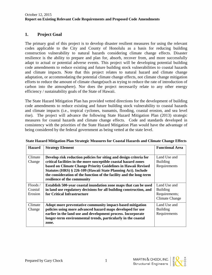
The primary goal of this project is to develop disaster resilient measures for using the relevant codes applicable to the City and County of Honolulu as a basis for reducing building construction vulnerability to natural hazards considering climate change effects. Disaster resilience is the ability to prepare and plan for, absorb, recover from, and more successfully adapt to actual or potential adverse events. This project will be developing potential building code amendments to reduce existing and future building stock vulnerabilities to coastal hazards and climate impacts. Note that this project relates to natural hazard and climate change adaptation, or accommodating the potential climate change effects, not climate change mitigation efforts to reduce the amount of climate change(such as trying to reduce the rate of introduction of carbon into the atmosphere). Nor does the project necessarily relate to any other energy efficiency / sustainability goals of the State of Hawaii. The State Hazard Mitigation Plan has provided vetted directions for the development of building code amendments to reduce existing and future building stock vulnerability to coastal hazards and climate impacts (i.e., tropical cyclones, tsunamis, flooding, coastal erosion, and sea level rise). The project will advance the following State Hazard Mitigation Plan (2013) strategic measures for coastal hazards and climate change effects. Code and standards developed in consistency with the priorities of the State Hazard Mitigation Plan would have the advantage of being considered by the federal government as being vetted at the state level. State Hazard Mitigation Plan Strategic Measures for Coastal Hazards and Climate Change Effects
Hazard Strategy Element Functional Area
Climate Change
Develop risk reduction policies for siting and design criteria for critical facilities in the more susceptible coastal hazard zones based on Climate Change Priority Guidelines in Hawaii Revised Statutes (HRS) § 226-109 (Hawaii State Planning Act). Include the consideration of the function of the facility and the long-term resilience of the community
Land Use and Building Requirements
Floods / Coastal Erosion
Establish 500-year coastal inundation zone maps that can be used in land use regulatory decisions for all building construction, and for Critical Infrastructure
Land Use and Building Requirements; Climate Change
Climate Change
Adopt more preventative community impact-based mitigation policies using more advanced hazard maps developed for use earlier in the land use and development process. Incorporate longer-term environmental trends, particularly in the coastal zone.
Land Use and Building Requirements
October 12, 2015 Report on Existing Relevant Code Requirements and Proposed Code Amendments
Prepared by Gary Chock 2
Project Objectives Addressed In the First Report (September 24, 2015) 2.
2.1 Objective 1: Examine the building codes currently in effect for the City and County of Honolulu and inventory existing regulatory standards intended to protect life and property from coastal hazards and climate impacts. Objective 1 Tasks:
a. Summarize existing and anticipated future coastal hazard and climate impacts to the City and County of Honolulu, which shall serve as the basis for the proposed code amendments to be developed.
b. Prepare an inventory of the building codes and regulatory standards currently in effect for the City and County of Honolulu that are intended to protect life and property from coastal hazards and climate impacts, including, but not limited to, the building, electrical, plumbing, and flood hazard area codes of the Revised Ordinances of Honolulu 1990, as amended, and evaluate regulatory gaps. The inventory shall, at minimum, include the legal citation, description, and purpose of the identified building codes and regulatory standards.
Note that not all of the above codes may necessarily address the protection of life and property from coastal hazards and climate change impacts on building vulnerability. That is, not all climate change effect measures would relate to building vulnerability (an example of a measure unrelated to building vulnerability would be measures regulating the use of recycled grey water in the plumbing code, which has the intent of water conservation).
2.1.1. Existing and Anticipated Future Coastal Hazard and Climate Impacts to the City and County of Honolulu
Climate change can be summarized as including the following potentially adverse effects to the Hawaii coastal zone:
i. Sea level rise and increasing rates of beach erosion ii. Groundwater rise
iii. Sea Surface Temperatures increasing with more frequent Central Pacific El Nino Southern Oscillation (ENSO) events and increased tropical cyclone activity
iv. Inundation / flooding from storms and tropical cyclones v. Increase in the number of unusually warm days
vi. More severe and longer drought periods due to reduced annual rainfall following a documented drier climate trend for Hawaii (such as affected by changes in the trade winds per Garza and Chu, et al. 2012); rainfall variation by season altered per duration of ENSO events
Effects i. through iv. are pertinent to the vulnerability of buildings and their foundations located in the coastal zone. These climate change impacts are also of potential relevance to state and county design standards to include stormwater and wastewater infrastructure, flood control infrastructure, coastal zone utility vulnerability, coastal transportation infrastructure, and port and harbor operations.
October 12, 2015 Report on Existing Relevant Code Requirements and Proposed Code Amendments
Prepared by Gary Chock 3
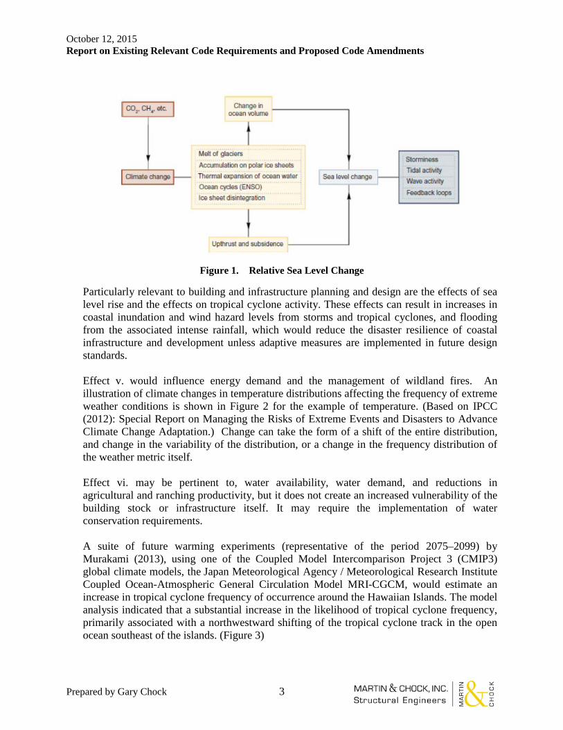
Figure 1. Relative Sea Level Change
Particularly relevant to building and infrastructure planning and design are the effects of sea level rise and the effects on tropical cyclone activity. These effects can result in increases in coastal inundation and wind hazard levels from storms and tropical cyclones, and flooding from the associated intense rainfall, which would reduce the disaster resilience of coastal infrastructure and development unless adaptive measures are implemented in future design standards. Effect v. would influence energy demand and the management of wildland fires. An illustration of climate changes in temperature distributions affecting the frequency of extreme weather conditions is shown in Figure 2 for the example of temperature. (Based on IPCC (2012): Special Report on Managing the Risks of Extreme Events and Disasters to Advance Climate Change Adaptation.) Change can take the form of a shift of the entire distribution, and change in the variability of the distribution, or a change in the frequency distribution of the weather metric itself. Effect vi. may be pertinent to, water availability, water demand, and reductions in agricultural and ranching productivity, but it does not create an increased vulnerability of the building stock or infrastructure itself. It may require the implementation of water conservation requirements. A suite of future warming experiments (representative of the period 2075–2099) by Murakami (2013), using one of the Coupled Model Intercomparison Project 3 (CMIP3) global climate models, the Japan Meteorological Agency / Meteorological Research Institute Coupled Ocean-Atmospheric General Circulation Model MRI-CGCM, would estimate an increase in tropical cyclone frequency of occurrence around the Hawaiian Islands. The model analysis indicated that a substantial increase in the likelihood of tropical cyclone frequency, primarily associated with a northwestward shifting of the tropical cyclone track in the open ocean southeast of the islands. (Figure 3)

October 12, 2015 Report on Existing Relevant Code Requirements and Proposed Code Amendments
Prepared by Gary Chock 4
Figure 2. Illustration of Various Modes of Climate Change Resulting in a Greater Frequency of Extreme Conditions
October 12, 2015 Report on Existing Relevant Code Requirements and Proposed Code Amendments
Prepared by Gary Chock 5
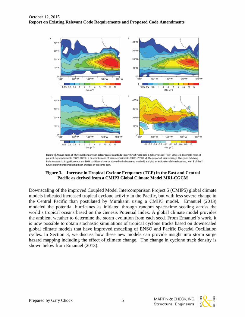
Figure 3. Increase in Tropical Cyclone Frequency (TCF) in the East and Central
Pacific as derived from a CMIP3 Global Climate Model MRI-CGCM
Downscaling of the improved Coupled Model Intercomparison Project 5 (CMIP5) global climate models indicated increased tropical cyclone activity in the Pacific, but with less severe change in the Central Pacific than postulated by Murakami using a CMIP3 model. Emanuel (2013) modeled the potential hurricanes as initiated through random space-time seeding across the world’s tropical oceans based on the Genesis Potential Index. A global climate model provides the ambient weather to determine the storm evolution from each seed. From Emanuel’s work, it is now possible to obtain stochastic simulations of tropical cyclone tracks based on downscaled global climate models that have improved modeling of ENSO and Pacific Decadal Oscillation cycles. In Section 3, we discuss how these new models can provide insight into storm surge hazard mapping including the effect of climate change. The change in cyclone track density is shown below from Emanuel (2013).

October 12, 2015 Report on Existing Relevant Code Requirements and Proposed Code Amendments
Prepared by Gary Chock 6
Figure 4. Change in Tropical Cyclone Track Density per a Suite of CIMP5 models (Emanuel, 2013)
2.1.2. Building Codes and Regulatory Standards Currently in Effect for the City and County of Honolulu that are intended to protect life and property from coastal hazards and climate impacts:
I. Land Use Ordinance (LUO), Revised Ordinances of Honolulu (ROH) Chapter 21 (amended 2014)
• Development and design standards for the location, height, size of structures, density and open spaces, traffic and amount and type of parking, property line setbacks, outdoor lighting and zoned uses
• Zoning Classification System implemented in maps; also includes preservation zoning for lands having an elevation below the maximum inland line of the zone of wave action, land susceptible to floods and soil erosion, land undergoing major erosion damage or susceptible to inundation (See ROH Chapter 24, § 24-1.3 for land use categories)
• Includes Specific Use Development Standards by type of occupancy and economic activity
October 12, 2015 Report on Existing Relevant Code Requirements and Proposed Code Amendments
Prepared by Gary Chock 7
• Flood hazard areas: “Dwellings in country, residential and agricultural districts, as well as detached dwellings and duplex units in apartment and apartment mixed use districts, may exceed the maximum height in the district by no more than five feet if required to have its lowest floor elevated to or above the base flood elevation, provided such additional height shall not be greater than 25 feet above the base flood elevation.”
• Special Districts such as Diamond Head, Waikiki, and Haleiwa, each having design controls
• Pre-permitting process requires public input at neighborhood boards
• Permitting is for “conditional use” that essentially involves conditions of additional specific requirements to meet “intent”
• Includes the process for zone changes that are essentially negotiated
• This is probably one of the key points of regulatory review and enforcement or exemptions, with a high degree of political visibility
Gap: Design Advisory Committee does not have any representative expertise for natural hazards and climate change adaptation; no design controls exist in the LUO related to these concerns, so presently, natural hazard concerns may not have explicit standing in the application of the LUO.
Proposed Changes: LUO Article 2 Administration and Enforcement – for Major Permits within the Shoreline Management Area, require evaluation of 75-years of relative sea level rise (determined per the USACE method) on the functionality of the development and land use and mitigation of the deleterious effects of the proposed use, and require the director to consider that as a criteria for permitting new development, variances, or zone changes.
October 12, 2015 Report on Existing Relevant Code Requirements and Proposed Code Amendments
Prepared by Gary Chock 8
II. Honolulu Building Code, ROH Chapter 16 (October 18, 2012) The Honolulu Building Code based on the 2006 International Building Code (IBC) has the following local amendment provisions relating to hurricane and flood protective design measures:
• The basic wind speed and design equations are intended to result in achieving structural integrity of typical new construction for windspeeds up to 130 mph, which is a mid-Category III hurricane.
• Recognizes Hawaii as a Special Wind Region with maps that account for topographic wind effects
• Windborne debris protection is mandated for critical facilities • State- and City-Owned High Occupancy Buildings have Enhanced Hurricane
Protection Area wind, windborne debris, and flood design requirements. • For other categories of buildings, internal pressurization requirements are included to
address glazing breakage during hurricanes • Certain atypical single-family residences without windborne debris protection, where
located outside of the flood zone, have safe room provisions for refuge with safety equivalent to that of a shelter
• There are Complete Load Path wind uplift resistance requirements for light frame residential construction
• Design rain load maps for a 100-year 1-hour rainfall rates apply to roof design and roof drainage, the same as in the Plumbing Code
• Flood hazard requirements are to document compliance with the American Society of Civil Engineers (ASCE) 24 Standard based on a 100-year flood, which is the same minimal flood level as the National Flood Insurance Program (NFIP).
Gaps being addressed in the next code update for the state adoption of the 2012 IBC: • Upgraded fastening of roofing underlayment and roofing systems for high wind • Wind design of photovoltaic panels and their attachments • Use of the more severe Exposure D wind profile for the coastal zone based on the
effect of more intense hurricane windspeeds acting on open ocean wave breaking
Other Gaps: • The roof design requirement for rain loading has no allowance for long-term
trends of climate causing more intense storms. • If the frequency and intensity of tropical cyclones will increase within the
economic lifespan of the building, then it would be justified to make a proportionately commensurate increase in the basic wind speed and associated maps
• If coastal storm inundation depths increase because of coastal erosion, shoreline recession, subsidence, and sea level rise, then greater “freeboard” requirements for clearance above the base flood elevation can be mandated in the Honolulu Building Code, without seeking changes to the Federal Emergency Management Agency (FEMA) Flood Insurance Rate Maps (FIRM).
• Foundation design requirements do not account for shoreline erosion.
October 12, 2015 Report on Existing Relevant Code Requirements and Proposed Code Amendments
Prepared by Gary Chock 9
Proposed Changes for Risk Category III and IV structures: • Revise rainfall intensity map figure 1611.1 to add 1 hour 500-year intensity • Adjust windspeed map for 1700-year and 3000-year windspeeds • Amend section for minimum elevation of the lowest horizontal structural
member, based on 500-year flood elevation taking into account relative sea level change
• Require consideration of shoreline erosion on foundation design
October 12, 2015 Report on Existing Relevant Code Requirements and Proposed Code Amendments
Prepared by Gary Chock 10
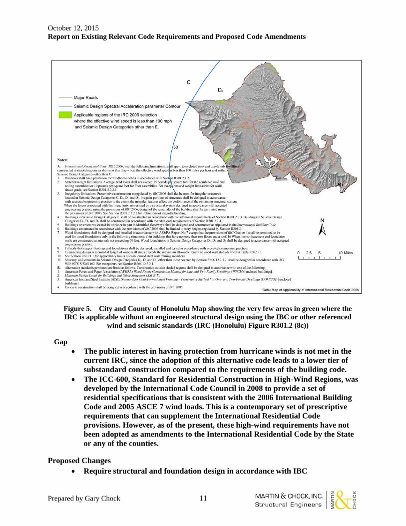
III. Honolulu International Residential Code (IRC), ROH Chapter 16 (October 18, 2012)
• This is an alternative set of non-engineered semi-prescriptive code provisions that are permitted as an exception to the Honolulu Building Code to apply to the construction, alteration, movement, enlargement, replacement, repair, equipment, use and occupancy, location, removal and demolition of detached one- and two-family dwellings and multiple single family dwellings (townhouses) not more than two stories high with separate means of egress and their accessory structures.
• Wind Limitations: the IRC model code was originally developed for areas on the mainland where design professionals and design standards for residential construction were historically lacking. It is a code that does not include the engineering of the structure. Instead, prototypical assumptions of building types were used to develop a series of prescriptive requirements for low to moderate seismic and low wind conditions (windspeeds less than 100 mph) outside of the hurricane-prone regions.
• However, the wind uplift prescriptive requirements of the IRC pertain only to the roof to wall connections; a complete load path of prescriptive connections is not provided and must be designed.
• Nevertheless, building code officials in three of the four counties and the American Institute of Architects Hawaii Chapter (AIA Hawaii) desired to have a separate building permit review process for single-family homes based on the IRC. Maps were developed to show where the IRC assumptions were violated and the prescriptive structural requirements would not be adequate.
• Construction in regions where the effective wind speed, Veff, shown on the Oahu wind maps, equal or exceed 100 miles per hour shall be structurally designed in accordance with engineered design standards.
• However, it does not appear that the building permit review process includes checking for applicability. As a result, many homes and accessory structures are permitted under the alternative IRC where the structural integrity provisions are invalid. Thus, as presently administered, the Honolulu IRC is a loophole for single family residence permitting without adequately designing for hurricanes.
• Typical users of these provisions are sole proprietor architectural practices and drafting services that do not use engineers except as plan “stampers”.
• Designers of major subdivision developments generally will use the Honolulu Building Code rather than the Honolulu IRC.
October 12, 2015 Report on Existing Relevant Code Requirements and Proposed Code Amendments
Prepared by Gary Chock 11
Figure 5. City and County of Honolulu Map showing the very few areas in green where the IRC is applicable without an engineered structural design using the IBC or other referenced
wind and seismic standards (IRC (Honolulu) Figure R301.2 (8c))
Gap • The public interest in having protection from hurricane winds is not met in the
current IRC, since the adoption of this alternative code leads to a lower tier of substandard construction compared to the requirements of the building code.
• The ICC-600, Standard for Residential Construction in High-Wind Regions, was developed by the International Code Council in 2008 to provide a set of residential specifications that is consistent with the 2006 International Building Code and 2005 ASCE 7 wind loads. This is a contemporary set of prescriptive requirements that can supplement the International Residential Code provisions. However, as of the present, these high-wind requirements have not been adopted as amendments to the International Residential Code by the State or any of the counties.
Proposed Changes • Require structural and foundation design in accordance with IBC

October 12, 2015 Report on Existing Relevant Code Requirements and Proposed Code Amendments
Prepared by Gary Chock 12
IV. Shoreline Setbacks, ROH Chapter 23 (1992)
• It is a primary policy of the City and County of Honolulu to protect and preserve the natural shoreline, especially sandy beaches; to protect and preserve public pedestrian access laterally along the shoreline and to the sea; and to protect and preserve open space along the shoreline. It is also a secondary policy of the City and County of Honolulu to reduce hazards to property from coastal floods.
• Prohibits any construction or activity that may adversely affect beach processes, shoreline access, and shoreline open space.
• Standard 40-foot setback from the certified shoreline, with exception that a minimum 30 f00t buildable area is to be maintained.
• "Shoreline" means the upper reaches of the wash of the waves, other than storm and seismic waves, at high tide during the season of the year in which the highest wash of the waves occurs, usually evidenced by the edge of vegetation growth, or the upper limit of debris left by the wash of the waves.
• Prohibited structures and prohibited taking of materials in the shoreline area. • If a nonconforming structure is destroyed by any means to an extent of more than 50
percent of its replacement cost at the time of destruction, it shall not be reconstructed except in conformity with the provisions of this Chapter 23. Existing nonconforming structures require a variance to reconstruct.
• Subdivisions must accommodate a 60-foot setback, with some exceptions based on topography.
• Procedure for variances based on feasibility and need. • Illegal shoreline protection structures are those that were not authorized by permit.
Gap: Unlike Maui and Kauai, these regulations are not based on historic shoreline erosion rates, although such information exists and is readily available. Proposed Changes:
• Adopt setbacks based on historic shoreline erosion rates for Oahu
October 12, 2015 Report on Existing Relevant Code Requirements and Proposed Code Amendments
Prepared by Gary Chock 13
V. Special Management Area, ROH Chapter 25 (amended November 2011)
• Special management area (SMA) means the land extending inland from the shoreline, as established by Chapter 25 and delineated on the maps established by the City Council.
• Special controls on development within an area along the shoreline are necessary to avoid permanent loss of valuable resources and foreclosure of management options, and to insure that adequate public access is provided to public owned or used beaches, recreation areas, and natural reserves, by dedication or other means. It is also the policy of the City and County of Honolulu to avoid or minimize damage to natural or historic special management area wetlands wherever prudent or feasible.
• “Development” does not include construction or reconstruction or improvements of a single-family residence that is less than 7,500 square feet of floor area and is not part of a larger development; nor repair or maintenance of roads and highways or streams, channels, and drainageways, nor underground utilities.
• "Shoreline" means the upper reaches of the wash of the waves, other than storm and tidal waves, at high tide during the season of the year in which the highest wash of the waves occurs, usually evidenced by the edges of vegetation growth or the upper limit of debris left by the wash of the waves.
• SMA use assessments include the following: o Adequate access publicly-owned beaches o Protection of water resources and water quality and natural habitats o Provisions for solid and liquid waste treatment o No substantial adverse environmental effects to the extent practicable o Consistent with the general plan and Chapter 24 development plans and
Chapter 21 zoning o Shielded exterior lighting o Minimizes dredging and filling
Gap: SMA maps may need adjustment in the future in high erosion rate areas; the actual lifespan of most building and infrastructure development (excluding single family homes) will typically be over 100 years. There is no statutory minimum lifespan of development defined for SMA considerations. Such a definition could bring standing to considerations of climate change. Proposed changes:
• Create another level of SMA zone maps to account for sea level rise, shoreline erosion, and coastal flood modeling under CMIP5 RCP8.5 climatic conditions. Have this applicable to major (definition TBD) developments.

October 12, 2015 Report on Existing Relevant Code Requirements and Proposed Code Amendments
Prepared by Gary Chock 14
VI. Flood Hazard Area, ROH Chapter 21A (May 2014) • Enacted to maintain compliance with the NFIP. • One of the amended provisions was the use of “market value” instead of
“replacement value” for purposes of establishing when proposed renovations, additions or expansions of non-conforming structures in a flood zone should be made compliant with the flood ordinance requirements. A project that equals or exceeds 50 percent of the market value of the existing structure within a cumulative period of five years is subject to full compliance with flood ordinance requirements.
• A project that equals or exceeds 50 percent of the market value of the existing structure within a cumulative period of five years is subject to full compliance with flood ordinance requirements. "Substantial improvement" means any reconstruction, rehabilitation, addition, or series of reconstruction, rehabilitation, or additions, or other proposed new development of a structure or repetitive loss structure, in any five-year period, the cumulative cost of which equals or exceeds fifty percent of the market value of the structure (excluding land) before the "start of construction" of the first improvement during that five-year period.
• Stated to be for the purposes of flood and tsunami protection; however, no tsunami provisions exist.
• Functionally dependent use includes only docking facilities, port facilities for cargo and passengers, and ship building and repair facilities.
• Administered by the Department of Planning and Permitting. • Based on FEMA 100-year flood zones in the Flood Insurance Rate Maps (FIRM) that
also establish the 1% annual exceedance base flood. • Digital Flood Insurance Rate Maps (DFIRM) was effective September 30, 2004;
coastal revision to account for hurricane storm surge was effective January 19, 2011. • V-zones: Minimum elevation of the lowest structural member above the Base Flood
Elevation (BFE); break-away wall construction below the BFE; use of fill for structural support is prohibited in the V-zone.
• A zones: Minimum elevation of lowest floor or basement above the BFE. • Areas beneath the BFE has restricted use as parking or storage only and must meet
minimum opening requirements. • Various conditions for seeking variances. • Certification standards for the flood boundary, flood elevation, lowest floor elevation
certification, and post-construction certification.
Gap: 100-year flood hazard has a 40% chance of being exceeded with a 50-year economic horizon; these are reliability targets that are far below any other engineering standard, even before the consideration of climate change effects that may increase inundation in the future.
Proposed Change for Risk Category III and IV structures: • Locally develop and adopt a 500-year flood zone that incorporates sea level rise,
and RCP 8.5 equivalent storm inundation • Do not engage FEMA-led mapping procedures

October 12, 2015 Report on Existing Relevant Code Requirements and Proposed Code Amendments
Prepared by Gary Chock 15
VII. National Flood Insurance Program (NFIP)
The federal government created the National Flood Insurance Program (NFIP) to insure those who suffer from flood disasters.
From 1968 until the adoption of the Flood Disaster Protection Act of 1973, the purchase of flood insurance was voluntary. The Flood Disaster Protection Act of 1973 mandated flood insurance coverage for many properties. For the first time, regulated lending institutions could not make, increase, extend, or renew any loan secured by improved real estate located in a Special Flood Hazard Area (SFHA) in a participating NFIP community unless the secured building and any personal property securing the loan were covered for the life of the loan by flood insurance. Congress established this requirement because, after major flood disasters, it became evident that relatively few individuals in eligible communities who sustained flood damage had purchased flood insurance. Also, federal officers or agencies could not approve any form of loan, grant, guaranty, insurance, payment, rebate, subsidy, disaster assistance loan or grant, for acquisition or construction purposes within a SFHA in a participating community unless the building and any personal property to which such financial assistance relates were covered during the life of the property.
Following the multi-billion dollar flood disaster in the Midwest in 1993, Congress enacted the National Flood Insurance Reform Act of 1994. One of the purposes of the 1994 Act is to improve compliance with the mandatory purchase requirements of the NFIP by lenders, servicers, and secondary-market purchasers. Congress was concerned over the low level of insurance participation among eligible property owners and resulting increases in Federal disaster relief payments. The law requires Federal agency lender regulators to develop regulations to direct their federally regulated lenders not to make, increase, extend, or renew any loan on applicable property unless flood insurance is purchased and maintained. The changes in NFIP regulations since 1994 have required additional homeowners in Hawai‘i to buy flood insurance. There are over 30,000 properties in Hawaii with flood insurance policies in force.
On June 30, 2004, President George W. Bush signed into law the Bunning-Bereuter-Blumenauer Flood Insurance Reform Act of 2004. The reforms covered by the Act include measures to address repetitive losses. The Biggert-Waters Flood Insurance Reform Act of 2012 (BW-12) was passed by Congress and signed by the President on July 6, 2012. The Reform extends the National Flood Insurance Program for five years, while requiring significant program reform. The law requires changes to all major components of the program, including flood insurance, flood hazard mapping, grants, and the management of floodplains. Many of the changes are designed to make the NFIP more financially stable, and ensure that flood insurance rates more accurately reflect the real risk of flooding. The changes will be phased in over time, beginning in 2013.
Under the NFIP, each county has mapped flood hazard areas and established a permit system to regulate development within these flood hazard areas. The Flood Insurance Rate Maps (FIRMs) include areas prone to rainfall flooding (A zones) and high waves (V zones). For the County of Kauaʻi, floodplain management and permitting regulations are included in Title IV, Chapter 8, of the Kauaʻi County Code. Floodplain management regulations for the City and County of Honolulu are stipulated in Chapter 21, Section 9.10, of the Revised Ordinances of the City and

October 12, 2015 Report on Existing Relevant Code Requirements and Proposed Code Amendments
Prepared by Gary Chock 16
County of Honolulu. In the case of the County of Maui, floodplain management policy is included in Chapter 19.62 of the Maui County Code. Lastly, the floodplain regulation and permitting system for the County of Hawaiʻi is set forth Chapter 27 of the Hawai‘i County Code. The NFIP mandates federal insured banks to require purchasing of flood insurance as a condition for financing the construction or purchase of existing buildings in flood plain areas, thereby shifting the primary burden for flood disaster relief to those who choose to live or conduct business in flood hazard areas.
The recurrence interval of a flood, or flood frequency, is the average time interval within which a flood of a given magnitude will be equaled or exceeded. Flood frequencies can be determined by plotting a graph of the size of all known floods for an area and determining how often floods of a particular size may occur, or gathering hydrologic and hydraulic data from streams and calculating probabilities through models. The FIRM maps identify a flood hazard area as the area that would be inundated by a 100-year flood, or a flood with a 1% chance of occurring annually. The 100-year flood, also referred to as the base flood, is a national standard adopted by the NFIP that represents a compromise between minor floods and the greatest flood likely to occur in a given area. The FIRM maps delineate the 100-year flood zones for rainfall flooding, coastal flooding, shallow flooding, and distinguish areas where detailed studies have been conducted to determine base flood elevations. While the 100 year floodplain identifies the boundary of a flood having an annual probability of occurrence of 1%, there are areas within the floodplain with higher probabilities of occurrence. The probability of recurrence increases with proximity to the stream channel or the coastline. Therefore, sites located at or near streams or shorelines have higher probabilities of occurrence than that of the floodplain
The NFIP sets minimum requirements for participating communities’ building construction regulations. The NFIP minimum requirements are summarized as follows:
There are five major floodplain regulation requirements. (Additional floodplain regulatory requirements may be set by state and local law.)
1. All development in the base floodplain must have a permit from the community. Agriculture and forestry activities are not exempt.
2. Encroachments, including fill, new construction, substantial improvements and other developments shall not be allowed in the floodway unless it has been demonstrated through hydrologic and hydraulic analyses performed in accordance with standard engineering practice that the proposed encroachment would not result in any increase in flood levels within the community during the occurrence of the base flood discharge. The floodway is the channel and central portion of the floodplain that is needed to convey the base flood. It is usually the most hazardous area of a riverine floodplain and the most sensitive to development. At a minimum, no development in the floodway can cause an obstruction to flood flows.
3. New buildings may be built in the floodplain, but they must be protected from damage by the base flood. The lowest floors of residential building must be elevated to or above the BFE. Non-residential buildings must be elevated or protected against floods.
October 12, 2015 Report on Existing Relevant Code Requirements and Proposed Code Amendments
Prepared by Gary Chock 17
4. When an addition, improvement or repair of damage to an existing building is valued at 50% or more than the value of the original building, then it is a considered a substantial improvement. A substantial improvement is treated as new construction and the building must be protected from damage by the base flood.
5. In coastal high hazard areas (V-zone), new buildings and substantial improvements to existing buildings must be elevated on open columns or piles so that the bottom of the lowest horizontal structural member is elevated at or above the BFE. New buildings shall also be on an anchored foundation engineered for the site. Construction projects are not allowed to alter sand dunes.
There are four significant benefits of participating in the NFIP. One focuses on property protection and three focuses on financial security. Specifically:
1. Development that complies with the minimum NFIP performance criteria is less likely to experience major damage. Studies have shown that, on average, buildings that meet the NFIP criteria sustain approximately 75% less damage than those that do not.
2. Federally insured or regulated lenders must require that improvements located in mapped flood hazard areas be insured for flood damage. If a community does not participate in the NFIP, then lenders must notify borrowers that federal disaster assistance for flood damage will not be available, including grants and loans.
3. People who have flood insurance have a significant advantage over those who have no financial support or those who have to get loans to help repair and rebuild. Most homeowners’ property insurance explicitly excludes damage from floods, and non-NFIP flood insurance is hard to find. However, it is easy for most home and business owners to get NFIP flood insurance because many private companies write and sell policies on behalf of the NFIP.
4. Federal assistance is available to repair or restore public infrastructure and buildings in flood hazard areas if damaged by a disaster that is declared by the president.
Gaps: The 100-year flood, or the flood with a 1% annual chance of being exceeded, results in a 40% chance of being exceeded over a typical economic lifespan of 50-years. That level of reliability is very far below the criteria used for any other natural hazard. For example, the wind design provisions of the code are based on the 700-year windstorm, which has about a 5% chance of being exceeded over 50 years. Floods are a special case where the design criteria has not been set by engineers, but by the NFIP legislation, resulting in relatively low requirements for flood mitigation that are exceeded in “real” disasters, such as due to surge and waves setup by hurricanes. Problems develop when flood loads start to overwhelm wind design capacity. In other words, flood loads will be much higher than wind loads, but the flood elevation prescribed is much lower than what the design level hurricane will produce, creating a severe gap of vulnerability.
October 12, 2015 Report on Existing Relevant Code Requirements and Proposed Code Amendments
Prepared by Gary Chock 18
Flood zones based on the 100-year mean recurrence interval BFE do not include all structures exposed to flood hazard. For storm events of greater return period, the flood hazard expands both in spatial extent and in depth. For those structures and components of structures that were not subject to the prescriptive flood design requirements, the ratio of flood load to design resistance becomes infinite, resulting in failure. Therefore, the flood loads that are associated with NFIP regulations do not have a uniform or consistent reliability basis to the same extent as the other natural hazards.
VIII. Honolulu Plumbing Code, ROH Chapter 19 (per State Plumbing Code 2010 based on 2006 Uniform Plumbing Code (UPC))
• Plumbing drains and gutters to be designed consistent with the statistical 100-year 1-hour rainfall rate for Hawaii as mapped by the National Weather Service.
• The Honolulu Plumbing Code has some provisions that allow the use of recycled water under certain circumstances:
o Gray-water systems are allowed for landscape irrigation purposes in single-family dwellings, provided design is substantiated by soil conditions for absorption and the lot area. It is not allowed within 3 feet of the highest known ground water, nor where contamination of groundwater or ocean may occur. The discharge of graywater is by drip irrigation or leach field; no surface or spray distribution of graywater is permitted.
• There is an allowance for septic tank requirements based on soil percolation rates for leaching.
Gap: This requirement has no allowance for long-term trends of climate change causing more intense storms. Proposed Change for Risk Category III and IV Structures:
• Develop and Adopt 500-year 1 hour rainfall intensity maps
IX. Honolulu Electrical Code, ROH Chapter 17
• Special requirements for electrical work in the flood hazard zone, typically the installation of ground fault protectors and ground fault circuit interrupters.
• Elevation of electrical equipment above the base flood elevation or ground fault protection is required.
• Applicability is essentially linked to the BFEs of the flood insurance rate maps.
Gap: There are no restrictions on locating electrical transformers and switchgear in basements within the flood hazard zone.
Proposed Change for Risk Category III and IV structures: • Require placement above 500-year flood or dry flood-proofing for 500-year flood
developed considering climate change.
October 12, 2015 Report on Existing Relevant Code Requirements and Proposed Code Amendments
Prepared by Gary Chock 19
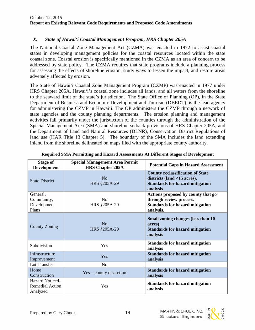
X. State of Hawai‘i Coastal Management Program, HRS Chapter 205A The National Coastal Zone Management Act (CZMA) was enacted in 1972 to assist coastal states in developing management policies for the coastal resources located within the state coastal zone. Coastal erosion is specifically mentioned in the CZMA as an area of concern to be addressed by state policy. The CZMA requires that state programs include a planning process for assessing the effects of shoreline erosion, study ways to lessen the impact, and restore areas adversely affected by erosion.
The State of Hawai‘i Coastal Zone Management Program (CZMP) was enacted in 1977 under HRS Chapter 205A. Hawai‘i’s coastal zone includes all lands, and all waters from the shoreline to the seaward limit of the state’s jurisdiction. The State Office of Planning (OP), in the State Department of Business and Economic Development and Tourism (DBEDT), is the lead agency for administering the CZMP in Hawai‘i. The OP administers the CZMP through a network of state agencies and the county planning departments. The erosion planning and management activities fall primarily under the jurisdiction of the counties through the administration of the Special Management Area (SMA) and shoreline setback provisions of HRS Chapter 205A, and the Department of Land and Natural Resources (DLNR), Conservation District Regulations of land use (HAR Title 13 Chapter 5). The boundary of the SMA includes the land extending inland from the shoreline delineated on maps filed with the appropriate county authority.
Required SMA Permitting and Hazard Assessments At Different Stages of Development
Stage of Development
Special Management Area Permit HRS Chapter 205A Potential Gaps in Hazard Assessment
State District No HRS §205A-29
County reclassification of State districts (land <15 acres). Standards for hazard mitigation analysis
General, Community, Development Plans
No HRS §205A-29
Actions proposed by county that go through review process. Standards for hazard mitigation analysis.
County Zoning No HRS §205A-29
Small zoning changes (less than 10 acres), Standards for hazard mitigation analysis
Subdivision Yes Standards for hazard mitigation analysis
Infrastructure Improvement Yes Standards for hazard mitigation
analysis Lot Transfer No Home Construction Yes – county discretion Standards for hazard mitigation
analysis Hazard Noticed-Remedial Action Analyzed
Yes Standards for hazard mitigation analysis

October 12, 2015 Report on Existing Relevant Code Requirements and Proposed Code Amendments
Prepared by Gary Chock 20
XI. State of Hawai‘i Coastal Lands Program (CLP) of DLNR Land Division (HAR Title 13, Subtitle 10, Chapters 219-223)
On November 20, 1997, the State of Hawai‘i Board of Land and Natural Resources established the Coastal Lands Program (CLP) within the Land Division. The purpose of the CLP is to establish a strategic and comprehensive framework to protect and conserve the state's beaches. This framework is set out in the Coastal Erosion Management Plan (COEMAP), a joint effort of the State of Hawai‘i DLNR and the University of Hawai‘i, Department of Geology and Geophysics. The major goals of the CLP are as follows:
• Develop consensus on the causes and consequences of beach loss for the beaches of the State of Hawai‘i.
• Develop agency agreements with respect to coordinating regulatory functions (i.e., permit streamlining and enforcement) and planning goals with other state, county and federal agencies.
• Build support for legislative actions needed to implement COEMAP. • Strike a balance between coastal development and beach conservation by promoting
alternatives to shoreline hardening, such as beach and dune restoration, coastal lands acquisition and strategic redevelopment.
• Form linkages with federal agencies and community groups and provide funds for research and planning to support county land management efforts along the coast.
The CLP is overseen by the State of Hawai‘i DLNR through the Office of Conservation and Coastal Lands (OCCL). Some of the initiatives taken by the CLP include developing pilot programs for beach nourishment, streamlining the beach nourishment regulatory process, and funding sediment and coastal engineering studies to better understand complex coastal areas such as Waikiki Beach. The Coastal Lands Program has also been developing public education programs and distributing information and guidelines on the best management, erosion control and construction practices for Hawai‘i’s coastal areas. Through these programs, the OCCL hopes to provide cutting edge coastal engineering and management and solutions that will prove to be useful for the next generation of coastal managers.
October 12, 2015 Report on Existing Relevant Code Requirements and Proposed Code Amendments
Prepared by Gary Chock 21
XII. State of Hawai‘i Land Use Commission, HRS Chapter 205
In 1961 the State Land Use Law was enacted and established the State Land Use Commission (LUC). The law provides that the LUC has the power to classify all lands in the State into four districts: Agriculture, Conservation, Rural, and Urban. Act 187 vested DLNR with jurisdiction over the Conservation District, enabling DLNR to formulate subzones within the Conservation District, and to regulate land uses and activities therein. Since 1964, the Board of Land and Natural Resources (BLNR) has adopted and administered land use rules for the Conservation District (HAR Chapter 13-15), and has made major changes to the rules in 1978 and 1994.
The Conservation District has five subzones: Protective, Limited, Resource, General, and Special. Omitting the Special subzone, the four subzones are arranged in a hierarchy of environmental sensitivity, ranging from the most environmentally sensitive (Protective) to the least sensitive (General); the Special subzone is applied in special cases specifically to allow a unique land use on a specific site.
The Conservation District includes numerous segments of coastal areas landward from the shoreline. Besides these lands, the Conservation District also includes all submerged lands seaward of the certified shoreline, to the limit of state territorial waters.
The BNLR, staffed by DLNR, is responsible for establishing the procedures for certifying where the shoreline is located, and for promulgating and administering the Conservation District use regulations. All activities proposed within the Conservation District must submit to an application and review permit in order to obtain a Conservation District Use Permit from BLNR.
XIII. State of Hawai‘i Certified Shoreline, HRS Chapter 205A
The State Board of Land and Natural Resources was authorized by HRS Chapter 205A, to adopt rules for determining the shoreline and appeals of shoreline determinations, and to enforce the established rules. The coastal setback in the State of Hawai‘i is measured from the Shoreline, defined in HRS Chapter 205A as:
The upper reaches of the wash of the waves, other than storm and seismic waves, at high tide during the season of the year in which the highest wash of the waves occurs, usually evidenced by the edge of vegetation growth or the upper limit of debris left by the wash of the waves. (HRS §205A-1)
Gap: This definition creates problems, as there are many variables associated within the measurable limits of building space on the shore. Unfortunately the “edge of vegetation growth” or the landward limit of development, all too often appears to be migrating seaward as commercial interests and homeowners frequently landscape their beachfront in order to gain valuable coastal building space. The cumulative effect of this practice constitutes a slow encroachment of the property line. On the other hand, encouraging vegetative growth can help mitigate the erosion of sand dunes. Also, measuring by the variable characteristics of wave run-up does not allow for a more accurate means of measurement, such as a fixed natural monument or datum with measurable characteristics.
October 12, 2015 Report on Existing Relevant Code Requirements and Proposed Code Amendments
Prepared by Gary Chock 22
Proposed Change: • Develop Expected Shoreline taking into account shoreline erosion and relative sea
level rise
XIV. Mandatory Seller Disclosures in Real Estate Transactions, HRS Chapter 508D The Mandatory Seller Disclosures in Real Estate Transactions Act ("Mandatory Disclosures Act") was passed in 1994. [HRS Chapter 508D] This law requires the seller or the seller’s agent to prepare a disclosure statement in good faith and with due care regarding material facts that would be expected to measurably affect the value to a reasonable person of the residential real estate being offered for sale. Related to hazard mitigation, disclosure is expressly required for residential property in the special flood hazard area. HRS § 508D-15(a)(1). These are areas on the Flood Insurance Rate Maps subject to the 100-year flood and are equivalent to FEMA's V, VE, A and AE zones. Disclosure is also required for anticipated inundation areas designated on the on the Department of Defense's civil defense tsunami inundation maps. HRS § 508D-15(a)(4). The Hawai‘i Supreme Court has indirectly indicated that erosion is a material factor to disclose. The Court ruled that a shoreline property boundary that was in dispute was a material fact that required disclosure. Shaffer v. Earl Thacker Co., 6 Haw. App. 188, 716 P.2d 163 (1986). Erosion changes the location of shoreline property boundaries, resulting in diminution of coastal lot size over time. County of Hawai‘i v. Sotomura, 54 Haw. 176 (1973). Gap: The Mandatory Disclosures Act covers only residential real property with one to four dwelling units or a condominium or cooperative apartment, the primary use of which is occupancy as a residence. [HRS § 508D-1] Empty lots with no structures on them are not covered, even though the lot may have a history of flooding and erosion. Proposed Change:
• Make mandatory seller disclosure apply to vacant lots as well
XV. Uniform Land Sales Practices Act, HRS Chapter 484 The Uniform Land Sales Practices Act was enacted in 1967 and deals specifically with the sale of subdivided lands. Under this law, a public offering statement is to be delivered to all purchasers and prospective purchasers of a lot in a subdivision. HAR § 16-104-26(a). The public offering statement is to fully and accurately disclose the physical characteristics of the subdivided lands offered and all unusual or material circumstances or features affecting the subdivided lands. HAR § 16-104-2.
Required information in the public offering statement that is relevant to hazard mitigation includes:
1. Existing zoning regulations, including land use classifications and general plan; 2. Encumbrances, easements, liens, restrictions;
October 12, 2015 Report on Existing Relevant Code Requirements and Proposed Code Amendments
Prepared by Gary Chock 23
3. Elevation of the land;
4. Soil conditions- drainage; and
5. Exposure to natural hazards; e.g., earthquakes, floods, tidal waves, volcano, forest fires, slides, etc. HAR § 16-104-25.
From the landowner/developer prospective, disclosure of hazard risks creates an incentive to design projects, subdivisions or lots that avoid hazard problems. This is because the combination of a poorly designed (substandard) lot and a knowledgeable buyer will reduce market value. The developer benefits from proper hazard mitigation design by offering a more valuable product and establishing a quality reputation. Aside from protecting the buyer and providing incentive for the landowner to implement hazard mitigation measures, seller disclosure laws promote economic efficiency. Hawai‘i's disclosure law was implemented, in part, after statistics showed that a leading cause of real estate litigation was due to the failure to disclose material facts regarding a property. Gap: The statutes do not reference any particular hazard maps or criteria of the severity of the hazard that warrants disclosure. Another problem with the public offering statement is the timing of receipt - at "time of sale" which is after a decision has been made to purchase. This coupled with vagueness of information required renders disclosure ineffective. A buyer has little recourse after the sale if the seller did not follow the disclosure requirements. Tropical cyclones are not considered. Climate change effects are not considered. Proposed change:
• Expand list of disclosable hazards in public offering to include, more explicitly: “Exposure to natural hazards: e.g., 2500-year earthquake ground motion in excess of SDC B levels and earthquake –induced ground failure and rockfalls/landlsides, 100-year and 500-year flooding, 2500-year tsunami inundation, lava inundation hazard zone 1, 2, or 3 per USGS 1992 map, forest and wildfire historic burn areas per DOFAW, effective windspeed hazards above 145 mph per Hawaii State Building Code”, dam failure inundation, high surf inundation, and 100-year coastal shoreline erosion.”

October 12, 2015 Report on Existing Relevant Code Requirements and Proposed Code Amendments
Prepared by Gary Chock 24
XVI. Hawaii State Building Code, HRS Chapter 107, Part II This statute of 2007 gives the State Building Code Council (SBCC) the authority to adopt, amend, and update codes and standards including but not limited to those applicable to buildings, residential structures, and hurricane resistant standards related to loss mitigation standards in accordance with HRS § 431P-12, flood and tsunami, and existing buildings. This statute makes the SBCC the primary means of implementing new codes and design standards for the State. All counties in Hawaii are required by this statute to update their county building code within two years of the adoption of any state building code. Therefore, the building, electrical, plumbing, and flooding hazard codes of the ROH are largely dependent on the maintenance and updating of the Hawaii State Building Code.
State Building Code Council Pending Hearing Authorization by
Governor
Current Codes by Jurisdiction
Currently Considering
Recently or soon to be Approved
Administrative Rules C&C Honolulu
Building 2012 IBC
2012 IBC (2015) 2012 IBC 2006 IBC
Adopted 10/3/2012
Plumbing 2012 UPC
2012 UPC (July 8, 2014)
2012 UPC 2006 UPC † ‡
Electrical 2014 NEC
2014 NEC 12/09/14 2014 NEC 2008 NEC
Adopted 2009 Energy 2015 IECC 2006 IECC
Adopted 11/29/09 Residential 2012 IRC*
2006 IRC*
2006 IRC*
2006 IRC* Adopted 10/3/2012
† State Version applies. ‡ County version being checked by Corporation Counsel. * IRC not applicable to high seismic areas and has limited applicability due to hurricane wind speeds.
If a county does not meet the two-year adoption schedule, the Hawaii State Building Code version of that code automatically becomes effective in the interim, until the county makes a formal adoption by ordinance. Such has been the typical case with the City and County of Honolulu, which missed the April 2012 deadline for the IBC and the IRC, as well as the deadline for the 2006 UPC. Gaps: The prior state executive branch did not support operations of the State Building Code Council which has resulted in significant latency in adopting current standards. Therefore, it should be noted that the implementation of any climate change adaptation measures will be severely impeded if funding of the State Building Code Council is not provided on a continual basis of support. Historically since the SBCC inception in 2007, State agencies have not been very active participants due to parochial hesitancy against “mission creep”.
October 12, 2015 Report on Existing Relevant Code Requirements and Proposed Code Amendments
Prepared by Gary Chock 25
With the exception of the State Fire Council, the DBEDT Office of Planning and State Energy Office, State agencies have not been advocates for modernizing building codes to present standards, much less accounting for climate change effects. Proposed change: Mandatory adoption of International Building Code as the interim state code when DAGS does not adopt HAR within 3 years of publication.
XVII. Public Utilities Commission (PUC) 2007 Adoption of the 2002 National Electric Safety Code (Department of Budget and Finance HAR 6-73 Installation, Operation, and Maintenance of Overhead and Underground Electrical Supply and Communication Lines)
• Prior to Hurricane Iwa Hawaii's PUC adopted General Order No.6 - Rules for Overhead Electric Line Construction (GO-6) in 1966. GO-6 specified a "Light Loading" condition applied to facilities where the elevation above sea level is 6,250 feet or less. “A horizontal wind pressure of 8 psf (56 mph) on projected area on cylindrical surfaces, and 13 psf (71 mph) on flat surfaces shall be assumed." In 1972, in recognition of the latest industry standards/practices, portions of the National Electric Safety Code (NESC) were adopted by the Hawaiian Electric Company (HECO) Engineering Department for use in the development of HECO's design criteria for transmission lines. According to NESC's General Loading Requirements and Maps, Hawaii was classified as a "Light" Loading District. The specified horizontal wind pressure was 9 psf (60 mph).
• After Hurricane Iwa, a design wind speed of 80 mph was adopted for all major 138 kV overhead lines except in the Pacific Palisades to Fort Shafter area. In this area, a 100 mph wind speed was used pending the outcome of the data from a wind tunnel model. Upon completion of the wind tunnel model tests, in some cases, the design wind speed was increased to 125 mph.
• In 2007, the PUC rescinded General Order 6 and adopted the 2002 NESC that uses a 105 mph basic wind speed.
• The 2002 NESC uses a design load methodology that references the ASCE 7-05 wind load provisions for windspeed. It does not include the topographic windspeed maps that were adopted beginning with the 2007 Honolulu Building Code and the 2010 Hawaii State Building Code.
Gaps: There is a code exemption for existing installations when they are repaired or maintained. Therefore, deteriorated poles are replaced in-kind without upgrade. Proposed Change: The PUC should adopt the windspeed maps of the 2010 Hawaii State Building Code, to replace the NEC 2012 Figure 250-2. Otherwise, the wind design standard is deficient with respect to actual wind speeds that would occur during tropical storms and hurricanes.
October 12, 2015 Report on Existing Relevant Code Requirements and Proposed Code Amendments
Prepared by Gary Chock 26
XVIII. Standards for Civil Works under the Jurisdiction of the US Army Corps of Engineers (USACE), Relating to Vulnerabilities to Climate Extremes
• Policy (June 2014): “It is the policy of USACE to integrate climate change preparedness and resilience planning and actions in all activities for the purpose of enhancing the resilience of our built and natural water-resource infrastructure and the effectiveness of our military support mission, and to reduce the potential vulnerabilities of that infrastructure and those missions to the effects of climate change and variability.”
• Regulation No. 1100-2-8162 Incorporating Sea Level Change (SLC) in Civil Works Programs
o United States Army Corps of Engineers (USACE, 2013) guidance for incorporating the direct and indirect physical effects of projected future sea level change across the project life cycle in managing, planning, engineering, designing, constructing, operating, and maintaining USACE projects and systems of projects.
o Potential local relative sea level change must be considered in every USACE coastal activity as far inland as the extent of estimated tidal influence.
• Engineer Technical Letter 1100-2-1 Procedures to Evaluate Sea level Change: Impacts, Responses, and Adaptation (USACE, 2014)
o This Engineer Technical Letter integrates the recommended planning and engineering to understand and adapt to impacts of projected SLC through a hierarchy of decisions and review points that identify the level of analysis required as a function of project type, planning horizon, and potential consequences.
o Essentially defines a standard of practice for coastal engineering considerations of SLC.
Gap: The USACE technical specification on how to evaluate and design for SLC does not apply to any construction outside the regulatory domain of the USACE, and not typically on private property that may have similar effects where life cycle analysis should be performed. These documents have procedures for what would typically be followed by coastal engineers involved in the design of coastal infrastructure.
Proposed Change for Risk Category III and IV structures: • Any proposed Hawaii codes and standards incorporating climate change effects
should use these technical guidelines for relative sea level rise.
October 12, 2015 Report on Existing Relevant Code Requirements and Proposed Code Amendments
Prepared by Gary Chock 27
XIX. The U.S. Navy Climate Change Roadmap (2010)
• Provides a list of planning actions over a five-year period to assess, predict and adapt to global climate change, having the following focus areas:
o Navy’s strategies, policies, and plans are informed by scientifically-based climate change assessments and predictions
o Identify potential changes to Navy activities based on the projected effects of climate change
o • Determine what modifications, if any, of weapons, platforms, and sensors, command, control, communications, computers, intelligence, surveillance, and reconnaissance (C4ISR), installations, and facilities are required to adapt to the effects of climate change
o • Openly engage in public discussion o • Understand the current environmental o changes and identify with high confidence projected effects of climate change on
the type, scope, and location of future Navy missions and installations
Gap: This is essentially an internal planning strategy document of the Navy.
XX. The American Society of Heating, Refrigerating, and Air-Conditioning Engineers Standard 169, Weather Data for Building Design Standards (ASHRAE 2006)
• This standard provides regional climatic zones for use in the application of ANSI/ASHRAE/IESNA Standard 90.1-2004, Energy Standard for Buildings Except Low-Rise Residential Buildings.
Gap: It is undergoing revision to account for climate change effects (it doesn’t presently). However, the City and Counties have not adopted any mechanical codes, but rather defers to the minimalist administrative rules of the Department of Health, and so this does not necessarily become a mandatory document, unless addressed by the State Building Code Council. However, all four county building officials are required to agree on any code provisions considered by the State Building Code Council.
Proposed Change:
• Adopt American Society of Heating, Refrigerating, and Air-Conditioning Engineers Standard 169, Weather Data for Building Design Standards for use in the application of ANSI/ASHRAE/IESNA Standard 90.1-2004, Energy Standard for Buildings, Except Low-Rise Residential Buildings.
October 12, 2015 Report on Existing Relevant Code Requirements and Proposed Code Amendments
Prepared by Gary Chock 28
XXI. The National Fire Protection Association NFPA 1144: Standard for Reducing Structure Ignition Hazards from Wildland Fire (NFPA 2013)
• This is a model code that is adopted by state and local governments as the basis for protection from wind driven conflagrations and wildfire.
Gap: The urban-wildland fire interface is not presently considered in development standards (such as the creation of buffer zones). However, it is a practice of Department of Forestry and Wildlife (DOFAW) wildfire management to try to remove excess growth to establish fire break zones. Proposed Change:
• Create regulatory maps of historic burn areas for use in other regulations and for mandatory seller disclosures
October 12, 2015 Report on Existing Relevant Code Requirements and Proposed Code Amendments
Prepared by Gary Chock 29
Adapting Building Construction and Civil Infrastructure to Climate Change 3.
Climate change adaptation measures take the projected climate change effects into account in future regulations. They can be characterized by the following concepts:
Accommodation of SLC (some of these have been implemented, depending on the jurisdiction
• Increased setbacks within existing parcels • Codes and design standards for siting, elevation, and building structures and
systems • Alteration / Retrofitting to mitigate flooding and erosion • Post-disaster redevelopment • Stream Levees and government flood control projects • Pumps and tidal gates for short-term mitigation of high tide events
Protection of existing development (all of these have been done in various situations)
• Coastal seawall armoring to defend existing property at the expense of public beaches
• Beach and dune restoration – sand replenishment from offshore • Dune Vegetation (sometimes done as a defacto change to shoreline extent) • Groins and breakwaters to lessen wave erosion
Retreat (largely hypothetical considerations of possible adaptive risk reduction mechanisms)
• Acquisition of repetitive loss properties • Acquisition of easements • Increased zoning restrictions in the coastal zone to prohibit larger developments • Transferable development rights/land swapping
Risk Transfer • Flood insurance • Litigation for economic compensation for harmful effects/damages/loss of
property value
Application of climate change adaptation could be considered in the following sectors:
• Buildings and other structures (buildings of all types and structural aspects of other infrastructure)
• Transportation networks (highways, bridges, culverts, airports, ports, fuel supply) • Water resources (flood control and risk management, dams, levees, reservoir
management, irrigation systems, drought management) • Urban water systems (stormwater systems, water supply, and wastewater systems) • Coastal management (erosion, seawalls, groins, dredging) • Energy supply (power distribution, solar and wind power, thermal plant cooling)
October 12, 2015 Report on Existing Relevant Code Requirements and Proposed Code Amendments
Prepared by Gary Chock 30
Civil engineers and other design professionals are responsible for planning and design of buildings and infrastructure facilities and network systems that commonly include critical facilities. Critical facilities are buildings and structures that provide services that are designated by federal, state, local, or tribal governments to be essential for the implementation of the response and recovery management plan or for the continued functioning of a community, such as facilities for power, fuel, water, communications, public health, major transportation infrastructure, supply chain, and emergency services and essential government operations. Critical facilities comprise all public and private facilities deemed by a community to be essential for the delivery of vital services, protection of special populations, and the provision of other services of importance for that community. There is also construction that would not necessarily be considered critical, but still constitute major investments singly or by general development in a coastal region, such as housing, and generators of economic activity such as commercial, industrial, and hotel buildings. Recreational and agricultural properties may have less intensive development. Buildings codes and standards typically differentiate between these different types of construction by classifications of zoning (dealing with types of economic activities), occupancy (dealing with specific uses), and risk category (dealing with importance and expectations for the reliability of function and safety). Accordingly, zoning ordinances, building codes, and design standards may apply different requirements based on these classifications. Although for practical purposes of return on ownership investment or benefit-cost analysis, the economic lifespan of the return on investment for a construction project may be relatively short, the actual physical service life of buildings and infrastructure may extend from 50 to 100 years or more. Engineering standards are meant to provide acceptably low risk of failures of functionality or safety over the service life of these structures, during which various natural hazards may occur with significant levels of severity. In the past, the evaluation of natural hazards has largely been based on a stationary climate assumption. However, climate change can potentially affect the severity of natural hazards within the structure’s service life, thereby reducing its reliability or safety in the future, unless accommodated in planning and design. Critical infrastructure that is most threatened by changing climate in a given region should be identified, and engineering-economic evaluation of the costs and benefits of implementing mitigation to critical infrastructure at state and local levels should be undertaken. More severe environmental conditions of use may also diminish the service life of infrastructure such as roadway pavements and utility poles. Bridges and culverts are often designed for floods of a given return period, or in other words, a given frequency of exceedance. If flood frequency and intensities increase, the design flood will be exceeded more often than assumed and cause interruptions and collateral flooding, scour, or erosion damage due to inadequate capacity of drainage and floodways. Storm sewers and wastewater treatment plants may need increased capacity to avoid releases during high rainfall events. Flood control levees at streams may become inadequate. Rising sea levels and potentially more intense storms, compounded by island subsidence, would increase the inundation of highways and roads in coastal areas, and affect piers and wharf structures in harbors. Sea level rise could result in shortened lifespans of coastal infrastructure due to corrosion.

October 12, 2015 Report on Existing Relevant Code Requirements and Proposed Code Amendments
Prepared by Gary Chock 31
The American Society of Civil Engineers (ASCE) adopted Policy Statement 360 on the Impact of Climate Change:
“Civil engineers are responsible for design and maintenance of infrastructure projects that facilitate economic development and protect human health, welfare and the environment. Climate change may result in significant impacts to this infrastructure. Civil engineers and government policy makers must work together to anticipate and plan for these impacts. ASCE, its members, leaders, and resources are ready to develop and implement prudent policies as part of their mission to serve the public good (ASCE, 2012).”
The report, Adapting Infrastructure and Civil Engineering Projects to a Changing Climate (ASCE, 2015) recommends to:
• Adopt integrated approaches: adaptation should be incorporated into core policies, planning, practices and programs whenever possible.
• Prioritize the most vulnerable: adaptation plans should prioritize helping people, places and infrastructure that are most vulnerable to climate impacts and be designed and implemented with meaningful involvement from all parts of society.
• Use best-available science: adaptation should be grounded in the best‐available scientific understanding of climate change risks, impacts and vulnerabilities.
• Maximize mutual benefits: adaptation should, where possible, use strategies that complement or directly support other related climate or environmental initiatives, such as efforts to improve disaster preparedness, promote sustainable resource management and reduce greenhouse gas emissions, including the development of cost‐effective technologies.
Climate change modeling at the global, and downscaled regional and local scales have much model uncertainty, with the uncertainty increasing with the planning horizon of interest. Nevertheless, engineering practice could accommodate future projections of increased hazard. Risk analysis and management is the primary approach engineers currently utilize to deal with future uncertainty. Civil engineers use standards as the basis for designs of infrastructure and structural systems, such as designing for a hurricane of a certain return period. The effects of natural hazards are already embedded in design practice with design parameters based on accepted probabilities of occurrence related to the severity of impacts. Engineering design is primarily concerned with the extremes, and existing design standards are based on probabilistic models of hazard occurrence with statistical allowances for variability of the contributing factors. As knowledge is gained over time, the probabilistic estimates of hazards are often adjusted over the course of successive codes and standards. Besides natural hazards, there are various sources of change and uncertainty of knowledge that are already recognized to impact the functionality of infrastructure, such as changes in demand, changes in technology and services, land use development, population changes, and development in the coastal zone. Over the course of time after initial construction, a facility may be renovated, expanded, or realigned to adapt to these changes. Recognizing the effect of climate change on a facility has an analogous impact on future suitability for use. Engineering standards would then
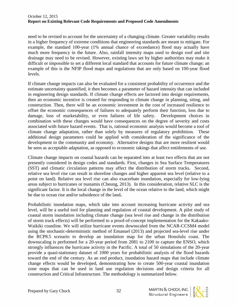
October 12, 2015 Report on Existing Relevant Code Requirements and Proposed Code Amendments
Prepared by Gary Chock 32
need to be revised to account for the uncertainty of a changing climate. Greater variability results in a higher frequency of extreme conditions that engineering standards are meant to mitigate. For example, the standard 100-year (1% annual chance of exceedance) flood may actually have much more frequency in the future. Also, rainfall intensity maps used to design roof and site drainage may need to be revised. However, existing laws set by higher authorities may make it difficult or impossible to set a different local standard that accounts for future climate change; an example of this is the NFIP flood maps and regulations that are only based on 100-year flood levels.
If climate change impacts can also be evaluated for a consistent probability of occurrence and the estimate uncertainty quantified, it then becomes a parameter of hazard intensity that can included in engineering design standards. If climate change effects are factored into design requirements, then an economic incentive is created for responding to climate change in planning, siting, and construction. Then, there will be an economic investment in the cost of increased resilience to offset the economic consequences of failures to adequately perform their function, loss due to damage, loss of marketability, or even failures of life safety. Development choices in combination with these changes would have consequences on the degree of severity and costs associated with future hazard events. That is, rational economic analysis would become a tool of climate change adaptation, rather than solely by measures of regulatory prohibition. These additional design parameters could be applied with consideration of the significance of the development to the community and economy. Alternative designs that are more resilient would be seen as acceptable adaptation, as opposed to economic takings that affect entitlements of use.
Climate change impacts on coastal hazards can be separated into at least two effects that are not presently considered in design codes and standards. First, changes in Sea Surface Temperatures (SST) and climatic circulation patterns may affect the distribution of storm tracks. Second, relative sea level rise can result in shoreline changes and higher apparent sea level (relative to a point on land). Relative sea level rise can also exacerbate inundation, especially for low-lying areas subject to hurricanes or tsunamis (Cheung, 2013). In this consideration, relative SLC is the significant factor. It is the local change in the level of the ocean relative to the land, which might be due to ocean rise and/or subsidence of the land.
Probabilistic inundation maps, which take into account increasing hurricane activity and sea level, will be a useful tool for planning and regulation of coastal development. A pilot study of coastal storm inundation including climate change (sea level rise and change in the distribution of storm track effects) will be performed to a proof-of-concept implementation for the Kakaako-Waikiki coastline. We will utilize hurricane events downscaled from the NCAR-CCSM4 model using the stochastic-deterministic method of Emanuel (2013) and projected sea-level rise under the RCP8.5 scenario to develop an inundation map for the urban Honolulu coast. The downscaling is performed for a 20-year period from 2081 to 2100 to capture the ENSO, which strongly influences the hurricane activity in the Pacific. A total of 50 simulations of the 20-year provide a quasi-stationary dataset of 1000 years for probabilistic analysis of the flood hazards toward the end of the century. As an end product, inundation hazard maps that include climate change effects would be developed, demonstrating how to create 500-year coastal inundation zone maps that can be used in land use regulation decisions and design criteria for all construction and Critical Infrastructure. The methodology is summarized below.

October 12, 2015 Report on Existing Relevant Code Requirements and Proposed Code Amendments
Prepared by Gary Chock 33
Probabilistic Mapping of Storm-Induced Coastal Inundation for Climate Change Adaptation
• Use recognized literature for climate change effects on tropical cyclone track distribution to create inventories of tropical storms and hurricanes that reflect longer term hazard. A large set of simulated tropical cyclone tracks based on CMIP5 would be acquired for the area affecting Oahu; this would also include the changes in the storm intensities based on this model.
• Incorporate net apparent sea level rise due to climate change and land subsidence effects at the Kakaako-Waikiki coastline.
• Utilize the meta-model Hakou, which is based on precomputed hurricane scenarios using coupled ADCIRC and SWAN (Kennedy et al., 2012), to estimate the offshore surge elevations and significant wave heights for hurricanes within 100 km of the project coastline. Screening of the estimated surge elevations and wave heights identifies the most severe three events for detailed inundation modeling at the site.
• Employ this storm inventory to perform hazard-consistent coastal inundation analysis that is also expected to be influenced by sea level rise. The third generation spectral model WAVEWATCH III provides the hurricane waves and the non-hydrostatic model NEOWAVE computes the surge using a system of nested grids with increasing resolution from the open ocean to the project coastline (Li et al., 2014). The output defines the boundary conditions and initial still-water elevation for computation of phase-resolving surf-zone and inundation processes using the Boussinesq model of Roeber and Cheung (2012).
• Create a prototypical inundation map with mean recurrence interval appropriate for buildings and critical infrastructure that also includes the longer term sea level trends.
• An immediate application is to assess the inventory of buildings and structures in Honolulu that would be exposed to increased flood risks due to climate change and identify potential revisions to the building code.
• Evaluate the feasibility of applying this methodology towards a new generation of coastal inundation hazard maps for the remainder of the island of Oahu.
October 12, 2015 Report on Existing Relevant Code Requirements and Proposed Code Amendments
Prepared by Gary Chock 34
Objective 2 - Proposed code amendments to strengthen and/or replace 4.existing regulatory standards in order to reduce existing and future building stock vulnerability to coastal hazards and climate impacts.
Draft list of proposed code amendments:
• ROH Chapter 21 - LUO Article 2 Administration and Enforcement: – for Major Permits within the Shoreline Management Area, require evaluation of 75-years of relative sea level rise (determined per the USACE method) on the functionality of the development and land use and mitigation of the deleterious effects of the proposed use, and require the director to consider that as a criteria for permitting new development, variances, or zone changes.
• ROH Chapter 16- Honolulu Building Code - for Risk Category III and IV structures:
o Revise rainfall intensity map figure 1611.1 to add 1 hour 500-year intensity o Adjust windspeed map for 1700-year and 3000-year windspeeds o Amend section for minimum elevation of the lowest horizontal structural
member, based on 500-year flood elevation taking into account relative sea level change
o Require consideration of shoreline erosion on foundation design • Honolulu Residential Code - Require structural and foundation design in
accordance with the IBC • ROH Chapter 23 – Shoreline Setbacks: Adopt setbacks based on historic shoreline
erosion rates for Oahu • ROH Chapter 25 SMA - Create another level of SMA zone maps to account for sea
level rise, shoreline erosion, and coastal flood modeling under CMIPd RCP8.5 climatic conditions. Have this applicable to major (definition TBD) developments.
• ROH Chapter 21A – Flood Ordinance: For Risk Category III and IV structures, Locally develop and adopt a 500-year flood zone that incorporates sea level rise, and RCP 8.5 equivalent storm inundation
• ROH Chapter 19 Honolulu Plumbing Code: for Risk Category III and IV Structures, develop and adopt 500-year 1 hour rainfall intensity maps
• ROH Chapter 17 Electrical Code: for Risk Category III and IV structures, require placement above 500-year flood or incorporate dry floodproofing protection for 500-year flood, developed considering climate change.
• HRS 205A Certified Shoreline: for planning purposes, also include an Expected Shoreline map taking into account shoreline erosion and relative sea level rise over the next 50 years.
• HRS Chapter 508D Mandatory Seller Disclosures in Real Estate Transactions: Make the mandatory seller disclosure apply to transactions involving vacant lots as well
• HRS Chapter 484 - Uniform Land Sales Practices Act – Expand list of disclosable hazards in public offering to include, more explicitly: “Exposure to natural hazards: e.g., 2500-year earthquake ground motion in excess of SDC B levels and earthquake –induced ground failure and rockfalls/landlsides, 100-year and 500-year flooding,
October 12, 2015 Report on Existing Relevant Code Requirements and Proposed Code Amendments
Prepared by Gary Chock 35
2500-year tsunami inundation, lava inundation hazard zone 1, 2, or 3 per USGS 1992 map, forest and wildfire historic burn areas per DOFAW, effective windspeed hazards above 145 mph per Hawaii State Building Code”, dam failure inundation, high surf inundation, and 100-year coastal shoreline erosion.”
• HRS Chapter 107 Part II - Hawaii State Building Code: Mandatory adoption of International Building Code as the interim state code when DAGS does not adopt HAR within 3 years of publication, subject to 6-year cycle.
• Public Utilities Commission: The PUC should adopt the windspeed maps of the 2010 Hawaii State Building Code, to replace the NEC 2012 Figure 250-2. Otherwise, the wind design standard for power transmission and distribution systems is deficient with respect to actual wind speeds that would occur during tropical storms and hurricanes.
• For Risk Category III and IV structures, any proposed Hawaii codes and standards incorporating climate change effects should reference the USCOE technical guidelines for determining relative sea level rise.
• ROH Chapter 32 Building Energy Conservation Code: Adopt American Society of Heating, Refrigerating, and Air-Conditioning Engineers Standard 169, Weather Data for Building Design Standards for use in the application of ANSI/ASHRAE/IESNA Standard 90.1-2004, Energy Standard for Buildings Except Low-Rise Residential Buildings
• ROH Chapter 20 Fire Code: Create regulatory maps of historic burn areas for use in these regulations and for mandatory seller disclosures

October 12, 2015 Report on Existing Relevant Code Requirements and Proposed Code Amendments
Prepared by Gary Chock 36
References 5.
Center for Island Climate Adaptation and Policy (2011), Sea-Level Rise and Coastal Land Use in Hawaii: A Policy Tool Kit for State and Local Governments, University of Hawaii Sea Grant College.
Cheung, K.F., Phadke, A.C., Wei, Y., Rojas, R., Douyere, Y.J.-M., Martino, C.D., Houston, S.H., Liu, P.L.-F., Lynett, P.J., Dodd, N., Liao, S., and Nakazaki, E. (2003). Modeling of storm-induced coastal flooding for emergency management. Ocean Engineering, 30(11), 1353-1386.
Cheung, K.F. (2013). Coastal Storms Program Sea Level Rise Study for Honolulu. NOAA Coastal Storms Program, Grant No. NA05OAR4170060 via University of Hawaii Sea Grant College Program, Project No. R/IR-8.
Chock, G. (Oct. 3, 2013). State of Hawaii Multi-Hazard Mitigation Plan 2013 Update, State of Hawaii Department of Defense, Civil Defense Division.
Emanuel, K., (2013), Downscaling CMIP5 Climate Models Shows Increased Tropical Cyclone Activity over the 21st Century, Proceedings of the National Academy of Science, 110 (30), 12219-12224.
Garza, Chu, Norton, and Schroeder (2012), Changes to the prevailing trade winds over the islands of Hawaii and the North Pacific, Journal of Geophysical Research, 117, D11109, doi:10.1029/2011JD016888
IPCC (2012). Summary for Policymakers. In: Managing the Risks of Extreme Events and Disasters to Advance Climate Change Adaptation [Field, C.B., V. Barros, T.F. Stocker, D. Qin, D.J. Dokken, K.L. Ebi, M.D. Mastrandrea, K.J. Mach, G.-K. Plattner, S.K. Allen, M. Tignor, and P.M. Midgley (eds.)]. A Special Report of Working Groups I and II of the Intergovernmental Panel on Climate Change. Cambridge University Press, Cambridge, UK, and New York, NY, USA, pp. 1-19.
Kennedy, A.B., Westerink, J.J., Smith, J.M., Hope, M.E., Hartman, M., Taflanidis, A.A., Tanaka, S., Westerink, H., Cheung, K.F., Smith, T., Hamann, M., Minamide, M., Ota, A. (2012). Tropical cyclone inundation potential on the Hawaiian Islands of Oahu and Kauai. Ocean Modelling, 52, 54-68.
Li, N., Roeber, V., Yamazaki, Y., Heitmann, T.W., Bai, Y., and Cheung, K.F. (2014). Integration of coastal inundation modeling from storm tides to individual waves. Ocean Modelling, 83, 26-42.
Murakami, H., Wang, B., Li, T., and Kitoh, A. (May 5, 2013) Projected Increase in Tropical Cyclones near Hawaii, Nature Climate Change 3, 749–754.
Roeber, V. and Cheung, K.F. (2012). Boussinesq-type model for energetic breaking waves in fringing reef environment. Coastal Engineering, 70, 1-20.
U.S. Army Corps of Engineers, (2014). Procedures to Evaluate Sea Level Change: Impacts, Responses, and Adaptation, Engineering Technical Letter 1100-2-1.

October 12, 2015 Report on Existing Relevant Code Requirements and Proposed Code Amendments
Prepared by Gary Chock 37
U.S. Army Corps of Engineers (2013). Incorporating Sea-Level Change Considerations For Civil Works Programs, Engineering Regulation 1100-2-8162.

October 12, 2015 Report on Existing Relevant Code Requirements and Proposed Code Amendments
Prepared by Gary Chock 38
5. Next Steps for this Report As coordinated by the Office of Planning, attend at least one meeting with each of the groups named herein to present and obtain input on the Draft list of proposed code amendments.
• City and County of Honolulu, Department of Planning and Permitting through a meeting of the State Building Code Council (October 13, 2015).
• Weather Impacts Advisory Committee (September 16 2015).
• Marine and Coastal Zone Advocacy Council (MACZAC), the STATE’s public advisory body established by HRS § 205A-3.5. (October 16, 2015).
• Hawaii Ocean Partnership Coordinated Working Group (to be determined by the Office of Planning).
Prepare revisions to the Draft list of proposed code amendments based on the feedback received.