building a sustainable auburn city of auburn, new york comprehensive plan december 2009
TRANSCRIPT
Building A Sustainable Auburn City of Auburn, New York Comprehensive Plan
Acknowledgements Elected Officials
Michael Quill, Mayor Gilda Brower, City Councilor Matthew Smith, City Councilor William Graney, City Councilor Thomas McNabb, City Councilor
Planning Board Sam Giangreco, Chair Anthony Bartolotta John Breanick Christopher DeProspero Anne McCarthy Frank Reginelli Allen Zentner
Comprehensive Plan Advisory Committee Gwen Webber-McLeod, Co-chair Karin Moskov, Co-chair Anthony Bartolotta Gilda Brower Carey Eidel Beth Hoey Ginny Kent Jessie Kline Linda Murphy Mike Rifanburg Stephanie Schuster Meg Vanek
City Staff Mark Palesh, City Manager Jennifer Haines, Director, Office of Planning and Economic Development Stephen Selvek, Senior Planner, Office of Planning and Economic Development Crystal Purcell, Program Manager, Office of Planning and Economic Development
Comprehensive Plan Consultants
Saratoga Associates 443 Broadway, Saratoga Springs, New York 12866 Tel 518.587.2550 Fax 518.587.2564
Building A Sustainable Auburn
City of Auburn, New York Comprehensive Plan
Table of Contents 1. Executive Summary 1 2. Boosting Downtown 13 3. Revitalizing Neighborhoods 31 4. Shaping Business Growth Across Auburn 61 5. Creating a Welcoming Community 83 6. Re-engaging the Owasco River 93 7. Simplifying and Improving Development 107 8. Realizing the Vision – Plan Implementation 117
This comprehensive plan has been formatted for double-sided printing. Please consider the environment before printing this document.
December 2009 1 Adoted 01.21.2010
Building a Sustainable FutureCity of Auburn Comprehensive Plan
Welcome to the City of Auburn Comprehensive Plan. This comprehensive plan, created with the extensive involvement of citizens, business leaders, elected officials and city staff, describes a vision for Auburn’s vibrant and revitalized future – a bustling community that is both environmentally and economically sustainable over the long-term. The Vision for a Sustainable Auburn is the starting point for planning the city’s future. This short statement, crafted by the comprehensive plan advisory committee and based upon extensive input received at numerous public meetings, pulls together the major components of a thriving Auburn in the 21st century – a city that is attractive to residents, workers and visitors. It is highlighted on the next page. The philosophy of long-term economic and environmental sustainability underpins this document. It is a plan for Auburn’s revitalized future as a thriving urban center – a vibrant core for surrounding towns and the greater region. This is plan is not the end product of a project, but the next step in the city’s ongoing revitalization efforts. The work presented here is only as good as the effort to implement it. The last chapter describes important implementation steps that involve elected officials, city staff and agencies around the city. Only working together can the goals of this document be achieved and its vision be realized.
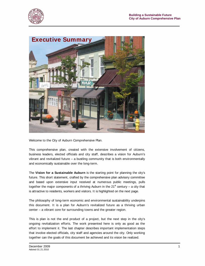
Executive Summary
Building a Sustainable Future City of Auburn Comprehensive Plan
2 December 2009 Adopted 01.21.2010
At the same time, the vision and goals described in these pages must guide all city actions. The comprehensive plan should be consulted regularly by the city council, planning board, zoning board, city staff, private developers, agency heads and the general public. The plan may not hold the answer to a specific problem facing the city, but its direction – its vision and goals – can be used as measuring sticks against which options can be evaluated. Ultimately, every decision needs to push the city towards its long-term economic and environmental sustainability.
The business climate of the 21st century will require the city be prepared to house a variety of enterprises. Traditional heavy industries, though on the decline in the northeastern United States, still have a foothold in Auburn. At the same time, many new businesses will be knowledge-based or creative enterprises. These lighter operations would fit easily into mixed-use centers. In fact, much of the creative class would want to be in a place where they can blend the personal and professional hours of the day – work, grab coffee with friends and then finish up a project. Entrepreneurs, no matter their field, need to have a business and people climate that suits their lifestyle.
Vision for a Sustainable Auburn
From mills to movies, Auburn has traditionally been a hub of innovation and economic progress. In the 21st century our city is ripe with potential, which we will maximize by creating a thoroughly sustainable community – from a bustling downtown to diverse neighborhoods. Auburn will become the regional destination for people seeking a culturally rich, economically successful and environmentally friendly place to live, visit, or conduct business. Sustainable Auburn will be a…
…Dynamic place with a thriving, mixed-use downtown as well as healthy, safe, and cohesive neighborhoods.
…Diverse community that embraces different cultures, offers opportunity to all age groups, and supports those in need.
…Heart of regional creativity by supporting and attracting cultural venues, artisans and talent.
…Vibrant tourism destination that builds upon and protects the city’s cultural, historic and natural assets.
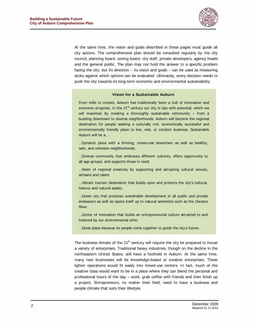
…Green city that practices sustainable development in all public and private endeavors as well as opens itself up to natural amenities such as the Owasco River.
…Center of innovation that builds an entrepreneurial culture attracted to and fostered by our environmental ethic.
…Great place because its people come together to guide the city’s future.

December 2009 3 Adoted 01.21.2010
Building a Sustainable FutureCity of Auburn Comprehensive Plan
The population of Auburn, as with other cities in upstate New York, continues to decline. This decline and economic dislocation have many causes – and the trend is not likely to reverse soon. However, this situation provides an opportunity for communities to rethink their goals for the future. The city does not need the “grow at any cost” mentality that afflicts and impacts many communities. The city needs to think about making itself an urban success. Vibrant neighborhoods, an active and thriving downtown, a strong arts and culture scene, tight community and an ethic of long-term environmental and economic sustainability. It is this high quality of life that will attract people to Auburn to start and work in the small businesses that generate the most jobs in this country. Auburn has started to transition from a manufacturing focus to a more diversified economy that includes the knowledge and creative sectors. To do this, the city must attract the entrepreneurs and skilled workers that will create and support the 21st century companies that will drive the city to success – and accommodate the preferences and lifestyle needs of these residents. University of Toronto professor Richard Florida’s widely cited work, “Competing in the Age of Talent: Environment, Amenities, and the New Economy” identified the preferences of knowledge workers. > Large numbers of active young people > Wide range of outdoor activities and recreation > Vibrant music and performance scene > Nightlife diversity, including many options without alcohol > A healthy environment and a dedication to sustainability > A lifestyle which is youth-friendly and supportive of diversity Finally, Auburn should make it easy for the private sector to give the community what it wants. From a land use perspective, the city should set high and achievable standards for new development. Once enacted, standards should not be compromised as they weaken the community’s long-term vision. However, the city must make it quick and easy for the private sector to meet those standards. Building a Sustainable Future: The Auburn Comprehensive Plan These complementary notions of economic and environmental sustainability weave their way through all chapters of this comprehensive plan. Communities are complex entities. The interwoven relationships between people and business as well as the land upon which they move make comprehensive planning an intricate, but vital, process. Even the casual reader of this document will find that many of the goals and strategies expressed in one chapter relate to, impact or could even be found in another chapter.
Green comes in many flavors in Auburn. The city’s vision as a sustainable city includes becoming a “regional destination for people seeking a culturally rich, economically successful and environmentally friendly place to live, visit, or conduct business.”
Building a Sustainable Future City of Auburn Comprehensive Plan
4 December 2009 Adopted 01.21.2010
The chapters, or topics, dealt with in this plan are: > Boosting Downtown > Revitalizing Neighborhoods > Shaping Business Growth Across Auburn > Creating a Welcoming Community > Re-Engaging the Owasco River > Simplifying & Improving Development > Realizing the Vision – Plan Implementation
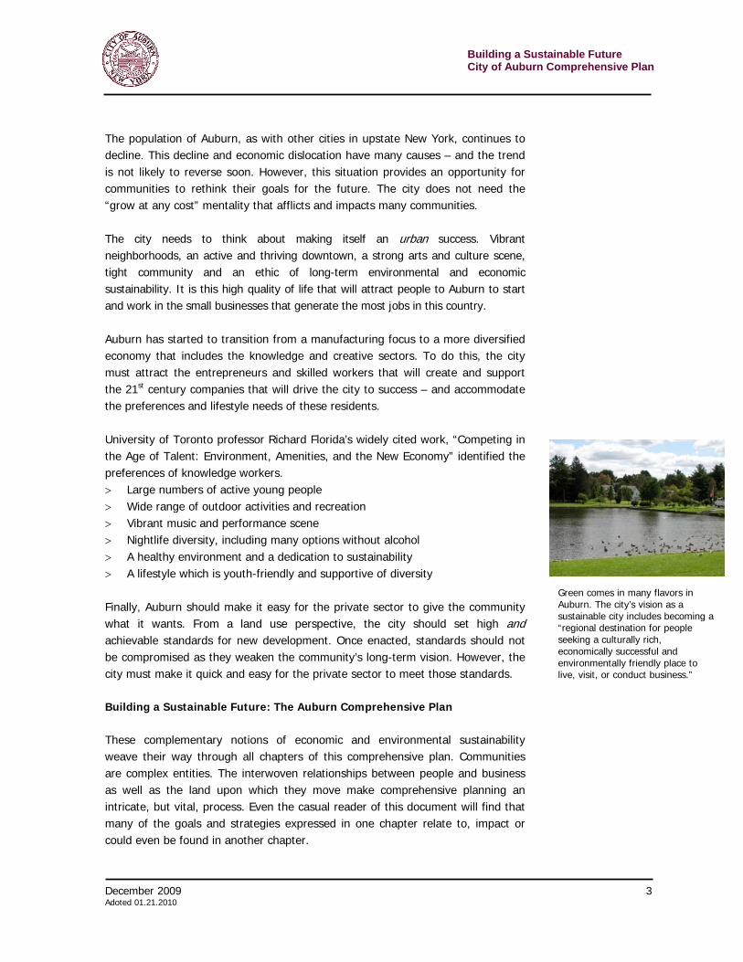
This final chapter, Realizing the Vision, contains the implementation component – the who, when, and approximate resource requirements of getting each strategy completed. Boosting Downtown
People like to window shop – walking from store to store – as long as the experience is interesting and safe. A fun and engaging place gets people out of cars and venturing by foot into stores, restaurants and other establishments. It is the premise upon which traditional downtowns have been built. Realizing this, many private developers now
build “town center” developments to attract shoppers – trying to recreate what Auburn has already on Genesee Street. The statistics show that such a strategy bears economic fruit. In 2005 an International Council of Shopping Centers survey found that customers spent an average of $57.50 an hour in enclosed shopping malls versus an average of $84.00 an hour in town center developments. Unfortunately, the broader downtown in Auburn, the area enclosed by the Business Improvement District boundaries, was hit hard by economic decline, suburban competition and misguided urban renewal. As with many cities, officials thought that downtowns could compete with suburban malls by becoming more like those suburban malls and catering to the automobile. While concessions have to be made to cars, the wholesale gutting of commercial areas proved a poor strategy. Long-term economic and environmental sustainability depend upon preserving and reinforcing the existing downtown historic character along Genesee Street and ensuring that new development within the BID boundaries reinforces the walkable, urban nature of a successful downtown. The goals and strategies described in the Boosting Downtown chapter of this comprehensive plan tailor for Auburn some of the best revitalization strategies from across the United States. These strategies, along with some of those in other sections, seek to continue revitalization efforts.
December 2009 5 Adoted 01.21.2010
Building a Sustainable FutureCity of Auburn Comprehensive Plan
The following goals for downtown Auburn will move the community towards realizing its vision. Goal 1. Enhance downtown as a walkable, vibrant urban place
Goal 2. Encourage more people to live and work downtown
Goal 3. Improve the marketing of downtown
Goal 4. Develop downtown Auburn as a center for arts and entertainment.
Revitalizing Neighborhoods
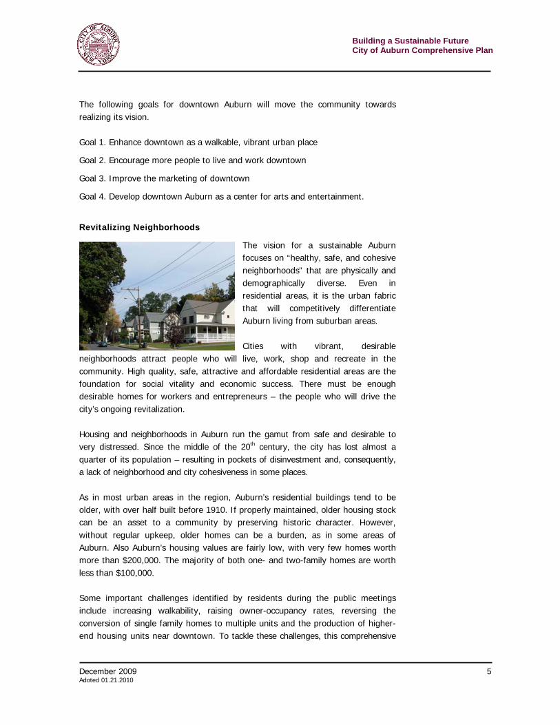
The vision for a sustainable Auburn focuses on “healthy, safe, and cohesive neighborhoods” that are physically and demographically diverse. Even in residential areas, it is the urban fabric that will competitively differentiate Auburn living from suburban areas. Cities with vibrant, desirable
neighborhoods attract people who will live, work, shop and recreate in the community. High quality, safe, attractive and affordable residential areas are the foundation for social vitality and economic success. There must be enough desirable homes for workers and entrepreneurs – the people who will drive the city’s ongoing revitalization. Housing and neighborhoods in Auburn run the gamut from safe and desirable to very distressed. Since the middle of the 20th century, the city has lost almost a quarter of its population – resulting in pockets of disinvestment and, consequently, a lack of neighborhood and city cohesiveness in some places. As in most urban areas in the region, Auburn’s residential buildings tend to be older, with over half built before 1910. If properly maintained, older housing stock can be an asset to a community by preserving historic character. However, without regular upkeep, older homes can be a burden, as in some areas of Auburn. Also Auburn’s housing values are fairly low, with very few homes worth more than $200,000. The majority of both one- and two-family homes are worth less than $100,000.
Some important challenges identified by residents during the public meetings include increasing walkability, raising owner-occupancy rates, reversing the conversion of single family homes to multiple units and the production of higher-end housing units near downtown. To tackle these challenges, this comprehensive
Building a Sustainable Future City of Auburn Comprehensive Plan
6 December 2009 Adopted 01.21.2010
plan outlines the following goals and strategies, which are described in the chapter Revitalizing Neighborhoods. Goal 1. Encourage the location and form of new development to emphasize pedestrians and protect neighborhood character.
Goal 2. Encourage environmentally friendly homes and neighborhoods
Goal 3. Improve the quality of life of existing neighborhoods Shaping Business Growth Across Auburn
In the 21st century, small companies will drive local and regional economic growth. While large businesses often draw headlines and garner strong political support, small businesses have a bigger impact on the economy. In New York State, the 1.9 million small businesses represent 99.1 percent of the state’s employers and 51.7 percent of its private sector employment.
Small business development is more cost effective for regional and local efforts. For example, if the expected 5,500 jobs materialize in the wake of a new chip fabrication facility in Malta, New York, the state will have spent about $117,000 per job in tax incentives. By contrast, the U.S. Small Business Administration says that job creation in small businesses costs as low as $10,000 per job. The odds are also better. The International Economic Development Council reports only about 300 companies consider relocating in a given year, while 300,000 economic development organizations and communities around the country vie for this small number of prospects. The Malta, New York chip fabrication plant recruitment effort, which finally broke ground in 2009, began in the 1980s. Attracting small businesses, especially in the knowledge and creative sectors, requires communities no longer focus solely on creating a friendly business climate. University of Toronto professor, Richard Florida wrote recently that creative cities are not thriving due to traditional economic reasons such as access to transportation, tax breaks or fiscal incentives. “They are succeeding largely because people want to live there. The companies follow the people – or, in many cases, are started by them.”1 These people, who will start and staff Auburn’s 21st century economy, must have places where they want to work. Many people today mix their home and work lives – creativity has become a 24 hour a day / seven day a week endeavor. The founders of tomorrow’s successes may not want to commute far from home. And
1 Florida, Richard, “Cities and the Creative Class”, City and Community, March 2003, p. 9.
December 2009 7 Adoted 01.21.2010
Building a Sustainable FutureCity of Auburn Comprehensive Plan
they may want to take a break midday or in the evening to attend a ball game or play, catch a show or meet friends in a coffee shop before heading back to work. This is the reality facing Auburn today. Many parts of the community contribute to commerce. In addition to downtown, there are small neighborhood retail areas and large suburban style strip malls. The city’s Technology Park hosts various industries, which, by design, tend to have a green focus. Together, these must work to reinforce Auburn’s historic character, urban fabric and sustainable values. Coordinating and shaping the growth of these areas is important to maintaining them over time. All members of the community, including businesses, will benefit from a growth plan with a consistent vision that protects the investment of property owners by ensuring all adhere to the same standards. To realize the vision of Auburn as an “economically successful… center of innovation” that “builds an entrepreneurial culture” in line with the city’s environmental ethic, this comprehensive plan establishes the following goals. Goal 1. Encourage sustainable development principles in the creation of new commercial parcels and buildings as well as in the renovation of existing commercial parcels and buildings.
Goal 2: Improve commercial signs so they reflect the character of the city and the character of particular neighborhoods
Goal 3: Develop a plan for universal broadband access
Goal 4: Encourage arts and culture as an integral part of Auburn’s economy Creating a Welcoming Community
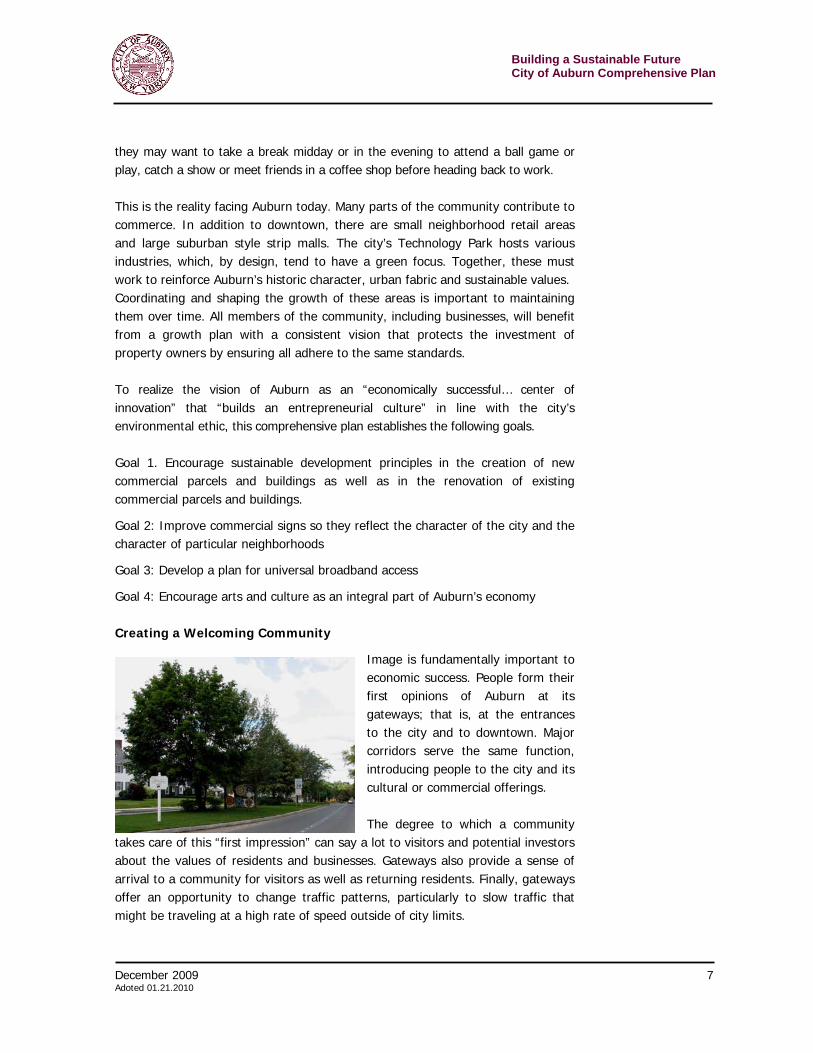
Image is fundamentally important to economic success. People form their first opinions of Auburn at its gateways; that is, at the entrances to the city and to downtown. Major corridors serve the same function, introducing people to the city and its cultural or commercial offerings. The degree to which a community
takes care of this “first impression” can say a lot to visitors and potential investors about the values of residents and businesses. Gateways also provide a sense of arrival to a community for visitors as well as returning residents. Finally, gateways offer an opportunity to change traffic patterns, particularly to slow traffic that might be traveling at a high rate of speed outside of city limits.
Building a Sustainable Future City of Auburn Comprehensive Plan
8 December 2009 Adopted 01.21.2010
There are primary gateways for Auburn from the north, south, east and west. From the north, visitors from the Thruway (I-90) are greeted by a series of unkempt signs and properties. From the south, the historic nature of the Harriet Tubman Home hints at the municipality beyond. From the east, a high quality of life is on display along the landscaped divided boulevard of E. Genesee Street. Getting into the city from the west is more problematic as most travelers end up on the Routes 5 & 20 arterial. Creating a more welcoming community requires a series of strategies that reshape the physical appearance at borders and along main corridors. The goals that push towards achieving this part of the vision are as follows.
Goal 1. Create a more welcoming environment for visitors and improve the experience of arriving in Auburn.
Goal 2. Develop a comprehensive system for directing people into and around Auburn.
Re-engaging the Owasco River
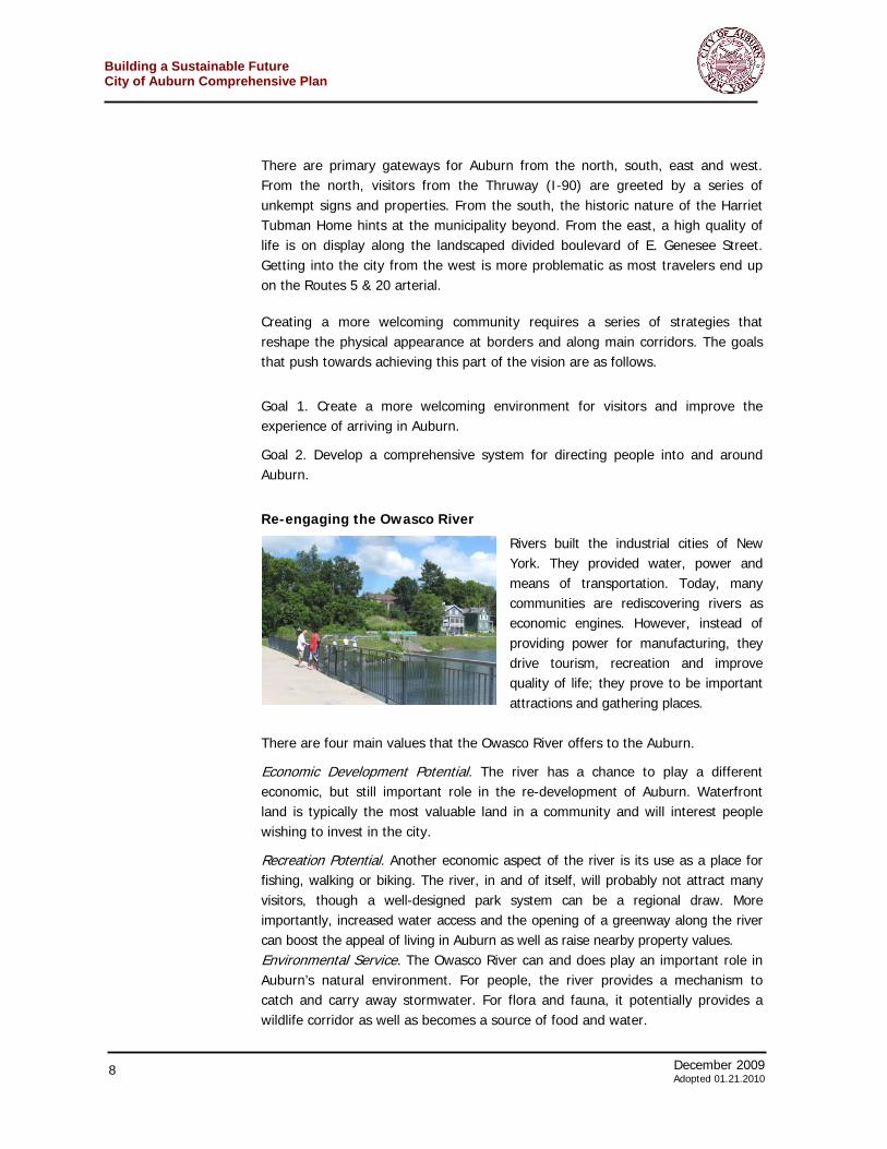
Rivers built the industrial cities of New York. They provided water, power and means of transportation. Today, many communities are rediscovering rivers as economic engines. However, instead of providing power for manufacturing, they drive tourism, recreation and improve quality of life; they prove to be important attractions and gathering places.
There are four main values that the Owasco River offers to the Auburn.
Economic Development Potential. The river has a chance to play a different economic, but still important role in the re-development of Auburn. Waterfront land is typically the most valuable land in a community and will interest people wishing to invest in the city.
Recreation Potential. Another economic aspect of the river is its use as a place for fishing, walking or biking. The river, in and of itself, will probably not attract many visitors, though a well-designed park system can be a regional draw. More importantly, increased water access and the opening of a greenway along the river can boost the appeal of living in Auburn as well as raise nearby property values. Environmental Service. The Owasco River can and does play an important role in Auburn’s natural environment. For people, the river provides a mechanism to catch and carry away stormwater. For flora and fauna, it potentially provides a wildlife corridor as well as becomes a source of food and water.

December 2009 9 Adoted 01.21.2010
Building a Sustainable FutureCity of Auburn Comprehensive Plan
Green Community Value. A rehabilitated river with different kinds of development along it and that is very accessible to the public is a signal of the strong sustainable values held by the community.
Unfortunately, most residents at the public meetings admitted extremely limited knowledge of the Owasco River. They recognized the river’s potential, but had little understanding of the Owasco. A visual survey along the river revealed a variety of promising opportunities as well as challenges. Re-engaging the river will require that the community achieve the following goals. Goal 1. Reconnect people to the river
Goal 2. Leverage the Owasco River as an economic asset for the community
Goal 3. Improve and maintain the integrity of the Owasco River as an environmental resource
Simplifying & Improving Development
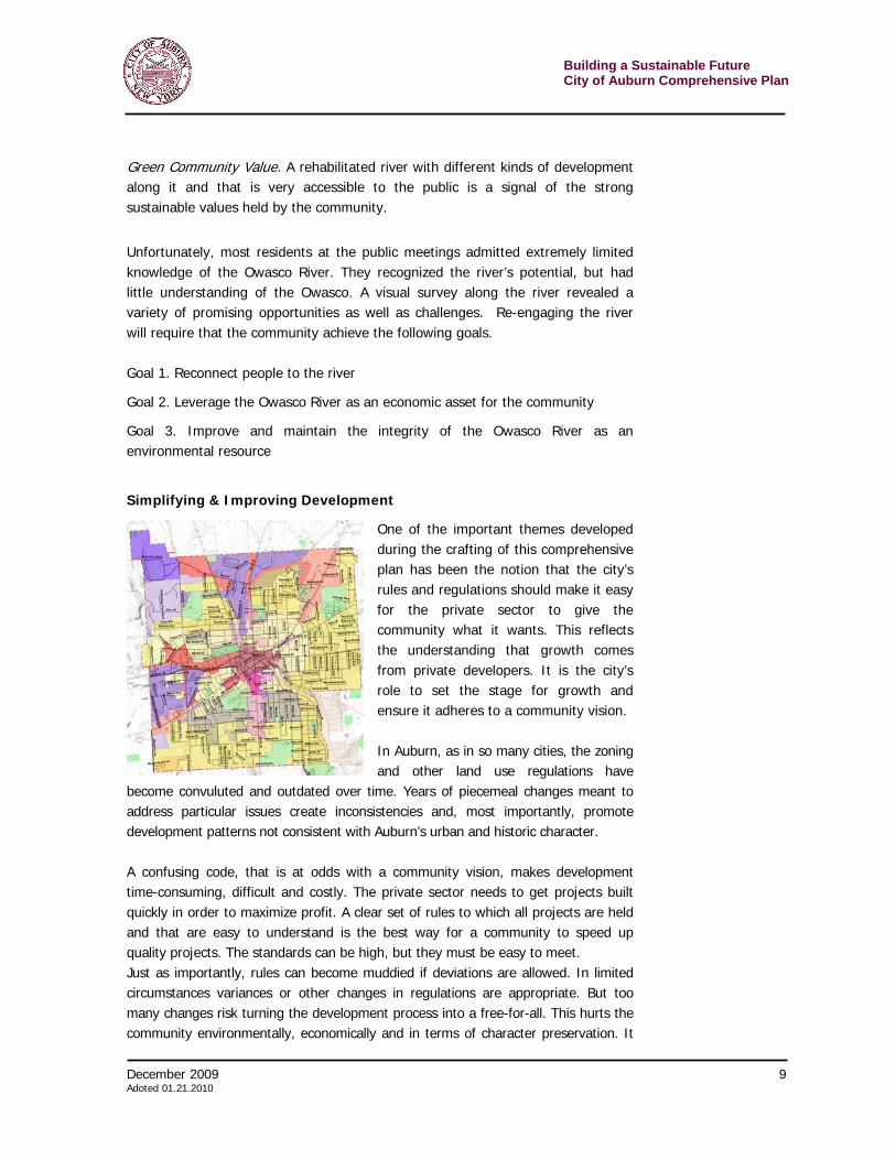
One of the important themes developed during the crafting of this comprehensive plan has been the notion that the city’s rules and regulations should make it easy for the private sector to give the community what it wants. This reflects the understanding that growth comes from private developers. It is the city’s role to set the stage for growth and ensure it adheres to a community vision. In Auburn, as in so many cities, the zoning and other land use regulations have
become convuluted and outdated over time. Years of piecemeal changes meant to address particular issues create inconsistencies and, most importantly, promote development patterns not consistent with Auburn’s urban and historic character. A confusing code, that is at odds with a community vision, makes development time-consuming, difficult and costly. The private sector needs to get projects built quickly in order to maximize profit. A clear set of rules to which all projects are held and that are easy to understand is the best way for a community to speed up quality projects. The standards can be high, but they must be easy to meet. Just as importantly, rules can become muddied if deviations are allowed. In limited circumstances variances or other changes in regulations are appropriate. But too many changes risk turning the development process into a free-for-all. This hurts the community environmentally, economically and in terms of character preservation. It
Building a Sustainable Future City of Auburn Comprehensive Plan
10 December 2009 Adopted 01.21.2010
also hurts developers because, in such an atmosphere, public pressure and politics intervene to slow or stop projects – even good ones. This chapter has set out the following goals. Goal 1. Review and revise zoning rules to make it easy for private developers to undertake projects that fit Auburn’s urban, historic, cultural and environmental vision.
Goal 2. Improve operations of the planning and zoning boards.
Goal 3. Adopt policies that promote arts and culture as economic development.
Goal 4. Make municipal operations more environmentally and economically sustainable. The Comprehensive Planning Process Cities must make choices. What kind of a community do residents want to live in? What kind of economic growth should be encouraged? Where and why? What should new businesses look like? Where should new neighborhoods be built? What should they look like? Auburn residents, business owners and public officials have asked themselves these questions during the comprehensive planning process. The result is a vision and set of goals for the future and a plan, with specific strategies and a timetable for action, to achieve those goals and realize the vision. This comprehensive plan is not an instruction manual. It gives some specific guidance, but, by and large, it serves a broader policy purpose. Auburn’s comprehensive plan establishes a vision and creates a framework for a community’s success – for the city’s economic and environmental sustainability. This plan gives decision makers and stakeholders (including elected officials, city and regional staff, planning and zoning board members, developers, property owners and citizens) a guide as they create new policies and judge new development projects. It also helps the community increase opportunities for grant money, as the state and federal government prefer to fund projects that fit into a plan for the future. Auburn’s comprehensive plan is a living document. The community must be alert to the need for changes and updates. It is important to remember, however, that adjusting the comprehensive plan does not mean lowering standards. The plan will not succeed if it is constantly changed to meet the demands of every particular project. Proposed changes should only be made if they further the plan’s vision and goals. Otherwise, the city should review the plan about every five years. This comprehensive plan, reviewed and approved by the planning board as well as the Auburn City Council, was crafted by a citizen advisory committee working
December 2009 11 Adoted 01.21.2010
Building a Sustainable FutureCity of Auburn Comprehensive Plan
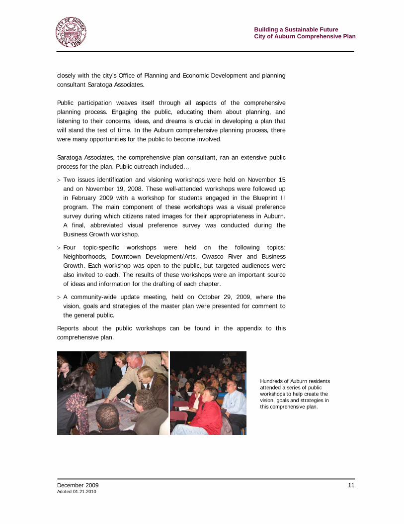
closely with the city’s Office of Planning and Economic Development and planning consultant Saratoga Associates. Public participation weaves itself through all aspects of the comprehensive planning process. Engaging the public, educating them about planning, and listening to their concerns, ideas, and dreams is crucial in developing a plan that will stand the test of time. In the Auburn comprehensive planning process, there were many opportunities for the public to become involved. Saratoga Associates, the comprehensive plan consultant, ran an extensive public process for the plan. Public outreach included…
> Two issues identification and visioning workshops were held on November 15 and on November 19, 2008. These well-attended workshops were followed up in February 2009 with a workshop for students engaged in the Blueprint II program. The main component of these workshops was a visual preference survey during which citizens rated images for their appropriateness in Auburn. A final, abbreviated visual preference survey was conducted during the Business Growth workshop.
> Four topic-specific workshops were held on the following topics: Neighborhoods, Downtown Development/Arts, Owasco River and Business Growth. Each workshop was open to the public, but targeted audiences were also invited to each. The results of these workshops were an important source of ideas and information for the drafting of each chapter.
> A community-wide update meeting, held on October 29, 2009, where the vision, goals and strategies of the master plan were presented for comment to the general public.
Reports about the public workshops can be found in the appendix to this comprehensive plan.
Hundreds of Auburn residents attended a series of public workshops to help create the vision, goals and strategies in this comprehensive plan.
Building a Sustainable Future City of Auburn Comprehensive Plan
12 December 2009 Adopted 01.21.2010
December 2009 13 Adoted 01.21.2010
Building a Sustainable FutureCity of Auburn Comprehensive Plan
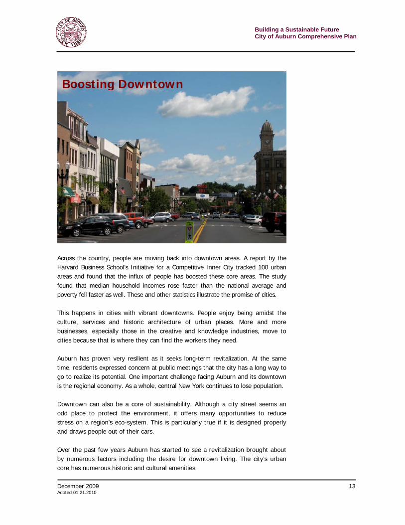
Across the country, people are moving back into downtown areas. A report by the Harvard Business School’s Initiative for a Competitive Inner City tracked 100 urban areas and found that the influx of people has boosted these core areas. The study found that median household incomes rose faster than the national average and poverty fell faster as well. These and other statistics illustrate the promise of cities. This happens in cities with vibrant downtowns. People enjoy being amidst the culture, services and historic architecture of urban places. More and more businesses, especially those in the creative and knowledge industries, move to cities because that is where they can find the workers they need. Auburn has proven very resilient as it seeks long-term revitalization. At the same time, residents expressed concern at public meetings that the city has a long way to go to realize its potential. One important challenge facing Auburn and its downtown is the regional economy. As a whole, central New York continues to lose population. Downtown can also be a core of sustainability. Although a city street seems an odd place to protect the environment, it offers many opportunities to reduce stress on a region’s eco-system. This is particularly true if it is designed properly and draws people out of their cars. Over the past few years Auburn has started to see a revitalization brought about by numerous factors including the desire for downtown living. The city’s urban core has numerous historic and cultural amenities.
Boosting Downtown
Building a Sustainable Future City of Auburn Comprehensive Plan
14 December 2009 Adopted 01.21.2010
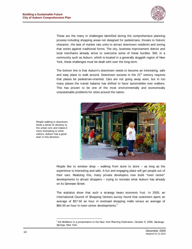
These are the many in challenges identified during the comprehensive planning process including shopping areas not designed for pedestrians, threats to historic character, the lack of market rate units to attract downtown residents and zoning that works against traditional forms. The city, business improvement district and local merchants already strive to overcome some of these hurdles. Still, in a community such as Auburn, which is located in a generally sluggish region of New York, these challenges must be dealt with over the long-term. The bottom line is that Auburn’s downtown needs to become an interesting, safe and easy place to walk around. Downtown success in the 21st century requires that places be pedestrian-oriented. Cars are not going away soon, but in too many places the transit balance has shifted to favor automobiles over walkers. This has proven to be one of the most environmentally and economically unsustainable problems for cities around the nation.
People like to window shop – walking from store to store – as long as the experience is interesting and safe. A fun and engaging place will get people out of their cars. Realizing this, many private developers now build “town center” developments to attract shoppers – trying to recreate what Auburn has already on its Genesee Street.
The statistics show that such a strategy bears economic fruit. In 2005, an International Council of Shopping Centers survey found that customers spent an average of $57.50 an hour in enclosed shopping malls versus an average of $84.00 an hour in town center developments.2
2 Ed McMahon in a presentation to the New York Planning Federation, October 9, 2006, Saratoga Springs, New York.
People walking in downtown lends a sense of vibrancy to the urban core and makes it more interesting to other visitors. Auburn has a good start in this direction.
December 2009 15 Adoted 01.21.2010
Building a Sustainable FutureCity of Auburn Comprehensive Plan
In some ways, downtown Auburn could take a lesson from the most successful new retail developments. The strategies outlined in this chapter seek to adopt tactics from other communities and malls that are doing well – and tailor them to the need of Auburn’s downtown.
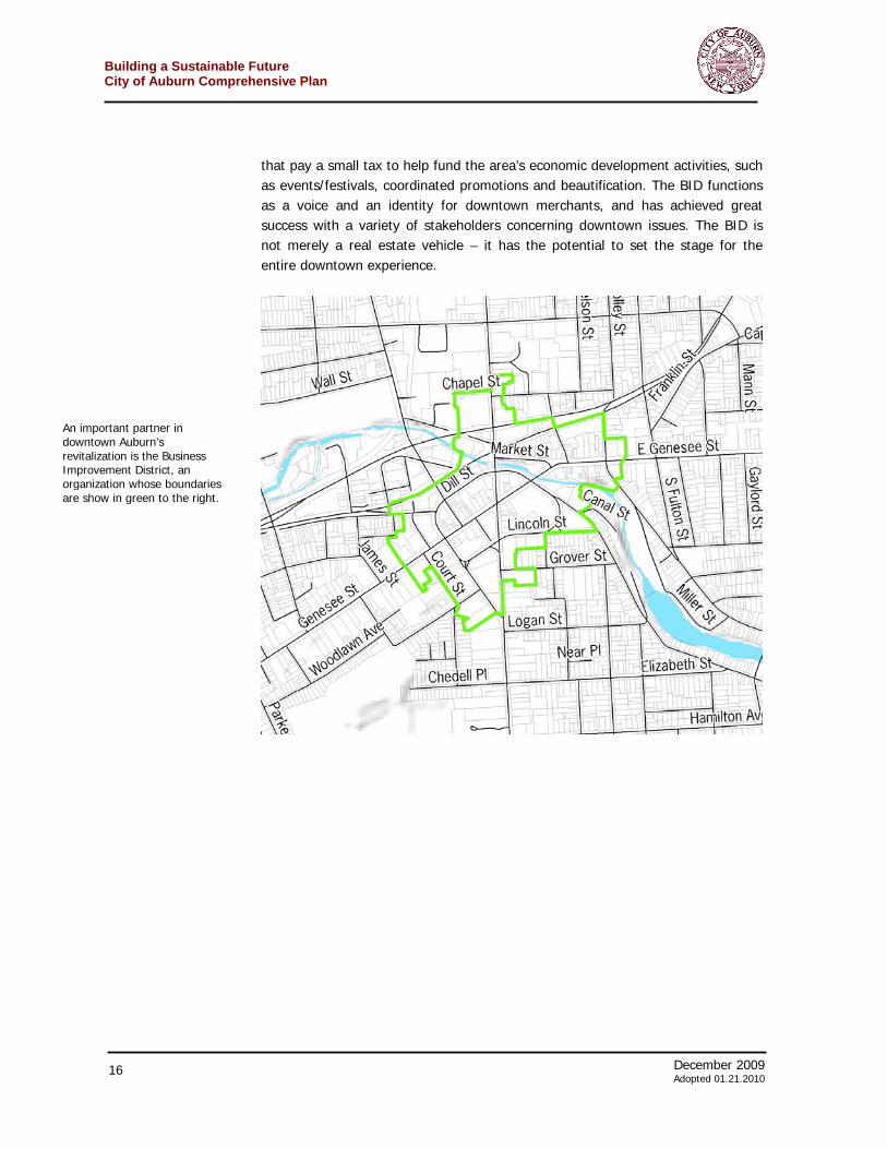
An important partner in any revitalization efforts in downtown Auburn is the existing business improvement district. The Downtown Auburn Business Improvement District (BID) represents over 200 businesses and property owners
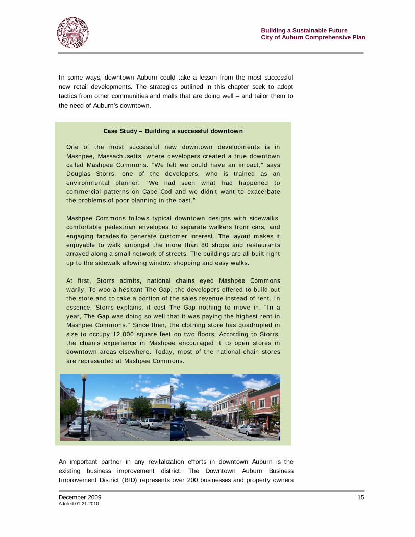
Case Study – Building a successful downtown
One of the most successful new downtown developments is in Mashpee, Massachusetts, where developers created a true downtown called Mashpee Commons. “We felt we could have an impact,” says Douglas Storrs, one of the developers, who is trained as an environmental planner. “We had seen what had happened to commercial patterns on Cape Cod and we didn't want to exacerbate the problems of poor planning in the past.” Mashpee Commons follows typical downtown designs with sidewalks, comfortable pedestrian envelopes to separate walkers from cars, and engaging facades to generate customer interest. The layout makes it enjoyable to walk amongst the more than 80 shops and restaurants arrayed along a small network of streets. The buildings are all built right up to the sidewalk allowing window shopping and easy walks. At first, Storrs admits, national chains eyed Mashpee Commons warily. To woo a hesitant The Gap, the developers offered to build out the store and to take a portion of the sales revenue instead of rent. In essence, Storrs explains, it cost The Gap nothing to move in. "In a year, The Gap was doing so well that it was paying the highest rent in Mashpee Commons." Since then, the clothing store has quadrupled in size to occupy 12,000 square feet on two floors. According to Storrs, the chain's experience in Mashpee encouraged it to open stores in downtown areas elsewhere. Today, most of the national chain stores are represented at Mashpee Commons.
Building a Sustainable Future City of Auburn Comprehensive Plan
16 December 2009 Adopted 01.21.2010
that pay a small tax to help fund the area’s economic development activities, such as events/festivals, coordinated promotions and beautification. The BID functions as a voice and an identity for downtown merchants, and has achieved great success with a variety of stakeholders concerning downtown issues. The BID is not merely a real estate vehicle – it has the potential to set the stage for the entire downtown experience.
An important partner in downtown Auburn’s revitalization is the Business Improvement District, an organization whose boundaries are show in green to the right.

December 2009 17 Adoted 01.21.2010
Building a Sustainable FutureCity of Auburn Comprehensive Plan
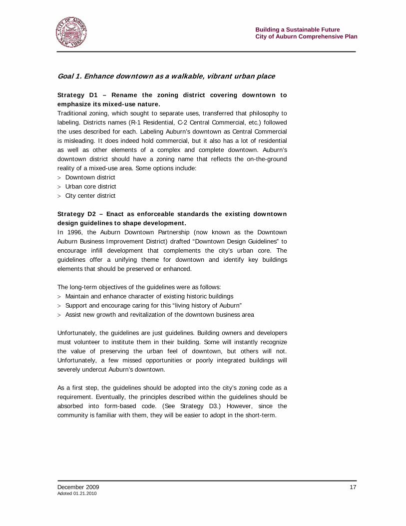
Goal 1. Enhance downtown as a walkable, vibrant urban place Strategy D1 – Rename the zoning district covering downtown to emphasize its mixed-use nature. Traditional zoning, which sought to separate uses, transferred that philosophy to labeling. Districts names (R-1 Residential, C-2 Central Commercial, etc.) followed the uses described for each. Labeling Auburn’s downtown as Central Commercial is misleading. It does indeed hold commercial, but it also has a lot of residential as well as other elements of a complex and complete downtown. Auburn’s downtown district should have a zoning name that reflects the on-the-ground reality of a mixed-use area. Some options include: > Downtown district > Urban core district > City center district Strategy D2 – Enact as enforceable standards the existing downtown design guidelines to shape development. In 1996, the Auburn Downtown Partnership (now known as the Downtown Auburn Business Improvement District) drafted “Downtown Design Guidelines” to encourage infill development that complements the city’s urban core. The guidelines offer a unifying theme for downtown and identify key buildings elements that should be preserved or enhanced. The long-term objectives of the guidelines were as follows: > Maintain and enhance character of existing historic buildings > Support and encourage caring for this “living history of Auburn” > Assist new growth and revitalization of the downtown business area Unfortunately, the guidelines are just guidelines. Building owners and developers must volunteer to institute them in their building. Some will instantly recognize the value of preserving the urban feel of downtown, but others will not. Unfortunately, a few missed opportunities or poorly integrated buildings will severely undercut Auburn’s downtown. As a first step, the guidelines should be adopted into the city’s zoning code as a requirement. Eventually, the principles described within the guidelines should be absorbed into form-based code. (See Strategy D3.) However, since the community is familiar with them, they will be easier to adopt in the short-term.
Building a Sustainable Future City of Auburn Comprehensive Plan
18 December 2009 Adopted 01.21.2010
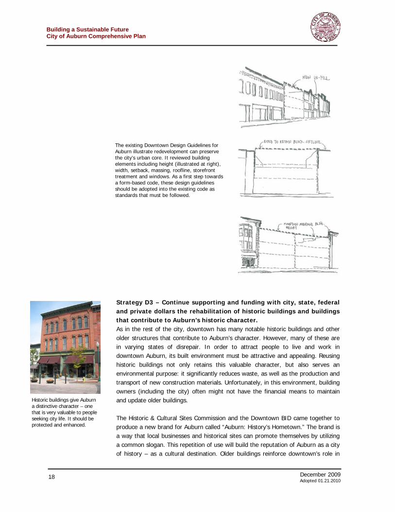
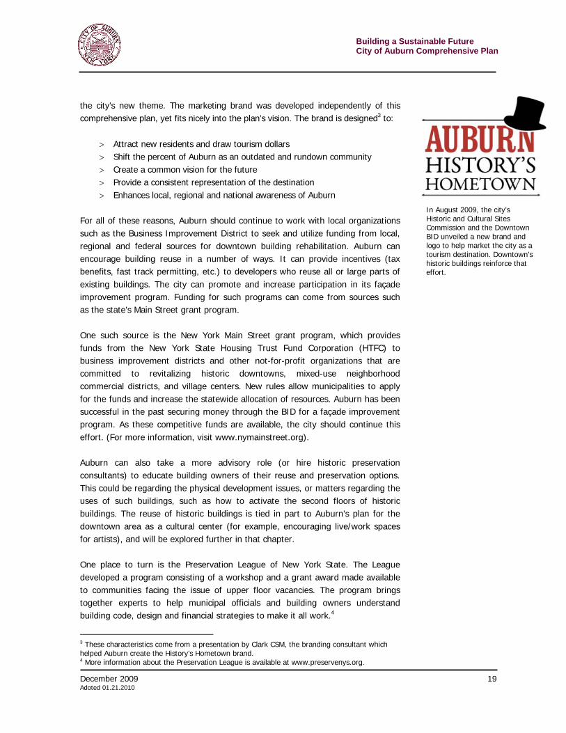
Strategy D3 – Continue supporting and funding with city, state, federal and private dollars the rehabilitation of historic buildings and buildings that contribute to Auburn’s historic character. As in the rest of the city, downtown has many notable historic buildings and other older structures that contribute to Auburn’s character. However, many of these are in varying states of disrepair. In order to attract people to live and work in downtown Auburn, its built environment must be attractive and appealing. Reusing historic buildings not only retains this valuable character, but also serves an environmental purpose: it significantly reduces waste, as well as the production and transport of new construction materials. Unfortunately, in this environment, building owners (including the city) often might not have the financial means to maintain and update older buildings. The Historic & Cultural Sites Commission and the Downtown BID came together to produce a new brand for Auburn called “Auburn: History’s Hometown.” The brand is a way that local businesses and historical sites can promote themselves by utilizing a common slogan. This repetition of use will build the reputation of Auburn as a city of history – as a cultural destination. Older buildings reinforce downtown’s role in
The existing Downtown Design Guidelines for Auburn illustrate redevelopment can preserve the city’s urban core. It reviewed building elements including height (illustrated at right), width, setback, massing, roofline, storefront treatment and windows. As a first step towards a form-based code, these design guidelines should be adopted into the existing code as standards that must be followed.
Historic buildings give Auburn a distinctive character – one that is very valuable to people seeking city life. It should be protected and enhanced.
December 2009 19 Adoted 01.21.2010
Building a Sustainable FutureCity of Auburn Comprehensive Plan
the city’s new theme. The marketing brand was developed independently of this comprehensive plan, yet fits nicely into the plan’s vision. The brand is designed3 to:
> Attract new residents and draw tourism dollars > Shift the percent of Auburn as an outdated and rundown community > Create a common vision for the future > Provide a consistent representation of the destination > Enhances local, regional and national awareness of Auburn
For all of these reasons, Auburn should continue to work with local organizations such as the Business Improvement District to seek and utilize funding from local, regional and federal sources for downtown building rehabilitation. Auburn can encourage building reuse in a number of ways. It can provide incentives (tax benefits, fast track permitting, etc.) to developers who reuse all or large parts of existing buildings. The city can promote and increase participation in its façade improvement program. Funding for such programs can come from sources such as the state’s Main Street grant program. One such source is the New York Main Street grant program, which provides funds from the New York State Housing Trust Fund Corporation (HTFC) to business improvement districts and other not-for-profit organizations that are committed to revitalizing historic downtowns, mixed-use neighborhood commercial districts, and village centers. New rules allow municipalities to apply for the funds and increase the statewide allocation of resources. Auburn has been successful in the past securing money through the BID for a façade improvement program. As these competitive funds are available, the city should continue this effort. (For more information, visit www.nymainstreet.org). Auburn can also take a more advisory role (or hire historic preservation consultants) to educate building owners of their reuse and preservation options. This could be regarding the physical development issues, or matters regarding the uses of such buildings, such as how to activate the second floors of historic buildings. The reuse of historic buildings is tied in part to Auburn’s plan for the downtown area as a cultural center (for example, encouraging live/work spaces for artists), and will be explored further in that chapter. One place to turn is the Preservation League of New York State. The League developed a program consisting of a workshop and a grant award made available to communities facing the issue of upper floor vacancies. The program brings together experts to help municipal officials and building owners understand building code, design and financial strategies to make it all work.4
3 These characteristics come from a presentation by Clark CSM, the branding consultant which helped Auburn create the History’s Hometown brand. 4 More information about the Preservation League is available at www.preservenys.org.
In August 2009, the city’s Historic and Cultural Sites Commission and the Downtown BID unveiled a new brand and logo to help market the city as a tourism destination. Downtown’s historic buildings reinforce that effort.
Building a Sustainable Future City of Auburn Comprehensive Plan
20 December 2009 Adopted 01.21.2010
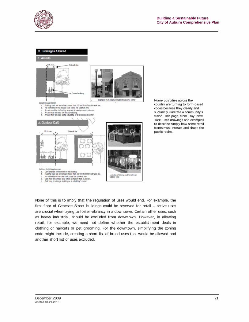
Strategy D4 – Institute form-based code in the downtown area From a land use perspective, the current zoning is one of the largest inhibitors to maintaining the traditional downtown that attracts residents and visitors. Standard zoning through the 20th century emphasizes the regulation (and separation) of uses: places where people live must be separate from where they work and where they shop. This is exactly the opposite of a successful downtown. In a vibrant downtown, a mix of uses is required. Residential units provide the customers who can walk to shop, dine and drink in the evenings. During the day office workers circulate around restaurants at lunch and shop before heading (often by foot) home. While the design guidelines described in Strategy D2 represent a short-term fix, the structure of traditional zoning, including that in Auburn, works against the mixed-use, vibrant vision for downtown. Cities across the nation are instituting more of a form-based code for their urban core. Form-based codes are alternatives to conventional zoning and are adopted into city law as regulations. This alternative approach fosters predictable results in terms of the form of buildings and the creation of a high-quality public realm, for example, sidewalks, streets, and plazas. It is in these public areas that vibrancy is created. By emphasizing the relationship between building facades and the public spaces around them, form-based codes more easily foster the creation of an urban environment. (Conventional codes focus on the separation and micromanagement of land uses and the micromanagement. The built form is often an afterthought.), Form-based codes are easier to read and interpret than traditional zoning codes – since they are written in plain English with diagrams and graphics – resulting in a more transparent process for both the public and for developers. Sketches or example site plans and photographs can provide developers, builders, review board members, public officials and the public with a more comprehensive vision for the community’s future. Since form-based codes emphasize what a community wants a place to look like, the result is a higher quality built environment than what is achievable with traditional zoning. Form-based codes rely on context to determine appropriate building scale, material, and overall design, and so such a scheme would be well suited to Auburn’s downtown. Since the “form” is built in, form-based codes eliminate the need for separate design guidelines. Auburn’s current design guidelines can become integrated right into the code.
December 2009 21 Adoted 01.21.2010
Building a Sustainable FutureCity of Auburn Comprehensive Plan
None of this is to imply that the regulation of uses would end. For example, the first floor of Genesee Street buildings could be reserved for retail – active uses are crucial when trying to foster vibrancy in a downtown. Certain other uses, such as heavy industrial, should be excluded from downtown. However, in allowing retail, for example, we need not define whether the establishment deals in clothing or haircuts or pet grooming. For the downtown, simplifying the zoning code might include, creating a short list of broad uses that would be allowed and another short list of uses excluded.
Numerous cities across the country are turning to form-based codes because they clearly and succinctly illustrate a community’s vision. This page, from Troy, New York, uses drawings and examples to describe simply how some retail fronts must interact and shape the public realm.
Building a Sustainable Future City of Auburn Comprehensive Plan
22 December 2009 Adopted 01.21.2010
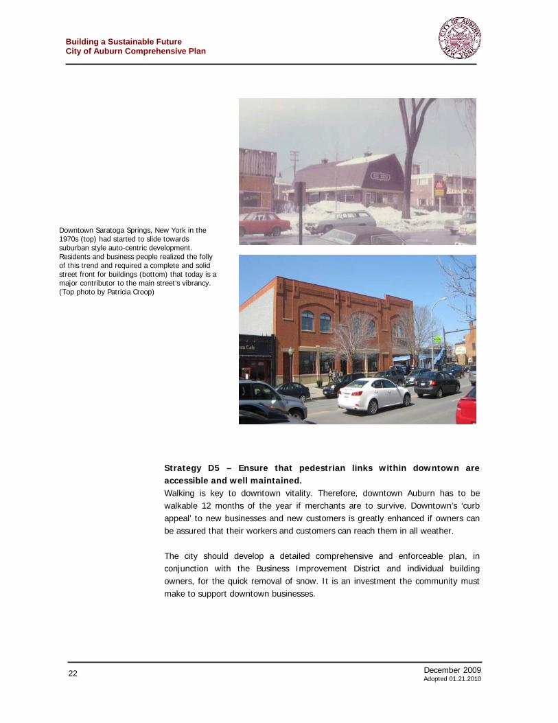
Strategy D5 – Ensure that pedestrian links within downtown are accessible and well maintained. Walking is key to downtown vitality. Therefore, downtown Auburn has to be walkable 12 months of the year if merchants are to survive. Downtown’s ‘curb appeal’ to new businesses and new customers is greatly enhanced if owners can be assured that their workers and customers can reach them in all weather. The city should develop a detailed comprehensive and enforceable plan, in conjunction with the Business Improvement District and individual building owners, for the quick removal of snow. It is an investment the community must make to support downtown businesses.
Downtown Saratoga Springs, New York in the 1970s (top) had started to slide towards suburban style auto-centric development. Residents and business people realized the folly of this trend and required a complete and solid street front for buildings (bottom) that today is a major contributor to the main street’s vibrancy. (Top photo by Patricia Croop)
December 2009 23 Adoted 01.21.2010
Building a Sustainable FutureCity of Auburn Comprehensive Plan
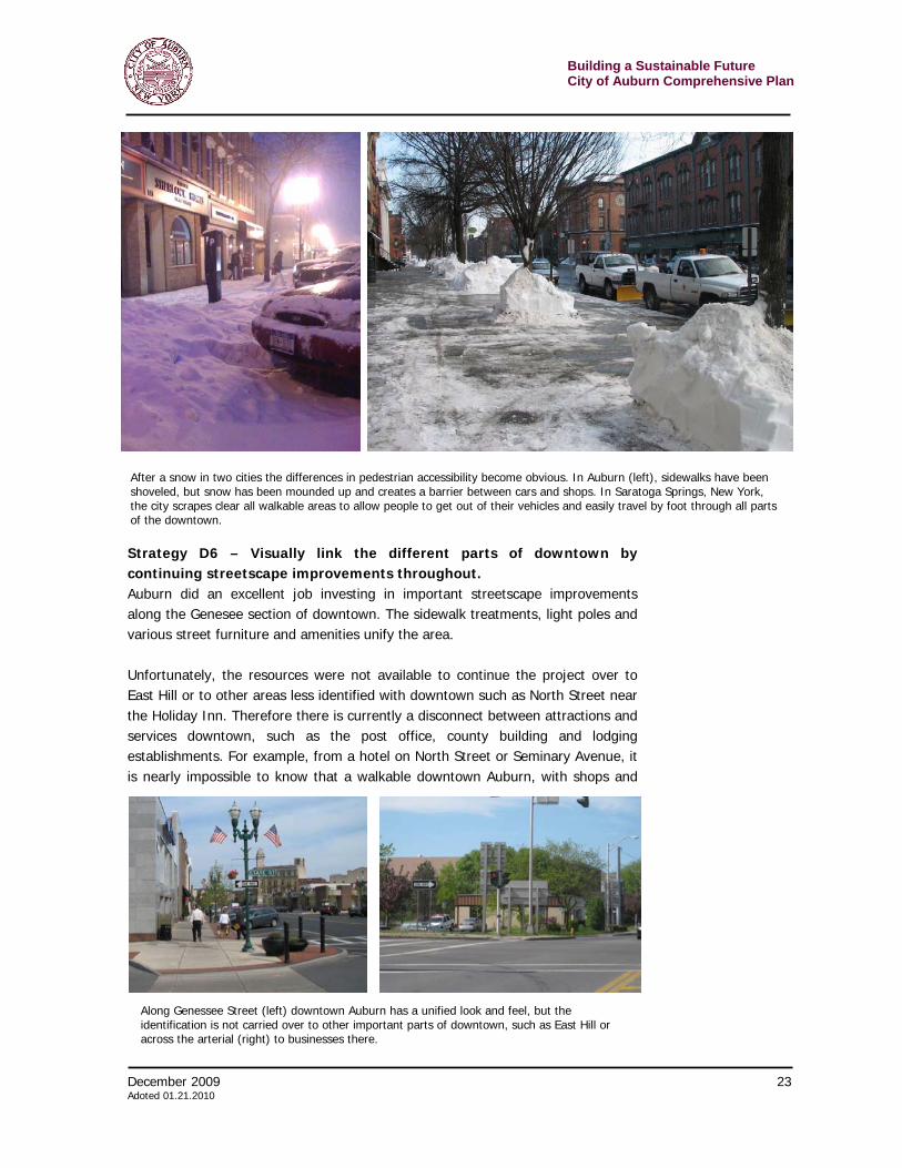
Strategy D6 – Visually link the different parts of downtown by continuing streetscape improvements throughout. Auburn did an excellent job investing in important streetscape improvements along the Genesee section of downtown. The sidewalk treatments, light poles and various street furniture and amenities unify the area. Unfortunately, the resources were not available to continue the project over to East Hill or to other areas less identified with downtown such as North Street near the Holiday Inn. Therefore there is currently a disconnect between attractions and services downtown, such as the post office, county building and lodging establishments. For example, from a hotel on North Street or Seminary Avenue, it is nearly impossible to know that a walkable downtown Auburn, with shops and
After a snow in two cities the differences in pedestrian accessibility become obvious. In Auburn (left), sidewalks have been shoveled, but snow has been mounded up and creates a barrier between cars and shops. In Saratoga Springs, New York, the city scrapes clear all walkable areas to allow people to get out of their vehicles and easily travel by foot through all parts of the downtown.
Along Genessee Street (left) downtown Auburn has a unified look and feel, but the identification is not carried over to other important parts of downtown, such as East Hill or across the arterial (right) to businesses there.
Building a Sustainable Future City of Auburn Comprehensive Plan
24 December 2009 Adopted 01.21.2010
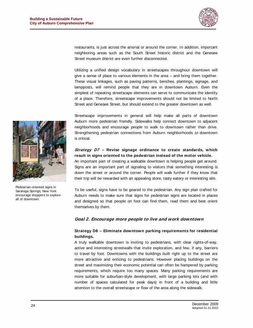
restaurants, is just across the arterial or around the corner. In addition, important neighboring areas such as the South Street historic district and the Genesee Street museum district are even further disconnected. Utilizing a unified design vocabulary in streetscapes throughout downtown will give a sense of place to various elements in the area – and bring them together. These visual linkages, such as paving patterns, benches, plantings, signage, and lampposts, will remind people that they are in downtown Auburn. Even the simplest of repeating streetscape elements can serve to communicate the identity of a place. Therefore, streetscape improvements should not be limited to North Street and Genesee Street, but should extend to the greater downtown as well. Streetscape improvements in general will help make all parts of downtown Auburn more pedestrian friendly. Sidewalks help connect downtown to adjacent neighborhoods and encourage people to walk to downtown rather than drive. Strengthening pedestrian connections from Auburn neighborhoods to downtown is critical. Strategy D7 – Revise signage ordinance to create standards, which result in signs oriented to the pedestrian instead of the motor vehicle. An important part of creating a walkable downtown is helping people get around. Signs are an important part of signaling to visitors that something interesting is down the street or around the corner. People will walk further if they know that their trip will be rewarded with an appealing store, tasty eatery or interesting site. To be useful, signs have to be geared to the pedestrian. Any sign plan crafted for Auburn needs to make sure that signs for pedestrian signs are located in places and designed so that people on foot can find them, read them and best orient themselves by them.
Goal 2. Encourage more people to live and work downtown Strategy D8 – Eliminate downtown parking requirements for residential buildings. A truly walkable downtown is inviting to pedestrians, with clear rights-of-way, active and interesting streetwalls that invite exploration, and few, if any, barriers to travel by foot. Downtowns with the buildings built right up to the street are more attractive and enticing to pedestrians. However placing buildings on the street and maximizing their economic potential can often be hampered by parking requirements, which require too many spaces. Many parking requirements are more suitable for suburban-style development, with large parking lots (and with number of spaces calculated for peak days) in front of a building and little attention to the overall streetscape or flow of the area along the sidewalk.
Pedestrian-oriented signs in Saratoga Springs, New York encourage shoppers to explore all of downtown.
December 2009 25 Adoted 01.21.2010
Building a Sustainable FutureCity of Auburn Comprehensive Plan
Auburn’s zoning code indicates that the city is aware of these issues: for the downtown Central Commercial zoning district, the code states “Any other provisions of this section to the contrary notwithstanding, no off-street parking shall be required for any use, other than residential uses, within the C-2 Central Commercial District.”5 This is an excellent first step. However, the requirement for parking for residential uses presents limitations for the viability of downtown living. Currently, residential parking requirements include one parking place per single-family detached dwelling unit; two spaces per two-family dwellings; and between one and two spaces for each multi-family dwelling unit. For mixed-use buildings in the C-2 district, the code states, “Mixed-use occupancy residential uses shall only be permitted when parking requirements for all business and residential uses in the building can be met.6 The city should modify on-site parking requirements in downtown Auburn in order to encourage the reuse of buildings as residences. Some of the potential changes include: > Reducing or eliminating the minimum requirement > Allowing shared parking with other nearby uses > Allow long-term parking for residents, perhaps by permit, in city lots and garages. Strategy D9 – Provide a diversity of housing options, particularly condominiums and high-quality rental units, within walking distance of downtown. Bringing residents back into downtown requires that have safe and attractive places to live for people of various income levels. In particular, the area needs high-quality, market-rate, owner-occupied units and rental units. Such residential units, which are just starting to be developed in a neighborhood on the outskirts of downtown, would be attractive to the creative class of entrepreneurs and workers important to Auburn’s 21st century future. The desire for more diverse types of housing can stem from both financial and behavioral needs. For instance, young singles or couples moving (or returning) to Auburn might not be able to afford a single family home – or they simply might not want that much space or the maintenance associated with it. These young people might want to feel more connected with their peers and want access to friends, jobs, and shops by foot in the downtown area. On the other end of the spectrum, empty nesters, or those whose children have left the household, might want to downsize their living space for a variety of reasons – not necessarily financial. Perhaps they would like to live in the cultural center of the city, close to the theater and shops. The city should explore ways to enable high-end housing outside of the traditional single-family model. As people age, downtown living tends to keep them more independent as a car is not
5 Auburn Zoning Ordinance, §305-26, (C) (2) “Off-Street Parking and Loading.” 6 Auburn Zoning Ordinance, §305-38 B (6) (b) [1] “Residential Uses in Commercial Districts”
Building a Sustainable Future City of Auburn Comprehensive Plan
26 December 2009 Adopted 01.21.2010
necessary for trips to the store or a restaurant. In particular, a 2006 Housing Market Study indicated that the senior market is growing and provides opportunities for age-restricted rental units. The city should seek to encourage more types of housing, including apartments, condominiums, and townhouses, in downtown Auburn. Greater density would help create more of a “downtown” feel in these areas, adding potential customers to nearby businesses and restaurants, community gathering places, and an overall sense of place and civic pride, helping to define Auburn’s vibrant cultural and artistic downtown.
Goal 3. Improve the marketing of downtown Strategy D10 – Offer a resource, through the BID or the city, to help shop owners succeed. Every merchant, especially those urban pioneers starting out in a small storefront, probably does not have all of the skills needed for success. Window displays, store layout and other retail business operations are a science, developed over years, in which new entrepreneurs need mentoring. This is a lesson that Auburn can take from malls. Successful malls, especially in competitive places, do not leave their merchants to fend for themselves. They are partners in the success. Often they bring in people to help with window display design, store layout, marketing, bookkeeping or other operations. Some of these services are already provided by the BID – and they should be continued and expanded. The BID should bring in experts and offer workshops on various aspects of the business. Some efforts could be fun, such as hosting a window display contest with consumers casting ballots for the best displays. Other workshops, such as those put on by the Preservation League of New York, help the owners of downtown buildings find ways to economically protect their historic structures. Strategy D11 – Fill vacant storefronts with art or other signs of life. Often, vacant storefronts in a downtown can give the appearance of a toothless smile, with vestiges of businesses long gone, or facades, signs, and interiors in disrepair. The City or BID should explore ways to work with property owners to utilize vacant storefronts creatively—as showcases for local art, marketing for events, and the like. Activating these storefronts would draw attention to the properties themselves, benefiting the landlords as well. Artistic work need not be static. Pittsfield, Massachusetts, which has had a storefront arts program for several years, experiments with putting musicians in windows at certain times. Philadelphia took this idea a step further, allowing
December 2009 27 Adoted 01.21.2010
Building a Sustainable FutureCity of Auburn Comprehensive Plan
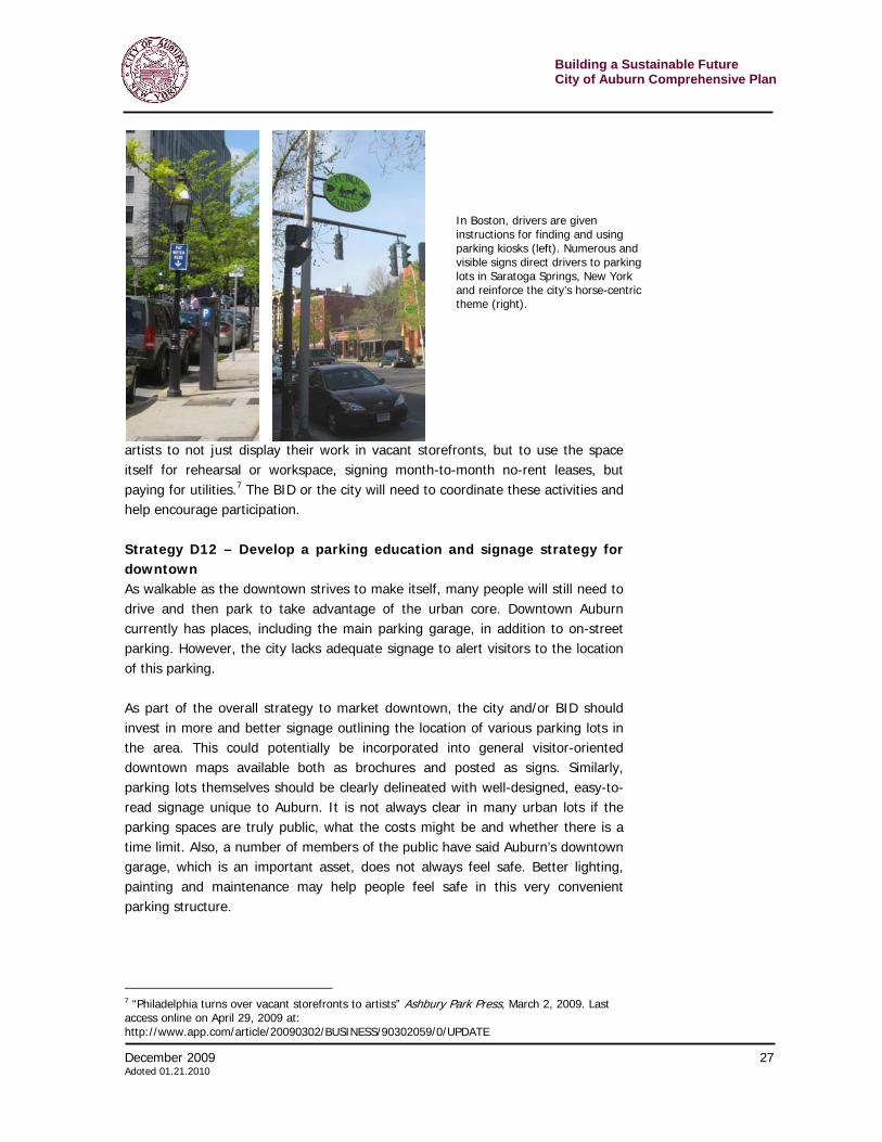
artists to not just display their work in vacant storefronts, but to use the space itself for rehearsal or workspace, signing month-to-month no-rent leases, but paying for utilities.7 The BID or the city will need to coordinate these activities and help encourage participation. Strategy D12 – Develop a parking education and signage strategy for downtown As walkable as the downtown strives to make itself, many people will still need to drive and then park to take advantage of the urban core. Downtown Auburn currently has places, including the main parking garage, in addition to on-street parking. However, the city lacks adequate signage to alert visitors to the location of this parking. As part of the overall strategy to market downtown, the city and/or BID should invest in more and better signage outlining the location of various parking lots in the area. This could potentially be incorporated into general visitor-oriented downtown maps available both as brochures and posted as signs. Similarly, parking lots themselves should be clearly delineated with well-designed, easy-to-read signage unique to Auburn. It is not always clear in many urban lots if the parking spaces are truly public, what the costs might be and whether there is a time limit. Also, a number of members of the public have said Auburn’s downtown garage, which is an important asset, does not always feel safe. Better lighting, painting and maintenance may help people feel safe in this very convenient parking structure.
7 “Philadelphia turns over vacant storefronts to artists” Ashbury Park Press, March 2, 2009. Last access online on April 29, 2009 at: http://www.app.com/article/20090302/BUSINESS/90302059/0/UPDATE
In Boston, drivers are given instructions for finding and using parking kiosks (left). Numerous and visible signs direct drivers to parking lots in Saratoga Springs, New York and reinforce the city’s horse-centric theme (right).
Building a Sustainable Future City of Auburn Comprehensive Plan
28 December 2009 Adopted 01.21.2010
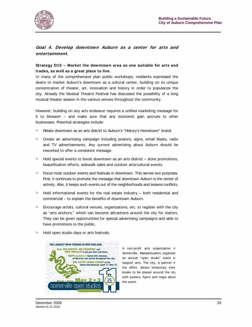
Strategy D13 – Support an aggressive schedule of outdoor festivals Music festivals, street fairs and other public outdoor events are excellent ways to promote downtown and bring customers there on special occasions. A well-done outdoor event, especially an annual one, can draw people from around the region and regularly expose them to the options found in a rejuvenated downtown. In many communities, such efforts are met with resistance from some residents or business owners. The complaints center on noise, loss of parking spaces or street closures. However, such fears can be alleviated with careful planning and education. Communication is crucial in making these events profitable to the broader community. Too often, large numbers of people will come for an outdoor concert or a road race and find stores closed. Other people reported merchants caught off guard – open, but unaware and unprepared for the people and selling out too quickly. Coordination, through the BID, helps eliminate frustrations felt by visitors and business owners. It helps make the visitors to Auburn feel welcome and come back for another event or just to stay, explore and spend their money. Auburn must support as many festivals as possible in downtown. Indeed they should act as a facilitator to see if festivals can be made bigger or more attractive by adding events such as a road race. The city will have to help alleviate the concerns of such neighbors as well as education everyone that short-term inconveniences can pay off in the long term – and be fun. Strategy D14 – Use street banners to tout Auburn Utilize street banners in central areas of downtown to promote events, such as art fairs or theater events. Banners can function as a “town crier”, giving downtown a sense of place and alerting residents and visitors to anything that boosts downtown. Banners can designate districts and link places, such as the disparate parts of Auburn’s downtown, together. Another example, museum district banners can help identify the area as important and interesting. Banners can be drawn by school children or professionally done for particular events. Banners could be sponsored by a business or organization, as long as they do not read like an advertisement.
Banners can announce community events (left), mark the boundary of a special place (center) and build community spirit (right). The banner pictured on the right, going up soon in the Village of Victor, was design by school children.
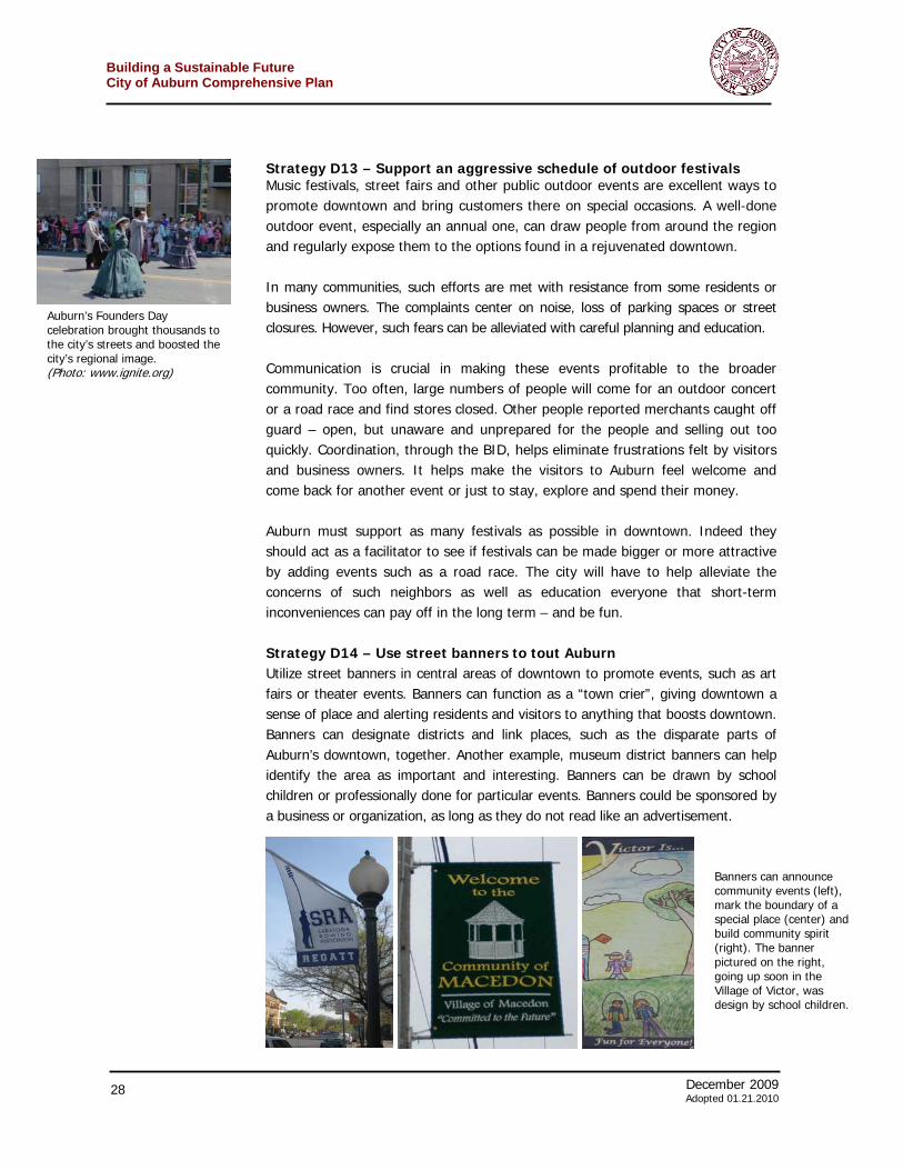
Auburn’s Founders Day celebration brought thousands to the city’s streets and boosted the city’s regional image. (Photo: www.ignite.org)
December 2009 29 Adoted 01.21.2010
Building a Sustainable FutureCity of Auburn Comprehensive Plan
Goal 4. Develop downtown Auburn as a center for arts and entertainment. Strategy D15 – Market the downtown area as one suitable for arts and trades, as well as a great place to live. In many of the comprehensive plan public workshops, residents expressed the desire to market Auburn’s downtown as a cultural center, building on its unique concentration of theater, art, innovation and history in order to popularize the city. Already the Musical Theatre Festival has discussed the possibility of a long musical theater season in the various venues throughout the community. However, building on any arts endeavor requires a unified marketing message for it to blossom – and make sure that any economic gain accrues to other businesses. Potential strategies include:
> Relate downtown as an arts district to Auburn’s “History’s Hometown” brand.
> Create an advertising campaign including posters, signs, email blasts, radio and TV advertisements. Any current advertising about Auburn should be reworked to offer a consistent message.
> Hold special events to boost downtown as an arts district – store promotions, beautification efforts, sidewalk sales and outdoor arts/cultural events.
> Focus most outdoor events and festivals in downtown. This serves two purposes. First, it continues to promote the message that downtown Auburn is the center of activity. Also, it keeps such events out of the neighborhoods and lessens conflicts.
> Hold informational events for the real estate industry – both residential and commercial – to explain the benefits of downtown Auburn.
> Encourage artists, cultural venues, organizations, etc. to register with the city as “arts anchors,” which can become attractions around the city for visitors. They can be given opportunities for special advertising campaigns and able to have promotions to the public.
> Hold open studio days or arts festivals.
A non-profit arts organization inSomerville, Massachusetts organizesan annual “open studio” event tosupport arts. The city, a partner inthe effort, allows temporary mini-kiosks to be placed around the citywith posters, flyers and maps aboutthe event.
Building a Sustainable Future City of Auburn Comprehensive Plan
30 December 2009 Adopted 01.21.2010
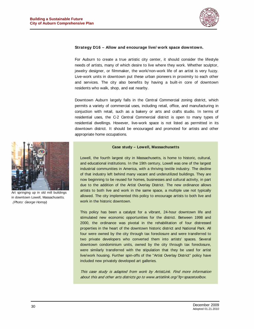
Strategy D16 – Allow and encourage live/work space downtown. For Auburn to create a true artistic city center, it should consider the lifestyle needs of artists, many of which desire to live where they work. Whether sculptor, jewelry designer, or filmmaker, the work/non-work life of an artist is very fuzzy. Live-work units in downtown put these urban pioneers in proximity to each other and services. The city also benefits by having a built-in core of downtown residents who walk, shop, and eat nearby. Downtown Auburn largely falls in the Central Commercial zoning district, which permits a variety of commercial uses, including retail, office, and manufacturing in conjuction with retail, such as a bakery or arts and crafts studio. In terms of residential uses, the C-2 Central Commercial district is open to many types of residential dwellings. However, live-work space is not listed as permitted in its downtown district. It should be encouraged and promoted for artists and other appropriate home occupations.
Art springing up in old mill buildings in downtown Lowell, Massachusetts. (Photo: George Homsy)
Case study – Lowell, Massachusetts Lowell, the fourth largest city in Massachusetts, is home to historic, cultural, and educational institutions. In the 19th century, Lowell was one of the largest industrial communities in America, with a thriving textile industry. The decline of that industry left behind many vacant and underutilized buildings. They are now beginning to be reused for homes, businesses and cultural activity, in part due to the addition of the Artist Overlay District. The new ordinance allows artists to both live and work in the same space, a multiple use not typically allowed. The city implemented this policy to encourage artists to both live and work in the historic downtown. This policy has been a catalyst for a vibrant, 24-hour downtown life and stimulated new economic opportunities for the district. Between 1998 and 2000, the ordinance was pivotal in the rehabilitation of four distressed properties in the heart of the downtown historic district and National Park. All four were owned by the city through tax foreclosure and were transferred to two private developers who converted them into artists’ spaces. Several downtown condominium units, owned by the city through tax foreclosure, were similarly transferred with the stipulation that they be used for artist live/work housing. Further spin-offs of the "Artist Overlay District" policy have included new privately developed art galleries. This case study is adapted from work by ArtistLink. Find more information about this and other arts districts go to www.artistlink.org/?q=spacetoolbox.
December 2009 31 Adoted 01.21.2010
Building a Sustainable FutureCity of Auburn Comprehensive Plan
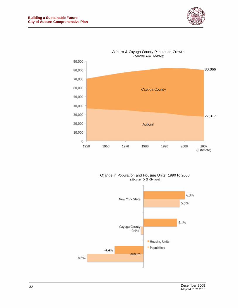
Housing and neighborhoods in Auburn run the gamut from safe and desirable to very distressed. In many neighborhoods, housing quality and safety are top priorities. This chapter assesses the general condition of housing and neighborhoods in Auburn, sets policy goals and describes strategies that will make Auburn a more attractive place for a variety of people to live. Safe and affordable housing is the bare minimum that a municipality should provide its residents. Cities with vibrant, desirable neighborhoods attract people who will live, work, shop and recreate in the community. High quality, attractive and affordable residential areas are the foundation for social vitality and economic success. There must be enough desirable homes for workers and entrepreneurs – the people who will drive the city’s revitalization. Housing and Neighborhoods today in Auburn Since 1950, Auburn has been steadily – though slowly, losing population to approximately 27,000 in 2007. At the same time Cayuga County experienced moderate growth, which leveled in the 1990s and declined slightly by 2007. Whereas Auburn represented just about half of the county’s population in 1950, it now represents just over one-third of the county.
From 1990 to 2000, while Auburn lost both housing units and population, the county had sprawl without growth. Despite a 0.5 percent decline in population, the number of housing units in Cayuga County grew 5.1 percent. New York State, during the same time period, grew both in terms of population and housing units.
Revitalizing Neighborhoods
Building a Sustainable Future City of Auburn Comprehensive Plan
32 December 2009 Adopted 01.21.2010
Auburn & Cayuga County Population Growth (Source: U.S. Census)
Cayuga County
Auburn
27,317
80,066
Change in Population and Housing Units: 1990 to 2000 (Source: U.S. Census)
December 2009 33 Adoted 01.21.2010
Building a Sustainable FutureCity of Auburn Comprehensive Plan
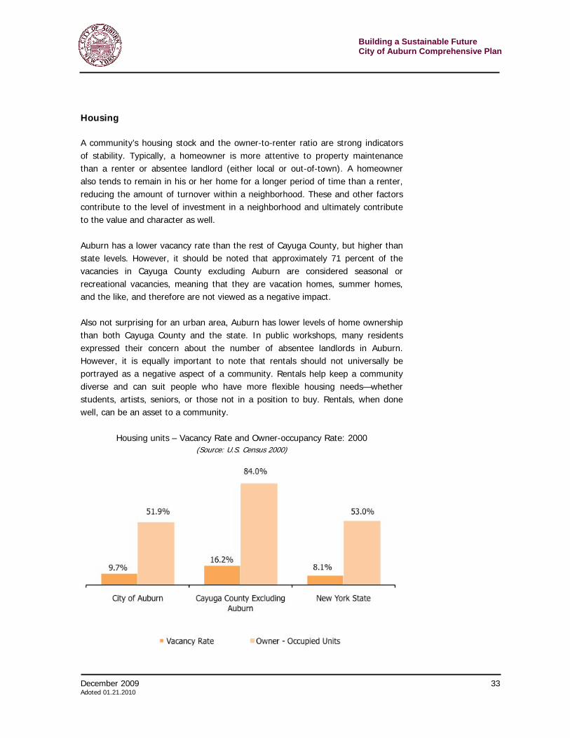
Housing A community’s housing stock and the owner-to-renter ratio are strong indicators of stability. Typically, a homeowner is more attentive to property maintenance than a renter or absentee landlord (either local or out-of-town). A homeowner also tends to remain in his or her home for a longer period of time than a renter, reducing the amount of turnover within a neighborhood. These and other factors contribute to the level of investment in a neighborhood and ultimately contribute to the value and character as well. Auburn has a lower vacancy rate than the rest of Cayuga County, but higher than state levels. However, it should be noted that approximately 71 percent of the vacancies in Cayuga County excluding Auburn are considered seasonal or recreational vacancies, meaning that they are vacation homes, summer homes, and the like, and therefore are not viewed as a negative impact. Also not surprising for an urban area, Auburn has lower levels of home ownership than both Cayuga County and the state. In public workshops, many residents expressed their concern about the number of absentee landlords in Auburn. However, it is equally important to note that rentals should not universally be portrayed as a negative aspect of a community. Rentals help keep a community diverse and can suit people who have more flexible housing needs—whether students, artists, seniors, or those not in a position to buy. Rentals, when done well, can be an asset to a community.
Housing units – Vacancy Rate and Owner-occupancy Rate: 2000
(Source: U.S. Census 2000)
Building a Sustainable Future City of Auburn Comprehensive Plan
34 December 2009 Adopted 01.21.2010
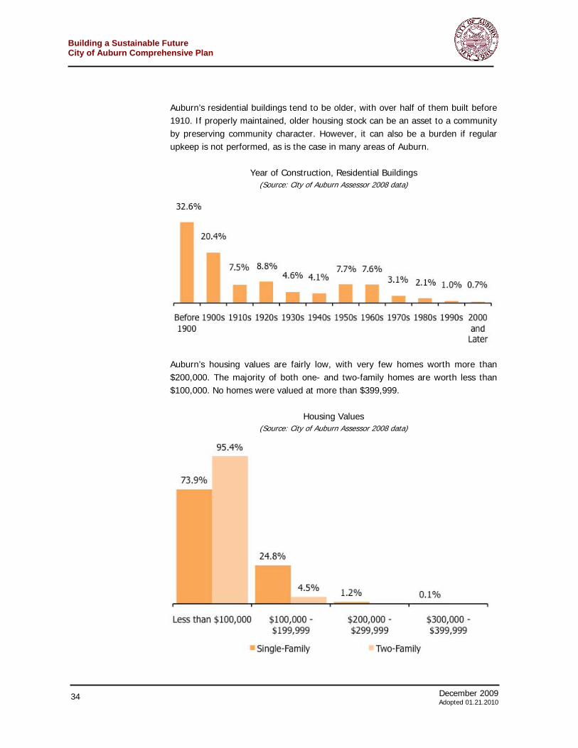
Auburn’s residential buildings tend to be older, with over half of them built before 1910. If properly maintained, older housing stock can be an asset to a community by preserving community character. However, it can also be a burden if regular upkeep is not performed, as is the case in many areas of Auburn.
Year of Construction, Residential Buildings
(Source: City of Auburn Assessor 2008 data)
Auburn’s housing values are fairly low, with very few homes worth more than $200,000. The majority of both one- and two-family homes are worth less than $100,000. No homes were valued at more than $399,999.
Housing Values
(Source: City of Auburn Assessor 2008 data)
December 2009 35 Adoted 01.21.2010
Building a Sustainable FutureCity of Auburn Comprehensive Plan
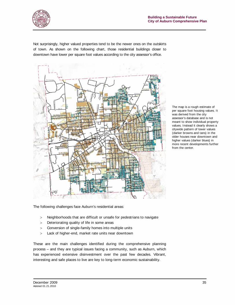
Not surprisingly, higher valued properties tend to be the newer ones on the outskirts of town. As shown on the following chart, those residential buildings closer to downtown have lower per square foot values according to the city assessor’s office.
The following challenges face Auburn’s residential areas:
> Neighborhoods that are difficult or unsafe for pedestrians to navigate > Deteriorating quality of life in some areas > Conversion of single-family homes into multiple units > Lack of higher-end, market rate units near downtown
These are the main challenges identified during the comprehensive planning process – and they are typical issues facing a community, such as Auburn, which has experienced extensive disinvestment over the past few decades. Vibrant, interesting and safe places to live are key to long-term economic sustainability.
The map is a rough estimate of per square foot housing values. It was derived from the city assessor’s database and is not meant to show individual property values. Instead it clearly shows a citywide pattern of lower values (darker browns and tans) in the older houses near downtown and higher values (darker blues) in more recent developments further from the center.
Building a Sustainable Future City of Auburn Comprehensive Plan
36 December 2009 Adopted 01.21.2010
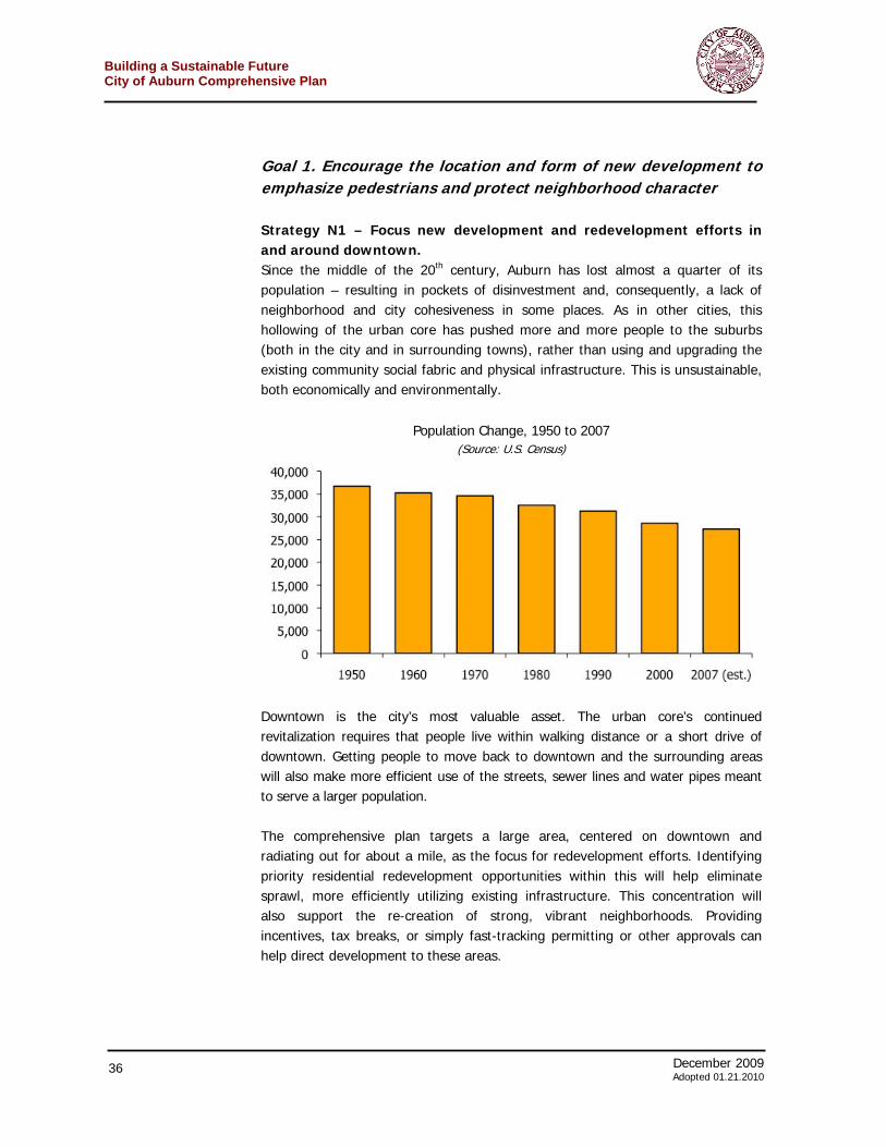
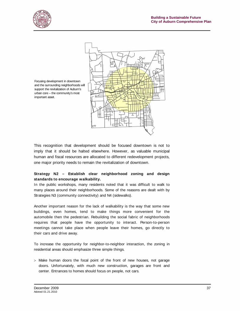
Goal 1. Encourage the location and form of new development to emphasize pedestrians and protect neighborhood character Strategy N1 – Focus new development and redevelopment efforts in and around downtown. Since the middle of the 20th century, Auburn has lost almost a quarter of its population – resulting in pockets of disinvestment and, consequently, a lack of neighborhood and city cohesiveness in some places. As in other cities, this hollowing of the urban core has pushed more and more people to the suburbs (both in the city and in surrounding towns), rather than using and upgrading the existing community social fabric and physical infrastructure. This is unsustainable, both economically and environmentally.
Population Change, 1950 to 2007
(Source: U.S. Census)
Downtown is the city’s most valuable asset. The urban core’s continued revitalization requires that people live within walking distance or a short drive of downtown. Getting people to move back to downtown and the surrounding areas will also make more efficient use of the streets, sewer lines and water pipes meant to serve a larger population. The comprehensive plan targets a large area, centered on downtown and radiating out for about a mile, as the focus for redevelopment efforts. Identifying priority residential redevelopment opportunities within this will help eliminate sprawl, more efficiently utilizing existing infrastructure. This concentration will also support the re-creation of strong, vibrant neighborhoods. Providing incentives, tax breaks, or simply fast-tracking permitting or other approvals can help direct development to these areas.
December 2009 37 Adoted 01.21.2010
Building a Sustainable FutureCity of Auburn Comprehensive Plan
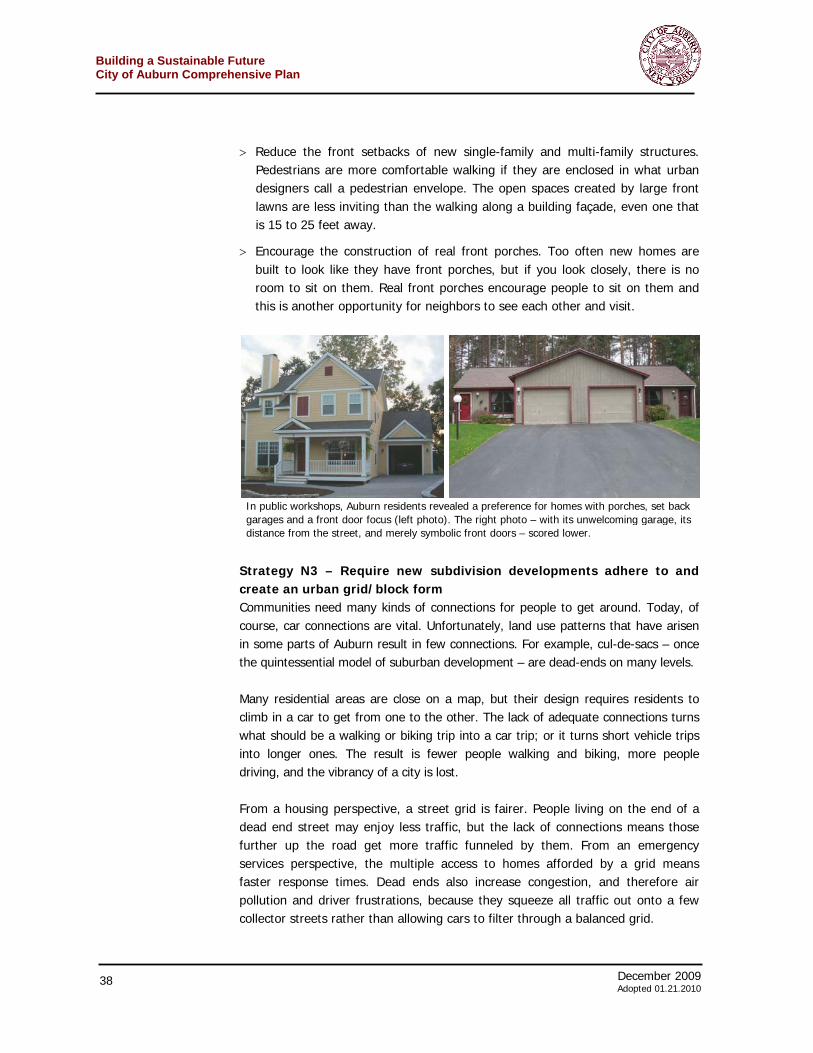
This recognition that development should be focused downtown is not to imply that it should be halted elsewhere. However, as valuable municipal human and fiscal resources are allocated to different redevelopment projects, one major priority needs to remain the revitalization of downtown. Strategy N2 – Establish clear neighborhood zoning and design standards to encourage walkability. In the public workshops, many residents noted that it was difficult to walk to many places around their neighborhoods. Some of the reasons are dealt with by Strategies N3 (community connectivity) and N4 (sidewalks). Another important reason for the lack of walkability is the way that some new buildings, even homes, tend to make things more convenient for the automobile then the pedestrian. Rebuilding the social fabric of neighborhoods requires that people have the opportunity to interact. Person-to-person meetings cannot take place when people leave their homes, go directly to their cars and drive away. To increase the opportunity for neighbor-to-neighbor interaction, the zoning in residential areas should emphasize three simple things. > Make human doors the focal point of the front of new houses, not garage
doors. Unfortunately, with much new construction, garages are front and center. Entrances to homes should focus on people, not cars.
Focusing development in downtown and the surrounding neighborhoods will support the revitalization of Auburn’s urban core – the community’s most important asset.
Building a Sustainable Future City of Auburn Comprehensive Plan
38 December 2009 Adopted 01.21.2010
> Reduce the front setbacks of new single-family and multi-family structures. Pedestrians are more comfortable walking if they are enclosed in what urban designers call a pedestrian envelope. The open spaces created by large front lawns are less inviting than the walking along a building façade, even one that is 15 to 25 feet away.
> Encourage the construction of real front porches. Too often new homes are built to look like they have front porches, but if you look closely, there is no room to sit on them. Real front porches encourage people to sit on them and this is another opportunity for neighbors to see each other and visit.
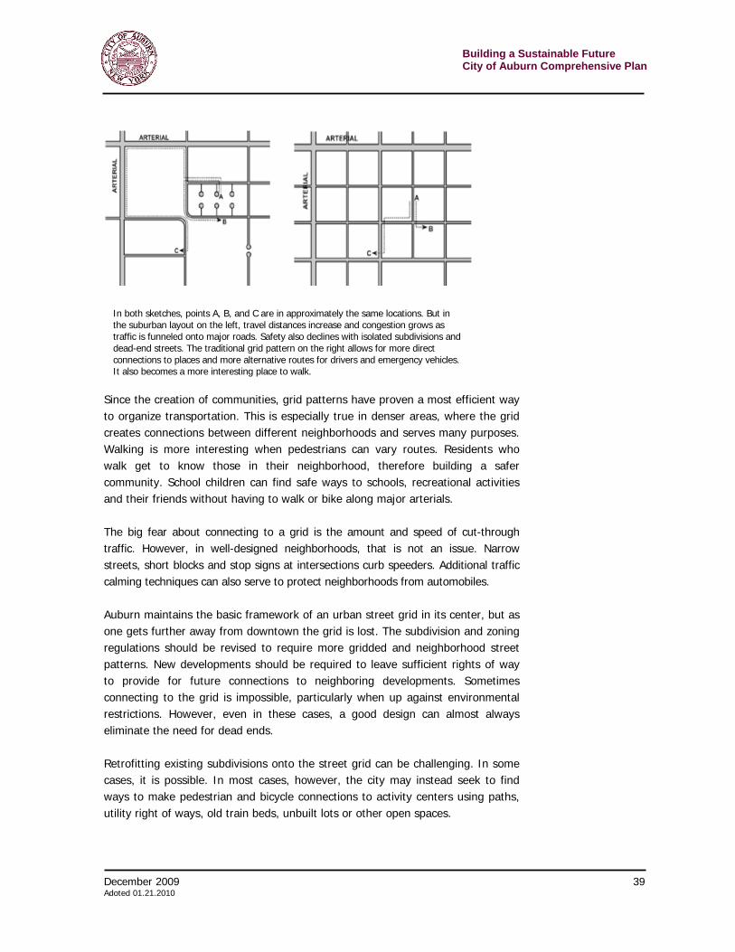
Strategy N3 – Require new subdivision developments adhere to and create an urban grid/block form Communities need many kinds of connections for people to get around. Today, of course, car connections are vital. Unfortunately, land use patterns that have arisen in some parts of Auburn result in few connections. For example, cul-de-sacs – once the quintessential model of suburban development – are dead-ends on many levels. Many residential areas are close on a map, but their design requires residents to climb in a car to get from one to the other. The lack of adequate connections turns what should be a walking or biking trip into a car trip; or it turns short vehicle trips into longer ones. The result is fewer people walking and biking, more people driving, and the vibrancy of a city is lost. From a housing perspective, a street grid is fairer. People living on the end of a dead end street may enjoy less traffic, but the lack of connections means those further up the road get more traffic funneled by them. From an emergency services perspective, the multiple access to homes afforded by a grid means faster response times. Dead ends also increase congestion, and therefore air pollution and driver frustrations, because they squeeze all traffic out onto a few collector streets rather than allowing cars to filter through a balanced grid.
In public workshops, Auburn residents revealed a preference for homes with porches, set back garages and a front door focus (left photo). The right photo – with its unwelcoming garage, its distance from the street, and merely symbolic front doors – scored lower.
December 2009 39 Adoted 01.21.2010
Building a Sustainable FutureCity of Auburn Comprehensive Plan
Since the creation of communities, grid patterns have proven a most efficient way to organize transportation. This is especially true in denser areas, where the grid creates connections between different neighborhoods and serves many purposes. Walking is more interesting when pedestrians can vary routes. Residents who walk get to know those in their neighborhood, therefore building a safer community. School children can find safe ways to schools, recreational activities and their friends without having to walk or bike along major arterials. The big fear about connecting to a grid is the amount and speed of cut-through traffic. However, in well-designed neighborhoods, that is not an issue. Narrow streets, short blocks and stop signs at intersections curb speeders. Additional traffic calming techniques can also serve to protect neighborhoods from automobiles. Auburn maintains the basic framework of an urban street grid in its center, but as one gets further away from downtown the grid is lost. The subdivision and zoning regulations should be revised to require more gridded and neighborhood street patterns. New developments should be required to leave sufficient rights of way to provide for future connections to neighboring developments. Sometimes connecting to the grid is impossible, particularly when up against environmental restrictions. However, even in these cases, a good design can almost always eliminate the need for dead ends. Retrofitting existing subdivisions onto the street grid can be challenging. In some cases, it is possible. In most cases, however, the city may instead seek to find ways to make pedestrian and bicycle connections to activity centers using paths, utility right of ways, old train beds, unbuilt lots or other open spaces.
In both sketches, points A, B, and C are in approximately the same locations. But in the suburban layout on the left, travel distances increase and congestion grows as traffic is funneled onto major roads. Safety also declines with isolated subdivisions and dead-end streets. The traditional grid pattern on the right allows for more direct connections to places and more alternative routes for drivers and emergency vehicles. It also becomes a more interesting place to walk.

Building a Sustainable Future City of Auburn Comprehensive Plan
40 December 2009 Adopted 01.21.2010
Strategy N4 — Continue to encourage sidewalks across the city and create a citywide sidewalk replacement plan that prioritizes the location for new walkways. Sidewalks play an important role in a city such as Auburn — even in the less dense areas. They are one of the most important networks that binds the city together — getting people out of automobiles and helping to create community. During the public meetings, many people recognized and described the value of sidewalks to Auburn. Most residents were concerned that there be safe places for the i r fami l ies to walk and that connect ions be made wi th in res ident ia l neighborhoods and to other neighborhoods as well as commercial areas or other areas of activity — especially around schools. There are numerous reasons to craft a plan for sidewalks that link together, creating a more interconnected system around Auburn. A few of these include the following. Sidewalks are important for Auburn's children The Auburn Enlarged City School District requires that children find their own way to school if they live within a mile of their school for elementary students, a mile and a half for middle schoolers and two miles for those in high school. At appropriate age-levels and maturity, students easily cover those distances on foot or bike. However, many parents will not and should not let their children walk if there is no sidewalk. In some places around Auburn, the city lacks sidewalks in close proximity to the school — de facto requiring that students be driven. This causes congestion, increases air pollution and greenhouse gas emissions and imposes higher fuel costs on family. Also, encouraging children to walk and bike would be a major contributor to improving and maintaining their health. The New York State Department of Health estimates that one in three children are obese or overweight. New federal guidelines urge children to exercise 60 minutes per day, yet fewer than one in four kids get even 20 minutes — and about another quarter report no significant physical activity per day. By making it safe for children to walk to the places they already go — school, parks, shops — Auburn can make a positive contribution to public health. Sidewalks distinguish Auburn from the suburbs Sidewalks provide cities an important advantage over suburbs as they compete for residents. Many people seek dense, well-connected neighborhoods in which to live and raise a family. These people need a choice other than the suburban, car-oriented places. (The suburbs are the
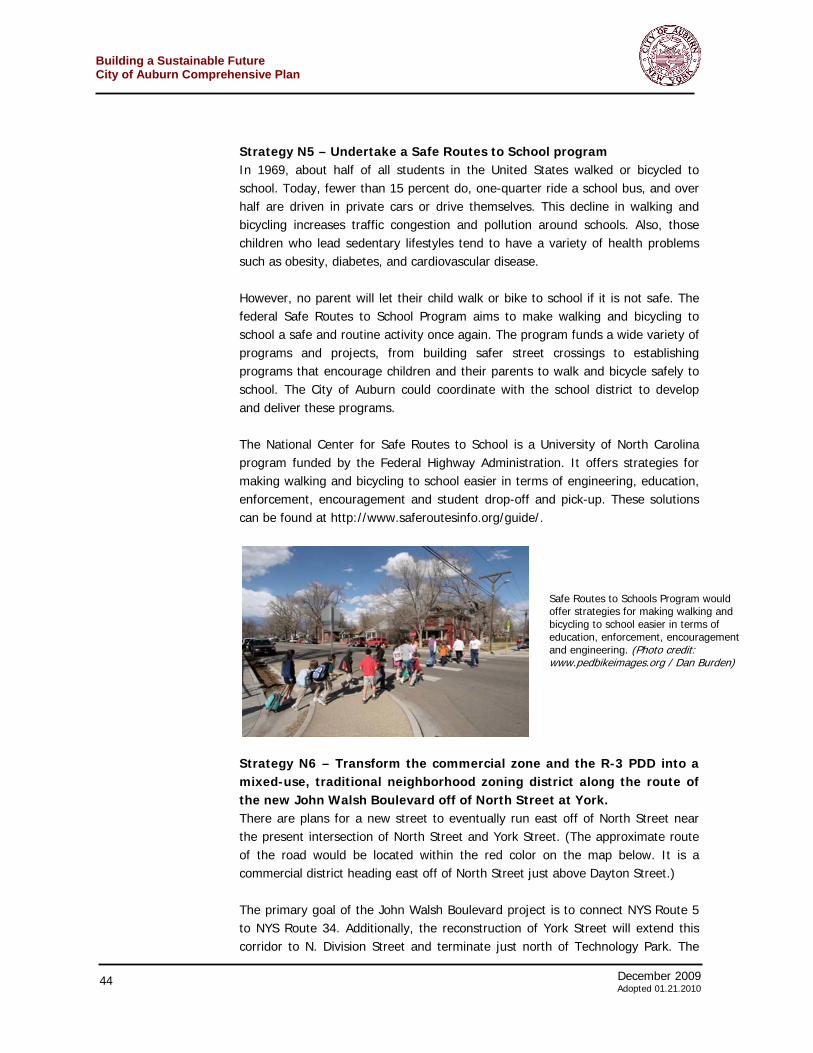
December 2009 41 Adoted 01.21.2010
Building a Sustainable FutureCity of Auburn Comprehensive Plan
choice of some people, who desire an auto-centric.) Providing sidewalks gives people this option and makes the city more attractive to them. It is one of the many ways that the city can stabilize its population and remain economically sustainable over the long-term. Sidewalks are more environmentally sustainable The most polluting time for an automobile occurs during the few minutes just after it is started. People in neighborhoods without sidewalks will, understandably, want to drive to run even short errands; trips so short that a car will not have had a chance to begin operating efficiently. Cutting out these shorter trips will benefit the entire community in lower air pollution and less congestion. Sidewalks build community An often-overlooked benefit of sidewalks is the neighbor-to-neighbor connections they foster. Walking to the store or to school or for exercise allows neighbors, particularly those that share l itt le else in common, to meet and become acquainted. Communities tend to be more cohesive and safer when neighbors get to know one another. However, when all movement in and out of a house requires one to be in a car, that opportunity is missed.
Case Study – Cleveland, Ohio In 2004, Cleveland Mayor Jane L. Campbell became aware of a “Walking School Bus” program that had been initiated by local activists around an elementary school. (A walking school bus is an organized group of children walking to school with one or more adults. It can be informal or include meeting points, timetables and regularly scheduled trained volunteers.) The mayor was looking for ways to get children to be more physically active and to decrease crime on the way to and from schools. After reviewing the success of the pilot program, the Mayor and her cabinet decided to implement the Walking School Bus program in over 100 schools citywide. Case study – Sacramento, California A non-profit institution (Walk Sacramento) initiated a partnership with the local school district to start a series of weekly walking Wednesdays. The coalition, through the skillful procurement of funding, made the streets surrounding schools safer for pedestrians, bicyclists, motorists, and bus riders alike. The group has community-planning councils that provide advice and recommendations on new land use projects. Their role as an educational clearinghouse for communities was especially useful for the Natomas Unified
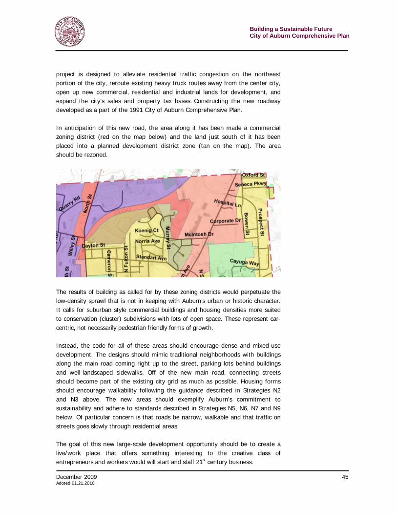
Building a Sustainable Future City of Auburn Comprehensive Plan
42 December 2009 Adopted 01.21.2010
Over the last few years, the city has made great strides weaving its disparate sidewalks together. However, there are still areas where the networks of sidewalks are incomplete and/or difficult to navigate. This is particularly challenging for some of Auburn's children, senior and disabled residents – those who may rely on walking or biking or want to use other means of transport besides the car. For this and the reasons above, the City should create a citywide pedestrian sidewalk plan. This plan should identify areas of existing sidewalks in need of replacement and identify areas in the City for the installation of sidewalks. Sidewalk Installation Priorities: While the Comprehensive Plan takes a big picture look at addressing the needs of pedestrians within the City, a sidewalk plan would be a detailed logical approach to the replacement and installation of sidewalks. The Office of Planning and Economic Development should develop a plan with priorities for sidewalk replacement and installation based on the following considerations: > Areas around school buildings, parks and recreation areas; > Streets that link neighborhoods to shopping areas and other activity centers; > Neighborhoods with a higher traffic volume; and > Where a sidewalk effort will complete a local network; and > The availability of potential State and Federal monies. These considerations will assist in the prioritization of sidewalk projects, which will be brought to the Auburn City Council and the neighborhoods identified. The City will focus the installation of sidewalks based on the availability of Federal and State resources, including but not limited to the United States Department of Housing and Urban Development’s Community Development Block Grant (CDBG) and the Department of Transportation’s Safe Routes to School Program. CDBG can only be used as an “area benefit” in areas where more than 51% of the population is low to moderate income (as determined by available Census data). When there is the opportunity to install new sidewalks in areas where necessary or grant resources are available the planning should involve three groups: The
School District when the school board acted on a school bond measure. Natomas was the first school district in the United States to include infrastructure improvements around the school in a bond measure. The school district used the money for physical projects such as widening sidewalks, creating safer intersections, and making new crosswalks. (Case study source: www.activelivingbydesign.org) A walk to school guide, put out the by U.S. Centers for Disease Control can be found at: http://www.cdc.gov/nccdphp/dnpa/kidswalk/pdf/kidswalk.pdf
December 2009 43 Adoted 01.21.2010
Building a Sustainable FutureCity of Auburn Comprehensive Plan
Office of Planning and Economic Development, the Auburn City Council and the neighborhood where the sidewalks are being proposed. Involvement and communication should, at a minimum, look like this: > City’s Planning Office identify areas based on considerations above; > Auburn City Council address the request from the City’s Planning Office; > Notify and engage the neighborhood; which may include mailing registered
letters to property owners, leafleting the affected area and/or hosting a Public Hearing;
> The City Planning Office will then present findings to the City Council; and > The City Council will make the final decision on the installation of sidewalks
based on community input and planning materials available. The City should also review policies and outreach regarding sidewalks to ensure individual property owners are not over-burdened by the cost of sidewalk improvements. The City’s code requirement that property owners install sidewalks in the public right-of-way has been an important part of the community's sidewalk success so far. However, this has been challenging to some property owners who live on corner lots, in areas where there have been no sidewalks or those property owners who have limited means to replace or install sidewalk. As such, the City will need to do more to advertise programs currently available to property owners including the Direct Benefit Sidewalk program for income eligible homeowners (funded through the City’s Community Development Block Grant) and the 5-year low interest loan for both business and homeowners. Additionally, to further develop the City’s objective in creating walkable neighborhoods, while not unfairly impacting property owners financially, the City should create opportunities for the installation of sidewalk through public and private resources based on City priorities and neighborhood need. The City Council should also consider and implement other creative financing opportunities beyond the programs currently in place to assist all property owners with the replacement and installation of new sidewalk; such programs could include but not be limited to shared financing or distributed costs. It is important to include City of Auburn’s City Council throughout the sidewalk planning process, as the City Council is responsible for the final decision regarding the installation of new sidewalks in identified neighborhoods based on community input and planning information available.
Building a Sustainable Future City of Auburn Comprehensive Plan
44 December 2009 Adopted 01.21.2010
Strategy N5 – Undertake a Safe Routes to School program In 1969, about half of all students in the United States walked or bicycled to school. Today, fewer than 15 percent do, one-quarter ride a school bus, and over half are driven in private cars or drive themselves. This decline in walking and bicycling increases traffic congestion and pollution around schools. Also, those children who lead sedentary lifestyles tend to have a variety of health problems such as obesity, diabetes, and cardiovascular disease. However, no parent will let their child walk or bike to school if it is not safe. The federal Safe Routes to School Program aims to make walking and bicycling to school a safe and routine activity once again. The program funds a wide variety of programs and projects, from building safer street crossings to establishing programs that encourage children and their parents to walk and bicycle safely to school. The City of Auburn could coordinate with the school district to develop and deliver these programs. The National Center for Safe Routes to School is a University of North Carolina program funded by the Federal Highway Administration. It offers strategies for making walking and bicycling to school easier in terms of engineering, education, enforcement, encouragement and student drop-off and pick-up. These solutions can be found at http://www.saferoutesinfo.org/guide/.
Strategy N6 – Transform the commercial zone and the R-3 PDD into a mixed-use, traditional neighborhood zoning district along the route of the new John Walsh Boulevard off of North Street at York. There are plans for a new street to eventually run east off of North Street near the present intersection of North Street and York Street. (The approximate route of the road would be located within the red color on the map below. It is a commercial district heading east off of North Street just above Dayton Street.) The primary goal of the John Walsh Boulevard project is to connect NYS Route 5 to NYS Route 34. Additionally, the reconstruction of York Street will extend this corridor to N. Division Street and terminate just north of Technology Park. The
Safe Routes to Schools Program would offer strategies for making walking and bicycling to school easier in terms of education, enforcement, encouragement and engineering. (Photo credit: www.pedbikeimages.org / Dan Burden)
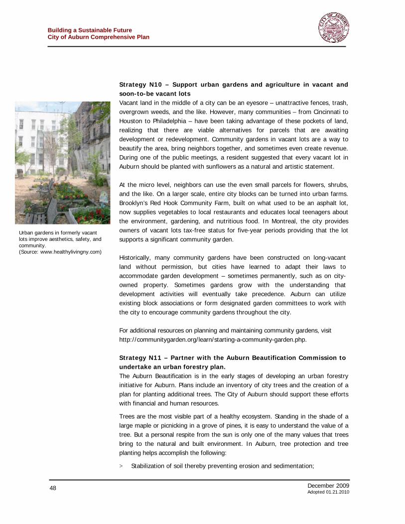
December 2009 45 Adoted 01.21.2010
Building a Sustainable FutureCity of Auburn Comprehensive Plan
project is designed to alleviate residential traffic congestion on the northeast portion of the city, reroute existing heavy truck routes away from the center city, open up new commercial, residential and industrial lands for development, and expand the city’s sales and property tax bases. Constructing the new roadway developed as a part of the 1991 City of Auburn Comprehensive Plan. In anticipation of this new road, the area along it has been made a commercial zoning district (red on the map below) and the land just south of it has been placed into a planned development district zone (tan on the map). The area should be rezoned.
The results of building as called for by these zoning districts would perpetuate the low-density sprawl that is not in keeping with Auburn’s urban or historic character. It calls for suburban style commercial buildings and housing densities more suited to conservation (cluster) subdivisions with lots of open space. These represent car-centric, not necessarily pedestrian friendly forms of growth. Instead, the code for all of these areas should encourage dense and mixed-use development. The designs should mimic traditional neighborhoods with buildings along the main road coming right up to the street, parking lots behind buildings and well-landscaped sidewalks. Off of the new main road, connecting streets should become part of the existing city grid as much as possible. Housing forms should encourage walkability following the guidance described in Strategies N2 and N3 above. The new areas should exemplify Auburn’s commitment to sustainability and adhere to standards described in Strategies N5, N6, N7 and N9 below. Of particular concern is that roads be narrow, walkable and that traffic on streets goes slowly through residential areas. The goal of this new large-scale development opportunity should be to create a live/work place that offers something interesting to the creative class of entrepreneurs and workers would will start and staff 21st century business.
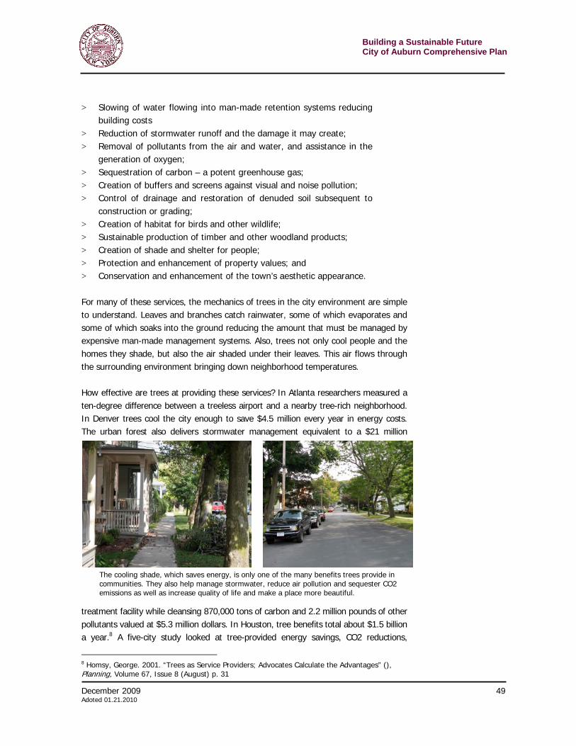
Building a Sustainable Future City of Auburn Comprehensive Plan
46 December 2009 Adopted 01.21.2010
Goal 2. Encourage environmentally friendly homes and neighborhoods Strategy N7 – Provide incentives for LEED-certified homes LEED (Leadership in Energy and Environmental Design) Green Building Rating System® is a voluntary, consensus-based standard for building high-performance, sustainable buildings. Issues addressed by LEED include sustainable site planning and indoor environmental quality, green roof technologies, Energy Star-compliant roofing materials, geothermal (renewable) energy sources, sustainable wood, purchase of goods manufactured within a 500-mile radius, and innovative wastewater technologies. LEED projects get rated as: certified, silver, gold or platinum. Auburn could offer incentives, such as density bonuses or streamlined permitting, to encourage construction of LEED-certified residential units. Giving developers the potential to build more square footage in certain areas of the city or enabling them to move more quickly through the permitting process could help increase density in areas, such as downtown Auburn, while addressing the city’s sustainability goals. (Certain areas of the city, including downtown, should be designated as targets for density bonuses as increased density many not be appropriate everywhere.) The city should also consider such bonuses for projects that meet LEED standards but do not necessarily go through the process – and expense – of receiving official certification. Strategy N8 – Revise subdivision regulations and zoning code to require that new housing developments have low impact on the environment and maintain the character of the community. Development patterns based on conventional zoning codes often result in sprawl with its associated large impervious areas, loss of natural areas, and alteration of hydrologic systems. Conventional developments commonly contain wide roads and lots of parking. These large impervious areas prevent water from infiltrating the ground and replenishing groundwater and supporting nearby wetlands and streams. Conventional landscaping brings additional concerns including the introduction of non-native plants, use of herbicides, pesticides and fertilizers – which runoff into waterbodies – and excessive water consumption. Typically, residential designers try to deal with water runoff by constructing expensive stormwater controls such as catch basins, pipes and detention ponds. New projects – greenfield as well as infill – should have as little impact on the environment as possible. This includes stormwater runoff, water and energy use, sustainable materials, and numerous other elements. Stormwater runoff is a major source of water pollution. During rainstorms stormwater runoff washes over impervious surfaces, such as roads, sidewalks and rooftops – increasing in temperature and carrying pollutants such as phosphorus, nitrogen, oil and grease, and pathogens to rivers, lakes and wetlands. This “nonpoint” source of pollution (because it does not
December 2009 47 Adoted 01.21.2010
Building a Sustainable FutureCity of Auburn Comprehensive Plan
come out of a single location such as a pipe) can result in degraded water, blocked fish passage, fish kills, loss of wetlands, degraded aesthetics, and impaired recreation. Low Impact Development (LID) is a stormwater management approach to development with the basic principle of modeling nature and mimicking a site's predevelopment water systems. Instead of managing and treating stormwater in large, costly end-of-pipe facilities, LID technology employs small, cost-effective landscape features often located at the lot level. LID allows for development with fewer environmental impacts through smarter designs and technologies that better balance conservation, growth, public health and quality of life. LID benefits the municipality, the developer, and the general public – through cost savings to developers, smaller burden on municipal infrastructure and reduced pollution to drinking water, recreational waterways and wetlands. Some of the LID best management practices include: > Permeable pavers > Porous surfaces > Tree box planters > Green roofs > Rain gardens > Grassed swales > Native plants > Open space conservation > Narrower streets > Shorter driveways > Smaller, better landscaped parking areas > Storage / reuse of rainwater Strategy N9 – Provide general landscaping standards that encourage native plants and those requiring less watering Using native plants in landscaping, buffers, and other vegetated areas, have multiple benefits, including: > Reduced landscape installation and maintenance costs; > Avoidance of the use of lawn chemicals such as fertilizers and herbicides; > Reduced or eliminated costs for irrigation systems; > Improved habitat and increased biodiversity; > Distinctive and attractive sites; > Improved water quality and reduced damages from stormwater; > Improved outdoor recreation and education opportunities; and > Strengthened environmental stewardship. Auburn should compile a list of native plants that are acceptable for landscaping and work with the Auburn Beautification Commission, local garden groups, the Cornell Cooperative Extension and others to maximize compliance.
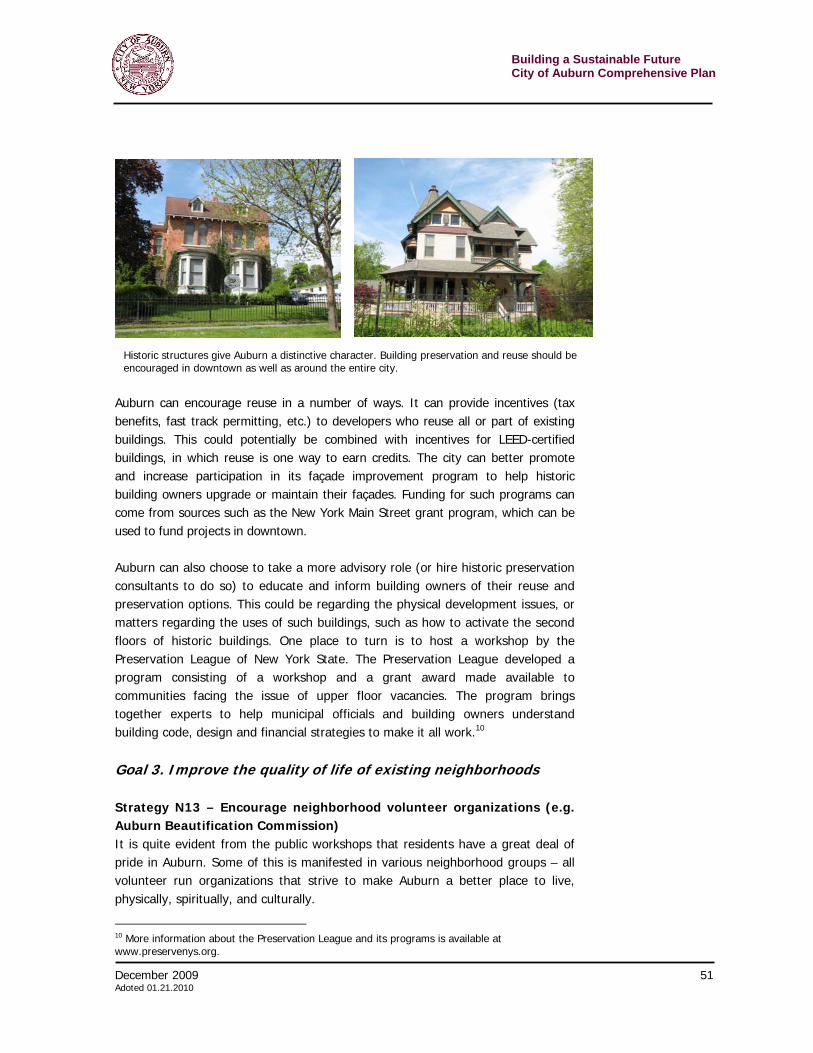
Building a Sustainable Future City of Auburn Comprehensive Plan
48 December 2009 Adopted 01.21.2010
Strategy N10 – Support urban gardens and agriculture in vacant and soon-to-be vacant lots Vacant land in the middle of a city can be an eyesore – unattractive fences, trash, overgrown weeds, and the like. However, many communities – from Cincinnati to Houston to Philadelphia – have been taking advantage of these pockets of land, realizing that there are viable alternatives for parcels that are awaiting development or redevelopment. Community gardens in vacant lots are a way to beautify the area, bring neighbors together, and sometimes even create revenue. During one of the public meetings, a resident suggested that every vacant lot in Auburn should be planted with sunflowers as a natural and artistic statement. At the micro level, neighbors can use the even small parcels for flowers, shrubs, and the like. On a larger scale, entire city blocks can be turned into urban farms. Brooklyn’s Red Hook Community Farm, built on what used to be an asphalt lot, now supplies vegetables to local restaurants and educates local teenagers about the environment, gardening, and nutritious food. In Montreal, the city provides owners of vacant lots tax-free status for five-year periods providing that the lot supports a significant community garden. Historically, many community gardens have been constructed on long-vacant land without permission, but cities have learned to adapt their laws to accommodate garden development – sometimes permanently, such as on city-owned property. Sometimes gardens grow with the understanding that development activities will eventually take precedence. Auburn can utilize existing block associations or form designated garden committees to work with the city to encourage community gardens throughout the city. For additional resources on planning and maintaining community gardens, visit http://communitygarden.org/learn/starting-a-community-garden.php. Strategy N11 – Partner with the Auburn Beautification Commission to undertake an urban forestry plan. The Auburn Beautification is in the early stages of developing an urban forestry initiative for Auburn. Plans include an inventory of city trees and the creation of a plan for planting additional trees. The City of Auburn should support these efforts with financial and human resources.
Trees are the most visible part of a healthy ecosystem. Standing in the shade of a large maple or picnicking in a grove of pines, it is easy to understand the value of a tree. But a personal respite from the sun is only one of the many values that trees bring to the natural and built environment. In Auburn, tree protection and tree planting helps accomplish the following:
> Stabilization of soil thereby preventing erosion and sedimentation;
Urban gardens in formerly vacant lots improve aesthetics, safety, and community. (Source: www.healthylivingny.com)
December 2009 49 Adoted 01.21.2010
Building a Sustainable FutureCity of Auburn Comprehensive Plan
> Slowing of water flowing into man-made retention systems reducing building costs
> Reduction of stormwater runoff and the damage it may create; > Removal of pollutants from the air and water, and assistance in the
generation of oxygen; > Sequestration of carbon – a potent greenhouse gas; > Creation of buffers and screens against visual and noise pollution; > Control of drainage and restoration of denuded soil subsequent to
construction or grading; > Creation of habitat for birds and other wildlife; > Sustainable production of timber and other woodland products; > Creation of shade and shelter for people; > Protection and enhancement of property values; and > Conservation and enhancement of the town’s aesthetic appearance. For many of these services, the mechanics of trees in the city environment are simple to understand. Leaves and branches catch rainwater, some of which evaporates and some of which soaks into the ground reducing the amount that must be managed by expensive man-made management systems. Also, trees not only cool people and the homes they shade, but also the air shaded under their leaves. This air flows through the surrounding environment bringing down neighborhood temperatures. How effective are trees at providing these services? In Atlanta researchers measured a ten-degree difference between a treeless airport and a nearby tree-rich neighborhood. In Denver trees cool the city enough to save $4.5 million every year in energy costs. The urban forest also delivers stormwater management equivalent to a $21 million
treatment facility while cleansing 870,000 tons of carbon and 2.2 million pounds of other pollutants valued at $5.3 million dollars. In Houston, tree benefits total about $1.5 billion a year.8 A five-city study looked at tree-provided energy savings, CO2 reductions,
8 Homsy, George. 2001. “Trees as Service Providers; Advocates Calculate the Advantages” (), Planning, Volume 67, Issue 8 (August) p. 31
The cooling shade, which saves energy, is only one of the many benefits trees provide in communities. They also help manage stormwater, reduce air pollution and sequester CO2 emissions as well as increase quality of life and make a place more beautiful.
Building a Sustainable Future City of Auburn Comprehensive Plan
50 December 2009 Adopted 01.21.2010
improved air quality, stormwater runoff benefits and aesthetics. It found that for every dollar invested in trees, communities reap annual returns ranging from $1.37 to $3.09.9 Aggressive planting is an important sustainable strategy for the city. Auburn should integrate tree-planting requirements into site design from the beginning of the development process and work with applicants to encourage trees. It could consider waiving or being more flexible for certain zoning requirements, such as setbacks, if the applicant intends to plant a significant number of trees. On a more ambitious level, the city could develop a tree-planting plan along the lines of “Million Trees NYC,” a New York City program that sets goals for new street and park trees. Such programs are a great way to rally the community to invest in neighborhoods. To help fund this, Auburn could apply for funding from programs such as the New York State Department of Environmental Conservation Urban Forestry Grants as well as use donated trees, city labor and volunteers. There are many opportunities to plant trees. The city, working with the Auburn Beautification Commission, should aggressively find places, such as along roadways and in public parking areas, for tree planting. As repaving and other maintenance projects are undertaken on any city-owned property, the goal should be to add more trees to the project site than were there when it started. The municipal government in this, as in many other areas, can set an example for the private sector. Auburn should make sure not to look at traditional “green” areas when seeking places for trees. It is important to look at turning “grey” areas, such as parking lots, as green as possible. Trees can plan an important role in cooling large stretches of asphalt – lowering cooling costs, managing stormwater and increasing aesthetic quality. Ordinances should include a requirement that all parking lots achieve a LEED 2.0 rating system standard of planting trees to shade 30 percent of a parking lot in five years. Strategy N12 – Encourage the reuse of existing historic buildings A significant component of Auburn’s appeal lies in its historic buildings, particularly downtown, but also in neighborhoods across the city. Part of what makes the city so unique is its history of invention, arts, and creativity – the built environment of Auburn should showcase this, to attract new visitors and residents, and to retain existing ones. Reusing historic buildings not only retains this valuable character, but also serves an environmental purpose: it significantly reduces waste, as well as the production and transport of new construction materials.
9 McPherson, Greg, et.al. 2005. “Municipal Forest Benefits and Costs in Five US Cities,” Journal for Forestry, (December), p.411.
December 2009 51 Adoted 01.21.2010
Building a Sustainable FutureCity of Auburn Comprehensive Plan
Auburn can encourage reuse in a number of ways. It can provide incentives (tax benefits, fast track permitting, etc.) to developers who reuse all or part of existing buildings. This could potentially be combined with incentives for LEED-certified buildings, in which reuse is one way to earn credits. The city can better promote and increase participation in its façade improvement program to help historic building owners upgrade or maintain their façades. Funding for such programs can come from sources such as the New York Main Street grant program, which can be used to fund projects in downtown. Auburn can also choose to take a more advisory role (or hire historic preservation consultants to do so) to educate and inform building owners of their reuse and preservation options. This could be regarding the physical development issues, or matters regarding the uses of such buildings, such as how to activate the second floors of historic buildings. One place to turn is to host a workshop by the Preservation League of New York State. The Preservation League developed a program consisting of a workshop and a grant award made available to communities facing the issue of upper floor vacancies. The program brings together experts to help municipal officials and building owners understand building code, design and financial strategies to make it all work.10
Goal 3. Improve the quality of life of existing neighborhoods Strategy N13 – Encourage neighborhood volunteer organizations (e.g. Auburn Beautification Commission) It is quite evident from the public workshops that residents have a great deal of pride in Auburn. Some of this is manifested in various neighborhood groups – all volunteer run organizations that strive to make Auburn a better place to live, physically, spiritually, and culturally.
10 More information about the Preservation League and its programs is available at www.preservenys.org.
Historic structures give Auburn a distinctive character. Building preservation and reuse should be encouraged in downtown as well as around the entire city.
Building a Sustainable Future City of Auburn Comprehensive Plan
52 December 2009 Adopted 01.21.2010
Volunteerism always has a connection to civic pride. In difficult economic times, when government resources may be stretched thin, volunteer organizations play an even more vital role in the success of Auburn. Auburn should encourage such groups in whatever ways possible, such as providing meeting space, posting announcements on the City website, helping with publicity, and working with representatives from neighborhood groups to achieve their goals. Strategy N14 – Implement a Landlord Registry Program. Absentee landlords are one of Auburn residents’ prime concerns regarding the quality of their neighborhoods. Many homes, particularly in the center of Auburn’s older neighborhoods, are poorly maintained – with problems ranging from peeling paint and piling up trash to larger structural issues. Particularly when concentrated in certain neighborhoods this contributes to an overall sense of disinvestment in the community, both aesthetically and economically. Many landlords, including out-of-town ones, are excellent stewards of their property. However, there are many problem landlords across the city. Naturally, it is easier for municipal officials and law enforcement to deal with landlords who live locally. Therefore, the city should adopt a new registration program for owners of multi-family dwellings. This program is more fully described in a report completed by Bond, Schoeneck and King titled “Aligning Auburn City Building, Housing, Fire and Zoning Codes.” This will make information distribution and code enforcement easier as there will be someone the city can turn to when issues rise with a particular property.
Strategy N15 – Increase code enforcement activities in neighborhoods Revisions to the city’s regulations are important, but without proper enforcement they are useless. Poorly maintained yards, sidewalks covered with snow, piles of trash or large discarded items and overcrowded buildings directly contribute to quality of life and safety issues within a community. This is especially true in already distressed neighborhoods.
Case study – Schenectady, New York Schenectady, New York, recently passed a law requiring all rental property owners to register their local contact information (including business and mobile numbers) with the building inspector’s office. Landlords living outside of the city must have a local contact. The goal is to keep landlords accountable and raise the quality of their properties. In addition, it helps city officials with emergencies – everything from building code violations to criminal activity. If landlords do not register, or register with false information, they can be subject to fines of up to $500 per week.
December 2009 53 Adoted 01.21.2010
Building a Sustainable FutureCity of Auburn Comprehensive Plan
Broad and consistent enforcement will send the signal to landlords that the city is serious about violations. The problem, of course, is a matter of resources. Troublesome property owners may ignore first citations anticipating that the city will not have the resources, political will or stamina to pursue violations further. Auburn should make sure that the human and fiscal resources are in place to soundly disabuse them of that hope. The city, especially the Code Enforcement Office and planning and zoning boards, needs to improve the enforcement process for existing and new construction. Revisions may include imposing more severe penalties and/or writing a fine and fee schedule into the code. Fines should be substantial so that property owners or developers do not simply absorb penalties as a cost of doing business. The fines should be an incentive to obey the rules and fix problems. The city should increase its inspection staff and provide training for these employees. Finally, as appropriate, the Auburn should implement the recommendations contained in the report, “Aligning Auburn City Building, Housing, Fire and Zoning Codes.” Strategy N16 – Craft a vacant building initiative Owing in part to its population decline as well as to the recent economic downturn, Auburn contains many vacant buildings. Vacant buildings are unsightly – attracting rodents and trash – as well as potentially unsafe – creating opportunities for crime. Too many vacant buildings can contribute to the decline of property values and the overall loss of a sense of community. Cities such as St. Louis and Chicago have promoted vacant building initiatives as ways of controlling the most negative aspects of the problem; Auburn should explore doing the same. A vacant building initiative would require owners to: > Register with the city and pay a yearly administrative fee > Post owner or agent contact information on the outside of buildings > Maintain liability insurance for vacant property > Secure all entrances of vacant properties to prevent theft or squatting As with all city regulations, enforcement would be key to the success of a vacant building initiative. Programs encouraging historic building reuse and homeownership will help to reduce the number of vacant buildings in Auburn; the vacant building initiative would address those buildings that remain and help ensure they do not become scars on the neighborhood. Strategy N17 – Develop a homeownership program The home-buying process can be very complicated. It is particularly bewildering if prospective homeowners have little experience with credit, mortgages, loans,
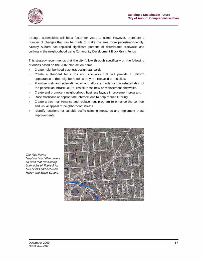
Building a Sustainable Future City of Auburn Comprehensive Plan
54 December 2009 Adopted 01.21.2010
home inspections and/or similar challenges that face every homebuyer. First time homebuyers often do not access special mortgages and financing, government grants, loans and other assistance simply because they do not know what is available. Given the recent subprime mortgage crisis, navigating the homebuying process has become even more complex and intimidating. Auburn should create a resource (a “HomeStore”) that provides advisory services to those seeking to become homeowners. The Auburn HomeStore could be a central resource for prospective buyers to learn about living in different city neighborhoods, obtaining a mortgage, fixing their credit, or finding an incentive program for purchase or rehabilitation. Other municipalities have created similar clearinghouses with great success. This would centralize resources to create an approachable, informative clearinghouse. Strategy N18 – Improve incentives to re-convert homes to single-family and discourage the conversion of single-family homes to multiple dwellings. The conversion of large single-family homes into multiple apartments is an attempt by some owners to maximize the economic value of their property. In some cases, the incomes from various apartments might be necessary to ensuring property maintenance on low value structures. However, as practiced in Auburn, the cumulative impact of the conversions has been negative, including overcrowding, increased criminal activity, increased traffic and parking problems and continually deteriorating buildings. In addition, in a weak real estate market such as Auburn, there is no need for the additional supply of units driving down prices and making it harder for quality landlords to maintain their buildings. The city has programs to encourage property owners to turn these converted multi-unit structures back into single-family homes. These programs include a low-interest or no-interest loan for income eligible applicants and a property tax exemption that phases in the value of the improvements over an eight-year period. So far, no one has taken advantage of these programs to reduce the number of units in a structure. The city needs to revisit the program and find out why it is unsuccessful. Some questions to examine include:
> Is the program promoted well? Does it reach the right people? There is nothing on the city’s website about the program. A mailing to all property owners boasting of the program might help catch the notice of those people inclined to reconvert.
> Is the incentive large enough? Perhaps the incentive should be increased. One strategy might include dramatically reducing property taxes for a period of ten years.
> Is their too much paperwork? Or is there a perception that applying for the money is too onerous? Sometimes people, even if there is a significant
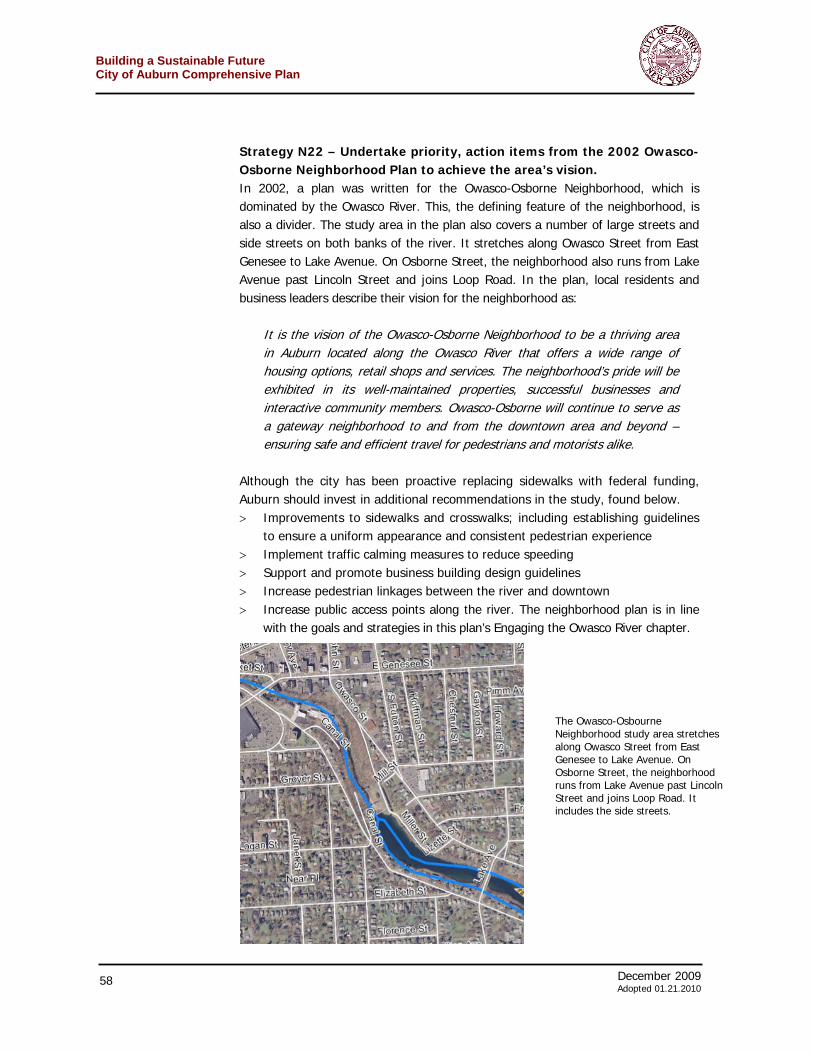
December 2009 55 Adoted 01.21.2010
Building a Sustainable FutureCity of Auburn Comprehensive Plan
advantage, fear the bureaucracy. Marketing materials should ensure people that qualified city-staff will help them through the process. This may be one of the tasks assigned to a HomeStore. (See strategy N17.)
> Is the program restricted to owner-occupied dwellings? Such a restriction may severely limit the pool of potential properties. An existing absentee landlord – the presumed majority of owners of such property – would be excluded. If the market incentives were correct, then having such a person reconvert the property and then rent it to a family would be a very acceptable outcome.
The city should also step up inspections of these properties since they tend to be a greater source of building problems. The increased cost of inspections and violations to property owners will make alternatives to the status quo look more appealing. It must cost more to do the wrong thing than to do the right thing. Finally, the city might realize that other factors may be required to spark reconversions. Stronger neighborhoods and higher property values will probably drive the change more than a city-based incentive program. Increasing the quality of life in these neighborhoods via other strategies in this plan may do more to stabilize the area than reconversions of buildings to single-family. Strategy N19 – Educate about and enforce sidewalk maintenance standards Sidewalk maintenance directly impacts a city’s overall walkability and connectivity. If just one section of sidewalk is impassable or unsafe, connections between neighborhoods can be severed. Sidewalk maintenance includes concrete/paved surfaces (cracked or uneven surfaces are not only unsightly but also hazardous), tree pruning (both on the sides as well as above), snow removal, and trash pickup. Sidewalk maintenance standards must be enforced more thoroughly across the city. However, residents and landowners may not be aware of current sidewalk standards in Auburn, or the procedures and tools available to help meet these standards. Per Auburn’s municipal code, the property owner is responsible for the maintenance of the sidewalks – including repairs, snow removal, litter pickup and tree/hedge pruning. For those facing repairs, it is important to publicize the city’s sidewalk program, which lets residents who choose to repair (or are required to repair) their sidewalks to pay for this work through their taxes over a five-year period. The city engineering department contracts for the repair work through an open competitive bid process. In addition, residents may report unsafe sidewalk conditions to the city – and have them remedied. If property owners do not take care of the problem, then the city will remedy the situation and add the bill for services to their property tax bill. As part of Strategy N4, the city should establish an outreach program to regularly inform landowners of their responsibility for sidewalk maintenance. The outreach
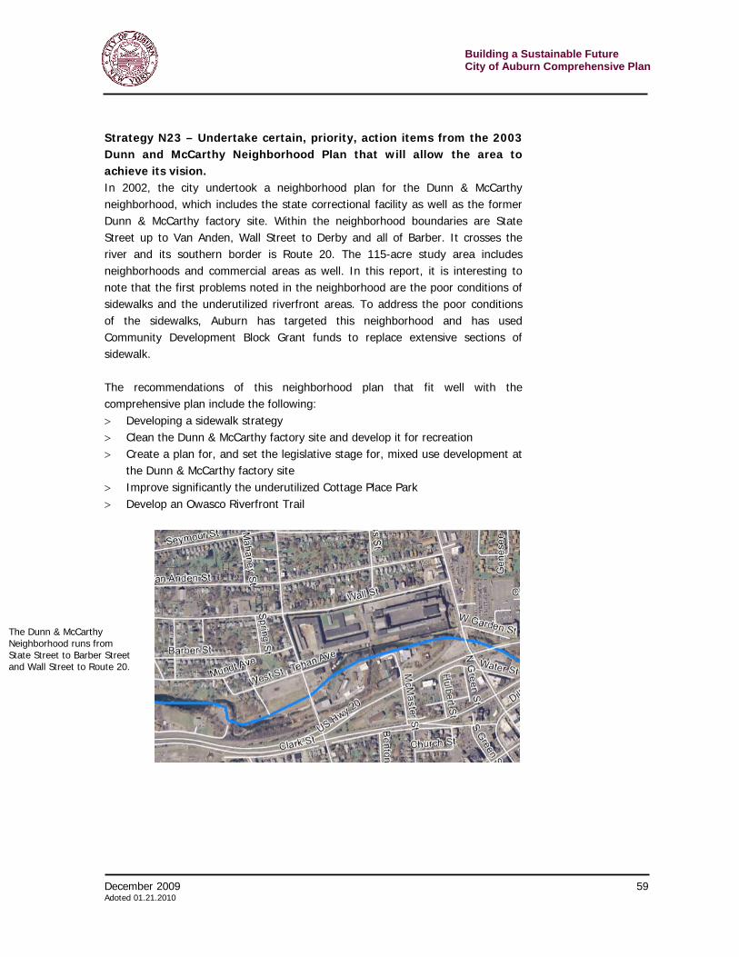
Building a Sustainable Future City of Auburn Comprehensive Plan
56 December 2009 Adopted 01.21.2010
may be in the form of an occasional brochure coupled with recurring reminders on the city website. The city should also lead by example and ensure that its own properties – from city hall to maintenance buildings – are adequately maintained. Also, city staff, especially those charged with clearing snow from the roads, will have to make adjustments that will not make resident efforts to keep sidewalks clear more difficult by mounting up snow on walks and at corners. By taking the time and/or money to perform such tasks, the city will demonstrate its commitment to making Auburn a better place to live. Strategy N20 – Implement traffic calming in residential areas, where speed is excessive. Within neighborhoods, according to people who attended the public meetings, an important concern is slowing traffic. The city can implement physical changes, signage and other strategies to slow cars, particularly as they drive through residential areas. Traffic calming involves roadway designs that slow traffic. Some of these strategies cause traffic to shift vertically (as in raised intersections) or horizontally (as in curb extensions) to reduce speed and/or volume. These physical changes include speed humps, speed cushions, chicanes, curb extensions, raised intersections, traffic circles, roundabouts, and so on. Other forms of traffic calming include road narrowing, road striping, dense street tree planning, and visual speed radar. These are visual clues that tend to make drivers slow down. In an urban area traffic must keep moving, but speed is not desirable. Strategy N21 – Undertake certain, priority, action items from the 2002 Five Points Neighborhood Plan that will allow the area to achieve its vision. In 2002, a plan was written for the Five Points Neighborhood, which runs on both sides of Route 5 between Holley Street and Mann Street. In the plan, local residents and business leaders describe their vision for the neighborhood as:
It is the vision of the Five Points Neighborhood to be a safe and attractive place to live, work and play. It will be known for its high-quality housing, safe streets and successful neighborhood businesses. The pride of this neighborhood’s property owners will be exhibited through well-maintained homes and businesses, interaction among neighbors and consistent communication with community leaders.
The plan included a series of solid recommendations, many of which are echoed elsewhere in this plan. Revitalizing this area involves the recognition that Five Points can become an important neighborhood commercial area. With the arterial cutting
December 2009 57 Adoted 01.21.2010
Building a Sustainable FutureCity of Auburn Comprehensive Plan
through, automobiles will be a factor for years to come. However, there are a number of changes that can be made to make the area more pedestrian-friendly. Already Auburn has replaced significant portions of deteriorated sidewalks and curbing in the neighborhood using Community Development Block Grant Funds. This strategy recommends that the city follow through specifically on the following priorities based on the 2002 plan action items. > Create neighborhood business design standards > Create a standard for curbs and sidewalks that will provide a uniform
appearance in the neighborhood as they are replaced or installed. > Prioritize curb and sidewalk repair and allocate funds for the rehabilitation of
the pedestrian infrastructure. Install those new or replacement sidewalks. > Create and promote a neighborhood business façade improvement program. > Place trashcans at appropriate intersections to help reduce littering > Create a tree maintenance and replacement program to enhance the comfort
and visual appeal of neighborhood streets. > Identify locations for suitable traffic calming measures and implement those
improvements.
The Five Points Neighborhood Plan covers an area that runs along both sides of Route 5 for two blocks and between Holley and Mann Streets.
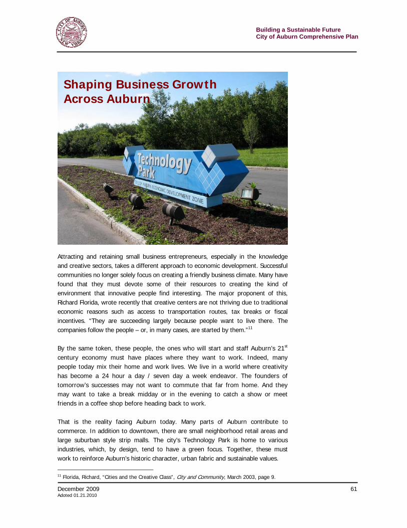
Building a Sustainable Future City of Auburn Comprehensive Plan
58 December 2009 Adopted 01.21.2010
Strategy N22 – Undertake priority, action items from the 2002 Owasco-Osborne Neighborhood Plan to achieve the area’s vision. In 2002, a plan was written for the Owasco-Osborne Neighborhood, which is dominated by the Owasco River. This, the defining feature of the neighborhood, is also a divider. The study area in the plan also covers a number of large streets and side streets on both banks of the river. It stretches along Owasco Street from East Genesee to Lake Avenue. On Osborne Street, the neighborhood also runs from Lake Avenue past Lincoln Street and joins Loop Road. In the plan, local residents and business leaders describe their vision for the neighborhood as:
It is the vision of the Owasco-Osborne Neighborhood to be a thriving area in Auburn located along the Owasco River that offers a wide range of housing options, retail shops and services. The neighborhood’s pride will be exhibited in its well-maintained properties, successful businesses and interactive community members. Owasco-Osborne will continue to serve as a gateway neighborhood to and from the downtown area and beyond – ensuring safe and efficient travel for pedestrians and motorists alike.
Although the city has been proactive replacing sidewalks with federal funding, Auburn should invest in additional recommendations in the study, found below. > Improvements to sidewalks and crosswalks; including establishing guidelines
to ensure a uniform appearance and consistent pedestrian experience > Implement traffic calming measures to reduce speeding > Support and promote business building design guidelines > Increase pedestrian linkages between the river and downtown > Increase public access points along the river. The neighborhood plan is in line
with the goals and strategies in this plan’s Engaging the Owasco River chapter.
The Owasco-Osbourne Neighborhood study area stretches along Owasco Street from East Genesee to Lake Avenue. On Osborne Street, the neighborhood runs from Lake Avenue past Lincoln Street and joins Loop Road. It includes the side streets.
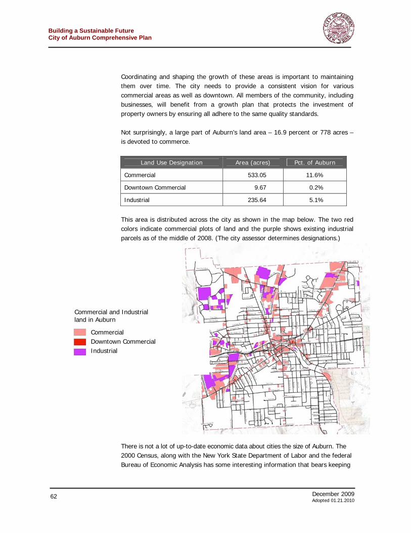
December 2009 59 Adoted 01.21.2010
Building a Sustainable FutureCity of Auburn Comprehensive Plan
Strategy N23 – Undertake certain, priority, action items from the 2003 Dunn and McCarthy Neighborhood Plan that will allow the area to achieve its vision. In 2002, the city undertook a neighborhood plan for the Dunn & McCarthy neighborhood, which includes the state correctional facility as well as the former Dunn & McCarthy factory site. Within the neighborhood boundaries are State Street up to Van Anden, Wall Street to Derby and all of Barber. It crosses the river and its southern border is Route 20. The 115-acre study area includes neighborhoods and commercial areas as well. In this report, it is interesting to note that the first problems noted in the neighborhood are the poor conditions of sidewalks and the underutilized riverfront areas. To address the poor conditions of the sidewalks, Auburn has targeted this neighborhood and has used Community Development Block Grant funds to replace extensive sections of sidewalk.
The recommendations of this neighborhood plan that fit well with the comprehensive plan include the following: > Developing a sidewalk strategy > Clean the Dunn & McCarthy factory site and develop it for recreation > Create a plan for, and set the legislative stage for, mixed use development at
the Dunn & McCarthy factory site > Improve significantly the underutilized Cottage Place Park > Develop an Owasco Riverfront Trail
The Dunn & McCarthy Neighborhood runs from State Street to Barber Street and Wall Street to Route 20.
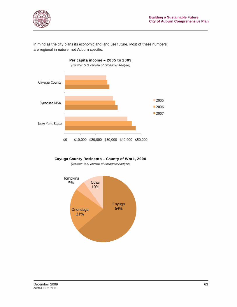
Building a Sustainable Future City of Auburn Comprehensive Plan
60 December 2009 Adopted 01.21.2010
Strategy N24 – Consider rules to allow in-law apartments. Currently, the Auburn zoning code does not address the issue of ‘in-law’ apartments. The city planning department reports a number of variance requests for these kinds of living units in existing homes. Although in-law apartment styles vary, most have separate entrances, their own kitchens, private bathrooms, and personal iving areas. They can be added on in a variety of ways: above a detached garage, on the second floor of a home, as a first-floor addition, in the basement, or as a guesthouse. Despite the name, in-law apartments are not just for in-laws. They can be used for other older relatives, caretakers, nannies or older children home after college. While excellent ways to keep extended families together, they also can become small rental units. In a city such as Auburn, that has an oversupply of subdivided single-family homes, care has to be taken to avoid exacerbating that situation. Some zoning strategies to control in-law apartments include: > Limiting the size of the unit > Restricting the number of units to one per single family home > Not allowing in-law apartments in multi-family structures > Integrating in-law accessory units into the main portion of the house > Requiring occupation by a family member > Prohibiting in-law apartments in zoning districts with too many single-family
houses converted to multi-unit dwellings

December 2009 61 Adoted 01.21.2010
Building a Sustainable FutureCity of Auburn Comprehensive Plan
Attracting and retaining small business entrepreneurs, especially in the knowledge and creative sectors, takes a different approach to economic development. Successful communities no longer solely focus on creating a friendly business climate. Many have found that they must devote some of their resources to creating the kind of environment that innovative people find interesting. The major proponent of this, Richard Florida, wrote recently that creative centers are not thriving due to traditional economic reasons such as access to transportation routes, tax breaks or fiscal incentives. “They are succeeding largely because people want to live there. The companies follow the people – or, in many cases, are started by them.”11 By the same token, these people, the ones who will start and staff Auburn’s 21st century economy must have places where they want to work. Indeed, many people today mix their home and work lives. We live in a world where creativity has become a 24 hour a day / seven day a week endeavor. The founders of tomorrow’s successes may not want to commute that far from home. And they may want to take a break midday or in the evening to catch a show or meet friends in a coffee shop before heading back to work. That is the reality facing Auburn today. Many parts of Auburn contribute to commerce. In addition to downtown, there are small neighborhood retail areas and large suburban style strip malls. The city’s Technology Park is home to various industries, which, by design, tend to have a green focus. Together, these must work to reinforce Auburn’s historic character, urban fabric and sustainable values.
11 Florida, Richard, “Cities and the Creative Class”, City and Community, March 2003, page 9.
Shaping Business Growth Across Auburn
Building a Sustainable Future City of Auburn Comprehensive Plan
62 December 2009 Adopted 01.21.2010
Coordinating and shaping the growth of these areas is important to maintaining them over time. The city needs to provide a consistent vision for various commercial areas as well as downtown. All members of the community, including businesses, will benefit from a growth plan that protects the investment of property owners by ensuring all adhere to the same quality standards. Not surprisingly, a large part of Auburn’s land area – 16.9 percent or 778 acres – is devoted to commerce.
Land Use Designation Area (acres) Pct. of Auburn
Commercial 533.05 11.6%
Downtown Commercial 9.67 0.2%
Industrial 235.64 5.1%
This area is distributed across the city as shown in the map below. The two red colors indicate commercial plots of land and the purple shows existing industrial parcels as of the middle of 2008. (The city assessor determines designations.)
There is not a lot of up-to-date economic data about cities the size of Auburn. The 2000 Census, along with the New York State Department of Labor and the federal Bureau of Economic Analysis has some interesting information that bears keeping
Commercial Downtown Commercial Industrial
Commercial and Industrial land in Auburn
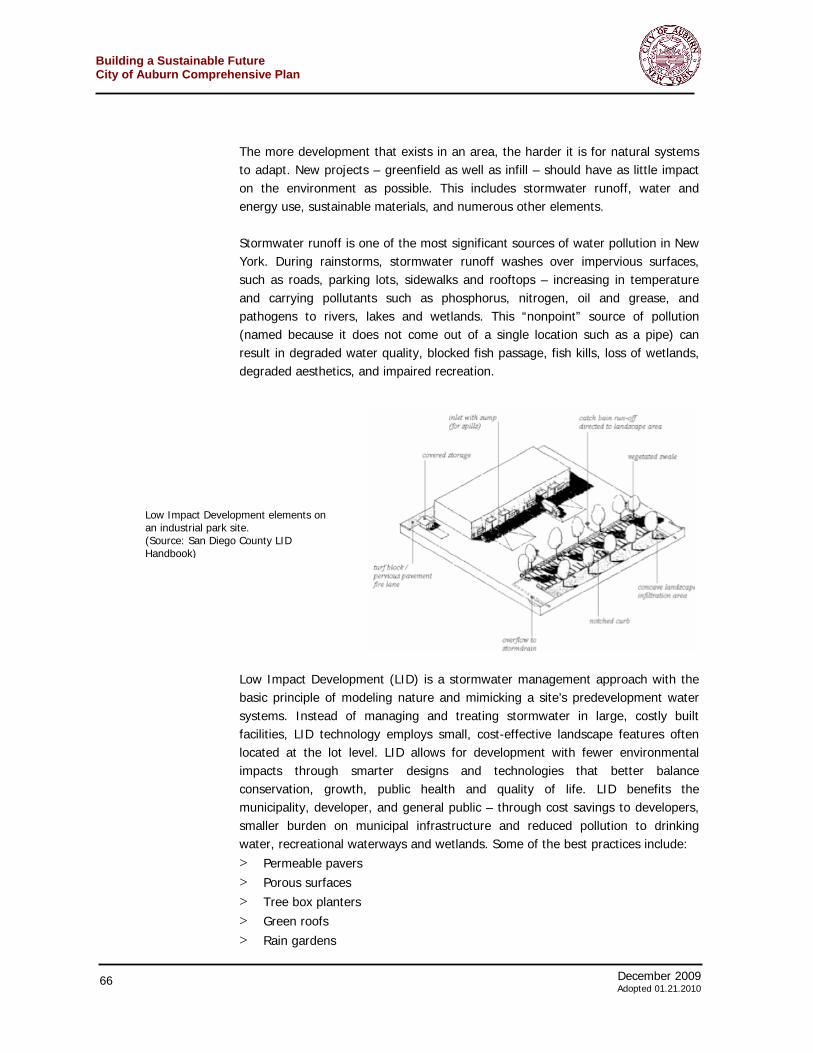
December 2009 63 Adoted 01.21.2010
Building a Sustainable FutureCity of Auburn Comprehensive Plan
in mind as the city plans its economic and land use future. Most of these numbers are regional in nature, not Auburn specific.
Per capita income – 2005 to 2009 (Source: U.S. Bureau of Economic Analysis)
Cayuga County Residents – County of Work, 2000 (Source: U.S. Bureau of Economic Analysis)
Building a Sustainable Future City of Auburn Comprehensive Plan
64 December 2009 Adopted 01.21.2010
Highest Education Level – People aged 25 and older
(Source: U.S. Census 2000)
Industrial Distribution of Busineses (Source: US Census Bureau, 2000)
Industry City of Auburn
Cayuga County
New York State
Agriculture, forestry, fishing and hunting, and mining 0.6% 3.9% 0.6%
Construction 3.5% 6.1% 5.1%
Manufacturing 18.1% 18.6% 10.0%
Wholesale trade 3.2% 3.3% 3.4%
Retail trade 14.0% 12.1% 10.5%
Transportation and warehousing, and utilities 3.7% 5.1% 5.5%
Information 1.0% 1.5% 4.1%
Finance, insurance, real estate, and rental and leasing 3.3% 3.4% 8.8%
Professional, scientific, management, administrative, and waste management services
5.6% 5.2% 10.1%
Educational, health and social services 24.9% 22.8% 24.3%
Arts, entertainment, recreation, accommodation and food services
6.8% 5.9% 7.3%
Other services (except public administration) 5.7% 4.9% 5.1%
Public administration 9.6% 7.2% 5.2%
December 2009 65 Adoted 01.21.2010
Building a Sustainable FutureCity of Auburn Comprehensive Plan
There are numerous challenges facing businesses in Auburn. Some have to do with the regional economy and are beyond the scope of this project – and require the city’s cooperation with other municipalities, counties and New York State. Locally, the challenges that the city can tackle include:
> Creating a physical environment that is attractive to new businesses > Ensuring land for local growth of existing businesses > Increasing the sustainability of new and existing developments > Improving the appearance of business and commercial areas > Better integrating business and commercial areas into the city fabric
A group of business owners came together and identified these and other issues during the comprehensive planning process. Very clearly the group was interested in sustainability, as long as it made sense to the bottom line. As outlined in the goals and strategies below, many of the actions that would make these areas more sustainable will prove to be more cost-effective over the long run. Many also prove to be sustainable from a quality of life perspective and attractive entrepreneurs and workers seeking a place to start or relocate their small to mid-size businesses. Goal 1. Encourage sustainable development principles in the creation of new commercial parcels and buildings as well as in the renovation of existing commercial parcels and buildings. Strategy B1 – Require low impact development practices for all large-scale developments in Auburn. This is a strategy that applies to commercial development as well as residential projects. It is placed in this section because commercial, industrial, retail and office developments can often benefit the most from these practices. Development patterns based on conventional zoning codes—particularly those for commercial/business parks—often result in sprawl with its associated large impervious areas, loss of natural areas and terrain, and alteration of hydrologic systems. Conventional developments, both residential and commercial, commonly contain wide roads and large parking lots. These large impervious areas prevent water from infiltrating the ground and replenishing groundwater and supporting wetlands and streams. The lack of green space also contributes to the heat island effect making many of these areas inhospitable to people during summer months. Conventional landscaping brings additional concerns including the introduction of non-native plants, use of herbicides, pesticides and fertilizers, and excessive water consumption. Typically, designers try to deal with water runoff by constructing expensive stormwater controls such as catch basins, pipes and detention ponds.
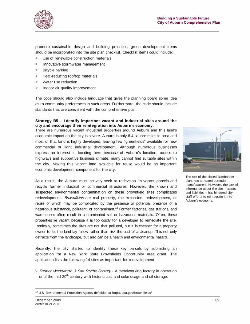
Building a Sustainable Future City of Auburn Comprehensive Plan
66 December 2009 Adopted 01.21.2010
The more development that exists in an area, the harder it is for natural systems to adapt. New projects – greenfield as well as infill – should have as little impact on the environment as possible. This includes stormwater runoff, water and energy use, sustainable materials, and numerous other elements. Stormwater runoff is one of the most significant sources of water pollution in New York. During rainstorms, stormwater runoff washes over impervious surfaces, such as roads, parking lots, sidewalks and rooftops – increasing in temperature and carrying pollutants such as phosphorus, nitrogen, oil and grease, and pathogens to rivers, lakes and wetlands. This “nonpoint” source of pollution (named because it does not come out of a single location such as a pipe) can result in degraded water quality, blocked fish passage, fish kills, loss of wetlands, degraded aesthetics, and impaired recreation.
Low Impact Development (LID) is a stormwater management approach with the basic principle of modeling nature and mimicking a site’s predevelopment water systems. Instead of managing and treating stormwater in large, costly built facilities, LID technology employs small, cost-effective landscape features often located at the lot level. LID allows for development with fewer environmental impacts through smarter designs and technologies that better balance conservation, growth, public health and quality of life. LID benefits the municipality, developer, and general public – through cost savings to developers, smaller burden on municipal infrastructure and reduced pollution to drinking water, recreational waterways and wetlands. Some of the best practices include: > Permeable pavers > Porous surfaces > Tree box planters > Green roofs > Rain gardens
Low Impact Development elements on an industrial park site. (Source: San Diego County LID Handbook)
December 2009 67 Adoted 01.21.2010
Building a Sustainable FutureCity of Auburn Comprehensive Plan
> Grassed swales > Dense development > Native plants > Open space conservation > Narrower streets > Shorter driveways > Smaller, better landscaped parking area > Storage / reuse of rainwater Auburn should incorporate LID practices into its business/technology park site design regulations for all future development. More information about Low Impact Development can be found at the Low Impact Development Center, http://www.lowimpactdevelopment.org/index.html. Any developers who choose to go beyond the basic LID regulations should be rewarded. Density bonuses, expediting permitting or tax incentives could be arranged to encourage environmentally sustainable practices. Strategy B2 – Require “town-center” and walkable designs for new business development including, where appropriate, mixed-uses. Auburn’s business/technology parks as well as retail commercial and office developments should aim to attract a diverse array of customers, and as such, should be accessible by non-vehicular modes of transportation as well as vehicular. Business development in Auburn should be at an attractive, accessible scale that appears inviting, rather than blank, featureless streetwalls and ambiguous travel spaces. Town center design, like a traditional Main Street, should incorporate multiple-uses (retail, professional offices, apartments, and civic services) wherever possible, and should tie in to a transportation network of buses where feasible. With offices or apartments above street-level retail, these centers provide for most daily needs and the core of civic and commercial experience. Employees who work in industrial or technology parks should still feel as if they are part of the urban fabric—not isolated into a single-use corner surrounded by parking. Already many of the people working in the city’s Technology Park seek to leave their building during lunch. They walk for exercise. Others jump in their cars to run errands or have lunch. These trips might be accomplished by foot if appropriate retail or services were allowed. Such amenities will make the park a more pleasant and desirable place to work, which benefits employees as much as employers and developers—and the city as a whole. This can be accomplished by modifying the allowed uses in the zoning code.
Building a Sustainable Future City of Auburn Comprehensive Plan
68 December 2009 Adopted 01.21.2010
It is important that these remain small-scale services designed to handle business in the park and surrounding neighborhood. Care must be taken that productive industrial land not be lost to large-scale commercial growth that could happen elsewhere in Auburn. Above all, the site plan review process should ensure that the designs for Auburn’s business areas are walkable. Any business relationship is with a customer or a client. It is not with a car. While motor vehicles will be around for a long time, it is important that the storage of automobiles not be the dominant design criteria. Even within dedicated technology or business parks, workers still need to get around—sidewalks should be provided and attention should be paid to the overall aesthetic. Auburn’s business parks should be seen as part of the city fabric, and not as an afterthought. This in turn will help attract new businesses and with it, new jobs. Strategy B3 – Revamp minimum parking requirements and require rear building parking As noted in the Downtown Development chapter, parking can often be an obstacle to the creation of a vibrant space for pedestrians, detracting from an appealing, inviting streetscape appropriate for urban areas. Similarly, more parking means more pavement, which adversely affects stormwater flow and the urban heat island effect. Too often, the parking required by code is based on peak activity—for instance at the holidays, for retail areas—and thus many spaces go unused for the majority of the year. Currently the parking requirements for all manufacturing, industrial, and warehouse uses is 1 per every two employees; for professional and business offices, three spaces are required for each 1,000 square feet of net floor area. The city should consider reducing these requirements, perhaps even instituting a parking maximum rather than a minimum, as some communities have been doing. Similarly, parking should be required to be at the back of the building and not the front. This will ensure that business and technology is still pedestrian friendly and urban in character. Strategy B4 – Provide a green development checklist in the code to make sure everyone is on the same page Too often, the idea of sustainable design is vague or merely conceptual, when what’s really needed is a specific, tangible description of what is required or recommended by the planning board. Currently, the planning board maintains a relatively standard checklist of items required for site plan review. Items include provisions for pedestrian access, description of the method of securing public water and location, design and construction materials of such facilities, location and proposed design of all buffer areas, including existing vegetative cover, and a general landscaping plan and planting schedule, among others. In order to
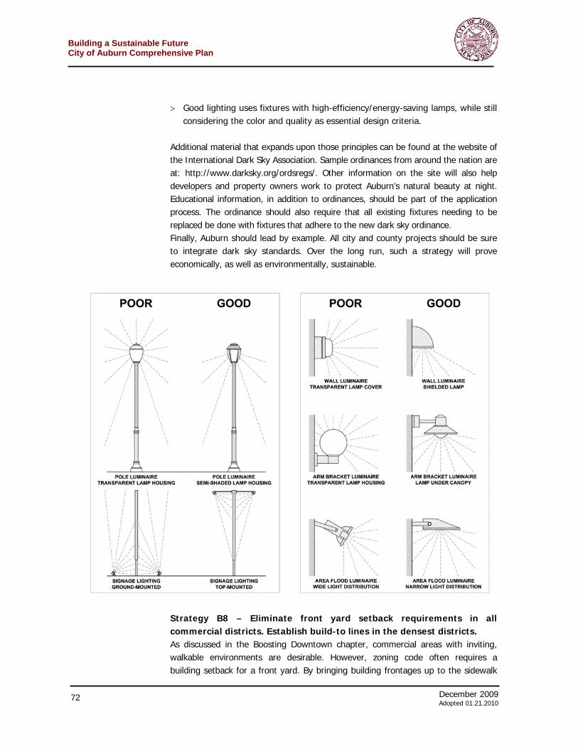
December 2009 69 Adoted 01.21.2010
Building a Sustainable FutureCity of Auburn Comprehensive Plan
promote sustainable design and building practices, green development items should be incorporated into the site plan checklist. Checklist items could include: > Use of renewable construction materials > Innovative stormwater management > Bicycle parking > Heat-reducing rooftop materials > Water use reduction > Indoor air quality improvement The code should also include language that gives the planning board some idea as to community preferences in such areas. Furthermore, the code should include standards that are consistent with the comprehensive plan. Strategy B5 – Identify important vacant and industrial sites around the city and encourage their reintegration into Auburn’s economy. There are numerous vacant industrial properties around Auburn and this land’s economic impact on the city is severe. Auburn is only 8.4 square miles in area and most of that land is highly developed, leaving few “greenfields” available for new commercial or light industrial development. Although numerous businesses express an interest in locating here because of Auburn’s location, access to highways and supportive business climate, many cannot find suitable sites within the city. Making this vacant land available for reuse would be an important economic development component for the city. As a result, the Auburn must actively seek to redevelop its vacant parcels and recycle former industrial or commercial structures. However, the known and suspected environmental contamination on these brownfield sites complicates redevelopment. Brownfields are real property, the expansion, redevelopment, or reuse of which may be complicated by the presence or potential presence of a hazardous substance, pollutant, or contaminant.12 Former factories, gas stations, and warehouses often result in contaminated soil or hazardous materials. Often, these properties lie vacant because it is too costly for a developer to remediate the site. Ironically, sometimes the sites are not that polluted, but it is cheaper for a property owner to let the land lay fallow rather than risk the cost of a cleanup. This not only detracts from the landscape, but also can be a health and environmental hazard. Recently, the city started to identify these key parcels by submitting an application for a New York State Brownfields Opportunity Area grant. The application lists the following 14 sites as important for redevelopment: > Former Wadsworth & Son Scythe Factory - A metalworking factory in operation
until the mid-20th century with historic coal and coke usage and oil storage.
12 U.S. Environmental Protection Agency definition at http://epa.gov/brownfields/
The site of the closed Bombardier plant has attracted potential manufacturers. However, the lack of information about the site – assets and liabilities – has hindered city staff efforts to reintegrate it into Auburn’s economy.
Building a Sustainable Future City of Auburn Comprehensive Plan
70 December 2009 Adopted 01.21.2010
> Former Henry & Allen Factory (2 parcels) - A former metal-working factory with a separate machine shop structure, active from the late 1800s until approximately 1970.
> Former Auburn Woolen Company - A factory manufacturing wool products until the mid-1900s.
> Former Bowen Manufacturing Facility - Originally a shoe factory with a nearby pattern maker, the site was later converted to a factory producing grease and oil cups.
> Former H.N. Lemon & Co. Factory - A glove and mitten factory, formerly a shoe factory, with operations including leather tanning and glove making. The factory was demolished in the mid 1900s.
> Fay & Bowen Bicycle Spokes and Nipples Factory - Also a former shoe factory prior to its conversion to cutting, finishing, and fitting bicycle tires, spokes, and nipples.
> Everts, Sheldon & Co. Factory - The factory’s operations are unknown and the facility closed prior to 1900.
> 10 Genesee Street - highly visible vacant structure with prior use as automotive sales and repair.
> 296 State Street - currently vacant with historical use as an automotive repair shop.
> 1-15 Pulaski Street - vacant.
> 72 Seymour Street - currently vacant with portions used as a parking lot.
> 144 Clark Street - auto body repair shop in poor condition, private owner.
> 151 Orchard Street - The plant was a large diesel engine and railroad equipment manufacturing facility owned by Bombardier (formerly Alco Power) and was closed in 2006.
> 40-46 Frazee Street - largely vacant with a portion leased as a parking lot by the Auburn Foundry Company.
> 41-55 Washington Street - former shoe factory that currently houses a utility building; remainder is vacant.
A good example of the potential for these sites could be found in the Bombardier plant (151 Orchard Street), which was closed in 2006, and now sits vacant. A number of manufacturing companies have approached the city about possibly using the site because of its access to rail lines as well as location along the arterial. Unfortunately, coordination with the landowners has been difficult. Creating a plan to reintegrate this site as well as others into Auburn’s economy and community could make such discussions easier.
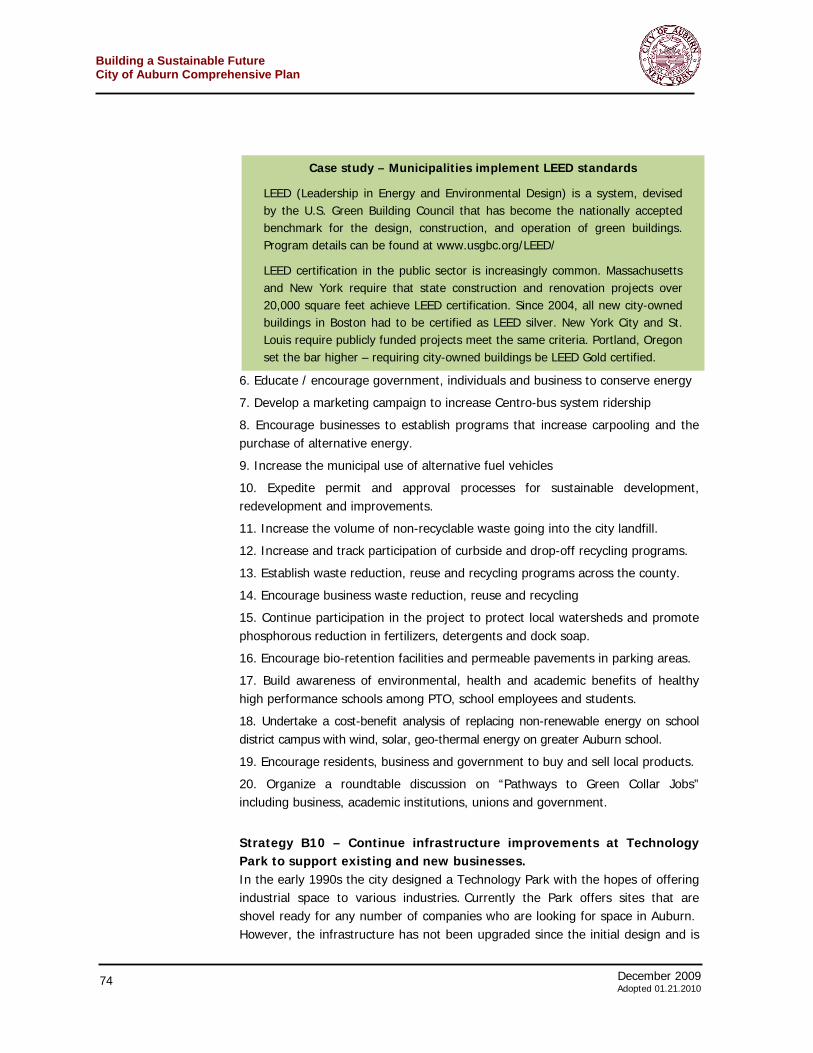
December 2009 71 Adoted 01.21.2010
Building a Sustainable FutureCity of Auburn Comprehensive Plan
Strategy B6 – Establish systems to monitor potential pollution beyond the boundaries of vacant industrial land. As in most post-industrial cities, there is concern in Auburn that some vacant manufacturing facilities are contaminated. The fear is based on an understanding that a majority of such sites, in use sometimes for decades, are polluted with various chemicals, solvents, fuel, or other hazardous materials. Over time this contamination can seep through the soil causing adverse health and environmental damage beyond the property lines of the facility. With various properties still in private hands – and hopes that profitable reuses will eventually be found for such land – there has been no reports about levels, if any of contamination. The city cannot forcibly monitor the pollution directly on such properties, but it might find it prudent to establish monitoring wells on public land surrounding these sites. If contamination is discovered, the city can more quickly work with the landowner (pressure the landowner, if necessary) to remedy the situation. Ultimately, this would help return this land back into Auburn’s economy. Strategy B7 – Institute Dark Sky standards for all non-residential lighting throughout the city including publicly- and utility-owned fixtures. Auburn’s natural beauty is one of its most valuable economic assets. Steps should be taken to preserve it – by day and by night. There are important safety, traffic and quality of life reasons to light our communities at night. Unfortunately, most outdoor lighting installed in recent decades is poorly designed. The lights overlight certain areas and cause overly dark shadows in other areas. The results include:
> Wasted energy – and a lot of money along with it
> Light trespass from one property to another causing annoyances or even harming health.
> Reduced visibility caused by uneven bright spots and dark shadows
> Concerns about traffic and personal safety from the reduced visibility
> Poor nighttime ambience – and the loss of rural star-filled skyscapes Auburn can reduce these impacts by enacting a “dark sky” ordinance that would reduce the light pollution from street lamps and building fixtures. “Good lighting,” as described by the New England Light Pollution Advisory Group and the International Dark-Sky Association, has four principles.
> Light should be adequate for the intended task, but should never over-light.
> Lighting fixtures should be fully-shielded, which means they control the light output in order to keep the light in the intended area and not up into the sky.
> The fixtures are carefully installed to maximize their effectiveness on the targeted property and to minimize adverse effects on neighboring properties.
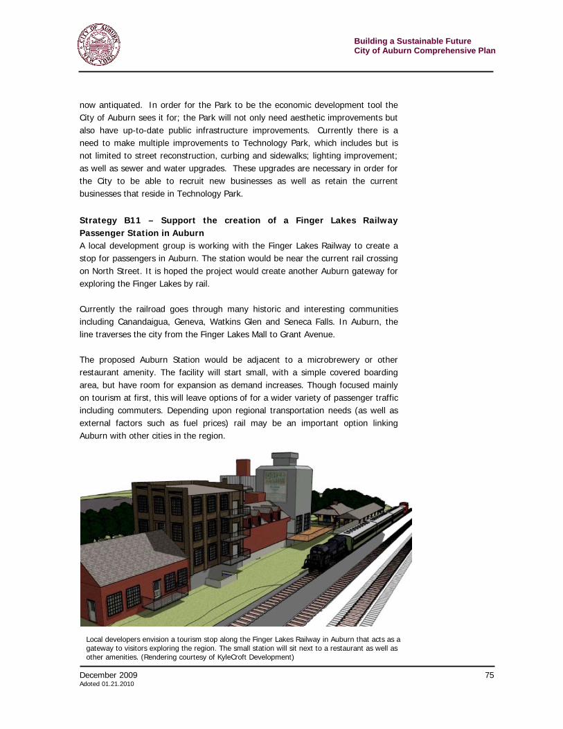
Building a Sustainable Future City of Auburn Comprehensive Plan
72 December 2009 Adopted 01.21.2010
> Good lighting uses fixtures with high-efficiency/energy-saving lamps, while still considering the color and quality as essential design criteria.
Additional material that expands upon those principles can be found at the website of the International Dark Sky Association. Sample ordinances from around the nation are at: http://www.darksky.org/ordsregs/. Other information on the site will also help developers and property owners work to protect Auburn’s natural beauty at night. Educational information, in addition to ordinances, should be part of the application process. The ordinance should also require that all existing fixtures needing to be replaced be done with fixtures that adhere to the new dark sky ordinance. Finally, Auburn should lead by example. All city and county projects should be sure to integrate dark sky standards. Over the long run, such a strategy will prove economically, as well as environmentally, sustainable.
Strategy B8 – Eliminate front yard setback requirements in all commercial districts. Establish build-to lines in the densest districts. As discussed in the Boosting Downtown chapter, commercial areas with inviting, walkable environments are desirable. However, zoning code often requires a building setback for a front yard. By bringing building frontages up to the sidewalk
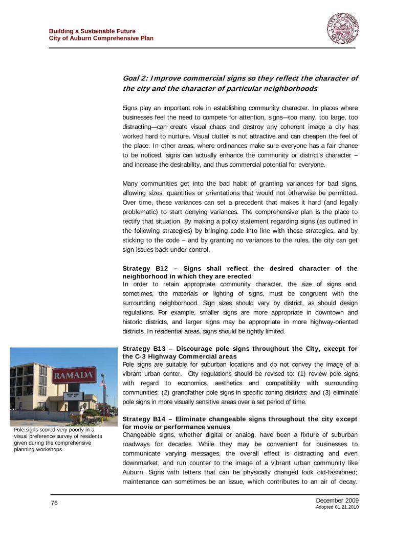
December 2009 73 Adoted 01.21.2010
Building a Sustainable FutureCity of Auburn Comprehensive Plan
rather than setting them back (as is customary in more suburban locations), this creates a unified pathway and designated pedestrian space where there is always something ahead to walk towards. Storefronts are all along the same plane, which is good for both pedestrians and businesses. This can be achieved by eliminating any front yard setback, or, more strongly, by requiring building to the front property line. It also makes it easier for people walking to quickly get on their way from a building without having to traverse a large uncomfortable parking lot. Strategy B9 – Embrace and implement recommendations outlined in the city’s recently completed energy master plan. For years, Auburn has developed a leadership role among municipalities in New York State in the arena of energy and environmental strategies. In March 2009 the city along with Cayuga County completed a Comprehensive Sustainable Energy and Development Plan. The plan’s preparation included the gathering of over 100 citizens at Cayuga Community College to craft a vision and develop the plan. The plan established a vision to achieve sustainable energy and economic development – building on the many sustainable success the city has already. It attempts to provide a holistic approach to addressing the diverse range of issues and policies, which lead to integrated solutions for further sustainable economic, energy, and environmental performance. The plan conducted research in eight areas of sustainability. These are:
1. Alternate Energy and Conservation
2. Transportation, Parks and Recreation and Open Spaces
3. Housing, Codes and Policies, Public Spaces
4. Solid Waste Management
5. Agriculture and Food Waste Management
6. Water and Storm Water Management
7. Healthy Schools
8. Business and Economic Development The project synthesized 42 high priority items and prepared a list of the top 20 challenges. These are: 1. Complete the Auburn wastewater treatment plant bio-digester
2. Complete the Cayuga County soild and water community bio-digester
3. Complete the Cayuga County public utility service centralized bio-digester
4. Initiate the Auburn hydropower projects
5. Create a municipal, low-interest, self-sustaining, green revolving loan fund to assist in financing LEED-certified projects, demand side energy management, weatherization and renewable energy projects.
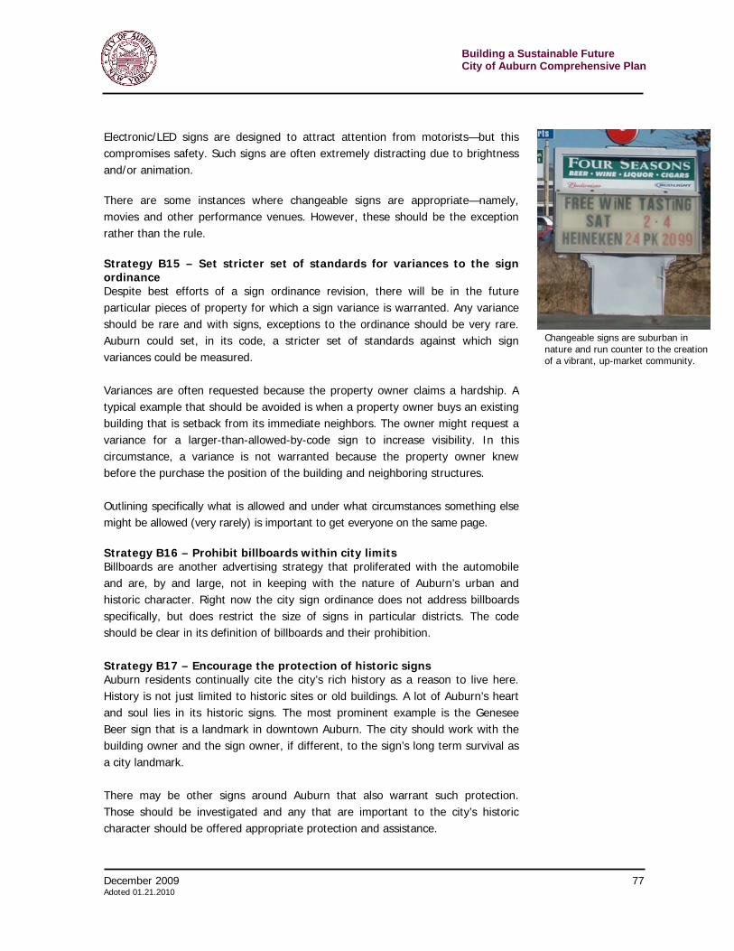
Building a Sustainable Future City of Auburn Comprehensive Plan
74 December 2009 Adopted 01.21.2010
6. Educate / encourage government, individuals and business to conserve energy
7. Develop a marketing campaign to increase Centro-bus system ridership
8. Encourage businesses to establish programs that increase carpooling and the purchase of alternative energy.
9. Increase the municipal use of alternative fuel vehicles
10. Expedite permit and approval processes for sustainable development, redevelopment and improvements.
11. Increase the volume of non-recyclable waste going into the city landfill.
12. Increase and track participation of curbside and drop-off recycling programs.
13. Establish waste reduction, reuse and recycling programs across the county.
14. Encourage business waste reduction, reuse and recycling
15. Continue participation in the project to protect local watersheds and promote phosphorous reduction in fertilizers, detergents and dock soap.
16. Encourage bio-retention facilities and permeable pavements in parking areas.
17. Build awareness of environmental, health and academic benefits of healthy high performance schools among PTO, school employees and students.
18. Undertake a cost-benefit analysis of replacing non-renewable energy on school district campus with wind, solar, geo-thermal energy on greater Auburn school.
19. Encourage residents, business and government to buy and sell local products.
20. Organize a roundtable discussion on “Pathways to Green Collar Jobs” including business, academic institutions, unions and government.
Strategy B10 – Continue infrastructure improvements at Technology Park to support existing and new businesses. In the early 1990s the city designed a Technology Park with the hopes of offering industrial space to various industries. Currently the Park offers sites that are shovel ready for any number of companies who are looking for space in Auburn. However, the infrastructure has not been upgraded since the initial design and is
Case study – Municipalities implement LEED standards
LEED (Leadership in Energy and Environmental Design) is a system, devised by the U.S. Green Building Council that has become the nationally accepted benchmark for the design, construction, and operation of green buildings. Program details can be found at www.usgbc.org/LEED/
LEED certification in the public sector is increasingly common. Massachusetts and New York require that state construction and renovation projects over 20,000 square feet achieve LEED certification. Since 2004, all new city-owned buildings in Boston had to be certified as LEED silver. New York City and St. Louis require publicly funded projects meet the same criteria. Portland, Oregon set the bar higher – requiring city-owned buildings be LEED Gold certified.
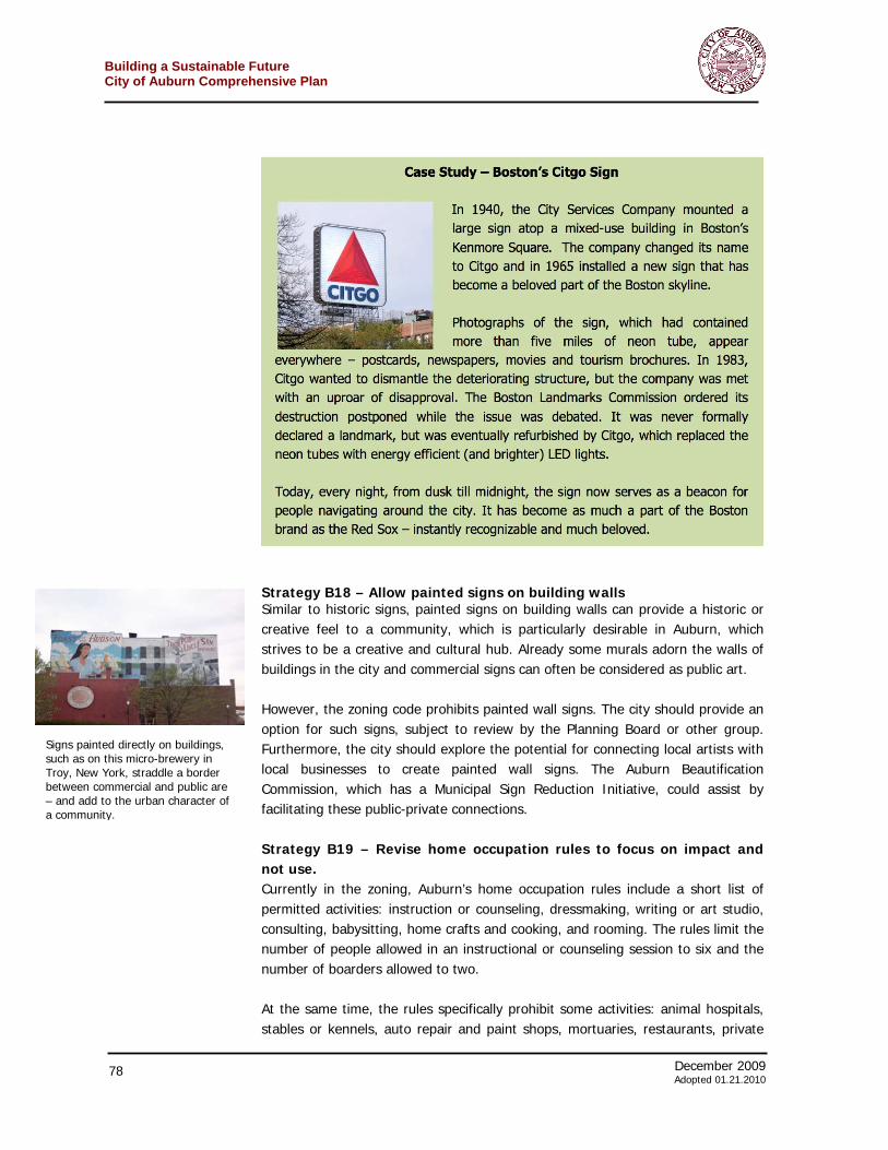
December 2009 75 Adoted 01.21.2010
Building a Sustainable FutureCity of Auburn Comprehensive Plan
now antiquated. In order for the Park to be the economic development tool the City of Auburn sees it for; the Park will not only need aesthetic improvements but also have up-to-date public infrastructure improvements. Currently there is a need to make multiple improvements to Technology Park, which includes but is not limited to street reconstruction, curbing and sidewalks; lighting improvement; as well as sewer and water upgrades. These upgrades are necessary in order for the City to be able to recruit new businesses as well as retain the current businesses that reside in Technology Park.
Strategy B11 – Support the creation of a Finger Lakes Railway Passenger Station in Auburn A local development group is working with the Finger Lakes Railway to create a stop for passengers in Auburn. The station would be near the current rail crossing on North Street. It is hoped the project would create another Auburn gateway for exploring the Finger Lakes by rail. Currently the railroad goes through many historic and interesting communities including Canandaigua, Geneva, Watkins Glen and Seneca Falls. In Auburn, the line traverses the city from the Finger Lakes Mall to Grant Avenue. The proposed Auburn Station would be adjacent to a microbrewery or other restaurant amenity. The facility will start small, with a simple covered boarding area, but have room for expansion as demand increases. Though focused mainly on tourism at first, this will leave options of for a wider variety of passenger traffic including commuters. Depending upon regional transportation needs (as well as external factors such as fuel prices) rail may be an important option linking Auburn with other cities in the region.
Local developers envision a tourism stop along the Finger Lakes Railway in Auburn that acts as a gateway to visitors exploring the region. The small station will sit next to a restaurant as well as other amenities. (Rendering courtesy of KyleCroft Development)
Building a Sustainable Future City of Auburn Comprehensive Plan
76 December 2009 Adopted 01.21.2010
Goal 2: Improve commercial signs so they reflect the character of the city and the character of particular neighborhoods Signs play an important role in establishing community character. In places where businesses feel the need to compete for attention, signs—too many, too large, too distracting—can create visual chaos and destroy any coherent image a city has worked hard to nurture. Visual clutter is not attractive and can cheapen the feel of the place. In other areas, where ordinances make sure everyone has a fair chance to be noticed, signs can actually enhance the community or district’s character – and increase the desirability, and thus commercial potential for everyone. Many communities get into the bad habit of granting variances for bad signs, allowing sizes, quantities or orientations that would not otherwise be permitted. Over time, these variances can set a precedent that makes it hard (and legally problematic) to start denying variances. The comprehensive plan is the place to rectify that situation. By making a policy statement regarding signs (as outlined in the following strategies) by bringing code into line with these strategies, and by sticking to the code – and by granting no variances to the rules, the city can get sign issues back under control. Strategy B12 – Signs shall reflect the desired character of the neighborhood in which they are erected In order to retain appropriate community character, the size of signs and, sometimes, the materials or lighting of signs, must be congruent with the surrounding neighborhood. Sign sizes should vary by district, as should design regulations. For example, smaller signs are more appropriate in downtown and historic districts, and larger signs may be appropriate in more highway-oriented districts. In residential areas, signs should be tightly limited. Strategy B13 – Discourage pole signs throughout the City, except for the C-3 Highway Commercial areas Pole signs are suitable for suburban locations and do not convey the image of a vibrant urban center. City regulations should be revised to: (1) review pole signs with regard to economics, aesthetics and compatibility with surrounding communities; (2) grandfather pole signs in specific zoning districts; and (3) eliminate pole signs in more visually sensitive areas over a set period of time. Strategy B14 – Eliminate changeable signs throughout the city except for movie or performance venues Changeable signs, whether digital or analog, have been a fixture of suburban roadways for decades. While they may be convenient for businesses to communicate varying messages, the overall effect is distracting and even downmarket, and run counter to the image of a vibrant urban community like Auburn. Signs with letters that can be physically changed look old-fashioned; maintenance can sometimes be an issue, which contributes to an air of decay.
Pole signs scored very poorly in a visual preference survey of residents given during the comprehensive planning workshops.
December 2009 77 Adoted 01.21.2010
Building a Sustainable FutureCity of Auburn Comprehensive Plan
Electronic/LED signs are designed to attract attention from motorists—but this compromises safety. Such signs are often extremely distracting due to brightness and/or animation. There are some instances where changeable signs are appropriate—namely, movies and other performance venues. However, these should be the exception rather than the rule. Strategy B15 – Set stricter set of standards for variances to the sign ordinance Despite best efforts of a sign ordinance revision, there will be in the future particular pieces of property for which a sign variance is warranted. Any variance should be rare and with signs, exceptions to the ordinance should be very rare. Auburn could set, in its code, a stricter set of standards against which sign variances could be measured. Variances are often requested because the property owner claims a hardship. A typical example that should be avoided is when a property owner buys an existing building that is setback from its immediate neighbors. The owner might request a variance for a larger-than-allowed-by-code sign to increase visibility. In this circumstance, a variance is not warranted because the property owner knew before the purchase the position of the building and neighboring structures. Outlining specifically what is allowed and under what circumstances something else might be allowed (very rarely) is important to get everyone on the same page.
Strategy B16 – Prohibit billboards within city limits Billboards are another advertising strategy that proliferated with the automobile and are, by and large, not in keeping with the nature of Auburn’s urban and historic character. Right now the city sign ordinance does not address billboards specifically, but does restrict the size of signs in particular districts. The code should be clear in its definition of billboards and their prohibition. Strategy B17 – Encourage the protection of historic signs Auburn residents continually cite the city’s rich history as a reason to live here. History is not just limited to historic sites or old buildings. A lot of Auburn’s heart and soul lies in its historic signs. The most prominent example is the Genesee Beer sign that is a landmark in downtown Auburn. The city should work with the building owner and the sign owner, if different, to the sign’s long term survival as a city landmark. There may be other signs around Auburn that also warrant such protection. Those should be investigated and any that are important to the city’s historic character should be offered appropriate protection and assistance.
Changeable signs are suburban in nature and run counter to the creation of a vibrant, up-market community.
Building a Sustainable Future City of Auburn Comprehensive Plan
78 December 2009 Adopted 01.21.2010
Strategy B18 – Allow painted signs on building walls Similar to historic signs, painted signs on building walls can provide a historic or creative feel to a community, which is particularly desirable in Auburn, which strives to be a creative and cultural hub. Already some murals adorn the walls of buildings in the city and commercial signs can often be considered as public art. However, the zoning code prohibits painted wall signs. The city should provide an option for such signs, subject to review by the Planning Board or other group. Furthermore, the city should explore the potential for connecting local artists with local businesses to create painted wall signs. The Auburn Beautification Commission, which has a Municipal Sign Reduction Initiative, could assist by facilitating these public-private connections. Strategy B19 – Revise home occupation rules to focus on impact and not use. Currently in the zoning, Auburn’s home occupation rules include a short list of permitted activities: instruction or counseling, dressmaking, writing or art studio, consulting, babysitting, home crafts and cooking, and rooming. The rules limit the number of people allowed in an instructional or counseling session to six and the number of boarders allowed to two. At the same time, the rules specifically prohibit some activities: animal hospitals, stables or kennels, auto repair and paint shops, mortuaries, restaurants, private
Signs painted directly on buildings, such as on this micro-brewery in Troy, New York, straddle a border between commercial and public are – and add to the urban character of a community.

December 2009 79 Adoted 01.21.2010
Building a Sustainable FutureCity of Auburn Comprehensive Plan
clubs, and retail sales. The code leaves the power to allow or disallow other uses in the hands of the planning board, which can issue a special permit. The vagueness and uncertainty in the rules makes it likely that most existing home occupations that are not on this list never come forward for a permit. In fact, it is likely that no one operating a home occupation ever seeks municipal approval. This makes the rules useless at controlling the issues of concern to neighborhoods – noise, traffic, lights, fumes, etc. Home occupations exist and will continue to do so in many residential areas throughout Auburn. This is a natural by-product of the interconnectedness of the 21st century and the knowledge economy. In fact, it is a desired result as the city seeks creative entrepreneurs; it is likely that more people will have offices in their homes – and visit their customers to consult or construct. Instead of trying to guess at the occupations people engage in their homes, it is more important to control impacts. The new rules should focus on issues including, but not limited to: > Whether signs should be allowed and, if so, what they should look like > Ensuring that parking for customers or employees can be handled in a
manner consistent with the neighborhood. > Banning heavy equipment or non-residential forms of storage (e.g. no
parking of backhoes or dump trucks in the driveway.) > Requiring that the business produce no noise that can be heard at the
property line > Regulating outdoor lighting to maintain its consistency with a residential
neighborhood Goal 3: Develop a plan for universal broadband access Strategy B20 – Research and create a plan for wireless broadband access throughout the city. In this information age, the provision of broadband Internet connectivity is no longer a luxury—it is a necessity for economic growth. For a community such as Auburn, which is trying to attract and retain a creative class of entrepreneurs, providing universal broadband access would be an attractive amenity that will help it be competitive with other cities. While broadband Internet proliferates in major U.S. cities, often the less wealthy places—both urban and rural—suffer from a lack of investment in the technology, or are faced with prohibitively expensive options. The need for universal broadband access has been discussed at the national and state level. Additionally, “A Call to Action: A Blueprint for our Region’s Future” has identified the implementation of a municipality-wide broadband wireless network as a priority. Auburn should research and develop a plan for universal wireless broadband access. Issues to address include ownership, funding, operation, and partnerships.
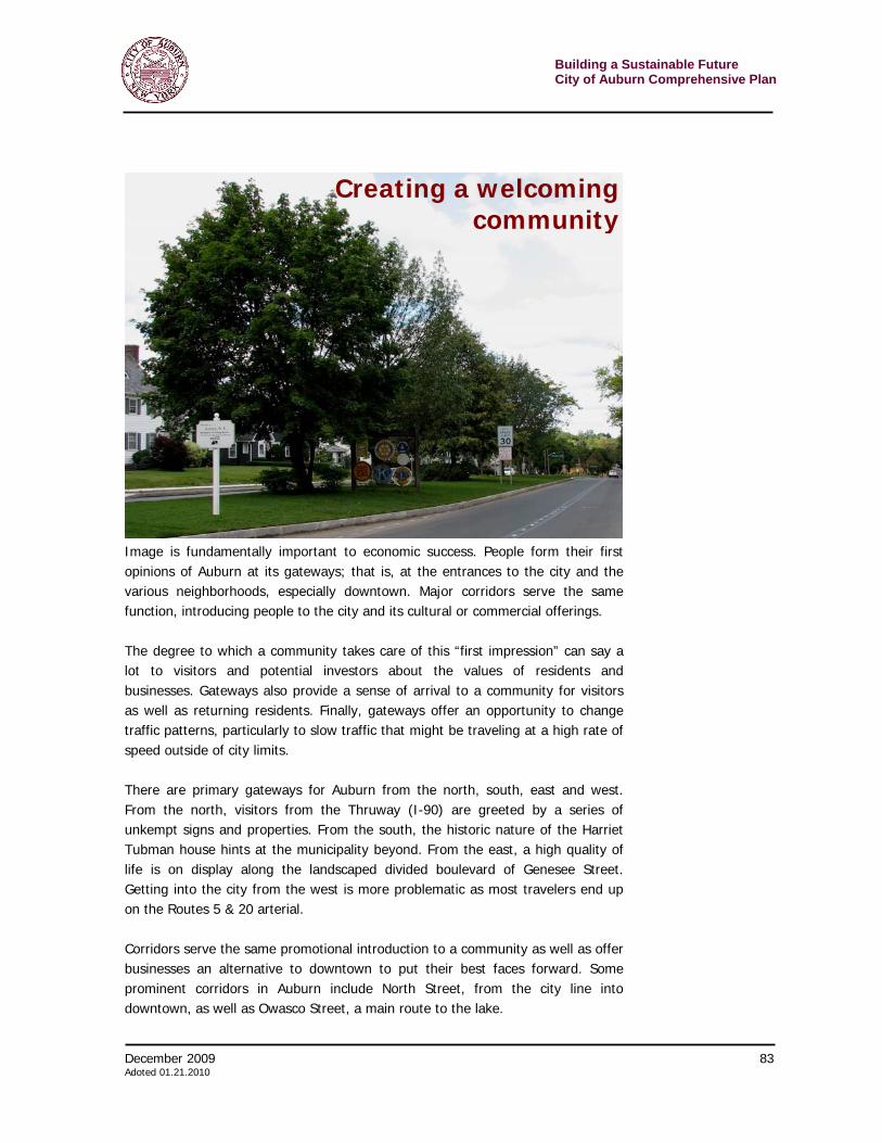
Building a Sustainable Future City of Auburn Comprehensive Plan
80 December 2009 Adopted 01.21.2010
Of course, universal broadband access is a relatively new concept, and as such has its share of failures as well as successes. Philadelphia announced it would provide wireless to low-income housing several years ago through the nonprofit Wireless Philadelphia (now called the Digital Impact Group). However, one of its partners pulled out, slowing the effort. A local company has since joined the effort, changing the business model, supporting it with wired infrastructure and “digital inclusion” programs aimed at people who could not afford a computer. While not to the scale originally hoped for, Philadelphia does provide wireless to large areas. Though many large cities have had high profile wireless program failures, smaller cities have enjoyed some success and could be better models. St. Cloud, Florida, is touted as a Wifi success story. This city of 30,000 annually spends $600,000 from tax revenues on the network, though an Economic Development Fund grant paid startup costs. Statistics claim that 77 percent of residents take advantage of the free wireless,13 though there have been reports of slow connection speeds. Corpus Christi, Texas, began its wireless effort with a proposal by the municipal gas and water companies to automate meter readings. The idea snowballed into a broader plant to improve services and cut costs by migrating time- and paper-intensive work to a wireless network.14 The public access was almost secondary, but remains in effect and is an often-cited example. For more on municipal wireless networks, visit: http://www.wired.com/special_multimedia/2008/st_atlas_1603 Goal 4: Encourage arts and culture as an integral part of Auburn’s economy Strategy B21 – Support existing (as well as future) future arts and cultural institutions and events. Arts and cultural institutions are important to local economic development, particularly in a city that desires tourism to be an important component. In Auburn, there are a number of important historic sites and cultural institutions as well as a growing number of other places and organizations that contribute to the arts/culture/tourism economy. Some of the organizations directly contributing to Auburn’s arts and cultural scene are the: > Auburn Public Theater > Auburn Schine Theater > Cayuga Museum & Case Research Lab > Harriet Tubman Home > Schweinfurth Memorial Art Center 13 http://www.freepress.net/communityinternet/stcloud 14http://www.heartland.org/publications/infotech%20telecom/article/22176/Corpus_Christi_Shows_Way_to_Muni_Success.html
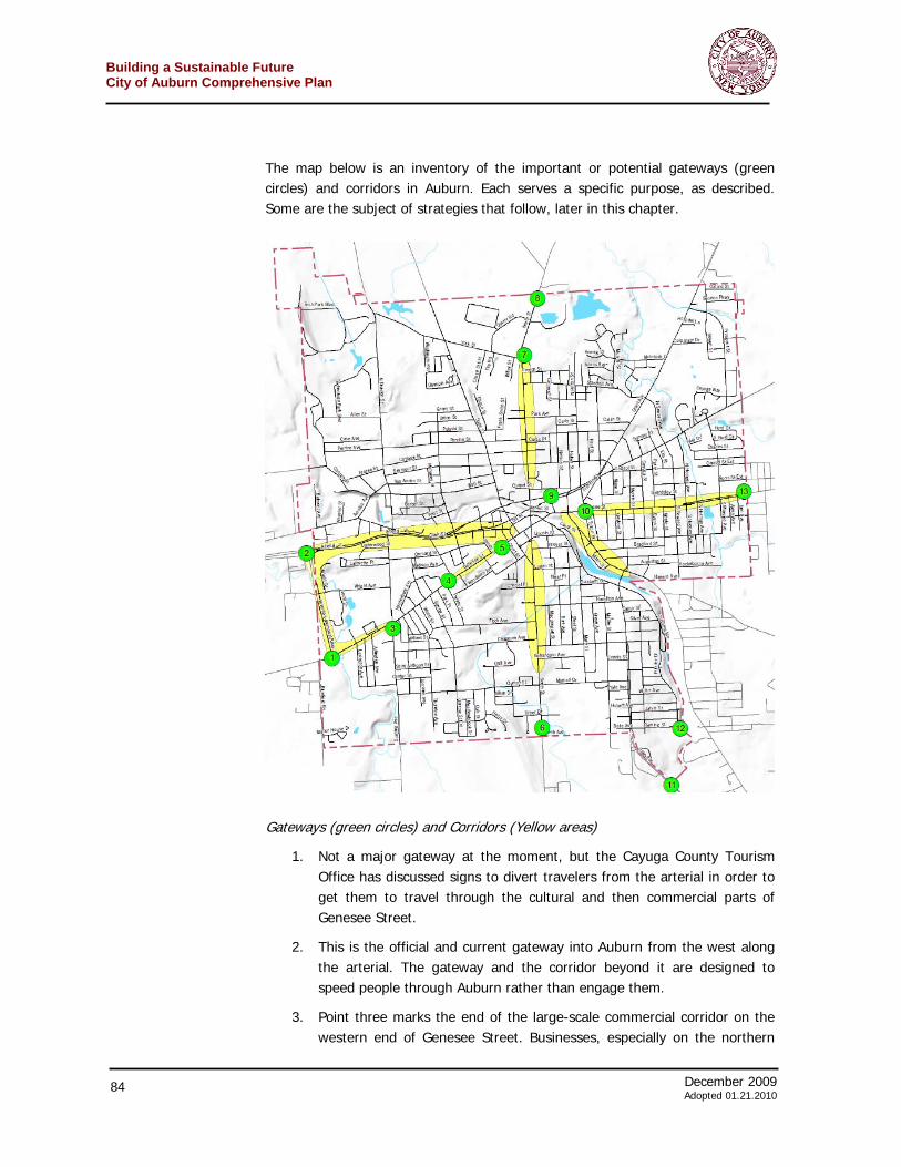
December 2009 81 Adoted 01.21.2010
Building a Sustainable FutureCity of Auburn Comprehensive Plan
> Seward House Museum > Willard Memorial Chapel In addition, there are many existing and emerging institutions in Auburn and around the county. All together these sites and events contribute significantly to the local economy – particularly in the tourism arena. Tourism, based upon arts, history and culture – as well as natural beauty – are important economic engines in Auburn and Cayuga County. According to data collected in 2007 and 2008 by the Cayuga County Convention and Visitors Bureau, over 90 percent of visitors to Cayuga County are leisure travelers and the average travel party spends $387.66 in the county. All together that brings in $90 million in direct revenues producing about $5.8 million in local taxes and $5.73 in state taxes. This translates into tax relief of $418.78 for every household in the county. The arts and culture in Auburn are and can continue to be an important part of this revenue.
Building a Sustainable Future City of Auburn Comprehensive Plan
82 December 2009 Adopted 01.21.2010
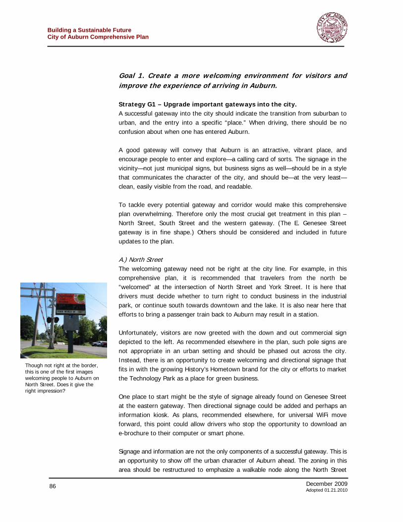
December 2009 83 Adoted 01.21.2010
Building a Sustainable FutureCity of Auburn Comprehensive Plan
Image is fundamentally important to economic success. People form their first opinions of Auburn at its gateways; that is, at the entrances to the city and the various neighborhoods, especially downtown. Major corridors serve the same function, introducing people to the city and its cultural or commercial offerings. The degree to which a community takes care of this “first impression” can say a lot to visitors and potential investors about the values of residents and businesses. Gateways also provide a sense of arrival to a community for visitors as well as returning residents. Finally, gateways offer an opportunity to change traffic patterns, particularly to slow traffic that might be traveling at a high rate of speed outside of city limits. There are primary gateways for Auburn from the north, south, east and west. From the north, visitors from the Thruway (I-90) are greeted by a series of unkempt signs and properties. From the south, the historic nature of the Harriet Tubman house hints at the municipality beyond. From the east, a high quality of life is on display along the landscaped divided boulevard of Genesee Street. Getting into the city from the west is more problematic as most travelers end up on the Routes 5 & 20 arterial. Corridors serve the same promotional introduction to a community as well as offer businesses an alternative to downtown to put their best faces forward. Some prominent corridors in Auburn include North Street, from the city line into downtown, as well as Owasco Street, a main route to the lake.
Creating a welcomingcommunity
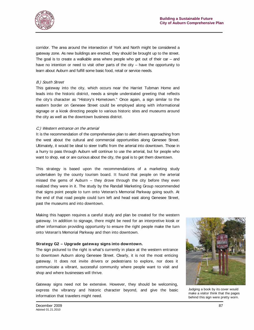
Building a Sustainable Future City of Auburn Comprehensive Plan
84 December 2009 Adopted 01.21.2010
The map below is an inventory of the important or potential gateways (green circles) and corridors in Auburn. Each serves a specific purpose, as described. Some are the subject of strategies that follow, later in this chapter.
Gateways (green circles) and Corridors (Yellow areas)
1. Not a major gateway at the moment, but the Cayuga County Tourism Office has discussed signs to divert travelers from the arterial in order to get them to travel through the cultural and then commercial parts of Genesee Street.
2. This is the official and current gateway into Auburn from the west along the arterial. The gateway and the corridor beyond it are designed to speed people through Auburn rather than engage them.
3. Point three marks the end of the large-scale commercial corridor on the western end of Genesee Street. Businesses, especially on the northern
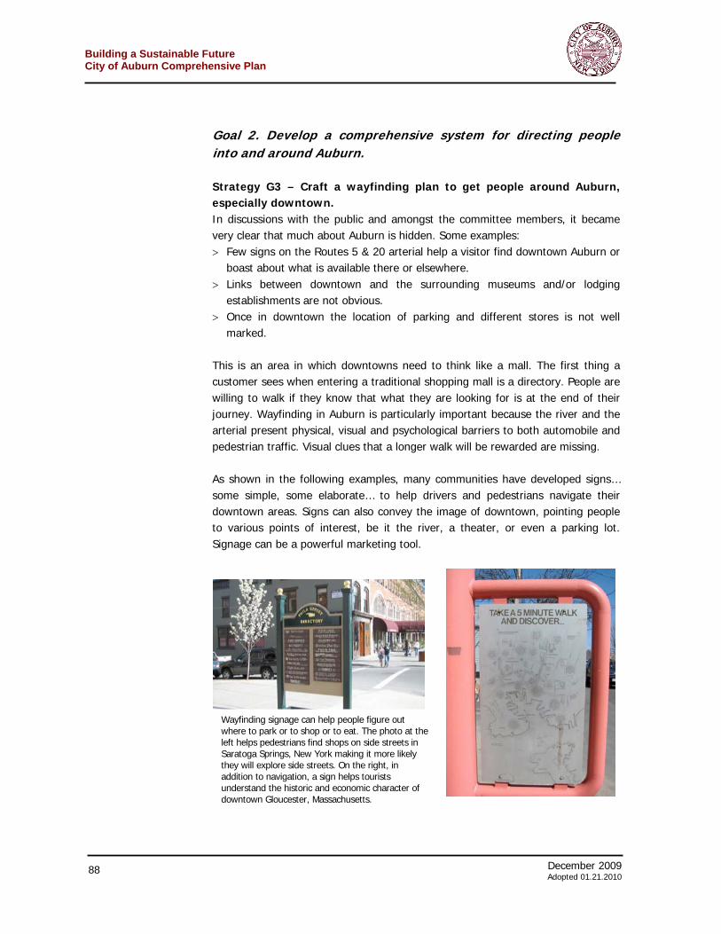
December 2009 85 Adoted 01.21.2010
Building a Sustainable FutureCity of Auburn Comprehensive Plan
side of this stretch are more appropriate in a suburban than urban location.
4. Gateway 4, which has not really been defined yet, is the beginning of the Museum Corridor part of Genesee Street.
5. This is the end of the museum stretch of the street and a major gateway to downtown.
6. This is the southern access to the city. It quickly empties people into the historic district, which is the corridor just to the gateway’s north.
7. This point is considered a major gateway point as it is here that some travelers heading south could turn right onto York Street and the industrial areas beyond. Or people could proceed south onto the North Street Corridor and head into downtown Auburn.
8. While this point is the official border of the city, it might not be considered an important gateway as Auburn does not gain its more urban appearance until point seven and the start of the North Street corridor. It is presently poorly marked and does not offer an overly positive impression of the community beyond.
9. This point is another place along the arterial where visitors from the east could decide to head into downtown. Such directional signage here and around the city is not helpful to finding Auburn’s central business district.
10. This intersection is another potential gateway for travelers from the east to enter downtown.
11. Point 11 is a major gateway from the south and takes people by the high school complex. It is the major link to Owasco Lake.
12. This entrance to the city is another from the south. Less well-used, the road takes people along the Owasco River and through residential areas. It is not a major entrance to the city, but used often enough that it warrants attention.
13. A major gateway from the east and easily the most welcoming entrance into Auburn.
Finally, the Owasco Street corridor, which does not have a major gateway number on either end, is an important link for travelers to the lake. Many people, never intending to travel to downtown Auburn may use this route. It is therefore an important opportunity to impress people with the community and try to get some to stop and engage in commerce.
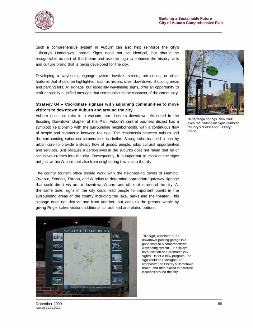
Building a Sustainable Future City of Auburn Comprehensive Plan
86 December 2009 Adopted 01.21.2010
Goal 1. Create a more welcoming environment for visitors and improve the experience of arriving in Auburn. Strategy G1 – Upgrade important gateways into the city. A successful gateway into the city should indicate the transition from suburban to urban, and the entry into a specific “place.” When driving, there should be no confusion about when one has entered Auburn. A good gateway will convey that Auburn is an attractive, vibrant place, and encourage people to enter and explore—a calling card of sorts. The signage in the vicinity—not just municipal signs, but business signs as well—should be in a style that communicates the character of the city, and should be—at the very least—clean, easily visible from the road, and readable. To tackle every potential gateway and corridor would make this comprehensive plan overwhelming. Therefore only the most crucial get treatment in this plan – North Street, South Street and the western gateway. (The E. Genesee Street gateway is in fine shape.) Others should be considered and included in future updates to the plan. A.) North Street The welcoming gateway need not be right at the city line. For example, in this comprehensive plan, it is recommended that travelers from the north be “welcomed” at the intersection of North Street and York Street. It is here that drivers must decide whether to turn right to conduct business in the industrial park, or continue south towards downtown and the lake. It is also near here that efforts to bring a passenger train back to Auburn may result in a station. Unfortunately, visitors are now greeted with the down and out commercial sign depicted to the left. As recommended elsewhere in the plan, such pole signs are not appropriate in an urban setting and should be phased out across the city. Instead, there is an opportunity to create welcoming and directional signage that fits in with the growing History’s Hometown brand for the city or efforts to market the Technology Park as a place for green business. One place to start might be the style of signage already found on Genesee Street at the eastern gateway. Then directional signage could be added and perhaps an information kiosk. As plans, recommended elsewhere, for universal WiFi move forward, this point could allow drivers who stop the opportunity to download an e-brochure to their computer or smart phone. Signage and information are not the only components of a successful gateway. This is an opportunity to show off the urban character of Auburn ahead. The zoning in this area should be restructured to emphasize a walkable node along the North Street
Though not right at the border, this is one of the first images welcoming people to Auburn on North Street. Does it give the right impression?
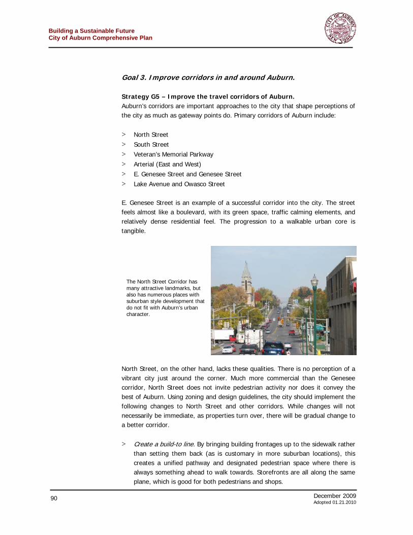
December 2009 87 Adoted 01.21.2010
Building a Sustainable FutureCity of Auburn Comprehensive Plan
corridor. The area around the intersection of York and North might be considered a gateway zone. As new buildings are erected, they should be brought up to the street. The goal is to create a walkable area where people who get out of their car – and have no intention or need to visit other parts of the city – have the opportunity to learn about Auburn and fulfill some basic food, retail or service needs. B.) South Street This gateway into the city, which occurs near the Harriet Tubman Home and leads into the historic district, needs a simple understated greeting that reflects the city’s character as “History’s Hometown.” Once again, a sign similar to the eastern border on Genesee Street could be employed along with informational signage or a kiosk directing people to various historic sites and museums around the city as well as the downtown business district. C.) Western entrance on the arterial It is the recommendation of the comprehensive plan to alert drivers approaching from the west about the cultural and commercial opportunities along Genesee Street. Ultimately, it would be ideal to steer traffic from the arterial into downtown. Those in a hurry to pass through Auburn will continue to use the arterial, but for people who want to shop, eat or are curious about the city, the goal is to get them downtown. This strategy is based upon the recommendations of a marketing study undertaken by the county tourism board. It found that people on the arterial missed the gems of Auburn – they drove through the city before they even realized they were in it. The study by the Randall Marketing Group recommended that signs point people to turn onto Veteran’s Memorial Parkway going south. At the end of that road people could turn left and head east along Genesee Street, past the museums and into downtown. Making this happen requires a careful study and plan be created for the western gateway. In addition to signage, there might be need for an interpretive kiosk or other information providing opportunity to ensure the right people make the turn onto Veteran’s Memorial Parkway and then into downtown. Strategy G2 – Upgrade gateway signs into downtown. The sign pictured to the right is what’s currently in place at the western entrance to downtown Auburn along Genesee Street. Clearly, it is not the most enticing gateway. It does not invite drivers or pedestrians to explore, nor does it communicate a vibrant, successful community where people want to visit and shop and where businesses will thrive. Gateway signs need not be extensive. However, they should be welcoming, express the vibrancy and historic character beyond, and give the basic information that travelers might need.
Judging a book by its cover would make a visitor think that the pages behind this sign were pretty worn.
Building a Sustainable Future City of Auburn Comprehensive Plan
88 December 2009 Adopted 01.21.2010
Goal 2. Develop a comprehensive system for directing people into and around Auburn. Strategy G3 – Craft a wayfinding plan to get people around Auburn, especially downtown. In discussions with the public and amongst the committee members, it became very clear that much about Auburn is hidden. Some examples: > Few signs on the Routes 5 & 20 arterial help a visitor find downtown Auburn or
boast about what is available there or elsewhere. > Links between downtown and the surrounding museums and/or lodging
establishments are not obvious. > Once in downtown the location of parking and different stores is not well
marked. This is an area in which downtowns need to think like a mall. The first thing a customer sees when entering a traditional shopping mall is a directory. People are willing to walk if they know that what they are looking for is at the end of their journey. Wayfinding in Auburn is particularly important because the river and the arterial present physical, visual and psychological barriers to both automobile and pedestrian traffic. Visual clues that a longer walk will be rewarded are missing. As shown in the following examples, many communities have developed signs… some simple, some elaborate… to help drivers and pedestrians navigate their downtown areas. Signs can also convey the image of downtown, pointing people to various points of interest, be it the river, a theater, or even a parking lot. Signage can be a powerful marketing tool.
Wayfinding signage can help people figure out where to park or to shop or to eat. The photo at the left helps pedestrians find shops on side streets in Saratoga Springs, New York making it more likely they will explore side streets. On the right, in addition to navigation, a sign helps tourists understand the historic and economic character of downtown Gloucester, Massachusetts.

December 2009 89 Adoted 01.21.2010
Building a Sustainable FutureCity of Auburn Comprehensive Plan
Such a comprehensive system in Auburn can also help reinforce the city’s “History’s Hometown” brand. Signs need not be identical, but should be recognizable as part of the theme and use the logo to enhance the history, arts and culture brand that is being developed for the city. Developing a wayfinding signage system involves streets, attractions, or other features that should be highlighted, such as historic sites, downtown, shopping areas and parking lots. All signage, but especially wayfinding signs, offer an opportunity to craft or solidify a unified message that communicates the character of the community. Strategy G4 – Coordinate signage with adjoining communities to move visitors to downtown Auburn and around the city. Auburn does not exist in a vacuum, nor does its downtown. As noted in the Boosting Downtown chapter of the Plan, Auburn’s central business district has a symbiotic relationship with the surrounding neighborhoods, with a continuous flow of people and commerce between the two. The relationship between Auburn and the surrounding suburban communities is similar. Strong suburbs need a healthy urban core to provide a steady flow of goods, people, jobs, cultural opportunities and services. Just because a person lives in the suburbs does not mean that he or she never crosses into the city. Consequently, it is important to consider the signs not just within Auburn, but also from neighboring towns into the city. The county tourism office should work with the neighboring towns of Fleming, Owasco, Sennett, Throop, and Aurelius to determine appropriate gateway signage that could direct visitors to downtown Auburn and other sites around the city. At the same time, signs in the city could lead people to important points in the surrounding areas of the county including the lake, parks and the theater. This signage does not detract one from another, but adds to the greater whole by giving Finger Lakes visitors additional cultural and art-related options.
In Saratoga Springs, New York, even the parking lot signs reinforce the city’s “Horses and History” brand.
This sign, attached to the downtown parking garage is a good start to a comprehensive wayfinding system – it displays both location and promotes city sights. Under a new program, the sign could be redesigned to emphasize the History’s Hometown brand, and then placed in different locations around the city.
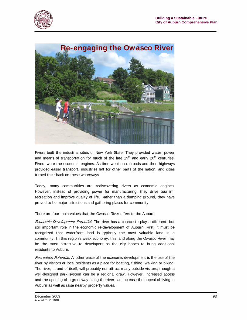
Building a Sustainable Future City of Auburn Comprehensive Plan
90 December 2009 Adopted 01.21.2010
Goal 3. Improve corridors in and around Auburn. Strategy G5 – Improve the travel corridors of Auburn. Auburn’s corridors are important approaches to the city that shape perceptions of the city as much as gateway points do. Primary corridors of Auburn include: > North Street > South Street > Veteran’s Memorial Parkway > Arterial (East and West) > E. Genesee Street and Genesee Street > Lake Avenue and Owasco Street E. Genesee Street is an example of a successful corridor into the city. The street feels almost like a boulevard, with its green space, traffic calming elements, and relatively dense residential feel. The progression to a walkable urban core is tangible.
North Street, on the other hand, lacks these qualities. There is no perception of a vibrant city just around the corner. Much more commercial than the Genesee corridor, North Street does not invite pedestrian activity nor does it convey the best of Auburn. Using zoning and design guidelines, the city should implement the following changes to North Street and other corridors. While changes will not necessarily be immediate, as properties turn over, there will be gradual change to a better corridor. > Create a build-to line. By bringing building frontages up to the sidewalk rather
than setting them back (as is customary in more suburban locations), this creates a unified pathway and designated pedestrian space where there is always something ahead to walk towards. Storefronts are all along the same plane, which is good for both pedestrians and shops.
The North Street Corridor has many attractive landmarks, but also has numerous places with suburban style development that do not fit with Auburn’s urban character.
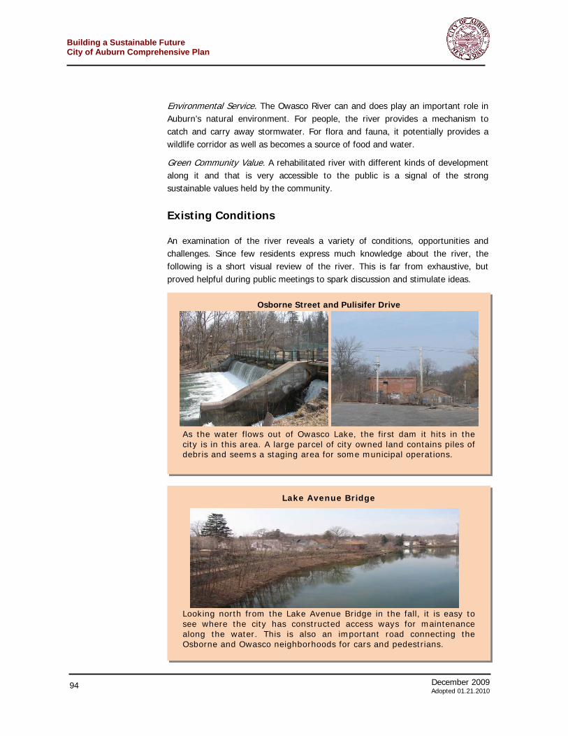
December 2009 91 Adoted 01.21.2010
Building a Sustainable FutureCity of Auburn Comprehensive Plan
> Relocate parking to the back of buildings. Moving parking lots echoes the same philosophy as creating a build-to line: it creates a designated corridor for travel. Parking lots in front of a store lack visual interest and do not encourage people to walk by—curb cuts can further complicate this. Relocating parking lots so they are not the primary point of interest creates a more urban feel that encourages walking or bicycling over automobile use, and allows people to see the businesses more closely.
> Unify the sidewalk along the street. When a sidewalk is present, it often appears willy-nilly—different paving styles here and there, different widths, varying degrees of maintenance or clearing in certain areas, and so on. Unifying both the materials and the maintenance of the sidewalk along the street will unify the corridor and make it feel like a true district, not an assemblage of haphazard landscape features. As sidewalks are replaced or installed, attention should be paid to the surrounding segments to ensure that they match up.
> Develop a landscape plan. A unified landscape plan will further communicate the importance of the corridors into Auburn. It should comprehensively address plantings (trees, grass, and seasonal plantings), site furniture (such as benches, trash and/or recycling receptacles, sign posts), and lighting. A landscape plan need not be costly—many of these elements exist already but are haphazard. Putting them all under the same umbrella will help create an identity for the corridor and streamline maintenance. The City could hire a landscape architect consultant or utilize existing groups to take action, such as the Auburn Beautification Commission.
Strategy G6 – Use banners to identify different districts. Banners are a relatively inexpensive, fast, and flexible way to designate special areas, including corridors, of the city, and take many forms. They should be used to identify downtown Auburn (as described in the Boosting Downtown chapter), the museum district, as well as many other areas. Along a corridor such as North Street, they could “escort” a traveler all the way into downtown. Since banners are quick to produce and hang, they can easily be used to announce time-sensitive material, such as events. As noted in the Downtown chapter, banners should be used where aesthetically appropriate to promote Auburn-related events or updates, whether a sidewalk sale or a graduation announcement.
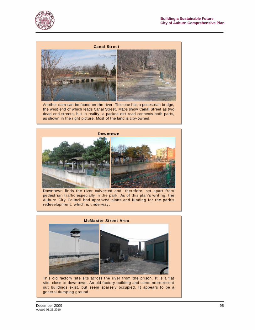
Building a Sustainable Future City of Auburn Comprehensive Plan
92 December 2009 Adopted 01.21.2010
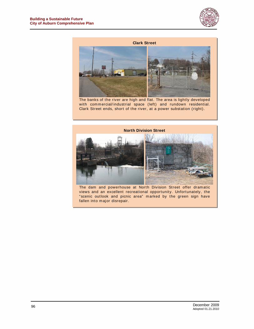
December 2009 93 Adoted 01.21.2010
Building a Sustainable FutureCity of Auburn Comprehensive Plan
Rivers built the industrial cities of New York State. They provided water, power and means of transportation for much of the late 19th and early 20th centuries. Rivers were the economic engines. As time went on railroads and then highways provided easier transport, industries left for other parts of the nation, and cities turned their back on these waterways. Today, many communities are rediscovering rivers as economic engines. However, instead of providing power for manufacturing, they drive tourism, recreation and improve quality of life. Rather than a dumping ground, they have proved to be major attractions and gathering places for community. There are four main values that the Owasco River offers to the Auburn.
Economic Development Potential. The river has a chance to play a different, but still important role in the economic re-development of Auburn. First, it must be recognized that waterfront land is typically the most valuable land in a community. In this region’s weak economy, this land along the Owasco River may be the most attractive to developers as the city hopes to bring additional residents to Auburn.
Recreation Potential. Another piece of the economic development is the use of the river by visitors or local residents as a place for boating, fishing, walking or biking. The river, in and of itself, will probably not attract many outside visitors, though a well-designed park system can be a regional draw. However, increased access and the opening of a greenway along the river can increase the appeal of living in Auburn as well as raise nearby property values.
Re-engaging the Owasco River
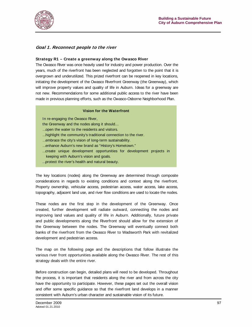
Building a Sustainable Future City of Auburn Comprehensive Plan
94 December 2009 Adopted 01.21.2010
Environmental Service. The Owasco River can and does play an important role in Auburn’s natural environment. For people, the river provides a mechanism to catch and carry away stormwater. For flora and fauna, it potentially provides a wildlife corridor as well as becomes a source of food and water.
Green Community Value. A rehabilitated river with different kinds of development along it and that is very accessible to the public is a signal of the strong sustainable values held by the community.
Existing Conditions
An examination of the river reveals a variety of conditions, opportunities and challenges. Since few residents express much knowledge about the river, the following is a short visual review of the river. This is far from exhaustive, but proved helpful during public meetings to spark discussion and stimulate ideas.
Osborne Street and Pulisifer Drive
As the water flows out of Owasco Lake, the first dam it hits in the city is in this area. A large parcel of city owned land contains piles of debris and seems a staging area for some municipal operations.
Lake Avenue Bridge
Looking north from the Lake Avenue Bridge in the fall, it is easy to see where the city has constructed access ways for maintenance along the water. This is also an important road connecting the Osborne and Owasco neighborhoods for cars and pedestrians.
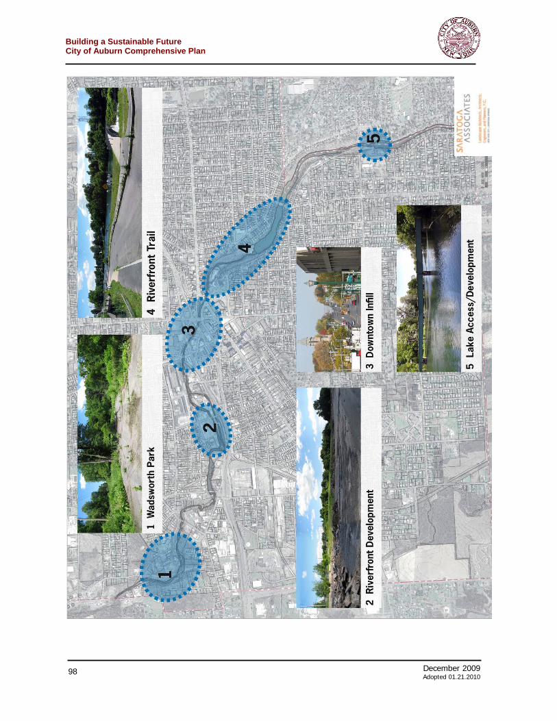
December 2009 95 Adoted 01.21.2010
Building a Sustainable FutureCity of Auburn Comprehensive Plan
Canal Street
Another dam can be found on the river. This one has a pedestrian bridge, the west end of which leads Canal Street. Maps show Canal Street as two dead end streets, but in reality, a packed dirt road connects both parts, as shown in the right picture. Most of the land is city-owned.
Downtown
Downtown finds the river culverted and, therefore, set apart from pedestrian traffic especially in the park. As of this plan’s writing, the Auburn City Council had approved plans and funding for the park’s redevelopment, which is underway.
McMaster Street Area
This old factory site sits across the river from the prison. It is a flat site, close to downtown. An old factory building and some more recent out buildings exist, but seem sparsely occupied. It appears to be a general dumping ground.
Building a Sustainable Future City of Auburn Comprehensive Plan
96 December 2009 Adopted 01.21.2010
North Division Street
The dam and powerhouse at North Division Street offer dramatic views and an excellent recreational opportunity. Unfortunately, the “scenic outlook and picnic area” marked by the green sign have fallen into major disrepair.
Clark Street
The banks of the river are high and flat. The area is lightly developed with commercial/industrial space (left) and rundown residential. Clark Street ends, short of the river, at a power substation (right).
December 2009 97 Adoted 01.21.2010
Building a Sustainable FutureCity of Auburn Comprehensive Plan
Goal 1. Reconnect people to the river Strategy R1 – Create a greenway along the Owasco River The Owasco River was once heavily used for industry and power production. Over the years, much of the riverfront has been neglected and forgotten to the point that it is overgrown and underutilized. This prized riverfront can be reopened in key locations, initiating the development of the Owasco Riverfront Greenway (the Greenway), which will improve property values and quality of life in Auburn. Ideas for a greenway are not new. Recommendations for some additional public access to the river have been made in previous planning efforts, such as the Owasco-Osborne Neighborhood Plan.
The key locations (nodes) along the Greenway are determined through composite considerations in regards to existing conditions and context along the riverfront. Property ownership, vehicular access, pedestrian access, water access, lake access, topography, adjacent land use, and river flow conditions are used to locate the nodes. These nodes are the first step in the development of the Greenway. Once created, further development will radiate outward, connecting the nodes and improving land values and quality of life in Auburn. Additionally, future private and public developments along the Riverfront should allow for the extension of the Greenway between the nodes. The Greenway will eventually connect both banks of the riverfront from the Owasco River to Wadsworth Park with revitalized development and pedestrian access. The map on the following page and the descriptions that follow illustrate the various river front opportunities available along the Owasco River. The rest of this strategy deals with the entire river. Before construction can begin, detailed plans will need to be developed. Throughout the process, it is important that residents along the river and from across the city have the opportunity to participate. However, these pages set out the overall vision and offer some specific guidance so that the riverfront land develops in a manner consistent with Auburn’s urban character and sustainable vision of its future.
Vision for the Waterfront
In re-engaging the Owasco River, the Greenway and the nodes along it should… …open the water to the residents and visitors. …highlight the community’s traditional connection to the river. …embrace the city’s vision of long-term sustainability. …enhance Auburn’s new brand as “History’s Hometown.” …create unique development opportunities for development projects in
keeping with Auburn’s vision and goals. …protect the river’s health and natural beauty.
Building a Sustainable Future City of Auburn Comprehensive Plan
98 December 2009 Adopted 01.21.2010
December 2009 99 Adoted 01.21.2010
Building a Sustainable FutureCity of Auburn Comprehensive Plan
1. Wadsworth Park Node Wadsworth Park will be the first constructed node, and is also the northern terminus of the Greenway. As such it will work to connect the Northwestern end of Auburn with downtown along the riverfront. This node will be designed as a rural park with a play area, picnic tables, parking, pedestrian riverfront access, and connections to historic river uses. (See Strategy R2 for more details.) 2. Riverfront Development Node The Riverfront Development Node is designed to initiate mixed-use development near downtown – adding to existing revitalization efforts through the city’s core. (See Strategy R4 for more details on the zoning that might occur in this area.) The Riverfront Development Node will provide a connection for the Owasco River Greenway midway between downtown and Wadsworth Park, provide mixed-use and pedestrian access to the riverfront, radiate improved property values, and revitalize the Wall Street neighborhood. The site itself is a large riverfront parcel with excellent street front access on two sides. One side is adjacent to private homes, and the other to commercially zoned lots. The riverfront itself is accessible along the entire lot and, potentially, across the river as well. A major aspect of the lot’s context is the correction facility. Related complications will require study, though it is likely that development in this plot can work with all aspects of the neighborhood to improve property values and quality of life issues. It is crucial that whatever private sector development be allowed in this (or any) place along the river that the access to and along the waterfront be maintained. The eventual vision of a greenway along the entire stretch of the river should not be compromised for any reason. (See Strategy R3.) 3. Downtown Infill Node There are numerous points along the river in downtown that would make sense for new development. These vacant areas often once housed structures and replacing those buildings would help reweave the urban fabric destroyed by the construction of the arterial. It is important that the mass and siting of these infill buildings match the traditional historic and pedestrian-friendly character of downtown and described in the Boosting Downtown chapter. As described above, it is important that public access be guaranteed along the river. 4. Riverfront Trail Node The Riverfront Trail Node is an area with the potential for an extensive greenway connection from downtown past the Lake Avenue Bridge. It is here that the trails can get started and demonstrate to others the potential importance of redeveloping much of the riverfront in this manner.
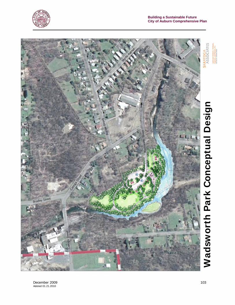
Building a Sustainable Future City of Auburn Comprehensive Plan
100 December 2009 Adopted 01.21.2010
A large hydroelectric dam that spans the river at its widest point largely defines this part of riverfront. The pedestrian bridge over the dam is the major hinge point at which the parcels change from mixed use zoning to industrial zoning. On the water, above the dam the river is held back into a small waterbody, while below the dam the river narrows and flows quickly through a narrow flood plain that continues until the river is channelized as it runs through downtown. Both cases provide for different design opportunities. Above the dam, the pedestrian bridge and lake-like waterfront provide for easy water access for fishing, small watercraft, and mixed-use development. Below the dam is ideal location for a series of naturalistic riverfront trails connecting downtown to the lake-like waterfront. There are some city-created riverside maintenance trails in this area. The investment already made in these trails brings public river access closer to reality and maximizes the money that the city must already put into these lanes. 5. Lake Access / Development Node The Lake Access / Development Node is the southernmost area along the Greenway. It will continue the Greenway from the Riverfront Node and Downtown and help extend the greenway through to high school and eventually to Owasco Lake. This is a large plot of largely city owned land. The waterfront access is above the dam, which will allow for a public boat launch for small and medium sized craft with access to Owasco Lake. Below the dam, the land might be suitable for private redevelopment, though, as noted earlier, all development must include access to and along the riverfront for the public. The lot itself has an asphalt-paved driveway and is located just above a dam. From this point up the river, all of the single-family homes have small docks for watercraft access. Just south of the node is the high school, which already has a path to the Lake. Strategy R2 – Create Wadsworth Park on the river This is one of the major recommendations for the near future in terms of reconnecting the Auburn community to the Owasco River. It is an effort that has been under consideration in the city. This strategy takes thinking about the park a little further with broad design outlines and the development of some crucial decisions that must be made. As the first node in the Auburn Riverfront Greenway (the Greenway) to be developed, Wadsworth Park is an important part of the Auburn Comprehensive
December 2009 101 Adoted 01.21.2010
Building a Sustainable FutureCity of Auburn Comprehensive Plan
Plan. When completed, the park will be the Northern terminus of the Greenway. The site slopes down slightly toward the riverfront, and will not require very much grading. Yet it is overgrown with mostly invasive species that have been growing for years unchecked. The riverfront is mostly inaccessible due to the weedy overgrowth, but clearing the unwanted growth will expose an excellent riverbank. The ruins of a historic hydro facility are located on the site. A stone building wall and its foundation could be used for historic interpretation. Also a concrete spillway that extends across the river could provide a striking view and a potential water access point. When the overgrowth is removed, the spillway structure will be a striking visual reminder of a past use and an impressive water feature. On both banks of the river there are riverfront paths and the chance to extend the paths to connect both sides of the river between bridges to the north and south. At this point of the Owasco River, the river runs relatively narrow and flows quickly, with the exception of where it flows over the spillway. Just above the spillway the water smoothes and calms, yet below the spillway there are some small rapids that are visually striking, but will prevent safe water access. In the immediate neighborhood of the park, there are a number of parcels that are vacant; some owned by the city and others in private hands. The map that follows shows these parcels. Immediately one could imagine how this park could quickly become the first link in the greenway trail. From the park, a trail could strike out along the steep southern side of Wadsworth Street and make a connection to Aurelius Avenue and the city land beyond. One of the biggest challenges is access to the park. As presently configured, Wadsworth Street is the only route in. Beyond Canoga Street, this narrow road becomes one way. A piece of a parcel at the northern end of the proposed park along Canoga Street could alleviate this problem. The land is part of a larger parcel with the house on the eastern half of the plot. If it could be acquired, it would facilitate access and take the burden off of Canoga Street residents. Additionally this acquisition would open the park up to other city owned and vacant parcels to the North of Wadsworth Park that would connect the park to woodland trails, northern riverfront access, parking areas, and an extended pedestrian loop. If not, traffic patterns could also be reworked along Wadsworth and Canoga Streets to allow vehicular access to the park. Another alternative is to use some of the ample public land around the park for parking – and make Wadsworth Park accessible only by non-vehicular transportation.
Building a Sustainable Future City of Auburn Comprehensive Plan
102 December 2009 Adopted 01.21.2010
During the preparation of the comprehensive plan, potential designs were drafted for Wadsworth Park within its present boundaries. The park is accessed through a parking loop from Wadsworth Street. Pedestrian pathways dotted with protected picnic areas extend throughout the park. The overgrowth is cut down and the riverbank is open to provide visual access to the entire riverfront. A mix of open grassed areas and tree-lined paths fill the main park area. Historic structures are spotlighted in the design, and the spillway is fully visible to give a sense of the past use of site and river. A rough cost estimate for this concept of Wadsworth Park is roughly $1.1 million for full construction. However, further surveying, geotechnical study, and other analysis will be necessary to give a more exact cost for the park construction. In addition, these further physical studies, as well as input from citizens around the city, will help refine both the design and the cost.
December 2009 103 Adoted 01.21.2010
Building a Sustainable FutureCity of Auburn Comprehensive Plan
Wad
swor
th P
ark
Con
cept
ual
Des
ign
Building a Sustainable Future City of Auburn Comprehensive Plan
104 December 2009 Adopted 01.21.2010
R3 – Ensure that public access along the river is protected over time. The river is a community asset, but today, citizens can only visit it at certain points. Strategy R1 (above) describes a way to, over time, build paths and trails along the waterfront in order to make it steady connection through the city. This strategy (R3) supports that notion by specifically calling for the protecting of public access that now exists on public land and that may become open on private land. It is crucial that the greenway starts – and demonstrates its success to the community – on existing public rights of way. As public or private development/re-development occurs along the river, public access along the river must be a condition before any project commences. Not only must rights of way be granted, but also the land must be improved into a trail or pathway that allows safe public travel (by foot or bike) along the water. The vision of a greenway along the river will fail if every link is not completely protected.
Goal 2. Leverage the Owasco River as an economic asset for the community. Strategy R4 – Rezone certain areas along the river to allow private residential or mixed-use development, while protecting public access to and along the river. As described in Strategy R1, certain parts of the river, particularly those close to downtown, should be designated for private development. These projects should be dense residential or multi-use. The zoning should be changed to encourage these projects. The zoning should make sure to shape the develops with at least the following points in mind… > Protect public access to and along the river > Waterfront developments, particularly near downtown, should be fairly dense. > Walkability is crucial, although cars will have to be accommodated. > Connect projects to surrounding neighborhoods, particularly downtown
Paths along rivers have proved to be boons to communities, residents and businesses, Paths can range from packed dirt in Cambridge, Massachusetts along the Charles River (left), to cobblestones in Providence, Rhode Island (center) and to separated uses for walkers and bikers as in Tonawanda, New York (right). In Tonawanda the yards of homes back right up to the well-used path. Residents sit in their backyards and watch the world go by on land and water.
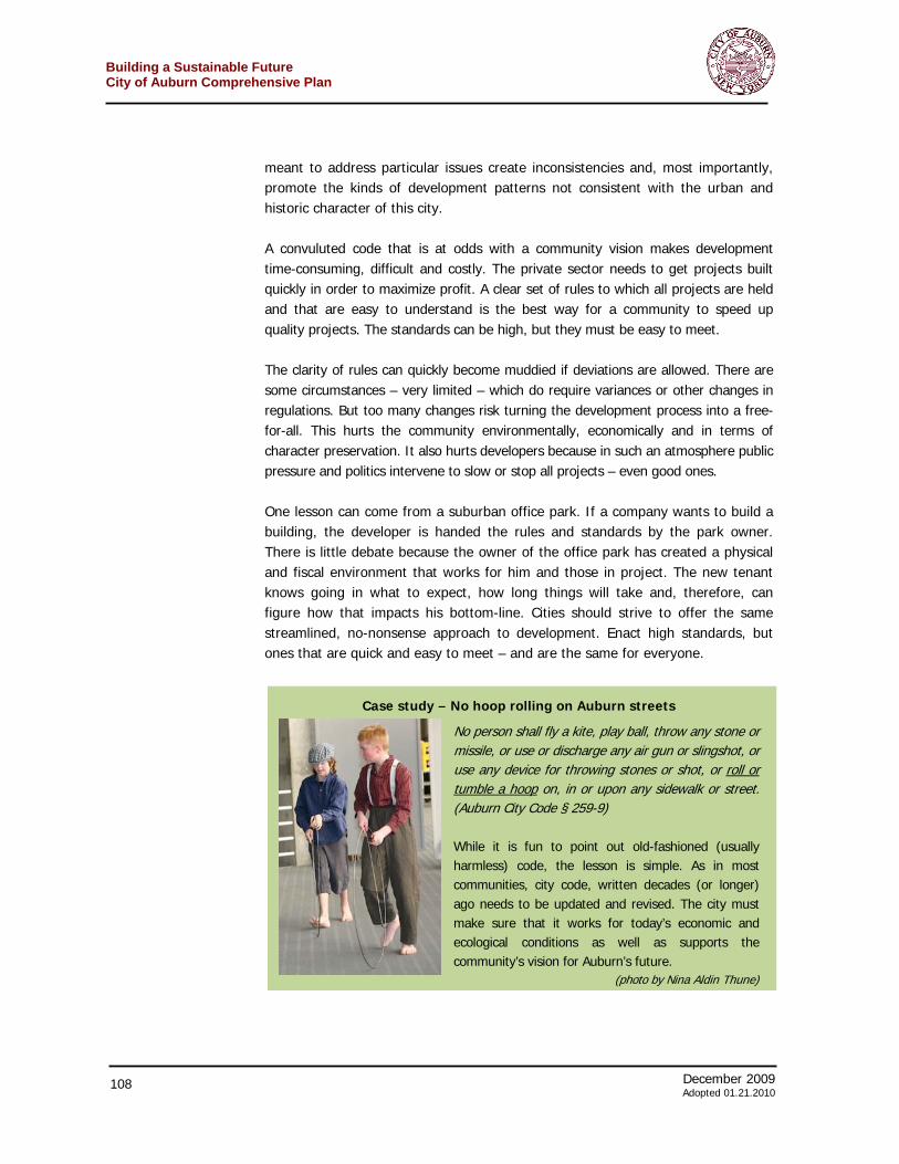
December 2009 105 Adoted 01.21.2010
Building a Sustainable FutureCity of Auburn Comprehensive Plan
> Residential is a high priority to bring people within walking distance (perhaps via paths along the river’s edge) to downtown. However, office and retail should also be allowed.
> Building styles should reflect and enhance Auburn’s urban and historic character Strategy R5 – Develop and promote options for enlarging the Market Street Park along Loop Road. The downtown park is high above the culverted river as the waterway cuts through downtown. The separation from the river is necessary as long as the Loop Road in this area continues to serve a useful function. It is likely that, in the near future, the community will find the road’s transportation function less important and take that as an opportunity to narrow it and put the land to better use. On one side, the extra land might be used to create a sloped portion of the park to get people closer to the river. On the other side, underused parking lots could be targeted by entrepreneurial landowners for infill development creating dense, walkable commercial strip – enlarging downtown and activating this road along the river for pedestrians. The Comprehensive Plan Advisory Committee recognizes that this is a long-term vision.
Strategy R6 – Find ways to open the river to more boat navigation The dams along the Owasco River offer an opportunity for increasing hydroelectric power production. Unfortunately, they also block the ability of boats to travel from Owasco Lake up the river to downtown and beyond. Remedying this situation may be complicated, especially as the community also seeks to reactivate dams for hydropower. Still, it may be worth investigating ways through or around the dams so that boats can navigate as far as downtown. Given likely water levels, there is no expectation that large power boats would be able to make that far. It is more likely personal watercraft would benefit the most. Therefore, the cost/benefit of this strategy will have to be carefully weighed. It is hoped that such a move would boost downtown business and increase the drive for opening access to the river downtown. However, it may not be fiscally feasible given the usually low water levels.
Various strategies have been used to open waterways in many cities to the public. Some of these ideas might be starting points as the Auburn community thinks about reconnecting people to the river in downtown.
Building a Sustainable Future City of Auburn Comprehensive Plan
106 December 2009 Adopted 01.21.2010
Goal 3. Improve and maintain the integrity of the Owasco River as an environmental resource Strategy R7 – Review and improve city ordinances with regards to stormwater runoff. Stormwater runoff carries more than water. As rainwater washes down streets and sidewalks it picks up contamination and nutrients that pollute waterways. Federal rules seek to control this ‘non-point’ pollution by requiring certain-sized new development projects to provide a level of protection against stormwater runoff. The federal rules offer a good starting point, but the city should research and implement regulations that control runoff from all projects. In addition to tightening standards for new projects, the city should create and fund a program to reduce the runoff from existing developments. Also, it is crucial that the city leads by example and do everything possible to reduce non-point source pollution from its own land. Strategy R8 – Undertake a public education campaign to keep the water in the Owasco River clean. A sustained campaign to keep the Owasco River clean will require extensive public information and involvement. The city should continue to fund the watershed inspector position and consider funding a watershed or riparian program to keep the river’s importance before the general public as well as various public officials. Such a program could also be done by or in conjunction with a private non-profit organization collaborating with the city. Such a “Know Your River” campaign also builds and maintains support for other objectives described in this chapter. Strategy R9 – Reactivate the river’s hydropower capacity. In 2004, the citizens of Auburn approved a referendum that created the Auburn Public Power Agency. This allows the city to buy and sell as well as develop its own alternative energy systems. One aspect of this power agency could be the revitalization of hydropower at dams deemed appropriate. The city is already working with the New York Power Authority to evaluate the potential of several hydroelectric sites along the Owasco River, especially in terms of low flow hydrogeneration. Any moves in this arena will also need review by the Federal Energy Regulatory Commission. The city has also received grant money from the state Department of Environmental Conservation for dam stabiliation at the State Dam near the city’s water filtration plant and lower pumping station. The city is already contemplating the installation of low-flow/low-head hydropower at this site. All of these efforts as well as similar ones should be encouraged, supported and expanded.
December 2009 107 Adoted 01.21.2010
Building a Sustainable FutureCity of Auburn Comprehensive Plan
One of the important themes developed during the crafting of this comprehensive plan has been the notion that the city’s rules and regulations should make it easy for the private sector to give the community what it wants. This reflects the understanding that growth in a community comes from private developers. It is the municipality’s role to set the stage for growth and to make sure it adheres to a community vision. Most of the land use rules in Auburn are contained in the Zoning or Subdivision sections of the city code. However, there are other parts of the code which impact community growth as well as economic and environmental sustainability. In addition, the rules contain procedures and processes by which developers, builders, the city, and the general public interact in matters regarding land use. In Auburn, as in so many communities, the zoning code and other land use regulations have become convoluted and outdated. Years of piecemeal changes
Simplifying & Improving Development
Building a Sustainable Future City of Auburn Comprehensive Plan
108 December 2009 Adopted 01.21.2010
meant to address particular issues create inconsistencies and, most importantly, promote the kinds of development patterns not consistent with the urban and historic character of this city. A convuluted code that is at odds with a community vision makes development time-consuming, difficult and costly. The private sector needs to get projects built quickly in order to maximize profit. A clear set of rules to which all projects are held and that are easy to understand is the best way for a community to speed up quality projects. The standards can be high, but they must be easy to meet. The clarity of rules can quickly become muddied if deviations are allowed. There are some circumstances – very limited – which do require variances or other changes in regulations. But too many changes risk turning the development process into a free-for-all. This hurts the community environmentally, economically and in terms of character preservation. It also hurts developers because in such an atmosphere public pressure and politics intervene to slow or stop all projects – even good ones. One lesson can come from a suburban office park. If a company wants to build a building, the developer is handed the rules and standards by the park owner. There is little debate because the owner of the office park has created a physical and fiscal environment that works for him and those in project. The new tenant knows going in what to expect, how long things will take and, therefore, can figure how that impacts his bottom-line. Cities should strive to offer the same streamlined, no-nonsense approach to development. Enact high standards, but ones that are quick and easy to meet – and are the same for everyone.
Case study – No hoop rolling on Auburn streets
No person shall fly a kite, play ball, throw any stone or missile, or use or discharge any air gun or slingshot, or use any device for throwing stones or shot, or roll or tumble a hoop on, in or upon any sidewalk or street. (Auburn City Code § 259-9) While it is fun to point out old-fashioned (usually harmless) code, the lesson is simple. As in most communities, city code, written decades (or longer) ago needs to be updated and revised. The city must make sure that it works for today’s economic and ecological conditions as well as supports the community’s vision for Auburn’s future.
(photo by Nina Aldin Thune)
December 2009 109 Adoted 01.21.2010
Building a Sustainable FutureCity of Auburn Comprehensive Plan
Goal 1. Review and revise zoning rules to make it easy for private developers to undertake projects that fit Auburn’s urban, historic, cultural and environmental vision. Strategy S1 – Require all applicants before the planning board, zoning board or city council describe, as part of their application, ways in which their project meets the vision and goals set out in the comprehensive plan. The residents of Auburn have spent a lot of time developing their vision for the future as described in this comprehensive plan. Yet too often developers, local residents and even public officials fail to consult the plan before the creation or review of site plans – particularly when the rules provide room for discretion. Requiring developers to explain how their applications help the city achieve its comprehensive plan goals ensures that applicants review the plans and apply them to their projects. Also, this regular review reminds public officials, as well as city residents, of their long-term vision. The application process for subdivision and site plan reviews as well as any appeals for a variance could be revised to include the requirement for a short, detailed description about the ways in which the project meets the vision and goals of the comprehensive plan. Given the importance of these plans, the community could make this the first page or item of review applications. Strategy S2 – Streamline and clarify the land use codes In the Boosting Downtown chapter of this plan, one of the important strategies for managing downtown redevelopment was the implementation of form-based code. Such code works best in downtown, but some of its principles would be useful as zoning and other ordinances are revised. The revision of ordinances could be done all at once or neighborhood-by-neighborhood depending upon resources available. Since, form-based codes emphasize what a community wants a place to look like the result is a higher quality built environment than what is achievable with traditional zoning. Form-based codes rely on context to determine appropriate building scale, material, and overall design, and so such a scheme may be well suited to various Auburn neighborhoods. Form-based codes are easier to read and interpret than traditional zoning codes – since they are written in plain English with diagrams and graphics – resulting in a more transparent process for both the public and for developers. Finally, since the “form” is built in, form-based codes eliminate the need for separate design guidelines. Another important change could be the addition of graphics to the zoning code. Too often words, particularly those written into a law, cannot convey true intent and cannot portray an accurate picture of the final result. There are some useful diagrams already in the Auburn zoning code, but sketches, site plans or photographs can
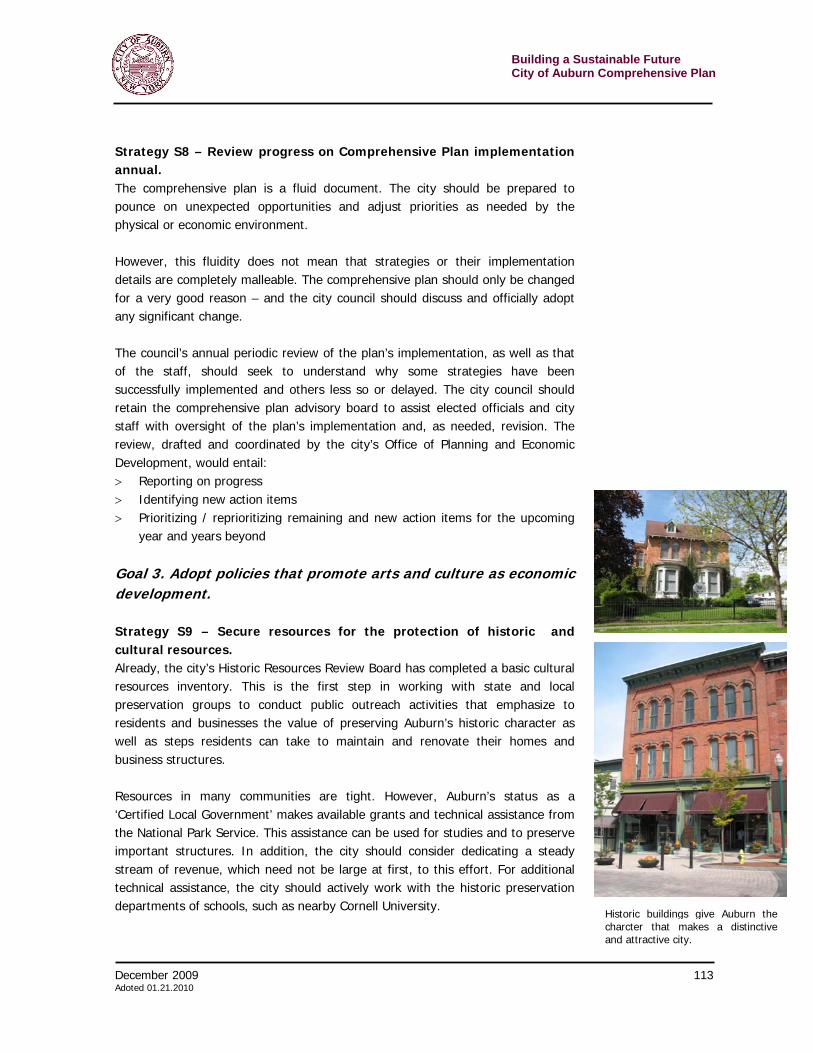
Building a Sustainable Future City of Auburn Comprehensive Plan
110 December 2009 Adopted 01.21.2010
provide developers, builders, review board members, public officials and the public with a more comprehensive vision for the community’s future. Strategy S3 – Revise and unify Definitions In almost all sections of city ordinances that deal with land use, there is a set of definitions. These help readers understand precisely the subject under discussion; they are vital to a defensible and uniform application of the rules across all projects. Unfortunately, over time definitions get muddled. In some cases the definition of a word in one section may be different than one in another. Another common problem is that rules often leak into definitions. For example, section 305-32 in Auburn’s zoning code has the following definition for a “bed and breakfast.”
An accessory use of an owner-occupied single-family dwelling providing overnight accommodations for transient guests who are provided with breakfast as a part of the cost of lodging. Such homes shall be allowed to host small events and receptions reserved by guests and nonguests and limited to invitations only and offer for sale to guests small ornamental items. The maximum number of guests at events shall be determined on a property-by-property basis by the Zoning Board of Appeals.
The second half of the definition, starting with “Such homes shall be allowed…” is a rule, not a definition and should be moved to the appropriate part of the code. Fixing both of these problems – dual definitions for the same words and the inclusion of zoning rules in the definitions – is a simple, but laborius task that can be undertake as the code is rewritten.
Goal 2. Improve operations of the planning and zoning boards. Strategy S4 – Link criteria for the parameters listed in the site plan review to standards elsewhere in the code or provide standards. Current requirements for site plan review, found in § 305-13 of the of the Auburn Zoning code, include a standard list of requirements for an application and a list of parameters against which the planning board can judge an application. An example of some of the items include:
(h) Provisions for pedestrian access;
(i) Location of outdoor storage, if any, and location, design and specific arrangements for storage and access to refuse collection containers;
December 2009 111 Adoted 01.21.2010
Building a Sustainable FutureCity of Auburn Comprehensive Plan
(j) Location, design and construction materials of all existing and proposed site improvements, including drains, culverts, retaining walls and fences;
(k) Description of the method of sewage disposal and location, design and construction materials of such facilities;
(l) Description of the method of securing public water and location, design and construction materials of such facilities;
Some items on the list have standard or engineering criteria against which the planning board can make a judgment. But many of the items, for example, provisions for pedestrian access, lighting plan (not listed above) or landscaping plan (not listed above) do not. As the zoning code is revised and begins to include standards that move projects towards realization of the community’s vision, the site plan review section should refer to those sections. If there are important parameters that are not clarified elsewhere, then the site plan review section should include some general criteria to give developers and board members guidance. Strategy S5 – Require more than four hours of training per year for planning and zoning board members New York State requires that volunteer members of planning and zoning boards get at least four hours of training a year. Typically this training involves reviewing the basic rules and requirements needed for the position. This instruction should be considered a bare minimum. The city can require that board members get an additional two to four hours of training annually. Additional training should focus on the latest techniques and practices that would help the planning and zoning boards work with applicants to maximize the potential of their projects for the community. These strategies could include environmentally friendly development practices, low impact development, pedestrian, bicycle friendliness and the like. A planning board that is thoroughly conversant in these strategies can better help developers understand them as well. Additional training need not be onerous to board members or costly to the community. It is likely that the city planning office or the county planners could conduct or arrange for sessions. These might include guest speakers or webinars. Strategy S6 – Make variances rare Zoning rules provide for the uniform application of adopted standards that will move the community toward its vision. However, zoning presumes that the land it regulates is uniform. The reality is that no two pieces of land are exactly the same, and it can be a challenge to apply fixed standards. A zoning variance is a way to provide a measure of relief from one or more requirements in very limited circumstances on particular pieces of land.
Building a Sustainable Future City of Auburn Comprehensive Plan
112 December 2009 Adopted 01.21.2010
Variances should be granted sparingly because they are permanent and run with the land, not limited to a particular landowner. Also, the zoning board needs to remember that variances set precedence. Under similar circumstances, the board must grant similar variances. The cumulative effect of this can quickly undermine the zoning ordinance and the community’s vision as established in the comprehensive plan. However, it should be recognized that the completion of a comprehensive plan is the perfect opportunity to reset precedence if past variances are at odds with achieving the community’s vision. The plan as well as any rewritten code would contain the rationale needed to break precedence with past variances. Strategy S7 – Institute systems to make sure planning and zoning boards have a complete and defendable record of decisions The decisions rendered by the planning and zoning boards – in conjunction with the comprehensive plan and rewritten zoning – need to make sure projects help achieve Auburn’s vision for an economically and environmentally sustainable future. Unfortunately some applicants will disagree with decisions made by the planning and zoning board. Some may disagree to the point they choose to take the city to court. In these cases, it is important that the boards have a complete and defendable record of their decisions. The first aspect to achieving this defensability is to emphasize written communication and decisions for Auburn planning and zoning boards. All decisions should be communicated to applicants in letter form and should be sure to include a clear and complete list of reasons for their decisions. In Auburn this is happening already and the practice should continue. Another strategy is to provide forms to planning board members on which they can make notes about about the projects, their questions, thoughts and deliberations. The forms, one for each project by each board member, should be saved as part of the project applicant file. These not only become part of the record that back up the final decision, but they also can be referred to when similar projects come before the board. They can serve to remind board members of their thoughts and the rational for their decisions in the previous case. Planning and zoning boards, by their nature, must hear facts and make decisions based upon those facts. As such they should feel free, in complicated or controversial cases, to swear in experts that come before them. While it is unlikely that most developers and their consultants lie to the board, swearing them in would make sure they tell the whole truth. In addition, making transcripts of their “testimony” helps make sure that they are more formal and more careful in their presentations to the board.

December 2009 113 Adoted 01.21.2010
Building a Sustainable FutureCity of Auburn Comprehensive Plan
Strategy S8 – Review progress on Comprehensive Plan implementation annual. The comprehensive plan is a fluid document. The city should be prepared to pounce on unexpected opportunities and adjust priorities as needed by the physical or economic environment. However, this fluidity does not mean that strategies or their implementation details are completely malleable. The comprehensive plan should only be changed for a very good reason – and the city council should discuss and officially adopt any significant change. The council’s annual periodic review of the plan’s implementation, as well as that of the staff, should seek to understand why some strategies have been successfully implemented and others less so or delayed. The city council should retain the comprehensive plan advisory board to assist elected officials and city staff with oversight of the plan’s implementation and, as needed, revision. The review, drafted and coordinated by the city’s Office of Planning and Economic Development, would entail: > Reporting on progress > Identifying new action items > Prioritizing / reprioritizing remaining and new action items for the upcoming
year and years beyond
Goal 3. Adopt policies that promote arts and culture as economic development. Strategy S9 – Secure resources for the protection of historic and cultural resources. Already, the city’s Historic Resources Review Board has completed a basic cultural resources inventory. This is the first step in working with state and local preservation groups to conduct public outreach activities that emphasize to residents and businesses the value of preserving Auburn’s historic character as well as steps residents can take to maintain and renovate their homes and business structures. Resources in many communities are tight. However, Auburn’s status as a ‘Certified Local Government’ makes available grants and technical assistance from the National Park Service. This assistance can be used for studies and to preserve important structures. In addition, the city should consider dedicating a steady stream of revenue, which need not be large at first, to this effort. For additional technical assistance, the city should actively work with the historic preservation departments of schools, such as nearby Cornell University.
Historic buildings give Auburn thecharcter that makes a distinctiveand attractive city.
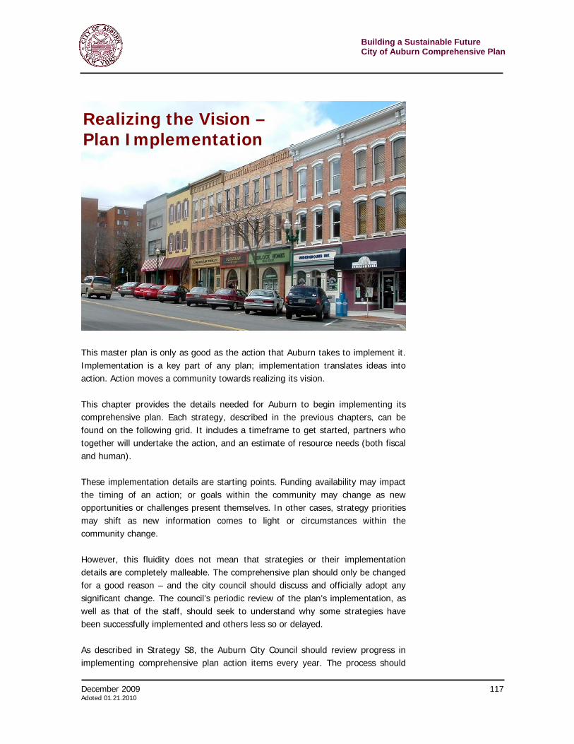
Building a Sustainable Future City of Auburn Comprehensive Plan
114 December 2009 Adopted 01.21.2010
One simple, inexpensive and educational activity, is the creation of a local historic preservation recognition program. Such an initiative could recognize buildings in good repair that contribute to their neighborhood’s historic character. If wanted, such a program could also offer enhanced zoning protections for landmarked buildings. A recognition program, without the legal protections, could be undertaken by the city or a non-profit organization. (See case study box below.)
Goal 4. Make municipal operations more environmentally and economically sustainable. Strategy S10 – Upgrade municipal facilities, equipment and operations including making them more environmentally friendly by incorporating sustainable technology and design into the construction of new municipal buildings and the renovation of old ones. Public dollars are valuable; they must be invested wisely. More and more building owners in both the public and private sectors recognize the fiscal wisdom of investing in buildings and equipment and the pay off over the long term in energy and water efficiency and, therefore, money saved. Auburn should strive to make all municipal buildings environmentally friendly when renovated or newly constructed. As green buildings become common, the cost to build them has dropped. A 2005 study15 by the Massachusetts Technology Collaborative found that the incremental cost of energy efficiency and water saving features was just three percent of the construction costs of municipal buildings – and that dropped to one percent when state and utility incentives were included. On average, the study found, it takes just three years to recoup those upfront costs through energy and water savings. Every year after that, especially as energy prices rise, the savings accrue directly to the taxpayer.
15 See Massachusetts Municipal Association, “Opportunities for reducing energy costs for municipal buildings”, viewed June 11, 2007 at http://www.mma.org/index.php?option=com_content&task=view&id=1111&Itemid=83
Case study – Non-profit recognizes private preservation efforts The Historic Albany Foundation recognizes private buildings that retain their original character, are in a good state of preservation, and contribute to the historical or architectural nature of their neighborhood. The program, initiated and paid for by individual property owners, bases eligibility on the Secretary of the Interior's standards for rehabilitation. For a $300 fee, the Foundation carefully researches the date of construction, first owner, architect, and/or other pertinent information concerning the origin of the building and includes them on with the 7" x 10" cast aluminum or bronze plaque, which can be posted on the building. The voluntary program offers no extra protections for the building.
December 2009 115 Adoted 01.21.2010
Building a Sustainable FutureCity of Auburn Comprehensive Plan
The city could enact an official policy for all new construction and major renovations of existing facilities to meet green building standards. A simple way of doing this is to require buildings achieve a certain threshold in the Leadership in Energy and Environmental Design (LEED) Green Building Rating System™. LEED, devised by the U.S. Green Building Council, is the nationally accepted benchmark for the design, construction, and operation of green buildings. LEED gives owners and operators the tools they need to have an immediate and measurable impact on their buildings’ performance. (Program details can be found at www.usgbc.org/LEED/)
Strategy S11 – Review and upgrade operations and purchases to improve sustainability Existing buildings and equipment, as well as current municipal operations can also be reviewed for environmentally friendly and fiscally lucrative adjustments. Auburn could also do a complete audit of its operations and look for places to protect the environment and the city’s taxpayers. Four places to start might include: > Recycling everything from municipal office paper to DPW construction debris. > Purchasing green power. > Purchasing environmentally friendly vehicles. > Retrofitting street lights with energy efficient, money saving fixtures.
Case study… New Haven’s Energy Savings In 1994, New Haven, Connecticut had annual energy costs of about $14 million spread over 300 facilities and the citywide street lighting system. The mayor established a committee, headed by the city budget director, to create a comprehensive energy work plan. At the close of fiscal year 2005, the city had invested $17.7 million dollars in energy reduction improvements resulting in $24.71 million in saved utility bills and maintenance cost – over $5 million one year alone.
Building a Sustainable Future City of Auburn Comprehensive Plan
116 December 2009 Adopted 01.21.2010

December 2009 117 Adoted 01.21.2010
Building a Sustainable FutureCity of Auburn Comprehensive Plan
This master plan is only as good as the action that Auburn takes to implement it. Implementation is a key part of any plan; implementation translates ideas into action. Action moves a community towards realizing its vision. This chapter provides the details needed for Auburn to begin implementing its comprehensive plan. Each strategy, described in the previous chapters, can be found on the following grid. It includes a timeframe to get started, partners who together will undertake the action, and an estimate of resource needs (both fiscal and human). These implementation details are starting points. Funding availability may impact the timing of an action; or goals within the community may change as new opportunities or challenges present themselves. In other cases, strategy priorities may shift as new information comes to light or circumstances within the community change. However, this fluidity does not mean that strategies or their implementation details are completely malleable. The comprehensive plan should only be changed for a good reason – and the city council should discuss and officially adopt any significant change. The council’s periodic review of the plan’s implementation, as well as that of the staff, should seek to understand why some strategies have been successfully implemented and others less so or delayed. As described in Strategy S8, the Auburn City Council should review progress in implementing comprehensive plan action items every year. The process should
Realizing the Vision – Plan Implementation
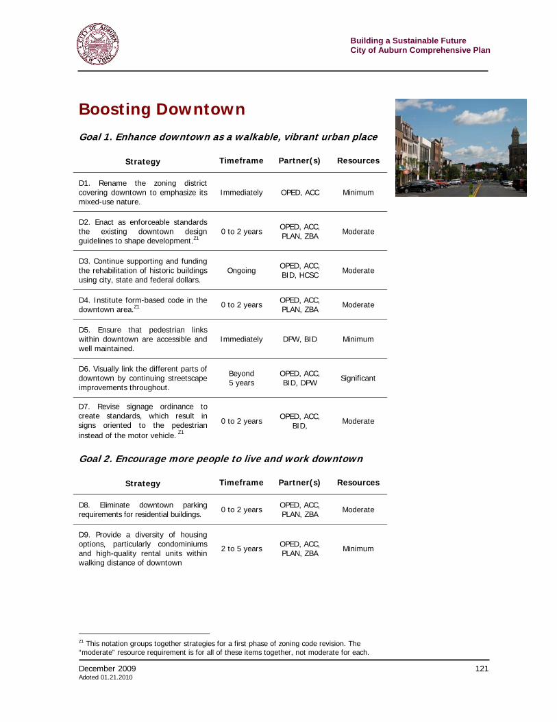
Building a Sustainable Future City of Auburn Comprehensive Plan
118 December 2009 Adopted 01.21.2010
occur concurrently with annual strategic, capital and budget planning. The review, drafted and coordinated by the city’s Office of Planning and Economic Development, would entail: > Reporting on progress > Identifying new action items > Prioritizing / reprioritizing remaining and new action items for the upcoming
year and years beyond This process will produce a short annual Implementation Plan that can be used in conjunction with other city plans. Every five to ten years, the comprehensive plan should be reviewed and updated to ensure that it is still consistent with the overall community vision as well as on-the-ground realities. As described above, each strategy has been assigned implementation particulars in the following categories: Time Frame This category assigns approximate timeframes for strategies to begin implementation. Some strategies will take a significant amount of time for completion, so this category only indicates start times. > Underway – Started as the comprehensive plan was being drafted > Immediately – Should start as soon as possible after plan adoption > 0 to 2 years > 2 to 5 years > Beyond 5 years > Ongoing Partners. As noted in the grid, the Auburn Office of Planning and Economic Development will be instrumental for implementing many of the strategies. However, they cannot act alone and this category lists partners who will be crucial to success. (The top agency listed in this category is the lead organization on the strategy. This is usually the Office of Planning and Economic Development.) Abbreviations used are: > ABC – Auburn Beautification Commission > ACC – Auburn City Council > APD – Auburn City Police Department > BID – Auburn Downtown BID > CCAC – Cayuga County Arts Council > CCE – Cornell Cooperative Extension > CCOT – Cayuga County Office of Tourism > CHAM – Cayuga County Chamber of Commerce > DPW – Auburn Department of Public Works > ENG – Auburn Engineering Office
December 2009 119 Adoted 01.21.2010
Building a Sustainable FutureCity of Auburn Comprehensive Plan
> FIN – Auburn Finance Department > HCSC – Historical and Cultural Sites Commission > OPED – Auburn Office of Planning and Economic Development > PLAN – Auburn Planning Board > ZBA – Auburn Zoning Board Resource needs The categories, described below, take into account both direct expenditures as well as staff time costs. > “Minimum” resource needs indicate that the implementation of the strategy
would likely take less than $10,000 in direct expenditures and could be accomplished within the schedules of existing staff and/or volunteers of the responsible parties.
> “Moderate” resource needs indicate that the implementation of the strategy would take more than $10,000 and less than $50,000 in direct expenditures and would require some coordination between agencies and increased staff time.
> “Significant” resource needs indicate that implementation of the strategy would take more than $50,000 in direct expenditures and would require significant coordination between agencies and significant staff time.
Finally, it is important to note that many of the tasks can be undertaken simultaneously. The numerous strategies that recommend changes to the zoning code are just one example. When a consultant is brought on board, even if to just tackle one piece of the code, it is likely that other changes can be implemented.
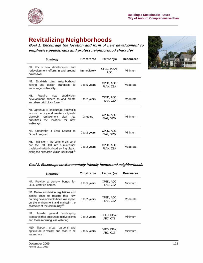
Building a Sustainable Future City of Auburn Comprehensive Plan
120 December 2009 Adopted 01.21.2010
December 2009 121 Adoted 01.21.2010
Building a Sustainable FutureCity of Auburn Comprehensive Plan
Boosting Downtown
Goal 1. Enhance downtown as a walkable, vibrant urban place
Strategy Timeframe Partner(s) Resources
D1. Rename the zoning district covering downtown to emphasize its mixed-use nature.
Immediately OPED, ACC Minimum
D2. Enact as enforceable standards the existing downtown design guidelines to shape development.Z1
0 to 2 years OPED, ACC, PLAN, ZBA Moderate
D3. Continue supporting and funding the rehabilitation of historic buildings using city, state and federal dollars.
Ongoing OPED, ACC, BID, HCSC Moderate
D4. Institute form-based code in the downtown area.Z1 0 to 2 years OPED, ACC,
PLAN, ZBA Moderate
D5. Ensure that pedestrian links within downtown are accessible and well maintained.
Immediately DPW, BID Minimum
D6. Visually link the different parts of downtown by continuing streetscape improvements throughout.
Beyond 5 years
OPED, ACC, BID, DPW Significant
D7. Revise signage ordinance to create standards, which result in signs oriented to the pedestrian instead of the motor vehicle. Z1
0 to 2 years OPED, ACC, BID, Moderate
Goal 2. Encourage more people to live and work downtown
Strategy Timeframe Partner(s) Resources
D8. Eliminate downtown parking requirements for residential buildings. 0 to 2 years OPED, ACC,
PLAN, ZBA Moderate
D9. Provide a diversity of housing options, particularly condominiums and high-quality rental units within walking distance of downtown
2 to 5 years OPED, ACC, PLAN, ZBA Minimum
Z1 This notation groups together strategies for a first phase of zoning code revision. The “moderate” resource requirement is for all of these items together, not moderate for each.
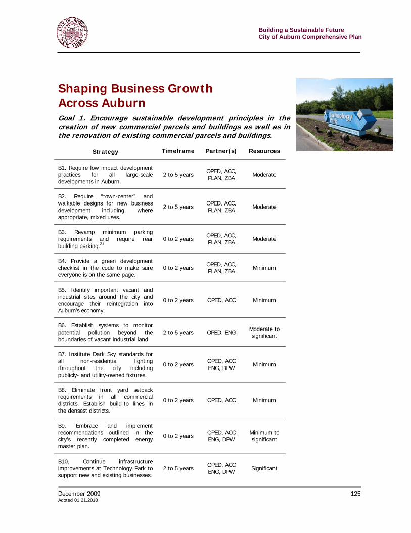
Building a Sustainable Future City of Auburn Comprehensive Plan
122 December 2009 Adopted 01.21.2010
Goal 3. Improve marketing of downtown
Strategy Timeframe Partner(s) Resources
D10. Offer a resource through the BID or city to help shop owners succeed.
Immediately OPED, BID Minimum
D11. Fill vacant storefronts with arts or other signs of life. Immediately OPED, CCAC Minimum
D12. Develop a parking education and signage strategy for downtown 0 to 2 years OPED, BID,
APD, DPW Moderate
D13. Support an aggressive schedule of outdoor festivals. Ongoing ACC, OPED,
BID, APD Minimum
D14. Use street banners to tout Auburn. 0 to 2 years OPED, ACC, HCSC, CCAC Minimum
Goal 4. Develop downtown Auburn as a center for arts and entertainment
Strategy Timeframe Partner(s) Resources
D14. Market the downtown area as one suitable for arts and trades, as well as a great place to live.
0 to 2 years OPED, BID, HCSC,CCAC Moderate
D15. Allow and encourage live/work space downtown.Z1 0 to 2 years OPED, ACC,
PLAN, ZBA Moderate

December 2009 123 Adoted 01.21.2010
Building a Sustainable FutureCity of Auburn Comprehensive Plan
Revitalizing Neighborhoods Goal 1. Encourage the location and form of new development to emphasize pedestrians and protect neighborhood character
Strategy Timeframe Partner(s) Resources
N1. Focus new development and redevelopment efforts in and around downtown.
Immediately OPED, PLAN, ACC Minimum
N2. Establish clear neighborhood zoning and design standards to encourage walkability.
2 to 5 years OPED, ACC, PLAN, ZBA Moderate
N3. Require new subdivision development adhere to and create an urban grid/block form.Z1
0 to 2 years OPED, ACC, PLAN, ZBA Moderate
N4. Continue to encourage sidewalks across the city and create a citywide sidewalk replacement plan that prioritizes the location for new walkways.
Ongoing OPED, ACC, ENG, DPW Minimum
N5. Undertake a Safe Routes to School program 0 to 2 years OPED, ACC,
ENG, DPW Minimum
N6. Transform the commercial zone and the R-3 PDD into a mixed-use traditional-neighborhood zoning district along the new John Walsh Boulevard.Z1
0 to 2 years OPED, ACC, PLAN, ZBA Moderate
Goal 2. Encourage environmentally friendly homes and neighborhoods
Strategy Timeframe Partner(s) Resources
N7. Provide a density bonus for LEED-certified homes. 2 to 5 years OPED, ACC,
PLAN, ZBA Minimum
N8. Revise subdivision regulations and zoning code to require that new housing developments have low impact on the environment and maintain the character of the community.Z1
0 to 2 years OPED, ACC, PLAN, ZBA Moderate
N9. Provide general landscaping standards that encourage native plants and those requiring less watering.
0 to 2 years OPED, DPW, ABC, CCE Minimum
N10. Support urban gardens and agriculture in vacant and soon to be vacant lots.
2 to 5 years OPED, DPW, ABC, CCE Minimum
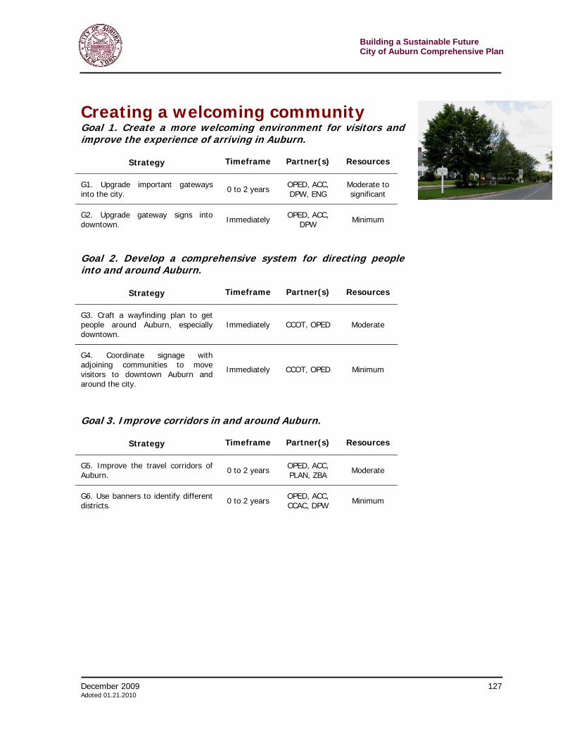
Building a Sustainable Future City of Auburn Comprehensive Plan
124 December 2009 Adopted 01.21.2010
Strategy Timeframe Partner(s) Resources
N11. Partner with the ABC to undertake an urban forestry plan.Z1 0 to 2 years OPED, ACC,
ABC, DPW Minimum
N12. Encourage the reuse of existing historic buildings 0 to 2 years OPED, ACC Minimum to
moderate
Goal 2. Encourage environmentally friendly homes and neighborhoods
Strategy Timeframe Partner(s) Resources
N13. Encourage neighborhood volunteer organizations. Ongoing OPED, ACC,
ABC Minimum
N14. Implement a Landlord Registry Program. 0 to 2 years OPED, ACC Minimum
N15. Increase code enforcement activities in neighborhoods. Ongoing OPED Minimum
N16. Craft a vacant building initiative. 0 to 2 years OPED, ACC Minimum
N17. Develop a home ownership program. 2 to 5 years OPED Minimum
N18. Improve incentives to re-convert homes to single family. 2 to 5 years OPED, ACC Minimum to
moderate
N19. Educate about and enforce sidewalk maintenance standards. Immediately OPED, ACC,
DPW Minimum
N20. Implement traffic calming in residential areas where speed is excessive.
Beyond 5 years
OPED, ACC, DPW Significant
N21. Undertake certain, priority action items from the 2002 Five Points Neighborhood Plan that will allow the area to achieve its vision.
0 to 2 years OPED, ACC, DPW
Moderate to Significant
N22. Undertake certain, priority action items from the 2002 Owasco-Osborne Neighborhood Plan that will allow the area to achieve its vision.
0 to 2 years OPED, ACC, DPW
Moderate to Significant
N23. Undertake certain, priority action items from the 2003 Dunn and McCarthy Neighborhood Plan that will allow the area to achieve its vision.
0 to 2 years OPED, ACC, DPW
Moderate to Significant
N24. Consider rules to allow in-law apartments. Z1 0 to 2 years OPED, ACC Moderate
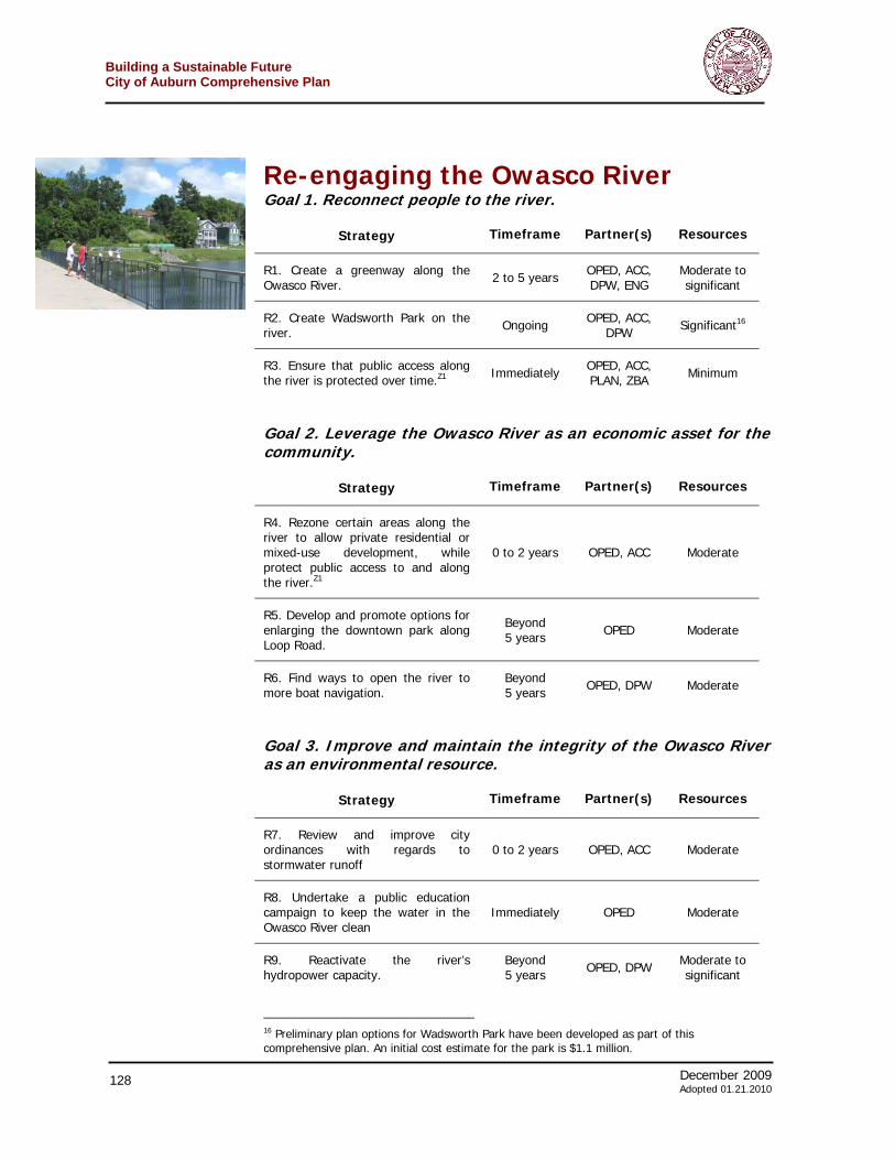
December 2009 125 Adoted 01.21.2010
Building a Sustainable FutureCity of Auburn Comprehensive Plan
Shaping Business Growth Across Auburn Goal 1. Encourage sustainable development principles in the creation of new commercial parcels and buildings as well as in the renovation of existing commercial parcels and buildings.
Strategy Timeframe Partner(s) Resources
B1. Require low impact development practices for all large-scale developments in Auburn.
2 to 5 years OPED, ACC, PLAN, ZBA Moderate
B2. Require “town-center” and walkable designs for new business development including, where appropriate, mixed uses.
2 to 5 years OPED, ACC, PLAN, ZBA Moderate
B3. Revamp minimum parking requirements and require rear building parking.Z1
0 to 2 years OPED, ACC, PLAN, ZBA Moderate
B4. Provide a green development checklist in the code to make sure everyone is on the same page.
0 to 2 years OPED, ACC, PLAN, ZBA Minimum
B5. Identify important vacant and industrial sites around the city and encourage their reintegration into Auburn’s economy.
0 to 2 years OPED, ACC Minimum
B6. Establish systems to monitor potential pollution beyond the boundaries of vacant industrial land.
2 to 5 years OPED, ENG Moderate to significant
B7. Institute Dark Sky standards for all non-residential lighting throughout the city including publicly- and utility-owned fixtures.
0 to 2 years OPED, ACC ENG, DPW Minimum
B8. Eliminate front yard setback requirements in all commercial districts. Establish build-to lines in the densest districts.
0 to 2 years OPED, ACC Minimum
B9. Embrace and implement recommendations outlined in the city’s recently completed energy master plan.
0 to 2 years OPED, ACC ENG, DPW
Minimum to significant
B10. Continue infrastructure improvements at Technology Park to support new and existing businesses.
2 to 5 years OPED, ACC ENG, DPW Significant
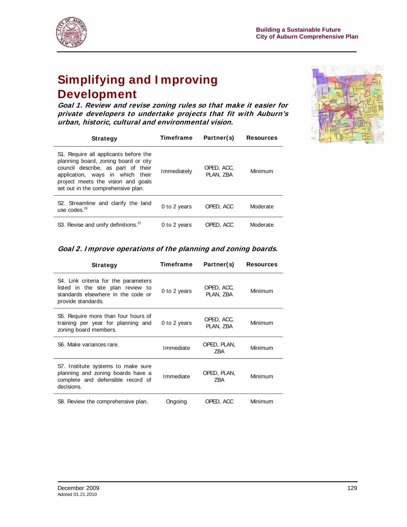
Building a Sustainable Future City of Auburn Comprehensive Plan
126 December 2009 Adopted 01.21.2010
Goal 2. Improve commercial signs so they reflect the character of the city and the character of particular neighborhoods.
Strategy Timeframe Partner(s) Resources
B11. Support the creation of a Finger Lakes Radio Passenger State in Auburn.
Beyond 5 years
OPED, ACC ENG, DPW Significant
B12. Signs shall reflect the desired character of the neighborhood in which they are erected.Z1
0 to 2 years OPED, ACC, PLAN, ZBA Moderate
B13. Discourage pole signs throughout the City, except for the C-3 Highway Commercial areas.Z1
0 to 2 years OPED, ACC, PLAN, ZBA Moderate
B14. Eliminate changeable signs throughout the city except for movie or other performance venues.Z1
0 to 2 years OPED, ACC, PLAN, ZBA Moderate
B15. Set a stricter set of standards for variances to the sign ordinance. 0 to 2 years OPED, ACC,
PLAN, ZBA Minimum
B16. Prohibit billboards within city limits. 0 to 2 years OPED, ACC,
PLAN, ZBA Minimum
B17. Encourage protection of historic signs 0 to 2 years OPED, ACC Minimum
B18. Allow painted signs on building walls. 0 to 2 years OPED, ACC,
PLAN, ZBA Minimum
B19. Revise home occupation rules to focus on impact and not use. 0 to 2 years OPED, ACC,
PLAN, ZBA Minimum
Goal 3. Develop a plan for universal broadband access
Strategy Timeframe Partner(s) Resources
B20. Research and create a plan for wireless broadband access throughout the city.
2 to 5 years OPED, ACC Moderate
Goal 4. Encourage the arts and culture sector as an integral part of Auburn’s economy
Strategy Timeframe Partner(s) Resources
B21. Support existing and future arts and cultural institutions and events. Ongoing
OPED, ACC, HCSC, BID,
CCAC, CCOT, CHAM
Minimum
December 2009 127 Adoted 01.21.2010
Building a Sustainable FutureCity of Auburn Comprehensive Plan
Creating a welcoming community Goal 1. Create a more welcoming environment for visitors and improve the experience of arriving in Auburn.
Strategy Timeframe Partner(s) Resources
G1. Upgrade important gateways into the city. 0 to 2 years OPED, ACC,
DPW, ENG Moderate to significant
G2. Upgrade gateway signs into downtown. Immediately OPED, ACC,
DPW Minimum
Goal 2. Develop a comprehensive system for directing people into and around Auburn.
Strategy Timeframe Partner(s) Resources
G3. Craft a wayfinding plan to get people around Auburn, especially downtown.
Immediately CCOT, OPED Moderate
G4. Coordinate signage with adjoining communities to move visitors to downtown Auburn and around the city.
Immediately CCOT, OPED Minimum
Goal 3. Improve corridors in and around Auburn.
Strategy Timeframe Partner(s) Resources
G5. Improve the travel corridors of Auburn. 0 to 2 years OPED, ACC,
PLAN, ZBA Moderate
G6. Use banners to identify different districts. 0 to 2 years OPED, ACC,
CCAC, DPW Minimum

Building a Sustainable Future City of Auburn Comprehensive Plan
128 December 2009 Adopted 01.21.2010
Re-engaging the Owasco River Goal 1. Reconnect people to the river.
Strategy Timeframe Partner(s) Resources
R1. Create a greenway along the Owasco River. 2 to 5 years OPED, ACC,
DPW, ENG Moderate to significant
R2. Create Wadsworth Park on the river. Ongoing OPED, ACC,
DPW Significant16
R3. Ensure that public access along the river is protected over time.Z1 Immediately OPED, ACC,
PLAN, ZBA Minimum
Goal 2. Leverage the Owasco River as an economic asset for the community.
Strategy Timeframe Partner(s) Resources
R4. Rezone certain areas along the river to allow private residential or mixed-use development, while protect public access to and along the river.Z1
0 to 2 years OPED, ACC Moderate
R5. Develop and promote options for enlarging the downtown park along Loop Road.
Beyond 5 years OPED Moderate
R6. Find ways to open the river to more boat navigation.
Beyond 5 years OPED, DPW Moderate
Goal 3. Improve and maintain the integrity of the Owasco River as an environmental resource.
Strategy Timeframe Partner(s) Resources
R7. Review and improve city ordinances with regards to stormwater runoff
0 to 2 years OPED, ACC Moderate
R8. Undertake a public education campaign to keep the water in the Owasco River clean
Immediately OPED Moderate
R9. Reactivate the river’s hydropower capacity.
Beyond 5 years OPED, DPW Moderate to
significant
16 Preliminary plan options for Wadsworth Park have been developed as part of this comprehensive plan. An initial cost estimate for the park is $1.1 million.

December 2009 129 Adoted 01.21.2010
Building a Sustainable FutureCity of Auburn Comprehensive Plan
Simplifying and Improving Development Goal 1. Review and revise zoning rules so that make it easier for private developers to undertake projects that fit with Auburn’s urban, historic, cultural and environmental vision.
Strategy Timeframe Partner(s) Resources
S1. Require all applicants before the planning board, zoning board or city council describe, as part of their application, ways in which their project meets the vision and goals set out in the comprehensive plan.
Immediately OPED, ACC, PLAN, ZBA Minimum
S2. Streamline and clarify the land use codes.z1 0 to 2 years OPED, ACC Moderate
S3. Revise and unify definitions.z1 0 to 2 years OPED, ACC Moderate
Goal 2. Improve operations of the planning and zoning boards.
Strategy Timeframe Partner(s) Resources
S4. Link criteria for the parameters listed in the site plan review to standards elsewhere in the code or provide standards.
0 to 2 years OPED, ACC, PLAN, ZBA Minimum
S5. Require more than four hours of training per year for planning and zoning board members.
0 to 2 years OPED, ACC, PLAN, ZBA Minimum
S6. Make variances rare. Immediate OPED, PLAN, ZBA Minimum
S7. Institute systems to make sure planning and zoning boards have a complete and defensible record of decisions.
Immediate OPED, PLAN, ZBA Minimum
S8. Review the comprehensive plan. Ongoing OPED, ACC Minimum

Building a Sustainable Future City of Auburn Comprehensive Plan
130 December 2009 Adopted 01.21.2010
Goal 3. Adopt policies that promote arts and culture as economic development.
Strategy Timeframe Partner(s) Resources
S9. Secure resources for the protection of historic and cultural resources.
0 to 2 years HCSC, OPED, ACC Moderate
Goal 4. Make municipal operations more environmentally and economically sustainable.
Strategy Timeframe Partner(s) Resources
S10. Upgrade municipal facilities, equipment and operations including making them more environmentally friendly by incorporating sustainable technology and design into the construction of new municipal buildings and the renovation of old ones.
0 to 2 years DPW, ACC Minimum to significant
S11. Review and upgrade operations and purchases to improve sustainability.
0 to 2 years FIN, ACC Minimum to significant