buckley river–lady loretta district, queensland r.r....
TRANSCRIPT

© CRC LEME 2003 Buckley River–Lady Loretta Page 1
BUCKLEY RIVER–LADY LORETTA DISTRICT, QUEENSLANDR.R. Anand1, J. Wilford2, C. Phang1
1. CRC LEME, CSIRO Exploration and Mining, PO Box 1130, Bentley, WA 61022. CRC LEME, Geoscience Australia, PO Box 378, Canberra, ACT 2601
LOCATION
The Buckley River–Lady Loretta regolith–landform map area lies some 50 km north-northwest of Mt Isa (Figure 1) and covers part of the 1:100 000 KENNEDY GAP (6757) and MAMMOTH MINES (6758) map sheets. The map covers an area of approximately 92 x 35 km and lies between the AMG coordinates of 291000mE, 7837000mN (top left) and 326000mE, 7745990mN (bottom right). The district exemplifi es regolith–landform relationships and some important exploration problems in the Western Succession of the Mt Isa region. This account is largely derived from Anand et al. (1996), Wilford (1997) and Anand et al. (1997).
PHYSICAL SETTINGGeologyThe bedrock geology of the Buckley River–Lady Loretta district consists of Proterozoic rocks of the Mt Isa Inlier, and Middle Cambrian and Mesozoic sediments. Proterozoic bedrock is most
RRAfBR01-03220
Mt IsaCloncurry
200
210
1390 1400
Major roads
Regional and local scalestudy areas
Lady Loretta
DrifterBlinder
Grey Ghost
Python
0 50kmN
Gently slopingPlains
Undulating to rollingFlat
Hill beltsLargely on Proterozoic basement
Dissected palaeosurface
Largely on Mesozoic sediments
Figure 1. Location of the Buckley River–Lady Loretta study area; generalised geomorphic provinces of the Mt Isa region are included.
common; Cambrian and Mesozoic sediments occur mainly over the northern half of the mapped area (Figure 1). Proterozoic bedrock includes siltstones, sandstones, metabasalt, quartzite, stromatolitic dolomite and shale (Hutton and Wilson, 1985). Cambrian sediments consist of siltstone, sandstone, limestone, chert and silicifi ed shale. Mesozoic sediments were deposited on a palaeo-slope dip of about 4° to the north (Hutton and Wilson, 1985) and consist of sandstone, siltstone, mudstone and conglomerate.
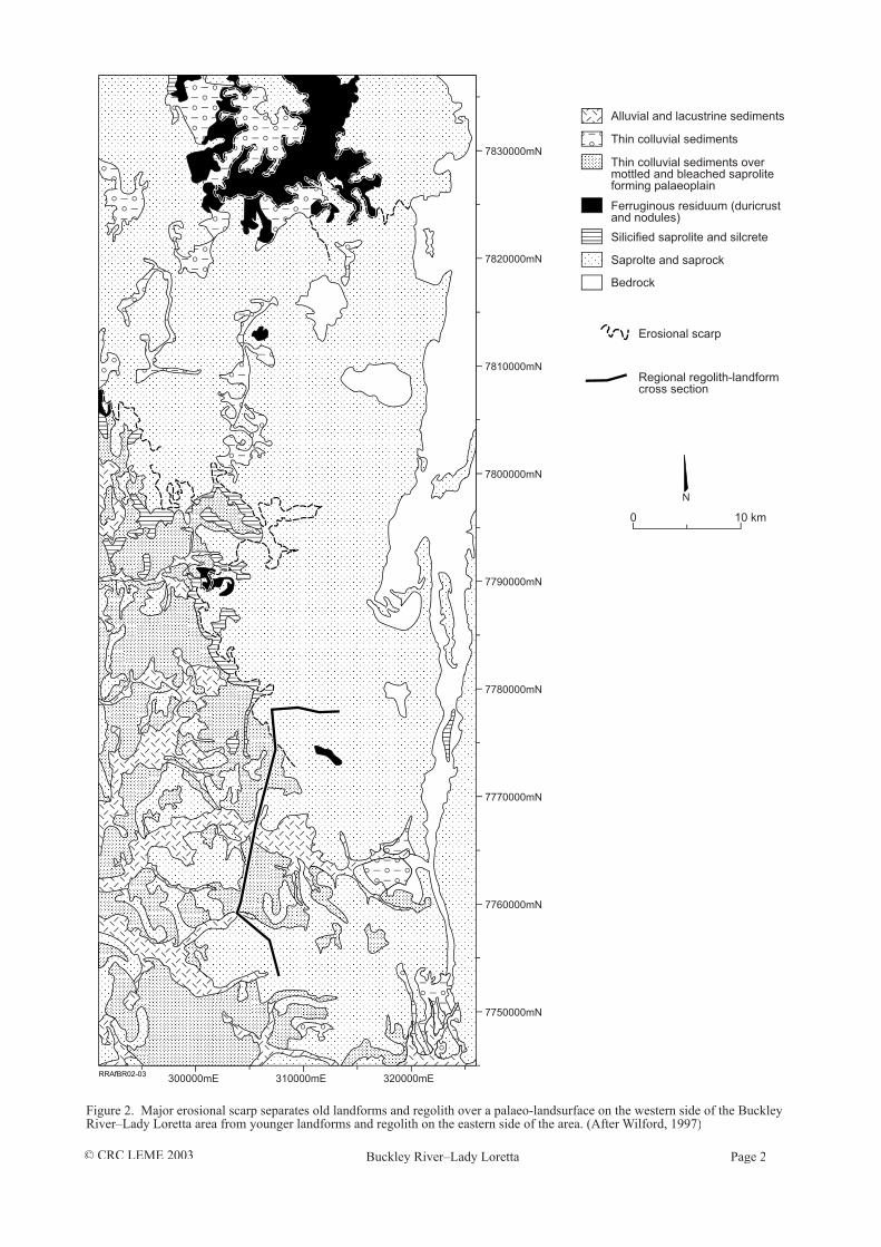
GeomorphologyThe landscape has a low to moderate relief with a series of remnant plateaux separated by extensive erosional and depositional plains. The southwestern part of the area is of low relief with extensive sheet-fl ow colluvial plains and broad fl oodplains associated with Buckley River, Cattle and Johnson creeks (Figure 2). In contrast, actively eroding landforms with generally greater relief (up to 300 m) exists in the north and northeast of the mapped area. A major erosional escarpment separates these two major physiographic regions (Figure 2), which correspond to the Buckley Tableland and Mt Isa Uplands of Smart et al. (1980).
Drainage patterns include open and closed dendritic, weakly braided and trellis. Trellis drainage refl ects the prominent north–south structural fabric of Proterozoic bedrock. Open dendritic and braided patterns are associated with low relief palaeoplains and high relief actively eroding landscapes, respectively. The highest relief is associated with resistant ridges along the northeastern border of the mapped area. Most of the ridges have bevelled tops due mainly to post-Proterozoic planation. Plateau surfaces and bevelled hill tops have developed on Proterozoic, Cambrian and Mesozoic lithologies and are best developed in the north. A major divide separates rivers fl owing west towards the Georgia Basin and those draining north into the Gulf of Carpentaria. The drainage systems fl ow intermittently with all but the largest rivers drying out to discontinuous waterholes in the dry season.
Climate and vegetationThe area has a semi-arid, monsoonal climate with distinct dry and wet seasons. The average rainfall is 500 mm. Mean daily maximum and minimum temperatures range from approximately 35°C to 25°C in December, with corresponding winter temperatures some 10–15°C cooler. Vegetation consists largely of spinifex, acacia shrubs and scattered low eucalyptus. Mesozoic sediments are typically densely covered by Acacia Shirleyi (Lancewood).
© CRC LEME 2003 Buckley River–Lady Loretta Page 2
Figure 2. Major erosional scarp separates old landforms and regolith over a palaeo-landsurface on the western side of the Buckley River–Lady Loretta area from younger landforms and regolith on the eastern side of the area. (After Wilford, 1997)

© CRC LEME 2003 Buckley River–Lady Loretta Page 3
REGOLITH–LANDFORM RELATIONSHIPS
Ferruginous and siliceous duricrusts on Proterozoic bedrock are generally preserved on palaeo-landforms including mesas, buttes and bevelled hills (Figure 3). In many places the erosional scarps form important contacts between different types of regolith, with generally older and typically indurated (Fe or Si) regolith on mesas and younger materials below on pediments. For example, near Buckley River (324605mE, 7755409mN), the mesa is some 20 m high above the surrounding pediments and consists of residual, hematite-rich massive lateritic duricrust over 3–4 m of mottled saprolite on saprolite formed from the weathering of shale. Manganese oxides from this profi le yield ages ranging from 30 to 40 Ma (Vasconcelos, 1997). The surrounding landforms consist of pediments and erosional plains covered with locally-derived ferruginous gravels and much younger thin (<1 m) residual soils formed from in situ weathering of underlying saprolite. Pockets of smectite-rich in situ black soils occur as gilgai. In places, fresh bedrock outcrops.
On mesas, ferruginous or siliceous duricrusts have formed mainly in residual regolith, but they have also developed in transported sands and gravels in valleys that have subsequently become indurated and now form high points in the topography due to relief inversion. These relationships occur around the Python prospect and the Grey Ghost area (Figure 3). The Grey Ghost area is dominated by low hills of silicifi ed saprolite and ferruginous duricrust, and plateaux of silcrete that rise to 60 m above the plain. Columnar silcrete has developed on Mesozoic sediments that overlie silicifi ed saprolite on Proterozoic bedrock. A mesa at a lower elevation than the columnar silcrete capped plateau is capped with slabby, ferruginous duricrust, developed in sandy grit and rounded quartz pebbles, cemented by goethite. At the Python prospect, slabby duricrust occurs on plateaux margins and forms
Colluvium, alluvium Silcrete Mottled saprolite Proterozoic bedrock
Lateritic duricrust Lateritic nodules,pisoliths and mottles
Clay rich saprolite,silicified saprolite
GreyGhost
BuckleyRiver
PythonProspect
JohnsonCreek
Slabbyduricrust
Massiveduricrust
Silificationof alluvium
Nodular/pisoliticduricrust
Massive/nodularduricrust
Slabby duricrustSilicifiedsaprolite
400
360
320
280
240
200
R.L.(metres)
S N NW N E
0 2 km
RRAfBR03-03
Figure 3. Schematic cross section showing the relationship between the landforms and regolith for the regional traverse, Buckley River area. Location of traverse shown in Figure 2. (After Anand et al., 1997)
massive, horizontal plates of quartz-rich material, impregnated by goethite but lacking quartz pebbles.
Ferruginous and silicifi ed saprolite form bevelled hills and rises, whereas saprolite occurs beneath erosional plains and pediments. In places, ferruginous saprolite and saprock occur as high relief landforms, including low hills (30–90 m relief), hills (90–300 m relief) and escarpments. The fl at summits (400–520 m AHD) preserved in quartzite, lack weathering profi les. However, in places, soil materials and colluvium in depressions contain ferruginous pisoliths, suggesting that even these summits may have been blanketed by weathering profi les.
Unconformably overlying the Proterozoic rocks are mesas and buttes of consolidated Mesozoic sediments that retain evidence for prolonged deep weathering; the upper ferruginised and silicifi ed saprolite contains a well developed ferruginous duricrust or silcrete. The duricrust-capped Mesozoic sediments occur at several levels. Most are lower than adjoining areas of Proterozoic rocks. The differences in elevation of the weathered surface suggests that the pre-Mesozoic landsurface had signifi cant relief. The form of the Proterozoic–Mesozoic unconformity can be best explained by infi lling of valleys.
Ferruginous duricrusts developed on Mesozoic sediments typically overlie highly weathered, mottled and in places silicifi ed siltstones and sandstones. In areas dominated by Cambrian sediments, the top of the saprolite is mantled by unconsolidated, well rounded cobbles and pebbles derived from Mesozoic sediments which probably once covered much of the area. Where the Mesozoic sediments have been removed, a thin veneer of cherty breccia or silcrete is revealed which is the base of an older sedimentary sequence (Cambrian) formed on silicifi ed saprolite formed from Proterozoic bedrock.

© CRC LEME 2003 Buckley River–Lady Loretta Page 4
Alluvial sediments on fl oodplains, alluvial plains and alluvial terraces consist of varying proportions of sand, gravel, clay, silt and minor cobbles. The sediments can be up to 15 m thick along major river channels but more commonly are <5 m thick. They generally exhibit upward fi ning (coarser channel deposits overlain by fi ner overbank deposits). The fl ood plains are mainly oriented in an easterly direction and refl ect continuation of an older palaeodrainage system superimposed on the predominantly northerly fabric of the Proterozoic rocks. Channel deposits occur in both active and abandoned stream channels. Some of the main streams, such as Wilford Creek and Buckley River, have well-rounded gravels and cobbles in their channels. Most active, northerly streams are generally smaller than the easterly drainages and have narrow sedimentary corridors. These are generally less than 1 m thick and bedrock is exposed in most channel fl oors. In many places, channel deposits are cemented by Si, clay or Fe to form alluvial hardpan, locally known as ‘creek rock’. This hardpan commonly extends into the weathered rock adjacent to the channels.
Colluvial sediments occur on erosional plains, pediments and footslopes and consist of unconsolidated polymictic gravel and gravel lags with various proportions of sand and clay. The underlying bedrock is generally weathered and mottled. Sediments ranges from <1 to 4 m thick and can have a proximal to distal source.
REGOLITH CHARACTERISATION
The depth of weathering profi les varies and is largely controlled by landscape position, bedrock type and structural features. Palaeoplains and topographic lows are more deeply weathered than the erosional plains and hill belts. At the Python prospect, the depth of weathering is about 90 m on dolomitic siltstones but, near faults and fractures, penetrates to >300 m. Palaeoplains, north of Buckley River, typically record weathering depths of up to 150 m.
Ferruginous duricrusts can be divided into three categories based largely on textural differences. They are massive, nodular and slabby. Ferruginous duricrusts cap deeply weathered profi les which include mottled saprolite, saprolite, saprock and bedrock. The massive and nodular duricrusts have formed in situ on Fe-rich weathered rocks by accumulation of ferruginous material from the mottled saprolite left by down-wasting of the profi le as clays and soluble elements were removed. Saprolite is largely kaolinitic but, at the base of the saprolite and saprock, smectite and mixed layer minerals occur over particular litholgies (e.g., basalts, schists). Mottled saprolite, 2–5 m thick, which overlies the saprolite, is characterised by hematite-rich mottles in a kaolinite-rich matrix and becomes more indurated towards the top of the profi le. There is a gradual transition between mottled saprolite and overlying hematite–goethite-rich massive duricrust which ranges in thickness from 0.5 to 1.5 m. The development of mottles is partly controlled by sub-vertical cleavage or schistosity of the bedrock. In places, higher in profi le, soft, clay-rich masses in
the mottled saprolite have been dissolved leading to its collapse (collapsed mottled saprolite). Collapsed mottled saprolite is composed of large fragments of mottled saprolite in a silty matrix. Where cemented, these form nodular duricrust. Further breakdown of nodular and massive duricrusts has left nodules and pisoliths on the surface, to form a lag.
Slabby duricrust is goethite-rich and is formed by ferruginisation of sediments. Iron in slabby duricrust is thought to be enriched by an absolute accumulation, derived from weathering of a local, upland area, lateral chemical transport and precipitation in a low landscape position.
The massive and slabby duricrusts, which developed on Mesozoic sediments (claystone and sandstone), closely resemble those developed on Proterozoic rocks in that their Fe oxide mineralogy is similar to those on Proterozoic rocks. However, they are relatively enriched in Si, Ti and Zr. Duricrusts have resulted from absolute accumulation of Fe because most contain more Fe than can normally be obtainable from their Fe-poor parent rocks by relative accumulation.
Silcretes commonly occurs as massive, nodular and large columnar jointed sheets. Massive silcrete locally consists of silicifi ed gravels overlying silicifi ed Proterozoic saprolite. Quartz gravel and sand within silcrete suggest that the original material was either river channel or sheetwash deposits. The columns in columnar silcretes may be up to 3 m high with 'caulifl ower-like' tops and fl uted or ropy features on the sides, resembling candle wax drippings, indicative of a pedogenic origin. Jointing may refl ect columnar peds in palaeosols and candle-stick bedding may relate to the movement of solute particles down an old soil profi le which has since been silicifi ed. Alternatively the jointing may relate to shrinking and cracking of the silcrete during de-watering. Silcretes consist mainly of randomly distributed and embayed quartz grains and rock fragments cemented and supported by a microcrystalline quartz–anatase–rutile matrix. Embayment of the quartz grains suggest a possible source for silica in the matrix. Silcretes may contain as much as 92-7% SiO2 as quartz, with TiO2 (2–7% as anatase) and traces of Zr (zircon) making up the remainder.
REGOLITH–LANDSCAPE EVOLUTION
Grimes (1972) proposed three major periods of active erosion and deposition for North Queensland, separated by two periods of stability and deep weathering. At the end of the fi rst cycle (Oligocene) of stability, a deeply weathered and duricrust-capped planation surface, the Aurukun Surface, formed. This surface is now preserved as duricrust-capped mesas. The second cycle, the Kendall Surface, also resulted in a stable landsurface which was deeply weathered and ferruginised. The third cycle, which commenced towards the end of the Tertiary, is continuing.
This study indicates that the landscape is ‘stepped’ with two main surfaces. Whether these surfaces correlate with those proposed by Grimes is problematical, since erosional surfaces will have

© CRC LEME 2003 Buckley River–Lady Loretta Page 5
RRAfBR04-03
1. Late Jurassic
2. Early Cretaceous
3. Late Cretaceous
4. Cenozoic
5. Present Day
Proterozoic bedrock
Proterozoic rocks forming undulating plains and hills, weatheringoccurring in valley floors.
Highest hills protrude above Mesozoic sea. Mesozoic sediments(sandstones, conglomerates and siltstones) infill valleys within Proterozoicbedrock landforms. Local relief is reduced due to valley infilling andbevelling of hills by erosion.
Weathering and erosion of Mesozoic and Proterozoic rocks. Weatheringproducts are retained where rate of weathering is greater than the rate oferosion.
Differential rates of erosion and weathering form a variety of differentweathering styles on Mesozoic, Cambrian and Proterozoic rocks.Ferruginisation and silicification of Mesozoic, Cambrian and Proterozoicrocks form mesas and resistant rises and hills. Some E-W flowing riversare captured and directed to the north. Relief inversion occurs in placesover palaeo surfaces. Alluvial sediments accumulate in floodplains,alluvial plains and sheet wash plains. Scarp retreat, valley widening andpediment development takes place.
Sheet washcolluvium
Bleached andsilicified saprolite
Highly weatheredPalaeo-plain
Erosional scarp
Scarp retreat
SaprockExhumedCambrian
Fe duricrust onProterozoic saprolite
The desert
Buckley RiverNORTHSOUTH
Mesozoic sediments infilling valley
Fe duricrust and silcrete and silicified saprolite Cambrian
Weathering
Fe + Si
Fe + Si
Figure 4. Interpreted stages of regolith–landform evolution over the Buckley River–Lady Loretta region of the Mt Isa Inlier. (After Anand et al., 1997; Wilford, 1997)
different ages on different parts of the surface. The higher of these stepped surfaces forms a palaeoplain in the Buckley River area and is bounded along its eastern edge by an erosional scarp (Figure 2). The surface consists of mesas, erosional plains and rises with typically highly weathered profi les capped with ferruginous or siliceous cappings. This surface was probably developed by the mid to late Mesozoic, and thus equivalent to the Early Mesozoic Surface of Twidale (1956). Since then, relatively low erosional rates due to the low relief, have preserved some of the most deeply weathered regolith over the study area.
Bevelled Proterozoic bedrock hills and extensive Mesozoic plateaux around Lady Lortetta and Drifter to the north may have also been part of this broad plain. However, irregular thicknesses of Mesozoic sediments and undulating contacts with the underlying Proterozoic rocks suggest that this surface was not fl at but broadly undulating. Rising sea level in the Early Cretaceous caused sedimentation in the lower stretches of the main drainages and eventually sediments drowned all but the highest parts of the local topography. The sediments are thickest in the north and northeast towards the depocentre of the Carpentaria Basin. Highly weathered Proterozoic bedrock beneath the Mesozoic sediments may indicate pre-Mesozoic weathering prior to valley fi ling or deep post-Jurassic weathering.
As the sea retreated during the Late Cretaceous the sea fl oor was exposed. Drainages were initiated on the sea bed sediments, fl owing generally north to the subsiding Carpentaria Basin and southwest to the Georgia Basin. East–west drainage superimposition across the predominantly north–south structural grain of the Proterozoic rocks refl ects an early drainage pattern inherited from the exposed sea fl oor cover. This inheritance strongly suggests that the Mesozoic cover extended over a large part if not all of the Buckley River-Lady Loretta region (Figure 4). Some resistant ridges may have protruded as islands surrounded by the Mesozoic sea. Immediately after emergence the area was relatively fl at with most of the Proterozoic hills bevelled as a result of the marine transgression. Most of the relatively soft Mesozoic sediments had been eroded by the end of the Cretaceous uncovering the basement rocks of the Mt Isa Inlier. Regional uplift of the inlier and modest down-warping of the Carpentaria and Georgina basins would appear to be the primary driving forces behind regional erosion and aggradation. Differential erosion following emergence left the Proterozoic basement rocks high in the landscape.
By the early Cenozoic, the Mesozoic sediments had been largely eroded except in the northern and central part of the map sheet area. Highly and deeply weathered Proterozoic bedrock over the southwestern part of the map have been preserved due to the low relief and induration by Fe and Si. The Mesozoic cover was never thick over this part of the landscape and was likely removed shortly after uplift, thereby exposing the Proterozoic rocks to weathering. throughout the Cenozoic. In places, river channel and sheet wash deposits have been ferruginised and silicifi ed. Subsequent erosion has left resistant siliceous duricrusts as relief
inverted landscape elements. Several periods of silicifi cation occurred during the Cenozoic, however, silicifi cation became more common as climatic conditions became more arid from the Late Miocene to the present. Silicifi cation appears to be occurring at the present with siliceous hardpans developing within extensive, low-lying, colluvial-alluvial plains. Either Si overprints ferruginous materials or the reverse, suggesting that conditions favourable for both silicifi cation and ferruginisation have occurred more recently. Ferruginous duricrusts developed on Mesozoic and Fe-rich Proterozoic lithologies. The ferruginous and the highly weathered nature of the Mesozoic sediments may relate to the original abundance of water in the sedimentary sequence. Water would have been associated with the initial deposition of the shallow marine/terrestrial sediments and then later with groundwater fl ow while the sediments still occupied lower parts of the landscape. The availability of the water would have accelerated the weathering process, particularly with regard to the movement of Fe and Si in the sedimentary pile.

© CRC LEME 2003 Buckley River–Lady Loretta Page 6
REFERENCES
Anand, R.R., Phang, C., Wilford, J.R., Wildman, J.E., Li Shu, Robertson, I.D.M. and Munday, T.J., 1996. Regolith-landscape characteristics, evolution and regional synthesis of the Mt Isa region - Progress Report. CSIRO Division of Exploration and Mining, Perth. Open File Report 125. 142 pp.
Anand, R.R., Fraser, S.J., Jones, M.R., Li Shu, Munday, T.J., Phang, C., Robertson, I.D.M., Wilford, J.R. and Wildman, J.E., 1997. Geochemical exploration in regolith-dominated terrain, North Queensland. CSIRO Division of Exploration and Mining, Perth. Open File Report 120. 130pp.
Grimes, K.G., 1972. The Mesozoic and Cainozoic geology of the Cloncurry 1:250 000 sheet area, Queensland. Bureau of Mineral Resources (Geoscience Australia), Canberra. Record 1972/57. 16 pp.
Hutton, L.J. and Wilson, I.H., 1985. 1:100 000 geological map commentary of the Mammoth Mines region, Queensland. Geological Survey of Queensland and Bureau of Mineral Resources and Energy (Geoscience Australia), Canberra.
Smart, J., Grimes, K.G., Doutch, H.F. and Pinchin, J., 1980. The Mesozoic Carpentaria Basin and the Cainozoic Karumba Basin, North Queensland. Bureau of Mineral Resources Geology and Geophysics (Geoscience Australia), Canberra. Bulletin 202. 73 pp.
Twidale, C.R., 1956. Chronology of denudation in northwest Queensland. Bulletin of the Geological Society of America, 67: 867-882.
Vasconcelos, P., 1997. Geochronology of weathering in the Mt Isa and Charters Towers Regions, Northern Queensland. CSIRO Division of Exploration and Mining, Perth. Open File Report 139. 184 pp.
Wilford, J., 1997. Regolith-landform characteristics, evolution and implications for mineral exploration over the Buckley River-Lady Loretta region, Mt Isa. CSIRO Division of Exploration and Mining, Perth. Open File Report 132. 83 pp.