brora back beach, sutherland data structure report
TRANSCRIPT

Brora Back Beach, Sutherland
Data Structure Report
Funded by Historic Scotland and National Lottery Awards For All, with support from The SCAPE Trust, the University of St Andrews and NOSAS

Back Beach, Brora, Sutherland August 2007
by
Janet Hooper and Jacqueline Aitken
with contributions by
Cathy Dagg and Nick Lindsay
Volunteers
Leoma Aitken Brian Adams Rick Bramley Derek Brown
Hannah Brown John Campbell Smith
Anne Coombs Andy Dorin Brian Duff
David Findlay Norman Gibson
Christine Goetz-Catto Charles Hepburn Eddie Keatinge
Elspeth Kennedy Przemyslaw Korczynski
Nick Lindsay Sena Mackay
John-Angus Macleod Meryl Marshall
Richard Munro Richard Murray Jenny Nicholls Penny Paterson Melainey Rose
Carol Ross Olly Ross
Marion Ruscoe Jean Sargent Meg Sinclair
Bill Stobo Mary Stobo Sine Stuart
Morag Sutherland Aisling Wells Anna Welti Peter Wild
John Wombell Trina Wombell
Professional Team Jacqueline Aitken
Cathy Dagg Janet Hooper
Labhaoise McKenna Jane Roberts
Harry Robinson
March 2008

Back Beach, Brora, Sutherland
Contents Page no. 1.0 Executive summary 5 2.0 Introduction 5 3.0 Aims and objectives 7 4.0 Methodology 9 4.1 Excavation 9 4.2 Historical Research 10 4.3 Community Participation 10 5.0 Archaeological and Historical Background 10 5.1 The History of the Salt and Coal Works at Brora 10
5.2 The Scottish Salt Vouchers 23 6.0 Results 26
6.1 Trench 1 26 6.2 Trench 2 29 6.3 Trench 3 34 6.4 Trench 4 37
7.0 Discussion and Recommendations for Future Work 41 8.0 Acknowledgements 44 9.0 Bibliography 45 9.1 Cartographic Sources 45 9.2 Manuscript Sources 45 9.3 Published Sources 47 10.0 Appendices 49 10.1 Analysis of Brora Salt Recorded in the Inverness Salt Vouchers 49
10.2 List of Contexts 52 10.3 List of Finds 55 10.4 List of Drawings 62 10.5 List of Photographs 63 List of Figures
Figure 1 Map showing location of study area. Scale 1:500,000 (Inset 1:1000,000). 8
© Ordnance Survey, by courtesy of Highland Council Figure 2 Extract from John Farey’s map of the Inverbrora coal workings, 1813. 11
Dep.314/17. Courtesy of The Trustees of the National Library of Scotland Figure 3 John Kirk’s Plan of Inverbrora Farm, 1772. Dep.313/3581. Courtesy of The 17 Trustees of the National Library of Scotland Figure 4 Extract from John Kirk’s Plan of Inverbrora Farm, 1772. Dep.313/3581. 18
Courtesy of The Trustees of the National Library of Scotland
3

Back Beach, Brora, Sutherland
Figure 5 Brora salt voucher for quarter year from 5th April 1768 to 10th October 1768 24 (NAS E536/54/1/12/B). Courtesy of the National Archives of Scotland
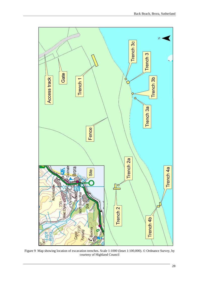
Figure 6 Brora Salt Received for Duty at Inverness (annually), 1768-77 25 Figure 7 Brora Salt Received for Duty at Inverness (quarterly), 1768-77 25 Figure 8 Brora Salt Received for Duty at Inverness (analysed by quarter), 1768-77 26 Figure 9 Map showing location of excavation trenches. Scale 1:1000 (Inset 1:100,000) 28 © Ordnance Survey, by courtesy of Highland Council Figure 10 Dr. Gilbert’s plan of the wall, now known as Site 4, drawn in 1974-5 36
List of Plates Plate 1 Aerial view of Brora from SW. The Winter Port lies in the centre of the 6
photograph, with the early industrial area immediately behind it. Courtesy of Highland Council
Plate 2 Marker stone on coastal road from Brora to Dunrobin 13 Plate 3 The Winter Port at low tide, viewed from above Site 4 16 Plate 4 Exposed part of the wall (Site 2) from S; the floor slabs lie just above the 27
horizontal ranging pole Plate 5 Quoins at NE corner of building from N 27 Plate 6 N wall and E gable [2020, 2022], appearing under the rubble (2008). Taken 29
from SW Plate 7 N wall and E gable [2020, 2022], showing extent of cobble floor (2024). 30
Taken from SW Plate 8 Slabs forming threshold of doorway (2028) within S wall [2027], from NE 32 Plate 9 Central part of building interior, showing red sandstone slabs and bricks (2033) 32
and coal filled pit (2030). Taken from W and above Plate 10 ‘Pillar’ (2038) and larger stones forming floor (2037) in SE corner of building. 33
Taken from W Plate 11 Remaining section of wall [3002], showing both faces and possible additional 34
reinforcement. Taken from NE Plate 12 Trench 3 from S, showing the scatter of probable building stones. The wall 35
[3002] runs across the rear of the trench Plate 13 E end of wall [3002] in Trench 3c, showing potential reinforcement. Taken 36
from NE Plate 14 External face of the wall [4003], showing the W side of the doorway on the 38
right hand side and the midden deposits known as the ‘coal road’ against its base (4008, 4017). Taken from S
Plate 15 Midden deposits (4014), extending into the interior of the building. Taken 39 from N
Plate 16 View of both hearths [4018, 4029], from E 40 Plate 17 Flue of chimney [4018], from above 40 Plate 18 Stone-built hearth [4029], from W 40 Plate 19 View of hearths from N, showing clay and rubble demolition layer sealing 40
them (4010, 4011) Plate 20 The collapsed corner of the building (Site 37), just to the east of Trench 4, 44
January 2008
4

Back Beach, Brora, Sutherland
1.0 Executive Summary This report sets out the results of archaeological fieldwork undertaken in 2007 at the Back Beach, Brora, the second phase of an ongoing interdisciplinary project carried out under the auspices of the Clyne Heritage Society and Shorewatch. The industrial heritage of Brora, in particular the history of the salt and coal works, has been the focus of two previous seasons of survey and a considerable amount of historical research (Aitken 2004; Badger, Cressey and Aitken 2006). The deteriorating condition of the buildings eroding out of the edge of the dunes led to the decision to carry out an excavation in summer 2007, with the support of Historic Scotland, National Lottery Awards for All and The SCAPE Trust. Four trenches were excavated in 2007, two over buildings thought to be associated with the earliest phases of salt production at Brora (1598-1617) and two in the area of the later eighteenth century salt works (1767-1777). Those in the area of the earlier salt works made clear the extent to which the remains on the Back Beach have suffered from erosion. In Trench 1, the NE corner of a building (Site 2) which was clearly visible in the face of the dune, along with its slabbed floor, was identified. However, the depth of deposits and the proximity of the gable to the dune edge meant that excavation could not continue down to expose the floor level as had originally been hoped. Trench 3 was opened up over the long wall which is all that remains of the only building situated at the base of the dunes (Site 4). Unfortunately, the wall proved to be so damaged that little information could be added to the 2004 survey, though secondary strengthening of the wall did become apparent. The investigation of two buildings believed to be associated with the eighteenth century salt works turned out to be far more interesting, particularly as the physical remains can be illustrated through the detailed historical research which has now been completed. Half of a building believed to be the Saltman’s house (Site 19) was taken down to floor level, revealing a substantial and well-built structure. The eastern part of the structure had a cobbled floor, but in the centre of the building the deposits were far more disturbed and more work is necessary to clarify its date and function. A wall, surrounded by extensive midden deposits, had been recently exposed in the face of the dune just to the south west of the Saltman’s house (Site 37). A trench opened up behind the wall uncovered part of the interior of the building behind it, apparently a pan house, as it contains two hearths within a wall which could have supported the pan itself. Following partial demolition and stone robbing, both structures appear to have been deliberately sealed with a layer of building debris and clay. 2.0 Introduction The history of Brora, in the parish of Clyne, on the east coast of Sutherland, is dominated by its long industrial past. These industries, including coal mining, salt panning, tweed production, distilling, electricity generation, etc., go back at least to 1598, though the coal is first referred to in a charter of 1529 (Origines Parochiales Scotiae 1855, 727). They were encouraged by the Earls (later Dukes) of Sutherland and it is perhaps the financial support provided by the estate, in conjunction with the availability of a wide range of resources (both natural and human) which made Brora the ‘Industrial Capital of the North’ in the late nineteenth century. The Back Beach at Brora formed the focus of many of these early industrial activities. The Back Beach is an area of links lying to the south west of the Brora river, from which it is separated by the early nineteenth century fishertown and the harbour of Lower Brora. A prominent raised beach defines its western boundary. Much of the northern half of the area is laid out as a golf course, known as Gleneagles, within which the remains of a WWII radio station form prominent features. The main concentration of archaeological sites lies to the south west of this, where the area begins to narrow; this part of the links is now used solely for pasture. No obvious topographical feature forms the southern boundary of the site, rather the division seems to be the boundary between the farm of Inverbrora (on which the Back Beach lies) and the township of Doll to the west. The shoreline itself is very undulating, with the obviously eroding buildings which form the focus of this project situated at
5

Back Beach, Brora, Sutherland
the highest points, close to an area of cleared beach known as Port a’ Gheamhraidh or the Winter Port. The Brora coal seams outcrop all the way along the foreshore south of the Brora river, but were particularly prominent at this point: The coal is seen on the shore at Brora, near the old salt pans; and at this place it has frequently been dug, the overlying roof bed having been removed by blasting, it now forms a very conspicuous reef on the shore at low water (Polson 1902).
Plate 1 Aerial view of Brora from SE. The Winter Port lies in the centre of the photograph, with the early
industrial area immediately behind it. Courtesy of Highland Council Salt pans were established adjacent to the most northerly coal pits in Britain in 1598. It was hoped that utilising the large amounts of poor-quality coal (‘small coals’ or ‘pan coal’) mined at Brora to evaporate salt water and turn it into salt would help make both ventures more profitable. Located on the Back Beach, close to the Winter Port, this early industrial phase was short-lived, though another attempt was made in 1614, when the pans were replaced. In 1767, the salt industry was resumed close to the earlier location. This third phase of activity finds its origins in the re-organisation of the Highland estates in the aftermath of Culloden in 1746, but came to an abrupt end in 1777. In the early
6

Back Beach, Brora, Sutherland
19th century, during the Clearances, the salt and coal industries at Brora were again revived by the Marquis of Stafford. New salt pans were established close to the harbour, while a coal mine was opened up further inland, on the north bank of the river (where the coal, though far deeper, was of higher grade). These operations were curtailed in 1825, following the abolition of the Salt Tax and the sudden availability of cheaper foreign salt. Though the coal mine was re-opened in 1872, continuing to operate until 1974 when it finally closed, no further attempts were made to resurrect the salt works. One of the authors, Jacqueline Aitken, grew up in Brora, playing on the Back Beach. In part at least, awareness of the walls and middens eroding out of the dunes, led to an interest in archaeology. As part of Aberdeen University’s Scottish Field Archaeology course, a detailed inspection of the visible archaeology at the Back Beach was undertaken in 1999. Since then as much material as possible - derived from the knowledge of local people, surface finds, and the Sutherland estate records - has been collected by the Clyne Heritage Society, forming the focus of exhibitions mounted in the Brora Heritage Centre. In 2004, as part of the Shorewatch project, members of the society and the North of Scotland Archaeology Society (NOSAS) recorded the sole remaining, long wall of a building on the beach now known as Site 4, which was actively eroding (Aitken 2004). The following year, CFA Archaeology Ltd (CFA), in conjunction with Clyne Heritage Society, carried out far more comprehensive recording of the archaeological features visible on the Back Beach (Badger, Cressey and Aitken 2006). An EDM survey of the whole area was completed, alongside detailed recording of the eroding features and soil-augering to determine the extents of buried archaeology behind the face of the dunes. In order to set these remains in context, the large corpus of documentary and cartographic material already collected was collated into an account of the salt and coal industries at Brora. This work highlighted the potential of the site, as well as the degree to which evidence was being lost through continued erosion. A map of the area of the Back Beach, compiled in 1813 and referred to frequently below, suggested that the walls obviously eroding out of the dunes could be related to the ‘Old’ and ‘New’ Salt House. The Old Salt House, which dates back to the turn of the seventeenth century, was already ‘washed and covered by the waves of every Spring Tide’ in 1813, while the lack of detail given for the New Salt House, which had only gone out of use in 1777, suggests that it had been buried in sand (Farey 1813; fig. 2). The re-appearance of a wall in spring 2007 in the location of the ‘New’ salt works graphically illustrates the instability of the dunes along the edge of the Back Beach, while also suggesting that active erosion may be increasing. These concerns led to the development of an excavation strategy which sought to assess the nature of the remains associated with the Old and New Salt Works and to ensure the preservation ‘by record’ of those sites which are actively eroding. A group of volunteers, including local people and members of Clyne Heritage Society and the North of Scotland Archaeology Society (NOSAS), led by a team of professional archaeologists, undertook a three week excavation in August 2007; the project was supported by Historic Scotland, National Lottery Awards for All and The SCAPE Trust. 3.0 Aims and Objectives In spite of its importance in both domestic and commercial contexts, little is known about the production of salt in Scotland prior to the eighteenth century. Even after this date, most research has been concentrated on the main centres of production along the shorelines of the Firths of Forth and Tay. The importance of the export of salted fish to the economy of the settlements around the Moray Firth is well known; the geographical separation of this area from the principal production centres (whether in Scotland or further afield), is likely to have resulted in a considerable demand for salt. If this could be produced locally, much of the additional expense of importing salt could have been avoided. Therefore, Brora is of particular significance as it offers an opportunity to investigate three quite distinct chronological phases of production, in a location where the physical remains associated with salt making can be elucidated through a comprehensive documentary record.
7

Back Beach, Brora, Sutherland
Figure 1 Map showing location of study area. Scale 1:500,000 (Inset 1:1000,000). ©Ordnance Survey, by
courtesy of Highland Council
8

Back Beach, Brora, Sutherland
The specific objectives of the project were: • Continued research into the history of the salt and coal works in Brora
The relatively few sources available for the 16thC/17thC industrial activities had been collated, but a wealth of information relating to the late 18thC/early 19thC phases was known to be present (in manuscript form) in the archives in Edinburgh.
• Excavation of those sites facing imminent destruction
The 2006 survey highlighted a number of sites which were actively eroding. In addition to retrieving as much information as possible before the sites were lost, the intention was also to provide local volunteers with training in archaeological techniques.
• Raising community profile
Though many people in Brora were aware of the walls eroding out of the dunes (and remembered them in a much better state of preservation), there is a lack of local knowledge about these sites, which appears to reflect the displacement of the population brought about by the Clearances and creation of the new planned village of Brora after 1810. It was hoped that, in addition to involving local people in the excavation, the profile of Brora’s industrial heritage would be raised within the community.
4.0 Methodology 4.1 Excavation In order to meet the objectives outlined above, four trenches specifically targeting those buildings which were eroding were opened up. As this was the first season of excavation, trenches were initially small, being expanded where appropriate when a clearer idea of the deposits being encountered had been achieved. Trench 1 was intended to examine a structure with a slabbed floor (Site 2), which was eroding out of the dune at the east end of the site. The trench was located behind the face of the dune in the hope of exposing its gable wall and the floor level. Below and just to the west of this, it was hoped that more information could be gleaned about the long wall, originally examined in 2004, by opening a wider trench across it (Site 4, Trench 3). Though not actively eroding, a trench was laid out over the building recorded as Site 19. As this building could be almost certainly identified, on the basis of the cartographic evidence, as the Saltman’s house (Trench 2), it was hoped that this trench would act as a ‘control’. A fourth trench was laid out behind a wall which had recently been exposed in the eroding face of a dune to the south west of Site 19. Trench 1 was opened up using a machine, because of the depth of overlying sand, but the other three trenches were entirely dug by hand. Except for Trench 3, where the overburden consisted of beach deposits, the turf was cut using spades and stored in coursed stacks. All deposits and features were exposed in plan, with discrete features being first sectioned; stratigraphic control was ensured by the deep sections created by the trench edges. All contexts identified were recorded in written form on pro forma sheets, were drawn in plan at scales of 1:20 and in section at 1:10, and were also photographed at all stages of the excavation. Each trench was given a unique sequence of context and finds numbers and a daybook was kept for each trench. The location of each trench was recorded by EDM. Spoil was stored on tarpaulins to prevent damage to the underlying vegetation. Prior to backfilling, geotextile was laid down and the deposits returned in the order in which they had been removed. This was done by hand, except in the case of Trench 2, where it was possible to return the spoil carefully by machine. The turf was replaced last, restoring the original appearance of the ground as far as possible.
9

Back Beach, Brora, Sutherland
4.2 Historical Research Although a considerable amount of historical investigation had already been undertaken by Jacqueline Aitken, this phase of work provided an opportunity to build on this through a co-ordinated program of research. Much of this effort was concentrated within the archives held in Edinburgh, where the Sutherland Estate Papers and other primary sources, are located. The desk assessment involved:
• The Sutherland Estate Papers, held in the National Library of Scotland, including the maps in the National Map Library
• Petitions and other relevant documentation, including Scottish salt vouchers, held in the
National Archive of Scotland, Edinburgh • Consultation of primary and secondary documentary material, such as the Statistical
Accounts, held by various libraries and archives
• A thorough review and collation of all pictorial, written and oral records relating to the site, held locally
• Elucidation of the remains visible on site, through the documentary, cartographic and oral
records, alongside comparative material drawn from other salt works around Scotland 4.3 Community Participation Throughout the excavation, training in archaeological field techniques was given to the local volunteers participating in the fieldwork, building on the skills many already possessed. In addition to excavating, there were also opportunities to undertake fieldwalking, metal detecting and erosion monitoring. Volunteer participation was encouraged through Clyne Heritage Society, NOSAS and Shorewatch. Locally, volunteers also came as a result of promoting the excavation in Historylinks in Dornoch and Timespan in Helmsdale and by advertisements put up throughout Brora and in the local press. Though the excavation took place during the school holidays, other volunteers came through the local learning centre. An open day was held, advertised through the Clyne Heritage Society and in the local press. During the excavation, there were numerous visitors, around 300 in total, many of whom dropped by every day while they were walking their dogs. Community and volunteer involvement has been maintained over the winter, through two finds days, attended by those who took part in the excavation. Monitoring of the beach by Clyne Heritage Society has continued. The results have been presented to the public as part of Highland Archaeology Fortnight and, locally, at Clyne Heritage Society’s AGM. It is intended to put on interpretative displays in Brora and in surrounding communities. 5.0 Archaeological and Historical Background 5.1 The History of the Salt and Coal Works at Brora An historical account of the first two phases of industrial activity at Brora was compiled in 2005 (Aitken in Badger, Cressey and Aitken 2006, 10-7). This information will not be repeated here, but in order to provide a context for the later developments, a summary of the main events is presented below. Prompted by the findings from the excavations undertaken on the Back Beach in summer 2007 (see 6.0), subsequent historical research has concentrated mainly on the third phase of salt and coal activities at Brora, dating from about 1747 to 1777, with which the excavated physical remains can be associated.
10

Back Beach, Brora, Sutherland
1598 to 1617
• Salt and coal phase one - 1598 to after 1601 (Initiated by Lady Jean Gordon, Countess of Sutherland)
• Brora created a burgh in 1601
(Granted by King James VI of Scotland)
• Salt and coal phase two - 1614 to about 1617 (Initiated by John Gordon, Earl of Sutherland)
• Sir Robert Gordon’s account of the Earldom of Sutherland c. 1631
(First historical references to salt being made at Brora)
• Mineral survey by John Farey, 1813 (Includes historical account of early industries)
Figure 2 Extract from John Farey’s map of the Inverbrora coal workings, 1813. Dep.314/17. Courtesy of The
Trustees of the National Library of Scotland Mid 17th to Mid 18th Century There is a significant gap between the second and third phases of salt production at Brora, i.e. from about 1617 to 1767. The main source of information for these seemingly unproductive years is ‘The Sutherland Book’ (1892), compiled by Sir William Fraser, who tirelessly transcribed Sutherland Estate
11

Back Beach, Brora, Sutherland
charters, correspondence and memoirs. There are hints in certain charters that the salt and coal rights at Brora were made available to lessees: giving the said lessees power to erect coal mines and salt works, and dispose of the produce thereof, but to leave them entire at the expiry of their lease………And if the said lessees should erect coal mines and salt works, they shall deliver two loads of coal weekly free for the use of his lordship’s house, and a chalder of salt yearly for three years, and thereafter in addition, make payment of one thousand merks yearly as casual rent therefor (Charter, dated 7th and 12th August 1675, quoted in Fraser 1892). However, no information has come to light so far to indicate whether any of these privileges were acted upon.
Another important source is an account of the minerals on the estate of Sutherland by John Farey, dated 1813. He was a pioneer English geologist, and his map of Derbyshire completed in 1811 is considered to be one of the very first true geological maps of England (Ford et al 2001; fig. 2). In his lengthy report, Farey included a history of the Sutherland coal works up to 1778, incorporating information obtained from local sources. His account covers all three phases of salt production, as well as containing dates, names and events associated with these industries. He also refers to a tragic accident which took place at the mine early in the 18th century: In an early part of the last century, the Earls of Sutherland appear to have ---- the Inver Brora Coal-Works, and the remains of four pits are still visible, in the south eastern sides of Shean Park, which were wrought in this period, in the third of which, reckoning from the south, 15 men lost their lives at one time by the falling of the roof, according to the tradition, and the 2nd of these pits near to the ruins of the Salt-maker’s House….. (Farey 1813; fig. 2). It has been suggested that mining techniques at Brora must have been quite advanced for so many people to have died in a single accident (Owen 1995). The year in which this accident occurred is not known, but Farey implies that the mine was revived earlier than is recorded in 1747. Post 1746 It is recorded that the coal mine was revived in 1747, some years before the salt works. A horse gin was erected by Kenneth Baillie of Dornoch and a number of people from the Doll were employed as labourers (Bangor-Jones 1995). However, it is thought that the mine closed again in 1748. This short-term revival took place under the direction of William, Earl of Sutherland. In the aftermath of the Battle of Culloden in 1746, thirteen Jacobite estates were forfeited to the Crown, though having supported the victorious Hanoverian cause, the estate of Sutherland did not fall into this category. In 1752, an act of Parliament was passed whereby the rents collected from the forfeited estates would be used to develop heavy industries, such as mining, as part of a quite deliberate attempt to assimilate the Highlands into Lowland culture (Berry 1997, 8-19; Whatley 2000, 106). The estate of Sutherland was able to draw funds from the Annexed Estates commission to subsidise the revived industrial works at Brora. John Williams It is understood that the Annexed Estates commission contributed a proportion of the funds required to conduct trials for coal at Brora in 1764, supplemented by money from the Earl of Sutherland himself. In September 1764, the coal mine was leased to John Williams, a prominent Welsh mineral surveyor. He had worked in many parts of Scotland, providing advice on coal trials at different works, before coming to Brora. He published a major work in 1789, ‘The Natural History of the Mineral Kingdom’, which drew him to wide attention and brought him a gold medal from Empress Catherine of Russia (Knight 1843, 400-1). Williams is also credited with bringing attention to the subject of vitrified forts. He visited many of these sites while conducting certain mining operations in the Highlands under the orders of the Board of Annexed (or Forfeited) estates in 1773, publishing ‘An Account of some
12

Back Beach, Brora, Sutherland
remarkable ancient Ruins lately discovered in the Highlands and Northern Parts of Scotland’ in 1777 (ibid.). John Williams began a series of coal trials at Brora and by New Year 1765 he was raising coal to the surface. Sufficient coal was got up to make six fires and it was found that the coal burnt ‘exceedingly well’ (Bangor-Jones 1995). However, the early indications of success were short-lived and the venture was fraught with problems. Although Williams was optimistic about the benefits the coal would bring to the surrounding district (for burning lime), the lack of sales suggested a more uncertain future for the industry. He outlined his situation in October 1765 to the Board of Annexed Estates in the following letter extract: You’ll please therefore to acquaint the hon. Board, that the 100£ I got in Augt. enables me to bring north colliers and horses, that I have now 9 colliers at work beginning to raise coals, I have room enough for 30 or 40 more, that the coals appears pretty well, & I expect will do so great good to the country. It falls pretty small in working being a little too free, so that it turns out more panwood than great coal, & the small does not cake, yet as there is 8 Shires who use lime, within 2 or 3 hours sail of the coal, those of Banff, Elgin, Nairn, Invernefs, Cromarty, Rofs, Sutherland & Caithness, I expect their getting panwood here at a very easy rate…………, for tho’ I am now beginning to raise coals., & I have some few on the hill mostly small coal, yet the weather has been so rugged of late in this country that no boat could come here, & as winter is ? on apace, & that people are not in the use of coming here, I suspect there will but few coals go off till spring (Letter from John Williams to Harry Barclay, Board of Annexed Estates, dated 16 Oct 1765). The situation did improve in spring 1766, but Williams was still complaining about having to supply coal to the estate house, smiddy and lime kiln at a low price. From his account of January 1766, it is clear that the coal was transported by cart from the coal works, along a coastal path for 5 miles to Dunrobin Castle (NLS Dep.313/1664). Part of this trackway is still in existence and is lined with roughly hewn stone road markers (plate 1).
Plate 2 Marker stone on coastal road from Brora to Dunrobin
Further setbacks to Williams’ ambitions continued to occur. The Customs at Inverness imposed a duty, equivalent to 3s 6d (17½p) per ton, on coals being transported within the Moray Firth (Bangor-Jones 1995). The Earl died on the 16th June 1766 and was succeeded by his daughter, Elizabeth, Countess of Sutherland, who was only one years of age. The young Countess went to live with her aunt, Lady Alva, in Edinburgh and the responsibility for estate management fell to a group of tutors made up of highly influential men. Finally, having undertaken to supply coal to Portsoy merchants, James Robertson & Co., disaster struck. Brora coal, in general of quite poor quality, was liable to spontaneously combust when exposed to air and moisture; a cargo being shipped across the Moray Firth caught fire, when the vessel was said to have sprung a leak. The subsequent alarm amongst
13

Back Beach, Brora, Sutherland
Williams’s customers was so great that they declined to deal with him for such a dangerous commodity. The local inhabitants, however, seem to have been more used to the problem: At some distance, and near the sea, are small strata of coal three feet thick dipping to the east, and found at the depth of about 14 to 24 yards. Sometimes it takes fire on the bank, which has given it so ill a name, that people are very fearful of taking it aboard their ships. I am surprised that they will not run the risk, considering the miraculous quality it possesses of driving away rats wherever it is used. This is believed by the good people of Sutherland, who assured me seriously of its virtues; and they farther attributed the same to the earth and very heath of their country. They add too, that not a rat will live with them, notwithstanding they swarm in the adjacent shires of Ross and Caithness (Pennant 1769 (1979), 172). New Salt Works, 1767 In spite of the difficulties inherent in transporting coal, Williams convinced James Robertson to join him in a venture to establish new salt pans at Brora. This venture had been proposed by the Commissioners of the Annexed Estates and received support from the Tutors. It provided the lifeline Williams needed to continue his contract at the mine: Please also acquaint the hon. Board I have got Mr. Ja. Robertson & Co merchts in Portsoy to join me to set on a number of Salt pans here, if we get liberty from the tutors for the young Countefs; which will be an effectual consump for the small coal; & certain means of improving this part of the north country, & of the estate of Sutherland: wherefore I hope the hon. Board will use their interest to procure us liberty to set on foot, a work that promifes such good effects; & that can do harm to nobody. Salt pans will certainly be the life of the coal, by effectually helping the increasing lime trade to consume the small coal, which the work produces in great quantity, & so enable me to produce the more house fuel (Extract from letter from John Williams to Board of Annexed Estates, dated 5th Nov. 1766, NAS E727/46/6) In January 1767, James Robertson sent a Mr Watson from near Forres, who had been in charge of the Wemyss salt works in Fife for many years, to report on the prospects for salt-making at Brora. Watson believed the prospects were favourable, providing Williams could supply enough poor quality or ‘small coals’ at a more reasonable price (Bangor-Jones 1995). The partners went ahead and built a new salt house, which appears to have been constructed about 200 yards west of the old salt house at the junction of the beach and the links (figs. 2 & 3). Williams’ letter to the Board was followed four months later by a petition outlining the work required to furbish the new salt works and the costs involved (NAS E728-42-3-1). It is transcribed here in full, as it provides a fascinating insight into the type and number of buildings required:
Unto the Right Honble the Board of Commifsioners for Managing his Majesties Annexed Estates in Scotland.
The Petition of James Robertson and Coy Merchants in Portsoy and John Williams Tacksman of the
Coal of Brora in Sutherland.
Humbly Sheweth That sometime ago it pleased the Honble Board of Annexed Estates to give very large Encouragement & Afsistance to the said John Williams, one of your Petitioners, to enable him to open & carry on the Coal of Brora in Sutherland; and accordingly that work was set agoing, so as to be able to supply a considerable part of the adjacent Countrys with Coals from thence, But from two unforeseen accidents, has found by Experience that the Coal of Brora is not so valuable for House fewel, or for Sea carriage, as could be wished. The one is, great part of it, breaks small in working & carriage and that small does not cake. The other fault of the small of this Coal is, it is very apt to, and really does take fire of itself when laid in heapes for any time within doors, or without; wherefore I was necefsary to fall upon some methods of consuming considerable quantities of the small coal upon the
14
Back Beach, Brora, Sutherland
spot, otherwise the good intention of the Board must prove abortive, as the work could not go on, unlefs there was a greater Demand for the small coal. Salt Pans are certainly the most effective consumption for the small coal; And as Brora is judged a proper situation for carrying on Saltwork the said James Robertson & Cot entered into an agreement with the said John Williams, and they jointly made application to the Tutors for the Countefs of Sutherland, on whose Estate the said Coal work is; and they have procured a Lease and Liberty to erect and carry on a Salt work at Brora, and are preparing to begin the work immediately this Spring. Your Petitioners are persuaded if they prove Succefsful that their undertaking will be of Considerable service to the publick, as it will effectually secure the Succefs of the Coals; It will certainly be a means of improving that part of the North by introducing Artificers and workmen from other places, who will shew examples of industry, by employing the inhabitants as labourers 7 Salters, and Circulating money amongst them, it will also be a means of improving the neighbouring Countrys upon the Murray firth, By enabling John Williams to afford them fewel for the House, and for Burning Lime in a reafonable way, which will be a help to Manufacturies & Husbandry; and they are also persuaded, if there is time prove succefsfull, it will be a means of ?easing his Majesties Revenues, by Introducing the use of Native Salt in Sutherland and the Neighbouring Shires which are now supplied with foreign Salt by the pernitious Practice of Smuggling which It’s hoped this undertaking will put an end to, in the article of Salt. The Honble Board of Annexed Estates have always been very attentive to every improvement; and it’s well known how ready they have been to Countenance, and to advance money for the Afsistance of carrying on such undertaking as they apprehended would be of publick utility and advance the Industry of the Country. Wherefore your Petitioners humbly hope their undertaking ? it’s the attention of the Honble Board; and as carrying this work into Execution will be attended with very great Expenses, and considerably more, as the most of the Materials and Artificers must be brought there a great way, they hope the Honble Board will please given them afsistance towards the Expence of the first pans & Storehouses. The Petitioners by leave to acquaint the Honble Board, they are to put up two pans and a Store House this Summer, and if they find these pans answer their Expectation, they propose putting up, at least ten pans more. from all the Information the Petitioners can get, they find the Expence of putting up one pan will be £220 Exclusive of the Storehouses Bucket Spouts and utensils. To that the Expence of Erecting twelve pans will be £2640/-/- Storehouse or Garnel will cost us £200/-/- Bucket pot, Spouts & utensils £100/-/- Total amount of the Expence £2940/-/- May it therefore please the Honble Board to take the premifses under their Consideration & to grant such afsistance to your Petitioners as to them shall seem good. And your Petitioners shall ever pray. James Robertson & Coy John Williams This must have found favour with the Board, as a lease was drawn up between the Tutors of the young Countess and the lessees of the proposed salt works in June 1767. It is probably significant that amongst the tutors was Lord James Wemyss, first cousin to the Countess and owner of at least one salt works in Kirkcaldy. He provided advice about the new salt works and there may be, as yet unresearched, parallels between the layout of his salt works at Wemyss and the plan used at Brora. Lord Wemyss was Provost of Dornoch from 1766 to 1785 and would have spent considerable time in the county (Ferne 2004). The lessees were:
15

Back Beach, Brora, Sutherland
• Messr James Robertson, Senior • Alexr Robertson, Son to the said James Robertson • James Gordon, merchant in Portsoy • James Miln, merchant in Portsoy • Alexander Mackenzie, merchant in Dingwall • John Williams, Tacksman of the coal at Brora
The 19-year lease outlined the proposals for the new salt works and the rights and privileges of the lessees. The annual rent was set at seven shillings and six pence sterling. The salt works were to be built on 1.5 acres of land, previously leased to John Williams and part of Inverbrora Farm, at a place known as the Winter Port. The buildings to be erected included salt pans, store houses, other necessary offices, and dwellings for overseers and workers, the latter referred to as ‘servants’ to be employed in the industry. Shipping salt out of Brora harbour without paying dues and building lime kilns were also privileges of the lease: the Privilege of shipping their Salt in the River of Brora, And of importing what materials they may have occasion for, in erecting said Salt pans & Houses into the said Port or River, free of any Duties whatever to the Heretor, with the privilege of anchoring their Ships, within the present Bason, So as not to be prejudicial to the Fishing, And also with the Privilege of erecting Lime Kilns, for burning the Lime necefsary for erecting said Houses and works, And Liberty of quarrying Lime Stones for that purpose, within the flood mark Eastward of Dunrobin….. (NLS Dep.313/724). In addition, the lessees were given the liberty to open clay pits on any part of the estate that lay near the proposed salt works. It is also hinted that a network of roads or wagon ways would be needed to ferry materials from their source to the site of the salt works.
Plate 3 The Winter Port at low tide, viewed from above Site 4
The lease has confirmed that the salt produced at this time was shipped out of the harbour at the mouth of the Brora River, not as previously thought, from the Winter Port, an artificial channel cut through the bedrock which lies directly in front of the works (figs. 2 & 3; plate 2). The Winter Port may then be associated with the production of salt at Brora in the late 16th and early 17th centuries. Within the river, a ‘bulwark’ (presumably a breakwater) was started by John Williams, the coal master, to assist in the shipping of coal from the harbour. The maintenance costs for this fell to Messrs. Robertson and John Williams. When the 19-year lease expired, the Countess of Sutherland had the right to purchase all buildings and utensils at an agreed cost or give the salt company six months to take away all salt pans, utensils,
16

Back Beach, Brora, Sutherland
timbers and slate. The lease would be considered to have terminated if the works stopped for 10 months - unless war or famine were the cause. If this happened, all buildings and utensils became forfeited to the heritor. In the event of the death or removal of the coal master, John Williams, the estate would be responsible for hiring another Tacksman to ensure a ready supply of coal for the salt pans. The salt pans would be supplied with small coal at a rate of 3½ pence per boll. As before, it was also understood that coal would be supplied at similarly reasonable rates to the estate house, smiddy, lime kiln and other farms on the estate.
Figure 3 John Kirk’s Plan of Inverbrora Farm, 1772. Dep.313/3581. Courtesy of The Trustees of the National
Library of Scotland The partners, collectively known as ‘The Salt Company’, appear to have made the necessary arrangements for building work to begin only 11 days after the lease was signed (NLS MS 1485). An update on the proposed work was conveyed by letter from Capt. James Sutherland, superintendent of the Sutherland estates, to Mackenzie of Delvine, their law agent: As for the Salt Works the stones & materials are preparing & they expect their masons smiths & they will begin to work some time next week (Letter extract from James Sutherland to Mr Mackenzie, dated 27th June 1767, NLS MS 1485).
17

Back Beach, Brora, Sutherland
The new salt house appears to have been built about 200 yards west of the old salt house at the junction of the beach and the links (Farey 1813; figs. 2, 3 & 4).
Figure 4 Extract from John Kirk’s Plan of Inverbrora Farm, 1772. Dep.313/3581. Courtesy of The Trustees of
the National Library of Scotland The Salt Works in Operation The materials for the salt pans arrived in Brora in May 1768: The Salt pans are at last arrived & they are now very much employed in making them up (Letter from James Sutherland, Superintendent, Dunrobin to Mr Mackenzie, Lawyer, Edinburgh, dated 24th May 1768, NLS MS 1485). Establishing the salt works had not gone without a hitch as the pans delivered in May appear to have been replacements: We have now got our Salt pans finished, & are making salt, of which I dare say you are otherwise informed. I had great difficulties to keep the coal going till the pans were finish’d, especially as we were disappointed of the iron work of the pans last year, which threw us a full year back, & keeping the coal going a whole year waiting the pans, without any other sale to do me any service, has really hurt me (Letter from John Williams, Coal master to the Annexed Estate Board, dated 23rd Augt. 1768, NLS MS 1485). The pans themselves were not the only problem: … I think the method Williams has proposed to convey the Water to the pans is expensive & too intricate to last any time which I will tell to the Mefsrs Robertsons who are expected daily to this Country (Letter from James Sutherland, Superintendent, Dunrobin to Mr Mackenzie, Lawyer, Edinburgh, dated 30th July 1768, NLS MS 1485). and: Williams the Coal Master used me some days ago with so much impertinence that one of a lefs warm temper than I am pofsefsed of ought to have caned him, & the reason of this usage was because I would not allow him to cut Divots to cover three houses that he is building for the salters. The tenants of the Doll complained to me some weeks ago of Mr Williams incroaching upon them, Mr Gilchrist & I went to settle this matter & at that time I agreed that Mr Williams should have as many Divots as
18

Back Beach, Brora, Sutherland
could cover one house because he represented that the work people could not work if they had no place to cover them & from this indulgence he wanted to peel the Country (Letter from James Sutherland, Superintendent, Dunrobin to Mr Mackenzie, Lawyer, Edinburgh, dated 26th July 1768, NLS MS 1485). The problems continued even when the salt works were up and running. The nature of the Brora coal was again the cause: even the grate-bats and bottoms of these, were corroded and wasted in a very rapid degree, by the sulphuric acid, which resulted from this pyretic dirt, on its being exposed to heat and air in the fireplace, or by the mere precious exposure to the air and moisture, as the coal lay in heaps by the pits: in this last situation, a large heap, heated, and actually took fire and burned for several months, until the whole was consumed….. (Farey 1813). Disagreements also occurred over the price of salt in 1769: I am informed that the Parson of Dornoch has told some of the Tutors that the salt that is made at Brora is sold dearer than the salts that is carried from the South to this family, there can be nothing more contrary to truth than such an afsertion for the fact is that the Boll of Salt from the South cost twelve shillings at the cheapest time for many years past and the Salt at Brora is sold just now at nine shillings the Boll, and since they have begun to make salt at Brora the price of south Country salt in this Country & in Rofs is fallen to ten shillings the Boll. These are the facts that you may depend on as I afsure you it consists with any particular knowledge, and I can afsure you that our Brora Salt is of superior quality to that we got from the South, when this was first reported I put it to the account of partiality but I saw the experiment made in this house both on Beef and fish (Letter from James Sutherland, Superintendent, Dunrobin to Mr Mackenzie, Lawyer, Edinburgh, dated 15th August 1769, NLS MS 1485). The last few lines of the above extract refer to experiments carried out at Dunrobin Castle, in which Brora salt appears to have been used successfully to cure both meat and fish (ibid.). The fishings of Brora, Helmsdale, Naver and Torrisdale were leased to Messrs. Arbuthnot & Guthrie, merchants in Edinburgh in 1767 (NLS Dep.313/724). It is known that large quantities of salmon were taken from these rivers and preserved using foreign salt, prior to the construction of the new salt works. Though no references have been found so far to Scottish salmon being preserved using Brora salt, it seems likely it would have been preferred as a cheaper and more accessible local product, at least in Sutherland; ‘The Dutch with their substantial requirements of salt for fish-curing, had little doubt of the quality of Scottish salt’ (Chadwick 1982). It is also likely that Brora salt was distributed locally for domestic use, sold by the saltwife, who would have walked all over the parish with her wares in a creel on her back (ibid.). Williams’ Misfortunes John Williams turned out to be singularly unlucky. His working relationship with James Sutherland, the estate’s superintendent, does not appear to have been good (cf. the dispute over cutting divots for salt workers houses quoted above). Mr Brown, a coal-viewer from Newcastle, who had been employed by a ‘number of gentlemen’ from Ross-shire to look for ‘deeper and better seams of coal, then were then working’ (Farey 1813), told James Sutherland that he was not pleased with the manner in which the existing mining operations were being managed. In consequence, Sutherland advised Mr Mackenzie that the terms outlined in Article 9 of the coal contract would provide a legitimate reason to relinquish Williams’s lease: I should have hopes of its succefs from the Character Mr Brown has in the World & the favourable report he gives of it and if you find it advisable to come into any terms about this coal with the Gentlemen who have subscribed or others you ought first to discharge Williams & I think the 9th article in the Coal Contract would do his bufinefs viz. – that at or befor Mart. 1766 the said coal works & procedure to be done & execute there anent upon certifying by a writing under thus hand that
19

Back Beach, Brora, Sutherland
there is no publick or private utility then this agreement to be void and the said Williams to ? all further working and concern therein and the whole Machinery Utensils to be disposed of and applied for repay! Of said £1000 (Letter from Capt. James Sutherland to Mr Mackenzie, Lawyer, Edinburgh, dated 14th June 1768, NLS MS 1485). It is perhaps no surprise that, on losing the lease of the coal works, Williams appears to have left the area, bitter at his treatment by the Estate (Bangor-Jones 1995). He left behind some unpaid creditors, including William Fraser, the smith at Brora, who had worked at the salt pans. It was also suggested that an illegitimate child had been born to him during his time at Brora, leading to his condemnation by the Kirk elders (Farey 1813). Messrs. Robertson & Co., Portsoy In April 1769, the coal lease was signed over to Messrs. Robertson and Co., who appointed Major Hugh Houston of Inverbrora to work the colliery. This episode was recorded in the Countess’s Minute Book for 1769: The Tutors next Considered the Letters Exchanged upon the 16th of May last between Messrs Jas Robertson & Co & Alexander Mackenzie Tacksmen of the Saltwork at Brora & Capt Sutherland, whereby upon John Williams his giving up his Tack of the Coalwork, Capt Sutherland did empower the Tacksmen of the Saltwork to carry on the Coalwork & raise as many Coals till the 1st of August next as would be sufficient for keeping the Saltworks agoing and likewise to take possession of the Horses that Capt Sutherland imagined did belong to the Coalworks for which the Tacksmen were to account to the Factor for the appraised value put on them providing they were found to be her property &c. The Tutors Approved of the said Agreement twixt Capt Sutherland and the Tacksmen of the Saltwork, and as by the Coal Contract they have no right of Hypotheque upon the Horses employed therein, They will not insist for the Apprised value of these Horses, only as the Tacksmen have taken possession of John Williams’s farm at Inverbrora, the Hypotheque extends to these Horses for payment of the Rent of that Farm. It being next represented That the Tacksmen of the Saltworks were desirous to know, how the Coalwork was to be carried on after 1st of August and Capt Sutherland’s Letters to the Agent on this Subject being laid before the Tutors along with the Coal Contract with John Williams and the Salt Contract with Messrs Robertson & Co. The Tutors after reasoning on the Subject did Resolve to Adhere to the Conditions of the Contract with Messrs Robertson & Compy whereby, In the Event that has now happened The Tutors Oblige the Countess & her Heirs To Allow Messrs Robertson & Compy & their Heirs to work the Coal themselves until the Expiry of their Tack upon the same terms & Conditions as John Williams could have done, and for payment of the same Tackdutys he would have been liable for &c And which Resolution they ordered the Agent to Notify to Messrs Robertson & Compy (Minute & Letter Book of the Tutors of the Duchess, 20th July 1769, NLS Dep.313/725). It does not appear from the above that any modifications were made to the salt lease at this time. In 1776, the Robertsons finally established the exact cause of the problems with the Brora coal which had, at least partly, brought about William’s downfall: In January 1776, Messrs. James Robertson & Co. the lessees, employed Mr William Beaumont coal-viewer, of Lime-kilns in Fife-shire, to examine and report on the coal-works at Inverbrora, and he seems first to have discovered and pointed out the important circumstance, that the sulphurous quality of the coal, was owing to the bat or dirt in the midst of it, and recommended that it should be carefully separated….. (Farey 1813). In Cullen Churchyard, a gravestone appears to refer to the Robertson family of merchants from Portsoy. The information on the stone is provided in full below:
20

Back Beach, Brora, Sutherland
This stone is laid here by James Robertson, Merchant in Portsoy, and William Robertson, Mercht. in Rotterdam, to the memory of their father, Alexander Robertson, sometime Merchant in Portsoy, who died July 1st 1744, aged 78 years; and of Elspet Lorimer, their mother, who died April 24th, 1760, aged 98 years - and were both buried here; as were also Jean, Mary, and Janet Robertson, daughters of the said James Robertson and Janet Milne, his wife, who all died in their infancie; and likewise the said Janet Milne, his wife, who died the twentie-eight day of October, 1779, aged 59 years It is interesting to note that James’s brother, William, was a merchant in Rotterdam, while one of the other lessees of the salt and coal works at Brora, James Miln, may have been related to Janet Milne, James Robertson’s wife. Local tradition suggests that a company called Messrs. Robertson were involved in smuggling (Slater 1997). It is clear that merchants from Portsoy, presumably the Robertsons, made regular trips to Brora to collect shipments of salt. It was in their interest to load up their ship on its outward voyage with saleable goods to be sold either on their way to Brora or at their final destination. The Sutherland estate took full advantage of these shipments, which included lime, slate and cereal crops: I understood yesterday when at Dornoch, that there was a Portsoy sloop at Tain, selling lime at 11d per Boll which they carried there in order to Defray a part of the expence of a freight of salt ?the is to carry from Brora. Immediately on hearing this sent word to the skipper that I would take his whole cargo which is only about 300 Bolls landed at Brora at 11d which I think is the cheapest way we can be secured in? lime for the house & mill of Clynemilton & I will look upon it as a lucky hit if my mefsage arrives before the lime is disposed off (Letter from James Sutherland, Superintendent, to Mr Mackenzie, dated 1774, NLS Dep.313/1105). The tack, or lease, of the salt works in 1767 also assigned to the named lessees ‘the liberty and privilege of cutting and burning all seaware fit for kelp growing on the shores belonging to the said Elizabeth, Countess of Sutherland, within the Shire of Sutherland…….’ It has been ascertained that Messrs. Robertson did pursue this privilege while at Brora, paying the estate an annual ‘Rock rent’ of £1/4/- sterling for each ton of kelp. A total of 41 tons of kelp were made between Martinmas 1767 and Martinmas 1768. The Portsoy Company transported the burnt kelp out of Brora harbour using local labour to load their vessel. John Kirk’s Map, 1772 A survey of Clyne and Golpsie Parishes undertaken for the Sutherland estate in 1772 by John Kirk included the area of the salt works at Brora. Of the series of maps produced for each farm those of Inverbrora and Doll are of importance to the current research into the 1770s coal and salt industries at Brora. The map of Inverbrora Farm depicts features associated with the salt works on the coast, i.e. one large rectangular building, named ‘Salt Pans’, and three other buildings (figs. 3 & 4; see 6.2 & 6.4). It also depicts an ‘old’ pit and a ‘new’ pit. It is thought that the ‘small coal’ used at the salt works around 1772 was mined at the new pit and transported along the wagon way shown on the map to the salt pans. Though the ‘Waggon Road’ is annotated ‘intended’, the current track giving access to the Back Beach does appear to run along this line. The modern track does not continue as far as the buildings thought to be part of the 1770s salt works and it is hoped that geophysical survey might identify its original line in this area. There are visible earthworks on the ground at the location of the ‘new’ pit on Kirk’s map which might also repay further investigation (Badger, Cressey and Aitken 2006, 40, Site 29 and fig. 3). The maps also provide useful information in trying to locate where the salt workers and colliers lived during their stay in the area. When John Williams took up the coal lease, he had to travel outwith Sutherland to find experienced colliers to come and work at the Brora pit. In March 1765, he hired three miners from the Lothians, James Ross, Alexander Sharp and John Gregg, whom he hoped would enable him:
21

Back Beach, Brora, Sutherland
to begin to open the coal, to make room for more, & to endeavour to learn some of the young fellows & boys of the County, if I can perswade them to engage, with a view both to promote a spirit of industry in the Country, & to save the exorbitant expense of bringing colliers from the south, whose wages at home are very high, & they must have extra encouragement before they’ll engage to go from home (Bangor-Jones 1994). In a letter, dated 26th July 1768, James Sutherland reported to Mackenzie of Delvine that Williams was building three houses for the salters at Brora (see above) and, like the miners, it seems probable that their expertise also had to be brought in. It can only be assumed that many colliers and salters came and went and that they all had to be accommodated somewhere near the salt and coal works. The difficult working conditions, and the need to be on duty for long periods, meant that the salters’ houses, in particular, were generally situated as close as possible to their workplace. Kirk’s maps may provide some clues as to their position, as all roofed buildings were depicted on his maps (fig. 3). The possible locations are as follows:
• The vicinity of the salt works • A township in East Doll • A township in West Doll • The harbour of Brora
More research still needs to be undertaken on this aspect of the salt and coal works, but the possibility that the two buildings shown next to the ‘salt pans’ on Kirk’s map, though so far not located on the ground, alongside the third building which can be tentatively identified as Farey’s Saltman’s house (and was perhaps occupied by the overseer), might be the three salters’ houses mentioned by Sutherland is intriguing. Final Closure of Inverbrora Salt and Coal Works, 1777 The 19-year lease of the salt works expired in 1786, while the coal lease taken over by James Robertson was due to expire a few years earlier in 1783. It seems likely that a combination of factors led to the closure of the salt and coal works some time before this date. In January 1777, Capt. Sutherland was asked by the Tutors to report on the salt and coal accounts. It appears that he was not able to obtain this information for the Tutors: Mr Wemyss resumed the Minute of the Tutors at their last Meeting 15th January last Remitting to Capt Sutherland to get a State of the Coal taken up by the Tacksmen of the Coal and Salt works at Brora And Capt Sutherland having reported that he had not hitherto got the State The Tutors of new Remitt to Captain Sutherland to demand the same from the Compy, and transmit to the Agent, for the Tutors consideration (Minute & Letter Book of the Tutors of the Duchess, 21st July 1777, NLS Dep.313/275). Farey appears to suggest that the Salt Company did seek to extend the salt and coal leases, but that the Tutors were not authorised to extend them beyond 19 years: … but it appearing, that the Countess of Sutherland’s Tutors were unauthorised to grant longer than a 19 year lease, the works continued to be carried on, for about a year longer, and in 1777 the Colliery and Salt-Works at Inverbrora were abandoned, and have not since been resumed (Farey 1813). Perhaps because of this lack of security of tenure, the Salt Company relinquished their lease on both the salt and coal works at the end of 1777. An entry in the Minute & Letter Book of the Tutors refers to the closure and to the state in which the salt and coal works were to be left: The Agent laid before the meeting a letter from Captain Sutherland of 28th October desiring the Tutors Instructions about the Utensils & Materials of the Coal & salt works at Brora which the Company were carrying away and disposing of. The Tutors recommend to Captain Sutherland to take care that the houses shall not be demolished, but have no objections to the Company’s carrying away the
22

Back Beach, Brora, Sutherland
Saltpans and utensils (Minute & Letter Book of the Tutors of the Duchess, 21st November 1778, NLS Dep.313/275). The Reverend Walter Ross in the first Statistical Account mentions the discontinuation of salt production at this period, though he gives the reason as the duties on coal and goes on to state that ‘It is to be wifhed that it were renewed with greater vigour’ (Ross 1794, 300). The Clynekirkton Salt Co. An interesting and unexpected reference to the Clynekirkton Salt Co. was found in the Sutherland Estate rentals in the 1770s. Clynekirkton is situated about half a mile inland on the north side of the Brora River. There is also a burn named Allt an Salainn, Gaelic for ‘Salt burn’, on this side of the river. It is not known if salt making was carried out on the north side of the river and further research is required to learn more about this company. 5.2 The Scottish Salt Vouchers by Nick Lindsay Within the National Archives of Scotland, in Edinburgh, are a collection of ‘Vouchers for Scottish Salt’ (NAS E536). These relate to the duty paid on the salt delivered to a selection of Scottish ports and cover the period from 1713 to 1798 (Whatley 1982). For this purpose, only those from the years 1768/69 to 1776/77 were examined, since these had relevance to the Brora salt production. The salt vouchers are standard printed forms, issued to the Government-appointed tax collectors, for recording deliveries of salt liable for duty. They accompany vouchers for herring, which were ‘entered with the Salt Officer for Home-consumption in the District’. The salt duty throughout the period was 12d (5p in today’s money) per bushel, although there was a 7½% discount for ‘prompt payment’. The forms record the origin of the salt (i.e. the salt works where the salt was manufactured) and the name of the proprietors, together with the amount of salt which was liable for duty and the total money due to the collector over a quarterly period. The earliest reference to Brora is on a voucher for the port of Inverness for the quarter August 5th to October 10th 1768 (fig. 5); indeed, the only salt delivered to Inverness for this and subsequent quarters until April 5th 1777 was from the Brora salt works, owned by James Robertson & Co. There is no evidence that Brora salt was delivered to any other Scottish ports during the period and no other salt works are recorded on the salt vouchers within the Highlands or Islands. The salt delivered to the port of Inverness was divided into salt ‘sent coastwise’ and salt ‘for retale (sic)’, both being liable to duty. All the salt delivered during the first quarter was for retail i.e. land sales (Whatley 1982). However, over the full nine year period, 55,624 bushels (79% of the total delivered) was sent coastwise, presumably meaning that it was redistributed from Inverness, perhaps back to smaller ports around the Moray Firth or even further afield (even out of Scotland). During this first quarter, a total of 128 bushels of salt was delivered to Inverness. This figure rose to a peak of 5950 bushels between April 5th and July 5th 1775. The duty paid to the government on the 128 bushels (including the discount) was £5.18.5¾d, but was £297.10.0 for the peak quarter. On the first voucher, the Examiner, George Gardiner recorded that ‘The Net amount of the Duty on Salt delivered, is only £5.18.4¾, the Collr (Collector, Roderick Mackenzie) having made the Discount for Prompt Payment one penny too little’. Over the nine year period in question, a total of 70,239 bushels of Brora salt was delivered to the port of Inverness and this accrued a total of £3511.19.0 in duty (pre-discount). At the peak of production, during 1775/76, salt deliveries received at Inverness amounted to 14,059 bushels (figs. 6 & 7; tables 1 & 2), while the vouchers for the final three years of the period (1774/75-1776/77) show that over 10,000 bushels were delivered each year. These figures indicate that of the 36 salt works in operation in Scotland at this time, Brora was ranked tenth (table 3). On the basis of recorded deliveries in 1774/5, the largest three salt works were St Phillips (30,093 bushels delivered to Anstruther), Methil (29,621 bushels delivered to Kirkcaldy) and Cockenzie (29,415 bushels delivered to Prestonpans),
23

Back Beach, Brora, Sutherland
which together accounted for nearly 30% (29.77%) of Scotland’s total. The salt from Brora for this year was 38.6% of the total salt produced by the largest salt works (St Philips), and this amounted to 3.88% of Scotland’s total for that year. The closure of the salt works at Brora only two years later in 1777 may be explained by the introduction of a duty on coal, rather than problems encountered in the salt making process itself (see above).
Figure 5 Brora salt voucher for quarter year from 5th April 1768 to 10th October 1768 (NAS E536/54/1/12/B).
Courtesy of National Archives of Scotland
24

Back Beach, Brora, Sutherland
The quantity of Brora salt delivered to Inverness was always greater during the quarter April 5th to July 5th each year (fig. 7), except for the year 1775/76. Indeed, over the nine year period, the summer quarter accounted for 38% of the total production, almost twice that for every other quarter (cf. Autumn and Spring 21% each, Winter 18%). Only in the years 1769/70 and 1772/73 were the winter delivery figures just marginally short of those for the summer period.
0
2000
4000
6000
8000
10000
12000
14000
16000
1768/69 (8 months only)
1769/70 1770/71 1771/72 1772/73 1773/74 1774/75 1775/76 1776/77
Annu
al T
otal
(Bus
hels
)
Production Year
Figure 6 Brora Salt Received for Duty at Inverness (annually), 1768-77
0
1000
2000
3000
4000
5000
6000
Qua
rter
ly T
otal
(Bus
hels
)
Production Qtr
Figure 7 Brora Salt Received for Duty at Inverness (quarterly), 1768-77 Amongst the many of the Salt vouchers for the Scottish ports are some ‘Particulars of All Salt Seized, Condemned and Sold’, which record salt seized by customs officers for which duty had not been paid. These records feature Brora salt on two occasions.
25

Back Beach, Brora, Sutherland
The first instance took place during the quarter 5th April to 5th July 1774, when 15 bushels 4 gallons of salt were seized by Archibald Chisholm, who was an Assistant Searcher in the Inverness Collection area. Chisholm made his seizure from on board the ship ‘Randoll’, the Master of which was a Donald Mckay of Brora. In this case, it appears that Mckay had under-recorded the amount of salt he had carried from Brora. Following the seizure, the condemned salt appears to have been sold and the money (£1/12/6d, less 5/- charges) split equally between the Officers of the Excise and the Crown, as recorded on the official form. Six months later, during the quarter 10th October 1774 to 5th January 1775, the Officer of Excise, John Murray, discovered 6 bushels of Brora salt in the possession of a carrier at Elgin. It is recorded on the form that Murray ‘had reason to believe that the same was to be applied to other uses than the cure of fish’. Again, the proceeds from the sale of the condemned salt (£1/4/6d, less 4/8d charges) were divided equally between the officers and the Crown.
0
1000
2000
3000
4000
5000
6000
7000
1768/69 1769/70 1770/71 1771/72 1772/73 1773/74 1774/75 1775/76 1776/77 Average
Qua
rterly
Tot
al (B
ushe
ls)
Production Qtr
Autumn
Winter
Spring
Summer
Figure 8 Brora Salt Received for Duty at Inverness (analysed by quarter), 1768-77 A lease was signed in 1769 between the Tutors of Sutherland estate and the Collector and Controller of the Customs at Inverness to rent land at the mouth of Brora harbour. The Commissioners of His Majesties Customs and Salt Duties in Edinburgh had ordered the construction of a house for a salt duty officer and another house for a tidesman. A tack duty of fifteen shillings was paid yearly to the estate for the two houses (Lease dated 1769, NLS 313/724). The salt duty officer was responsible for levying any duties on salt, and probably coal, that was transported out of Brora harbour. Shipments of cured salmon transported out of Brora harbour may also have been liable for salt duty. It is not currently known how this process worked or how it related to the duties imposed in Inverness, but it may be assumed that a check was carried out at Brora harbour by the duty officer and that the administration of the duty was handled at the port of Inverness. 6.0 Results In the following sections, context numbers for layers and feature fills are given in curved brackets ( ), while numbers for structures and cuts are given in square brackets [ ]. 6.1 Trench 1 In 2005, a mortared wall, 1.90m high, associated with a flagged floor, was recorded in the eroding face of a dune at the east end of the site; it is possible that this building lies in the location of the ‘Old Salt
26

Back Beach, Brora, Sutherland
House’ as recorded on Farey’s map of 1813 (Badger, Cressey and Aitken 2006, 36, Site 2 and figs. 3 & 6; figs. 2 & 9; plate 4). Augering suggested that the wall extended back from the present edge of the dune for approximately 3m (ibid., 30 and fig. 5). It was hoped that by inserting a trench behind the dune edge, it would be possible to find the return of the wall and to dig safely to a depth which would allow the floor deposits to be explored.
Plate 4 Exposed part of the wall (Site 2) from S; the floor slabs lie just above the horizontal ranging pole
In the event, it was found that the wall did not extend as far as the augering had suggested - though scattered stone with mortar adhering (1003), which probably had been picked by the auger, was found, separated by thick layers of relatively clean, windblown sand (1002), within the area opened by machine. It proved impractical to continue excavation without risking destabilising the dune, so the machine was utilised just before backfilling to locate the position of the back wall of the building. By projecting the line of the wall, which runs into the dune on a NE-SW angle, the north east corner of the structure was exposed, less than 1m behind the face of the dune. Two quoins [1004], measuring 0.3m high by at least 0.6m long, were of hard white quartzite, in keeping with the character of the wall exposed in the face of the dune - and on a similarly substantial scale to the walls of the other buildings on the Back Beach at Brora (plate 5). Rising up against the outer face of the wall and clearly postdating it, was a layer of building debris (including stone, brick and shale) associated with carbonised material (1005), while - close to the bottom limit of excavation, several thin soily layers, possibly representing old ground surfaces, were revealed. The lowest of these layers overlay a thick deposit of clean, yellow-grey clay (1006), reminiscent of the clay found across the site (see below). These deposits were recorded photographically and the trench backfilled.
Plate 5 Quoins at NE corner of building, from N
27
Back Beach, Brora, Sutherland
Figure 9 Map showing location of excavation trenches. Scale 1:1000 (Inset 1:100,000). © Ordnance Survey, by
courtesy of Highland Council
28

Back Beach, Brora, Sutherland
6.2 Trench 2 by Cathy Dagg Site 19 consists of a rectangular building, oriented NE-SW, which appears to be identified as the ruins of the ‘Saltmans house’ on Farey’s map of 1813 (Badger, Cressey and Aitken 2006, 39 and fig. 3; figs. 2 & 9). On the ground, the building appeared as a regularly shaped depression defined by low banks, with slightly more distinctly defined gable ends, but no obvious doorway. Midden deposits, the full extent of which were not be identified during the 2005 auger survey, appeared to extend from the south gable to outcrop in the face of the dunes, 10m to the south (ibid., 37, Sites 5-7 and fig. 3). A boundary wall cuts across the SE corner of the building (ibid., 37, Site 9 and fig. 3). Though a group of four structures are shown in this area on an earlier map of Inverbrora farm in 1772, when the salt pans were in operation, this confirms that the building on the ground is almost certainly that shown by Farey, as the wall also appears on his map (figs. 2, 3 & 4). A N-S trench, measuring 8.4m long by 2m wide, was laid out across the long axis of the building, extending beyond both long walls in order to expose the midden to the south, as well as an area outside the structure to the north.
Removal of the turf revealed a dark brown topsoil (2001) containing frequent inclusions of shale and a scatter of midden material, predominantly shells. The midden material became more concentrated with depth in the SW corner of the trench, with the shells set into a gritty black matrix (2002). There was little other organic material. No layering was visible within the midden deposits and there was no clear division between it and the topsoil. In the northern half of the trench, at a depth of 0.10m, the top of a bank of rubble, spread to 1.5m-2m in width, was revealed (2008). This bank was aligned NE-SW, but lay on a slightly different angle to where the long north wall had appeared to be, prior to the removal of the topsoil (plate 6). The rubble consisted of generally uniformly sized, angular quartzite flakes, averaging 0.20m in size. These were tightly packed, suggesting the core material of a wall, which had possibly originated as the waste from shaping the facing stones. Numerous small, marble-sized fragments of loose mortar were found between the stones. Under the rubble was a substantial, mortared wall, standing to 0.40m high on average, although towards the west edge of the trench, it had been reduced to 0.15m in height [2020]. Relatively little stone was found on the outside of the wall and much of the rubble appeared to have been cast off the wall into the interior of the building.
Plate 6 N wall and E gable [2020, 2022], appearing under
the rubble (2008). Taken from SW
29

Back Beach, Brora, Sutherland
North of this rubble bank was an area, 1.4m in maximum width, devoid of any stones. Here the topsoil lay directly over a loose pale brown sand (2006) and, north of this, within a dark soil which could not be distinguished from the topsoil (2018), was a layer of rubble, apparently no more than 1-2 stones deep, of similar size and nature to the main rubble bank, but including some cobbles (2017). This area was left unexcavated, but has been tentatively interpreted as more material resulting from the demolition of the building, although - as it had quite clearly defined edges - it could also have been the remains of a boundary dyke or a roughly cobbled surface outside the building. The lowest of these stones sat on sand, considered to be the same as the windblown sands visible around the outside of the building (2006). The sand dipped sharply approximately 0.20m from the edge of the N wall. This seems more likely to have been a robber than a foundation trench, since, once the rubble overlying the wall had been removed, it was clear that no facing stones remained on this side [2019]. At this point, an area 5m by 2m was opened up at right angles and to the east of the original trench to look for the east gable, in the hope of gaining a clearer understanding of the layout of the building. Towards the east end of the trench, a line of three large, set blocks was revealed immediately under the topsoil, amidst a scatter of rubble (plate 6). This rubble was similar in character to that overlying the long wall (2008), but was only 1-2 courses deep and was restricted to the line of the wall (2021). The line of larger stones proved to be the top course of a substantial gable wall [2022], standing up to 0.60m high, which returned on the north side of the trench to link up with the north wall. The walling, which stood to at least two courses in height, consisted of shaped facing stones, laid in courses with small pinning stones, mortared and possibly originally harled on the outside (plate 7).
Plate 7 N wall and E gable [2020, 2022], showing
extent of cobble floor (2024). Taken from S
The wall sat on what appeared to be clean sand (2023); no foundation cut was visible, but, over time, windblown deposits had built up against the outside face of the wall (2006). Layers of cleaner sand alternated with thin, dark layers, where tiny coal and shale particles dominated; though these are assumed to be naturally accumulating, windblown deposits, no coal/shale layers were apparent below the level of the wall foundations within a sondage dug to a depth of 0.65m against the west edge of the
30

Back Beach, Brora, Sutherland
trench, suggesting that the lower, clean sand (2023) should be considered as a separate context. The windblown deposits (2006) had presumably built up following the abandonment of the building, but, at some time later, the wall appears to have been taken down to what is now the top of these deposits. They confirm, perhaps not surprisingly, that coal was being worked in this area, potentially long after the buildings themselves had gone out of use. South of the rubble bank, below the topsoil, was a homogenised, pale brown sandy soil (2005). This contained relatively modern material (e.g. shoes, drinks can, bottle cap), as well as animal bones and a range of ceramics, suggesting that it may have been dumped inside the building in order to infill the hollow formed by the walls; this deposit was 0.30m deep in the centre of the building. (2005) did abut the rubble bank (2008), as well as overlying it, indicating that the latter was exposed at the time that it was laid down. Within the eastern half of the building, a layer of compacted grey clay under the rubble may be the result of the deliberate demolition of the building (2009). This clay, at first presumed to be a floor surface, sloped markedly downwards from the top of the wall to the west, becoming much thinner towards the centre of the building. Underlying the clay was a neatly laid cobble floor (2024), including a number of slabs against the S side of the trench. The cobbles were laid on a thin layer of dark sand, 0.04m thick (2025), which overlay the natural sand (2023). The cobbles did not extend further than 2m from the east wall, coincidentally the edge of the original trench (plate 7). Here, the modern fill (2005) contained a number of large stones towards its base, which could have been cast from the wall during demolition or infill from elsewhere. This area was very disturbed and the sequence is not clear.
Below 2002 in the SW corner of the original trench, a thin, but well-defined, layer of burnt shale fragments capped a concentrated midden deposit, 0.4m thick against the south side of the trench (2004). Although the midden material shelved steeply to the north and east, it did spread out over the partly demolished south wall of the building, but did not extend into its interior. The midden partially overlay a relatively sterile sandy loam (2003), which sloped down from the SE corner of the trench towards the south wall of the structure. In the corner of the trench, this deposit was of similar thickness to the midden material (2004), though there was no clear division between it and the overlying topsoil. A comparable deposit (2007), visible in both the eastwards extension of the trench and a small trench, 2a, dug to discover the SE corner of the structure (see below), was found on the outside of the east gable. This did contain midden material, including a dense concentration of mussel shells up against the outside face of the wall. These appear to be post-abandonment deposits, which have built up in discrete layers, though the timescale over which this happened is not as obvious. In the southern part of the trench, removal of a much less well defined bank of rubble (2026) than that overlying the N wall revealed a compact grey clay, 0.20m thick, containing lots of decayed mortar (2010), which in turn sealed the south wall of the building [2027], spilling just into the interior of the building. The south wall had survived to approximately the same height and width as the north and east walls. It contained an entrance, 0.80m wide, which must be roughly in the centre of the wall and within which most of the grey clay (2010) was concentrated. Within this doorway, a rectangular red sandstone slab, 0.24m wide, had been set as a step (plate 8); behind this, on the inside of the threshold, was a row of bricks, set on edge, and on a slightly lower level, another sandstone slab, measuring 0.60m by 0.40m, which did not extend the full width of the doorway and which may have been a later addition, particularly as it overlay a slab at a lower level (2028). Further slabs, half-bricks and cobbles had been laid, apparently randomly, outside the doorway to the south, perhaps to create a firmer surface (2029).
To the south of the building, under the midden, horizontally laid sand layers, containing numerous coal/shale fragments and shells (2030), appeared similar to the windblown deposits found around the north and east of the building (2006). Though they did not rise up against the outside face of the wall (as did those of 2006), these deposits probably also represent a natural accumulation, which clearly postdates the building. The slabs and bricks on the outside of the wall (2029) lay at the bottom of these layers, resting on a clean sand on which the wall had been built (2023). A linear cut [2031] into this sand was infilled with the same material as immediately above (2032); this, in conjunction with
31

Back Beach, Brora, Sutherland
the fact that its sandy edges had not obviously crumbled, suggests that the cut had filled up very soon after it had been dug. The cut, which runs at a slight angle to the wall (possibly continuing under the wall to the east of the doorway), was U-shaped in section, measuring 0.36m wide and 0.15m deep. Its purpose was not obvious, as a drain cut into the sand appears unnecessary.
Plate 8
Slabs forming threshold of doorway (2028) within S wall [2027], from NE
Plate 9 Central part of building
interior, showing red sandstone slabs and
bricks (2033) and coal filled pit [2030]. Taken
from W and above
32

Back Beach, Brora, Sutherland
On the inside of the south wall, except at the doorway, was a compacted deposit of decayed mortar within a grey clay matrix, 0.35m thick (2011); in contrast to the clay overlying the wall (2010), this contained a lot of angular stone and appears to represent demolition rubble. Within this layer was a small deposit of winkles (2012), tucked against the inside face of the wall. The clay dips markedly towards the middle of the building, petering out 0.80m from the wall, suggesting that, alongside the mixed and perhaps relatively recent deposit (2005), it may have been used to infill the hollow formed by the abandoned building. Underneath these deposits were apparently randomly placed red sandstone slabs and short rows of bricks (2033). As the slabs and bricks did not extend across the whole of the floor area, they cannot be definitely interpreted as a floor surface, though they do appear to have been laid horizontally (plate 9). It is possible that the rest of the floor surface may have been removed or perhaps the floor was never completed. The slabs closest to the wall lay within a dark layered deposit, 0.15m thick, dominated by shale fragments (2034), while the bricks lay within a compact, clean grey clay with few other inclusions (2035). This clay extended across much of the interior of the building, rising up against the inner face of the N wall, where it reached a maximum thickness of 0.35m. Underneath the clay (2035) - but not under the shaley layer (2034) - is a thin black layer, made up of small pieces of coal (2036). Though very thin, particularly in the southern half of the structure where it almost peters out altogether, it is possible that the flooring originally rested on this layer. Under this was a loose pale brown sand, which, though its upper surface is disturbed and dirty brown, may also be the natural (2013). Excavation did not continue below this level. In the centre of the building, a single large, unshaped, red sandstone slab, measuring 1m by 0.5m and aligned N-S, lay at a much lower level (0.10m) than the possible flooring (plate 9). The slab rested directly on sand (2013), but had tilted down to the north. Below the clay and just inside the north wall is what appeared to be a shallow pit [2030], 1.64m long and a maximum of 0.35m wide, infilled with coal (2015); the coal lies above a layer of dirty grey sand (2016), which may represent the cleaning out and re-use of the pit. The cut for the pit appears to partly overlie the large sandstone slab, as well as the sand (2013). Stratigraphically, this coal-filled pit is the only feature within the walls (apart from the cobbles and other possible flooring) which may be contemporary with the primary use of the structure; though the pieces of coal are generally small, it could represent either a store of coal for domestic use or for the adjacent salt pans.
Plate 10 ‘Pillar’ (2038) and larger stones forming floor (2037) in SE corner of building. Taken from W
A trench, measuring 2m by 2m, was opened to the SE of the main trench, in order to locate the SE corner of the building, as well as the field boundary recorded on Farey’s 1813 map (Site 9). The corner of the building was uncovered and a small area of the interior, which was not cobbled, but did appear to have a laid floor of larger slabs, just over 0.70m below the top of the wall (2037; plate 10).
33

Back Beach, Brora, Sutherland
One stone, measuring 0.16m by 0.18m, appeared to have been set as a pillar against the inside face of the gable; it had been keyed into the wall, but its function was not immediately obvious (2038). The floor underlay an extremely hard, rubble filled clay (2039), equivalent to that overlying the cobbles (2009). A number of large stones of bright yellow sandstone, similar to those eroding out of the dunes at the seaward end of the field dyke, were noted overlying the wall of the building and on the approximate line of the dyke (2041). A midden deposit consisting predominantly of mussel shells was mounded up against the outside of the wall and may have been overlaid by the stone dyke; it lay within a brown sandy loam (2040), which appears similar to analogous deposits visible elsewhere around the outside of the building (2003, 2007). 6.3 Trench 3 The line of a substantial wall, aligned E-W and with a doorway towards its east end, running along the base of the dune to the south-west of Site 2, was uncovered and drawn in 2004 (Aitken 2004; 2005; Badger, Cressey and Aitken 2006, 18-9, 36, Site 4 and fig. 5). The wall consists predominantly of large white sandstone blocks, which have been mortared. For a short part of its length, the wall stands to 1.5m in height; the 2004 survey suggested it was over 30m in length. The position of this wall suggests that, like Site 2, it might be associated with the ‘Old Salt House’ on Farey’s 1813 map (figs. 2 & 9). Its location ensures that it is very vulnerable to erosion, evidenced in the photographic and drawn record which now extends back to the 1970s (fig. 10). Although the walling appears to be very similar in character, it is located at a much lower level than the other buildings eroding out of the dunes in this area. Given that its condition has deteriorated markedly since 2004 (the surviving door jambs, recorded in 2004, have now been displaced), it was decided to see if the full extent of the wall could be exposed and, by opening a wider trench across the best surviving stretch of walling, explore whether any surviving deposits preserved at the base of the wall could be identified. It was also hoped to follow up on intriguing accounts of one or more stone-lined circular features of room sized proportions, which had appeared on the beach, first in the 1920s (Donald Macleod, pers. comm.) and again more recently (Rob Wilson and Edna Rekhy separately, pers. comm.). On both occasions, the ‘holes’ had been backfilled by the council, before any proper investigation could be carried out, though photographs were taken on the second occasion. There is another account of a tunnel-like feature seen in the vicinity of Site 4 (Mr. Sutherland, pers. comm.), while the foundation stones of two rectangular features also appear on Dr. Gilbert’s 1974 plan on the seaward side of the wall (fig. 10).
Plate 11 Remaining section of wall [3002], showing both faces and possible additional reinforcement. Taken
from NE
34

Back Beach, Brora, Sutherland
A trench, 3m by 3m, was laid out over the best preserved stretch of walling [3002], located just to the west of the doorway. Where both faces were visible, the wall measured 1m in width and stood to 0.8m in height (plate 11). Under 0.20m of fine yellowish brown sand, the make-up of the beach contained a far greater percentage of gravel and beach cobbles of varying size and geological origin, but otherwise changed little in composition with depth (3001). As winter storms regularly reach the base of the dune, this was not unexpected. Removal of this overburden revealed the degree to which the massive blocks forming the wall had been displaced and established unequivocally that no deposits survived within the interior of the building, which the position of the door jambs had indicated lay on the sea (south) side of the wall (plate 12). On the south side of the wall there appeared to be either a wider basal course or an additional face inserted to strengthen the wall, though not enough survived to be certain. Unfortunately, the proximity of the unstable dune meant that it proved impossible to dig more than a narrow slot down to the base of the wall against its outside (north) face. This indicated that the basal course rested on loose, well-sorted orangey brown sand (3007), but that what appeared to be a small, circular pit [3004] and a pale yellowish grey deposit containing flecks of shale and probably charcoal (3005). Though the latter may just represent differential drainage in an area protected by the wall and relatively well sealed by the overlying deposits, it is possible that it was an old ground surface contemporary with the building. The instability of the dune meant that it was not possible to examine either this deposit or the fill of the pit (3003) - which appeared to be similar in composition, though darker in colour - in more detail.
Plate 12 Trench 3 from S, showing the scatter of probable building stones. The wall [3002] runs across the
rear of the trench
Two 2m by 2m trenches were laid out to the west of this trench (Trenches 3a and b). The first lay some distance beyond the end of the wall as identified in 2004. Under the sand (3008), this contained a number of massive, rounded white sandstone blocks, comparable to those used in the fabric of the wall (3009). However, none of the blocks appeared to be in situ and they could not be distinguished from the blocks scattered across much of the beach in this area. No other deposits were uncovered. It was not possible, therefore, to establish the original length of the wall; Dr. Gilbert’s sketch map, drawn in 1974-5, does show the wall continuing some distance in this direction, though only a single course in height at its west end (fig. 10). A second trench was laid out over the west end of the wall as identified in 2004, since this would also allow exploration of a possible return to the wall. Having cleaned off the overburden (3010), only two large sandstone blocks were revealed (3011). Both were resting on the sand and, though on the line of the wall, both had tipped forward. There was no trace of the return of the wall to the south.
35

Back Beach, Brora, Sutherland
Figure 10 Dr. Gilbert’s plan of the wall, now known as Site 4, drawn in 1974-5
Plate 13 E end of wall [3002] in Trench 3c, showing potential reinforcement. Taken from NE
Finally, a fourth trench (Trench 3c) was laid out over the east end of the wall, in front of its best preserved section, to try and establish its degree of survival at this point. Here the beach was higher than further to the west, leading to the hope that more of the wall would be preserved (3012). A 6m by 1m trench was exposed, revealing that a second line of white sandstone blocks had been inserted in front of the wall, on the side facing the sea, pinned together with frequent small pieces of the same sandstone and doubling the wall in width (3013). Though no mortar was visible, it seems likely that
36

Back Beach, Brora, Sutherland
this was also to strengthen the wall in order to protect it from the sea (plate 13). The explanation for the stones to the rear - and higher than - the wall is less obvious. The end of the wall in this direction was not uncovered; according to Dr. Gilbert’s plan, it should continue for another 17m. 6.4 Trench 4 In spring 2007, Jacqueline Aitken and Nick Lindsay noticed a mortared wall eroding out of the dunes, just to the south west of the Saltman’s house and in the vicinity of the middens recorded as Sites 6 and 7 in 2005 (following on from the site numbering system established in 2005, this wall is now Site 37). This places it in the vicinity of the ‘New Salt House’ recorded on Farey’s map in 1813, when his lack of detail suggests that the building had already been covered in sand blow (fig. 2). In 1772, Kirk’s map of Inverbrora farm, which depicts the salt works when they were still in operation, shows four roofed buildings in this location. These include a long structure, immediately adjacent to the shore and set slightly apart from the other three, which is annotated as ‘Salt Pans’ (figs. 3 & 4). Given this information and the danger of erosion, establishing the nature of this wall and any features associated with it, were considered vital to understanding of the Brora site. The middens (4008, 4017) which ran up against the outer face of the wall, were first cleaned up, photographed and drawn, along with the exposed stretch of wall face [4003]. This proved that the wall was very similar in character and scale to those exposed in the other three trenches and was also mortared (4004; plate 14). It had been harled externally and stood to three courses in height (0.65m), while initially it also appeared to return just to the west end of the exposed part of the face. It appeared to sit directly on a clean, yellow sand (4005). Given its relationship to the structure thought to be the Saltman’s house (Site 19, see above), this suggested that this building might be that shown as gable end onto the sea on the 1772 map (fig. 4). Therefore, after extensive probing which appeared to reveal concentrations of stone, a 2m by 1m trench was laid out over the predicted location of the west wall of this building. At a depth of 0.5m, this revealed only a scatter of large rounded chunks of bright yellow sandstone (4036) which appear to relate to the field boundary shown by Farey as cutting across the site and which is now exposed in the dune edge to the west of Site 37 (Badger, Cressey and Aitken 2006, 37, Site 9 and fig. 4). At the same level, a thin layer of hard, yellow grey clay (4010), similar to that which seems to lie at the base of the middens on the outside of the wall (4035) was apparent. The clay was 0.02m thick and overlay a layer, 0.20m-0.25m thick, of rubble within a similar clay matrix (4011), which appeared to represent building debris and was very similar to the demolition layers in Trench 2.
In consequence, it was decided - in addition to continuing down in the first trench which was expanded to 3m by 2m in size (Trench 4b) - to open up a second trench at right angles to the first. Trench 4a was set 1m in from the exposed face of the wall, where the turf and topsoil was only 0.30m thick, in order to establish the orientation of the structure with more certainty. Underneath the sandy topsoil (4001), a thin layer of yellow sand (4020), averaging 0.05m in thickness, separated it from an earlier turf layer, also generally about 0.05m thick (4021); these layers did not extend the full length of the trench. Below these was a 0.45m thick layer of pale yellow windblown sand (4002). Under the sand, a large amount of stone (and pantiles) were revealed within a similar matrix of yellow grey clay and mortar to that first seen in Trench 4b (4011), overlain by the thin layer of clay (4010) which seems to cap the demolition layer. These deposits sloped down to the east to such a degree that the trench had to be increased in size, eventually measuring 4m by 2m, which necessitated removal of the turf overhanging the outer face of the wall. This revealed the inner (north) face of the wall running the full length of the trench, as well as a doorway towards its east end, beyond which the wall was less well preserved [4003]. In light of the length of this wall, further probing was undertaken. This suggested that it continued 4.3m to the east of the doorway, where there appears to be a corner, visible in the face of the dune, while it also continues less certainly to the west, at a slight angle away from the face of the dune. The length and orientation of this wall suggested that it is more likely to form part of the long building, annotated as ‘Salt Pans’, on Kirk’s 1772 map, than the one at right angles to the shore (fig. 4), while it also seemed clear that - unlike Site 4 in Trench 3 - the interior of the building lay on the landward side of the wall.
37

Back Beach, Brora, Sutherland
Plate 14 External face of the wall [4003], showing the W side of the doorway on the right hand side and the
midden deposits known as the ‘coal road’ against its base (4008, 4017). Taken from S The layers of clay and building debris (4010, 4011) were mounded up at the junction of Trenches 4a and 4b, becoming thinner as they sloped down to the east and levelling out in line with the E side of the doorway in the wall [4003]. In Trench 4a, 0.90m from the west side of the trench, a thin layer of clay (4024), similar to that above the rubble (4010), seems to seal in the base of the rubble layer. These deposits overlay the lower part of the wall [4003] in the eastern part of the trench, but the amount of erosion, as well as what appeared to be a very recent deposit of winkles (perhaps within an animal burrow, though this was not clear; 4013), had removed these relationships at the west end. Below the rubble (4011), was another thick build-up of windblown deposits (0.53m thick), which also sloped down markedly to the east. These consist of generally thicker layers of clean sand (4012, 4016, 4023, 4025), containing only occasional inclusions of coal/shale, brick, tile and mortar, interleaved with far thinner layers dominated by similar inclusions. The latter (4015, 4022, 4026) were generally no more than 2cm in thickness, though this did vary from west to east; within the lowest of these, a lens of even darker material (4027) did not extend the full length of the trench. Their dark colour appeared to derive principally from tiny fragments of shale; the lack of humic material throughout this sequence suggests that these layers had built up rapidly. A sondage cut across the trench, through the doorway, suggested that similar windblown deposits were present on the outside of the wall (4039, 4040), separated from those inside by the rubble infill of the doorway (4006). The windblown layers clearly rose up against the inner (N) face of the wall [4003] and must postdate it. The middens on the outside of the wall, which are known locally as the ‘coal road’, similarly rise up against the wall face, but also extend into the doorway of the structure, beneath the layer of demolition rubble (4006), which in turn sits on an almost solid layer of mortar chunks (4041). The upper midden layers (4008, 4017) stopped at the internal threshold, suggesting that they formed while the building was still in use, while the lower middens (4034), separated from the upper layer by a thin band of sand only 0.01m thick (4033), extended within the structure and so may predate it. Inside the building, the midden deposit (4014, equivalent to 4034), which had a compacted upper surface, could have acted as the floor surface. It was overlain by a thin layer of hard yellow grey clay at the doorway (4038; plate 15). This clay is very similar to that overlying the demolition layer (4010) and was perhaps only necessary just inside the doorway to offset the greater amount of wear in this area. The midden deposit (4014) was only 0.06m thick and overlay a dark brown sand (4050), which may be the disturbed natural, possibly equivalent to the sand visible on the outside of the wall (4005). As the top of these deposits lay 1.2m below the original ground surface, excavation within the interior of the building was halted at this point.
38

Back Beach, Brora, Sutherland
Plate 15 Midden deposits (4014), extending into the interior
of the building. Taken from N
On the outside of the wall, it was clear that the midden deposits were made up of numerous thin, horizontal layers, between which were discrete, often very small, lenses of sand. The bulk of these deposits appear to be made up of coal and shale fragments; not all of this was burnt and perhaps represents dross which was too small to burn. The layering suggests that large amounts of material had been laid down rapidly and perhaps spread out into the horizontal layers from which the local name, the ‘coal road’, derives. Just to the east of the doorway, below 4034, a thicker layer of dirty brown sand (4044), represented a windblow event prior to the deposition of the middens, which was not present west of the doorway. Below this, a layer of compact brown clay (4042), above another band of hard, yellow grey clay (4035), both 0.04m thick, seems to have been a deliberate attempt to contain the middens - though, to the east of the trench, where the midden deposits are thickest, further layers are visible below the clay. Again to the east of the doorway, a thin lens of shale fragments (4043) and a band of dark sand (4046) within the possibly natural sand underlying the wall (4005), suggested that this was also a windblown deposit. The explanation for the mounding of the windblown deposits was not apparent in Trench 4a, but it did become obvious in Trench 4b. Although in a dilapidated condition, the brick-built flue of a chimney [4018] was revealed in the south east corner of the trench immediately below the clay and rubble layer (4011). The brickwork stood to at least 0.5m high, but the south side of the fireplace is still hidden within the section (plates 16 & 17). Time constraints and the depth of the trench meant that base of the chimney was not reached, though thin lenses of soft black, ashy sand (4032) visible within the overlying sand (4012), suggested that excavation had stopped just above it. To the north and west of the chimney, it became obvious that this fireplace was contained within a cross-shaped stone wall [4028] and that there had been a second hearth within the south west angle of the wall, which was also only partly exposed within the trench [4029]. The base of the second hearth, which appeared to be of similar dimensions to the first, appeared to be lined with heavily burnt (and now very friable) red sandstone, though no traces of a similarly brick-built flue remained (plates 16 & 18). The walling [4028], which consisted of mortared white sandstone masonry, only stood to 0.15m in height and was 0.40m wide. Like the hearths, its condition suggests that it was robbed once the building had gone out of use, though it may never have been that high. A concentration of mortar and angular pieces of
39

Back Beach, Brora, Sutherland
white sandstone, in a matrix of decayed mortar (4051), running north through the centre of the trench, suggested that the wall once continued in this direction. It seems probable that these hearths confirm the identification of this building as the ‘salt pans’ on the 1772 map and that the stone wall would have supported the iron pans.
Plate 16 View of both hearths [4018, 4029], from
E
Plate 17 Flue of chimney [4018], from S
Plate 18 Stone-built hearth [4029], from W
Plate 19 View of hearths from N, showing clay and rubble demolition layer sealing them (4010, 4011)
The N facing section revealed that, though a considerable depth of windblown sand (4012), containing two very thin lenses of dark ash stained sand (4019), had built up over the brick-built hearth [4018] - and perhaps protected it soon after it went out of use - the deposits over the hearth in the SW corner
40

Back Beach, Brora, Sutherland
[4029] were heavily disturbed (plate 19). The demolition rubble (4011) dipped down behind the bricks of the chimney, but, directly above the second hearth [4029], rested on a compact deposit of small stones and mortar in a dark, clayey matrix (4030). This probably also represents a demolition level, as the black matrix cannot be distinguished from a plastic, reddish black clay (4031), which was visible between the stones of the wall [4028] and the lining of the hearth [4029]. In the north facing section, above the demolition rubble (4011) and right in the corner of the trench, two comparatively thin layers of sand containing small lumps of mortar (4052, 4053) appear to represent a short period of time, perhaps soon after the deposition of the rubble, when building debris was still being incorporated into the windblown sand being deposited over the abandoned hearths. Only the uppermost of these deposits (4053) continued into the east-facing section, terminating in line with the outer face of the wall [4028] around the hearths, though it is possible that a thick lens of similar material (4054), visible at the same level, but slightly separated, should be associated with it. These deposits were capped by the layer of bright yellow sandstone (4036), which, though it appeared simply as a scatter of stone running diagonally through the trench during excavation, might represent the remains of the field boundary shown by Farey in 1813 (fig. 2). In the east-facing section, it was apparent that the demolition rubble (4011) dipped down on the outside of the walling containing the hearths [4028], before continuing horizontally to the north (plate 19). Above it - but below the yellow sandstone (4036) - was a thick layer of windblown sand, containing numerous small chunks of mortar (4037). Though laid down horizontally, the sand did rise up against the demolition rubble (4011), confirming that it postdated it. While not picked up in plan, the lens of fairly compact dirty brown sand, 0.08m thick and 0.35m long (4054), immediately under the possible field boundary (4036), might represent the old ground surface on which it was built. This was matched in the west-facing section by a more substantial lens, 1.03m long, of similar material (4047). In general, analogous windblown deposits were visible in the west-facing section, though the sequence was less clear. The clay layer (4010) capping the demolition rubble (4011), only continued for a short distance (approx. 0.60m) to the north, tapering upwards slightly. However, after a gap of about 0.40m, a lens of similar hard, yellow clay, 0.24m in length and 0.04m in thickness (4048), probably represents a continuation. This clay terminates at the same point as the probable old ground surface (4047), immediately below it. The layer of demolition rubble (4011) also appears to be truncated by a thick lens of dirty grey-brown sand, 0.64m long by 0.14m thick (4045), at the point where the clay (4048) also begins. However, as the rubble (4011) seems to reappear to the north and the sand (4045) contains a similar mix of small pieces of shale, brick and tile, the latter should probably be considered as simply a deposit within the demolition layer. 0.78m from the north side of the trench a vertical cut, 0.30m high (4049), truncated the thick windblown sand [4012], which lies under the rubble (4011). Within the cut, the rubble extended to the base of the trench. As only part of this feature lies within the trench, further excavation will be required if its purpose is be established. 7.0 Discussion and Recommendations for Future Work Most Scottish pan houses were built of stone and had turf, thatched or slate roofs; their interiors were hot, steamy, dark and cramped (Geddes 1994). Prior to 1810, the most common dimensions for salt pans were 14 feet by 7 feet by 18 inches deep (Chadwick 1982), though they could be much larger (Smout 1978, 14; Whatley 1984, 22). Each pan could occupy a single building, which, as at St. Monans in Fife, were laid out in an arc at the back of the shore, gable end on to the sea (Lewis 1989; 1999). However, the single long building depicted on Kirk’s map, alongside Farey’s reference to the ‘New Salt House’ (see above; fig. 4), suggests that - at Brora - the arrangements were slightly different, with more than one pan standing adjacent to its neighbour within the same building. If the identification of the building within Trench 4 is correct, then the excavation has begun to provide hints as to the internal layout of this pan house in the 1760s/1770s. The two hearths partially exposed in the southern half of Trench 4b would have provided the heat to evaporate the salt, but would probably not have lain directly under the pans. In the absence of any evidence so far for more elaborate arrangements, it can be assumed that the pans themselves rested on the walls containing the hearths,
41

Back Beach, Brora, Sutherland
the heat and smoke from the fires passing beneath the pans. How the smoke then escaped from the building is not yet known. At St. Monan’s, the coal was delivered into the pan house through a chute in one wall, covering the interior in a layer of coal dust, which along with ash, appeared to serve as a floor surface once compacted (Lewis 1989, 364, 366); this also seems to have been the case at Brora. The fireplaces would have been cleaned out after the pans had completed a draw, which usually took between 24 and 28 hours. The clinker, the incombustible remains from the furnace beneath the salt pans would have been taken away and dumped, along with the ash (Chadwick 1982), while large amounts of ‘pancoal’ or ‘small coals’ were found around the outside of the pan house at St. Monan’s (Lewis 1989, 364). A series of ash and clinker middens can be seen eroding out of the dunes in close proximity to the remains of buildings at the site of both the old and new salt pans at Brora, though here shale fragments also form a large component of the midden layers (Badger, Cressey and Aitken 2006, 36-7, Sites 3 and 5-7, fig. 3). Though partially eroded away, the relationships between the middens on the seaward side of the building within Trench 4 have been preserved within the doorway, suggesting that they are contemporary with the use of this building. Such material was used elsewhere for road surfacing and it is possibly this which has given rise to the local name, the ‘coal road’, for the middens closest to the presumed ‘salt pans’ building (Cross 1965, 87, quoted in Lewis 1989, 364). Half of Site 19, the presumed Saltman’s house, was excavated in 2007. However, the extent of disturbance which the floor deposits have undergone, means that they were not well understood. The abundant midden material is of a generally domestic nature, though it all appears to postdate the building. It is hoped that further excavation would help resolve these issues, while also providing an explanation for the function of this building. The name, Saltman’s house, elsewhere referred to by Farey as the ‘Salt-maker’s House’, would imply the home of the saltman; perhaps it was occupied by the overseer or other important officer? However, no hearth was discovered in the excavated half of the structure, while the cobbles in the eastern half, especially as they slope downwards (albeit towards the centre of the building), perhaps suggest the presence of animals. The lack of a drain might also preclude against animals. The doorway is narrow (0.8m), more suited to a dwelling than to a store. Establishing the dimensions of the building, as well as any dating evidence for its construction, use and abandonment seems vital to validating the cartographic sources for the salt works (since this is the most certainly identifiable building) - therefore aiding the identification of the other buildings visible on the maps and perhaps now found on the ground. As yet, no dating evidence for the construction and use of any of the buildings has been recovered - though the deposits overlying them appear to be of early nineteenth century date (more detailed analysis of the ceramics, in particular, needs to be completed before this statement can be definitive (see below)). It is easy to assume that these buildings should be associated with the ‘New’ salt works, operational at the end of the eighteenth century, but this needs to be proved unequivocally, if the evidence revealed so far is to be fully understood. A large amount of pottery, brick and tile has now been recovered and it is hoped that detailed examination of these finds - drawing on comparative material found at Portsoy and further afield - may shed light on developments at Brora, particularly since the expertise in terms of the workers employed on the site seems to have been drawn from the same places. Within Trench 4a, a number of almost complete pantiles, complete with their mortar bedding, suggest that they had been used to roof this building. If this was the case, it appears to contradict the mention of slate in the 1767 lease of the salt works (NAS E728-42-3-1) and the use of turf for the salters’ houses, which were being built a year later (NLS MS 1485). Brick and tile were only made at Brora in the early nineteenth century, so, if the buildings on the Back Beach relate to the earlier periods of industrial activity, the material found in the excavations must have been imported, perhaps arriving as ballast in one of the ships which then took away the salt or coal. It is clear that the various middens on the site (including those which are not associated with specific buildings) contain differing quantities of material such as brick and tile, as do the deposits excavated from within the building. It is hoped that by quantifying these it might be possible to establish some idea of relationships and relative dates.
42

Back Beach, Brora, Sutherland
A total of 92 sherds of pottery were retrieved during the excavation. These sherds were catalogued along with the other finds, and then recorded in more detail using a separate pottery recording form. This information was inputted into a database to allow for further analysis, which is still ongoing. The more diagnostic sherds include 13 rims, 4 basal sherds and 6 handles. The most distinctive ceramics are redwares, with a cream and green salt glaze, for which precise parallels have not yet been found. Red-bodied earthenware was made over a long period from pre-factory production into the 20th century, often in local potteries (Cruickshank 2005, 7, 25). The majority of the redwares have been recovered from layers which appear to be stratigraphically lower than the cobble flooring in Trench 2 and so may date the demolition or robbing of the building. Similarly, in Trench 4, the same pottery has been found in the layers immediately overlying the hearths, where excavation is not yet down to an original floor level. Surprisingly perhaps, only one sherd of blue and white china was recovered, suggesting that the assemblage may date to the early nineteenth century, if not earlier. Though there are a considerable number of rough-bodied whiteware sherds, there is a similarly surprising lack of stoneware sherds. The quality and substantial scale of all the buildings on the Back Beach reinforces their association with estate-sponsored activities. The walls of the buildings have been constructed from the soft white sandstone which most probably comes from the Sputie quarry and is not as hard as the more well-known Clynelish sandstone. Many of the dressed stones are white quartzite, the source of which is not known, though the yellow sandstone, which appears to have been utilized for the field boundary exposed in Trenches 2 and 4, seems also to have come from Sputie (Nick Lindsay, pers. comm.). Further research might shed further light on these stone types, their origin and use. Initial visual examination of mortar samples gathered during the excavation suggests that the buildings in Trenches 1 and 3 were bonded with a fine, soft, lime mortar, with few inclusions, which contrasts markedly with the hard, white, mortar, containing large amounts of shell and gravel, found in Trenches 2 and 4. This would seem to support the interpretation of these buildings as being associated with two different phases of salt production at Brora. The explanation for the clay which appears to seal both buildings - in Trench 4, only after windblown sand had also accumulated - and which lies both above and below the midden deposits on the outside of the structure in Trench 4, requires further elucidation. The quantity of material preserved in the Sutherland Estate Records has already shed a considerable amount of light on the history of the salt (and coal) industries in Brora; it is hoped that, guided by the excavated evidence and comparative material, there are many more insights to be gained from ongoing research. At present, the western half of the presumed Saltman’s house remains unexcavated, while - although the orientation of the building in Trench 4 is now known - its size is unclear and only a small part of its interior has been excavated. Two of the quoins at what is presumed to be its south east corner have fallen out of the dune over the winter since the excavation and this structure must be considered as in imminent danger (plate 20). The possibility that this building does actually contain the salt pans lends it particular significance, given its recent discovery and the high probability that it might disappear just as quickly. If the excavated buildings are those shown on Kirk’s map of 1772, then, in addition to determining their size and orientation, there are still a further two buildings to be discovered in their vicinity. It is known that, in addition to the twelve pans which were proposed in 1767, a girnel or storehouse was also erected (see above). The description of the pans in the petition from John Williams and James Robertson & Coy could be taken to imply that they were housed in separate structures, making the long building the girnel, which its form is more reminiscent of. A second season, undertaken in light of the evidence gleaned so far, should enable some of the issues highlighted above to be resolved. The question of whether more investigation should be undertaken at Site 2, given that the face of the dune seems to be actively eroding and that the flagged floor has slumped considerably between summer 2003 and 2007, should be considered further. The recovery of dating material from the floor deposits should perhaps be attempted - particularly given that this building (as well as Site 4) may relate to the first phase of saltworking at Brora, dating back to 1598 - in order to provide material which can be compared to that from trenches 2 and 4. The discovery of several sherds of pottery of possibly 13th-15th century date from an erosion scar in the dune behind Site 2 requires further investigation, since these would seem to lend weight to the suggestion that earlier
43

Back Beach, Brora, Sutherland
activities were concentrated in this area. There is also a distinct depression on top of the sand dune between sites 2 and 4 which could be explored further - it may be a trial pit, a structural feature related to the nearby buildings or entirely natural. In addition, discrete concentrations of stone have been noted around the base of the dune which are now no longer visible. A strategy for dealing with this area - taking into account the differences in height, but perhaps not focused on the obviously eroding buildings - requires to be worked out. It is considered that no further useful information can be retrieved from Site 4, though the wall itself will still be monitored photographically. It is possible that the remnants of the stone features noted as lying on the seaward side of the wall on various occasions during the twentieth century might still exist; if they do, they must lie some distance below the base of the wall, though this is not the impression given by Dr. Gilbert’s plan.
Plate 20 The collapsed corner of the building (Site 37), just to the east of Trench 4, January 2008
While not actively eroding, Trench 2 is the building where the overlying deposits are not as deep and where there is no danger from unstable dune edges, making this the most suitable trench for less physically able volunteers. In Trench 4, both hearths were in such a fragile condition that it was decided to cover them over as carefully as possible, in the hope that it will be possible to return for a second season to open up more of the building and to explore them more fully. Again, no dating evidence for the hearths or for the structure itself was recovered within the fairly limited area excavated so far - but a fairly secure, relative dating sequence was established, which includes the middens on the outside of the building. Now that the amount and nature of the overburden has been established, it is hoped that any future excavation can proceed more quickly, allowing a larger area to be explored. This building, along with the external midden deposits, is also at considerable threat from erosion, as it lies right on the eroding coastal edge; emphasis should be placed on as complete excavation as possible of this structure. 9.0 Acknowledgements The authors would like to thank the trench supervisors - Cathy Dagg, Labhaoise McKenna, Jane Roberts and Harry Robinson. In addition, Labhaoise McKenna did much of the organisation and setting up prior to the excavation beginning, while Jacqueline Aitken acted as volunteer coordinator. Nick Lindsay carried out the survey and organised the open day. NOSAS provided the on-site facilities and all of the excavation equipment - our thanks go to John and Trina Wombell in particular. The Highland Council Archaeology Unit kindly provided an EDM. The success of the excavation was due to the commitment and hard work of all the volunteers - our grateful thanks are extended to them all. Through their interest and enthusiasm, the community of Brora made the excavation a constantly entertaining and rewarding experience. Dr. Robbie Gilbert and Dr. Michael Simpson provided freely
44

Back Beach, Brora, Sutherland
of their knowledge of the site, now stretching back 40 years. Access to the Back Beach was by courtesy of Martin Janson and was facilitated by Chris Whealing, factor of the Sutherland Estates and by the tenant of Inverbrora Farm, Malcolm McCall. Richard Sutherland provided the digger and, the driver, Mattie Matheson, responded to every request without batting an eyelid. Robert and Dawn Powell provided excellent hospitality in Dalchalm. We also appreciate the advice and support of Noel Fojut of Historic Scotland and Tom Dawson of SCAPE. A comprehensive history of Brora’s early coal industry by Malcolm Bangor-Jones has proved to be an invaluable resource and his continued encouragement an inspiration to the project. Thanks are due to the staff of the Highland Council Archive, the National Archives and the National Library of Scotland. 9.0 Bibliography 9.1 Cartographic sources Farey, J., 1813. Mineral Map of the Coal Field at and near Brora in the County of Sutherland.
Dep.314/17. Kirk, J., 1772. Doll. NLS Dep.313/3581. Kirk, J., 1772. Inverbrora. NLS Dep.313/3581. 9.2 Manuscript Sources National Archives of Scotland E536/54/1/12/A Voucher for white herring entered at Port of Inverness for home consumption
from 5th July to 10th October, 1768 E536/54/1/12/B Scottish salt voucher for Inverness collection area from 5th August to 5th October,
1768 E536/55/3/10 Scottish salt voucher for Alloa collection area from 5th January to 5th April, 1770 E536/55/12/1 Scottish salt voucher for Inverness collection area from 5th April 5th July, 1769 E536/55/12/5 Scottish salt voucher for Inverness collection area from 10th October 5th January, 1769 E536/55/12/3 Scottish salt voucher for Inverness collection area from 5th July to 10th October, 1769 E536/55/12/7 Scottish salt voucher for Inverness collection area from 5th January to 5th April, 1770 E536/55/12/8 Scottish re-entered at Port of Inverness in the quarter ended 5th April, 1770 E536/55/22/1 Scottish salt voucher for Prestonpans collection area from 5th April to 5th July, 1769 E536/56/14/3 Abstract of seized salt in the quarter ended 5th July - Kirkaldy Division, 1770 E536/56/14/1 Scottish salt voucher for Kirkaldy collection area from 5th April to 5th July, 1770 E536/57/21/A Scottish salt voucher (re-entered for home consumption) for Port Greenock collection
area in quarter ended the 10th October, 1771 E536/57/21/B Voucher for white herring entered at Port Glasgow for home consumption from 5th
July to 10th October, 1771 E536/57/21/C Voucher for white herring entered at Port Glasgow for home consumption from 5th
July to 10th October, 1771 E536/57/21/D Voucher for white herring entered at Greenock for home consumption from 5th July to
10th October, 1771 E536/57/21/E Voucher for white herring entered at Port Glasgow for home consumption 10th
October, 1771 E730/28 Proposals concerning the coal in Sutherland, 1764 E728/42/1 Letter from John Williams to the Honble. Board of Annexed Estates dated 9th August,
1765 E728/42/2 Letter from John Williams to the Honble. Board of Annexed Estates dated 17th
January, 1765 E728/42/3/1 Petition of James Robertson and Co. Merchants in Portsoy and John Williams
Tacksman of the coal of Brora in Sutherland, 1767
45

Back Beach, Brora, Sutherland
E727/46/2 Letter from John Williams to Harry Barclay, Secretary to the Honble. Board of Annexed Estates dated 16th October, 1765
E727/46/3 Letter from John Williams to Harry Barclay, Secretary to the Honble. Board of Annexed Estates dated 22nd November, 1765
E727/46/4 Letter from John Williams to Harry Barclay, Secretary to the Honble. Board of Annexed Estates dated 6th June, 1766
E727/46/5 Letter from John Williams to the Honble. Board of Annexed Estates dated 1st December, 1766
E727/46/6 Letter from John Williams to the Honble. Board of Annexed Estates dated 5th November, 1766
E536/60/12/ A Scottish salt seized at Port of Inverness and sold from 5th April to 5th July, 1774 E536/60/12/B Scottish salt seized at Port of Inverness and sold from 10th October to 5th January,
1773 E536/60/14/A Abstract of salt seized quarter ended 5th April - Kirkaldy Division, 1774 E536/60/14/B Abstract of salt seized quarter ended 5th April - Kirkaldy Division, 1775 National Library of Scotland Dep.313/724 Minute Book of the Curators of the Countess - pp 47-8 salmon fishings, 1765 Dep.313/724 Minute Book of the Curators of the Countess - p 62 salmon fishings, 1766 MS 1485 Letter from Capt James Sutherland to John Mackenzie of Delvin, 1766 Dep.313/724 Minute Book of the Curators of the Countess - p 52 Expence & Discompts, 1766 Dep.313/724 Minute Book of the Curators of the Countess - pp 210-1 Tack of Thomas & James
Arbuthnot, 1766 Dep.313/1664 Account of coal furnished to Dunrobin & lime kiln from John Williams to Dugald
Gilchrist, 1766 Dep.313/1664 Coal account to Dunrobin from John Williams to Dugald Gilchrist, 1767 Dep.313/724 Minute Book of the Curators of the Countess - p 68 John Williams’s dyke at
Inverbrora, 1767 Dep.313/724 Minute Book of the Curators of the Countess - pp 44-5 Tack of Arbuthnot & Guthrie -
salmon fishings, 1767 Dep.313/1664 Account of coal furnished to Dunrobin & lime kiln from John Williams to Dugald
Gilchrist, 1767 Dep.313/724 Minute Book of the Curators of the Countess - p 142 Arbuthnot & Guthrie, 1767 MS 1485 Letter from Capt James Sutherland to John Mackenzie of Delvin, 1767 Dep.313/724 Minute Book of the Curators of the Countess - p 82 Tack of the Collector of Customs
at Inverness, 1767 Dep.313/724 Minute Book of the Curators of the Countess - p 96 rentals 1767, 1767 Dep.313/724 Minute Book of the Curators of the Countess - pp 29-32 Tack of James Robertson &
Coy - saltpans, 1767 MS 1485 Letter from Capt James Sutherland to John Mackenzie of Delvin, 1768 MS 1485 Letter from Capt James Sutherland to John Mackenzie of Delvin, 1768 Dep.313/2922 Receipt for surveying the Estate for its suitability for improvements from John
Campbell, 1768 Dep.313/2922 Account for tools from Alexander Crichton, 1768 MS 1485 Letter from Capt James Sutherland to John Mackenzie of Delvin, 1768 MS 1485 Letter from Capt James Sutherland to John Mackenzie of Delvin, 1768 MS 1485 Letter from Capt James Sutherland to John Mackenzie of Delvin, 1768 Dep.313/2922 Account for tools from Alexander Crichton, 1768 MS 1485 Letter from Capt James Sutherland to John Mackenzie of Delvin, 1769 Dep.313/725 Minute & Letter Book of the Tutors of the Duchess - Coal, salt & lease of Killen,
1769 Dep.313/725 Minute & Letter Book of the Tutors of the Duchess - Coal, salt & lease of Killen,
1769 MS 1485 Letter from Capt James Sutherland to John Mackenzie of Delvin, 1769 MS 1485 Letter from Capt James Sutherland to John Mackenzie of Delvin, 1769
46

Back Beach, Brora, Sutherland
Dep.313/724 Minute Book of the Curators of the Countess - pp 116-7 Coal & boreings at Brora, 1770
Dep.313/1664 Discharge Account for building lime miln at Golspy from Thomas Muirson to Dugald Gilchrist, 1770
Dep.313/1664 Account of small outlays on Garden Improvements at Dunrobin, 1770 Dep.313/1664 Invoice for Mason work at new lime miln at Golspy, 1770 Dep.313/1664 Day labourers at new lime miln at Golspy from William Hutton to Dugald Gilchrist,
1770 Dep.313/724 Minute Book of the Curators of the Countess - p 112 rent of the ground of Brora for
the Tidesman & Salt Officers Houses, 1771 Dep.313/1666 Account of coal for lime kiln from Hugh Houston to James Campbell, factor, 1772 Dep.313/1666 Account of Freights, 1772 Dep.313/2924 Account for tools from Alexander Crichton to James Sutherland, 1772 Dep.313/1104 Letter re shipping (Mr Sutherland, Wester), 1773 Dep.313/725 Minute & Letter Book of the Tutors of the Duchess - Watch-house at Salt Works,
1773 Dep.313/1666 Discharge William Fraser, Smith at Brora, for mending Road Tools, 1773 Dep.313/1104 Letter re shipping (James Robertson, Portsoy), 1773 Dep.313/1104 Letter re shipping (Mr Grant, Latheronwheel), 1773 Dep.313/1103 Letter re shipping (James Robertson, Portsoy), 1773 Dep.313/2924 Receipt for annual salary from James Sutherland, 1773 Dep.313/1105 Letter book - re lime for the miln at Clynemilton (James Robertson, Portsoy), 1774 Dep.313/2924 Accounts from Alexander Mackenzie, 1774 Dep.313/725 Minute & Letter Book of the Tutors of the Duchess - Coal & new Miln at
Clynemilton, 1774 MS 1485 Letter from Capt James Sutherland to John Mackenzie of Delvin, 1775 Dep.313/724 Minute Book of the Curators of the Countess - p 234 rent of 3 additional salt
watchmen’s houses, 1775 MS 1485 Letter from Capt James Sutherland to John Mackenzie of Delvin, 1776 Dep.313/725 Minute & Letter Book of the Tutors of the Duchess - Appeal for info from Salt &
Coal Co, 1777 Dep.313/725 Minute & Letter Book of the Tutors of the Duchess - Appeal for info from Salt &
Coal Co, 1777 Dep.313/725 Minute & Letter Book of the Tutors of the Duchess - Carrying Away of Salt Pans,
1778 Dep.313/725 Minute & Letter Book of the Tutors of the Duchess - Kelp, 1780 Dep.313/725 Minute & Letter Book of the Tutors of the Duchess - Kelp, 1780 Dep.313/724 Minute Book of the Curators of the Countess, p 344 Reparations including Coals,
1783 Dep.314/17 John Farey’s Inverbrora Coal Workings: History of the working and searching for
Coal in Sutherland prior to the year 1778, pp 37-61, 1813 Other Ferne, D., 2004 Unpublished research on Dornoch area. 9.3 Published sources Aitken, J. A., 2004. Salt Pans, Brora Back Beach, Clyne, Sutherland. Coastal Erosion Monitoring
Diary - October and November 2004. Clyne Heritage Society/Shorewatch Unpublished Report.
Aitken, J. A., 2005. Salt Pans, Brora Back Beach, Clyne, Sutherland. A Report on the History of the
Salt Pans and Summarised Survey Report - June 2004. Clyne Heritage Society/Shorewatch Unpublished Report.
47

Back Beach, Brora, Sutherland
Badger, S., Cressey, M., and Aitken, J. A., 2006. The Extractive Industries of Brora. Archaeological Assessment. CFA Unpublished Report No. 1138.
Bangor-Jones, M., 1994. ‘The Early Story of Brora Coal. Part 1’. The Northern Times, 30.12.1994. Bangor-Jones, M., 1995. ‘The Early Story of Brora Coal. Part 2’. The Northern Times, 6.1.1995. Berry, C. J., 1997. Social Theory of the Scottish Enlightenment. Edinburgh: Edinburgh University
Press. Chadwick, T. D., 1982. ‘Thomas D. Chadwick looks at Scotland’s once thriving salt industry.’ The
Scots Magazine ?, 158-165. Fraser, W., 1892. The Sutherland Book, vol. 3 (Charters). Edinburgh: Privately Published. Geddes, O., 1994. The Laird’s Kitchen, Three Hundred Years of Food in Scotland. Edinburgh:
National Library of Scotland. Gordon, Sir R., 1630 (1813). A Genealogical History of the Earldom of Sutherland. From its Origins
to the Year 1630 with a Continuation to the Year 1651 [by Gilbert Gordon]. Edinburgh: Archibald Constable and Company.
Knight, C., 1843. The Penny Cyclopaedia of the Society for the Diffusion of Useful Knowledge.
London: Charles Knight & Co. Lewis, J., 1989. ‘The excavation of an 18th-century salt-pan at St Monance, Fife.’ Proceedings of the
Antiquaries of Scotland 119, 361-70. Lewis, J., 1999. ‘The Salt and Coal Industries at St Monans, Fife, 18th & 19th Centuries. Monograph
2. Glenrothes: Tayside and Fife Archaeological Committee. Origines Parochiales Scotiae. The Antiquities Ecclesiastical and Territorial of the Parishes of Scotland. Clyne. vol. II.2. 1855. Edinburgh: The Bannatyne Club. Owen, J. S., 1995. Coal Mining at Brora (1529-1974). Inverness: Highland Libraries. Pennant, T., 1774 (1979). A Tour in Scotland, 1769. Perth: Melven Press. Polson, A., 1902. Brora and Surrounding Area. Dingwall: The Pefferside Press Ltd. Ross, W., 1794. Clyne. The First Statistical Account of Scotland. Sutherland-shire, vol. x, 298-306. Slater, J., 1997. Bonnie Portsoy. Banff: W. Peters & Sons Ltd. Smout, T. C., ed., 1978. ‘Journal of Henry Kalmeter’s travels in Scotland, 1719-20’. in R. H.
Campbell, ed., Scottish Industrial History: A Miscellany. Scottish History Society 14, 1-52. Whatley, C. A., 1982. Scottish Salt Making in the 18th Century: A Regional Survey. Whatley, C. A., 1984. ‘That Important and Necessary Article’: The Salt Industry and its Trade in Fife
and Tayside, c1570-1850’. Abertay Historical Society 22. Whatley, C. A., 2000. Scottish Society, 1707-1830. Manchester: Manchester University Press.
48

Back Beach, Brora, Sutherland
10.0 Appendices 10.1 Analysis of the Amounts of Brora Salt Recorded in the Inverness Salt Vouchers Table 1 Amounts of salt (in bushels) recorded each quarter at Inverness
Date Sent Coastwise For Retale Total Salt Delivered
Amount @ 12d/Bushel
05/08/1768-05/10/1768 128 128 £6.8.0 10/10/1768-05/01/1768 77 77 £3.17.0 05/01/1769-05/04/1769 988 988 £49.8.0 05/04/1769-05/07/1769 1400 293 1693 £84.13.0 05/07/1769-10/10/1769 910 355 1265 £63.5.0 10/10/1769-05/01/1770 1600 353 1953 £97.13.0 05/01/1770-05/04/1770 1256 173 1429 £71.9.0 05/04/1770-05/07/1770 1500 586 2086 £104.6.0 05/07/1770-10/10/1770 800 664 1464 £73.4.0 10/10/1770-05/01/1771 393 393 £19.13.0 05/01/1771-05/04/1771 716 403 1119 £55.19.0 05/04/1771-05/07/1771 1238 556 1794 £89.14.0 05/07/1771-10/10/1771 328 328 £16.8.0 10/10/1771-05/01/1772 286 286 £14.6.0 05/01/1772-05/04/1772 383 383 £19.3.0 05/04/1772-05/07/1772 1960 568 2528 £126.8.0 05/07/1772-10/10/1772 1380 712 2092 £104.12.0 10/10/1772-05/01/1773 1994 607 2601 £130.1.0 05/01/1773-05/04/1773 1600 300 1900 £95.0.0 05/04/1773-05/07/1773 2400 286 2686 £134.6.0 05/07/1773-10/10/1773 1048 519 1567 £78.7.0 10/10/1773-05/01/1774 1600 361 1961 £98.1.0 05/01/1774-05/04/1774 2400 225 2625 £131.5.0 05/04/1774-05/07/1774 5100 305 5405 £270.5.0 05/07/1774-10/10/1774 2828 693 3521 £176.1.0 10/10/1774-05/01/1775 1000 276 1276 £63.16.0 05/01/1775-05/04/1775 1200 215 1415 £70.15.0 05/04/1775-05/07/1775 5560 390 5950 £297.10.0 05/07/1775-10/10/1775 1920 528 2448 £122.8.0 10/10/1775-05/01/1776 2000 391 2391 £119.11.0 05/01/1776-05/04/1776 3000 270 3270 £163.10.0 05/04/1776-05/07/1776 2230 485 2715 £135.15.0 05/07/1776-10/10/1776 2000 630 2630 £131.10.0 10/10/1776-05/01/1777 2500 482 2982 £149.2.0 05/01/1777-05/04/1777 2484 406 2890 £144.10.0
49

Back Beach, Brora, Sutherland
50
Table 2 Total amount of salt (in bushels) recorded each year at Inverness Production Year Annual
Total (Bushels)
1768/69 (8 months only)
1193
1769/70 6340 1770/71 5062 1771/72 2791 1772/73 9121 1773/74 8839 1774/75 11617 1775/76 14059 1776/77 11217
Table 3 Scottish Salt Production, 1774-75

Back Beach, Brora, Sutherland
51
5/4/1774-5/7/1774 5/7/1774-10/10/1774
10/10/1774-5/1/1775 5/1/1775-5/4/1775 Annual
Total
Salt Pan Owner Sent to Bushels Bushels Bushels Bushels Bushels Rank
St Philips Sir John Anstruther & Robert Hall Anstruther 11270 12569 2656 3598 30093 1
Methil Hon James Wemyss Kirkcaldy 3338 15776 5147 5360 29621 2Cockenzie William Cadell Prestonpans 8434 11109 5516 4356 29415 3Thirlston Duke of Hamilton Bo'ness 4881 5027 5311 4360 19579 4Corbyhall Duke of Hamilton Bo'ness 5447 4619 6141 1960 18167 5Craigflower Robert Colville Alloa 2772 6227 4807 4240 18046 6Wemyss Hon James Wemyss Kirkcaldy 5828 6954 2501 2638 17921 7Diddingstonpans Thomas Hamilton Prestonpans 3261 4804 5744 2533 16342 8Grangepans George Thomson Bo'ness 1434 6117 3990 834 12375 9Brora James Robertson & Co Inverness 5405 3521 1276 1415 11617 10 Kirkaldy James Townshend Oswald Kirkcaldy 1303 5478 2579 1270 10630 11 Maryburgh Richard Oswald Ayr 1653 2017 2758 705 7133 12West Pans James Anderson Prestonpans 1552 2029 2023 1179 6783 13 Dysart Col James Sinclair Kirkcaldy 814 2418 2947 511 6690 14 Saltcoats John Reid Irvine 2044 2534 1524 566 6668 15Edmonstonpans Robert Balderstone Prestonpans 1511 1909 1708 1233 6361 16Cuttle James Watson Prestonpans 1510 2041 1825 886 6262 17Largo James Durham Kirkcaldy 1632 1954 620 655 4861 18Kincardine Gibson & Henderson Alloa 1716 2455 296 0 4467 19 Inverkeithing Robert Henderson Bo'ness 2023 154 2017 117 4311 20Dromachy David Erskine Kirkcaldy 1863 1963 292 177 4295 21St Mungos Archibald Lord Cochrane Alloa 0 1196 1505 1266 3967 22 Cockenzie James Watson Prestonpans 665 1258 1041 776 3740 23Torry Peter Colville Alloa 846 1114 895 547 3402 24Prestonpans Thomas Mackie Prestonpans 621 1294 858 542 3315 25Craigie Sir Thomas Wallace Dunlop Ayr 0 3053 254 0 3307 26Saltcoats Earl of Eglinton Irvine 1303 500 483 253 2539 27 Magdalenpans Thomas Hamilton Prestonpans 624 354 606 391 1975 28Cuttle David Thomson Prestonpans 662 766 99 168 1695 29Newpans John Cumming Alloa 210 418 712 0 1340 30Leven William Robertson, Tacksman Kirkcaldy 537 593 40 20 1190 31 Prestonpans George Linn Prestonpans 518 650 14 0 1182 32Limekilns William Scotland Alloa 35 42 6 22 105 33Kincaple Arthur Martin Anstruther 0 20 0 0 20 34Galdinach Alexander Caven Stranraer 0 4 10 0 14 35Shalloch John Hamilton Ayr 0 0 0 0 0 36

Back Beach, Brora, Sutherland
10.2 List of Contexts Trench 1
No. Description Interpretation/Relationships 1001 Dark brown friable sandy loam, supporting lush
grass and bracken Turf and topsoil
1002 Loose, clean creamy brown sand interleaved with thin dark layers, made up of shale/coal fragments
Windblown deposit. Brown sand may represent old ground surfaces
1003 Scatter of stone, some with mortar adhering ?Building debris 1004 Shaped, white quartzite blocks, plus pinnings.
Mortared Masonry wall, forming gable end of Site 2
1005 Carbonised material, containing stone, brick and shale
Post-abandonment deposit
1006 Loose, clean creamy brown sand interleaved with and thin bands of brown sand
Windblown deposit. Brown sand may represent old ground surfaces
1007 Clean, plastic yellow grey clay (unexcav.) ?Natural clay. Similar to that found sealing buildings elsewhere
Trench 2
No. Description Interpretation/Relationships 2001 Dark brown friable sandy loam, supporting lush
grass and bracken Turf and topsoil
2002 Midden material set in gritty, black matrix. Concentrated in SW corner
Midden spread. Post-abandonment deposit.
2003 Almost sterile, friable mid brown sandy loam Directly below 2001 and 2002. Post-abandonment build-up?
2004 Concentration of midden material, with very little matrix
Midden deposit. Post-abandonment deposit
2005 Homogenous, pale brown sandy loam, containing mixed (including modern) finds
Post-abandonment deposit or material, perhaps dumped to infill the hollow created by the building
2006 Loose, clean creamy brown sand interleaved with thin dark layers, made up of shale/coal fragments
Windblown deposit. ?Naturally accumulating deposit around N and E sides of building, following its abandonment
2007 Friable mid brown sandy loam Post-abandonment deposit on outside of gable wall in both E extension of trench and Trench 2a. Probably equivalent to 2003
2008 Sharply angular stones forming bank running NE-SW through trench
Demolition rubble overlying N wall of building
2009 Compacted grey clay, containing frequent gritty inclusions of decayed mortar and rubble
?Demolition layer, overlying cobbled floor within E end of building
2010 Compacted grey clay, containing lots of decayed mortar
Demolition rubble overlying S wall of building. Not as substantial as 2008
2011 Mixed deposit consisting of rubble, brick, red sandstone and decayed mortar in a grey clay matrix
Demolition layer on inside (N) of S wall, except at doorway. Similar to 2009
2012 Deposit of shells, tucked against inside (N) face of S wall
Midden deposit
2013 Loose, pale brown, layered sand (unexcav.) ?Natural 2014 Cut of shallow, oval pit Storage pit? 2015 Concentration of small pieces of coal Infill of pit. ?Store of coal 2016 Grey sand below 2015 Infill of pit 2017 Rubble spread to north of N wall (unexcav.) Demolition rubble? 2018 Friable dark brown, sandy loam. Difficult to Matrix within which rubble, 2017, located
52

Back Beach, Brora, Sutherland
No. Description Interpretation/Relationships distinguish from 2001 (unexcav.)
2019 Steeply sloping cut ?Robber trench 2020 Mortared white sandstone blocks forming wall Long, N wall of building 2021 Thin layer of rubble overlying E gable Demolition rubble? 2022 Mortared white sandstone blocks forming wall E gable of building 2023 Clean, creamy brown sand (unexcav.) ?Natural 2024 Horizontally laid cobbles and small slabs in
eastern part of building Cobbles/slabs forming floor surface
2025 Thin dark sand underlying cobbles Bedding for cobbles 2026 Thin layer of rubble overlying S wall Demolition rubble? 2027 Mortared white sandstone blocks forming wall Long, S wall of building 2028 Red sandstone slabs and bricks laid to form
threshold and step Doorway in S wall
2029 Loose, clean creamy brown sand interleaved with thin dark layers, made up of shale/coal fragments
Windblown deposit. ?Naturally accumulating deposit to S of building, following its abandonment
2030 Linear U-shaped cut Linear feature, of unknown purpose, to S of wall 2031 See 2029 Fill of cut, 2030. Probably the same as 2029 2032 Horizontally laid bricks and red sandstone slabs Bricks/slabs laid to form firmer surface outside
(S) doorway 2033 Horizontally laid bricks and red sandstone slabs Bricks/slabs laid to form floor surface within
interior of building 2034 Layered deposit formed from shale fragments ?Deposit sealing floor surface 2035 Clean, grey compacted clay ?Deposit sealing floor surface 2036 Thin layer of coal fragments ?Bedding for floor slabs/bricks 2037 Horizontally laid slabs Slabbed floor within trench 2a. Though no
cobbles, must be equivalent to 2024 2038 Upright stone, keyed into inside face of E gable Stone pillar. Purpose unknown 2039 See 2009 ?Demolition layer, overlying cobbled floor
within E end of building 2040 See 2007 Post-abandonment deposit on outside of E gable
in both E extension of trench and Trench 2a. Probably equivalent to 2003
2041 Bright yellow sandstone stones ?Remnants of field wall (Site 9) Trench 3
No. Description Interpretation/Relationships 3001 Fine, pale yellowish brown sand, containing
cobbles of varying geological origin Beach deposit
3002 Large well dressed and frequently mortared sandstone blocks, oriented E-W, standing to 3 courses in height. Other tumbled masonry blocks on seaward side of wall.
Masonry walling (Site 4)
3003 Dark grey-black, partially organic, deposit (unexcav.)
Fill of possible pit preserved against outside face of wall
3004 Possible cut of pit containing 3003 (unexcav.) Possible pit against outside face of wall 3005 Mixed deposit, containing fragments of shale and
possibly charcoal and other humic material. OGS on outside of wall. Contemporary with building?
3006 Pale yellowish brown sand, containing frequent gravel-sized inclusions
Beach deposit
3007 Pale orangey brown sand Beach deposit, on which the wall appears to have been built
53

Back Beach, Brora, Sutherland
No. Description Interpretation/Relationships 3008 Same as 3001 (Trench 3a) Beach deposit 3009 Large white sandstone blocks Displaced masonry from wall, 3002 3010 Same as 3006 (Trench 3b) Beach deposit 3011 Large white sandstone blocks Displaced masonry from wall, 3002 3012 Same as 3001 (Trench 3c) Beach deposit 3013 Same as 3002 Masonry walling
Trench 4
No. Description Interpretation/Relationships 4001 Mid grey-brown humic sand and turf penetrated
by bracken roots Turf and topsoil
4002 Clean, pale yellow sand Windblown deposit under 4001 4003 White sandstone masonry blocks of wall Wall, forming long side of a building running E-
W parallel to the shore (Site 37) 4004 Mortar of wall Mortar bonding of wall 4005 Yellow sand. Lenses of shale fragments present E
of doorway (unexcav.) ?Natural sand, under wall, 4003
4006 Predominantly white sandstone rubble in hard, yellow grey clay matrix
Infill within doorway in wall, 4003
4007 Predominantly white sandstone rubble in hard, yellow grey clay matrix
Rubble against outer face of wall, 4003. Very similar to 4006
4008 Dark orange sulphuric layer, containing pieces of (oxidised) burnt shale
Upper part of ‘coal road’. Abuts outer face of wall, 4003
4009 Clean, pale yellow sand Windblown sand under 4001. Same as 4002 4010 Thin layer of yellow grey clay Layer of clay, potentially sealing 4011 4011 Rubble layer in clay matrix, underlying 4010.
Mixture of angular and dressed stone and chunks of mortar
Demolition layer
4012 Bright orangey yellow sand Windblown deposit, underlying 4011 4013 Winkle (whelk) deposit within 4007 Recent dump of shells, perhaps brought in by an
animal 4014 Black, compacted, ashy sand, containing
numerous fragments of burnt shale (unexcav.) Midden deposit, underlying 4012. Equivalent to 4034
4015 Thin band of dark sand Windblown deposit, below 4016 4016 Band of bright orangey yellow sand Windblown deposit between 4010 and 4015.
Similar to 4012 4017 Compact dark grey sand, containing numerous
fragments of shale/burnt shale Midden deposit, forming upper part of the ‘coal road’ on seaward (outside) of building.
4018 Rectangular brick-built structure (partially excav.)
Brick-built chimney
4019 Thin ash-stained lenses of sand Windblown deposit, within 4012 4020 Thin band of yellow sand Windblown deposit, between turf layers, 4001
and 4021 4021 Mid grey-brown humic sand Old turf layer below 4020 4022 Dark band of sand, containing numerous small
fragments of shale Windblown deposit, below 4015
4023 Band of bright orangey yellow sand Windblown deposit, below 4022. Similar to 4012 4024 Thin layer of hard yellow grey clay Additional layer of clay, potentially sealing base
of 4011 4025 Thin band of bright orangey yellow sand Windblown deposit, below 4024. Similar to 4012 4026 Band of dark grey sand, containing numerous
tiny fragments of shale Windblown deposit
54

Back Beach, Brora, Sutherland
No. Description Interpretation/Relationships 4027 Dark lens of concentrated shale fragments within
4026 Windblown deposit
4028 Mortared white sandstone masonry Walling, containing hearths, 4018 and 4029 4029 Heavily burnt stone-built structure ?Stone-built hearth 4030 Rubble and mortar set in a dark, clayey matrix Demolition layer, overlying hearth 4029 4031 Plastic, black/red clay between walling, 4028 and
lining of hearth, 4029 ?
4032 Soft black ashy sand (unexcav.) ?Thin lenses of burnt material within 4018 4033 Thin band of bright orangey yellow sand Windblown deposit, separating upper (4017) and
lower (4034) middens 4034 Compact dark grey sand, containing numerous
fragments of shale/burnt shale Midden deposit, below 4033, forming lower part of ‘coal road’. Equivalent to 4014
4035 Thin band of hard yellow grey clay At base of midden deposits. Along with 4042, perhaps to contain them
4036 Spread of yellow sandstone ?Spread of rubble from field boundary 4037 Pale yellow sand, containing numerous small
lumps of mortar Windblown deposit
4038 Thin band of hard, yellow grey clay ?Floor surface, overlying 4014 4039 Band of dark grey sand, containing numerous
tiny fragments of shale Windblown deposit, on outside (seaward) of wall. Possibly same as 4026
4040 Bright orangey yellow sand Windblown deposit, on outside (seaward) of wall. Possibly same as 4012
4041 Almost solid mortar fragments within a sandy matrix
Demolition layer, below 4006
4042 Dark brown clay below 4034 At base of midden deposits. Along with 4035, perhaps to contain them
4043 Thin band of ash/shale stained sand Windblown deposit, within 4005 4044 Dirty brown sand Windblown deposit. Only present E of doorway 4045 Dirty grey brown sand, containing fragments of
shale and brick/tile ?Lens within 4011
4046 Thin band of dark grey sand Windblown deposit, within 4005 4047 Compact, dirty brown sand, containing numerous
shale fragments ?Remnant OGS on which wall, 4036, built. Similar to 4054
4048 Lens of hard yellow grey mortar/clay Similar to 4010 and probably a continuation of it 4049 Vertical cut Contains 4011. Only partially exposed 4050 Dark brown sand (unexcav.) ?Natural, under 4014 4051 Loose mortar in a sandy matrix ?Continuation of wall, 4028, to the N 4052 Sand containing mortar fragments Windblown deposit 4053 Compact yellow grey clayey sand, containing
small chunks of white sandstone and mortar ?Windblown deposit
4054 Lens of compact, dirty brown sand ?Remnant OGS on which wall, 4036, built. Similar to 4047
10.3 List of Finds Trench 1
No Tr Context No pieces
Material Description
1 1 1002 1 Bone Animal bone 2 1 1002 1 Ceramic Pottery 3 1 1004 many Mortar Sample of mortar
55

Back Beach, Brora, Sutherland
No Tr Context No pieces
Material Description
4 1 1004 5 Ceramic Brick fragments 5 1 1005 1 Stone Burnt/cracked stone 6 1 1005 3 Slag/clinker Slag/clinker 7 1 1002 3 Glass Bottle glass 8 1 1002 3 Metal 2 iron nails & 1 amorphous lump
Trench 2
No Tr Context No pieces
Material Description
1 2 2001 many Stone Sample of angular ?Clynelish sandstone chips 2 2 2001 1 Metal Riveted rim from large vessel 3 2 2001 many Coal Sample of coal 4 2 2001 many Bone Animal bone 5 2 2001 many Bone Fish bone 6 2 2001 1 Stone Belemnite fossil 7 2 2001 1 Ceramic Pottery 8 2 2001 1 Ceramic White glazed pottery 9 2 2001 6 Shell Crustacean, probably lobster/crab
10 2 2002 1 Ceramic Clay pipe stem 11 2 2002 1 Stone Belemnite fossil 12 2 2002 24 Shell Crustacean, probably lobster/crab 13 2 2002 1 Ceramic Glazed pottery 14 2 2002 1 Ceramic Glazed pottery 15 2 2002 1 Ceramic White glazed pottery 16 2 2002 2 Bone Bird bone 17 2 2002 2 Bone Animal bone 18 2 2002 6 Bone ?Fish bone 19 2 2002 3 Metal Corroded iron fragments 20 2 2003 3 Ceramic Clay pipe stem 21 2 2003 3 Ceramic White glazed pottery 22 2 2003 2 Bone Animal bone 23 2 2003 3 Shell Crustacean, probably lobster/crab 24 2 2004 1 Metal Corroded iron fragments 25 2 2004 Ash Sample of ash 26 2 2004 2 Stone Belemnite fossils 27 2 2004 6 Ceramic Brown salt glazed pottery 28 2 2004 3 Wood/metal Wood with nails 29 2 2004 1 Ceramic Dairy ware' 30 2 2004 1 Ceramic White glazed pottery 31 2 2004 1 Ceramic Pottery 32 2 2004 1 Ceramic Clay pipe stem 33 2 2004 4 Bone ? bone 34 2 2004 7 Ceramic Patterned, salt glazed pottery
56

Back Beach, Brora, Sutherland
No Tr Context No pieces
Material Description
35 2 2004 1 Ceramic Dark glazed pottery 36 2 2004 3 Ceramic White glazed pottery 37 2 2004 2 Ceramic Clay pipe stem 38 2 2004 2 Glass Bottle glass 39 2 2004 2 Ceramic Salt glazed pottery 40 2 2004 2 Ceramic White glazed handle and base 41 2 2004 many Mortar Mortar sample 42 2 2004 18 Bone Fish bone 43 2 2004 5 Bone Bird bone 44 2 2004 1 Ceramic Glazed pottery 45 2 2004 1 Ceramic White glazed pottery 46 2 2004 14 Bone Bone, probably animal 47 2 2004 1 Ceramic Purple/red glazed pottery 48 2 2004 2 Shell/ash Mussel shell containing ash 49 2 2004 1 Shell Crustacean, probably lobster/crab 50 2 2004 1 Bone ? bone 51 2 2004 2 Ceramic White glazed pottery handles 52 2 2004 6 Ceramic White glazed pottery (including handle) 53 2 2004 1 Ceramic Yellow/green glazed pottery 54 2 2004 1 Ceramic Brown salt glazed pottery 55 2 2004 1 Ceramic Clay pipe fragment 56 2 2004 1 Ceramic Glass bottle base 57 2 2004 1 Ceramic White glazed pottery 58 2 2004 1 Ceramic Brown glazed pottery 59 2 2004 1 Ceramic Dark brown glazed pottery 60 2 2004 20 Bone Bone (fish? marine mammal?) 61 2 2004 20 Bone Fish bone 62 2 2004 4 Bone Animal bone 63 2 2004 3 Bone Bird bone 64 2 2004 1 Bone Small mammal bones/teeth 65 2 2004 4 Bone ? bone 66 2 2004 22 Shell Crustacean, probably lobster/crab 67 2 2004 1 Ceramic Clay pipe bowl 68 2 2004 2 Metal Iron nails 69 2 2004 3 Ceramic Pantile fragments 70 2 2004 16 Bone Animal bone, probably cow 71 2 2004 2 Metal Metal fragments 72 2 2004 1 Ceramic Brick 73 2 2004 1 Ceramic Brick 74 2 2005 2 Metal Metal hanger 75 2 2005 1 Bone Cow jaw bone 76 2 2005 2 Bone Fish bone 77 2 2005 57 Bone ? bone/teeth
57

Back Beach, Brora, Sutherland
No Tr Context No pieces
Material Description
78 2 2005 1 Stone/mortar Sample of stone/mortar 79 2 2005 3 Ceramic Clay pipe 80 2 2005 1 Metal Bottle top 81 2 2005 1 Flint Flint flake (?unworked) 82 2 2005 1 Ceramic Willow pattern china 83 2 2005 2 Coal Sample of coal 84 2 2005 1 Ceramic Brown salt glazed pottery 85 2 2005 1 Ceramic Buff/brown glazed pottery 86 2 2005 1 Ceramic White glazed pottery 87 2 2005 1 Ceramic Brown and cream glazed pottery 88 2 2005 1 Ceramic Buff coloured rim with decoration 89 2 2005 1 Glass Coloured bottle glass 90 2 2005 1 Glass Bottle glass with patina 91 2 2005 4 Glass Bottle glass 92 2 2005 4 Wood Wood 93 2 2005 2 Metal Metal fragments 94 2 2005 1 ? Blue inorganic material 95 2 2004 Peat Peat sample 96 2 2007 12 Coal Sample of coal 97 2 2007 1 Ceramic Brick (burnt) 98 2 2007 1 Bone Animal jaw bone 99 2 2007 1 Ceramic Dark brown pottery
100 2 2007 1 Bone Fish bone 101 2 2007 1 Metal Iron nail 102 2 2007 1 Ceramic Pantile fragments 103 2 2007 4 Metal Iron nails 104 2 2007 5 Ceramic Dark brown glazed pottery 105 2 2007 1 Ceramic Clay pipe 106 2 2007 1 Glass Glass with patina 107 2 2007 1 Glass Hand blown glass bottle neck 108 2 2007 2 Coal Sample of coal 109 2 2007 5 Stone Belemnite fossils 110 2 2007 10 Glass Bottle glass 111 2 2007 8 Bone ? bone 112 2 2007 2 Ceramic White glazed pottery with raised pattern 113 2 2007 1 Ceramic White glazed pottery 114 2 2007 6 Metal Metal fragments 115 2 2007 16 Stone Burnt stone 116 2 2007 1 Metal Iron nail 117 2 2007 1 Shell Mussel shell 118 2 2007 4 Shell Crustacean, probably lobster/crab 119 2 2007 2 Ceramic Cream glazed pottery 120 2 2007 1 Ceramic Glazed pottery
58

Back Beach, Brora, Sutherland
No Tr Context No pieces
Material Description
121 2 2007 1 Ceramic Pantile fragment 122 2 2009 1 Ceramic Brown glazed pottery 123 2 2009 7 Metal Metal fragments 124 2 2009 10 Bone ? bone 125 2 2009 Mortar Mortar sample 126 2 2009 10 Bone ? bone 127 2 2009 6 Glass Green bottle glass 128 2 2009 2 Ceramic/
mortar Brick with mortar adhering
129 2 2011 5 Bone ? bone 130 2 2011 1 Wood Wood 131 2 2013 2 Ceramic Pantile fragments 132 2 2013 2 Stone Belemnite fossils 133 2 2013 1 Glass Bottle glass 134 2 2013 4 Bone ? bone/teeth 135 2 2013 4 ? ? samples 136 2 2013 4 Metal Metal fragments 137 2 2013 3 Ceramic Pantile fragments 138 2 2013 6 Bone ? bone 139 2 2013 1 Glass Bottle glass 140 2 2014 4 Metal Metal fragments 141 2 2014 8 Bone Fish bones 142 2 2015 7 Metal Metal fragments 143 2 2015 12 Bone Fish bones 144 2 2017 1 Wood Knife handle 145 2 2013 1 Ceramic Large pot with dark brown glaze 146 2 2013 2 Ceramic Pantile fragments 147 2 2013 Misc. Spoil heap finds 148 2 2011 1 Shell ? 149 2 2010 2 Shell Crustacean, probably lobster/crab 150 2 2011 3 Shell Crustacean, probably lobster/crab 151 2 2011 1 Bone ? bone 152 2 2011 1 Bone ? bone 153 2 2010 1 Metal Large iron nail 154 2 2011 6 Metal 5 iron nails & 1 amorphous lump 155 2 2011 1 Glass Bottle glass 156 2 2011 1 Bone Bone button 157 2 2011 3 Ceramic Clay pipe stem 158 2 2004 1 Mortar Mortar 159 2 2011 1 Ceramic Brick 160 2 2004 4 Metal 3 iron nail/rivets & 1 amorphous lump 161 2 2011 1 Metal Iron fragment (?sickle) 162 2 2011 2 Wood Wood fragments
59

Back Beach, Brora, Sutherland
No Tr Context No pieces
Material Description
163 2 2002 8 Ceramic Pottery 164 2 2002 1 Stone Flint flake (?unworked) 165 2 2002 1 Glass Bottle glass 166 2 2009 many Mortar Sample of mortar 167 2 2010 2 Mortar Sample of mortar 168 2 2011 5 Mortar Sample of mortar 169 2 2004 many Stone Sample of burnt shale 170 2 2012 1 Wood Wood fragment 171 2 2012 6 Bone Fish bone 172 2 2012 3 Shell Crustacean, probably lobster/shell 173 2 2012 7 Ceramic Pantile fragments, including rim and lug 174 2 2004 7 Ceramic Pantile fragments, including rim/lug and lug 175 2 2012 1 Ceramic Brick 176 2 2012 5 Metal 3 iron nails, 2 iron straps 177 2 2008 15 Bone Fish vertebrae 178 2 2008 14 Glass Bottle glass, including neck and rim 179 2 2008 2 Metal Iron fragments, possibly a sickle 180 2 2008 2 Stone Belemnite fossils 181 2 2008 3 Ceramic Pottery 182 2 2008 1 Stone Flint flake (?unworked) 183 2 2008 3 Ceramic Brick
Trench 3
No Tr Context No pieces
Material Description
1 3 3005 2 Clay Two lumps of unfired clay 2 3 3006 1 Metal Iron ?waste with stone inclusion 3 3b 3010 4 Metal Four pieces of iron, including a weight and part of 2
straps 4 3b 3010 many Stone Fragments of burnt shale, plus piece of slate with
pyrite crystals 5 3b 3010 1 Ceramic Whole waterworn brick 6 3b 3010 9 Stone/mortar Sample of stone/mortar 7 3b 3010 1 Ceramic Pantile fragment 8 3b 3010 6 Metal Iron pieces, including 2 part horseshoes, 1 pipe, 1
rounded strap with holes and 1 ?stove part 9 3b 3010 1 Ceramic Cream glazed pottery
10 3b 3010 1 Glass Green bottle glass Trench 4
No Tr Context No pieces
Material Description
1 4 4001 3 Bone ? bone 2 4 4001 3 Mortar Sample of mortar 3 4 4001 47 Ceramic Pantile fragments, of which two have preserved part or
all of the lug
60

Back Beach, Brora, Sutherland
No Tr Context No pieces
Material Description
4 4 4001 13 Ceramic Pantile fragments, all with mortar adhering 5 4 4001 1 Metal Iron nail, plus modern fence clasp 6 4 4001 2 Ceramic Brick fragments 7 4 4001 1 Glass Green bottle glass 8 4 Surface 11 Ceramic Part bricks, plus 1 piece pantile 9 4 4002 2 Ceramic Part brick, plus pantile fragment
10 4a 4004 many Mortar Sample of mortar 11 4a 4006 4 Ceramic Pantile fragments 12 4a 4006 many Mortar Sample of mortar 13 4a 4006 1 Metal Corroded iron nail 14 4a 4006 1 Bone ?Animal bone 15 4a 4006 4 Metal/wood 2 pieces of wood, containing nails and 2 additional
nails 16 4b 4009 1 Slag Large chunk of metal slag 17 4b 4009 3 Glass Green bottle glass 18 4b 4009 15 Mortar Sample of mortar/harl 19 4 4010 4 Bone 2 fish vertebrae, 1 bird 'wishbone' and 1 large animal
joint 20 4 4010 7 Glass Green bottle glass, plus 1 piece clear bottle glass 21 4 4010 1 Metal Iron nail 22 4 4010 1 Ceramic Body sherd, glazed on inside 23 4 4010 8 Glass/
ceramic Green/brown bottle glass, plus sherd highly glazed pottery
24 4 4010 6 Ceramic 4 part bricks, plus 2 pantiles, with mortar adhering 25 4 4010 1 Metal Iron nail 26 4 4010 many Ceramic Brick with well mortared surfaces 27 4 4010 many Stone Sample of shale fragments 28 4 4010 many Clay Sample of clay 29 4 4011 7 Bone Animal bone 30 4 4011 4 Glass Bottle glass 31 4 4011 6 Ceramic Pantile fragments 32 4 4011 9 Ceramic Part brick, plus 8 pantile fragments 33 4 4012 1 Ceramic Redware, with green, brown and cream glaze 34 4 4011 3 Bone Fish bone 35 4 4011 many Clay/stone Sample of clay/building debris 36 4a 4017 1 Ceramic Redware, with yellow/brown mottled glaze 37 4 4012 1 Ceramic Redware, with yellow/brown mottled glaze 38 4 4012 17 Glass Bottle glass, plus 2 sherds of clear, flat glass 39 4a 4017 1 Ceramic Redware, with yellow/brown mottled glaze 40 4 4011 1 Metal Iron hook, plus 2 nails 41 4a 4017 1 Glass Clear wineglass stem 42 4a 4012 2 Glass Green glass (not bottle glass) 43 4 4012 3 Bone ?Animal bone 44 4b 4037 2 Bone ?Animal bone 45 4a 4026 1 Bone ?Animal bone 46 4a 4017 5 Bone ?Animal bone, 2 with butcher marks
61

Back Beach, Brora, Sutherland
No Tr Context No pieces
Material Description
47 4 4012 2 Metal/wood Iron ?rivet, plus iron fragment attached to wood 48 4a 4026 1 Wood Wood fragment 49 4 4012 1 Metal Iron ?nail 50 4 4012 1 Metal Iron bracket 51 4 4012 1 Metal Iron ?nail 52 4b 4037 1 Metal Iron ?nail 53 4a 4026 2 Metal Iron ?nail, plus another fragment 54 4a 4017 2 Metal Iron fragments 55 4 4012 1 Ceramic Small piece pantile 56 4a 4017 4 Ceramic Pantile fragments 57 4a 4017 1 Ceramic Brick fragments 58 4 4012 24 Ceramic Pantile fragments 59 4 4012 4 Ceramic Brick fragments 60 4 4012 2 Ceramic Pantile fragments 61 4 4012 1 Ceramic Brick fragment 62 4a 4012 many Ceramic 23 tile fragments, plus smaller fragments, some with
mortar adhering 63 4 4012 2 Ceramic Brick fragments 64 4b 4011 7 Ceramic Brick fragments 65 4b 4011 3 Mortar Sample of mortar 66 4 4012 4 Mortar Sample of mortar 67 4a 4017 many Mortar Sample of mortar (very crumbly) 68 4a 4017 1 Metal Iron ?strap 69 4a 4017 1 Metal Large iron rivet/bolt 70 4a 4004 2 Metal Iron fragments 71 4b 4029 4 Stone Sample of red sandstone 72 4a 4013 many Shell Winkles and whelks 73 4 4012 many Stone/
ceramic/ mortar
Unsorted shale, tile & mortar, etc.
74 4 4011 2 Mortar Sample of mortar 75 4b 4011 many Mortar Sample of mortar 76 4b 4018 3 Ceramic Brick fragments 77 4b 4009 many Ceramic Brick/pantile fragments 78 4 4010 5 Ceramic Pantile fragments 79 4 4010 6 Ceramic Brick fragments, 1 with mortar adhering 80 4a 4011 many Mortar Sample of mortar
10.4 List of Drawings Sheet No Tr Description Scale Date Author
1 T4-01 4 SE facing section of wall eroding out of sand dunes 1:10 25/8/07 MM 2 T4-02 4 S facing section of midden on seaward side of Site 37 1:10 25/8/07 MM 3 T3-01 3 Plan drawing of trench 1:20 25/8/07 PK, JN,
JR
62

Back Beach, Brora, Sutherland
Sheet No Tr Description Scale Date Author 4 T3-
01a 3 Overlay plan of wall following removal of rubble 1:20 26/8/07 PK
5 T3-02 3 Plan demonstrating large wall stones (unexcav.) assoc. with 3002 wall and loose blocks in T3A
1:20 22/8/07 CR, JR
6 T2-01 2 Plan of E part of extension to T2, including E gable and external deposits
1:20 2/9/07 AC
7 T2-02 2 Plan of N end of trench, including part of extension to E
1:20 1/9/07 JW
8 T2-03 2 Plan of central area, S wall of building and external deposits
1:20 2/9/07 CD
9 T2-04 2 Plan of Trench 2a 1:20 1/9/07 AC 10 T2-05 2 Plan of strip (0.6m wide) between Plans T2-01 and
T2-03 1:20 2/9/07 CD
10 T2-06 2 N end of W facing section of trench 1:10 2/9/07 CD 8 T2-07 2 S end of W facing section of trench 1:10 2/9/07 CD
11 T2-08 2a W facing section of Trench 2a 1:10 1/9/07 MS 11 T2-09 2 W facing elevation of E gable of building 1:10 1/9/07 MS 11 T2-10 2 E facing elevation of E gable of building 1:10 1/9/07 MS 12 T2-11 2 N facing elevation of S wall of building, including
doorway 1:10 2/9/07 AC
12 T2-12 2 S facing section of coal lens on inside (S) of N wall of building
1:10 2/9/07 JA, PP
13 T2-13 2 N facing section of E extension of T2 1:10 1/9/07 TW, AC
14 T2-14a
2 E facing section of trench 1:10 1/9/07 CD
15 T2-14b
2 E facing section of trench, S end 1:10 1/9/07 CD
15 T2-15 2 N facing section of trench 1:10 1/9/07 CD 16 T4-03 4a N facing section of trench 4a 1:10 2/9/07 AD 17 T4-04 4 S facing section of trench 1:10 2/9/07-
3/9/07 MS, BS
17 T4-05 4 W facing section of sondage across trench 1:10 3/9/07 AD, NL
17 T4-06 4 W end of section along outer face of wall, E of doorway (cf. T4-09)
1:10 4/9/07 NL
18 T4-07 4 Plan of trench 1:20 2/9/07-3/9/07
AC
18 T4-08 4 Overlay plan of sondage across trench 1:20 4/9/07 NL 19 T4-09 4 S facing section along outer face of wall, E of
doorway 1:10 4/9/07 AD
20 T4-10 4a Plan of trench 1:20 2/9/07 JH 10.5 Photo Record Trench 1
No Trench Context No(s)
Description From
1 1 General view of Site 2, from beach SE and below 2 1 E wall of Site 2, showing dune deposits on outside of wall SE and below 3 1 E wall of Site 2, showing overgrown floor slabs SE and below 4 1 Detail of floor slabs SE
63

Back Beach, Brora, Sutherland
No Trench Context No(s)
Description From
5 1 Detail of E wall of Site 2 SE 6 1 Detail of E wall of Site 2 SE 7 1 E wall of Site 2, showing dune deposits on outside of wall E and below 8 1 E wall of Site 2, showing dune deposits on outside of wall E and below 9 1 E wall of Site 2, showing dune deposits on outside of wall SE and below
10 1 Dune deposits on outside of wall SE 11 1 Detail of dune deposits on outside of wall SE 12 1 Detail of dune deposits on outside of wall SE 13 1 Detail of dune deposits on outside of wall SE 14 1 1001 Working shot, showing machine beginning work SW 15 1 1002 Working shot, showing trench following stripping NE 16 1 1002 Working shot, showing trench following stripping SW and above 17 1 1002, 1003 Scatter of stone NE and above 18 1 1002, 1003 Scatter of stone NE and above 19 1 1002, 1003 Scatter of stone NW and above 20 1 1002, 1003 Scatter of stone NW and above 21 1 1002, 1003 Scatter of stone SW and above 22 1 1002, 1003 Scatter of stone SW and above 23 1 1002, 1003 Scatter of stone SE and above 24 1 1002, 1003 Scatter of stone SE and above 25 1 1005,
1006, 1007 Layering of deposits within lower part of trench E
26 1 1005, 1006, 1007
Layering of deposits within lower part of trench NE
27 1 1005 Carbonised material containing building debris, appearing at S side of trench
NE and above
28 1 1002, 1003, 1005
Building debris overlying carbonised material against outside of gable wall
N
29 1 1002, 1003, 1005
Building debris overlying carbonised material against outside of gable wall
N
30 1 1003 Quoins at NE corner of building N 31 1 1003, 1006 Windblown material rising up against outside of wall NE
Trench 3
No Trench Context No(s)
Description From
1 3 3002 Pre-excavation view of wall SE 2 3 3002 Pre-excavation view of wall SE 3 3 3002 Wall, following removal of overlying sand NE and above 4 3 3002 Wall, following removal of overlying sand SW and above 5 3 3002 Wall, following removal of overlying sand SW and above 6 3 3002 Wall, following removal of overlying sand SW and above 7 3 3002 Wall, following removal of overlying sand S and above 8 3 3002 Outside face of wall, following removal of overlying sand N and above 9 3 3001 Layering within dune deposits on outside of wall S
10 3 3003, 3004, 3005
Deposits on outside of wall SW
11 3 3003, 3004, 3005
Deposits on outside of wall NE
64

Back Beach, Brora, Sutherland
No Trench Context No(s)
Description From
12 3 3003, 3004, 3005
Deposits on outside of wall N and above
13 3a 3008, 3009 Post-excavation view of trench SE 14 3a 3008, 3009 Post-excavation view of trench NW 15 3b 3010, 3011 Setting of trench 3b SW 16 3b 3010, 3011 Post-excavation view of trench SW and above 17 3b 3010, 3011 Post-excavation view of trench SE 18 3b 3010, 3011 Post-excavation view of trench NW 19 3 3002 Post-excavation view of wall SE 20 3 3002 Post-excavation view of trench SE 21 3 3002 Post-excavation view of trench SE 22 3 3002 Post-excavation view of trench NE 23 3 3002 Post-excavation view of trench SW 24 3 3002 Post-excavation view of trench N and above 25 3 3002 Post-excavation view of wall, following removal of tumble SW 26 3 3002 Post-excavation view of wall, following removal of tumble SW and above 27 3 3002 Post-excavation view of wall, following removal of tumble NE and above 28 3 3002 Post-excavation view of wall, following removal of tumble NE and above 29 3 3002 Remnant of upstanding wall SE 30 3 3002 Remnant of upstanding wall SE 31 3 3002 Remnant of upstanding wall SW 32 3 3002 Remnant of upstanding wall NE 33 3 3002 Remnant of upstanding wall NE 34 3 3002 Stonework of wall SE 35 3 3002 Stonework of wall SE 36 3 Midden against outside face of wall NE 37 3 Midden against outside face of wall SE 38 3c 3002 Post-excavation view of trench SE 39 3c 3002 Post-excavation view of trench SE 40 3c 3002 Post-excavation view of trench, showing tumble overlying it SE 41 3c 3002 Post-excavation view of trench SE 42 3c 3002 Post-excavation view of trench SW 43 3c 3002 Post-excavation view of trench SW 44 3c 3002 Post-excavation view of trench NE 45 3c 3002 Post-excavation view of trench NE 46 3c 3002 Post-excavation view of trench SE 47 3c 3002 Post-excavation view of trench NW 48 3c 3002 Post-excavation view of trench, showing outside face of wall NW
Trench 4
No Trench Context No(s)
From Description
1 Middens immediately W of wall, 4003 S 2 4 4003 Pre-excavation view of wall S 3 4 4003 Pre-excavation view of wall S 4 4 4003 Detail of wall S 5 4 4008, 4017 Pre-excavation view of middens on outside of wall SE 6 4 4008, 4017 Pre-excavation view of middens on outside of wall SW 7 4 4008, 4017 Pre-excavation view of middens on outside of wall SW and above 8 4 4008, 4017,
4034 Middens against outside face of wall, E of Trench 4a S
65

Back Beach, Brora, Sutherland
No Trench Context No(s)
Description From
9 4 4008, 4017, 4034
Middens against outside face of wall, E of Trench 4a S
10 4 4008, 4017, 4034
Middens against outside face of wall, E of Trench 4a S
11 4 4008, 4017, 4034
Middens against outside face of wall, E of Trench 4a S
12 4b 4002, 4036 View of trench, following removal of topsoil S 13 4b 4002, 4036 View of trench, following removal of topsoil N 14 4a 4008, 4017 Middens against outside face of wall S 15 4a 4008, 4017 Middens against outside face of wall SE 16 4a 4008, 4017 Middens against outside face of wall S 17 4a 4008, 4017 Middens against outside face of wall S 18 4b 4011 View of trench (once expanded), showing extent of demolition
rubble S
19 4a 4003, 4011, 4012
View of trench, showing wall and extent of demolition rubble, with sand appearing below
E
20 4a 4003 Detailed view of wall E and above 21 4a 4003, 4011,
4012 View of trench, showing wall and extent of demolition rubble, with sand appearing below
W
22 4a 4003 Detailed view of wall W 23 4a 4003, 4008 Detailed view of wall and middens against face W and above 24 4a 4003, 4008 Detailed view of wall and middens against face W and above 25 4a 4003 View of external face of wall, following cleaning S 26 4a 4008, 4017 External view of middens wall, following cleaning S 27 4a 4003 View of external face of wall S 28 4a 4006, 4008,
4017, 4034 Middens within doorway, underneath rubble SW
29 4a 4006, 4008, 4017, 4034
Middens within doorway, underneath rubble S
30 4a 4008, 4017, 4034
Middens against outside face of wall, E of doorway S
31 4a 4012 Iron object in sand, 4012 N 32 4a 4012 Iron object in sand, 4012 W 33 4a 4012, 4017 Sondage through doorway, during excavation N and above 34 4a 4012, 4017 Sondage through doorway, during excavation E and above 35 4b 4018, 4028,
4029 Hearths and containing wall E and above
36 4b 4018, 4028, 4029
Hearths and containing wall W and above
37 4b 4018, 4028, 4029
Hearths and containing wall S and above
38 4b 4018, 4028 Interior of hearth E and above 39 4b 4010, 4011,
4018, 4028, 4029
N facing section, showing hearths and overlying demolition layers N
40 4b 4010, 4011, 4012
W facing section W
41 4b 4010, 4011, 4012
E facing section E
42 4b 4010, 4011, 4012
S facing section S
43 4a 4003, 4011 View of trench, during excavation E 44 4a 4003, 4011 View of trench, during excavation W 45 4a 4011 Rubble overlying E end of wall N
66

Back Beach, Brora, Sutherland
No Trench Context No(s)
Description From
46 4a 4011 Rubble overlying E end of wall N 47 4a 4011 Rubble overlying E end of wall N and above 48 4a 4002, 4012,
etc. W facing section
W 49 4a 4002, 4012,
etc. E facing section
E 50 4a 4002, 4012,
etc. S facing section S 51 4a 4002, 4012,
etc. W end of S facing section S 52 4a 4002, 4012,
etc. W end of S facing section S 53 4a 4003 Inside face of wall N 54 4a 4003 Return of wall on W side of doorway E 55 4b 4028, 4029 Detail of hearth and containing wall W and above 56 4b 4029 Detail of hearth W and above 57 4b 4029 Detail of hearth S and above 58 4b 4011, 4029 Detail of hearth and overlying rubble E 59 4b 4018, 4028 Detail of hearth and containing wall E and above 60 4b 4018 Detail of hearth S and above 61 4b 4011, 4049 Rubble contained within cut, 4049 W 62 4a 4014, 4034 Middens extending through doorway and forming floor of building S 63 4a 4014, 4034 Middens extending through doorway and forming floor of building N 64 4a 4006, 4026 W facing section of sondage across floor, during excavation E 65 4a 4006 W facing section of sondage across floor, within doorway, during
excavation E
66 4a 4003, 4034 View through doorway, following excavation S 67 4a 4003, 4034 View through doorway, following excavation S 68 4a 4003 Outside face of wall, E of doorway S 69 4a 4003, 4034 Outside face of wall, E of doorway, with middens within doorway S 70 4a 4034 Section through middens on outside of wall S 71 4a 4006, 4026 W facing section of sondage across floor, following excavation W 72 4a 4006, 4041 W facing section of sondage across floor, within doorway, following
excavation W
73 4a 4003 Probable corner of building, E of Trench 4a S 74 4a 4003 Probable corner of building, E of Trench 4a S
67

This report is dedicated to Melainey Rose, who died in a road accident in December 2007. Melainey participated in the excavation and contributed much to the industrial history of Brora.
She will be sorely missed.