brc wellington lc permit application dry-coal … dry...brc wellington lc dry-coal cleaning facility...
TRANSCRIPT

BRC Wellington LC Dry-Coal Cleaning Facility
4.10 Land Use
CHAPTER 4
LAND USE AND AIR QUALITY
4.1.1 Environmental Description
4.1.1.1 Premining Land Use
Permit Application October 2013
The northern 10 acres within the permit area were purchased by COVOL Engineered Fuels,
LC from Terra Systems Inc. in 2003. The southern 20 acres within the permit area were sold to
COVOL Engineered Fuels, LC in 2005 by Price City. The entire site was purchased in 2013 by
Bowie Refined Coal and/or its subsidiaries and/or affiliates (see Chapter 1). Due to its high
alkaline and saline content, the land is poorly suited for agriculture. Construction of the facility
was initiated in July 2005, and limited operations began in January 2006.
Land Use Map. Zoned land use in the vicinity of the site is indicated on Figure 4-1.
Land Capability. The land capability of the permit and adjacent areas is suited to its
current industrial zoning status. The soils are composed primarily of alkaline, saline, weathered
shale that do not readily support agricultural activities. The Natural Resources Conservation
Service indicates that these soils have a poor revegetation potential due to the lack of precipitation
and infertile soil properties (Jensen and Borchert, 1988). The native vegetation consists of a salt
desert community that is poorly suited for wildlife and livestock use.
Land Use Description. According to the development code of Carbon County, Utah
(Carbon County, 2003), the surface lands are zoned 1-2 (General Industrial) as follows~; ,- (- '.:,.':;lC"q/\TED 11'1u,-J, I, .... ~ ~
DEC 3 0 20\3
':)\\1 , at Oil, Gas & Mining
4-1 EarthFax Engineering, Inc.

BRC Wellington LC Dry-Coal Cleaning Facility
Permit Application October 2013
"The 1-2 General Industrial zone has been established for the purpose of providing a place where firms engaged in mining and related activities, and/or heavy manufacturing, processing and fabrication of goods and materials, can locate with minimum conflict or deleterious effect on surrounding properties and the natural environment, and with a high degree of protection from encroachment of residential and commercial uses. It is also the intent of this zone to promote the economic well being of the people within the County and to broaden the tax base. "
The land has also been zoned by Wellington City as M-l (light industrial). Permitted uses under
this zoning classification include a variety of industrial and manufacturing operations (see
Appendix 1-4).
BRC Wellington ("BRCW") operates a dry coal cleaning facility at the site, separating
coal from waste rock using a dry (air-enhanced) process. This work is done on a toll basis, with
BRCW not having ownership of the coal. All material is shipped off site in accordance with
client contracts once processing is completed. Activities at the site are in accordance with the 1-2
and M-l zoning as described above.
Cultural and Historic Resources Information. A Class 1 cultural resource inventory of
the area surrounding the Wellington facility was conducted from the records of the Utah State
Historical Preservation Office ("SHPO"). The results of this survey are provided in Appendix 4-1.
The qualifications of the individual who conducted the records search are provided in the resume
contained in Appendix 4-3. As indicated, 10 inventories have extended to areas within 1 mile of
the BRCW facility, with only one cultural resource site identified within this I-mile radius. This
site was an insignificant lithic scatter located more than 500 feet from the BRCW site. Its location
with respect to the BRCW facility is not shown in Appendix 4-1 due to SHPO data restrictions.
No cultural resource sites have been identified within the BRCW facility boundaries.
4.1.1.2 Previous Mining Activity lNCORPORATED
DEC 3 0 2013 No previous mining activity occurred in the permit area. '\' ot 011, Gas & Mining
4-2 EarthFax Engineering, Inc.

BRC Wellington LC Dry-Coal Cleaning Facility
4.1.2 Reclamation Plan
4.1.2.1 Postmining Land Use Plan
Permit Application October 2013
As indicated in Section 2.2.2.2 of this application, the soil at the BRCW facility is poorly
suited for agricultural use. Furthermore, native vegetation in the area is poorly suited for rangeland
use of the site (see Section 3.2.1). Hence, in accordance with R645-301-413.120, rather than
restoring the land to its pre-disturbance use it will be restored to a higher or better post-operations
industrial land use consistent with the current zoning of the site and adjacent areas. The extent of
site restoration following operations is discussed more fully in Section 5.40 of this permit
application.
The land occupied by the Wellington Dry Coal Cleaning Facility will adequately support
future industrial land uses after operations are complete. The Applicant intends that the post
operational land uses will be consistent with the industrial land use plans approved by Carbon
County and Wellington City. Final reclamation activities will be completed in a manner consistent
with that intended post-operation industrial land use and in accordance with Carbon County and
Wellington City zoning ordinances. Given its excellent access via Ridge Road, its gentle terrain,
and the existence of utilities, the land will have value as an industrial site following closure of the
BRCW facility.
4.1.2.2 Land Owner or Surface Manager Comments
BRCW owns and operates the facility. Thus, surface land owner comments are not
required. All operations will be conducted in accordance with applicable local, State, and Federal
regUlations. INCORPORATED
DEC 3 0 2013
Div. of Oil , Gas & Mining
4-3 EarthFax Engineering, Inc.

BRC Wellington LC Dry-Coal Cleaning Facility
4.1.2.3 Suitability and Capability
Final fills will not contain excess spoils.
4.1.3 Performance Standards
4.1.3.1 Postmining Land Use
Permit Application October 2013
The proposed post-operations land uses will be industrial. The land IS capable of
supporting such a land use.
4.1.3.2 Determining Premining Uses of Land
The post-operations land use is the same as that which existed before the operation began.
4.1.3.3 Criteria for Alternative Postmining Land Uses
No alternative post-operations land uses are anticipated.
4.1.4 Alternative Land Use
No alternative post-operations land uses are anticipated.
4.20 Air Quality
This section includes descriptions of plans to comply with the Clean Air Act and applicable
Utah or federal statutes and regulations pertaining to air quality standards. INCORPORATED
DEC 3 0 2013
O/v. of Oil, Gas & Mining
4-4 EarthFax Engineering, Inc.

BRC Wellington LC Dry-Coal Cleaning Facility
4.2.1 Air Quality Standards
Permit Application October 2013
BRCW's operations are being conducted in compliance with the requirements of the Clean
Air Act and the Utah Air Quality Regulations.
4.2.2 Compliance Efforts
Air emissions from the facility comply with applicable local, state, and federal standards,
and are permitted with the Utah Division of Air Quality (DAQ) under Approval Order (AO)
DAQE#AN2952001-05 issued on June 30, 2005. Under the permit, the facility qualifies as a
minor source of particulate emissions. Controls at the facility include dust suppression of the
roadways with water, a telescoping drop chute on the primary stacking conveyor, enclosed screen
and crusher, and fixed discharge chutes on the stacking conveyors and at the truck loadout stations.
A copy of the AO is included in Appendix 4-2. A copy of a letter from the prior owner to DAQ
concerning the onset of production is also included in Appendix 4-2. This permit allows for 7.12
tons of PM 10 emissions per year, provided that BRCW complies with the stipulations of the permit.
These stipulations are summarized in the following paragraphs.
Fabric Filter Baghouses. All of the exhaust from the air cleaning tables is channeled
through baghouses before being discharged to the atmosphere. The fabric filters used in each
baghouse will comply with the specifications for porosity and differential pressure as specified in
theAO.
Opacity. Visible emissions from the components of the facility are restricted to the
following opacity limits:
• Crushers: 15~
• Screens: 10~
4-5
INCORPORATED
DEC 3 0 2013
,y Oil, C~ dS & Mining
EarthFax Engineering, Inc.

BRC Wellington LC Dry-Coal Cleaning Facility
• Conveyor Transfer Points: 10%
• Baghouse Exhaust Stacks: 10%
• Haul Road TrafficN ehicles: 20%
• All other points: 20%
Permit Application October 2013
Process Limitations. The facility is limited to processing no greater than 1,500,000 tons
of coal per rolling 12-month period.
Fugitive Dust Controls. Standard procedures, including water and/or chemical treatment
of roads and other areas with vehicle traffic, will be followed in accordance with the AO. Storage
piles will also be sprayed with water as necessary. In-plant haul roads will be limited to a total
length of 0.69 miles, with a speed limit of 10 miles per hour. They will be paved and swept as
needed, as per the A O.
Other Controls. Conveyors and stackers are covered or enclosed. Discharge chutes have
been installed on radial stacker conveyor drops and truck loadouts at the alternate product loading
hopper and the product storage silo.
4.2.3 Monitoring Program
DOOM does not require an air monitoring program for the Wellington Dry-Coal Cleaning
Facility at this time. A monitoring program has been established with the DAQ under AO#
AN2952001-05. The program includes the installation of manometers to measure the differential
pressures across the filters in the baghouses, a protocol for measuring opacity from fugitive dust
road emissions, and specifies the types of records to be maintained for control measures that are
applied. Additional details for the DAQ air monitoring program are included in the AO document,
which is included in Appendix 4-2.
4-6
INCORPORATED
DEC 3 0 2013
Jiv of Oil, Gas & Mining
EarthFax Engineering, Inc.

BRC Wellington LC Dry-Coal Cleaning Facility
REFERENCES
Permit Application October 2013
Carbon County, 2003. The Development Code for Carbon County, Utah. Revised March 2003.
Jensen, Earl H. and James W. Borchert, 1988. Soil Survey of Carbon Area, Utah. U.S. Department of Agriculture Soil Conservation Service. 294 pp.
INCORPORATED
DEC 3 0 2013
"ot Ol\. Gas & Mining
4-7 EarthFax Engineering, Inc.

BRC Wellington LC Dry-Coal Cleaning Facility
APPENDIX 4-1
Class I Cultural Resource Inventory
Permit Application October 2013
INCORPORATED
DEC 3 0 2013
Oiv. of Oil, Gas & Mining
EarthFax Engineering, Inc.

BRC Wellington LC Dry~Coal Cleaning Facility
APPENDIX 4-2
Utah Division of Air Quality Approval Order
Permit Application October 2013
INCORPORATED
DEC 3 0 20t3
')IV. of Oil, Gas & Mining
EarthFax Engineering, Inc.
BRC Wellington LC Dry-Coal Cleaning Facility
APPENDIX 4-3
Resume of Individual Conducting the Cultural Resource Evaluation
Permit Application October 2013
INCORPORATED
DEC 3 0 2013
.' Y ot Oil, Gas & Mining
EarthFax Engineering, Inc.

BRC Wellington LC Dry-Coal Cleaning Facility
APPENDIX 4-1
Class I Cultural Resource Inventory
Permit Application October 2013
INCORPORATED
DEC 3 0 2013
Oiv. of Oil, Gas & Mining
EarthFax Engineering, Inc.

Canyon Environmental 326 East Stadium Avenue Provo, UT 84604 Phone: 801.602.6883 Fax: 801.341.0005 www.canyonenvironmental.com
September 5, 2008 Rich White EarthFax Engineering, Inc. 7324 South Union Park Ave. Suite 100 Midvale, UT 84047 Subject: Class I File Cultural Resources File Search for the Wellington Dry-Coal Cleaning
Facility on behalf of COVOL Engineered Fuels, LC Address: Section 14, Township 15 South, Range 10 East Dear Mr. White: Canyon Environmental has conducted a Class I Literature Search for the above mentioned site at the Utah State Historic Preservation Office (SHPO) on behalf of COVOL Engineered Fuels, LC. The Class I was conducted in order to comply with requirements set forth by the Utah Division of Oil, Gas, and Mining (DOGM). The proposed Dry-Coal Cleaning Facility will comprise approximately 30 acres and will be developed on lands that have been previously disturbed (Figure 1). DOGM has requested that a File Search be conducted to determine the extent and disposition of any cultural resources that have been previously identified in the surrounding area. The file search was conducted on September 3, 2008 at the Utah State Historic Preservation Office in Salt Lake City, Utah. The file search identified 10 previously conducted inventories and one cultural resource site within a one-mile radius of the proposed project area. According to the information obtained from SHPO, the proposed project area has not been previously surveyed for cultural resources. The file search results are described in the Table 1.1.
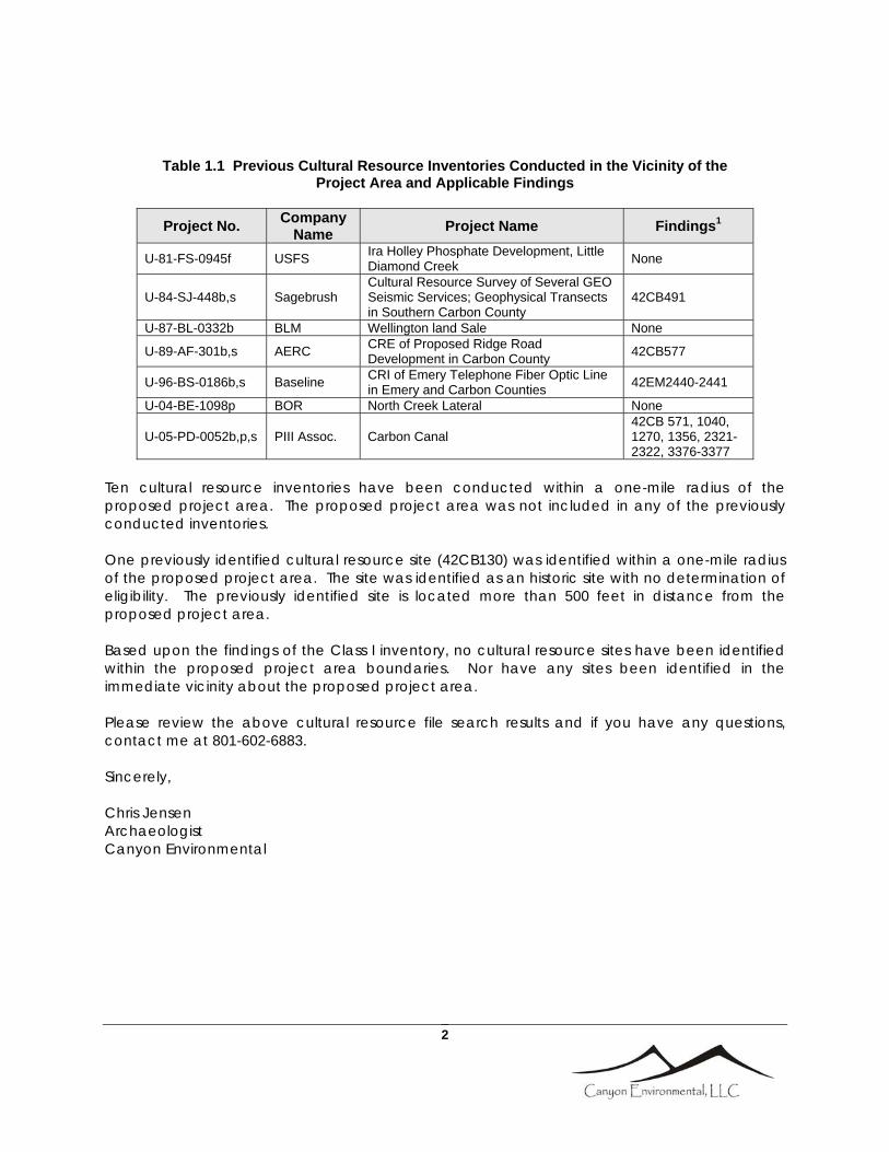
Table 1.1 Previous Cultural Resource Inventories Conducted in the Vicinity of the Project Area and Applicable Findings
Project No. Company Name Project Name Findings1
U-77-UA-0318b,f,s U of U Green River Reservoirs / Plants/ pipeline / Transmission Lines
42CB130, 42EM969-974 & 976-990
U-78-UA-0245b,s U of U Denver and Rio Grande Spur Line 42EM1072-1079, 42CB336-340, 733
U-80-UB-0722p UTARC Coal Plant in Castle Valley None
2
Table 1.1 Previous Cultural Resource Inventories Conducted in the Vicinity of the Project Area and Applicable Findings
Project No. Company Name Project Name Findings1
U-81-FS-0945f USFS Ira Holley Phosphate Development, Little Diamond Creek None
U-84-SJ-448b,s Sagebrush Cultural Resource Survey of Several GEO Seismic Services; Geophysical Transects in Southern Carbon County
42CB491
U-87-BL-0332b BLM Wellington land Sale None
U-89-AF-301b,s AERC CRE of Proposed Ridge Road Development in Carbon County 42CB577
U-96-BS-0186b,s Baseline CRI of Emery Telephone Fiber Optic Line in Emery and Carbon Counties 42EM2440-2441
U-04-BE-1098p BOR North Creek Lateral None
U-05-PD-0052b,p,s PIII Assoc. Carbon Canal 42CB 571, 1040, 1270, 1356, 2321-2322, 3376-3377
Ten cultural resource inventories have been conducted within a one-mile radius of the proposed project area. The proposed project area was not included in any of the previously conducted inventories. One previously identified cultural resource site (42CB130) was identified within a one-mile radius of the proposed project area. The site was identified as an historic site with no determination of eligibility. The previously identified site is located more than 500 feet in distance from the proposed project area. Based upon the findings of the Class I inventory, no cultural resource sites have been identified within the proposed project area boundaries. Nor have any sites been identified in the immediate vicinity about the proposed project area. Please review the above cultural resource file search results and if you have any questions, contact me at 801-602-6883. Sincerely, Chris Jensen Archaeologist Canyon Environmental

TOPOGRAPHIC MAPWellington Dry-Coal Cleaning FacilitySection 14, Township 15 South, Range 10 East
USGS TOPOGRAPHIC MAP:Price, Utah 7.5 Min Quadrangle
Figure 1Job No. C080001
Project Area
File searchradius
42CB130

BRC Wellington LC Dry~Coal Cleaning Facility
APPENDIX 4-2
Utah Division of Air Quality Approval Order
Permit Application October 2013
INCORPORATED
DEC 3 0 20t3
')IV. of Oil, Gas & Mining
EarthFax Engineering, Inc.


BRC Wellington LC Dry-Coal Cleaning Facility
APPENDIX 4-3
Resume of Individual Conducting the Cultural Resource Evaluation
Permit Application October 2013
INCORPORATED
DEC 3 0 2013
.' Y ot Oil, Gas & Mining
EarthFax Engineering, Inc.

Christopher T. Jensen 326 Stadium Avenue Provo, Utah 84604
801-602-6883 [email protected]
Mr. Jensen is an environmental professional with over ten years experience in the industry. Due to his unique educational and professional background, Mr. Jensen is qualified to conduct numerous aspects of environmental consultation ranging from Cultural Resource (archaeological) evaluations, Biological Assessments, soils evaluations, carbon analyses, and contaminant characterization and remediation. By combining these elements during project planning and permitting, Mr. Jensen delivers quality, cost-effective environmental services for many clients. EDUCATION Master of Science Degree in Agronomy with Archaeological Science and Soil Chemistry emphasis. Brigham Young University, Provo, Utah. August 2003. Relevant course work includes: Maya Archaeology, Case Studies in Environmental Policy, Water/Environment, Environmental Issues, Soil and Plant Analyses, Rangeland Plants, Range Management, Laboratory Safety, Soil Physics, Soil Taxonomy, Statistics, and GIS mapping Bachelor Degree in Anthropology with a minor in Geography. Brigham Young University, Provo, Utah. December 2001. Relevant course work includes: Geology, Seminar in Environmental Policy, Maps and Air Photos, Physical Geography, Cultural Geography, Human Osteology, Archaeological Methods, and Historic Archaeology RESEARCH PROJECTS Urban and rural planning studies of Indonesia. 1999. Soil chemical investigations of Kay’s Cabin archaeological site. 2000-2003. Soil evaluations and environmental changes at Motul de San Jose, Guatemala. 2001-2007. Soil chemical studies at Chunchucmil, Mexico and Antigua, Guatemala. 2001-2007. Marketplace studies and environmental soils analysis in Antigua, Guatemala. 2002. Design of a constructed wetland to treat agricultural run-off in Spanish Fork, Utah 2001. Application of oily waste to arid agricultural fields in the West Desert, Utah. 2002. GIS planning for a new park location for Orem City, Utah. 2003. Nitrogen fixation studies of compost media for UDOT freeway interchanges, Utah County, Utah. 2003. Soil chemical procedures as a viable alternative in Cultural Resource Management. 2002 – present. EMPLOYMENT President, Canyon Environmental, Provo, Utah. August 2008 – Present I currently own Canyon Environmental and oversee business development, operations, and services. Canyon Environmental specializes in a multi-disciplinary approach to environmental services. The

company conducts biological assessments, cultural resource inventories, environmental site assessments, carbon credit analyses and verification services, and focuses on cost-effective strategies to improve efficiencies and coordinate project developments for our clients. Clientele ranges from energy companies, financial institutions, development corporations, holding companies, and governmental and non-governmental organizations. Senior Scientist, Miller Brooks Environmental, American Fork, Utah. January 2008 – August 2008 I oversaw business operations for Miller Brooks in Utah and throughout the Intermountain West. I oversaw environmental site assessments, NEPA project development, Cultural Resource Inventories and permitting, biological evaluations, and assisted in the development of Environmental Impact Statements, and other associated projects. I was responsible for assisting clients in developing projects under the auspices of the National Environmental Policy Act (NEPA), and conducted cultural resource inventories, biological inventories, and regulatory assessments in connection with those policies. Southwest Regional Director, AEI Consultants, Phoenix, Arizona. October 2006 – January 2008 I managed the Southwest Regional Office in Phoenix and oversaw business operations in Arizona, Nevada, Southern Utah, and New Mexico. I began the development of NEPA training for the company including; cultural resource inventories, biological assessments, 404 permitting, and other similar projects. I conducted and oversaw site assessments, subsurface investigations, media sampling, and Property Condition and Safety Assessments for various clients. Project experience includes Phase I and Phase II assessments on tire re-tread facilities, printing facilities, plating and powder coating facilities, commercial office buildings, medical offices, hotels, and apartment complexes. I was responsible for advising clients on ‘Best Management Practices’ pertaining to Hazardous Waste storage, transport, and removal; and in identifying potential safety concerns and proposing methods and procedures to decrease risks within industrial and commercial settings. I was also responsible for overseeing and training staff members, business development, budgeting and minor accounting, and client relationships within the southwest region. Environmental Scientist/ Archaeologist, Earthtouch, Inc., Layton, Utah. October 2003 – October 2006. I conducted Phase I site assessments and NEPA analyses in California, Oregon, Washington, Idaho, Utah, Nevada, Arizona, Oklahoma, and other locations throughout the United States. I authored Environmental Site Assessment (ESA) reports, soil analyses reports, archaeological inventories, Phase I assessments, and Phase II assessments for Federal and State agencies, commercial clients, financial lending institutions and wireless telecommunications providers. I categorized waste materials and identified potential environmental and safety hazards for industrial and commercial properties. I was responsible for designing sample strategies for various sites and implementing soil and groundwater testing. I prepared samples for transport and reported on laboratory results. I also helped resolve concerns between clients and various government and state agencies in order to expedite project completion and insure the proper implementation of proposed developments. I conducted numerous cultural resource inventories and biological assessments throughout Utah, Idaho, Arizona, California, Washington, and Oregon. Project experience includes; fiber optic lines, road expansion developments, utility permitting, fuels surveys, historic building and feature recordation, cellular tower development, rock shelter monitoring, and other projects. Graduate Research Assistant, BYU Soils Laboratory, Provo, Utah. January 2002 – August 2003.

I planned, organized, and conducted independent studies of soils, plants, and geography; and documented environmental changes in areas of Mexico, Guatemala, and Utah. The majority of my research focused on using soil chemical analyses for archaeological prospecting and site evaluation. I conducted surveys and assisted in excavations and used soil chemical techniques to delineate and study site specific characteristics and to developed data to identify sub-surface cultural deposits. I developed sample strategies, organized and managed work crews, and supervised student volunteers for two years in Guatemala , Mexico, and Utah. I established contacts with government agency personnel, and worked with local Maya indigenous groups to evaluate agricultural practices and forest management issues. I oversaw sample analysis at the BYU soils laboratory, organized data, and prepared manuscripts for publication. I presented research findings at professional meetings and consulted as an environmental soils expert with various projects in Guatemala and Mexico. I also participated in local research projects in Utah and helped in the development of wetlands to treat agricultural run-off, the development of soil chemical analysis techniques to prospect for archaeological deposits, and monitoring stream flow on the Provo River. Other research projects include; the testing various composting materials for use on I-15 freeway interchanges, identifying Nitrogen fixation of crypto-biotic soils in southern Utah, and the application of oily waste products in areas of the West Desert to improve soil structure and increase agricultural output. Archaeological Contractor, EarthTouch Inc., Layton, Utah. March 2001 – January 2002. I assessed historic properties and archaeological sites for National Register of Historic Places status for government agencies and private companies. I evaluated sites and properties for various private and government entities. I conducted archaeological surveys and excavations and reported results to clients and government agency personnel. I participated in extensive research to document historic uses of properties included in land exchanges, road construction, and other infrastructure improvements. I worked with clients and government agency personnel through the NEPA process to resolve concerns and develop project initiatives for a positive outcome for all interested parties. Archaeologist, JBR Environmental Consultants, Inc. Springville, Utah. September 2000 – March 2001. I conducted archaeological surveys and assessments of proposed project areas. I recorded archaeological sites, mapped landscape features and excavated sites for governmental and private contractors. I prepared reports and data to be included in Environmental Assessments (EAs) and Environmental Impact Statement (EIS) documentation. I edited reports, prepared artifacts for storage, and assisted other professionals within the company. Student Volunteer, Brigham Young University Archaeological Field School, Austin, Texas and Utah County, Utah. May - August 2000. I excavated Paleo-Indian sites in Texas and Utah with other student volunteers. I collected and described artifacts, kept field notes, and prepared artifacts for analysis. I analyzed stone and bone artifacts, prepared reports and reported findings to other students in a forum. I also participated in project planning, and logistical support to provide students and faculty personnel with food, water and sanitary facilities. On the Kay’s Cabin archaeological site, I conducted soil chemical sampling for phosphates and trace elements to assist in the delineation of sub-surface features and potential cultural resources. The soil investigations identified an additional Fremont Indian pit-house, and other features that provided crucial data for understanding the site. These findings are currently under review, pending additional data prior to publication.

Volunteer Archaeological Lab Assistant, BYU Piedras Negras Project. Guatemala. April - May 2000. I helped assess, organize, and conduct archaeological investigations of various structures within the site of Piedras Negras during the summer field season. I organized work crews for the field laboratory and conducted analysis of micro and macro-botanical samples from archeological sites. I organized artifact collection and storage while overseeing the field laboratory, and maintained necessary camp equipment such as water pumps, water filters, generators, and other electronic and mechanical equipment. SELECTED ARCHAEOLOGICAL PROJECT EXPERIENCE Oil field leases and access permits (cultural and biological clearances) Tribal and Federal lands Beehive Fiber Optic Line – Wendover to Baker, archaeological survey and testing Evaluation of historic structures in Gold Hill, Utah – Tooele County Mills Junction near Lakepoint, survey and testing Historical documentation of the Handy Corner Gas Station on the Historic Lincoln Highway Monitoring for wireless telecommunications service (WTS) facility installation – various locations Nextel Communications, surveys and evaluations throughout western United States Cultural Resource Assessment and site recordation on US Naval Oil Preserve 10400 South Street – Salt Lake City, archaeological survey and historic building assessment SUFCO Subsidence Mine Monitoring and Survey – Southern Wasatch Plateau Hinckley Drive Road Improvement Project (SR 79), survey and collection Joe’s Valley Road Improvement Project – San Rafael Swell, survey and analyses Martin Quarry Project – Central Utah, survey and testing Nevada Automotive Testing Center proving Grounds, survey and analyses Skull Valley Land Exchange, survey and testing Survey and Testing in Red Cliffs Desert Reserve – St. George, survey and testing Carbonville Road Project – Carbonville, Inventory Mona Ridge BLM Fuels Inventory SELECTED BIOLOGICAL PROJECT EXPERIENCE Threatened and Endangered Species evaluations for telecom projects throughout California, Nevada, Arizona, Washington, Oregon, and Utah Wetland and Sensitive Habitat evaluation for the Red-Legged Frog in the Sacramento Valley, California Biological Inventory of the proposed ACDC gravel pit lease on the Uinta-Ouray Reservation Biological Inventory of proposed French Drain locations along the White River Biological Inventory for the proposed Wellington, Utah Walking Trail KNOWLEDGE AND SKILLS Public Lands Policy Coordination Office (PLPCO) Archaeological Permit # 177 AHERA Building Inspector (#D10620) National Environmental Policy Act (NEPA) regulations. Soil chemical prospecting techniques for archaeological sites. C13/C14 carbon analyses for identifying early agricultural corn production. Carbon sequestration verification services. RCRA regulations and procedures. 40-Hour HAZWOPER Training. Plant and soil analysis. Stream flow monitoring and water testing procedures.

Soil and plant sampling and analysis procedures. Mapping programs including; Arch View, Arch Map and Surfer. Soil map generation and evaluation. TOPCON total station mapping and various GPS mapping techniques. ICP/AES analysis procedures. Atomic Absorption analysis procedures. Fluent Spanish (speaking, reading, writing). AWARDS Recipient of the 2003 BYU Graduate Student Association Research Presentation Award Graduate Student Assistantship 2001-2003 Tuition Scholarship 2001-2003 AFFILIATIONS Member of the Society of American Archaeologists Member of the Association of American Geographers SELECTED PUBLICATIONS AND PRESENTATIONS First Author Soil Resources of the Motul de San Jose Maya: Correlating soil taxonomy and modern Itza Maya soil classification within a Classic Maya archaeological zone. Christopher T. Jensen, Matthew D. Moriarti, Kristofer D. Johnson, Richard E. Terry, Kitty Emery, and Sheldon D. Nelson. Geoarchaology: An International Journal, Volume 22, No. 3, 337-357 (2007). Soil Chemical Investigations of agricultural resource control and distribution in Chunchucmil, Mexico and Motul de San Jose, Guatemala. Christopher T. Jensen. A thesis presented to the Brigham Young University Department of Plant and Animal Sciences in fulfillment of a Master of Science Degree. 2003. The use of soil chemical analysis and ethnographic studies to define marketplace activities in the site of Chunchucmil, Mexico. Christopher Jensen, Richard E. Terry, Bruce Dahlin. A manuscript submitted to Science. 2004. Connections between settlement patterns and soil types in the close-periphery of Motul de San José, Guatemala. Christopher Jensen, Kristoffer Johnson, Richard Terry, Matt Moriarti. A manuscript submitted to Geoarchaeology, an international journal. 2003. Soil typologies and connections between agriculture and settlement at Motul de San Jose, Guatemala. Christopher Jensen, Matthew Moriarti, Richard E. Terry, Kitty Emery. Paper presented at the 2003 Society of American Archaeologists in Milwaukee, MI. Soil chemistry of ancient and modern Maya marketplaces. Christopher Jensen, Richard E. Terry, David R. Wright. Paper presented at the 2003 American Association of Geographers meetings in New Orleans, LA. Soil chemical signatures at Motul de San Jose, Guatemala. Christopher Jensen, Kris Johnson, Richard E. Terry. Paper presented at the 2002 Society of American Archaeologists meetings in Denver, Colorado.

The Pakbeh regional economy program. Report of the 2001 field season: Chemical analysis of soils at Chunchucmil. Chris Jensen, Bruce Dahlin, Richard E. Terry. Proyecto Arqueologico Motul de San Jose. Informe #4, Temporada de campo 2001: Analisis quimico de suelos en Motul de San Jose. Chris Jensen, Kris Johnson, Richard E. Terry. Second Author In Search of an Ancient Maya Market. Bruce H. Dahlin, Christopher T. Jensen, Richard E. Terry, David R. Wright, and Timothy Beach. Latin American Antiquity, 18(3), 2007 pp 121-143. Interpreting ancient Maya behavior through soil chemical analysis of activity areas in Chunchucmil, Mexico. Travis L. Thomason, Christopher Jensen, Richard E. Terry. Presentation at the 2002 American Society of Agronomy meetings in Indianapolis, IN. Soil chemical signatures and Classic Maya land use at Motul de San Jose, Guatemala. Richard E. Terry, Christopher Jensen, Kris Johnson. Presentation at the 2001 American Society of Agronomy meetings in Charlotte, NC.