brazilian navy directorate of hydrography and … · brazilian navy. directorate of hydrography and...
TRANSCRIPT

BRAZILIAN NAVYDIRECTORATE OF HYDROGRAPHY AND
NAVIGATION – NAVY HYDROGRAPHIC CENTER
DPCPDPCP-- XXVIXXVI
Oban, September, 27th 2010
THE NATIONAL BUOY PROGRAMTHE NATIONAL BUOY PROGRAM (PNBOIA) ISABP / DBCP(PNBOIA) ISABP / DBCP
The National Buoy Program has the goal of The National Buoy Program has the goal of collecting oceanographic and meteorological collecting oceanographic and meteorological data in the Atlantic Ocean, by a buoy network data in the Atlantic Ocean, by a buoy network in support to meteorological and oceanoin support to meteorological and oceano-- graphic activities in Brazil.graphic activities in Brazil.a) Maintain and enlarge the moored and drifting buoys a) Maintain and enlarge the moored and drifting buoys network; network; andandb)b) DDisseminateisseminate data on a real time base on GTS.data on a real time base on GTS.
DBCPData Buoy Cooperation Panel
ISABPInternational South Atlantic Buoy Program
PNBOIA PARTICIPANTSPNBOIA PARTICIPANTS
1. SECIRM - Secretary of the Interministry Commission for the Sea Resources;
2. DHN - Directorate of Hydrography and Navigation, represented by CHM - Navy Hydrographic Center;
3. IEAPM - Institute of Sea Studies Admiral Paulo Moreira;4. INMET - National Institute of Meteorology;5. FURG - Rio Grande Federal University;6. INPE - National Institute of Space Research;7. IOUSP - Oceanographic Institute of São Paulo University;
and8. PETROBRAS.
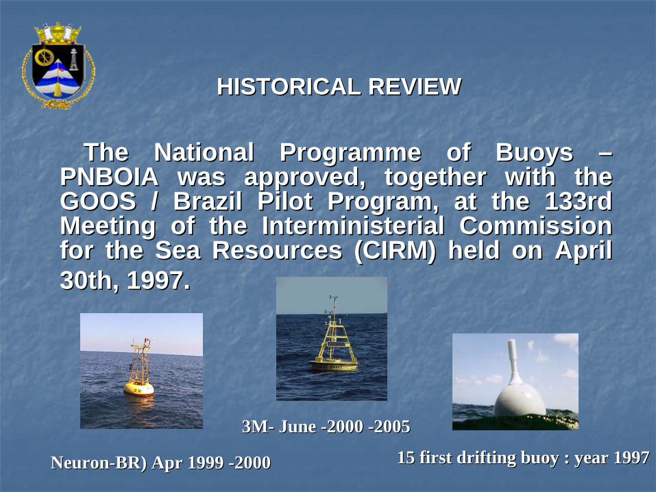
The National Programme of Buoys The National Programme of Buoys –– PNBOIA was approved, together with the PNBOIA was approved, together with the GOOS / Brazil Pilot Program, at the 133rd GOOS / Brazil Pilot Program, at the 133rd Meeting of the Interministerial Commission Meeting of the Interministerial Commission for the Sea Resources (CIRM) held on April for the Sea Resources (CIRM) held on April 30th, 1997.30th, 1997.
HISTORICAL REVIEWHISTORICAL REVIEW
NeuronNeuron--BR) Apr 1999 BR) Apr 1999 --20002000 15 first drifting buoy : year 199715 first drifting buoy : year 1997
3M3M-- June June --2000 2000 --2005 2005
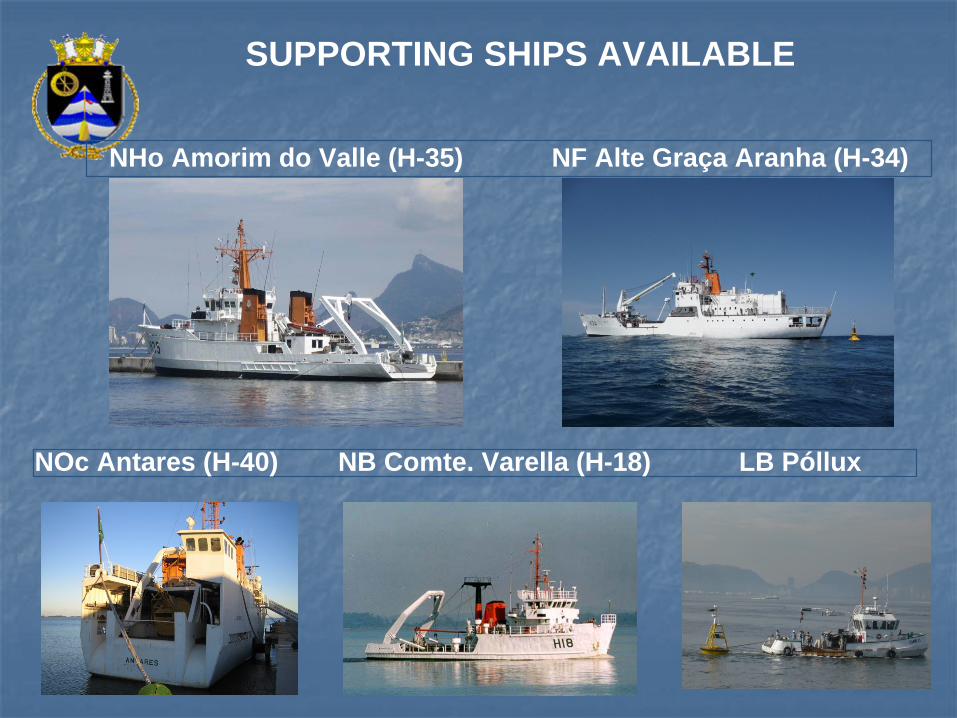
NHo Amorim do Valle (H-35) NF Alte Graça Aranha (H-34)
NOc Antares (H-40) NB Comte. Varella (H-18) LB Póllux
SUPPORTING SHIPS AVAILABLE
••
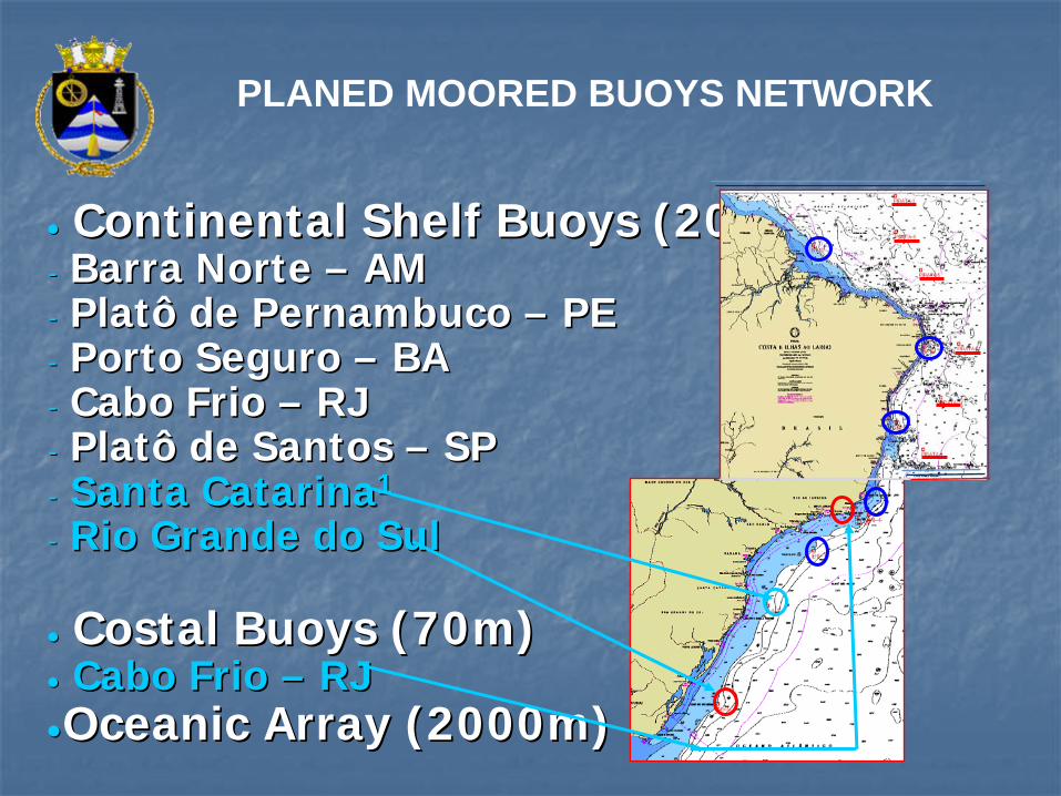
Continental Continental ShelfShelf BuoysBuoys (200m)(200m)-- Barra Norte Barra Norte –– AMAM-- Platô de Pernambuco Platô de Pernambuco –– PEPE-- Porto Seguro Porto Seguro –– BABA-- Cabo Frio Cabo Frio –– RJ RJ -- Platô de Santos Platô de Santos –– SPSP-- Santa CatarinaSanta Catarina11
-- Rio Grande do SulRio Grande do Sul
••
Costal Costal BuoysBuoys (70m)(70m)•• Cabo Frio Cabo Frio –– RJRJ••OceanicOceanic ArrayArray (2000m)(2000m)
PLANED MOORED BUOYS NETWORK
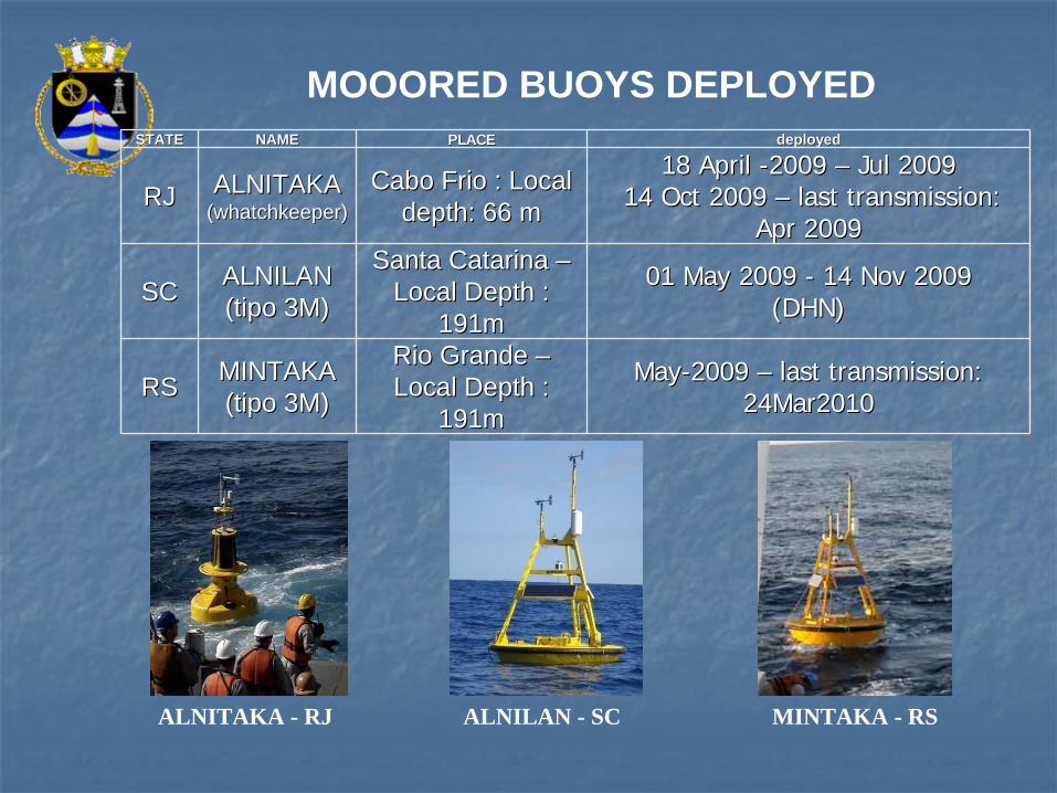
STATESTATE NAMENAME PLACEPLACE deployeddeployed
RJRJ ALNITAKAALNITAKA((whatchkeeperwhatchkeeper))
Cabo Frio : Local Cabo Frio : Local depthdepth: 66 m: 66 m
18 18 AprilApril --2009 2009 –– Jul 2009Jul 200914 14 OctOct 2009 2009 –– lastlast transmissiontransmission::
AprApr 20092009
SCSC ALNILANALNILAN(tipo 3M)(tipo 3M)
Santa Catarina Santa Catarina –– Local Local DepthDepth : :
191m191m
01 01 MayMay 2009 2009 -- 14 Nov 200914 Nov 2009(DHN)(DHN)
RSRS MINTAKAMINTAKA(tipo 3M)(tipo 3M)
Rio Grande Rio Grande –– Local Local DepthDepth : :
191m191m
MayMay--2009 2009 –– lastlast transmissiontransmission: : 24Mar201024Mar2010
MINTAKA - RSALNILAN - SCALNITAKA - RJ
MOOORED BUOYS DEPLOYED
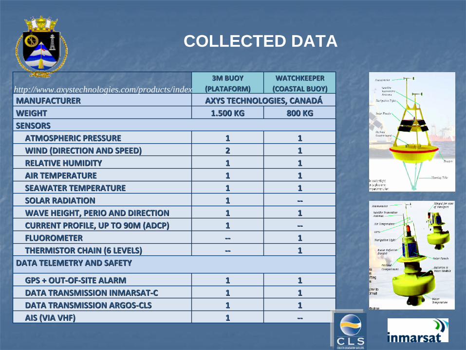
3M BUOY3M BUOY(PLATAFORM)(PLATAFORM)
WATCHKEEPER WATCHKEEPER
(COASTAL BUOY)(COASTAL BUOY)
MANUFACTURERMANUFACTURER AXYS TECHNOLOGIES, CANADAXYS TECHNOLOGIES, CANADÁÁWEIGHTWEIGHT 1.500 KG1.500 KG 800 KG800 KGSENSORSSENSORSATMOSPHERIC PRESSUREATMOSPHERIC PRESSURE 11 11WIND (DIRECTION AND SPEED)WIND (DIRECTION AND SPEED) 22 11RELATIVE HUMIDITYRELATIVE HUMIDITY 11 11AIR TEMPERATUREAIR TEMPERATURE 11 11SEAWATER TEMPERATURESEAWATER TEMPERATURE 11 11SOLAR RADIATIONSOLAR RADIATION 11 ‐‐‐‐WAVE HEIGHT, PERIO AND DIRECTIONWAVE HEIGHT, PERIO AND DIRECTION 11 11CURRENT PROFILE, UP TO 90M (ADCP)CURRENT PROFILE, UP TO 90M (ADCP) 11 ‐‐‐‐FLUOROMETERFLUOROMETER ‐‐‐‐ 11THERMISTOR CHAIN (6 LEVELS)THERMISTOR CHAIN (6 LEVELS) ‐‐‐‐ 11
DATA TELEMETRY AND SAFETYDATA TELEMETRY AND SAFETY
GPS + OUTGPS + OUT‐‐OFOF‐‐SITE ALARMSITE ALARM 11 11DATA TRANSMISSION INMARSATDATA TRANSMISSION INMARSAT‐‐CC 11 11DATA TRANSMISSION ARGOSDATA TRANSMISSION ARGOS‐‐CLSCLS 11 11AIS (VIA VHF)AIS (VIA VHF) 11 ‐‐‐‐
http://www.axystechnologies.com/products/index
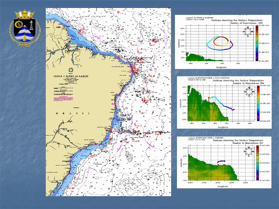
COLLECTED DATA
CurrentCurrent SituationSituation
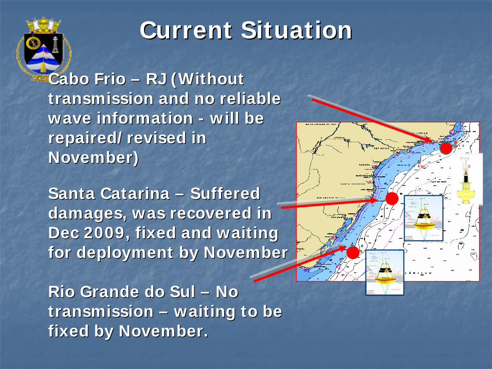
Cabo Frio Cabo Frio –– RJ (RJ (WithoutWithout transmissiontransmission andand no reliano reliableble wave information wave information -- will be will be repaired/revised in repaired/revised in November)November)
Santa Catarina Santa Catarina –– SufferedSuffered damagesdamages, , waswas recoveredrecovered in in DecDec 2009, 2009, fixedfixed andand waitingwaiting for for deploymentdeployment byby NovemberNovember
Rio Grande do Sul Rio Grande do Sul –– No No transmissiontransmission –– waitingwaiting to to bebe fixedfixed byby NovemberNovember..
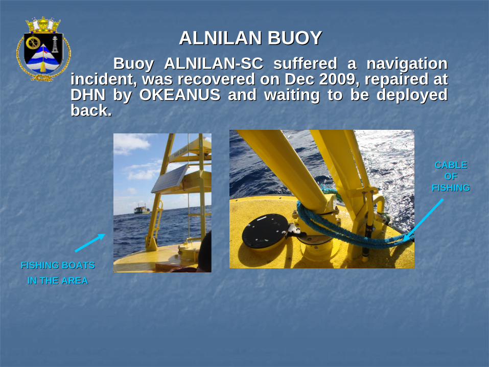
ALNILAN BUOYALNILAN BUOYBuoy ALNILANBuoy ALNILAN--SC suffered a navigation SC suffered a navigation
incident, was recovered on Dec 2009, repaired at incident, was recovered on Dec 2009, repaired at DHN by OKEANUS and waiting to be deployed DHN by OKEANUS and waiting to be deployed back.back.
CABLE CABLE OF OF
FISHINGFISHING
FISHING BOATS FISHING BOATS IN THE AREAIN THE AREA
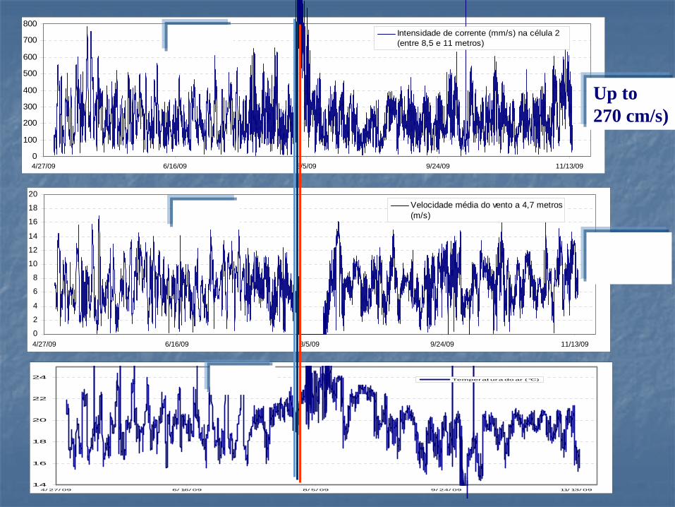
0
100
200
300
400
500
600
700
800
4/27/09 6/16/09 8/5/09 9/24/09 11/13/09
Intensidade de corrente (mm/s) na célula 2 (entre 8,5 e 11 metros)ADCP
0
2
4
6
8
10
12
14
16
18
20
4/27/09 6/16/09 8/5/09 9/24/09 11/13/09
Velocidade média do vento a 4,7 metros(m/s)WIND
14
16
18
20
22
24
4/ 27/ 09 6/ 16/ 09 8/ 5/ 09 9/ 24/ 09 11/ 13/ 09
Temperat ura do ar (°C)AIR T
Up to 270 cm/s)
Up to 17.9 m/s)
ALNITAKA ALNITAKA –– navigationnavigation incidentincident- Data before incident:
0
2
4
6
8
10
12
14
17-Apr 7-May 27-May 16-Jun 6-Jul 26-Jul
Velocidade média do vento(m/s)WIND
14
16
18
20
22
24
26
28
30
17-Apr 7-May 27-May 16-Jun 6-Jul 26-Jul
Temperatura do ar (°C)
AIR T
Back to sea 14Oct2009
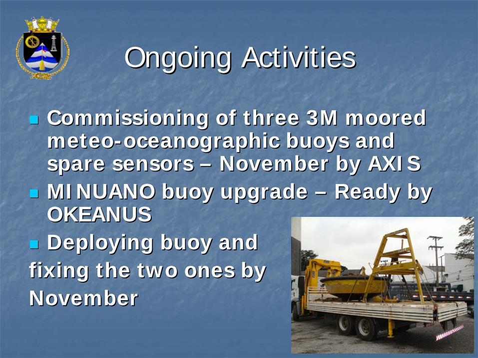
Ongoing ActivitiesOngoing Activities
Commissioning of three 3M moored Commissioning of three 3M moored meteometeo--oceanographic buoys and oceanographic buoys and spare sensors spare sensors –– November by AXISNovember by AXISMINUANO MINUANO buoybuoy upgrade upgrade –– ReadyReady bybyOKEANUSOKEANUSDeploying buoy and Deploying buoy and
fixing the two ones by fixing the two ones by November November
Next FutureNext Future
•• DeploymentDeployment ofof 3 3 newnew meteometeo oceanographicoceanographic buoysbuoys ((afterafter DEC 2010 )
•• Acquisition of another Platform Buoy, Acquisition of another Platform Buoy, probably will be deployed on the probably will be deployed on the North and closes PNBOIA first set of North and closes PNBOIA first set of moored buoys for covering all moored buoys for covering all Brazilian coast on a interval of 500 Brazilian coast on a interval of 500 km. km.
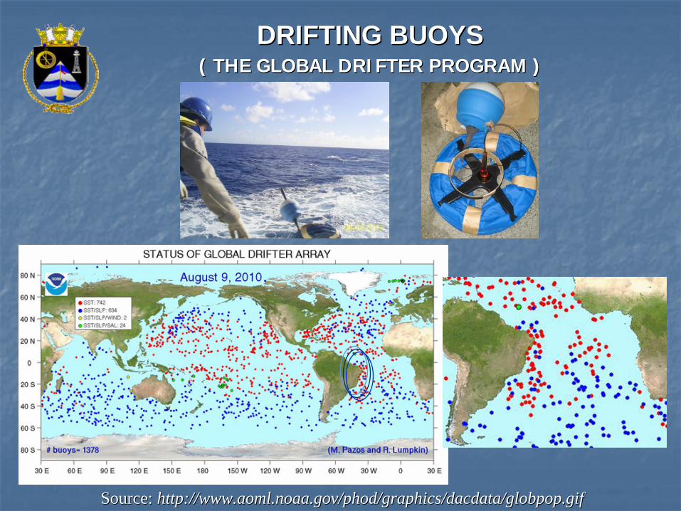
DRIFTING BUOYSDRIFTING BUOYS ( ( THE GLOBAL DRIFTER PROGRAM )THE GLOBAL DRIFTER PROGRAM )
Source:Source: http://www.aoml.noaa.gov/phod/graphics/dacdata/globpop.gifhttp://www.aoml.noaa.gov/phod/graphics/dacdata/globpop.gif
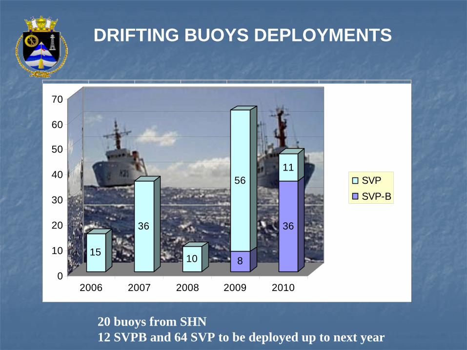
DRIFTING BUOYS DEPLOYMENTS
15
36
10 8
56
36
11
0
10
20
30
40
50
60
70
2006 2007 2008 2009 2010
SVPSVP-B
20 buoys from SHN12 SVPB and 64 SVP to be deployed up to next year
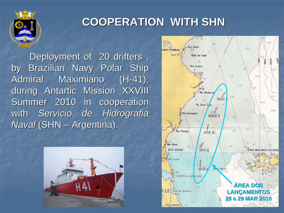
DeploymentDeployment ofof 20 20 driftersdrifters , , byby BrazilianBrazilian NavyNavy Polar Polar ShipShip AdmiralAdmiral Maximiano (HMaximiano (H--41), 41), duringduring AntarticAntartic MissionMission XXVIII XXVIII Summer 2010 in Summer 2010 in cooperationcooperation withwith ServicioServicio de Hidrografia de Hidrografia NavalNaval (SHN (SHN –– Argentina).Argentina).
COOPERATION WITH SHNCOOPERATION WITH SHN
ÁÁREA DOS REA DOS LANLANÇÇAMENTOSAMENTOS
28 e 29 MAR 201028 e 29 MAR 2010
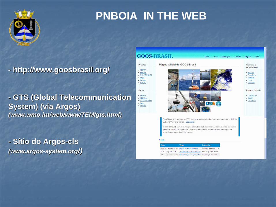
-- http://http://www.goosbrasil.orgwww.goosbrasil.org//
-- GTS (Global GTS (Global TelecommunicationTelecommunication System) (via Argos)System) (via Argos) (www.wmo.int/web/www/TEM/gts.html)(www.wmo.int/web/www/TEM/gts.html)
-- SSíítio do tio do ArgosArgos--clscls (www.argos(www.argos--system.orgsystem.org//))
PNBOIA IN THE WEB
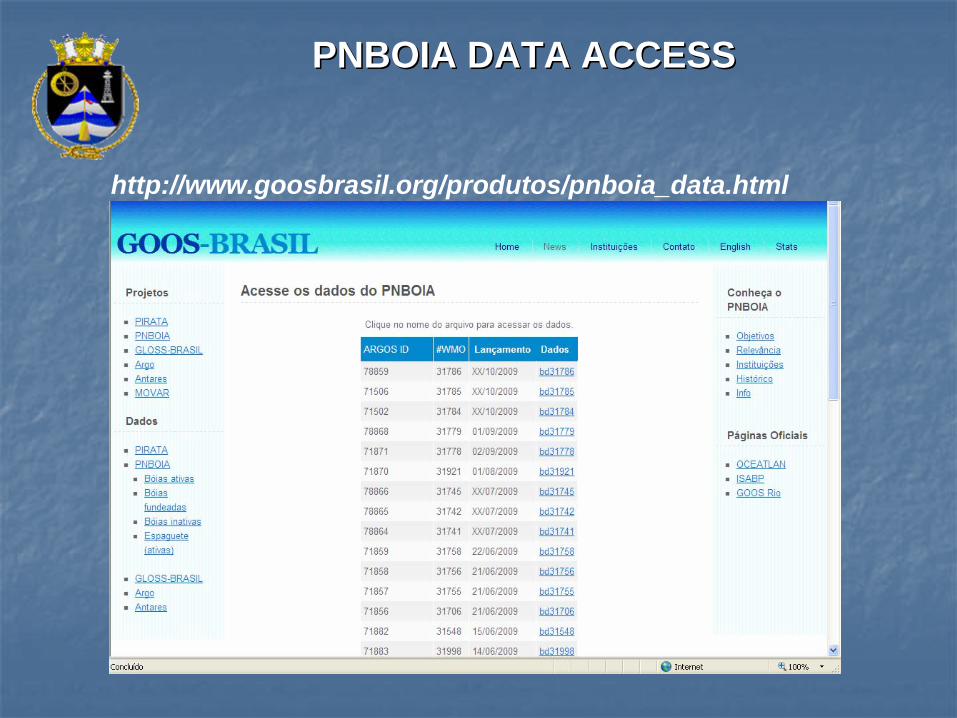
PNBOIA DATA ACCESSPNBOIA DATA ACCESS
http://www.goosbrasil.org/produtos/pnboia_data.html
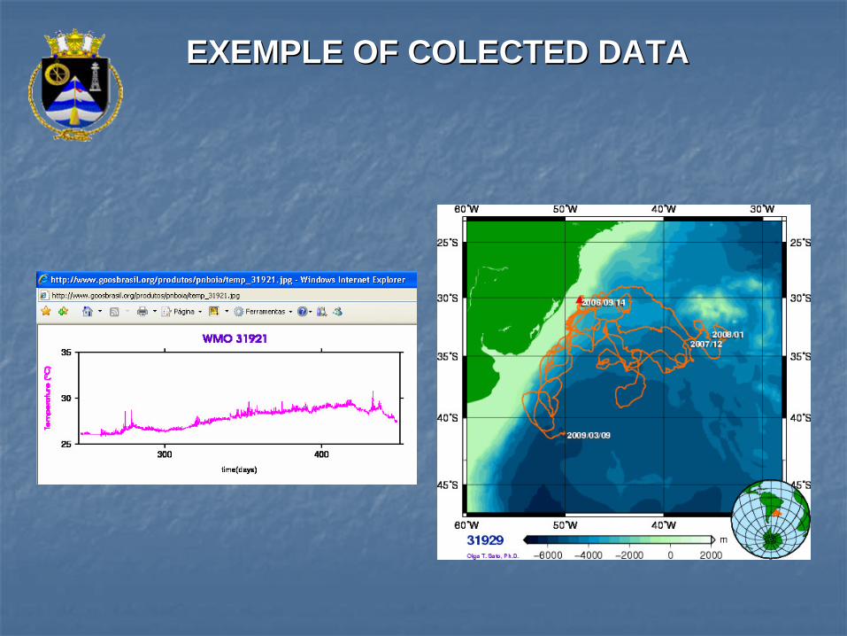
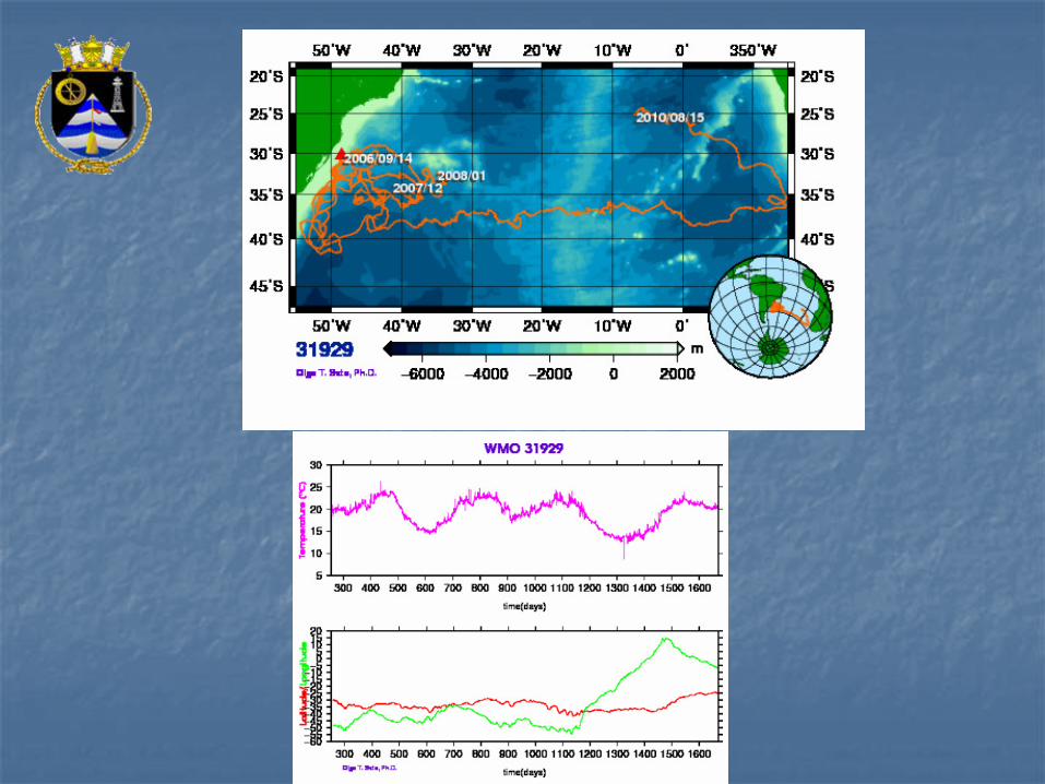
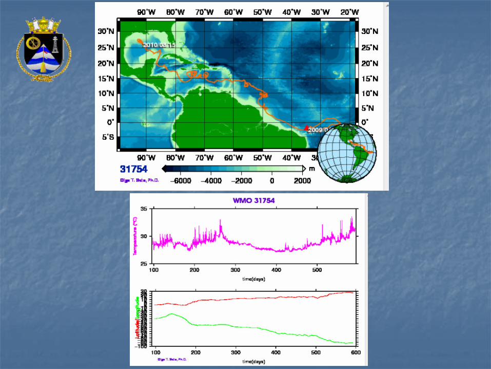
EXEMPLE OF COLECTED DATAEXEMPLE OF COLECTED DATA
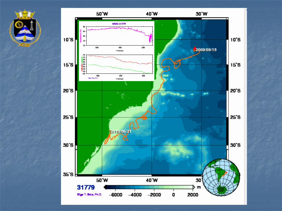
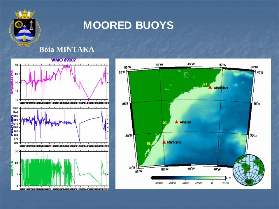
Bóia MINTAKA
MOORED BUOYS
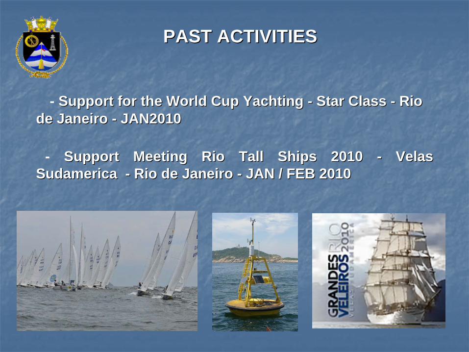
PAST ACTIVITIESPAST ACTIVITIES
- Support for the World Cup Yachting Support for the World Cup Yachting -- Star Class Star Class -- Rio Rio de Janeiro de Janeiro -- JAN2010JAN2010
- Support Meeting Rio Tall Ships 2010 Support Meeting Rio Tall Ships 2010 -- VelasVelas SudamericaSudamerica -- Rio de Janeiro Rio de Janeiro -- JAN / FEB 2010JAN / FEB 2010
THANKSTHANKSSONIA LUCIA SARTORI CAVALCANTE
Lieutennant Commander, DScNavy Hydrographic Center
Oceanographic Information DivisionFone: +55 (21) [email protected]
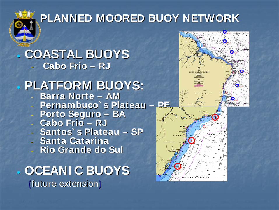
PLANNEDPLANNED MOORED BUOY NETWORKMOORED BUOY NETWORK
•• COASTAL BUOYSCOASTAL BUOYS-- Cabo Frio Cabo Frio –– RJRJ
•• PLATFORM BUOYS:PLATFORM BUOYS:-- Barra Norte Barra Norte –– AMAM-- Pernambuco`Pernambuco`s s PlateauPlateau –– PEPE-- Porto Seguro Porto Seguro –– BABA-- Cabo Frio Cabo Frio –– RJ RJ -- Santos`Santos`s s PlateauPlateau –– SPSP-- Santa CatarinaSanta Catarina-- Rio Grande do SulRio Grande do Sul
•• OCEANIC BUOYS OCEANIC BUOYS ((futurefuture extensionextension))